agenda item request office use: board of city
TRANSCRIPT

Dustin T. Scott - City Engineer Jerry Wallace – Civil Engineer Andrew Wrucke – Transportation Engineer Kayla Volness – Engineering Office Manager
Engineering Department
800 4th Ave E West Fargo, ND 58078
701-433-5330 www.westfargond.gov
OFFICE USE: AGENDA ITEM # ______
** “Consent” or “Regular” Agenda Item? [Regular] **
AGENDA ITEM REQUEST BOARD OF CITY COMMISSIONERS WEST FARGO, NORTH DAKOTA
1. CONTACT PERSON(s): • Dustin T. Scott, City Engineer (433-5425)
2. DATE OF MEETING: February 17th, 2020
3. DESCRIPTION OF REQUEST:
• Review Engineer’s Report for Project No. 6055 – Drain 45 Multi-Use Path – Phase I (7th
to 13th Ave).
4. LOCATION (address; legal; etc.):
• Drain 45 – 13th Ave E to 7th Ave E.
5. ACTION(S) REQUESTED:
• Approve the Engineer’s Report and direct the Engineer to prepare detailed plans and specifications for the construction of Project No. 6055 – Drain 45 Multi-Use Path – Phase I (7th to 13th Ave).

925 10th Avenue East West Fargo, ND 58078
P: 701.282.4692 F: 701.282.4530
North Dakota - Bismarck • Minot • West Fargo • Williston Minnesota - Fergus Falls • St. Cloud mooreengineeringinc.com
February 11, 2020 Mr. Dustin Scott City of West Fargo - City Engineer 800 4th Ave E, Ste 1 West Fargo, ND 58078 RE: Project No. 6055
Drain 45 Multi-Use Path - Phase I (7th to 13th Ave) Moore Project No. 20829
Dear Mr. Scott, We are submitting the attached Engineer’s Report for the aforementioned project. Please review and provide comment at your earliest convenience. If you do not have any questions or comments, and the report is acceptable to you, please present it to the West Fargo City Commission. To meet the project’s proposed schedule, this report needs to be approved by the City Commission by February 18, 2020. We will wait for your response and the City Commission before taking further action. Please contact me with your questions or comments. Thank you for your time and consideration. Sincerely,
Dylan Dunn, EI Project Engineer Enclosure(s): Engineer’s Report
Engineer’s Report
This document was originally issued and sealed by Kevin J. Knott, Registration No. PE-5679, on 02/11/2020 and the original document is stored at Moore Engineering, Inc., West Fargo, N.D.
City of West Fargo, North Dakota
Project No. 6055
Drain 45 Multi-Use Path - Phase I
(7th to 13th Ave)
mooreengineeringinc.com
February 2020 Project No. 20829
2
Table of Contents
1. INTRODUCTION ..................................................................................................................................... 3
2. PROPOSED IMPROVEMENTS ................................................................................................................. 3
3. ALTERNATIVE SELECTION ...................................................................................................................... 4
4. ENVIRONMENTAL DOCUMENT ............................................................................................................. 5
5. FUNDING ............................................................................................................................................... 5
6. CONCLUSION ......................................................................................................................................... 5
APPENDIX A
Exhibit 1: Proposed Improvements Exhibit Exhibit 2: Engineer’s Opinion of Probable Cost Exhibit 3: Categorical Exclusion by Definition Exhibit 4: Original Transportation Alternative Program Application

3
1. INTRODUCTION
The City of West Fargo, North Dakota (“City”) believes there is a need for a North/South bikeway route
along Drain 45 from Main Avenue to 13th Avenue. A multi-use path at this location would provide a
connection between the two arterial corridors of Main Avenue and 13th Avenue through residential
neighborhoods providing access to many users with close proximity to numerous schools, public and
recreational facilities, and commerce.
A storm water project was completed to enclose Drain 45 by placing an arch culvert in the bottom of the
concrete ditch and installing topsoil above it, turning it in to greenspace. The intent of this project is to
construct a concrete bike path above the arch pipe to be used as a pedestrian path. A structural analysis
is currently being conducted to confirm the assumption that the arch pipe can support the proposed
concrete path and the potential of maintenance vehicles.
The City applied for funds available through the North Dakota Department of Transportation (NDDOT)
Transportation Alternatives Program. On May 6, 2019, the NDDOT selected the City for a portion of
these funds up to a maximum amount of $232,000 for Drain 45 Multi-Use Path Phase One, from 7th
Avenue to 13th Avenue.
The purpose of this preliminary engineer’s report is to establish the general nature, purpose, and an
estimate of the probable costs of the improvements. Additionally, this report will include the proposed
improvements, environmental documents, and funding related to the Improvements.
2. PROPOSED IMPROVEMENTS
The proposed Improvements are summarized as follows:
• Path Items
o 10’ Multi-Use Path from 7th Avenue to 13th Avenue
o Speed Tables at 10th Avenue and 12th Avenue
o Rectangular Rapid Flashing Beacons (RRFB) at street crossings
o Street and path signage and pavement markings
• Utility Item
o Minor Storm Sewer drainage modifications

4
The proposed Multi-Use Path section currently proposed to be constructed is the West Fargo City
Standard 10’ wide and 5” thick concrete over 4” aggregate base. Moore Engineering was directed to
solicit a structural engineer to confirm that such a proposed section is acceptable over the arch pipe in
regards to the bearing capacity of the pipe. It is possible that the structural engineer will determine that
a wider or thicker section may be required for distributing the load differently. The structural analysis
will also determine if vehicular traffic is to be allowed over the pipe or if vehicular traffic is to be
restricted by the use of bollards at street access points.
The use of speed tables, RRFBs, and continental crosswalk striping at 10th Avenue and 12th Avenue are
proposed to provide a safer street crossing for the path, with a secondary result of reducing traffic
speed on the local street, one of which crosses in front of an elementary school.
Minor storm sewer extensions are required to redirect existing surface drainage patterns after the
introduction of the proposed path and speed tables. Catch basins will be added in areas that will no
longer naturally drain.
3. ALTERNATIVE SELECTION
Two alignment alternatives were developed. Alternative one was aligned over the center of the
previously enclosed concrete lined channel, and alternative two was aligned to the east side of the
previously enclosed concrete lined channel. They are as follows:
• Alternative one best fits the existing drainage pattern as the previously enclosed concrete lined
channel in the center of the drain Right-of-Way is now crowned, providing natural drainage
away from the path to the catch basins near the edges of the drain Right-of-Way.
• Alternative two was explored due to the unknown bearing capacity of the arch pipe used to
enclose Drain 45. The concept of shifting the path away from the arch pipe would reduce the
risk of arch pipe failure. The results of the shifted alignment were conflicts with the previously
installed catch basins which would have to be relocated, increasing the project cost.
Assuming the structural analysis results demonstrated that the arch pipe is acceptable in supporting the
proposed path, the selected alternative is alternative one.
5
4. ENVIRONMENTAL DOCUMENT
Due to the federal funding, the Improvements must follow procedures as required by the NDDOT, which
includes an Environmental Document consisting of a Categorical Exclusion by Definition (CED). The CED
expresses the environmental issues and estimated cost for the project. The Final Categorical Exclusion
by Definition is found in Appendix A.
5. FUNDING
The total estimated construction cost of the project to install the Improvements is estimated to be
$739,600. The Engineer’s Opinion of Probable Cost can be found in Appendix A. The Improvements are
intended to be funded by a combination of the Transportation Alternative Program funds and City sales
tax revenue. The estimated project construction costs have increased from the original application
estimate by $118,000 as a result of the following:
• Speed tables and storm sewer extensions were added to the crossings at 10th Avenue and 12th
Avenue
• RRFBs were added to the scope of the project
• The cost above includes both a 20% construction and a 20% design contingency due to having
not received proposed design requirements from the structural engineer the at the time of this
report.
• The cost above includes engineering, materials testing, legal and administration costs not
funded by the TAP funds.
6. CONCLUSION
The proposed Improvements would provide the intended connectivity from neighborhoods to numerous
schools, public and recreational facilities, and commerce. The selected alternative of the proposed
improvements are to fulfill the intent of the Transportation Alternatives Program and would be in
accordance with the City of West Fargo and NDDOT design standards for public improvements.

APPENDIX A

DRAI
N 45
6TH
ST
E
1ST
ST
2ND
ST
E
7TH AVE E
13TH AVE E
12TH AVE E
10TH AVE E
3RD
ST
E
12 1/2 AVE E
14TH AVE E
11TH AVE E
10 1/2 AVE E
13 1/2 AVE E
7 1/
2 ST
E
PHEASANT RUN
CED
AR L
N
7TH
ST
E
9TH AVE E
8TH AVE E
9 1/2 AVE E
5TH
ST
E
CH
ERR
Y C
T
DELO
RES D
R
4TH
ST
E
6TH AVE E
5TH
STR
EET
CT
E
10TH AVE E
8TH AVE E
14TH AVE E
3RD
ST
E
4TH
ST
E
6TH AVE E
Created By: GZ Date Created: 10/17/18 Date Saved: 12/02/19 Date Plotted: 10/18/18 Date Exported: 12/02/19Plotted By: tanner.schmidt Parcel Date: NA Aerial Image: 2017 County NAIP SIDS Elevation Data: LidarHorizontal Datum: NAD 1983 UTM Zone 14N Vertical Datum: NAT:\Projects\20800\20829\20829_Multi_Use_Path.mxd
EXHIBIT 1 - PROJECT NO. TAU-8-984(042) PCN 22578CITY OF WEST FARGO - DRAIN 45 MULTI-USE PATH - PHASE 1 CASS COUNTY, NORTH DAKOTA
LegendPhase 1

Q:\Projects\20000\20800\20829 WFgoND Proj6055Drain45MultiUsePathPhI\100-Studies and Reports\01-Cost Estimates for Reports (Rp)\Opinion of Cost-2020-02-05.xlsx
ITEM UNIT QUANTITY UNIT PRICE TOTALPHASE I - 17TH AVENUE EAST TO 13TH AVENUE EAST103 100 CONTRACT BOND LSum 1 $6,000.00 $6,000.00 202 114 REMOVAL OF CONCRETE PAVEMENT SY 75 $15.00 $1,125.00 202 130 REMOVAL OF CURB & GUTTER LF 175 $7.50 $1,312.50 202 132 REMOVAL OF BITMINOUS SURFACING SY 250 $7.50 $1,875.00 202 210 REMOVAL OF MANHOLE EA 1 $1,000.00 $1,000.00 202 231 REMOVE & RESET INLETS EA 7 $1,500.00 $10,500.00 203 109 TOPSOIL CY 3,000 $7.50 $22,500.00 216 100 WATER MGAL 100 $20.00 $2,000.00 251 200 SEEDING CLASS II ACRE 3.5 $700.00 $2,450.00 253 201 HYDRAULIC MULCH ACRE 3.5 $1,500.00 $5,250.00 260 100 SILT FENCE SUPPORTED LF 4,800 $2.50 $12,000.00 260 101 REMOVE SILT FENCE SUPPORTED LF 4,800 $1.00 $4,800.00 261 112 FIBER ROLL 12IN EA 300 $3.00 $900.00 261 113 REMOVE FIBER ROLL 12IN EA 300 $1.00 $300.00 265 100 STABILIZED CONSTRUCTION ACCESS EA 5 $2,000.00 $10,000.00 265 101 REMOVE STABILIZED CONSTRUCTION ACCESS EA 5 $1,000.00 $5,000.00 302 120 AGGREGATE BASE COURSE CL 5 TON 600 $35.00 $21,000.00 302 314 TEMPORARY TRAFFIC SURFACE AGGREGATE TON 250 $15.00 $3,750.00 430 500 COMMERICAL GRADE HOT MIX ASPHALT TON 25 $90.00 $2,250.00 550 112 8IN NON-REINF CONCRETE PAVEMENT CL AE SY 200 $100.00 $20,000.00 702 100 MOBILIZATION LSum 1 $16,000.00 $16,000.00 704 1100 TRAFFIC CONTROL LSum 1 $5,000.00 $5,000.00 708 1540 INLET PROTECTION - SPECIAL EA 8 $200.00 $1,600.00 708 1541 REMOVE INLET PROTECTION - SPECIAL EA 8 $50.00 $400.00 709 151 GEOSYNTHETIC MATERIAL TYPE R1 SY 100 $2.00 $200.00 714 210 PIPE CONC REINF 15IN CL III - STORM DRAIN LF 30 $75.00 $2,250.00 714 4097 PIPE CONDUIT 15IN- STORM DRAIN LF 100 $50.00 $5,000.00 714 5010 PIPE CORR STEEL .064IN 15IN LF 100 $40.00 $4,000.00 722 100 MANHOLE 48IN EA 2 $2,000.00 $4,000.00 722 1100 MANHOLE 48IN RISER LF 12 $250.00 $3,000.00 722 3500 INLET - TYPE 1 EA 2 $4,000.00 $8,000.00 722 3510 INLET - TYPE 2 EA 2 $2,500.00 $5,000.00 722 3700 INLET SPECIAL - TYPE 1 48IN EA 1 $4,000.00 $4,000.00 748 140 CURB & GUTTER - TYPE I LF 175 $25.00 $4,375.00 750 115 SIDEWALK CONCRETE 4IN SY 100 $45.00 $4,500.00 750 120 SIDEWALK CONCRETE 5IN REINF SY 2,800 $50.00 $140,000.00 750 2115 DETECTABLE WARNING PANELS SF 80 $50.00 $4,000.00 754 110 FLAT SHEET FOR SIGNS - TYPE XI REFL SHEETING SF 130 $25.00 $3,250.00 754 206 STEEL GALV POST - TELESCOPING PERFORATED TUBE LF 250 $20.00 $5,000.00 754 592 RESET SIGN PANEL EA 1 $250.00 $250.00 754 7005 BLINKER SIGN - SOLAR EA 4 $13,000.00 $52,000.00 762 1325 PREF PATT PVMT MK 24IN LINE - GROOVED LF 260 $30.00 $7,800.00
Construction Subtotal $413,637.50 Construction Contingencies (≈20%) $83,181.25
Design Contingencies (≈20%) $83,181.25 Construction Subtotal $580,000.00
Study & Report $16,000.00 Engineering (12%) $69,600.00
Additional Consultanting Services $45,000.00 Legal & Administration $29,000.00
TOTAL PROJECT COST $739,600.00
WEST FARGO ND7th Avenue to 13th Avenue Connection (Phases I)
DRAIN 45 MULTI-USE PATH IMPROVEMENTS
Engineer's Opinion of Probable CostExhibit 2

February 2020 Page 1
Categorical Exclusion by Definition Checklist
Project Number: TAU‐8‐984(042) PCN: 22578 Date: 02/07/2020
Estimated Cost (Construction & CE): $475,000
Although no further NEPA approval is required for this action, the checklist below and Categorical Exclusion by Definition Checklist (CED) Instructions are intended to identify any additional consultation, coordination, notifications, or permitting that may be required. If the answer is Yes to any of the questions below, additional documentation of that Subject Area is required, and shall be added to this CED Checklist, and incorporated into the design where applicable. For any questions contact your NDDOT Environmental Reviewer. An overall project map is required to be included with the CED package.
Subject Area Questions Yes No Documentation added to the Project File
Right of Way Is temporary right of way required?
If Yes, then attach a figure showing the location(s) and amount(s) needed at each location.
X
Is permanent right of way is required?
If Yes, then attach a figure showing the location(s) and amount(s) needed at each location.
X
If permanent right of way is required, will any right of way thresholds be exceeded?
‐See right of way thresholds in the instructions.
If Yes, then a higher level NEPA document is required.
X
Historic/ Archeological
Does the project involve any of the following?
‐ Work on a Historic Bridge ‐ Work in a Historic District ‐ Environmental Mitigation ‐ Landscaping ‐ Work within Reservation Boundaries ‐ Disposal or Early Acquisition of Right of Way ‐ Trenching for wires or power for any of the following: ITS, ATR, Destination Lighting, or Signals
‐ Disturbance of existing ground outside of the existing roadway foreslope
If Yes, to any of these items, then a Class III Survey and consultation may be required. Contact ETS Division, Cultural Resource Section for further guidance.
X SHPO Concurrence Letter. SPHO Ref.: 20‐5364
Exhibit 3

February 2020 Page 2
Subject Area
Questions Yes No
Documentation added to the Project File
Section 4(f) Are there any impacts to Section 4(f) properties such as: ‐ Historic Site or Historic District ‐ Publicly owned parks and recreation areas ‐ Wildlife & waterfowl refuges
If Yes, then the applicable documentation and agency coordination is required.
X
Threatened or Endangered Species
Does the project occur within 0.5 mile of designated criticalhabitat; require the adjustment of above ground utilities in rural areas; or involve tree removals or structure (bridge, box culvert, cattle pass, or outbuilding) work? ‐ See link to designated critical habitat map in the instructions. If yes, see the “Section 7 ESA Guidance” document for further information on how to complete this Subject Area.
X
NDDOT Threatened, Endangered, Proposed, Candidates Species and Critical Habitat Affect Determination Table and Map Attached
Floodplain Permitting and Floodway Authorization
Will the project occur within a 100‐year floodplain and/or Zone X Area Of Special Consideration? ‐ See link for FEMA FIRM in the instructions. If Yes, then a floodplain permit may be required.
Will the project occur within a floodway? ‐ See link for FEMA FIRM in the instructions. If Yes, then a floodway authorization may be required.
X FIRM Map Attached Map 38017C0757G
Airports Does the project intersect the glide path of an airport? ‐ See link for a map of airport locations in the instructions
If Yes then a Notification may need to be provided to the FAA. See Design Manual Section III‐17.
X
Local Public Agencies
Do any Local Public Agencies have an interest in the project?
If Yes, then ensure proper coordination/communication has occurred.
X City of West Fargo Led Project

February 2020 Page 3
Subject Area
Questions Yes No
Documentation added to the Project File
Migratory Bird Does your project involve work on bridges, box culverts, or Structural Plate Pipes?
If Yes, then see the Migratory Bird section in the instructions.
X
Wetlands Does your project involve work beyond the roadway foreslope, or other work that could result in earth work?
If Yes, an aquatic resource delineation, jurisdictional determination, mitigation, and permitting may be required with
the project. If an aquatic resource delineation was completed, then attach the “Appendix A5 Wetland and OW
Impact Table” and ensure the aquatic resource delineation is added to FileNet.
X
National Wetlands Inventory Map Attached
DR
AIN
45
6TH
ST
E
1ST
ST
2ND
ST
E
7TH AVE E
13TH AVE E
12TH AVE E
10TH AVE E
3RD
ST
E
12 1/2 AVE E
14TH AVE E
11TH AVE E
10 1/2 AVE E
13 1/2 AVE E
7 1/
2 ST
E
PHEASANT RUN
CED
AR L
N
7TH
ST
E
9TH AVE E
8TH AVE E
9 1/2 AVE E
5TH
ST
E
CH
ERR
Y C
T
DELO
RES D
R
4TH
ST
E
6TH AVE E
5TH
STR
EET
CT
E
10TH AVE E
8TH AVE E
14TH AVE E
3RD
ST
E
4TH
ST
E
6TH AVE E
Created By: GZ Date Created: 10/17/18 Date Saved: 12/02/19 Date Plotted: 10/18/18 Date Exported: 12/02/19Plotted By: tanner.schmidt Parcel Date: NA Aerial Image: 2017 County NAIP SIDS Elevation Data: LidarHorizontal Datum: NAD 1983 UTM Zone 14N Vertical Datum: NAT:\Projects\20800\20829\20829_Multi_Use_Path.mxd
PROJECT NO. TAU 8-984(042) PC 22578CITY OF WEST FARGO - DRAIN 45 MULTI-USE PATH - PHASE 1CASS COUNTY, NORTH DAKOTA
LegendPhase 1
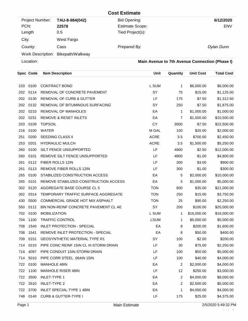
Project Number: TAU-8-984(042)PCN: 22578
Location: Main Avenue to 7th Avenue Connection (Phase I)
City: West Fargo
County: Cass
Bid Opening: 6/12/2020
Work Description: Bikepath/Walkway
Length 0.5
Cost Estimate
Estimate Scope: ENV
Prepared By: Dylan Dunn
Tied Project(s):
Spec Code Item Description Unit CostQuantity Total CostUnit
103 0100 CONTRACT BOND $6,000.001L SUM $6,000.00
202 0114 REMOVAL OF CONCRETE PAVEMENT $15.0075SY $1,125.00
202 0130 REMOVAL OF CURB & GUTTER $7.50175LF $1,312.50
202 0132 REMOVAL OF BITUMINOUS SURFACING $7.50250SY $1,875.00
202 0210 REMOVAL OF MANHOLES $1,000.001EA $1,000.00
202 0231 REMOVE & RESET INLETS $1,500.007EA $10,500.00
203 0109 TOPSOIL $7.503000CY $22,500.00
216 0100 WATER $20.00100M GAL $2,000.00
251 0200 SEEDING CLASS II $700.003.5ACRE $2,450.00
253 0201 HYDRAULIC MULCH $1,500.003.5ACRE $5,250.00
260 0100 SILT FENCE UNSUPPORTED $2.504800LF $12,000.00
260 0101 REMOVE SILT FENCE UNSUPPORTED $1.004800LF $4,800.00
261 0112 FIBER ROLLS 12IN $3.00300LF $900.00
261 0113 REMOVE FIBER ROLLS 12IN $1.00300LF $300.00
265 0100 STABILIZED CONSTRUCTION ACCESS $2,000.005EA $10,000.00
265 0101 REMOVE STABILIZED CONSTRUCTION ACCESS $1,000.005EA $5,000.00
302 0120 AGGREGATE BASE COURSE CL 5 $35.00600TON $21,000.00
302 0314 TEMPORARY TRAFFIC SURFACE AGGREGATE $15.00250TON $3,750.00
430 0500 COMMERCIAL GRADE HOT MIX ASPHALT $90.0025TON $2,250.00
550 0112 8IN NON-REINF CONCRETE PAVEMENT CL AE $100.00200SY $20,000.00
702 0100 MOBILIZATION $16,000.001L SUM $16,000.00
704 1100 TRAFFIC CONTROL $5,000.001LSUM $5,000.00
708 1540 INLET PROTECTION - SPECIAL $200.008EA $1,600.00
708 1541 REMOVE INLET PROTECTION - SPECIAL $50.008EA $400.00
709 0151 GEOSYNTHETIC MATERIAL TYPE R1 $2.00100SY $200.00
714 0210 PIPE CONC REINF 15IN CL III-STORM DRAIN $75.0030LF $2,250.00
714 4097 PIPE CONDUIT 15IN-STORM DRAIN $50.00100LF $5,000.00
714 5010 PIPE CORR STEEL .064IN 15IN $40.00100LF $4,000.00
722 0100 MANHOLE 48IN $2,000.002EA $4,000.00
722 1100 MANHOLE RISER 48IN $250.0012LF $3,000.00
722 3500 INLET-TYPE 1 $4,000.002EA $8,000.00
722 3510 INLET-TYPE 2 $2,500.002EA $5,000.00
722 3700 INLET SPECIAL-TYPE 1 48IN $4,000.001EA $4,000.00
748 0140 CURB & GUTTER-TYPE I $25.00175LF $4,375.00
Page 1 2/5/2020 5:49:32 PMMain Estimate . . .. . ..

Spec Code Item Description Unit CostQuantity Total CostUnit
750 0115 SIDEWALK CONCRETE 4IN $45.00100SY $4,500.00
750 0120 SIDEWALK CONCRETE 5IN REINF $50.002800SY $140,000.00
750 2115 DETECTABLE WARNING PANELS $50.0080SF $4,000.00
754 0110 FLAT SHEET FOR SIGNS-TYPE XI REFL SHEETING $25.00130SF $3,250.00
754 0206 STEEL GALV POSTS-TELESCOPING PERFORATED TUBE
$20.00250LF $5,000.00
754 0592 RESET SIGN PANEL $250.001EA $250.00
754 7005 BLINKER SIGN-SOLAR $13,000.004EA $52,000.00
762 1325 PREFORMED PATTERNED PVMT MK 24IN LINE-GROOVED
$30.00260LF $7,800.00
$413,637.50Subtotal
Subtotal:$413,637.50 + 15.00% Engineering = $475,683.13
Engineering Percent: 15.00%Estimate Summary and Totals
Page 2 2/5/2020 5:49:32 PMMain Estimate . . .. . ..


February 4, 2020 Mr. Paul Demers NDDOT 608 East Boulevard Avenue Bismarck, ND 58505-0700 ND SHPO Ref.: 20-5364, NDOT 8-984(042) PCN 22578, Shared Use Path, in portions of [T139N R49W Section 8], West Fargo, Cass County, North Dakota Dear Mr. Demers, We reviewed ND SHPO Ref.: 20-5364, NDOT 8-984(042) PCN 22578, Shared Use Path, in portions of [T139N R49W Section 8], West Fargo, Cass County, North Dakota and we concur with a determination of “No Historic Properties Affected” for this project provided it takes place in the location and in the manner described in the documentation and provided all borrow comes from an approved source. Thank you for the opportunity to review this project. Please include the ND SHPO Reference number listed above in further correspondence for this specific project. If you have any questions please contact Lisa Steckler, Historic Preservation Specialist at (701) 328-3577 or [email protected] Sincerely,
for Claudia J. Berg State Historic Preservation Officer (North Dakota)
20
-53
64
Listing Key: E – Endangered T – Threatened P – Proposed C – Candidate D – Designated Date of last updates to table: 2/2017
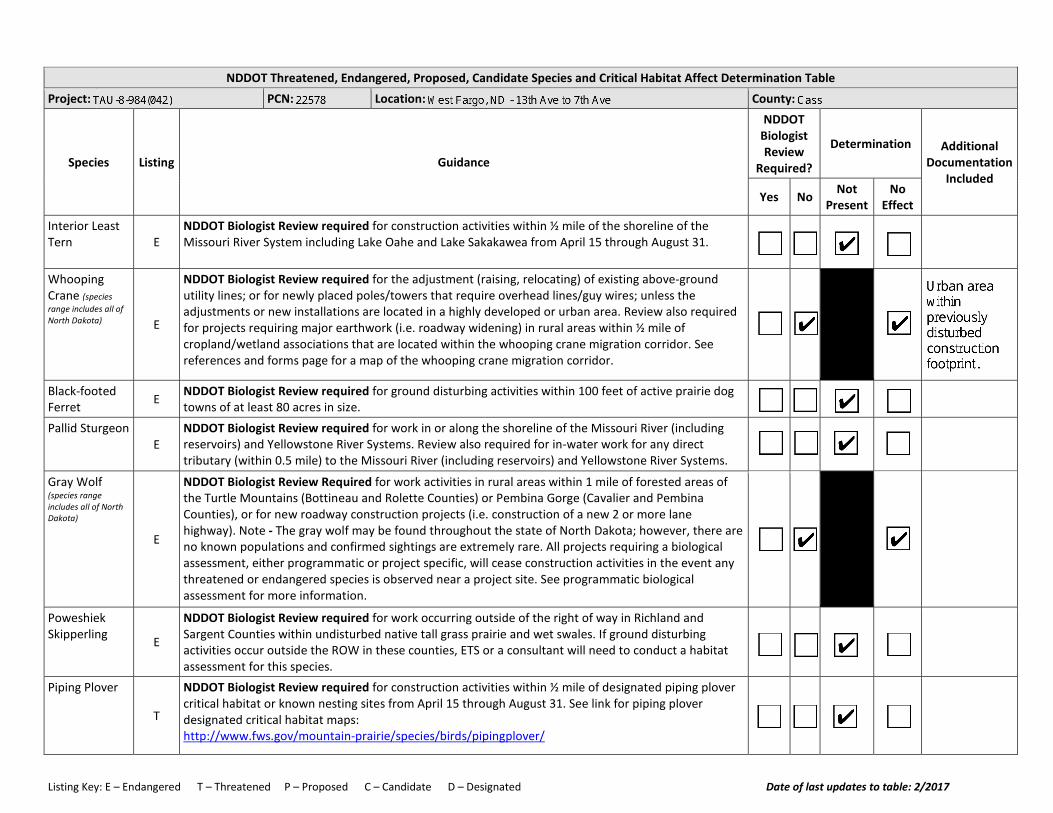
NDDOT Threatened, Endangered, Proposed, Candidate Species and Critical Habitat Affect Determination Table Project: PCN: Location: County:
Species Listing Guidance
NDDOT Biologist Review
Required?
Determination Additional Documentation
Included Yes No Not
Present No
Effect Interior Least Tern E
NDDOT Biologist Review required for construction activities within ½ mile of the shoreline of the Missouri River System including Lake Oahe and Lake Sakakawea from April 15 through August 31.
Whooping Crane (species range includes all of North Dakota) E
NDDOT Biologist Review required for the adjustment (raising, relocating) of existing above-ground utility lines; or for newly placed poles/towers that require overhead lines/guy wires; unless the adjustments or new installations are located in a highly developed or urban area. Review also required for projects requiring major earthwork (i.e. roadway widening) in rural areas within ½ mile of cropland/wetland associations that are located within the whooping crane migration corridor. See references and forms page for a map of the whooping crane migration corridor.
Black-footed Ferret E NDDOT Biologist Review required for ground disturbing activities within 100 feet of active prairie dog
towns of at least 80 acres in size.
Pallid Sturgeon E
NDDOT Biologist Review required for work in or along the shoreline of the Missouri River (including reservoirs) and Yellowstone River Systems. Review also required for in-water work for any direct tributary (within 0.5 mile) to the Missouri River (including reservoirs) and Yellowstone River Systems.
Gray Wolf (species range includes all of North Dakota)
E
NDDOT Biologist Review Required for work activities in rural areas within 1 mile of forested areas of the Turtle Mountains (Bottineau and Rolette Counties) or Pembina Gorge (Cavalier and Pembina Counties), or for new roadway construction projects (i.e. construction of a new 2 or more lane highway). Note - The gray wolf may be found throughout the state of North Dakota; however, there are no known populations and confirmed sightings are extremely rare. All projects requiring a biological assessment, either programmatic or project specific, will cease construction activities in the event any threatened or endangered species is observed near a project site. See programmatic biological assessment for more information.
Poweshiek Skipperling E
NDDOT Biologist Review required for work occurring outside of the right of way in Richland and Sargent Counties within undisturbed native tall grass prairie and wet swales. If ground disturbing activities occur outside the ROW in these counties, ETS or a consultant will need to conduct a habitat assessment for this species.
Piping Plover
T
NDDOT Biologist Review required for construction activities within ½ mile of designated piping plover critical habitat or known nesting sites from April 15 through August 31. See link for piping plover designated critical habitat maps: http://www.fws.gov/mountain-prairie/species/birds/pipingplover/
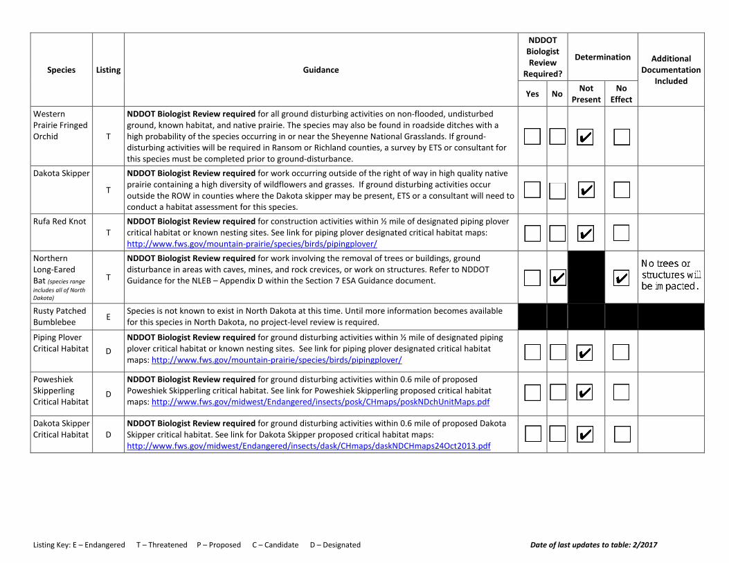
Listing Key: E – Endangered T – Threatened P – Proposed C – Candidate D – Designated Date of last updates to table: 2/2017
Species Listing Guidance
NDDOT Biologist Review
Required?
Determination Additional Documentation
Included Yes No Not
Present No
Effect Western Prairie Fringed Orchid T
NDDOT Biologist Review required for all ground disturbing activities on non-flooded, undisturbed ground, known habitat, and native prairie. The species may also be found in roadside ditches with a high probability of the species occurring in or near the Sheyenne National Grasslands. If ground-disturbing activities will be required in Ransom or Richland counties, a survey by ETS or consultant for this species must be completed prior to ground-disturbance.
Dakota Skipper
T
NDDOT Biologist Review required for work occurring outside of the right of way in high quality native prairie containing a high diversity of wildflowers and grasses. If ground disturbing activities occur outside the ROW in counties where the Dakota skipper may be present, ETS or a consultant will need to conduct a habitat assessment for this species.
Rufa Red Knot T
NDDOT Biologist Review required for construction activities within ½ mile of designated piping plover critical habitat or known nesting sites. See link for piping plover designated critical habitat maps: http://www.fws.gov/mountain-prairie/species/birds/pipingplover/
Northern Long-Eared Bat (species range includes all of North Dakota)
T
NDDOT Biologist Review required for work involving the removal of trees or buildings, ground disturbance in areas with caves, mines, and rock crevices, or work on structures. Refer to NDDOT Guidance for the NLEB – Appendix D within the Section 7 ESA Guidance document.
Rusty Patched Bumblebee E
Species is not known to exist in North Dakota at this time. Until more information becomes available for this species in North Dakota, no project-level review is required.
Piping Plover Critical Habitat D
NDDOT Biologist Review required for ground disturbing activities within ½ mile of designated piping plover critical habitat or known nesting sites. See link for piping plover designated critical habitat maps: http://www.fws.gov/mountain-prairie/species/birds/pipingplover/
Poweshiek Skipperling Critical Habitat
D
NDDOT Biologist Review required for ground disturbing activities within 0.6 mile of proposed Poweshiek Skipperling critical habitat. See link for Poweshiek Skipperling proposed critical habitat maps: http://www.fws.gov/midwest/Endangered/insects/posk/CHmaps/poskNDchUnitMaps.pdf
Dakota Skipper Critical Habitat D
NDDOT Biologist Review required for ground disturbing activities within 0.6 mile of proposed Dakota Skipper critical habitat. See link for Dakota Skipper proposed critical habitat maps: http://www.fws.gov/midwest/Endangered/insects/dask/CHmaps/daskNDCHmaps24Oct2013.pdf


Drain 45 Multi-Use Path Phase One
U.S. Fish and Wildlife Service, National Standards and Support Team,[email protected]
WetlandsEstuarine and Marine DeepwaterEstuarine and Marine Wetland
Freshwater Emergent WetlandFreshwater Forested/Shrub WetlandFreshwater Pond
LakeOtherRiverine
December 2, 2019
0 0.25 0.50.125 mi
0 0.35 0.70.175 km
1:14,435
This page was produced by the NWI mapperNational Wetlands Inventory (NWI)
This map is for general reference only. The US Fish and Wildlife Service is not responsible for the accuracy or currentness of the base data shown on this map. All wetlands related data should be used in accordance with the layer metadata found on the Wetlands Mapper web site.
0
CITY OF WEST FARGO DRAIN 45 MULTI-USE PATH PHASE ONE WEST FARGO PUBLIC WORKS
2019
TRANSPORTATION ALTERNATIVE PROGRAM APPLICATION
WEST FARGO PUBLIC WORKS | 810 12th Avenue NW, West Fargo ND 58078
Exhibit 4CITY OF WEST FARGO
Drain 45 Multi-Use Path
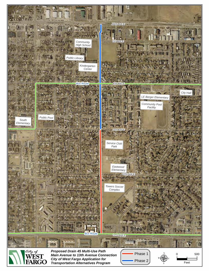
Phase One Main Avenue to 13th Avenue Connection
Phase One – 7th Avenue to 13th Avenue

1
CITY OF WEST FARGO DRAIN 45 MULTI-USE PATH PHASE ONE WEST FARGO PUBLIC WORKS
1. Project Name Drain 45 Multi-Use Path; Main Avenue to 13th Avenue Connection - Phase One
2. Project Location
On the enclosed portion of Drain 45 (4th St E.) from Main Avenue to 13th Avenue East. Please refer to the attached map. Phase one will consist of the portion between 13th Ave E. and 7th Ave E. Phase Two will consist of the portion between 7th Ave E and Main Ave E to be completed at a later date.
3. Project Contact
West Fargo Public Works
4. Contact Person
Chris Brungardt, Director West Fargo Public Works 810 12th Avenue Northwest West Fargo ND 58078 701.433.5400 [email protected]
5. Project Sponsor
City of West Fargo
6. Sponsoring Official
Chris Brungardt, Director West Fargo Public Works 810 12th Avenue Northwest West Fargo ND 58078 701.433.5400 [email protected]
7. Project Description
The City of West Fargo believes there is a need for a North/South bikeway route between 9th Street East and 8th Street West, a full 1 ½ miles. A storm water project was completed to enclose drain 45 using an arch culvert. This storm water project was designed in a manner to allow for a future bikeway to be constructed on top. A multi-use path at this location would provide a connection between the two arterial corridors of Main Avenue and 13th Avenue

2
CITY OF WEST FARGO DRAIN 45 MULTI-USE PATH PHASE ONE WEST FARGO PUBLIC WORKS
through residential neighborhoods providing access to many users with close proximity to numerous schools, public and recreational facilities, and commerce.
8. Project Cost
The total opinion of probable cost for construction of this Phase One is $324,775. Cost breakdown as proposed under an 80% Federal and 20% local funding ratio would be $259,820
Federal share and $64,955 local share. The detailed estimate completed by Dustin Scott of Moore Engineering is attached. All planning, preliminary engineering, and construction engineering will be paid with local funds.
9. What TAP category best fits your project?
A. Construction of on-road and off-road trail facilities for pedestrians, bicyclists, and other non-motorized forms of transportation, including sidewalks, bicycle infrastructure, pedestrian and bicycle signals, traffic calming techniques, lighting and other safety-related infrastructure, and transportation projects to achieve compliance with the Americans with Disabilities Act of 1990.
10. Supporting Data
1. Is your project part of an identified recreation or transportation plan? If so, explain.
This project is identified in the 2016 Fargo-Moorhead Metropolitan Bicycle and is being included in the West Fargo Comprehensive Plan – West Fargo 2.0.
2. Is your project tied to another project? If so, please explain.
No 3. How does your project fit with similar projects in your community and/or region?
This project would provide increased options for mobility and access to trails and park amenities throughout town.
4. Provide documentation of governmental agencies that are in support of this project. Letters of support from City of West Fargo and West Fargo Park District are attached. 11. Public Accessibility
This project is proposed to be constructed within city owned and maintained property. It will access several other existing bikeways on Main, 4th, 7th, and 13th Avenues East.
12. Matching Funds Provided By
City of West Fargo will be providing the matching funds for this project.
13. Will Right of Way For This Project Be Needed?
No additional property or right of way will be needed for this project.

3
CITY OF WEST FARGO DRAIN 45 MULTI-USE PATH PHASE ONE WEST FARGO PUBLIC WORKS
14. Maintenance of This Project Will Be Provided By:
West Fargo Public Works will be responsible for providing maintenance of this project.
15. Environmental Impacts
Land Use – No impact. Farmland – No impact. Social – positive impacts through the reinforcement of livable walkable neighborhoods
and encouragement of an active healthy lifestyle. Economic – No impact. Relocation – No impact. Wetlands – Impact during construction expected to be minimal. City is prepared to
obtain necessary clearance and permitting if necessary. Flood plain – No impact – City is prepared to obtain necessary clearance and
permitting if necessary. Threatened or Endangered Species – No impact. Cultural Resources – No impact. Hazardous Waste – No impact.
16. Signatures
Contact Person / Responsible Official
Chris Brungardt, Director West Fargo Public Works Date
MPO Official
Michael Maddox, Interim Director FM Metro COG Date
LE Berger Elementary
Public Library
Eastwood Elementary
Community PoolFacility
Community High School
Kindergarten Center
Public PoolSouth
Elementary
Service ClubPark
Towers SoccerComplex
City Hall
1ST AVE E
4TH AVE E
10TH AVE E
7TH AVE E
13TH AVE E
MAIN AVE E
Bus Route
Bus Route
0 500
Feet
Phase 1
Phase 2
Proposed Drain 45 Multi-Use PathMain Avenue to 13th Avenue ConnectionCity of West Fargo Application forTransportation Alternatives Program

IMPROVEMENT PROJECT NO. 17631B
Drain 45 Multi Use Path 7th to 13th Avenue East
WEST FARGO ND
Engineer's Opinion of Probable Cost
ITEM UNIT QUANTITY UNIT PRICE TOTAL
7TH AVENUE EAST TO 13TH AVENUE EAST
1. Temporary Haul Road SY 4,350 $8.00 $34,800.00
2. Curb & Gutter - Remove LF 90 $5.00 $450.00
3. Curb & Gutter LF 90 $20.00 $1,800.00
4. Curb Ramp - 6" Concrete Each 6 $350.00 $2,100.00
5. Detectable Warning Panel SF 120 $40.00 $4,800.00
6. Multi-Use Path - 5" Concrete SY 3,000 $60.00 $180,000.00
7. Sign Each 6 $250.00 $1,500.00
8. Striping - 24" White Grooved Plastic LF 160 $30.00 $4,800.00
9. Cleaning LSum 1 $3,000.00 $3,000.00
10. Storm Water Management LSum 1 $3,000.00 $3,000.00
11. Traffic Control LSum 1 $3,000.00 $3,000.00
12. Inlet Protection Device Each 15 $100.00 $1,500.00
13. Sedimentation Control Fence LF 1,000 $3.00 $3,000.00
14. Rock Construction Entrance Each 3 $1,000.00 $3,000.00
15. Topsoil Stripping - 6" CY 10,000 $4.00 $40,000.00
16. Seeding - Type II SY 5,000 $0.30 $1,500.00
17. Mulch - Type B - Hydromulch SY 5,000 $0.40 $2,000.00
18. Mowing Each 5 $500.00 $2,500.00
19. Watering Each 5 $500.00 $2,500.00
Construction Subtotal $295,250.00
Contingencies $29,525.00
Total Construction $324,775.00
Engineering $35,725.25
Legal & Administration $32,477.50
TOTAL PROJECT $392,977.75
C:\Users\tim.solberg\AppData\Local\Microsoft\Windows\Temporary Internet Files\Content.Outlook\0IP9KXON\17631B -Amended Opinion of Cost -Drain 45 - 7th - 13th
segment 2