agencies’ response to drm pilot eo data requirements ivan petiteville (esa, chair wgdisasters)...
TRANSCRIPT

Agencies’ response to DRM pilot EO data requirementsIvan Petiteville (ESA, Chair WGDisasters)Stéphane Chalifoux (CSA, Vice-Chair WGDisasters)Andrew Eddy (Secretary, WGDisasters)
CEOS Action 27-11CEOS SIT-29 MeetingCNES, Toulouse, France9th-10th April 2014
SIT-29 MeetingCNES, Toulouse, France9th-10th April 2014
2
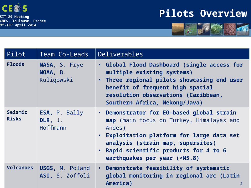
Pilots Overview
Pilot Team Co-Leads Deliverables
Floods NASA, S. FryeNOAA, B. Kuligowski
• Global Flood Dashboard (single access for multiple existing systems)
• Three regional pilots showcasing end user benefit of frequent high spatial resolution observations (Caribbean, Southern Africa, Mekong/Java)
Seismic Risks
ESA, P. BallyDLR, J. Hoffmann
• Demonstrator for EO-based global strain map (main focus on Turkey, Himalayas and Andes)
• Exploitation platform for large data set analysis (strain map, supersites)
• Rapid scientific products for 4 to 6 earthquakes per year (>M5.8)
Volcanoes USGS, M. Poland ASI, S. Zoffoli
• Demonstrate feasibility of systematic global monitoring in regional arc (Latin America)
• Develop new EO-based monitoring products at supersites
• Real-time in-depth monitoring of one ‘100-year’ category major eruption
2

SIT-29 MeetingCNES, Toulouse, France9th-10th April 2014
Develop flood monitoring products for flood mitigation, warning, response and recovery in the Caribbean/Central America, Southern Africa and Southeast Asia. Use these regional pilots to validate/calibrate lower resolution global flood products and to develop capacity in region.
Target areas for Flood Pilot EO data
SIT-29 MeetingCNES, Toulouse, France9th-10th April 2014
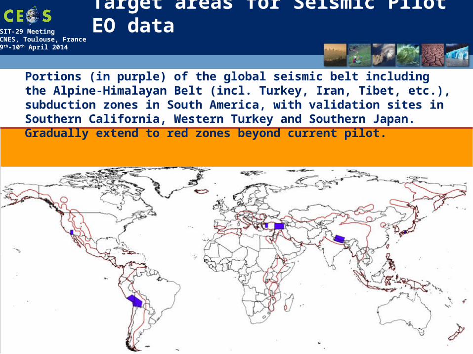
Target areas for Seismic Pilot EO data
Portions (in purple) of the global seismic belt including the Alpine-Himalayan Belt (incl. Turkey, Iran, Tibet, etc.), subduction zones in South America, with validation sites in Southern California, Western Turkey and Southern Japan. Gradually extend to red zones beyond current pilot.
SIT-29 MeetingCNES, Toulouse, France9th-10th April 2014
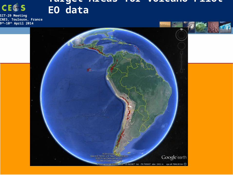
Target Areas for Volcano Pilot EO data

SIT-29 MeetingCNES, Toulouse, France9th-10th April 2014
Response to Pilots: Strategic EO Data Acquisition Plan
6
• Detailed EO Requirements for each pilot approved at last Plenary• Pilot definition included types of data required, frequency of
observations and polygons of interest, etc
• Pilot EO Requirements submitted to Data Coordination Team made up of representatives from CEOS agencies
• Assessment of EO Requirements between last Plenary and SIT-29 by each individual agency• Agencies’ responses analysed and consolidated by Data
Coordination Team and pilot Leads. (WGDisasters meeting # 1, Montreal 17-19 March)
• Analysis included trade-offs between pilots (e.g. Pleiades data to be used in priority for volcanoes and seismic hazards), synergies across pilots (volcanoes and seismic hazards) and possible overlaps with other major initiatives (GEOGLAM, GFOI in S-E Asia, Supersites)

SIT-29 MeetingCNES, Toulouse, France9th-10th April 2014
Analysis from Space Agencies

SIT-29 MeetingCNES, Toulouse, France9th-10th April 2014
Data Contributions* from CEOS Agencies (1/3)
8
CEOS Agency Flood Pilot Seismic Pilot Volcano Pilot
ASIProposed contribution under review.
Approximately 300 CSK images/year/pilot over three years, in addition to existing GSNL commitments. Priority given to archived imagery.
NRT images for rapid science products under Flood Objective B, Seismic Objective C (1-2 events/year) and Volcanic Objective C (1 major eruption) to be
evaluated on case by case basis.
CNESNRT imagery request being discussed with commercial partner
SPOT World Heritage Archive made available to pilots (1000s of SPOT-5 archived images) with five-year rolling buffer. Up to 50 Pleiades images/year/pilot over three years. Commitment to be finalized after discussions with industrial partner. Night-
time SPOT-5 imagery during 2014. ANR KalHaiti data base over Haiti.
CSAReview against commercial conflict required.
About 500 RSAT-2 products to support the Flood Pilot until November 2016 (end of the Pilot). More than 400 RSAT-2 products to support GSNL i.e. Hawaii (ongoing)
and Iceland (in negotiation with MDA). Potential access to Volcano Watch Background Mission over Latin America (archived RADARSAT-2 products). Data for rapid science products for Seismic and Volcano Pilots evaluated on case-by-case basis: contribution of 40 RSAT-2 products for Event Supersite: Sinabung
Volcano, Indonesia.
*contributions are in addition to existing GSNL contributions and International Charter data made available during or after activation

SIT-29 MeetingCNES, Toulouse, France9th-10th April 2014
Data Contributions* from CEOS Agencies (2/3)
9
CEOS Agency Flood Pilot Seismic Pilot Volcano Pilot
ESASentinel-1 launch April 2014. Six months commissioning. Sentinel-2, SMOS.
Sentinel-1 gradually made available starting with pilot targets in 2014 when these
converge with baseline observing strategy. +20000 scenes over Italy, Japan,
California, Turkey & Greece the first year
overall for 3 pilots
Sentinel-1 gradually made available starting with pilot
targets in 2014 and with the goal to cover priority areas
of Objective A for 2016 – 10s of 1000s of images
Sentinel-1 gradually made available starting with
pilot targets in 2014 and with the goal to cover
priority areas of Objective A for 2016, especially
when these converge with seismic areas
DLRProposed contribution under review. Review against commercial conflict required.
200 TSX scenes over three years; access to TanDEM Elevation Model without data transfer (through
viewer) being considered
Assessment of validation areas and data volumes (Objective A) under way.
Possible access to TanDEM Elevation Model without data
transfer being considered.
400 TSX scenes over three years (under Obj.
A); contribution to Obj. C to be evaluated after eruption; access to
TanDEM Elevation Model for erupting volcano being
considered.
JAXAProposed contribution under review. ALOS-2 launch May 2014.
100 ALOS-2 products/year/pilot made available for promotion/demonstration; additional data available at marginal cost of $100/scene; barter arrangements for further data
requests under review. Acquisitions requested are covered by ALOS-2 Basic Observation Scenario
*contributions are in addition to existing GSNL contributions and International Charter data made available during or after activation
SIT-29 MeetingCNES, Toulouse, France9th-10th April 2014
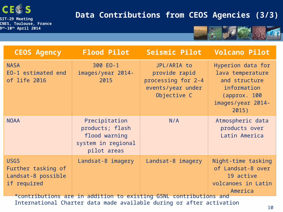
Data Contributions from CEOS Agencies (3/3)
10
CEOS Agency Flood Pilot Seismic Pilot Volcano Pilot
NASAEO-1 estimated end of life 2016
300 EO-1 images/year 2014-2015
JPL/ARIA to provide rapid processing for 2-4
events/year under Objective C
Hyperion data for lava temperature and
structure information (approx. 100
images/year 2014-2015)
NOAA Precipitation products; flash flood warning
system in regional pilot areas
N/A Atmospheric data products over Latin
America
USGSFurther tasking of Landsat-8 possible if required
Landsat-8 imagery Landsat-8 imagery Night-time tasking of Landsat-8 over 19 active
volcanoes in Latin America
*contributions are in addition to existing GSNL contributions and International Charter data made available during or after activation
SIT-29 MeetingCNES, Toulouse, France9th-10th April 2014
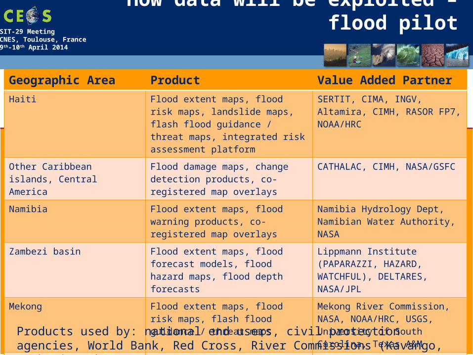
How data will be exploited – flood pilot
Geographic Area Product Value Added PartnerHaiti Flood extent maps, flood risk maps,
landslide maps, flash flood guidance / threat maps, integrated risk assessment platform
SERTIT, CIMA, INGV, Altamira, CIMH, RASOR FP7, NOAA/HRC
Other Caribbean islands, Central America
Flood damage maps, change detection products, co-registered map overlays
CATHALAC, CIMH, NASA/GSFC
Namibia Flood extent maps, flood warning products, co-registered map overlays
Namibia Hydrology Dept, Namibian Water Authority, NASA
Zambezi basin Flood extent maps, flood forecast models, flood hazard maps, flood depth forecasts
Lippmann Institute (PAPARAZZI, HAZARD, WATCHFUL), DELTARES, NASA/JPL
Mekong Flood extent maps, flood risk maps, flash flood guidance / threat maps
Mekong River Commission, NASA, NOAA/HRC, USGS, University of South Carolina, Texas A&M
Java (Bandung, Jakarta, Cilacap)
Flood risk maps, subsidence maps tied to flood risk, tsunami risk maps (Cilacap only), flood extent maps
SERTIT, Deltares, CIMA, Altamira, INGV, RASOR FP7
Products used by: national end users, civil protection agencies, World Bank, Red Cross, River Commissions (Kavango, Zambezi, Mekong)
SIT-29 MeetingCNES, Toulouse, France9th-10th April 2014
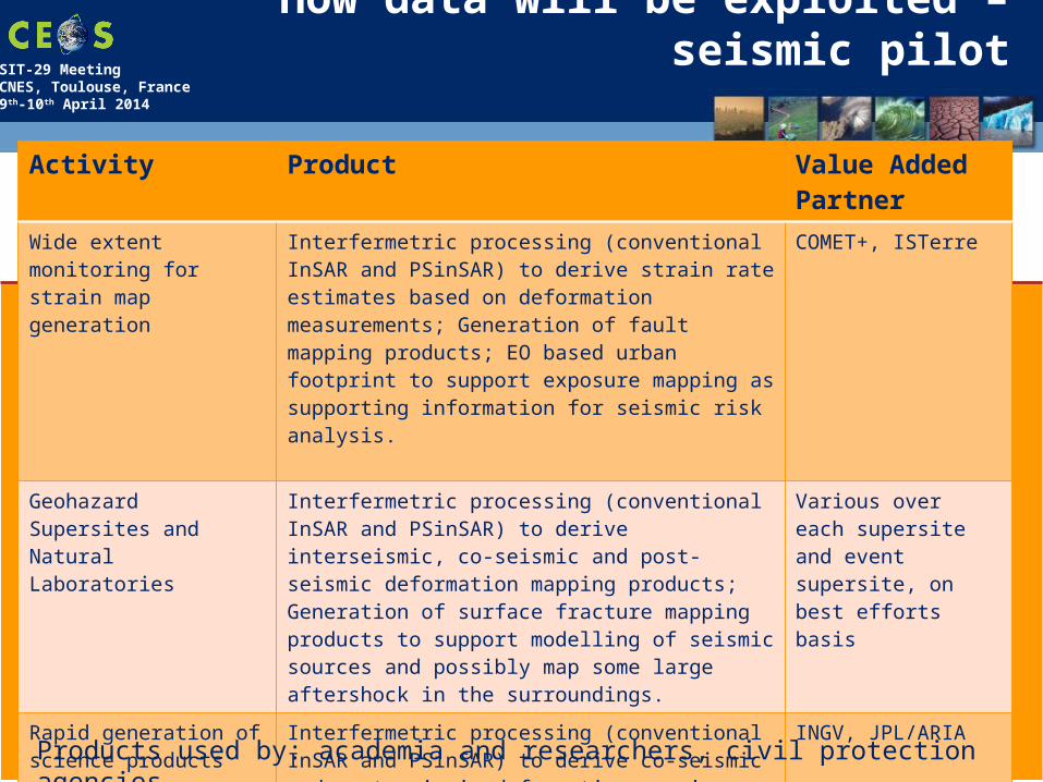
How data will be exploited – seismic pilot
Activity Product Value Added Partner
Wide extent monitoring for strain map generation
Interfermetric processing (conventional InSAR and PSinSAR) to derive strain rate estimates based on deformation measurements; Generation of fault mapping products; EO based urban footprint to support exposure mapping as supporting information for seismic risk analysis.
COMET+, ISTerre
Geohazard Supersites and Natural Laboratories
Interfermetric processing (conventional InSAR and PSinSAR) to derive interseismic, co-seismic and post-seismic deformation mapping products; Generation of surface fracture mapping products to support modelling of seismic sources and possibly map some large aftershock in the surroundings.
Various over each supersite and event supersite, on best efforts basis
Rapid generation of science products
Interfermetric processing (conventional InSAR and PSinSAR) to derive co-seismic and post-seismic deformation mapping products; Generation of surface fracture mapping products to support modelling of seismic sources and possibly map some large aftershock in the surroundings.
INGV, JPL/ARIA
Products used by: academia and researchers, civil protection agencies…

SIT-29 MeetingCNES, Toulouse, France9th-10th April 2014
How data will be exploited – volcano pilot
Activity Product Value Added Partner
Regional volcanic monitoring in Latin America
Terrain deformation products over 300 volcanoes to identify unsuspected activity; weekly monitoring of 19 active volcanoes; thermal anomaly detection; atmospheric products during eruptions; ash dispersal and ash cover maps.
Bristol University, Cornell University, Open University, NOAA, Buenos Aires and Washington VAACS
Development of new methodologies and products for intensive monitoring over supersites
Using GSNL data collects over the volcano supersites, the CEOS pilot will develop and validate new monitoring protocols for active volcanoes and generate products that could be used for global monitoring of holocene volcanoes after the pilot period.
USGS, INGV, University of Iceland
Major volcano eruption 2014-2016
Pre-event deformation products if data available over volcano selected, to examine retroactively the benefit of deformation mapping in precursor phaseCo- and Post-event deformationCo- and Post-event products for ground (ash cover, thermal monitoring etc.)Co- and Post-event atmospheric products (ash dispersal, SO2 monitoring etc.)
USGS/VDAP, Bristol, Cornell and others depending on eruption location
Products used by: national end users, civil protection agencies, volcanic observatories in Latin America, VAACS
SIT-29 MeetingCNES, Toulouse, France9th-10th April 2014
Response to Pilots: CONCLUSIONS
14
• Majority of contributions (open & free data) confirmed by Agencies. Some options still being worked (e.g. alternatives addressing some data policies constraints.• Main issue: data contributions are for R&D activity; should some
activities become operational after 2016, funding is required to ensure sustainability
• Consolidated response from space agencies very positive; volume of EO data & products confirmed is similar or greater to what was initially provided for Forest Carbon Tracking and for JECAM.
• Main objectives of each pilot can be reached with the firm contributions announced.
• On-going refinement for data; some specific imaging requirements being reconsidered given trade-offs between agencies: how to best exploit synergies?

SIT-29 MeetingCNES, Toulouse, France9th-10th April 2014
15
Decision
CEOS Plenary Action to WGDisasters: Prepare for approval the strategic data acquisition plan in response to the flood, seismic hazard, and volcano pilots’ EO requirements.
Requested decision: CEOS Principals are asked to endorse the strategic data acquisition plan prepared by the relevant CEOS Agencies, in response to the flood, seismic hazard, and volcano pilots’ EO requirements.