aecos no. 1150 - malama maunalua
TRANSCRIPT

AECOS No. 1150
Marine biological and water quality resources at
Hawai‘i Kai Marina, Hawai‘i Kai, O‘ahu
Prepared by:
AECOS, Inc. 45‐939 Kamehameha Hwy, Suite 104
Kāne‘ohe, Hawai‘i 96744‐3221
October 4, 2010

Marine biological and water quality resources at Hawaii Kai Marina, Hawai‘i Kai, O‘ahu1 October 4, 2010 AECOS No. 1150 Susan Burr AECOS, Inc. 45‐939 Kamehameha Hwy, Suite 104 Kāne‘ohe, Hawai‘i 96744 Phone: (808) 234‐7770 Fax (808) 234‐7775 Email: [email protected] Introduction
The Hawaii Kai Marina Community Association is proposing maintenance dredging at the Hawaii Kai Marina (Fig. 1). The project consists of two distinct activities: (1) dredge 10 areas within the marina to previously permitted depths and dispose of the dredged material; and (2) dredge the entrance channel to previously permitted depth and nourish an adjacent beach with the dredged sand. The following departmental approvals and permit applications will be required to conduct the project: Conservation District Use Permit (CDUP) from the Department of Land and Natural Resources‐Office of Coastal and Conservation Lands (DLNR‐OCCL), U.S. Department of Army Standard Individual Permit, Clean Water Act (CWA) Section 401 Water Quality Certification (WQC) from the Hawai‘i Department of Health‐Clean Water Branch (HDOH‐CWB), City and County of Honolulu Grading Permit, a federal consistency determination from the Department of Business, Economic Development and Tourism, Office of Planning, Coastal Zone Management Program (CZM), a Special Management Area (SMA) permit from the City and County of Honolulu‐Department of Land Utilization, a shoreline setback variance from the City and County of Honolulu‐Department of Land Utilization, and testing to show the dredged material meets the Special Waste criteria from the HDOH‐Solid and Hazardous Waste Branch
1 Report prepared for Anchor Environmental for use in the preparation of an Environmental
Assessment.

Biological and Water Quality Survey HAWAI‘I KAI, O‘AHU
AECOS, Inc. [FILE: 1150.DOC] Page | 3
(HDOH‐SHWB). An initial step of the permitting process is to prepare an Environmental Assessment (EA) to determine resources in the area and potential impacts of the project as proposed. This report describes existing marine biological resources and water quality of the marina and vicinity of the marina mouth in Maunalua Bay. This information will be used to assess the potential effects of the dredging project.
Figure 1. Island of O‘ahu showing location of Hawai‘i Kai Marina.
Background Information The reef and the shoreline of Maunalua Bay in the project vicinity have been extensively modified since the 1930s (WOA, 1988). Development of the Hawaii Kai Marina (marina) began in 1959 by modifying Kuapā Pond (USACE, 1975). Kuapā Pond itself was “created” by the ancient Hawaiians (legend has it, with the help of the menehune) by modifying an extensive wetland (Fig. 2; Kumu Pono Associates, 1998). The wetland system was created around 11,600 years ago by the flooding of a valley (older embayment) at the end of the last glacial period, with the rise in sea level resulting from worldwide glacial melt (Stearns, 1985). Erosion of the adjacent headlands led to a build‐up of sediment between

Biological and Water Quality Survey HAWAI‘I KAI, O‘AHU
AECOS, Inc. [FILE: 1150.DOC] Page | 4
the wetlands and Maunalua Bay, forming a barrier beach restricting water flow between the wetland and Maunalua Bay (Nixon, 1994).
Figure 2. Map of Kuapā Pond in the early 1900s (Fig. 5 from Kumu Pono
Associates, 1998).
The Early Hawaiians used the lagoon as a fish pond and built a stone wall to reinforce the naturally accreted barrier beach. They also created cuts in the wall which allowed water flow between the ocean and the lagoon. The fish ponds were considered private property by the Hawaiian government. In 1851, the pond covered 212 ha (523 ac; Kumu Pono, 1998). In 1921, the water area was 122 ha (301 ac) with swamp land occupying another 50.6 ha (125 ac; Kumu Pono, 1998). Today the marina is approximately 108 ha (268 ac), ranging in depth from 1.5 to 2.4 m (5 to 8 ft) below mean sea level (MSL; USACE, 1975).

Biological and Water Quality Survey HAWAI‘I KAI, O‘AHU
AECOS, Inc. [FILE: 1150.DOC] Page | 5
Maunalua Bay Maunalua Bay encompasses the area off the coast of O‘ahu between Koko Head and Diamond Head. The bay is lined by a fringing reef extending about 915 m (3,000 ft) offshore. Between the shore and reef margin is a low‐relief flat and seaward of the fringing reef is a wide shelf of sand bottom with scattered limestone outcrops. Water Quality AECOS (1979) noted that, even prior to dredging of Kuapā Pond to construct the marina, the nearshore waters of Maunalua Bay were turbid due to outflow of water from Kuapā Pond and the resuspension of fine material accumulated on the reef flat. Subsequent to the development of the pond into a marina, boat traffic has served to keep materials in suspension. Therefore, it was concluded that high particulate loading in the water column of the bay near the marina entrances has been the norm for at least 50 years (now closer to 80 years). The waters of Maunalua Bay between Paikō Peninsula and Koko Head are classified in the Hawai‘i Water Quality Standards (HDOH, 2009) as a Class A “embayment” and as a “Class II nearshore reef flat.” It is the objective of Class A waters that their use for recreational purposes and aesthetic enjoyment be protected. Other uses are permitted so long as it is compatible with the protection and propagation of fish, shellfish, and wildlife, and with recreation in and on these waters. Class A waters shall not act as receiving waters for any discharge which has not received the best degree of treatment or control. The Hawai‘i Department of Health (HDOH) monitors water quality in the bay at four nearshore stations (Fig. 3; 229‐Hawaii Kai, 279‐Maunalua Beach Park, 202‐Kuliouou Beach Park, and 277‐Paikō Beach) and three offshore stations (441, 442, and 443‐Maunalua Bay Ocean Monitoring Sites). Water quality samples were collected irregularly at these stations and data are available as follows: 229–May 1992 to October 2008, 279–July 2006 to November 2008, 202–May 1973 to November 2008, 277–July 2006 to November 2008, Maunalua Bay 441–October 1979 to October 1997, Maunalua Bay 442–January 1982 to October 1997, and Maunalua Bay 443–January 1983 to October 1997. Table 1 summarizes the results of these tests. No nutrient data are available for the nearshore stations. The nearshore stations in Table 1 have been arranged from east (Hawai‘i Kai) to west (Paikō Beach). Mean temperature is higher in the shallower waters of Stas. 229, 279, and 202 and may represent a greater effect of solar radiation. Mean

Biological and Water Quality Survey HAWAI‘I KAI, O‘AHU
AECOS, Inc. [FILE: 1150.DOC] Page | 6
salinity is lowest at Sta. 202, likely due to fresh water inputs from Kuli‘ou‘ou Stream. pH is fairly consistent at the four stations throughout the sampling period, with the greatest variation seen at Sta. 202, again, likely due to fresh water inputs from the stream. The mean percent saturation of dissolved oxygen (DO) at Sta. 277 is low. Geometric mean turbidity levels are very high at Stas. 229 and 279, quite high at Sta. 202, and elevated at Sta. 277.
Figure 3. Satellite image showing approximate locations of HDOH nearshore water quality sampling stations in Maunalua Bay near Hawai‘i Kai Marina
(USEPA, 2009).
Mean temperature, salinity, and pH at the Maunalua Bay offshore stations (Stas. 441, 442, and 443) are representative of open coastal and oceanic water, as are the low geometric mean turbidity levels. Mean salinities at these offshore stations are somewhat lower and mean pH levels are slightly higher compared with the nearshore means. The differences in salinity may reflect the effect of solar radiation in shallow water (reef flat) locations, resulting in heating effects and higher evaporation rates (leading to higher salinities) and the high turbidities measured at the nearshore stations are caused by the resuspension of fine materials on the reef flat. The higher and less variable pH levels of the offshore stations demonstrate the buffering properties of seawater. The

Biological and Water Quality Survey HAWAI‘I KAI, O‘AHU
AECOS, Inc. [FILE: 1150.DOC] Page | 7
concentrations of nutrients (nitrogen inorganics, total nitrogen, and total phosphorus) are low in the offshore waters, but the concentration of phytoplankton (as measured by chlorophyll α) is slightly elevated.
Table 1. A summary of selected water quality parameters for the waters of
Maunalua Bay (various dates between 1973 and 2008) near Hawai‘i Kai (data collected by HDOH; USEPA, 2009).
Shoreline Stations
Station Temp.
(ºC) Salinity
(psu) pH DO sat.
(%) Turbidity†
(NTU) Hawai‘i Kai 229
mean 25.0 34.5 8.0 83 9.0 range 21.35 - 26.69 15 - 36.45 7.65 - 8.18 60 - 110 3.33 - 24.4 count 48 304 32 31 29
Maunalua Beach Park 279 mean 24.8 34.6 8.0 77 10.3 range 22.59 - 26.92 27.2 - 36.18 7.8 - 8.28 65 - 92 3.85 - 32.4 count 11 11 11 11 11
Kuliouou Beach 202 mean 25.0 33.4 7.9 77 7.4 range 21 - 28 12.36 - 36.01 6 - 8.28 53 - 95 1.1 - 27 count 35 12 34 12 35
Paikō Beach 277 mean 24.2 35.3 8.0 68 3.9 range 21.46 - 26.75 32.68 - 36.9 7.56 - 8.23 44 - 94 1.46 - 11.1 count 31 31 31 30 31
Offshore Stations
Station Temp. (ºC)
Salinity (ppt)
pH Turbidity† (NTU)
TSS† (mg/L)
Maunalua Bay 441 mean 24.6 33.9 8.2 0.3 23 range 20 - 27.7 30 - 35.2 7.1 - 8.6 0.1 - 10 1 - 223 count 121 121 115 121 120
Maunalua Bay 442 mean 24.7 33.8 8.2 0.2 20 range 21 - 27.7 30.4 - 35.7 7.6- 8.5 0.1 - 2.8 1 - 187 count 109 109 105 109 108
Maunalua Bay 443 mean 24.5 33.9 8.2 0.2 17 range 21 - 27.8 28.5 - 37 7.6 - 8.5 0.1 - 2.8 0 - 192 count 96 96 93 96 95
† geometric mean

Biological and Water Quality Survey HAWAI‘I KAI, O‘AHU
AECOS, Inc. [FILE: 1150.DOC] Page | 8
Table 1 (continued). Offshore Stations
Station NO3+NO2†
(mg N/L)
NH4†
(mg N/L)
Total Nitrogen† (mg N/L)
Total Phosphorus †
(mg P/L) Chl α† (µg/L)
Maunalua Bay 441 mean 0.01 0.07 0.12 0.01 3.2 range 0 - 0.18 0 - 0.23 0 - 1.1 0.001 - 0.073 0 – 25 count 120 117 118 123 106
Maunalua Bay 442 mean 0.01 0.06 0.10 0.01 2.4 range 0 - 0.08 0 - 7 0.06 - 0.30 0.005 - 0.039 0 - 3.7 count 52 104 109 108 95
Maunalua Bay 443 mean 0.01 0.06 0.12 0.01 2.2 range 0 - 0.05 0 - 0.7 0 - 0.5 0.002 - 0.128 0 - 2.5 count 96 90 90 96 88
† geometric mean
Marine Biota Seaward of the reef off Maunalua Bay Beach Park, the bottom of Maunalua Bay is largely sand with scattered limestone outcrops. The limestone outcrops were surveyed for the proposed Maunalua Bay Ferry Terminal (Brock, 1988) and the following description is taken largely from that report. A limestone mound biotope commences approximately 900 m (2,953 ft) from shore in 3.5 m (11.5 ft) of water and extends seaward at least an additional 300 m (984 ft) to a depth of 6 m (20 ft) or more. The limestone outcrops range in size from 10 x 15 m (33 x 50 ft) to more than 30 x 80 m (98 x 262 ft). The patches are spaced from 30 to over 100 m (98 to 328 ft) apart and are separated by sand bottom. Benthic communities in this biotope are sparse; little shelter is available and sand scour is likely frequent. Coral cover on the limestone mounds was less than 4% and macroalgae coverage was less than 8%. Species of corals reported from this survey are Porites lobata, Pocillopora meandrina, Montipora capitata, M. patula, and Cyphastrea ocellina. The reef flats off Maunalua Bay Beach Park (located to the north of the entrance channel) and off Portlock Beach (located to the south) were surveyed by AECOS biologists in November 2007 and October 2009 (Fig. 4). Table 2 presents a list of organisms observed by AECOS biologists on the reef flat in these surveys.

Biological and Water Quality Survey HAWAI‘I KAI, O‘AHU
AECOS, Inc. [FILE: 1150.DOC] Page | 9
Figure 4. Areas surveyed (outlined by blue dashed lines)in channel and on
nearshore reef remnant November 2007 and October 2009; approximate area of seagrass bed (green) off Portlock Beach also shown.
Reef Flats off Maunalua Bay Beach Park and Portlock Beach ‐ The reef flat remnants off Maunalua Bay Beach Park and Portlock Bach are highly‐eroded, low‐relief limestone platforms. The shallow (less than 1 m or 3 ft) reef areas are covered with a veneer of sand and silt. Some sections are exposed at low tide. The benthic communities close to shore are highly disturbed and dominated by sessile filter and suspension feeding organisms. A study by ECI in 1975, cited in Brock (1988), found small colonies of the corals, Cyphastrea ocellina and Pocillopora damicornis, and abundant colonies of Porites compressa and P. lobata on the reef flat off Maunalua Bay Beach Park and Portlock Beach. The algae, Acanthophora spicifera was present in 1975, along

Biological and Water Quality Survey HAWAI‘I KAI, O‘AHU
AECOS, Inc. [FILE: 1150.DOC] Page | 10
with Dictyosphaeria cavernosa, which was growing along the boulders of the western edge of the entrance channel. In 1975, ECI indicated that algae growth approached 100% in some areas, dominated by Codium edule, Halimeda sp., and Enteromorpha sp. The 1975 study found 53 species of fish (dominated by Stethojulis balteata or ‘omaka), most associated with areas of high coral cover, particularly along the western edge of the entrance channel. In 1988, only a few very small colonies of Poc. damicornis, Porites compressa, and P. lobata were reported on the reef flat off Maunalua Bay Beach Park and Portlock Beach (Brock, 1988). A. spicifera was reported as present on the reef flat, along with 8 other algal species, but having a mean coverage of only 0.8%. The 1988 survey found five species of fish on the reef flat: Acanthurus triostegus, Foa brachygramma, Asterropteryx semipunctatus, and Pervagor spilosoma. In 2002 (Coles et al., 2002) found benthic cover on the reef flat off Portlock Beach to be an abundance of a non‐native alga, Avrainvillea amadelpha, growing in sand and on a small limestone outcrop supporting the coral, Pavona varians. Native seagrass, Halophila hawaiiana, was present. Today, the reef flat off Maunalua Bay Beach Park and Portlock Beach continues to be dominated by non‐indigenous algae, such as Acanthophora spicifera (most abundant), Avrainvillea amadelpha, and Lyngbya majuscule; Gracilaria salicornia is occasionally found. The algae grow on limestone rubble, easily rolled by waves and swells. Algal growth is most dense close to shore. Other algae present on the reef flat include species that are preferred (Arthur and Balazs, 2008) by green sea turtles (Chelonia mydas), such as Ulva fasciata, Hypnea cervicornis, Spyridia filamentosa, Cladophora catenata, and C. seriacea (as well as the abundant A. spicifera). A seagrass bed (Fig. 4), consisting of both the endemic Halophila hawaiiana and the introduced H. decipiens, is located off Portlock Beach. Seagrass is another important component of the diet of green sea turtle (Arthur and Balazs, 2008). Very few coral colonies are present on the reef flat, with the first colony appearing more than 100 m (330 ft) offshore. Coral colonies present include Montipora capitata, M. flabellata, Poc. damicornis, Poc. meandrina, P. compressa and P. lobata. Other reef macro‐invertebrates, such as brittle stars, sea urchins, and sea anemones, are relatively uncommon. Fish biomass and diversity are very low in the nearshore areas of low relief bottom. Fifteen species of fishes were observed on the reef flat. Arothron hispidus (o‘opu hue or stripebelly puffer) and Acanthurus nigrofuscus (mā‘i‘i‘i or brown surgeonfish) are common, while Abudefduf abdominalis (mamo or Hawaiian sergeant) and Acanthurus blochii (pualu or ringtail surgeonfish) are seen occasionally.

Biological and Water Quality Survey HAWAI‘I KAI, O‘AHU
AECOS, Inc. [FILE: 1150.DOC] Page | 11
Paikō Peninsula and Lagoon ‐ West of the marina is Paikō Peninsula and Lagoon (Fig. 3). The peninsula is a barrier spit built by sand and rubble transported eastward along the inner reef flat (WOA, 1998). The spit shelters the lagoon, an important habitat for various shorebirds. Paikō Lagoon is designated as a wildlife sanctuary by the Hawai‘i Department of Land and Natural Resources (HDLNR, 2009). Consisting of all state‐owned land adjacent to Paikō Lagoon and water areas within Paikō Lagoon (approximately 13.4 ha or 33 ac), the sanctuary provides the only protected waterbird habitat on the Maunalua Bay coast. Portions of Paikō Peninsula are within the conservation district pursuant to Hawai‘i Land Use Law (Chapter 205, HRS), whereas a small section in the middle is within the urban district. Paikō Lagoon, formerly a coastal fishpond, is fed by a freshwater springs and Kuli‘ou‘ou Stream. The tidal flats of the lagoon are used by shorebirds for foraging at low tide. Paikō Lagoon wildlife sanctuary provides a permanent sanctuary to the endangered Hawaiian stilt (a‘eo), as well as migratory shore birds, including golden‐plovers, turnstones, and tattlers (Engilis and Naughton, 2002). Benthic invertebrates found in Paikō Lagoon include: crabs (Ocypodidae, Graspus graspus, Thalamita crenata, Charybdis hawaiiensis, Macropthalamus telescopis), alpheid shrimps, and polychaete worms. The lagoon supports blenny (Istiblennius gibbifrons), goby (Bathygobius fuscus), āholehole (Kuhlia sandvicensis), mollies (Mollienesia latipinna), mullet (Mugil cephalus), and awa (Chanos chanos; USACE, 1975). Kuli‘ou‘ou Beach ‐ Kuli‘ou‘ou Beach is situated between Paikō Lagoon and the channel to the west arm of the marina. It is largely a mudflat covering an old fringing reef (WOA, 1988). A dredged channel connects Kuli‘ou‘ou Stream with the entrance channel to the marina. Kuli‘ou‘ou Beach is within the urban district pursuant to Hawai‘i Land Use Law (Chapter 205, HRS). In the channel outside Paikō Lagoon, Coles et al. (2002) found a consolidated limestone reef flat outside of a sand channel. The reef flat supported abundant growth of non‐native algae: mostly Gracilaria salicornia, Hypnea musciformis, and Avrainvillea amadelpha. Native seagrass (Halophila hawaiiana) was sparse, and a few propagules of Rhizophora mangle mangrove were present. Maunalua Bay Beach Park ‐ Maunalua Bay Beach Park (Fig. 4) was created in the 1960s from the dredged material resulting from dredging of the west channel to the marina and a connecting channel just off the shore. Presently, the shore is a mix of coral rubble, silt, and sand. A boat launching ramp is located at the eastern end of the park and a 183‐m (600‐ft) rock revetment lines the west end of the park. The nearshore channel is approximately 45 m (148 ft)

Biological and Water Quality Survey HAWAI‘I KAI, O‘AHU
AECOS, Inc. [FILE: 1150.DOC] Page | 12
in width and 2.5 m (8.2 ft) in depth. Presently, this channel serves as a collection point for the discharge of freshwater and terrigenous materials from Paikō Lagoon, Kuli‘ou‘ou Stream, and the west channel into the marina (Brock, 1988). A description of the fringing reef off the beach park is provided above (p. 8 to 9). Maunalua Bay Beach Park is within the urban district pursuant to Hawai‘i Land Use Law (Chapter 205, HRS). Portlock Beach ‐ Portlock Beach lies directly east of the main entrance channel to the marina (Fig. 5) and is a 650‐m (2,140‐ft) long, narrow sand beach. Portlock Beach is within the urban district pursuant to Hawai‘i Land Use Law (Chapter 205, HRS). Inland of the beach is an upscale residential area. Beyond Portlock Beach, towards Kawaihoa Point (Koko Head), the shoreline is artificially stabilized with revetments and seawalls and by low cliffs and benches cut in the tuff of the headland. The sand on Portlock Beach is actively eroding; longshore currents move the sand westward into the marina entrance channel. The main portion of Portlock Beach is presently receding at ‐0.17 +0.11 m/yr (‐0.56 +0.35 ft/yr; Coastal Geology Group, 2009). The nearshore bottom immediately off Portlock Beach is sand with occasional coral rubble. No fish, corals, or large invertebrates inhabit this area, although sea urchins and burrows of small invertebrates are present. A description of the fringing reef off this beach is provided above (p. 8 to 9).
Marina Entrance Channel
According to WOA (1988), when Kalaniana‘ole Highway was built in the late 1930s, the main entrance channel from Kuapā Pond to Maunalua Bay was widened to 12 m (40 ft) and another channel to the west arm of the marina constructed to provide better water exchange. The entrance channel was built at a natural break in the reef, probably a drainage channel for the brackish water of Kuapā Pond initially formed during a lower stand of the sea (AECOS, 1979). The entrance channel was again dredged in the 1940s to facilitate landing craft operations and to service the military installation during World War II. As part of the development of the Hawai‘i Kai community, the entrance channel was widened to 76 m (250 ft) and dredged to 1.9 m (6.2 ft) to accommodate potential runoff from a 100‐year storm (PODCO Permit 820D issued 04/14/67). At that time, an access channel from Kuli‘ou‘ou Stream to the entrance channel was dredged parallel to the shore and the second channel to the west arm of the marina was dredged. The material from this dredging project was used to construct Maunalua Bay Beach Park and the boat launching area. Since the 1960s, the entrance channel has largely filled in and, despite

Biological and Water Quality Survey HAWAI‘I KAI, O‘AHU
AECOS, Inc. [FILE: 1150.DOC] Page | 13
maintenance dredging once every ten years, now more closely resembles the 12 m‐ (40 ft‐) wide channel that was first created in the 1930s.
Figure 5. Portlock Beach looking northwest towards the main entrance channel to
the Hawaii Kai Marina (under highway bridge).
Biota The bottom of the entrance channel consists largely of shifting sands and silt and does not provide suitable habitat for most reef organisms. Table 2 presents a list of organisms observed in the entrance channel in the November 2007 and October 2009 surveys made by AECOS biologists. The hard surfaces, such as areas where the channel bisects the reef flat and concrete pilings of the bridge, are colonized by a variety of flora and fauna, primarily introduced fouling organisms. The pilings, in particular, are heavily covered with Carijoa riisei, an introduced octocoral, and Amathia distans (bushy bryozoan). Gracilaria salicornia (gorilla ogo), an introduced red alga, is also attached to the pilings. Dascyllus albisella (‘alo‘ilo‘i or Hawaiian domino damselfish), Acanthurus triostegus (manini or convict tang), Forcipiger flavissimus (lauwiliwili

Biological and Water Quality Survey HAWAI‘I KAI, O‘AHU
AECOS, Inc. [FILE: 1150.DOC] Page | 14
nukunuku‘oi‘oi or yellow longnose butterflyfish), and juvenile wrasses (Labridae family) were observed in the entrance channel in the recent surveys.
Table 2. Checklist of organisms observed in the main entrance channel to Hawaii Kai
Marina and on the adjacent reef flat in November 2007 and October 2009.
PHYLUM, CLASS, ORDER, FAMILY Genus species Common name Abundance Status Location BLUE‐GREEN ALGAE CYANOPHYTA Lyngbya majuscula C Ind. REEF ALGAE RHODOPHYTA Anotrichium tenue O Ind. REEF Acanthophora spicifera limu ‘aki‘aki A Ind. REEF Avrainvillea amadelpha leather mudweed C Nat. REEF Gracilaria parvispora R End. REEF Gracilaria salicornia gorilla ogo O Nat. REEF Galaxaura rugosa R Ind. REEF Gelidium pluma R End. CHAN. Hydrolithon reinboldii O Ind. REEF Hypnea cervicornis O Ind. REEF Hypnea musciformis hookweed R Ind. REEF Spyridia filamentosa R Ind. REEF Spirocladia hodgsoniae O End. REEF CHLOROPHYTA Bryopsis hypnoides R Ind. REEF Cladophora catenata R Ind. REEF Cladophora seriacea R Ind. REEF Caulerpa taxifolia U Ind. REEF Chaetomorpha antennina R Ind. REEF Halimeda discoidea O Ind. REEF Neomeris sp. R Ind. REEF Ulva fasciata limu pālahalaha U Ind. REEF Ventricaria ventricosa sailor’s eyeballs R Ind. REEF

Biological and Water Quality Survey HAWAI‘I KAI, O‘AHU
AECOS, Inc. [FILE: 1150.DOC] Page | 15
Table 2 (continued).
PHYLUM, CLASS, ORDER, FAMILY Genus species Common name Abundance Status LocationPHAEOPHTYA Dictyota ceylanica O Ind.
REEF Padina australis U Ind. REEF FLOWERING PLANTS MAGNOLIOPHYTA Halophila decipiens Caribbean seagrass C, U‡ Nat. REEF Halophila hawaiiana Hawaiian seagrass C, U‡
End. REEF
INVERTEBRATES PORIFERA, DEMOSPONGIA unid. blue sponge O ‐‐ CHAN. NIPHATIDAE Gelloides fibrosa grey encrusting sponge O Nat. CHAN. SUBERITIDAE Terpios zeteki variable terpios R Nat. CHAN. CNIDARIA, HYDROZOA PENNARIIDAE Pennaria disticha Christmas tree hydroid R Nat. CHAN. CNIDARIA, SCYPHOZOA CARYBDEADAE Carybdea alata box jellyfish R Ind. REEF CNIDARIA, ANTHOZOA ACTINARIA
ACTINIDAE Gyractis sesere Sesere’s anemone R Ind. REEF CNIDARIA, ANTHOZOA SCLERACTINIA
POCILLOPORIDAE Pocillopora damicornis lace coral R Ind. REEF Pocillopora meandrina cauliflower coral R Ind. REEF PORITIDAE Porites lobata pōhaku puna, lobe coral R Ind. REEF Porites compressa finger coral R End. REEF ACROPORIDAE Montipora capitata rice coral R Ind. REEF Montipora flabellata blue rice coral R End. REEF

Biological and Water Quality Survey HAWAI‘I KAI, O‘AHU
AECOS, Inc. [FILE: 1150.DOC] Page | 16
Table 2 (continued).
PHYLUM, CLASS, ORDER, FAMILY Genus species Common name Abundance Status LocationCNIDARIA, ANTHOZOA CERIANTHARIA
ACONTIFERIDAE Isarachnanthus bandanensis ghost tube anemone R Ind. REEF ANNELIDA, POLYCHAETA CHAETOPTERIDAE Chaetopterus sp. parchment worm R Ind. CHAN. SABELLIDAE Sabellastarte spectabilis feather duster worm O Ind. CHAN. BRYOZOA, GYMNOLAEMATA unid. unidentified bryozoan R ‐‐ CHAN. VESICULARIIDAE Amathia distans bushy bryozoan R Ind. CHAN. MOLLUSCA, GASTROPODA CONIDAE Conus lividus spiteful cone R Ind. REEF MOLLUSCA, GASTROPODA DORIDACEA
CHOROMODORIDAE Choromodoris decora decorated nudibranch R Ind. REEF MOLLUSCA, BIVALVIA ANOMIDAE Anomia noblis jingle shell R Nat. CHAN. OSTREIDAE Dendostrea sandvicensis Hawaiian oyster U Ind. CHAN. TEREDINIDAE unid. shipworm R ‐‐ CHAN. ARTHROPODA, CRUSTACEA, DECAPODA
CALLIANASSIDAE Corallianassa borradailei Borradaile’s ghost
shrimp R Ind. REEF
GRAPSIDAE Grapsus tenuicrustatus ‘a‘ama, thin shelled rock
crab R Ind. CHAN.
ECHINODERMATA, OPHUIROIDEA
AMPHIUROIDAE Ophiactis sp. sponge brittle star R Ind. CHAN.

Biological and Water Quality Survey HAWAI‘I KAI, O‘AHU
AECOS, Inc. [FILE: 1150.DOC] Page | 17
Table 2 (continued).
PHYLUM, CLASS, ORDER, FAMILY Genus species Common name Abundance Status Location OPHIOCOMIDAE Ophicoma dentata toothed brittle star R Ind. CHAN. ECHINODERMATA, ECHINOIDEA TOXOPNEUSTIDAE Tripneustes gratilla ‘hāwa‘e po‘o hina,
collector urchin R Ind. REEF
CHORDATA, ASCIDACEA ASCIDIIDAE Ascidea sydneiensis yellow‐green sea squirt R Nat? CHAN. Phallusia nigra black sea squirt R Nat? CHAN. DIADEMNIDAE Diademnum sp. colonial tunicate R ‐‐ CHAN. FISHES MURAENIIDAE Echidna nebulosa puhi kapa, snowflake
moray R Ind. REEF
KUHLIIDAE Kuhlia sandvicensis āholehole, zebra‐
headflagtail R Ind. REEF
MULLIDAE Mulloidichthys flavolineatus weke ā, yellow stripe
goatfish R Ind. REEF
Upeneus arge weke pueo, bandtail goatfish
R Ind. REEF
CHAETODINTIDAE Chaetodon miliaris lau wiliwili, milletseed
butterflyfish R Ind. REEF
Forcipiger flavissimus lauwiliwilinukunuku‘oi‘o, yellow longnose butterflyfish
U Ind. CHAN.
POMACENTRIDAE Abudefdef abdominalis Hawaiian sergeant O End. REEF Dascyllus albisella ‘alo‘ilo‘i, Hawaiian
dascyllus U End. CHAN.
LABRIDAE Stethojulis balteata ‘ōmaka, belted wrasse U End. REEF Thalassoma trilobatum ‘awela, Christmas
wrasse R Ind. REEF

Biological and Water Quality Survey HAWAI‘I KAI, O‘AHU
AECOS, Inc. [FILE: 1150.DOC] Page | 18
Table 2 (continued).
PHYLUM, CLASS, ORDER, FAMILY Genus species Common name Abundance Status Location SCARIDAE Chlorurus sordidus uhu, bullethead
parrotfish R Ind. REEF
GOBIIDAE Asterropteryx semipunctatus halfspotted goby R Ind. REEF ZANCLIDAE Zanclus cornutus kihikihi , Moorish idol R Ind. REEF ACANTHURIDAE Acanthurus blochii pualu, ringtail
surgeonfish O Ind. REEF
Acanthurus triostegus sandvicensis
manini, convict surgeonfish
C End. CHAN.
TETRAODONTIDAE Arothron hispidus ‘o‘opu hue, stripebelly
puffer C Ind. REEF
KEY TO SYMBOLS USED: Abundance categories:
P – Present – identified but abundance not assessed R –Rare – only one or two individuals observed. U – Uncommon – several to a dozen individuals observed. O – Occasional – seen irregularly and always in small numbers. C – Common – observed everywhere, generally not in large numbers. A – Abundant – observed in large numbers and widely distributed.
Status categories: End. – Endemic – species found only in Hawai‘i Ind. – Indigenous – species found in Hawai‘i and elsewhere Nat. – Naturalized – Not native to Hawai‘i; introduced and surviving in the wild.
Location: CHAN. – Entrance channel REEF – All reef flats
Notes: † – species presence inferred from non‐living material or evidence ‡ ‐ common offshore of Portlock Beach, uncommon offshore Maunalua Bay Beach Park
Results of a survey conducted in 1988 and reported in the Environmental Assessment (EA) for the Maunalua Ferry Terminal (WOA, 1988) indicated the presence of burrows of Alpheus mackayi (snapping shrimp), and larger crab species in the entrance channel. The authors assumed Psilogobius mainlandii (Hawaiian shrimp goby), a species commensual with A. mackay, also reside in the soft sediments. They surmised that tilapia (Cichlidae family), kaku (Sphyraenidae family), and pua (author is likely referring to Rhinecanthus

Biological and Water Quality Survey HAWAI‘I KAI, O‘AHU
AECOS, Inc. [FILE: 1150.DOC] Page | 19
rectangulus or humuhumunukunukuapua‘a) swam along the channel edges and reported that fishermen saw nehu (Encrasicholina purpurea) and caught small papio (Carangidae family) there.
Hawaii Kai Marina Hawaii Kai Marina (the marina) consists of three major parts: a large “east” arm, and the two smaller “middle” and “west” arms (Fig. 6). The margins of the marina are largely hardened by seawalls and numerous storm drains discharge into the marina. Several islands have been created in the marina from the material of the initial and subsequent dredging projects. The marina and Maunalua Bay are connected through two channels under Kalaniana‘ole Highway and the diurnal tides promote water exchange throughout the marina.
Figure 6. Satellite photograph of Hawai‘i Kai Marina and environs showing the three
arms, two rim islands, and two channel openings to Maunalua Bay.
Prior to its development as a marina, Kuapā Pond was an embayment isolated from Maunalua Bay by a barrier beach. Over time, the feature became a brackish

Biological and Water Quality Survey HAWAI‘I KAI, O‘AHU
AECOS, Inc. [FILE: 1150.DOC] Page | 20
water lake with wetlands. The basin served to settle out terrigenous sediments washed downstream by runoff, protecting Mauanalua Bay and its coral reefs by filtering the water. If left in its natural state, Kuapā Pond would have eventually filled in with sediments. Hawai‘i Kai Marina still serves as a “sink” for sediments coming from the surrounding watershed. In fact, the urban storm drain system built throughout the watershed transports runoff quickly and directly into the marina and ultimately into Maunalua Bay. The process of accretion that was occurring prior to the development of Kuapā Pond into a marina continues, requiring regular maintenance dredging. Hawaii Kai Marina is considered a Class II “artificial basin” by HDOH and must meet the basic water quality criteria for all state waters (HDOH, 2009). Maunalua Bay (from Paikō Peninsula to Koko Head) is considered a Class A “embayment.” Maunalua Bay is a Water Quality‐Limited Segment listed by the Hawai‘i Department of Health pursuant to Subsection 303(d) of the Federal Clean Water Act (HDOH, 2008). Permitting history ‐ Table 3 lists the state and federal dredging‐related permits issued and activities authorized in the marina and near the entrance channels to Maunalua Bay since 1959. The most recent permit issued was a 10‐year maintenance dredging permit from the USACE (PODCO 93‐017) on January 26, 1994. This round of permitting is to obtain a new 10‐year maintenance dredging permit to replace that one that expired in 2004.
Table 3. Known dredging‐related permits issued to Hawai‘i Kai Marina
since 1959.
Date Authorizing
Agency Permit & Authority
Activities Authorized (and conducted, if known)
1959 PODCO 557
USACE Department of Army, Section 10
Dredging of entrance channel to state boat ramp in Maunalua Bay
1961 PODCO 626
USACE Department of Army, Section 10
Dredging of state boat ramp and channel area in Maunalua Bay
1962 PODCO 627
USACE Department of Army, Section 10
Dredging of Portlock area in Maunalua Bay
1965 PODCO 792D
USACE Department of Army, Section 10
Dredging of 1330 cy of area adjacent to Kalanianaole Bridge
1967 PODCO 820
USACE Department of Army, Section 10
Dredging of 37,000 cy of entrance channel under Kalanianaole Bridge

Biological and Water Quality Survey HAWAI‘I KAI, O‘AHU
AECOS, Inc. [FILE: 1150.DOC] Page | 21
Table 3 (continued).
Date Authorizing Agency
Permit & Authority
Activities Authorized (and conducted, if known)
1974 CDUA‐0A‐1/10/74‐517
DLNR Conservation District Use Permit (CDUA)
Maintenance dredging of Kupuā Pond
1975 PODCO 1217D
USACE Department of Army, Section 10
Dredging of Hahaione Spillway (probably issued to City & County of Honolulu)
1977 PODCO‐O 1077‐D
USACE Department of Army, Section 10
5‐year maintenance dredging of 750,000 cy in marina and entrance channel (200,000 to 250,000 cy was suction dredged from marina in 1981)
1983 PODCO 1077D
USACE Department of Army, Section 10
Maintenance dredging of 10 designated areas in marina.
1986 PODCO GP 82‐1‐J
USACE Department of Army, Section 10
Dredging of 3000 cy of area adjacent to Kalanianaole Bridge. (Entrance channel was dredged with a dragline bucket. Results were poor and silt moved back within 4 months)
1988 PODCO 2036
USACE Department of Army, Section 10
Dredging of Kawaihae Street spillway
1994 PODCO 93‐017
USACE Department of Army, Section 10
Maintenance dredging of marina and entrance channel. (In 1996, 53,600 cy was dredged from marina with bucket & barge. Material was disposed on Rim Islands 1 and 2).
2001 CDUA
DLNR CDUA Dredging of entrance channel, nourishment of Portlock Beach, and construction of temporary groin. (In 2002, 7,500 cy was dredged from entrance channel, placed on Portlock Beach, and 90 ft temporary groin built)
Water quality To characterize water quality of Hawaii Kai Marina and contribute to establishing baseline water quality in the project area, AECOS established 11 sampling stations within the marina and 6 near the entrance channel (Fig. 7) and completed a sampling event on November 13, 2007 at the beginning of the rainy season. Samples were collected from just below the water surface at each station and temperature, salinity, pH, and dissolved oxygen (DO) were measured in the field. Water samples for all other analytes (turbidity, total suspended solids, nitrate‐nitrite, ammonia, total nitrogen, total phosphorus, and chlorophyll α) were collected in appropriate containers, preserved on ice, and taken to AECOS in Kāne‘ohe, O‘ahu (Log No. 23551) for laboratory analyses.

Biological and Water Quality Survey HAWAI‘I KAI, O‘AHU
AECOS, Inc. [FILE: 1150.DOC] Page | 22
Measurable rainfall prior to the sampling event included nearly 16.5 cm (6.5 in) November 4 to 5, 2007 and 1.3 cm (0.5 in) on November 12, 2007 (NOAA‐NWS, 2001). Tidal predictions for Hanauma Bay (located near the marina) on November 13, 2007 include a higher high water (HHW) tide of 2.2 ft at 0511, a higher low water (HLW) tide of 0.4 ft at 1328, a lower high water (LHW) tide of 0.5 ft at 1640, and a lower low water (LLW) tide of 0.1 ft at 2200 at Honolulu (NOAA0NOS, 2010). Table 4 lists the field instruments and analytical methods used to evaluate these samples. The results of this sampling event are given in Table 5.
Figure 7. Locations of water quality stations, November 13, 2007 sampling event.
Temperatures measured at all of the stations are fairly typical for embayments in Hawai‘i. The most notable observation is that afternoon temperatures are higher than measurements made in the morning. pH also demonstrates an increasing trend as the day progresses and this is likely due to photosynthesis,

Biological and Water Quality Survey HAWAI‘I KAI, O‘AHU
AECOS, Inc. [FILE: 1150.DOC] Page | 23
which removes dissolved carbon dioxide (a weak acid) from the water column, resulting in higher pH values. Fig. 8 demonstrates the correlation between pH and DO in the waters of the marina. The waters of the marina are saturated with oxygen and are supersaturated at almost half of the stations, especially in the
Table 4 Analytical methods and instruments used for November 13, 2007 water
quality sampling of Hawai‘i Kai Marina.
Analysis Method Reference Instrument
Temperature EPA 170.1 USEPA (1983) YSI Model 550A DO meter Salinity Refractive index Handheld refractometerpH
EPA 150.1 USEPA (1983) Hannah pocket pH meter
Dissolved Oxygen EPA 360.1 USEPA (1983) YSI Model 550A DO meter Turbidity EPA 180.1 USEPA (1993) Hach 2100N TurbidimeterTotal Suspended Solids EPA 160.2 USEPA(1993) Mettler H31 balance
Nitrate + Nitrite EPA 353.2 Rev. 2.0 USEPA (1993) Technicon AutoAnalyzer IIAmmonia nitrogen
SM 4500‐NH3 B/C Grasshoff et al. (1999) Technicon AutoAnalyzer II
Total Nitrogen persulfate digestion Grasshoff et al. (1999) Technicon AutoAnalyzer IITotal Phosphorus persulfate digestion Grasshoff et al. (1999) Technicon AutoAnalyzer II
Chlorophyll α SM 10200 H Standard Methods (1998)
Turner Model 112 fluorometer
afternoon. This is also due to photosynthesis by phytoplankton (algae) in the water. Salinity values are typical for oceanic waters (average 34 psu); the salinity was lowest at Sta. 2 (30 psu), indicating freshwater input near the mouth of Kamiloiki Stream at the very upper end of the marina. Turbidity and TSS levels were high at all 17 stations. Total nitrogen (TN) concentrations (consisting of organic, inorganic, and particulate moieties) were elevated at all stations inside of the marina and the entrance channel (Stas. 1 through 13), but were relatively low at the stations in Maunalua Bay (Stas. 14 through 17). Nitrate‐nitrite nitrogen (NO3+NO2) concentrations followed this same pattern, but ammonia nitrogen (NH3) concentrations were elevated at five stations inside the marina (Stas. 1 through 5), but very low or non‐detectable at the remaining stations inside of the marina, the entrance channel stations, and the Maunalua Bay stations (Stas. 6 through 17). Total phosphorus (TP) concentrations, also consisting of organic, inorganic, and particulate moieties, were elevated at 9 stations inside the marina (Stas. 2 through 8, 11, and 12). Chlorophyll α (chl α) levels were
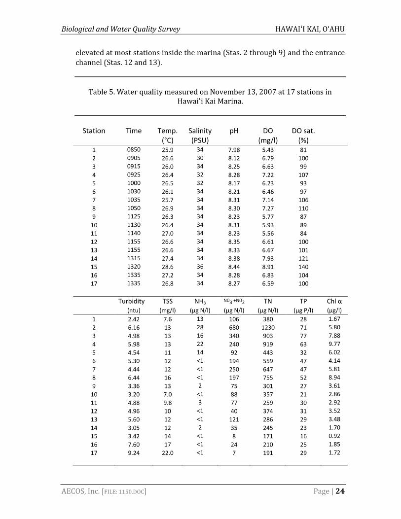
Biological and Water Quality Survey HAWAI‘I KAI, O‘AHU
AECOS, Inc. [FILE: 1150.DOC] Page | 24
elevated at most stations inside the marina (Stas. 2 through 9) and the entrance channel (Stas. 12 and 13).
Table 5. Water quality measured on November 13, 2007 at 17 stations in
Hawai‘i Kai Marina.
Station Time Temp. Salinity pH DO DO sat. (°C) (PSU) (mg/l) (%) 1 0850 25.9 34 7.98 5.43 81 2 0905 26.6 30 8.12 6.79 100 3 0915 26.0 34 8.25 6.63 99 4 0925 26.4 32 8.28 7.22 107 5 1000 26.5 32 8.17 6.23 93 6 1030 26.1 34 8.21 6.46 97 7 1035 25.7 34 8.31 7.14 106 8 1050 26.9 34 8.30 7.27 110 9 1125 26.3 34 8.23 5.77 87 10 1130 26.4 34 8.31 5.93 89 11 1140 27.0 34 8.23 5.56 84 12 1155 26.6 34 8.35 6.61 100 13 1155 26.6 34 8.33 6.67 101 14 1315 27.4 34 8.38 7.93 121 15 1320 28.6 36 8.44 8.91 140 16 1335 27.2 34 8.28 6.83 104 17 1335 26.8 34 8.27 6.59 100
Turbidity TSS NH3 N03 +N02 TN TP Chl α (ntu) (mg/l) (µg N/l) (µg N/l) (µg N/l) (µg P/l) (µg/l)
1 2.42 7.6 13 106 380 28 1.672 6.16 13 28 680 1230 71 5.803 4.98 13 16 340 903 77 7.884 5.98 13 22 240 919 63 9.775 4.54 11 14 92 443 32 6.026 5.30 12 <1 194 559 47 4.147 4.44 12 <1 250 647 47 5.818 6.44 16 <1 197 755 52 8.949 3.36 13 2 75 301 27 3.6110 3.20 7.0 <1 88 357 21 2.8611 4.88 9.8 3 77 259 30 2.9212 4.96 10 <1 40 374 31 3.5213 5.60 12 <1 121 286 29 3.4814 3.05 12 2 35 245 23 1.7015 3.42 14 <1 8 171 16 0.9216 7.60 17 <1 24 210 25 1.8517 9.24 22.0 <1 7 191 29 1.72

Biological and Water Quality Survey HAWAI‘I KAI, O‘AHU
AECOS, Inc. [FILE: 1150.DOC] Page | 25
Figure 8. Trend showing correlation between increasing pH and DO for the
November 13, 2007 sampling event.
Biota Prior to its development as a marina, Kuapā Pond was a brackish fishpond used to raise ‘ama‘ama or mullet (Mugil cephalus), ‘awa or milkfish (Chanos chanos), and āholehole or Kuhlia xenura (Sakoda, 1975). Fish still inhabit the marina and the following fish species have been reported from the marina (USACE, 1975): Apogon sp. (cardinal fish), Holocentrus diadema (squirrel fish), Zebrasoma flavescens (yellow tang), Z. veliferum (sailfin tang), Scarus sp. (parrot fish), Kuhlia sandvicensis (āholehole), Scomberioides sanctipetri (lae), Aetobatus narinari (eagle ray), several species of butterfly fish from the Chaetodontidae family, and schools of Stolephorus [Encrasicholina] purpureus (nehu). A survey in 2002 by the Bishop Museum found that the sampling stations in Kuapā Pond (Hawai‘i Kai Marina) showed the highest percentage (40%) of introduced or cryptogenic species (collectively termed nonindigenous species or NIS) determined in Hawai‘i (Coles et al., 2002). Hard surfaces within the marina are moderately fouled with suspension feeders commonly found in O‘ahu waters.
Biological and Water Quality Survey HAWAI‘I KAI, O‘AHU
AECOS, Inc. [FILE: 1150.DOC] Page | 26
The Department of Land and Natural Resources (DLNR) Division of Aquatic Resources (DAR) commented on the 1993 permit application to perform maintenance dredging in the marina that dredging activities “are not likely to further diminish aquatic resource values in the marina (Kuapā Pond) which is a highly developed and modified area. Some turbidity can be expected during dredging, but impacts adverse to the existing resident aquatic resource populations in the marina should be minimal and temporary” (DLNR, 1993).
Dredged Material Disposal Areas Several areas have been identified for disposal of material generated from dredging the marina. To the extent that the entrance channel deposits comprise good quality sand, this sand will be used to nourish one or more beach locations in Maunalua Bay close to the entrance channel. All other dredged material will need to be put onto land in a location that avoids unmanaged return to the marina or other state waters. Rim Island 1 Rim Island 1 was originally created by stockpiling dredged material from the surrounding marina. The island initially consisted of a berm surrounding an interior depression, but the depression was partially filled in with dredged material in 1995 and 1996. The central part of the islet remains a depression with pickleweed (Batis maritima; Fig. 9) and potentially a wetland. However, open, standing water is not present. The islet is maintained (including watering) as a picnic destination for marina users. Rim Island 2 Rim Island 2 was created by stockpiling dredged material from the surrounding marina. The perimeter of the island is a berm some 2 m (6 ft) high, which surrounds a depression that is near, and in places below, sea level and intermittently contains standing water in an open flat, surrounded by a pickleweed flat (Fig. 10). The Hawaiian stilt (Himantopus mexicanus knudseni) is a federally‐listed endangered species. The US Fish and Wildlife Service (USFWS) has documented that shallow water and open mudflat areas on Rim Island 2 are suitable for stilt feeding and loafing (USFWS, 2003).

Biological and Water Quality Survey HAWAI‘I KAI, O‘AHU
AECOS, Inc. [FILE: 1150.DOC] Page | 27
Figure 9. Central part of Rim Island 1 (note sprinkler heads) supporting yellowish‐
green Batis in low areas.
Yacht Club Site The Yacht Club site is an unused upland parcel located between Hawaii Kai Drive and Keahole along the south side of the marina. The site could accommodate approximately 3,058 m3 (4,000 yd3) of dredged material from the marina dredging. The return water from the dredged material would need to captured or treated before reaching the marina.
Species of Special Concern Federal and State of Hawai‘i listed species status follows species identified in the following referenced documents: Department of Land and Natural Resources (HDLNR, 1996) and U.S. Fish & Wildlife Service (USFWS, 2005a, 2010). Based on preferred habitats and sighting information, the following

Biological and Water Quality Survey HAWAI‘I KAI, O‘AHU
AECOS, Inc. [FILE: 1150.DOC] Page | 28
Figure 10. Rim Island 2 showing central depression with open water and mud flats. Houses behind are separated by marina waters beyond the rim at far sides of pond.

Biological and Water Quality Survey HAWAI‘I KAI, O‘AHU
AECOS, Inc. [FILE: 1150.DOC] Page | 29
species listed under the Endangered Species Act (ESA) are known to occur, or could reasonably be expected to occur, in the vicinity of the proposed action: ae‘o or Hawaiian stilt (Himantopus mexicanus knudseni) and honu or green sea turtle (Chelonia mydas). Hawaiian stilts nest on Rim Island 2 within the marina and forage on the mudflats of Paikō Lagoon. Green sea turtles may occasionally enter the Hawaii Kai Marina and feed on the reef flat and rest on the beaches surrounding the entrance channel. Koholā or humpback whale (Megaptera novaeangliae) are present in the deeper waters of Maunalua Bay and ‘ilio holo i ka uaua or Hawaiian monk seal (Monachus schauinslandi) and honu‘ea or hawksbill sea turtle (Eretmochelys imbricata) may be found in Maunalua Bay or farther offshore. There is no designated or proposed critical habitat for any listed species within or adjacent to the project area (NMFS, 1998). Seagrass beds and coral reefs, which occur in Maunalua Bay near the entrance channel to Hawaii Kai Marina, are designated as special aquatic sites under the Clean Water Act. The taking of corals is prohibited by the State (DLNR, 2002) and three species of coral known to occur in the vicinity of the project area (Cyphastrea ocellina, Montipora patula, and Psammocora stellata) are proposed for protection under Federal law (NMFS, 2010). Hawaiian stilt The ae‘o or Hawaiian stilt (Himantopus mexicanus knudseni) is a slender wading bird currently found on all the main Hawaiian islands except Kaho‘olawe (USFWS, 2005b). In 1967, the Hawaiian stilt was listed as an endangered species under the Endangered Species Act (USFWS, 2005a, 2010). The Hawaiian Waterbirds Recovery Plan (USFWS, 2005b) was completed in 1978, revised in 1985, and in May 2005 a draft recovery plan was published. Estimates of historical population sizes are not known, but extensive wetlands and aquatic agricultural lands provided habitat. Loss of this habitat resulted in a decrease in stilt numbers. Additionally, the Hawaiian stilt was a popular game bird, and hunting contributed to local population declines until waterbird hunting was prohibited in 1939 (Schwartz and Schwartz, 1949). Currently, O‘ahu supports the largest number of silts in the Hawaiian Islands (USFWS, 2005b). Hawaiian stilt prefer to nest on freshly exposed mudflats interspersed with low growing vegetation. The nesting season of the Hawaiian stilt normally extends from mid‐February through August, but varies among years, perhaps depending on water levels (USFWS, 2005b). Stilt are opportunistic feeders and eat a variety of invertebrates and other aquatic organisms available in shallow water and exposed flats. Being a wading bird, feeding typically occurs in shallow flooded wetlands. Within the marina, Rim Island 2 is used by the Hawaiian stilt

Biological and Water Quality Survey HAWAI‘I KAI, O‘AHU
AECOS, Inc. [FILE: 1150.DOC] Page | 30
for foraging on an irregular basis, and is also known to be a nesting site (David, 2004). Green sea turtle The most common sea turtle in the Hawaiian Islands is the honu or green sea turtle (Chelonia mydas), an occasional inhabitant of the shallow waters of Maunalua Bay. In 1978, the green sea turtle was listed as a threatened species under the Endangered Species Act (USFWS, 2005a, 2010). The National Marine Fisheries Service and U.S. Fish and Wildlife Service (NMFS and USFWS, 1998a) developed a recovery plan for U.S. Pacific populations of the green sea turtle that aids in management decisions to protect the population for its recovery. The green sea turtle diet consists primarily of benthic macroalgae (Arthur and Balazs, 2008), which the reefs of the main Hawaiian Islands provide in abundance. The shallow, nearshore reef environment along the south shore of O‘ahu is primarily an ancient limestone platform covered by algae with very little coral cover. Red macroalgae make up 78% of the turtle diet and green macroalgae make up 12% (Arthur and Balazs, 2008). The single most consumed algal species is Acanthophora spicifera (prickly seaweed), which is a non‐native species introduced to Hawai‘i in 1950 (Huisman et al., 2007). Of the many benthic marine algae and plants considered as food resources of the Hawaiian green sea turtle (Russell et al., 2003), the proposed project vicinity supports growth of Codium sp., Pterocladiella sp., Acanthophora spicifera, Hypnea musciformis, and Halophila spp. Except for A. spicifera, these species are in low quantities for most of the area surveyed and are not likely a substantial foraging resource for green sea turtle. Traditionally, sea turtles rest in deeper water during the day where they use reef features to shelter themselves (Smith, 1999) and come to shallow water of the reef flats to feed at night (Balazs et al., 1987). Before acquiring the status of threatened under the Endangered Species Act, sea turtles would flee upon encountering human swimmers in Hawai‘i. In recent years, however, green sea turtle here have become exceedingly tolerant of human presence and now regularly come to shallows to feed during the day as well as the night (Balazs, 1996). Turbid (murky) water does not appear to deter green sea turtle from foraging and resting areas. Construction projects on the south shore of O‘ahu at Hawaii Kai and off of Kapolei have found sea turtles adaptable and tolerant of construction‐related disturbances (Brock, 1998a, b). The entrance channel into Pearl Harbor, which is periodically dredged and regularly trafficked by large

Biological and Water Quality Survey HAWAI‘I KAI, O‘AHU
AECOS, Inc. [FILE: 1150.DOC] Page | 31
ships and submarines, is home to a resident population of green sea turtle (Smith, 1999). Green sea turtle nesting is primarily limited to a few beaches of the Northwestern Hawaiian Islands with 90% of nesting occurring at French Frigate Shoals (Balazs et al., 1992); O‘ahu is not considered a primary nesting island for green sea turtles (NMFS‐USFWS, 1998a). The green sea turtle is not known to nest or haul‐out on Portlock Beach or Maunalua Bay Beach Park. Offshore and about 500 m (1,640 ft) west of the blinker buoy marking the Hawai‘i Kai boat entrance channel is a green sea turtle resting area known as “Turtle Canyon” (WOA, 1988). This area experiences regular daily boat traffic. Hawksbill sea turtle The honu‘ea or hawksbill sea turtle (Eretmochelys imbricata) was listed as endangered under the Endangered Species Act in 1970 (USFWS, 2005a, 2010). Compared with green sea turtle, hawksbill turtle is uncommon in marine waters of Hawai‘i. Of 545 sea turtles rescued in the state between 1990 and 2008, less than 3% were hawksbill, while more than 95% were green sea turtle (PIFSC‐NMFS, n.d.). Honu‘ea feeds primarily on sponges, but is also known to take macroalgae (Balazs, 1978). Sponges occur with some regularity in the marina entrance channel, although these are unlikely to be a foraging resource for hawksbill turtle. Unlike the Pacific green sea turtle, hawksbill turtle do not currently nest in the Northwestern Hawaiian Islands. The number of adult nesting female hawksbill on the main Hawaiian Islands has been estimated at roughly 100 individuals (King et al., 2004). Nesting in Hawai‘i is known to occur on Moloka‘i, O‘ahu, Maui, and Hawai‘i, with the majority occurring on the east coast of the island of Hawai‘i (Balazs et al., 1992). O‘ahu is not considered a primary nesting island for hawksbill sea turtle (NMFS‐USFWS, 1998b). During peak nesting season, late July to early September (NMFS and USFWS, 1998b), adult turtle may be more likely to transit the project area on their way to or from nesting beaches. Hatching takes place about 60 days later (September to November). Hawaiian monk seal The ‘ilio holo i ka uaua or Hawaiian monk seal (Monachus schauinslandi) was listed as endangered in 1976 (USFWS, 2005, 2010), is endemic to the Hawaiian Islands, and is the only pinniped found in Hawaiian waters (USFWS, 2005). The species has a recovery priority number of one, based on the high magnitude of threats, the high recovery potential, and the potential for economic conflicts while implementing recovery actions. The Hawaiian monk seal, one of the rarest

Biological and Water Quality Survey HAWAI‘I KAI, O‘AHU
AECOS, Inc. [FILE: 1150.DOC] Page | 32
seals on Earth, has experienced a steady population decline from a population estimate of around 1,400 in the late 1990s to a population of approximately 1,000 individuals in 2006 (NMFS, 2007). Although most monk seals are primarily found in the Northwestern Hawaiian Islands, individuals are also found in lower numbers throughout the Main Hawaiian Islands, where documented births and sightings suggest that numbers are increasing (Baker and Johanos, 2004). Monk seal feed on fish, crustaceans, and octopus, and haul out on beaches to rest, digest, and escape predators. Monk seal primarily pup in the remote Northwestern Hawaiian Islands, but also pup in the main Hawaiian Islands, including the island of Maui, Kaua‘i, and O‘ahu. Monk seal births have been documented in all months of the year, but are most common between February and August, peaking in March and April. Crucial threats to the remaining population are food limitation, marine debris entanglement, and shark predation. Other threats include: infectious disease, fisheries interactions, male aggression, habitat loss, and human interaction. No monk seals have been recorded hauling‐out on Portlock Beach or Maunalua Bay Beach Park. Humpback whale The koholā or humpback whale (Megaptera novaeangliae) was listed as endangered under the Endangered Species Act in 1970 (USFWS, 2005a, 2010). Prior to protection, the Pacific humpback whale population was estimated to have fewer than 1,000 individuals (Rice, 1978). Today, there are over 7,000, and of these, an estimated 5,000 individuals migrate to waters of Hawai‘i (HIHWNMS, 2004). Humpback whale feed on krill and fish in their summer feeding grounds in the northern North Pacific and are not thought to feed while migrating or while in residence in Hawaiian waters (NMFS, 1991). Mating and calving generally take place over the shallow banks between Maui, Lana‘i, and Kaho‘olawe, with adults and calves commonly sighted in these waters. The waters of Maunalua Bay are within the Hawaiian Islands Humpback Whale National Marine Sanctuary (HIHWNMS), which encompasses approximately 4,178 km2 (1,218 nautical mi2) of coastal and ocean waters out to the 183‐m (600‐ft) isobath. The sanctuary protects the winter breeding, calving, and nursing grounds of the north Pacific humpback whale population.

Biological and Water Quality Survey HAWAI‘I KAI, O‘AHU
AECOS, Inc. [FILE: 1150.DOC] Page | 33
Stony corals All stony coral species are protected under state law (HLDNR, 2002). State law prohibits the breaking or damaging, with any implement, any stony coral from the waters of Hawai‘i, including any reef or mushroom coral. It is also unlawful to take, break or damage, with any implement, any rock or coral to which marine life of any type is visibly attached. In February 2010, 83 species of corals world‐wide were petitioned to be listed as threatened or endangered under the Endangered Species Act (NMFS, 2010). Of the 83 species, 75 occur in the Indo‐Pacific region and 9 occur in Hawai‘i (Acropora paniculata, Cyphastrea agassizi, Cyphastrea ocellina, Leptoseris incrustans, Montipora dilatata, Montipora flabellata, Montipora patula, Pocillopora elegans, and Psammocora stellata). The petition for listing states that these species are classified as vulnerable, except for M. dilatata, which is classified as endangered by the International Union for Conservation of Nature (IUCN). M. dilatata is also on the Species of Concern list (NOAA‐NMFS, 2007). NOAA has initiated a status review of the species to determine if listing under the ESA is warranted (NMFS, 2010); results are anticipated in late 2010 (NOAA‐NMFS Endangered Species Division, pers. comm). Small colonies of various species of coral occur offshore Portlock Beach and Maunalua Bay Beach Park. Of the species proposed to be listed (NMFS, 2010), Cyphastrea ocellina, Montipora patula, and Psammocora stellata are found in Maunalua Bay in the survey areas shown in Fig. 4. Seagrasses Hawai‘i has one endemic seagrass, Halophila hawaiiana, one indigenous seagrass, Ruppia maritima, and one non‐native seagrass, Halophila decipiens. Halophila hawaiiana and H. decipiens are very similar in appearance with both growing to a height of approximately 2.5 to 2.8 cm (1.0 to 1.5 in), but H. decipiens differs in having small marginal spines. In general, seagrasses thrive in areas with low sedimentation, adequate water flow, and low wave energy (Hemminga and Duarte, 2000). Both species of Halophila are consumed by green sea turtles (Russell et al., 2003). The general degradation of seagrass beds by eutrophication, sedimentation, chemical poisoning, collecting and gleaning, trampling, anchoring, etc. is a widespread threat to the recovery of depleted sea turtle stocks (NMFS and USFWS, 1998a).

Biological and Water Quality Survey HAWAI‘I KAI, O‘AHU
AECOS, Inc. [FILE: 1150.DOC] Page | 34
Seagrass beds are classified as special aquatic sites in the federal Clean Water Act (Subpart E of 40 CFR Part 230). Special aquatic sites include: sanctuaries and refuges, wetlands, mud flats, vegetated shallows (seagrass beds), coral reefs, and riffle and pool complexes. When a project requiring a Clean Water Act Section 404 permit (regulating the discharge of dredged, excavated, or fill material in wetlands, streams, rivers, and other waters of the U.S.) is proposed to be conducted in a special aquatic site, as part of the permitting process, all alternatives that do not result in the discharge in a special aquatic site are presumed to have less adverse impact. Scattered patches of seagrasses (Halophila hawaiiana and H. decipiens) are present in sandy areas offshore Portlock Beach and Maunalua Bay Beach Park as shown in Fig. 4.
Impacts Assessment
The nearshore and reef flat biological assemblages of Maunalua Bay in the vicinity of the Hawai‘i Kai marina are poorly developed and suggest a highly disturbed environment. Maunalua Bay appears to be negatively affected by a variety of environmental disturbances, including freshwater input and sedimentation, from landward sources. For example, a storm in 1988 created a turbid cell of water extending 4.8 km by 3.2 km (3 mi by 2 mi) and remained in Maunalua Bay for more than 45 days (Brock, 1988). Dredging and dewatering operations have the potential to increase turbidity in the vicinity of the project site (in the marina, entrance channel, and immediately offshore the dewatering site), but these activities are not likely to affect offshore areas in Maunalua Bay. The material to be dredged in the entrance channel is primarily sand, which generates minimal turbidity when disturbed as sand particles quickly settle out of the water column. The material to be dredged from the marina consists of finer particles, which may stay suspended in the water column for a long period of time; however, due to the low flushing rate in the marina, these particles will likely resettle on the bottom before entering Maunalua Bay. A system to dewater the dredged material should be developed and the effluent monitored to ensure that the water quality of Maunalua Bay is not affected. Entrance Channel Dredging and dewatering operations have the potential to cause a short‐term increase turbidity in the vicinity of the project site. The material to be dredged in the entrance channel is primarily sand. The sand particles will quickly settle

Biological and Water Quality Survey HAWAI‘I KAI, O‘AHU
AECOS, Inc. [FILE: 1150.DOC] Page | 35
out of the water column and be deposited again on the bottom. However, a silt curtain should be placed around the dredging area to reduce turbidity outside of the project area. Dredging of channel sand will lead to the loss of some benthic organisms. However, benthic organisms inhabiting the sand bottoms of other channels on the reef flat will quickly recolonize the dredged entrance channel without any foreseeable long‐term impact. No significant adverse impacts are expected to any species that are currently listed as endangered, threatened, or proposed for listing under either the Federal or State endangered species programs that are within the immediate vicinity of the entrance channel. Federal and State of Hawai‘i listed species status follows species identified in the following documents: Department of Land and Natural Resources (HDLNR, 1996) and U.S. Fish and Wildlife Service (USFWS, 2005, 2010). Additionally, no significant adverse impacts to live coral or seagrass beds are expected from the project. Marina Dredging and dewatering operations have the potential to cause a short‐term increase in turbidity in the vicinity of the project site. The material to be dredged from the marina consists of finer particles, which may stay suspended in the water column for a longer period of time. Due to the low flushing rate of the marina, these particles will likely resettle on the bottom before entering Maunalua Bay. The biological community in the marina has adapted to turbid conditions and, therefore, is not likely to be negatively impacted by a temporary increase in turbidity and suspended sediments by dredging. The biological community in the nearshore waters of Maunalua Bay has also adapted to turbid water quality conditions and a high load of suspended sediments in the water column, so a short‐term pulse of sediments from dredging should not have a long‐term impact on the biological community. Sessile benthic infauna existing within the areas of the marina proposed to be dredged will experience direct mortality, although the existing population is not expected to be large (USACE, 1975). Only a small portion of the marina bottom is slated to be dredged and benthic organisms inhabiting the remaining marina bottom should quickly recolonize the dredged areas without any foreseeable long‐term impact. No significant adverse impacts are expected to any marine species that are currently listed as endangered, threatened, or proposed for listing under either the federal or state endangered species programs that are within the immediate

Biological and Water Quality Survey HAWAI‘I KAI, O‘AHU
AECOS, Inc. [FILE: 1150.DOC] Page | 36
vicinity of the entrance channel. Federal and State of Hawai‘i listed species status follows species identified in the following documents: Department of Land and Natural Resources (DLNR, 1998) and US Fish and Wildlife Service (USFWS, 2005, 2010). Additionally, no significant adverse impacts to live coral or seagrass beds are expected from the project. Recommendations A best management practice plan (BMPP) should be prepared and implemented to minimize turbidity and to avoid, minimize, or mitigate potential pollution events from equipment maintenance, leaks, and spills. A water quality monitoring program should be prepared and implemented to ensure permit requirements are met during dredging and disposal operations. Impacts to Protected Species A discussion of potential impacts to listed species from project activities is presented below. The proposed project is not anticipated to have any significant impacts on protected species.
1. Collision with project‐related vessels (sea turtles and marine mammals); 2. Entrainment or impingement by dredging equipment and activity (sea
turtles); 3. Exposure to elevated noise levels of dredging equipment (sea turtles and
marine mammals); and 4. Loss of foraging habitat (green sea turtle).
1. Collision with project‐related vessels: Sea turtles and marine mammals must surface to breathe, and they are known to rest or bask at the surface. When at or near the surface within the project area, these animals are at risk of being struck by vessels (or the propellers) as the vessels transit to and from the project site. Green sea turtle is known to forage and transit though the nearshore waters of Maunalua Bay near the entrance channel to the marina, where vessel collisions could be a potential impact. Vessel collisions are not anticipated to increase with the proposed project, as no significant change in vessel traffic is anticipated ass an outcome of the project. To reduce the chance of vessel collisions, any vessels associated with construction traveling during winter whale season (November to May) should follow best management practices (BMPs) to avoid protected species. These BMPs should include: 1) keep vessels at least 91 m (100 yd) from whales and at least 46 m (50 yd) from other marine mammals and sea turtles; 2) reduce vessel speeds to 19 km/hr (10 knots) or less when in the proximity of marine

Biological and Water Quality Survey HAWAI‘I KAI, O‘AHU
AECOS, Inc. [FILE: 1150.DOC] Page | 37
mammals and 9 km/hr (5 knots) or less when in areas of known or suspected turtle activity; and 3) use of silt curtains to create barriers, preventing turtles from entering an area of potential harm (D. Hubner, NOAA‐NMFS, pers. comm., HIHWNMS, 2008). 2. Entrainment or impingement by dredging equipment and activity: The dredging method may use a hydraulic dredge that suctions sediment from the bottom as slurry (sand/water mixture), and could cause entrainment or impingement to marine animals. Entrainment occurs when an organism is sucked into the dredge intake. Impingement occurs when an animal becomes held fast against the dredge head by suction. Both entrainment and impingement could result in an animal drowning or being injured. Recommended BMPs include the use of an excluder device on dredging equipment, as similarly recommended for the Waikiki Beach Maintenance Project (Tosatto, 2010). Also, the NMFS Protected Resources Division BMPs require construction crews to watch for sea turtles and marine mammals 30 minutes prior to beginning work, and to halt or postpone that work when those animals are within 46 m or 50 yd (Tosatto, 2010). It is expected that sea turtles and marine mammals will avoid the area during dredging operations, and therefore the risk of entrainment or impingement of sea turtles and marine mammals is unlikely. 3. Exposure to elevated noise levels of dredging equipment: Hydraulic dredges can produce underwater noise that is continuous and of high enough intensity to affect marine life adversely. Effects vary with the frequency, intensity, and duration of the sound source, and the hearing characteristics of the exposed animal. The sound generated from dredging activities is not anticipated to be substantial enough to cause an acoustic disturbance to protected species in nearshore waters. Project plans should ensure that sound emanation from the project site is below the temporary threshold shift (TTS) of 180 to 190 dB re 1 microPascal/m (rms) for marine mammals (NOAA, 2005). Currently, no acoustic thresholds have been established for sea turtles. Current research suggests that sea turtles may be less acoustically sensitive than cetaceans, relying more heavily on visual cues, rather than auditory input (Hazel et al., 2007, Ridgeway et al., 1969). Therefore, application of the marine mammal thresholds is considered conservative for sea turtles. 4. Loss or degradation of forage habitat: The nearshore area off Portlock Beach and Maunalua Bay Beach Park consists of a limestone platform covered by turf‐forming macroalgae with very little coral present. Green sea turtle forages across the shallows and are the only listed marine species known to forage in the area. As such, they are the only ESA species potentially impacted by this

Biological and Water Quality Survey HAWAI‘I KAI, O‘AHU
AECOS, Inc. [FILE: 1150.DOC] Page | 38
stressor. Dredging is proposed for the entrance channel, which does not support seagrasses or macroalgae. Since very little macroalgae and no seagrasses nor corals are present in the footprint of the beach proposed for nourishment with the dredged sand, this action will not affect forage resources for sea turtles or environment used by seagrasses.
5. Other potential impacts: The proposed project will have no impact on the Hawaiian stilt because dredged material will not be deposited on Rim Island 2. “Turtle Canyon,” located offshore the entrance channel, experiences regular daily boat traffic, and the dredge operation will not contribute to a significant increase in vessel numbers or vessel speeds. Green sea turtle may haul‐out and rest on the widened beach that is to be created from the dredged material. Because no nesting (green or hawksbill sea turtles) beaches are close to the project area and hatchlings quickly move to the open ocean, it is unlikely hatchlings will transit the project area. The primary food resource for hawksbill turtles, sponges, occur, but are uncommon, in the project area. No corals or seagrasses are found in the entrance channel or within the footprint of the beach proposed to be nourished. Invasive species occur in Maunalua Bay, including introduced algae, Acanthophora spicifera, Gracilaria salicornia, and Avrainvillea amadelpha. Invasive algal removal efforts on O‘ahu have focused attention on Paikō Lagoon and Maunalua Bay. Best Management Practices can minimize the chance of additional introductions and reduce the chance of contributing to existing populations of invasive species. The dredge barge should be inspected by a trained biologist prior to relocating the barge to the site for dredging operations. If invasive species are found, the barge hull should be cleaned to minimize introductions.
References
AECOS, Inc. (AECOS). 1979. Hawaii coral reef inventory: Island of Oahu. Part B – sectional map descriptions. Prep. for: U.S. Army Corp of Engineers, Pacific Ocean Division, Fort Shafter, Hawai‘i. 552 pp.
_______. 2007a. Marine environmental monitoring for the Kūhiō Beach small‐
scale beach nourishment project, Waikīkī, O‘ahu. Prep. for: DLNR‐OCCL. AECOS Report 936B: 22 pp.
______. 2007b. Marine turtle monitoring; Kawela Bay, O‘ahu, Hawai‘i. AECOS
Report 1119C: 9 pp.

Biological and Water Quality Survey HAWAI‘I KAI, O‘AHU
AECOS, Inc. [FILE: 1150.DOC] Page | 39
AECOS, Inc. (AECOS). 2008. Marine environmental monitoring for the Kūhiō Beach small‐scale beach nourishment project, 3‐month and 15‐month post dredging monitoring results. Waikīkī, O‘ahu. Prep. for DLNR‐OCCL. AECOS Report 936G: 27 pp.
______. 2009a. Marine biological resources near Gray’s Beach, Waikīkī, O‘ahu.
Prep. for: Sea Engineering, Inc. AECOS Report 1152D: 66 pp, incl. appendices.
______. 2009b. Water quality near Gray’s Beach, Waikīkī, O‘ahu. Prep. for: Sea
Engineering, Inc. AECOS Report 1152D: 17 pp, Arthur, K. E. and G. H. Balazs. 2008. A Comparison of Immature Green Turtle
(Chelonia mydas) Diets among Seven Sites in the Main Hawaiian Islands. Pac. Sci. 62(2): 205–217.
Baker, J. D. and T. C. Johanos. 2004. Abundance of the Hawaiian monk seal in the
main Hawaiian Islands. Biol. Conserv., 116: 103‐110.
Bailey‐Brock, J. and E. Krause. 2008. Gray’s Beach infauna study of source sand off Waikīkī. University of Hawai‘i at Mānoa, Water Resources Research Center Report WWRC‐2009‐01. 13 pp.
Balazs, G. H. 1978. A hawksbill turtle in Kaneohe Bay, Oahu. Elepaio 38(11):128‐
129. ______. 1996. Behavioral changes within the recovering Hawaiian green turtle
population. In: J. A. Keinath, D. E. Barnard, J. A. Musick, and B. A. Bell (comps.), Proceedings of the 15th Annual Symposium on Sea Turtle Biology and Conservation, Feb. 20‐25, 1995, Hilton Head, SC, p. 16‐20. U.S. Dep. of Comm. NOAA Tech. Memo. NMFS‐SEFSC‐387.
Balazs, G. H, R. G. Forsyth, and A. K. H. Kam. 1987. Preliminary Assessment of
Habitat Utilization by Hawaiian Green Turtles in their Resident Foraging Pastures. U.S. Dep. Commer., NOAA Tech. Memo. NOAA‐TIM‐NMFS‐SWFC‐71, Honolulu. 107 pp.
Brock, R. E. 1988a. Green sea turtle population monitoring during blasting work
at West Beach, Oahu. Final Report. Prep. for Alfred A. Yee Division, Leo A. Daly. 15 pp.

Biological and Water Quality Survey HAWAI‘I KAI, O‘AHU
AECOS, Inc. [FILE: 1150.DOC] Page | 40
Brock, R. E. 1988b. Green turtles (Chelonia mydas) at Hawaii Kai, Hawaii: An analysis of the impacts with the development of a ferry system. Prep. for Sea Engineering, Inc. 26 pp.
_______. 1988. Biological assessment for the proposed intra‐island ferry system:
Hawaii Kai terminal. Prep. for: Wilson Okamoto. 41 pp. Coastal Geology Group. 2009. Hawai‘i coastal erosion website. Available online
at URL: http://www.soest.hawaii.edu/asp/coasts/index.asp; last accessed November 10, 2009.
Coles, S. L., R. C. DeFelice, and L. G. Eldredge. 2002. Nonindigenous marine
species at Waikīkī and Hawai‘i Kai, O‘ahu, Hawai‘i. Prep. For Packard Foundation & Hawai‘i DLNR‐DAR. Bishop Museum Technical Report 25: 255 pp.
Coral Reef Assessment Monitoring Program (CRAMP) Hawaii. 2008. CRAMP
Rapid Assessment Technique Fish Results. Available online at URL: http://cramp.wcc.hawaii.edu/ Rapid_Assessment_Files/RA_Results_fish.html; last accessed April 21, 2008.
David, R. E. 2004. Hawaii Kai Marina Association, Rim Island 2 Waterbird
Habitat Best Management Practices. Prep for: Hawaii Kai Marina Association. 7 pp.
Engilis, A. and M. Naughton. 2002. U.S. Pacific Shorebird Conservation Plan. U.S.
Fish and Wildlife Service. 71 pp. Environmental Consultants, Inc. (ECI). 1975. Preliminary environmental impact
studies on the marine environment at Maunalua Bay. Prep for: Kentron Hawaii, Ltd. 65 pp.
Grasshoff, K., M. G. Ehrhardt, & K. V. Kremling (eds). 1999. Methods of Seawater
Analysis (3rd ed). Wiley‐VHC. 419 pp. Hawai‘i Department of Health (HDOH). 2008. 2006 State of Hawai‘i Water
Quality Monitoring and Assessment Report: Integrated Report to the U.S. Environmental Protection Agency and The U.S. Congress Pursuant To Sections §303(D) and §305(B), Clean Water Act (P.L. 97‐117). 279 pp.
Hawai‘i Department of Health (HDOH). 2009b. Hawaii Administrative Rules,
Title 11, Department of Health, Chapter 54, Water Quality standards. 90 pp.

Biological and Water Quality Survey HAWAI‘I KAI, O‘AHU
AECOS, Inc. [FILE: 1150.DOC] Page | 41
Hawai‘i Department of Land and Natural Resources (HDLNR). 1993. Letter to
District Engineer (PODCO‐O), U.S. Army Corps of Engineers. 3 pp. _______. 1996. Hawai‘i Administrative Rules, Title 13, Chapter 124, Indigenous
Wildlife, Endangered and Threatened Wildlife and Plants, and Introduced Wild Birds. 22 pp.
_______. 2002. Hawai‘i Administrative Rules, Title 13, Chapter 95, Rules
Regulating the Taking and Selling of Certain Marine Resources. 14 pp. _______. 2009. Hawai‘i Administrative Rules, Title 13, Chapter 126, Rules
Regulating Wildlife Sanctuaries. 32 pp. Hawaiian Islands Humpback Whale National Marine Sanctuary (HIHWNMS).
2004. North Pacific humpback whale. Brochure. Available online at URL: http://hawaiihumpbackwhale.noaa.gov/documents/pdfs_info_facts/humpback_card.pdf; last accessed April 15, 2010.
_______. 2008. Vessel Collisions. Available online at URL: http://
hawaiihumpbackwhale.noaa.gov/res/vessel_collisions.html; last accessed on August 4, 2010.
Hazel, J., I. R. Lawler, H. Marsh, & S. Robson. 2007. Vessel speed increases
collision risk for the green turtle Chelonia mydas. Endang. Spec. Res., 3: 105‐113.
Hemminga, M. A. and C. M. Duarte. 2000. Seagrass Ecology: An Introduction.
Cambridge University Press, Cambridge, MA. 298 pp. Huisman, J. M., I. A. Abbott, and C.M. Smith. 2007. Hawaiian Reef Plants. Univ. of
Hawai‘i Sea Grant College Prog. Honolulu, HI. Rept. UNIHI_SEAGRANT‐BA‐03‐02. 264 pp.
King, C. K., W. Gilmartin, S. Hau, H. Bernard, S. Canja, G. Nakai, M. J. Grady, S.
Williams, and A. G. Hebard. 2007. Nesting hawksbill turtles (Eretmochelys imbricata) on the island of Maui, Hawaii from 1996–2003. In R. B. Mast, B. J. Hutchinson, and A. H. Hutchinson (comps.), Proceedings of the 24th Annual Symposium on Sea Turtle Biology and Conservation, p. 134–135. U.S. Dep. Comm. NOAA Tech. Memo. NMFS‐SEFSC‐567.

Biological and Water Quality Survey HAWAI‘I KAI, O‘AHU
AECOS, Inc. [FILE: 1150.DOC] Page | 42
Kumu Pono Associates. 1998. Historical Documentary Research: Kawaihoa‐Kuamo‘okāne, Hanauma, and Kohelepelepe ‐ The Koko Head Regional Park and Nature Preserve, Ahupua‘a of Maunalua, District of Kona, Island of O‘ahu. Prep. for: Group 70 International. 37 pp.
National Marine Fisheries Service (NMFS). 1991. Final recovery plan for the
humpback whale (Megaptera novaeangliae). 115 pp. Available online at URL: http://www.nmfs.noaa.gov/pr/pdfs/recovery/whale_humpback.pdf; last accessed April 15, 2010.
National Marine Fisheries Service (NMFS). 1998. Department of Commerce,
National Oceanic and Atmospheric Administration. 50 CFR 226. Designated Critical Habitat: Green and Hawksbill Sea Turtles; Endangered Species Act. Federal Register, 63 (170; September 2, 1998): 46693‐46701. Available online at URL: http://www.nmfs.noaa.gov/pr/pdfs/fr/fr63-46693.pdf; last accessed July 28, 2010.
_______. 2007. Recovery Plan for the Hawaiian Monk Seal (Monachus
schauinslandi). Second Revision. National Marine Fisheries Service, Silver Spring, MD. 165 pp. Available online at URL: http://www.nmfs.noaa.gov/pr/pdfs/recovery/hawaiianmonkseal.pdf; last accessed April 15, 2010.
_______. 2010. Department of Commerce, National Oceanic and Atmospheric
Administration. 50 CFR 223 and 224. Endangered and Threatened Wildlife Notice of 90‐Day Finding on a Petition to List 83 Species of Corals as Threatened or Endangered Under the Endangered Species Act (ESA). Federal Register, 75 (27; February 10, 2010): 6616‐6621.
National Marine Fisheries Service and U.S. Fish and Wildlife Service (NMFS and
UWFWS). 1998a. Recovery Plan for U.S. Pacific Populations of the Hawksbill Turtle (Eretmochelys imbricata). National Marine Fisheries Service, Silver Spring, MD. 95 pp. Available online at URL: http://www.nmfs.noaa.gov/ pr/pdfs/recovery/turtle_hawksbill_pacific.pdf; last accessed on April 15, 2010.
National Marine Fisheries Service and U.S. Fish and Wildlife Service (NMFS and
USFWS). 1998b. Recovery Plan for U.S. Pacific Populations of the Green Turtle (Chelonia mydas). National Marine Fisheries Service, Silver Spring, MD. 97 pp. Available online at URL: http://www.nmfs.noaa.gov/pr/pdfs/recovery/ turtle_green_pacific.pdf; last accessed on April 15, 2010.

Biological and Water Quality Survey HAWAI‘I KAI, O‘AHU
AECOS, Inc. [FILE: 1150.DOC] Page | 43
National Oceanic and Atmospheric Administration (NOAA). 2005. Department of Commerce, National Oceanic and Atmospheric Administration. Small Takes of Marine Mammals Incidental to Specified Activities; Low‐Energy Seismic Survey in the Southwest Pacific Ocean. Federal Register, 70 (35; February 10, 2005): 8768 ‐ 8783.
National Oceanic and Atmospheric Administration (NOAA). 2007. Species of
Concern – Hawaiian reef coral. Available online at URL: http://www.nmfs.noaa.gov/pr/pdfs/species/hawaiianreefcoral_detailed.pdf; last accessed on August 4, 2010.
______. 2010. Department of Commerce, National Oceanic and Atmospheric
Administration. 50 CFR 223 and 224. Endangered and Threatened Wildlife Notice of 90‐Day Finding on a Petition to List 83 Species of Corals as Threatened or Endangered Under the Endangered Species Act (ESA). Federal Register, 75 (27; February 10, 1010): 6616‐6621.
National Oceanographic and Atmospheric Administration‐National Ocean
Service (NOAA‐NOS). 2010. 2007 NOAA Tide Predictions: Oahu Island, Hanauma Bay. Available online at URL: http://tidesandcurrents.noaa.gov/get_predictions.shtml?year=2007&stn=4342+Honolulu&secstn=Oahu+Island,+Hanauma+Bay&thh=-0&thm=59&tlh=-0&tlm=45&hh=*1.00&hl=*1.00&footnote=; last accessed September 3, 2010.
National Oceanographic and Atmospheric Administration‐National Weather
Service Forecast Office. Hawaii Kai Golf Course (HI21) Rainfall Graphs. Available online at URL: http://www.prh.noaa.gov/hnl/hydro/pages/rra_graphs.php?station=HAJH1&mo=112007; last accessed September 3, 2010.
Nixon, D.W. 1994. Marine and Coastal Law: Cases and Materials. Greenwood
Publishing Group. 373 pp. Pacific Islands Fisheries Science Center‐National Marine Fisheries Service
(PIFSC‐NMFS). No date. Rescue, Rehabilitation and Ocean Return of 545 Marine Turtles in the Hawaiian Islands, January 1990 ‐ September 2008.
Rice, D. W. 1978. The humpback whale in the North Pacific: distribution,
exploitation and numbers. Appendix 4, pp. 2944, In: Norris, K. S. and Reeves, R. R. (eds.). Report on a workshop on problems related to humpback whales (Megaptera novaeangliae) in Hawaii. U.S. Dept. Commerce, Nat. Tech. Info. Sew. PB‐280 794. Springfield, Virginia.

Biological and Water Quality Survey HAWAI‘I KAI, O‘AHU
AECOS, Inc. [FILE: 1150.DOC] Page | 44
Ridgway, S. H., E. G. Wever, J. G. McCormick, J. Palin, and J. H. Anderson. 1969. Hearing in the Giant Sea Turtle, Chelonia mydas. PNAS, 64, 884‐890.
Russell, D. J., G. H. Balazs, R. C. Phillips, and A. K. H. Kam. 2003. Discovery of the
seagrass Halophila decipiens (Hydrocharitaceae) in the diet of the Hawaiian green sea turtle, Chelonia mydas. Pac. Sci. 57(4): 393‐397.
Sakoda, E. T. 1975. The marine geology and sedimentology of Hawaii Kai, Kuapa
Pond, and adjacent Maunalua Bay. M.S. Thesis (Geophysis), Univ. Hawaii, Honolulu. 71 pp.
Schwartz, C.W. and E.R. Schwartz. 1949. The game birds in Hawai‘i. Division
Fish and Game and Board of Commissioners of Agriculture and Forestry, Honolulu, HI. 168 pp.
Smith, S.H. 1999. Field survey of sea turtles in the vicinity of the Pearl Harbor
Entrance Channel. Prep for: Pacific Division Naval Facilities Engineering Command. 20 pp.
Smith, J. E., C. L. Hunter, E. J. Conklin, R. Most, T. Sauvage, C. Squair, and C. M.
Smith. 2004. Ecology of the invasive red algae Gracilaria salicornia (Rhodophyta) on Oahu, Hawaii. Pac. Sci. 58: 325‐343.
Standard Methods (SM). 1998. Standard Methods for the Examination of Water
and Wastewater. 20th Edition. (Greenberg, Clesceri, and Eaton, eds.). APHA, AWWA, & WEF. 1100 pp.
Stearns, H. T. 1985. Geology of the State of Hawaii. Pacific Books. 335 pp. Tosatto, M. D. 2010. Letter to G.P. Young, P.E., U.S. Army Corps of Engineers,
dated July 28, 2010. U.S. Army Engineer District Honolulu (USACE). 1975. Final environmental
statement for Department of the Army permit applications in the Hawai‘i Kai Marina, O‘ahu, Hawai‘i. 52 pp. + appendices.
U.S. Environmental Protection Agency (USEPA). 1983. Methods for Chemical
Analysis of Water and Wastes. EPA 600/4‐79/020. 491 pp. Available on line at http://nepis.epa.gov/EPA/html/Pubs/pubtitleORD.htm; last accessed on August 5, 2010.
_______. 1993. Methods for the Determination of Inorganic Substances in
Environmental Samples. EPA 600/R‐93/100.

Biological and Water Quality Survey HAWAI‘I KAI, O‘AHU
AECOS, Inc. [FILE: 1150.DOC] Page | 45
U.S. Environmental Protection Agency (USEPA). 2009. STORET, USEPA’s
computerized environmental data system. Available online at URL: http://www.epa.gov/STORET/; last accessed August 26, 2009.
U.S. Fish & Wildlife Service (USFWS). 2003. Letter to Lt. Colonel Ronald N. Light,
District Engineer, US Army Corps of Engineers. 4 pp. _______. 2005a. Part II. Department of the Interior, Fish and Wildlife Service. 50
CFR 17. Endangered and Threatened Wildlife and Plants; Review of Species That Are Candidates or Proposed for Listing as Endangered or Threatened: Annual Notice of Findings on Resubmitted Petition: Annual Description of Progress on Listing Actions. Federal Register, 70 (90; Wednesday, May 11, 2005): 24870‐24934.
_______. 2005b. Draft Revised Recovery Plan for Hawaiian Waterbirds, Second
Draft of Second Revision. U.S. Fish and Wildlife Service Ecological Services, Portland, Oregon. 173 pp.
_______. 2010. USFWS Threatened and Endangered Species System (TESS).
Available online URL: http://ecos.fws.gov/tess_public/StartTess.doc; last accessed on August 3, 2010.
Willis, T. J. 2001. Visual census methods underestimate density and diversity of cryptic reef fishes. Journal of Fish Biol., 59(5): 1408‐1411.
Wilson Okamoto & Associates, Inc. (WOA). 1988. Environmental Assessment for
Maunalua Bay Ferry Terminal. Prep. for: Hawai‘i Dept. of Trans.‐Harbors Div. 190 pp. + appendices.