advisory visit river bain, donington, lincolnshirewildtrout.org/system/files/private/bain2008.pdf2.0...
TRANSCRIPT

Advisory Visit
River Bain, Donington, Lincolnshire
4th November, 2008

2
1.0 Introduction
This report is the output of a site visit undertaken by Tim Jacklin of the Wild Trout Trust to the River Bain, Lincolnshire on 4th November 2008. Comments in this report are based on observations on the day of the site visit and discussions with Richard Osmond, the landowner, and Ian Rees, Lincolnshire Chalk Streams Project Officer.
Normal convention is applied throughout the report with respect to bank identification, i.e. the banks are designated left hand bank (LHB) or right hand bank (RHB) whilst looking downstream.
2.0 Fishery Overview
The River Bain is a small chalk river rising in the Lincolnshire Wolds close to Ludford, flowing south through Horncastle and Coningsby, and joining the River Witham at Dogdyke. This visit was at Donington-on-Bain, near Louth (TF 233 834), on an approximately 850-m stretch of river alongside the Old Mill House (Figure 1).
The primary influence on the habitat in this reach of the River Bain is the mill impoundment. The mill is no longer in use, but the diverted river channel upstream of the mill building remains; this is a perched channel which overflows through a sluice and a weir into a weirpool. Upstream of the weir and sluice the river is impounded for a considerable distance upstream (Figure 2).
At the upstream boundary of the reach is an online lake formed by damming the river. There is an overflow structure into the river that is sufficiently high to prevent upstream fish movement. Any downstream drift is also likely to be limited to very small juvenile coarse fish by the overflow structure.
The river here has a good fish population as evidenced by the last Environment Agency electric fishing survey in 2005. This estimated a density of 26.6 fish/100m2 (+/- 1.1) and a biomass of 2104 g/100m2 (+/- 397). Trout comprised around 40% of the biomass (Appendix 1).

3
Figure 1 Site Map
Upstream limit (lake outflow)
Downstream limit

4
Figure 2
Flow

5
3.0 Habitat Assessment
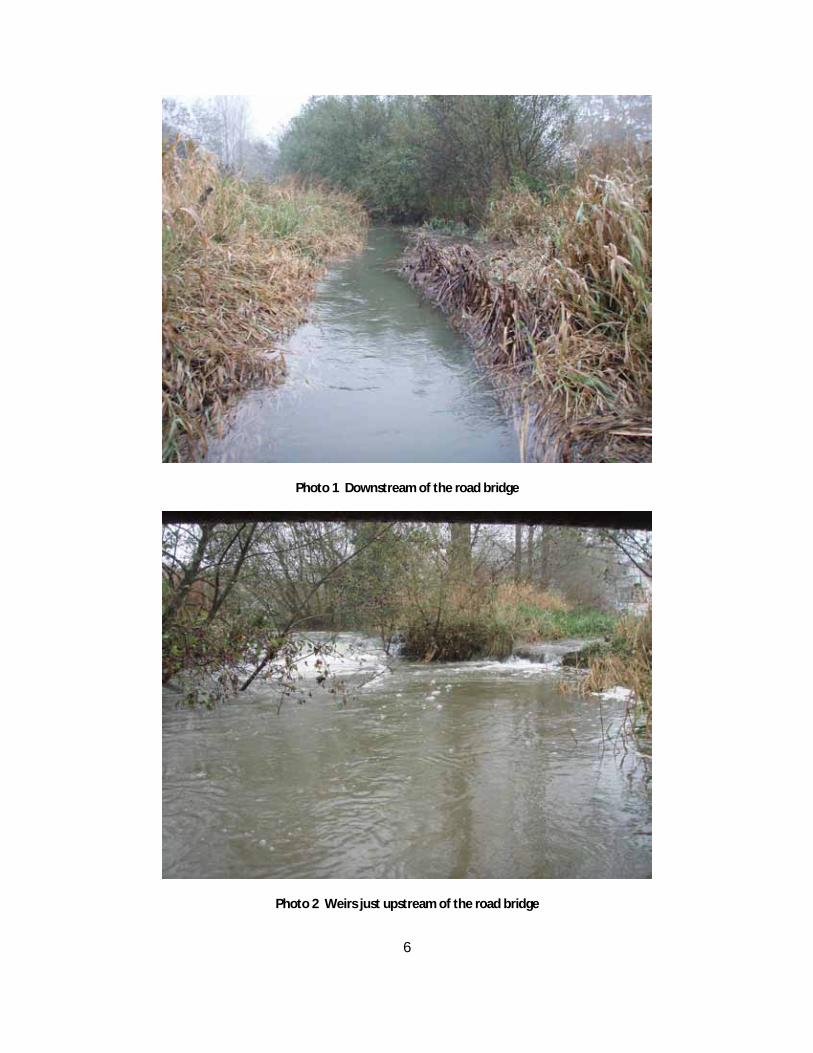
At the downstream end of the reach, below the road bridge the river has a channel width of about four metres, two of which comprise a wet berm along each margin vegetated with grasses, reeds and sedges (Carex sp., Phalaris sp., Sparganium sp.) (Photo 1). There are some young alder and sallow trees present, and the river is fenced along both banks; behind the fence, the land use is hay meadow (LHB) and a wet grazing meadow (RHB; this is in Countryside Stewardship).
There is little variation in depth and width in this section of the river; the channel width is approximately 4 m and the depth 0.5 m. The river bed here is poorly sorted and comprises sand and silt; there was little in the way of gravel of a suitable size for spawning.
Just above the road bridge two channels converge, meeting at a weir (Photo 2). The right channel takes the main flow, and the left channel (cover photograph) takes the flow from the pool outside the mill house (this pool is fed by a pipe from the main channel). A crayfish trap was found just below the weir, containing a live signal crayfish (Pacifastacus leniusculus); these are known to be present in large numbers in this part of the river.
Crayfish trapping is regulated by the Environment Agency (EA) under a national byelaw. Written consent must be obtained from the EA to use crayfish traps and each trap must carry an identification tag issued along with the consent. Trapping signal crayfish can be counter-productive in terms of controlling their numbers, and poorly designed traps can kill protected species such as otters and water voles (See http://www.environment-agency.gov.uk/news/2106559 and http://news.bbc.co.uk/1/low/england/cambridgeshire/7046887.stm ). For more information see the EA website at the link below, and obtain a crayfish trapping advice pack from the EA National Fisheries Laboratory (tel. 01480 483968).
http://www.environment-agency.gov.uk/subjects/fish/246986/342184/1205879/
6
Photo 1 Downstream of the road bridge
Photo 2 Weirs just upstream of the road bridge

7
Photo 3 Weirpool with outflow from sluice (nearest) and overflow weir visible top right
Photo 4 Overflow weir and eroding embankment

8
Between the weirs next to the road and the weir pool alongside the mill house, the river channel is slow and deep, with a low weir under a footbridge. The weir pool itself receives the flow from the impounded channel upstream of the mill (Photo 3); the flow can be controlled by a sluice gate, and there is also a concrete overflow channel adjacent to the RHB which is showing signs of erosion (Photo 4). The height of the sluice and overflow is such that fish wishing to move upstream would not be able to pass this point.
Upstream of the mill the river is impounded in a deep, wide channel perched above the level of the surrounding land (Photo 5); this was obviously constructed to provide a head of water for milling. The LHB is used for grazing and is traversed by the long-distance public footpath, the Viking Way; the river is fenced on this bank and there is a wide margin of wetland vegetation between the river and the fence. There was an area of standing water in the low lying ground in the field beside the river at the time of the visit (Photo 6).
The RHB here is an extensive area of wet, marshy ground with wetland vegetation, willow and sallow, and ponds and duck flights; an area of high value for wildlife, and probably where the original river channel was found prior to the construction of the mill (Photo 7).
The impounded nature of the channel here limits its value as trout habitat, although the wet, vegetated margins and low overhanging cover provided by willow bushes make it suitable for holding adult trout (Photo 8).
Progressing upstream, the river channel enters a copse of trees (willow, beech, alder, sycamore, larch, sweet chestnut) and is quite heavily shaded. There is a fallen willow across the channel at one point, providing a good example of large woody debris (LWD) in the river channel (Photo 9). The importance of LWD in streams is described fully in the WTT Chalkstream Habitat Manual.
Beyond the copse the river opens out, and the effect of the impoundment at the mill begins to run out. The river is bordered by a low-lying wet floodplain area on the RHB (Photo 10) and a steeper bank with arable fields on the RHB. The water depth here was around 0.9 m, with an additional 0.2 m of soft substrate on the bed.

9
Photo 5 The slow-flowing mill channel
Photo 6 Standing water on the LHB having overflowed from the perched mill channel

10
Photo 7 Low-lying wetland area on the RHB
Photo 8 Wet margins and good low overhead cover alongside the mill channel

11
Photo 9 A fallen willow providing valuable large woody debris in the channel
Photo 10 Upper part of the fishery flowing through a low wetland area

12
Wading upstream, the depths were more variable than the section waded downstream of the road, but the bed substrate was uniform sand and silt, with no gravel. The channel was bordered by Sparganium sp. reeds.
A kick sample for invertebrates was carried out in this section and Mayfly nymphs Ephemera danica and caseless caddis Hydropsyche sp. were caught indicating reasonably good water quality.
At the upstream limit of the stretch, a ditch enters the river on the LHB. At the time of the visit this was carrying water with a high sediment load, clearly visible at the confluence with the main river; the source of the sediment was undoubtedly run off from arable land (Photo 11). High sediment inputs are detrimental to trout in the river as they will clog the spaces between gravel leading to reduced survival of trout eggs and alevins which spend several weeks incubating there during the winter.
Above this point is the dam forming the online lake. The overflow from the lake prevents fish movement past this point (Photos 12 and 13).
A brief visit was made to the river reaches upstream at Biscathorpe and downstream on the Stenigot Estate, to make a comparison with the mill site.
Upstream, at Biscathorpe, the river is formed from two or more small channels coming together in open grassland (grazing being managed under Countryside Stewardship Scheme). The streams have good habitat with a steeper gradient, gravel bed, and a shallow bank profile (Photo 14). There was however grazing access right up to the river, and despite the obviously careful control over grazing pressure, this had resulted in a dearth of marginal habitat which would suit trout, such as emergent aquatic plants and low overhanging cover. A brief kick sample at this site caught Mayfly Ephemera danica, shrimp Gammarus pulex, and bullhead Cottus gobio.
Downstream on the Stenigot Estate, the river is currently being surveyed by Ian Rees of the Lincolnshire Chalk Streams Project. From the road bridge, the in-stream habitat looked reasonably good, with wide, wooded banks between the river and farmed land. The channel width looked quite uniform, so it may also be lacking a diversity of depths and bed substrate composition (Photo 15).

13
Photo 11 Sediment-laden water entering from a ditch
Photo 12 Online lake and overflow structure

14
Photo 13 Closer view of one of the apertures in the lake overflow structure
Photo 14 River Bain at Biscathorpe

15
Photo 15 River Bain on the Stenigot Estate
4.0 Conclusion
Overall this section of river is limited in habitat value for trout by the mill impoundment and its effect upon in-stream habitat, and the lack of access for fish from both upstream (because of the lake) and downstream (mill weirs and sluice). There is generally a lack of habitat for spawning and the juvenile life stages of trout, and this will be creating a bottleneck limiting adult numbers. There is some very good bankside habitat in the form of wet, marshy, low-lying ground and this is demonstrated by the presence of otters and possibly water voles.
5.0 Recommendations
· Introduce some gravel riffle areas to improve trout spawning. These would need to be located in areas of the river which were not affected by the backwater effects of impoundments, so would be best positioned in the section of river between the copse and the lake

16
outflow (two riffle areas of 20-m length each), and downstream of the road bridge (one riffle of 20-m length). Further information on the introduction of gravels is provided in the Chalkstream Habitat Manual.
· Large woody debris should be retained in the channel and should be introduced to promote localised scour of the river bed and create a greater variety of depths and sorting of river bed materials. This would be most appropriate in the section of river downstream of the road and between the copse and the lake. The Chalkstream Habitat Manual provides details on the use of LWD and in-stream structures.
· Improving fish passage across the impoundments present on this reach of river is desirable and would benefit fish populations. This would be relatively easy for the smaller weirs, but a significant and expensive undertaking for the larger barriers such as the mill pool and the lake dam.
The small weirs could be improved by installing simple pre-barrages; these are lower weirs installed downstream of the obstruction in order to reduce the head loss across it. They are commonly used in conjunction with a notch or gap in the weirs, creating a series of “steps” down below the existing structure (Photo 16). They can be constructed from stone or logs.
For the larger obstructions the simplest solution would probably be a “nature-like bypass channel”. These are low gradient (1:80 – 1:100) channels dug around the obstacle to create a pathway for fish migration. They tend to be less costly than a formal fish pass (or “fish ladder”) and can pass a wider range of species. Appendix 2 gives further information on fish passage and references which give examples and design criteria.
It is a legal requirement that all the works to the river require written Environment Agency (EA) consent prior to undertaking any works, either in-channel or within 8 metres of the bank.

17
Photo 16 Pre-barrages installed on an upland stream to enable fish passage over a formerly impassable weir (not visible – around the corner at the top left of the picture)
6.0 Making it Happen
The WTT can provide further assistance in the following ways:
· Advice and support in formulating a worked-up project proposal and assistance with the preparation of Environment Agency Land Drainage consent applications.
· Seed corn funding of £500 to £1500 to kick start projects. These bursaries are intended to be used as matched funding to assist in raising money from other funders towards project works.
· Works could be kick-started with the assistance of a WTT ‘Practical Visit’ (PV). The WTT will fund the cost of labour (two-man team) and materials. Recipients will be expected to cover travel and accommodation expenses of the advisors. The use of specialist plant will be by separate negotiation.
18
Note: Recipients of the programme must have received a WTT AV and have obtained the appropriate consents from the Environment Agency, landowners, etc., prior to arrangements being made to undertake the PV.
Applications for all the above should be made via [email protected]
Liaison with Ian Rees of the Lincolnshire Chalk Streams Project should be continued to see if any of the recommendations can be implemented as part of wider improvement schemes planned for the river.
7.0 Acknowledgements
This Wild Trout Trust advisory visit was made possible through sponsorship provided by the Environment Agency, the aim of which is to provide professional advice and project support for fishing clubs, riparian owners and community groups wishing to undertake wild trout conservation projects.
8.0 Disclaimer
This report is produced for guidance only and should not be used as a substitute for full professional advice. Accordingly, no liability or responsibility for any loss or damage can be accepted by the Wild Trout Trust as a result of any other person, company or organisation acting, or refraining from acting, upon comments made in this report.

19
Appendix 1
Environment Agency data from electric fishing surveys on the River Bain
Figure 39 River Bain - Annual trends in total catch since 1985 and the contribution of species to biomass.
0
2000
4000
6000
8000
10000
12000
14000
16000
18000
20000
1985 1988 1994 1997 2005
Donington-On-Bain
Minor SpeciesPikePerchRoachDaceChubBrown / sea trout
0
2000
4000
6000
8000
10000
12000
14000
16000
18000
20000
1985 1988 1994 1997 2005
Donington-On-Bain
Minor SpeciesPikePerchRoachDaceChubBrown / sea trout

20
Appendix 2 Improving Fish Passage
Advice on improving fish passage should be sought in the first instance from the Environment Agency. The local fisheries team will be able to advise and there is also a National Fish Passage Panel (secretary Greg Armstrong [email protected]) which can provide guidance, and has produced the following manual:
Armstrong G.S., Aprahamian M.W., Fewings G.A., Gough P.J., Reader N.A., & Varallo P.V. 2004. Environment Agency Fish Pass Manual: Guidance notes on the Legislation, Selection and Approval of Fish Passes in England and Wales. Version 1.1. 24/02/04. Available on CD from 1st named author: Environment Agency, Llys Afon, Hawthorn Rise, Haverfordwest, Pembrokeshire, SA61 2BQ, Wales, UK. E-mail: [email protected]
Improvements to fish passage through the use of channels with natural characteristics have been used widely in Europe and the following references give examples.
Redeker, M. (2006) Provision of upstream fish passage by means of nature-like fish passes EIFAC Symposium on Hydropower, Flood Control and Water Abstraction: Implications for Fish and Fisheries, 14. - 17.6.2006, Mondsee, Austria
Wildman, L., Parasiewicz, P., Katopodis, C. & Dumont, U. An Illustrative Handbook of Nature-Like Fishways
Larinier M, Courret D, & Gomes P., Decembre 2006. Guide Technique pour la Conception des Passes <<Naturelles>>. Rapport GHAAPPE RA.06.05-V1. (In French).

21
Photo 17 Example of a fish easement by-passing a mill leat on the River Bourne, Wiltshire