adventure jennings ambleside full
TRANSCRIPT

Grade: Time/effort 5, Navigation 3, Technicality 3Start: Inn on the Lake, Glenridding GR NY386170Finish: Inn on the Lake, Glenridding GR NY386170Distance: 35.1 miles (56.5km)Time: 4 daysHeight gain: 2525mMaps: OS Landranger 90 (1:50 000), OS Explorer OL 4, 5, 6 & 7 (1:25 000), Harveys' Superwalker (1:25 000) Lakeland Central and Lakeland North, British Mountain Maps Lake District (1:40 000)
This four day journey takes you over ancient packhorse passes, through bustling villages, alongside
flashing waters, and to the tops of summits that visually give many Alpine peaks a run for their money.
Starting at the Inn on the Lake it weaves its course from Ullswater and over the long spine of the Helvellyn
range to take in Ambleside's lively village life with a night at the Queens Head Hotel. It then follows in the
footsteps of the romantic poets around Rydal and Grasmere and takes in a selection of the Langdale Pikes
so beloved by Wainwright. There are plenty of opportunities to sample to classic Jennings Ales with night
stops at the Langdale Hotel (Elterwater) and the Wordsworth Hotel (Grasmere) before tackling the final day.
On day 4 it’s time to head back over to
Ullswater and the Inn on the Lake via the high
pass of Grisedale Hause and through the
deep glacier carved valley of Grisedale that in
times gone by was an important trade route
that saw trains of up forty packhorses steadily
carrying their burdens along its rocky tracks.
Before setting off please make sure you plot
the suggested route on OS maps and pack
a compass. They are essential for a safe,
enjoyable day in the hills!
jennings 4 dayambleside ale trail
Bridge House, Ambleside

Day 1 - inn on the lake, glenridding - queens hotel, ambleside
jennings 4 day ambleside ale trail
If anybody ever tells you that the Lake District is crowded, odds on they don’t know what they are talking about. This first day will prove categorically that it is easy to get away from the madding crowds even on the very doorsteps of the areas most popular villages. For the first leg we head out from Inn on the Lake and follow the ancient route over to Ambleside via Brotherswater and Caiston Glen and then cross Scandale Pass to arrive at the Queens Hotel in Ambleside. With the arrival of the present road route over Kirkstone Pass, this route fell out of favour and is now pleasantly quiet and only ever used by walkers. Considering how close it is to civilisation if you meet more than a handful of fellow walkers you will have hit it on a busy day! Before setting off please make sure you plot the suggested route on OS maps and pack a compass. They are essential for a safe, enjoyable day in the hills!
Grade: Time/effort 3, Navigation 2, Technicality 2 Start: Inn on the Lake, Glenridding GR NY386170 Finish: Queens Hotel, Ambleside GR NY376045 Distance: 9.8 miles (15.8km)Time: 5-6 hoursHeight gain: 570mMaps: OS Landranger 90 (1:50 000), OS Explorer OL 4, 5, 6 & 7 (1:25 000), Harveys' Superwalker (1:25 000) Lakeland Central and Lakeland North, British Mountain Maps Lake District (1:40 000)
1 First to the Inn on the Lake, right on the edge of Ullswater;
the second largest lake in England. Relax, take in the stunning
views and experience fine Cumbrian hospitality with a few pints
of award winning Jennings Ales in the bar. Cocker Hoop, a beer
of great character, is one of the original golden ales and an
excellent to start to the Jennings Ale Trail! Although very tranquil
now the often calm waters of UIlswater have hosted numerous
world water speed record attempts, the last being by Donald
Campbell in July 1955 before he moved his efforts to Coniston
water.
2 From the hotel head south through the village on the A592.
The road is narrow in parts but there are permissive paths on
either side. Cross Grisedale Bridge and walk past the church at
Patterdale to a track on the left for Side
Farm (campsite). Follow the track to the
farm and through the yard to join the
bridleway behind the farm house.
3 Turn right on to the bridleway (the lower
of two bridleways) and follow it to join a
minor road. Follow this for a short distance
to a bend. Turn left and follow the
track/path to Rooking. Continue along the
path to pass Beckstones and to a junction
with a bridleway. Go left passing Dubhow
until the bridleway joins the minor road just
west of Hartsop.
4 Turn right along the road to the A592. Turn right onto the
A592 and follow it a short distance to a track on the left at Cow
Bridge (by the small car park). This track gives access to
Hartsop Hall and is followed pleasantly through the trees beside
Brothers Water to a junction of paths just past the hall.
5 Take the middle of the three paths and cross Dovedale
Beck, continue to another path junction at the mouth of Caiston
Glen. This is the start of the old packhorse route up through
Caiston Glen to Scandale Pass and is the main climb of the day.
This was the main trade link between Ambleside and Patterdale
before the improvement of Kirkstone Pass. Caiston Glen is in
complete contrast to the pastoral landscape of Patterdale and
Brothers Water and has a remote and wild feel to it. The climb is
actually well-graded and once you put your mind to it, it is soon
over. Don’t forget to look back as the views down Caiston Glen
are very impressive.
6 The packhorse route crosses straight over the broad col at
the top of Scandale Pass. Ignore the paths to the left and right,
follow the path to the wall corner. From here follow the good
path, then track, south to a junction at High Sweden Bridge.
Ignore the path over the bridge and continue straight on through
the trees and then all the way down into Ambleside and the
Queens Hotel.
7 Head through the double doors, across the welcome mat,
and through to the bar. You’ve reached your destination so it’s
time to get a pint of the distinctively dark Jennings Bitter, find a
seat in the local’s corner and savour the taste of the original
beer to come from the famous Cockermouth Brewery.

Day 1 - inn on the lake, glenridding - queens hotel, ambleside
jennings 4 day ambleside ale trail
Day 2 - queens hotel, ambleside - langdale hotel, elterwater
jennings 4 day ambleside ale trail
It’s time to leave the Queens Hotel but day two is really quiet and restful taking in the old lanes and bridlewayswhich weave in and out of all the interesting corners of Rydal, Grasmere, Loughrigg, Skelwith Bridge and Elterwater. Along the way there are plenty of excuses to stop and explore before you reach the comfort of the Langdale Hotel and settle in the cool contemporary bar for a pint of refreshing Cumberland Ale. Silver Medal winner at the International Beer Awards 2009 this ale is a must do when in Cumbria!
Before setting off please make sure you plot the suggested route on OS maps and pack a compass. They are essential for a safe, enjoyable day in the hills!
Grade: Time/effort 2, Navigation 1, Technicality 1
Start: Queens Hotel, Ambleside GR NY376045
Finish: Langdale Hotel, Elterwater GR NY326051
Distance: 7.1 miles (11.5km)
Time: 4-5 hours
Height gain: 300m
Maps: OS Landranger 90 (1:50 000), OS Explorer
OL 4 ,5,6 & 7 (1:25 000), Harveys' Superwalker (1:25
000) Lakeland Central and Lakeland North, British
Mountain Maps Lake District (1:40 000)
1 Leave the Queens Head and head out on the A591,
passing the mini-roundabout to a path on the right just after
crossing Scandale Bridge. Take the path and follow it through
Rydal Park and around the back of Rydal Hall to join the lane
near Rydal Mount.
2 Follow the lane down through Rydal to the A591. Turn right
onto it and follow it carefully for 150m to a path on the left. Take
the path, and immediately cross the bridge over the River
Rothay. On the other side turn right and follow the path and then
the pleasant bridleway alongside Rydal Water. Once past Rydal
Water the bridleway splits in a fork. Ignore
the path (right branch) and continue on the
bridleway (Loughrigg Terrace) as it climbs
high above Grasmere giving wonderful
views of both the lake and the village.
On the northern flanks of Loughrigg Fell,
above the bridleway, are a series of caves,
the remains of quarrying for high quality
slate. Wainwright commented that the
biggest could accommodate the population
of Ambleside, although he did note that ‘many would be
standing in water’! As the bridleway enters the trees at the other
end it splits. Take the left branch and follow it up to join the Red
Bank Road.
3 Turn left on to the road and follow it uphill a short distance to
a junction. Turn left again and head down hill for 700m to a track
on the left. Join it and follow it as it loops around overlooking
Loughrigg Tarn to join the road at Tarn Foot.
4 Turn right, then immediately left and follow the lane down to
Skelwith Bridge. Join the A593 and carefully cross the junction
of the Langdale Road, past the hotel to join the river side lane.
Beside the tea room and passing between the slate cutting
sheds is a path to Skelwith Force. Join it and follow it to the
waterfalls and the impressive footbridge (Woodburn Bridge).
Continue past the bridge and follow the cycleway alongside the
River Brathay, past Elterwater to Elterwater village. In front of the
Inn turn right and follow the road up through the village to join
the main valley road (B5343). Turn left onto it and carefully
follow it the short distance to the Langdale Hotel.
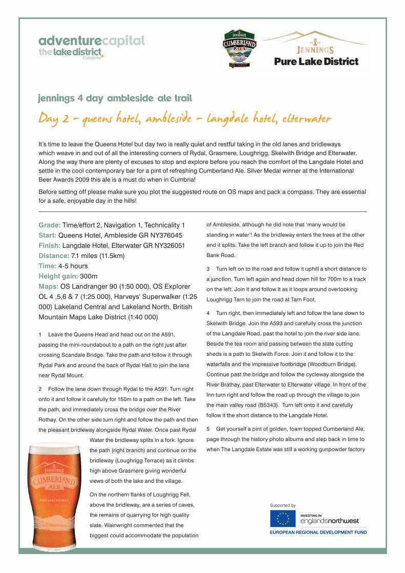
5 Get yourself a pint of golden, foam topped Cumberland Ale,
page through the history photo albums and step back in time to
when The Langdale Estate was still a working gunpowder factory

Day 2 - queens hotel, ambleside - langdale hotel, elterwater
jennings 4 day ambleside ale trail

Day 3 - langdale hotel, elterwater - wordsworth hotel, grasmere
jennings 4 day ambleside ale trail
This is the peak bagging day of the trip. After leaving the Langdale Hotel the route heads out along the old tracks down Langdale to the hotel at the foot of Stickle Gill. From here a fairly stiff climb gives access to the dramatic crag ringed corrie occupied by Stickle Tarn. Unlikely as it might seem standing amongst all the towering crags there is a sneaky route to the surrounding summits from the tarn. It leads in zig-zags to the dip between Harrison Stickle and Pavey Ark from where both peaks can easily be gained. The obvious diagonal line that cuts across the crags of Pavey Ark is Jack’s Rake which is a popular scramble. The rest of the crag provides top quality rock climbs. Having summited these two a big loop takes in Thunacar Knott and Sergeant Man, and then heads down, via Blea Rigg and Easedale Tarn, to the pastoral beauty of Grasmere and the welcome sight of the Wordsworth Hotel where a lovely, refreshing pint of Cumberland Ale awaits you!
Before setting off please make sure you plot the suggested route on OS maps and pack a compass. They are essential for a safe, enjoyable day in the hills!
Grade: Time/effort 3, Navigation 3, Technicality 3 Start: Langdale Hotel, Elterwater GR NY326051 Finish: Wordsworth Hotel, Grasmere GR NY337074 Distance: 10 miles (16km)Time: 6-7 hoursHeight gain: 920mMaps: OS Landranger 90 (1:50 000), OS Explorer OL 4 ,5,6 & 7 (1:25 000), Harveys' Superwalker (1:25 000) Lakeland Central and Lakeland North, British Mountain Maps Lake District (1:40 000)
1 From the Langdale Hotel head up the valley road for 500m
to join the Cumbria Way. Follow over New Bridge and onwards
towards Oak Howe. Continue past taking the path (not the
bridleway) to Side House. From Side House take the Cumbria
Way to the main valley road. Turn right off the Cumbria Way and
follow the bridleway crossing Langdale Beck to join the valley
road near the New Hotel.
2 Enter the main public car park, and at the top end, beside the
WC join the Stickle Gill Path. The path climbs a steepening route
up the side of the beck all the way up to the dam at Stickle Tarn.
3 Cross the dam and make your way around the side of
Stickle Tarn to the foot of the steep path that climbs to the
saddle on the north side of Harrison Stickle.
This is the last big climb but if you take your
time and pace yourself the work is soon
done and you are delivered to a
magnificent spot right at the heart of the
Langdale Pikes plateau. Harrison Stickle
the highest of the ‘Pikes’ (736m) lies a short
climb to the south. Once you have
summited you need to backtrack the
saddle then follow the rocky path across it
to make another short climb to the airy
summit of Pavey Ark. The summit gives
stunning unrestricted views to the south out over Langdale and
towards the giants of the Coniston Fells. The next of the ‘Pikes’
is Thunacar Knott. It’s little more than a rocky knoll in the middle
of the plateau, but it is a charming spot and is relatively
sheltered making it a great place to stop for lunch.
4 The next leg out to the Sergeant Man takes the route away
from the Langdale Pikes and crosses over on to the broad
shoulder of High Raise. The going is easy over relatively flat
moorland but be careful if there is any mist about as the path is
vague and easily lost. From Thunacar Knott head north for
600m across a broad col then take the path that splits off
northeast then east to Sergeant Man. The summit is little more
than a collection of rocks but it is set in a truly wild spot and is
well worth visiting.
5 From Sergeant Man head east then southeast along the
path that descends the broad ridge. After about 750m the path
splits at a junction into three paths. Take the left hand path that
leads down first past the shapely bump of Belles Knott, and
then into the upper reaches of Easedale. Continue along the
path to join the bridleway at the mouth of Easedale Tarn.
6 The bridleway leads easily from Easedale Tarn carrying you
above the waterfalls of Sourmilk Gill and down to the pasture of
lower Easedale. Continue along the bridleway to join Easedale
Road. Follow into Grasmere and walk through the village past
the green and around the road to the Wordsworth Hotel. Head
for the bar and reflect on the adventure so far with a pint of
classic Lakeland ale from Jennings.

Day 3 - langdale hotel, elterwater - wordsworth hotel, grasmere
jennings 4 day ambleside ale trail

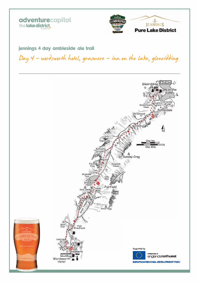
Day 4 - wordsworth hotel, grasmere - inn on the lake, glenridding
jennings 4 day ambleside ale trail
The final day involves crossing the backbone of the Helvellyn range back to the start at the Inn on the Lake. To do this the route exploits the line taken by an ancient packhorse trail that crosses the ridge at the dip between Dollywaggon Pike and Fairfield. Between these two giants lies a broad depression occupied by the wild waters of Grisedale Tarn; 33m at its deepest point it is reported to hold some of the largest trout found in the Lake District’s high tarns.Either side of the tarn on the western side are a couple of cols. The route over from Grasmere crosses the southern of the two called Grisedale Hause. The approach to Grisedale Hause is short but steep, whilst the descent down the other side along Grisedale is long but at a more moderate angle. The last leg is over the minor subsidiary ridge of Keldas which at the high point of Lanty’s Tarn gives an absolutely stunning view down to Ullswater. Before setting off please make sure you plot the suggested route on OS maps and pack a compass. They are essential for a safe, enjoyable day in the hills!
Grade: Time/effort 3, Navigation 2, Technicality 2 Start: Wordsworth Hotel, Grasmere GR NY337074 Finish: Inn on the Lake, Glenridding, GR NY386170 Distance: 8.25 miles (13.25km)Time: 5-6 hoursHeight gain: 735mMaps: OS Landranger 90 (1:50 000), OS Explorer OL 4, 5, 6 & 7 (1:25 000), Harveys' Superwalker (1:25 000) Lakeland Central and Lakeland North, British Mountain Maps Lake District (1:40 000)
1 From the Wordsworth Hotel backtrack along the previous
days route a short distance along Easedale Road to Goody
Bridge. Cross it, and continue a short distance to a junction,
turn right and follow the lane to another junction by Low Mill
Bridge. Turn right and follow the lane to the A591.
2 Carefully cross the A591 and join the bridleway/track. This is
the start of the old packhorse route up to Grisedale Hause.
Follow it to the water intake at the foot of Great Tongue. The
packhorse route/bridleway climbs alongside Little Tongue Gill
then up the steep crest of Little Tongue. As Little Tongue
merges into the slopes of Seat Sandal the bridleway turns and
traverses at an easier angle onto the flats of Hause Moss. Head
across the moss and then make the short zig-zag up the
enclosing headwall to the col at Grisedale Hause.
3 Cross the col and follow the bridleway
easily down to the ruffled waters of
Grisedale Tarn. Cross the outlet stream and
head a short distance to a junction. This is
the start of the descent into Grisedale. Turn
right on to the bridleway and follow it. It has
the odd steep rocky step but generally its
easy going. Ruthwaite Lodge (an Outward
Bound climbing hut) is soon reached after
which the bridleway descends to a
footbridge. Ignore it and instead continue
dropping a short distance until you reach
a second footbridge over Grisedale Beck. Cross this and
continue all the way down Grisedale until you reach the road
head just by Thornhow.
4 Turn left at the road head and cross Grisedale Beck by the
bridge. On the other side the track turns at a junction with a
path. Ignore the track instead head straight on and climb up the
path a short distance to another junction. Turn left and follow
the path to Lanty’s Tarn. Past the tarn the path descends steeply
to the houses at Westside. Continue past the houses, then turn
right onto a bridleway which is then followed into Glenridding.
Turn left onto the A593 which is crossed over the bridge to the
Inn on the Lake.
5 The journey is now complete and you have explored
some of the best landscapes the area has to offer. Sit back
and reflect on your journey with a final pint of Jennings classic
awarding winning Cumberland Ale or the distinctive, quality ale
Cocker Hoop.
Day 4 - wordsworth hotel, grasmere - inn on the lake, glenridding
jennings 4 day ambleside ale trail