advantages of the integration of image processing and ... · surveying – development of ......
TRANSCRIPT

JS 28....... Michael Scherer Advantages of the Integration of Image Processing and Direct Coordinate Measurement for Architectural Surveying – Development of the System TOTAL FIG XXII International Congress Washington, D.C. USA, April 19-26 2002
1/11
Advantages of the Integration of Image Processing and Direct Coordinate Measurement for Architectural Surveying
- Development of the System TOTAL –
Michael SCHERER, Germany
Key words: ABSTRACT First a short investigation is presented, where different types of edifices, different types of recording, different instruments and different surveying methods are compared. Obviously, certain surveying methods are suited more or less well to detect special qualities of a building. The methods very often compete up to a certain amount. However it would be more effective, cost-reducing and time-saving to use more often different surveying methods side by side than to refer to insist on a single one. It is shown, that benefits derive from a close combination of certain elements of the methods in one instrument. As a synthesis the system TOTAL was developed. CONTACTS Prof. Dr.-Ing. Michael Scherer Ruhr-Universität Bochum Arbeitsgruppe Geodäsie Universitätsstr. 150 44780 Bochum Germany Tel. +49 + 234/3226070 Fax + 49 + 234/3214373 Email: [email protected] Web site: www.ruhr-uni-bochum.de/geodaesie

Advantages of the Integration of Image Processing and Direct Coordinate Measurement for Architectural Surveying
- Development of the System TOTAL –
Michael SCHERER, Germany
1. ARCHITECTURAL SURVEYING – AN OVERVIEW Architectural surveying affects different types of areas:
a) different disciplines like preservation of buildings and monuments, facility manage-ment, architectural analysis of buildings, archeology and as built documentation for reconstruction,
b) different types of results and presentation and c) different technical methods of surveying.
Table 1 shows interactions between disciplines, typical accuracies and some characteristics concerning clients and the role of visualization for the disciplines. Precision is the most important factor in choosing a measuring method. Thus it was chosen as background allowing a classification. It decreases from high precision needed for the analysis of buildings via recording in perservation of historic buildings and monuments, via architectural surveying down to low accuracy in facility management. The transitions are not very distinct but the direction of the gradation is obvious. Also knowledge about the variety of possibilities for presenting results is important, no matter whether the surveyor carries out the presentation himself or not. There are traditional and modern types of presentation (table 2): conventional presentation of highest accuracy on one side, rough visualization for popular purposes on the other, different types of monuments and of recording
documentation for analysis of buildings, surveying artefacts
preservation of historic buildings and monuments, archeology
architectural surveying, as built documentation
facility management
magnitude of demanded accuracy
3 mm ... 1 cm
1 cm ... 2 cm
2 cm ... 5 cm
3 cm ... 10 cm
geometrical accuracy
characteristical catchwords
on-site, portraying, analytical recording
giving a precise model of shape
presentation fit for architectural means, rather schematic graph
determining areas, rough positioning of attributes
JS 28....... Michael Scherer Advantages of the Integration of Image Processing and Direct Coordinate Measurement for Architectural Surveying – Development of the System TOTAL FIG XXII International Congress Washington, D.C. USA, April 19-26 2002
2/11

JS 28....... Michael Scherer Advantages of the Integration of Image Processing and Direct Coordinate Measurement for Architectural Surveying – Development of the System TOTAL FIG XXII International Congress Washington, D.C. USA, April 19-26 2002
3/11
importance and clients
special scientific interest
public general interest
private client
geometrical back-ground, private interest
demand for visualization
detailed, but only for parts of the object
rarely public, mostly for education and tourism
planning, background for decisions
commercial/ estate agent
Table 1: Types of recording concerning geometry visualization and accuracy
numerical presentation, drawn plans and more or less photorealistic visualization with simulation and animation. Obviously the chosen form of presentation influences the surveying-method, especially when visual information has to be recorded with the geometry. numerical presentation
visualization drawing
photorealistic model, surface
numerical data: coordinates, measurements, surfaces
alphanumerical data: list of attributes and objects
horizontal profile and vertical profile, projection, elevation drawing, precise plan of quarrystones, gridmodel, e.g. as network of triangles
panorama, rectification/ortho-image, 3 D-model with texture/rendering, photorealistic walk bys, precalculated or free
Table 2: Forms to present results
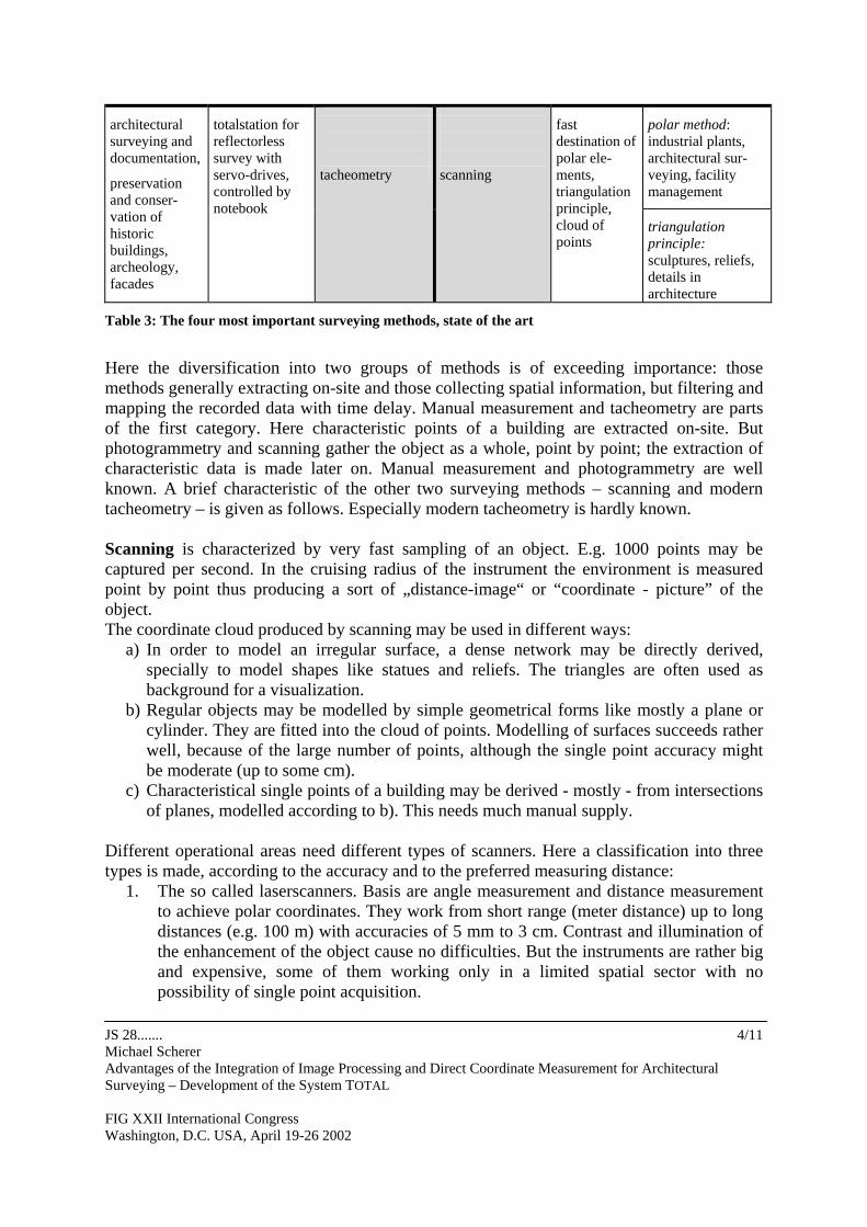
2. TODAYS SURVEYING METHODS – THEIR ADVANTAGES AND DISADVAN-TAGES Table 3 contents the most important surveying methods and characteristics concerning their actual instrumentation and the disciplines where the methods are mostly used.
filtering/extraction of the points of interest
actual application
instrumen-tation
on-site, before measuring
later on, in course of mapping
instrumen-tation
actual application
supplementary and control measurements, facility management
handheld notebook controlled distancemeter, telescope rod, plumb
manual measurement
photogrammetry
digital camera, bundle-adjustment, matching
preservation of historic buildings, architectural surveying, mapping of facades, visualization
JS 28....... Michael Scherer Advantages of the Integration of Image Processing and Direct Coordinate Measurement for Architectural Surveying – Development of the System TOTAL FIG XXII International Congress Washington, D.C. USA, April 19-26 2002
4/11
polar method: industrial plants, architectural sur-veying, facility management
architectural surveying and documentation, preservation and conser-vation of historic buildings, archeology, facades
totalstation for reflectorless survey with servo-drives, controlled by notebook
tacheometry
scanning
fast destination of polar ele-ments, triangulation principle, cloud of points
triangulation principle: sculptures, reliefs, details in architecture
Table 3: The four most important surveying methods, state of the art
Here the diversification into two groups of methods is of exceeding importance: those methods generally extracting on-site and those collecting spatial information, but filtering and mapping the recorded data with time delay. Manual measurement and tacheometry are parts of the first category. Here characteristic points of a building are extracted on-site. But photogrammetry and scanning gather the object as a whole, point by point; the extraction of characteristic data is made later on. Manual measurement and photogrammetry are well known. A brief characteristic of the other two surveying methods – scanning and modern tacheometry – is given as follows. Especially modern tacheometry is hardly known. Scanning is characterized by very fast sampling of an object. E.g. 1000 points may be captured per second. In the cruising radius of the instrument the environment is measured point by point thus producing a sort of „distance-image“ or “coordinate - picture” of the object. The coordinate cloud produced by scanning may be used in different ways:
a) In order to model an irregular surface, a dense network may be directly derived, specially to model shapes like statues and reliefs. The triangles are often used as background for a visualization. b) Regular objects may be modelled by simple geometrical forms like mostly a plane or
cylinder. They are fitted into the cloud of points. Modelling of surfaces succeeds rather well, because of the large number of points, although the single point accuracy might be moderate (up to some cm).
c) Characteristical single points of a building may be derived - mostly - from intersections of planes, modelled according to b). This needs much manual supply.
Different operational areas need different types of scanners. Here a classification into three types is made, according to the accuracy and to the preferred measuring distance:
1. The so called laserscanners. Basis are angle measurement and distance measurement to achieve polar coordinates. They work from short range (meter distance) up to long distances (e.g. 100 m) with accuracies of 5 mm to 3 cm. Contrast and illumination of the enhancement of the object cause no difficulties. But the instruments are rather big and expensive, some of them working only in a limited spatial sector with no possibility of single point acquisition.

2. Scanners of high resolution (0.2 mm at 1 m distance up to 2 cm at a range of 30 m), based on the triangulation principle. Disadvantages are the decrease of accuracy with growing distance, their considerable weight, great volumes and high costs. The receiver, the CCD-array needs sufficient return signal. So working at night is often necessary.
3. Scanners of highest resolution, enabling freehand-scanning with an accuracy of millimeter to submillimeter. They may be used for sculptures, reliefs, architectural and archeological details. Disadvantages may be the rather limited cruising radius, problems to fit different areas together and high costs.
Modern tacheometry uses as hardware totalstation equipped with servodrives, directed by a notebook and measuring ranges reflectorless. The first instrument was developed and constructed in 1994 in our laboratory (figure 1).
3 rd generation: Totalstation Leica TCRM / TCRA
1st generation: Special mounting with an Ibeo - Pulsar for distance measurement
-
2 nd generation: Modified Geodimeter DR 486 with mounted CCD- Camera
Common qualities of modern tacheometers: controlled and directed by notebook, distance measured without reflector
Figure 1: Development of the hardware
Meanwhile important manufacturers of surveying instruments produce this type of instrument. We continued to develop special software with regard to the survey of architectural sites and historic monuments. Thus this class of totalstations may be used in an optimal way. A very central principle in the developments was the idea to control each result on-site. The whole system is named TOTAL - Tacheometric Object-oriented Partly (Teil-) Automated Lasersurveying – and it runs on a notebook. The software provides a large spectrum of automatic and half-automatic measuring possibilities. E.g. very precise detection of edges and corners is possible. Due to the laser beam measuring several centimeters in diameter, they cannot be otherwise determined with high precision. Another tool is a specially coded extrapolation-rod to measure hidden points quickly, precisely and widely automatic.
JS 28....... Michael Scherer Advantages of the Integration of Image Processing and Direct Coordinate Measurement for Architectural Surveying – Development of the System TOTAL FIG XXII International Congress Washington, D.C. USA, April 19-26 2002
5/11

When documenting monuments the profile-measuring function proved a very powerful tool, making location-independent horizontal and vertical profiling possible. An example is given in figure 2, showing rough data of surveying the Basilica di Massenzio, Forum Romanum, Rome, Italy. Profiles are taken absolutely independent from the position where the totalstation is stationed. They are automatically continued everywhere in the monument e.g. on both sides of a wall. Further useful tools, like initiating measurements out of the graph shown on the screen of the notebook enable fast, effective work (Juretzko 2001). Using the totalstation in this modern way may be characterized as a continuation of the classical “painting a portrait “ like this praxis to document and to analyze face to the building is designated in architectural recording.
JS 28....... Michael Scherer Advantages of the Integration of Image Processing and Direct Coordinate Measurement for Architectural Surveying – Development of the System TOTAL FIG XXII International Congress Washington, D.C. USA, April 19-26 2002
6/11
Figure 2: Horizontal and vertical profiles
20 m
Basilica di Massenzio
Looking back to the four principal methods discussed in this chapter, manual measurement, photogrammetry, scanning and tacheometry, it can be seen that each one has its advantages and its disadvantages (detailed in (Scherer 2001, a)). Obviously for an ideal recording several methods need to be used at least parallel. With regard to a synthesis of parts of them it had to be analyzed which characteristics should be chosen and combined.
3. TOWARDS A SYNTHESIS OF DIFFERENT SURVEYING METHODS Those qualities of each method have to be picked up which are unique or/and supplemental. In a first step the importance of each method for different tasks had to be investigated (table 4). method architectural
analysis and documentation
as built docu-mentation for architectural reconstruction
preservation of historic buildings and monuments
facades archeology facility manage-ment
industrial plants
manual measurement
3 – 1* 1 1 1 2 2 0
photogrammetry 2 0 2 3 2 0 3 scanning 1 2 1 2 1 2* 3

JS 28....... Michael Scherer Advantages of the Integration of Image Processing and Direct Coordinate Measurement for Architectural Surveying – Development of the System TOTAL FIG XXII International Congress Washington, D.C. USA, April 19-26 2002
7/11
tacheometry 2 3 2 3 3 1 1 1 = occasinally used 2 = medium 3 = preferred 0 = without importance * = strongly depending on type of recording
Table 4: The actual role of the surveying methods in different disciplines of architectural surveying
Table 4 gives an impression of the importance of each method for different tasks. The digits are strongly dependant of individual experiences, tendencies are at least right. Photogrammetry and tacheometry seem to be the most important tools for architectural surveying. It is a positive aspect, that they each belong to one of the two very different categories (see table 3): methods measuring discrete points (manual measurement and tacheometry) on one side and the more globally data gathering methods (photogrammetry und scanning) on the other side. At least one method of each category should be taken in account for a synthesis because their different nature offers a broad number of complementing qualities. Another way to compare the importance of the surveying methods more in detail is to look at job steps in the survey itself. Table 5 gives an overview about useful qualities and specifications of the methods. Manual measurement is no longer regarded, because of the difficulties introducing the results into a consistent coordinate system.
rectification
step method
single point
corner, edge
irregular surface
control point
image
coordinates
profile
accuracy
results on-site
photo-grammetry
X
X
X
0
X
indirect
X
tacheo-metry
X
X
(X)
X
0
X
X
corres-ponding
image process-ing possible
scanning
0
indirect
X
0
0
0
X
0/X
X = existing/ possible 0 = unfavorable/ impossible / difficult
Table 5: Corresponding characteristics chosen for a synthesis
Tacheometry and photogrammetry each have more tools already existing than scanning. So elements of these methods were selected for the synthesis. Because of the oppositeness of photogrammetry (gathering point clouds and extracting characteristic points with time delay) and tacheometry (selecting before measurement) we combined tacheometry with elements from photogrammetry, hardware as well as software. The functions marked in grey in table 5 were selected of each method. Obviously all important functions can be gathered from photogrammetry and from tacheometry based on the experience with the notebook-controlled total station. Only fast scanning of surfaces is not possible. As a compensation the option to
scan a raster within a polygonal enclosed area has been developed. Based on this analysis the new system was designed.
4. TOTAL – INTEGRATION OF GEOMETRICAL AND VISUAL FUNCTIONALITIES
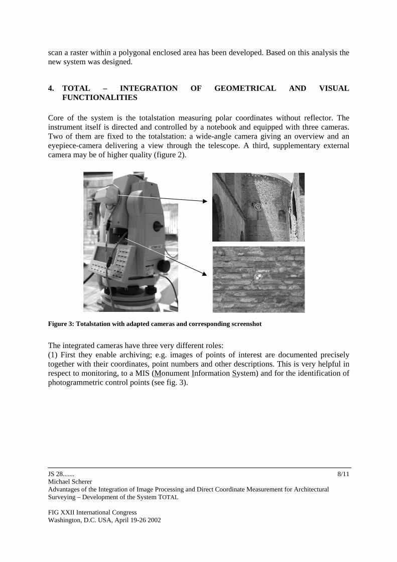
Core of the system is the totalstation measuring polar coordinates without reflector. The instrument itself is directed and controlled by a notebook and equipped with three cameras. Two of them are fixed to the totalstation: a wide-angle camera giving an overview and an eyepiece-camera delivering a view through the telescope. A third, supplementary external camera may be of higher quality (figure 2).
Figure 3: Totalstation with adapted cameras and corresponding screenshot
The integrated cameras have three very different roles: (1) First they enable archiving; e.g. images of points of interest are documented precisely together with their coordinates, point numbers and other descriptions. This is very helpful in respect to monitoring, to a MIS (Monument Information System) and for the identification of photogrammetric control points (see fig. 3).
JS 28....... Michael Scherer Advantages of the Integration of Image Processing and Direct Coordinate Measurement for Architectural Surveying – Development of the System TOTAL FIG XXII International Congress Washington, D.C. USA, April 19-26 2002
8/11

Figure 3: Screenshot showing the software-integration of geometrical and image processing
(2) Targeting and Calibration. Targeting is done via the images of the cameras (see fig. 2). The redundant information of the images and of the polar measurements may be used for automated detection of corners (fig. 4) and to control some tools of the system itself.
raised central point
Figure 4: Three-dimensional target for calibration, sensitive towards distance-change and differences in contrast
(3) The images are used for visualization and modelling, e.g. to generate ortho-images. For this purpose it is a great advantage that coordinates may be measured quasi simultaneous
JS 28....... Michael Scherer Advantages of the Integration of Image Processing and Direct Coordinate Measurement for Architectural Surveying – Development of the System TOTAL FIG XXII International Congress Washington, D.C. USA, April 19-26 2002
9/11
within the photo-array. Overlapping photos for bundle adjustment are then hardly necessary (fig. 5).
Figure 5: Orthophoto for restauration purposes
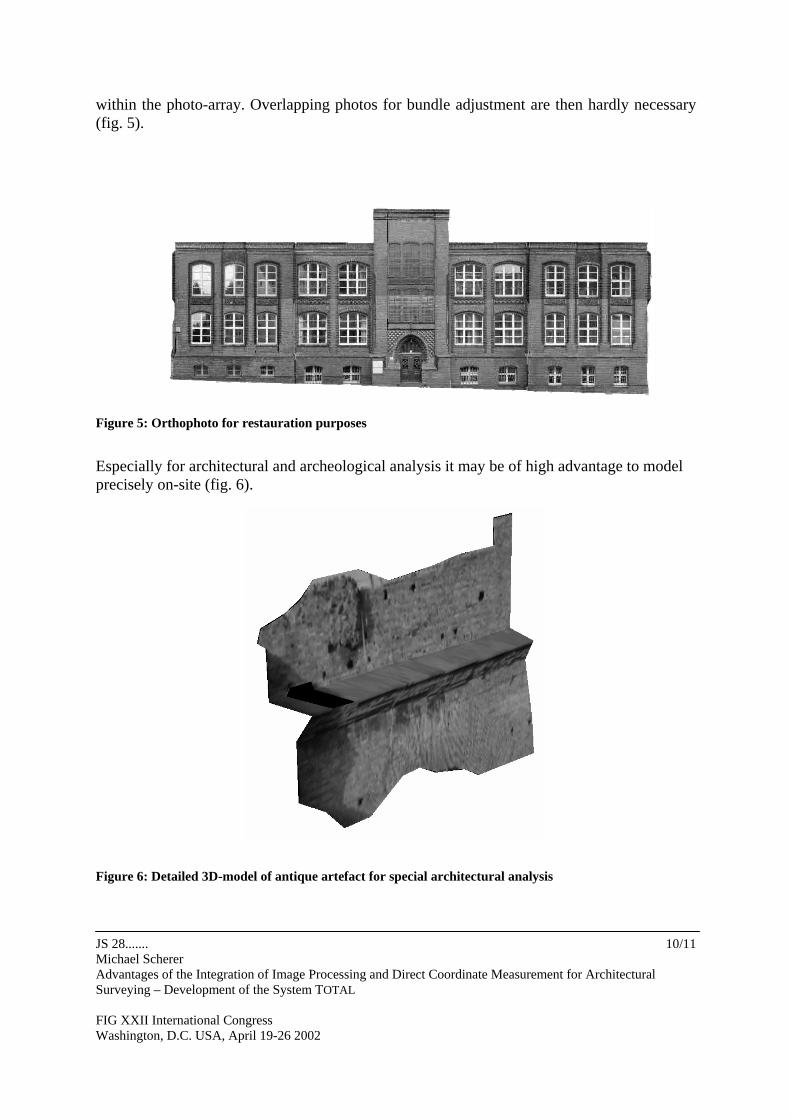
Especially for architectural and archeological analysis it may be of high advantage to model precisely on-site (fig. 6). Figure 6: Detailed 3D-model of antique artefact for special architectural analysis
JS 28....... Michael Scherer Advantages of the Integration of Image Processing and Direct Coordinate Measurement for Architectural Surveying – Development of the System TOTAL FIG XXII International Congress Washington, D.C. USA, April 19-26 2002
10/11

JS 28....... Michael Scherer Advantages of the Integration of Image Processing and Direct Coordinate Measurement for Architectural Surveying – Development of the System TOTAL FIG XXII International Congress Washington, D.C. USA, April 19-26 2002
11/11
5. FUTURAL DEVELOPMENTS – GENERAL VIEW AND OUR PLANS Visualization will be an expending area in near future. Not only for scientific and public purposes, but for commercial ones above all. The integration of tacheometry and photogrammetry enables automated modelling within areas of different precision, controlled on site. Using the redundant information realized by tacheometric measurement and by the variation of intensity in the picture will give another strong impact towards automation. We are working on both actually: integration of visualization and automated recognition of edges and corners. Looking at the advantages of the integration of tacheometry and photogrammetry, scanning should be added soon. Modern instruments for architectural surveying will consist of a synthesis of tacheometry, photogrammetry and scanning. I think our way is right approaching to this aim from the side of very precise determination of single points as the core of the system, while other methods are added and grouped around and integrated. REFERENCES Juretzko, M., 2001, The System TOTAL for Recording Geometry and Image Data of Historic Buildings and Monuments, CIPA International Symposium, Potsdam, going to press. Scherer, M., 2001, a. Objekterfassung: Was? – Wie? – Wozu? Eine Analyse mit Schwerpunkt bei der Bauaufnahme, periodical Flächenmanagement und Bodenordnung 4/2001, pp.188-199. Scherer, M., 2001, b. „About the Synthesis of different methods in Surveying“, CIPA International Symposium, Potsdam, going to press.