advanced secondary recovery project cooperative …
TRANSCRIPT
ADVANCED SECONDARY RECOVERY PROJECTFOR THE SOONER “D” SAND UNIT,
WELD COUNTY, COLORADOCOOPERATIVE AGREEMENT DE4’C2293BC14954
FINAL REPORT
Report Date:Award Date:Completion Date:
Project Manager:
Principal Investigator:
DOE Project Officer:
DOE Contract Officer:
July 1996October 21, 1992November 30, 1995
Terry J, CammonDiversified operating CorporationMark A. SippelMark Sippel Engineering, Inc.
Edith AllisonBartlesville Project office
David HunterPittsburgh Energy Technology Center
Prepared byDiversified operating Corp.
1675 Larimer Street, Suite 400Denver, Colorado 80202
U.S. DOE Patent Clearanceis not requiredprior to the publicationof this document

ADVANCED SECONDARY RECOVERY PROJECT FOR THE SOONER “D” SANDUNIT,
WELD COUNTY, COLORADOCOOPERATIVE AGREEMENT DE+ C22%IBC14954
Disclaimer
This report was prepared as an account of work sponsored by an agency of the UnitedStates Government. Neither the United States Government nor any agency thereof, nor theiremployees, makes any warranty, expressed or implied, or assumes any legal liability orresponsibility for the accuracy, completeness, or usefulness of any information, apparatus,product, or process disclosed or represented that its use would not infringe privately ownedrights. Reference herein to any specific commercial product, process, or service by tradename, trademark, manufacturer, or otherwise does not necessarily constitute or imply itsendorsement, recommendation, or favoring by the United States Government or any agencythereof. The views and opinions of authors expressed herein do not necessarily state or reflectthose of the United States Government or any agency thereof.

ADVANCED SECONDARY RECOVERY PROJECT FOR THE SOONER “D” SANDUNIT,
WELD COUNTY, COLORADOCOOPERATIVE AGREEMENT DE+ C22%IBC14954
Abstract
The objective of this project is to increase production from the Cretaceus DSandstone in the Denver-Julesburg (D~) Basin through geologically targeted infill drillingand improved reservoir management of waterflood operations. This project involves multi–disciplinary reservoir characterization using highdensity 3D seismic, detailed stratigraphyand reservoir simulation studies. Infill drilling, water-injection conversion and re-completingsome wells to add short-radius laterals will be based on the results of the reservoircharacterization studies. Production response will be evaluated using reservoir simulation andproduction tests. Technology transfer will utilize workshops, presentations and technicalpapers which will emphasize the economic advantages of implementing the demonstratedtechnologies. The success of this project and effective technology transfer should prompt-re–appraisal of older waterflood projects and implementation of new projects in oil provincessuch as the D ~ Basin.
ii

ADVANCED SECONDARY RECOVERY PROJECT FOR THE SOONER “D” SANDUNIT,
WELD COUNTY, COLORADOCOOPERATIVE AGREEMENT DE+ C22%IBC14954
Table of Contents
Section Page
Disclaimer . . . . . . . . . . . . . . . . . . . . . . . . . . . . . . . . . . . . . . . . . . . . . . . . . . . . . . . . . . . . . . ..iAbstract . . . . . . . . . . . . . . . . . . . . . . . . . . . . . . . . . . . . . . . . . . . . . . . . . . . . . . . . . . . . . . . ..iiTable of Contents . . . . . . . . . . . . . . . . . . . . . . . . . . . . . . . . . . . . . . . . . . . . . . . . . . . . . . . . ..iiiListofFigures . . . . . . . . . . . . . . . . . . . . . . . . . . . . . . . . . . . . . . . . . . . . . . . . . . . . . . . . . . ..ivList ofTables . . . . . . . . . . . . . . . . . . . . . . . . . . . . . . . . . . . . . . . . . . . . . . . . . . . . . . . . . . . . ..vExecutive Summary . . . . . . . . . . . . . . . . . . . . . . . . . . . . . . . . . . . . . . . . . . . . . . . . . . . . . . ..viBackground ofExploration and Waterflooding forthe D Sandstone . . . . . . . . . . . . . . . . . I–1History ofthe Sooner ’’D’’SandUnit . . . . . . . . . . . . . . . . . . . . . . . . . . . . . . . . . . . . . . . ...11-1Geology ofthe Sooner ’’D’’Sand Unit and Adjacent Area..... . . . . . . . . . . . . . . . . . . . . III–1Petrographical Analysis of the D Sandstone . . . . . . . . . . . . . . . . . . . . . . . . . . . . . . . . . ..IV–lCore and Electrical Log Descriptions ofthe D Sandstone . . . . . . . . . . . . . . . . . . . . . . . . . V–1Pressure Transient Analysisof the D Sandstone . . . . . . . . . . . . . . . . . . . . . . . . . . . . . . ..VI–1Seismic Characterizations of the D Sandstone . . . . . . . . . . . . . . . . . . . . . . . . . . . . . . . . . VII–1Reservoir Compartments . . . . . . . . . . . . . . . . . . . . . . . . . . . . . . . . . . . . . . . . . . . . . . . . VIII–1Reservoir Simulation forWaterflooding . . . . . . . . . . . . . . . . . . . . . . . . . . . . . . . . . . . . ..IX–lTargeted Infill Drilling and Economics . . . . . . . . . . . . . . . . . . . . . . . . . . . . . . . . . . . . . . . X–1Summary and Conclusions . . . . . . . . . . . . . . . . . . . . . . . . . . . . . . . . . . . . . . . . . . . . . . . ..XI–l
. . .111

ADVANCED SECONDARY RECOVERY PROJECT FOR THE SOONER “D” SANDUNIT,
Figure
Figure I-1Figure I-2Figure II-1Figure II-2Figure III-1Figure III-2Figure III-3Figure III-4Figure III-5Figure III-6Figure III-7Figure III-8Figure 111+Figure IV-1Figure IV-2Figure IV-3Figure IV-4Figure V-lFigure V-2Figure VII-1Figure VII-2Figure VII-3Figure VII-4Figure VII-5Figure VII-6Figure VII-7Figure VII-8Figure VII+Figure VIII-1Figure VIII-2Figure VIII-3Figure VIII-4Figure IX-lFigure IX-2Figure IX-3Figure IX4Figure X-lFigure X-2
WELDCGUNTY, COLORADOCGGPERATIVEAGREEMENT DE+C22%IBC14954
List ofFiguresPage
Limits of Denver Basin and D Sandstone Play. . . . . . . . . . . . . . . . . . . . . . . . I-5Denver Basin and D Sandstone Fields in Eastern Colorado . . . . . . . . . . . . . I-6Net Pay Interpretation of the DSandstone atthe Sooner Unit inl988. . ...11-2Production History from the Sooner Unit “D” Sand Unit . . . . . . . . . . . . . . . II-3Location of Sooner Unit and D Sandstone Fields in Eastern Colorado . . . 111~5Structure Mapof D Sandstone . . . . . . . . . . . . . . . . . . . . . . . . . . . . . . . . .. 111-6Type Log of D Sandstone and Adjacent Llithology . . . . . . . . . . . . . . . . . . III-7Isopach Mapof Huntsman Shale . . . . . . . . . . . . . . . . . . . . . . . . . . . . . . .. 111-8Structure Mapof Huntsman Shale.. . . . . . . . . . . . . . . . . . . . . . . . . . . ...111+Depositional Block Ddiagram for D Sandstone . . . . . . . . . . . . . . . . . . . . 111–10Isopach Mapof ’X’ Bentoniteto Mowry . . . . . . . . . . . . . . . . . . . . . . . . ..111–11Log Cross–Section with Faulting. . . . . . . . . . . . . . . . . . . . . . . . . . . . . . ..111–12Cross-Section of Thick Valley +ill . . . . . . . . . . . . . . . . . . . . . . . . . . . . .. III-l3Core Logof DSandstone from SU 7-21. . . . . . . . . . . . . . . . . . . . . . . . . .. IV-7Density Log from SU 7-21 . . . . . . . . . . . . . . . . . . . . . . . . . . . . . . . . . . . . .. IV43Density Log from SU21-14-l . . . . . . . . . . . . . . . . . . . . . . . . . . . . . . . . .. IV+Stratigraphic Comparison of SU 21-14-1 and 7-21 . . . . . . . . . . . . . . . . . . IV-10Porosity permeability Cross+lot from D Sandstone Cores . . . . . . . . . . . . V-3Permeability Distribution from D Sandstone Cores . . . . . . . . . . . . . . . . . . V-4Seismic Section from Sooner 3D Data Volume . . . . . . . . . . . . . . . . . . . VII–10Synthetic Seismogram Cross–Section . . . . . . . . . . . . . . . . . . . . . . . . . . . VII–11Stratigraphic West-East Cross-Section at the Sooner Unit . . . . . . . . . . . VII-12Seismic Amplitude of the D Sandstone at the Sooner Unit . . . . . . . . . . . VII-13Seismic Isochron of the D Sandstone at the Sooner Unit . . . . . . . . . . . . VII–14Prediction of Gross Thickness from Seismic Attributes . . . . . . . . . . . . . VII–15Prediction of Net+ay Thickness from Seismic Attributes . . . . . . . . . . . VII–16Prediction of Hydrocarbon+eet from Seismic Attributes . . . . . . . . . . . . VII–17Net+ay Map of the Sooner Unit D Sandstone in 1988 . . . . . . . . . . . . . VII-18Schematic of Compartments in D Sandstone Reservoirs . . . . . . . . . . . . VIII-3PreWnitization Map of Reservoir Using Net Thickness . . . . . . . . . . . . . VIII-4Map of Functional Reservoir Compartments . . . . . . . . . . . . . . . . . . . . . VIII~53D seismic Attribute Map of Huntsman Shale . . . . . . . . . . . . . . . . . . . . VIII-6Functional Reservoir Compartments at Sooner Unit . . . . . . . . . . . . . . . . . . IX–73D Seismic Attribute Map of Huntsman Shale . . . . . . . . . . . . . . . . . . . . . . IX-8Example of Single–Well History Matching . . . . . . . . . . . . . . . . . . . . . . . . . IX+History Match of Composite Sooner Unit . . . . . . . . . . . . . . . . . . . . . . . . . IX–10Map of Drilling Activity During the Project . . . . . . . . . . . . . . . . . . . . . . . . X-5Map of Hydrocarbon+eet from Siesmic4ttribute Correlations . . . . . . . . X-6
iv

Figure X-3 Map–View of Functional Reservoir Compartments . . . . . . . . . . . . . . . . . . X–7

ADVANCED SECONDARY RECOVERY PROJECT FOR THE SOONER “D” SANDUNIT,
Table
Table I-1Table IV-1Table IV-2Table IV-3Table V-1Table V-2Table VI-1Table VII-1Table VII-2Table IX-1Table IX-2Table IX-3Table IX-4
Table X-1
WELD COUNTY, COLORADOCOOPERATIVE AGREEMENT DE+ C22%IBC14954
List of Tables
Page
Recovery by Waterflood from D Sandstone Fields Near the Sooner Unit. . . I-3Composition of D Sandstone from Thin–Section Analysis . . . . . . . . . . . . . IV-4Grain Size for D Sandstone from Thin–Section Samples . . . . . . . . . . . . . . IV-4D Sandstone Petrographic Descriptions from SU 21-14-1 . . . . . . . . . . . . . IV-5Permeability Data from D Sandstone Cores in the Sooner Unit Area. . . . . V–1Summary of Log Calculations in the D Sandstone at the Sooner Unit . . . . V-2Summary of Pressure Fall-off Analysis from Water Injection Wells . . . . . VI-1Processing Flow Used for Sooner 3D Seisimic Data . . . . . . . . . . . . . . . . VII-8Correlation Coefficients of Seismic and Electrical Log Data . . . . . . . . . . VII+Reservoir Properties Used for Simulation . . . . . . . . . . . . . . . . . . . . . . . . . . IX–2Results from History Matching by Well . . . . . . . . . . . . . . . . . . . . . . . . . ..IX4Results from History Matching Composite Production . . . . . . . . . . . . . . . 1X5Economic Value of Various Thicknesses in a 40-acre,2–Spot Waterflood Pattern Before Capital Expenditures . . . . . . . . . . . . . . IX-6Economic Model for Comparison of Targeted and Blanket Infill Drilling . X-4
vi

ADVANCED SECONDARY RECOVERY PROJECT FOR THE SOONER “D” SANDUNIT,
WELD COUNTY, COLORADOCOOPERATIVE AGREEMENT DE+ C22%IBC14954
Executive Summary
Production and Reserves
The oil producing rate at the Sooner Unit was increased nearly 200 bopd above pre–project projected trends. The projected ultimate developed reserves were increased from1,556,000 bbl to 1,861,000 bbl. These production increases were the result of realignment ofinjection~roduction patterns and the drilling of one injection well and one production well.The original~il-in-place (GGIP) calculated for the Sooner Unit were increased from5,900,000 bbl to 6,900,000 bbl. The increase in GGIP are the result of seismic mappingwhich was integrated with geological and engineering studies. The methodologies anddevelopment plan which evolved during the project lead to projections of 2,252,000 bbl (33percent of GGIP) ultimate recovery after drilling of an additional five wells.
Seismic Modeling
Detailed synthetic seismic modeling was performed to determine resulting seismicsignature and seismic frequency content necessary to resolve the internal stratigraphicarchitecture within the D Sandstone interval and to confirm the mapping and interpretationmethodologies from earlier work during the project.
Seismic Attribute Correlation
Correlations of seismic attributes were made with petrophysical properties fromelectrical log data. It was found that direct attributes of the D Sandstone interval wereinconsistent with reservoir development. Combination of attributes from the D Sandstone andadjacent temporal horizons through multiple~inear regression resulted in maps which weremore consistent with geological and engineering interpretations. It is concluded that adjacentnon-reservoir rock can provide important indicators of positive or negative development inadjacent reservoir rock.
Horizontal Completions
Attempts to drill a horizontal extension in a centrally located injection well wereunsuccessful. Mechanical difficulties were encountered in the first attempt which utilizedtechnology to drill an ultra+hort radius curve with articulated drill collars and angledbottomhole assembly. The second attempt utilized a short-radius curve with a downholemud-motor and steering assembly. A collapsing shale section above the target formationprevented completion of the lateral extension. A lithological barrier was penetrated duringthe second drilling attempt which confirms the objective and purpose of the horizontalextension.
vii

Vertical Wells
Two conventional, vertical wells were drilled based on integrated studies. one wellwas an injection well and the other was a production well. The injection well encountered athick gross (55 ft) section of D Sandstone but had only 6 ft of net reservoir thickness. Theproducing well location was based on seismic attribute correlations. It encountered 26 ft ofnet reservoir thickness and was completed with a producing rate of over 200 bopd.
Petrography
Descriptions were made from whole and sidewall cores. Permeability ranges from 1md to 100 md with a geometric+nean permeability of 21 md. Average porosity is 11.5percent. Sidewall cores were taken from the SU 21-14-1 well. Petrographical studies andthin sections were made of these core samples. The study indicates that poor porosity andpermeability development are primarily related to deposition. Clays and cements were foundto be indicative of different facies. Low%and facies are characterized by kaolinite andfeldspar. Abundance of calcite cement and chlorite clay suggest a transgressive setting withrising marine water. Low porosity and permeability rock results from fine laminations of clayand silty material.
Pressure Tests
Pressure tests taken during the project consisted of static shut-in measurements andtransient surveys for injection and production wells. Pressure falloff tests were performed onthree water-injection wells. Pressure buildup tests were taken from four producing wells.
Realign Injection%-oduction
Four wells were converted from either production to injection or vice+ersa in order torealign injection patterns which are better suited to the understanding of functional reservoircompartments. Reservoir management utilizing balancing injection with withdrawals offluids and gas by compartments had a positive result. Gas recycling was found to limit water-injection and was terminated.
Inter+vell Tracers
Inter+vell tracers were tested at three injection wells. Sodium bromide was used as thetracer material. Results were inconclusive.
Reservoir Simulation
Reservoir simulation was performed for two+pot situations to calculate recoverable oilin small, two+vell compartments.
. . .Vlll

Technology Transfer
An oral presentation was made at the regional section meeting of AAPG in Reno, NVin July, 1995. The talk presented the case history of drilling a horizontal well at the SoonerUnit.
A workshop presentation was made on November 17, 1995 in Denver with the RockyMountain regional Petroleum Technology Transfer Council (PTTC). The Sooner project wasone of three characterization studies presented from Eastern Colorado oil fields.
The project was presented on tour in six cities with the PTTC-BDM U.S. Departmentof Energy Class I traveling workshop during January and February, 1996.
All reservoir characterization data were donated to the Colorado School of Mines foruse under the direction of Robert Thompson, John Curtis and Tom Davis. This data setincludes electrical logs, production, pressure transient tests and 3 D seismic. The data havebeen used in under~raduate classes and in graduate studies.
The Sooner 3D seismic survey was donated to the Rocky Mountain PTTC under thedirection of Roger Slatt for use in the computer+echnology demonstration lab.
ix

ADVANCED SECONDARY RECOVERY PROJECT FOR THE SOONER “D” SANDUNIT,
WELD COUNTY, COLORADOCOOPERATIVE AGREEMENT DE+ C22%IBC14954
Background of Exploration and Waterflooding for the D Sandstone
Exploration
The D Sandstone play in the Denver Basin encompasses northeast Colorado andsouthwest Nebraska (Fig. I–l). The D Sandstone is a subsurface member of the Dakota Groupand is early Late Cretaceus age (Haun 1963). About 160 (42 percent) of the D Sandstonereservoirs in Colorado were abandoned or shut-in as of 1992 (Hemborg 1993). Although theD Sandstone may be considered a mature play, significant discoveries are still possible asshown by the discovery of Sooner Field in 1985 and Lilli Field in 1987, both in T. 8 N, R. 58W., Weld County, Colorado.
The west side of the Denver Basin was the second area in the United States to produceoil from drilled wells. The early exploration was based on random wildcatting for fracturedshale zones near oil seeps from 1862 through 1922. After 1920, exploration was based onsurface geological surveys for anticlinal structures on the west side of the basin near the frontrange of the Rocky Mountains. Development of the east flank of the basin was slower thanthe west flank because of low, unreliable surface dips and blanket Tertiary gravel beds.
A 1930 wildcat discovery (sec. 24, T. 6 N., R. 61 W.) on a gentle surface anticline onthe east flank of the basin in east Weld County, Colorado established the initial productionfrom the D Sandstone and the first production from any reservoir on the east flank of thebasin (Lavington 1941). This well, the Platte Valley Petroleum Corporation Patterson No. 1,initially flowed 184 barrels of oil a day from a depth of 6661 ft . This D field was namedGreasewood (Fig. I-2). The operators who developed the field believed trapping in theGreasewood was a stratigraphic+tructural combination. The discovery of Greasewood Fieldresulted in some additional nearby wildcat drilling. Interest in the Greasewood area and theeast flank of the Denver Basin subsided quickly because of 1) lack of further discoveries, 2)the achievement of commercial production in only two of eight Greasewood Fielddevelopment wells, 3) realization that surface structure did not mirror D Sandstone reservoirstructure, and 4) erratic distribution of the D Sandstone in Greasewood Field (Rountree 1984).
After 1949, seismic exploration resulted in finding D Sandstone production onsubsurface areas with structural nosing and anticlinal closures. In August 1949, the Ohio GilCompany completed a 225 barrel per day oil discovery from the D Sandstone near Gurley,Cheyenne County, Nebraska. This discovery, Egging No. 1, precipitated a decade and a halfof active exploration on the east flank of the basin which caused the discovery of mostNebraska and Colorado D Sandstone reservoirs (Volk 1972). Many early D Sandstone fieldswere discovered from seismic leads, but as subsurface control accumulated, it becameapparent that stratigraphic traps were dominant. In the 1970’s, the primary interpretations ofdepositional environments for D Sandstone sediments were deltaic and fluvial withtransitional and marine environments also represented.
By the late 1980’s, a geological model was proposed which favored a valley+illdepositional system (Sonnenberg 1987). The D Sandstone interval, in this model, is divided
I -1

into two sand-body types. The first or older unit was deposited during a regression at the endof Huntsman deposition. This unit is of regional extent and occurs across the entire westernportion of the basin. The second or younger unit is a channel deposit (fluvial and estuarine)that accumulated as part of a valley fill. These valley+ill sediments were deposited instructurally low areas which are frequently associated with pre– D Sandstone faulting.
As the interpretation of D Sandstone reservoirs evolved from structurally to primarilystratigraphically controlled, interpreters of seismic data also began to realize that seismicamplitude of horizon+ime events relating to the D Sandstone and adjacent formations shouldbe indicators of reservoir development. As early as 1984, it was reported in the literature thatchannel complexes and valley+ill deposits could be located at Zenith Field (Fig. I–2) usingseismic techniques (Sonnenberg 1987). Seismic modeling of a 52+ft reservoir produced anamplitude peak and trough associated with the top and base of the D Sandstone, respectively,which diminished significantly as the sandstone thickness decreased. Amplitude responseswere found in 2D seismic data across a D Sandstone valley+ill reservoir which were similarto the results from seismic modeling. Although stratigraphic interpretation of seismic datapromised to be a boon for D Sandstone exploration, the method did not receive widespreadacceptance. Possible reasons for this are 1) reluctance to look for D Sandstone reservoirs inareas which were structurally low during deposition and 2) inability to tie synthetic–seismogram events with actual survey data because of phase rotation or lack of adequatesonic logs.
Waterflooding
Waterflooding of D Sandstone reservoirs began in the 1960’s. Production by primarydepletion from the D Sandstone has been good to excellent; however, secondary recovery bywaterflooding has been disappointing. In 1974, there were 37 waterflood projects in the DSandstone in Colorado according to a U.S. Bureau of Mines Report of Investigations (Biggsand Koch 1974). Data from the 37 D Sandstone waterfloods indicates incremental recoveryof only 50 stb/ac+t by waterflooding from 65 percent of the projects. Waterflood projects inthe general vicinity of the Sooner Unit had marginal to negative incremental reservescompared to primary production extrapolations. Table I–1 shows data from the waterfloodprojects in the area of the Sooner Unit.
Bureau of Mines Report of Investigations No. 7959, which tabulated statistics in 1974on waterflooding oil fields in Colorado, is an excellent resource for production data from DSandstone reservoirs in the Denver Basin. However, the authors of the report did not attemptto qualify the statistics on recovery by giving reasons for good or poor recovery.Coincidentally after the report was published, interest waned for waterflooding the DSandstone in the Colorado portion of the Denver Basin. These statistics were subsequentlyused by engineers on technical committees for proposed waterflood projects to demonstratethat the D Sandstone was a poor waterflood candidate. Between 1974 and 1992, only twowaterflood projects were approved by the Colorado Gil and Gas Commission. Some of thepopular reasons which were proposed by engineers for poor waterflooding recovery were 1)high Dykstra+arsons coefficient of permeability variation and 2) high gas+aturation at theend of primary depletion.
one of the D Sandstone fields found during the boomexploration is the Jackpot Field. The Jackpot Field is located
period for D Sandstonein T. 6 N., R. 59 W. which is
I -2

approximately 10 miles southwest from the Sooner Unit. Jackpot Field was discovered in1955 from seismic mapping and subsurface control. Waterflood operations at Jackpot beganin 1960. The D Sandstone sediments were described as discontinuous, lenticulartransgressive sandstones (Webster 1982). The field was developed on 40-acre spacing with amaximum of 32 productive wells. The Jackpot Field project has the highest recovery bywaterflood in the area around the Sooner Unit with a recovery factor of 31.9 percent of GGIPas shown in Table I–1. However, the ratio of incremental oil recovered by waterflooding torecovery by primary is only 25 percent. The calculated GGIP for this field may be too low.The Jackpot Field waterflood project is a technical success, but probably an economic failure.
The average primary recovery of D Sandstone waterflood projects in the areasurrounding the Sooner Unit, shown in Table 1, is 16.1 percent of GGIP. The total recoveryafter primary and waterflooding is 17.7 percent. An average incremental recovery of only 1.6percent after waterflooding is demonstrated by these fields. All of these waterflood projects,except the Jackpot Field, are technical failures. The decision to risk waterflooding at theSooner Unit was influenced to a large degree by the fact that the Sooner reservoir thickness isnearly double the average of the fields listed in Table I–1.
Table I-1Recovery by Waterflood from D Sandstone Fields Near the Sooner Unit
Field Name Township– Area – Acre– OOIP- Primary Waterflood RecoveryRange Acre Feet Mbbl EUR=Mbbl EUR=Mbbl Factor
Bijou
Bijou–West
Buckingham
Greasewood
Jackpot
0rchard43ast
Orchard–West
Roggen*W
Roggen-SE
Masters
Total
4+SN,59-60W
4N, 60W
8N, 58W
6N, 61W
6-7N,59W
4n, 60W
4N, 60W
2N, 63W
2N, 63W
5N, 60W
1180
1320
480
240
1440
360
200
200
1050
360
6830
11800
14520
5760
1920
11520
2160
1200
2000
10500
2160
63540
7410
7540
2740
1235
5515
1237
766
1462
6267
4070
38242
1400
1198
389
248
1381
301
132
204
496
335
6084
1570
1211
389
267
1762
308
132
241
552
354
6786
21.2%
16.l%
14.2~o
21.6%
31.9%
24.9%
17.2~o
16.570
8.8%
8.7%
17.7~oNote: WaterfloodEUR is total primaryplus secondaryrecovery.
I -3

References
Biggs, Paul and Charles Koch. 1974. Waterjlooding of Oil Fields in Colorado, U.S. Bureau ofMines Report of Investigations No. 7959.
Haun, John D. 1963. “Stratigraphy of Dakota Group and Relationship to PetroleumOccurrence, Northern Denver Basin,” in Guidebook to the Northern Denver Basin and
Adjacent Uplifts, eds. P.J. Katch and D.W. Bolyard, (Denver: Rocky MountainAssociation of Geologists): 119-134.
Hemborg, H. Thomas. 1993. “Denver Basin Plays -D Sand,” in Atlas of Major RockyMountain Gas Reservoirs, ed. Carol L. Hjellming, (Socorro: New Mexico Bureau of
Mines and Mineral Resources): 111-112.
Lavington, C.S. 1941. “Greasewood Gil Field,” in Stratigraphic Type Oil Fields-ASymposium, ed. A. I. Levorsen, American Association of Petroleum Geologists: 19-42.
Rountree, Russ. 1984. Rocky Mountain Oil History, (Denver, Co: Hart Publications, Inc.):46-48.
Sonnenberg, Stephen A. 1987. “Tectonic, Sedimentary, and Seismic Models for the DSandstone, Zenith Field Area, Denver Basin, Colorado”, The American Association of
Petroleum Geologists Bulletin, 45(11): 1366-1377 (November 1987).
Volk, Richard W. 1972. “The Denver Basin and the Las Animas Arch”, in Geologic Atlas ofthe Rocky Mountain Region, ed. W.W. Mallory, (Denver, Co: Rocky Mountain
Association of Geologists).
Webster, Mark. 1982. “Jackpot Field”, in Oil and Gas Fields of Colorado, Nebraska andAdjacent Areas, (Denver, Co: Rocky Mountain Association of Geologists).
I -4

ADVANCED SECONDARY RECOVERY PROJECT FOR THE SOONER UNIT,WELD COUNTY, COLORADO
COOPERATIVE AGREEMENT DE+ C22%IBC14954
History of the Sooner “D” Sand Unit
Production from the D Sandstone was established in 1969 in the Sooner Field one mileeast from the Sooner “D” Sand Unit (Sooner Unit) in section 27, T. 8 N., R. 58 W. Methodsused for exploration and development in the area were geology from well logs andwildcatting. The field consisted of a single well until 1980, when four additional wells werecompleted. The first productive D Sandstone oil well within the confines of the currentSooner Unit boundary (NWSE section 28, T. 8 N., R 58 W.) was completed in December1985. By 1988, the productive surface area of the Sooner Unit reservoir was defined at about720 acres with wells spaced on regular 40-acre production units. The 1440-acre Sooner Unitwas created in September 1989. At that time, the unitized area had produced 772,000 stock–tank bbl (stb) of oil and 3,000,000 mcf of gas. The reservoir did not have a gas cap or free–water contact. Negligible formation water produced during primary depletion. Estimates oforiginalail-in-place (GGIP) at the time the Sooner Unit was formed ranged from 5,300,000 to5,900,000 stb. Estimates of ultimate primary recovery of oil by the unitization technicalcommittee averaged 900,000 bbl and ranged from 850,000 to 1,100,000 bbl.
The geological interpretation of the reservoir at the time of unitization waspredominately a fluvial channel with associated splay deposits. The strategy for waterinjection was to inject in the center of the channel and at the northern and southern ends.Production was curtailed during fill-up for approximately one year.
At the time of unitization there were 17 active wells. Four wells were converted towater injection service. Figure II–1 is a map of the reservoir area based on net-pay thicknessand configuration of the original injection~roduction alignment. Water supply is from twowells completed in the J Sandstone which is approximately 100 ft below the top of the DSandstone. These two sandstones are separated by 40 to 80 ft of Huntsman shale and Mowrysiltstone.
When the Sooner Unit Class I project began in October 1992, there were 17 active DSandstone wells, which consisted of 11 production wells, four water-injection wells and twogas-recycling wells. one well was shut-in and two wells were producing make-up water fromthe J Sandstone. Cumulative oil production was 1,086,133 bbl. The average oil rate from thetotal Unit was 332 bbl oil per day.
By December 1995, and at the end of the project, there were 15 active D Sandstonewells, which consisted of 11 production wells and four water-injection wells. Four DSandstone wells were shut-in. one water+upply well was active and the other water+upplywell was shut-in. Three new wells were drilled and completed in the D Sandstone. The twogas-recycling wells were converted to production service. Two producing wells wereconverted to water-injection service. one well was plugged during the project after anunsuccessful horizontal completion attempt. At the end of December 1995, cumulative oilproduction was 1,436,707 bbl and the average oil rate from the total Unit was 442 bbl perday. Figure II-2 shows the monthly production from Sooner Unit wells since discovery.
II -1

ADVANCED SECONDARY RECOVERY PROJECT FOR THE SOONER “D” SANDUNIT,
WELD COUNTY, COLORADOCOOPERATIVE AGREEMENT DE+ C22%IBC14954
Geology of the Sooner Unit and Adjacent Area
The Sooner “D” Sand Unit (Sooner Unit) is located approximately 100 miles fromDenver in the central portion of the Denver Basin in T. 8 N., R 58 W., Weld County,Colorado (Fig. III-l). The Denver Basin is asymmetric and trends north+ outh, with thedeepest part of the basin near Denver where sedimentary rocks exceed 13,000 ft. The basinwas formed during the Laramide orogeny and the western portion of the basin has the greatestdip near the flank of the Rocky Mountain Front Range. The producing reservoir at SoonerUnit is the D Sandstone with an average net pay of 17 ft at an average depth of 6,300 ft. TheSooner Unit reservoir is interpreted to be a valley+ill estuary. The predominant sedimentaryfeatures in the Sooner Unit are fluvial point bars and shallow+vater tidal bars. The reservoiris stratigraphically trapped on monocline with a dip angle of 0.4° oriented at 288° (Fig. III–2).
The D Sandstone, a member of the Dakota Group, is of Upper Cretaceus age andoccurs between marine shales (Fig. 111=3). The base of the overlying Graneros Shale is the topof the D Sandstone. It is black, organic-ich marine shale. The top of the Graneros is markedby the ‘X’ bentonite bed, a widespread and correlative marker in the Denver Basin. TheHuntsman Shale underlies the D Sandstone and is also a black, organic-ich, non-burrowedmarine shale. The Graneros interval thickness is nearly constant from 94 to 106 ft over alarge area surrounding the Sooner Unit. Any significant thinning of this interval is interpretedto be the result of postdepositional normal faulting. The Huntsman ranges in thickness from18 to 48 ft (Fig. III-4). The variation of Huntsman thickness is related to erosion from the DSandstone drainage system. A structure map of the top of the Huntsman shale shows the DSandstone drainage system of the Sooner Unit reservoir (Fig. III-S).
At the end of Huntsman deposition, a regressive event (stage 1) began that depositedshoreline and shallow+narine sandstones across the basin (Fig. III-6). These sandstones arein transitional contact with the Huntsman. Slight fault-block movement influencedsedimentation. Streams and deltas were positioned in topographically low areas and inter–deltaic deposition occurred in topographically high areas. The regressive D Sandstone wasdeposited over the basin as the shoreline prograded seaward, approximately toward thenorthwest across the Sooner Unit area. Regional erosion and incitement occurred after thedeposition of thin, regressive sandstones (stage 2). River and stream drainage incisedthrough the older D Sandstone and into the underlying Huntsman Shale. The third stage of DSandstone deposition occurred during a rise in sea level. During stage 3, the incised drainagewere filled with fluvial and estuarine sandstones and siltstones.
There are several maps which can be made for reconstruction of paleo+tructure. Amap which corresponds well with production is the isopach from the ‘X’ bentonite to theMowry (Figs. III-7). The ‘X’ bentonite4Wowry interval ranges from 158 to 184 ft and thethickest interval coincides with thickest D Sandstone and thinnest Huntsman Shale. Thedepositional model which most appropriately explains these thickness variations is thatthicker D Sandstone+Iuntsman Shale areas correspond to paleo%ructurally low areas. These
III-2
low areas are frequently bounded by normal faulting which occurred prior and concurrentwith D Sandstone deposition (Sonnenberg 1982, Sonnenberg 1987 and Plybon 1983). This isdemonstrated on log cross+ections (Fig. III-8) at the Sooner Unit and other fields. The faultsin the Sooner Unit have a maximum displacement of 20 ft and are nearly vertical. Seismicindications of thick D Sandstone sediments (amplitude and wavelet isochron) frequentlycorrespond to basement faults. Huntsman shale thickness of less than 38 ft at the Sooner Unitand adj scent area represents erosional down-cutting by the D Sandstone drainage system.Productive valley+ill sediments are found in and immediately adjacent to these thin areas.Productive D Sandstone reservoirs associated with thick Huntsman exhibit a coarsening–upward character on electrical logs. These reservoirs are more marine in character andprobably resulted from winnowing on subtle high areas.
The shape of the Sooner Unit reservoir is that of a funnel-mouth estuary. The mouthof estuary or valley+ill is located at to the north while the up+tream neck is located at thesouth end of the reservoir. To the north of the Sooner Unit is the Lilli Field (Fig. III–2). TheLilli Field is an east+vest trending double~obed marine bar. The Lilli Field produces from astage+ D Sandstone which was winnowed on a slight paleo%ructural high. Immediately tothe east of the Sooner Unit is another D Sandstone reservoir which is a bifurcation of theerosional valley system found in the Sooner Unit (Fig. III-4).
The predominant sedimentary features in the Sooner Unit are fluvial point bars andshallow+vater tidal bars (stage–2 and stage+ deposition). There are fine to medium ~rainedfluvial deposits with gross thickness of up to 55 ft. These are identified from a bell+hapedlog character with the most permeable and porous rock at the base and a finingwpwardcharacter. Identification of valleys does not guarantee thick reservoirquality rock. Someareas of thick sediments are filled with muddy siltstone with low porosity and permeability(Fig. 111+). Regional and non-productive stage-1 D Sandstone is found in all the dry holessurrounding the Sooner Unit (Fig. III-8).
A similar D Sandstone reservoir to the Sooner Unit can be found at Zenith Field inAdams County, Colorado (Fig. III–l). This field also produces from channel deposits in avalley +ills ystem (Sonnenberg 1987). The field is located on a regional monocline withoutstructural closure as is the Sooner Unit reservoir. The Zenith reservoir is stratigraphicallytrapped as a result of facies changes of porous, permeable stage–2 and stage+ deposits tomore silty stage–1 deposits. The regional regressive stage–1 sandstones that are adj scent tothe valley fill are non-productive. The field had a solution~as drive and produced no water.The same criteria used at Zenith Field to identify productive intervals apply quite well at theSooner unit. These include: 1) resistivity of greater than 30 ohm-m, 2) gamma ray of lessthan 30 API units, micro-resistivity and caliper log readings indicating mud-cake buildup and3) density~og porosities of greater than 8 percent. The similarities between the Sooner Unitand Zenith Field indicate that the valley+ill model is applicable across much of the DenverBasin.
Most of the petroleum produced from D Sandstone reservoirs has been fromstratigraphic traps. In the Sooner Unit and adjacent area, the fields do not have structural–closure and do not produce formation water. The more prolific recoveries per well and peracre have been found in the thicker valley+ill reservoirs. Identification of areas with the mostpotential for prolific production depends on recognition of valley systems and paleo–structurally low areas by mapping the thickness of the Huntsman Shale and ‘X’ bentonite–Mowry interval. While many D Sandstone exploration targets have been based on structural
III-3

closure or nosing, these elements are often found to actually have negligible impact onreservoir quality or trapping after development drilling is finished.
References
Plybon, Steven C. 1983. “Seismic-Stratigraphic Investigation of the D Sandstone at MastersField, Weld County, Colorado,” Masters Thesis No. 2781, Colorado School of Mines,Golden, Colorado.
Sonnenberg, Stephen A. 1982. “The Lanyard Field, a Structural–Stratigraphic Trap, DenverBasin, Colorado,” The Mountain Geologist, 19(3): 63-72 (July 1982).
Sonnenberg, Stephen A. 1987. “Tectonic, Sedimentary, and Seismic Models for the DSandstone, Zenith Field Area, Denver Basin, Colorado,” The American Association of
Petroleum Geologists Bulletin, 45(11): 1366-1377 (November 1987).
III-4

ADVANCED SECONDARY RECOVERY PROJECT FOR THE SOONER “D” SANDUNIT,
WELD COUNTY, COLORADOCOOPERATIVE AGREEMENT DE% C22%IBC14954
Petrographical Analysis of the D Sandstone
Introduction
Whole and sidewall cores were described from five wells. Two of these wells are inthe Sooner Unit and four are in nearby fields. Thinaections were taken and analyzed fromthe two wells in the Sooner Unit. The petrographical analysis helped define the estuarinedepositional setting for the D Sandstone reservoir and support a basin+vide depositionalmodel for the D Sandstone as a valley+ill system. Petrographical analysis shows two types ofdeposition in the Sooner Unit reservoir. Lower and older fluvial sandstones are characterizedby kaolinite clays. Upper and younger sandstones are more estuarine in nature and arecharacterized by calcite and opal cements with burrowing by marine organisms. Rootstructures and carbonaceous shales also confirm the estuarine setting at the Sooner Unit DSandstone reservoir. The primary component of D Sandstone at the Sooner Unit is mono–crystalline quartz which is fine~rained with a size of 0.163 mm +/–0.045 mm. Tables IV–1and IV–2 summarize composition and grain size from D Sandstone thinaection study. Majorcements include iron oxide, clay and quartz. There are insufficient core data to determine ifthese cements constitute any significant component of reservoir compartmentalization. Themain benefit derived from the petrographical analysis was from formulation of thedepositional setting with well~og data.
Description of D Sandstone from SU 7-21
The reservoir rock from the SU 7–21 core contains very fine~rained sandstone, quartzto sub-arkosic arenite, styolites in thin clay laminae, rippledrift cross%rata, trough class–beds, clay clasts, lenticular and flaser bedding (Fig. IV–l). The overlying cap rock isdescribed as alternating shale and siltstone, with alternating laminate of high bioturbation andlow to no bioturbation, horizontal and vertical burrows, some escape burrows, some laminaeof shale with coal or organic with pyrite concretions. The underlying Huntsman Shale isdescribed as uniform, dark~rey shale with no obvious bioturbation. The density log from theSU 7-21 well is shown in Figure IV-2.
Description of D Sandstone from SU 14-21-1
Nine sidewall<ore samples were obtained and examined from the D Sandstoneinterval in SU 21 –14–1. The samples were obtained with Schlumberger’s sidewall drillingtool. A cut of each sample was impregnated with blue epoxy to allow estimation of porosityand thin sections were made. Detailed petrographic descriptions are found in Table IV-3 andthe density ~orosity log from the SU 21 –14–1 is shown in Figure IV=?. These petrographicalexaminations were integrated with previous petrographical work from the SU 7–21 core(SWNE Sec 21).
IV-1

Core samples show the D Sandstone interval to be fine~rained to very+fine~rainedquartz arenite (to sub-arkose) sandstone which is inter-bedded with calcareous, organic-ichsilt and clay. The sandstone is generally well sorted with sub-angular to rounded grains.Mono-crystalline quartz is the dominant grain type. other grains include feldspar (oftenaltered to sericite), chert, calcareous siltstone clasts, and muscovite mica. Quartz over–growths are the most volumetrically significant type of cement. They were preceded only byclay-rim cement. other cements include calcite, brown clay (pelloidal texture, possibly ironoxide stained), opal, chlorite and illite clay, and kaolinite clay with vermiculite texture. TheD Sandstone has been divided into three benches from youngest to oldest; upper (Dl), middle(D2) and lower (D3),. Summary descriptions of each bench follow.
D1 and D2, Upper and Middle Benches (6269 -6296 ft)
The upper and middle benches of the D Sandstone in the SU 21–14–1 well aregenerally finer grained, more finely inter~aminated with clay and silt-rich material, and havemuch less porosity than those found in the SU 7–21 well. Primary inter~ranular porosity isalmost always occluded by a variety of cements. The most volumetrically important of theseinclude calcite, clay rims, and quartz over~rowths. Non-kaolinitic clay pore+fill and minoramounts of opal pore+fill are also present. Secondary (leached) porosity is present in twosamples at 6251 ft and 6258 ft (Fig. IV-3).
The abundance of calcite cement and chloritic, illitic (?) clay-types suggests a moremarine+vater composition of pore fluids. Finer grain size and abundant clays suggestdeposition in a quiet water environment, possibly in a protected estuarine setting.
D3 Lower Bench (6238 -6268 ft)
Porosity is best developed in the sample at 6279 ft (Fig. IV-3). This sample shows acombination of preserved primary inter~ranular porosity (not occluded by quartz over–growths) and secondary porosity. The secondary porosity appears as oversized poresdeveloped when feldspar grains or calcite cement were dissolved (leached). Permeabilityshould be good in this interval since inter~ranular pore systems generally have a high degreeof connectivity. This zone and the one immediately below at 6290 ft are the best sorted,coarsest grained and with least clay-rim cement. Porosity is less at 6290 ft due to extensivedevelopment of quartz over~rowths. Porosity occlusion in the zone at 6258 and 6272 ft iscontrolled by kaolinite clay pore+fill with a distinctive vermiculite texture. This interval isfine grained with clay rim cements, finely inter~aminated silty clay layers, and calcareoussiltstone clasts.
Reservoir quality is best developed in sandstones which were deposited in higherenergy environments, incompletely cemented by quartz over~rowths, and exposed to watersthat leach feldspar grains. Kaolinite is a clay typically associated with soil development insub-aerially exposed environments. These characteristics are typical of fluvial deposits in anexposed alluvial~lain setting
Stratigraphic Analysis
Correlation between the Sooner Uni 21-14-1 and the Sooner Unit 7-21 (Fig. IV-4)
IV-2

indicates that the D Sandstone is thicker and more clay-rich in the Sooner Unit 21 –14–1. TheD Sandstone is bracketed between the high gamma-ay shales in the J Silt (below) and theGraneros Shale (above) which represent periods of quiet+vater deposition during maximummarine transgression. These are maximum% ooding surfaces (MFS) in sequence stratigraphy.Correlation from these flooding surfaces reveals that the D3 bench is an additional sandpackage in the SU 21-14-1 which includes the reservoir interwalley and the kaolin clay-richsands. This interval is bounded at the base by an erosionalaequence boundary (S B) whichwas the floor of an incised valley system. It is bounded at the top by a transgressive surface(TS) and represents the low%and systems tract in this area. The upperaandstone package(DI and D2 benches) is of similar thickness in the SU 21-14-1 and 7-21 wells. These sandsare characterized by calcite cements and burrowing by marine organisms. They weredeposited during marine transgression into the valley system. Root structures andcarbonaceous shales found in the SU 7–21 core suggest that these sands were deposited in anestuarine environment. They are bounded at the top eroding surface and generally fineupward. This interval is the transgressiveay stems tract in sequence stratigraphy. The D 1 andD2 benches are coarser grained and less clay-rich in the SU 7-21 than in the SU 21-14-1.They are oil reservoirs at the SU 7-21 and non-productive at the SU 21-14-1. The trend ofquality sands is elongate parallel to the estuary margin. These sands were probably depositedas estuarine bar sands similar to those described by Allen and Posamentier at the GirondeEstuary, France.
Reservoir Compartmentalization
The lowatand and transgressiveay stems tracts are characterized by different reservoircompartmentalization styles. Low%and sands were deposited in fluvial point bars whichwere separated by clay-rich channel+ill along depositional strike (northaouth to northwest–southeast). They are restricted to the deepest part of the incised valley and probably separatedinto reservoir pods along that trend. The most effective vertical%ow barrier is probably thekaolinitic clay pore+fill between the low%and (D3) and transgressive (D I and D2)sandstones.
Transgressive sands were deposited in a setting with increasing accommodation spaceduring marine transgression. Consequently, they cover a wider area and are moreaggradational in nature. Within the estuarine environment, elongate bar sands developparallel to depositional strike. These bar sands form the reservoir compartments in the D 1and D2 benches.
Summary and Conclusions
Petrographic study of core data can tell much about reservoir heterogeneity byestablishing elements indicative of depositional setting. The petrographic studies of theSooner Unit D Sandstone established an estuarine setting. This allowed review of literaturewhich described estuaries. Descriptions of modern estuaries helped visualize the Sooner Unitreservoir in the subsurface and orientation of sedimentary features.
IV-3

Table IV-1Composition of D Sandstone from Thin–Section Analysis
Component Percentage
Mono-crystalline Quartz
Poly-crystalline Quartz
Potassium Feldspar
Plagioclase
Mica
Rock Fragments
Clay Cement
Iron oxide Cement
Calcite Cement
opal Cement
Quartz Cement
Total
66.5%
7.2%
0.8%
0.5%
0.8%
2.5%
6.4%
7.2%
1.0%
2.9%
4.0%
100.0%
Table V-2Grain Size for D Sandstone from Thin–Section Samples
Sample Mean Standard VerbalSize (mm) Deviation
1 0.179 0.043 Fine
2 0.157 0.047 Fine
3 0.160 0.047 Fine
4 0.158 0.044 Fine
5 0.325 0.108 Medium
6 0.116 0.044 Very Fine
Mean size was determinedby measurementof apparentlong axesof40 randomlyselectedmono-crystallinequartzgrainsper thin section.
IV-4

Table IV-3D Sandstone Petrographic Descriptions from SU 21-14-1
Depth Description of thinaection from sidewall core
6243 ft Calcareous siltstone inter~aminated with very+fine~rain quartzsandstone, no visible porosity, micaceous, abundant pyrite.
6247 ft Very+fine~rain quartz sandstone inter~aminated with calcareous, clay-rich siltstone and organic-ich microatyolites. Sandstone shows novisible porosity, primary inter~ranular porosity has been occluded bycements; including clay rims, calcite pore+fill, opal and quartzovergrowths; rare, brown pelloidal clay clasts.
6251 ft
6258 ft
6272 ft
6276 ft
Very+fine~rain quartz sandstone inter~aminated with calcareous, clay-rich siltstone and organic-ich microatyolites. Sandstone shows up to10% porosity as oversized pores (secondary porosity due to dissolutionof feldspar grains and/or calcite cement). Primary inter%ranularporosity has been occluded by clay rims, quartz overgrowths and minoropal and dark-brown clay (possibly iron oxide) pore+fill.
Very+fine~rain quartz sandstone inter~aminated with calcareous, clay-rich siltstone and organic-ich microatyolites. Ripple cross~aminationin sandstone layer. Sandstone shows up to 5‘% porosity as oversizedpores (secondary porosity due to dissolution of feldspar grains and/orcalcite cement). Primary inter~ranular porosity has been occluded byclay rims, quartz overgrowths and minor opal and dark-brown clay(possibly iron oxide) pore+fill.
Very fine grain quartz sandstone (40%), wellaorted, with no visibleporosity. Primary inter%ranular porosity has been occluded bykaolinite clay with vermiculite texture. Sandstone includes less than10% feldspar (altered to sericite), chert, calcareous siltstone andmuscovite grains. Sandstone is inter~aminated with calcareous,micaceous, clay-rich siltstone (60’%) and organic-ich microatyolites.
Fine~rain quartz sandstone with up to 10% feldspar, moderately well-sorted, 5‘% porosity (both primary inter~ranular and secondary graindissolution). Cements include quartz overgrowths, clay rims, andkaolinite clay pore+fill with vermiculite texture. Sample contains thinlylaminated calcareous, micaceous, clay-rich siltstone and organic-ichmicro at yolites in upper 20’%.
IV-5

Table IV-3D Sandstone Petrographic Descriptions from SU 21-14-1
6279 ft Fine~rain quartz sandstone, wellaorted, with up to 10% feldspar(Plagioclase altering to sericite), muscovite mica, and distorted silty-clay clasts. Cement includes quartz overgrowths and possibly feldsparovergrowths. observed 15’% porosity, about half preserved primaryinter~ranular and half secondary dissolution of feldspar grains. Minorauthigenic calcite rhombs, kaolinite clay, and chlorite clay associatedwith mafic grains.
6290 ft
6295 ft
References
Fine grain quartz sandstone, wellaorted, with mineral assemblage as at6279 ft. Primary inter~ranular porosity is almost completely occludedby quartz (+/-feldspar) overgrowth cement. observed 3% porosity isentirely secondary dissolution of feldspar, mica, and/or calcite.
Very fine quartz sandstone inter~aminated with calcareous, micaceous,clay-rich siltstone and organic~ich microatyolites. Cements includequartz overgrowths and kaolinite clay pore+fill with vermiculite texture.observed less than 1‘%micro-porosity associated with incomplete claypore+fill and possible calcite dissolution.
Allen, G.P. and H. W. Posamentier. 1993. “Sequence Stratigraphy and Facies Model of anIncised Valley Fill: The Gironde Estuary, France,” Journal of Sedimentary Petrology,
63(3): 378-391 (May 1993).
IV-6

ADVANCED SECONDARY RECOVERY PROJECT FOR THE SOONER “D” SANDUNIT,
WELD COUNTY, COLORADOCOOPERATIVE AGREEMENT DE% C224ZIBC14954
Core and Electrical Log Descriptions of the D Sandstone
Basic to the characterizations of the D Sandstone reservoir at the Sooner Unit are datafrom conventional core analysis and electrical log calculation. The permeability-porositycross-plot from D Sandstone cores is shown in Figure V–1. The plot suggests a porosity cut–off of between 6 and 8 percent for determination of net pay. The average net-pay porosity ofthe Sooner Unit reservoir is 11.5 percent. Statistics for permeability are summarized in TableV-1. The tabulation is intended to show that a permeability cut-off of 0.5 md is probablyappropriate and a value of 0.74 for Dykstra~arsons coefficient of permeability variationresults when a log-normal frequency plot is made as shown in Figure V–2.
Calculations of net-pay properties from electrical logs are summarized in Table V-2.Net-pay thickness averages 17 ft (+/–8 ft) with a maximum of 34 ft. At the Sooner Unit,criteria used to identify productive intervals include 1) resistivity of greater than 30 ohm-m, 2)gamma ray of less than 30 API units, micro-resistivity and caliper log readings indicatingmud-cake buildup and 3) density~og porosities of greater than 8 percent. Calculations ofwater saturations are qualitative but are performed with reasonable success using a standardArchie equation for sandstones. The formation water is very fresh and a value of 0.06 ohm-mis used for water resistivity (RW) at formation temperature of 220° F. Using the medium–induction curve value for formation resistivity (Rt) produces reasonable values for watersaturation. A shale content of 35 percent from gamma-ay readings and water saturation of60 percent are used to discriminate the net-pay from non-reservoir rock as summarized inTable V–2. The D Sandstone did not produce formation water during primary depletion and itis assumed that the reservoir water saturation was initially at irreducible conditions. Specialcore analysis indicates a value for irreducible water saturation of 19 percent.
Table V-1Permeability Data from Four D Sandstone Cores in the Sooner Unit Area
0.1 md cutoff 0.5 md cutoff 1.0 md cutoff
Geometric Mean k 8.8 21.3 23.6
Median Value k 20.8 28.0 28.2
Dykstra~arsons 0.890 0.744 0.715Coef. of Variation
Cumulative Capacity 99.9% 99.8% 99.7%
v-l

Table V-2Summary of Log Calculations from 23 wells in the D Sandstone at the Sooner Unit
Hydro -Net Pay Porosity carbon Average Gil
Thickness Thickness Thickness Porosity Saturation(feet) (feet) (feet)
Maximum 34.0 2.887 3.725 11.0% 77.5%
Mean 16.6 1.408 1.899 11.5% 74.1%
Median 19.0 1.363 2.052 10.8% 66.4%
Standard Deviation 8.2 0.892 1.110 1.4% 5.5%
v-2

ADVANCED SECONDARY RECOVERY PROJECT FOR THE SOONER “D” SANDUNIT,
WELD COUNTY, COLORADOCOOPERATIVE AGREEMENT DE% C224ZIBC14954
Pressure Transient Analysis of the D Sandstone
Pressure transient testing wasperformed atinjection andproduction wells. Theduration of these pressure tests were from 72 to 120 hours. Permeability to water at injectionwells ranged from 5 to 50 md and most wells indicate negative skins from –2 to -4. All wellsin the Sooner Unit have been hydraulically fractured. The character from plots of the pressuretransient data indicate late-time linear or bi~inear flow which is most likely resulting fromreservoir heterogeneity. Evaluations of the pressure transient data using analytical simulationand type curves indicate channel+vidths which average 610 ft. The analyses from injection–well data are summarized in Table VI–1.
Table VI-1Summary of Pressure Fall-off Analysis from Water Injection Wells
Transmissibility Bi~inear FlowWell kh/#B Skin Width
(md+ftlcp) (feet)
Su 2-21 3641 -4.3 905
Su 3-21 650 -3.3 684
SU 1O-21A 1106 -4.6 490
SU 10-28 400 -2.0 363
Average 1449 -3.6 610
Most of the pressure tests could not be matched by type-curves or simulation withoutinclusion of nearby barriers in the analysis. These dimensions appear to be valid whencompared to the dimensions and shapes on map displays of various 3D seismic attributes ofthe D Sandstone and related horizons.
VI-1

ADVANCED SECONDARY RECOVERY PROJECT FOR THE SOONER “D” SANDUNIT,
WELD COUNTY, COLORADOCOOPERATIVE AGREEMENT DE% C224ZIBC14954
Seismic Characterizations of the D Sandstone
Introduction
Fluvial and valley+ill hydrocarbon reservoir systems are frustrating to theexplorationist and development engineer%eologist. This is because they exhibit a highdegree of lateral and vertical heterogeneity. Countless examples can be given where near–offset and replacement wells encountered unpredicted and dramatic changes in reservoirdevelopment. During waterflood operations, effects from heterogeneity and anisotropy of thereservoir are magnified over what is observed during primary depletion. It is concluded thatregular well spacing of 40-acre patterns is not efficient for waterflooding fluvial and valley–fill D Sandstone reservoirs in the Denver Basin. While infill drilling at 20-acre spacing anddeveloping D Sandstone fields on regular fiveapot injection patterns would recover most ofthe moveable oil, it is not economically efficient. Integrated reservoir characterization with3D seismic can optimize infill locations with the minimum number of wells to maximizeeconomic benefit. A method is presented which has successfully integrated 3D seismicattributes with electric~og and well-performance data for the purpose of drilling low-risk andhigh-recovery wells. While interpreters of 2D and 3D seismic in the Denver Basin have beenable to resolve the general limits and outline of valley+ill systems in the D Sandstone withsingle attributes such as amplitude, it is possible to improve resolution ofcompartmentalization by using multiple attributes of the D Sandstone and adjacent temporalhorizons.
The acquisition of 3D seismic does not result in an easy and immediate interpretationof D Sandstone reservoirs. This is because reservoir development is primarily stratigraphic innature and it is relatively thin at a maximum gross thickness of 70 ft with an average of 30 ft.It is possible with patience and systematic analysis to not only produce maps representingstratigraphic variability but to also quantify (with an error range) reservoir development interms of net feet and porosity +eet.
Seismic Acquisition and Processing
The Sooner Unit 3D seismic data were recorded October 8–17, 1992. The source wascreated with four LRS -315FC vibrators. Twenty receiver lines were surveyed east+vest andspaced 800 ft apart. Twenty +five source lines were oriented northaouth and were spaced 600ft apart. The 200+ft sourceapacing used on each source line allowed four vibration points(VP) to be recorded between each pair of receiver lines. A total of 732 VPS were recorded tocreate the 3 D data volume. The source and receiver coverage extended beyond theboundaries of the Sooner Unit so a stacking fold of 20 or more would begin immediatelyinside the Sooner Unit boundary. The initial processing steps of the Sooner 3 D data areshown in table VII–1.
VII-1
Interpretation
Three synthetic seismograms (from sonic and density log data in the 3D survey area)and a vertical seismic profile (VSP) taken in SU 10–21A at time of 3 D data acquisition wereused to calibrate initial interpretation efforts. The calibration identified the D Sandstone atapproximately 1.456 sec two+vay time (TWT). The analysis also indicated the zero-phasesynthetic seismograms best tie reverse~olarity seismic data. Picking of events was done onreverse~olarity (zero-phase) data. The correlation of the VSP to surface seismic data is goodat the D Sandstone but deteriorates uphole. It is fortunate that one of the electrical~og suitesused for construction of synthetic seismograms was from a well which was drilled to thePermian Ingelside (8133 ft total depth) as the Plainview (6646 ft) is a strong reflector belowthe D and J Sandstones (6308 ft and 6388 ft, respectively). A seismic section, shown inFigure VII–1, from the Sooner 3D data volume shows the relationship of these reflectors. It isconcluded that synthetic seismograms from goodquality sonic and density logs are sufficientto calibrate seismic data with formation horizons in the Sooner Unit area. A suite of logsthrough the Plainview formation is recommended for a high-confidence calibration.
The amplitude and isochron of the D Sandstone temporal event are good indicators ofthe general valley+ill system geometry and limits, but there are inconsistencies between theseseismic attributes and good reservoir development. After additional study of syntheticseismograms and creating many maps of direct and complex seismic attributes of the DSandstone and adjacent temporal horizons, it became clear that there was not a single attributethat best describes the Sooner Unit reservoir.
Synthetic Seismic Stratigraphic Modeling
As early as 1984, it was reported in the literature that channel complexes and valley-fill deposits could be located at Zenith Field in Adams Co., Colorado using seismictechniques (Sonnenberg 1987). Seismic modeling of the 52+ft reservoir at Zenith fieldproduced an amplitude peak and trough associated with the top and base of the D Sandstone,respectively, which diminished significantly as the sandstone thickness decreased. Amplituderesponses were found in 2D seismic data across the Zenith D Sandstone valley+ill reservoirwhich were similar to the results from seismic modeling. The initial seismic modeling for theSooner 3D survey indicated that amplitude of the D Sandstone event would be a primaryattribute for interpretation. Figure VII–2 is a synthetic seismogram section which showsamplitude variation with sandstone thickness from log data from the Sooner Unit. Amplitudedecreases in the D Sandstone interval are primarily the result of thinning of valley+illsediments or diminished acoustic contrast caused by lithological changes in the valley+illsediments. Map view of the D Sandstone amplitude attribute displayed obviousinconsistencies with reservoir development of pay thickness and porosity +eet. This resultedin a lack of confidence for this attribute and other seismic attributes to produce maps suitablefor targeted infill drilling. Further synthetic seismic modeling was performed with log datafrom the Sooner Unit reservoir to determine resulting seismic signature and seismic frequency
VII-2

content necessary to resolve the internal stratigraphic architecture within the D Sandstoneinterval and to confirm mapping and interpretation methodologies from earlier work duringthe project. Stratigraphic crossaections of the D Sandstone interval were constructed acrossthe central portion of the unit, running west to east. Stratigraphic correlation of well log datasuggests that the D Sandstone interval can be subdivided into a series of vertically stackedreservoir flow units that may be related to sequence stratigraphic events or surfaces (Fig. VII–3). This reservoir unit correlation scheme was subsequently employed as geometric controlfor seismic modeling to determine the impact of the internal stratigraphic architecture onseismic response and potential vertical and lateral resolution limitations.
A seismic crossaection model was built across the Sooner Unit erosional valley.Synthetic seismograms were generated for each well using sonic~og data or transformedresistivity~og data. All correlations between well locations and stratigraphic boundaryconditions for the seismic crossaection modeling were based on the stratigraphic correlations.As a result, the synthetic seismic model geometry represents the D Sandstone internalstratigraphic architecture as interpreted from log correlation and production behavior.
A series of Ricker wavelet filters, at different frequencies, were applied to thesynthetic crossaection model to determine the frequency content necessary to resolve internalstratigraphy. Ricker wavelets were used on all models and at all frequencies for simplicityand to remove any possibility of wavelet side~obe interference of the modeled seismicresponse. Wavelet extraction from the Sooner 3 D seismic data, over the Niobrara to Dakotainterval, reveals broad frequency spectra with central frequencies in the 45 to 50 Hz range andwith usable, high-end frequencies in the range of 70 to 85 Hz.
Generation of a 5041z model shows that internal D Sandstone stratigraphy is notresolvable into separate seismic events at this frequency. A general broadening of the seismicpeak associated with the D Sandstone is observed where the gross sand thickness is greatest(65 ft) in the stratigraphic crossaection. A model generated at 75 Hz does not differ greatlyfrom the 5041z model. No appreciable increase in resolution is gained at these slightly higherfrequencies. Modeling at 50 and 75 Hz shows similar results as exhibited by the initialseismic modeling effort. As gross sand thickness increases, a corresponding increase isobserved of the D Sandstone peak-amplitude and Huntsman shale trough~mplitude.Isochron thickening is also observed between the D Sandstone and Huntsman events. As 50to 75 Hz seismic data were recorded during the 3D acquisition at the Sooner Unit,observations from the synthetic seismic modeling offer the most reasonable and cost-effectivemethodologies for D Sandstone development and exploitation.
Seismic modeling at higher frequencies was also done to establish seismic parametersnecessary to resolve internal stratigraphy. A 10041z model begins to show resolution of DSand stratigraphy with initial development of a lower, secondary seismic peak within the DSand interval in thicker D Sandstone fill. At 125 Hz, the seismic modeling shows fulldevelopment of a secondary peak and trough pair which are coincident with increased erosionof the Huntsman and thicker D Sandstone fill in the valley system. This model also exhibitssharp lateral boundaries truncating the lower D Sandstone seismic peak. This sharp valley(channel) boundary is also observed in the dramatic isochron thinning of the Huntsman to JSandstone (trough~eak) interval.
A final model was created at 300 Hz which fully resolves internal D Sandstonestratigraphy. Tops and bottoms of individual sandstones of 8–12 ft are observable as separateseismic events. Abrupt channel boundaries are observable as sharp character and phase
VII-3

changes in the synthetic model. At 300 Hz, a significant amount of background noise isevident in the modeling, both within and outside of the valley trend.
Synthetic seismic modeling, constrained by stratigraphic correlation, shows that DSandstone internal stratigraphic architecture is resolvable into individual seismic events withdata frequencies of 125 Hz or greater. While surface seismic data with frequencies in therange of 125 Hz to 150 Hz have been acquired in several producing fields, the increased costrelated to this acquisition would be substantial due to the increased source effort and down–spacing of receiver and source points. Models with frequency content between 250 Hz and300 Hz exhibit the greatest resolution of D Sandstone internal stratigraphy, with addedbackground noise resulting from slight lithological and impedance variations. At present, it isnot technically feasible to acquire 300 Hz surface seismic data at these depths. These veryhigh frequencies can only be acquired with cross+vellbore seismic tomography techniques.At less than 125 Hz frequencies, vertical stratigraphy is not resolvable and gross thicknessvariations can be estimated from analysis of seismic amplitude and isochron data. Higherfrequencies would result in higher confidence for detection of stratigraphic variation, but atsignificantly higher seismic costs. Interpretation methodologies would vary slightlyaccording to the frequency content of the data.
Seismic Attribute Correlation
The D Sandstone is a seismic thin bed at the frequencies recorded at the Sooner DSandstone Unit (Sooner Unit) and produces a single wavelet at the D Sandstone temporalhorizon at the frequencies recorded. Initial seismic modeling during this project indicated thatthe amplitude of the D Sandstone event would be the primary indicator of reservoirqualitysandstone development. Figure VII–2 shows modeled amplitude increasing with D Sandstonethickness. After mapping the D Sandstone amplitude at the Sooner Unit, it became clear thatthere were many places of poor correlation between good reservoir development andamplitude response, although the amplitude defines the approximate limits of the valley+ill orestuarine system. Figure VII-4 shows the amplitude from the D Sandstone horizon in mapview. Notice the amplitude in the northeast portion of the Sooner Unit indicates a strongamplitude response over several dry holes which are thin and have no reservoirquality rock.The amplitude map indicates several interesting features and patterns, but the use of thisattribute alone for reservoir interpretation is not recommended. The isochron of the DSandstone seismic event is shown in Figure VII-S. The D Sandstone isochron is not exactlycoincident with amplitude.
Ten seismic attributes were picked from the D Sandstone and adjacent horizons in aneffort to find attributes with better correlation by empirical methods. These included simpleattributes (such as amplitude and isochron) and more complex attributes (such as phase andfrequency). The seismic data, measured at bin locations each 100 ft in the reservoir, providehigher spatial resolution than 1320+ft (40-acre) well spacing. Reservoir properties measuredat the well locations were integrated with the 3 D seismic data to provide correlation betweendata gathered at different spatial intervals. Petrophysical properties from 36 wells werecalculated from digitized electrical logs. The petrophysical properties included grossthickness, net-pay thickness, porosity+eet and hydrocarbon+feet. Multiple linear regressionswere then performed to correlate the seismic attributes with petrophysical values and it wasfound that correlation coefficients of multiple attributes are higher than for any single
VII-4

attribute. Maps were then constructed from these correlations of seismic attributes for grossthickness, net-pay thickness, porosity+eet and hydrocarbon+feet. Figures VII-6, VII–7, andVII-8 demonstrate the prediction of these reservoir attributes. Maps such as these can be usedto directly estimate oil-in~lace and its distribution across the field. These maps resulted ingood agreement with the understanding of the reservoir from both geological and engineeringperspectives. Calculation of originalail-in-place (OOIP) from the hydrocarbon+feet mapresults in 6,900,000 stock-tank barrels (stb) inside the Sooner Unit boundary. This value for00IP is slightly larger than was initially estimated by the unitization technical committee in1988 at 5,800,000 stb. While it is comforting to be able to calculate a reservoir volume and00IP that is in good agreement with the well data, it is more important to compare thedistribution of 00IP. Comparison between the pre-unitization interpretation of net pay fromlog data shown in Figure VII+ with the seismic~ttribute net-pay map in Figure VII-7indicates that the location of many of the regularly spaced wells are not optimal. The series ofseismic attributes used for correlation with petrophysical attributes include the following:
1)
2)
3)
4)
5)6)7)8)9)10)
COMBINATION AMPLITUDE (absolute difference of maximum D Sand peak-amplitude and Huntsman trough–amplitude),D SANDSTONE ISOCHRON (measured for the D Sandstone peak to the HuntsmanShale trough),D SANDSTONE ZERO-CROSSING ISOCHRON (measured from the #+ zero–crossing above the D Sandstone peak to the +/–zero<rossing below the D Sandstonepeak),D SANDSTONE TO J SANDSTONE ISOCHRON (measured from the D Sandstonepeak to the J Sandstone peak),D SANDSTONE INSTANTANEOUS FREQUENCY,HUNTSMAN INSTANTANEOUS FREQUENCY,D SANDSTONE INSTANTANEOUS PHASE,HUNTSMAN INSTANTANEOUS PHASE,D SANDSTONE HILBERT REFLECTIVITY, andHUNTSMAN HILBERT REFLECTIVITY.
These 10 seismic attributes were measured at 36 well locations within the 3D survey and thencompared to reservoir properties from well logs by multiple linear regression analysis. Thestatistical and multiple regression analyses which allowed creation of correlation equationswere performed with the PC software program WinStat ‘M. Coefficients from multiple linearregression are shown in Table VII–2.
The gross D Sandstone isolith is measured from the top of the D Sandstone where theshallow resistivit y is greater than 10 ohm-meters to the erosional contact at the HuntsmanShale where the shallow resistivity is less than 5 ohm-meters. The net pay thickness is basedon density porosity greater than 6 percent, shale volume of less than 30 percent and watersaturation of less than 70 percent. Hydrocarbon porosity+eet is calculated using conventionalArchie equations for sandstones and previously described cut-off parameters. Results ofmultiple linearflegression analyses are as follows:
Y = XIC1 + X2C2+ X3C3+ X4C4+ X5C5+ X6C6+ X7C7+ X8C8+ X9C9+ Xloclo + z
VII-5

Where:
Y = reservoir attribute: gross, net or hydrocarbon-porosity thickness (ft)
X = Seismic attribute: amplitude, isochron, instantaneous frequency, etc.
C = Attribute coefficient from regression analysis
Z = constant
Results from the multiple linear regression analysis vary by reservoir property. Thebest correlation exists between SD seismic attributes and the D Sandstone gross thicknesswith a correlation coefficient of 85 percent. As a result, there exists a 85 percent probabilityof predicting gross D Sandstone thickness with a standard error of 8.3 ft from the 3 D seismicdata. Linear regression of the well~og calculated versus SD seismic predicted values forgross thickness shows a 77 percent correlation. Cross-plotting of well~og calculated versusSD seismic predicted net pay thickness shows a 68 percent correlation. The reservoirproperty with the greatest usefulness in reservoir management (hydrocarbon pore+footthickness) exhibits the weakest correlation coefficient between log values and SD seismicattributes. Seismic attributes allow for only a 49 percent probability of predicting with astandard error of 0.86 ft. Cross-plot comparison of well~og calculated versus 3 D seismicpredicted values of hydrocarbon pore+foot thickness yields a correlation coefficient of only 52percent. While the use of SD seismic attributes in the prediction of gross D Sandstone isoliththickness is strong, similar prediction of hydrocarbon pore+foot thickness is weak.Unfortunately, the prediction of gross sand thickness does not guarantee economicdevelopment of hydrocarbon pore+foot thickness in a given wellbore. Comparison ofcalculated gross thickness and correlative hydrocarbon pore+foot thickness for all wells in theSooner Unit shows a linear regression correlation of 68 percent. It is unknown if the poorpredictability of hydrocarbon pore+foot thickness is unique to this SD survey or a function ofthe depositional system. one possibility for the poor correlation is that the reservoirsandstone has an average porosity of 12 percent. The regression correlations provided inTable VII–2 are not offered as universal for the Denver Basin; it is the approach that isimportant. Each seismic survey should have different coefficients and correlations.
Summary and Conclusions
Mapping of seismic attributes from SD surveys over D Sandstone reservoirs canproduce images of complex reservoir heterogeneity. It appears from empirical observationthat 25 ft is the minimum gross thickness required to image variability in the D Sandstone atthe recorded frequencies of the Sooner survey. The acquisition of SD seismic does not resultin an easy and immediate interpretation of D Sandstone reservoirs. There are many steps to asuccessful interpretation of the D Sandstone from a 3 D seismic survey.
The first step is correlation of seismic events with lithology. It was found that avertical seismic profile (VSP) is not necessary and synthetic seismograms from density andsonic logs can provide sufficient lithological control. The Plainview formation(approximately 350 ft below the D Sandstone) produces a strong reflector below the D and J
VII-6

Sandstones and the inclusion of log data through the Plainview in synthetic seismogramsshould insure a correct tie of lithology to seismic events. Drilling an exploratory ordevelopment well through the Plainview for these data is concluded to be more useful andprobably less expensive than a VSP survey. After successful correlation of seismic eventsand lithology, all seismic attributes of the D Sandstone and bounding lithologies should bemeasured.
Well logs in the 3Daeismic area should be digitized and carefully calculated for grossand net thickness, porosity thickness and hydrocarbon+feet. A matrix of seismic~ttribute andwell~og properties can be analyzed quickly by multiple linear regression with inexpensivestatistical software such as WinStatTM. If the SD survey covers few existing wells, it isadvisable to generate hypothetical synthetic seismograms from representative well~og data tocover the expected range of D Sandstone and adjacent lithological development. Seismicattributes from the synthetic seismograms can be also analyzed by regression analysis toidentify which attributes should be most important. The correlation process should beperformed step=wise fashion to identify the best three to five high-correlation attributes foreach reservoir property. The correlation coefficients can be then used to quantify reservoirdevelopment.
The correlation coefficients are applied to each gridded attribute from the seismicsurvey. These altered grids are then summed together with the correlation constant toproduce a grid file containing the desired reservoir property. The resulting grid file can bedisplayed as a map of thickness or porosity thickness, etc. Gil-inalace can be then calculatedfrom these maps as would be done from contoured well~og data.
It is important to pay attention to correlation error. Drilling a location with a predictedthickness of 10 ft when the error is also 10 ft is not advisable; however, drilling a locationwith a predicted thickness of 20 ft with the same error may be acceptable. With theseattribute<orrelation maps it is possible to rank and prioritize drilling locations for infilldevelopment or exploration. It is possible with patience and systematic analysis to not onlyproduce maps representing stratigraphic variability but to also quantify (with an error range)reservoir development in terms of net feet and porosit y+feet. The current cost of 3 D seismicand interpretation covering approximately 7.7 sq miles at the Sooner Unit would beapproximately $250,000. This is approximately equal to the cost of one completed well.
References
Sonnenberg, Stephen A. 1987. “Tectonic, Sedimentary, and Seismic Models for the DSandstone, Zenith Field Area, Denver Basin, Colorado,” The American Association of
Petroleum Geologists Bulletin, 45(11): 1366-1377 (November 1987).
VII-7

Table VII-1Processing Flow Used for Sooner SD Seismic Data
1.
2.
3. .
4.
5. .
6.
7.
8.
9.
10.
11.
12.
SEG-D DemultiplexProcess Sample Rate: 2 msecProcess Record Length 4 sec
Geometry Assignment
DeconvolutionSurface Consistent
~Perator Length: 200 msecGap: 2 msecWhitening: 0.01%
Spectral Whitening: 10-129 Hz
Reflection Statics First Pass MiserWindow: 100–2000 msecMaximum Shift: 24 sec
Reflection Statics Second Pass MiserWindow: 300–1600 msecMaximum Shift: 36 sec
NMG and First Break Suppression First Miser Velocities
Stack
Migration 90% of Velocities
Filter: 10–100 Hz 0.0 sec10–100 Hz 1.6 sec
10-60 Hz 4.0 secFX Deconvolution
Spectral Whitening: 10-100 Hz
VII-8

Table VII-2Correlation Coefficients of Seismic and Electrical Log Data from Regression Analysis
Gross Isolith Net Productive Hydrocarbon–Seismic Attribute Thickness Thickness Porosity
Thickness
1
2
3
4
5
6
7
8
9
10
Constant
IIRII
Standard error
8.176e414
-S.411e+O0
-1.316e+Ol
-S.356e411
-3.444e+O0
-1.535e+O0
5.148e+Ol
-1.660e+O0
1.647e+O0
-2.122e+O0
502.93
84.87%
8.3 ft
1.018e4El
-1.558e+Ol
-1.633e+O0
3.317e+O0
-2.099e+O0
-6.446e411
1.570e+Ol
-1.638e+O0
-1.443e+O0
6.096e411
254.13
65.40%
8.2 ft
9.710e415
-1.611e+O0
-8.883e413
3.080e41
1.717e-01
-S.333e412
5.107e42
+.367e413
-1.922e411
3.661e+O0
21.78
48.71%
0.87 ft
VII+

ADVANCED SECONDARY RECOVERY PROJECT FOR THE SOONER “D” SANDUNIT,
WELD COUNTY, COLORADOCOOPERATIVE AGREEMENT DE% C224ZIBC149S4
Reservoir Compartments in the D Sandstone
Geological%eophy sical characterizations of the D Sandstone at the Sooner Unitindicate that both regressive and transgressive depositions which were influenced by recurrentmovement of pre-cambrian faults. Regional mapping of D Sandstone reservoirs at a fieldscale in the Denver Basin indicates length +o+vidth ratios of 2.5 to 1. Geostatisticalevaluation of reservoir heterogeneity using variograms constructed with sandstone thicknessfrom electrical logs in the Sooner Unit indicates a correlation trend of 2 to 1 at a scale ofnearly one mile by one-half mile. The major axis is oriented normal to paleo dip.Interpretation of functional data such as pressure and injection response leads to theconclusion that functional reservoir compartments have a major axis of one-half mile and aminor axis of one-quarter mile. The orientation of these functional reservoir compartments isgenerally parallel to the axis of the eroded valley. It is noted that the ratio of majorminoraxes and orientations are the same at all scales, while functional dimensions of reservoircompartment size are approximately half that which is estimated from variogram analysisfrom electrical log data (Fig. VIII-l). These observations indicate that appropriate wellspacing would have higher density across the axis of valley+ill systems. In the specific caseat the Sooner Unit, it appears that wells should have been placed at approximately 1980 ftalong and at 990 ft across the system axes (approximately 45 acre per well). This drillingstrategy can only work if a relatively clear interpretation of the reservoir and depositionalsystem exists at the time of discovery and prior to development drilling.
An interpretation of the Sooner Unit D Sandstone reservoir before unitization in 1988is shown in Figure VIII–2. The initial well spacing at the Sooner Unit was 40 acres per well,which is typical for D Sandstone fields. The map is a net-pay thickness contoured in aconventional manner used frequently for equity participation for waterflood units. While thismap (and similar maps) is useful for unitization parameters and division of equity, it doeslittle to describe the depositional and functional heterogeneity of the reservoir. Consequently,the use of this type of reservoir interpretation for implementing a waterflood or enhancedrecovery project can result in disappointing recovery.
During the initial stages of waterflooding at the Sooner Unit, production was curtailedduring re-pressurization of the reservoir by producing wells only a few days each month.This provided opportunity for pressure surveys at the producing wells which measured astabilized static pressure. It became readily apparent from these pressure surveys that thereservoir was not pressurizing evenly across the field. An interpretation of functionalreservoir compartments from the pressure data, injection breakthrough and non-reservoirdevelopment is shown in Figure VIII-3. The functional reservoir compartments are depictedas a series of ellipses which show reservoir and drainage areas shared by wells. Thesereservoir compartments are not in all cases absolute permeability barriers. By 1995, it wasdetermined that there were four single+vell (40 acre) reservoir compartments.
Shape characteristics from electrical logs indicate several depositional styles in theSooner Unit. These depositional styles and petrographical analysis of core data indicate a
VIII-1

most likely depositional model would be valley+ill and estuarine. The establishment of adepositional model helped the interpretation of SD seismic data. The initial seismic modelingstudies indicated that the amplitude of the D Sandstone event would be the primary indicatorof sandstone development. The D Sandstone is a seismic thin bed at the frequencies recordedat Sooner and produces a single wavelet at the event time which corresponds to the DSandstone reservoir. After mapping the D Sandstone amplitude at the Sooner Unit, it becameclear from even casual observation that there were many places of poor correlation betweengood reservoir development and amplitude response, although the amplitude defines theapproximate limits of the valley+ill or estuarine system.
Ten seismic attributes were picked from the D Sandstone and adjacent horizons.These include simple attributes (such as amplitude and isochrons) and more complexattributes (such as phase and frequency). The display of these attributes in mapwiew werevisually inspected for features which appeared to depict erosional and sedimentary featureswhich would be expected in a valley+ill and estuarine environment. Maps of attributes whichproduced patterns and textures which fit the depositional model gave comfort to coldstatistical correlations of attributes with petrophysical properties from electrical logs. A mapof instantaneous frequency at the Huntsman shale temporal horizon (below the D Sandstone)is shown in Figure VIII-4. Maps such as this demonstrate the complexity and scale ofdepositional features in valley+ill reservoirs which cannot be mapped from well data atspacings of 40 acres (1320 ft).
It is concluded from the studies performed at the Sooner Unit that some infill drilis required for a successful waterflood in D Sandstone compartments where normal wellspacing is 40 acres or greater. After reviewing the failed waterfloods in the area aroundSooner Unit, it is also concluded that the primary reasons for these failures were small
ing
he
reservoir compartments and inadequate number of wells; especially injection wells. Reservoirinterpretation using integrated SD seismic data indicates that heterogeneity in valley+illreservoirs dictates drilling of wells with unconventional spacing and patterns for successfulwaterflood recovery.
References
Mossel, L.G. 1978. “Hydrocarbon Accumulations in the ‘D’ Sand, Adams and ArapahoeCounties, Colorado,” (1978 Symposium, Rocky Mountain Association of Geologists,Denver): 75-80.
VIII-2
ADVANCED SECONDARY RECOVERY PROJECT FOR THE SOONER “D” SANDUNIT,
WELD COUNTY, COLORADOCOOPERATIVE AGREEMENT DE% C224ZIBC149S4
Reservoir Simulation for Waterflooding
Introduction
Using computer simulation to evaluate waterflood performance in a heterogeneous andcompartmented reservoir can be a difficult task. Most small companies do not have theresources for sophisticated reservoir simulation nor is it economically justified in smallreservoirs. Streamtube models for waterflood performance can provide a quick and effectiveevaluation of many elements expected from reservoir simulation. Simulations of individual–well and composite+vell production data with streamtube models were successfullyemployed in the Sooner Unit project. Reservoir simulations using core, fluid and relativepermeability data from the Sooner Unit reservoir indicate that waterflooding the D Sandstonecould incrementally recover 24 percent of the original~il-in-place (GGIP) in fully sweptreservoir regions. Simulation studies indicate that as of October 1992, between 8 to 12additional wells would be required to fully develop the waterflood at the Sooner Unit.
Reservoir simulation is a tool which can be an effective means of reservoir descriptionand prediction of future performance. Reservoir simulation at the Sooner “D” Sand Unit(Sooner Unit) was performed with the following objectives:
1) Determine appropriate reservoir parameters for evaluation by computersimulation,
2) determine contacted (swept) oil by well,3) predict ultimate recovery by well,4) calculate unswept reservoir volume, and5) estimate number of wells required to fully develop secondary reserves.
Type of Simulation Model
The pressure~roduction performance of the 1440-acre Sooner Unit indicates morethan eight functional reservoir compartments (Fig. IX–l). Imaging of the reservoir throughSD seismic, indicates many more potential reservoir compartments (Fig. IX–2). There arethree major vertical units in the D Sandstone reservoir and each of these vertical reservoirunits are sometimes difficult to correlate laterally. This poses a challenge for deterministicreservoir simulation. The reservoir must be divided into several layers with lateral changesand permeability barriers. There is the additional problem of imperfect production allocationsduring the primary depletion phase. The iterations required to produce a realistic full+fieldmodel is staggering and then the model would be still non-unique and ambiguous. Aftersome experimentation with finitedifference, three-phase, black-oil simulation; it was foundthat single+vell and composite+vell modeling with streamtube simulation software producedmeaningful results in a time-efficient manner.
Two streamtube models were found to produce satisfactory results for evaluation by
IX-1

reservoir simulation of the Sooner Unit reservoir. These models should be also effective forother D Sandstone reservoirs. The first model is named C02 %ophet. It was developed aspart of the U.S. Department of Energy Class I Gil program under contract number DE+C22-93 BC14960. The second model is named Polymer Predictive Model. Both models are freeand available from the U.S. Department of Energy. These models generate streamlines forfluid flow between injection and production wells and then do displacement and recoverycalculations along the streamtubes. The streamlines form flow boundaries for thestreamtubes. A finitedifference routine is used for displacement calculations. Layers arecreated from a Dykstra~arsons coefficient for description of permeability variation. C02 –Prophet is a model for prediction by waterflood and enhanced recovery by CGZ. ThePolymer Predictive Model is a waterflood and polymer+mhanced waterflood model. Bothmodels work well with the waterflooding-only option. C02 %ophet has several options forinjection patterns and the capability to construct custom, multiple+vell patterns. The PolymerPredictive Model allows only a fiveapot pattern but has better graphical capabilities. Whilethese streamtube models have limitations, they also have advantages over more complexfinitedifference models. These advantages are simplicity and speed. It is also recommendedthat they be used before attempting to construct a model with complex lateral permeabilityvariations and multiple relative~ermeability rock regions.
Useful core and relative permeability data were obtained from the Sooner Unitreservoir. Additionally, all well logs were digitized and the data were used for net-pay andwateraaturation calculations. The average reservoir properties found at the Sooner Unit areas listed in the following table.
Table IX-1Average reservoir fluid and rock properties from the Sooner Unit D Sandstone reservoirwhich were used for reservoir simulation
Depth 6300 ft Gas Gravity 1.0 Air = 1.0
Reservoir Temp. 220° F Solution Gas 500 scf/stb
Net thickness 17 ft Gil Viscosity 0.48 Cp
Porosity 12% Gil Volume Factor 1.365 rb/stb
Air Permeability 21 md Water Salinity 5000 TDS
Dykstra~arsons Coef. 0.74 Water Viscosity 0.27 Cp
Gil Gravity 42° API Water Volume 1.04 rb/stbfactor
History Matching
The parameters which are important for history matching with streamtube models areoil-in~lace, oil saturation, Dykstra~arsons coefficient of permeability variation, and oil–water relative permeability. An oil saturation of 65 percent at the start of the waterflood wasused for simulations of Sooner Unit production performance. This represented a gas
IX-2

saturation of 17 percent at the end of primary. Conventional core analysis from the SoonerUnit and adjacent reservoirs indicated Dykstra~arsons permeability variations from 0.7 to0.8. Water-oil relative permeability studies on the Sooner Unit core indicated an irreduciblewater saturation of 19 percent and a residual oil saturation of 65 percent. The initial relativepermeability to oil is 0.80 and the final relative permeability to water is 0.35.
Relative permeability equations are used for constructing two-phase flow equations.An equation for the two-phase water relative permeability (KN1 is as follows with parametersfrom the Sooner Unit data shown in parentheses:
WhereKm relative permeability of waterSw water saturationM water equation exponent (2.5)SWi, irreducible water saturation (0.19)s ON residual oil to waterflood (0.65)K~,0 endpoint relative permeability of water at residual oil saturation (0.35)
An equation for the two-phase oil relative permeability in the presence of water (K,OW)is asfollows:
WhereK,O relative permeability of oilSw water saturationN oil equation exponent (2.5)SWi, irreducible water saturation (0.19)s ON residual oil to waterflood (0.65)K,OCWendpoint relative permeability of oil at irreducible water saturation (0.80)
Since injection patterns at the Sooner Unit are limited by the number of wells, narrowconfiguration of the reservoir and compartmented behavior, a twoapot injection pattern wasconcluded to be the best representation for history matching and prediction by simulation.The expected recovery from a hypothetical 2apot, 40-acre pattern was found to be 24 percentof GGIP to economical limits. Gil and total fluid rates were matched by varying the oil-in–place at the start of the waterflood and injection rates. An example of history matching
IX-3

results for a single well is shown in Figure IX=?.Table IX–2 summarizes results from single+vell history matching using a 2apot
streamtube model. The average waterflood recovery of responding wells is about 78,000 bblper well with a secondary recovery of 21 percent of the GGIP. This is equivalent to asecondary recovery of 115 bbl ac+ft. Total recovery after primary and secondary is indicatedto be 37 percent in efficiently swept areas. However, the summation of contacted oil-in~laceby wells at the start of the waterflood is only 3,514 Mbbl.
Table IX-2Listing of results from history matching of production performance
~il~n~lace at Model Ratio of Pore–Start of Predicted Secondary Feet in Model
Waterflood Secondary Gil Recovery to Average inWell (Mbbl) (Mbbl) Factor of GGIP 40 acre
SU 13-16
SU 14-16
SU 1-21A
Su 2-21
SU 4-21
SU 6-21
SU 7-21
SU 9-21
SU 15-21
SU 21-16+
SU 2-28
SU 7-28
Total of Wells
Average of Wells
Standard Deviation
212.8
89.0
195.1
354.7
230.5
266.0
354.7
399.0
195.1
461.0
177.3
579.1
3514.3
292.9
133.6
48.5
9.9
35.5
89.0
63.3
73.8
101.4
92.9
58.3
137.8
46.7
172.8
929.9
77.5
43.2
12.9%
2.6%
9.4%
23.7%
16.8%
19.6%
27.0%
24.7%
15.5%
36.7%
12.4%
46.0%
20.6%
11.5%
0.71
0.29
0.65
1.18
0.88
1.18
1.32
0.65
1.53
0.59
1.92
0.97
0.99
0.44
This represents only 57 percent of the 6,200 Mbbl oil-in~lace at the start of waterfloodingwhich was estimated from volumetric and primary production calculations. This is notsurprising because four of the 19 wells at the start of waterflooding were not incommunication with the rest of the reservoir.
In similar fashion to history matching individual well performance by adjusting
IX-4

hydrocarbon porewolume and injection rate, the composite performance of the Sooner Unitcan be simulated. Table IX=? shows the results from history matching the total Unitproduction history prior to the commencement of the project in October 1992. Examples ofproduction and history matching curves for the 2apot model listed in Table IX=? is shown inFigure IX-4. Cumulative production prior to injection of water was 789 Mbbl. The totalcumulative production (primary and secondary) from the Sooner Unit was 1,086 Mbbl onOctober 1992.
Table IX-3Results from history matching the composite production from the Sooner Unit prior toOctober 1992
~il~n~lace at Start Model Predicted Secondary RecoveryStreamtube of Waterflood Secondary Gil Factor of Volumetric
Model (Mbbl) (Mbbl) GGIP
5 spot 3287 825 12.0%
2 spot 4696 1086 16.0%
Table IX–2 shows that on October 1992, the porewolume being swept as efficiently asa fully developed Sapot waterflood contained only 3,287 Mbbl or 53 percent of thevolumetric GGIP. Similarly, the less efficient 2apot waterflood model indicates a sweptreservoir volume containing 4,696 Mbbl or 75 percent of the volumetric GGIP. Both modelspredict incremental waterflood recovery of nearly 2,000 Mbbl (2,789 Mbbl total primary andsecondary) should be possible if all portions of the Sooner Unit reservoir were fullydeveloped with at least one injector and one producer in each functional reservoircompartment.
The difference between total volumetric oil-in~lace and oil-in~lace being contactedand swept by waterflooding represents the undeveloped potential of the reservoir. Both thesingle+vell and composite+vell simulations indicate non-contacted or poorly contactedreservoir oil of over 3,000 Mbbl at the start of the project in 1992. Using reservoir conditionson October 1992, and results from 2apot composite+vell simulation there were probable,undeveloped reserves of 914 Mbbl (2,000 Mbbl possible minus 1,086 Mbbl developed).
Having characterized the reserves and swept porewolumes of effective waterfloodproducers, it is possible to quantify the number of wells which would be required to fullydevelop the waterflood and effectively sweep the entire reservoir. The average 40-acrerecovery is indicated to be 78 Mbbl (+/–44 Mbbl). Therefore, it would appear that 12additional wells would be required to develop 914 Mbbl. This may be optimistic without clearimaging of reservoir compartment regions and boundaries. If 3 D seismic can provide clearimaging of reservoir areas with thick net pay and compartment boundaries, it is possible thatthe expected reserves from targeted wells would be greater than the average of 78 Mbbl.Targeted wells could be expected to develop 122 Mbbl per well where SD seismic indicatesnet-pay thickness of greater than 15 ft. Using this reserve model for targeted wells , fulldevelopment of the 914 Mbbl might be achieved with as few as eight wells.
Simulation can also be used to quantify the economics of drilling locations and
IX-S

prioritize these locations by economic rank. A series of 40-acre, 2apot locations weresimulated using the average Sooner Unit reservoir parameters and varying the net paythickness. The economic value of these hypothetical locations was calculated using an oilprice of $17.00/bbl, net revenue interest of 82 percent, state taxes of 6 percent and lifting costof $1,500 per month. The total fluid rate in each 2apot pattern was fixed at 300 bbl per day.Table IX-4 shows there is a linear relationship between cumulative income and net paythickness. This table also should be useful as a template to screen other D Sandstonereservoirs for economical potential by waterflooding.
Conclusion
Reservoir simulations using core, fluid and relative permeability data from the SoonerUnit reservoir indicate that waterflooding the D Sandstone could incrementally recover 24percent of the GGIP in fully swept reservoir regions. Using simple streamtube models,single+vell and composite+vell production data can be quickly history matched to makeestimates of swept reservoir volumes and probable undeveloped reserves. A developmentplan and economics can be prepared from expected reserves and the number of wells whichwould be required to exploit these undeveloped reserves.
Table IX-4Economic Value of Various Net Thicknesses in a 40-acre, 2–Spot Waterflood Pattern BeforeCapital Expenditures
SecondaryThickness Economic Life Recovery Cumulative Present Value
(feet) (years) (Mbbl) Income (M$) (10% pv M$)
5 5 27.3 $269 $258
10 9 54.6 $538 $490
15 13 80.5 $807 $700
20 15 107.0 $1,075 $891
25 18 129.5 $1,337 $1,066
35 29 186.8 $1,883 $1,383
IX-6
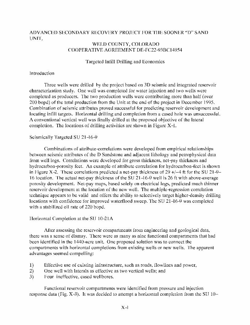
ADVANCED SECONDARY RECOVERY PROJECT FOR THE SOONER “D” SANDUNIT,
WELD COUNTY, COLORADOCOOPERATIVE AGREEMENT DE% C224ZIBC149S4
Targeted Infill Drilling and Economics
Introduction
Three wells were drilled by the project based on SD seismic and integrated reservoircharacterization study. one well was completed for water injection and two wells werecompleted as producers. The two production wells were contributing more than half (over200 bopd) of the total production from the Unit at the end of the project in December 1995.Combination of seismic attributes proved successful for predicting reservoir development andlocating infill targets. Horizontal drilling and completion from a cased hole was unsuccessful.A conventional vertical well was finally drilled at the proposed objective of the lateralcompletion. The locations of drilling activities are shown in Figure X–1.
Seismically Targeted SU 21-16+
Combinations of attribute<orrelations were developed from empirical relationshipsbetween seismic attributes of the D Sandstone and adjacent lithology and petrophysical datafrom well logs. Correlations were developed for gross thickness, net-pay thickness andhydrocarbon-porosity feet. An example of attribute correlation for hydrocarbon+feet is shownin Figure X–2. These correlations predicted a net-pay thickness of 29 +/–4 ft for the SU 21+–16 location. The actual net-pay thickness of the SU 21 –164 well is 26 ft with above+werageporosity development. Net-pay maps, based solely on electrical logs, predicted much thinnerreservoir development at the location of the new well. The multiple-egression correlationtechnique appears to be valid and offers the ability to selectively target higherdensity drillinglocations with confidence for improved waterflood sweep. The SU 21-16+ was completedwith a stabilized oil rate of 220 bopd.
Horizontal Completion at the SU 1O-21A
After assessing the reservoir compartments from engineering and geological data,there was a sense of dismay. There were as many as nine functional compartments that hadbeen identified in the 1440-acre unit. one proposed solution was to connect thecompartments with horizontal completions from existing wells or new wells. The apparentadvantages seemed compelling:
1) Effective use of existing infrastructure, such as roads, flowlines and power,2) one well with laterals as effective as two vertical wells; and3) Four ineffective, cased wellbores.
Functional reservoir compartments were identified from pressure and injectionresponse data (Fig. X=?). It was decided to attempt a horizontal completion from the SU 10–
x-l

21A water-injection well as it was not affecting waterflood response to the west or east 40-acre offset wells (Fig. X–1 and Fig. X=?). The well had excellent infectivity and had beninjecting water at over 1000 bpd with no wellhead pressure. A radioactive and temperaturesurvey indicated that water was being injected into the D Sandstone reservoir.
The drilling technology selected for the horizontal completion from the SU 1O-21Awell was developed by Amoco (Warren, et al 1993). The technology appeared to beinexpensive. This technology consists of a rotary ~uided short-radius curve drilling systemand the system can be used to drill drainholes with curvatures of approximately 30 ft fromexisting wellbores. The curvedrilling assembly is composed of an anti+vhirl poly-crystallinediamond bit, flexible joint, eccentric deflection sleeve, orientation indicator, and flexibledrillstring. The drill string is turned at the surface with a power swivel. The articulated drillcollars are lined with high-pressure hose to allow circulation through the bit. The casing issectionmilled and a cement plug is set at the kick-off point. The system can drill to 90° witha 30+ft radius when conditions are ideal and achieve lateral reaches of 300 ft or more. Theuse of lateral re-completions from injection wells was hoped to help contact unswept oil andredirect sweep in directions dictated by well spacing and geological heterogeneity. Twoattempts were made with this technology to drill a lateral to the southwest from the SU 10–21A well. The technology was unable to achieve a full 90° curve or penetrate further than 30ft beyond the casing.
This drilling system failed at the SU 1O-21A for several reasons. The depth ofoperations for the D Sandstone is about 6300 ft. The weight on the razor-back knuckle jointand articulated drill collars is critical for proper drilling of the curve. A normal weightindicator is the only guide for the rig operator and provides inadequate control at a depth of6300 ft and corresponding string weight. At much shallower depths of 3500 ft or less, there ismuch less string weight and the accuracy of the weight indicator is sufficient to properly loadthe bottom~ole drilling assembly. Trip time with a slick~ine to check angle and orientationis slow. Frequent trips to check the bit and bottom~ole assembly limits effective time fordrilling if operations are only working daylight tours.
After the failure of the USR lateral drilling, it was still believed important to determineif utilization of existing wells and infrastructure could be accomplished in the infill drillingand completion program. A more conventional mud motor with steering system andconventional drill rig were mobilized to the SU 1O–21A well. A cement plug was placed inthe wellbore across the casing window used for USR and a second 100 ft section of casingwas milled for the medium-adius lateral drilling. Again, two unsuccessful attempts weremade to drill horizontally. Final displacement of the second lateral was 680 ft (185 ft southand 655 ft west) at 6,239 ft totalwerticaldepth (TVD). The horizontal drilling wasunsuccessful because the Graneros Shale overlying the D Sandstone was unstable and thehorizontal hole collapsed during trips despite careful attention to mud properties andhydraulics. The Graneros Shale section is not a problem during conventional vertical drillingoperations.
Despite the failure to complete a lateral extension from the SU 1O–21A well, it wasdetermined that a significant lithological or fault barrier exists at about 250 ft west from thewell. At a horizontal reach of 254 feet from the wellbore (94 ft south and 236 ft west with aTVD of 6239 ft), the mud motor stalled and drilling angle changed abruptly. This barrier is inagreement with distance+ o%arrier calculations made from a pressure fall-off test performedon the well. The pressure transient behavior of this test indicates channel~ike flow with a
x-2

width of 400 to 500 ft. The SD seismic also indicates a change west from the SU 1O–21Awell. The amplitude and isochron attributes of the D Sandstone waveform indicate rapidthickening of the section in the westerly direction.
Conclusions
The Sooner Unit D Sandstone reservoir has significant heterogeneity. Infill drilling toless than 40 acres per well is required to allow efficient waterflooding of certain portions ofthe reservoir. Vertical wells to the D Sandstone in the Denver Basin are relativelyinexpensive and are quickly drilled with little mechanical risk. Targeting vertical wells usingSD seismic appears to offer the most efficient method to for infill drilling at low cost and withlow risk.
Interpretation of functional data such as pressure and injection response leads to theconclusion that functional reservoir compartments have a major axis of one-half mile and aminor axis of one-quarter mile. The orientation of these functional reservoir compartments isgenerally parallel to the axis of the eroded valley in the Huntsman Shale. These observationsindicate that appropriate well spacing should have higher density across the axis of valley+illsystems. In the specific case at the Sooner Unit, it appears that wells for primarydevelopment should have been placed at approximately 1980 ft along and at 990 ft across thesystem axes (approximately 45 acre per well). This drilling strategy can only work if arelatively clear interpretation of the reservoir and depositional system exists at the time ofdiscovery and prior to development drilling. Experience from the Sooner Unit waterflood andother nearby D Sandstone waterfloods indicates that regular spacing of wells on 40-acrepatterns is inadequate for an efficient waterflood.
The experience from the Sooner Unit projects suggests that targeted drilling based on1) a geological model, 2) understanding of functional reservoir compartments and 3) SDseismic should be more efficient than blanket infill drilling. An economic comparison oftargeted drilling and blanket infill drilling on 20-acre patterns is shown in Table X–1. Thistable is based on incremental cost and recovery and assumes that the waterflood infrastructureis already in place. The revenue calculations are based on an oil price of $17.00 per bbl. Thiseconomic model suggests a $2,280,000 advantage from targeted infill drilling in the bestportions of the reservoir and effectively matching injection~roduction well pairs.
References
Warren, T. M., W. J. Winters and H.B. Mount, “Short~adius Lateral Drilling System,”Journal of Petroleum Technology, 45(2): 108–115 (February 1993).
x--3

Table X-1Economic Model for Comparison of Targeted and Blanket Infill Drilling
Blanket Infill Drilling Targeted Infill Drilling
Number of Wells 20 8
Incremental Gil 768,000 bbl 640,000 bbl11% of GGIP 9% of GGIP
Capital Expenditures $4,500,000 $1,800,000
Lease operating Expense $3,262,000 $1,902,000
Net Profit $2,788,000 $5,068,000
Note: These numbers are incremental and assume the waterflood infrastructure is in place.
x-4

ADVANCED SECONDARY RECOVERY PROJECT FOR THE SOONER “D” SANDUNIT,
WELD COUNTY, COLORADOCOOPERATIVE AGREEMENT DE% C224ZIBC149S4
Summary and Conclusions
Theproject objective toimprove recovery atthe Sooner Unit was achieved. Projectedrecovery was increased from 1,556,000 bbl to 1,861,000 bbl. Daily production from theSooner Unit increased more than 100% above the trend established before the project wasinitiated. A development plan was established to further increase total recovery to 2,252,000bbl after the project term closed. Ultimate oil recovery from the D Sandstone reservoir isprojected to be 32.6 percent of GGIP.
Several technologies were employed during the project. Successful elements of theproject are SD seismic imaging, selective infill drilling and reservoir management based onoperational compartments, and reservoir description. The project acquired 3 D seismic over a7.7 sq-mile area. Transient and static pressure+est data were used with water-cut informationfor the delineation of operational compartments. Three vertical wells were drilled (oneinjector and two producers). Vertical drilling based on seismic~ttribute maps provedeffective while attempts at horizontal drilling and completion were unsuccessful. The greatestimpact on describing the reservoir and developing an infilldrilling plan came from the 3 Dseismic. The greatest cost was incurred from horizontal drilling attempts.
Waterflood projects in the Cretaceus D Sandstone of the Denver~ulesburg Basinhave been perceived as unattractive because of historically poor recovery. Reservoirheterogeneity and poor reservoir management practices are the major reasons for historicallypoor secondary recovery. The key to successfully developing a waterflood in the D sandstoneis recognition of the depositional system and heterogeneity which is likely to have beencreated by that system. The waterflood must be designed to sweep oil from compartmentsand acknowledge anisotropy. operators need to think in terms of nonstandard well spacingand injection patterns to implement successful waterflood projects in the D Sandstone (andreservoirs with similar geological settings).
Results from the project demonstrate that waterflooding the D Sandstone can yieldsecondary oil equal to that obtained by primary depletion. The important concept forsuccessful waterflooding the D Sandstone is injection by reservoir compartment andunconventional patterns. While infill drilling at 20-acre spacing and developing the field onregular fiveapot injection patterns would recover most of the moveable oil, it would not beeconomically efficient. Integrated reservoir characterization with 3 D seismic can optimizeinfill locations with the minimum number of wells to maximize economic benefit.
Project studies concluded there were eight high-priority infill locations at the SoonerUnit. Three of these locations were drilled during the project. Work performed during theproject increased production more than 100% and increased proveddeveloped andundeveloped reserves by 696,000 bbl. The Sooner Unit production rate was 400 bopd inOctober 1995, which is 220 bopd over the prior production trend. The current cost of the SDseismic survey and three wells is $850,000. The incremental proveddeveloped oil reservesresulting from just 3 D seismic and three wells are placed at 305,000 bbl. The additionalfuture income (using $17 per bbl) before income taxes is calculated to be $1,233,000
XI-1

(undiscounted) and $876,000 (discounted at 10%). While the total project cost of $1,577,000is not expected to payout from the current incremental reserves, future development isexpected to result in a 2 to 1 return. The project cost and remaining developmentexpenditures are estimated to be $2,700,000. Cash+flow and economic analysis of a
$2,700,000expenditure for 696,000 bbl projected reserves indicates incremental incomebefore income taxes of $2,854,000 (undiscounted) and $1,901,000 (discounted at 10%).
XI-2