adopted september 3, 1992 by ordinance no. 92-11 · 2014-09-22 · suwannee county _____ land...
TRANSCRIPT

SUWANNEE COUNTY
____________________
LAND DEVELOPMENT REGULATIONS
Adopted September 3, 1992 by Ordinance No. 92-11
Amended September 21, 1993 by Ordinance No. 93-05 Amended September 7, 2006 by Ordinance No. 06-09 Amended September 21, 1993 by Ordinance No. 93-06 Amended September 7, 2006 by Ordinance No. 06-10 Amended September 21, 1993 by Ordinance No. 93-07 Amended September 7, 2006 by Ordinance No. 06-11 Amended June 21, 1994 by Ordinance No. 94-03 Amended September 7, 2006 by Ordinance No. 06-12 Amended May 2, 1995 by Ordinance No. 95-04 Amended September 7, 2006 by Ordinance No. 06-13 Amended September 3, 1996 by Ordinance No. 96-15 Amended September 7, 2006 by Ordinance No. 06-14 Amended September 3, 1996 by Ordinance No. 96-16 Amended September 7, 2006 by Ordinance No. 06-15 Amended September 3, 1996 by Ordinance No. 96-17 Amended September 7, 2006 by Ordinance No. 06-16 Amended September 3, 1996 by Ordinance No. 96-19 Amended September 7, 2006 by Ordinance No. 06-17 Amended September 17, 1996, by Ordinance No. 96-20 Amended September 7, 2006 by Ordinance No. 06-18 Amended September 17, 1996 by Ordinance No. 96-21 Amended September 7, 2006 by Ordinance No. 06-19 Amended September 17, 1996 by Ordinance No. 96-22 Amended September 7, 2006 by Ordinance No. 06-20 Amended September 17, 1996 by Ordinance No. 96-23 Amended September 7, 2006 by Ordinance No. 06-21 Amended September 17, 1996 by Ordinance No. 96-24 Amended September 7, 2006 by Ordinance No. 06-22 Amended September 17, 1996 by Ordinance No. 96-25 Amended October 17, 2006 by Ordinance No. 07-02 Amended September 17, 1996 by Ordinance No. 96-26 Amended October 17, 2006 by Ordinance No. 07-03 Amended September 17, 1996 by Ordinance No. 96-27 Amended October 17, 2006 by Ordinance No. 07-04 Amended September 17, 1996 by Ordinance No. 96-28 Amended October 17, 2006 by Ordinance No. 07-05 Amended September 17, 1996 by Ordinance No. 96-30 Amended October 17, 2006 by Ordinance No. 07-06 Amended September 17, 1996 by Ordinance No. 96-31 Amended October 17, 2006 by Ordinance No. 07-07 Amended October 1, 1996 by Ordinance No. 97-01 Amended October 17, 2006 by Ordinance No. 07-08 Amended December 17, 1996 by Ordinance No. 97-06 Amended October 17, 2006 by Ordinance No. 07-09 Amended December 17, 1996 by Ordinance No. 97-08 Amended October 17, 2006 by Ordinance No. 07-10 Amended December 17, 1996 by Ordinance No. 97-15 Amended November 21, 2006 by Ordinance No. 07-11 Amended July 15, 1997 by Ordinance No. 97-16 Amended December 1, 2009 by Ordinance No. 10-05 Amended March 17, 1998 by Ordinance No. 98-05 Amended October 19, 2010 by Ordinance No. 11-01 Amended March 17, 1998 by Ordinance No. 98-06 Amended March 15, 2011 by Ordinance No. 11-05 Amended June 23, 1998 by Ordinance No. 98-13 Amended April 19, 2011 by Ordinance No. 11-09 Amended October 20, 1998 by Ordinance No. 99-01 Amended March 20, 2012 by Ordinance No. 12-07 Amended December 1, 1998 by Ordinance No. 99-06 Amended November 20, 2012 by Ordinance No. 13-02 Amended July 20, 1999 by Ordinance No. 99-11 Amended March 19, 2013 by Ordinance No. 13-06 Amended August 17, 1999 by Ordinance No. 99-12 Amended April 2, 2013 by Ordinance No. 13-09 Amended July 17, 2001 by Ordinance No. 01-12 Amended April 2, 2013 by Ordinance No. 13-10 Amended November 15, 2005 by Ordinance No. 06-02 Amended June 18, 2013 by Ordinance No. 13-12 Amended September 7, 2006 by Ordinance No. 06-07 Amended July 16, 2013 by Ordinance No. 13-13 Amended September 7, 2006 by Ordinance No. 06-08 Amended May 20, 2014 by Ordinance No. 14-02
September 2014

SUWANNEE COUNTY LAND DEVELOPMENT REGULATIONS
Prepared for
Board of County Commissioners
Prepared by Local Planning Agency
With Assistance from North Central Florida Regional Planning Council
2009 N.W. 67th Place Gainesville, FL 32653
352.955.2200
Adopted September 3, 1992 by Ordinance No. 92-11
Amended September 21, 1993 by Ordinance No. 93-05 Amended September 7, 2006 by Ordinance No. 06-09 Amended September 21, 1993 by Ordinance No. 93-06 Amended September 7, 2006 by Ordinance No. 06-10 Amended September 21, 1993 by Ordinance No. 93-07 Amended September 7, 2006 by Ordinance No. 06-11 Amended June 21, 1994 by Ordinance No. 94-03 Amended September 7, 2006 by Ordinance No. 06-12 Amended May 2, 1995 by Ordinance No. 95-04 Amended September 7, 2006 by Ordinance No. 06-13 Amended September 3, 1996 by Ordinance No. 96-15 Amended September 7, 2006 by Ordinance No. 06-14 Amended September 3, 1996 by Ordinance No. 96-16 Amended September 7, 2006 by Ordinance No. 06-15 Amended September 3, 1996 by Ordinance No. 96-17 Amended September 7, 2006 by Ordinance No. 06-16 Amended September 3, 1996 by Ordinance No. 96-19 Amended September 7, 2006 by Ordinance No. 06-17 Amended September 17, 1996, by Ordinance No. 96-20 Amended September 7, 2006 by Ordinance No. 06-18 Amended September 17, 1996 by Ordinance No. 96-21 Amended September 7, 2006 by Ordinance No. 06-19 Amended September 17, 1996 by Ordinance No. 96-22 Amended September 7, 2006 by Ordinance No. 06-20 Amended September 17, 1996 by Ordinance No. 96-23 Amended September 7, 2006 by Ordinance No. 06-21 Amended September 17, 1996 by Ordinance No. 96-24 Amended September 7, 2006 by Ordinance No. 06-22 Amended September 17, 1996 by Ordinance No. 96-25 Amended October 17, 2006 by Ordinance No. 07-02 Amended September 17, 1996 by Ordinance No. 96-26 Amended October 17, 2006 by Ordinance No. 07-03 Amended September 17, 1996 by Ordinance No. 96-27 Amended October 17, 2006 by Ordinance No. 07-04 Amended September 17, 1996 by Ordinance No. 96-28 Amended October 17, 2006 by Ordinance No. 07-05 Amended September 17, 1996 by Ordinance No. 96-30 Amended October 17, 2006 by Ordinance No. 07-06 Amended September 17, 1996 by Ordinance No. 96-31 Amended October 17, 2006 by Ordinance No. 07-07 Amended October 1, 1996 by Ordinance No. 97-01 Amended October 17, 2006 by Ordinance No. 07-08 Amended December 17, 1996 by Ordinance No. 97-06 Amended October 17, 2006 by Ordinance No. 07-09 Amended December 17, 1996 by Ordinance No. 97-08 Amended October 17, 2006 by Ordinance No. 07-10 Amended December 17, 1996 by Ordinance No. 97-15 Amended November 21, 2006 by Ordinance No. 07-11 Amended July 15, 1997 by Ordinance No. 97-16 Amended December 1, 2009 by Ordinance No. 10-05 Amended March 17, 1998 by Ordinance No. 98-05 Amended October 19, 2010 by Ordinance No. 11-01 Amended March 17, 1998 by Ordinance No. 98-06 Amended March 15, 2011 by Ordinance No. 11-05 Amended June 23, 1998 by Ordinance No. 98-13 Amended April 19, 2011 by Ordinance No. 11-09 Amended October 20, 1998 by Ordinance No. 99-01 Amended March 20, 2012 by Ordinance No. 12-07 Amended December 1, 1998 by Ordinance No. 99-06 Amended November 20, 2012 by Ordinance No. 13-02 Amended July 20, 1999 by Ordinance No. 99-11 Amended March 19, 2013 by Ordinance No. 13-06 Amended August 17, 1999 by Ordinance No. 99-12 Amended April 2, 2013 by Ordinance No. 13-09 Amended July 17, 2001 by Ordinance No. 01-12 Amended April 2, 2013 by Ordinance No. 13-10 Amended November 15, 2005 by Ordinance No. 06-02 Amended June 18, 2013 by Ordinance No. 13-12 Amended September 7, 2006 by Ordinance No. 06-07 Amended July 16, 2013 by Ordinance No. 13-13 Amended September 7, 2006 by Ordinance No. 06-08 Amended May 20, 2014 by Ordinance No. 14-02

THIS PAGE LEFT BLANK INTENTIONALLY

LAND DEVELOPMENT REGULATIONS
TABLE OF CONTENTS
Page ARTICLE ONE GENERAL PROVISIONS
Section 1.1 Short Title ............................................................................................. 1-1 Section 1.2 Authority ............................................................................................... 1-1 Section 1.3 Jurisdiction ............................................................................................ 1-1 Section 1.4 Relationship to Existing Land Development Ordinances ..................... 1-1 Section 1.5 Relationship to the Comprehensive Plan .............................................. 1-1 Section 1.6 Conformity with Land Development Regulation Provisions ................ 1-1 Section 1.7 Fees ....................................................................................................... 1-2 Section 1.8 Severability ........................................................................................... 1-2 Section 1.9 Computation of Time ............................................................................ 1-2 Section 1.10 Repeal of Conflicting Ordinances ......................................................... 1-2
ARTICLE TWO DEFINITIONS, LOTS DIVIDED BY DISTRICT LINES, AND NONCONFORMING SITUATIONS
Section 2.1 Definitions ............................................................................................ 2-1 Section 2.2 Lots Divided by District Lines ............................................................ 2-27 Section 2.3 Nonconforming Lots, Nonconforming Uses of Land,
Nonconforming Structures, Nonconforming Characteristics of Use, Nonconforming Use of Structures and Premises ................. 2-27
ARTICLE THREE ADMINISTRATIVE MECHANISMS
Section 3.1 Planning and Zoning Board .................................................................. 3-1 Section 3.2 Board of Adjustment ............................................................................. 3-4
ARTICLE FOUR ZONING REGULATIONS
Section 4.1 Zoning Districts .................................................................................... 4-1 Section 4.2 "CSV" Conservation ............................................................................. 4-7 Section 4.3 "ESA" Environmentally Sensitive Areas .............................................. 4-9 Section 4.4 "A" Agricultural ................................................................................. 4-13 Section 4.5 "RSF" Residential, Single Family ....................................................... 4-21 Section 4.6 "RSF/MH" Residential, (Mixed) Single Family/Mobile Home .......... 4-25 Section 4.7 "RMH" Residential, Mobile Home ..................................................... 4-29 Section 4.8 "RMH-P" Residential, Mobile Home Park ......................................... 4-33 Section 4.9 "RMF" Residential Multiple Family ................................................... 4-39 Section 4.10 "CN" Commercial, Neighborhood ...................................................... 4-43 Section 4.11 "CG" Commercial, General ................................................................ 4-47 Section 4.12 "CI" Commercial, Intensive ................................................................ 4-53 Section 4.13 "CSC" Commercial, Shopping Center ................................................ 4-57 Section 4.14 "CHI" Commercial, Highway Interchange ......................................... 4-61 Section 4.15 "ILW" Industrial, Light and Warehousing .......................................... 4-65 Section 4.16 "I" Industrial ....................................................................................... 4-69 Section 4.17 "PRD" Planned Residential Development .......................................... 4-73 Section 4.18 "PRRD" Planned Rural Residential Development ............................. 4-83 Section 4.19 Supplemental District Regulations ..................................................... 4-95 Section 4.20 "ICS" Industrial, Catalyst Site ........................................................... 4-121
iii

TABLE OF CONTENTS Continued
Page ARTICLE FIVE SUBDIVISION REGULATIONS
Section 5.1 Appendices ........................................................................................... 5-1 Section 5.2 Policy .................................................................................................... 5-1 Section 5.3 Purpose ................................................................................................. 5-1 Section 5.4 Conditions ............................................................................................ 5-1 Section 5.5 Character of the Land ........................................................................... 5-2 Section 5.6 Jurisdiction ........................................................................................... 5-2 Section 5.7 Maintenance ......................................................................................... 5-2 Section 5.8 Plats Straddling Local Government Boundaries .................................. 5-2 Section 5.9 Resubdivision of Land ......................................................................... 5-2 Section 5.10 Self-Imposed Restrictions .................................................................... 5-3 Section 5.11 Subdivision by Metes and Bounds ....................................................... 5-3 Section 5.12 Subdivision Name ................................................................................ 5-3 Section 5.13 Vacation and Annulment of Plats ......................................................... 5-3 Section 5.14 General Procedure ................................................................................ 5-4 Section 5.15 Pre-Application Conference ................................................................. 5-5 Section 5.16 Preliminary Plat Procedure ................................................................... 5-5 Section 5.17 Construction Plans Procedures ............................................................. 5-6 Section 5.18 Final Plat Procedure ............................................................................. 5-6 Section 5.19 General Improvements ......................................................................... 5-8 Section 5.20 Maintenance and Repair of Required Improvements ........................... 5-8 Section 5.21 Subdivisions Located Outside the Corporate Limits of Municipalities
But Connected to Municipal Utilities ............................................ 5-8 Section 5.22 Monuments ........................................................................................... 5-8 Section 5.23 Lot Improvements ................................................................................ 5-8 Section 5.24 Use of Subdivided Lots ........................................................................ 5-9 Section 5.25 Public Purpose Sites ............................................................................. 5-9 Section 5.26 Streets ................................................................................................... 5-9 Section 5.27 Stormwater Management and Flood Protection Requirements .......... 5-15 Section 5.28 Sanitary Sewer .................................................................................... 5-16 Section 5.29 Water Supply ...................................................................................... 5-16 Section 5.30 Water and Sanitary Sewer Systems .................................................... 5-16 Section 5.31 Utilities ............................................................................................... 5-17 Section 5.32 Preliminary Plat Specifications .......................................................... 5-17 Section 5.33 Required Information on Preliminary Plat ......................................... 5-17 Section 5.34 Construction Plan Specifications ........................................................ 5-18 Section 5.35 Subdivider's Agreement ..................................................................... 5-19 Section 5.36 Final Plat Specifications ..................................................................... 5-19 Section 5.37 Required Information on Final Plat .................................................... 5-19 Section 5.38 Signed Certificates ............................................................................. 5-20 Section 5.39 Bonding in Lieu of Completed Improvements ................................... 5-21 Section 5.40 Other Documents Required on the Final Plat ..................................... 5-21 Section 5.41 Performance Standards ....................................................................... 5-21 Section 5.42 Vested Rights ..................................................................................... 5-22
iv

TABLE OF CONTENTS Continued
Page ARTICLE SIX PRIME NATURAL GROUNDWATER AQUIFER RECHARGE
AND POTABLE WATER WELLFIELD REGULATIONS Section 6.1 Prime Natural Groundwater Aquifer Recharge Protection ................... 6-1 Section 6.2 Potable Water Wellfield Protection ...................................................... 6-2
ARTICLE SEVEN STORMWATER MANAGEMENT REGULATIONS
Section 7.1 Relationship to other Stormwater Management Requirements ............ 7-1 Section 7.2 Exemptions ........................................................................................... 7-1 Section 7.3 Stormwater Management Requirements ............................................... 7-2 Section 7.4 Dedication or Maintenance of Stormwater Management Systems ....... 7-5
ARTICLE EIGHT FLOOD DAMAGE PREVENTION REGULATIONS
Section 8.1 Administration, General ........................................................................ 8-1 Section 8.2 Applicability ........................................................................................ 8-2 Section 8.3 Duties and Powers of the Floodplain Administrator .............................. 8-3 Section 8.4 Permits .................................................................................................. 8-5 Section 8.5 Site Plans and Construction Documents ................................................ 8-7 Section 8.6 Inspections ............................................................................................ 8-9 Section 8.7 Variances and Appeals ...................................................................... 8-10 Section 8.8 Violations .......................................................................................... 8-11 Section 8.9 Definitions ........................................................................................ 8-12 Section 8.10 Flood Resistant Development: Buildings and Structures . .................. 8-17 Section 8.11 Subdivisions ...................................................................................... 8-17 Section 8.12 Site Improvements, Utilities and Limitations ..................................... 8-17 Section 8.13 Manufactured Homes ...................................................................... 8-18 Section 8.14 Recreational Vehicles and Park Trailers ............................................. 8-19 Section 8.15 Tanks.................................................................................................... 8-19 Section 8.16 Other Development ........................................................................... 8-20
ARTICLE NINE MINIMUM HOUSING REGULATIONS
Section 9.1 Article Remedial ................................................................................... 9-1 Section 9.2 Scope ..................................................................................................... 9-1 Section 9.3 Existing Buildings ................................................................................ 9-1 Section 9.4 Special Historic Buildings and Districts ............................................... 9-1 Section 9.5 Maintenance .......................................................................................... 9-2 Section 9.6 Application of Land Development Regulations ................................... 9-2 Section 9.7 Enforcement Officer ............................................................................. 9-2 Section 9.8 Restrictions on Employees .................................................................... 9-2 Section 9.9 Records ................................................................................................. 9-2 Section 9.10 Right of Entry ....................................................................................... 9-2 Section 9.11 Unsafe Residential Buildings ................................................................ 9-2 Section 9.12 Requirements Not Covered by this Article ........................................... 9-3 Section 9.13 Liability ................................................................................................. 9-3 Section 9.14 Letter of Compliance ............................................................................ 9-3 Section 9.15 Inspections ............................................................................................ 9-3 Section 9.16 Hardships .............................................................................................. 9-4 Section 9.17 Decisions ............................................................................................... 9-4
v

TABLE OF CONTENTS Continued
Page ARTICLE NINE MINIMUM HOUSING REGULATIONS Continued
Section 9.18 Appeals ................................................................................................. 9-4 Section 9.19 Minimum Standards for Base Equipment and Facilities ...................... 9-4 Section 9.20 Minimum Requirements for Light and Ventilation .............................. 9-5 Section 9.21 Minimum Requirements for Electrical Systems ................................... 9-6 Section 9.22 General Requirements for the Exterior and Interior of Structures ....... 9-6 Section 9.23 Minimum Dwelling Space Requirements ............................................ 9-8 Section 9.24 Sanitation Requirements ...................................................................... 9-8 Section 9.25 Rooming Houses .................................................................................. 9-9 Section 9.26 Designation of Unfit Dwellings and
Legal Procedure of Condemnation ................................................ 9-9 ARTICLE TEN HAZARDOUS BUILDINGS REGULATIONS
Section 10.1 Scope .................................................................................................. 10-1 Section 10.2 Organization ....................................................................................... 10-1 Section 10.3 Powers and Duties of the Land Development
Regulation Administrator ............................................................ 10-2 Section 10.4 Appeals to the Board of Adjustment .................................................. 10-2 Section 10.5 Inspections .......................................................................................... 10-2 Section 10.6 Notice ................................................................................................. 10-2 Section 10.7 Standards for Compliance .................................................................. 10-4 Section 10.8 Compliance ......................................................................................... 10-4 Section 10.9 Extension of Time .............................................................................. 10-4 Section 10.10 Interference ......................................................................................... 10-4 Section 10.11 Performance of Work ......................................................................... 10-4
ARTICLE ELEVEN HISTORIC SITES AND STRUCTURES
PRESERVATION REGULATIONS Section 11.1 Planning and Zoning Board Designated as the
Historic Preservation Agency ...................................................... 11-1 Section 11.2 Powers and Duties of the Agency ...................................................... 11-1 Section 11.3 Designation of Landmarks, Landmark Sites, and Historic Districts .. 11-1 Section 11.4 Applications Requirements ................................................................ 11-2 Section 11.5 Public Hearings for Designations ....................................................... 11-2 Section 11.6 Criteria for Designation of Property ................................................... 11-2 Section 11.7 Agency Recommendation .................................................................. 11-3 Section 11.8 Board of County Commissioners Decision ........................................ 11-3 Section 11.9 Successive Applications ..................................................................... 11-3 Section 11.10 Amendments and Rescissions ............................................................ 11-3 Section 11.11 Approval of Changes to Landmarks and Landmark Sites .................. 11-3
ARTICLE TWELVE APPEALS, SPECIAL EXCEPTIONS, VARIANCES
AND INTERPRETATIONS Section 12.1 Appeals ............................................................................................... 12-1 Section 12.2 Special Exceptions ............................................................................. 12-4 Section 12.3 Variances, General ............................................................................. 12-6
vi

TABLE OF CONTENTS Continued
Page ARTICLE THIRTEEN HEARING PROCEDURES FOR SPECIAL EXCEPTIONS,
VARIANCES, CERTAIN SPECIAL PERMITS, APPEALS AND APPLICATIONS FOR AMENDMENT
Section 13.1 General ................................................................................................ 13-1 Section 13.2 Hearings before the Board of Adjustment .......................................... 13-1 Section 13.3 Hearings before the Planning and Zoning Board and Board of County Commissioners ................................................ 13-1 Section 13.4 Notice of Hearing ............................................................................... 13-2
ARTICLE FOURTEEN PERMITTING AND CONCURRENCY MANAGEMENT
Section 14.1 General ................................................................................................ 14-1 Section 14.2 Land Development Regulation Action on Building Permits .............. 14-1 Section 14.3 Application for Building Permits ........................................................ 14-1 Section 14.4 Certificate of Land Development Regulation Compliance ................. 14-2 Section 14.5 Assurance of Completion of Public Improvements ............................ 14-3 Section 14.6 Special Permits for Bulkheads, Docks and Other Similar Structures ............................................................... 14-4 Section 14.7 Special Permits for Land or Water Excavation or Mining ................. 14-7 Section 14.8 Special Move-On Permits for Mobile Homes .................................. 14-10 Section 14.9 Special Family Lots Permits ............................................................. 14-10 Section 14.10 Special Permits for Temporary Uses ................................................ 14-10 Section 14.11 Special Permits for Essential Services .............................................. 14-15 Section 14.12 Special Permits for Landspread of Domestic Sludge ....................... 14-20 Section 14.13 Site and Development Plan Approval ............................................... 14-23 Section 14.14 Consistency with the County Comprehensive Plan .......................... 14-26 Section 14.15 Level of Service Standards ............................................................... 14-31 Section 14.16 Proportionate Fair-Share Transportation Program ............................ 14-39 Section 14.17 Special Permits for Solid Waste Facilities ........................................ 14-45
ARTICLE FIFTEEN ENFORCEMENT AND REVIEW Section 15.1 Complaints Regarding Violations ....................................................... 15-1 Section 15.2 Persons Liable ..................................................................................... 15-1 Section 15.3 Procedures Upon Discovery of Violations ......................................... 15-1 Section 15.4 Penalties and Remedies for Violations ............................................... 15-1
ARTICLE SIXTEEN AMENDMENTS
Section 16.1 Initiation of Amendments ................................................................... 16-1 Section 16.2 Planning and Zoning Board Report .................................................... 16-1 Section 16.3 Board of County Commissioners: Action on Planning and Zoning Board Report .............................................. 16-2 Section 16.4 Relationship of Amendments to the Comprehensive Plan .................. 16-3 Section 16.5 Limitations on Subsequent Applications ............................................ 16-3
vii
TABLE OF CONTENTS Continued
Page APPENDIX A Street Cross Section and Curb Standards ............................................ A-1
Cul-de-Sac Detail ................................................................................ A-2 Intersection Design Standards ............................................................. A-3 Utility Location ................................................................................... A-4 Certificate of Surveyor and Mapper .................................................... A-5 Certificate of Subdivider's Engineer .................................................... A-5 Certificate of Approval by County Health Department ...................... A-6 Certificate of Approval by the County Attorney ................................. A-6 Certificate of Approval of the Board of County Commissioners ........ A-6 Certificate of Estimated Cost .............................................................. A-7 Certificate of Tax Collector ................................................................. A-7 Preliminary and Final Plat Size Specifications ................................... A-8 Statement Required on Final Plat ........................................................ A-9
APPENDIX B Commercial Neighborhood (CN) District Legal Descriptions Identified on the Official Zoning Atlas
Introduction .......................................................................................... B-1 CN-1 ..................................................................................................... B-2 CN-2 ..................................................................................................... B-3 CN-3 ..................................................................................................... B-4 CN-4 ..................................................................................................... B-5 CN-5 ..................................................................................................... B-6 CN-6 ..................................................................................................... B-7 CN-7 ..................................................................................................... B-8 CN-8 ..................................................................................................... B-9 CN-9 ................................................................................................... B-10 CN-10 ................................................................................................. B-11 CN-11 ................................................................................................. B-12 CN-12 ................................................................................................. B-13 CN-13 ................................................................................................. B-14 CN-14 ................................................................................................. B-15 CN-15 ................................................................................................. B-16 CN-16 ................................................................................................. B-17 CN-17 ................................................................................................. B-18 CN-18 ................................................................................................. B-19 CN-19 ................................................................................................. B-20 CN-20 ................................................................................................. B-21 CN-21 ................................................................................................. B-22
viii

ARTICLE ONE
GENERAL PROVISIONS

THIS PAGE LEFT BLANK INTENTIONALLY

ARTICLE ONE. GENERAL PROVISIONS
SECTION 1.1 SHORT TITLE
The regulations hereby adopted shall be known and cited as the "Land Development Regulations for Suwannee County, Florida."
SECTION 1.2 AUTHORITY
These land development regulations are adopted pursuant to the authority contained in Chapter 125, Florida Statutes and Chapter 163.3161 through 163.3215, Florida Statutes and Rule 9J-24, Florida Administrative Code.
Unless specifically otherwise stated, whenever any provision of these land development regulations refers to or cites a section of Florida Statutes or Florida Administrative Code and that section is later amended or superseded, these land development regulations shall be deemed amended to refer to the amended section or the section that most nearly corresponds to the superseded section.
SECTION 1.3 JURISDICTION
These land development regulations shall apply to the entire unincorporated area of the County.
SECTION 1.4 RELATIONSHIP TO EXISTING LAND DEVELOPMENT ORDINANCES
To the extent that the provisions of these land development regulations are the same in substance as the previously adopted provisions that they replace in the various ordinances of the County, they shall be considered as continuations thereof and not as new enactments unless otherwise specifically provided. In particular, a situation that did not constitute a lawful, nonconforming situation under the previously adopted land development regulations does not achieve lawful nonconforming status under these regulations merely by the repeal of the previous land development ordinances.
SECTION 1.5 RELATIONSHIP TO THE COMPREHENSIVE PLAN
In order to accomplish the goals, objectives and policies listed within the County's Comprehensive Plan, these land development regulations and accompanying Official Zoning Atlas are guided by, based on, related to, and a means of implementation for the Comprehensive Plan as required by the "Local Government Comprehensive Planning and Land Development Regulation Act" (Chapter 163.3161 through 163.3215, Florida Statutes, as amended). All regulations, districts, and the accompanying Official Zoning Atlas are consistent with the Comprehensive Plan and any amendments thereto shall be consistent with the Comprehensive Plan. The phrase "consistent with the Comprehensive Plan" means in a manner which the land development regulations are compatible with and further the Comprehensive Plan. The term "compatible with" means that the land development regulations are not in conflict with the Comprehensive Plan; and the term "furthers" means to take action in the direction of the Comprehensive Plan.
SECTION 1.6 CONFORMITY WITH LAND DEVELOPMENT REGULATION PROVISIONS
1.6.1 Subject to Article 2.3 of these land development regulations (nonconforming situations), no person may use, occupy, or sell any land or buildings or authorize or permit the use, occupancy, or sale of land or buildings under his or her control except in accordance with all of the applicable provisions of these land development regulations.
1.6.2 For purposes of this Article, the "use" or "occupancy" of a building or land relates to anything and everything that is done to, on, or in that building or land.
1 - 1

SECTION 1.7 FEES
1.7.1 Reasonable fees sufficient to cover the costs of administration, inspection, publication of notice and similar matters may be charged to applicants for zoning permits, sign permits, special exceptions applications, subdivision plat approval, zoning amendments, variances and other administrative relief. The amount of the fees charged shall be as established by resolution of the Board of County Commissioners filed in the office of the Clerk of the Circuit Court of the County.
1.7.2 Fees established in accordance with Section 1.7.1 shall be paid upon submission of a signed application or notice of appeal.
SECTION 1.8 SEVERABILITY
In the event any court of competent jurisdiction should hold any section or provision of these land development regulations to be unconstitutional or invalid, the same shall not affect the validity of these land development regulations as a whole or any part thereof, other than the part so declared to be unconstitutional or invalid.
SECTION 1.9 COMPUTATION OF TIME
1.9.1 Unless otherwise specifically provided, the time within which an act is to be done shall be computed by excluding the first and including the last day. If the last day is a Saturday, Sunday, or legal holiday, that day shall be excluded. When the period of time prescribed is less than seven (7) days, intermediate Saturdays, Sundays and holidays shall be excluded.
1.9.2 Unless otherwise specifically provided, whenever a person has the right or is required to do some act within a prescribed period after the service of a notice or other paper upon him or her and the notice or paper is served by mail, three (3) days shall be added to the prescribed period.
SECTION 1.10 REPEAL OF CONFLICTING ORDINANCES
All ordinances and regulations or parts of ordinances and regulations in conflict with these land development regulations, or inconsistent with the provisions of these land development regulations, are hereby repealed to the extent necessary to give these land development regulations full force and effect.
1 - 2

ARTICLE TWO
DEFINITIONS, LOTS DIVIDED BY DISTRICT LINES AND NONCONFORMING
SITUATIONS

THIS PAGE LEFT BLANK INTENTIONALLY

ARTICLE TWO. DEFINITIONS, LOTS DIVIDED BY DISTRICT LINES AND
NONCONFORMING SITUATIONS
SECTION 2.1 DEFINITIONS
For the purpose of these land development regulations, certain terms or words used herein shall be interpreted as follows:
The word person includes a firm, association, organization, partnership, trust, company, or corporation as well as an individual. The present tense includes the future tense, the singular number includes the plural, and the plural number includes the singular.
The word shall is mandatory, the word may is permissive. The words used or occupied include the words intended, designed, or arranged to be used or occupied.
The word lot includes the words plot, parcel, tract, or site. The word structure includes the word building as well as other things constructed or erected on the ground, attached to something having location on the ground, or requiring construction or erection on the ground. Among other things, structures include walls, buildings, fences, signs, and swimming pools but excludes wire or chain link fences and other non-solid fences, which shall not be considered a structure under these land development regulations, although the location of such fences shall not constitute an obstruction to visibility at entranceways or adjacent streets.
The word land includes the words water, marsh, or swamp. The word abut shall not include directly across from.
The words Board of County Commissioners shall mean the Board of County Commissioners of Suwannee County, Florida. The word County shall mean Suwannee County, Florida.
Abandoned Motor Vehicle. Abandoned motor vehicle means one that is in a state of disrepair and incapable of being moved under its own power.
Abutting or Adjacent Property. Abutting or adjacent property means property that is immediately adjacent to the property being considered under these land development regulations.
Access. Access shall mean the primary means of ingress and egress to abutting property from a dedicated right-of-way.
Accessory Use or Structure. An accessory use or structure means a use or structure of a nature customarily incidental and subordinate to the principal use or structure and, unless otherwise provided, on the same premises. On the same premises with respect to accessory uses and structures shall be construed as meaning on the same lot or on a contiguous lot in the same ownership. Where a building is attached to the principal building, it shall be considered a part thereof, and not an accessory building.
Addition. An addition is an extension or increase in floor area of height of a building or structure.
Administrator. Administrator means the Land Development Regulation Administrator designated by the Board of County Commissioners for the administration and enforcement of these land development regulations (see Land Development Regulation Administrator).
2 - 1

Adverse Effect. Adverse effect means increases in flood elevations on adjacent properties attributed to physical changes in the characteristics of the Official 100-Year Flood Area due to development.
Agricultural Use Plan. Agricultural use plan means the formal document submitted by an applicant to the Florida Department of Environmental Protection which describes the controlled use residuals as part of a planned agricultural operation as provided for in Florida Administrative Code, Chapter 62-640.500.
Alter or Alteration of a Stormwater Management System. Alter or alteration of a stormwater management system means work done other than that necessary to maintain the system's original design and function.
Alteration. Alteration shall mean any change in size, shape, occupancy, character, or use of a building or structure.
Alley or Service Drive. Alley or service drive means a public or private right-of-way which affords only a secondary means of access to property abutting thereon.
Application Site. Application site means the parcel of property containing the application zones or zones for a special permit for landspread of domestic sludge.
Application Zone. Application zone means the designated area or areas on the application site where domestic sludge will be applied in accordance with a special permit for landspread of domestic sludge.
Aquifer or Aquifer System. Aquifer or aquifer system means a geologic formation, group of formations, or part of a formation that contains sufficient saturated permeable material to yield significant quantities of water to wells and springs.
Arterial Streets. Arterial streets are streets which conduct large volumes of traffic over long distances and are functionally classified as such on the Future Traffic Circulation Map of the Comprehensive Plan.
Auction Yards. An area where sale items such as large and small equipment, parts (not including salvage yards), vehicles (not including car lots), fleets, government surplus, collectables, antiques, memorabilia, and similar items are temporarily stored or displayed on property not less than 10 acres in size where persons are permitted to attend sales and offer bids on such items, provided items sold are removed from the property within 90 days.
Automobile Wrecking or Automobile Wrecking Yard. The term automobile wrecking or automobile wrecking yard means to the dismantling or disassembling of used motor vehicles or trailers, or the storage, sale, or dumping of dismantled, partially dismantled, obsolete, or wrecked vehicles or their parts.
Automotive Service Station Automotive service station means an establishment whose principal business is the dispensing at retail of motor fuel and oil primarily for automobiles and where grease, batteries, tires, and automobile accessories may be supplied and dispensed at retail. In addition, an automotive service station may provide accessory facilities for car washing and polishing and may render minor repair services. However, major mechanical and body work, straightening of frames or body parts, steam cleaning, painting, tire recapping or re-grooving, storage of automobiles not in operating condition, or other work involving undue noise, glare, fumes, smoke, or other characteristics to an extent greater than normally found in such stations are prohibited. An automotive service station is not a repair garage, a body shop, truck stop, or a car wash (see Article 4.19.6 for special design standards for automotive service stations).
2 - 2

Automotive Self-Service Station Automotive self-service station means an establishment where motor fuel pumps are erected for the purpose of dispensing motor fuel at retail primarily for automobiles, but does not include minor automotive repair or the outside display of batteries tires and automobile accessories nor additional services which are customarily associated with an automotive service station. Where such motor fuel pumps are erected in conjunction with a convenience store or any other retail commercial outlet, which sells food, hardware or drugs, each use shall be considered as a separate principal use and as such, each must meet all applicable requirements of these land development regulations (see Article 4.19.6 for special design standards for automotive service and self-service stations). Bar, Cocktail Lounge, or Tavern. Bar, cocktail lounge, or tavern means any establishment which is devoted primarily to the retailing and on premises drinking of malt, vinous, or other alcoholic beverages, and which is licensed by the State of Florida to dispense or sell alcoholic beverages. Bicycle and pedestrian ways. Bicycle and pedestrian ways means any road, path or way which is open to bicycle travel and traffic afoot and from which motor vehicles are excluded. Block. Block means a tier or group of lots existing with well-defined and fixed boundaries, usually being an area surrounded by streets or other physical barriers and having an assigned number, letter, or other name through which it may be identified. Board of Adjustment. The term Board of Adjustment shall mean the Board of Adjustment, as herein provided for within these land development regulations. Buildable Area. Buildable area is that portion of a lot remaining after the required yards have been provided. Building. Building means any structure, either temporary or permanent, having a roof impervious to weather, and used or built for the enclosure or shelter of persons, animals, vehicles, goods, merchandise, equipment, materials, or property of any kind. This definition shall include tents, dining cars, trailers, mobile homes, sheds, garages, carports, animal kennels, storerooms, or vehicles serving in any way the function of a building as described herein. This definition of a building does not include screened enclosures not having a roof impervious to weather. Building Front Yard Setback Line. The building front yard setback line is the rear edge of any required front yard as specified within these land development regulations. Building, Height of. Height of building means the vertical distance measured from the established grade at the center of a front of a building to the highest point of the roof surface of a flat or Bermuda roof, to the deck line of a mansard roof, and to the mean height level between eaves and ridge of gable, hip, and gambrel roofs. (See Article 4, Exclusions from Height Limitations).
2 - 3

Building Line. Building line means the rear edge of any required front yard or the rear edge of any required setback line. Capital Budget. Capital budget means the portion of an annual budget which reflects capital improvements scheduled for a fiscal year. Capital Improvements. Capital improvements means physical assets constructed or purchased to provide, improve or replace a public facility and which are large scale and high in cost. The cost of a capital improvement is generally nonrecurring and may require multi-year financing. Physical assets which have been identified as existing or projected needs in the Comprehensive Plan shall be considered capital improvements. Child Care Center. Child care center means an establishment where six (6) or more children, other than members of the family occupying the premises, are cared for during the day. The term includes day nurseries, kindergartens, day care services, nursery school, or play school. Child Care Center, Overnight. Overnight child care center means an establishment where six (6) or more children, other than members of the family occupying the premises, are cared for not only during the day but overnight. An overnight child care center provides full overnight sleeping facilities for such children. Class I Waste. Class I waste means solid waste that is not hazardous waste, and that is not prohibited from disposal in a lined landfill pursuant to Chapter 62-701.300, Florida Administrative Code. Class III Waste. Class III waste means yard trash, construction and demolition debris, processed tires, asbestos, carpet, cardboard, paper, glass, plastic, furniture other than appliances, or other materials approved by the Florida Department of Environmental Protection, that are not expected to produce leachate that poses a threat to public health or the environment. Clinics, Medical or Dental. Medical or dental clinic means an establishment where patients, who are not lodged overnight, are admitted for examination and treatment by one (1) person or a group of persons practicing any form of the healing arts, whether such persons be medical doctors, chiropractors, osteopaths, chiropodists, naturopaths, optometrists, dentists, or any such profession, the practice of which is regulated by the State of Florida. Club, Private. Private clubs means those associations and organizations of a civic, fraternal, recreational, or social character, not operated or maintained for profit. The term "private club" shall not include casinos, nightclubs, bottle clubs, or other establishments operated or maintained for profit. Collector Streets. Collector streets mean streets which serve as the connecting link for local streets and arterials. The traffic characteristics generally consist of relatively short trip lengths with moderate speeds and volumes. In addition, collectors are so functionally classified as such on the Future Traffic Circulation Map of the Comprehensive Plan. Commercial Kennel. A commercial operation for profit, in which six (6) or more adult dogs (canis familiares) and house cats (felis catus domestica) are groomed, bred, boarded, trained, sold, and provided with minor medical treatment. An adult dog is hereby defined as being twelve (12) months of age or older (refer to Section 4.19). Communication Antenna. Communication antenna means an antenna designed to transmit or receive communications as authorized by the Federal Communications Commission. Communication Tower. Communication tower means a tower greater than seventy-five (75) feet in height (including antenna) which supports communication equipment for either transmission or receiving. The term communication tower shall not include amateur radio operators equipment, including citizens band, Very High Frequency and Ultra High Frequency Aircraft/Marine, and other similar operators. Design examples of communication towers are described, as follows: 1. Self-supporting lattice;
2 - 4

2. Guyed; and
3. Monopole.
Community Residential Home. Community residential home means a dwelling unit licensed to serve clients of the Florida Department of Health and Rehabilitative Services, which provide a living environment for seven (7) to fourteen (14) unrelated residents who operate as the functional equivalent of a family, including such supervision and care by supportive staff as may be necessary to meet physical emotional, and social needs of the residents (See also Article 4).
Completely Enclosed Building. Completely enclosed building means a building separated on all sides from adjacent open space, or from other buildings or other structures, by a permanent roof and by exterior walls or party walls, pierced only by windows and normal entrance and exit doors.
Comprehensive Plan. Comprehensive Plan shall mean the official Comprehensive Plan adopted by the Board of County Commissioners pursuant to the "Local Government Comprehensive Planning and Land Development Regulation Act" (Chapter 163.3161 through 163.3215, Florida Statutes) and Chapter 9J-5, Florida Administrative Code.
Cone of Influence. Cone of influence means an area around one or more major waterwells the boundary of which is determined by the Board of County Commissioners based on groundwater travel or drawdown depth.
Conservation Plan. Conservation plan means a record of the client’s decisions and supporting information, for treatment of a land unit or water as a result of the planning process, that meets Field Office Technical Guide quality criteria for each natural resource (soil, water, air, plants, and animals) and takes into account economic and social considerations for a special permit for landspread of domestic sludge. The conservation plan describes the schedule of operations and activities needed to solve identified natural resource problems and take advantage of opportunities at a conservation management system level. The needs of the client, the resources, Federal, state, and local requirements will be met.
Construction, Actual. Actual construction includes the placing of substantial construction materials in permanent position and fastened in a permanent manner; except that where demolition, excavation, or removal of an existing structure has been substantially begun preparatory to new construction, such excavation, demolition, or removal shall be deemed to be actual construction, provided that work shall be continuously carried on until the completion of the new construction involved. Actual construction shall include only work begun under a valid building permit.
Construction and Demolition Debris. Construction and demolition debris means discarded materials generally considered to be not water soluble and non-hazardous in nature, including but not limited to steel, glass, brick, concrete, asphalt material, pipe, gypsum wallboard, and lumber, from the construction or destruction of a structure as part of a construction or demolition project or from the renovation of a structure, including such debris from construction of structures at a site remote from the construction or demolition project site. The term includes rocks, soils, tree remains, trees, and other vegetative matter that normally results from land clearing or land development operations for a construction project; clean cardboard, paper, plastic, wood, and metal scraps from a construction project; except as provided in Section 403.707(9)(j), Florida Statutes, yard trash and unpainted, non-treated wood scraps from sources other than construction or demolition projects; scrap from manufacturing facilities that is the type of material generally used in construction projects and that would meet the definition of construction and demolition debris if it were generated as part of a construction or demolition project, including debris from the construction of manufactured homes and scrap shingles, wallboard, siding concrete, and similar materials from industrial or commercial facilities and de minimis amounts of other non-hazardous wastes that are generated at construction or
2 - 5

demolition projects, provided such amounts are consistent with best management practices of the construction and demolition industries. Mixing of construction and demolition debris with other types of solid waste will cause it to be classified as other than construction and demolition debris.
County Health Department. The term County Health Department shall mean the Health Department of the County.
Cul-de-sac. A cul-de-sac is a local street of relatively short length with one end open and the other end terminating in a vehicular turnaround.
Curb Break. A curb break is a driveway or any other point of access or opening for vehicles onto a public street.
Day Care Center or Nursery. See Child Care Center.
Density, Gross Residential. The term residential density refers to the number of residential dwelling units permitted per gross acre of land and is determined by dividing the number of units by the total area of land within the boundaries of a lot or parcel including dedicated rights-of-way and except as otherwise provided for in these land development regulations. In the determination of the number of residential units to be permitted on a specific parcel of land, a fractional unit shall not entitle the applicant to an additional unit.
Developer. Developer means any person, including a governmental agency, undertaking any development as defined in Chapter 163.3161 through 163.3215I and Chapter 380.031, Florida Statutes, as amended.
Development. Development has the meaning as defined in Chapter 163.3161 through 163.3215 and Chapter 380.04, Florida Statutes, as amended.
Development Order. Development Order means any order granting, denying, or granting with conditions an application for a development permit, which includes any building permit, subdivision approval, rezoning, certification or designation, special exception, variance, special or temporary permit, or any other official action of the appropriate County approval body or Land Development Regulation Administrator having the effect of permitting the development of land.
Domestic Animals. Domestic Animals means all animals which have been domesticated by man as to live and breed in a tame condition, excepting exotic animals as defined in this section of these land development regulations. Domestic Animals include such animals as cats (felis catus domestica), dogs (canis familiares), feathered vertebrates, poultry and livestock.
Domestic Septage. Domestic septage means the liquid and solid material pumped from a septic tank, holding tank, portable toilet, or similar domestic sewage treatment or holding system when the system is cleaned or maintained, but shall not include any manufactured or manmade item or product.
Domestic Sludge. Domestic sludge means any wastewater sludge which is generated by a domestic wastewater treatment plant or related operation including, but not limited to domestic septage as defined herein. The material may be either solid, liquid or semisolid. Domestic sludge does not include treated effluent from a wastewater treatment plant or any manufactured or manmade product or item.
Dormitory. Dormitory means a space in a unit where group sleeping accommodations are provided with or without meals for persons not members of the same family group, in one (1) room, or in a series of closely associated rooms under joint occupancy and single management, as in college dormitories, fraternity houses, and military barracks.
2 - 6

Drive-In Restaurant or Refreshment Stand. Drive-in restaurant or refreshment stand means any place or premises where provision is made on the premises for the selling, dispensing, or serving of food, refreshments, or beverage to persons in automobiles and/or in other than a completely enclosed building on the premises, including those establishments where customers may serve themselves and may eat or drink the food, refreshments, or beverages in automobiles on the premises. A restaurant which provides drive-in facilities of any kind shall be deemed a drive-in restaurant. A barbecue stand or pit having the characteristics noted in this definition shall be deemed a drive-in restaurant.
Drainage Basin. Drainage basin means the area defined by topographic boundaries which contributes stormwater to a drainage system, estuarine waters, or oceanic waters, including all areas artificially added to the basin.
Drainage Detention Structure. Drainage detention structure means a structure which collects and temporarily stores stormwater for the purpose of treatment through physical, chemical, or biological processes with subsequent gradual release of the stormwater.
Drainage Facilities. Drainage facilities means a system of man-made structures designed to collect, convey, hold, divert or discharge stormwater, and includes stormwater sewers, canals, detention structures, and retention structures.
Drainage Retention Structure. Drainage retention structure means a structure designed to collect and prevent the release of a given volume of stormwater by complete on-site storage.
Drive-In Theater. A drive-in theater is a place of outdoor assembly used for the showing of plays, operas, motion pictures, and similar forms of entertainment which is designed to permit the audience to view the performance from vehicles parked within the theater (see also Article 4).
Dwelling Unit (D.U.). Dwelling unit means a room or rooms connected together, constituting a separate, independent housekeeping establishment for one (1) family, for owner occupancy or rental or lease on a weekly, monthly, or longer basis, and physically separated from any other rooms or dwelling units which may be in the same structure, and containing sleeping facilities and one (1) kitchen.
Dwelling, Single Family. Single family dwelling means a building containing only one (1) dwelling unit and structurally connected to no other dwelling unit. The term single family dwelling also includes dwelling units which meet the State of Florida certification requirements for a "Manufactured Building". Manufactured homes defined by these land development regulations as a Residential Design Manufactured Home and meet the installation criteria prescribed in Section 4.19 of these land development regulations shall be considered a single family dwelling unit. For regulatory purposes, the term is not to be construed as including mobile homes, travel trailers, housing mounted on self-propelled or drawn vehicles, tents, house boats, or other forms of temporary or portable housing.
Dwelling, Mobile Home or Mobile Home. Mobile home dwelling or mobile home means a detached one (1) family dwelling unit with all the following characteristics: 1. Designed for long term occupancy, and containing sleeping accommodations, a flush toilet, a
tub or shower bath, and kitchen facilities, with plumbing and electrical connections provided for attachment to outside systems;
2. Designed for transportation after fabrication on streets or highways on its own wheels or on a flatbed or other trailers;
3. Arriving at the site where it is to be occupied as a dwelling complete and ready for occupancy except for minor incidental unpacking and assembly operations, location on jacks or other temporary or permanent foundations, connection to utilities, and the like; and
2 - 7

4. Manufactured homes defined by these land development regulations as Standard Design
Manufactured Homes and do not meet the installation criteria prescribed in Section 4.19 of these land development regulations shall be considered a mobile home.
A travel trailer is not to be considered a mobile home.
Dwelling, One Family. One (1) family dwelling is one (1) building under one (1) roof containing only one (1) dwelling unit. A one (1) family dwelling may be either a single family conventional dwelling or a mobile home dwelling.
Dwelling, Residential Design Manufactured Home. Residential design manufactured home means a manufactured home built on or after June 15, 1976 and certified to be in compliance with the manufactured housing construction safety standards (42 United States Code 5401, et seq) promulgated by the United States Department of Housing and Urban Development, and such manufactured home shall:
1. Have house-type siding and roofing materials with treatment of a type generally acceptable for site-built housing;
2. Measure at least twenty (20) feet in width (requiring at least a double section home;
3. Have a minimum roof pitch of two and one-half (2 1/2) rise for each twelve (12) feet of horizontal run; and
4. Have a minimum roof-overhang on all sides of six (6) inches.
Dwelling, Standard Design Manufactured Home. Standard design manufactured home means a manufactured home built on or after June 15, 1976 and certified to be in compliance with the manufactured housing construction safety standards (42 United States Code 5401, et seq) promulgated by the U.S. Department of Housing and Urban Development, which does not meet the definition of a Residential Design Manufactured Home.
Dwelling, Two Family or Duplex. Two (2) family or duplex dwelling means one (1) building under one (1) roof containing only two (2) dwelling units.
Dwelling, Multiple or Multi-Family. Multiple family dwelling means one (1) building under one roof containing three (3) or more dwelling units. Housing for the aged, which does not provide for routine nursing and/or medical care, shall be construed to be a multiple family dwelling.
Dwelling, Multiple Dwelling Use. For purposes of determining whether a lot is in multiple dwelling use, the following considerations shall apply: 1. Multiple dwelling uses may involve dwelling units intended to be rented and maintained under
central ownership and management or cooperative apartments, condominiums, and the like. 2. Where an undivided lot contains more than one (1) building and the buildings are not so located
that lots and yards conforming to requirements for single or two (2) family dwellings in the district could be provided, the lot shall be considered to be in multiple dwelling use if there are three (3) or more dwelling units on the lot, even though the individual buildings may each contain less than three (3) dwelling units.
3. Guest houses and servant's quarters in connection with single family residences shall not be considered as dwelling units in the computation of (2) above.
4. Any multiple dwelling in which dwelling units are available for rental for periods of less than one (1) week shall be considered a tourist home, a motel, motor hotel, or hotel as the case may be.
2 - 8

Easement. Easement means any strip of land created by a subdivider for public or private utilities, drainage, sanitation, or other specified uses having limitations, the title to which shall remain in the name of the property owner, subject to the right of use designated in the reservation of the servitude.
Engineer. The term engineer shall mean a Professional Engineer registered to practice engineering by the State of Florida who is in good standing with the Florida Board of Engineer Examiners.
Elevation. Elevation means height in feet above mean sea level as established by the National Geodetic Vertical Datum (NGVD) of 1929.
Essential Services. See Article 14.
Excavation. Means reducing or lowering the level of ground and/or removal of overburden by means that do not include blasting.
Exotic Animals. Exotic animals means all animals excepting house cats (Felis catus domestica), dogs (canis familiares), feathered vertebrates and poultry and livestock as defined in this section of these land development regulations.
Extermination. Extermination shall mean the control and extermination of insects, rodents, or other pests by eliminating their harborage places; by removing or making inaccessible materials that may serve as their food; by poisoning, spraying, fumigating, trapping; or by any other recognized and legal pest elimination methods.
Facility. Facility means a building or buildings, appurtenant structures and surrounding land area used by a single business private entity or governmental unit or sub-unit at a single location or site.
Family. A family is one (1) or more persons occupying a single dwelling unit, provided that unless all members are related by consanguinity, adoption, marriage or foster care, no family shall contain over three (3) persons, but further provided that domestic servants employed on the premises may be housed on the premises without being counted as a separate or additional family or families and not more than two (2) roomers or boarders may occupy the dwelling unit (for three (3) or more roomers or boarders, see Group Living Facility). The term family shall not be construed to mean a fraternity, sorority, club, monastery or convent, or institutional group.
Fill. Fill means any materials deposited for the purpose of raising the level of natural land surface.
Flea Market. Flea market means a marketplace where the daily leasing of individual booth spaces is available for the sale of goods, wares and crafts.
Floor Area. Floor area means, except as may be otherwise indicated in relation to particular districts and uses, the sum of the gross horizontal areas of the several floors of a building measured from the exterior faces of the exterior walls or from the centerline of walls separating two (2) buildings, excluding attic areas with a headroom of less than seven (7) feet, unenclosed stairs or fire escapes, elevator structures, cooling towers, areas devoted to air conditioning, ventilating or heating or other building machinery and equipment, parking structures and basement space where the ceiling is not more than forty-eight (48) inches above the general finished and graded level of the adjacent part of the lot.
Floor Area Ratio. Floor area ratio means the ratio of the floor area to the size of the lot.
Floridan Aquifer System. Floridan Aquifer System means the thick carbonate sequence which includes all or part of the Paleocene to early Miocene Series and functions regionally as a water-yielding hydraulic unit. Where overlaid by either the intermediate aquifer system or the intermediate confining unit, the Floridan contains water under confined conditions. Where overlaid directly by the surficial aquifer system, the Floridan may or may not contain water under confined conditions,
2 - 9

depending on the extent of low permeability materials in the surficial aquifer system. Where the carbonate rocks crop out, the Floridan generally contains water under unconfined conditions near the top of the aquifer system, but, because of vertical variations in permeability, deeper zones may contain water under confined conditions. The Floridan Aquifer is the deepest part of the active ground water flow system. The top of the aquifer system generally coincides with the absence of significant thicknesses of clastics from the section and with the top of the vertically persistent permeable carbonate section. For the most part, the top of the aquifer system coincides with the top of the Suwannee Limestone, where present, or the top of the Ocala Group. Where these are missing, the Avon Park Limestone or permeable carbonate beds of the Hawthorn Formation form the top of the aquifer system. The base of the aquifer system coincides with the appearance of the regionally persistent sequence of anhydride beds that lie near the top of the Cedar Keys Limestone.
Frontage of a Lot. See Lot Frontage.
Garage, Parking. Parking garage means a building or portion thereof designed or used for temporary parking of motor vehicles. Garage, Private. Private garage means a structure designed or used for inside private parking of private passenger vehicles by the occupants of the main building. A private garage attached to or a part of the main structure is to be considered part of the main building. An unattached private garage is to be considered as an accessory building.
Garage, Repair. Repair garage means a building or portion thereof, other than a private, storage, or parking garage or automotive service station, designed or used for repairing, equipping, or servicing of motor vehicles. Such garages may also be used for hiring, renting, storing, or selling of motor vehicles.
Garage, Storage. Storage garage means a building or portion thereof designed and used exclusively for the storage of motor vehicles, and within which temporary parking may also be permitted.
Garbage. Garbage shall mean the animal and vegetable waste resulting from the handling, preparation, cooking and consumption of food.
Grade. The level of the finished ground surface immediately adjacent to the exterior walls of the building.
Ground Water. Ground water shall mean water in saturated zones or stratum beneath the surface of land or water, whether or not it is flowing through known and definite channels.
Group Living Facility. Group living facility means an establishment where lodging is provided 1. For four (4) or more persons who are not a family or for three (3) or more roomers or boarders, 2. For residents rather than transients, 3. On a weekly or longer basis, and 4. In which residents may share common sleeping or kitchen facilities.
The term group living facility includes dormitories, fraternities, sororities, rooming or boarding houses, convents or monasteries, orphanages, migrant farm worker housing (excepting temporary migrant farm worker housing as provided for in Section 4.4.2 herein) and housing for other institutional groups. One (1), two (2), or multiple family dwellings which constitute separate, individual housekeeping establishments for one (1) family shall not be considered to be group living facilities.
Guest House or Guest Cottage. Guest house or guest cottage means a dwelling unit in a building separate from and in addition to the main residential building on a lot, intended for intermittent or temporary occupancy by a non-paying guest, provided, however, that such quarters shall have no cooking facilities, shall not be rented, and shall not have separate utility meters.
2 - 10

Habitable Story. Habitable story means any story used or to be used for living purposes, which includes working, sleeping, eating cooking, recreation, or a combination thereof. A story used only for storage purposes having only non-loadbearing walls, e.g., breakaway lattice-work, wall, or screen, is not a "habitable story".
Habitable Room. Habitable room means a space in a structure for living, sleeping, eating or cooking. Bathrooms, toilet compartments, closets, halls, storage or utility space and similar areas are not considered habitable space.
Hazardous Waste. Hazardous waste means solid waste, or a combination of solid wastes, which, because of its quantity, concentration, or physical, chemical, or infectious characteristics, may cause, or significantly contribute to, an increase in mortality or an increase in serious irreversible or incapacitating reversible illness or may pose a substantial present or potential hazard to human health or the environment when improperly transported, disposed of, stored, treated or otherwise managed.
Height of a Building. See Building Height.
Home Occupation. Unless otherwise provided herein, home occupation means an occupation conducted entirely in a dwelling unit, in accordance with the home occupation criteria in section 4.19 of these land development regulations.
Hotel, Motel, Motor Hotel, Motor Lodge, Tourist Court. Hotel, motel, motor hotel, motor lodge, and tourist court are to be considered synonymous terms and to mean a building or a group of buildings in which sleeping accommodations are offered to the public and intended primarily for rental to transients with daily charge, as distinguished from multiple family dwellings and group living facilities, where rentals are for periods of a week or longer and occupancy is generally by residents rather than transients.
Improvements. The term improvements means street pavements, curbs and gutters, sidewalks, alley pavements, walkway pavements, water mains, sanitary sewers, storm sewers or drains, road and street signs, landscaping, permanent reference monuments ("PRMs"), permanent control points ("PCPs"), or any other improvements required by these land development regulations.
Infestation. Infestation shall mean the presence within or around a dwelling, of any insects, rodents, or other pests.
Intensive Agriculture. The term intensive agriculture means all areas of concentrated animal density generally associated with milking barns, feed lots, chickenhouses and holding pens.
Junk Yard. Junk yard means a place, structure, or lot where junk, waste, discarded, salvaged, or similar materials such as old metals, wood, slush, lumber, glass, paper, rags, cloth, bagging, cordage, barrels, containers, etc., are brought, bought, sold, exchanged, baled, packed, disassembled, stored, or handled, including used lumber and building material yards, housewrecking yards, heavy equipment wrecking yards, and yards or places for the storage, sale, or handling of salvaged house wrecking or structural steel materials. This definition shall not include automobile wrecking or automobile wrecking yards and establishments for the sale, purchase, or storage of second-hand cars, clothing, salvaged machinery, furniture, radios, stoves, refrigerators, or similar household goods and appliances, all of which shall be usable, nor shall it apply to the processing of used, discarded, or salvaged materials incident to manufacturing activity on the same site where such processing occurs.
Land. Land means the earth, water and air, above, below, or on the surface, and includes any improvements or structures customarily regarded as land.
2 - 11
Land Development Regulations. The term land development regulations shall mean regulations which address the use of land and water, subdivision of land, drainage and stormwater management, protection of environmentally sensitive areas, sign control, standards for public facilities and services, on-site traffic flow and parking and any other regulation so deemed appropriate by the Board of County Commissioners.
Land Development Regulation Administrator. Land Development Regulation Administrator means the official designated by the Board of County Commissioners for the administration and enforcement of these land development regulations. Landfill. Landfill means a solid waste disposal facility, which is an area of land or an excavation where wastes are or have been placed for disposal, for which a permit, other than a general permit, is required by Section 403.707, Florida Statutes. This term shall not include: 1. A land spreading site; 2. A surface impoundment; 3. An injection well defined under and subject to the provisions of Chapter 62-528, Florida
Administrative Code.; or 4. A construction and demolition debris disposal site regulated by Chapter 62-701.730, Florida
Administrative Code. Landmark. Landmark means a building or structure which has been designated as such within the Comprehensive Plan. Landmark Site. Landmark site means the land on which a landmark and related buildings and structures are located and the land that provides the grounds, the premises or the setting for the landmark. Landspread. Landspread means the application of domestic sludge to land for agricultural, reclamation, storage, or any other purpose. Landspread does not mean the placement of domestic sludge in a permitted landfill or other treatment facility.
Landspread Special Permit. Landspread special permit means the special permit for landspread of domestic sludge required by these land development regulations prior to the application of domestic sludge to land within the County.
Level of Service. Level of service means an indicator of the extent or degree of service provided by, or proposed to be provided by a facility based on and related to the operational characteristics of the facility. Level of service indicates the capacity per unit of demand for each public facility.
Lien. Lien means a claim on the property of another as security against the payment of a just debt.
Livestock. The term livestock shall mean all domesticated animals of the equine, bovine, or swine class, including goats, sheep, mules, horses, hogs, cattle and poultry.
Loading Space, Offstreet. Offstreet loading space means a space logically and conveniently located for pickups and/or deliveries or for loading and/or unloading, scaled to delivery vehicles expected to be used, and accessible to such vehicles when required offstreet parking spaces are filled.
Local Planning Agency. The term Local Planning Agency means the agency designated by the Board of County Commissioners, under the provisions of Chapter 163.3161 through 163.3215, Florida Statutes.
Local Streets. Local streets means streets whose primary function is to provide the initial access to the collector and arterial roadways. These facilities are characterized by short trips, low speeds, and small traffic volumes.
2 - 12
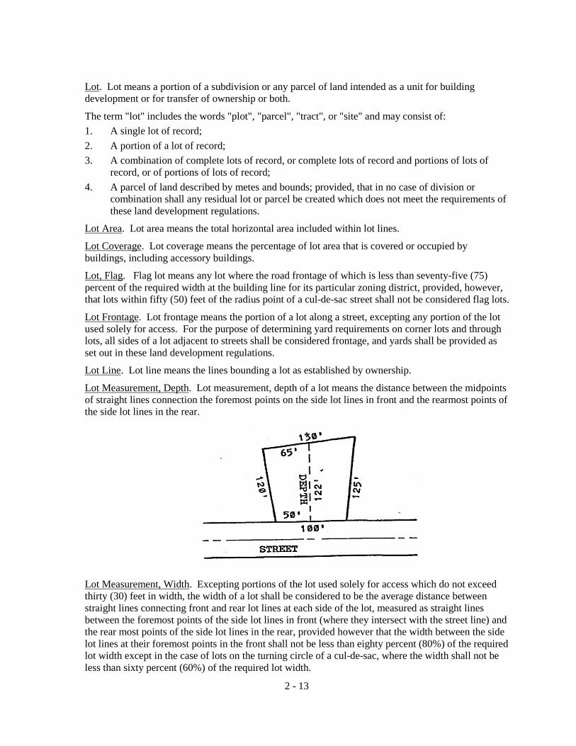
Lot. Lot means a portion of a subdivision or any parcel of land intended as a unit for building development or for transfer of ownership or both.
The term "lot" includes the words "plot", "parcel", "tract", or "site" and may consist of: 1. A single lot of record; 2. A portion of a lot of record; 3. A combination of complete lots of record, or complete lots of record and portions of lots of
record, or of portions of lots of record; 4. A parcel of land described by metes and bounds; provided, that in no case of division or
combination shall any residual lot or parcel be created which does not meet the requirements of these land development regulations.
Lot Area. Lot area means the total horizontal area included within lot lines.
Lot Coverage. Lot coverage means the percentage of lot area that is covered or occupied by buildings, including accessory buildings.
Lot, Flag. Flag lot means any lot where the road frontage of which is less than seventy-five (75) percent of the required width at the building line for its particular zoning district, provided, however, that lots within fifty (50) feet of the radius point of a cul-de-sac street shall not be considered flag lots.
Lot Frontage. Lot frontage means the portion of a lot along a street, excepting any portion of the lot used solely for access. For the purpose of determining yard requirements on corner lots and through lots, all sides of a lot adjacent to streets shall be considered frontage, and yards shall be provided as set out in these land development regulations.
Lot Line. Lot line means the lines bounding a lot as established by ownership.
Lot Measurement, Depth. Lot measurement, depth of a lot means the distance between the midpoints of straight lines connection the foremost points on the side lot lines in front and the rearmost points of the side lot lines in the rear.
Lot Measurement, Width. Excepting portions of the lot used solely for access which do not exceed thirty (30) feet in width, the width of a lot shall be considered to be the average distance between straight lines connecting front and rear lot lines at each side of the lot, measured as straight lines between the foremost points of the side lot lines in front (where they intersect with the street line) and the rear most points of the side lot lines in the rear, provided however that the width between the side lot lines at their foremost points in the front shall not be less than eighty percent (80%) of the required lot width except in the case of lots on the turning circle of a cul-de-sac, where the width shall not be less than sixty percent (60%) of the required lot width.
2 - 13
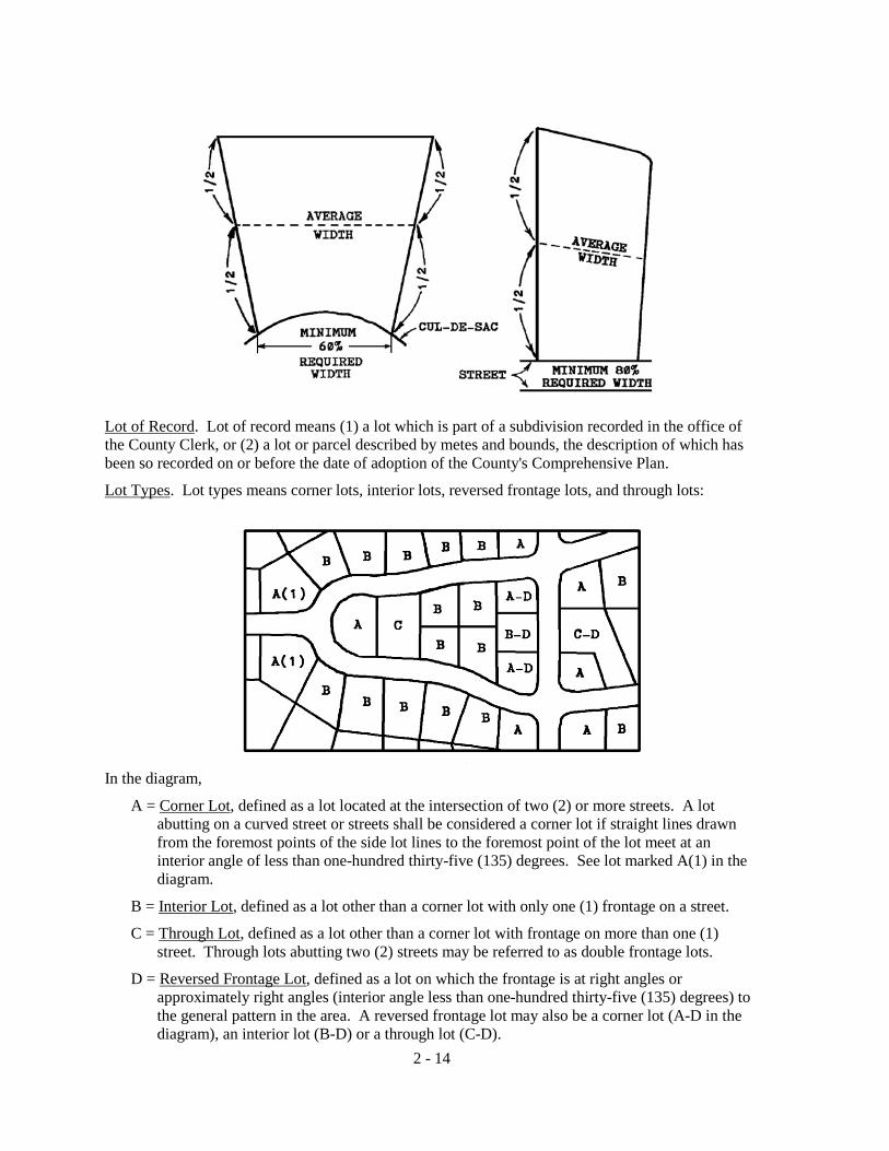
Lot of Record. Lot of record means (1) a lot which is part of a subdivision recorded in the office of the County Clerk, or (2) a lot or parcel described by metes and bounds, the description of which has been so recorded on or before the date of adoption of the County's Comprehensive Plan.
Lot Types. Lot types means corner lots, interior lots, reversed frontage lots, and through lots:
In the diagram,
A = Corner Lot, defined as a lot located at the intersection of two (2) or more streets. A lot abutting on a curved street or streets shall be considered a corner lot if straight lines drawn from the foremost points of the side lot lines to the foremost point of the lot meet at an interior angle of less than one-hundred thirty-five (135) degrees. See lot marked A(1) in the diagram.
B = Interior Lot, defined as a lot other than a corner lot with only one (1) frontage on a street.
C = Through Lot, defined as a lot other than a corner lot with frontage on more than one (1) street. Through lots abutting two (2) streets may be referred to as double frontage lots.
D = Reversed Frontage Lot, defined as a lot on which the frontage is at right angles or approximately right angles (interior angle less than one-hundred thirty-five (135) degrees) to the general pattern in the area. A reversed frontage lot may also be a corner lot (A-D in the diagram), an interior lot (B-D) or a through lot (C-D).
2 - 14
Marginal Access Street. Marginal access street means a street, parallel and adjacent to an existing street, providing access to abutting lots.
Mining. All excavation that requires blasting and mining, as defined by Chapter 378, Florida Statutes.
Mobile Home. See Dwelling, Mobile Home.
Mobile Home Park. Mobile home park means a parcel of land under single ownership or management which is operated as a business engaged in providing for the parking of mobile homes to be used for non-transient living or sleeping purposes, and where lots are offered only for rent or lease, and including customary accessory uses such as owners' and managers' living quarters, laundry facilities, and facilities for parks and recreation.
Mobile Home Stand. Mobile home stand means a lot or parcel of ground designated for the accommodation of not more than one (1) mobile home.
Mobile Home Subdivision. Mobile home subdivision means a residential subdivision where lots are offered for sale for use exclusively by mobile homes.
Motel, Motor Hotel, or Motor Lodge. See Hotel.
Natural Drainage Features. Natural drainage features means the naturally occurring features of an area which accommodates the flow of stormwater, such as streams, rivers, lakes, and wetlands.
New Construction. New construction means structures for which the "start of construction" commenced on or before the effective date of these land development regulations.
Newspaper of General Circulation. Newspaper of general circulation means a newspaper published at least on a weekly basis and printed in the language most commonly spoken in the area within which it circulates, but does not include a newspaper intended primarily for members of a particular professional or occupational group, a newspaper whose primary function is to carry legal notices, or a newspaper that is given away primarily to distribute advertising.
Nonconforming Lot, Use of Land, Structure, Characteristics of Use and Use of Structure and Premises, etc. See Section 2.3.
Nuisance. Nuisance shall mean the following:
1. Any public nuisance known in common law or in equity jurisprudence.
2. Any attractive nuisance which may prove detrimental to children whether in a building, on the premises of a building, or upon an unoccupied lot. This includes any abandoned wells, shafts, basements, or excavations; abandoned refrigerators and motor vehicles; or any structurally unsound fences or structures; or any lumber, trash, fences, debris or vegetation which may prove a hazard for inquisitive minors.
3. Whatever is dangerous to human life or is detrimental to health, as determined by the County health officer.
4. Overcrowding a room with occupants.
5. Insufficient ventilation or illumination.
6. Inadequate or unsanitary sewerage or plumbing facilities.
7. Uncleanliness, as determined by the County health officer. 8. Whatever renders air, food or drink unwholesome or detrimental to the health of human beings,
as determined by the County health officer.
2 - 15

Nursery School. See Child Care Center.
Nursing Home. Nursing home means a private home, institution, building, residence, or other place, whether operated for profit or not, including those places operated by units of government, which undertakes through its ownership or management to provide for a period exceeding twenty-four (24) hours, maintenance, personal care, or nursing for three (3) or more persons not related by lineal consanguinity or marriage to the operator, who by reason of illness, physical infirmity, or advanced age are unable to care for themselves; provided, that this definition shall include homes offering services for less than three (3) persons where the homes are held out to the public to be establishments which regularly provide nursing, extended care, and custodial services. (See also, Residential Home for the Aged.)
Office, Business. Business office means an office for such operations as real estate agencies, advertising agencies (but not sign shop), insurance agencies, travel agencies and ticket sales, chamber of commerce, credit bureau (but not finance company), abstract and title agencies, insurance companies, stockbroker, employment agencies, billing office, and the like. It is characteristic of a business office that retail or wholesale goods are not shown to or delivered from the premises to a customer.
Office, Professional. Professional office means an office for the use of a person or persons generally classified as professional such as architects, engineers, attorneys, accountants, doctors, lawyers, dentists, veterinarians (but not including boarding of animals on the premises, except as part of treatment and then only in soundproof buildings), psychiatrists, psychologists, and the like. It is characteristic of professional offices that the use is devoted principally on an offering of consultive services.
100-Year Flood Area. 100-Year Flood Area means those areas within the scope of these land development regulations that have a land elevation less than the Official 100-Year Flood Elevations.
Official 100-Year Flood Map. Official 100-Year Flood Map means the map issued by the Federal Emergency Management Agency that delineates, to the nearest section, the areas having ground elevations that are less than the Official 100-Year Flood Elevations.
Official 10-Year Flood Elevations. Official 10-Year Flood Elevations means the most recent and reliable flood elevations based on a Log Pearson type III probability distribution produced by the United States Geological Survey and based on historical data.
Openable Area. Openable area (window) shall mean that part of a window or door which is available for unobstructed ventilation and which opens directly to the outdoors.
Open Spaces. Open spaces means undeveloped lands suitable for passive recreation or conservation uses.
Operator. Operator shall mean any person who has charge, care or control of a building, or part thereof, in which dwelling units or rooming units are let.
Overburden. Means soil and rock removed to gain access to the resources to be extracted and means such soil or rock before or after its removal.
Owner. Owner shall mean the holder of the title in fee simple and any person, group of persons, company, association or corporation in whose name tax bills on the property are submitted. Owner also means any person who, alone or jointly or severally with others:
1. As legal title to any dwelling or dwelling unit, with or without accompanying actual possession thereof; or
2 - 16

2. Has charge, care or control of any dwelling or dwelling unit, as owner, executor, executrix,
administrator, trustee, guardian of the estate of the owner, mortgagee or vendee in possessions, or assignee of rents, lessee, or other person firm, or corporation in control of a building; of their duly authorized agents. Any such person thus representing the actual owner is considered to be bound by these land development regulations to the same extent as if he or she were the owner. It is his or her responsibility to notify the actual owner of the reported infractions of these land development regulations pertaining to the property which apply to the owner.
Package Liquor Store. A package liquor store is a place where alcoholic beverages are dispersed or sold in containers for consumption off the premises.
Parcel of Land. Parcel of Land means any quantity of land capable of being described such that its location and boundary may be established, which is designated by its owner or developer as land to be used, or developed as, a unit or which has been used or developed as a unit.
Park Model Trailer. A transportable unit which has a body width not exceeding fourteen (14) feet and which is built on a single chassis and is designed to provide seasonal or temporary living quarters when connected to utilities necessary for operation of installed fixtures and appliances. The total area of the unit in a setup mode, when measured from exterior surface of the exterior stud walls at the level of maximum dimensions, not including any bay window, does not exceed four hundred (400) square feet when constructed to American National Standards Institute (ANSI) A-119.5 standards, and five hundred (500) square feet when constructed to United States Department of Housing and Urban Development standards.
Park Model Trailer Space. A site of land in a Travel Trailer Park or Campground designated for the placement of one (1) park model trailer for the exclusive use of its occupants. During the time the Park Model Trailer is not occupied as temporary or seasonal quarters, it may be stored and tied down to the site. The affixing of the Park Model Trailer to the ground by way of tie-downs or other removable fasteners, and the attachment of carports, porches, screen rooms, and similar appurtenances by way of removable attaching devices, does not render the Park Model Trailer a permanent part of the site. Parking Space, Handicapped. A handicapped parking space is an offstreet parking space which is reserved for persons who are physically disabled or handicapped. Parking Space, Offstreet. Offstreet parking space means a space adequate for parking a standard size automobile with room for opening doors on both sides, together with properly related access to a public street or alley and maneuvering room. Performance Bond. See Surety Device. Permanent Control Point (PCP). Permanent control point (PCP) means a secondary horizontal control monument as defined in Chapter 177, Florida Statutes. Permanent Reference Monument (PRM). Permanent reference monument (PRM) means control monument as defined in Chapter 177, Florida Statutes. Person. Person means any individual, association, partnership, corporation or other entity, including any officer, employee, department, agency or instrumentality of the United States, the State of Florida or any political subdivision thereof. Plat. Plat means a map or drawing depicting the division of land into lots, blocks, parcels, tracts, sites, or other divisions, however the same may be designated, and other information required by these land development regulations. The word plat includes the terms replat or revised plat.
Plat, Final. Final plat means a finished drawing of a subdivision showing completely and accurately all legal and engineering information and certification necessary for recording.
2 - 17

Planning and Zoning Board. The term Planning and Zoning Board means the Planning and Zoning Board herein provided for within these land development regulations.
Plumbing. Plumbing shall mean the practice, materials, and fixtures used in the installation, maintenance, extension, and alteration of all piping, fixtures, appliances, and appurtenances in connection with any of the following: Sanitary drainage or storm drainage facilities, the venting system and the public or private water-supply systems, within or adjacent to any building structure, or conveyance; also the practice and materials used in the installation, maintenance, extension, or alteration of storm-water, liquid waste, or sewerage, and water supply systems of any premises to their connection with any point of public disposal or other acceptable terminal.
Plot. See Lot.
Poultry. The term poultry shall mean all domesticated birds that serve as a source of eggs or meat, including chickens, turkeys, ducks, ostriches, quail, pheasants and geese.
Premises. Premises shall mean a lot, plot or parcel of land including the buildings of structures thereon.
Product tight. Product tight shall mean impervious to the hazardous material which is or could be contained so as to prevent the seepage of the hazardous material from the containment system. To be product tight, the containment system shall be made of a material that is not subject to physical or chemical deterioration by the hazardous material being contained.
Public Areas. Public areas mean an unoccupied open space adjoining a building and on the same property, that is permanently maintained accessible to the Fire Department and free of all encumbrances that might interfere with its use by the Fire Department.
Public Buildings and Facilities. Public buildings and facilities shall mean the use of land or structures by a municipal, county, State, or Federal governmental entity for a public service purpose. More specifically public facility means major capital improvements including but not limited to transportation, sanitary sewer, solid waste, drainage, potable water, educational, parks and recreation, and health systems and facilities. Essential services shall not be considered public buildings and facilities.
Recreational Facility. Recreation facility means a component of a recreation site used by the public such as a trail, court, athletic field or swimming pool.
Recreational Uses. Recreational uses means activities within areas where recreation occurs.
Regulated materials. Regulated materials means the following:
1. Petroleum products, which include fuels (gasoline, diesel fuel, kerosene and mixtures of these products, lubricating oils, motor oils, hydraulic fluids and other similar products. This term does not include liquefied petroleum gas, American Society for Testing and Materials grade number 5 and number 6 residual oils, bunker C residual oils, intermediate fuel oils used for marine bunkering with a viscosity of 30 and higher and asphalt oils.
2. Substances listed by the Secretary of the Florida Department of Labor and Employment Security pursuant to Chapter 442, Florida Statutes, (Occupational Health and Safety). This list, known as the Florida Substances List, is provided in Chapter 38F-41, Florida Administrative Code.
3. Substances listed by the Administrator of the United States Environmental Protection Agency pursuant to Section 102 of the Comprehensive Environmental Response, Compensation, and Liability Act of 1980. This list is provided in Title 40 (Protection of the Environment) of the Code of Federal Regulations, Part 302, Designation, Reportable Quantities and Notification.
2 - 18

4. Substances listed by the Administrator of the United States Environmental Protection Agency
pursuant to Title III of the Superfund Amendments and Reauthorization Act of 1986. The list is provided in Title 40 of the Code of Federal Regulations, Part 355, Emergency Planning and Notification.
5. Materials listed by the Secretary of the United States Department of Transportation pursuant to the Hazardous Materials Transport Act. This list is provided in Title 49 (Transportation) of the Code of Federal Regulations, Part 172, Hazardous Materials Tables and Communications Regulations.
6. The following elemental metals, if they are stored in an easily crumbled, powdered, or finely divided state: aluminum, beryllium, cadmium, chromium, copper, lead, manganese, mercury, molybdenum, nickel, rhodium, silver, tellurium, tin and zinc.
7. Mixtures containing the above materials if they contain one per cent (1%) or more by volume or if they are wastes.
8. Any material not included above which may present similar or more severe risks to human health or the environment as determined by the Land Development Regulation Administrator. Such determinations must be based upon competent testing or other objective means with conclusions which indicate that the material may pose a significant potential or actual hazard.
Repair. Repair means the replacement of existing work with the same kind of material used in the existing work, not including additional work that would change the structural safety of the building, or that would affect or change required existing facilities, a vital element of an elevator, plumbing, gas piping, wiring or heating installations, or that would be in violation of a provisions of law or ordinance. The term repair or repairs shall not apply to any change of construction.
Residential Buildings. Residential buildings means buildings in which families or households live or in which sleeping accommodations are provided and all dormitories, shall be classified as residential occupancy. Such buildings include, among others, the following: dwellings, multiple dwellings and rooming houses (see also Dwelling Unit).
Residential Home for the Aged. Residential home for the aged means a health care facility containing characteristics of multiple family housing, providing a maximum in independent living conditions for individuals or couples and a minimum of custodial services which would include daily observation of the individual residents by designated staff personnel. As accessory uses, residential homes for the aged may include dining rooms and infirmary facilities for intermediate or skilled nursing care solely for the use of the occupants residing in the principal facility.
Restaurant. Restaurant means an establishment where meals or prepared food, including beverages and confections, are served to customers for consumption on or off the premises. The term restaurant includes cafes, coffee shops, donut shops, delicatessens, cafeterias, and other establishments of a similar nature.
Retention. Retention means the collection and storage of runoff without subsequent discharge to surface waters.
Right-of-Way. Right-of-way means land dedicated, deeded, used, or to be used for a street, alley, pedestrian way, crosswalk, bikeway, drainage facility, or other public uses, wherein the owner gives up his or her rights to the property so long as it is being or will be used for the dedicated purpose. Right-of-way also is a land measurement term, meaning the distance between lot property lines which generally contains not only the street pavement, but also the sidewalk, grass area, and underground or aboveground utilities.
2 - 19

Riverbank Setback Line. Riverbank Setback Line means a line running parallel to a river and at a distance as specified within these land development regulations.
Roadway Functional Classification. Roadway functional classification means the assignment of roads into categories according to the character of service they provide in relation to the total road network. Basic functional categories include limited access facilities, arterial roads, and collector roads, which may be subcategorized into principal, major or minor levels. Those levels may be further grouped into urban and rural categories.
Rooming House. Rooming house means any dwelling, or that part of any dwelling containing one (1) or more rooming units, in which space is let by the owner or operator to three (3) or more persons which are not husband or wife, son or daughter, mother or father, or sister or brother of the owner or operator.
Rooming Unit. Rooming unit means any room or group of rooms forming a single habitable unit used or intended to be used for living and sleeping, but not for cooking or eating purposes.
Rubbish. Rubbish shall mean combustible and non-combustible waste materials, except garbage; and the term shall include the residue from the burning of wood, coal, coke, or other combustible materials, paper, rags, cartons, boxes, wood, excelsior, rubber leather, tree branches, yard trimmings, tin cans, metal, mineral matter, glass crockery, and dust.
Sanitary Sewer Facilities. Sanitary sewer facilities means structures or systems designed for the collection, transmission, treatment, or disposal of sewage and includes trunk mains, interceptors, treatment plants, and disposal systems.
Sediment. Sediment means the mineral or organic particulate material that is in suspension or has settled in surface or ground waters.
Servants' Quarters. Servants' quarters means accommodations, without cooking facilities or separate utility meters, for domestic servants employed on the premises. Such units may be in either a principal or an accessory building but no such living quarters shall be rented, leased, or otherwise be made available for compensation of any kind except in the form of housing for servants.
Service Station. See Automotive Service and Self-Service Station.
Sidewalk. Sidewalk means that portion of the street right-of-way outside the roadway, which is improved for the use of pedestrian or bike traffic.
Sign. Sign means any device designed to inform or attract the attention of persons not on the premises on which the sign is located. Unless otherwise specified, a sign may have one (1) or two (2) faces. (See Article 4 for general regulations governing signs.)
Sign, Surface Area. Surface area of a sign means the entire area within the periphery of a regular geometric form, or combinations of regular geometric forms, comprising all of the display area of the sign, and including all of the elements of the matter displayed, but not including blank masking, frames, or structural elements of the sign and bearing no advertising matter. In the case of double face signs, each sign face shall be measured as surface area and the combined surface area of both faces shall not exceed the maximum permitted for the building or use.
Sign, On-Site. On-site sign means a sign relating in its subject matter to the premises on which it is located, or to products, accommodations, services, or activities on the premises. On-site signs do not include signs erected by the outdoor advertising industry in the conduct of the outdoor advertising business.
Sign, Off-Site. Off-site sign means a sign other than an on-site sign.
2 - 20
Sign, Animated. Animated sign means a sign with externally moving parts or messages, or so operating as to give a viewer the illusion of moving parts or messages.
Sign, Attached. Attached sign means a sign painted on the exterior face of a building or attached to a building. Attached signs include canopy signs, marquee signs, wall signs, roof signs, and projecting or hanging signs supported or attached to a canopy, awning, marquee, or building.
Sign, Flashing. Flashing sign means a sign designed to attract attention by the inclusion of a flashing, changing, revolving, or flickering light source or a change of light intensity.
Sign, Freestanding. Freestanding sign means a sign which is not attached to a building. Freestanding signs include ground signs, pole signs, and portable signs.
Sign, Identification. Identification sign means a sign which depicts the name and/or address or a building or establishment on the premises where the sign is located as a means of identifying said building or establishment. An identification sign shall not contain promotional or sales material.
Sign, Nonflashing. Nonflashing sign means a sign which does not have a flashing, changing, revolving, or flickering light source or which does not change light intensity.
Sign, Subdivision. Subdivision sign means a sign that depicts the name of a subdivision as a means of identifying said subdivision. A subdivision sign shall not contain promotional or sales material.
Site. See Lot.
Soil Survey. The term soil survey shall mean the United States Department of Agriculture, Soil Conservation Service Soil Survey for the County.
Solid Waste. Solid waste means sludge from a waste treatment works, water supply treatment plant, or air pollution control facility or garbage, rubbish, refuse, or other discarded material, including solid, liquid, semisolid, or contained gaseous material resulting from domestic, industrial, commercial, mining, agricultural, or governmental operations.
Solid Waste Facilities. Solid waste facilities means structures or systems designed for the collection, processing or disposal of solid wastes, including hazardous wastes, and includes transfer stations, processing plants, recycling plants, and disposal systems.
Solid Waste Processing Plant. Solid waste processing plant means a facility for incineration, resource recovery, or recycling of solid waste prior to its final disposal.
Solid Waste Transfer Station. Solid waste transfer station means a facility for temporary collection of solid waste prior to transport to a processing plant or to final disposal.
Special Exception. Special exception means a use that would not be appropriate generally or without restriction throughout a zoning district but which, if controlled as to number, area, location, or relation to the neighborhood, would not adversely affect the public health, safety, morals, order, comfort, convenience, appearance, prosperity, or the general welfare. Such uses may be permissible in a zoning district as a special exception if specific provision for such a special exception is made in these land development regulations. (For the procedure in securing special exceptions, see Articles 12 and 13.)
Stairway. Stairway means one (1) or more flights of stairs and the necessary landings and platforms connecting then, to form a continuous and uninterrupted passage from one (1) story to another in a building or structure.
2 - 21
Start of Construction. Start of construction means substantial improvement, provided the actual start of construction, repair, reconstruction, or improvement was within one-hundred eighty (180) days of the date the building permit was issued. The actual start means the first placement of permanent construction of a structure (including a manufactured home) on a site, such as the pouring of slabs or footings, installation of piles, construction of columns, or any work beyond the stage of excavation or the placement of a manufactured home on a foundation. Permanent construction does not include land preparation, such as clearing, grading and filling; nor does it include the installation of streets and/or walkways; nor does it include excavation for a basement, footings, piers or foundations or the erection of temporary forms; nor does it include the installation on the property of accessory buildings, such as garages or sheds not occupied as dwelling units or not part of the main structure. Stormwater. Stormwater means the flow of water which results from and that occurs immediately following a rainfall. Stormwater Runoff. Stormwater runoff means that portion of the stormwater that flows from the land surface of a site either naturally, in manmade ditches, or in a closed conduit system. Stormwater Management System. Stormwater management system, means a system designed to treat stormwater, or collect, convey, channel, hold, inhibit, or divert the movement of stormwater on, through and from a site. Story. Story is that portion of a building included between the surface of any floor and the surface of the next floor above it (including basement), or if there is no floor above it, then the space between such floor and the ceiling next above it. (See Habitable Story.) Street. A street is a public or private roadway which affords the principal means of access to abutting property. The term street includes lanes, ways, places, drives, boulevards, roads, avenues, or other means of ingress or egress regardless of the descriptive term used. Street Line. Street line means the line between the street and abutting property. A street line is also referred to as the right-of-way line. Structure. The word structure includes the word building as well as other things constructed or erected on the ground, attached to something having location on the ground, or requiring construction or erection on the ground. Among other things, structures include walls, buildings, solid fences, signs, and swimming pools, but excludes wire or chainlink fences and other nonsolid fences, which shall not be considered a structure under these land development regulations although the location of such fences shall not constitute an obstruction to visibility at entranceways or adjacent streets. Subdivider. The term subdivider means any person, firm, corporation, partnership, association, estate, or trust or any other group or combination acting as a unit, dividing or proposing to divide land so as to constitute a subdivision as herein defined, including a developer or an agent of a developer. Subdivision. Subdivision means the division of a parcel of land, whether improved or unimproved, into three (3) or more lots or parcels of land, for the purpose whether immediate or future, of transfer of ownership, whether by deed, metes and bounds description, devise, lease, map, plat or other recorded instrument or if the establishment of a new street is involved, any division of such parcel. The term shall not mean the transfer of property by sale or gift of testate or intestate succession from a property owner to his or her spouse or lineal descendants; or the transfer of property between tenants in common for the purpose of dissolving the tenancy in common among those tenants. The term includes a resubdivision and, when appropriate to the context, relates to the process of subdividing or to the land subdivided.
2 - 22

Subdivision, Major. Major subdivision means any subdivision not classified as a minor subdivision, including but not limited to subdivisions of four (4) or more lots, or any size subdivision requiring any new street or extension of the local governmental facilities, or the creation of any public improvements, except where otherwise specifically exempted from the requirements of these land development regulations.
Subdivision, Minor. Minor subdivision means any subdivision containing three (3) lots fronting on an existing street, not involving any new street or road, or the extension of local governmental facilities or the creation of any public improvements, and not adversely affecting the remainder of the parcel or adjacent property, and not in conflict with any provision or portion of the Comprehensive Plan or these land development regulations.
Substantial Damage. Substantial damage means damage of any origin sustained by a structure whereby the cost of restoring the structure to its before damaged condition would equal or exceed fifty (50) percent of the market value of the structure before the damage occurred.
Substantial Improvement. Substantial Improvement means for a structure built prior to the enactment of these land development regulations any repair, reconstruction, or improvement of a structure the cost of which equals or exceeds fifty (50) percent of the market value of the structure before the improvement or repair is started. Substantial improvement is considered to occur when the first alteration on any wall, ceiling, floor, or other structural part of the building commences, whether or not that alteration affects the external dimensions of the structure. The term does not, however, include either
1. Any project for improvement of a structure to comply with existing state or local health, sanitary, or safety code specifications which are solely necessary to assure safe living conditions, or
2. Any alteration of a structure listed on the National Register of Historic Places.
Supplied. Supplied means paid for, furnished, or provided by or under control of, the owner or operator.
Surface Water. Surface water means water above the surface of the ground whether or not flowing through definite channels, including the following: 1. Any natural or artificial pond, lake, reservoir, or other area which ordinarily or intermittently
contains water and which has a discernible shoreline; or 2. Any natural or artificial stream, river, creek, channel, ditch, canal, conduit culvert, drain,
waterway, gully, ravine, street, roadway, swale or wash in which water flows in a definite direction, either continuously or intermittently and which has a definite channel, bed or banks; or
3. Any wetland.
Surficial Aquifer System. Surficial aquifer system means the permeable hydrogeologic unit contiguous with land surface that is comprised principally of unconsolidated to poorly indurated clastic deposits. It also includes well-indurated carbonate rocks, other than those of the Florida Aquifer System where the Florida is at or near land surface. Rocks making up the surficial aquifer system belong to all or part of the upper Miocene to Holocene Series. It contains the water table and water within it is under mainly unconfined or locally confined conditions; however, beds of low permeability may cause semi-confined conditions to prevail in its deeper parts. The lower limit of the surficial aquifer system coincides with the top of laterally extensive and vertically persistent beds of much lower permeability. Within the surficial aquifer system, one (1) or more aquifers may be designated based on lateral or vertical variations on water bearing properties.
2 - 23

Surety Device. Surety device means an agreement by a subdivider with the Board of County Commissioners for the amount of the estimated construction cost guaranteeing the completion of physical improvements according to plans and specifications within the time prescribed by the agreement.
Surveyor, Land. The term land surveyor shall mean a land surveyor registered under Chapter 472, Florida Statutes, who is in good standing with the Florida State Board of Engineer Examiners and Land Surveyors.
To Plat. The phrase to plat shall mean to divide or subdivide land into lots, blocks, parcels, tracts, sites, or other divisions, however the same may be designated, and the recording of the plat in the office of the County Clerk in the manner provided for in these land development regulations.
Tower Site. Tower site means a parcel on which a communication tower and accessory structures are located which may be smaller than the minimum lot size required for a particular zoning district.
Travel Trailer. Travel trailer means a vehicular portable unit, mounted on wheels, of such a size or weight as not to require special highway movement permits when drawn by a motorized vehicle. It is primarily designed and constructed to provide temporary living quarters for recreational, camping, or travel use. It has a body width of no more than eight and one-half (8 1/2) feet and an overall body length of no more than forty (40) feet when factory-equipped for the road.
Truck Stop. Truck stop means an establishment where the principal use is primarily the refueling and servicing of trucks and tractor trailer rigs. Such establishments may have restaurants or snack bars and sleeping accommodations for the drivers of such over-the-road equipment and may provide facilities for the repair and maintenance of such equipment.
Truck Terminal. Truck terminal means the use of land or a structure for storage, servicing and dispatching of three (3) or more semi tractor-trailers, trailers, trucks or vehicles used as part of a commercial enterprise.
Unsafe Building. Unsafe building means any structure that has any of the following conditions, such that the life, health, property, or safety of the general public is endangered:
1. Whenever the stress in any material, member or portion thereof, due to all imposed loads including dead load exceeds the working stresses allowed in the County Building Code for new buildings.
2. Whenever a building, structure or portion thereof has been damaged by fire, flood, earthquake, wind or other cause to the extent that the structural integrity of the buildings or structures is less than it was prior to the damage and is less than the minimum requirement established by the County Building Code for new buildings.
3. Whenever for any reason a building, structure or portion thereof is manifestly unsafe or unsanitary for the purpose for which it is designed.
4. Whenever any building, structure or portion thereof as a result of decay, deterioration or dilapidation is likely to fully or partially collapse.
5. Whenever any building, structure or portion thereof has been constructed or maintained in violation of a specific requirement of County regulations.
6. Whenever any building, structure or portion thereof is unsafe, unsanitary or not provided with adequate egress, or which constitutes a fire hazard, or is otherwise dangerous to human life, or, which in relation to existing use, constitutes a hazard to safety or health by reason of inadequate maintenance, dilapidation, obsolescence, or abandonment.
2 - 24

Use. Use means the purpose for which land or water or a structure thereon is designed, arranged, or intended to be occupied or utilized or for which it is occupied or maintained. The use of land or water in the various zoning districts is governed by these land development regulations.
Use of Land. Use of land means use of land, water surface, and land under water to the extent covered by these land development regulations.
Utilities. The term utilities means, but is not necessarily limited, to water systems, electrical power, sanitary sewer systems, storm water management systems, and telephone or television cable systems; or portions, elements, or components thereof.
Valuation or Value. Valuation or value means the estimated cost to replace a building in kind.
Variance. Variance means a relaxation of the terms of these land development regulations where such variance will not be contrary to the public interest and where, owing to conditions peculiar to the property and not the result of the actions of the applicant, a literal enforcement of these land development regulations would result in unnecessary and undue hardship on the land. Establishment or expansion of a use otherwise prohibited or not permitted shall not be allowed by variance, nor shall a variance be granted because of the presence of nonconformities in the zoning classification or district or adjoining zoning classifications or districts. (For the procedure in securing variances, see Article 12).
Ventilation. Ventilation means the process of supplying and removing air by natural or mechanical means to or from any space.
Water-dependent Uses. Water-dependent uses mean activities which can be carried out only on, in or adjacent to water areas because the use requires access to the water body for: waterborne transportation including ports or marinas; recreation; electrical generating facilities; or water supply. Water-related Uses. Water-related uses mean activities which are not directly dependent upon access to a water body, but which provide goods and services that are directly associated with water-dependent or waterway uses. Water Wells. Water wells means wells excavated, drilled, dug, or driven for the supply of industrial, agricultural, or potable water for general public consumption. Well. Well means any excavation that is drilled, cored, bored, washed, driven, dug, jetted, or otherwise constructed when intended use of such excavation is to conduct ground water from an aquifer or aquifer system to the surface by pumping or natural flow, to conduct waters or other liquids from the surface into any area beneath the surface of land or water by pumping or natural flow, or to monitor the characteristics of ground water within an aquifer system(s). Geotechnical borings greater than twenty (20) feet in depth shall be included in the definition of "well". Wellfield Management Zone. Wellfield management zone means a wellfield protection area around wellheads with a permitted capacity of one-hundred thousand (100,000) gallons per day or more (see Section 6.2). Wetlands. Wet lands means land that is inundated or saturated by surface water or groundwater at a frequency and duration sufficient of support, and that under normal circumstances do or would support, a prevalence of vegetation typically adapted for life in saturated soil conditions. The term includes, but is not limited to, swamp hammocks, hardwood swamps, riverine cypress stands, cypress ponds, bayheads and bogs, wet prairies, freshwater marshes, tidal flats, salt marshes and marine meadows. Yard. Yard means a required open space unoccupied and unobstructed from the ground upward, provided however, that fences, walls, poles, posts, and other customary yard accessories, ornaments, and furniture may be permitted in any yard, subject to height limitations and requirements limiting obstruction of visibility.
2 - 25

For explanation of how to measure the various types of yards, on rectangular and non-rectangular lots, as defined in the following definitions, see accompanying diagrams.
Yard, Front. Front yard means a yard extending between side lot lines across the front of a lot adjoining a street. In the case of through lots, unless the prevailing front yard pattern on adjoining lots indicates otherwise, front yards shall be provided on all frontages. Where one of the front yards that would normally be required on a through lot is not in keeping with the prevailing yard pattern, the Land Development Regulation Administrator may waive the requirement for the normal front yard and substitute therefore a special yard requirement which shall not exceed the average of the yards provided on adjacent lots.
2 - 26
In the case of corner lots and reverse frontage lots, a front yard of the required depth shall be provided on both frontages.
Yard Front; Depth Required. Front Yard, depth required means an area measured at right angles to a straight line joining the foremost points of the side lot lines. The foremost point of the side lot line, in the case of rounded property corners at street intersections, shall be assumed to be the point at which the side and front lot lines would have met without such rounding.
Yard, Side. Side yard means a yard extending from the rear line of the required front yard to the rear lot line, or in the absence of any clearly defined rear lot line to the point on the lot farthest from the intersection of the lot line involved with the street. In the case of through lots, side yards shall extend from the rear lines of front yards required. In the case of corner lots, yards remaining after front yards have been established on both frontages shall be considered side yards.
Yard, Side; Depth Required. Side Yard; depth required, shall be measured in such a manner that the yard established is a strip of the minimum width required by district regulations with its inner edge parallel with the side lot line.
Yard, Rear. Rear yard means a yard extending across the rear of the lot between inner side yard lines. In the case of through lots and corner lots, there will be no rear yards, but only front and side yards.
Yard Rear; Depth Required. Rear Yard; depth required, shall be measured in such a manner that the yard established is a strip of the minimum width required by district regulations with its inner edge parallel with the rear lot line.
Yard, Special. A special yard is a yard behind any required yard adjacent to a street required to perform the same functions as a side or rear yard, but adjacent to a lot line and so placed or oriented that neither the term "side yard" nor the term "rear yard" clearly applies. In such cases, the Land Development Regulation Administrator shall require a yard with minimum dimensions as generally required for a side yard or a rear yard in the district, determining which shall apply by the relation of the portion of the lot on which the yard is to be located to the adjoining lot or lots, with due regard to the orientation and location of structures and buildable area thereon.
Yard, Waterfront. Waterfront yard means a yard measured from and parallel to the mean high water mark of the lake, stream, or other watercourse on which the lot is located.
SECTION 2.2 LOTS DIVIDED BY DISTRICT LINES
Whenever a single lot is located within two (2) or more different zoning districts, each portion of that lot shall be subject to all the regulations applicable to the district in which it is located.
SECTION 2.3 NONCONFORMING LOTS, NONCONFORMING USES OF LAND, NONCONFORMING STRUCTURES, NONCONFORMING CHARACTERISTICS OF USE, NONCONFORMING USE OF STRUCTURES AND PREMISES
Within the districts established by these land development regulations or amendments that may later be adopted there may exist
1. Lots,
2. Uses of land,
3. Structures,
4. Characteristics of use, and
2 - 27

5. Use of structures and premises which were lawful before the adoption or amendment of the
Comprehensive Plan or these land development regulations, but which would be prohibited, regulated or restricted under the terms of these land development regulations or future amendments.
It is the intent of these land development regulations to permit these nonconformities to continue until they are voluntarily removed or removed as required by these land development regulations.
To avoid undue hardship, nothing in these land development regulations shall be deemed to require a change in the plans, construction, or designated use of any building on which actual construction was lawfully begun prior to the adoption or amendment of the Comprehensive Plan and upon which actual building construction has been carried on diligently (see Section 2.1 for definition of actual construction). Where excavation or demolition or removal of an existing building has been substantially begun preparatory to rebuilding, such excavation, demolition, or removal shall be deemed to be actual construction, provided that work shall be carried on diligently.
Nonconforming Lots of Record. Vacant or unimproved lands or parcels which are nonconforming as to size for residential use for single family, duplex, or triplex units only, and which can individually be identified and described from documents recorded in the Public Records of Suwannee County, Florida, as of the date of adoption or amendment of the Comprehensive Plan, shall continue to be eligible for the issuance of residential building permits, subject to all other provisions of the plan, including setbacks and concurrency.
Nonconforming Uses of Land. Where, as of the date of adoption or amendment of the Comprehensive Plan, lawful use of land existed which would not be permitted by the Comprehensive Plan or these land development regulations, such use may be continued, so long as it remains otherwise lawful, subject to the following provisions:
1. Movement. No such nonconforming use shall be moved in whole or in part to any portion of the lot or parcel other than that occupied by such use as of the date of adoption or amendment of the Comprehensive Plan.
2. Discontinuance. If any such nonconforming use ceases for any reason (except when governmental action impedes access to the premises) for a period of more than twelve (12) consecutive months, any subsequent use of such land shall conform to the regulations specified by these land development regulations for the district in which such land is located.
Nonconforming Structures. Where a structure existed lawfully under these land development regulations at the date of adoption or amendment of the Comprehensive Plan, that could not be built under the Comprehensive Plan or these land development regulations by reason of restrictions on area, lot coverage, height, yards, location on the lot, or requirements other than use concerning the structure, such structure may be continued so long as it remains otherwise lawful, subject to the following provisions:
1. Enlargement or alteration. No such nonconforming structure may be enlarged or altered in a way which increases its nonconformity although any structure or portion thereof may be altered to decrease its non-conformity;
2. Destruction. Should such nonconforming structure or nonconforming portion of structure be destroyed by any means to an extent of more than fifty percent (50%) of its replacement value at time of destruction, it shall not be reconstructed except in conformity with the provisions of these land development regulations.
3. Movement. Should such structure be moved for any reason for any distance whatever, it shall thereafter conform to the regulations for the district in which it is located after it is moved.
2 - 28

Nonconforming Characteristics of Use. If characteristic of use of residential density which lawfully existed on the date of adoption or amendment of the Comprehensive Plan are made nonconforming by the Comprehensive Plan as adopted or amended, no change shall thereafter be made in such characteristic of use which increases nonconformity with the Comprehensive Plan; provided however, that changes may be made which do not increase, or which decrease, such non-conformity
If the characteristics of use such as signs, off-street parking or off-street loading, or other matters pertaining to the use of land, structures, and premises are made nonconforming by the Comprehensive Plan and these land development regulations as adopted or amended, no change shall thereafter be made in such characteristics of use which increases nonconformity with the regulations set out in these land development regulations; provided, however, that changes may be made which do not increase, or which decrease, such nonconformity.
Non-Conforming Use of Structures and Premises. Where a lawful use of a structure, or of a structure and premises in combination, existed at the date of adoption or amendment of the Comprehensive Plan, that would not be allowed in the district under the terms of the Comprehensive Plan or these land development regulations, the lawful use may be continued so long as it remains otherwise lawful, subject to the following provisions:
1. Change in tenancy or ownership. There may be a change in tenancy, ownership, or management of a nonconforming use provided there is no change in the nature or character of such nonconforming use.
2. Change in use. Any nonconforming use of a structure, or of a structure and premises in combination, may be changed to another nonconforming use of the same character, or to a more restricted but nonconforming use, provided that the Board of Adjustment shall find after due public notice and hearing that the proposed use is equally or more appropriate to the district than the existing nonconforming use and that the relation of the structure to surrounding properties is such that adverse effects on occupants and neighboring properties will not be greater than if the existing nonconforming use is continued. In permitting such change, the Board of Adjustment may require appropriate conditions and safeguards in accordance with the intent and purpose of these land development regulations.
3. Change to conforming use requires future conformity with district regulations. Any structure, or structure and premises in combination, in or on which a nonconforming use is superseded by a permitted use shall thereafter conform to the regulations for the district in which such structure is located, and the nonconforming use shall not thereafter be resumed nor shall any other nonconforming use be permitted.
4. Discontinuance. If any nonconforming use of a structure, or structure and premises in combination, ceases for any reason (except where governmental action impedes access to the premises) for a period of more than twelve (12) consecutive months, any subsequent use shall conform to the regulations for the district in which the use is located.
5. Destruction. Should a structure containing a nonconforming use be destroyed by any means to the extent of more than eighty percent (80%) of its replacement value at the time of destruction, provided that if the County is under an officially declared state of emergency by the Board of County Commissioners, one hundred percent (100%) of its replacement value at the time of destruction, its status as a nonconforming use is terminated and it shall not be reconstructed except in conformity with all provisions of these land development regulations and unless the use of land and structures thereafter conforms to the regulations for the district in which such land is located.
2 - 29

Casual, Temporary, or Illegal Use. The casual, temporary, or illegal use of land or structures, or land and structures in combination, shall not be sufficient to establish the existence of a nonconforming use or to create rights in the continuance of such use.
Uses Under Special Exception and Special Permit Provisions Not Nonconforming Uses.
Where on the date of adoption of these land development regulations the lawful use of land exists which would be permitted as a special exception or special permit under the terms of these land development regulations, such use shall not be deemed a nonconforming use in such district, but shall without further action be deemed a conforming use in such district. However any enlargement or expansion of any such uses shall be subject to the procedures for securing special exceptions or special permits (see Article 12, 13 and 14).
The upgrading of a waste management system at an existing intensive agriculture operation, at the same location, and to the specifications of the United States Department of Agriculture (USDA) Natural Resources Conservation Service (NRCS) or meeting such published performance criteria for waste management systems as specified by USDA NRCS, and signed by a licensed engineer, shall not be considered an enlargement or expansion and shall not require a special permit, as long as the upgraded part of the waste management system is built at least three hundred (300) feet from the property lines or no less than the distance of the existing facilities to the closest lot line.
2 - 30

ARTICLE THREE
ADMINISTRATIVE MECHANISMS

THIS PAGE LEFT BLANK INTENTIONALLY

ARTICLE THREE. ADMINISTRATIVE MECHANISMS
SECTION 3.1 PLANNING AND ZONING BOARD
3.1.1 Planning and Zoning Board: Organization
3.1.1.1 Establishment. A Planning and Zoning Board is hereby established for the County.
3.1.1.2 Appointment. The Planning and Zoning Board shall consist of five (5) residents of the County who shall be appointed by the Board of County Commissioners. No member of the Planning and Zoning Board shall be a paid or elected official or employee of the County.
The Board of County Commissioners may by resolution designate members of the Planning and Zoning Board to perform the functions of the Board of Adjustment. If the Board of County Commissioners so elects, the terms of office of members of the Planning and Zoning Board shall run concurrently with said members term of office on the Board of Adjustment.
3.1.1.3 Term of office. The term of office shall be for three (3) years; provided, however, that of the five (5) members first appointed to the Planning and Zoning Board at the effective date of these land development regulations one (1) shall be appointed for one (1) year, two (2) shall be appointed for two (2) years, and two (2) shall be appointed for three (3) years, and that all appointments thereafter shall be for three (3) years.
3.1.1.4 Removal for cause. Members of the Planning and Zoning Board may be removed for cause by the Board of County Commissioners after filing of written charges, a public hearing, and a majority vote of the Board of County Commissioners.
3.1.1.5 Removal for absenteeism. The term of office of any member of the Planning and Zoning Board who is absent from three (3) consecutive, regularly scheduled meetings of the Planning and Zoning Board shall be declared vacant by the Board of County Commissioners.
3.1.1.6 Appointments to fill vacancies. Vacancies in Planning and Zoning Board membership shall be filled by appointment by the Board of County Commissioners for the unexpired term of the member affected. It shall be the duty of the Chairman of the Planning and Zoning Board to notify the Board of County Commissioners within ten (10) days after any vacancy shall occur among members of the Planning and Zoning Board.
3.1.2 Planning and Zoning Board: Procedure
3.1.2.1 Rules. The Planning and Zoning Board shall establish rules for its own operation not inconsistent with the provisions of applicable State statutes or of these land development regulations. Such rules of procedure shall be available in a written form to persons appearing before the Planning and Zoning Board and to the public.
3.1.2.2 Officers. The Planning and Zoning Board shall elect from within the Board a Chairman, who shall be the presiding member; a Vice Chairman, who shall preside in the Chairman's absence or disqualification. The Land Development Regulation Administrator shall serve as the Secretary for the Planning and Zoning Board. Terms of all elected officers shall be for one (1) year. Elected officers shall serve no more than two (2) consecutive terms in the same position.
3 - 1

3.1.2.3 Meetings and quorum. The Planning and Zoning Board shall meet at regular
intervals at the call of the Chairman, at the written request of three (3) or more regular members, or within thirty (30) days after receipt of a matter to be acted upon by the Planning and Zoning Board, provided that the Planning and Zoning Board shall hold a least one (1) regularly scheduled meeting each month, on a day to be scheduled by the Planning and Zoning Board. Three (3) members of the Planning and Zoning Board shall constitute a quorum.
All meetings of the Planning and Zoning Board shall be public. A record of all its resolutions, transactions, findings, and determinations shall be made, which record shall be a public record on file in the office of the Land Development Regulation Administrator.
3.1.2.4 Disqualification of members. If any member of the Planning and Zoning Board shall find that his or her private or personal interests are involved in a matter coming before the Planning and Zoning Board, he or she shall disqualify himself or herself from all participation in that case. No member of the Planning and Zoning Board shall appear before the Planning and Zoning Board as agent or attorney for any person.
3.1.2.5 Decisions. The concurring vote of a majority of the members of the Planning and Zoning Board, who are present and voting, shall be necessary to pass any motion which is considered by the Planning and Zoning Board.
3.1.2.6 Appropriations, fees, and other income. The Board of County Commissioners shall make available to the Planning and Zoning Board such appropriations as it may see fit for expenses necessary in the conduct of Planning and Zoning Board work.
3.1.3 Planning and Zoning Board: Functions, Powers, and Duties: Generally.
The functions, powers, and duties of the Planning and Zoning Board in general shall be:
1. To acquire and maintain such information and materials as are necessary to an understanding of past trends, present conditions, and forces at work to cause changes in these conditions. Such information and material may include maps and photographs of man-made and natural physical features of the County, statistics on past trends and present conditions with respect to population, property values, economic base, land use, and such other information as is important or likely to be important in determining the amount, direction, and kind of development to be expected in the County.
2. To prepare and recommend to the Board of County Commissioners for adoption, and from time to time amend and revise a comprehensive and coordinated general plan (the Comprehensive Plan) for meeting present requirements and such future requirements as may be foreseen.
3. To recommend principles and policies for guiding action affecting development in the County.
4. To recommend to the Board of County Commissioners regulations, and other proposals promoting orderly development along the lines indicated as desirable by the Comprehensive Plan.
5. To determine whether specific proposed developments conform to the principles and requirements of the Comprehensive Plan, especially relating to the management of concurrency requirements as stated within the Comprehensive Plan and these land development regulations.
3 - 2

6. To serve as the County's Historic Preservation Agency to meet the requirements and
carry out the policies and responsibilities of the Comprehensive Plan and Article 11 of these land development regulations.
7. To conduct an annual review of the County's Capital Improvement Element of the Comprehensive Plan, in conformance with the Procedure for Monitoring and Evaluation of the Capital Improvements Element (see Chapter VIII of the Comprehensive Plan). This review is conducted to ensure that the fiscal resources are available to provide the public facilities needed to support the established level of service standards.
8. To conduct such public hearings as may be required to gather information necessary for the establishment, and maintenance of the Comprehensive Plan and ordinances, codes, and regulations related to it.
9. To make any necessary special studies on the location, adequacy, and conditions of specific facilities in the County. These may include but are not limited to studies on housing, commercial and industrial conditions and facilities, recreation, public and private utilities, roads and traffic, transportation, parking, and the like.
10. To keep the Board of County Commissioners informed and advised on these matters. 11. To perform such other duties as may be lawfully assigned to it, or which may have
bearing on the preparation or implementation of the Comprehensive Plan. All employees of the County shall, upon request and within a reasonable time, furnish
to the Planning and Zoning Board such available records or information as may be required in its work. The Planning and Zoning Board may in the performance of official duties enter upon lands and make examinations or surveys in the same manner as other authorized agents or employees of the County, and shall have such other powers as are required for the performance of official functions in carrying out the purposes of the Planning and Zoning Board.
3.1.4 Planning and Zoning Board: Powers and Duties: Special Exceptions.
It is the intent of these land development regulations that all proposed special exceptions shall be heard in the first instance by the Planning and Zoning Board as set out in Articles 12 and 13 of these land development regulations.
3.1.5 Planning and Zoning Board: Powers and Duties: Amendments.
It is the intent of these land development regulations that all proposed amendments shall be heard in the first instance by the Planning and Zoning Board as set out in Articles 13 and 16 of these land development regulations.
3.1.6 Planning and Zoning Board: Powers and Duties: Land and Water Fills, Dredging, Excavation, and Mining.
It is the intent of these land development regulations that all proposals for land and water fills, dredging, excavation, and mining shall be heard in the first instance by the Planning and Zoning Board as set out in Article 14 of these land development regulations.
3.1.7 Planning and Zoning Board: Powers and Duties: Bulkheads, Docks, Piers, Wharves, and Similar Structures.
It is the intent of these land development regulations that all proposals to erect or enlarge bulkheads, docks, piers, wharves and similar structures (excepting those located on navigable rivers, lakes and streams) shall be heard in the first instance by the Planning and Zoning Board as set out in Article 14 of these land development regulations.
3 - 3

3.1.8 Planning and Zoning Board: Powers and Duties: Temporary Use Permits.
It is the intent of these land development regulations that temporary use permits which are issued by the Board of County Commissioners shall be heard in the first instance by the Planning and Zoning Board as set out in Article 14 of these land development regulations
3.1.9 Planning and Zoning Board: Powers and Duties: Site and Development Plans.
It is the intent of these land development regulations that all applications for site and development plan approval shall be heard by the Planning and Zoning Board as set out in Article 14 of these land development regulations.
SECTION 3.2 BOARD OF ADJUSTMENT
3.2.1 Board of Adjustment: Organization.
3.2.1.1 Establishment. A Zoning Board of Adjustment is hereby established for the County.
3.2.1.2 Appointment. The Board of Adjustment shall consist of five (5) residents of the County who shall be appointed by the Board of County Commissioners.
The Board of County Commissioners may by resolution designate members of the Board of Adjustment to perform the functions of the Planning and Zoning Board. If the Board of County Commissioners so elects, the terms of office of members of the Planning and Zoning Board shall run concurrently with said members term of office on the Board of Adjustment. The Board of County Commissioners may by resolution designate the members of the Board of County Commissioners to perform the functions of the Board of Adjustment.
3.2.1.3 Term of office. The term of office shall be for three (3) years; provided, however, that of the five (5) members first appointed to the Board of Adjustment at the effective date of these land development regulations one (1) shall be appointed for one (1) year, two (2) shall be appointed for two (2) years, and two (2) shall be appointed for three (3) years, and that all appointments thereafter shall be for three (3) years. However, where the Board of County Commissioners has been designated as the Board of Adjustment, the terms shall be concurrent with the terms of office of the members of the Board of County Commissioners.
3.2.1.4 Removal for cause. Members of the Board of Adjustment may be removed for cause by the Board of County Commissioners after filing of written charges, a public hearing, and a majority vote of the Board of County Commissioners.
3.2.1.5 Removal for absenteeism. The term of office of any member of the Board of Adjustment who is absent from three (3) consecutive, regularly scheduled meetings of the Board of Adjustment shall be declared vacant by the Board of County Commissioners.
3.2.1.6 Appointments to fill vacancies. Vacancies in Board of Adjustment membership shall be filled by appointment by the Board of County Commissioners for the unexpired term of the member affected. It shall be the duty of the Chairman of the Board of Adjustment to notify the Board of County Commissioners within ten (10) days after any vacancy shall occur among members of the Board of Adjustment.
3 - 4

3.2.2 Board of Adjustment: Procedure.
3.2.2.1 Rules. The Board of Adjustment shall establish rules for its own operation not inconsistent with the provisions of applicable State statutes or of these land development regulations. Such rules of procedure shall be available in a written form to persons appearing before the Board of Adjustment and to the public.
3.2.2.2 Officers. The Board of Adjustment shall elect from within the Board a Chairman, who shall be the presiding member; a Vice Chairman, who shall preside in the Chairman's absence or disqualification. The Land Development Regulation Administrator shall serve as the Secretary for the Board of Adjustment. Terms of all elected officers shall be for one (1) year. Elected officers shall serve no more than two (2) consecutive terms in the same position.
3.2.2.3 Meetings and quorum. The Board of Adjustment shall meet at regular intervals at the call of the Chairman, at the written request of three (3) or more regular members, or within thirty (30) days after receipt of a matter to be acted upon by the Board of Adjustment provided that the Board shall hold at least one (1) regularly scheduled meeting each month, on a day to be scheduled by the Board of Adjustment. Three (3) members of the Board of Adjustment shall constitute a quorum.
All meetings of the Board of Adjustment shall be public. A record of all its resolutions, transactions, findings, and determinations shall be made, which record shall be a public record on file in the office of the Land Development Regulation Administrator.
3.2.2.4 Disqualification of members. If any member of the Board of Adjustment shall find that his or her private or personal interests are involved in a matter coming before the Board, he or she shall disqualify himself or herself from all participation in that case. No member of the Board of Adjustment shall appear before the Board of Adjustment as agent or attorney for any person.
3.2.3 Board of Adjustment: Powers and Duties: Administrative Review. The Board of Adjustment shall have the power to hear and decide appeals when it is alleged
that there is error in any order, requirement, decision, or determination made by the Land Development Regulation Administrator in the enforcement of these land development regulations as set out in Article 12 of these land development regulations.
3.2.4 Board of Adjustment: Powers and Duties: Special Exceptions. The Board of Adjustment shall have the power to hear and decide upon appeal in specific
cases such special exceptions as the Board of Adjustment is specifically authorized to pass on under the terms of these land development regulations; to decide such questions as are involved in the determination of when special exceptions should be granted; and to grant special exceptions with appropriate conditions and safeguards or to deny special exceptions when they would not adversely affect the public health, safety, morals, order, comfort, convenience, appearance prosperity or general welfare as set forth in Articles 12 and 13 of these land development regulations.
3.2.5 Board of Adjustment: Powers and Duties: Variances. The Board of Adjustment shall have power to authorize upon appeal such variance from the
terms of these land development regulations as will not be contrary to the public interest and where, owing to conditions peculiar to the property and not the result of the actions of the applicant, a literal enforcement of the provisions of these land development regulations would result in unnecessary and undue hardship on the land as set out in Article 12 of these land development regulations.
3 - 5

THIS PAGE LEFT BLANK INTENTIONALLY
3 - 6
ARTICLE FOUR
ZONING REGULATIONS

THIS PAGE LEFT BLANK INTENTIONALLY

ARTICLE FOUR. ZONING REGULATIONS
SECTION 4.1 ZONING DISTRICTS
4.1.1 ESTABLISHMENT OF DISTRICTS
In order to classify, regulate, and restrict the use of land, buildings, and structures; to regulate the area of yards and open spaces about buildings; to regulate the intensity of land use, and to promote orderly growth within areas subject to these land development regulations the following zoning districts are established:
CODE NAME SECTION NO. A-1, 2 Agricultural Section 4.4 CSV Conservation Section 4.2 CG Commercial, General Section 4.11 CHI Commercial, Highway Interchange Section 4.14 CI Commercial, Intensive Section 4.12 CN Commercial, Neighborhood Section 4.10 CSC Commercial, Shopping Center Section 4.13 ESA-1, 2 Environmentally Sensitive Areas Section 4.3
I Industrial Section 4.16
ICS Industrial, Catalyst Site Section 4.20 ILW Industrial, Light and Warehousing Section 4.15
PRD Planned Residential Development Section 4.17
PRRD Planned Rural Residential Development Section 4.18
RMF-1, 2, 3 Residential, Multiple Family Section 4.9 RMH-1, 2, 3, 4 Residential, Mobile Home Section 4.7
RMH-P Residential, Mobile Home Park Section 4.8
RSF-1, 2, 3, 4 Residential, Single Family Section 4.5
RSF/MH-1, 2, 3, 4 Residential, (Mixed) Single Family/Mobile Home Section 4.6
4.1.2 OFFICIAL ZONING ATLAS
The land areas subject to these land development regulations are hereby divided into zone districts as set out in this Article above and as shown on the Official Zoning Atlas of the County. The Official Zoning Atlas, which may consist of one (1) or more maps, together with all explanatory material shown therein is hereby declared to be part of these land development regulations. The Official Zoning Atlas is and shall remain on file in the office of the Land Development Regulation Administrator. The Official Zoning Atlas shall be identified by the signature of the Chairman of Board of County Commissioners and attested by the Clerk of the Circuit Court of the County.
If, in accordance with the provisions of these land development regulations, changes are made in district boundaries or other subject matter portrayed on the Official Zoning Atlas, such changes shall be made on the Official Zoning Atlas, by the Land Development Regulation Administrator, promptly after the amendment has been adopted by the Board of County Commissioners.
4 - 1

No changes of any nature shall be made on the Official Zoning Atlas or matter shown thereon except in conformity with the procedures set forth in these land development regulations.
The Official Zoning Atlas which shall be located in its designated place easily accessible to the public shall be the final authority as to the current zoning status of land and water areas, buildings, and other structures in areas subject to these land development regulations. All zoning atlases or remaining portions thereof, which have had the force and effect of official zoning maps or atlases for areas subject to these land development regulations, shall be retained as a public record and as a guide to the zoning status of land and water areas prior to such date.
4.1.3 RULES FOR INTERPRETATION OF DISTRICT BOUNDARIES
4.1.3.1 District regulations extend to all portions of districts surrounded by boundaries. Except as otherwise specifically provided, a district symbol or name shown within district boundaries on the Official Zoning Atlas indicates that district regulations pertaining to the district extend throughout the whole area surrounded by the boundary line.
4.1.3.2 Rules where uncertainty exists. Where uncertainty exists as to the boundaries of districts as shown on the Official Zoning Atlas, the following rules shall apply:
1. Centerlines. Boundaries indicated as approximately following the centerlines of dedicated streets, highways, alleys, or rights-of-way shall be construed as following such center lines as they exist on the ground, except where variation of actual location from mapped location would change the zoning status of a lot or parcel, in which case the boundary shall be interpreted in such a manner as to avoid changing the zoning status of any lot or parcel. In case of a street vacation, the boundary shall be construed as remaining in its location except where ownership of the vacated street is divided other than at its center, in which case the boundary shall be construed as moving with the ownership.
2. Lot lines. Boundaries indicated as approximately following lot lines, public property lines, and the like shall be construed as following such lines; provided, however, that where such boundaries are adjacent to a dedicated street, alley, highway, or right-of-way and the zoning status of the street, highway, alley, or right-of-way is not indicated, the boundaries shall be construed as running to the middle of the street, highway, alley, or right-of-way. In the event of street vacation, interpretation shall be as provided in (1) above.
3. City or Town Limits. Boundaries indicated as approximately following city or town limits shall be construed as following such city or town limits.
4. Railroad tracks. Boundaries indicated as following railroad tracks shall be construed as being midway between the main tracks.
5. Mean high water lines; centerlines of streams, canals, lakes, or other bodies of water. Boundaries indicated as following mean high water lines or centerlines of streams, canals, lakes, or other bodies of water shall be construed as following such mean high water lines or centerlines. In case of a change in mean high water line, or of the course or extent of bodies of water, the boundaries shall be construed as moving with the change, except where such moving would change the zoning status of a lot or parcel; and in such case, the boundary shall be interpreted in such a manner as to avoid changing the zoning status of any lot or parcel.
4 - 2

6. Body of water. Boundaries indicated as entering any body of water but not
continuing to intersection with other zoning boundaries or with the limits of jurisdiction of Board of County Commissioners shall be construed as extending in the direction in which they enter the body of water to intersection with other zoning boundaries or with the limits of jurisdiction of the Board of County Commissioners.
7. Boundaries parallel. Boundaries indicated as parallel to or extensions of features indicated in (1) through (6) above shall be construed as being parallel to or extensions of such features.
8. Measurement of district boundaries. Distances not specifically indicated on the Official Zoning Atlas shall be determined by the scale of the map showing the property in question.
4.1.3.3 Cases not covered by Section 4.1.3.2. In cases not covered by Section 4.1.3.2 above, the Land Development Regulation Administrator shall interpret the Official Zoning Atlas in accord with the intent and purpose of these land development regulations. Appeal from the interpretation of the Land Development Regulation Administrator shall be only to the Board of Adjustment in conformity with Article 12 of these land development regulations.
4.1.4 SCHEDULE OF DISTRICT REGULATIONS
The restrictions and controls intended to regulate development in each zoning district are set forth in the Schedule of District Regulations within this Article and are supplemented by Section 4.19, Supplementary District Regulations and Section 2.3, Nonconformities.
4.1.5 APPLICATION OF DISTRICT REGULATIONS
The regulations, set by these land development regulations, within each district shall be minimum or maximum limitations, as appropriate to the use, and shall apply uniformly to each class or kind of structure, use, land, or water. Except as hereinafter provided:
4.1.5.1 Zoning affects use or occupancy. No structure, land, or water shall hereafter be used or occupied, and no structure or part thereof shall hereafter be erected, constructed, reconstructed, located, moved, or structurally altered except in conformity with the regulations specified in these land development regulations for the district in which it is located.
4.1.5.2 Zoning affects height of structures, population density, lot coverage, yards, and open spaces. No structure shall hereafter be erected or altered:
1. To exceed height, bulk, or floor area;
2. To provide a greater number of dwelling units or less lot area per dwelling unit;
3. To provide less lot area per dwelling unit or to occupy a smaller lot; or
4. To occupy a greater percentage of lot area; or to provide narrower or smaller yards, courts, or open spaces; or lesser separation between buildings or structures or portions of buildings or structures, than herein required; or in any other manner contrary to the provisions of these land development regulations.
4 - 3

4.1.5.3 Multiple use of required space prohibited. No part of a required yard or other
required open space, or off-street parking or off-street loading space, provided in connection with one (1) structure or use shall be included as meeting the requirements for any other structure or use, except where specific provision is made in these land development regulations.
4.1.5.4 Reduction of lot area prohibited. No lot or yard existing at the effective date of these land development regulations shall thereafter be reduced in dimension or area below the minimum requirements set forth herein, except by reason of a portion being acquired for public use in any manner including dedication, condemnation, purchase, and the like. Lots or yards created after the effective date of these land development regulations shall meet at least the minimum requirements established by these land development regulations.
4.1.6 DEFINITIONS OF GROUPINGS OF VARIOUS DISTRICTS Where the phrases "all conservation districts, "conservation districts", "zoned conservation", "conservation zone", or phraseology of similar intent are used in these land development regulations, the phrases shall be construed to include the following district:
CSV Conservation
Where the phrases "environmentally sensitive area districts", "zoned environmentally sensitive", "environmentally sensitive zone", or phraseology of similar intent are used in these land development regulations, the phrases shall be construed to include the following districts:
ESA-1, 2 Environmentally Sensitive Areas
Where the phrases "all agricultural districts", "agricultural districts", "zoned agriculturally", "agricultural zone", "agriculturally zoned", or phraseology of similar intent are used in these land development regulations, the phrases shall be construed to include the following districts:
A-1, 2 Agricultural
Where the phrases "one (1) family residential districts", "one (1) family residential district", "zoned for one (1) family residential purposes", or phraseology of similar intent are used in these land development regulations, the phrases shall be construed to include the following districts:
RSF-1, 2, 3, 4 Residential, Single Family RSF/MH-1, 2, 3, 4 Residential, (Mixed) Single Family/Mobile Home RMH-1, 2, 3 Residential, Mobile Home
Where the phrases "all residential districts", "residential district", "zoned residentially", "residentially zoned", "zoned for residential purposes" or phraseology of similar intent are used in these land development regulations, the phrases shall be construed to include the following districts:
RSF-1, 2, 3, 4 Residential, Single Family RSF/MH-1, 2, 3, 4 Residential, (Mixed) Single Family/Mobile Home RMH-1, 2, 3, 4 Residential, Mobile Home RMH-P Residential, Mobile Home Park RMF-1, 2, 3 Residential, Multiple Family
4 - 4
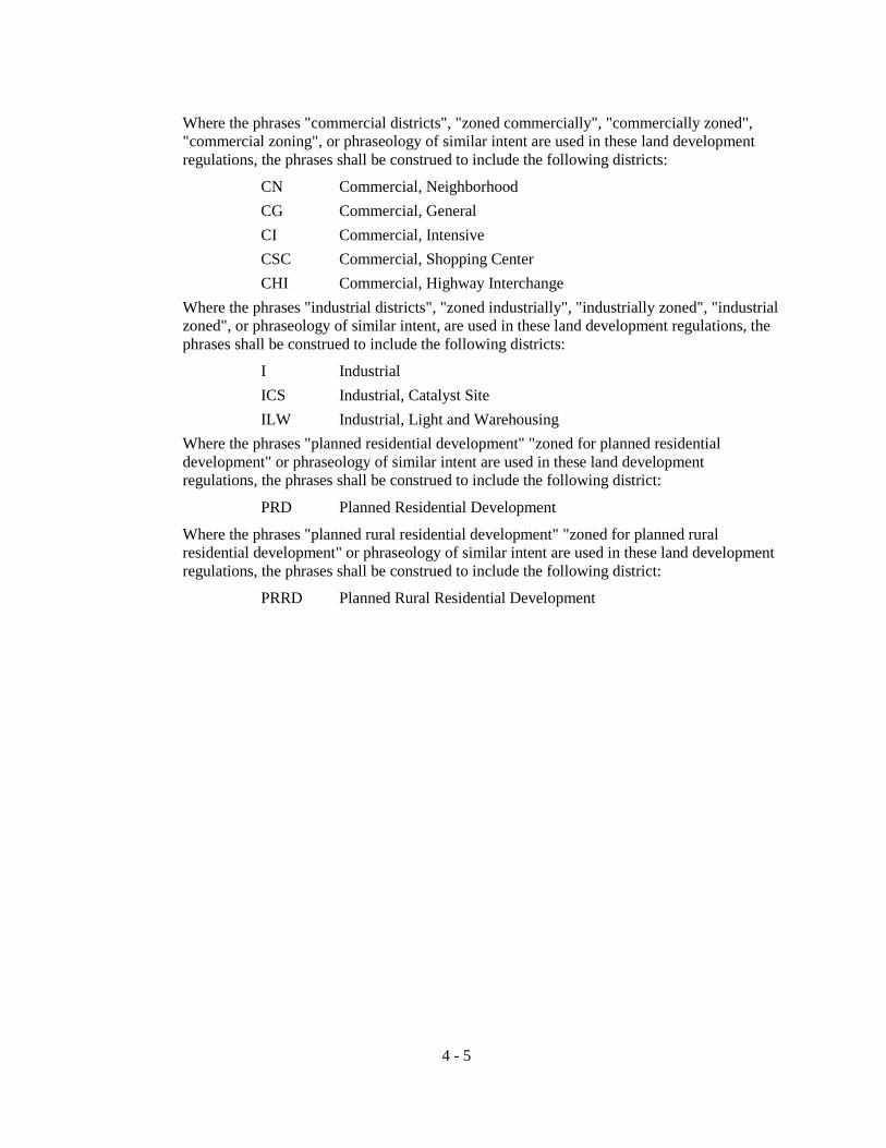
Where the phrases "commercial districts", "zoned commercially", "commercially zoned", "commercial zoning", or phraseology of similar intent are used in these land development regulations, the phrases shall be construed to include the following districts:
CN Commercial, Neighborhood CG Commercial, General CI Commercial, Intensive CSC Commercial, Shopping Center CHI Commercial, Highway Interchange
Where the phrases "industrial districts", "zoned industrially", "industrially zoned", "industrial zoned", or phraseology of similar intent, are used in these land development regulations, the phrases shall be construed to include the following districts:
I Industrial ICS Industrial, Catalyst Site ILW Industrial, Light and Warehousing
Where the phrases "planned residential development" "zoned for planned residential development" or phraseology of similar intent are used in these land development regulations, the phrases shall be construed to include the following district:
PRD Planned Residential Development
Where the phrases "planned rural residential development" "zoned for planned rural residential development" or phraseology of similar intent are used in these land development regulations, the phrases shall be construed to include the following district:
PRRD Planned Rural Residential Development
4 - 5

THIS PAGE LEFT BLANK INTENTIONALLY
4 - 6

SECTION 4.2 "CSV" CONSERVATION
4.2.1 DISTRICTS AND INTENT
The "CSV" Conservation category includes one (1) zone district: CSV Lands in this district are lands devoted to the conservation of the unique natural functions within these lands. To conserve these lands, no use other than non-intensive resource-based recreation activities and forestry conducted in accordance with the County's Comprehensive Plan shall be permitted.
4.2.2 PERMITTED PRINCIPAL USES AND STRUCTURES
1. Non-intensive resource-based recreation activities.
2. Forestry conducted in accordance with the County's Comprehensive Plan.
4.2.3 PERMITTED ACCESSORY USES AND STRUCTURES
1. Uses and structures which:
a. Are customarily accessory and clearly incidental and subordinate to non-intensive resource-based recreation activities.
2. Examples of permitted accessory uses and structures include:
a. Forestry stations and scientific stations for the study of the natural resources within the conservation district.
b. Residential facilities for caretakers.
c. Boat docks and boat ramps.
4.2.4 PROHIBITED USES AND STRUCTURES
1. Residential uses (excepting forestry stations or scientific stations for the study of the natural resources within the conservation district).
2. Any use or structure not specifically, provisionally or by reasonable implication permitted herein or permissible as a special exception.
3. Class I landfills and Class III landfills (construction and demolition landfills).
4.2.5 SPECIAL EXCEPTIONS
1. Recreational activities, such as campsites and similar uses.
4.2.6 MINIMUM LOT REQUIREMENTS
None, except to meet other requirements as set out herein.
4.2.7 MINIMUM YARD REQUIREMENTS (See Section 4.19.30 for right-of-way setback requirements.)
Special Provisions:
The location of any structure (except permitted docks, walkways and piers) shall be setback a minimum of thirty-five (35) feet from wetlands.
The location of any structure (except permitted docks, walkways and piers) shall be setback a minimum of seventy-five (75) feet from the Suwannee, Santa Fe and Ichetucknee Rivers.
4 - 7

The location of any structure (except permitted docks, walkways and piers) shall be setback a minimum of fifty (50) feet from all other perennial rivers, streams and creeks.
4.2.8 MAXIMUM HEIGHT OF STRUCTURES: NO PORTION SHALL EXCEED: (See Section 4.19 for exclusions from height limitations)
Thirty-five (35) feet
4.2.9 MINIMUM LOT COVERAGE
None
4.2.10 MINIMUM LANDSCAPED BUFFERING REQUIREMENTS
None
4.2.11 MINIMUM OFFSTREET PARKING REQUIREMENTS
None
4 - 8

SECTION 4.3 "ESA" ENVIRONMENTALLY SENSITIVE AREAS
4.3.1 DISTRICTS AND INTENT
The "ESA" category includes two (2) zone districts: ESA-1, 2 Lands in these districts are considered in need of special planning and treatment regarding land development regulation. Environmentally Sensitive Districts are lands within the areas of the 100-year floodplain, as designated by the Federal Emergency Management Agency, Flood Insurance Rate Map, dated January 6, 1988, which are located in the Santa Fe River Corridor, Suwannee River Corridor Segment II and III, Ichetucknee River and the stream to sink recharge areas shown on the Future Land Use Plan Map of the County’s Comprehensive Plan and Official Zoning Atlas of these land development regulations. Those lands not within the 100-year floodplain of the above described natural features, but shown within the Environmentally Sensitive area district boundary shall conform to the requirements of the Agriculture-1 (A-1) zoning district as provided within these land development regulations. These are not preservation districts, but land uses permitted within these districts are to provide mitigating measures to protect the natural functions of the County’s environmentally sensitive areas as designated within the Comprehensive Plan as regionally significant areas. These regulations prohibit intensive residential, recreational and agricultural uses and prohibit industrial and nonwater-dependent commercial development.
4.3.2 PERMITTED PRINCIPAL USES AND STRUCTURES
1. Non-intensive agricultural (see definition of intensive agriculture in Section 2.1) and forestry operations conducted in accordance with the County's Comprehensive Plan.
2. Single family dwellings.
3. Mobile homes (see placement of mobile homes in floodways in Article 8).
4. Public resource-based recreation facilities.
5. Homes of six (6) or fewer residents which otherwise meet the definition of a "community residential facility" (see Section 4.19).
6. Churches and other houses of worship.
4.3.3 PERMITTED ACCESSORY USES AND STRUCTURES
1. Uses and structures which:
a. Are customarily accessory and clearly incidental and subordinate to permitted or permissible uses and structures.
b. Are located on the same lot as the permitted or permissible principal use or structure, or on a contiguous lot in the same ownership.
c. Do not involve operations or structures not in keeping with the intent of these land development districts.
2. Examples of permitted accessory uses and structures include:
a. Private garages.
b. Docks, ramps, piers and walkways for residential and water-dependent commercial uses (see Article 14).
4 - 9

c. Residential facilities for caretakers whose work requires residence on the
premises or for employees who will be quartered on the premises.
4.3.4 PROHIBITED USES AND STRUCTURES
Industrial and commercial uses, intensive agricultural uses (see section 2.1 for definition of intensive agriculture), private recreational uses, Class I landfills and Class III landfills (construction and demolition landfills) and any use or structure not specifically, provisionally, or by reasonable implication permitted herein or permissible as a special exception.
4.3.5 SPECIAL EXCEPTIONS (See also Articles 12 and 13)
1. Home occupations.
2. Campgrounds of less than 100 campsites.
3. Public buildings and facilities
4.3.6 MINIMUM LOT REQUIREMENTS (area, width)
1. Single family dwellings and mobile homes:
ESA-1 Minimum lot area 20 acres
Minimum lot width 550 ft.
ESA-2 Minimum lot area 10 acres (5 acres if developed as a Planned Rural Residential Development and an overall density of one (1) dwelling unit per ten (10) acres is maintained on site)
Minimum lot width 400 ft.
NOTE: Minimum lot areas for those portions of the area designated as environmentally sensitive which is outside of the 100-year floodplain as designated by the Federal Emergency Management Agency, Flood Insurance Rate Map, shall conform to the following minimum lot requirements:
ESA 1 and 2 Minimum lot area 5 acres (2 acres if developed as a Planned
Residential Development and an overall density of one (1) unit per five (5) acres is maintained on site)
2. All other permitted or permissible uses and structures (unless otherwise specified):
Minimum lot area 10 acres
Minimum lot width 400 ft.
4.3.7 MINIMUM YARD REQUIREMENTS (depth of front and rear yard, width of side yard) (See Section 4.19.30 for right-of-way setback requirements.)
1. All permitted or permissible uses and structures (unless otherwise specified):
Front 30 ft.
Side 15 ft.
Rear 15 ft.
4 - 10
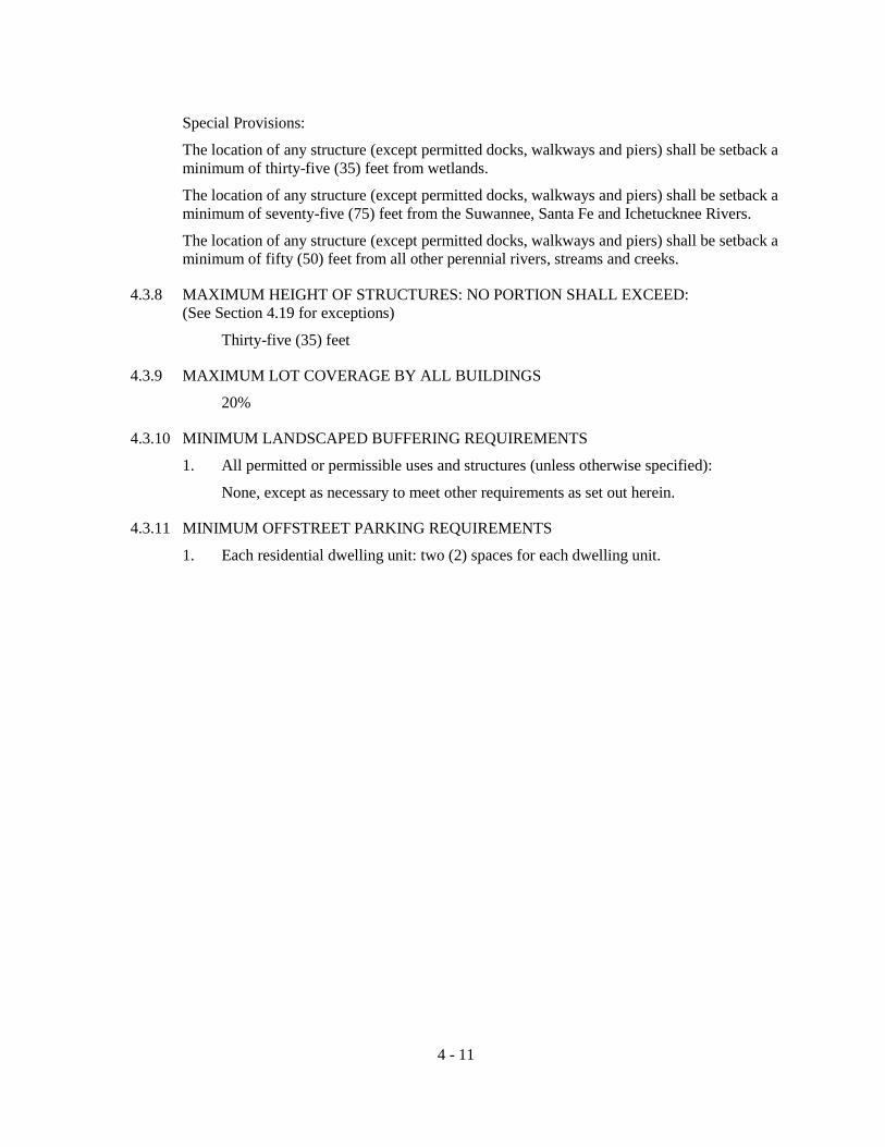
Special Provisions:
The location of any structure (except permitted docks, walkways and piers) shall be setback a minimum of thirty-five (35) feet from wetlands.
The location of any structure (except permitted docks, walkways and piers) shall be setback a minimum of seventy-five (75) feet from the Suwannee, Santa Fe and Ichetucknee Rivers.
The location of any structure (except permitted docks, walkways and piers) shall be setback a minimum of fifty (50) feet from all other perennial rivers, streams and creeks.
4.3.8 MAXIMUM HEIGHT OF STRUCTURES: NO PORTION SHALL EXCEED: (See Section 4.19 for exceptions)
Thirty-five (35) feet
4.3.9 MAXIMUM LOT COVERAGE BY ALL BUILDINGS
20%
4.3.10 MINIMUM LANDSCAPED BUFFERING REQUIREMENTS
1. All permitted or permissible uses and structures (unless otherwise specified):
None, except as necessary to meet other requirements as set out herein.
4.3.11 MINIMUM OFFSTREET PARKING REQUIREMENTS
1. Each residential dwelling unit: two (2) spaces for each dwelling unit.
4 - 11

THIS PAGE LEFT BLANK INTENTIONALLY
4 - 12

SECTION 4.4 "A" AGRICULTURAL
4.4.1 DISTRICTS AND INTENT
The "A" Agricultural category includes two (2) zone districts: A-1 and A-2. Lands in the A-1 district are intended to provide for areas primarily consisting of agricultural and residential uses consistent with the areas shown on the County's Future Land Use Plan Map as rural areas. Lands in the A-2 district are intended to provide for areas primarily consisting of non-intensive agricultural uses and residential uses consistent with the areas shown on the County's Future Land Use Plan Map as urban development areas.
4.4.2 PERMITTED PRINCIPAL USES AND STRUCTURES
In A-1 Districts:
1. All agricultural activities (except intensive agricultural uses as defined in Section 2.1 herein, which may be permitted in this district by special exception), silvicultural activities (conducted in accordance with the County’s Comprehensive Plan), the cultivation of field crops and fruits and berries, forestry, apiculture, and similar uses; provided that structures used for housing domestic animals shall maintain the following setbacks from any lot line:
a. One hundred (100) feet for structures housing ten (10) domestic animals or less;
b. Two hundred (200) feet for structures housing more than ten (10) domestic animals, but less than fifty-one (51) domestic animals;
c. Three hundred (300) feet for structures housing more than fifty-one (51) domestic animals;
d. Where an existing structure for housing domestic animals does not meet the above stated setback requirements, such structure may be altered or enlarged not to exceed one hundred (100) percent of the total existing square footage or an additional agriculture structure may be located adjacent to the existing structure not to exceed one hundred (100) percent of the total existing square footage of the adjacent agriculture building(s). In addition, a site and development plan shall be submitted to the Land Development Regulation Administrator for approval of such agriculture structure and where possible, any such new structure or portion thereof shall be constructed away from the adjacent property line.
2. The processing, storage, and sale of agricultural products and commodities which are raised on the premises (but not including livestock or poultry slaughterhouses); provided, that no building used for these activities shall be located within three hundred (300) feet of any side or rear lot line.
3. Single family dwellings.
4. Mobile homes.
5. Plant nurseries and greenhouses.
6. Homes of six (6) or fewer residents which otherwise meet the definition of a "community residential home" (see section 4.19).
4 - 13

7. The temporary housing of migrant farm workers within mobile homes provided:
a. That a maximum of three (3) mobile home units may be located on a farm or agricultural unit under own ownership containing contiguous land of at least forty (40) acres.
b. Each mobile home must be approved and a permit therefore issued by the Department of Health and Rehabilitative Services of the State of Florida as required by law; and
c. The owner of the farm or agricultural unit shall certify to the County that each mobile home is or will be occupied by only migrant workers in the employment of such owner on the farm or agricultural unit of owner and will not be used by any other person or for any other purpose.
8. Churches and other houses of worship;
9. Cemeteries as exempted by Section 497.003, Florida Statutes.
10. Public schools or private schools offering curricula comparable to that of public schools.
In A-2 Districts:
1. All agricultural activities (except intensive agricultural uses as defined in Section 2.1 herein, silvicultural activities (conducted in accordance with the provisions of the County’s Comprehensive Plan), the cultivation of field crops and fruits and berries, forestry, apiculture, and similar uses; provided structures used for housing domestic animals shall maintain the following setbacks from any lot line:
a. One hundred (100) feet for structures housing ten (10) domestic animals or less;
b. Two hundred (200) feet for structures housing more than ten (10) domestic animals, but less than fifty-one (51) domestic animals;
c. Three hundred (300) feet for structures housing more than fifty-one (51) domestic animals;
d. Where an existing structure for housing domestic animals does not meet the above stated setback requirements, such structure may be altered or enlarged not to exceed one hundred (100) percent of the total existing square footage or an additional agriculture structure may be located adjacent to the existing structure not to exceed one hundred (100) percent of the total existing square footage of the adjacent agriculture building(s). In addition, a site and development plan shall be submitted to the Land Development Regulation Administrator for approval of such agriculture structure and where possible, any such new structure or portion thereof shall be constructed away from the adjacent property line.
2. The processing, storage, and sale of agricultural products and commodities which are raised on the premises (but not including livestock or poultry slaughterhouses); provided, that no building used for these activities shall be located within three hundred (300) feet of any side or rear lot line.
3. Single family dwellings.
4. Mobile homes.
5. Plant nurseries and greenhouses.
4 - 14

6. Homes of six (6) or fewer residents which otherwise meet the definition of a
"community residential home" (see section 4.19).
7. Churches and other houses of worship.
8. Cemeteries as exempted by Section 497.003, Florida Statutes.
9. Public schools or private schools offering curricula comparable to that of public schools.
4.4.3 PERMITTED ACCESSORY USES AND STRUCTURES
1. Uses and structures in both A-1 and A-2 districts which:
a. Are customarily accessory and clearly incidental and subordinate to permitted or permissible uses and structures.
b. Are located on the same lot as the permitted or permissible principal use or structure, or on a contiguous lot in the same ownership.
c. Do not involve operations or structures not in keeping with the character of a rural area.
2. Examples of permitted accessory uses and structures include:
a. Barns and stables.
b. Private garages.
c. Private swimming pools.
d. On-site signs (see Section 4.19).
e. Residential facilities for caretakers whose work requires residence on the premises or for employees who will be quartered on the premises.
4.4.4 PROHIBITED USES AND STRUCTURES
In A-1 and A-2 districts: Junk yard or automobile wrecking yard, and any use or structure not specifically, provisionally, or by reasonable implication permitted herein or permissible as a special exception.
In A-1 districts, Class I landfills are prohibited, however, provided that permitted existing Class I landfills that lawfully existed on or before December 31, 2011 are not prohibited.
In A-2 districts, Class I landfills and Class III landfills (construction and demolition landfills) are prohibited.
4.4.5 SPECIAL EXCEPTIONS AND SPECIAL PERMITS
In A-1 Districts:
A. Special Exceptions (see Articles 12 & 13)
1. The processing, storage, and sale of agricultural products and commodities which are not raised on the premises; provided, that no building used for these activities shall be located within two hundred (200) feet of any side or rear lot line.
2. Livestock auction arenas.
3. Agricultural equipment and related machinery sales.
4. Agricultural feed and grain packaging, blending, storage, and sales.
4 - 15

5. Agricultural fertilizer storage and sales.
6. Agricultural fairs and fairground activities.
7. Recreational activities such as racetracks and speedways; golf courses; country clubs; tennis and racquet clubs; golf and archery ranges; rifle, shotgun, and pistol ranges; travel trailer parks or campgrounds, including day camps; hunting or fishing camps; and similar uses.
8. Riding or boarding stables; provided the following setbacks are maintained from any lot lines; one hundred (100) feet for housing ten (10) animals or less; two hundred (200) feet for housing more than ten (10) animals, but less than fifty-one (51) animals; three hundred (300) feet for housing more than fifty-one (51) animals.
9 Drive-in theaters (See Section 4.19 for special design standards).
10. Commercial kennels, veterinary clinics, and animal shelters, provided that any open runs or buildings used for housing of animals maintain the following setbacks from any lot lines: two hundred (200) feet for housing up to twenty-four (24) animals; three hundred (300) feet for housing twenty-five (25) or more animals. (See Section 4.19.35 for additional requirements for commercial kennels).
11. Group living facilities.
12. Crematories.
13. Child care centers, provided:
a. No outdoor play activities shall be conducted before 8:00 a.m. or after 8:00 p.m.
b. Provision is made for areas for offstreet pick-up and drop- off of children.
14. Private clubs and lodges.
15. Off-site signs (see also Section 4.19).
16. Flea markets.
17. Exotic animals (see section 2.1 for definition).
18. Small engine repair, excluding boat motors (not to exceed two-thousand (2,000) square feet).
19. Automotive repair and repair of agricultural equipment (not to exceed two-thousand five hundred (2,500) square feet).
20. Welding shop (not to exceed two-thousand five hundred (2,500) square feet).
21. Bed and breakfast inns.
22. Mini-storage warehouses for rent to the public where all storage occurs in completely enclosed buildings not to exceed 2,500 square feet total.
23. Cemeteries and mausoleums not exempted by Section 497.003, Florida Statutes.
24. Home occupation use, which is conducted outside of the principal building. (See Article 4.19.31)
4 - 16

25. A truck terminal for the storage, dispatching and servicing of semi tractor-trailers
or trucks (not to exceed 15,000 square feet) and provided no activities shall be located within 300 feet from any lot lines.
26. Security system monitoring facilities.
27. Auction Yards.
B. Special Permits (see Article 14.6)
1. Livestock or poultry slaughterhouses; provided that no building used for these activities shall be located within three hundred (300) feet of any side or rear lot line.
2. Sawmills and planing mills; provided that no building used for these activities shall be located within three hundred (300) feet of any side or rear lot lines.
3. Hospitals, sanitariums, nursing homes, and residential homes for the aged.
4. Airplane landing fields.
5. Public buildings and facilities unless otherwise specified (see Article 4.19.9).
6. Solid waste transfer stations.
7. Class III landfills (construction and demolition landfills).
8. Conference centers.
9. Explosives, manufacturing or storage.
10. Paper and pulp manufacturing.
11. Intensive agriculture (see Article 2.1 for definition).
12. Utilities and related facilities.
In A-2 Districts: A. Special Exceptions (see Articles 12 & 13)
1. Group living facilities.
2. Crematories.
3. Child care centers, provided: a. No outdoor play activities shall be conducted before 8:00 a.m. or after
8:00 p.m. b. Provision is made for areas for offstreet pick-up and drop-off of children.
4. Private clubs and lodges.
5. Off-site signs (see also Section 4.19).
6. Cemeteries and mausoleums not exempted by Section 497.003, Florida Statutes.
7. Small engine repair, excluding boat motors (not to exceed two-thousand (2,000) square feet).
8. Automotive repair and repair of agricultural equipment (not to exceed two-thousand five hundred (2,500) square feet).
9. Welding shop (not to exceed two-thousand five hundred (2,500) square feet).
10. Bed and breakfast inns.
4 - 17

11. Mini-storage warehouses for rent to the public where all storage occurs in
completely enclosed buildings not to exceed 2,500 square feet total.
12. Home occupation use, which is conducted outside of the principal building.
13. Security system monitoring facilities.
B. Special Permits (see Article 14.6)
1. Airplane landing fields.
2. Public buildings and facilities unless otherwise specified (see Article 4.19.9).
3. Utilities and related facilities.
4.4.6 MINIMUM LOT REQUIREMENTS (area, width)
1. Single family dwellings, mobile homes, and group living facilities:
A-1 Minimum lot area 5 acres (except housing for temporary farm workers meeting the requirements stated in Section 4.4.2 herein)
Minimum lot width 275 ft.
A-2 Minimum lot area 2 acres
Minimum lot width 175 ft.
2. All other permitted or permissible uses and structures (unless otherwise specified):
None, except as necessary to meet other requirements as set out herein.
4.4.7 MINIMUM YARD REQUIREMENTS (depth of front and rear yard, width of side yard) (See Section 4.19.30 for right-of-way setback requirements.)
1. All permitted or permissible uses and structures (unless otherwise specified):
Front 30 ft.
Side 15 ft.
Rear 15 ft.
Special Provisions: The location of any structure (except permitted docks, walkways and piers) shall be setback a minimum of thirty-five (35) feet from wetlands. The location of any structure (except permitted docks, walkways and piers) shall be setback a minimum of seventy-five (75) feet from the Suwannee, Santa Fe and Ichetucknee Rivers. The location of any structure (except permitted docks, walkways and piers) shall be setback a minimum of fifty (50) feet from all other perennial rivers, streams and creeks.
4.4.8 MAXIMUM HEIGHT OF STRUCTURES: NO PORTION SHALL EXCEED (See also Section 4.19 for exceptions) Thirty-five (35) feet
Exception: Sawmills and planing mills height limitations shall be determined by findings in the particular Special Permit case.
4 - 18

4.4.9 MAXIMUM LOT COVERAGE BY ALL BUILDINGS 20%
Note: In addition to meeting the required lot yard, building height, lot coverage, landscaped buffering, and off-street parking requirements of this section, no structure shall exceed a 1.0 floor area ratio.
4.4.10 MINIMUM LANDSCAPED BUFFERING REQUIREMENTS (See also Section 4.19)
1. All permitted or permissible uses and structures (unless otherwise specified):
None, except as necessary to meet other requirements as set out herein.
4.4.11 MINIMUM OFFSTREET PARKING REQUIREMENTS (See also Section 4.19)
1. Each residential dwelling unit: two (2) spaces for each dwelling unit.
2. Elementary and junior high schools: two (2) spaces for each classroom or office room, plus one (1) space for each three (3) seats in any auditorium or gymnasium.
3. Senior high school: four (4) spaces for each classroom or office room, plus two (2) spaces for each three (3) seats in any auditorium or gymnasium.
4. Churches or other houses of worship: one (1) space for each six (6) permanent seats in the main auditorium.
5. Public buildings and facilities (unless otherwise specified): one (1) space for each two hundred (200) sq. ft. of floor area.
6. Private clubs and lodges: one (1) space for each three hundred (300) sq. ft. of floor area.
7. Child care centers: one (1) space for each three hundred (300) sq. ft. of floor area devoted to child care activities.
8. Group living facilities: one (1) space for each bedroom.
9. Hospitals: one (1) space for each bed.
10. Sanitariums and nursing homes: one (1) space for each 2 beds.
11. Residential home for the aged: one (1) space for each dwelling unit.
12. Commercial and service establishments (unless otherwise specified): one (1) space for each one hundred fifty (150) sq. ft. of non-storage floor area.
13. Livestock or poultry slaughterhouse; saw mills and planing mills; crematories; agricultural feed and grain packaging, blending, storage and sales; agricultural fertilizer storage and sales: one (1) space for each five hundred (500) sq. ft. of floor area.
14. Livestock auction arenas; agricultural equipment and related machinery sales; agricultural fairs and fairground activities; drive-in theaters; racetracks and speedways; golf and archery ranges; rifle, shotgun, and pistol ranges; commercial kennels; veterinary clinics; and animal shelters: one (1) space for each three hundred fifty (350) sq. ft. of floor area, plus, where applicable, one (1) space for each one thousand (1,000) sq. ft. of lot or ground area outside buildings used for any type of sales, display, or activity.
4 - 19

15. Conference centers; one (1) space for each three hundred (300) sq. ft. of floor area.
16. For other special exceptions as specified herein: to be determined by findings in the particular case.
4 - 20

SECTION 4.5 "RSF" RESIDENTIAL, SINGLE FAMILY
4.5.1 DISTRICTS AND INTENT
The "RSF" Residential, Single Family category includes four (4) zone districts: RSF-1, RSF-2, RSF-3 and RSF-4. It is the intent of these districts to provide for single family areas of low to medium density together with public and semi-public buildings and facilities and accessory structures as may be desirable and compatible with such development, as well as surrounding development within the designated urban development area as defined within the County's Comprehensive Plan. Non-residential uses in these districts may be subject to restrictions and requirements necessary to preserve and protect the single family residential character of these districts. Variation among the RSF-1, RSF-2, RSF-3 and RSF-4 districts is in requirements for lot area, width, and certain yards.
4.5.2 PERMITTED PRINCIPAL USES AND STRUCTURES 1. Single family dwellings.
2. Public parks and recreational areas.
3. Homes of six (6) or fewer residents which otherwise meet the definition of a "community residential home" (see section 4.19).
4. Public schools or private schools offering curricula comparable to that of public schools.
4.5.3 PERMITTED ACCESSORY USES AND STRUCTURES 1. Uses and structures which:
a. Are customarily accessory and clearly incidental and subordinate to permitted or permissible uses and structures.
b. Are located on the same lot as the permitted or permissible principal use or structure, or on a contiguous lot in the same ownership.
c. Are not of a nature likely to attract visitors in larger numbers than would normally be expected in a residential neighborhood.
d. Do not involve operations or structures not in keeping with the character of single family residential development.
2. Examples of permitted accessory uses and structures include:
a. Private garages. b. Private swimming pools. c. Non-commercial greenhouses and plant nurseries. d. On-site signs (see Section 4.19).
4.5.4 PROHIBITED USES AND STRUCTURES Trade or service establishments or storage in connection with such establishments, storage or
overnight parking of commercial or industrial vehicles in excess of one (1) ton capacity, storage of building materials (except in connection with active construction activities on the premises), signs except as specifically permitted, the keeping of horses, cows, swine, sheep, goats, or poultry, Class I landfills and Class III landfills (construction and demolition landfills) and any use or structure not specifically, provisionally, or by reasonable implication permitted herein or permissible as a special exception.
4 - 21

4.5.5 SPECIAL EXCEPTIONS AND SPECIAL PERMITS
A. Special Exceptions (see Articles 12 and 13)
1. Churches and other houses of worship.
2. Golf courses, country clubs, and racquet and tennis clubs.
3. Cemeteries and mausoleums.
4. Private clubs and lodges.
5. Parks maintained by any private association of persons residing in the district.
6. Child care centers, provided:
a. No outdoor play activities shall be conducted before 8:00 a.m. or after 8:00 p.m.
b. Provision is made for areas for offstreet pick-up and drop-off of children.
7. Commercial greenhouses and plant nurseries.
8. Bed and breakfast inns.
4.5.6 MINIMUM LOT REQUIREMENTS (area, width)
1. Single family dwellings:
RSF-1: Minimum lot area; 1 acre.
Minimum lot width; 125 ft.
RSF-2: Minimum lot area; 20,000 sq. ft.
Minimum lot width; 100 ft.
Note: RSF-2 districts shall only be permitted where community water systems and centralized sanitary sewer systems are available and accessible.
RSF-3: Minimum lot area; 10,000 sq. ft.
Minimum lot width; 85 ft.
Note: RSF-3 districts shall only be permitted where community water systems and centralized sanitary sewer systems are available and accessible.
RSF-4: Minimum lot area; 7,500 sq. ft.
Minimum lot width; 50 ft.
Note: RSF-4 districts shall only be permitted where community water systems and centralized sanitary sewer systems are available and accessible.
2. Other permitted or permissible uses and structures:
None, except as needed to meet all other requirements herein set out.
4 - 22
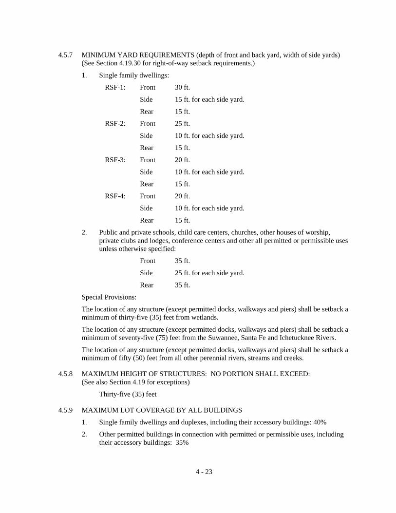
4.5.7 MINIMUM YARD REQUIREMENTS (depth of front and back yard, width of side yards)
(See Section 4.19.30 for right-of-way setback requirements.)
1. Single family dwellings:
RSF-1: Front 30 ft.
Side 15 ft. for each side yard.
Rear 15 ft.
RSF-2: Front 25 ft.
Side 10 ft. for each side yard.
Rear 15 ft.
RSF-3: Front 20 ft.
Side 10 ft. for each side yard.
Rear 15 ft.
RSF-4: Front 20 ft.
Side 10 ft. for each side yard.
Rear 15 ft.
2. Public and private schools, child care centers, churches, other houses of worship, private clubs and lodges, conference centers and other all permitted or permissible uses unless otherwise specified:
Front 35 ft.
Side 25 ft. for each side yard.
Rear 35 ft.
Special Provisions:
The location of any structure (except permitted docks, walkways and piers) shall be setback a minimum of thirty-five (35) feet from wetlands.
The location of any structure (except permitted docks, walkways and piers) shall be setback a minimum of seventy-five (75) feet from the Suwannee, Santa Fe and Ichetucknee Rivers.
The location of any structure (except permitted docks, walkways and piers) shall be setback a minimum of fifty (50) feet from all other perennial rivers, streams and creeks.
4.5.8 MAXIMUM HEIGHT OF STRUCTURES: NO PORTION SHALL EXCEED: (See also Section 4.19 for exceptions)
Thirty-five (35) feet
4.5.9 MAXIMUM LOT COVERAGE BY ALL BUILDINGS
1. Single family dwellings and duplexes, including their accessory buildings: 40%
2. Other permitted buildings in connection with permitted or permissible uses, including their accessory buildings: 35%
4 - 23

Note: In addition to meeting the required lot yard, building height, lot coverage, landscaped
buffering, and off-street parking requirements of this section, no structure shall exceed a 1.0 floor area ratio.
4.5.10 MINIMUM LANDSCAPED BUFFERING REQUIREMENTS (See also Section 4.19)
1. Churches, other houses of worship, private clubs and lodges, child care centers, commercial greenhouses and plant nurseries, public buildings (but not public schools):
Where a use listed under (1) above is erected or expanded on land abutting either (a) a residential district or (b) property used for residential purposes in a residential/office district, then the proposed use shall provide a landscaped buffer which shall not be less than ten (10) ft. in width along the affected rear and/or side yards as the case may be.
2. All other permitted or permissible uses (unless otherwise specified):
None, except as necessary to meet other requirements set out herein.
4.5.11 MINIMUM OFFSTREET PARKING REQUIREMENTS (See also Section 4.19)
1. Each residential dwelling unit: two (2) spaces for each dwelling unit.
2. Elementary and junior high schools: two (2) spaces for each classroom or office room, plus one (1) space for each three (3) seats in any auditorium or gymnasium.
3. Senior high school: four (4) spaces for each classroom or office room, plus two (2) spaces for each three (3) seats in any auditorium or gymnasium.
4. Churches or other houses of worship: one (1) space for each six (6) permanent seats in the main auditorium.
5. Public buildings and facilities (unless otherwise specified): one (1) space for each two hundred (200) sq. ft. of floor area.
6. Private clubs and lodges: one (1) space for each three hundred (300) sq. ft. of floor area.
7. Childcare centers: one (1) space for each three hundred (300) sq. ft. of floor area devoted to child care activities.
8. Conference centers; one (1) space for each three hundred (300) sq. ft. of floor area.
9. Commercial greenhouses and plant nurseries: one (1) space for each one hundred fifty (150) sq. ft. of non-storage floor area.
10. For other special exceptions as specified herein: to be determined by findings in the particular case.
4 - 24

SECTION 4.6 "RSF/MH" RESIDENTIAL, (MIXED) SINGLE FAMILY/MOBILE HOME
4.6.1 DISTRICTS AND INTENT The "RSF/MH" Residential, (Mixed) Single Family/Mobile Home category includes four (4) zone districts: RSF/MH-1, RSF/MH-2, RSF/MH-3 and RSF/MH-4. It is the intent of these districts to provide for single family residential areas of low to medium density for conventional single family dwellings and individual mobile homes within designated urban areas as defined within the County's Comprehensive Plan. In addition to providing for mixed single family/mobile home areas, this district also provides for public and semi-public buildings and facilities and accessory structures as may be desirable and compatible with mixed single family/mobile home residential development. In these districts, permitted non-residential uses and special exceptions may be subject to restrictions and requirements necessary to preserve and protect the single family residential character of these districts.
4.6.2 PERMITTED PRINCIPAL USES AND STRUCTURES 1. Single family dwellings. 2. Mobile home dwellings. 3. Public parks and recreational areas. 4. Homes of six (6) or fewer residents which otherwise meet the definition of a
"community residential home" (see Section 4.19). 5. Public schools or private schools offering curricula comparable to that of public
schools.
4.6.3 PERMITTED ACCESSORY USES AND STRUCTURES 1. Uses and structures which:
a. Are customarily accessory and clearly incidental and subordinate to permitted or permissible uses and structures.
b. Are located on the same lot as the permitted or permissible principal use or structure, or on a contiguous lot in the same ownership.
c. Are not of a nature likely to attract visitors in larger numbers than would normally be expected in a residential neighborhood.
d. Do not involve operations or structures not in keeping with the character of residential development.
2. Examples of permitted accessory uses and structures include: a. Private garages. b. Private swimming pools. c. Non-commercial greenhouses and plant nurseries. d. On-site signs (see Section 4.19).
4.6.4 PROHIBITED USES AND STRUCTURES Trade or service establishments or storage in connection with such establishments, storage or overnight parking of commercial or industrial vehicles in excess of one (1) ton capacity, storage of building materials (except in connection with active construction activities on the premises), mobile home parks, signs except as specifically permitted, the keeping of horses, cows, swine, sheep, goats, or poultry, Class I landfills and Class III landfills (construction and demolition landfills) and any use or structure not specifically, provisionally, or by reasonable implication permitted herein or permissible as a special exception.
4 - 25

4.6.5 SPECIAL EXCEPTIONS AND SPECIAL PERMITS
A. Special Exceptions (see Articles 12 and 13)
1. Churches and other houses of worship. 2. Golf courses, country clubs, racquet and tennis clubs. 3. Cemeteries and mausoleums. 4. Private clubs and lodges. 5. Parks maintained by any private association of persons residing in the district. 6. Child care centers, provided:
a. No outdoor play activities shall be conducted before 8:00 a.m. or after 8:00 p.m.
b. Provision is made for areas for offstreet pick-up and drop-off of children. 7. Commercial greenhouses and plant nurseries. 8. Bed and breakfast inns.
B. Special Permits (see Article 14.6)
1. Public buildings and facilities, unless otherwise specified (see Article 4.19.9).
2. Conference Centers.
4.6.6 MINIMUM LOT REQUIREMENTS (area, width)
1. Single family dwellings and mobile homes: RSF/MH-1: Minimum lot area 1 acre
Minimum lot width 125 ft. RSF/MH-2: Minimum lot area 20,000 sq. ft.
Minimum lot width 100 ft. Note: RSF/MH-2 districts shall only be permitted where community water systems
and centralized sanitary sewer systems are available and accessible. RSF/MH-3: Minimum lot area 10,000 sq. ft. Minimum lot width 85 ft.
Note: RSF/MH-3 districts shall only be permitted where community water systems and centralized sanitary sewer systems are available and accessible.
RSF/MH-4: Minimum lot area 7,500 sq. ft. Minimum lot width 50 ft.
Note: RSF/MH-4 districts shall only be permitted where community water systems and centralized sanitary sewer systems are available and accessible.
2. Other permitted or permissible uses and structures: None, except as needed to meet all other requirements herein set out.
4.6.7 MINIMUM YARD REQUIREMENTS (depth of front and rear yard, width of side of yards) (See Section 4.19.30 for right-of-way setback requirements.)
1. Single family dwellings and mobile homes:
4 - 26

RSF/MH-1: Front 30 ft.
Side 15 ft. for each side yard. Rear 15 ft.
RSF/MH-2: Front 30 ft. Side 15 ft. for each side yard Rear 15 ft.
RSF/MH-3: Front 25 ft. Side 10 ft. for each side yard Rear 15 ft. RSF/MH-4: Front 20 ft. Side 10 ft. for each side yard. Rear 15 ft.
2. Public and private schools, child care centers, churches, other houses of worship, private clubs and lodges, conference centers and all other permissible uses unless otherwise specified:
Front 35 ft. Side 25 ft. for each side yard. Rear 35 ft.
Special Provisions:
The location of any structure (except permitted docks, walkways and piers) shall be setback a minimum of thirty-five (35) feet from wetlands.
The location of any structure (except permitted docks, walkways and piers) shall be setback a minimum of seventy-five (75) feet from the Suwannee, Santa Fe and Ichetucknee Rivers.
The location of any structure (except permitted docks, walkways and piers) shall be setback a minimum of fifty (50) feet from all other perennial rivers, streams and creeks.
4.6.8 MAXIMUM HEIGHT OF STRUCTURES: NO PORTION SHALL EXCEED (See also Section 4.19 for exceptions)
Thirty-five (35) feet
4.6.9 MAXIMUM LOT COVERAGE BY ALL BUILDINGS
1. One family dwellings and duplexes, including their accessory buildings: 40%
2. Other permitted buildings in connection with permitted or permissible uses, including their accessory buildings: 35%.
Note: In addition to meeting the required lot yard, building height, lot coverage, landscaped buffering, and off-street parking requirements of this section, no structure shall exceed a 1.0 floor area ratio.
4.6.10 MINIMUM LANDSCAPED BUFFERING REQUIREMENTS (See also Section 4.19)
4 - 27

1. Churches, other houses of worship, private clubs and lodges, conference centers, child
care centers, commercial greenhouses and plant nurseries, public buildings (but not public schools):
Where a use listed under (1) above is erected or expanded on land abutting either (a) a residential district or (b) property used for residential purposes in a residential/office district, then the proposed use shall provide a landscaped buffer which shall not be less than 10 ft. in width along the affected rear and/or side yards as the case may be.
2. All other permitted or permissible uses (unless otherwise specified):
None, except as necessary to meet other requirements set out herein.
4.6.11 MINIMUM OFFSTREET PARKING REQUIREMENTS (See also Section 4.19)
1. Each residential dwelling unit: two (2) spaces for each dwelling unit.
2. Elementary and junior high schools: two (2) spaces for each classroom or office room, plus one (1) space for each three (3) seats in any auditorium or gymnasium.
3. Senior high schools: four (4) spaces for each classroom or office room, plus two (2) spaces for each three (3) seats in any auditorium or gymnasium.
4. Churches or other houses of worship: one (1) space for each six (6) permanent seats in the main auditorium.
5. Public buildings and facilities (unless otherwise specified): one (1) space for each two hundred (200) sq. ft. of floor area.
6. Childcare centers: one (1) space for each three hundred (300) sq. ft. of floor area devoted to child care activities.
7. Private clubs and lodges: one (1) space for each three hundred (300) sq. ft. of floor area.
8. Conference Centers; one (1) space for each three hundred (300) sq. ft. of floor area.
9. Commercial greenhouses and plant nurseries: one (1) space for each one hundred fifty (150) sq. ft. of non-storage floor area.
10. For other special exceptions as specified herein: to be determined by findings in the particular case.
4.6.12 ADDITIONAL REQUIREMENTS FOR MOBILE HOMES
1. Anchoring. Each mobile home shall be located on a stand that will permit each unit to be sufficiently supported and anchored as in compliance with the State Standards for Anchoring Mobile Homes.
In addition, each mobile home shall have the wheels and axles removed, shall be placed as close to the ground as can be practically accomplished and shall have the tongue or hitch portion of the mobile home removed from the mobile home unless that portion of the mobile home is permanently attached in such a manner that it cannot be readily be removed there from.
2. Skirting. A skirt or apron which is continually and properly maintained shall surround each mobile home between the bottom of the unit and the ground. This skirt shall be continually and properly maintained by the owner of the mobile home.
4 - 28

SECTION 4.7 "RMH" RESIDENTIAL, MOBILE HOME
4.7.1 DISTRICTS AND INTENT The "RMH" Residential, Mobile Home category includes four (4) zone districts: RMH-1, RMH-2, RMH-3 and RMH-4. It is the intent of these districts to provide for low to medium density mobile home subdivision development together with public and semi-public buildings and facilities and accessory structures as may be desirable and compatible with such development as well as surrounding development within the designated urban development area, as defined within the County's Comprehensive Plan. Non-residential uses in these districts may be subject to restrictions and requirements necessary to protect the residential character of these districts.
4.7.2 PERMITTED PRINCIPAL USES AND STRUCTURES 1. Mobile homes.
2. Public parks and recreational areas.
3. Homes of six (6) or fewer residents which otherwise meet the definition of a "community residential home" (see section 4.19).
4. Public schools or private schools offering curricula comparable to that of public schools.
4.7.3 PERMITTED ACCESSORY USES AND STRUCTURES 1. Uses and structures which:
a. Are customarily accessory and clearly incidental and subordinate to permitted or permissible uses and structures.
b. Are located on the same lot as the permitted or permissible principal use or structure, or on a contiguous lot in the same ownership.
c. Are not of a nature likely to attract visitors in larger numbers than would normally be expected in a residential neighborhood.
d. Do not involve operations or structures not in keeping with the character of residential development.
2. Examples of permitted accessory uses and structures include: a. Private garages.
b. Private swimming pools.
c. Non-commercial greenhouses and plant nurseries.
d. On-site signs (see Section 4.19).
4.7.4 PROHIBITED USES AND STRUCTURES Trade or service establishments or storage in connection with such establishments, storage or overnight parking of commercial or industrial vehicles in excess of one (1) ton capacity, storage of building materials (except in connection with active construction activities on the premises), new conventional single family dwelling units, mobile home parks, signs except as specifically permitted, the keeping of horses, cows, swine, sheep, goats, or poultry, Class I landfills and Class III landfills (construction and demolition landfills) and any use or structure not specifically, provisionally, or by reasonable implication permitted herein or permissible as a special exception.
4 - 29

4.7.5 SPECIAL EXCEPTIONS AND SPECIAL PERMITS
A. Special Exceptions (see Articles 12 and 13)
1. Churches and other houses of worship.
2. Golf courses, country clubs, and racquet and tennis clubs.
3. Cemeteries and mausoleums.
4. Private clubs and lodges.
5. Parks maintained by any private association of persons residing in the district.
6. Child care centers, provided:
a. No outdoor play activities shall be conducted before 8:00 a.m. or after 8:00 p.m.
b. Provision is made for areas for offstreet pick-up and drop-off of children.
7. Commercial greenhouses and plant nurseries.
B. Special Permits (see Article 14.6)
1. Public buildings and facilities, unless otherwise specified (see Article 4.19.9).
2. Conference Centers.
4.7.6 MINIMUM LOT REQUIREMENTS (areas, width)
1. Mobile homes:
RMH-1: Minimum lot area 1 acre.
Minimum lot width 125 ft.
RMH-2: Minimum lot area 20,000 sq. ft.
Minimum lot width 100 ft.
Note: RMH-2 districts shall only be permitted where a community water system and centralized sanitary sewer system is available and accessible.
RMH-3: Minimum lot area 10,000 sq. ft.
Minimum lot width 85 ft.
Note: RMH-3 districts shall only be permitted where a community water system and centralized sanitary sewer system is available and accessible.
RMH-4: Minimum site are for mobile home subdivision; 10 acres.
Minimum lot area 7,500 sq. ft.
Minimum lot width 50 ft.
Note: RMH-4 districts shall only be permitted where a community water system and centralized sanitary sewer system is available and accessible.
2. Other permitted or permissible uses and structures:
None, except as needed to meet all other requirements herein set out.
4 - 30

4.7.7 MINIMUM YARD REQUIREMENTS (depth of front and rear yard, width of side yards)
(See Section 4.19.30 for right-of-way setback requirements.)
1. Mobile homes:
RMH-1: Front 30 ft. Side 15 ft. for each side yard. Rear 15 ft. RMH-2: Front 30 ft. Side 15 ft. for each side yard. Rear 15 ft. RMH-3: Front 25 ft. Side 15 ft. for each side yard. Rear 15 ft. RMH-4: Front 20 ft. Side 10 ft. for each side yard Rear 15 ft.
2. Public and private schools, child care centers, churches, other houses of worship, private clubs and lodges, and all other permitted or permissible uses unless otherwise specified:
Front 35 ft. Side 25 ft. for each side yard.
Rear 35 ft.
Special Provisions: The location of any structure (except permitted docks, walkways and piers) shall be setback a minimum of thirty-five (35) feet from wetlands. The location of any structure (except permitted docks, walkways and piers) shall be setback a minimum of seventy-five (75) feet from the Suwannee, Santa Fe and Ichetucknee Rivers. The location of any structure (except permitted docks, walkways and piers) shall be setback a minimum of fifty (50) feet from all other perennial rivers, streams and creeks.
4.7.8 MAXIMUM HEIGHT OF STRUCTURES: NO PORTION SHALL EXCEED (See also Section 4.19 for exceptions)
Thirty-five (35) feet
4.7.9 MAXIMUM LOT COVERAGE BY ALL BUILDINGS 1. Mobile home dwellings including their accessory buildings: 40%.
2. Other permitted building in connection with permitted or permissible uses, including their accessory buildings: 35%.
Note: In addition to meeting the required lot yard, building height, lot coverage, landscaped buffering, and off-street parking requirements of this section, no structure shall exceed a 1.0 floor area ratio.
4 - 31

4.7.10 MINIMUM LANDSCAPED BUFFERING REQUIREMENTS (See also Section 4.19)
1. Churches, other houses of worship, private clubs and lodges, child care centers, commercial greenhouses and plant nurseries, public buildings (but not public schools):
Where a use listed under (l) above is erected or expanded on land abutting either (a) a residential district or (b) property used for residential purposes in a residential/office district, then the proposed use shall provide a landscaped buffer which shall be not less than ten (10) ft. in width along the affected rear and/or side yards as the case may be.
2. All other permitted or permissible uses (unless otherwise specified):
None, except as necessary to meet other requirements set out herein.
4.7.11 MINIMUM OFFSTREET PARKING REQUIREMENTS (See also Section 4.19)
1. Each residential dwelling unit: two (2) spaces for each dwelling unit.
2. Elementary and junior high schools: two (2) spaces for each classroom or office room, plus one (1) space for each three (3) seats in any auditorium or gymnasium.
3. Senior high schools: four (4) spaces for each classroom or office room, plus two (2) spaces for each three (3) seats in any auditorium or gymnasium.
4. Churches or other houses of worship: one (1) space for each six (6) permanent seats in the main auditorium.
5. Public buildings and facilities (unless otherwise specified): one (1) space for each two hundred (200) sq. ft. of floor area.
6. Private clubs and lodges: one (1) space for each three hundred (300) sq. ft. of floor area.
7. Child care centers: one (1) space for each three hundred (300) sq. ft. of floor area devoted to child care activities.
8. Conference centers; one (1) space for each three hundred (300) sq. ft. of floor area.
9. Commercial greenhouses and plant nurseries: one (1) space for each one hundred fifty (150) sq. ft. of non-storage floor area.
10. For other special exceptions as specified herein: to be determined by findings in the particular case.
4.7.12 ADDITIONAL REQUIREMENTS FOR MOBILE HOMES 1. Anchoring. Each mobile home shall be located on a stand that will permit each unit to
be sufficiently supported and anchored as in compliance with the State Standards for Anchoring Mobile Homes. In addition, each mobile home shall have the wheels and axles removed, shall be placed as close to the ground as can be practically accomplished and shall have the tongue or hitch portion of the mobile home removed from the mobile home unless that portion of the mobile home is permanently attached in such a manner that it cannot readily be removed there from.
2. Skirting. A skirt or apron which is continually and properly maintained shall surround each mobile home between the bottom of the unit and the ground. This skirt or apron shall be continually and properly maintained by the owner of the mobile home.
4 - 32

SECTION 4.8 "RMH-P" RESIDENTIAL, MOBILE HOME PARK
4.8.1 DISTRICTS AND INTENT
The "RMH-P" Residential, Mobile Home Park category includes one (1) zone district: RMH-P. It is the intent of this district to provide for mobile homes in approved parks, occupied as one family dwellings within designated urban development areas, as defined within the County's Comprehensive Plan. This is a high density district designed to create an environment of residential character and permitting only those uses, activities, and services which are compatible with the residential environment. The RMH-P district is a residential district, and not a commercial district. The minimum size for a mobile home park shall be five (5) acres in order to avoid spotty development and to provide enough area for adequate site design.
4.8.2 PERMITTED PRINCIPAL USES AND STRUCTURES
1. Mobile home parks.
2. Homes of six (6) or fewer residents which otherwise meet the definition of "community residential home" (See Section 4.19).
3. Public schools or private schools offering curricula comparable to that of public schools.
For uses under (1) above: Site and development plan approval is required (see Article 14).
4.8.3 PERMITTED ACCESSORY USES AND STRUCTURES
1. Uses and structures which:
a. Are customarily accessory and clearly incidental and subordinate to permitted or permissible uses and structures.
b. Are located on the same lot as the permitted or permissible principal use or structure, or on a contiguous lot in the same ownership.
c. Are not of a nature likely to attract visitors in larger numbers than would normally be expected in a residential neighborhood.
d. Do not involve operations or structures not in keeping with the character of residential development.
2. Examples of permitted accessory uses and structures include:
a. Private garages.
b. Private swimming pools.
c. Non-commercial greenhouses and plant nurseries.
d. Storage rooms.
e. Mobile home park administrative/management offices and recreational and laundry facilities intended for use solely by the residents of the mobile home park and their guests.
f. On-site signs (see Section 4.19).
4 - 33

4.8.4 PROHIBITED USES AND STRUCTURES
Trade or service establishments or storage in connection with such establishments, retail commercial outlets for sale of new and used mobile homes, storage or overnight parking of commercial or industrial vehicles in excess of one (1) ton capacity, storage of building materials (except in connection with active construction activities on the premises), signs except as specifically permitted, the keeping of horses, cows, swine, sheep, goats, or poultry, Class I landfills and Class III landfills (construction and demolition landfills) and any use or structure not specifically, provisionally, or by reasonable implication permitted herein or permissible as a special exception.
4.8.5 SPECIAL EXCEPTIONS AND SPECIAL PERMITS
A. Special Exceptions (see Articles 12 and 13)
1. Churches and other houses of worship.
2. Golf courses, country clubs, and racquet and tennis clubs.
3. Cemeteries or mausoleums.
4. Private clubs and lodges.
5. Public parks; parks maintained by any private association of persons residing in the district.
6. Child care centers, provided:
a. No outdoor play activities shall be conducted before 8:00 a.m. or after 8:00 p.m.
b. Provision is made for areas for offstreet pick-up and drop-off of children.
B. Special Permits (see Article 14.6)
1. Public buildings and facilities, unless otherwise specified (see Article 4.19.9).
2. Conference centers.
4.8.6 MINIMUM LOT REQUIREMENTS (area, width)
1. Mobile Home Parks Site Requirements
Minimum site area 5 acres.
Minimum site width 275 ft.
Minimum land area per dwelling unit 5,445 sq. ft. (Density; 8 dwelling units per acre).
Mobile Home Stand Requirements
Minimum mobile home stand size 3,500 sq. ft.
Minimum average width of mobile home stand 40 ft.
2. Other permitted or permissible uses and structures:
None, except as needed to meet all other requirements herein set out.
4 - 34
4.8.7 MINIMUM YARD REQUIREMENTS (depth of front and rear yard, width of side yards)
(See Section 4.19.30 for right-of-way setback requirements.)
1. Mobile home parks: (to be applied at site perimeter)
Front 35 ft.
Side 25 ft. for each side yard
Rear 25 ft.
Special Provisions: In a mobile home park, no mobile home shall be located closer than twenty (20) feet to (a) another mobile home, or (b) a mobile home park access or circulation drive.
As an alternate to, but not in conjunction with, the above special provisions regarding mobile home location requirements, the following may be used as requirements for mobile home setbacks within a RMH-P zoning district for mobile home parks that were in existence prior to the adoption of the land development regulations;
No mobile home may be located closer than fifteen (15) feet from any side, rear or front line of an individual mobile home stand, except that if the side, front or rear lot line of the individual mobile home stand adjoins a private internal circulation or access drive, not maintained by the County, the setback from the lot line adjoining the circulation or access road may be reduced to ten (10) feet, provided a minimum distance from any adjacent mobile home or other structure be not less than thirty-five (35) feet where an internal circulation or access drive intervenes between two structures, and provided that the location of the mobile home or other structure does not encroach on utility locations including water, sewer, electric, telephone and cable television.
2. Public and private schools, child care centers, churches, other houses of worship, private clubs and lodges, conference centers and all other permitted or permissible uses unless otherwise specified:
Front 35 ft.
Side 25 ft. for each side yard
Rear 35 ft.
Special Provisions: The location of any structure (except permitted docks, walkways and piers) shall be setback a minimum of thirty-five (35) feet from wetlands.
The location of any structure (except permitted docks, walkways and piers) shall be setback a minimum of seventy-five (75) feet from the Suwannee, Santa Fe and Ichetucknee Rivers.
The location of any structure (except permitted docks, walkways and piers) shall be setback a minimum of fifty (50) feet from all other perennial rivers, streams and creeks.
4.8.8 MAXIMUM HEIGHT OF STRUCTURES: NO PORTION SHALL EXCEED (See also Section 4.19 for exceptions)
Thirty-five (35) feet
4 - 35

4.8.9 MAXIMUM LOT COVERAGE BY ALL BUILDINGS
1. Mobile home parks, including all accessory buildings: 30%.
2. Other permitted buildings in connection with permitted or permissible uses, including their accessory buildings: 35%.
Note: In addition to meeting the required lot yard, building height, lot coverage, landscaped buffering, and off-street parking requirements of this section, no structure shall exceed a 1.0 floor area ratio.
4.8.10 MINIMUM LANDSCAPED BUFFERING REQUIREMENTS (See also Section 4.19)
1. Mobile home parks:
Where a use under (1) above is erected or expanded on land abutting a one (1) family residential district, then the proposed use shall provide a landscaped buffer which shall be not less than fifteen (15) ft. in width along the affected rear and/or side yards as the case may be.
2. Churches, other houses of worship, private clubs and lodges, conference centers, child care centers, public buildings (but not public schools):
Where a use listed under (2) above is erected or expanded on land abutting a residential district, then the proposed use shall provide a landscaped buffer which shall be not less than ten (10) ft. in width along the affected rear and/or side yards as the case may be.
3. All other permitted or permissible uses (unless otherwise specified):
None, except as necessary to meet other requirements set out herein.
4.8.11 MINIMUM OFFSTREET PARKING REQUIREMENTS (See also Section 4.19)
1. Each residential dwelling unit: two (2) spaces for each dwelling unit.
2. Elementary and junior high schools: two (2) spaces for each classroom or office room, plus one (1) space for each three (3) seats in any auditorium or gymnasium.
3. Senior high schools: four (4) spaces for each classroom or office room, plus two (2) spaces for each three (3) seats in any auditorium or gymnasium.
4. Churches or other houses of worship: one (1) space for each six (6) permanent seats in the main auditorium.
5. Public buildings and facilities (unless otherwise specified): one (1) space for each two hundred (200) sq. ft. of floor area.
6. Child care centers: one (1) space for each three hundred (300) sq. ft. of floor area devoted to child care activities.
7. Private clubs and lodges and conference centers: one (1) space for each three hundred (300) sq. ft. of floor area.
8. For other special exceptions as specified herein: to be determined by findings in the particular case.
4 - 36

4.8.12 ADDITIONAL REQUIREMENTS FOR MOBILE HOME PARKS
1. Mobile home stands. The following requirements shall be met:
a. Each mobile home shall be located on a stand that will permit each unit to be sufficiently supported and anchored as in compliance with the State Standards for Anchoring Mobile Homes.
b. Each approved mobile home stand shall be clearly defined by stakes or other markers which physically delineate the location of each stand within the mobile home park.
c. A skirt or apron shall surround each mobile home between the bottom of the unit and the ground. This skirt or apron shall be continually and properly maintained by the owner of the mobile home.
2. Street or Driveway Improvements. All streets and drives shall be constructed using generally accepted engineering practices so as to allow proper drainage of the entire area, and to provide access to each mobile home site.
a. Pavement base. Six (6) inches of compacted limerock.
b. Wearing surface. One (1) inch of Type II asphalt or concrete surface course or the equivalent as approved as meeting standards established by the Board of County Commissioners.
c. Pavement width. All streets shall have a minimum pavement width of twenty (20) feet.
3. Street lighting. All streets or driveways within the park shall be lighted at night with electric lights providing a minimum illumination of 0.2 foot candles.
4. Usable open space. A minimum of fifteen (15) percent of the gross land area within the mobile home park shall be designed for recreational purposes.
5. Parking. No parking shall be allowed on any mobile home park access or circulation drive.
6. State regulations. In addition to the requirements listed above, the mobile home park shall comply with all applicable rules and regulations of the State of Florida including Chapter 10D-26 of the Florida Administrative Code, as amended.
4 - 37

THIS PAGE LEFT BLANK INTENTIONALLY
4 - 38
SECTION 4.9 "RMF" RESIDENTIAL, MULTIPLE FAMILY
4.9.1 DISTRICTS AND INTENT
The "RMF" Residential, Multiple Family category includes three (3) zone districts: RMF-1, RMF-2 and RMF-3. It is the intent of these districts to provide for residential areas of medium to high density within designated urban development areas as defined within the County's Comprehensive Plan and only when community potable water systems are available and accessible. These zoning districts allow for a desirable variety of housing types together with public and semi-public buildings and facilities and accessory structures as may be compatible with residential development. Non-residential uses in these districts may be subject to restrictions and requirements necessary to preserve and protect the residential character of these districts. Variation between the RMF-1, RMF-2 and RMF-3 districts is in requirements for density (land area per dwelling unit).
4.9.2 PERMITTED PRINCIPAL USES AND STRUCTURES
1. Single family dwellings. 2. Duplex dwellings. 3. Homes of six (6) or fewer residents which otherwise meet the definition of a
"community residential home" (see section 4.19). 4. Multiple family dwellings. 5. Community residential facility (see Section 4.19). 6. Public parks and recreational areas. 7. Public schools or private schools offering curricula comparable to that of public
schools. For uses under (4) above: Site and development plan approval is required for multiple family developments consisting of five (5) or more dwellings or two (2) or more separate buildings (see Article 14).
For uses under (5) above: Site and development plan approval is required (see Article 14).
4.9.3 PERMITTED ACCESSORY USES AND STRUCTURES
1. Uses and structures which:
a. Are customarily accessory and clearly incidental and subordinate to permitted or permissible uses and structures.
b. Are located on the same lot as the permitted or permissible principal use or structure, or on a contiguous lot in the same ownership.
c. Are not of a nature likely to attract visitors in larger numbers than would normally be expected in a residential neighborhood.
d. Do not involve operations or structures not in keeping with the character of residential development.
2. Examples of permitted accessory uses and structures include: a. Private garages. b. Private swimming pools. c. Non-commercial greenhouses and plant nurseries.
4 - 39

d. For multiple family dwellings: administrative/management offices for the
multiple family complex and recreational and laundry facilities intended for use solely by the residents of the multiple family complex and their guests.
e. On-site signs (see Section 4.19).
4.9.4 PROHIBITED USES AND STRUCTURES
Trade or service establishments or storage in connection with such establishments, storage or overnight parking of commercial or industrial vehicles, in excess of one (1) ton capacity, storage of building materials (except in connection with active construction activities on the premises), signs except as specifically permitted, the keeping of horses, cows, swine, sheep, goats, or poultry, Class I landfills and Class III landfills (construction and demolition landfills) and any use or structure not specifically, provisionally, or by reasonable implication permitted herein or permissible as a special exception.
4.9.5 SPECIAL EXCEPTIONS AND SPECIAL PERMITS
A. Special Exceptions (see Articles 12 and 13) 1. Churches and other houses of worship. 2. Golf courses, country clubs, and racquet and tennis clubs. 3. Cemeteries and mausoleums. 4. Private clubs and lodges. 5. Parks maintained by any private association of persons residing in the district. 6. Child care centers, provided:
a. No outdoor play activities shall be conducted before 8:00 a.m. or after 8:00 p.m.
b. Provision is made for areas for offstreet pick-up and drop-off of children. 7. Group living facilities. 8. Bed and breakfast inns.
B. Special Permits (See Article 14.6) 1. Public buildings and facilities, unless otherwise specified (see Article 4.19.9) 2. Nursing homes and residential homes for the aged. 3. Conference Centers.
4.9.6 MINIMUM LOT REQUIREMENTS (area, width)
1. Conventional single family dwellings:
Minimum lot area 7,500 sq. ft.
Minimum lot width 50 ft.
2. Duplexes
Minimum lot area 10,000 sq. ft.
Minimum lot width 85 ft.
3. Multiple family development Minimum site area 16,335 sq. ft. Minimum site width 80 ft.
4 - 40

Minimum land area per dwelling unit
RMF-1 10,900 sq. ft.
RMF-2 5,445 sq. ft.
RMF-3 2,178 sq. ft.
4. Other permitted or permissible uses and structures:
None, except as needed to meet all other requirements herein set out.
4.9.7 MINIMUM YARD REQUIREMENTS (depth of front and rear yards, width of side yards) (See Section 4.19.30 for right-of-way setback requirements.)
1. Conventional single family dwellings, mobile homes, and duplexes:
Front 20 ft.
Side 10 ft. for each side yard.
Rear 15 ft.
2. Multiple family dwellings: (to be applied to site perimeter)
Front 30 ft.
Side 15 ft. for each side yard.
Rear 20 ft.
Special Provisions; Where two (2) or more multiple family structures are located together on one (1) site, no detached residential structure shall be closer than twenty (20) ft. to another.
3. Public and private schools, child care centers, churches, other houses of worship, private clubs and lodges, nursing homes, residential homes for the aged, group living facilities, and all other permitted or permissible uses unless otherwise specified:
Front 35 ft.
Side 25 ft. for each side yard.
Rear 35 ft.
Special Provisions:
The location of any structure (except permitted docks, walkways and piers) shall be setback a minimum of thirty-five (35) feet from wetlands.
The location of any structure (except permitted docks, walkways and piers) shall be setback a minimum of seventy-five (75) feet from the Suwannee, Santa Fe and Ichetucknee Rivers.
The location of any structure (except permitted docks, walkways and piers) shall be setback a minimum of fifty (50) feet from all other perennial rivers, streams and creeks.
4.9.8 MAXIMUM HEIGHT OF STRUCTURES: NO PORTION SHALL EXCEED (See also Section 4.19 for exceptions)
Forty-five (45) feet
4 - 41

4.9.9 MAXIMUM LOT COVERAGE BY ALL BUILDINGS
1. Conventional single family dwellings, including their accessory buildings: 40% 2. Duplexes and multiple family development, including their accessory buildings: 40% 3. Other permitted buildings in connection with permitted or permissible uses, including
their accessory buildings: 35% Note: In addition to meeting the required lot, yard, building height, lot coverage,
landscaped buffering, and off-street parking requirements of this section, no structure shall exceed a 1.0 floor area ratio.
4.9.10 MINIMUM LANDSCAPED BUFFERING REQUIREMENTS (See also Section 4.19)
1. In the RMF-2 district only, multiple family dwellings: Where a use listed under (1) above is erected or expanded on land abutting a one family
residential district, then the proposed use shall provide a landscaped buffer which shall not be less than fifteen (15) ft. in width along the affected rear and/or side yards as the case may be.
2. Churches, other houses of worship, private clubs and lodges, and conference centers, child care centers, public buildings (but not public schools):
Where a use listed under (2) above is erected or expanded on land abutting a residential district, then the proposed use shall provide a landscaped buffer which shall be not less than ten (10) ft. in width along the affected rear and/or side yards as the case may be.
3. All other permitted or permissible uses (unless otherwise specified): None, except as necessary to meet other requirements set out herein.
4.9.11 MINIMUM OFFSTREET PARKING REQUIREMENTS (See also Section 4.19)
1. Each residential dwelling unit: two (2) spaces for each dwelling unit. 2. Elementary and junior high schools: two (2) spaces for each classroom or office room, plus
one (1) space for each three (3) seats in any auditorium or gymnasium. 3. Senior high schools: four (4) spaces for each classroom or office room, plus two (2) spaces
for each three (3) seats in any auditorium or gymnasium. 4. Churches or other houses of worship: one (1) space for each six (6) permanent seats in the
main auditorium. 5. Public buildings and facilities (unless otherwise specified): one (1) space for each two
hundred (200) sq. ft. of floor area. 6. Child care centers: one (1) space for each three hundred (300) sq. ft. of floor area devoted
to child care activities. 7. Private clubs and lodges and conference centers: one (1) space for each three hundred
(300) sq. ft. of floor area. 8. Group living facilities: one (1) space for each bedroom. 9. Nursing homes: one (1) space for each two (2) beds. 10. Residential homes for the aged: one (1) space for each dwelling unit. 11. For other special exceptions as specified herein: to be determined by findings in the
particular case.
4 - 42
SECTION 4.10 "CN" COMMERCIAL, NEIGHBORHOOD
4.10.1 DISTRICTS AND INTENT
The "CN" Commercial, Neighborhood category includes one (1) zone district: CN. It is the intent of this district to provide for small scale retail and service developments which serve the convenience needs of a limited population and/or geographic area (i.e., a neighborhood) within both rural and designated urban development areas as defined within the County's Comprehensive Plan. In accordance with the Comprehensive Plan, this district is not intended to accommodate major or large scale commercial or service activities. The CN district is intended to be oriented to and compatible with the neighborhood to be served, and shall be located on a collector or arterial road.
4.10.2 PERMITTED PRINCIPAL USES AND STRUCTURES
1. Retail commercial outlets for sale of food, hardware, and drugs. 2. Service establishments such as barber or beauty shop, shoe repair shop, self-service
laundry or dry cleaner, laundry or dry cleaning pick-up station. 3. Automobile service station and automobile self-service station.
The above uses are subject to the following limitations:
1. Floor area of each individual outlet or establishment shall not exceed three thousand (3,000) sq. ft;
2. Sale, display, preparation, and storage to be conducted within a completely enclosed building, and no more than twenty percent (20%) of floor area to be devoted to storage;
3. Products to be sold only at retail; and 4. Site and development plan approval is required for all developments (see Article 14).
4.10.3 PERMITTED ACCESSORY USES AND STRUCTURES
1. On the same premises and in connection with permitted principal uses and structures, dwelling units only for occupancy by owners or employees thereof.
2. On-site signs (see Section 4.19)
3. Uses and structures which:
a. Are customarily accessory and clearly incidental and subordinate to permitted or permissible uses and structures.
b. Are located on the same lot as the permitted or permissible use or structure, or on a contiguous lot in the same ownership.
c. Do not involve operations or structures not in keeping with the character of the district.
4.10.4 PROHIBITED USES AND STRUCTURES
1. Any use or structure not specifically, provisionally, or by reasonable implication permitted herein.
2. Residential uses, except as specified under CN accessory uses.
3. Off-site signs.
4. Class I landfills and Class III landfills (construction and demolition landfills).
4 - 43

4.10.5 SPECIAL EXCEPTIONS AND SPECIAL PERMITS
A. Special Exceptions (see Articles 12 and 13)
1. Child care centers and overnight child care centers, provided:
a. No outdoor play activities shall be conducted before 8:00 a.m. or after 8:00 p.m.
b. Provision is made for areas for offstreet pick-up and drop-off of children.
2. Banks and financial institutions.
3. Churches and other houses of worship.
4. Bed and breakfast inns.
5. Building supply retailer (of less than 2,500 square feet of enclosed floor area and no outdoor storage yard).
6. Automobile service station. (See Article 4.19.6).
B. Special Permits (see Article 14.6)
1. Public buildings and facilities, unless otherwise specified (see Article 4.19.9).
4.10.6 MINIMUM LOT REQUIREMENTS (area, width) None, except as necessary to meet other requirements as set out herein.
4.10.7 MINIMUM YARD REQUIREMENTS (depth of front and rear yard, width of side yards) (See Section 4.19.30 for right-of-way setback requirements.) 1. Commercial and service establishments (unless otherwise specified):
Front 25 ft.
Side 10 ft. for each side yard.
Rear 15 ft.
2. Child care centers and overnight child care centers:
Front 20 ft.
Side 10 ft. for each side yard.
Rear 15 ft.
Special Provisions: The location of any structure (except permitted docks, walkways and piers) shall be setback a minimum of thirty-five (35) feet from wetlands. The location of any structure (except permitted docks, walkways and piers) shall be setback a minimum of seventy-five (75) feet from the Suwannee, Santa Fe and Ichetucknee Rivers. The location of any structure (except permitted docks, walkways and piers) shall be setback a minimum of fifty (50) feet from all other perennial rivers, streams and creeks.
4.10.8 MAXIMUM HEIGHT OF STRUCTURES: NO PORTION SHALL EXCEED (See also Section 4.19 for exceptions)
Thirty-five (35) feet
4 - 44

4.10.9 MAXIMUM LOT COVERAGE BY ALL BUILDINGS
40%
Note: In addition to meeting the required yard, building height, lot coverage, landscaped buffering, and off-street parking requirements of this section, no structure shall exceed a 1.0 floor area ratio.
4.10.10 MINIMUM LANDSCAPED BUFFERING REQUIREMENTS (See also Section 4.19)
1. All permitted or permissible uses (unless otherwise specified):
Where a use listed under (1) above is erected or expanded on land abutting a residential district, then the proposed use shall provide a landscaped buffer which shall be not less than twenty (20) ft. in width along the affected rear and/or side yards as the case may be. In addition, such land uses shall provide within this buffer landscaping which shall be designed, planted and maintained as to be 80 percent or more opaque between 2 and 6 feet above average ground level when viewed horizontally. A masonry or wood opaque structure may be substituted for the landscaped buffer.
4.10.11 MINIMUM OFFSTREET PARKING REQUIREMENTS (See also Section 4.19)
1. Commercial and service establishments (unless otherwise specified): one (1) space for each one hundred fifty (150) sq. ft. of non-storage floor area.
2. Child care centers and overnight child care centers: one (1) space for each three hundred (300) sq. ft. of floor area devoted to child care activities.
3. Public buildings and facilities (unless otherwise specified): one space for each two hundred (200) sq. ft. of floor area.
4. Banks and financial institutions: one (1) space for each one hundred fifty (150) sq. ft. of non-storage floor area.
5. Each residential dwelling unit: two (2) spaces for each dwelling unit.
Note: Offstreet loading required (see Section 4.19)
4 - 45

THIS PAGE LEFT BLANK INTENTIONALLY
4 - 46
SECTION 4.11 "CG" COMMERCIAL, GENERAL
4.11.1 DISTRICTS AND INTENT
The "CG" Commercial, General category includes one (1) zone district: CG. This district is intended for general retail commercial, office, and service activities which serve a market area larger than a neighborhood. While some of the same types of uses are found in CN areas, the CG areas are generally greater in scale and intensity. Businesses in this category require locations convenient to automotive traffic and ample offstreet parking is required, however, pedestrian traffic may also be found in this district. This district is not suitable for highly automotive-oriented uses and shall be located within designated urban development areas as defined by the County's Comprehensive Plan.
4.11.2 PERMITTED PRINCIPAL USES AND STRUCTURES
1. Retail commercial outlets for sale of food, wearing apparel, fabric, toys, sundries and notions, books and stationery, leather goods and luggage, paint, glass, wallpaper, jewelry (including repair) art, cameras or photographic supplies (including camera repair), sporting goods, hobby shops and pet shops (but not animal kennel), musical instruments, optical goods, television and radio (including repair incidental to sales), florist or gift shop, delicatessen, bake shop (but not wholesale bakery), drugs, plants and garden supplies (including outside storage of plants and materials), automotive vehicle parts and accessories (but not junk yards or automotive wrecking yards), and similar uses.
2. Retail commercial outlets for sale of home furnishings (furniture, floor coverings, draperies, upholstery) and appliances (including repair incidental to sales), office equipment or furniture, hardware, second-hand merchandise in completely enclosed buildings, and similar uses.
3. Service establishments such as barber or beauty shop, shoe repair shop, restaurant, interior decorator, photographic studio, art or dance or music studio, reducing salon or gymnasium, animal grooming, self-service laundry or dry cleaner, tailor or dressmaker, laundry or dry cleaning pickup station, and similar uses.
4. Service establishments such as radio or television station (but not television or radio towers or antennae); funeral home, radio and television repair shop, appliance repair shop, letter shops and printing establishments, pest control, and similar uses.
5. Medical or dental offices, clinics, and laboratories.
6. Business and professional offices.
7. Newspaper offices.
8. Banks and financial institutions.
9. Professional, business, and technical schools.
10. Commercial recreational facilities in completely enclosed, soundproof buildings, such as indoor motion picture theater, community or little theater, billiard parlor, bowling alley, and similar uses.
11. Hotels and motels.
4 - 47

12. Dry cleaning and laundry package plants in completely enclosed buildings using non-
flammable liquids such as perchlorethylene and with no odor, fumes, or steam detectable to normal senses from off the premises.
13. Art galleries.
14. Miscellaneous uses such as telephone exchange and commercial parking lots and parking garages.
15. Recovery homes.
16. Residential treatment facilities.
17. Automotive self service station. (See Section 4.19.6 for special design standards for automotive self service stations)
18. Churches and other houses of worship.
19. Residential dwelling units, which existed within this district on the date of adoption or amendment of those land development regulations.
Unless otherwise specified, the above uses are subject to the following limitations:
1. Sale, display, preparation, and storage to be conducted within a completely enclosed building, and no more than thirty percent (30%) of floor space to be devoted to storage;
2. Products to be sold only at retail; and
3. Site and development plan approval (see Article 14) is required for the following uses:
a. All commercial developments.
4.11.3 PERMITTED ACCESSORY USES AND STRUCTURES
1. Uses and structures which:
a. Are customarily accessory and clearly incidental and subordinate to permitted or permissible uses and structures.
b. Are located on the same lot as the permitted or permissible use or structure, or on a contiguous lot in the same ownership.
c. Do not involve operations or structures not in keeping with the character of the district.
2. On-site signs (see Section 4.19).
3. On the same premises and in connection with permitted principal uses and structure dwelling units only for the occupancy by owners of employees thereof.
4.11.4 PROHIBITED USES AND STRUCTURES
1. Manufacturing activities, except as specifically permitted or permissible.
2. Warehousing or storage, except in connection with a permitted or permissible use.
3. Off-site signs.
4. Retail commercial outlets for sale of new and used automobiles, motorcycles, trucks and tractors, mobile homes, boats, heavy machinery and equipment, lumber and building supplies, and monuments.
4 - 48

5. Motor vehicle body shop.
6. Class I landfills and Class III landfills (construction and demolition landfills).
7. Any other uses or structures not specifically, provisionally, or by reasonable implication permitted herein. Any use which is potentially dangerous, noxious, or offensive to neighboring uses in the district or to those who pass on public ways by reason of smoke, odor, noise, glare, fumes, gas, vibration, threat of fire or explosion, emission of particulate matter, interference with radio or television reception, radiation, or likely for other reasons to be incompatible with the character of the district. Performance standards apply (see Section 4.19.20).
4.11.5 SPECIAL EXCEPTIONS AND SPECIAL PERMITS
A. Special Exceptions (see Articles 12 and 13)
1. Automotive service stations (see Section 4.19.6 for special design standards for automotive service stations).
2. Rental of automotive vehicles, trailers, and trucks.
3. Package store for sale of alcoholic beverages, bar, tavern, or cocktail lounge.
4. Child care centers and overnight child care centers, provided:
a. No outdoor play activities shall be conducted before 8:00 a.m. or after 8:00 p.m.
b. Provision is made for areas for offstreet pick-up and drop-off of children.
5. Private clubs and lodges.
6. Bed and breakfast inns.
7. Wholesale, warehouse, or storage use in completely enclosed buildings. However, bulk storage of flammable liquids is not permitted.
B. Special Permits (see Article 14.6)
1. Hospitals, sanitariums, nursing homes, and residential homes for the aged.
2. Motor bus or transportation terminals.
3. Public buildings and facilities, unless otherwise specified (see Article 4.19.9).
4.11.6 MINIMUM LOT REQUIREMENTS (area, width)
1. All permitted or permissible uses and structures (unless otherwise specified):
None, except as needed to meet other requirements set out herein.
4.11.7 MINIMUM YARD REQUIREMENTS (depth of front and rear yard, width of side yards) (See Section 4.19.30 for right-of-way setback requirements.)
1. All permitted or permissible uses and structures (unless otherwise specified):
Front 20 ft.
Side None, except where a side yard is provided, then a side yard of at least 10 ft. must be provided.
Rear 15 ft.
4 - 49

2. Child care centers and overnight child care centers:
Front 20 ft.
Side 10 ft. for each side yard.
Rear 15 ft.
Special Provisions:
The location of any structure (except permitted docks, walkways and piers) shall be setback a minimum of thirty-five (35) feet from wetlands.
The location of any structure (except permitted docks, walkways and piers) shall be setback a minimum of fifty (50) feet from all perennial rivers, streams and creeks.
4.11.8 MAXIMUM HEIGHT OF STRUCTURES: NO PORTION SHALL EXCEED (See also Section 4.19 for exceptions)
Thirty-five (35) feet
4.11.9 MAXIMUM LOT COVERAGE BY ALL BUILDINGS
In addition to meeting the required yard, building height, landscaped buffering, and off-street parking requirements of this section, no structure shall exceed a 1.0 floor area ratio.
4.11.10 MINIMUM LANDSCAPED BUFFERING REQUIREMENTS (See also Section 4.19)
1. All permitted or permissible uses (unless otherwise specified):
Where a use listed under (1) above is erected or expanded on land abutting a residential district, then the proposed use shall provide a landscaped buffer which shall be not less than ten (10) ft. in width along the affected rear and/or side yards as the case may be. In addition, such land uses shall provide within this buffer landscaping which shall be designed, planted and maintained as to be 80 percent or more opaque between 2 and 6 feet above average ground level when viewed horizontally. A masonry or wood opaque structure may be substituted for the landscaped buffer.
2. Existing conventional single-family dwellings and mobile homes:
None, except as necessary to meet other requirements set out herein.
4.11.11 MINIMUM OFFSTREET PARKING REQUIREMENTS (See also Section 4.19)
1. Commercial and service establishments (unless otherwise specified): one (1) space for each one hundred fifty (150) sq. ft. of non-storage floor area.
2. Commercial establishments selling home furnishings and major appliances, and office equipment and furniture: one (1) space for each five hundred (500) sq. ft. of non-storage floor area.
3. Restaurants, cocktail lounges, bars, and taverns: one (1) space for each three (3) seats in public rooms.
4. Funeral homes: one (1) space for each three (3) seats in the chapel.
4 - 50

5. Medical or dental offices, clinics, or laboratories: one (1) space for each one hundred
fifty (150) sq. ft. of floor area.
6. Business and professional offices: one (1) space for each two hundred (200) sq. ft. of floor area.
7. Newspaper office: one (1) space for each three hundred fifty (350) sq. ft. of floor area.
8. Public buildings and facilities (unless otherwise specified): one (1) space for each two hundred (200) sq. ft. of floor area.
9. Banks and financial institutions: one (1) space for each one hundred fifty (150) sq. ft. of non-storage floor area.
10. Professional, business, and technical schools: one (1) space for each two hundred (200) sq. ft. of floor area.
11. Community and little theaters, indoor motion picture theaters: one (1) space for each four (4) seats.
12. Hotels and motels: one (1) space for each sleeping room, plus two (2) spaces for the owner or manager, plus required number of spaces for each accessory use such as restaurant, bar, etc., as specified.
13. Dry cleaning and laundry package plants: one (1) space for each one hundred fifty (150) sq. ft. of non-storage floor area.
14. Each residential dwelling unit: two (2) spaces for each dwelling unit
15. Churches and houses of worship: one (1) space for each six (6) permanent seats in main auditorium.
16. Art galleries: one (1) space for each three hundred (300) sq. ft. of floor area.
17. Dance, art, and music studios: one (1) space for each three hundred fifty (350) sq. ft. of floor area.
18. Private clubs and lodges: one (1) space for each three hundred (300) sq. ft. of floor area.
19. Hospitals: one (1) space for each bed.
20. Nursing homes: one (1) space for each three (3) beds.
21. Telephone exchange, motor bus or other transportation terminals: one (1) space for each three hundred fifty (350) sq. ft. of floor area.
22. Child care centers and overnight child care centers: one (1) space for each three hundred (300) sq. ft. of floor area devoted to child care activities.
23. For other special exceptions as specified herein: to be determined by findings in the particular case.
Note: Offstreet loading required (see Section 4.19).
4 - 51

THIS PAGE LEFT BLANK INTENTIONALLY
4 - 52

SECTION 4.12 "CI" COMMERCIAL, INTENSIVE
4.12.1 DISTRICTS AND INTENT
The "CI" Commercial, Intensive category includes one (1) zone district: CI. This district is intended for intensive, highly automotive-oriented uses that require a conspicuous and accessible location convenient to streets carrying large volumes of traffic and shall be located within designated urban development areas as defined within the County's Comprehensive Plan. Such activities generally require large land areas, do not cater directly in appreciable degree to pedestrians, and require ample offstreet parking and offstreet loading space. This district permits certain uses not of a neighborhood or general commercial type and serves the entire County.
4.12.2 PERMITTED PRINCIPAL USES AND STRUCTURES
As for CG, and in addition:
1. Retail commercial outlets for sale of new and used automobiles, motorcycles, trucks and tractors, mobile homes, boats, heavy machinery and equipment, dairy supplies, feed, fertilizer, lumber and building supplies, monuments, and outdoor retail commercial display areas associated with sale of said items.
2. Service establishments such as repair and service garage, motor vehicle body shop, car wash, auction house (but not including livestock auction arena), laundry or dry cleaning establishment, animal boarding kennels in soundproof buildings, plant nursery or landscape contractor, carpenter or cabinet shop, home equipment rental, ice delivery station, upholstery shop, marina and boat sales, commercial water softening establishment, rental of automotive vehicles, trailers, and trucks.
3. Commercial recreation facilities such as drive-in theater (see Section 4.19), golf driving range, miniature golf course, skating rink, skateboard arena, go-cart track, and similar uses.
4. Palmist, astrologist, psychics, clairvoyants, and phrenologists.
5. Miscellaneous uses such as express or parcel delivery office, motor bus or other transportation terminal.
6. Wholesaling from sample stocks only, providing no manufacturing or storage for distribution is permitted on the premises.
Site and development plan approval (see Article 14) is required for the following uses:
1. All commercial developments.
4.12.3 PERMITTED ACCESSORY USES AND STRUCTURES
1. Uses and structures which:
a. Are customarily accessory and clearly incidental and subordinate to permitted or permissible uses and structures.
b. Are located on the same lot as the permitted or permissible use or structure, or on a contiguous lot in the same ownership.
c. Do not involve operations or structures not in keeping with the character of the district.
4 - 53

2. On-site signs (see also Section 4.19).
3. Outdoor storage yard in connection with permitted or permissible use only; provided, this provision shall not permit wrecking yards (including automobile wrecking yard), junk yards, or yards used in whole or in part for scrap or salvage operations or for processing, storage, display, or sales of any scrap, salvage, or second-hand building materials, junk automotive vehicles, or second-hand automotive parts.
4. On the same premises and in connection with permitted principal uses and structure dwelling units only for the occupancy by owners of employees thereof.
4.12.4 PROHIBITED USES AND STRUCTURES
1. Manufacturing activities, except as specifically permitted or permissible.
2. Class I landfills and Class III landfills (construction and demolition landfills).
3. Any other uses or structures not specifically, provisionally, or by reasonable implication permitted herein. Any use which is potentially dangerous, noxious, or offensive to neighboring uses in the district or to those who pass on public ways by reason of smoke, odor, noise, glare, fumes, gas, vibration, threat of fire or explosion, emission of particulate matter, interference with radio or television reception, radiation, or likely for other reasons to be incompatible with the character of the district. Performance standards apply (see Section 4.19.20).
4.12.5 SPECIAL EXCEPTIONS AND SPECIAL PERMITS
A. Special Exceptions (see Articles 12 and 13)
1. Wholesale, warehouse, or storage use in completely enclosed buildings. However, bulk storage of flammable liquids is not permitted.
2. Package store for sale of alcoholic beverages, bar, tavern, or cocktail lounge.
3. Off-site signs (see also Section 4.19).
4. Truck stops and automotive service stations (see Section 4.19 for special design standards for automotive service stations).
5. Service establishments such as crematory.
6. Agricultural fairs and fairground activities, livestock auction arenas.
7. Commercial tourist attractions.
8. Building trades contractor with on premises storage yard for materials and equipment.
9. Private clubs and lodges.
10. Bed and breakfast inns.
11. Light manufacturing, assembling, processing (including food processing, but not slaughter houses), packaging, or fabricating in a completely enclosed building not to exceed 10,000 square feet of gross floor area.
B. Special Permits (Article 14.6)
1. Public buildings and facilities, unless otherwise specified (see Article 4.19.9).
4 - 54

4.12.6 MINIMUM LOT REQUIREMENTS (area, width)
1. All permitted or permissible uses and structures (unless otherwise specified):
None, except as needed to meet the other requirements as set out herein.
4.12.7 MINIMUM YARD REQUIREMENTS (depth of front and rear yard, width of side yard) (See Section 4.19.30 for right-of-way setback requirements.)
1. All permitted or permissible uses and structures (unless otherwise specified):
Front 20 ft.
Side None, except where a side yard is provided, then a side yard of at least ten (10) ft. must be provided.
Rear 15 ft.
Special Provisions:
The location of any structure (except permitted docks, walkways and piers) shall be setback a minimum of thirty-five (35) feet from wetlands.
The location of any structure (except permitted docks, walkways and piers) shall be setback a minimum of fifty (50) feet from all perennial rivers, streams and creeks.
4.12.8 MAXIMUM HEIGHT OF STRUCTURES: NO PORTION SHALL EXCEED (See also Section 4.19 for exceptions)
Thirty-five (35) feet
4.12.9 MAXIMUM LOT COVERAGE BY ALL BUILDINGS
In addition to meeting the required yard, building height, landscaped buffering, and off-street parking requirements of this section, no structure shall exceed a 1.0 floor area ratio.
4.12.10 MINIMUM LANDSCAPED BUFFERING REQUIREMENTS (See also Section 4.19)
1. All permitted or permissible uses (unless otherwise specified):
Where a use listed under (1) above is erected or expanded on land abutting a residential district, then the proposed use shall provide a landscaped buffer which shall be not less than 10 ft. in width along the affected rear and/ or side yards as the case may be. In addition, such land uses shall provide within this buffer landscaping which shall be designed, planted and maintained as to be 80 percent or more opaque between 2 and 6 feet above average ground level when viewed horizontally. A masonry or wood opaque structure may be substituted for the landscaped buffer.
4.12.11 MINIMUM OFFSTREET PARKING REQUIREMENTS (See also Section 4.19)
1. For uses specifically listed under CG: As for CG OFFSTREET PARKING REQUIREMENTS.
4 - 55

2. Commercial or service establishments (unless otherwise specified); agricultural fairs
and fairgrounds; livestock auction arena: one (1) space for each three hundred fifty (350) sq. ft. of floor area, plus, where applicable, one (1) space for each one thousand (1,000) sq. ft. of lot or ground area outside buildings used for any type of sales, display, or activity.
3. Express or parcel delivery office, motor bus or other transportation terminal: one (1) space for each three hundred fifty (350) sq. ft. of floor area.
4. Palmist, astrologist, psychics, clairvoyants, and phrenologist: one (1) space for each two hundred (200) sq. ft. of floor area.
5. Wholesale establishments: one (1) space for each five hundred (500) sq. ft. of floor area.
6. Warehouse or storage use only: one (1) space for each one thousand five hundred (1,500) sq. ft. of floor area.
7. Each existing residential dwelling unit: two (2) spaces for each dwelling unit.
8. Private clubs and lodges: one (1) space for each three hundred (300) sq. ft. of floor area.
9. Churches and houses of worship: one (1) space for each six (6) permanent seats in main auditorium.
10. Public buildings and facilities (unless otherwise specified): one (1) space for each two hundred (200) sq. ft. of floor area.
11. For other special exceptions as specified herein: to be determined by findings in the particular case.
Note: Offstreet loading required (see Section 4.19).
4 - 56

SECTION 4.13 "CSC" COMMERCIAL, SHOPPING CENTER
4.13.1 DISTRICTS AND INTENT The "CSC" Commercial, Shopping Center category includes one zone district: CSC. This district is intended to be applied to new planned and unified shopping centers; however, the district may also be applied to existing shopping centers meeting the general requirements for the shopping center district. Since the shopping center must be a planned center, and since it may well extend into residential areas, great care is required in fitting it into its surroundings. This district is intended to encourage the development of planned facilities with depth rather than strip type commercial development. The tracts on which shopping centers are located should be of a size, shape, and location as to enable development of well-organized commercial facilities with proper access streets, ingress and egress, offstreet parking and loading space, and other pertinent requirements and amenities.
4.13.2 PERMITTED PRINCIPAL USES AND STRUCTURES 1. Full line department stores; retail commercial outlets for sale of food, wearing apparel,
fabric, toys, sundries and notions, books and stationary, leather goods and luggage, paint, glass, wallpaper, hardware, jewelry (including repair), art, cameras or photographic supplies (including camera repair), sporting goods, hobby shops and pet shops (but not animal kennel), musical instruments, optical goods, television and radio (including repair incident to sales), florist or gift shop, delicatessen, bake shop (but not wholesale bakery), drugs, plants and garden supplies (including outside storage of plants and materials), automotive vehicle parts and accessories (but not junk yards or automotive wrecking yards), and similar uses.
2. Retail commercial outlets for sale of home furnishings (furniture, floor coverings, draperies, upholstery) and appliances (including repair incidental to sales), office equipment or furniture, and similar uses.
3. Service establishments such as barber or beauty shop, shoe repair shop, restaurant, interior decorator, photographic studio, art or dance or music studio, reducing salon or gymnasium, animal grooming, radio or television station, self-service laundry or dry cleaner, tailor or dressmaker, laundry or dry cleaning pickup station, and similar activities.
4. Medical or dental offices, clinics, and laboratories.
5. Business and professional offices.
6. Banks and financial institutions.
7. Commercial recreational facilities in completely enclosed, soundproof buildings, such as indoor motion picture theater, community or little theater, billiard parlor, bowling alley, and similar uses.
8. Art galleries.
9. Miscellaneous uses such as telephone exchange and commercial parking lots and parking garages.
Unless otherwise specified, the above uses are subject to the following limitations: (1) sale, display, preparation, and storage to be conducted within a completely enclosed building, and not more than 30% of floor space to be devoted to storage; (2) products to be sold only at retail; and (3) site and development plan approval is required (see Section 14.13).
4 - 57

4.13.3 PERMITTED ACCESSORY USES AND STRUCTURES
1. Uses and structures which:
a. Are customarily accessory and clearly incidental and subordinate to permitted or permissible uses and structures.
b. Are located on the same lot as the permitted or permissible use or structure, or on a contiguous lot in the same ownership.
c. Do not involve operations or structures not in keeping with the character of the district.
2. On-site signs (see Section 4.19).
4.13.4 PROHIBITED USES AND STRUCTURES
1. One family, duplex, or multiple family dwelling units.
2. Manufacturing activities, except as specifically permitted or permissible.
3. Warehousing or storage, except in connection with a permitted or permissible use.
4. Off-site signs.
5. Retail commercial outlets for sale of new and used automobiles, motorcycles, trucks and tractors, mobile homes, boats, heavy machinery and equipment, lumber and building supplies, and monuments.
6. Motor vehicle body shop.
7. Class I landfills and Class III landfills (construction and demolition landfills).
8. Any other uses or structures not specifically, provisionally, or by reasonable implication permitted herein. Any use which is potentially dangerous, noxious, or offensive to neighboring uses in the district or to those who pass on public ways by reason of smoke, odor, noise, glare, fumes, gas, vibration, threat of fire or explosion, emission of particulate matter, interference with radio or television reception, radiation, or likely for other reasons to be incompatible with the character of the district.
4.13.5 SPECIAL EXCEPTIONS AND SPECIAL PERMITS
A. Special Exceptions (see Sections Articles 12 and 13)
1. Automotive service and self service stations; provided any automotive service or self service station shall be so located that there will be no interference with pedestrian traffic (see Section 14 for special design standards for automotive service stations).
2. Package store for sale of alcoholic beverages; bar, tavern, or cocktail lounge.
3. Child care centers and overnight child care centers, provided:
a. No outdoor plan activities shall be conducted before 8:00 a.m. or after 8:00 p.m.
b. Provision is made for areas for offstreet pick-up and drop-off of children.
4 - 58

B. Special Permits (see Article 14.6).
1. Motor bus or transportation terminals.
2. Public buildings and facilities, unless otherwise specified (see Article 4.19.9).
4.13.6 MINIMUM LOT REQUIREMENTS (area, width)
1. Shopping centers
Minimum site area 4 acres
Minimum frontage on public street 250 ft.
4.13.7 MINIMUM YARD REQUIREMENTS (depth of front and rear yard, width of side yards)
1. Shopping centers
Front 30 ft.
Side 30 ft.
Rear 30 ft.
Special provisions; No less than 15 ft. of the depth of the required front yard shall be maintained as a landscaped area. The depth of this landscaped area shall be measured at right angles to property lines and shall be established along the entire length and contiguous to the designated property line or lines. This landscaped area may be penetrated at right angles by driveways. The remainder of the required yard may be used for offstreet parking, but not for buildings.
The location of any structure (except permitted docks, walkways and piers) shall be setback a minimum of thirty-five (35) feet from wetlands.
The location of any structure (except permitted docks, walkways and piers) shall be setback a minimum of fifty (50) feet from all perennial rivers, streams and creeks.
4.13.8 MAXIMUM HEIGHT OF STRUCTURES: NO PORTION SHALL EXCEED (See Section 4.19 for exceptions)
Thirty-five (35) feet
4.13.9 MAXIMUM LOT COVERAGE BY ALL BUILDINGS
30%
Note: In addition to meeting the required lot yard, building height, lot coverage, landscaped buffering, and off-street parking requirements of this section, no structure shall exceed a 1.0 floor area ratio.
4.13.10 MINIMUM LANDSCAPED BUFFERING REQUIREMENTS (See also Section 4.19)
1. Shopping centers:
4 - 59

Where a use listed under (1) above is erected or expanded on land abutting either (a) residential district or (b) property used for residential purposes in a residential/office district, then the shopping center shall provide a landscaped buffer which shall be not less than 25 ft. in width along the affected rear and/or side yards as the case may be. In addition, such land uses shall provide within this buffer landscaping which shall be designed, planted and maintained as to be 80 percent or more opaque between 2 and 6 feet above average ground level when viewed horizontally. A masonry or wood opaque structure may be substituted for the landscaped buffer.
4.13.11 MINIMUM OFFSTREET PARKING REQUIREMENTS (See also Section 4.19)
1. All permitted or permissible uses: One space for each 150 sq. ft. of floor area.
2. Child care centers and overnight child care centers: One space for each three hundred (300) sq. ft. of floor area devoted to child care activities.
3. For other special exceptions as specified herein: to be determined by findings in the particular area.
Note: Offstreet loading required (see Section 4.19)
4.13.12 ADDITIONAL REQUIREMENTS FOR SHOPPING CENTERS
1. Curb breaks. See section 4.19 and in addition:
a. The maximum number of curb breaks permitted on any one street frontage is 2.
b. Curb breaks shall be located at least 100 ft. from any intersection of public streets.
Note: For roadways which are part of the State of Florida highway system the number and location of curb breaks shall be in conformance with Chapter 14-96 and 14-97, Rules of the Florida Department of Transportation and the Departments Access Management Manual.
2. Rubbish. Rubbish, trash, garbage, and litter of owners or lessees to be stored in closed containers screened from general view of the public.
4 - 60

SECTION 4.14 "CHI" COMMERCIAL, HIGHWAY INTERCHANGE
4.14.1 DISTRICTS AND INTENT The "CHI" Commercial, Highway Interchange category includes one zone district: CHI. This specialized district is intended to be applied to areas where adequate lot depth is available to provide rational development for vehicular related uses which serve the traveling public. Uses in such district are subject to criteria and standards intended to preserve the character of the district and to minimize friction with abutting and nearby uses. One stop complexes consisting of automotive service stations, motels, restaurants, and similar uses are encouraged. This district has particular, applicability to areas identified on the Future Land Use Plan Map of the County's Comprehensive Plan as Highway Interchange as located at interstate highway interchanges.
4.14.2 PERMITTED PRINCIPAL USES AND STRUCTURES 1. Automotive service and self-service stations (see Section 14.19.6 for special design
standards for automotive service and self-service stations).
2. Rental of automotive vehicles, trailers, and trucks.
3. Restaurants.
4. Hotels and motels.
5. Retail commercial outlets for sale of fruit, gifts, novelties, and similar uses catering to tourists.
6. Light manufacturing, assembling, processing, packaging or fabricating in a completely enclosed building.
7. Facilities for storage and distribution of products including wholesale activity.
8. Wholesale and retail factory outlets for sale of goods.
9. Business and professional offices.
10. Printing, lithographing, publishing, photographic processing, blue printing, or similar establishments.
Unless otherwise specified, the above uses are subject to the following limitations: for all developments, site and development plan approval is required (see Article 14).
4.14.3 PERMITTED ACCESSORY USES AND STRUCTURES 1. On the same premises and in connection with permitted principal uses and structures,
dwelling units only for occupancy by owners or employees thereof.
2. Uses and structures which:
a. Are customarily accessory and clearly incidental and subordinate to permitted or permissible uses and structures.
b. Are located on the same lot as the permitted or permissible use or structure, or on a contiguous lot in the same ownership.
c. Do not involve operations or structures not in keeping with the character of the district.
3. On-site signs (see Section 4.19.22).
4 - 61
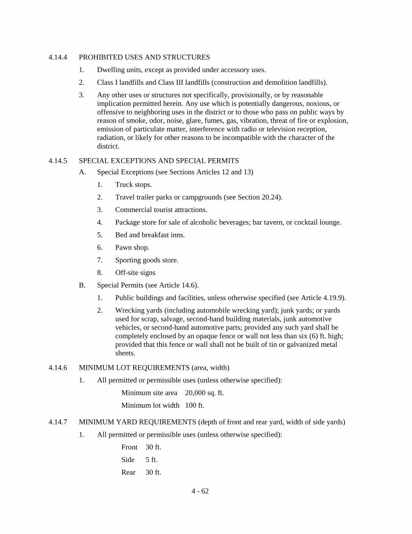
4.14.4 PROHIBITED USES AND STRUCTURES
1. Dwelling units, except as provided under accessory uses.
2. Class I landfills and Class III landfills (construction and demolition landfills).
3. Any other uses or structures not specifically, provisionally, or by reasonable implication permitted herein. Any use which is potentially dangerous, noxious, or offensive to neighboring uses in the district or to those who pass on public ways by reason of smoke, odor, noise, glare, fumes, gas, vibration, threat of fire or explosion, emission of particulate matter, interference with radio or television reception, radiation, or likely for other reasons to be incompatible with the character of the district.
4.14.5 SPECIAL EXCEPTIONS AND SPECIAL PERMITS A. Special Exceptions (see Sections Articles 12 and 13)
1. Truck stops.
2. Travel trailer parks or campgrounds (see Section 20.24).
3. Commercial tourist attractions.
4. Package store for sale of alcoholic beverages; bar tavern, or cocktail lounge.
5. Bed and breakfast inns.
6. Pawn shop.
7. Sporting goods store.
8. Off-site signs
B. Special Permits (see Article 14.6).
1. Public buildings and facilities, unless otherwise specified (see Article 4.19.9).
2. Wrecking yards (including automobile wrecking yard); junk yards; or yards used for scrap, salvage, second-hand building materials, junk automotive vehicles, or second-hand automotive parts; provided any such yard shall be completely enclosed by an opaque fence or wall not less than six (6) ft. high; provided that this fence or wall shall not be built of tin or galvanized metal sheets.
4.14.6 MINIMUM LOT REQUIREMENTS (area, width)
1. All permitted or permissible uses (unless otherwise specified):
Minimum site area 20,000 sq. ft.
Minimum lot width 100 ft.
4.14.7 MINIMUM YARD REQUIREMENTS (depth of front and rear yard, width of side yards)
1. All permitted or permissible uses (unless otherwise specified):
Front 30 ft.
Side 5 ft.
Rear 30 ft.
4 - 62

Special provisions; No less than 15 ft. of the depth of the required front yard shall be maintained as a landscaped area. The depth of this landscaped area shall be measured at right angles to property lines and shall be established along the entire length and contiguous to the designated property line or lines. This landscaped area may be penetrated at right angles by driveways. The remainder of the required yard may be used for offstreet parking, but not for buildings.
The location of any structure (except permitted docks, walkways and piers) shall be setback a minimum of thirty-five (35) feet from wetlands.
The location of any structure (except permitted docks, walkways and piers) shall be setback a minimum of fifty (50) feet from all perennial rivers, streams and creeks.
4.14.8 MAXIMUM HEIGHT OF STRUCTURES: NO PORTION SHALL EXCEED (See Section 4.19 for exceptions)
50 ft., except the height of signs which advertise commercial establishments located within the same CHI district shall be unrestricted, provided that such sign shall not exceed height limitations prescribed by the Federal Aviation Agency or airport zoning regulations within the flight-approach zone of airports.
4.14.9 MAXIMUM LOT COVERAGE BY ALL BUILDINGS
35%
Note: In addition to meeting the required lot yard, building height, lot coverage, landscaped buffering, and off-street parking requirements of this section, no structure shall exceed a 1.0 floor area ratio.
4.14.10 MINIMUM LANDSCAPED BUFFERING REQUIREMENTS (See also Section 4.19)
1. All permitted or permissible uses (unless otherwise specified):
Where a use listed under (1) above is erected or expanded on land abutting either (a) residential district or (b) property used for residential purposes in a residential/office district, then the proposed use shall provide a landscaped buffer which shall be not less than 20 ft. in width along the affected rear and/or side yards as the case may be. In addition, such land uses shall provide within this buffer landscaping which shall be designed, planted and maintained as to be 80 percent or more opaque between 2 and 6 feet above average ground level when viewed horizontally. A masonry or wood opaque structure may be substituted for the landscaped buffer.
4.14.11 MINIMUM OFFSTREET PARKING REQUIREMENTS (See also Section 4.19)
1. Commercial and service establishments (unless otherwise specified): One (1) space for each 150 sq. ft. of non-storage floor area, plus, where applicable, One (1) space for each 1,000 sq. ft. of lot or ground area outside buildings used for any type of sales, display, or activity.
2. Restaurants, cocktail lounges, bars, and taverns: One (1) space for each 3 seats in public rooms.
3. Hotels and motels: One (1) space for each sleeping room, plus two (2) spaces for the owner or manager, plus required number of spaces for each accessory use such or restaurant, bar, etc. as specified.
4 - 63

4. Warehousing and storage only; one (1) space for each one thousand five hundred
(1,500) sq. ft. of floor area.
5. Public buildings and facilities (unless otherwise specified): one (1) space for each two hundred (200) sq. ft. of floor area.
6. For other special exceptions as specified herein: to be determined by findings in the particular case.
Note: Offstreet loading required (see Section 4.19)
4 - 64

SECTION 4.15 "ILW" INDUSTRIAL, LIGHT AND WAREHOUSING
4.15.1 DISTRICTS AND INTENT The "ILW" Industrial, Light and Warehousing category includes one (1) zone district: ILW. This district is intended for light manufacturing, processing, storage and warehousing, wholesaling, and distribution within the designated urban development areas defined within the County's Comprehensive Plan. Service and commercial activities relating to the character of the district and supporting its activities are permitted. Certain commercial uses relating to automotive and heavy equipment sales and repair are permitted, but this district is not to be deemed commercial in character. Regulations are intended to prevent or reduce friction between uses in this district and also to protect nearby residential and commercial districts. Performance standards are applied at lot lines (see Section 4.19).
4.15.2 PERMITTED PRINCIPAL USES AND STRUCTURES
1. Wholesaling, warehousing, storage, or distribution establishments and similar uses.
2. Research laboratories and activities in completely enclosed buildings.
3. Light manufacturing, assembling, processing (including food processing, but not slaughter house), packaging, or fabricating in completely enclosed building.
4. Printing, lithographing, publishing, photographic processing, blue printing, or similar establishments.
5. Outdoor storage yards and lots, provided, this provision shall not permit wrecking yards (including automobile wrecking yards), junk yards, or yards used in whole or in part for scrap or salvage operations or for processing, storage, display, or sales of any scrap, salvage, or second-hand building materials, junk automotive vehicles, or second-hand automotive parts.
6. Retail commercial establishments for sale, repair, and service of new and used automobiles, motorcycles, trucks and tractors, mobile homes, boats, heavy machinery and equipment, and farm equipment; motor vehicle body shop; establishments for sale of farm supplies, lumber and building supplies, monuments, automotive vehicle parts and accessories (but not junk yards or automotive vehicle wrecking yards), and similar uses.
7. Service establishments catering to commerce and industry including linen supply, freight movers, communications services, business machine services, canteen service, restaurant, employment agency, sign company, pest control, water softening establishment, and similar uses.
8. Service establishments such as crematory.
9. Vocational, technical, trade, or industrial schools and similar uses.
10. Medical clinic in connection only with industrial activity.
11. Miscellaneous uses such as express or parcel delivery office, telephone exchange, commercial parking lots and garages, motor bus or truck or other transportation terminal.
12. Radio and television stations.
4 - 65

13. Building trades contractor including on premises storage yard for materials and
equipment, but no manufacturing of concrete or asphalt is permitted.
14. Railroad switching, freight, and storage yards; railroad buildings and maintenance structures.
Site and development plan approval (see Section Article 14) is required for the following uses:
1. All commercial or industrial developments.
4.15.3 PERMITTED ACCESSORY USES AND STRUCTURES
1. Uses and structures which are customarily accessory and clearly incidental and subordinate to permitted principal uses and structures.
2. On-site signs (see Section 4.19).
4.15.4 PROHIBITED USES AND STRUCTURES
Any uses or structures not specifically, provisionally, or by reasonable implication permitted herein, including the following, which are listed for purposes of emphasis:
1. Petroleum bulk storage and sales.
2. Yards or lots for scrap or salvage operations or for processing, storage, display, or sale of any scrap, salvage, or second-hand building materials and automotive vehicle parts.
3. Wrecking yards (including automotive vehicle wrecking yards) and junk yards.
4. Manufacturing activities not in completely enclosed buildings.
5. Class I landfills and Class III landfills (construction and demolition landfills).
6. Any use not conforming to performance standards of Section 4.19.
4.15.5 SPECIAL EXCEPTIONS AND SPECIAL PERMITS
A. Special Exceptions (see Articles 12 and 13)
1. Off-site signs (see also Section 4.19).
2. Truck stops and automotive service and self service stations (see Section 4.19 for special design standards for automotive service stations).
B. Special Permits (see Article 14.6).
1. Public buildings and facilities, unless otherwise specified (see Article 4.19.9).
4.15.6 MINIMUM LOT REQUIREMENTS (area, width)
1. All permitted or permissible uses and structures (unless otherwise specified):
None, except as needed to meet the other requirements as set out herein.
4.15.7 MINIMUM YARD REQUIREMENTS (depth of front and rear yard, width of side yard) (See Section 4.19.30 for right-of-way setback requirements.)
4 - 66

1. All permitted or permissible uses and structures (unless otherwise specified):
Front 20 ft., of which no less than 1/2 the depth shall be maintained as a landscaped area; the remainder may be used for off-street parking, but not for buildings. The depth of this landscaped area shall be measured at right angles to property lines and shall be established along the entire length of and contiguous to the designated property line or lines. This landscaped area may be penetrated at right angles by driveways.
Side and Rear 15 ft. except where railroad spur abuts side or rear property line, in which case no yard is required.
Special Provisions:
The location of any structure (except permitted docks, walkways and piers) shall be setback a minimum of thirty-five (35) feet from wetlands.
The location of any structure (except permitted docks, walkways and piers) shall be setback a minimum of fifty (50) feet from all perennial rivers, streams and creeks.
4.15.8 MAXIMUM HEIGHT OF STRUCTURES: NO PORTION SHALL EXCEED (See also Section 4.19 for exceptions)
Thirty-five (35) feet
4.15.9 MAXIMUM LOT COVERAGE BY ALL BUILDINGS
In addition to meeting the required yard, building height, landscaped buffering, and off-street parking requirements of this section, no structure shall exceed a 1.0 floor area ratio.
4.15.10 MINIMUM LANDSCAPED BUFFERING REQUIREMENTS (See also Section 4.19)
1. All permitted or permissible uses (unless otherwise specified):
Where a use listed under (1) above is erected or expanded on land abutting a residential district, then the proposed use shall provide a landscaped buffer which shall be not less than twenty-five (25) ft. in width along the affected rear and/or side yards as the case may be. In addition, such land uses shall provide within this buffer landscaping which shall be designed, planted and maintained as to be 80 percent or more opaque between 2 and 6 feet above average ground level when viewed horizontally. A masonry or wood opaque structure may be substituted for the landscaped buffer.
4.15.11 MINIMUM OFFSTREET PARKING REQUIREMENTS (See also Section 4.19)
1. Warehousing and storage only: one (1) space for each one thousand five hundred (1,500) sq. ft. of floor area.
4 - 67

2. Retail commercial establishments for sale, repair, and service of new and used
automobiles, motorcycles, trucks and tractors, mobile homes, boats, heavy machinery and equipment, and farm equipment; motor vehicle body shops; retail establishments for sale of farm supplies, lumber and building supplies, monuments, and automotive vehicle parts and accessories; crematories; and similar uses: one (1) space for each three hundred fifty (350) sq. ft. of floor area, plus, where applicable, one (1) space for each one thousand (1,000) sq. ft. of lot or ground area outside buildings used for any type of sales, display, or activity.
3. Restaurants: one (1) space for each three (3) seats in public rooms.
4. Miscellaneous uses such as express or parcel delivery office, telephone exchange, motor bus or truck or other transportation terminal: one (1) space for each three hundred fifty (350) sq. ft. of floor area.
5. For uses specifically listed under CI: As for CI OFFSTREET PARKING REQUIREMENTS.
6. Other permitted or permissible uses (unless otherwise specified): one (1) space for each five hundred (500) sq. ft. of floor area.
7. For other special exceptions as specified herein: to be determined by findings in the particular case.
Note: Offstreet loading required (see Section 4.19).
4.15.12 ACCESS REQUIREMENTS
All ingress and egress points to each individual industrial establishment shall connect to a paved roadway that is constructed in accordance with County and/or Florida Department of Transportation standards.
4 - 68

SECTION 4.16 "I" INDUSTRIAL
4.16.1 DISTRICTS AND INTENT
The "I" Industrial category includes one (1) zone district: "I". This district is intended primarily for manufacturing and closely related uses within designated urban development areas as defined by the County's Comprehensive Plan. It is intended to preserve such lands for the functions of industrial activity, wholesaling, warehousing, and distribution. To allow maximum latitude for operations, performance standards are applied at district boundaries, so that uses which might otherwise not be permitted are allowable in portions of the district well away from district boundary lines.
4.16.2 PERMITTED PRINCIPAL USES AND STRUCTURES
As for ILW, and in addition:
1. Any industrial use which is otherwise lawful (except those uses requiring special controls and permissible as special exceptions) and which conforms to performance standards as set out in Article 4.19.
Site and development plan approval (see Article 14) is required for the following uses:
1. All industrial developments.
4.16.3 PERMITTED ACCESSORY USES AND STRUCTURES
1. Uses and structures which are customarily accessory and clearly incidental and subordinate to permitted principal uses and structures.
2. On-site signs (see Section 4.19).
4.16.4 PROHIBITED USES AND STRUCTURES
1. Class I landfills and Class III landfills (construction and demolition landfills).
2. Any uses or structures not specifically, provisionally, or by reasonable implication permitted herein, including any use not conforming to performance standards of Section 4.19.
4.16.5 SPECIAL EXCEPTIONS AND SPECIAL PERMITS
A. Special Exceptions (see Articles 12 and 13)
1. Wrecking yards (including automobile wrecking yard); junk yards; or yards used for scrap, salvage, second-hand building materials, junk automotive vehicles, or second-hand automotive parts; provided any such yard shall be completely enclosed by an opaque fence or wall not less than six (6) ft. high; provided that this fence or wall shall not be built of tin or galvanized metal sheets.
2. Bulk storage yards including bulk storage of flammable liquids, subject to provisions of local and State Fire Codes.
3. Chemical and fertilizer manufacture.
4. Paint, oil (including linseed), shellac, turpentine, lacquer, or varnish manufacture.
5. Petroleum refining.
4 - 69

6. Rendering plant.
7. Storage, sorting, collecting or baling of rags, iron, or junk.
8. Off-site signs (see Section 4.19).
9. Truck stops and automotive service and self-service stations (see Section 4.19 for special design standards for automotive service stations).
10. Electric or gas generating plants.
11. Asphalt or concrete batching plants.
12. Uses which are similar to the ones listed above.
B. Special Permits (see Article 14.6).
1. Paper and pulp manufacturing.
2. Hazardous waste disposal.
3. Public buildings and facilities, unless otherwise specified (see Article 4.19.9).
4.16.6 MINIMUM LOT REQUIREMENTS (area, width)
1. All permitted or permissible uses and structures (unless otherwise specified):
None, except as needed to meet the other requirements as set out herein.
4.16.7 MINIMUM YARD REQUIREMENTS (depth of front and rear yard, width of side yards) (See Section 4.19.30 for right-of-way setback requirements.)
1. All permitted or permissible uses and structures (unless otherwise specified):
Front 20 ft.
Side and Rear 15 ft. except where railroad spur abuts side or rear property line, in which case no yard is required.
Special Provisions
The location of any structure (except permitted docks, walkways and piers) shall be setback a minimum of thirty-five (35) feet from wetlands.
The location of any structure (except permitted docks, walkways and piers) shall be setback a minimum of fifty (50) feet from all perennial rivers, streams and creeks.
4.16.8 MAXIMUM HEIGHT OF STRUCTURES: NO PORTION SHALL EXCEED (See also Section 4.19)
Thirty-five (35) feet
4.16.9 MAXIMUM LOT COVERAGE BY ALL BUILDINGS
In addition to meeting the required yard, building height, landscaped buffering, and off-street parking requirements of this section, no structure shall exceed a 1.0 floor area ratio.
4.16.10 MINIMUM LANDSCAPED BUFFERING REQUIREMENTS (See also Section 4.19)
1. All permitted or permissible uses (unless otherwise specified):
4 - 70

Where a use listed under (1) above is erected or expanded on land abutting a residential district, then the proposed use shall provide a landscaped buffer which shall be not less than twenty-five (25) ft. in width along the affected rear and/or side yards as the case may be. In addition, such land uses shall provide within this buffer landscaping which shall be designed, planted and maintained as to be 80 percent or more opaque between 2 and 6 feet above average ground level when viewed horizontally. A masonry or wood opaque structure may be substituted for the landscaped buffer.
4.16.11 MINIMUM OFFSTREET PARKING REQUIREMENTS (See also Section 4.19)
1. Warehousing and storage only: one (1) space for each one thousand five hundred (1,500) sq. ft. of floor area.
2. Retail commercial establishments for sale, repair, and service of new and used automobiles, motorcycles, trucks and tractors, mobile homes, boats, heavy machinery and equipment, and farm equipment; motor vehicle body shops; retail establishments for sale of farm supplies, lumber and building supplies, monuments, and automotive vehicle parts and accessories; wrecking yards; and similar uses: one (1) space for each three hundred fifty (350) sq. ft. of floor area, plus where applicable, one (1) space for each one thousand (1,000) sq. ft. of lot or ground area outside buildings used for any type of sales, display, or activity.
3. Restaurants: one (1) space for each three (3) seats in public rooms.
4. Miscellaneous uses such as express or parcel delivery office, telephone exchange, motor bus or truck or other transportation terminal: one (1) space for each three hundred fifty (350) sq. ft. of floor area.
5. For uses specifically listed under ILW: As for ILW OFFSTREET PARKING REQUIREMENTS.
6. Other permitted or permissible uses (unless otherwise specified): one (1) space for each five hundred (500) sq. ft. of floor area.
7. For other special exceptions as specified herein: to be determined by findings in the particular case.
Note: Offstreet loading required (see Section 4.19).
4.16.12 ACCESS REQUIREMENTS
All ingress and egress points to each individual industrial establishment shall connect to a paved roadway that is constructed in accordance with County and/or Florida Department of Transportation standards.
4 - 71

THIS PAGE LEFT BLANK INTENTIONALLY
4 - 72

SECTION 4.17 "PRD" PLANNED RESIDENTIAL DEVELOPMENT
4.17.1 DISTRICTS AND INTENT
The "PRD" Planned Residential Development category includes one (1) zone district: PRD. The purpose of this district is to permit Planned Residential Developments within designated urban development areas as defined within the County's Comprehensive Plan, which are intended to: 1. Encourage the development of planned residential development of land; 2. Encourage flexible and creative concepts of site planning; 3. Preserve the natural amenities of the land by encouraging scenic and functional open
areas; 4. Accomplish a more desirable environment than would be possible through strict
application of the minimum requirements of these land development regulations; 5. Provide for an efficient use of land resulting in smaller networks of utilities and
streets and thereby lowering development and housing costs; and 6. Provide a stable environmental character compatible with surrounding areas.
4.17.2 PERMITTED PRINCIPAL USES AND STRUCTURES
1. Residential dwellings including conventional single family dwellings, duplex dwellings, and multiple family dwellings.
2. Public or private schools offering curricula comparable to that of public schools.
3. Churches and other houses of worship.
4. Golf courses, country clubs, and racquet and tennis clubs.
5. Public buildings and facilities.
6. Homes of six (6) or fewer residents which otherwise meet the definition of a "community residential home" (see Section 4.19).
7. Community residential homes within multiple dwelling unit areas of planned residential developments (see Section 4.19).
4.17.3 PERMITTED ACCESSORY USES AND STRUCTURES
1. On-site signs (see also Section 4.19).
2. Uses and structures which: a. Are customarily accessory and clearly incidental and subordinate to permitted
uses and structures; b. Are located on the same lot as the permitted use or structure, or on a
contiguous lot in the same ownership; and c. Do not involve operations or structures not in keeping with the character of the
district.
4.17.4 SPECIAL EXCEPTIONS (See also Articles 12 and 13).
1. Public schools or private schools offering curricula comparable to that of public schools.
4 - 73
4.17.5 DEFINITIONS
In addition to the definitions contained in Article 2, the following terms, phrases, words, and derivations shall have the following meaning: 1. Applicant. Applicant is a landowner or the landowner's agent who files a petition for
a zoning amendment to a Planned Residential Development District. 2. Development Plan. Development plan is the proposal for development of a Planned
Residential Development, including a plat of subdivision, all covenants, grants of easement and other conditions relating to use, location and bulk of building, density of development, common open space, and public facilities.
3. Common Open Space. Common Open Space is an area of land, or an area of water, or a combination of land and water within the area of a Planned Residential Development in common. Common open space may contain such recreational structures and improvements as are desirable and appropriate for the common benefit and enjoyment of residents of the Planned Residential Development.
4. Gross Density. Gross Density is the total number of dwelling units divided by the total number of acres within the perimeter boundaries of a Planned Residential Development.
5. Net Residential Acreage. Net Residential Acreage is the total number of acres within the perimeter boundaries of a Planned Residential Development excluding areas devoted to streets, rights-of-way, easements, lakes, public and private open space, recreation, and other permitted non-residential uses.
6. Planned Residential Development. Planned Residential Development (PRD): a. Is a concept which requires land to be under unified control, planned and
developed as a whole in a single development or approved, programed series of developments for dwelling units and related uses and facilities;
b. Is a plan which, when adopted, becomes the land development regulations for the land to which it is applied;
c. Includes principal and accessory structures substantially related to the character of the development itself and the surrounding area of which it is a part; and
d. Is a concept which, when implemented, allows for development according to comprehensive and detailed plans which include not only streets, utilities, building sites, and the like, but also site plans and elevations for all buildings as intended to be located, constructed, used, and related to each other, and detailed plans for other uses, and improvements on the land as related to the buildings.
4.17.6 PROCEDURE FOR APPROVAL OF A PLANNED RESIDENTIAL DEVELOPMENT
The procedure for obtaining a change in zoning for the purpose of undertaking a Planned Residential Development shall be as follows: 1. Planned Residential Development Zoning and Preliminary Development Plan
Approval. The applicant shall submit to the Land Development Regulation Administrator a request for change to a Planned Residential Development zoning district containing the following exhibits: a. A statement of objectives describing:
(1) The general purpose of the proposed development; and (2) The general character of the proposed development.
4 - 74

b. A Vicinity Map showing the location of the proposed Planned Residential
Development in relation to: (1) Surrounding streets and thoroughfares; (2) Existing zoning on the site and surrounding areas; and (3) Existing land use on the site and surrounding areas. The Vicinity Map shall be drawn at a scale to show an area of no less
than one thousand (1,000) feet surrounding the property. A greater area may be required if the Planning and Zoning Board determines information on a larger vicinity is needed.
c. A Boundary Survey and legal description of the property. d. A Topographic Survey. The most recent United States Geological Service
topographic survey may be used if more detailed topographic information is not available.
e. A Site Analysis Map at the same scale as the Preliminary Development Plan described below shall be submitted indicating flood prone areas, areas with slopes greater than five (5) percent, areas of soils which are marginally suited for development purposes and tree cover.
f. A Preliminary Development Plan drawn at a scale suitable for presentation, showing: (1) Proposed land uses; (2) Lot sizes indicated either by lot lines drawn in their proposed location or
a statement on the face of the Preliminary Development Plan concerning proposed lot sizes, including minimum lot sizes; and
(3) Building setbacks defining the distance buildings will be set back from: (a) Surrounding property lines; (b) Proposed and existing streets; (c) Other proposed buildings; (d) The center line of rivers, streams and creeks; (e) The high water line of lakes; and (f) Other man-made or natural features which would be affected by
building encroachment. (4) Maximum height of buildings; (5) Common open spaces; (6) Arterial and collector streets and thoroughfares;
Local access streets and interior circulation should be shown on the Preliminary Development Plan for Planned Residential Developments which have no planned arterial or collector streets within the projects.
(7) Common outside storage areas; and (8) Screening, buffering, and landscaped buffer areas. Special Provisions: The location of any structure (except permitted docks, walkways and piers) shall be setback a minimum of thirty-five (35) feet from wetlands. The location of any structure (except permitted docks, walkways and piers) shall be setback a minimum of seventy-five (75) feet from the Suwannee, Santa Fe and Ichetucknee Rivers.
4 - 75

The location of any structure (except permitted docks, walkways and piers) shall be setback a minimum of fifty (50) feet from all other perennial rivers, streams and creeks.
g. A table showing acreage for each category of land use. h. A statement concerning gross density and net residential acreage (see Section
4.17.5 for definition of gross density and net residential acreage). i. A statement concerning proposed floor area ratios (percent of lot in relation to
building floor area) and the maximum building coverage expressed as a percent of the total site area.
j. A Preliminary Utility Service Plan including sanitary sewers, storm drainage, and potable water supply, showing general locations of major water and sewer lines, plant location, lift stations, and indicating whether gravity or forced systems are planned. Size of lines, specific locations, and detailed calculations are not required at this stage.
k. A statement indicating the type of legal instruments that will be created to provide for the management of common areas and any private roads.
2. Processing the Planned Residential Development Zoning Application and Preliminary Development Plan Submittals. When the Land Development Regulation Administrator has received the application and submittals, and is satisfied that the application and submittals are complete, the application shall be processed as any other zoning application in accordance with the provisions of these land development regulations.
The Planning and Zoning Board shall make a recommendation to the Board of County Commissioners. The Board of County Commissioners' actions shall be one (1) of the following: a. Approval as submitted. b. Conditional approval. c. Disapproval.
3. Final Development Plan. If the Preliminary Development Plan for the Planned Residential Development is approved, the applicant shall submit a Final Development Plan covering all or part of the approved Preliminary Development Plan within twelve (12) months to the Land Development Regulation Administrator. Thirty (30) days prior to any lapse date, the Land Development Regulation Administrator shall notify the Board of County Commissioners and the applicant of such date. Such notice to the applicant shall be mailed via Certified Mail Return Receipt Requested. If a Final Development Plan is not submitted within this twelve (12) month period or an additional twelve (12) month period granted by the Board of County Commissioners the Land Development Regulation Administrator shall cause the Planned Residential Development district to be removed from the Official Zoning Atlas and reinstate the zoning district in effect prior to approval of the Planned Residential Development. The Board of County Commissioners may extend this lapse date for a period not to exceed an additional twelve (12) months, provided the request for extension is made in writing to the Land Development Regulation Administrator by the applicant prior to the expiration of the initial approval period.
The Final Development Plan shall include the following exhibits:
a. A statement of objectives:
4 - 76

(1) The general purpose of the proposed development. (2) The general character of the proposed development.
b. A Topographic Map drawn at a scale of one hundred (100) feet to one (1) inch by a surveyor or engineer registered in the state of Florida showing: (1) The location of existing private and public property rights-of-way,
streets, buildings, water courses, transmission lines, sewers, bridges, culverts, and drain pipes, water mains, and any public utility easements;
(2) Wooded areas, streams, lakes, marshes, and any other physical conditions affecting the site; and
(3) Existing contours at intervals of one (1) foot. c. A Final Development Plan drawn at a scale of one hundred (100) feet to one (1)
inch and showing: (1) The boundaries of the site, topography, and proposed grading plan; (2) Width, location, and names of surrounding streets; (3) Surrounding land use; (4) Proposed streets and street names and other vehicular and pedestrian
circulation systems including off-street parking; (5) The use, size, and location of all proposed building sites; and (6) Location and size of common open spaces and public or semi-public
areas. d. A Utility Service Plan showing:
(1) Existing drainage and sewer lines; (2) The disposition of sanitary waste and storm water; (3) The source of potable water; (4) Location and width of all utility easements or rights-of-way; and (5) Plans for the special disposition of stormwater drainage when it appears
that said drainage could substantially harm a body of surface water. e. A Landscaping Plan showing:
(1) Landscaped areas; (2) Location, height, and material for walks, fences, walkways, and other
man-made landscape features; and (3) Any special landscape features such as, but not limited to, man-made
lakes, land sculpture, and waterfalls. f. Statistical information:
(1) Total acreage of the site; (2) Maximum building coverage expressed as a percent of the area; (3) Area of land devoted to landscaping and/or common open space usable
for recreation purposes expressed as a percent of the total site area; and (4) Calculated gross density and net residential acreage for the proposed
development (see Section 4.17.5 for definition of gross density and net residential acreage).
4 - 77

g. The substance of covenants, grants, easements, or other restrictions to be
imposed on the use of the land, buildings, and structures, including proposed easements for public and private utilities. All such legal documents, including homeowners associations and deed restrictions, shall be approved by the County Attorney before final approval of the plan.
4.17.7 ISSUANCE OF BUILDING PERMITS
No building permit shall be issued for any portion of a proposed Planned Residential Development until the Final Development Plan has been approved.
4.17.8 REVISION OF A PLANNED RESIDENTIAL DEVELOPMENT
A proposed substantial change in the approved Preliminary Development Plan which affects the intent and character of the development, the density or land use patterns, proposed buffers, the location or dimensions of arterial or collector streets, or similar substantial changes, shall be reviewed by the Planning and Zoning Board and the Board of County Commissioners in the same manner as the initial application. A request for a revision of the Preliminary Development Plan shall be supported by a written statement and by revised plans demonstrating the reasons the revisions are necessary or desirable. All revisions to the approved Preliminary Development Plan shall only be approved if they are consistent with the original purpose, intent, overall design, and integrity of the approved Preliminary Development Plan.
Minor changes, and/or deviations from the Preliminary Development Plan which do not affect the intent or character of the development shall be reviewed by the Land Development Regulation Administrator and shall be approved only if they are consistent with the original purpose, intent and overall design and integrity of the approved preliminary development plan. Upon approval of the revision, the applicant shall make revisions to the plans and submittals and file the revised plans with the Land Development Regulation Administrator within thirty (30) days.
Examples of substantial and minor changes are:
Substantial changes:
1. Perimeter changes.
2. Major street relocation.
3. Change in building height, density, land use patterns, or buffers.
Minor Changes
1. Change in alignment, location, or length of local street.
2. Adjustments or minor shifts in dwelling unit mixes, not resulting in increased overall density.
3. Reorientation or slight shifts in building locations.
4.17.9 PLANNED RESIDENTIAL DEVELOPMENT TIME LIMITATIONS
If substantial construction, as determined by the Land Development Regulation Administrator, has not begun within two (2) years after approval of the Final Development Plan, the approval of the Planned Residential Development will lapse. Thirty (30) days prior to any lapse date, the Land Development Regulation Administrator shall notify the Board of County Commissioners and the applicant of such date. Such notice to the
4 - 78

applicant shall be mailed via certified mail return receipt requested. The Board of County Commissioners may extend the period for beginning construction, at the request of the applicant for a period not to exceed an additional two (2) years, provided the request for extension is made in writing to the Land Development Regulation Administrator prior to the expiration of the initial approval period. If the Planned Residential Development lapses under this provision, the Land Development Regulation Administrator shall cause the Planned Residential Development district to be removed from the Official Zoning Atlas and reinstate the zoning district which was in effect prior to the approval of the Planned Residential Development.
4.17.10 DEVIATION FROM THE FINAL DEVELOPMENT PLAN
Any unapproved deviation from the accepted Final Development Plan shall constitute a breach of agreement between the applicant and the Board of County Commissioners. Such deviation may cause the County to immediately revoke the Final Development Plan until such time as the deviations are corrected or become a part of the accepted Final Development Plan.
4.17.11 PHASING
The Board of County Commissioners may permit or require the phasing of a Planned Residential Development. When provisions for phasing are included in the Final Development Plan, each phase of development shall be so planned and so related to previous development, surrounding properties, and available public facilities and services so that a failure to proceed with subsequent phases of development will have no adverse impact on the Planned Residential Development or surrounding properties.
4.17.12 DEVELOPMENT STANDARDS FOR PLANNED RESIDENTIAL DEVELOPMENTS 1. The minimum size parcel for Planned Residential Development shall be five (5)
acres.
2. Conformance with the Comprehensive Plan. Densities for Planned Residential Developments shall be based upon and be consistent with the Comprehensive Plan. No Final Development Plan may be approved unless it is in conformance with the Comprehensive Plan.
3. Relationship to Zoning District. An approved Planned Residential Development is a separate zoning district in which the Final Development Plan, as approved, establishes the restrictions and regulations according to which the development shall occur. Upon approval, the Official Zoning Atlas shall be changed to indicate the area as a Planned Residential Development.
4. Residential Density and Housing Types. Any combination of residential density and housing types is permitted for a Planned Residential Development, as long as the overall gross density does not exceed the prescribed total number of dwelling units of the Comprehensive Plan land use classifications contained on the project site.
5. Dimensional and Bulk Restriction. The location of all proposed building sites shall be shown on the Final Development Plan subject to minimum lot sizes, setback lines, lot coverage and floor area specified by the Preliminary Development Plan as approved by the Board of County Commissioners.
4 - 79
6. Internal Compatibility. All land uses proposed within a Planned Residential
Development shall be compatible with other proposed uses; that is, uses shall be able to coexist in relative proximity to other uses in a stable fashion over time such that no other uses are unduly, negatively impacted, directly or indirectly by such uses. An evaluation of the internal compatibility by a Planned Residential Development shall be based on the following factors: a. The existence or absence of and the location of common open spaces and
recreational areas; b. The use of existing and proposed landscaping; c. The treatment of pedestrian ways; d. The use of topography, physical environment, and other natural features; e. The traffic and pedestrian circulation pattern; f. The use and variety of building setback lines, separations and buffering; g. The use and variety of building groupings; h. The use and variety of building sizes; i. The separation and buffering of parking areas and sections of parking area; j. The variety and design of dwelling types; k. The proposed land uses and the conditions and limitations thereon; l. The form of ownership proposed for various uses; and m. Any other factor deemed relevant to the privacy, safety, preservation,
protection, or welfare of any proposed use within the Planned Residential Development.
7. External Compatibility. All land uses proposed within a Planned Residential Development shall be compatible with existing and planned uses of properties surrounding the Planned Residential Development; that is, internal uses shall be able to coexist in relation proximity to existing or planned surrounding uses in a stable fashion over time such that neither internal or surrounding uses are unduly, negatively impacted, directly or indirectly, by such uses. An evaluation of the external compatibility of a Planned Residential Development should be based on the following factors:
a. All of these factors listed in this Section, with particular attention to those areas of the Planned Residential Development located on or near its perimeter;
b. The uses proposed near the Planned Residential Development perimeter and the conditions and limitations thereon;
c. The type, number, and location of surrounding external uses;
d. The Comprehensive Plan designation and zoning on surrounding lands; and
e. Any other factor deemed relevant to the privacy, safety, preservation, protection, or welfare of lands surrounding the Planned Residential Development and any existing or planned use of such lands.
8. Intensity of Development. The residential density and intensity of use of a Planned Residential Development shall:
4 - 80

a. Be compatible with the physical and environmental characteristics of the site
b. Be able to coexist in relative proximity to existing or planned surroundings uses in a stable fashion over time such that neither internal per surrounding uses are unduly, negatively impacted, directly or indirectly by such densities or intensities of use, and
c. Comply with the policies and density limitations set forth in the Comprehensive Plan. Specific densities and intensity of uses within a Planned Residential Development shall be determined based on the following factors:
(1) The locations of various proposed uses within the Planned Residential Development and the degree of compatibility of such uses with each other and with surrounding uses;
(2) The amount and type of protection provided for the safety, habitability, and privacy of land uses both internal and external to the Planned Residential Development;
(3) The existing residential density and intensity of use of surrounding lands;
(4) The availability and location of utility services and public facilities and services;
(5) The amount and size of common open spaces and recreation areas;
(6) The existence and treatment of any environmentally sensitive areas on the Planned Residential Development property or surrounding lands;
(7) The access to and suitability of transportation arteries proposed within the Planned Residential Development and existing external transportation systems and arteries; and
(8) Any other factor deemed relevant to the limitation of the intensity of development for the benefit of the public health, safety, and welfare.
9. Common Open Space. At least fifteen (15) percent of the area covered by a Final Development Plan shall be usable, common open space owned and operated by the applicant or dedicated to a homeowner association or similar group, provided that in establishing the density per gross acre the Board of County Commissioners may increase the percentage of common open space in order to carry out the intent and purpose set forth in this Article; and provided that any Planned Residential Development which only consists of one family dwellings with individually deeded lots shall only be required to have five (5) percent usable, common open space. Not more than one-half (1/2) of the total common open space area may be in a flood plain, buffer area, and/or water bodies.
Special Provisions: The location of any structure (except permitted docks, walkways and piers) shall be setback a minimum of thirty-five (35) feet from wetlands. The location of any structure (except permitted docks, walkways and piers) shall be setback a minimum of seventy-five (75) feet from the Suwannee, Santa Fe and Ichetucknee Rivers. The location of any structure (except permitted docks, walkways and piers) shall be setback a minimum of fifty (50) feet from all other perennial rivers, streams and creeks.
4 - 81

10. Access and Parking. All streets, thoroughfares, and access ways shall be designed to
relate to the traffic circulation plans of the area. Adequate off-street parking shall meet the requirements specified for the uses found in the District Regulations and Section 4.19 of these land development regulations.
11. External Transportation Access. A Planned Residential Development shall provide direct access to, a major street (arterial or collector) unless, due to the size of the Planned Residential Development and the type of uses proposed, it will not adversely affect the traffic on adjoining minor (local) streets.
12. Internal Transportation Access. Every dwelling unit or other use permitted in a Planned Residential Development shall have access to a public street either directly or by way of a private road. Permitted uses are not required to front on a dedicated public road. Private roads shall be constructed according to County specifications as found in Article 5, Subdivision Regulations. If the Planned Residential Development contains private roads, such private roads shall be owned and maintained by the applicant or dedicated to a homeowners association or similar group.
13. Perimeter Requirements. Structures, buildings and streets located at the perimeter of the development shall be permanently screened by a landscaped buffer area (see Section 4.19).
14. Control of Area Following Completion. After completion of a Planned Residential Development, the use of the land and/or modification or alteration of any buildings or structures within the area covered by the Final Development Plan shall continue to be regulated in accordance with the approved Final Development Plan except as otherwise provided for herein. a. Minor extensions, alterations or modifications of existing buildings or
structures may be permitted after review and approval by the Land Development Regulation Administrator provided they are substantially consistent with the original purpose, intent, overall design, and integrity of the Final Development Plan.
b. Substantial change in permitted uses, location of buildings, or other specifications of the Final Development Plan may be permitted following public hearing and approval by the Board of County Commissioners upon receipt of the recommendation of the Planning and Zoning Board, as long as such changes are consistent with the original purpose, intent, overall design, and integrity of the Final Development Plan.
4.17.13 PROHIBITED USES AND STRUCTURES
1. Class I landfills and Class III landfills (construction and demolition landfills). 2. Any uses or structures not specifically, provisionally, or by reasonable implication
permitted herein, including any use not conforming to performance standards of Section 4.19.
4 - 82

SECTION 4.18 "PRRD" PLANNED RURAL RESIDENTIAL DEVELOPMENT
4.18.1 DISTRICTS AND INTENT
The "PRRD" Planned Rural Residential Development category includes one (1) zone district: PRRD. The purpose of this district is to permit Planned Rural Residential Developments within the County's rural areas as identified within the County's Comprehensive Plan, which are intended to:
1. Encourage the development planned residential development of land;
2. Encourage flexible and creative concepts of site planning;
3. Provide for rural residential development and agricultural and silviculture uses;
4. Accomplish a more desirable environment than would be possible through strict application of the minimum requirements of these land development regulations;
5. Provide for an efficient use of land resulting in smaller networks of utilities and streets and thereby lowering development and housing costs; and
6. Provide a stable environmental character compatible with surrounding areas.
4.18.2 PERMITTED PRINCIPAL USES AND STRUCTURES
1. Residential dwellings including Single family dwellings, duplex dwellings, and multiple family dwellings.
2. Public or private schools offering curricula comparable to that of public schools.
3. Churches and other houses of worship.
4. Golf courses, country clubs, and racquet and tennis clubs.
5. Public buildings and facilities.
6. Within the designated undeveloped areas of the development, agriculture or silviculture uses as provided for in the "A" Agricultural district for areas designated Agriculture on the County's Future Land Use Plan Map and as provided for in "ESA" Environmentally Sensitive Area districts for areas designated Environmentally Sensitive on the County's Future Land Use Plan Map.
7. Homes of six (6) or fewer residents which otherwise meet the definition of a "community residential home" (see Section 4.19).
8. Community residential homes within multiple dwelling unit areas of planned residential developments (see Section 4.19).
4.18.3 PERMITTED ACCESSORY USES AND STRUCTURES
1. On-site signs (see also Section 4.19). 2. Uses and structures which:
a. Are customarily accessory and clearly incidental and subordinate to permitted uses and structures;
b. Are located on the same lot as the permitted use or structure, or on a contiguous lot in the same ownership; and
c. Do not involve operations or structures not in keeping with the character of the district.
4 - 83

4.18.4 SPECIAL EXCEPTIONS (See also Articles 12 and 13).
1. Public schools or private schools offering curricula comparable to that of public schools.
4.18.5 DEFINITIONS In addition to the definitions contained in Article Two, the following terms, phrases, words, and derivations shall have the following meaning:
1. Applicant. Applicant is a landowner or the landowner's agent who files a petition for a zoning amendment to a Planned Rural Residential Development District.
2. Development Plan. Development Plan is the proposal for development of a Planned Rural Residential Development, including a plat of subdivision, all covenants, grants of easement and other conditions relating to use, location and bulk of building, density of development, undeveloped area, and public facilities.
3. Gross Density. Gross Density is the total number of dwelling units divided by the total number of acres within the perimeter boundaries of a Planned Rural Residential Development.
4. Net Residential Acreage. Net Residential Acreage is the total number of acres within the perimeter boundaries of a Planned Rural Residential Development excluding areas devoted to streets, rights-of-way, easements, lakes, public and private open space, recreation, and other permitted uses.
5. Planned Rural Residential Development. Planned Rural Residential Development (PRRD), (a) is a concept which requires land to be under unified control, planned and developed as a whole in a single development or approved, programmed series of developments for dwelling units and related uses and facilities; (b) is a plan which, when adopted, becomes the land development regulations for the land to which it is applied; (c) includes principal and accessory structures substantially related to the character of the development itself and the surrounding area of which it is a part; and (d) is a concept which, when implemented, allows for development according to comprehensive and detailed plans which include not only streets, utilities, building sites, and the like, but also site plans and elevations for all buildings as intended to be located, constructed, used, and related to each other, and detailed plans for other uses, and improvements on the land as related to the buildings.
6. Undeveloped area. Undeveloped area means areas within a Planned Rural Residential Development, as required by this Comprehensive Plan designed and intended for agricultural uses, (not to include intensive agricultural uses); silviculture uses and conservation uses. It is not the intent that such undeveloped area be established perpetually. Therefore, at some future time, the Comprehensive Plan may be amended to allow other uses to occur within the undeveloped area.
4.18.6 PROCEDURE FOR APPROVAL OF A PLANNED RURAL RESIDENTIAL DEVELOPMENT
The procedure for obtaining a change in zoning for the purpose of undertaking a Planned Rural Residential Development shall be as follows:
4 - 84

1. Planned Rural Residential Development Zoning and Preliminary Development Plan
Approval. The applicant shall submit to the Land Development Regulation Administrator his or her request for change to a Planned Rural Residential Development zoning district containing the following exhibits:
a. A statement of objectives describing:
(1) The general purpose of the proposed development; and
(2) The general character of the proposed development.
b. A Vicinity Map showing the location of the proposed Planned Rural Residential Development in relation to:
(1) Surrounding streets and thoroughfares;
(2) Existing zoning on the site and surrounding areas; and
(3) Existing land use on the site and surrounding areas.
The Vicinity Map shall be drawn at a scale to show an area of no less than one thousand (1,000) feet surrounding the property. A greater area may be required if the Planning and Zoning Board determines information on a larger vicinity is needed.
c. A Boundary Survey and legal description of the property.
d. A Topographic Survey. The most recent United States Geological Service topographic survey may be used if more detailed topographic information is not available.
e. A Site Analysis Map at the same scale as the Preliminary Development Plan described below shall be submitted indicating flood prone areas, areas with slopes greater than five (5) percent, areas of soils which are marginally suited for development purposes and tree cover.
f. A Preliminary Development Plan drawn at a scale suitable for presentation, showing the following:
(1) Proposed land uses;
(2) Lot sizes; the lot sizes should be indicated either by lot lines drawn in their proposed location or a statement on the face of the Preliminary Development Plan concerning proposed lot sizes.
(3) Building setbacks; building setbacks should be noted and shall define the distance buildings will be set back from:
(a) Surrounding property lines.
(b) Proposed and existing streets.
(c) Other proposed buildings.
(d) The center line of rivers, streams, and creeks.
(e) The high water line of lakes.
(f) Other man-made or natural features which would be affected by building encroachment.
(4) Maximum height of buildings; 4 - 85

(5) Undeveloped areas;
(6) Arterial and collector streets and thoroughfares; local access streets and interior circulation should be shown on the Preliminary Development Plan for Planned Rural Residential Developments which have no planned arterial or collector streets within the projects.
(7) Common outside storage areas; and
(8) Screening, buffering, and landscaped buffer areas.
Special Provisions:
The location of any structure (except permitted docks, walkways and piers) shall be setback a minimum of thirty-five (35) feet from wetlands. The location of any structure (except permitted docks, walkways and piers) shall be setback a minimum of seventy-five (75) feet from the Suwannee, Santa Fe and Ichetucknee Rivers. The location of any structure (except permitted docks, walkways and piers) shall be setback a minimum of fifty (50) feet from all other perennial rivers, streams and creeks.
g. A table showing acreage for each category of land use.
h. A statement concerning gross density and net residential acreage (see Section 2.1 for definition of gross density and net residential acreage).
i. A statement concerning proposed floor area ratios (percent of lot in relation to building floor area) and the maximum building coverage expressed as a percent of the total site area.
j. A Preliminary Utility Service Plan including sanitary sewers, storm drainage, and potable water supply, showing general locations of major water and sewer lines, plant location, lift stations, and indicating whether gravity or forced systems are planned. Size of lines, specific locations, and detailed calculations are not required at this stage.
k. A statement indicating the type of legal instruments that will be created to provide for the management of common areas and any private roads.
2. Processing the Planned Rural Residential Development Zoning Application and Preliminary Development Plan Submittals. When the Land Development Regulation Administrator has received the application and submittals, and is satisfied that the application and submittals are complete, the application shall be processed as any other zoning application in accordance with the provisions of these land development regulations.
The Planning and Zoning Board shall make a recommendation to the Board of County Commissioners. The Board of County Commissioners' actions shall be one (1) of the following:
a. Approval as submitted.
b. Conditional approval.
c. Disapproval.
4 - 86

3. Final Development Plan. If the Preliminary Development Plan for the Planned Rural
Residential Development is approved, the applicant shall submit a Final Development Plan covering all or part of the approved Preliminary Development Plan within twelve (12) months to the Land Development Regulation Administrator. Thirty (30) days prior to any lapse date, the Land Development Regulation Administrator shall notify the Board of County Commissioners and the applicant of such date. Such notice to the applicant shall be mailed via Certified Mail, Return Receipt Requested. If a Final Development Plan is not submitted within this twelve (12) month period, or an additional twelve (12) month period granted by the Board of County Commissioners, the Land Development Regulation Administrator shall cause the Planned Rural Residential Development district to be removed from the Official Zoning Atlas and reinstate the zoning district in effect prior to approval of the Planned Rural Residential Development. The Board of County Commissioners may extend this lapse date for a period not to exceed an additional twelve (12) months, provided the request for extension is made in writing to the Land Development Regulation Administrator by the applicant prior to the expiration of the initial approval period.
The Final Development Plan shall include the following exhibits:
a. A statement of objectives:
(1) The general purpose of the proposed development.
(2) The general character of the proposed development.
b. A Topographic Map drawn at scale of one hundred (100) feet to one (1) inch by a surveyor or engineer registered in the State of Florida showing:
(1) The location of existing private and public property rights-of-way, streets, buildings, water courses, transmission lines, sewers, bridges, culverts, and drain pipes, water mains, and any public utility easements.
(2) Wooded areas, streams, lakes, marshes, and any other physical conditions affecting the site.
(3) Existing contours at intervals of one (1) foot.
c. A Final Development Plan drawn at a scale of one hundred (100) feet to one (1) inch and showing:
(1) The boundaries of the site, topography, and proposed grading plan.
(2) Width, location, and names of surrounding streets.
(3) Surrounding land use.
(4) Proposed streets and street names and other vehicular and pedestrian circulation systems including off-street parking.
(5) The use, size, and location of all proposed building sites.
(6) Location and size of undeveloped areas and public or semi-public areas.
d. A Utility Service Plan showing:
(1) Existing drainage and sewer lines.
(2) The disposition of sanitary waste and stormwater.
4 - 87

(3) The source of potable water.
(4) Location and width of all utility easements or rights-of-way.
(5) Plans for the special disposition of storm water drainage when it appears that said drainage could substantially harm a body of surface water.
e. A Landscaping Plan showing:
(1) Landscaped areas.
(2) Location, height, and material for walks, fences, walkways, and other man-made landscape features.
(3) Any special landscape features such as, but not limited to, man-made lakes, land sculpture, and waterfalls.
f. Statistical information:
(1) Total acreage of the site.
(2) Maximum building coverage expressed as a percent of the area.
(3) Area of land devoted to landscaping and/or undeveloped area usable for recreation purposes expressed as a percent of the total site area.
(4) Calculated gross density and net residential acreage for the proposed development (see Section 2.1 for definition of gross density and net residential acreage).
g. The substance of covenants, grants, easements, or other restrictions to be imposed on the use of the land, buildings, and structures, including proposed easements for public and private utilities. All such legal documents, including homeowners associations and deed restrictions, shall be approved by the County Attorney before final approval of the plan.
4.18.7 ISSUANCE OF BUILDING PERMITS No building permit shall be issued for any portion of a proposed Planned Rural Residential Development until the Final Development Plan has been approved.
4.18.8 REVISION OF A PLANNED RURAL RESIDENTIAL DEVELOPMENT A proposed substantial change in the approved Preliminary Development Plan which affects the intent and character of the development, the density or land use patterns, proposed buffers, the location or dimensions of arterial or collector streets, or similar substantial changes, shall be reviewed by the Planning and Zoning Board and the Board of County Commissioners in the same manner as the initial application. A request for a revision of the Preliminary Development Plan shall be supported by a written statement and by revised plans demonstrating the reasons the revisions are necessary or desirable. All revisions to the approved Preliminary Development Plan shall only be approved if they are consistent with the original purpose, intent, overall design, and integrity of the approved Preliminary Development Plan.
Minor changes, and/or deviations from the Preliminary Development Plan which do not affect the intent or character of the development shall be reviewed and approved by the Land Development Regulation Administrator and shall only be approved if they are consistent with the original purpose, intent, overall design, and integrity of the approved Preliminary Development Plan.
4 - 88

Upon approval of the revision, the applicant shall make revisions to the plans and submittals and file the revised plans with the Land Development Regulation Administrator within thirty (30) days.
Examples of substantial and minor changes are:
Substantial changes:
1. Perimeter changes.
2. Major street relocation.
3. Change in building height, density, land use patterns, or buffers.
Minor Changes
1. Change in alignment, location, or length of local street.
2. Adjustments or minor shifts in dwelling unit mixes, not resulting in increased overall density.
3. Reorientation or slight shifts in building locations.
4.18.9 PLANNED RURAL RESIDENTIAL DEVELOPMENT TIME LIMITATIONS
If substantial construction, as determined by the Land Development Regulation Administrator, has not begun within two (2) years after approval of the Final Development Plan, the approval of the Planned Rural Residential Development will lapse. Thirty (30) days prior to any lapse date, the Land Development Regulation Administrator shall notify the Board of County Commissioners and the applicant of such date. Such notice to the applicant shall be mailed via certified mail return receipt requested. The Board of County Commissioners may extend the period for beginning construction, at the request of the applicant for a period not to exceed an additional two (2) years, provided the request for extension is made in writing to the Land Development Regulation Administrator prior to the expiration of the initial approval period. If the Planned Rural Residential Development lapses under this provision, the Land Development Regulation Administrator shall cause the Planned Rural Residential Development district to be removed from the Official Zoning Atlas and reinstate the zoning district which was in effect prior to the approval of the Planned Rural Residential Development.
4.18.10 DEVIATION FROM THE FINAL DEVELOPMENT PLAN
Any unapproved deviation from the accepted Final Development Plan shall constitute a breach of agreement between the applicant and the Board of County Commissioners. Such deviation may cause the County to immediately revoke the Final Development Plan until such time as the deviations are corrected or become a part of the accepted Final Development Plan.
4.18.11 PHASING
The Board of County Commissioners may permit or require the phasing of a Planned Rural Residential Development. When provisions for phasing are included in the Final Development Plan, each phase of development shall be so planned and so related to previous development, surrounding properties, and available public facilities and services so that a failure to proceed with subsequent phases of development will have no adverse impact on the Planned Rural Residential Development or surrounding properties.
4 - 89

4.18.12 DEVELOPMENT STANDARDS FOR PLANNED RURAL RESIDENTIAL
DEVELOPMENTS
1. The minimum size parcel for Planned Rural Residential Development shall be ten (10) acres.
2. Conformance with the Comprehensive Plan. Densities for Planned Rural Residential Developments shall be based upon and be consistent with the Comprehensive Plan. No Final Development Plan may be approved unless it is in conformance with the Comprehensive Plan. All planned rural residential development shall be developed as follows:
a. The number of lots within the Planned Rural Residential Development shall not exceed forty-nine (49).
b. The development shall be compact and contiguous and shall not be scattered throughout the development parcel;
c. The development shall provide a minimum of a fifty (50) foot undisturbed buffer from adjacent properties and a minimum fifty (50) foot setback from a lake, pond or wetland. This buffer area may be a portion of the required undeveloped area;
d. The developed area shall be configured in such a manner as to permit continued agriculture and/or silviculture uses of the undeveloped area;
e. The developed area of the development, shall be located outside of (1) Wetlands; (2) Floodplain; (3) Native upland vegetation; and (4) Active agricultural areas, unless the entire development site consists of
any or a combination of such areas. If the entire development site consists of any or a combination of such areas,
the developed area shall be located in the least sensitive of such areas. Least sensitive areas shall be determined according to the order of priority of the above listing of such areas from most sensitive to least sensitive. In addition, if any developed area is located within any such sensitive areas, the development of such area shall be in accordance with Policies V.2.7 and V.2.8 of the County's Comprehensive Plan;
f. The development shall have direct access to a paved or graded road; g. All internal roads shall be so located in order to minimize the number of access
points to external roadways; and h. The developed area within the development shall provide a buffer to minimize
the negative impacts of the uses within the developed area and uses within the undeveloped area upon each other, such that, the long term continuance of uses in either area is not threatened by such impact. The buffer shall consist of a landscaped buffer and shall be designed, planted and maintained as to be eighty (80) percent or more opaque between two (2) and (6) feet above average ground level when viewed horizontally. A masonry or wood opaque structure may be substituted for the landscaped buffer.
4 - 90

3. Relationship to Zoning District. An approved Planned Rural Residential
Development is a separate zoning district in which the Final Development Plan, as approved, establishes the restrictions and regulations according to which the development shall occur. Upon approval, the Official Zoning Atlas shall be changed to indicate the area as a Planned Rural Residential Development.
4. Residential Density and Housing Types. Any combination of residential density and housing types is permitted for a Planned Rural Residential Development, as long as the overall gross density does not exceed the prescribed total number of dwelling units of the Comprehensive Plan land use classifications contained on the project site.
5. Dimensional and Bulk Restriction. The location of all proposed building sites shall be shown on the Final Development Plan subject to minimum lot sizes, setback lines, lot coverage and floor area, specified by the Preliminary Development Plan as approved by the Board of County Commissioners.
6. Internal Compatibility. All land uses proposed within a Planned Rural Residential Development shall be compatible with other proposed uses; that is, uses shall be able to coexist in relative proximity to other uses in a stable fashion over time such that no other uses are unduly, negatively impacted directly or indirectly by such uses. An evaluation of the internal compatibility by a Planned Rural Residential Development shall be based on the following factors:
a. The existence or absence of and the location of undeveloped areas and recreational areas;
b. The use of existing and proposed landscaping;
c. The treatment of pedestrian ways;
d. The use of topography, physical environment, and other natural features; e. The traffic and pedestrian circulation pattern; f. The use and variety of building setback lines, separations and buffering; g. The use and variety of building groupings; h. The use and variety of building sizes;
i. The separation and buffering of parking areas and sections of parking area;
j. The variety and design of dwelling types;
k. The proposed land uses and the conditions and limitations thereon;
l. The form of ownership proposed for various uses; and
m. Any other factor deemed relevant to the privacy, safety, preservation, protection, or welfare of any proposed use within the Planned Rural Residential Development.
7. External Compatibility. All land uses proposed within a Planned Rural Residential Development shall be compatible with existing and planned uses of properties surrounding the Planned Rural Residential Development; that is, internal uses shall be able to coexist in relative proximity to existing or planned surrounding uses in a stable fashion over time such that neither internal or surrounding uses are unduly, negatively impacted, directly or indirectly by such uses. An evaluation of the external compatibility of a Planned Rural Residential Development should be based on the following factors:
4 - 91

a. All of these factors listed in this Section, with particular attention to those areas
of the Planned Rural Residential Development located on or near its perimeter;
b. The uses proposed near the Planned Rural Residential Development perimeter and the conditions and limitations thereon;
c. The type, number, and location of surrounding external uses;
d. The Comprehensive Plan designation and zoning on surrounding lands; and
e. Any other factor deemed relevant to the privacy, safety, preservation, protection, or welfare of lands surrounding the Planned Rural Residential Development and any existing or planned use of such lands.
8. Intensity of Development. The residential density and intensity of use of a Planned Rural Residential Development shall (1) be compatible with the physical and environmental characteristics of the site, (2) be able to coexist in relative proximity to existing or planned surroundings uses in a stable fashion over time such that neither internal nor surrounding uses are unduly, negatively impacted, directly or indirectly by such densities and intensities of use, (3) shall comply with the policies and density limitations set forth in the Comprehensive Plan. Specific densities and intensity of uses within a Planned Rural Residential Development shall be determined based on the following factors:
a. The locations of various proposed uses within the Planned Rural Residential Development and the degree of compatibility of such uses with each other and with surrounding uses;
b. The amount and type of protection provided for the safety, habitability, and privacy of land uses both internal and external to the Planned Rural Residential Development;
c. The existing residential density and intensity of use of surrounding lands;
d. The availability and location of utility services and public facilities and services;
e. The amount and size of undeveloped areas and recreation areas;
f. The existence and treatment of any environmentally sensitive areas on the Planned Rural Residential Development property or surrounding lands;
g. The access to and suitability of transportation arteries proposed within the Planned Rural Residential Development and existing external transportation systems and arteries; and
h. Any other factor deemed relevant to the limitation of the intensity of development for the benefit of the public health, welfare, and safety.
9. Undeveloped area. The development shall maintain 80 percent of the development as undeveloped area. The undeveloped area shall be configured in such a manner as to permit agriculture or silviculture uses.
Special Provisions: The location of any structure (except permitted docks, walkways and piers) shall be setback a minimum of thirty-five (35) feet from wetlands. The location of any structure (except permitted docks, walkways and piers) shall be setback a minimum of seventy-five (75) feet from the Suwannee, Santa Fe and Ichetucknee Rivers.
4 - 92

The location of any structure (except permitted docks, walkways and piers) shall be setback a minimum of fifty (50) feet from all other perennial rivers, streams and creeks.
10. Access and Parking. All streets, thoroughfares, and access ways shall be designed to relate to the traffic circulation plans of the area. Adequate off-street parking shall meet the requirements specified for the uses found in the District Regulations and Section 4.19 of these land development regulations.
11. External Transportation Access. A Planned Rural Residential Development shall provide direct access to a major street (arterial or collector) unless, due to the size of the Planned Rural Residential Development and the type of uses proposed, it will not adversely affect the traffic on adjoining minor (local) streets.
12. Internal Transportation Access. Every dwelling unit or other use permitted in a Planned Rural Residential Development shall have access to a public street either directly or by way of a private road. Permitted uses are not required to front on a dedicated public road. Public and private roads shall be constructed according to County specifications found in Article 5, Subdivision Regulations. If the Planned Rural Residential Development contains private roads, such private roads shall be owned and maintained by the applicant or dedicated to a homeowners association or similar group. All internal roads shall be so located to minimize the number of access points to external roadways.
13. Perimeter Requirements. Structures, buildings and streets located at the perimeter of the development shall be permanently screened by providing a landscaped buffer area (see Section 4.19).
14. Control of Area Following Completion. After completion of a Planned Rural Residential Development, the use of the land and/or modification or alteration of any buildings or structures within the area covered by the Final Development Plan shall continue to be regulated in accordance with the approved Final Development Plan except as otherwise provided for herein. a. Minor extensions, alterations, or modifications of existing buildings or
structures may be permitted after review and approval by the Land Development Regulation Administrator provided they are substantially consistent with the original purpose, intent, overall design, and integrity of the Final Development Plan.
b. Substantial change in permitted uses, location of buildings, or other specifications of the Final Development Plan may be permitted at such time as the Future Land Use Plan Map of the County's Comprehensive Plan is amended to allow a residential land use category and corresponding densities within the area which includes the Planned Rural Residential Development. The applicant may request an amendment to the Final Development Plan of the Planned Rural Residential Development for substantial change from the Board of County Commissioners. Such change to the Planned Rural Residential Development may be approved by the Board of County Commissioners, after conducting a public hearing, subsequent to approval of the above stated amendment to the County's Future Land Use Plan Map and upon receipt of a recommendation of the Planning and Zoning Board.
4 - 93

4.18.13 PROHIBITED USES AND STRUCTURES
1. Class I landfills and Class III landfills (construction and demolition landfills). 2. Any uses or structures not specifically, provisionally, or by reasonable implication
permitted herein, including any use not conforming to performance standards of Section 4.19.
4 - 94

SECTION 4.19 SUPPLEMENTARY DISTRICT REGULATIONS
4.19.1 SCOPE
Provisions set forth in this Section apply to all areas subject to these land development regulations, and all zoning districts therein, unless exceptions are specifically provided relating to one (1) or more zoning districts, or except as otherwise provided in these land development regulations.
4.19.2 ACCESSIBILITY FOR THE PHYSICALLY DISABLED OR HANDICAPPED
The public interest, welfare, and safety requires that buildings and uses erected after the effective date of these land development regulations shall be accessible to the physically disabled and handicapped.
4.19.2.1 Application. The requirements of Section 4.19 shall apply to all levels and areas of buildings and uses, and to all types of uses, with the exceptions that one (1) family and two (2) family (duplex) dwellings are exempted from these requirements.
4.19.2.2 Requirements for access to buildings and uses.
1. Accessibility to buildings and uses shall be provided from rights-of-way and parking areas by means of a pathway leading to at least one (1) entrance generally used by the public. Such pathway shall have been cleared of all obstructions related to construction activity, prior to the opening of the building to the general public. Where curbs exist along such pathway, as between a parking lot surface and a sidewalk surface, inclined curb approaches or curb cuts having a gradient of not more than one (1) foot in twelve (12) feet and a width of not less than four (4) feet shall be provided for access by wheelchairs.
2. Except as otherwise specified herein, required off-street parking areas shall have off-street parking space reserved for the physically handicapped. (See Section 4.19.17.5, Off-street Parking: Handicapped Parking Spaces, for the number, dimensions, and other requirements for handicapped parking spaces).
4.19.3 ACCESS CONTROL
In order to provide ease and convenience in ingress and egress to private property, but more importantly to provide the maximum safety with the least interference to the traffic flow on public streets, the number and location of curb breaks shall be regulated relative to the intensity or size of the property served and the amount of frontage which that property has on a given street. Further, for roadways which are part of the State of Florida highway system the number and location of curb breaks shall be in conformance with Chapters 14-96 and 14-97, Florida Administrative Code Rules of the Florida Department of Transportation and the Departments Access Management Manual.
4.19.3.1 Number and location of curb breaks. A curb break is a driveway or any other point of access or opening for vehicles onto a public street. The number and location of curb breaks shall be regulated as follows:
4 - 95
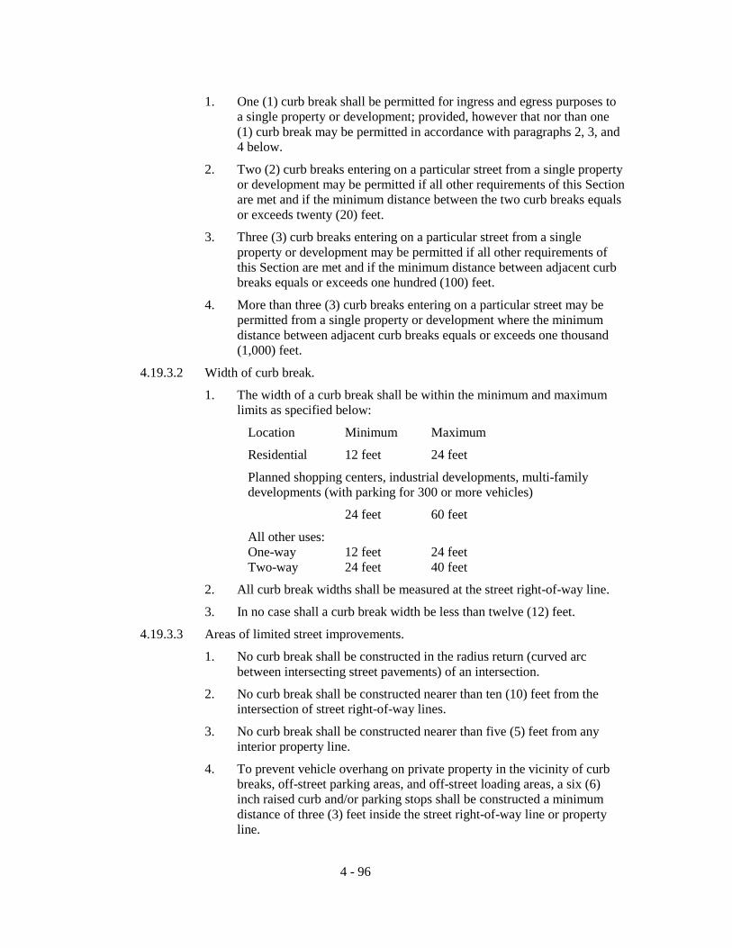
1. One (1) curb break shall be permitted for ingress and egress purposes to
a single property or development; provided, however that nor than one (1) curb break may be permitted in accordance with paragraphs 2, 3, and 4 below.
2. Two (2) curb breaks entering on a particular street from a single property or development may be permitted if all other requirements of this Section are met and if the minimum distance between the two curb breaks equals or exceeds twenty (20) feet.
3. Three (3) curb breaks entering on a particular street from a single property or development may be permitted if all other requirements of this Section are met and if the minimum distance between adjacent curb breaks equals or exceeds one hundred (100) feet.
4. More than three (3) curb breaks entering on a particular street may be permitted from a single property or development where the minimum distance between adjacent curb breaks equals or exceeds one thousand (1,000) feet.
4.19.3.2 Width of curb break.
1. The width of a curb break shall be within the minimum and maximum limits as specified below:
Location Minimum Maximum
Residential 12 feet 24 feet
Planned shopping centers, industrial developments, multi-family developments (with parking for 300 or more vehicles)
24 feet 60 feet
All other uses: One-way 12 feet 24 feet Two-way 24 feet 40 feet
2. All curb break widths shall be measured at the street right-of-way line.
3. In no case shall a curb break width be less than twelve (12) feet.
4.19.3.3 Areas of limited street improvements.
1. No curb break shall be constructed in the radius return (curved arc between intersecting street pavements) of an intersection.
2. No curb break shall be constructed nearer than ten (10) feet from the intersection of street right-of-way lines.
3. No curb break shall be constructed nearer than five (5) feet from any interior property line.
4. To prevent vehicle overhang on private property in the vicinity of curb breaks, off-street parking areas, and off-street loading areas, a six (6) inch raised curb and/or parking stops shall be constructed a minimum distance of three (3) feet inside the street right-of-way line or property line.
4 - 96

5. No curb break shall be permitted to include any public facility such as
traffic signal standards, catch basins, fire hydrants, utility poles, fire alarm supports, or other similar type structures.
4.19.3.4 Curb break permit. No curb break shall be established or altered without a permit issued by the Land Development Regulation Administrator.
4.19.4 ACCESSORY USES AND STRUCTURES
Unless otherwise provided in these land development regulations, in all districts accessory uses and structures shall not be located in required front, side, or waterfront yards but may be located in rear yards not less than fifteen (15) feet from the rear lot line; provided, however,
1. That accessory structures for the housing of persons, such as guest houses, shall not be located in any required yard, nor shall air conditioner compressor units be located in any required yard; and
2. Structures used for water related activities such as boat docks, boat houses, and similar uses may be located anywhere in a required waterfront yard.
No separate accessory building shall be located within five (5) feet of any building.
Motor vehicles, mobile homes, school buses and recreational vehicles shall not be used as accessory structures.
4.19.5 ALCOHOLIC BEVERAGES
Indications in the Schedule of District Regulations that the sale of alcoholic beverages is permitted in any zoning district shall not in any way be deemed to limit, qualify, or repeal any other existing local regulations or regulations of the State of Florida relating to the licensing, dispensing, or sale of such beverages or the location of alcoholic beverage establishments.
4.19.6 AUTOMOTIVE SERVICE AND SELF-SERVICE STATIONS
The following regulations shall apply to the location, design, construction, operation, and maintenance of automotive service and self-service stations (with the exception that for automobile self-service stations where self-service gasoline pumps in conjunction with retail and commercial outlets for sale of food, hardware and drugs, there shall be no outside sales of oil, grease, parts or accessories for automobiles and no service except for self-service water, air or carwash).
4.19.6.1 Lot dimensions and area. An automotive service station lot shall be of adequate width and depth to meet all setback requirements, but in no case shall a corner lot have less than one hundred fifty (150) feet of frontage on each street side, and an interior lot shall have a minimum width of at least one hundred fifty (150) feet. A corner lot shall have a minimum area of not less than twenty thousand (20,000) square feet and an interior lot a minimum area of not less than fifteen thousand (15,000) square feet.
4.19.6.2 Lighting. All lights and lighting for an automotive service station shall be so designed and arranged that no source of light shall be visible from any residential district.
4 - 97

4.19.6.3 Location of pumps and structures. No main or accessory building, no sign of
any type, and no gasoline pump shall be located within twenty-five (25) feet of the lot line of any property that is zoned for residential purposes. No gasoline pump shall be located within fifteen (15) feet of any street right-of-way line; where a greater street setback line has been established, no gasoline pump shall be located within fifteen (15) feet of such setback line.
4.19.6.4 Curb breaks. A curb break is a driveway or any other point of access or opening for vehicles onto a public street. The number of curb breaks for each automotive service station shall not exceed two (2) for each one hundred fifty (150) feet of street frontage, each break having a width of no more than thirty (30) feet exclusive of transitions and located not closer than fifteen (15) feet of right-of-way lines of any intersection. Curb breaks shall not be closer than fifteen (15) feet to any other property line. There shall be a minimum distance of twenty (20) feet between curb breaks.
4.19.6.5 Trash storage. Adequate, enclosed trash storage facilities shall be provided on the site.
4.19.7 DRIVE-IN THEATERS
The following regulations apply to the construction and operation of drive-in theaters:
1. The screen must be so oriented that the picture is not visible from any existing or proposed major street.
2. Not more than two (2) exits shall be provided to each access highway but such exits may be suitably channelized to provide for right and left turns onto the highway, and not more than one (1) traffic lane shall be permitted for each traffic lane on the highway available to vehicles leaving the theater.
3. No entrance or exit shall be within five hundred (500) feet of the intersection of the right-of-way lines of any public street.
4. Sufficient area shall be provided between the highway and the viewing area to provide storage space for vehicles equal to not less than twenty-five (25) percent of theater capacity and of that storage space so provided not less than ten (10) percent of the theater capacity shall be provided between the highway and the ticket booths. In all cases, sufficient storage space shall be provided so that vehicles will not back onto the traveled way of the highway. Storage area shall be calculated on the basis of one (1) space per twenty-five (25) lineal feet of storage lane.
5. An individual speaker shall be provided for each vehicle. All speakers shall be equipped with sufficient cord to permit the speaker to be placed inside the vehicle. Speakers must not be audible beyond the boundaries of the theater property lines.
4.19.8 ERECTION OF MORE THAN ONE PRINCIPAL STRUCTURE ON A PLATTED LOT
Whenever any land is subdivided, a building permit for the construction of a building or other principal structure (excluding commercial buildings under common ownership or unified control) shall not be issued for any such structure on less than a lot as platted within such subdivided land. The provision of Section 14.10.2.7 of these land development regulations shall be exempt from the requirements of this section, provided that there are not any existing plat restrictions to the contrary. Where there are existing plat restrictions to the contrary, such restrictions shall be applied in lieu of the provisions of this section.
4 - 98

4.19.9 EXCLUSIONS FROM HEIGHT LIMITATIONS
The height limitations contained in the Schedule of District Regulations do not apply to spires, belfries, cupolas, antennae, water tanks, ventilators, chimneys, elevator shaft enclosures, the height of unenclosed piers elevating the structure in floodplain or flood prone areas (see Article 8), airport control towers, observation towers or other appurtenances usually required to be placed above the roof level. However, the heights of these structures or appurtenances, excepting airport control towers, shall not exceed any height limitations prescribed by the Federal Aviation Agency or airport zoning regulations within the flight-approach zone of airports.
4.19.10 FUTURE LAND USE PLAN AMENDMENT FOR PUBLIC BUILDINGS AND FACILITIES Public buildings and facilities, including public schools, which do not meet the definition of "essential services" as stated in Article 14 of these land development regulations, shall require an amendment to the Future Land Use Plan Map of the County's Comprehensive Plan to "Public Land Use", prior to consideration for approval as a special exception. Upon amendment to the County’s Comprehensive Plan public schools or private schools offering curricula comparable to that of public schools shall not require an amendment to the Future Land Use Plan Map prior to commencement of construction of a public school or issuance of a permit for a private school offering curricula comparable to a public school. Although, the location of such public schools or private schools offering curricula comparable to that of public schools shall be restricted to those zoning districts which permit such uses. A site plan conforming to the provisions of these land development regulations shall be submitted prior to commencement of construction for a public school or prior to issuance of a building permit in the case of a private school in accordance with the procedures described in this article. The overall layout and site design of the school shall conform to the provisions of these land development regulations.
4.19.11 FALLOUT SHELTERS
Fallout shelters are permitted in all zoning districts. Individual structures in residential districts shall be considered as accessory structures.
4.19.12 FENCES, WALLS, AND HEDGES
Notwithstanding other provisions of these land development regulations, fences, walls, and hedges may be permitted in any required yard or along the edge of any yard; provided that no solid fence, solid wall, or hedge located within the required front yard shall constitute an obstruction to visibility between two and one half (2-1/2) and six (6) feet above the centerline grade of the adjacent street.
4.19.13 LANDSCAPED BUFFER AREAS The use of properly planted and maintained buffer areas may reduce and ease potential incompatibility between or among different uses of land in proximity to each other. 4.19.13.1 Requirements. Where these land development regulations require a
landscaped buffer area, the following requirements shall be met: 1. The landscaped buffer area width shall be measured at right angles to
property lines and shall be established along the entire length of and contiguous to the designated property line or lines.
4 - 99

2. The area shall be so designed, planted, and maintained as to be eighty
(80) percent or more opaque between two (2) and six (6) feet above average ground level when viewed horizontally; provided, however, that plants located in the required front yard shall not exceed two and one-half (2 1/2) ft. in height.
3. Types and numbers of plants for landscaped buffers shall be submitted with application for building permit. No building permit shall be issued without such data, where these land development regulations require a landscaped buffer area or areas.
4. Plants shall be of a size and type which will ensure the meeting of the eighty (80) percent opacity requirement within no longer than thirty (30) months of the date of first planting. Where questions may arise as to the suitability of proposed plant materials to meet this requirement, final determination of suitability shall be made by the Land Development Regulation Administrator.
5. The remainder of the required landscaped buffer area not covered by planting shall be landscaped with grass, ground cover, or other landscape treatment; except as otherwise provided herein, structures including buildings and offstreet parking and loading areas shall not be located in any required landscaped buffer area.
6. The landscaped buffer area shall be maintained by the property owner and continued so long as the main use continues. Failure to maintain the landscaped buffer area as set out above shall be a violation of these land development regulations.
4.19.13.2 Substitution for landscaped buffer area. Except when otherwise specifically provided by these land development regulations, a six (6) foot high masonry or wood opaque structure may be substituted for the six (6) foot high, planted buffer within these supplementary regulations; provided, however, that where the masonry or wood opaque structure is located in the required front yard, it shall not exceed two and one-half (2 1/2) feet in height.
4.19.13.4 Waiver by Land Development Regulation Administrator. When the Land Development Regulation Administrator finds that the public safety requires, he or she may waive or modify the buffer requirements set out in Section 4.19 at street and alley frontages adjacent to any entrance; the finding of the Land Development Regulation Administrator shall be in writing and shall be filed with the approved building permit. The finding shall demonstrate that the buffer is not required for a certain number of feet back from the street or alley entrance in order to afford protection to pedestrian or vehicular traffic entering or leaving the lot on which the landscaped buffer area is required by these land development regulations.
4.19.13.5 Waiver by Board of Adjustment. Where by the terms of these land development regulations a non-residential use is required to provide a landscaped buffer along a property line which is contiguous to another non-residential use, the Board of Adjustment may waive the landscaped buffer requirements if evidence is presented to the Board that the buffer will serve no useful purpose. Such evidence shall be heard in the same manner as a request for variances, and adjoining property owners must be notified in writing of the Board of Adjustment meeting when the request will be heard.
4 - 100

4.19.13.6 Application where these land development regulations set out different
requirements. In those instances where these land development regulations set out a different buffering requirement (e.g., greater height of landscaped buffer, or a different type of buffer), then the specific provisions of these land development regulations applicable to the particular type of use shall govern.
4.19.14 MINIMUM LIVING AREA
Minimum living area requirements are specified in Article 9 of these land development regulations.
4.19.15 MOBILE HOME - REPLACEMENT OF EXISTING MOBILE HOMES
For the purposes of these land development regulations, the phrase existing mobile homes shall mean mobile homes which existed as of the effective date of adoption or amendment of these land development regulations. In those districts which do not permit the erection of new mobile homes but do permit existing mobile homes as a principal use, such existing mobile homes may be removed and replaced by another mobile home, provided:
1. That a period of not greater than six (6) consecutive months elapses between the removal of one (1) mobile home and the erection of another mobile home; and
2. Where a mobile home is removed and is not replaced for a period greater than six (6) consecutive months for any reason (except where governmental action impedes access to the premises), such mobile home shall not be replaced and any subsequent use shall conform to the regulations for the district in which the use is located.
4.19.16 MOVING OF BUILDINGS AND STRUCTURES No building or structure shall be moved from one (1) lot to another lot, or moved to another location on the same lot, unless such building or structure shall thereafter conform to all of the applicable provisions of these land development regulations and to all other regulations and ordinances of the County.
4.19.17 OFFSTREET PARKING AND LOADING
It is the intent of these land development regulations that the public interest, welfare, and safety requires that buildings and uses erected after the effective date of these land development regulations shall be provided with adequate offstreet parking facilities (including in certain specified cases, offstreet parking facilities for the handicapped) for the use of occupants, employees, visitors, customers, or patrons. It is also the intent of these land development regulations that the public interest, welfare, and safety require that certain uses provide adequate offstreet loading facilities. Such offstreet parking and offstreet loading facilities shall be maintained and continued so long as the main use continues. (For definitions of "loading space, offstreet", "parking space, handicapped", and "parking space, offstreet", see Definitions, Section 2.1)
4.19.17.1 Offstreet parking and offstreet loading: general.
1. Offstreet parking and loading facilities shall be provided as set out in these land development regulations. Conforming buildings and uses existing as of the effective date of these land development regulations may be modernized, altered, or repaired without providing additional offstreet parking or offstreet loading facilities, providing there is no increase in floor area or capacity.
4 - 101

2. Where a conforming building or use existed as of the effective date of
these land development regulations and such building or use is enlarged in floor area, volume, capacity, or space occupied, offstreet parking and offstreet loading as specified in these land development regulations shall be provided for the additional floor area, volume, capacity, or space so created or used.
3. Change in use of a building or use existing as of the effective date of these land development regulations shall require additional offstreet parking and offstreet loading facilities to the extent that the use shall provide additional parking spaces amounting to the difference between the required number of parking spaces for the new use and the required number of parking spaces for the previous use.
4. The design, construction, and arrangement regulations herein set out for offstreet parking and offstreet loading facilities do not apply to one (1) and two (2) family (duplex) dwellings.
5. Required offstreet parking areas shall not be used for sales or display, dead storage, repair, dismantling, or servicing of any type or kind, nor shall areas devoted to such activities count as meeting offstreet parking requirements.
6. Unless otherwise specified and subject to meeting required landscaped buffer requirements, all required yards may be used for offstreet parking.
4.19.17.2 Offstreet parking and offstreet loading facilities: identification, surfacing, drainage, lighting, access. The required offstreet parking and offstreet loading facilities shall be:
1. Identified as to purpose and location when not clearly evident.
2. Surfaced with one (1) inch of Type II asphaltic concrete surface course or the equivalent as approved as meeting standards established by the Board of County Commissioners and maintained in a smooth, well-graded condition (driveways, access aisles, and parking spaces for public and private schools offering academic courses may be surfaced with grass or lawn).
3. Drained so as not to cause any nuisance on adjacent property.
4. So lighted as to prevent glare or excessive light on adjacent property.
5. Arranged for convenient access and safety of pedestrians and vehicles.
6. Designed to conform to curb break requirements (see Section 4.19.3).
7. So arranged that no vehicle shall be required to back from such facilities directly onto public streets.
8. Designed to provide curbs or motor vehicle stops or similar devices so as to prevent vehicles from overhanging on or into public right-of-way or adjacent property.
4 - 102

4.19.17.3 Offstreet parking: location. The required offstreet parking facilities shall be
located on the same lot or parcel of land they are intended to serve, provided, however, that the Board of Adjustment may allow the establishment of such offstreet parking facilities within three hundred (300) feet of the premises they are intended to serve when:
1. Practical difficulties prevent the placing of the facilities on the same lot as the premises they are designed to serve;
2. The owner of the said parking area shall enter into a written agreement with the Board of County Commissioners with enforcement running to the Board of County Commissioners providing that the land comprising the parking area shall never be disposed of except in conjunction with the sale of the building which the parking area serves so long as the facilities are required; and
3. The owner agrees to bear the expense of recording the agreement and agrees that the agreement shall be voided by the Board of County Commissioners if other offstreet facilities are provided in accord with these land development regulations.
4.19.17.4 Offstreet parking: dimensional standards. Each offstreet parking space, with the exception of handicapped parking spaces, shall be a minimum of ten (10) feet by twenty (20) feet in size. Minimum aisle width shall be as follows:
Angle of Aisle Width Parking One Way Two Way Parallel 12 ft. 20 ft. 30° 12 ft. 22 ft. 45° 12 ft. 22 ft. 60° 18 ft. 24 ft. 90° 22 ft. 24 ft.
For purposes of rough computation, an offstreet parking space and necessary access and maneuvering room may be estimated at three hundred (300) square feet, but offstreet parking requirements will be considered to be met only where actual spaces meeting the requirements above are provided and maintained, improved in the manner required by these land development regulations, and in accordance with all ordinances and regulations of the Board of County Commissioners.
4.19.17.5 Offstreet parking: handicapped parking spaces. Except as otherwise specified herein, required offstreet parking areas shall have a number of level parking spaces, as set forth in the following table, identified by above-grade signs as being reserved for physically handicapped persons. Each parking space so reserved shall be not less than twelve (12) feet in width and twenty (20) feet in length.
4 - 103

Parking Spaces for Handicapped Required Number of
Total Spaces in Lot Required Spaces Up to 25 1 26 to 50 2 51 to 75 3 76 to 100 4 101 to 150 5 151 to 200 6 201 to 300 7 301 to 400 8 401 to 500 9 501 to 1,000 2% of total Over 1,000 20 plus 1 for each 100 over 1,000
Parking spaces for the physically handicapped shall be located as close as possible to elevators, ramps, walkways, and entrances. These parking spaces should be located so that physically handicapped persons are not compelled to wheel or walk behind parked cars to reach entrances, ramps, walkways, and elevators. (See Section 4.19.2 for additional provisions regarding accessibility for physically handicapped persons.)
4.19.17.6 Offstreet parking: plans required. A plan shall be submitted with every application for a building permit for any building or use that is required to provide offstreet parking. The plan shall accurately designate the required parking spaces, access aisles, and driveways, and the relation of the offstreet parking facilities to the uses or structures such facilities are designed to serve.
4.19.17.7 Offstreet parking: combined offstreet parking. Two (2) or more owners or operators of buildings or uses requiring offstreet parking facilities may make collective provision for such facilities, provided that the total of such parking spaces when combined or used together shall not be less than the sum of the requirements computed separately. Any arrangement for combined offstreet parking shall be subject to the filing of a deed restriction satisfactory to the Attorney for the Board of County Commissioners insuring that such offstreet parking will be maintained in the future so long as a use or uses requiring such offstreet parking continue.
No part of an offstreet parking area required for any building or use shall be included as a part of an offstreet parking area similarly required for another building or use unless the Board of Adjustment shall find that the type of use indicates that the period of usage will not overlap or be concurrent with each other.
4.19.17.8 Offstreet parking: fractional measurements. When units or measurements determining number of required offstreet parking spaces result in requirement of a fractional space, then such fraction equal or greater than one half (1/2) shall require a full offstreet parking space.
4 - 104

4.19.17.9 Offstreet parking: minimum requirement. Irrespective of any other
requirement of these land development regulations, each and every separate individual store, office, or other business shall be provided with at least one (1) offstreet parking space, unless specific provision to the contrary is made herein.
4.19.17.10 Offstreet parking: landscaping requirements. Wherever in any zoning district offstreet parking facilities are provided, such offstreet parking facilities shall conform to the minimum landscaping requirements set forth in this section, except that one (1) family and two (2) family (duplex) residential dwellings and multi-level parking structures shall be exempt from such requirements. 1. Except as otherwise noted herein, a minimum of ten percent (10%) of
any offstreet parking area shall be landscaped with grass, plants, shrubs, and/or trees. Required landscaping may, in part, be located around the periphery of the offstreet parking area; however, where possible a portion of the required landscaping shall also be located within the interior of the offstreet parking area and shall be located in such a manner as to divide and break up the expanse of paving and guide traffic flow and direction.
2. Each separate landscaped area shall contain a minimum of fifty (50) square feet and shall have a minimum dimension of at least three (3) feet, and shall include at least one (1) tree, with the remaining area adequately landscaped with shrubs, ground cover, or other landscaping material.
3. The total number of trees shall not be less than one (1) for each two hundred (200) square feet or fraction thereof of required landscaping. Trees shall be a minimum of four (4) feet overall height immediately after planting. Trees shall not be planted closer than six (6) feet to any public street or other public works, unless the tree root system is completely contained within a barrier for which the minimum interior dimensions shall be five (5) feet square and five (5) feet deep, and for which the construction requirements shall be four (4) inch thick concrete reinforced with #6 road mesh (6 x 6 x 6) or equivalent.
4. Required landscaped areas shall be maintained by the property owner and continued so long as the main use continues. Failure to maintain required landscaped area shall be a violation of these land development regulations.
5. See also Section 4.19.3, Visibility at intersections and curb breaks.
4.19.17.11 Offstreet loading: specifications, amounts. Offstreet loading facilities are required by these land development regulations so that vehicles engaged in unloading will not encroach on or interfere with public use of streets and alleys. Offstreet loading facilities supplied to meet the needs of one (1) use may not be considered as meeting the needs of another use. Offstreet parking facilities may not be used or counted as meeting offstreet loading requirements.
When the use of a structure or land or any part thereof is changed to a use requiring offstreet loading facilities, the full amount of offstreet loading
4 - 105
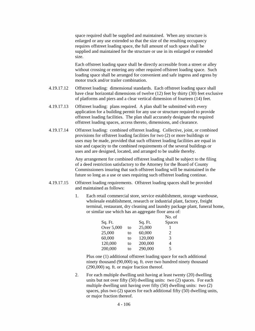
space required shall be supplied and maintained. When any structure is enlarged or any use extended so that the size of the resulting occupancy requires offstreet loading space, the full amount of such space shall be supplied and maintained for the structure or use in its enlarged or extended size.
Each offstreet loading space shall be directly accessible from a street or alley without crossing or entering any other required offstreet loading space. Such loading space shall be arranged for convenient and safe ingress and egress by motor truck and/or trailer combination.
4.19.17.12 Offstreet loading: dimensional standards. Each offstreet loading space shall have clear horizontal dimensions of twelve (12) feet by thirty (30) feet exclusive of platforms and piers and a clear vertical dimension of fourteen (14) feet.
4.19.17.13 Offstreet loading: plans required. A plan shall be submitted with every application for a building permit for any use or structure required to provide offstreet loading facilities. The plan shall accurately designate the required offstreet loading spaces, access thereto, dimensions, and clearance.
4.19.17.14 Offstreet loading: combined offstreet loading. Collective, joint, or combined provisions for offstreet loading facilities for two (2) or more buildings or uses may be made, provided that such offstreet loading facilities are equal in size and capacity to the combined requirements of the several buildings or uses and are designed, located, and arranged to be usable thereby.
Any arrangement for combined offstreet loading shall be subject to the filing of a deed restriction satisfactory to the Attorney for the Board of County Commissioners insuring that such offstreet loading will be maintained in the future so long as a use or uses requiring such offstreet loading continue.
4.19.17.15 Offstreet loading requirements. Offstreet loading spaces shall be provided and maintained as follows:
1. Each retail commercial store, service establishment, storage warehouse, wholesale establishment, research or industrial plant, factory, freight terminal, restaurant, dry cleaning and laundry package plant, funeral home, or similar use which has an aggregate floor area of:
No. of Sq. Ft. Sq. Ft. Spaces Over 5,000 to 25,000 1 25,000 to 60,000 2 60,000 to 120,000 3 120,000 to 200,000 4 200,000 to 290,000 5
Plus one (1) additional offstreet loading space for each additional ninety thousand (90,000) sq. ft. over two hundred ninety thousand (290,000) sq. ft. or major fraction thereof.
2. For each multiple dwelling unit having at least twenty (20) dwelling units but not over fifty (50) dwelling units: two (2) spaces. For each multiple dwelling unit having over fifty (50) dwelling units: two (2) spaces, plus two (2) spaces for each additional fifty (50) dwelling units, or major fraction thereof.
4 - 106

3. For each auditorium, convention hall, exhibition hall, museum, motel,
hotel, bank or financial institution, office building, sports arena, stadium, hospital, or similar use which has an aggregate floor area of: Over ten thousand (10,000) square feet but not over 40,000 (40,000) square feet: one (1) space; plus for each additional sixty thousand (60,000) square feet over 40,000 square feet or major fraction thereof: one (1) space.
4. For any use not specifically mentioned, the requirements for offstreet loading facilities for a use which is so mentioned and to which the unmentioned use is similar shall apply.
4.19.18 PARKING, STORAGE, OR USE OF MAJOR RECREATIONAL EQUIPMENT Major recreational equipment is hereby defined as including boats and boat trailers, travel trailers, pickup campers or coaches (designed to be mounted on automotive vehicles), motorized dwellings, tent trailers, houseboats, and the like, and cases or boxes used for transporting recreational equipment, whether occupied by such equipment or not. No major recreational equipment shall be used for living, sleeping, or housekeeping purposes when parked or stored on a lot in a residential district, or in any other location not approved for such use. In residential districts, major recreational equipment may be parked or stored in a rear or side yard, but not in a required front yard; provided however, that such equipment may be parked anywhere on residential premises for a period not to exceed twenty-four (24) hours during loading and unloading.
4.19.19 PARKING AND STORAGE OF CERTAIN VEHICLES
In residential districts, automotive vehicles or trailers of any type without current license plates shall not be stored other than in completely enclosed buildings. Trucks that meet the definition of truck terminal shall not be stored in agricultural or residential districts without an approved special exception.
4.19.20 PERFORMANCE STANDARDS
All uses and activities permitted in any district within these land development regulations shall conform to the standards of performance described below:
4.19.20.1 Fire and explosion hazards. In any zoning district, all uses shall comply with applicable standards set forth in the rules and regulations of the State Fire Marshal.
4.19.20.2 Smoke, dust, dirt, visible emissions, and open burning. Regulations controlling smoke, dust, dirt, or visible emissions shall be the same as those contained in Chapter 17-2, Florida Administrative Code. Regulations controlling open burning shall be the same as those contained in Chapter 17-5, Florida Administrative Code.
4.19.20.3 Fumes, vapors, and gases. Regulations controlling the emission of any fumes, vapors, or gases of a noxious, toxic, or corrosive nature shall be the same as those contained in Chapter 17-2, Florida Administrative Code.
4.19.20.4 Heat, cold, dampness, or movement of air. Activities which may produce any adverse effect on the temperature, motion, or humidity of the atmosphere beyond the lot line shall not be permitted, with the exception that in the I-Industrial district, this standard shall be applied at the boundaries of the I district and not at the lot lines of the individual properties located within the I district.
4 - 107

4.19.20.5 Noise. The permitted level of noise or sound emission at the property line of
the lot on which the principal use is located shall not at any time exceed the average noise level prevailing for the same hour, as generated by street and traffic activity, with the exception that in the I-Industrial district, this standard shall be applied at the boundaries of the I district and not at the lot lines of the individual properties located within the I district. The determination of noise level shall be measured with a sound level meter that conforms to specifications published by the American Standards Association.
4.19.20.6 Odor. Regulations controlling the emission of objectionable odorous gases or other odorous matter, except those associated with normal agricultural practices, shall be the same as those contained in Chapter 17-2, Florida Administrative Code.
4.19.20.7 Glare. There shall be no direct glare visible from any residential district caused by unshielded floodlights or other sources of high intensity lighting.
4.19.21 RAILROAD RIGHT-OF-WAY
Existing railroad right-of-way, but not including switching, freight, or storage yards and railroad buildings or maintenance structures, is a permitted use in all zone districts. Switching, freight, or storage yards and railroad buildings or maintenance structures are permitted only where expressly allowed by these land development regulations.
4.19.22 SIGNS The provisions of these land development regulations shall govern the sizes, location, and character of signs which may be permitted as a principal or accessory use. No signs shall be permitted in any location except in conformity with these land development regulations.
4.19.22.1 Intent. Signs may unreasonably distract the attention of motorists and interfere with traffic safety. Indiscriminate erection and maintenance of signs seriously detract from the enjoyment and pleasure in the natural scenic beauty of the areas subject to these land development regulations and, in turn, injuriously affects the economic well-being of the citizenry. Thus, it is the intent of these land development regulations to prevent the uncontrolled erection of signs. The provisions of this section are intended to provide for the regulation of types, sizes, and locations of signs in relation to the identification of various uses and activities on premises, to provide for certain types and locations of off-site signs, and to supplement the regulations set out in the Schedule of District Regulations.
4.19.22.2 Applicability of other code or regulatory requirements. Signs or other advertising structures shall be constructed and maintained in accordance with the building and electrical codes of the County, and all other applicable ordinances and regulations of the County, as well as other, State and Federal rules and regulations.
4.19.22.3 Definitions. Definitions for the purposes of sign regulation under these land development regulations are set out in the definitions section of these land development regulations under Sign, etc. (Sections 2.1)
4.19.22.4 Prohibited signs. It shall be a violation of these land development regulations punishable as provided by these land development regulations, to erect or maintain:
4 - 108

1. Traffic or pedestrian hazard. Any sign which constitutes a traffic
hazard or a detriment to traffic safety by reason of its size, location, movement, content, coloring, or method of illumination, or by obstructing the vision of drivers, or by obstructing or detracting from the visibility of any official traffic control device by diverting or tending to divert the attention of moving vehicles from the traffic movement on streets, roads, or access facilities; nor shall any sign be erected in such a manner as to obstruct the vision of pedestrians. The use of flashing or revolving red, green, blue, or amber lights is prohibited in any sign as constituting a hazard to traffic. Any sign which by glare or method of illumination constitutes a hazard to traffic is prohibited. No sign may use the words "Stop", "Look", "Drive-in", "Danger", or any other word, phrase, symbol, or character in such a manner as to interfere with, mislead, or confuse traffic.
2. Obscenities. Signs which are obscene, indecent, or immoral. 3. Rights-of-way. Signs erected on the right-of-way of any street, road,
or public way, except as specifically provided by these land development regulations.
4. Public property. Signs erected on public property, other than signs erected by a public authority for public purposes, unless otherwise authorized by these land development regulations.
5. Ingress or egress to buildings. Signs so located as to prevent free ingress or egress from any door, window, or fire escape.
6. Yard areas. Signs in required yard areas except as specifically permitted by the terms of these land development regulations.
7. Roof signs. Signs erected, constructed, and maintained wholly upon or over the roof structure.
8. Height. Signs which are higher than eighteen (18) feet from established grade except as otherwise provided in these Land Development Regulations.
9. Glare. Illuminated signs which result in glare or reflection of light on residential property in the surrounding area.
10. Minimum clearance. Canopy, marquee, projecting, or hanging signs with less than a nine (9) ft. minimum clearance between the bottom of the sign and the ground surface.
4.19.22.5 Sign permits. Within areas subject to these land development regulations, it shall be unlawful for any person to erect, maintain, or replace any sign not specifically exempted by these land development regulations, without first securing from the Land Development Regulation Administrator a building permit to do so.
4.19.22.6 Exemptions. Except as otherwise provided, the following signs may be erected without a permit, subject, however, to all remaining requirements of these land development regulations. All exempt signs may be located within the required front yard, but shall not be located within twenty (20) ft. of any adjacent property line (except as provided in subsection 3 below). 1. Signs not exceeding one (1) sq. ft. in area and bearing only property
numbers, mail box numbers, names of occupants of premises, or other identification of premises not having commercial connotations.
4 - 109
2. Flags and insignia of any government except when displayed in
connection with commercial promotion. 3. Traffic or other municipal, County, State, or Federal signs, legal notices,
railroad crossing signs, danger signs, and such temporary, emergency, or non-advertising signs as may be approved by the Board of County Commissioners. Such signs may be located in or may overhang or infringe upon the right-of-way of streets, roads, or public ways.
4. Integral decorative or architectural features of buildings except letters, trademarks, moving parts, or moving lights.
5. Signs directing and guiding traffic and parking on private property, but bearing no advertising matter.
6. Signs within buildings. 7. One (1) "For Sale" or "For Rent" sign per parcel of property, unless such
property fronts on more than one (1) street, in which case two (2) signs may be erected, one (1) on each frontage. The size of any such sign shall not be in excess of eight (8) sq. ft., and such sign shall be removed within one (1) month after the premises have been sold or rented.
8. Occupational signs denoting only the name, street number, and business of an occupant, which do not exceed two (2) sq. ft. in surface area.
4.19.22.7 On-site signs. Unless otherwise specified in these land development regulations, the following regulations shall govern on-site signs (see Section 2.1 for definition of on-site signs): 1. On-site signs may be erected in any zone district. 2. On-site signs may be located in the required front yard; provided,
however that any such sign shall not obstruct visibility at intersections and curb breaks (see Section 4.19.26).
3. On-site signs shall not exceed a height above established grade of eighteen (18) feet except as otherwise provided in these land development regulations.
4.19.22.8 Off-site signs. Unless otherwise specified in these land development regulations, the following regulations shall govern off-site signs (see Section 2.1 for definition of off-site signs): 1. Off-site signs are prohibited, except where specifically permitted by
these land development regulations. 2. Off-site signs may be erected in the required front yard, provided:
a. Off-site signs shall be no nearer the street right-of-way line than fifteen (15) feet.
b. No off-site sign shall be erected so as to obstruct visibility at intersections and curb breaks (see Section 4.19.26).
3. Off-site signs may not be erected within one hundred (100) feet of any church, school, cemetery, public park, public reservation, public playground, State or National forest, or railroad intersection.
4. Off-site signs shall not exceed a height above established grade of eighteen (18) feet, except as otherwise provided in these land development regulations.
4 - 110

4.19.22.9 Subdivision signs. The Land Development Regulation Administrator may
permit permanent, free standing subdivision signs to be located at each entrance to a subdivision as part of the subdivision review process or upon request of property owners after the development of a subdivision. Such subdivision signs may not be located in or over a County street right-of-way.
4.19.23 TRANSITIONAL USE AREA REQUIREMENTS
It is the intent of these requirements to ease the frictions between residential and non-residential uses by creating a transition zone in which certain intensive non-residential uses are prohibited. Where a commercial or industrial district adjoins a residential district, along the same frontage and without an intervening street, the following uses shall not be located within one hundred (100) feet of the residential district: 1. Drive-in restaurants or refreshment stands. 2. Bars, taverns, and cocktail lounges. 3. Car washes. 4. Outdoor storage yards, wrecking yards, automobile wrecking yards, junk yards, yards
used in whole or in part for scrap or salvage operations, or for processing, storage, display, or sales of any scrap, salvage, or second-hand building materials, junk automotive vehicles, or second-hand automotive parts.
5. Bulk storage of flammable liquids or explosives.
4.19.24 TRAVEL TRAILER PARKS AND CAMPGROUNDS
The following regulations apply to the construction and operation of travel trailer parks and campgrounds.
1. Sites in travel trailer parks and campgrounds shall be occupied primarily by travel trailers, pickup coaches, tents, camping trailers, and other vehicular accommodations.
2. Each site in a travel trailer park or campground shall be at least twelve hundred (1,200) sq. ft. in area. No part of a travel trailer or other unit placed on a travel trailer or campground site shall be closer than twenty-five (25) feet to any lot line.
4.19.25 USE OF LAND IN A RESIDENTIAL DISTRICT FOR ACCESS
No land in a residential district shall be used for drive-way, walkway, or access purposes to any land which is in a commercial or industrial district, or used for any purpose not permitted in a residential district except for ingress and egress to an existing use which does not abut on a street.
4.19.26 VISIBILITY AT INTERSECTIONS AND CURB BREAKS
4.19.26.1 Visibility at intersections. On a corner lot in all zoning districts, no fence, wall, hedge, landscaping, or structure shall be erected, placed, planted, or allowed to grow in such a manner as to obstruct vision between a height of two and one-half (2-1/2) feet and six (6) feet above the centerline grades of the intersecting streets in the area bounded by the street lines of such corner lots and a line joining points along said street lines twenty-five (25) feet from the point of intersection.
4 - 111
4.19.26.2 Visibility at curb breaks. In all zone districts, where a curb break intersects a
public right-of-way, no fence, wall, hedge, landscaping, or structure shall be erected, placed, planted, or allowed to grow in such a manner as to obstruct cross-visibility between a height of two and one-half (2-1/2) and six (6) ft. within the areas of property on both sides of the curb break formed by the intersection of each side of the curb break and public right-of-way lines with two (2) sides of each triangle being ten (10) ft. in length from the point of intersection and the third being a line connecting the end of the two (2) other sides.
4.19.26.3 Retaining walls. The requirements of this Section shall not be deemed to prohibit any necessary retaining wall.
4.19.26.4 Trees. Trees shall be permitted in the clear space provided that foliage is cut away within the prescribed heights.
4.19.27 WATERFRONT YARDS - MINIMUM REQUIREMENT
Waterfront yard requirements for streams and creeks are provided for in Article 4, Zoning Districts, Minimum Yard Requirements, Special Provisions.
For all other waterfront yards, no structure (except permitted docks, walkways, and piers) shall be located closer than thirty-five (35) to the mean high water line.
Exceptions regarding accessory structures for all waterfront yards are provided for in Section 4.19.4.
4.19.28 YARD ENCROACHMENTS
Every part of every required yard shall be open and unobstructed from the ground to the sky except as hereinafter provided or as otherwise permitted in these land development regulations: 1. Sills and belt courses may project not over twelve (12) inches into a required yard. 2. Movable awnings may project not over three (3) feet into a required yard, provided
that where the yard is less than five (5) feet in width the projection shall not exceed one-half (1/2) the width of the yard.
3. Chimneys, fireplaces, bay windows, or pilasters may project not over two (2) feet into a required yard.
4. Fire escapes, stairways, and balconies which are unroofed and unenclosed may project not over five (5) feet into a required rear yard, or not over three (3) feet into a required side yard of a multiple dwelling, hotel, or motel.
5. Hoods, canopies, roof overhangs, or marquees may project not over three (3) feet into a required yard, but shall not come closer than one (1) foot to the lot line.
6. Fences, walls, and hedges are permitted in required yards, subject to the provisions of this Section.
7. Cornices, eaves, or gutters may project not over three (3) feet into a required yard, provided that where the required yard is less than six (6) feet in width, such projection shall not exceed one-half (1/2) of the width of the yard.
8. Except as provided herein, nothing in these land development regulations shall be so construed as to prohibit any type of landscaping or private, non-profit, gardening on any lot.
4 - 112

4.19.29 AIRPORT LAND USE RESTRICTIONS
1. Use Restrictions. Notwithstanding any other provisions of these land development regulations, no use may be made of land or water adjacent to any publicly owned airport which will interfere with the operation of an airborne aircraft. The following special requirements shall apply to each permitted use.
a. All lights or illumination used in conjunction with street, parking, signs, or use of land and structures shall be arranged and operated in such a manner that it is not misleading or dangerous to aircraft operating from the airport or in vicinity thereof.
b. No operations from any land use type shall produce smoke, glare, or other visual hazards within three (3) statute miles of any usable runway of the airport.
c. No operations from any land use type shall produce electronic interference with navigation signals or radio communication between the airport and aircraft.
d. Sanitary landfills shall not be located within ten thousand (10,000) feet from the nearest point of any runway used or planned to be used by turbojet or turboprop aircraft.
e. Sanitary landfills shall not be located within five thousand (5,000) feet from the nearest point of any runway used or planned to be used by piston-type aircraft.
f. Neither residential construction nor any educational facility as defined by Chapter 1013, Florida Statutes, with the exception of aviation school facilities, shall be permitted within an area contiguous to the airport measuring one-half the length of the longest runway on either side of the end of each runway centerline.
g. The construction of an educational facility of a public or private school shall be prohibited at either end of a runway of a publicly owned airport within an area which extends five (5) miles in a direct line along the centerline of the runway, and which has a width measuring one-half the length of the runway. Exemptions approving construction of an educational facility within the delineated area shall only be granted by the Board of County Commissioners when the Board of County Commissioners makes specific findings detailing how the public policy reasons for allowing the construction outweigh health and safety concerns prohibiting such a location.
h. Nothing in this section shall be construed to require the removal, alteration, sound conditioning, or other change, or to interfere with the continued use or adjacent expansion of any educational structure or site in existence on July 1, 1993, or be construed to prohibit the construction of any new structure for which a site has been determined as provided in former Section 235.19, Florida Statutes, as of July 1, 1993.
i. The Board of County Commissioners may grant a variance for the erection, alteration, or modification of any structure which would cause the structure to exceed the federal obstruction standards as contained in 14 C.F.R. ss. 77.21, 77.23, 77.25, 77.28, and 77.29;
Obstruction marking and lighting for structures shall conform to the requirements as specified in Section 333.07 (3), Florida Statutes;
4 - 113

Documentation showing compliance with the federal requirement for notification of proposed construction and a valid aeronautical evaluation submitted by each person applying for a variance;
The Board of County Commissioners shall consider the criteria in Section 333.025(6), Florida Statutes, when determining whether to issue or deny a variance; and
That no variance shall be approved by the Board of County Commissioners solely on the basis that such proposed structure will not exceed federal obstruction standards as contained in 14 C.F.R. ss. 77.21, 77.23, 77.25, 77.28, or 77.29, or any other federal aviation regulation.
4.19.30 SPECIAL RIGHT-OF-WAY REQUIREMENTS
4.19.30.1 For all new arterial and collector roadways extra right-of-way, as provided within the Florida Department of Transportation Bicycle Facilities Planning and Design Manual, Official Standards, Revised Edition, 1982, shall be provided for integrated or parallel bicycle ways or lanes.
4.19.30.2 All new structures shall provide a minimum setback of one hundred fifty (150) feet as measured from the center line of the right-of-way for new or realigned arterial roads.
4.19.30.3 All future arterial and collector roads shall be constructed on section or quarter section lines, unless otherwise approved by the Board of County Commissioners.
4.19.31 HOME OCCUPATION REQUIREMENTS
1. Only one (1) additional person other than members of the family residing on the premises shall be engaged in such occupation;
2. The use of the dwelling unit for the home occupation shall be clearly incidental and subordinate to its use for residential purposes by its occupants, and shall under no circumstances change the residential character thereof;
3. There shall be no change in the outside appearance of the building or premises, or other visible evidence of the conduct of such home occupation other than one (1) sign, not exceeding two (2) square feet in area, non-illuminated, mounted flat against the wall of the principal building at a position not more than two (2) feet distance from the main entrance to the residence and one (1) sign, not exceeding eight (8) square feet in area located in the front yard at least fifteen (15) feet from the front yard line;
4. In all zone districts except agricultural districts, no home occupation shall be conducted in an accessory building. In agriculture districts, home occupations may be conducted in an accessory building, provided that the floor area devoted to the home occupation does not exceed one thousand (1,000) square feet.
5. No home occupation shall occupy more than twenty percent (20%) of the first floor area of the residence, exclusive of the area of any open porch or attached garage or similar space not suited or intended for occupancy as living quarters. No rooms which have been constructed as an addition to the residence, nor any attached porch or garage which has been converted into living quarters, shall be considered as floor area for the purpose of this definition until two (2) years after the date of completion thereof.
4 - 114

6. No traffic shall be generated by such home occupation in greater volumes than would
normally be expected in a residential neighborhood, and any need for parking generated by the conduct of such home occupation shall be met off the street and other than in the required front yard.
7. No equipment or process shall be used in such home occupation which creates noise, vibration, glare, fumes, odors, or electrical interference detectable to the normal senses off the lot. In the case of electrical interference, no equipment or process shall be used which creates visual or audible interference in any radio or television receivers off the premises, or causes fluctuations in line voltage off the premises.
8. A take out only restaurant shall be allowed as a home occupation in Agriculture-1 zoning districts. A take out only restaurant shall mean an establishment where meals or prepared food including beverages and confections are served to customers for consumption off the premises. Further in addition to the requirements of subparagraphs 1-11 of this section, such take out only restaurant home occupation shall;
a. Be located on a lot or parcel, as part of the principal dwelling unit or as provided for in subparagraph 4. of this section, which is in accordance with the minimum lot size required in the Agriculture-1 zoning district (excepting non-conforming lots or parcels, which are at least three acres in size); and
b. Maintain a minimum thirty (30) foot front yard setback and be located at least fifty (50) feet from any side or rear lot line; and
c. Limit the hours of operation, which shall not be earlier than 9:00 a.m. and not be later than 10:00 p.m.; and
d. Prohibit dining by customers on the premises; and e. Prohibit ordering devices outside of the building; and f. Maintain the operation of the facility in accordance with all County and State
of Florida health and safety requirements; and g. Prohibit vehicular stacking lanes for the provision of service at a takeout
window. All service must be conducted at a walk up window. In order to maintain the take out only restaurant in the character of a home occupation, offstreet parking shall be limited to three (3) spaces. Any such off street parking shall not be located in the required front yard.
9. Hours of operation shall be limited to not earlier than 7:00 a.m. and not later than 10:00 p.m.
10. A home occupation shall be subject to all applicable occupational licenses and other business taxes.
11. For purposes of illustration, the following uses shall not be considered home occupations: a. Studio for group instruction; b. Dining facility or restaurant; c. Antique or gift shop; d. Photographic studio; e. Outdoor repair; f. Food processing; g. Retail sales; and h. Child care center.
4 - 115

12. For purposes of illustration, the following uses may be considered home occupations,
provided they meet all the requirements listed in subparagraphs 1-10 above and all other provisions of these land development regulations: a. The giving of individual instruction to one (1) person at a time such as art or
music teacher; b. Fabrication of articles such as are commonly classified under the terms arts and
handicrafts, providing no retail sales are made in the home; c. Custom dressmaking, seamstress, milliner; d. Tutoring for not more than one (1) student at a time; e. Answering telephone; f. Barber or beauty shop; and g. professional offices.
4.19.32 SPECIAL SEPTIC TANK REQUIREMENTS Existing septic tanks shall be allowed to remain in service until such time as a centralized sanitary sewer service is accessible, conditioned on the following requirements: 1. A building permit shall not be issued for construction of a building or facility where
sanitary sewage is proposed to be disposed using an onsite sewage disposal system in an area zoned industrial on the County's official zoning atlas, or used for industrial or manufacturing purposes, or its equivalent, where the County's centralized sanitary sewer system is available within 1/4 mile of the area used or zoned industrial or manufacturing, or where a likelihood exists that the onsite sewage disposal system may receive toxic, hazardous or industrial waste;
2. An occupational license shall not be issued to the owner or tenant of a building located in an area zoned industrial on the County's official zoning atlas, or used for industrial or manufacturing purposes, or its equivalent, when such site is served by an onsite sewage disposal system without first obtaining an annual operating permit from the County Health Department; and
3. A certificate of land development regulation compliance shall not be issued to a new owner or tenant of a building located in an area zoned industrial on the County's official zoning atlas, or used for industrial or manufacturing purposes, or its equivalent, or who operates a business which has the potential to generate toxic, hazardous or industrial wastewater, when such site is served by an onsite sewage disposal system without first obtaining an annual operating permit for an onsite sewage disposal system from the County Health Department.
4.19.33 SPECIAL COMMUNITY RESIDENTIAL HOME REQUIREMENTS Homes of six (6) or fewer residents which otherwise meet the definition of a "community residential home" and community residential homes as defined in Section 2.1 shall be located in accordance with the following: 4.19.33.1 The County shall not permit homes of six (6) or fewer residents which
otherwise meet the definition of a community residential home to be located within a radius of one-thousand (1,000) feet of an existing home of six (6) or fewer residents, which otherwise meets the definition of a community residential home.
4.19.33.2 The County shall permit the siting of a community residential home, unless the County determines that the site selected meets the following criteria:
4 - 116

1. The site selected does not meet applicable licensing criteria established
and determined by the Florida Department of Health and Rehabilitative Services, including requirements that the home be located to assure the safe care and supervision of all clients in the home.
2. The site selected would result in such a concentration of community residential homes in the area in proximity to the site selected, or would result in a combination of such homes with other residences in the community, such that the nature and character of the area would be substantially altered. (A home that would be located within a radius of 1,200 feet of another existing community residential home shall be considered to be an over concentration of such homes that substantially alters the nature and character of the area. A home that would be located within a radius of 500 feet of a one (1) family residential district shall be considered to substantially alter the nature and character of the area).
4.19.34 PROVISIONS FOR RESIDENTIAL DESIGN MANUFACTURED HOUSING.
Residential Design Manufactured Homes as defined in Section 2.1 shall:
1. Be installed on a permanent foundation and anchoring according to Chapter 15c - 1.10 of the Florida Administrative Code;
2. Have under floor area of the home shall be permanently enclosed
(e.g. masonry block stem wall);
3. Have all transportation equipment shall be removed;
4. Have house-type siding and roofing materials with treatment of a type generally acceptable for site-built housing;
5. Measure at least twenty (20) feet in width (requiring at least a double section home;
6. Have a minimum roof pitch of two and one-half (2 1/2) rise for each twelve (12) feet of horizontal run; and
7. Have a minimum roof-overhang on all sides of six (6) inches.
4.19.35 COMMERCIAL KENNELS
Commercial kennels, as defined within these land development regulations, shall only be allowed within those districts, which permit commercial kennels as a permitted use or as a special exception in areas zoned Agriculture. In addition, commercial kennels shall conform to the following:
1. All animals shall be kept in a sound-proof structure, with adequate ventilation and sanitation in accordance with standards set by Chapter 828, Florida Statutes, between the hours of 10:00 p.m. and 6:00 a.m.;
2. All dogs must have free access to adequate runs or exercise areas, or be exercised by the kennel operators in conformance with Chapter 828, Florida Statutes;
3. All animals shall have access to clean drinking water at all times;
4. Animals shall not be kept in an area where direct sunlight cannot be escaped;
4 - 117

5. For commercial kennels located in Agriculture districts, no structure or fenced
exercise area shall be within three-hundred (300) feet of a property line; and
6. Commercial kennels located in Agriculture districts shall be located on a minimum land area of ten (10) acres.
4.19.36 BED AND BREAKFAST INN REQUIREMENTS
Bed and Breakfast Inns shall be approved by special exception as provided within these land development regulations in accordance with the following criteria:
1. The owner must live on the premises;
2. Separate toilet and bathing facilities for the exclusive use of guests must be provided;
3. Rentals shall be on a daily basis. The maximum stay for an individual guest shall be thirty (30) days in a twelve-month period;
4. No cooking facilities shall be allowed in guest rooms;
5. Bed and breakfast establishments must comply with appropriate health permits, building and fire codes and business licenses as applicable to such use;
6. In addition to the parking required for the residence, one (1) parking space shall be provided for each guest room. The Board of Adjustment may vary the parking requirement for those properties listed on the County's historic landmark or site list based upon site constraints including, but not limited to, small yards, inadequate space for parking, and the availability of on-street parking;
7. Signage, excepting historical markers located by federal, state, or County agencies, shall be limited to one (1) sign, not exceeding two (2) square feet in area, non-illuminated (excepting flood lighting on each side of the sign);
9. The maximum number of rooms for guests shall be as follows:
Building Size (Gross Floor Area) Maximum Guest Rooms
Less than 1,200 sq. ft. 1 1,200 - 1,800 sq. ft. 2 1,801 - 2,400 sq. ft. 3 2,401 - 3,000 sq. ft. 4 3,001 - 3,600 sq. ft. 5 over 3,600 sq. ft. 6
4.19.37 TRAVEL TRAILER REQUIREMENTS
Travel trailers and motor homes that have a current license plate attached to the travel trailer or motor home may be used as temporary vacation dwellings allowed in the Agriculture-1 district and in Environmentally Sensitive Areas, provided the owner can demonstrate a permanent residence in another location. Occupancy cannot exceed six (6) months during a calendar year. Travel trailers and motor homes must obtain a building permit and septic tank permit.
4 - 118

4.19.38 REQUIRED FLOOR ELEVATION OUTSIDE OF FLOOD HAZARD AREAS.
The following standards shall apply to areas located outside of flood hazard areas delineated on the Federal Emergency Management Agency, Flood Insurance Rate Maps.
1. The lowest floor of all new construction of and substantial improvements to residential structures shall be elevated at least two (2) feet.
2. The lowest floor of all new construction of and substantial improvements to non-residential structures shall:
a. Have the lowest floor elevated at least two (2) feet;
b. Together with attendant utility and sanitary facilities be completely flood-proofed to or above the level so that any space below that level is watertight with walls substantially impermeable to the passage of water and with structural components having the capability of resisting hydrostatic and hydrodynamic loads and effects of buoyancy.
3. A registered land surveyor shall file a certification with the Building Department concerning the finished floor elevation.
4 - 119

THIS PAGE LEFT BLANK INTENTIONALLY
4 - 120

SECTION 4.20 "ICS" INDUSTRIAL, CATALYST SITE
4.20.1 DISTRICTS AND INTENT
The “ICS” district is intended to accommodate heavy and light industrial uses such as, but not limited to, manufacturing, processing, warehousing, wholesaling, and distribution. This zoning district shall be restricted only to property located within the Rural Area of Critical Economic Concern Catalyst Site as designated by the Governor.
4.20.2 PERMITTED PRINCIPAL USES AND STRUCTURES
1. Wholesaling, warehousing, and distribution establishments and similar uses.
2. Research laboratories and activities in completely enclosed buildings.
3. Heavy and light manufacturing, assembling, processing (including food processing, packaging, or fabricating in completely enclosed building.
4. Sawmills and planning mills.
5. Railroad switching, freight, and storage yards; railroad buildings and maintenance structures.
6. Electric generating plants.
7. Asphalt or concrete batching plants.
8. Utilities and related facilities.
9. Wood pellet manufacturing.
Site and development plan approval is required for all permissible uses.
4.20.3 PERMITTED ACCESSORY USES AND STRUCTURES
Uses and structures which are customarily accessory and clearly incidental and subordinate to permitted principal uses and structures.
4.20.4 PROHIBITED USES AND STRUCTURES
1. Class 1 landfills and Class 3 landfills (construction and demolition landfills).
2. Junk yard or automobile wrecking yard.
3. Any uses or structures not specifically, provisionally, or by reasonable implication permitted herein, including any use not conforming to performance standards of Section 4.19 Supplementary District Regulations.
4.20.5 SPECIAL PERMITS
1. Hazardous waste disposal.
2. Livestock or poultry slaughterhouses.
3. Explosives, manufacturing or storage.
4. Paper and pulp manufacturing.
5. Rail-car shakers.
6. Chemical and fertilizer manufacture.
7. Paint, oil (including linseed), shellac, turpentine, lacquer, or varnish manufacture.
4 - 121

8. Petroleum refining.
9. Any use not determined to be a permitted or accessory use but which, if allowed with specific conditions, will not adversely affect the public health, safety, and welfare, as determined by the Board of County Commissioners.
4.20.6 MINIMUM LOT REQUIREMENTS (area, width)
None, except as needed to meet other requirements.
4.20.7 MINIMUM YARD REQUIREMENTS (depth of front and rear yard, width of side yard)
All permitted or permissible uses and structures (unless otherwise specified):
Front 20 ft.
Side and Rear 15 ft. except where railroad spur abuts side or rear property line, in which case no yard is required.
Special Provisions:
Minimum setback requirements for rail-car shakers special permits are to be determined by findings in the particular case.
The location of any structure shall be setback a minimum of thirty-five (35) feet from wetlands.
The location of any structure shall be setback a minimum of fifty (50) feet from all perennial rivers, streams and creeks.
4.20.8 MAXIMUM HEIGHT OF STRUCTURES
Sixty (60) feet except the height of signs which advertise industrial establishments located within the Industrial, Catalyst Site district shall be unrestricted, provided that such sign shall not exceed height limitations prescribed by the Federal Aviation Agency or airport zoning regulations within the flight-approach zone of airports.
4.20.9 MAXIMUM LOT COVERAGE BY ALL BUILDINGS
In addition to meeting the required yard, building height, landscape buffering, and off-street parking requirements, no structure shall exceed a 1.0 floor area ratio.
4.20.10 MINIMUM LANDSCAPED BUFFERING REQUIREMENTS
In order to minimize impacts on properties adjoining the catalyst site, those properties located adjacent to the outside boundary of a catalyst site, the following shall apply:
A minimum fifty (50) foot buffer shall be established on that portion of the property that is adjacent to the outer boundary. This fifty (50) foot buffer may be reduced to thirty (30) feet if necessary to accommodate a drainage retention pond. Immediately adjacent to the outer boundary there shall be a combination of planted and natural vegetation at least twelve (12) feet in height and of sufficient depth to create a visual buffer, or able to achieve such height and depth in two (2) years. A visual buffer plan shall be a part of the site and development plan review process.
In lieu of the vegetative buffer referenced above, a berm with planted vegetation on top, the combination of which meets the height and depth requirement, may be used.
4 - 122

Special Provisions:
Minimum landscaped buffering requirements for rail-car shakers special permits are to be determined by findings in the particular case.
4.20.11 MINIMUM OFF-STREET PARKING REQUIREMENTS:
1. Warehousing and storage only: one (1) space for each one-thousand five-hundred (1,500) sq. ft. of floor area.
2. Other permitted or permissible uses (unless otherwise specified): one (1) space for each five-hundred (500) sq. ft. of floor area.
3. For special permits as specified herein: to be determine by findings in the particular case.
4.20.12 ACCESS REQUIREMENTS
All ingress and egress points to each individual industrial establishment shall connect to a paved roadway that is constructed in accordance with County and/or Florida Department of Transportation standards.
Exception: Roadways primarily utilized for access between businesses located within the Industrial, Catalyst Site district may be constructed to a different standard determined by findings to be appropriate for the particular site, and upon approval of the Board of County Commissioners. These roads are typically located between or to the rear of lots.
4 - 123

THIS PAGE LEFT BLANK INTENTIONALLY
4 - 124

ARTICLE FIVE
SUBDIVISION REGULATIONS

THIS PAGE LEFT BLANK INTENTIONALLY

ARTICLE FIVE. SUBDIVISION REGULATIONS
SECTION 5.1 APPENDICES The appendices set forth in these land development regulations are made a part hereof and shall be used where required by these land development regulations.
SECTION 5.2 POLICY
5.2.1 It is hereby declared to be the policy of the Board of County Commissioners to consider the subdivision of land and the subsequent development of the subdivision plat as subject to the control of the Board of County Commissioners pursuant to the Comprehensive Plan for the orderly, planned, efficient, and economical development of the area.
5.2.2 Land to be subdivided shall:
1. Aid in the coordination of land development in accordance with orderly physical patterns.
2. Discourage haphazard, premature, uneconomic, or scattered land development.
3. Insure safe and convenient traffic control.
4. Encourage development of an economically stable and healthful community.
5. Insure adequate utilities.
6. Prevent periodic and seasonal flooding by providing adequate protective flood control and drainage facilities.
7. Provide public open spaces and/or parks for recreation.
8. Assure land subdivision with installation of adequate and necessary physical improvements.
9. Assure that citizens and taxpayers will not have to bear the costs resulting from haphazard subdivision of land and the lack of authority to require installation by the subdivider of adequate and necessary physical improvements.
10. Assure to the purchaser of land in a subdivision that necessary improvements of lasting quality have been installed.
11. Serve as one (1) of the several instruments of implementation for the Comprehensive Plan.
SECTION 5.3 PURPOSE It is the intent of these land development regulations to encourage and promote, in accordance with present and future needs, the safety, morals, health, order, convenience, prosperity and general welfare of the residents of the County.
SECTION 5.4 CONDITIONS Regulations of the subdivision of land and the attachment of reasonable conditions to land subdivision is an exercise of valid police power delegated by the State to the County. The subdivider has the duty of compliance with reasonable conditions established by the Board of County Commissioners for design, dedication, improvement, and restrictive use of the land so as to conform to the physical and economical development of the area and to the safety and general welfare of future property owners in the subdivision and of the community at large. In addition, within the Agriculture-1 land use classification on the County's Future Land Use Plan Map, any development,
5 - 1

including all phases, which contains up to a cumulative twenty-five (25) lots may either be developed as a subdivision with a minimum lot size of five (5) acres or as a Planned Rural Residential Development. Within the Agriculture-1 land use classification on the County's Future Land Use Plan Map any development which contains more than twenty-five (25) lots shall be developed as a Planned Rural Residential Development (see Section 4.18).
SECTION 5.5 CHARACTER OF THE LAND
Land which the Board of County Commissioners finds to be unsuitable for subdivision of development due to flooding, improper drainage, steep slopes, rock formations, adverse earth formations or topography, utility easements, or other features which will reasonably be harmful to the safety, health, and general welfare of the present or future inhabitants of the subdivision and/or its surrounding areas, shall not be subdivided or developed unless adequate methods are formulated by the subdivider and approved by the Board of County Commissioners to solve the problems created by the unsuitable land conditions.
SECTION 5.6 JURISDICTION
5.6.1 These land development regulations shall apply to all subdivisions of land, as defined herein, located within the unincorporated area of the County.
5.6.2 No land shall be subdivided within any area subject to these land development regulations until: 1. The subdivider or his agent has obtained approval of the final plat by the Board of
County Commissioners; and 2. The approved final plat is filed with the Clerk of the Circuit Court of the County.
5.6.3 No building permit shall be issued for any parcel or plat of land which was created by subdivision after the effective date, of and not in conformity with, the provisions of these land development regulations. No excavation of land or construction of any public or private improvements shall take place or be commenced except in conformity with these land development regulations.
SECTION 5.7 MAINTENANCE
Nothing in these land development regulations shall be construed as meaning that the Board of County Commissioners shall take over for maintenance any road, street, utilities, public parking or other public area, or drainage facility related thereto, except those designed and built in accordance with the requirements of the Board of County Commissioners and accepted for maintenance by specific action by the Board of County Commissioners.
SECTION 5.8 PLATS STRADDLING LOCAL GOVERNMENT BOUNDARIES Whenever access to the subdivision is required across land in another government's jurisdiction, the Board of County Commissioners may request assurance from that government's attorney that access is legally established, and that the access road is adequately improved or that a performance bond has been duly executed and is sufficient in amount to assure the construction of the access road.
SECTION 5.9 RESUBDIVISION OF LAND 5.9.1 Procedure for Resubdivision. For any change in a map of an approved or recorded
subdivision plat, if such change affects any public use, or any lot line, or if it affects any map or plan legally reached prior to the adoption of any regulations controlling subdivisions, such parcel shall be approved by the Board of County Commissioners by the same procedure, rules, and regulations as for a subdivision.
5 - 2

5.9.2 Procedure for Subdivisions Where Future Resubdivision is Indicated. Whenever a parcel of
land is subdivided and the subdivision plat shows one (1) or more lots containing more than one (1) acre of land and where such lots could eventually be resubdivided into smaller building sites, the Board of County Commissioners may require that such parcel of land allow for the future opening of streets and the ultimate extension of adjacent streets and utilities. Easements providing for the future opening and extension of such streets may be made a requirement of the plat.
SECTION 5.10 SELF-IMPOSED RESTRICTIONS
If the subdivider places restrictions on any of the land contained in the subdivision greater than those required by these land development regulations, such restriction or reference thereto shall be indicated on the subdivision plat and/or recorded with the Clerk of the Circuit Court of the County.
SECTION 5.11 SUBDIVISION BY METES AND BOUNDS
The subdivision of any lot or parcel of land, by the use of metes and bounds description for the purpose of sale, transfer, or lease, shall be subject to all of the requirements of these land development regulations. Such subdivision of a parcel of land by the use of metes and bounds description for the purpose of sale, transfer or lease shall be subject to these subdivision regulations where two or more developments which separately do not meet the literal definition of a subdivision but which collectively demonstrate at least one of the following characteristics:
1. The same person has retained or shared control of the parcels within the developments,
2. The same person has ownership or a significant legal or equitable interest in the parcels within the developments,
3. There is common management of the development controlling the form of physical development or disposition of parcels of the development,
4. There is a voluntary sharing of infrastructure that is indicative of common development, or
5. There is a common advertising theme or promotional plan for the parcels within the developments.
SECTION 5.12 SUBDIVISION NAME
Every subdivision shall be given a name by which it shall be legally known. Such name shall not be the same or similar to a subdivision name appearing on another recorded plat within the County so as to confuse the records or to mislead the public as to the identity of the subdivision, except when the subdivision is subdivided as an additional unit or section by the same subdivider or his or her successors in title. The name of the subdivision shall be shown in the dedication and shall coincide exactly with the subdivision name. The Board of County Commissioners shall have final authority to approve the names of subdivisions.
SECTION 5.13 VACATION AND ANNULMENT OF PLATS
The vacation and annulment of plats shall be according to Chapter 177, Florida Statues, as amended. In addition, the Board of County Commissioners may, on its own motion, order the vacation and revision to acreage of all or any part of a subdivision within its jurisdiction including the vacation of streets or other parcels of land dedicated for public purposes or any of such streets or other parcels, when:
1. The plat of which subdivision was recorded as provided by law not less than five (5) years before the date of such action, and
5 - 3

2. In which subdivision or part thereof not more than ten percent (10%) of the total subdivision
area has been sold as lots by the original subdivider or his successor in title.
Such action shall be based on a finding by the Board of County Commissioners that the proposed vacation and reversion to acreage of subdivided land conforms with the Comprehensive Plan and that the public health, safety, economy, comfort, order, convenience, and welfare will be promoted thereby. Before acting on a proposal for vacation and reversion of subdivided land to acreage, the Board of County Commissioners shall hold a public hearing thereon with due public notice.
No owner of any parcel of land in a subdivision shall be deprived by the reversion to acreage of all or any part of the subdivision of reasonable access to existing facilities to which such parcel has theretofore had access, provided that such access remaining or provided after such vacation need not be the same as that theretofore existing, but shall be reasonably equivalent thereto.
If land in a subdivision or part thereof is proposed for reversion to acreage, the Board of County Commissioners shall conduct proceedings for amending the zoning district designation of such acreage as may be deemed advisable in view of the conditions that will exist subsequent to such reversion to acreage.
SECTION 5.14 GENERAL PROCEDURE
5.14.1 Preparation of Plats. All preliminary and final plats shall be prepared by a surveyor registered in the State of Florida or a professional engineer registered in the State of Florida and construction plans and specifications for required improvements shall be prepared by a registered engineer. The subdivider shall present a letter to the Board of County Commissioners certifying that he or she has employed a registered surveyor to prepare the plats and if construction plans are required, a registered engineer.
5.14.2 Classification of Subdivisions. Whenever any subdivision of land is proposed, before any contract is made for the sale of any part thereof, and before any permit for the erection of a structure in such proposed subdivision shall be granted, the subdividing owner, or his or her authorized agent, shall apply for and secure approval of such proposed subdivision in accordance with the following procedure, which includes basically two (2) steps for a minor subdivision and four (4) steps for a major subdivision (see Section 2.1 for the definition of a major and minor subdivision):
1. Minor Subdivision
a. Pre-application Conference
b. Final Subdivision Plat
2. Major Subdivision
a. Pre-application Conference
b. Preliminary Plat
c. Construction Plans
d. Final Subdivision Plat
5.14.3 Modified Procedure for Minor Subdivisions. Proposed subdivisions meeting the criteria of a minor subdivision as defined by these land development regulations in Section 2.1 shall not have to comply with Sections 5.16 and 5.17. A final plat may be prepared directly following the pre-application conference in accordance with the final plat procedure as outlined in Section 5.18.
5 - 4

SECTION 5.15 PRE-APPLICATION CONFERENCE
The subdivider or his or her representative shall have a pre-application conference with the Land Development Regulation Administrator and other departments or agencies as the case may require, in order that the subdivider may become familiar with the requirements of these land development regulations, and any provisions of the Comprehensive Plan affecting the land in which the proposed subdivision is located.
SECTION 5.16 PRELIMINARY PLAT PROCEDURE
5.16.1 Step 1 - The subdivider shall submit fifteen (15) copies of the preliminary plat materials which have been prepared in accordance with these land development regulations to the Land Development Regulation Administrator.
5.16.2 Step 2 - The Land Development Regulation Administrator shall transmit copies of the preliminary plat materials to the County Attorney, County Road Superintendent, County Health Department, the Water Management District and other appropriate departments or agencies as the case may require for review and comment.
5.16.3 Step 3 - Following review of the materials by the Land Development Regulation Administrator, County Attorney, County Road Superintendent, County Health Department, Water Management District and other agencies which received copies of the preliminary plat materials, the plat materials shall be submitted to the Board of County Commissioners.
5.16.4 Step 4 - The Board of County Commissioners shall consider approval, approval with conditions, or disapproval of the preliminary plat at its next regularly scheduled meeting as part of a previously prepared agenda. At the meeting, any person may appear in person or by agent. The reasons for approving the preliminary plat subject to conditions or disapproving shall be stated in writing to the subdivider. Reference should be made to the specific sections of these land development regulations, the Comprehensive Plan, or other ordinances or regulations of the County with which the preliminary plat does not comply.
5.16.5 The action of the Board of County Commissioners shall be noted on two (2) copies of the preliminary plat. One (1) copy shall be returned to the subdivider and the other retained in the office of the Land Development Regulation Administrator.
5.16.6 Approval of the preliminary plat shall not constitute approval of the final plat. Approval of the preliminary plat shall be deemed an expression of approval of the layout submitted as a guide to the preparation of the final plat. Any change in the number and configuration of lots and/or the addition of a new street subsequent to preliminary plat approval shall require the subdivider to re-submit the preliminary plat and follow the procedures for approval of the preliminary plat. Approval of the preliminary plat shall be valid for a period of twelve (12) months, but may be extended by a request from the subdivider and approval of the Board of County Commissioners for up to two (2) separate twelve (12) month periods not to exceed a cumulative total of twenty four (24) months for all extensions, provided the request for the first extension is made prior to the expiration of the initial approval period, and the request for the second extension is made prior to the expiration of the first extended approval period. After the expiration date, the subdivider must re-submit the preliminary plat and follow the procedures for approval of the preliminary plat.
5.16.7 A development order shall not be issued by the Board of County Commissioners prior to the review and approval of construction plans as provided in Section 5.17 of these land development regulations.
5 - 5

SECTION 5.17 CONSTRUCTION PLANS PROCEDURES
5.17.1 Step 1 - Either at the time of submission of preliminary plat materials or following preliminary plat approval by the Board of County Commissioners, the subdivider shall submit fifteen (15) copies of the construction plan materials as specified herein to the Land Development Regulation Administrator.
5.17.2 Step 2 - The Land Development Regulation Administrator shall transmit copies of the construction plan materials to the County Road Superintendent, the County Attorney, the County Engineer, the Water Management District and other appropriate departments or agencies as the case may require for review and comment. The Land Development Regulation Administrator shall evaluate the comments from the appropriate departments or agencies and notify the subdivider of the status of the construction plans.
5.17.3 Step 3 - Following review by these agencies, the Board of County Commissioners shall consider approval, approval with conditions, or disapproval of the construction plans at its next regularly scheduled meeting as part of a previously prepared agenda. The reasons for approving with conditions or disapproving shall be stated in writing to the subdivider. Reference should be made to the specific sections of these or other applicable ordinances or regulations with which the construction plans do not comply.
5.17.4 At this stage, if the proposed subdivision is extensive and the Board of County Commissioners finds that development in stages is consistent with the intent and purpose of these land development regulations, the Board of County Commissioners, with the aid of the Land Development Regulation Administrator and appropriate departments shall, if approval of the preliminary plat and construction plans has been given, work out an agreement (or agreements) with the subdivider. This agreement (or agreements) shall include, but not to be limited to, provisions for carrying out the required construction and improvements to completion and the developing of the subdivision in stages.
This agreement (called the Subdivider's Agreement) shall constitute a covenant by the Board of County Commissioners and the subdivider of the subdivision. The terms and conditions of which shall run with the land and be binding upon all successors in interest to the subdivider.
5.17.5 Approval of the preliminary plat and construction plans by the Board of County Commissioners is authorization for the subdivider to proceed with site development and the installation of improvements in accordance with the approved construction plans, subject to the approval of other agencies having authority. In the event minor changes or deviations from the approved construction plans are necessary due to requirements caused by actual construction or the necessary causes, the Board of County Commissioners shall authorize such minor changes or deviations. If minor changes or deviations are authorized, the subdivider shall submit new construction plan materials as specified herein.
SECTION 5.18 FINAL PLAT PROCEDURE
5.18.1 Step 1 - Following approval of the preliminary plat and construction plans and while the preliminary plat approval is in effect, the subdivider shall submit fifteen (15) copies of the final plat for approval to the Land Development Regulation Administrator. The final plat shall include the information required in Section 5.37 of these land development regulations. The final plat shall also be accompanied by the materials required in Section 5.37 of these land development regulations, as well as a copy of any conditions imposed at the time of conditional approval of the preliminary plat or of the construction plans. Also, the final plat shall conform to all applicable provisions of Chapter 177, Florida Statutes.
5 - 6
5.18.2 Step 2 - The Land Development Regulation Administrator shall transmit copies of the final
plat and materials to the County Health Department, County Road Superintendent, County Attorney, the Water Management District and other appropriate departments or agencies as the case may require for review and comment. The Land Development Regulation Administrator shall evaluate the comments from the appropriate departments and agencies and notify the subdivider of the status of the final plat.
5.18.3 Step 3 - Following review by these agencies, the Board of County Commissioners shall consider and take action on the final plat at its next regularly scheduled meeting as part of a previously prepared agenda. The final plat shall essentially conform to the preliminary plat as approved and, at the option of the subdivider, may constitute only that portion of the approved preliminary plat which he or she proposes to record at the time; provided however, that such portion conforms to all requirements of these land development regulations. Approval by the Board of County Commissioners shall not be shown on the final plat until all requirements of these land development regulations have been met and the following conditions have been complied with:
1. Upon completion of the improvements, the Board of County Commissioners or its authorized representative has inspected the construction work to determine that the work has been completed in a satisfactory manner and complies with the requirements of these land development regulations or a surety device has been posed which meets the requirements of Section 5.40;
2. Upon completion of improvements in the subdivision, the subdivider has submitted three (3) blue line sets and one (1) reproducible set of blue prints showing "as-built" improvements;
3. Subdivider's Agreement as required in Section 5.17.4 of these land development regulations has been entered into by the subdivider and the Board of County Commissioners;
4. Certificate of the Surveyor has been executed (see Section 5.38 and Appendix A);
5. Certificate of the Subdivider's Engineer has been executed (see Section 5.38 and Appendix A) or a Certificate of Estimated Cost (see Appendix A) has been completed and a surety device has been provided by the subdivider to satisfy the requirements of Section 5.40);
6. Certificate of Approval of the County Health Department has been executed (see Section 5.38 and Appendix A); and
7. Certificate of Approval by the County Attorney has been executed (see Section 5.38 and Appendix A).
5.18.4 Step 4 - Upon final plat approval by the Board of County Commissioners, the subdivider shall submit the original and three (3) copies of the approved final plat for execution to the Land Development Regulation Administrator. Upon execution, the subdivider shall take the signed original and one (1) signed copy of the approved final plat to the Clerk of the Circuit Court of the County for recording. The subdivider shall pay all recording costs. Two (2) signed copies of the final plat shall be filed in the office of the Land Development Regulation Administrator.
5 - 7
SECTION 5.19 GENERAL IMPROVEMENTS
Where required by these land development regulations, the subdivider shall grade and improve streets; install sidewalks, street name signs, street lights, fire hydrants, and curbs and gutters; place monuments and corner stakes and install sanitary sewer and water mains and storm water facilities in accordance with the specifications of these land development regulations and any other specifications established by the Board of County Commissioners. The Board of County Commissioners may, if conditions warrant such action, require that improvements be designed and constructed to higher standards than are incorporated herein. All required improvements shall be paid for by the subdivider. In addition to the requirements established herein, all subdivision plats shall comply with the following laws, rules, and regulations:
1. All applicable statutory provisions.
2. The Building Code, and other applicable land development regulations of the County.
3. The Comprehensive Plan in effect at the time of submission.
4. Rules and regulations of the Florida Department of Health and Rehabilitative Services, Florida Department of Environmental Regulation, the appropriate Water Management District and other appropriate regional, State and Federal agencies.
5. Rules and regulations of the Florida Department of Transportation if the subdivision or any lot contained therein abuts a State highway or connecting street.
SECTION 5.20 MAINTENANCE AND REPAIR OF REQUIRED IMPROVEMENTS
The subdivider shall maintain and repair all improvements which these land development regulations require the subdivider to construct in the subdivision for a period of one (1) year after the completion of the same. A final plat shall neither be approved by the Board of County Commissioners nor accepted for filing until the subdivider posts a maintenance bond to cover at least one hundred ten (110) percent of the estimated costs of all required improvements for a period of one (1) year (See Appendix A). All defects which occur within one (1) year after completion of all required improvements shall be remedied and corrected at the subdivider's expense.
SECTION 5.21 SUBDIVISIONS LOCATED OUTSIDE THE CORPORATE LIMITS OF MUNICIPALITIES BUT CONNECTED TO MUNICIPAL UTILITIES
Subdivisions which are located outside the corporate limits of any municipality but are to be connected to and serviced by municipal utilities such as water, sewage, and/or natural gas shall meet all the requirements of the applicable sections of these regulations, as well as municipal regulations governing the design, construction, and connection of such utilities.
SECTION 5.22 MONUMENTS
The subdivider shall adhere to the requirements of Chapter 177, Florida Statutes, as amended, regarding the placement of all monuments.
SECTION 5.23 LOT IMPROVEMENTS
5.23.1 Arrangement. The lot arrangement shall be such that there will be no foreseeable difficulties, for reasons of topography or other conditions, in securing building permits to build on all lots in compliance with these land development regulations of the County and other applicable regulations and in providing driveway access to buildings on such lots from an approved street.
5 - 8

5.23.2 Dimensions and Design. Lot dimensions, shall comply with any minimum standards as
established within any land development regulations of the County and provided, that the lot length shall not exceed three (3) times the width of lots. Flag lots shall not be permitted within subdivisions. In general, side lot lines shall be at right angles to street lines (or radial to curving street lines) unless variation from this rule will provide a better street or lot plan. The entrance of automobiles from the lot to the street shall be approximately at right angles or radial to street lines. Corner lots shall be sufficiently wider and larger to permit additional yard area. Lots shall be laid out so as to provide positive drainage away from all buildings and individual lot drainage shall be coordinated with the general storm water drainage pattern for the area in accordance with approved construction plans (see Article 8 of these land development regulations).
5.23.3 Double Frontage. Double frontage and reversed frontage lots shall be prohibited except where necessary to provide separation of residential development from existing streets or to overcome specific disadvantages of topography and orientation.
5.23.4 Corner Stakes. The subdivider shall adhere to the requirements of Chapter 21 HH-6, Florida Administrative Code regarding the placement of all corner stakes.
SECTION 5.24 USE OF SUBDIVIDED LOTS
The proposed use of lots within any subdivision shall comply with those uses permitted by the Comprehensive Plan and these land development regulations. Further, whenever any land in the unincorporated area of the County is subdivided, a building permit for the construction of a residence, commercial building or other principal structure shall not be issued for any such structure on less than a lot as platted within such subdivided land.
SECTION 5.25 PUBLIC PURPOSE SITES
The Board of County Commissioners may require the dedication to the public of public purpose sites (school sites, parks, playground, or other public areas) as are attributable by the Board of County Commissioners to the demand and created by the subdivision.
SECTION 5.26 STREETS
5.26.1 General Requirements.
1. The arrangements, character, extent, width, grade, and location of all streets shall conform with the Comprehensive Plan, where applicable, and shall be considered in their relations to existing and planned streets, to topographical conditions, to public convenience and safety, and in their appropriate relation to the proposed uses of land to be served by such streets. All streets within a subdivision shall be dedicated to the perpetual use of the public and shall be designed and constructed in accordance with the standards established in these land development regulations. However, the Board of County Commissioners may approve private streets when constructed to the specifications of these land development regulations and when adequate provision for initial installation and future private maintenance is made for such streets.
2. All work performed under these land development regulations concerning road right-of-way clearing and grubbing, earthwork, stabilizing, and construction of a base and surface course shall meet the minimum requirements of the Florida Department of Transportation Standard Specifications for Road and Bridge Construction, latest edition and amendments, where applicable, unless stated otherwise herein. These specifications are intended to govern the equipment, materials, construction methods,
5 - 9

and quality control of the work, unless otherwise provided herein. The provisions of those specifications pertaining to basis of payment are not applicable to these land development regulations.
3. At least one road that provides access to a proposed Standard A, B, C or D class subdivision shall be paved with a sixty (60) foot right-of way and twenty (20) foot wearing surface as specified in Section 5.26.2.11.2 from the proposed subdivision to a paved state, County or municipal road at the expense of the subdivider. All defects which occur within one (1) year after completion of all required improvements shall be remedied and corrected at the subdivider=s expense.
5.26.2 Street Improvement Schedule. Street improvements shall be provided as required by the following schedule. Improvements shall conform with:
1. STANDARD A, for commercial and industrial subdivisions.
2. STANDARD B, for residential subdivisions where any lot is less than or equal to twenty thousand (20,000) square feet.
3. STANDARD C, for residential subdivisions where all lots are greater than twenty thousand (20,000) square feet but less than ten (10) acres.
4. STANDARD D, for residential subdivisions where all lots are ten (10) acres or greater.
Where the proposed subdivision includes an existing street, said street shall also be improved as required to conform with this schedule. This requirement shall not apply to any abutting street which is not connected with the proposed subdivision's street system.
STANDARD IMPROVEMENT
5.26.2.1 Grading and Centerline Gradients
Standards A, B, C and D: Grading and Centerline Gradients shall be a maximum of eight percent (8%) and a minimum of three-tenths of a percent (.3%) for standard A and B and a maximum of eight percent (8%) (no minimum) for standards C, and D.
5.26.2.2 Arterial Streets
Standards A, B, C and D: Arterial Streets shall be improved as follows: Two (2) twenty-four (24) foot wearing surfaces with twenty (20) foot median. The subdivider shall be required to install the second twenty-four (24) foot wearing surface only in large subdivisions where projected average daily traffic generated on the arterial by the subdivision exceeds seven thousand (7,000) vehicles. Minimum right-of-way shall be one hundred (100) feet.
5.26.2.3 Collector Streets
Standards A, B, C and D: Collector Streets shall be improved as follows:
1. Thirty-six (36) foot wearing surface and minimum right-of-way of eighty (80) feet.
5.26.2.4 Local Streets shall be improved as follows:
1. Standard A: Twenty-four (24) foot wearing surface and minimum right-of-way of sixty (60) feet.
5 - 10

2. Standards B and C: Twenty (20) foot wearing surface and minimum right-
of-way of sixty (60) feet.
3. Standard D: Twenty (20) foot pavement base and minimum right-of-way of sixty (60) feet.
5.26.2.5 Marginal Access Streets shall be improved as follows:
1. Standard A: Twenty-four (24) foot wearing surface and minimum right-of-way of sixty (60) feet.
2. Standards B and C: Twenty (20) foot wearing surface and minimum right-of-way of sixty (60) feet.
3. Standard D: Twenty (20) foot pavement base and minimum right-of-way of sixty (60) feet.
5.26.2.6 Curb and gutter (see Appendix A) shall be provided as follows:
1. Standards A and B: Type E or F curb. (Except where the subdivision is specifically designed as a retirement village for residents fifty-five (55) years of age or older, provided that such restriction for sale of lots within the subdivision be limited to persons fifty-five (55) years of age, or older and such restrictions are recorded in the Official Records of the County and except in commercial and industrial subdivisions when all lots in the subdivision exceed one (1) acre in size.
2. Standards C and D: Curbs not required.
5.26.2.7 Stabilized Shoulders Standards C and D: Stabilized Shoulders shall be required on both sides of all
streets not having curb and gutter. Stabilized shoulders shall be six (6) feet in width and constructed as specified for the subgrade [see Section 5.26.2.9] except that they shall be constructed to a compacted thickness of four (4) inches and have a minimum Florida Bearing Value (FBV) of fifty (50).
5.26.2.8 Roadside Swales Standards C and D: Roadside Swales shall have side slopes and back slopes no
steeper than four (4) to one (1). Run-off may be accumulated and carried in the swales in the right-of-way up to but not above the point where flooding of the shoulders or roadside property would occur. Water in excess of this quantity shall be diverted from the roadside swales and carried away by storm sewers or other approved means.
5.26.2.9 Subgrade Standards A, B, C and D: Subgrade shall have a compacted thickness of eight (8)
inches, stabilized to a minimum Florida Bearing Value (FBV) of seventy-five (75) and compacted to ninety-eight (98) percent of Standard Proctor Density (American Society for Testing Materials D1557). Also where soil classified as AASHO (American Association of State Highway Officials) soil groups A-6 or A-7 are encountered in the subgrade, such materials shall be removed to a minimum depth of eighteen (18) inches below the pavement base and replaced with acceptable material and where soil classified as AASHO (American Association of State Highway Officials) soil group A-8 is encountered, in the subgrade, all such materials shall be removed.
5 - 11

5.26.2.10 Pavement Base shall be improved as follows:
1. Arterial
Standards A, B, C and D: Eight (8) inches of compacted limerock.
2. Collector, Local, and Marginal Access Streets:
a. Standard A: Eight (8) inches of compacted limerock.
b. Standards B and C: Six (6) inches of compacted limerock.
c. Standard D: Six (6) inches of compacted limerock shall be constructed above the subgrade and stabilized to have a minimum Florida Bearing Value (FBV) of seventy-five (75) and compacted to ninety-eight (98) percent of Standard Proctor Density (American Society for Testing Materials (D1557).
5.26.2.11 Wearing Surface shall be improved as follows:
1. Arterials
Standards A, B, C and D: One and one-half (1 1/2) inches of Type I asphaltic concrete surface course.
2. Collector, Local, and Marginal Access Streets:
a. Standards A, B and C: One and one-fourth (1 1/4) inch of Type I asphaltic concrete surface course.
b. Standard D: Wearing surface is not required.
5.26.2.12 Grassing
Standards A, B C and D: Grassing shall be provided as follows:
1. Seeding and mulching shall be performed on all areas within the right-of-way, except for that part of the right-of-way covered by a wearing surface or, where these land development regulations do not require a wearing surface, that part covered by the pavement base.
2. Sodding may be required in areas of high erosion potential.
5.26.2.13 Concrete Sidewalks are not required unless, in the opinion of the Board of County Commissioners, pedestrian traffic will justify the installation of sidewalks as a safety precaution. If sidewalks are required, they shall be installed by the subdivider, provide curb cuts for bicycles and handicapped access, and constructed at least five (5) feet wide and four (4) inches thick.
5.26.2.14 Quality Control. The subdivider shall be required to have a qualified soils and materials testing laboratory certify to the Board of County Commissioners that all materials and improvements entering into the completed work are in compliance with these land development regulations. All costs shall be borne by the subdivider and copies of the test results shall be submitted to the Board of County Commissioners with the final plat. There shall be a minimum of one (1) density test on subgrade and base for every one thousand (1,000) square yards each. In addition, there shall be a minimum of one (1) Florida Bearing Value Test (FBV) for every one-thousand (1,000) square yards of the subgrade.
5 - 12

5.26.3 Design Standards.
5.26.3.1 Topography and Arrangement.
1. Streets shall be related appropriately to the topography. All streets shall be arranged so as to place as many building sites as possible at or above, the grades of the streets. Grades of streets shall conform as closely as possible with the original topography. A combination of steep grades and curves shall be avoided.
2. Local streets shall be laid out to discourage use by through traffic, to permit efficient drainage and utility systems and to require the minimum number of streets necessary to provide convenient and safe access to property.
3. The rigid rectangular gridiron street pattern need not necessarily be adhered to, and the use of curvilinear streets, cul-de-sacs, or U-shaped streets shall be encouraged where such configuration will result in a more desirable layout.
4. Proposed streets shall be extended to the boundary lines of the tract to be subdivided unless prevented by topography or other physical conditions or unless, in the opinion of the Board of County Commissioners, such extension is neither necessary nor desirable for the coordination of the layout or the most advantageous future development of adjacent tracts.
5. In commercial and industrial development, the streets and other accessway shall be planned in connection with the grouping of buildings, location of rail facilities, and the provision of alleys, truck loading and maneuvering areas, and walks and parking areas so as to minimize conflict of movement between the various types of traffic, including pedestrian traffic.
5.26.3.2 Blocks.
1. Blocks shall have sufficient width to provide for two (2) tiers of lots of appropriate depths. Exceptions to this prescribed block width shall be permitted in blocks adjacent to existing streets, railroads, or waterways.
2. The lengths, widths, and shapes of blocks shall be such as are appropriate for the locality and the type of development contemplated, but block lengths in residential areas shall not exceed two thousand two hundred (2,200) feet, nor be less than four hundred (400) feet in length.
3. In long blocks, the Board of County Commissioners may require the reservation of an easement through the block to accommodate utilities, drainage facilities, or pedestrian traffic.
Pedestrian ways or crosswalks, not less than ten (10) feet wide, may be required by the Board of County Commissioners through the center of blocks more than eight hundred (800) feet long where deemed essential to provide circulation or access to schools, playgrounds, shopping centers, transportation, or other community facilities.
5.26.3.3 Street Names. The following standards shall be followed in establishing street names:
1. No two (2) streets shall have the same name.
2. Streets in a proposed subdivision which are extensions of existing streets shall have the same name as the existing street.
5 - 13

3. No street names shall be used which will duplicate or be confused with the
names of existing or other proposed streets.
4. All street names shall conform to the County's street naming and addressing system.
5. The Board of County Commissioners shall have final authority to approve the names of all streets.
5.26.3.4 Road and Street Signs.
1. Road and Street Signs are traffic control signs such as stop signs, speed limit signs, etc. for all subdivisions, all road and street signs shall be designed in number and location to meet Florida Department of Transportation standards and shall be shown on the preliminary plat. Prior to approval of the final plat, the subdivider shall install such road and street signage as approved by the Board of County Commissioners body and shall maintain and repair such signage as provided for in Section 5.20 herein. In lieu of installation of such signage prior to the approval of the final plat, the posting of a surety device in accordance with Section 5.39 herein shall be filed, approved and accepted by the Board of County Commissioners.
2. Street name signs are signs within a subdivision which identify street names. Street name signs shall be placed, by the subdivider, at all intersections within or abutting the subdivision, the type and location of which to be approved by the Board of County Commissioners, shall be submitted as part of the preliminary plat and shall conform to the County's street naming and addressing system.
5.26.3.5 Street Lights. Installation of street lights is not required unless, the Board of County Commissioners determines that the public's safety justifies the installation of street lights. If street lights are required, they shall be installed by the subdivider and constructed according to the standards of the Board of County Commissioners.
5.26.3.6 Reserve Strips. The creation of reserve strips shall not be permitted adjacent to a proposed street in such a manner as to deny access to such street from property adjacent to the proposed subdivision.
5.26.3.7 Construction of Roads and Dead-End Streets.
1. Construction of Roads. The arrangement of streets shall provide for the continuation of arterial and/or collector streets between the proposed subdivision and adjacent properties when such continuation is necessary to convenient movement of traffic, effective fire protection, for efficient provision of utilities, and where such continuation is in accordance with the Comprehensive Plan.
If the property adjacent to the proposed subdivision is undeveloped and the street must temporarily be a stub street (a street planned for future continuation), the street right-of-way shall be extended to the property line of the proposed subdivision. All stub streets which are two hundred fifty (250) feet or less shall have a temporary T- or L-shaped turnabout, while stub streets which are greater than two hundred fifty (250) feet shall have a temporary cul-de-sac turnabout.
5 - 14

There shall be a notation on the final plat that land used for a temporary T- or
L-shaped cul-de-sac or turnabout which is outside the normal street right-of-way shall revert to abutting land owners whenever the street is continued. The subdivider of the adjoining area shall pay the cost of restoring any stub street to its original design cross-section and extending the street. The Board of County Commissioners may limit the length of temporary stub streets in accordance with the design standards of these land development regulations.
2. Dead-End Streets. Dead-end streets are not permitted in any proposed subdivision under these land development regulations. For purposes of these land development regulations, stub streets (streets planned for future continuation) are not to be considered dead-end streets.
5.26.3.8 Cul-de-sac Streets. Cul-de-sacs shall be provided with a turnaround having an outside roadway diameter of at least eighty (80) feet, and a street property line diameter of at least one-hundred (100) feet (see Appendix A). Cul-de-sacs shall have a maximum length of eight hundred (800) feet including the turnaround.
5.26.3.9 Intersections.
1. Streets shall be laid out so as to intersect as nearly as possible at right angles (see Appendix C). A proposed intersection of two (2) new streets at an angle of less than seventy-five (75) degrees shall not be acceptable. An oblique street should be curved approaching an intersection and should be approximately at right angles for at least one- hundred (100) feet therefrom. No more than two (2) streets shall intersect at any one (1) point unless specifically approved by the Board of County Commissioners.
2. Proposed new intersections along one (1) side of an existing street shall, wherever practicable, coincide with any existing intersections on the opposite side of such street. Street jogs with center-line offsets of less than one (1) hundred twenty-five (125) feet shall not be permitted (see Appendix A). Where proposed streets intersect major streets, their alignment shall be continuous.
3. Minimum curb radii at the intersection of two (2) local streets shall be at least twenty (20) feet, and a minimum curb radius at an intersection involving a collector street shall be at least twenty-five (25) feet. Abrupt changes in alignment within a block shall have the corners cut off in accordance with standard engineering practice to permit safe vehicular movement.
5.26.3.10 Widening and Realignment of Existing Roads. Where a subdivision borders on an existing street or when the Comprehensive Plan or land development regulations, or other local, regional or State agency plan or program indicates plans for realignment or widening a road that would require use of some of the land in the subdivision, the applicant shall be required to dedicate at his or her expense such areas for widening or realignment of such roads. Such frontage roads and streets shall be dedicated by the subdivider at his or her own expense to the full width as required by these land development regulations.
SECTION 5.27 STORMWATER MANAGEMENT AND FLOOD PROTECTION REQUIREMENTS (Refer to Articles 7 and 8 of these land development regulations).
5 - 15

SECTION 5.28 SANITARY SEWER 5.28.1 Where a publicly-owned sanitary sewer system is available and reasonably accessible as
determined by the Board of County Commissioners, the subdivider shall provide sanitary sewer services to each lot within the subdivision. All sewer lines serving lots within the subdivision shall be designed to operate on a gravity flow basis wherever possible. If a wearing surface (see Section 5.26.2.11) and sanitary sewer lines are required, all sewer lines shall be installed by the subdivider prior to the paving of the street.
5.28.2 Where lots cannot be served by the extension of an existing publicly-owned sanitary sewer, an alternate method of sewage disposal for each lot may be used in compliance with all applicable standards of the County Health Department, the Florida Department of Health and Rehabilitative Services, the Florida Department of Environmental Regulation and any other regional, State or Federal agency, as applicable. Alternative methods of sewage disposal shall be so installed as to simplify later connections to a publicly-owned sanitary sewer system as service becomes available.
5.28.3 The subdivider must furnish written proof to the Board of County Commissioners which shows that provisions for sanitary sewage disposal of the entire subdivision meets with the approval of the County Health Department. Preliminary plat and construction plan approval shall not be given until this condition has been met.
SECTION 5.29 WATER SUPPLY 5.29.1 Where a publicly-owned water supply is available and within a reasonable distance as
determined by the Board of County Commissioners, the subdivider shall provide a system of water mains and shall connect the system to such supply. If a wearing surface [see Section 5.26.2.11] and water mains are required, all water lines shall be installed by the subdivider prior to the paving of the street.
5.29.2 Where no publicly-owned water supply is available within a reasonable distance, an alternate supply may be used when in compliance with all applicable standards of the County Health Department, the Florida Department of Health and Rehabilitative Services, the Water Management District and the Florida Department of Environmental Regulation.
5.29.3 The subdivider must furnish written proof to the Board of County Commissioners which shows that provisions for water supply of the entire subdivision meet with the approval of the County Health Department. Preliminary plat and construction plan approval shall not be given until this condition has been met.
5.29.4 Fire protection improvements shall be provided when the subdivision is connected to a publicly-owned water system and shall include the installation of fire hydrants to water mains with a minimum pipe size of six (6) inches in diameter.
If fire protection improvements are required, then fire hydrants shall be located no more than one-thousand (1,000) feet apart and within five hundred (500) feet of each lot. Also, the distribution system shall be capable of delivering, in addition to domestic requirements of residual pressures of not less than twenty (20) pounds per square inch and fire flows of at least five hundred (500) gallons per minute.
SECTION 5.30 WATER AND SANITARY SEWER SYSTEMS New central water and sanitary sewer systems where required by the County's Comprehensive Plan shall be designed by a Florida registered engineer in accordance with all applicable regulations of the County Health Department, the Florida Department of Environmental Regulation, the Water Management District, and the Florida Department of Health and Rehabilitative Services.
5 - 16
SECTION 5.31 UTILITIES 5.31.1 Location. All utilities shall be located out of the road right-of-way. 5.31.2 Easements. Easements may be located along side, rear or front lot line. Where, due to
topography or other circumstances beyond the control of the subdivider, such easements are deemed by the Board of County Commissioners to be necessary to the reasonable development of the property, such easements shall be at least twenty (20) feet wide and centered as near as practical between the lots.
SECTION 5.32 PRELIMINARY PLAT SPECIFICATIONS The preliminary plat shall be drawn clearly and legibly at a scale of at least one (1) inch equals two hundred (200) feet using a sheet size of twenty-four (24) inches by thirty-six (36) inches, reserving a three (3) inch binding margin on the left side and one half (1/2) inch margin on the other three sides (see Appendix A). If more than one (1) sheet is required, an index map relating each sheet to the entire subdivision shall be shown on the first sheet.
Fifteen (15) sets of the preliminary plat and necessary supporting material shall be submitted in accordance with the procedure outlined in Section 5.16 of these land development regulations.
SECTION 5.33 REQUIRED INFORMATION ON PRELIMINARY PLAT The preliminary plat shall contain the following information. 1. Proposed name of subdivision. 2. Name, address, and telephone number of the subdivider and agent of the subdivider. 3. Name, address, telephone number, and registration number of surveyor and engineer. 4. Date of boundary survey, north arrow, graphic scale, date of plat drawing, and space for
revision dates. 5. Existing contours at five (5) foot intervals based on U.S. Coastal and Geodetic Datum for the
tract to be subdivided and extending twenty-five (25) feet beyond the tract boundary. 6. Vicinity map showing location with respect to existing roads, landmarks, section lines and
quarter section lines, etc., and total acreage of the subdivision and total number of lots. The vicinity map shall be drawn to show clearly the information required, but not less than one (1) inch to two thousand (2,000) feet. U.S. Geological Survey Maps may be used as a reference guide for the vicinity map.
7. Boundary line of the tract, by bearing and distance, drawn by a heavy line. 8. Legal description of the tract to be subdivided. 9. Names of owners of adjoining land with their approximate acreage or, if developed, names of
abutting subdivisions. 10. Existing streets, utilities, and easements on and adjacent to the tract, including the name,
purpose, location, and size of each and the invert elevation of sewers. 11. Other existing improvements including buildings on or adjacent to the tract. 12. Preliminary layout including streets and easements with dimensions and street names, lot lines
with appropriate dimensions, land to be reserved or dedicated for public or common uses, and any land to be used for purposes other than single-family dwellings.
13. Block letters and lot numbers, lot lines, and scaled dimensions. 14. Zoning district boundaries on and abutting the tract.
15. Proposed method of water supply, sewage disposal, drainage, and street lighting. 5 - 17
16. Minimum building front yard setback lines as required by these land development regulations. 17. Typical street cross-sections for each street type and the location of all road and street signs and
street name signs as required within these land development regulations shall also be noted on a separate sheet.
18. Natural features, including lakes, marshes or swamps, water courses, wooded areas, and land subject to the 100-year flood as defined by the Federal Emergency Management Agency, official flood maps.
19. Surface drainage and direction of flow and method of disposition and retention indicated. 20. Soil survey map. 21. Subsurface conditions of the tract showing: subsurface soil, rock and ground water conditions,
location and results of soil percolation tests, and location and extent of muck pockets. 22. Existing and proposed covenants and restrictions. 23. Inscription stating "NOT FOR FINAL RECORDING". 24. Any other information that may be considered necessary by either the subdivider or the Board
of County Commissioners for full and proper consideration of the proposed subdivision.
SECTION 5.34 CONSTRUCTION PLAN SPECIFICATIONS
Plans for the required improvements shall be prepared for the approval of the Board of County Commissioners prior to construction and either at the time of submission of the preliminary plat or after approval of the preliminary plat. Construction plans shall show the proposed locations, sizes, grades, and general design features of each facility.
5.34.1 Required Materials for Submission. Five (5) sets of construction plans and necessary supporting material shall be submitted in accordance with the procedure outlined in Section 5.17 of these land development regulations.
5.34.2 Plans Specifications. Construction plans shall be drawn to a scale of one (1) inch represents two hundred (200) feet or larger and shall consist of the following:
1. A topographic map of the subdivision with a maximum contour interval of one (1) foot where overall slopes are zero (0) percent to two (2) percent, two (2) feet where slopes are over two (2) percent, based on U.S. Coast and Geodetic Datum. This topographic map shall be prepared by a land surveyor.
2. A contour drainage map of the basins within the proposed subdivision, with the size of each basin shown in acres. The outlines and sizes, in acres, of all existing and proposed drainage areas shall be shown and related to corresponding points of flow concentration. Each drainage area shall be clearly delineated. Flow paths shall be indicated throughout, including any final outfalls from the subdivision and basins. Existing and proposed structures affecting the drainage shall be shown.
3. Plans showing proposed design features and typical sections of canals, swales and all other open channels, storm sewers, all drainage structures, and other proposed subdivision improvements.
4. Plans and profiles for all proposed streets and curbs are required. Where proposed streets intersect existing streets, elevations and other pertinent details shall be shown for existing streets for a minimum distance of three hundred (300) feet from point of intersection.
5 - 18

5. Plans of any proposed water distribution system and sanitary sewer collection system
showing pipe sizes and location of valves, pumping stations and fire hydrants, where the installation of such facilities are required by these land development regulations.
6. Plans for all road and street signs and street name signs showing the location of such signage and any other traffic safety control devices which is required or proposed. In addition, the specifications for such signage shall be provided as part of this plan, which shall detail in diagram form as necessary the size, material, color, and specifications for installation of such signage.
7. Other information on the construction plans as may be required by the Board of County Commissioners.
SECTION 5.35 SUBDIVIDER'S AGREEMENT The subdivider's agreement, required in Section 5.17.4, shall specify the following: 1. The work to be done, and the time specified therefore, by the subdivider. 2. The variances, if any, approved by the Board of County Commissioners to standard
requirements (see Article 12 of these land development regulations). 3. The participation in the development, if any, by the Board of County Commissioners and the
time for completion of such work. 4. The lien, if any, imposed upon the land of the subdivider for any work performed by the Board
of County Commissioners. 5. The conveyance by the subdivider to the County of all required water, sanitary sewer, and
storm sewer lines installed within dedicated public right-of-way. 6. The agreement of the subdivider to maintain and repair all improvements which these land
development regulations require the subdivider to install in the subdivision for a period of one (1) year after completion of the same.
SECTION 5.36 FINAL PLAT SPECIFICATIONS The final plat shall be drawn clearly and legibly in ink at a scale of at least one (1) inch equals two hundred (200) feet using a sheet size of twenty-four (24) inches by thirty-six (36) inches. Each sheet shall be drawn with a marginal line completely around the sheet and placed so as to leave a three (3) inch binding margin on the left side and a one-half (½) inch margin on the other three (3) sides (see Appendix A). If more than one (1) sheet is required, an index map relating each sheet to the entire subdivision shall be shown on the first sheet. Fifteen (15) sets of the final plat and necessary supporting material shall be submitted in accordance with the procedure outlined in Section 5.18 of these land development regulations.
SECTION 5.37 REQUIRED INFORMATION ON FINAL PLAT 1. Name of subdivision shall be shown in bold legible letters, as stated in Chapter 177, Florida
Statutes. The name of the subdivision shall be shown on each sheet included and shall have legible lettering of the same size and type including the words "section," "unit," "replat," "amended," etc.
2. Name and address of subdivider. 3. North arrow, graphic scale, and date of plat drawing. 4. Vicinity map showing location with respect to existing streets, landmarks, etc., and total
acreage of the subdivision and total number of lots. The vicinity map shall be drawn to show clearly the information required, but not less than one (1) inch to two thousand (2,000) feet. U.S. Geological Survey Maps may be used as a reference guide for the vicinity map.
5 - 19

5. Exact boundary line of the tract, determined by a field survey, giving distances to the nearest
one-hundredth (1/100) foot and angles to the nearest minute, shall be balanced and closed with an apparent error of closure not to exceed one (1) in five thousand (5,000).
6. Legal description of the tract. 7. Names of owners of adjoining lands with their approximate acreage or, if developed, names of
abutting subdivisions. 8. Location of streams, lakes and swamps, and land subject to the 100-year flood as defined by the
Federal Emergency Management Agency, official flood maps. 9. Bearing and distance to permanent points on the nearest existing street lines of bench marks or
other permanent monuments (not less than three (3)) shall be accurately described on the plat. 10. Municipal and County lines shall be accurately tied to the lines of the subdivision by distance
and angles when such lines traverse or are reasonably close to the subdivision. 11. The closest land lot corner shall be accurately tied to the lines of the subdivision by distance
and angles. 12. Location, dimensions, and purposes of any land reserved or dedicated for public use. 13. Exact locations, width, and names of all streets within and immediately adjoining the new
subdivision. 14. Street right-of-way lines shall show deflection angles of intersection, radii, and lines of
tangents. 15. Lot lines shall be shown with dimensions to the nearest one hundredth (1/100) foot and
bearings.
16. Lots shall be numbered in numerical order and blocks lettered alphabetically.
17. Accurate location and description of monuments and markers.
18. Minimum building front yard setback lines as required by these land development regulations.
19. Reference to recorded subdivision plats of adjoining platted land shall be shown by recorded names, plat book, and page number.
20. Covenants and restrictions, notice in accordance with Chapter 177.091(28) Florida Statutes although covenants and restrictions may be recorded by separate instrument.
21. A title opinion, prepared by an attorney licensed to practice law in the State of Florida, or a title insurance policy.
22. A disclosure statement to include information as requested by the Land Development Regulation Administrator.
SECTION 5.38 SIGNED CERTIFICATES
The following certificates shall appear on the final plat. Certificates listed within this section shall be properly signed before the final plat is submitted to the Board of County Commissioners and the Certificate of Approval by the Board of County Commissioners shall be properly signed after the final plat is approved by the Board of County Commissioners. (See Appendix A).
1. Certificate of Surveyor.
2. Certificate of the Subdivider's Engineer.
3. Certificate of Approval by the Board of County Commissioners.
5 - 20
SECTION 5.39 BONDING IN LIEU OF COMPLETED IMPROVEMENTS
A final plat shall neither be approved by the Board of County Commissioners nor accepted for filing until the improvements required by these land development regulations have been constructed in a satisfactory manner or, in lieu of such construction, the posting of a surety device. Such surety, in the form of a surety bond, performance bond, escrow agreement, or other collateral (the form of which to be approved the attorney for the County) shall be filed with the Board of County Commissioners. Such surety shall:
5.39.1 Cover at least one hundred and ten (110) percent of the estimated cost of all required improvements such as streets, drainage, fill, and other public improvements with estimated costs provided by the subdivider's engineer. A certificate of the estimated cost shall appear on the final plat (see Appendix A). This certificate shall be properly signed before the final plat is submitted to the Board of County Commissioners. This estimated cost shall represent the total estimated cost of installing all required improvements. Such estimate shall be prepared by a registered engineer. As an alternative to the above, bids of two (2) licensed contractors or a copy of all executed contracts for the installation of the above mentioned improvements may be submitted.
5.39.2 Be conditioned upon the faithful performance by the subdivider of all work required to complete all improvements and installations for the subdivision or unit division thereof, in compliance with these land development regulations and within a specified time as determined between the subdivider and the Board of County Commissioners.
5.39.3 Be payable to, and for the indemnification of the Board of County Commissioners.
SECTION 5.40 OTHER DOCUMENTS REQUIRED ON THE FINAL PLAT 5.40.1 Dedication. A dedication to the public by the owners of the land involved of all streets,
drainage easements, and other rights-of-way however designated and shown on the plat for perpetual use for public purposes, including vehicular access rights where required. If the property is encumbered by a mortgage, the owner of the mortgage shall join in the dedication or in some other manner subordinate the mortgagee's interest to the dedication of public right-of-way.
5.40.2 Certificate of Payment of Taxes. Certification that all payable taxes have been paid and all tax sales against the land redeemed (see Appendix A).
5.40.3 Certificate of Title and Encumbrances. Title certification as required by Chapter 177, Florida Statutes.
5.40.4 Statement concerning issuance of building permits on lots less than as platted. The following statement shall be required on all final plats; "A building permit for the construction or location of any residential building or structure shall not be issued for less than one entire lot as depicted on this subdivision plat, exception as otherwise provided by law."
SECTION 5.41 PERFORMANCE STANDARDS
5.41.1 A. Roads.
1. Subdivisions with lot sizes of 10 acres and greater but less than 20 acres:
a. All lots shall have direct access to a paved road.
b. If access is to a private road or easement, the developer must erect a weatherproof sign that is clearly visible at the intersection point to a public road. The sign shall have a blue background with 2" high, white letters:
5 - 21

PRIVATE ROAD
NOT COUNTY MAINTAINED The developer must also erect a street number sign with a blue background and
white letters. c. The intersection of a private road to public road must maintain a safe visibility,
as determined by the County Public Works Director.
2. Subdivisions with lot sizes less than 10 acres:
a. All lots must have direct access onto a paved road.
b. If access is to an existing local paved road, then the road must have a condition classification of three (3) or better and also connect to a collector road with a condition classification of three (3) or better. The County may also require additional right-of-way and drainage improvements, as needed. Driveways must be constructed with concrete or asphalt for a distance of two (2) feet from the edge of the roadway, with the remainder of the driveway to be limerocked. All construction shall meet County requirements.
c. If access is to an existing collector road, then the road must have a condition classification of three (3) or better, and driveways must be constructed with concrete or asphalt for a distance of two (2) feet from the edge of the roadway, with the remainder of the driveway to be limerocked. All construction shall meet County requirements.
d. If access is to a new local road, the road must be constructed in accordance with Section 5.26, and the road must connect to a collector road with a condition classification of three (3) or better.
The Public Works Director will determine the condition classification of all local and collector roads.
SECTION 5.42 VESTED RIGHTS
In recognition of the fact that certain land development rights of property owners may be vested with respect to these subdivision regulations, as amended, this section sets forth a procedure for the determination of these rights.
5.42.1 Determination of Vested Rights
A development shall be considered to be vested with respect to these subdivision regulations, as amended, if:
a. There exists a survey by a Florida registered surveyor, dated prior to the adoption of these Land Development Regulations, as amended, that clearly shows the intent of the developer.
b. Proof of the sale of three (3) or more lots or parcels since September 3, 1992, which clearly demonstrates the intent of the developer.
c. By an appeal to the Board of County Commissioners showing reasonable evidence of the intent of the developer.
The vesting of rights shall only apply to these subdivision regulations, as amended, on the date of adoption of an ordinance by the Board of County Commissioners.
5 - 22

ARTICLE SIX
PRIME NATURAL GROUNDWATER AQUIFER RECHARGE
AND POTABLE WATER WELLFIELD
REGULATIONS

THIS PAGE LEFT BLANK INTENTIONALLY

ARTICLE SIX. PRIME NATURAL GROUNDWATER AQUIFER RECHARGE AND POTABLE WATER WELLFIELD REGULATIONS
SECTION 6.1 PRIME NATURAL GROUNDWATER AQUIFER RECHARGE PROTECTION
6.1.1 Prime Natural Groundwater Aquifer Recharge Areas. For the purposes of these land development regulations, such recharge areas shall be as identified in the County's Comprehensive Plan.
6.1.2 Prime Natural Groundwater Aquifer Recharge Area Requirements. Within the areas designated as Prime Natural Groundwater Aquifer Recharge Areas as provided within Section 6.1.1, all proposed development shall comply with the following:
1. Stormwater management practices shall not include drainage wells and sinkholes for stormwater disposal where recharge is into potable water aquifers. Where development is proposed in areas with existing wells, these wells shall be abandoned, including adequate sealing and plugging according to Chapter 17-28, Florida Administrative Code. The site and development plan shall clearly indicate that the proposed stormwater disposal methods meet requirements established in Article 7 herein;
2. Well construction, modification, or closure shall be regulated in accordance with the criteria established by the Water Management District and the Florida Department of Health and Rehabilitative Services. Construction of a permitted well with a capacity of one-hundred thousand (100,000) gallons per day or more, or modification may be allowed in the surficial, intermediate or Floridan Aquifer System after a determination by the Planning and Zoning Board that the construction and use will not directly or indirectly degrade water quality in the Floridan Aquifer System;
3. Abandoned wells shall be closed in accordance with the criteria established by Chapter 17-28, Florida Administrative Code;
4. No person shall discharge or cause to or permit the discharge of a regulated material, as defined in Section 2.1 of these land development regulations (or as listed in Chapter 442, Florida Statutes), to the soils, groundwater, or surfacewater of any Prime Natural Groundwater Aquifer Recharge Area;
5. No person shall tamper or bypass or cause or permit tampering with or bypassing of the containment of a regulated material storage system, within any prime natural groundwater recharge area, except as necessary for maintenance or testing of those components; and
6. Landfill and storage facilities for hazardous/toxic wastes shall also require approval as a special exception by the Board of Adjustment as required in Article 12 of these land development regulations.
6.1.3 Notification upon Sale or Transfer. Owners of real property located either partly or entirely within a Prime Natural Groundwater Aquifer Recharge Area, shall at the time of any transfer of interest in such property, create in any deed, lease, or other document conveying such interest a notation that the property is subject to the provisions for prime natural groundwater aquifer recharge area protection of these land development regulations.
6 - 1

SECTION 6.2 POTABLE WATER WELLFIELD PROTECTION
6.2.1 Wellfield Management Zone. A wellfield protection area shall be established as a minimum of three-hundred (300) feet around community water facility wellheads as identified in the County's Comprehensive Plan. The following standards shall apply for the issuance of development orders for structures or uses within the Wellfield Management Zone:
6.2.1.1 New Uses. No new uses of land shall be permitted which require or involve storage, use or manufacture of regulated materials as defined in Section 2.1 herein.
6.2.1.2 Limitation on New Wells. No new wells shall be permitted or contracted in a surficial intermediate, or Floridan Aquifer System. Exemptions as approved by the Board of County Commissioners, after a recommendation has been provided to the Board of County Commissioners by the Planning and Zoning Board, may be granted on a case by case basis and shall be limited to:
1. Wells constructed by the County, a Community Water Association or their contractor as part of a monitoring system surrounding the well field. New construction or repair of the wellfield production wills or other well construction or modification required in the operations of the County or Community Water Association water treatment plant.
2. Wells constructed as part of a County/Florida Department of Environmental Regulation-approved contaminant assessment/remediation plan where ground water contamination has been identified or is suspected.
3. Wells constructed for private water supply in locations where the cost of connection to a public water utility would exceed the cost of the proposed private supply well and pumping system by a factor of two and one-half (2 1/2) times.
4. Geotechnical borings constructed in the surficial aquifer system.
6.2.1.3 Discharge Prohibited. No person shall discharge or cause to or permit the discharge of a regulated material, as defined in Section 2.1 of these land development regulations, or within Chapter 442, Florida Statutes, to the soils, groundwater, or surface water of any Well Field Management Zone.
6.2.1.4 Landfills Prohibited. New sanitary landfills, as defined by Chapter 17-7, Florida Administrative Code, shall be prohibited within Well Field Management Zones.
6.2.1.5 Limitation of Septic Tanks. New septic tank waste water treatment systems shall be prohibited within Well Field Management Zones, except where the cost of connection of a public waste water utility would exceed the cost of the proposed septic tank and installation by a factor of two and one-half (2 1/2) times or where no public sanitary sewer system is available.
6.2.1.6 Sanitary Sewer Plants Prohibited. New domestic and/or industrial waste water treatment facilities shall be prohibited within Well Field Management Zones.
6.2.1.7 Transportation of Regulated Materials. No transportation of regulated materials shall be allowed in the Well Field Management Zone, except local traffic serving facilities within the Well Field Management Zone.
6 - 2

6.2.1.8 Material Exemptions. The Board of County Commissioners, after the request has
been heard and a recommendation provided to the Board of County Commissioners by the Planning and Zoning Board, may exempt any material from the requirements of these land development regulations if, in the opinion of the Board of County Commissioners, it has been demonstrated that the material, in the quantity and/or solution handled or the conditions under which it is stored, does not present a significant actual or potential hazard to the contamination of ground-water in case of a discharge.
6.2.1.9 Temporary Storage Permit. A temporary permit approval shall be required for the temporary storage of regulated materials in containers or tanks exceeding fifty (50) gallons aggregate volume for use in normal agricultural or forestry practices and in construction activities within the Well Field Management Zone. The temporary permit procedure shall consist of application to the Planning and Zoning Board for the proposed activity requiring temporary hazardous material storage. The application shall be made on County forms and shall include details of the proposed activity, a schedule of activity, types and quantities of regulated materials to be stored and a plan for monitoring and remedial action, where necessary, as determined by the Board of County Commissioners. Following a recommendation of the Planning and Zoning Board on the application for temporary permit, the Board of County Commissioners shall approve, approve with conditions or deny the application. If the applicant chooses to appeal a decision by the Board of County Commissioners, procedures set forth in Article 12 shall be followed.
6.2.2 Notification upon Sale or Transfer. Owners of real property located either partly or entirely within a Wellfield Management Zone, shall at the time of any transfer of interest in such property, create in any deed, lease, or other document conveying such interest a notation that the property is subject to the provisions for potable water well field protection of these land development regulations.
6 - 3

THIS PAGE LEFT BLANK INTENTIONALLY
6 - 4

ARTICLE SEVEN
STORMWATER MANAGEMENT REGULATIONS

THIS PAGE LEFT BLANK INTENTIONALLY

ARTICLE SEVEN. STORMWATER MANAGEMENT REGULATIONS
SECTION 7.1 RELATIONSHIP TO OTHER STORMWATER MANAGEMENT REQUIREMENTS
7.1.1 General. In addition to meeting the requirements of these land development regulations, the design and performance of stormwater management systems shall comply with applicable state and water management district regulations (Chapters 17-25, Rules of the Florida Department of Environmental Regulation and 40B-4 Rules of the Water Management District, Florida Administrative Code). In all cases the strictest of the applicable standards shall apply.
SECTION 7.2 EXEMPTIONS
7.2.1 General Exemptions. The following development activities are exempt from these land development regulations, except that steps to control erosion and sedimentation must be taken for all development and any development exempt from Chapter 17-25 or 40B-4 as cited above which is adjacent to or drains into a surface water, canal, or stream, or which empties into a sinkhole, shall first allow the runoff to enter a grassed swale or other conveyance designed to percolate 80 percent of the runoff from a three year, one hour design storm within 72 hours after a storm event. In addition, any development exempt from Chapter 17-25 or 40B-4, as cited above, which is directly discharged into an Outstanding Florida Water shall include an additional level of treatment equal to the runoff of the first 1.5 inches of rainfall from the design storm consistent with Chapter 17-25.025(9), Florida Administrative Code, in effect upon adoption of the County's Comprehensive Plan, in order to meet the receiving water quality standards of Chapter 17-302, F.A.C. Stormwater discharge facilities shall be designed so as not to lower the receiving water quality below the minimum condition necessary to assure the suitability of water for the designated use of its classification as established in Chapter 17-302, Florida Administrative Code, in effect upon adoption of the County's Comprehensive Plan.
1. The clearing of land which is to be used solely for agriculture, silviculture, floriculture, or horticulture provided no obstruction or impoundment of surface water will take place. Also, the construction, maintenance, and operation of self-contained agricultural drainage systems provided adjacent properties will not be impacted and sound engineering practices are followed.
2. The construction, alteration, or maintenance of a private residence or agricultural building provided the total impervious area is less than 10,000 square feet (i.e., house, barn, driveways) and provided further that the residence or agricultural building is not adjacent to an Outstanding Florida Water or adjacent to or drains into a surface water, canal, or stream, or which empties into a sinkhole.
3. The connection of a system to an existing permitted system provided the existing system has been designed to accommodate the proposed system.
4. The placement of culverts whose sole purpose is to convey sheet flow when an existing facility is being repaired or maintained provided the culvert is not placed in a stream or wetland.
5. Existing systems that are operated and maintained properly and pose no threat to public health and safety.
7 - 1

6. Connections to existing surfacewater management systems that are owned, operated,
and maintained by a public entity provided, under ordinance, the proposed connections comply with a surfacewater management plan compatible with the Water Management District's requirements.
7. Any development within a subdivision if each of the following conditions have been met: a. Stormwater management provisions for the subdivision were previously
approved and remain valid as part of a final plat or development plan; and b. The development is conducted in accordance with the stormwater management
provisions submitted with the construction plan.
8. Action taken under emergency conditions to prevent imminent harm or danger to persons, or to protect property from imminent fire, violent storms, hurricanes, or other hazards. A report of the emergency action shall be made to the Board of County Commissioners and Water Management District as soon as practicable.
SECTION 7.3 STORMWATER MANAGEMENT REQUIREMENTS
7.3.1 Natural Drainage System Utilized to Extent Feasible. To the extent practicable, all development shall conform to the natural contours of the land and natural and preexisting man-made drainage ways shall remain undisturbed.
7.3.2 Lot Boundaries. To the extent practicable, lot boundaries shall be made to coincide with natural and preexisting man-made drainage ways within subdivisions to avoid the creation of lots that can be built upon only by altering such drainage ways.
7.3.3 Developments to Drain Properly. All developments shall be provided with a drainage system that is adequate to prevent the undue retention of stormwater on the development site. Stormwater shall not be regarded as unduly retained if:
1. The retention results from a technique, practice or device deliberately installed as part of a sedimentation or stormwater runoff control plan approved by the Water Management District; or
2. The retention is not substantially different in location or degree than that experienced by the development site in its pre-development stage, unless such retention presents a danger to health or safety.
7.3.4 Stormwater Management General. All developments shall be constructed and maintained so that post-development runoff rates and pollutant loads do not exceed pre-development conditions. While development activity is underway and after it is completed, the characteristics of stormwater runoff shall approximate the rate, volume, quality, and timing of stormwater runoff that occurred under the site's natural unimproved or existing state, except that the first one-half (1/2) inch of stormwater runoff shall be treated in an off line retention system or according to other best management practices as described in the Water Management District's Surfacewater Management Permitting Manual, as amended. More specifically:
1. No development may be constructed or maintained so that such development impedes the natural flow of water from higher adjacent properties across such development, thereby causing substantial damage to such higher adjacent properties; and
2. No development may be constructed or maintained so that stormwaters from such development are collected and channeled onto lower adjacent properties.
7 - 2

7.3.5 Sedimentation and Erosion Control. Final plat approval for subdivisions may not be given
with respect to any development that would cause land disturbing activity subject to the jurisdiction of the Water Management District, unless the Water Management District has certified to the County, either that:
1. The proposed construction plans are approved for permitting by the Water Management District; or
2. The Water Management District has examined the preliminary plat for the subdivision and it reasonably appears that permits for such subdivision improvements can be approved, upon submission of the subdivider of construction plans. However in this case, construction of the development may not begin until the Water Management District issues its permit.
For the purposes of this section, land disturbing activity means:
1. Use of the land in residential, industrial, educational, institutional, or commercial development; or
2. Street construction and maintenance that results in a change in the natural cover or topography and that may cause or contribute to sedimentation.
7.3.6 Water Quality. The proposed development and development activity shall not violate the water quality standards as set forth in Chapter 17-3, Florida Administrative Code.
Facilities which directly discharge into an Outstanding Florida Water shall include an additional level of treatment equal to the runoff of the first 1.5 inches of rainfall from the design storm consistent with Chapter 17-25.025(9), Florida Administrative Code, in effect upon adoption of the County's Comprehensive Plan, in order to meet the receiving water quality standards of Chapter 17-302, Florida Administrative Code, in effect upon adoption of the County's Comprehensive Plan. Stormwater discharge facilities shall be designed so as not to lower the receiving water quality below the minimum conditions necessary to assure the suitability of water for the designated use of its classification as established in Chapter 17-302, Florida Administrative Code, in effect upon adoption of the County's Comprehensive Plan.
7.3.7 Design Standards. To comply with the foregoing standards the proposed stormwater management system shall conform with the following:
1. Detention and retention systems shall be designed in conformance with the Water Management District's Surfacewater Management Permitting Manual, as amended.
2. Natural systems shall be used to accommodate stormwater, to the maximum extent practicable.
3. The proposed stormwater management system shall be designed to accommodate the stormwater that both originates within the development and stormwater that flows onto or across the development from adjacent lands.
4. The proposed stormwater management system shall be designed to function properly for a minimum twenty (20) year life.
5. Design and construction of the proposed stormwater management system shall be certified as meeting the requirements of these land development regulations and the Water Management District's Surfacewater Permitting Manual, as amended, by a professional engineer, architect, or landscape architect, registered in the State of Florida.
7 - 3

6. No stormwater may be channeled or directed into a sanitary sewer.
7. The proposed stormwater management system shall coordinate with and connect to the drainage systems or drainage ways on surrounding properties or roads, whenever practicable.
8. Use of drainage swales rather than curb and gutter and storm sewers in subdivision is provided for in Article 5 of these land development regulations. Private roads and access ways within unsubdivided developments shall utilize curb and gutter and storm drains to provide adequate drainage if the grade of such roads or access ways is too steep to provide drainage in another manner or if other sufficient reasons exist to require such construction.
9. Stormwater management systems shall be designed and constructed to provide retention of run-off volumes such that the peak discharge from the developed site shall not exceed the equivalent peak discharge from the natural or undeveloped site.
10. The Board of County Commissioners may require any water retention areas to be fenced and screened by trees or shrubbery.
11. In areas where high ground water and other conditions exist and it is deemed necessary by the Board of County Commissioners, subsurface drainage facilities shall be installed. If a wearing surface (see Article 5 of these land development regulations) and subsurface drainage facilities are required, all subsurface drainage facilities shall be installed by the subdivider prior to the paving of the street.
12. All required improvements shall be installed so as to maintain natural watercourses.
13. Construction specifications for drainage swales, curbs and gutters are contained in Article 5 and Appendix A of these land development regulations.
14. The banks of detention and retention areas shall be sloped to accommodate, and shall be planted with vegetation which will maintain the integrity of the bank.
15. Dredging, clearing of vegetation, deepening, widening, straightening, stabilizing, or otherwise altering natural surface waters shall be minimized.
16. Natural surface water shall not be used as sediment traps during or after development.
17. For aesthetic reasons and to increase shoreline habitat, the shorelines of detention and retention areas shall be curving rather than straight.
18. Water reuse and conservation shall, to the maximum extent practicable, be achieved by incorporating the stormwater management system into irrigation systems serving the development, if any.
19. Vegetated buffers of sufficient width to prevent erosion shall be retained or created along the shores, banks, or edges of all natural or man-made surface waters.
20. In phased developments, the stormwater management system for each integrated stage of completion shall be capable of functioning independently as required by these land development regulations.
21. All detention and retention basins, except natural water bodies used for this purpose, shall be accessible for maintenance from streets or public rights-of-way.
7 - 4

SECTION 7.4 DEDICATION OR MAINTENANCE OF STORMWATER MANAGEMENT
SYSTEMS
7.4.1 Dedication. If a stormwater management system approved under these land development regulations will function as an integral part of the County's system, as determined by the Board of County Commissioners, the facilities shall be dedicated to the County.
7.4.2 Maintenance by an Acceptable Entity. All stormwater management systems that are not dedicated to the County shall be operated and maintained by one (1) of the following entities:
1. A local governmental unit including a school board, special district or other governmental unit.
2. A regional water management agency or an active water control district created pursuant to Chapter 298, Florida Statutes, or drainage district created by special act, or special assessment district created pursuant to Chapter 170, Florida Statutes.
3. A state or federal agency.
4. An officially franchised, licensed, or approved communication, water, sewer, electrical or other public utility.
5. The property owner or developer if:
a. Written proof as submitted in the appropriate form by either letter or resolution, that a governmental entity as set forth in paragraphs 1-3 above, will accept the operation and maintenance of the stormwater management and discharge facility at a time certain in the future.
b. A surety bond or other assurance of continued financial capacity to operate and maintain the system is submitted to the Board of County Commissioners. The developer shall maintain and repair all improvements which these stormwater management regulations require the developer to construct. The developer shall post a maintenance bond to cover at least ten (10) percent of the estimated costs of all required stormwater improvements (See Appendix A).
6. For-profit or non-profit corporations', including home-owners associations, property owners associations, condominium owners associations or master associations if:
a. The owner or developer submits documents constituting legal capacity and a binding legal obligation between the entity and the County, whereby the entity affirmatively takes responsibility for the operation and maintenance of the stormwater management facility.
b. The association has sufficient powers reflected in its organizational or operational documents to:
(1) Operate and maintain the stormwater management system as permitted by the Water Management District.
(2) Establish rules and regulations.
(3) Assess members.
(4) Contract for services.
(5) Exist perpetually, with the Articles of Incorporation providing that if the association is dissolved, the stormwater management system will be maintained by an acceptable entity as described above.
7 - 5
7.4.3 Phased Projects. If a project is to be constructed in phases and subsequent phases will use the
same stormwater management systems as the initial phase or phases, the operation/maintenance entity shall have the ability to accept responsibility for the operation and maintenance of the stormwater management systems of future phases of the project.
In phased developments that have an integrated stormwater management system, but employ independent operation/maintenance entities for different phases, the operation/maintenance entities, either separately or collectively, shall have the responsibility and authority to operate and maintain the stormwater management system for the entire project. That authority shall include cross easements for stormwater management and the authority and ability of each entity to enter and maintain all facilities, should any entity fail to maintain a portion of the stormwater management system within the project.
7.4.3 Applicant as Acceptable Entity. The applicant shall be an acceptable entity and shall be responsible for the operation and maintenance of the stormwater management system from the time construction begins until the stormwater management system is dedicated to and accepted by another acceptable entity.
7 - 6

ARTICLE EIGHT
FLOOD DAMAGE PREVENTION REGULATIONS

THIS PAGE LEFT BLANK INTENTIONALLY
ARTICLE EIGHT. FLOOD DAMAGE PREVENTION REGULATIONS
SECTION 8.1 ADMINISTRATION, GENERAL
8.1.1 Title. These regulations shall be known as the Flood Damage Prevention Regulations of the County, hereinafter referred to as “this Article.”
8.1.2 Scope. The provisions of this Article shall apply to all development that is wholly within or partially within any flood hazard area, including but not limited to the subdivision of land; filling, grading, and other site improvements and utility installations; construction, alteration, remodeling, enlargement, improvement, replacement, repair, relocation or demolition of buildings, structures, and facilities that are exempt from the Florida Building Code; placement, installation, or replacement of manufactured homes and manufactured buildings; installation or replacement of tanks; placement of recreational vehicles; installation of swimming pools; and any other development.
8.1.3 Intent. The purposes of this Article and the flood load and flood resistant construction requirements of the Florida Building Code are to establish minimum requirements to safeguard the public health, safety, and general welfare and to minimize public and private losses due to flooding through regulation of development in flood hazard areas to:
1. Minimize unnecessary disruption of commerce, access and public service during times of flooding;
2. Require the use of appropriate construction practices in order to prevent or minimize future flood damage;
3. Manage filling, grading, dredging, mining, paving, excavation, drilling operations, storage of equipment or materials, and other development which may increase flood damage or erosion potential;
4. Manage the alteration of flood hazard areas, watercourses, and shorelines to minimize the impact of development on the natural and beneficial functions of the floodplain;
5. Minimize damage to public and private facilities and utilities;
6. Help maintain a stable tax base by providing for the sound use and development of flood hazard areas;
7. Minimize the need for future expenditure of public funds for flood control projects and response to and recovery from flood events; and
8. Meet the requirements of the National Flood Insurance Program for community participation as set forth in the Title 44 Code of Federal Regulations, Section 59.22.
8.1.4 Coordination with the Florida Building Code. This Article is intended to be administered and enforced in conjunction with the Florida Building Code. Where cited, American Society of Civil Engineers 24 refers to the edition of the standard that is referenced by the Florida Building Code.
8.1.5 Warning. The degree of flood protection required by this Article and the Florida Building Code, as amended by the Board of County Commissioners, is considered the minimum reasonable for regulatory purposes and is based on scientific and engineering considerations. Larger floods can and will occur. Flood heights may be increased by man-made or natural causes. This Article does not imply that land outside of mapped special flood hazard areas, or that uses permitted within such flood hazard areas, will be free from flooding or flood damage. The flood hazard areas and base flood elevations contained in the Flood Insurance Study and shown on Flood Insurance Rate Maps and the requirements of Title 44 Code of Federal Regulations, Sections
8 - 1

59 and 60 may be revised by the Federal Emergency Management Agency, requiring the Board of County Commissioners to revise these regulations to remain eligible for participation in the National Flood Insurance Program. No guaranty of vested use, existing use, or future use is implied or expressed by compliance with this Article.
8.1.6 Disclaimer of Liability. This Article shall not create liability on the part of the Board of County Commissioners or by any officer or employee thereof for any flood damage that results from reliance on this Article or any administrative decision lawfully made thereunder.
SECTION 8.2 APPLICABILITY
8.2.1 General. Where there is a conflict between a general requirement and a specific requirement, the specific requirement shall be applicable.
8.2.2 Areas to Which this Article Applies. This Article shall apply to all flood hazard areas within the County as established in Section 8.2.3 of this Article.
8.2.3 Basis for Establishing Flood Hazard Areas. The Flood Insurance Study for Suwannee County, Florida and Incorporated Areas dated April 16, 2013, and all subsequent amendments and revisions, and the accompanying Flood Insurance Rate Maps, and all subsequent amendments and revisions to such maps, are adopted by reference as a part of this Article and shall serve as the minimum basis for establishing flood hazard areas. Studies and maps that establish flood hazard areas are on file at the Land Development Administrator’s office.
8.2.3.1 Submission of Additional Data to Establish Flood Hazard Areas. To establish flood hazard areas and base flood elevations, pursuant to Section 8.5 of this Article the Floodplain Administrator may require submission of additional data. Where field surveyed topography prepared by a Florida licensed professional surveyor or digital topography accepted by the community indicates that ground elevations:
1. Are below the closest applicable base flood elevation, even in areas not delineated as a special flood hazard area on a Flood Insurance Rate Map, the area shall be considered as flood hazard area and subject to the requirements of this Article and, as applicable, the requirements of the Florida Building Code.
2. Are above the closest applicable base flood elevation, the area shall be regulated as special flood hazard area unless the applicant obtains a Letter of Map Change that removes the area from the special flood hazard area.
8.2.4 Other Laws. The provisions of this Article shall not be deemed to nullify any provisions of local, state or federal law.
8.2.5 Abrogation and Greater Restrictions. This Article supersedes any ordinance in effect for management of development in flood hazard areas. However, it is not intended to repeal or abrogate any existing ordinances including the Florida Building Code. In the event of a conflict between this Article and any other ordinance, the more restrictive shall govern. This Article shall not impair any deed restriction, covenant or easement, but any land that is subject to such interests shall also be governed by this Article.
8.2.6 Interpretation. In the interpretation and application of this Article, all provisions shall be:
1. Considered as minimum requirements;
2. Liberally construed in favor of the governing body; and
3. Deemed neither to limit nor repeal any other powers granted under state statutes.
8 - 2

SECTION 8.3 DUTIES AND POWERS OF THE FLOODPLAIN ADMINISTRATOR
8.3.1 Designation. The Land Development Regulation Administrator is designated as the Floodplain Administrator. The Floodplain Administrator may delegate performance of certain duties to other employees.
8.3.2 General. The Floodplain Administrator is authorized and directed to administer and enforce the provisions of this Article. The Floodplain Administrator shall have the authority to render interpretations of this Article consistent with the intent and purpose of this Article and may establish policies and procedures in order to clarify the application of its provisions. Such interpretations, policies, and procedures shall not have the effect of waiving requirements specifically provided in this Article without the granting of a variance pursuant to Section 8.7 of this Article.
8.3.3 Applications and Permits. The Floodplain Administrator, in coordination with other pertinent offices of the community, shall:
1. Review applications and plans to determine whether proposed new development will be located in flood hazard areas;
2. Review applications for modification of any existing development in flood hazard areas for compliance with the requirements of this Article;
3. Interpret flood hazard area boundaries where such interpretation is necessary to determine the exact location of boundaries; a person contesting the determination shall have the opportunity to appeal the interpretation;
4. Provide available flood elevation and flood hazard information;
5. Determine whether additional flood hazard data shall be obtained from other sources or shall be developed by an applicant;
6. Review applications to determine whether proposed development will be reasonably safe from flooding;
7. Issue floodplain development permits or approvals for development other than buildings and structures that are subject to the Florida Building Code, including buildings, structures and facilities exempt from the Florida Building Code, when compliance with this Article is demonstrated, or disapprove the same in the event of noncompliance; and
8. Coordinate with and provide comments to the Building Official to assure that applications, plan reviews, and inspections for buildings and structures in flood hazard areas comply with the applicable provisions of this Article.
8.3.4 Substantial Improvement and Substantial Damage Determinations. For applications for building permits to improve buildings and structures, including alterations, movement, enlargement, replacement, repair, change of occupancy, additions, rehabilitations, renovations, substantial improvements, repairs of substantial damage, and any other improvement of or work on such buildings and structures, the Floodplain Administrator, in coordination with the Building Official, shall:
1. Estimate the market value, or require the applicant to obtain an appraisal of the market value prepared by a qualified independent appraiser, of the building or structure before the start of construction of the proposed work; in the case of repair, the market value of the building or structure shall be the market value before the damage occurred and before any repairs are made;
8 - 3

2. Compare the cost to perform the improvement, the cost to repair a damaged building to
its pre-damaged condition, or the combined costs of improvements and repairs, if applicable, to the market value of the building or structure;
3. Determine and document whether the proposed work constitutes substantial improvement or repair of substantial damage; and
4. Notify the applicant if it is determined that the work constitutes substantial improvement or repair of substantial damage and that compliance with the flood resistant construction requirements of the Florida Building Code and this Article is required.
8.3.5 Modifications of the Strict Application of the Requirement of the Florida Building Code. The Floodplain Administrator shall review requests submitted to the Building Official that seek approval to modify the strict application of the flood load and flood resistant construction requirements of the Florida Building Code to determine whether such requests require the granting of a variance pursuant to Section 8.7 of this Article.
8.3.6 Notices and Orders. The Floodplain Administrator shall coordinate with appropriate local agencies for the issuance of all necessary notices or orders to ensure compliance with this Article.
8.3.7 Inspections. The Floodplain Administrator shall make the required inspections as specified in Section 8.6 of this Article for development that is not subject to the Florida Building Code, including buildings, structures and facilities exempt from the Florida Building Code. The Floodplain Administrator shall inspect flood hazard areas to determine if development is undertaken without issuance of a permit.
8.3.8 Other Duties of the Floodplain Administrator. The Floodplain Administrator shall have other duties, including but not limited to:
1. Establish, in coordination with the Building Official, procedures for administering and documenting determinations of substantial improvement and substantial damage made pursuant to Section 8.3.4 of this Article;
2. Require that applicants proposing alteration of a watercourse notify adjacent communities and the Florida Division of Emergency Management, State Floodplain Management Office, and submit copies of such notifications to the Federal Emergency Management Agency;
3. Require applicants who submit hydrologic and hydraulic engineering analyses to support permit applications to submit to the Federal Emergency Management Agency the data and information necessary to maintain the Flood Insurance Rate Maps if the analyses propose to change base flood elevations, flood hazard area boundaries, or floodway designations; such submissions shall be made within six (6) months of such data becoming available;
4. Review required design certifications and documentation of elevations specified by this Article and the Florida Building Code and this Article to determine that such certifications and documentations are complete; and
5. Notify the Federal Emergency Management Agency when the boundaries of the County are modified.
8.3.9 Floodplain Management Records. Regardless of any limitation on the period required for retention of public records, the Floodplain Administrator shall maintain and permanently keep and make available for public inspection all records that are necessary for the
8 - 4

administration of this Article and the flood resistant construction requirements of the Florida Building Code, including Flood Insurance Rate Maps; Letters of Change; records of issuance of permits and denial of permits; determinations of whether proposed work constitutes substantial improvement or repair of substantial damage; required design certifications and documentation of elevations specified by the Florida Building Code and this Article; notifications to adjacent communities, Federal Emergency Management Agency, and the state related to alterations of watercourses; assurances that the flood carrying capacity of altered watercourses will be maintained; documentation related to appeals and variances, including justification for issuance or denial; and records of enforcement actions taken pursuant to this Article and the flood resistant construction requirements of the Florida Building Code. These records shall be available for public inspection in the Office of the Land Development Regulation Administrator.
SECTION 8.4 PERMITS
8.4.1 Permits Required. Any owner or owner’s authorized agent (hereinafter referred to as “applicant”) who intends to undertake any development activity within the scope of this Article, including buildings, structures and facilities exempt from the Florida Building Code, which is wholly within or partially within any flood hazard area shall first make application to the Floodplain Administrator, and the Building Official if applicable, and shall obtain the required permit(s) and approval(s). No such permit or approval shall be issued until compliance with the requirements of this Article and all other applicable codes and regulations has been satisfied.
8.4.2 Floodplain Development Permits or Approvals. Floodplain development permits or approvals shall be issued pursuant to this Article for any development activities not subject to the requirements of the Florida Building Code, including buildings, structures and facilities exempt from the Florida Building Code. Depending on the nature and extent of proposed development that includes a building or structure, the Floodplain Administrator may determine that a floodplain development permit or approval is required in addition to a building permit.
8.4.2.1 Buildings, Structures and Facilities Exempt from the Florida Building Code. Pursuant to the requirements of federal regulation for participation in the National Flood Insurance Program (44 Code of Federal Regulations Sections 59 and 60), floodplain development permits or approvals shall be required for the following buildings, structures and facilities that are exempt from the Florida Building Code and any further exemptions provided by law, which are subject to the requirements of this Article:
1. Railroads and ancillary facilities associated with the railroad. 2. Nonresidential farm buildings on farms, as provided in Section 604.50,
Florida Statutes. 3. Temporary buildings or sheds used exclusively for construction purposes. 4. Mobile or modular structures used as temporary offices. 5. Those structures or facilities of electric utilities, as defined in Section 366.02,
Florida Statutes, which are directly involved in the generation, transmission, or distribution of electricity.
6. Chickees constructed by the Miccosukee Tribe of Indians of Florida or the Seminole Tribe of Florida. As used in this paragraph, the term “chickee” means an open-sided wooden hut that has a thatched roof of palm or palmetto or other traditional materials, and that does not incorporate any electrical, plumbing or other non-wood features.
8 - 5
7. Family mausoleums not exceeding two hundred fifty (250) square feet in
area which are prefabricated and assembled on site or preassembled and delivered on site and have walls, roofs, and a floor constructed of granite, marble or reinforced concrete.
8. Temporary housing provided by the Florida Department of Corrections to any prisoner in the state correctional system.
9. Structures identified in Section 553.73(10)(k), Florida Statutes, are not exempt from the Florida Building Code if such structures are located in flood hazard areas established on Flood Insurance Rate Maps.
8.4.3 Application for a Permit or Approval. To obtain a floodplain development permit or approval the applicant shall first file an application in writing on a form furnished by the County. The information provided shall:
1. Identify and describe the development to be covered by the permit or approval.
2. Describe the land on which the proposed development is to be conducted by legal description, street address or similar description that will readily identify and definitively locate the site.
3. Indicate the use and occupancy for which the proposed development is intended.
4. Be accompanied by a site plan or construction documents as specified in Section 8.5 of this Article.
5. State the valuation of the proposed work.
6. Be signed by the applicant or the applicant's authorized agent.
7. Give such other data and information as required by the Floodplain Administrator.
8.4.4 Validity of Permit or Approval. The issuance of a floodplain development permit or approval pursuant to this Article shall not be construed to be a permit for, or approval of, any violation of this Article, the Florida Building Codes, or any other ordinance of this County. The issuance of permits based on submitted applications, construction documents, and information shall not prevent the Floodplain Administrator from requiring the correction of errors and omissions.
8.4.5 Expiration. A floodplain development permit or approval shall become invalid unless the work authorized by such permit is commenced within one hundred eighty (180) days after its issuance, or if the work authorized is suspended or abandoned for a period of one hundred eighty (180) days after the work commences. Extensions for periods of not more than one hundred eighty (180) days each shall be requested in writing and justifiable cause shall be demonstrated.
8.4.6 Suspension or Revocation. The Floodplain Administrator is authorized to suspend or revoke a floodplain development permit or approval if the permit was issued in error, on the basis of incorrect, inaccurate or incomplete information, or in violation of this ordinance or any other ordinance, regulation or requirement of this community.
8.4.7 Other Permits Required. Floodplain development permits and building permits shall include a condition that all other applicable state or federal permits be obtained before commencement of the permitted development, including but not limited to the following:
1. Suwannee River Water Management District; Section 373.036, Florida Statutes.
8 - 6

2. Florida Department of Health for onsite sewage treatment and disposal systems;
Section 381.0065, Florida Statute and Chapter 64E-6, Florida Administrative Code.
3. Florida Department of Environmental Protection for activities subject to the Joint Coastal Permit; Section 161.055, Florida Statutes.
4. Florida Department of Environmental Protection for activities that affect wetlands and alter surface water flows, in conjunction with the U.S. Army Corps of Engineers; Section 404 of the Clean Water Act.
5. Federal permits and approvals.
SECTION 8.5 SITE PLANS AND CONSTRUCTION DOCUMENTS
8.5.1 Information for Development in Flood Hazard Areas. The site plan or construction documents for any development subject to the requirements of this Article shall be drawn to scale and shall include, as applicable to the proposed development:
1. Delineation of flood hazard areas, floodway boundaries and flood zone(s), base flood elevation(s), and ground elevations if necessary for review of the proposed development.
2. Where base flood elevations, or floodway data are not included on the Flood Insurance Rate Map or in the Flood Insurance Study, they shall be established in accordance with Section 8.5.2(2) or (3) of this Article.
3. Where the parcel on which the proposed development will take place will have more than fifty (50) lots or is larger than five (5) acres and the base flood elevations are not included on the Flood Insurance Rate Map or in the Flood Insurance Study, such elevations shall be established in accordance with Section 8.5.2(1) of this Article.
4. Location of the proposed activity and proposed structures, and locations of existing buildings and structures.
5. Location, extent, amount, and proposed final grades of any filling, grading or excavation.
6. Where the placement of fill is proposed, the amount, type, and source of fill material; compaction specifications; a description of the intended purpose of the fill areas; and evidence that the proposed fill areas are the minimum necessary to achieve the intended purpose.
7. Existing and proposed alignment of any proposed alteration of a watercourse.
The Floodplain Administrator is authorized to waive the submission of site plans, construction documents and other data that are required by this Article but that are not required to be prepared by a registered design professional if it is found that the nature of the proposed development is such that the review of such submissions is not necessary to ascertain compliance with this Article.
8.5.2 Information in Flood Hazard Areas Without Base Flood Elevations (Approximate Zone A)
Where flood hazard areas are delineated on the Flood Insurance Rate Map and base flood elevation data have not been provided, the Floodplain Administrator shall:
1. Require the applicant to include base flood elevation data prepared in accordance with currently accepted engineering practices.
8 - 7

2. Obtain, review, and provide to applicants base flood elevation and floodway data
available from a federal or state agency or other source or require the applicant to obtain and use base flood elevation and floodway data available from a federal or state agency or other source.
3. Where base flood elevation and floodway data are not available from another source, where the available data are deemed by the Floodplain Administrator to not reasonably reflect flooding conditions, or where the available data are known to be scientifically or technically incorrect or otherwise inadequate:
a. Require the applicant to include base flood elevation data prepared in accordance with currently accepted engineering practices; or
b. Specify that the base flood elevation is three (3) feet above the highest adjacent grade at the location of the development, provided there is no evidence indicating flood depths have been or may be greater than three (3) feet.
4. Where the base flood elevation data are to be used to support a Letter of Map Change from Federal Emergency Management Agency, advise the applicant that the analyses shall be prepared by a Florida licensed engineer in a format required by Federal Emergency Management Agency, and that it shall be the responsibility of the applicant to satisfy the submittal requirements and pay the processing fees.
8.5.3 Additional Analysis and Certifications. As applicable to the location and nature of the proposed development activity, and in addition to the requirements of this section, the applicant shall have the following analyses signed and sealed by a Florida licensed engineer for submission with the site plan and construction documents:
1. For development activities proposed to be located in a regulatory floodway, a floodway encroachment analysis that demonstrates that the encroachment of the proposed development will not cause any increase in base flood elevations; where the applicant proposes to undertake development activities that do increase base flood elevations, the applicant shall submit such analysis to Federal Emergency Management Agency as specified in Section 8.5.4 of this Article and shall submit the Conditional Letter of Map Revision, if issued by Federal Emergency Management Agency, with the site plan and construction documents.
2. For development activities proposed to be located in a riverine flood hazard area for which base flood elevations are included in the Flood Insurance Study or on the Flood Insurance Rate Map and floodways have not been designated, hydrologic and hydraulic analyses that demonstrate that the cumulative effect of the proposed development, when combined with all other existing and anticipated flood hazard area encroachments, will not increase the base flood elevation more than one (1) foot at any point within the community. This requirement does not apply in isolated flood hazard areas not connected to a riverine flood hazard area or in flood hazard areas identified as Zone AO or Zone AH.
3. For alteration of a watercourse, an engineering analysis prepared in accordance with standard engineering practices which demonstrates that the flood-carrying capacity of the altered or relocated portion of the watercourse will not be decreased, and certification that the altered watercourse shall be maintained in a manner which preserves the flood-carrying capacity of the channel; the applicant shall submit the analysis to Federal Emergency Management Agency as specified in Section 8.5.4 of this Article.
8 - 8

8.5.4 Submission of Additional Data. When additional hydrologic, hydraulic or other engineering
data, studies, and additional analyses are submitted to support an application, the applicant has the right to seek a Letter of Map Change from Federal Emergency Management Agency to change the base flood elevations, change floodway boundaries, or change boundaries of flood hazard areas shown on Flood Insurance Rate Maps, and to submit such data to Federal Emergency Management Agency for such purposes. The analyses shall be prepared by a Florida licensed engineer in a format required by Federal Emergency Management Agency. Submittal requirements and processing fees shall be the responsibility of the applicant.
SECTION 8.6 INSPECTIONS
8.6.1 General. Development for which a floodplain development permit or approval is required shall be subject to inspection.
8.6.1.1 Development Other than Buildings and Structures. The Floodplain Administrator shall inspect all development to determine compliance with the requirements of this Article and the conditions of issued floodplain development permits or approvals.
8.6.1.2 Buildings, Structures and Facilities Exempt from the Florida Building Code. The Floodplain Administrator shall inspect buildings, structures and facilities exempt from the Florida Building Code to determine compliance with the requirements of this Article and the conditions of issued floodplain development permits or approvals.
8.6.1.2.1 Buildings, Structures and Facilities Exempt from the Florida Building Code, Lowest Floor Inspection. Upon placement of the lowest floor, including basement, and prior to further vertical construction, the owner of a building, structure or facility exempt from the Florida Building Code, or the owner’s authorized agent, shall submit to the Floodplain Administrator:
1. If a design flood elevation was used to determine the required elevation of the lowest floor, the certification of elevation of the lowest floor prepared and sealed by a Florida licensed professional surveyor; or
2. If the elevation used to determine the required elevation of the lowest floor was determined in accordance with Section 8.5.2(3)(b) of this Article, the documentation of height of the lowest floor above highest adjacent grade, prepared by the owner or the owner’s authorized agent.
8.6.1.2.2 Buildings, Structures and Facilities Exempt from the Florida Building Code, Final Inspection. As part of the final inspection, the owner or owner’s authorized agent shall submit to the Floodplain Administrator a final certification of elevation of the lowest floor or final documentation of the height of the lowest floor above the highest adjacent grade; such certifications and documentations shall be prepared as specified in Section 8.6.1.2.1 of this Article.
8.6.1.3 Manufactured Homes. The Building Official shall inspect manufactured homes that are installed or replaced in flood hazard areas to determine compliance with the requirements of this Article and the conditions of the issued permit. Upon placement of a manufactured home, certification of the elevation of the lowest floor shall be submitted to the Floodplain Administrator.
8 - 9

SECTION 8.7 VARIANCES AND APPEALS
8.7.1 General. The Board of County Commissioners shall hear and decide on requests for appeals and requests for variances from the strict application of this Article. Pursuant to Section 553.73(5), Florida Statutes, the Board of County Commissioners shall hear and decide on requests for appeals and requests for variances from the strict application of the flood resistant construction requirements of the Florida Building Code.
8.7.2 Appeals. The Board of County Commissioners shall hear and decide appeals when it is alleged there is an error in any requirement, decision, or determination made by the Floodplain Administrator in the administration and enforcement of this Article. Any person aggrieved by the decision of Board of County Commissioners may appeal such decision to the Circuit Court, as provided by Florida Statutes.
8.7.3 Limitations on Authority to Grant Variances. The Board of County Commissioners shall base its decisions on variances on technical justifications submitted by applicants, the considerations for issuance in Section 8.7.6 of this Article, the conditions of issuance set forth in Section 8.7.7 of this Article, and the comments and recommendations of the Floodplain Administrator and the Building Official. The Board of County Commissioners has the right to attach such conditions as it deems necessary to further the purposes and objectives of this Article.
8.7.3.1 Restrictions in Floodways. A variance shall not be issued for any proposed development in a floodway if any increase in base flood elevations would result, as evidenced by the applicable analyses and certifications required in Section 8.5.3 of this Article.
8.7.4 Historic Buildings. A variance is authorized to be issued for the repair, improvement, or rehabilitation of a historic building that is determined eligible for the exception to the flood resistant construction requirements of the Florida Building Code, Existing Building, Chapter 11 Historic Buildings, upon a determination that the proposed repair, improvement, or rehabilitation will not preclude the continued designation of the building as a historic building and the variance is the minimum necessary to preserve the historic character and design of the building. If the proposed work precludes the continued designation of the building as a historic building, a variance shall not be granted and the building and any repair, improvement, and rehabilitation shall be subject to the requirements of the Florida Building Code.
8.7.5 Functionally Dependent Uses. A variance is authorized to be issued for the construction or substantial improvement necessary for the conduct of a functionally dependent use, as defined in this Article, provided the variance meets the requirements of Section 8.7.3.1, is the minimum necessary considering the flood hazard, and all due consideration has been given to use of methods and materials that minimize flood damage during occurrence of the base flood.
8.7.6 Considerations for Issuance of Variances. In reviewing requests for variances, the Board of County Commissioners shall consider all technical evaluations, all relevant factors, all other applicable provisions of the Florida Building Code, this Article, and the following:
1. The danger that materials and debris may be swept onto other lands resulting in further injury or damage;
2. The danger to life and property due to flooding or erosion damage;
3. The susceptibility of the proposed development, including contents, to flood damage and the effect of such damage on current and future owners;
4. The importance of the services provided by the proposed development to the community; 8 - 10
5. The availability of alternate locations for the proposed development that are subject to
lower risk of flooding or erosion; 6. The compatibility of the proposed development with existing and anticipated development; 7. The relationship of the proposed development to the comprehensive plan and
floodplain management program for the area; 8. The safety of access to the property in times of flooding for ordinary and emergency vehicles; 9. The expected heights, velocity, duration, rate of rise and debris and sediment transport
of the floodwaters and the effects of wave action, if applicable, expected at the site; and 10. The costs of providing governmental services during and after flood conditions
including maintenance and repair of public utilities and facilities such as sewer, gas, electrical and water systems, streets and bridges.
8.7.7 Conditions for Issuance of Variances. Variances shall be issued only upon:
1. Submission by the applicant, of a showing of good and sufficient cause that the unique characteristics of the size, configuration, or topography of the site limit compliance with any provision of this Article or the required elevation standards;
2. Determination by the Board of County Commissioners that:
a. Failure to grant the variance would result in exceptional hardship due to the physical characteristics of the land that render the lot undevelopable; increased costs to satisfy the requirements or inconvenience do not constitute hardship;
b. The granting of a variance will not result in increased flood heights, additional threats to public safety, extraordinary public expense, nor create nuisances, cause fraud on or victimization of the public or conflict with existing local laws and ordinances; and
c. The variance is the minimum necessary, considering the flood hazard, to afford relief;
3. Receipt of a signed statement by the applicant that the variance, if granted, shall be recorded in the Office of the Clerk of the Court in such a manner that it appears in the chain of title of the affected parcel of land; and
4. If the request is for a variance to allow construction of the lowest floor of a new building, or substantial improvement of a building, below the required elevation, a copy in the record of a written notice from the Floodplain Administrator to the applicant for the variance, specifying the difference between the base flood elevation and the proposed elevation of the lowest floor, stating that the cost of federal flood insurance will be commensurate with the increased risk resulting from the reduced floor elevation (up to amounts as high as twenty-five dollars ($25) for one hundred dollars ($100) of insurance coverage), and stating that construction below the base flood elevation increases risks to life and property.
SECTION 8.8 VIOLATIONS
8.8.1 Violations. Any development that is not within the scope of the Florida Building Code but that is regulated by this Article that is performed without an issued permit, that is in conflict with an issued permit, or that does not fully comply with this Article, shall be deemed a violation of this Article. A building or structure without the documentation of elevation of the lowest floor, other required design certifications, or other evidence of compliance required by this Article or the Florida Building Code is presumed to be a violation until such time as that documentation is provided.
8 - 11

8.8.2 Authority. For development that is not within the scope of the Florida Building Code but that
is regulated by this Article and that is determined to be a violation, the Floodplain Administrator is authorized to serve notices of violation or stop work orders to owners of the property involved, to the owner’s agent, or to the person or persons performing the work.
8.8.3 Unlawful Continuance. Any person who shall continue any work after having been served with a notice of violation or a stop work order, except such work as that person is directed to perform to remove or remedy a violation or unsafe condition, shall be subject to penalties as prescribed by law.
SECTION 8.9 DEFINITIONS
8.9.1 Scope. Unless otherwise expressly stated, the following words and terms shall, for the purposes of this Article, have the meanings shown in this section.
8.9.2 Terms Defined in the Florida Building Code. Where terms are not defined in this Article and are defined in the Florida Building Code, such terms shall have the meanings ascribed to them in the Florida Building Code.
8.9.3 Terms Not Defined. Where terms are not defined in this Article or the Florida Building Code, such terms shall have ordinarily accepted meanings such as the context implies.
8.9.4 Definitions. Unless specifically defined below, words or phrases used in this Article shall be interpreted so as to give them the meaning they have in common usage and to give this Article its most reasonable application.
Alteration of a Watercourse. A dam, impoundment, channel relocation, change in channel alignment, channelization, or change in cross-sectional area of the channel or the channel capacity, or any other form of modification which may alter, impede, retard or change the direction and/or velocity of the riverine flow of water during conditions of the base flood. Appeal. A request for a review of the Floodplain Administrator’s interpretation of any provision of this Article or a request for a variance. ASCE 24. A standard titled Flood Resistant Design and Construction that is referenced by the Florida Building Code. ASCE 24 is developed and published by the American Society of Civil Engineers, Reston, VA. Base Flood. A flood having a one (1)-percent chance of being equaled or exceeded in any given year. The base flood is commonly referred to as the “one hundred (100)-year flood" or the “one (1) percent annual chance flood.”
Base Flood Elevation. The elevation of the base flood, including wave height, relative to the National Geodetic Vertical Datum, North American Vertical Datum or other datum specified on the Flood Insurance Rate Map.
Basement. The portion of a building having its floor subgrade (below ground level) on all sides.
Design Flood. The flood associated with the greater of the following two areas:
1. Area with a floodplain subject to a one (1) percent or greater chance of flooding in any year; or
2. Area designated as a flood hazard area on the flood hazard map of the community, or otherwise legally designated.
Design Flood Elevation. The elevation of the “design flood,” including wave height, relative to the datum specified on the legally designated flood hazard map of the community. In areas designated as Zone AO, the design flood elevation shall be the elevation of the highest
8 - 12

existing grade of the perimeter of the building plus the depth number (in feet) specified on the flood hazard map. In areas designated as Zone AO where the depth number is not specified on the map, the depth number shall be taken as being equal to two (2) feet.
Development. Any man-made change to improved or unimproved real estate, including but not limited to, buildings or other structures, tanks, temporary structures, temporary or permanent storage of equipment or materials, mining, dredging, filling, grading, paving, excavations, drilling operations or any other land disturbing activities.
Encroachment. The placement of fill, excavation, buildings, permanent structures or other development into a flood hazard area which may impede or alter the flow capacity of riverine flood hazard areas.
Existing Building and Existing Structure. Any buildings and structures for which the “start of construction” commenced before January 6, 1988.
Existing Manufactured Home Park or Subdivision. A manufactured home park or subdivision for which the construction of facilities for servicing the lots on which the manufactured homes are to be affixed (including, at a minimum, the installation of utilities, the construction of streets, and either final site grading or the pouring of concrete pads) is completed before January 6, 1988.
Expansion to an Existing Manufactured Home Park or Subdivision. The preparation of additional sites by the construction of facilities for servicing the lots on which the manufactured homes are to be affixed (including the installation of utilities, the construction of streets, and either final site grading or the pouring of concrete pads).
Federal Emergency Management Agency. The federal agency that, in addition to carrying out other functions, administers the National Flood Insurance Program.
Flood or Flooding. A general and temporary condition of partial or complete inundation of normally dry land from:
1. The overflow of inland or tidal waters.
2. The unusual and rapid accumulation or runoff of surface waters from any source.
Flood Damage-Resistant Materials. Any construction material capable of withstanding direct and prolonged contact with floodwaters without sustaining any damage that requires more than cosmetic repair.
Flood Hazard Area. The greater of the following two areas:
1. The area within a floodplain subject to a one (1)-percent or greater chance of flooding in any year.
2. The area designated as a flood hazard area on the flood hazard map of the community, or otherwise legally designated.
Flood Insurance Rate Map. The official map of the community on which the Federal Emergency Management Agency has delineated both special flood hazard areas and the risk premium zones applicable to the community.
Flood Insurance Study. The official report provided by the Federal Emergency Management Agency that contains the Flood Insurance Rate Map, the Flood Boundary and Floodway Map (if applicable), the water surface elevations of the base flood, and supporting technical data.
8 - 13

Floodplain Administrator. The office or position designated and charged with the administration and enforcement of this Article (may be referred to as the Floodplain Manager).
Floodplain Development Permit or Approval. An official document or certificate issued by the community, or other evidence of approval or concurrence, which authorizes performance of specific development activities that are located in flood hazard areas and that are determined to be compliant with this Article.
Floodway. The channel of a river or other riverine watercourse and the adjacent land areas that must be reserved in order to discharge the base flood without cumulatively increasing the water surface elevation more than one (1) foot.
Floodway Encroachment Analysis. An engineering analysis of the impact that a proposed encroachment into a floodway is expected to have on the floodway boundaries and base flood elevations; the evaluation shall be prepared by a qualified Florida licensed engineer using standard engineering methods and models.
Florida Building Code. The family of codes adopted by the Florida Building Commission, including: Florida Building Code, Building; Florida Building Code, Residential; Florida Building Code, Existing Building; Florida Building Code, Mechanical; Florida Building Code, Plumbing; Florida Building Code, Fuel Gas.
Functionally Dependent Use. A use which cannot perform its intended purpose unless it is located or carried out in close proximity to water, including only docking facilities, port facilities that are necessary for the loading and unloading of cargo or passengers, and ship building and ship repair facilities; the term does not include long-term storage or related manufacturing facilities.
Highest Adjacent Grade. The highest natural elevation of the ground surface prior to construction next to the proposed walls or foundation of a structure.
Historic Structure. Any structure that is determined eligible for the exception to the flood hazard area requirements of the Florida Building Code, Existing Building, Chapter 11 Historic Buildings.
Letter of Map Change. An official determination issued by Federal Emergency Management Agency that amends or revises an effective Flood Insurance Rate Map or Flood Insurance Study. Letters of Map Change include: 1. Letter of Map Amendment: An amendment based on technical data showing that a
property was incorrectly included in a designated special flood hazard area. A Letter of Map Amendment amends the current effective Flood Insurance Rate Map and establishes that a specific property, portion of a property, or structure is not located in a special flood hazard area.
2. Letter of Map Revision: A revision based on technical data that may show changes to flood zones, flood elevations, special flood hazard area boundaries and floodway delineations, and other planimetric features.
3. Letter of Map Revision Based on Fill: A determination that a structure or parcel of land has been elevated by fill above the base flood elevation and is, therefore, no longer located within the special flood hazard area. In order to qualify for this determination, the fill must have been permitted and placed in accordance with the community’s floodplain management regulations.
8 - 14

4. Conditional Letter of Map Revision: A formal review and comment as to whether a
proposed flood protection project or other project complies with the minimum National Flood Insurance Program requirements for such projects with respect to delineation of special flood hazard areas. A Conditional Letter of Map Revision does not revise the effective Flood Insurance Rate Map or Flood Insurance Study; upon submission and approval of certified as-built documentation, a Letter of Map Revision may be issued by Federal Emergency Management Agency to revise the effective Flood Insurance Rate Map.
Light-Duty Truck. As defined in 40 Code of Federal Regulations 86.082-2, any motor vehicle rated at eight thousand five hundred (8,500) pounds Gross Vehicular Weight Rating or less which has a vehicular curb weight of six thousand (6,000) pounds or less and which has a basic vehicle frontal area of forty-five (45) square feet or less, which is:
1. Designed primarily for purposes of transportation of property or is a derivation of such a vehicle, or
2. Designed primarily for transportation of persons and has a capacity of more than twelve (12) persons; or
3. Available with special features enabling off-street or off-highway operation and use.
Lowest Floor. The lowest floor of the lowest enclosed area of a building or structure, including basement, but excluding any unfinished or flood-resistant enclosure, other than a basement, usable solely for vehicle parking, building access or limited storage provided that such enclosure is not built so as to render the structure in violation of the non-elevation requirements of the Florida Building Code or American Society of Civil Engineers 24.
Manufactured Home. A structure, transportable in one or more sections, which is eight (8) feet or more in width and greater than four hundred (400) square feet, and which is built on a permanent, integral chassis and is designed for use with or without a permanent foundation when attached to the required utilities. The term "manufactured home" does not include a "recreational vehicle" or “park trailer.”
Manufactured Home Park or Subdivision. A parcel (or contiguous parcels) of land divided into two (2) or more manufactured home lots for rent or sale.
Market Value. The price at which a property will change hands between a willing buyer and a willing seller, neither party being under compulsion to buy or sell and both having reasonable knowledge of relevant facts. As used in this Article, the term refers to the market value of buildings and structures, excluding the land and other improvements on the parcel. Market value may be established by a qualified independent appraiser, Actual Cash Value (replacement cost depreciated for age and quality of construction), or tax assessment value adjusted to approximate market value by a factor provided by the Property Appraiser.
New Construction. For the purposes of administration of this Article and the flood resistant construction requirements of the Florida Building Code, structures for which the “start of construction” commenced on or after January 6, 1988 and includes any subsequent improvements to such structures.
New Manufactured Home Park or Subdivision. A manufactured home park or subdivision for which the construction of facilities for servicing the lots on which the manufactured homes are to be affixed (including at a minimum, the installation of utilities, the construction of streets, and either final site grading or the pouring of concrete pads) is completed on or after January 6, 1988.
8 - 15

Park Trailer. A transportable unit which has a body width not exceeding fourteen (14) feet and which is built on a single chassis and is designed to provide seasonal or temporary living quarters when connected to utilities necessary for operation of installed fixtures and appliances.
Recreational Vehicle. A vehicle, including a park trailer, which is:
1. Built on a single chassis;
2. Four hundred (400) square feet or less when measured at the largest horizontal projection;
3. Designed to be self-propelled or permanently towable by a light-duty truck; and
4. Designed primarily not for use as a permanent dwelling but as temporary living quarters for recreational, camping, travel, or seasonal use.
Special Flood Hazard Area. An area in the floodplain subject to a one (1) percent or greater chance of flooding in any given year. Special flood hazard areas are shown on Flood Insurance Rate Maps as Zone A, AO, A1-A30, AE, A99, AH, V1-V30, VE or V.
Start of Construction. The date of issuance for new construction and substantial improvements to existing structures, provided the actual start of construction, repair, reconstruction, rehabilitation, addition, placement, or other improvement is within one hundred eighty (180) days of the date of the issuance. The actual start of construction means either the first placement of permanent construction of a building (including a manufactured home) on a site, such as the pouring of slab or footings, the installation of piles, the construction of columns. Permanent construction does not include land preparation (such as clearing, grading, or filling), the installation of streets or walkways, excavation for a basement, footings, piers, or foundations, the erection of temporary forms or the installation of accessory buildings such as garages or sheds not occupied as dwelling units or not part of the main buildings. For a substantial improvement, the actual “start of construction” means the first alteration of any wall, ceiling, floor or other structural part of a building, whether or not that alteration affects the external dimensions of the building.
Substantial Damage. Damage of any origin sustained by a building or structure whereby the cost of restoring the building or structure to its before-damaged condition would equal or exceed fifty (50) percent of the market value of the building or structure before the damage occurred.
Substantial Improvement. Any repair, reconstruction, rehabilitation, addition, or other improvement of a building or structure, the cost of which equals or exceeds fifty (50) percent of the market value of the building or structure before the improvement or repair is started. If the structure has incurred "substantial damage," any repairs are considered substantial improvement regardless of the actual repair work performed. The term does not, however, include either:
1. Any project for improvement of a building required to correct existing health, sanitary, or safety code violations identified by the building official and that are the minimum necessary to assure safe living conditions.
2. Any alteration of a historic structure provided the alteration will not preclude the continued designation of the structure as a historic structure.
Variance. A grant of relief from the requirements of this Article, or the flood resistant construction requirements of the Florida Building Code, which permits construction in a manner that would not otherwise be permitted by this Article or the Florida Building Code.
8 - 16

Watercourse. A river, creek, stream, channel or other topographic feature in, on, through, or over which water flows at least periodically.
SECTION 8.10 FLOOD RESISTANT DEVELOPMENT: BUILDINGS AND STRUCTURES
8.10.1 Design and Construction of Buildings, Structures, and Facilities Exempt from the Florida Building Code. Pursuant to Section 8.4.2.1 of this Article, buildings, structures, and facilities that are exempt from the Florida Building Code, including substantial improvement or repair of substantial damage of such buildings, structures and facilities, shall be designed and constructed in accordance with the flood load and flood resistant construction requirements of ASCE 24. Structures exempt from the Florida Building Code that are not walled and roofed buildings shall comply with the requirements of Section 8.16 of this Article.
SECTION 8.11 SUBDIVISIONS
8.11.1 Minimum Requirements. Subdivision proposals, including proposals for manufactured home parks and subdivisions, shall be reviewed to determine that:
1. Such proposals are consistent with the need to minimize flood damage and will be reasonably safe from flooding;
2. All public utilities and facilities such as sewer, gas, electric, communications, and water systems are located and constructed to minimize or eliminate flood damage; and
3. Adequate drainage is provided to reduce exposure to flood hazards; in Zones AH and AO, adequate drainage paths shall be provided to guide floodwaters around and away from proposed structures.
8.11.2 Subdivision Plats. Where any portion of proposed subdivisions, including manufactured home parks and subdivisions, lies within a flood hazard area, the following shall be required:
1. Delineation of flood hazard areas, floodway boundaries and flood zones, and design flood elevations, as appropriate, shall be shown on preliminary plats and final plats;
2. Where the subdivision has more than fifty (50) lots or is larger than five ( 5) acres and base flood elevations are not included on the Flood Insurance Rate Map, the base flood elevations determined in accordance with Section 8.5.2(1) of this Article; and
3. Compliance with the site improvement and utilities requirements of Section 8.12 of this Article.
SECTION 8.12 SITE IMPROVEMENTS, UTILITIES AND LIMITATIONS
8.12.1 Minimum Requirements. All proposed new development shall be reviewed to determine that:
1. Such proposals are consistent with the need to minimize flood damage and will be reasonably safe from flooding;
2. All public utilities and facilities such as sewer, gas, electric, communications, and water systems are located and constructed to minimize or eliminate flood damage; and
3. Adequate drainage is provided to reduce exposure to flood hazards; in Zones AH and AO, adequate drainage paths shall be provided to guide floodwaters around and away from proposed structures.
4. At a minimum, no encroachments, including fill material or structures, shall be located within a distance of the stream bank equal to five (5) times the width of the stream at the top of the bank or fifty (50) feet, whichever is greater.
8 - 17

8.12.2 Sanitary Sewage Facilities. All new and replacement sanitary sewage facilities, private
sewage treatment plants (including all pumping stations and collector systems), and on-site waste disposal systems shall be designed in accordance with the standards for onsite sewage treatment and disposal systems in Chapter 64E-6, Florida Administrative Code and American Society of Civil Engineers 24 Chapter 7 to minimize or eliminate infiltration of floodwaters into the facilities and discharge from the facilities into flood waters, and impairment of the facilities and systems.
8.12.3 Water Supply Facilities. All new and replacement water supply facilities shall be designed in accordance with the water well construction standards in Chapter 62-532.500, Florida Administrative Code and American Society of Civil Engineers 24 Chapter 7 to minimize or eliminate infiltration of floodwaters into the systems.
8.12.4 Limitations on Sites in Regulatory Floodways. No development, including but not limited to site improvements, and land disturbing activity involving fill or regrading, shall be authorized in the regulatory floodway unless the floodway encroachment analysis required in Section 8.5.3(1) of this Article demonstrates that the proposed development or land disturbing activity will not result in any increase in the base flood elevation.
8.12.5 Limitations on Placement of Fill. Subject to the limitations of this Article, fill shall be designed to be stable under conditions of flooding, including rapid rise and rapid drawdown of floodwaters, prolonged inundation, and protection against flood-related erosion and scour. In addition to these requirements, if intended to support buildings and structures (Zone A only), fill shall comply with the requirements of the Florida Building Code.
SECTION 8.13 MANUFACTURED HOMES
8.13.1 General. All manufactured homes installed in flood hazard areas shall be installed by an installer that is licensed pursuant to Section 320.8249, Florida Statutes, and shall comply with the requirements of Chapter 15C-1, Florida Administrative Code and the requirements of this Article.
8.13.1.1 Limitations on Installation in Floodways. Prohibit the placement of manufactured homes, except in an existing manufactured home parks or subdivisions, which existed prior to January 6, 1988. A replacement manufactured home may be placed on a lot in an existing manufactured home park or subdivision provided the anchoring and elevation standards established herein are met.
8.13.2 Foundations. All new manufactured homes and replacement manufactured homes installed in flood hazard areas shall be installed on permanent, reinforced foundations that are designed in accordance with the foundation requirements of the Florida Building Code Residential Section R322.2 and this Article.
8.13.3 Anchoring. All new manufactured homes and replacement manufactured homes shall be installed using methods and practices which minimize flood damage and shall be securely anchored to an adequately anchored foundation system to resist flotation, collapse or lateral movement. Methods of anchoring include, but are not limited to, use of over-the-top or frame ties to ground anchors. This anchoring requirement is in addition to applicable state and local anchoring requirements for wind resistance.
8.13.4 Elevation. Manufactured homes that are placed, replaced, or substantially improved shall comply with Section 8.13.4.1 or 8.13.4.2 of this Article, as applicable.
8 - 18

8.13.4.1 General Elevation Requirement. Unless subject to the requirements of Section
8.13.4.2 of this Article, all manufactured homes that are placed, replaced, or substantially improved on sites located: a. Outside of a manufactured home park or subdivision; b. In a new manufactured home park or subdivision; c. In an expansion to an existing manufactured home park or subdivision; or d. In an existing manufactured home park or subdivision upon which a
manufactured home has incurred "substantial damage" as the result of a flood, shall be elevated such that the bottom of the frame is at or above the elevation required, as applicable to the flood hazard area, in the Florida Building Code, Residential Section R322.2 (Zone A).
8.13.4.2 Elevation Requirement for Certain Existing Manufactured Home Parks and Subdivisions. Manufactured homes that are not subject to Section 8.13.4.1 of this Article, including manufactured homes that are placed, replaced, or substantially improved on sites located in an existing manufactured home park or subdivision, unless on a site where substantial damage as result of flooding has occurred, shall be elevated such that either the: 1. Bottom of the frame of the manufactured home is at or above the elevation
required in the Florida Building Code, Residential Section R322.2 (Zone A); or
2. Bottom of the frame is supported by reinforced piers or other foundation elements of at least equivalent strength that are not less than thirty-six (36) inches in height above grade.
8.13.5 Enclosures. Enclosed areas below elevated manufactured homes shall comply with the requirements of the Florida Building Code, Residential Section R322 for such enclosed areas.
8.13.6 Utility Equipment. Utility equipment that serves manufactured homes, including electric, heating, ventilation, plumbing, and air conditioning equipment and other service facilities, shall comply with the requirements of the Florida Building Code, Residential Section R322.
SECTION 8.14 RECREATIONAL VEHICLES AND PARK TRAILERS
8.14.1 Temporary Placement. Recreational vehicles and park trailers placed temporarily in flood hazard areas shall: 1. Be on the site for fewer than one hundred eighty (180) consecutive days; or 2. Be fully licensed and ready for highway use, which means the recreational vehicle or
park model is on wheels or jacking system, is attached to the site only by quick-disconnect type utilities and security devices, and has no permanent attachments such as additions, rooms, stairs, decks and porches.
8.14.2 Permanent Placement. Recreational vehicles and park trailers that do not meet the limitations in Section 8.14.1 of this Article for temporary placement shall meet the requirements of Section 8.13 of this Article for manufactured homes.
SECTION 8.15 TANKS
8.15.1 Underground Tanks. Underground tanks in flood hazard areas shall be anchored to prevent flotation, collapse or lateral movement resulting from hydrodynamic and hydrostatic loads during conditions of the design flood, including the effects of buoyancy assuming the tank is empty.
8 - 19

8.15.2 Above-Ground Tanks, Not-elevated. Above-ground tanks that do not meet the elevation
requirements of Section 8.15.3 of this Article shall be permitted in flood hazard areas provided the tanks are anchored or otherwise designed and constructed to prevent flotation, collapse or lateral movement resulting from hydrodynamic and hydrostatic loads during conditions of the design flood, including the effects of buoyancy assuming the tank is empty and the effects of flood-borne debris.
8.15.3 Above-Ground Tanks, Elevated. Above-ground tanks in flood hazard areas shall be attached to and elevated to or above the design flood elevation on a supporting structure that is designed to prevent flotation, collapse or lateral movement during conditions of the design flood. Tank-supporting structures shall meet the foundation requirements of the applicable flood hazard area.
8.15.4 Tank Inlets and Vents. Tank inlets, fill openings, outlets and vents shall be: 1. At or above the design flood elevation or fitted with covers designed to prevent the
inflow of floodwater or outflow of the contents of the tanks during conditions of the design flood; and
2. Anchored to prevent lateral movement resulting from hydrodynamic and hydrostatic loads, including the effects of buoyancy, during conditions of the design flood.
SECTION 8.16 OTHER DEVELOPMENT
8.16.1 General Requirements for Other Development. All development, including man-made changes to improved or unimproved real estate for which specific provisions are not specified in this Article or the Florida Building Code, shall:
1. Be located and constructed to minimize flood damage;
2. Meet the limitations of Section 8.12.4 of this Article if located in a regulated floodway;
3. Be anchored to prevent flotation, collapse or lateral movement resulting from hydrostatic loads, including the effects of buoyancy, during conditions of the design flood;
4. Be constructed of flood damage-resistant materials; and
5. Have mechanical, plumbing, and electrical systems above the design flood elevation, except that minimum electric service required to address life safety and electric code requirements is permitted below the design flood elevation provided it conforms to the provisions of the electrical part of building code for wet locations.
8.16.2 Fences in Regulated Floodways. Fences in regulated floodways that have the potential to block the passage of floodwaters, such as stockade fences and wire mesh fences, shall meet the limitations of Section 8.12.4 of this Article.
8.16.3 Retaining Walls and Sidewalks and Driveways in Regulated Floodways. Retaining walls and sidewalks and driveways that involve the placement of fill in regulated floodways shall meet the limitations of Section 8.12.4 of this Article.
8.16.4 Roads and Watercourse Crossings in Regulated Floodways. Roads and watercourse crossings, including roads, bridges, culverts, low-water crossings and similar means for vehicles or pedestrians to travel from one side of a watercourse to the other side, that encroach into regulated floodways shall meet the limitations of Section 8.12.4 of this Article. Alteration of a watercourse that is part of a road or watercourse crossing shall meet the requirements of Section 8.5.3 (3) of this Article.
8 - 20
ARTICLE NINE
MINIMUM HOUSING REGULATIONS

THIS PAGE LEFT BLANK INTENTIONALLY

ARTICLE NINE. MINIMUM HOUSING REGULATIONS
SECTION 9.1 ARTICLE REMEDIAL This Article is hereby declared to be remedial, and shall be construed to secure the beneficial interests and purposes thereof, which are public safety, health, and general welfare, through structure strength, stability, sanitation, adequate light and ventilation, and safety to life and property from fire and other hazards incident to the construction, alteration, repair, removal, demolition, use, and occupancy of residential buildings.
SECTION 9.2 SCOPE The provisions of this Article shall apply to all buildings or portions thereof used, or designed or intended to be used, for human habitation, regardless of when such building may have been constructed. This Article establishes minimum standards for occupancy, and does not replace or modify standards otherwise established for construction, replacement or repair of buildings except such as are contrary to the provisions of this Article. Buildings or structures moved into or within the County shall comply with the requirements in the County Building Code for new buildings.
SECTION 9.3 EXISTING BUILDINGS 9.3.1 Alterations, repairs or rehabilitation work may be made to any existing building without
requiring the building to comply with all the requirements of this Article provided that the alteration, repair or rehabilitation work conforms to the requirements of this County Building Code for new construction. The Land Development Regulation Administrator shall determine, subject to appeal to the Board of Adjustments and Appeals, the extent, if any, to which the existing building shall be made to conform to the requirements of this Article for new construction.
9.3.2 Alterations, repairs or rehabilitation work shall not cause an existing building to become unsafe as defined in Section 2.1 of these land development regulations.
9.3.3 If the occupancy classification of an existing building is changed, the building shall be made to conform to the intent of this Article for the new occupancy classification as established by the Land Development Regulation Administrator.
9.3.4 Repairs and alterations, not covered by the preceding paragraphs of this section, restoring a building to its condition previous to damage or deterioration, or altering it in conformity with the provisions of this Article or in such manner as will not extend or increase an existing nonconformity or hazard, may be made with the same kind of materials as those of which the building is constructed; but not more than twenty-five (25) percent of the roof covering of a building shall be replaced in any period of twelve (12) months unless the entire roof covering is made to conform with the requirements of the County Building Code for new buildings.
SECTION 9.4 SPECIAL HISTORIC BUILDINGS AND DISTRICTS The provisions of this Article relating to the construction alteration, repair, enlargement, restoration, relocation or moving buildings or structures shall not be mandatory for existing buildings or structures designated by these land development regulations as historic buildings when such buildings or structures are judged by the Land Development Regulation Administrator to be safe and in the public interest of health, safety and welfare regarding any proposed construction, alteration, repair, enlargement, restoration, relocation or moving of buildings. The applicant shall submit complete architectural and engineering plans and specifications bearing the seal of a registered professional engineer or architect.
9 - 1

SECTION 9.5 MAINTENANCE
All buildings or structures, both existing and new, and all parts thereof, shall be maintained in a safe and sanitary condition. All devices or safeguards which are required by this Article in a building when erected, altered, or repaired, shall be maintained in good working order. The owner, or his designated agent, shall be responsible for the maintenance of buildings, structures and premises.
SECTION 9.6 APPLICATION OF LAND DEVELOPMENT REGULATIONS
Nothing in this Article shall be construed to cancel, modify, or set aside any other provision of these land development regulations.
SECTION 9.7 ENFORCEMENT OFFICER
The Land Development Regulation Administrator shall be the enforcement officer of the provisions of this Article.
SECTION 9.8 RESTRICTIONS ON EMPLOYEES
An officer or employee of the County, shall not be financially interested in the furnishing of labor, material, or appliances for the construction, alteration, or maintenance of a building, or in the making of plans or of specifications therefore, unless he or she is the owner of such building. Such officer or employee shall not engage in any work which is inconsistent with his or her duties or with the interests of the County.
SECTION 9.9 RECORDS
The Land Development Regulation Administrator shall keep, or cause to be kept, a record of such actions related to this Article.
SECTION 9.10 RIGHT OF ENTRY
The Land Development Regulation Administrator shall enforce the provisions of this Article, and such Land Development Regulation Administrator, or their duly authorized representative upon presentation of proper identification to the owner, agent, or tenant in charge of such property, may enter any building, structure, dwelling, apartment, apartment house, or premises, during all reasonable hours, except in cases of emergency where extreme hazards are known to exist which may involve the potential loss of life or severe property damage, in which case the above limitations shall not apply.
SECTION 9.11 UNSAFE RESIDENTIAL BUILDINGS
All residential buildings or structures used as such which are unsafe, unsanitary, unfit for human habitation, or not provided with adequate egress; or which constitute a fire hazard, or are otherwise dangerous to human life, or which in relation to existing use constitute a hazard to safety or health by reason of inadequate maintenance, dilapidation, obsolescence, or abandonment, are severally in contemplation of this section, unsafe buildings. All such unsafe buildings are hereby declared illegal and shall be abated by repair and rehabilitation or by demolition in accordance with the following procedure:
9.11.1 Whenever the Land Development Regulation Administrator determines that there are reasonable grounds to believe that there has been a violation of any provision of this Article, he or she shall give notice of such alleged violation to the person or persons responsible therefor and such alleged violations shall constitute a nuisance. Such notice shall.
1. Be put in writing;
9 - 2

2. Include a statement of the reasons why it is being issued; 3. Allow one hundred twenty (120) days time for the performance of any act it requires; 4. Said notice shall further state that, if such repairs; reconstruction, alterations,
removal, or demolition are not voluntarily completed within the stated time as set forth in the notice, the Land Development Regulation Administrator shall institute such legal proceedings charging the person or persons, firm, corporation, or agent with a violation of this Article.
In addition, the notice shall include a statement advising that any person having any legal interest in the property may appeal the notice by the Land Development Regulation Administrator to the Board of Adjustment; and that such appeal shall be in writing in the form specified by the County and shall be filed with the Land Development Regulation Administrator within thirty (30) days from the date of the notice and that failure to appeal in the time specified will constitute a waiver of all rights to an appeal.
9.11.2 Service of notice shall be as follows:
1. By depositing the notice in the United States Post Office addressed to the owner at his or her last known address with postage prepaid thereon; or
2. By posting and keeping posted for twenty-four (24) hours a copy of the notice in a conspicuous place on the premises to be repaired.
9.11.3 When a residential building is to be demolished, it shall be done so in accordance with the provisions of Article 10 of these land development regulations.
SECTION 9.12 REQUIREMENTS NOT COVERED BY THIS ARTICLE
Any requirement, not specifically covered by this Article, found necessary for the safety, health, and general welfare of the occupants of any dwelling, shall be determined by the Land Development Regulation Administrator subject to appeal to the Board of Adjustment.
SECTION 9.13 LIABILITY
Any officer or employee charged with the enforcement of this Article, in the discharge of their duties, shall not thereby render themselves liable personally, and they are hereby relieved from all personal liability for any damage that may accrue to persons or property as a result of any act required or permitted in the discharge of their duties. Any suit brought against any officer or employee because of this Article shall be defended by the County Attorney until the final termination of the proceedings.
SECTION 9.14 LETTER OF COMPLIANCE
A letter indicating compliance with the provisions of this Article may be issued by the Land Development Regulation Administrator.
SECTION 9.15 INSPECTIONS
The Land Development Regulation Administrator shall make or cause to be made inspections to determine the condition of residential buildings and premises in the interest of safeguarding the health and safety of the occupants of such buildings and of the general public. For the purpose of making such inspections, the Land Development Regulation Administrator, or their agent, is hereby authorized to enter, examine, and survey at all reasonable times all residential buildings and premises. The owner or occupant of every residential building or the person in charge thereof shall give the Land Development Regulation Administrator free access to such residential building and its premises, at all reasonable times for the purpose of such inspection, examination, and survey.
9 - 3

SECTION 9.16 HARDSHIPS (Refer to Section 12.3.4 of these land development regulations.)
SECTION 9.17 DECISIONS
All decisions of the Board of Adjustment to vary the application of any provision of this Article or to modify an order of the Land Development Regulation Administrator shall specify in what manner such variance or modification is made, the conditions upon which it is made, and the reasons therefor. Every decision shall be promptly filed in the office of the Land Development Regulation Administrator.
SECTION 9.18 APPEALS (Refer to Section 12.1.4 of these land development regulations.)
SECTION 9.19 MINIMUM STANDARDS FOR BASE EQUIPMENT AND FACILITIES
No person shall occupy as owner-occupant or let or sublet to another for occupancy any dwelling or dwelling unit designed or intended to be used for the purpose of living, sleeping, cooking, or eating therein, nor shall any vacant dwelling building be permitted to exist which does not comply with the following requirements.
9.19.1 Sanitary Facilities Required. Every dwelling unit shall contain not less than a kitchen sink, lavatory, tub or shower, and a water closet all in good working condition and properly connected to an approved water and sanitary sewer system. Every plumbing fixture and water and waste water pipe shall be properly installed and maintained in good sanitary working condition free from defects, leaks, and obstructions.
9.19.2 Location of Sanitary Facilities.
1. All required plumbing fixtures shall be located within the dwelling unit and be accessible to the occupants of same. The water closet, tub or shower and lavatory shall be located in a room affording privacy to the user and such room shall have a minimum floor space of thirty (30) square feet, with no dimension less than four (4) feet; and
2. Bathrooms shall be accessible from habitable rooms, hallways, corridors or other protected or enclosed areas, not including kitchens or other food preparation areas.
9.19.3 Hot and Cold Water Supply. Every dwelling unit shall have connected to the kitchen sink, lavatory, and tub or shower an adequate supply of both cold water and hot water.
9.19.4 Water Heating Facilities. Every dwelling unit shall have water heating facilities which are properly installed and maintained in a safe and good working condition and are capable of heating water to such a temperature as to permit an adequate amount of water to be drawn at every required kitchen sink, lavatory basin, bathtub or shower at a temperature of not less than 120oF. Minimum storage capacity of the water heater shall be thirty (30) gallons. Such water heating facilities shall be capable of meeting the requirements of this sub-section when the dwelling or dwelling unit heating facilities required under the provisions of this Article are not in operation. Apartment houses may use a centralized water heating facility capable of heating an adequate amount of water as required by the Southern Standard Plumbing Code to not less than 120oF.
9.19.5 Heating Facilities.
1. Every dwelling unit shall have heating facilities which are properly installed, are maintained in safe and good working conditions, and are capable of safely and
9 - 4

adequately heating all habitable rooms, and bathrooms in every dwelling unit located therein to a temperature of at least 70oF at a distance three (3) feet above floor level, under ordinary minimum winter conditions;
2. Where a central heating system is not provided, each dwelling unit shall be provided with facilities whereby heating appliances may be connected;
3. Unvented fuel burning heaters shall be prohibited except for gas heaters listed for unvented use and the total input rating of the unvented heaters is less than thirty (30) BTU per hour per cu. ft. of room content; and
4. Unvented fuel burning heaters shall be prohibited in bedrooms.
9.19.6 Cooking and Heating Equipment. All cooking and heating equipment and facilities shall be installed in accordance with the building, mechanical, gas or electrical code and shall be maintained in a safe and good working condition. Portable cooking equipment employing flame is prohibited.
9.19.7 Garbage Disposal Facilities. Every dwelling unit shall have adequate garbage disposal facilities or garbage storage containers.
9.19.8 Fire Protection. A person shall not occupy as owner-occupant or shall let to another for occupancy, any building or structure which does not comply with the applicable provisions of the fire prevention code of the County.
9.19.9 Smoke Detector Systems. Every dwelling unit shall be provided with an approved listed smoke detector, installed in accordance with the manufacturer's recommendations and listing. When activated, the detector shall provide an audible alarm. The detector shall be tested in accordance with and meet the requirements of UL 217, Single and Multiple Station Smoke Detectors.
SECTION 9.20 MINIMUM REQUIREMENTS FOR LIGHT AND VENTILATION
9.20.1 Size. Every habitable room shall have at least one (1) window or skylight facing directly to the outdoors. The minimum total window area, measured between stops, for every habitable room shall be eight (8) percent of the floor area of such room. Whenever walls or other portions of structures face a window of any such room and such light-obstruction structures are located less than three (3) feet from the window and extend to a level above that of the ceiling of the room, such a window shall not be deemed to face directly to the outdoors and shall not be included as contributing to the required minimum total window area. Whenever the only window in a room is a skylight-type window in the top of such room, the total window area of such skylight shall equal at least fifteen percent (15%) of the total floor area of such room.
9.20.2 Habitable Rooms.
1. Every habitable room shall have at least one (1) window or skylight which can be easily opened, or such other device as will adequately ventilate the room. The total of openable window area in every habitable room shall equal to at least forty-five percent (45%) of the minimum window area size or minimum skylight-type window size, as required, or shall have other approved, equivalent ventilation; and
2. Year round mechanically ventilating conditioned air systems may be substituted for windows, as required herein, in rooms other than rooms used for sleeping purposes. Window type air-conditioning units are not included in this exception.
9 - 5

9.20.3 Bathroom. Every bathroom shall comply with the light and ventilation requirements for
habitable rooms except that no window or skylight shall be required in adequately ventilated bathrooms equipped with an approved ventilating system.
9.20.4 Electric Lights and Outlets Required. Where there is electric service available to the building structure, every habitable room or space shall contain at least two (2) separate and remote convenience outlets and bedrooms shall have, in addition, at least one (1) wall switch controlled ceiling or wall type light fixture. In kitchens, three (3) separate and remote convenience outlets shall be provided, and a wall or ceiling type light fixture controlled by a wall switch shall be required. Every hall, water closet compartment, bathroom, laundry room or furnace room shall contain at least one (1) electric fixture. In bathrooms, the electric light fixture shall be controlled by a wall switch. In addition to the electric light fixture in every bathroom and laundry room, there shall be provided at least one (1) convenience outlet. Any new bathroom outlet shall have ground-fault circuit interrupter protection. Every such outlet and fixture shall be properly installed, shall be maintained in good and safe working condition, and shall be connected to the source of electric power in a safe manner.
9.20.5 Light in Public Halls and Stairways. Every common hall and inside stairway in every building, other than one-family dwellings, shall be adequately lighted at all times with an illumination of at least one (1) foot candle intensity at the floor in the darkest portion of the normally traveled stairs and passageways.
SECTION 9.21 MINIMUM REQUIREMENTS FOR ELECTRICAL SYSTEMS
Every electrical outlet and fixture required by this Article shall be installed, maintained, and connected to a source of electric power in accordance with the provisions of the electrical code of the County.
SECTION 9.22 GENERAL REQUIREMENTS FOR THE EXTERIOR AND INTERIOR OF STRUCTURES
9.22.1 Foundation. The building foundation system shall be maintained in a safe manner and capable of supporting the load which normal use may cause to be placed thereon.
9.22.2 Exterior Walls. Every exterior wall shall be free of holes, breaks, loose or rotting boards or timbers, and any other conditions which might admit rain, or dampness to the interior portions of the walls or to the occupied spaces of the building. All siding material shall be kept in repair.
9.22.3 Roofs. Roofs shall be structurally sound and maintained in a safe manner and have no defects which might admit rain or cause dampness in the walls or interior portion of the building.
9.22.4 Means of Egress. Every dwelling unit shall have safe, unobstructed means of egress with minimum ceiling height of seven (7) feet leading to a safe and open space at ground level. Stairs shall have a minimum head room of six (6) feet eight (8) inches.
9.22.5 Stairs, Porches and Appurtenance. Every inside and outside stair, porch and any appurtenance thereto shall be safe to use and capable of supporting the load that normal use may cause to be placed thereon; and shall be kept in sound condition and good repair.
9.22.6 Protective Railings. Protective railings shall be required on any unenclosed structure over thirty (30) inches from the ground level or on any steps containing four (4) risers or more.
9 - 6

9.22.7 Windows and Doors. Every window, exterior door and basement or cellar door and
hatchway shall be substantially weathertight, watertight, and rodent proof; and shall be kept in sound working condition and good repair.
9.22.8 Windows to be Glazed. Every window sash shall be fully supplied with glass window panes or an approved substitute which are without open cracks or holes.
9.22.9 Window Sash. Window sash shall be properly fitted and weathertight within the window frame.
9.22.10 Windows to be Openable. Every window required for light and ventilation for habitable rooms shall be capable of being easily opened and secured in position by window hardware.
9.22.11 Hardware. Every exterior door shall be provided with proper hardware and be maintained in good condition.
9.22.12 Door Frames. Every exterior door shall fit reasonably well within its frame so as to substantially exclude rain and wind from entering the dwelling building.
9.22.13 Screens. Dwelling units which do not have a central air conditioning system shall have screens on all exterior openable windows and shall have a screen door with a self-closing device on all exterior doors except for the one (1) main entrance door.
9.22.14 Protective Treatment. All exterior wood surfaces, other than decay resistant woods, shall be protected from the elements and decay by painting or other protective covering or treatment. All siding shall be weather resistant and water tight. All masonry joints shall be sufficiently tuck pointed to insure water and air tightness.
9.22.15 Accessory Structures. Garages, storage buildings, and other accessory structures shall be maintained and kept in good repair and sound structural condition.
9.22.16 Interior Floor, Walls, and Ceilings. Every floor, interior wall, and ceiling shall be substantially rodent proof; shall be kept in sound condition and good repair; and shall be safe to use and capable of supporting the load which normal use may cause to be placed thereon.
Every toilet, bathroom and kitchen floor surface shall be constructed and maintained so as to be substantially impervious to water and so as to permit such floor to be easily kept in a clean and sanitary condition.
9.22.17 Structural Supports. Every structural element of the dwelling shall be maintained structurally sound and show no evidence of deterioration which would render them incapable of carrying loads which normal use may cause to be placed thereon.
9.22.18 Protective Railings for Interior Stairs. Interior stairs and stairwells more than four (4) risers high shall have handrails located in accordance with the requirements of the building code. Handrails or protective railings shall be capable of bearing normally imposed loads and be maintained in good condition.
9.22.19 Firestopping and Draftstopping. 1. Firestopping shall be maintained to cut off all concealed draft openings both
horizontal and vertical and to form a fire barrier between floors and between the upper floor and the roof space; and
2. Draftstopping shall be maintained to cut off all concealed draft openings in floor/ceiling assemblies and in attics.
9 - 7
SECTION 9.23 MINIMUM DWELLING SPACE REQUIREMENTS
9.23.1 Required Space in Dwelling Unit. Every dwelling unit shall contain at least one hundred fifty (150) square feet of floor space for the first occupant thereof and at least one hundred (100) additional square feet of floor area per additional occupant. The floor area shall be calculated on the basis of the total area of all habitable rooms.
9.23.2 Required Space in Sleeping Rooms. In every dwelling unit of two (2) or more rooms, every room occupied for sleeping purposes by one (1) occupant shall contain at least seventy (70) square feet of floor space, and every room occupied for sleeping purposes by more than one occupant shall contain at least fifty (50) square feet of floor space for each occupant thereof.
9.23.3 Minimum Ceiling Height. Habitable rooms other than kitchen, storage rooms, and laundry rooms shall have a ceiling height of not less than seven (7) feet. Hallways, corridors, bathrooms, water closet rooms and kitchens shall have a ceiling height of not less than seven (7) feet measured to the lowest projection from the ceiling. If any room in a building has a sloping ceiling, the prescribed ceiling height for the room is required in only one-half (1/2) the area thereof. No portion of the room measuring less than five (5) feet from the finished floor to the finished ceiling shall be included in any computation of the minimum area thereof.
9.23.4 Occupancy of Dwelling Unit Below Grade. No basement or cellar space shall be used as a habitable room or dwelling unit unless: 1. The floor and walls are impervious to leakage of underground and surface runoff
water and are insulated against dampness; 2. The total of window area in each room is equal to at least the minimum window area
size as required in this Article; 3. Such required minimum window area is located entirely above the grade of the
ground adjoining such window area; and 4. The total of openable window area in each room is equal to at least the minimum as
required in this Article, except where there is supplied some other device affording adequate ventilation.
SECTION 9.24 SANITATION REQUIREMENTS 9.24.1 Sanitation. Every owner of a multiple dwelling shall be responsible for maintaining in a clean
and sanitary condition the shared or common areas of the dwelling and premises thereof.
9.24.2 Cleanliness. Every tenant of a dwelling unit shall keep in a clean and sanitary condition that part of the dwelling, dwelling unit and premises thereof which he or she occupies or which is provided for his or her particular use.
9.24.3 Garbage Disposal. Every tenant of a dwelling or dwelling unit shall dispose of all his or her garbage and any other organic waste which might provide food for rodents and all rubbish in a clean and sanitary manner by placing it in the garbage disposal facilities or garbage or rubbish storage containers.
9.24.4 Care of Premises. It shall be unlawful for the owner or occupant of a residential building, structure, or property to utilize the premises of such residential property for the open storage of any abandoned motor vehicle, ice box, refrigerator, stove, glass, building material, building rubbish or similar items. It shall be the duty and responsibility of every such owner or occupant to keep the premises of such residential property clean and to
9 - 8

remove from the premises all such abandoned items as listed above, including but not limited to weeds, dead trees, trash, garbage, etc., upon notice from the Land Development Regulation Administrator.
9.24.5 Extermination. Every occupant of a one (1) family dwelling building and every owner of a building containing two (2) or more dwelling units shall be responsible for the extermination of any insects, rodents, or other pests within the building or premises.
9.24.6 Use and Operation of Supplied Plumbing Fixtures. Every tenant of a dwelling unit shall keep all plumbing fixtures therein in a clean and sanitary condition and shall be responsible for the exercise of reasonable care in the proper use and operation thereof.
SECTION 9.25 ROOMING HOUSES
No person shall operate a rooming house, or shall occupy or let to another for occupancy any rooming unit in any rooming house, except in compliance with the provisions of every section of these land development regulations.
9.25.1 Water Closet, Lavatory and Bath Facilities.
1. At least one (1) flush water closet, lavatory basin, and bathtub or shower, properly connected to a water and sanitary sewer system and in good working condition, shall be supplied for each four (4) rooms within a rooming house wherever said facilities are shared; and
2. All such facilities shall be located on the floor they serve within the dwelling so as to be reasonably accessible from a common hall or passageway to all persons sharing such facilities.
9.25.2 Water Heater Required. Every lavatory basin and bathtub or shower shall be supplied with hot water at all times.
9.25.3 Minimum Floor Area for Sleeping Purposes. Every room occupied for sleeping purposes by one (1) person shall contain at least seventy (70) square feet of floor space and every room occupied for sleeping purposes by more than one (1) person shall contain at least fifty (50) square feet of floor space for each occupant thereof.
9.25.4 Exit Requirement. Every rooming unit shall have safe, unobstructed means of egress leading to safe and open space at ground level, as required by the building code of the County.
9.25.5 Sanitary Conditions. The operator of every rooming house shall be responsible for the sanitary maintenance of all walls, floors, and ceilings, and for maintenance of a sanitary condition in every other part of the rooming house; and he or she shall be further responsible for the sanitary maintenance of the entire premises where the entire structure or building is leased or occupied by the operator.
SECTION 9.26 DESIGNATION OF UNFIT DWELLINGS AND LEGAL PROCEDURE OF CONDEMNATION
The designation of dwellings or dwelling units as unfit for human habitation and the procedure for the condemnation and posting of such unfit dwellings or dwelling units shall be carried out in compliance with the following requirements:
9.26.1 Dangerous Structures. Any dwelling or dwelling unit which shall be found to have any of the following defects shall be condemned as unfit for human habitation and declared to be a nuisance and shall be so designated and posted by the Land Development Regulation Administrator.
9 - 9

1. One (1) which is so damaged, decayed, dilapidated, unsanitary, unsafe, or vermin-
infested that it creates a serious hazard to the health or safety of the occupants or the public.
2. One (1) which lacks illumination, ventilation, or sanitation facilities adequate to protect the health or safety of the occupants or the public.
9.26.2 Form of Notice. Whenever the Land Development Regulation Administrator has declared a one (1) family dwelling or multi-family dwelling as unfit for human habitation and constituting a nuisance, he or she shall give notice to the owner of such declaration and posting of the one (1) family dwelling or multi-family dwelling as unfit for human habitation. Such notice shall:
1. Be in writing;
2. Include a description of the real estate sufficient for identification;
3. State the time occupants must vacate the dwelling units;
4. Said notice shall further state that, if such repairs, reconstruction, alterations, removal, or demolition are not voluntarily completed within the stated time as set forth in the notice, the Land Development Regulation Administrator shall institute such legal proceedings charging the person or persons, firm, corporation, or agent with a violation of this Article.
In addition, the notice shall include a statement advising that any person having any legal interest in the property may appeal the notice by the Land Development Regulation Administrator to the Board of Adjustment; and that such appeal shall be in writing in the form specified by the County and shall be filed with the Land Development Regulation Administrator within thirty (30) days from the date of the notice and that failure to appeal in the time specified will constitute a waiver of all rights to an appeal.
9.26.3 Service of Notice. Service of notice to vacate shall be as follows:
1. By depositing the notice in the United States Post Office addressed to the owner at his last known address with postage prepaid thereon; or
2. By posting and keeping posted for twenty-four (24) hours a copy of the notice in placard form in a conspicuous place on the premises to be vacated.
9.26.4 Vacating of Declared Building. Any dwelling or dwelling unit condemned as unfit for human habitation, and so designated and placarded by the Land Development Regulation Administrator, shall be vacated within thirty (30) days after notice of such condemnation has been given by the Land Development Regulation Administrator to the owner and/or occupant of the building.
9.26.5 Occupancy of Building. No dwelling or dwelling unit which has been condemned and placarded as unfit for human habitation shall again be used for human habitation until approval is secured from and such placard is removed by the Land Development Regulation Administrator. The Land Development Regulation Administrator shall remove such placard whenever the defect or defects upon which the condemnation and placarding action were based have been eliminated.
9.26.6 Removal of Placard or Notice. No person shall deface or remove the placard from any dwelling or dwelling unit which has been condemned as unfit for human habitation and placarded as such, except as provided herein.
9 - 10
ARTICLE TEN
HAZARDOUS BUILDINGS REGULATIONS

THIS PAGE LEFT BLANK INTENTIONALLY
ARTICLE TEN. HAZARDOUS BUILDINGS REGULATIONS
SECTION 10.1 SCOPE
10.1.1 Article Remedial. This Article is hereby declared to be remedial and shall be constructed to secure the beneficial interests and purposes thereof, which are public safety, health and general welfare, through structural strength, stability, sanitation, adequate light and ventilation, and safety to life and property from fire and other hazards incident to the construction, alteration, repair, removal, demolition, use and occupancy of buildings, structures or premises.
10.1.2 Scope. The provisions of this Article shall apply to unoccupied and unsafe buildings or structures as herein defined, and shall apply equally to new and existing conditions.
10.1.3 Alterations, Repairs or Rehabilitation Work.
1. Alterations, repairs or rehabilitation work may be made to any existing building without requiring the building to comply with all the requirements of the County Building Code provided that the alteration, repair or rehabilitation work conforms to the requirements of the County Building Code for new construction. The Land Development Regulation Administrator shall determine, subject to appeal to the Board of Adjustment the extent, if any, to which the existing building shall be made to conform to the requirements of the County Building Code for new construction;
2. Alterations, repairs or rehabilitation work shall not cause an existing building to become unsafe as defined in Section 2.1 of these land development regulations;
3. If the occupancy classification of an existing building is changed, the building shall be made to conform to the intent of the County Building Code for the new occupancy classification as established by the Land Development Regulation Administrator; and
4. Repairs and alterations, not covered by the preceding paragraphs of this section, restoring a building to its condition previous to damage or deterioration, or altering it in conformity with the provisions of this Article or in such manner as will not extend or increase an existing non-conformity or hazard, may be made with the same kind of materials as those of which the building is constructed.
10.1.4 Special Historic Buildings and Districts. The provisions of this Article relating to the construction alteration, repair, enlargement, restoration, relocation, or moving buildings or structures shall not be mandatory for existing buildings or structures identified and classified by the County's Comprehensive Plan and these land development regulations as historic Buildings when such buildings or structures are judged by the Land Development Regulation Administrator to be safe and in the public interest of health, safety and welfare regarding any proposed construction, alteration, repair, enlargement, restoration, relocation, or moving of buildings within fire districts. The applicant shall be required to submit complete architectural and engineering plans and specifications bearing the seal of a registered professional engineer or architect.
SECTION 10.2 ORGANIZATION
10.2.1 Enforcement Officer. The Land Development Regulation Administrator shall be the enforcement officer of the provisions of this Article.
10 - 1

10.2.2 Restrictions on Employees. An officer or employee connected with the County shall not
have a financial interest in the furnishing of labor, material or appliances for the construction, alteration, demolition, repair or maintenance of a building, or in the making of plans or of specifications therefor, unless he or she is the owner of such building. Such officer or employee shall not engage in any work which is inconsistent with his or her duties or with the interests of the County.
10.2.3 Records. The Land Development Regulation Administrator shall keep, or cause to be kept, a record of the actions related to this Article.
SECTION 10.3 POWERS AND DUTIES OF THE LAND DEVELOPMENT REGULATION ADMINISTRATOR
10.3.1 Right of Entry. The Land Development Regulation Administrator shall enforce the provisions of this Article, and such Land Development Regulation Administrator, or their duly authorized representative upon presentation of proper identification to the owner, agent, or tenant in charge of such property, may enter any building, structure, dwelling, apartment, apartment house, or premises, during all reasonable hours, except in cases of emergency where extreme hazards are known to exist which may involve the potential loss of life or severe property damage, in which case the above limitation shall not apply.
10.3.2 Inspections. The Land Development Regulation Administrator, and other authorized representatives are hereby authorized to make such inspections and take such actions as may be required to enforce the provisions of this Article.
10.3.3 Liability. Any officer or employee of the County charged with the enforcement of this Article, acting for the County in the discharge of their duties, shall not thereby render themselves liable personally, and they are hereby relieved from all personal liability for any damage that may accrue to persons or property as a result of any act required or permitted in the discharge of duties. Any suit brought against any officer or employee because of such act performed in the enforcement of any provision of this Article shall be defended by the County Attorney until the final termination of the proceedings.
SECTION 10.4 APPEALS TO THE BOARD OF ADJUSTMENT (Refer to Section 12.1.5 of these land development regulations.)
SECTION 10.5 INSPECTIONS
10.5.1 General. The Land Development Regulation Administrator shall inspect or cause to be inspected any building, structure or portion thereof which is or may be unsafe.
10.5.2 Action Required. After the Land Development Regulation Administrator has inspected or caused to be inspected a building, structure or portion thereof and has determined that such building, structure or portion thereof is unsafe, he or she shall initiate proceedings to cause the abatement of the unsafe condition by repair or demolition.
SECTION 10.6 NOTICE
10.6.1 Form.
1. The Land Development Regulation Administrator shall prepare and issue a notice of unsafe building directed to the owner of record of the building or structure. The notice shall contain, but not be limited to, the following information;
10 - 2
a. The street address and/or legal description of the building, structure, or
premise.
b. A statement indicating the building or structure has been declared unsafe by the Land Development Regulation Administrator, and a report adequately documenting the conditions determined to have rendered the building or structure unsafe under the provisions of this Article.
c. The action required to be taken as determined by the Land Development Regulation Administrator.
2. If the building or structure is to be repaired, the notice shall require that all necessary permits be secured and the work commenced within sixty (60) days and continued to completion within such time as the Land Development Regulation Administrator determines. The notice shall also indicate the degree to which the repairs must comply with the provisions of the County Building Code, in accordance with the provisions of this Article.
3. If the building or structure is to be demolished, the notice shall require that all required permits for demolition be secured and that the demolition be completed within ninety (90) days except as provided under "Extension of Time," found within this Article.
a. A statement advising that any person having any legal interest in the property may appeal the notice by the Land Development Regulation Administrator to the Board of Adjustment; and that such appeal shall be in writing in the form specified by the County and shall be filed with the Land Development Regulation Administrator within thirty (30) days from the date of the notice and that failure to appeal in the time specified will constitute a waiver of all rights to an appeal.
4. The notice and all attachments thereto shall be served upon the owner of record and posted on the property in a conspicuous location. A copy of the notice and all attachments thereto shall also be served on any person determined from official public records to have a legal interest in the property. Failure of the Land Development Regulation Administrator to serve any person herein required to be served other than the owner of record shall not invalidate any proceedings hereunder nor shall it relieve any other person served from any obligation imposed on him or her.
5. The notice shall be served by certified mail, postage prepaid, return receipt requested to the property owner, as it appears on the official public records. If addresses are not available on any person required to be served the notice, the notice addressed to such person shall be mailed to the address of the building or structure involved in the proceedings. The failure of any person to receive notice, other than the owner of record, shall not invalidate any proceedings under this section. Service by certified mail as herein described shall be effective on the date the notice was received as indicated on the return receipt, or returned refused or unclaimed.
6. Proof of service of the notice shall be by written declaration indicating the date, time and manner in which service was made and signed by the person served on by the return receipt.
10 - 3

SECTION 10.7 STANDARDS FOR COMPLIANCE
When ordering the repair or demolition of an unsafe building or structure, the Land Development Regulation Administrator shall order that such work be done in accordance with the County Building Code or demolished at the option of the owner.
SECTION 10.8 COMPLIANCE
10.18.1 Failure to Respond. Any person, who, after the order of the Land Development Regulation Administrator or the decision of the Board of Adjustment becomes final, fails or refuses to respond to the direction of such order, shall be prosecuted to the extent provided for by Article 15 of these land development regulations.
10.18.2 Failure to Commence Work. (1) Whenever the required repair or demolition is not commenced within sixty (60) days after the effective date of any order, the building, structure or premise shall be posted as follows:
UNSAFE BUILDING DO NOT OCCUPY It shall be punishable by law to occupy this building or remove or deface this notice. Land Development Regulation Administrator 10.8.3 Subsequent to posting the building, the Land Development Regulation Administrator
may cause the building to be repaired to the extent required to render it safe or if the notice required demolition, to cause the building or structure to be demolished and all debris removed from the premise.
The cost of repair or demolition shall constitute a lien on the property and shall be collected in a manner provided by law.
10.8.4 Any monies received from the sale of a building or from the demolition thereof, over and above the cost incurred, shall be paid to the owner of record or other persons lawfully entitled thereto.
SECTION 10.9 EXTENSION OF TIME
The Board of Adjustment may approve one (1) or more extensions of time as it may determine to be reasonable to initiate or complete the required repair or demolition. However, such extension or extensions shall not exceed a total of ninety (90) days. Such request for extensions shall be made in writing stating the reasons therefor.
SECTION 10.10 INTERFERENCE No person shall obstruct or interfere with the implementation of any action required by the final notice of the Land Development Regulation Administrator. Any person found interfering or obstructing such actions shall be prosecuted to the extent provided for by Article 15 of these land development regulations.
SECTION 10.11 PERFORMANCE OF WORK
The repair or demolition of an unsafe building as required in the notice by the Land Development Regulation Administrator or the final decision by the Board of Adjustment shall be performed in an expeditious and workmanlike manner in accordance with the requirements of this Article and all other applicable provisions of these land development regulations and accepted engineering practice standards.
10 - 4

ARTICLE ELEVEN
HISTORIC SITES AND STRUCTURES PRESERVATION REGULATIONS

THIS PAGE LEFT BLANK INTENTIONALLY

ARTICLE ELEVEN. HISTORIC SITES AND STRUCTURES PRESERVATION
REGULATIONS
SECTION 11.1 PLANNING AND ZONING BOARD DESIGNATED AS THE HISTORIC PRESERVATION AGENCY
The County Planning and Zoning Board shall serve as the County Historic Preservation Agency (hereinafter referred to within this Article as Agency) to meet the requirements and carry out the responsibilities of this Article.
SECTION 11.2 POWERS AND DUTIES OF THE AGENCY
In addition to the powers and duties stated within Article 3 of these land development regulations, the Agency shall take action necessary and appropriate to accomplish the purposes of this Article. These actions may include, but are not limited to:
1. Surveying and inventorying of historic buildings and areas and archeological sites and the plan for their preservation;
2. Recommending the designation of historic districts and individual landmarks and landmark sites;
3. Regulating alterations, demolitions, relocations and new construction to designated property;
4. Adopting guidelines for changes to designated property;
5. Working with and advising the federal, state and other appropriate governmental agencies and other agencies or boards of local government;
6. Advising and assisting property owners and other persons and groups including neighborhood organizations who are interested in historic preservation; and
7. Undertaking educational programs which contribute to the awareness of the preservation of historic sites and structures.
SECTION 11.3 DESIGNATION OF LANDMARKS, LANDMARK SITES, AND HISTORIC DISTRICTS
A landmark, landmark site or historic district shall be presumed to have historical or archaeological significance if it meets one (1) of the following criteria:
1. It is listed on the National Register of Historic Places or State of Florida Historical Register (State Master Site File).
2. It is within a district listed on the National Register of Historic Places or State of Florida Historical Register (State Master Site File) and has been requested for such designation by the owner of the site or structure or their agent.
3. It has been requested to be designated by the property owner or their agent upon approval of an application, with information as required by this Article, and amendment of the Historical Resources Map within the County's Comprehensive Plan (whether or not it is to be submitted for inclusion on the Florida Master Site File or for consideration for the National Register of Historic Places).
11 - 1

SECTION 11.4 APPLICATION REQUIREMENTS
Consideration of the designation of a landmark and landmark site or a historic district shall be initiated by the filing of an application for designation by the property owner. The County shall charge a fee for each application as provided for in Article 1 of these land development regulations. The applicant shall complete an application form provided by the Land Development Regulation Administrator which shall include:
1. A written description of the architectural, historical, or archeological significance of the proposed historic site or district and specifically addressing and documenting those related points contained the criteria for designation of property within this Article;
2. Date of construction of the structures on the property and the names of the former owners;
3. Photographs of the property; and
4. Legal description and map of the property to be designated as a landmark, landmark site, or historic district.
On applications for the description of historic districts, the applicant shall also submit:
1. Evidence of the approval of the district from two-thirds (2/3) of the property owners; and
2. A written description of the boundaries of the district.
The Land Development Regulation Administrator or their designee shall determine when an application is complete and may request additional information when such application is determined to be incomplete. Applications for such designation shall be considered as applications for amendment of the Historical Resources Map of the County's Comprehensive Plan and amendment to the Official Zoning Atlas.
SECTION 11.5 PUBLIC HEARINGS FOR DESIGNATIONS
Following the submission of a completed application the Agency shall conduct a public hearing on the proposed designation. Notice of the public hearing and notice to the owner shall be given in accordance with Chapter 163, Part II, Florida Statutes, as amended, and Article 13 of these land development regulations.
SECTION 11.6 CRITERIA FOR DESIGNATION OF PROPERTY
The Agency shall recommend the designation of property as a landmark, landmark site, or historic district after the public hearing based upon one (1) or more of the following criteria:
1. Its value is a significant reminder of the cultural or archeological heritage of the County, state or nation;
2. Its location is a site of a significant local, state, or national event;
3. It is identified with a person or persons who significantly contributed to the development of the County, state, or nation.
4. It is identified as the work of a master builder, designer, or architect whose individual work has influenced the development of the County, state, or nation;
5. Its value as a building is recognized for the quality of its architecture, and it retains sufficient elements showing its architectural significance;
6. It has distinguishing characteristics of an architectural style value for the study of a period, method of construction, or use of indigenous materials;
11 - 2

7. Its character is a geographically definable area possessing a significant concentration, or
continuity of sites, buildings, objects or structures united in past events or aesthetically by plan or physical development; or
8. Its character is an established and geographically definable neighborhood, united in culture, architectural style, or physical plan and development.
SECTION 11.7 AGENCY RECOMMENDATION
After evaluating the testimony, survey information and other material presented at the public hearing, the Agency shall make its recommendation to the local governing body on the property or area under consideration. Applications for designation shall be recommended for approval or denial. If the Agency recommends a designation, it shall explain how the proposed landmark or historic district qualifies for designation under the criteria contained in this section.
SECTION 11.8 BOARD OF COUNTY COMMISSIONERS DECISION
The Board of County Commissioners shall approve, modify or disapprove the proposed designation as an amendment to the Official Zoning Atlas and the Historic Resources Map of the County's Comprehensive Plan after meeting the requirements for amending the Zoning Atlas as provided in Chapter 163, Part II, Florida Statutes, as amended, for amendment of the Comprehensive Plan and Article 13 of these land development regulations.
SECTION 11.9 SUCCESSIVE APPLICATIONS
Upon denial of the application for designation, there shall be a twelve (12) month waiting period before any applicant may resubmit the proposal unless the Agency waives said waiting period based upon consideration of the following factors:
1. There is presented with such new written petition new evidence bearing upon the subject matter of the written petition, which could not reasonably have been presented to the Agency at the time of the previous hearing on the written petition; or
2. Failure to waive said twelve (12) months waiting period constitutes a hardship to the applicant resulting from mistake, inadvertence, or newly discovered matter of consideration.
SECTION 11.10 AMENDMENTS AND RESCISSIONS
The designation of any landmark, landmark site, or historic district may be amended or rescinded through the same procedure utilized for the original designation.
SECTION 11.11 APPROVAL OF CHANGES TO LANDMARKS AND LANDMARK SITES
11.11.1 Certificate of Appropriateness. No person may undertake the following actions affecting a designated landmark, or a designated landmark site without first obtaining a Certificate of Appropriateness from the Agency:
1. Alteration of an archeological site or the exterior part of a building or a structure;
2. New construction;
3. Demolition; or
4. Relocation.
11 - 3

11.11.2 Review of New Construction and Alterations. Review of new construction and
alterations to designated buildings and structures shall be limited to exterior changes visible to the public. Whenever any alteration, new construction, demolition or relocation is undertaken on a designated landmark or a designated landmark site, without a Certificate of Appropriateness, the Land Development Regulation Administrator is authorized to issue a Stop Work Order.
A Certificate of Appropriateness shall be in addition to any other building permits required by law. The issuance of a Certificate of Appropriateness from the Historic Preservation Agency shall not relieve the property owner of the duty to comply with other state and local laws and regulations.
Ordinary repairs and maintenance, that are otherwise permitted by law, may be undertaken without a Certificate of Appropriateness provided this work on a designated landmark or a designated landmark site does not alter the exterior appearance of the building, structure, or archeological site, or alter elements significant to its architectural or historic integrity.
No Certificate of Appropriateness for alteration, new construction, demolition, or relocation pursuant to the provisions of this Article shall be effective for a period of fifteen (15) days subsequent to the Agency's decision. If during that fifteen (15) day period an appeal is made to the Board of County Commissioners, the decision of the Agency shall automatically be stayed pending Board of County Commissioners review.
11.11.3 Application Procedures for Certificates of Appropriateness. Each application for a Certificate of Appropriateness shall be accompanied by the required fee. The Land Development Regulation Administrator shall forward to the Agency each application for a permit that would authorize an alteration, new construction, demolition or relocation affecting a designated landmark or a designated landmark site. The applicant shall complete an application form provided by the Land Development Regulation Administrator containing in part the following information:
1. Drawings of the proposed work; 2. Photographs of the existing building or structure and adjacent properties; and 3. Information about the building materials to be used. The Land Development
Regulation Administrator or their designee shall determine when an application is complete and may request additional information when such application is determined to be incomplete.
11.11.4 Public Hearings for Certificates of Appropriateness. The Agency shall hold a public hearing on each Certificate of Appropriateness on a completed application in accordance with the public hearing procedures forth in Article 13 of these land development regulations. The Agency shall approve, approve with conditions, or disapprove each application, based on the criteria contained in this section.
In approving or denying applications for Certificates of Appropriateness for alterations, new construction, demolition, or relocation, the Agency shall use the following general guidelines:
1. The effect of the proposed work on the landmark or the property upon which such work is to be done;
2. The relationship between such work and other structures on the landmark site or other property in the historic district;
11 - 4

3. The extent to which the historic, architectural, or archeological significance,
architectural style, design, arrangement, texture, materials, and color of the landmark or the property will be affected;
4. Whether the denial of a Certificate of Appropriateness would deprive the property owner of reasonable beneficial use of his or her property; and
5. Whether the plans may be reasonably carried out by the applicant.
No Certificate of Appropriateness for demolitions shall be issued by the Agency until the applicant has demonstrated that no other feasible alternative to demolition can be found. The Agency may ask interested individuals and organizations for assistance in seeking an alternative to demolition. On all demolition applications, the Agency shall study the question of economic hardship for the applicant and shall determine whether the landmark can be put to reasonable beneficial use without the approval of the demolition application. In the case of an income-producing building, the Agency shall also determine whether the applicant can obtain a reasonable return from his or her existing building. The Agency may ask applicants for additional information to be used in making these determinations including, but not limited to, evidence that the plans for a new building on the site will be implemented. If the applicant fails to establish the lack of a reasonable beneficial use or the lack of a reasonable return, Agency shall deny the demolition application.
The Agency may grant a Certificate of Appropriateness for demolition even though the designated landmark or designated landmark site has reasonable beneficial use if:
1. The Agency determines that the property no longer contributes to a historic district or no longer has significance as a historic, architectural or archeological landmark; and
2. The Agency determines that the demolition of the designated property is required by a community redevelopment plan or the County's Comprehensive Plan.
11 - 5

THIS PAGE LEFT BLANK INTENTIONALLY
11 - 6

ARTICLE TWELVE
APPEALS, SPECIAL EXCEPTIONS, VARIANCES AND INTERPRETATIONS

THIS PAGE LEFT BLANK INTENTIONALLY

ARTICLE TWELVE. APPEALS, SPECIAL EXCEPTIONS, VARIANCES AND
INTERPRETATIONS
SECTION 12.1 APPEALS An appeal from any decision of an administrator or board may be taken as follows by any person aggrieved. 12.1.1 Zoning Regulation Appeals Provisions.
1. Board of Adjustment: Appeals: How Taken a. Appeals; Hearings; Notice. Appeals to the Board of Adjustment concerning
any order, requirement, decision or determination made by the Land Development Regulation Administrator may be taken by any person aggrieved or by any officer, agency or bureau of the County affected by any such action of the Land Development Regulation Administrator. Such appeals shall be taken by filing, within thirty (30) days after rendition of any such order, requirement, decision or determination, with the Land Development Regulation Administrator or written notice of appeal specifying the grounds thereof. In addition, appeals to the Board of Adjustment for special exception or for variance under these land development regulations shall be taken by a property owner of the property subject to the appeal or his or her agent, or any officer, agency or bureau of the County by filing a written notice of appeal with the Land Development Regulation Administrator.
Before rendering a decision upon an appeal, the Board of Adjustment shall hold a public hearing. The Board of Adjustment shall fix a reasonable time for the hearing, give public notice thereof, as well as due notice to the parties involved. In addition, in the case of an appeal for special exception or variance, the Land Development Regulation Administrator shall erect a sign advertising the appeal on a prominent position on the land in question and clearly visible to the public. At the hearing, any party may appear in person or by agent or attorney. Appellants may be required to assume such reasonable costs as the Board of County Commissioners may determine through action in setting fees to be charged for appeals.
b. Stay of Proceedings. An appeal stays all proceedings in furtherance of the action appealed from, unless the Land Development Regulation Administrator from whom the appeal is taken certifies to the Board of Adjustment after the notice of appeal is filed that, by reason of facts stated in the certificate, a stay would, in the Land Development Regulation Administrator's opinion, cause imminent peril to life and property. In such case, proceedings shall not be stayed other than by a restraining order which may be granted by the Board of Adjustment or by a court of record on application, on notice to the Land Development Regulation Administrator from whom the appeal is taken and on due cause shown.
c. Decisions. The concurring vote of a majority of the members of the Board of Adjustment who are present and voting shall be necessary to reverse any order, requirement, decision, or determination of the Land Development Regulation Administrator or to decide in favor of the appellant in respect to any matter upon which it is required to pass under the terms of Article 4 of these land development regulations or to effect any variance of Article 4 of these land development regulations.
12 - 1

2. Appeals From Decisions of Planning and Zoning Board. Wherever in Article 4 of
these land development regulations the Planning and Zoning Board is required to make a final decision rather than an advisory recommendation, said decision shall be final provided that any person or persons, jointly or severally aggrieved by said decision of the Planning and Zoning Board, or any officer, department, board, commission, or bureau of the County aggrieved by said decision may, within thirty (30) days after said decision is rendered, appeal said decision to the Board of County Commissioners by filing a written notice of appeal specifying the grounds thereof with the Land Development Regulation Administrator.
12.1.2 Minimum Housing Regulation Appeals Provisions. 1. Any person receiving written notice from the Land Development Regulation
Administrator of deficiencies in his or her property under Article 9 of these land development regulations may within thirty (30) days following the date of such notice enter an appeal to the Board of Adjustment, and file the same in writing with the Land Development Regulation Administrator.
Such appeal shall state the location of the property, the date of the notice of violations, and the number of such notice. The appellant must state the modification requested, the reasons therefor, and the hardship or conditions upon which the appeal is made.
2. Where the literal application of the requirements of Article 9 of these land development regulations would appear to cause undue hardship on an owner or tenant, or when it is claimed that the true intent and meaning of Article 9 of these land development regulations have been misconstrued or wrongly interpreted, the owner of such building or structure, or their authorized agent, may appeal the decision of the Land Development Regulation Administrator to the Board of Adjustment.
12.1.3 Hazardous Building Regulations Appeal Provisions.
1. Form of Appeal. Any person served notice in accordance with the provisions of Article 10 may appeal such action of the Land Development Regulation Administrator under this Article to the Board of Adjustment. Such appeal must be filed in writing with the Land Development Regulation Administrator within thirty (30) days from the date of service and must contain at least the following information: a. Identification of the building or structure concerned by street address or legal
description. b. A statement identifying the legal interest of each appellant. c. A statement identifying the specific order or section being appealed. d. A statement detailing the issues on which the appellant desires to be heard. e. The legal signatures of all appellants and their official mailing addresses.
2. Upon the filing of an appeal, the Board of Adjustment shall as soon as practicable fix a date, time and location for the hearing of the appeal. Written notice of the time and location of the hearing shall be mailed to each appellant at the address on the appeal by certified mail, postage prepaid and receipt requested.
3. Failure to Appear. Failure of any person to appear at the hearing set forth in accordance with the provisions of this Article shall constitute a waiver of his or her right to an appeal on the notice.
12 - 2

4. Scope of Appeal. The appeal public hearing shall offer the appellant reasonable
opportunity to be heard on only those specific matters or issues raised by the appellant in his or her appeal.
The appellant may appear at the hearing in person or through his or her attorney or other designated representative.
5. Staying of Notice Under Appeal. Enforcement of any notice issued by the Land Development Regulation Administrator under the provisions of this Article shall be held in abeyance during the course of an appeal to Article 10 herein.
12.1.4 Historic Preservation Regulation Appeal Provisions. Within fifteen (15) days of the Agency decision any person may appeal to the Board of County Commissioners any decision of the Agency on an application for a Certificate of Appropriateness. If during that fifteen (15) day period an appeal is made to the Board of County Commissioners, the decision of the Agency shall automatically be stayed pending the Board of County Commissioners review. The Board of County Commissioners shall approve, approve with modifications or disapprove the application.
12.1.5 Appeals General. For appeal procedures for all Articles of these land development regulations not specifically described above the following shall apply:
1. An appeal from any final order or decision of the Land Development Regulation Administrator may be taken to the Board of Adjustment by any person aggrieved. An appeal is taken by filing with the Land Development Regulation Administrator a written notice of appeal specifying the grounds therefor. A notice of appeal shall be considered filed with the Land Development Regulation Administrator when delivered to the Office of the Land Development Regulation Administrator. The date and time of filing shall be entered on the notice by County staff.
2. An appeal must be taken within thirty (30) days after the date of the decision or order appealed from.
3. Whenever an appeal is filed, the Land Development Regulation Administrator shall forthwith transmit to the Board of Adjustment all the papers constituting the record relating to the action appealed from.
4. An appeal stays all actions by the Land Development Regulation Administrator seeking enforcement of or compliance with the order or decision appealed from, unless the Land Development Regulation Administrator certifies to the Board of Adjustment that (because of the facts stated in the certificate) a stay would, in the Land Development Regulation Administrator's opinion, cause imminent peril to life or property. In that case, proceedings shall not be stayed except by order of the Board of Adjustment or a court of record on application, on notice to the Land Development Regulation Administrator from whom the appeal is taken and on due cause shown.
5. The Board of Adjustment may reverse or affirm (wholly or partly) or may modify the order, requirement or decision or determination appealed from and shall make any order, requirement, decision or determination that in its opinion ought to be made in the case before it. To this end, the Board of Adjustment shall have all the powers of the officer from whom the appeal is taken.
12 - 3

SECTION 12.2 SPECIAL EXCEPTIONS
12.2.1 Board of Adjustment: Powers and Duties: Special Exceptions. The Board of Adjustment shall have the power to hear and decide upon appeals in specific cases such special exceptions as the Board of Adjustment is specifically authorized to pass on under the terms of Article 4 of these land development regulations; to decide such questions as are involved in the determination of when special exceptions should be granted; and to grant special exceptions with appropriate conditions and safeguards or to deny special exceptions when they would adversely affect the public health, safety, morals, order, comfort, convenience, appearance, prosperity, or general welfare.
Appropriate conditions and safeguards may include, but are not limited to, reasonable time limits within which the action for which special exception is requested shall be begun or completed, or both. Violation of such conditions and safeguards, when made a part of the terms under which the special exception is granted, shall be deemed a violation of these land development regulations and punishable as provided in these land development regulations.
If the Board of Adjustment shall deny a special exception, it shall state fully in its record its reasons for doing so. Such reasons shall take into account the factors stated in this Article, or such of them as may be applicable to the action of denial, and the particular regulations relating to the specific special exception requested, if any.
The procedure for taking an appeal for a special exception shall be as set forth in this Article, and in addition, a special exception shall not be granted by the Board of Adjustment unless and until:
1. Written Petition. A written petition for special exception is submitted by the applicant indicating the section of Article 4 of these land development regulations under which the special exception is sought and stating the grounds on which it is requested, with particular reference to the types of findings which the Board of Adjustment must make under this Article below. The petition should include material necessary to demonstrate that the granting of the special exception would not adversely affect the public health, safety, morals, order, comfort, convenience, appearance, prosperity or general welfare. Such material shall include, but is not limited to the following: a. Site plans at an appropriate scale showing proposed placement of structures on
the property; provisions for ingress and egress, offstreet parking and offstreet loading areas, and refuse and service areas; and required yards and other open spaces;
b. Plans showing proposed locations for utility hook-up; c. Plans for screening and buffering with reference as to type, dimensions, and
character; d. Proposed landscaping; and signs and lighting, including type, dimensions, and
character. Where these land development regulations place additional regulations on specific
special exceptions, the petition should demonstrate that such requirements are met. 2. Planning and Zoning Board Report. It is the intent of these land development
regulations that all proposed special exceptions shall be heard in the first instance by the Planning and Zoning Board and that the Planning and Zoning Board's report and recommendations in such matters be advisory only to the Board of Adjustment.
12 - 4

Within a reasonable time after a proposed special exception is officially received by the Planning and Zoning Board, the Planning and Zoning Board shall submit its report and recommendations concerning the proposed special exception to the Board of Adjustment. Before making a recommendation concerning the proposed special exception, the Planning and Zoning Board shall hold a public hearing to consider the proposed special exception. The Planning and Zoning Board shall fix a reasonable time for the hearing, give public notice thereof, as well as due notice to the parties involved. At the hearing, any party may appear in person or by agent or attorney.
Where the designated members of the Planning and Zoning Board perform the functions of the Board of Adjustment, the provisions of this Section shall not apply.
3. Findings. Before any special exception shall be granted, the Board of Adjustment shall make a specific finding that it is empowered under Article 4 of these land development regulations to grant the special exception described in the petition, and that the granting of the special exception would not adversely affect the public health, safety, morals, order, comfort, convenience, appearance, prosperity or general welfare. Before any special exception shall be granted, the Board of Adjustment shall further make a determination that the specific rules governing the individual special exception, if any, have been met by the petitioner and that, further, satisfactory provision and arrangement has been made concerning the following matters, where applicable:
a. Ingress and egress to property and proposed structures thereon with particular reference to automotive and pedestrian safety and convenience, traffic flow and control, and access in case of fire or catastrophe.
b. Offstreet parking and loading areas, where required, with particular attention to the items in (a) above and the economic, noise, glare, or odor effects of the special exception on adjoining properties and properties generally in the district.
c. Refuse and service areas, with particular reference to the items in (a) and (b) above.
d. Utilities, with reference to locations, availability, and compatibility.
e. Screening and buffering with reference to type, dimensions, and character.
f. Signs, if any, and proposed exterior lighting with reference to glare, traffic safety, economic effects, and compatibility and harmony with properties in the district.
g. Required yards and other open space.
h. Considerations relating to general compatibility with adjacent properties and other property in the district including but not limited to:
(1) Conformity with the County's Comprehensive Plan and the effects upon the Comprehensive Plan;
(2) The existing land use pattern;
(3) The impact of the proposed use upon the load on public facilities such as schools, utilities, and streets;
(4) Changed or changing conditions which find the proposed use to be advantageous to the community and the neighborhood;
12 - 5
(5) The impact of the proposed use upon living conditions in the
neighborhood;
(6) The impact of the proposed use upon traffic congestion or other public safety matters;
(7) The impact of the proposed use upon drainage;
(8) The impact of the proposed use upon light and air to adjacent areas;
(9) The impact of the proposed use upon property values in the adjacent area;
(10) The impact of the proposed use upon the improvement or development of adjacent property in accordance with existing regulations; and
(11) The impact of the proposed use with regard to the scale of needs of the neighborhood or the community.
4. Limitations on Subsequent Written Petition for a Special Exception. No written petition by an owner of real property for a special exception for a particular parcel of property, or part thereof, shall be filed with the Land Development Regulation Administrator until the expiration of twelve (12) calendar months from the date of denial of a written petition for a special exception for such property, or part thereof, unless the Board of Adjustment specially waives said waiting period based upon a consideration of the following factors:
a. The new written petition constitutes a proposed special exception different from the one (1) proposed in the denied written petition.
b. Failure to waive said twelve (12) month waiting period constitutes a hardship to the applicant resulting from mistake, inadvertence, or newly discovered matters of consideration.
SECTION 12.3 VARIANCES, GENERAL
The specific provisions of this Section apply to the following portions of these land development regulations. Not all portions of these land development regulations provide for variances to the requirements contained therein. This is due to the inappropriateness of granting variances to such specific regulations as, but not limited to, the use of land, hazardous building requirements, historic site designation.
12.3.1 Variances to Zoning Regulations. The Board of Adjustment shall have power to authorize upon appeal such variance from the terms of these land development regulations as will not be contrary to the public interest and where, owing to special conditions particular to the property and not the result of the action of the applicant a literal enforcement of the provisions of these land development regulations would result in unnecessary and undue hardship on the land.
In granting any variance to the provisions of Article 4 of these land development regulations, the Board of Adjustment may prescribe appropriate conditions and safeguards in conformity with such regulations, including but not limited to, reasonable time limits within which the action for which variance is requested shall be begun or completed, or both. Violation of such conditions and safeguards, when made a part of the terms under which the variance is granted, shall be deemed a violation of these land development regulations.
12 - 6

Under no circumstance shall the Board of Adjustment grant a variance to permit a use not permitted under the terms of these land development regulations in the zoning district involved, or any use expressly or by implication prohibited by the terms of these land development regulations in the zoning district.
No nonconforming use of neighboring lands, structures, or buildings in the same zoning district and no permitted use of lands, structures, or buildings in other zoning districts shall be considered grounds for the authorization of a variance. The procedure for taking an appeal for a variance shall be as set forth in this Article, and in addition, a variance shall not be granted by the Board of Adjustment unless and until:
12.3.1.1 Written Petition. A written petition for a variance from the terms of these land development regulations is submitted by the applicant indicating the section of these land development regulations from which the variance is sought and stating the grounds on which it is requested, with particular reference to the types of findings which the Board of Adjustment must make under Section 12.3.1.2 below.
12.3.1.2 Findings. In order to authorize any variance from the terms of these land development regulations, the Board of Adjustment must find:
1. Special conditions and circumstances exist which are peculiar to the land, structure, or building involved and which are not applicable to other lands, structures, or buildings in the same zoning district.
2. The special conditions and circumstances do not result from the actions of the applicant.
3. Granting the variance requested will not confer on the applicant any special privilege that is denied by these land development regulations to other lands, buildings, or structures in the same zoning district.
4. Literal interpretation of the provisions of these land development regulations would deprive the applicant of rights commonly enjoyed by other properties in the same zoning district under the terms of these land development regulations and will not be contrary to the public interest and where, owing to conditions peculiar to the property and not the result of the action of the applicant, a literal enforcement of these land development regulations would result in unnecessary and undue hardship on the land.
5. The variance granted is the minimum variance that will make possible the reasonable use of the land, building, or structure.
6. The grant of the variance will not be contrary to the public interest and where, owing to conditions peculiar to the property and not the result of the action of the applicant, a literal enforcement of these land development regulations would result in unnecessary and undue hardship on the land.
7. Limitations on subsequent written petition for a variance. No written petition by an owner of real property for a variance for a particular parcel of property, or part thereof, shall be filed with the Land Development Regulation Administrator until the expiration of twelve (12) calendar months from the date of denial of a written petition for a variance for such property, or part thereof, unless the Board of Adjustment specially waives said waiting period based upon a consideration of the following factors:
12 - 7

a. The new written petition constitutes a proposed variance different
from the one (1) proposed in the denied written petition.
b. Failure to waive said twelve (12) month waiting period constitutes a hardship to the applicant resulting from mistake, inadvertence, or newly discovered matters of consideration.
12.3.2 Variances to the Subdivision Regulations. Where the Board of County Commissioners finds that compliance with the design standards for lot and street layout of the provisions of Article 5 of these land development regulations would cause unusual or extraordinary difficulties because of exceptional and unique conditions of topography, access, location, shape, size, drainage, or other physical features of the site, it may grant a variance from the subdivision regulations found herein so that substantial justice may be done and the public interest secured; provided, that the public interest is protected and the development is in keeping with the general spirit and intent of these land development regulations. No such variance shall be granted if the special conditions or circumstances are the result of action of the applicant. No such variance shall be granted if it would have the effect of nullifying the intent and purpose of these land development regulations. Furthermore, no variance shall be granted from the required improvements as specified within Article 5 of these land development regulations.
12.3.2.1 Conditions. In granting variances and/or modifications, the Board of County Commissioners may require such conditions as will, in the judgment of the Board of County Commissioners secure substantially the objectives of the standards for requirements so varied or modified.
12.3.2.2 Procedures. Variances may be granted upon written request of the subdivider setting forth the reasons for each variance. A petition for any such variance shall be submitted in writing by the subdivider to the Land Development Regulation Administrator for the consideration of the Board of County Commissioners, in conjunction with the submission of the preliminary plat.
The Board of County Commissioners shall by majority vote either approve, approve with conditions, or deny the request. Such matters shall be handled in a public session as part of a previously prepared agenda.
12 - 8

ARTICLE THIRTEEN
HEARING PROCEDURES FOR SPECIAL EXCEPTIONS, VARIANCES, CERTAIN SPECIAL PERMITS,
APPEALS AND APPLICATIONS FOR AMENDMENT

THIS PAGE LEFT BLANK INTENTIONALLY

ARTICLE THIRTEEN. HEARING PROCEDURES FOR SPECIAL EXCEPTIONS,
VARIANCES, CERTAIN SPECIAL PERMITS, APPEALS AND APPLICATIONS FOR AMENDMENT
SECTION 13.1 GENERAL
All meetings of the Planning and Zoning Board, and Board of Adjustment are required to be open to the public. There is a difference, as noted in the County's Citizen Participation Procedures In Conjunction with the Comprehensive Planning Program, between workshops, public hearings and public meetings, as well as a difference between meetings conducted by County staff and those conducted by the County advisory boards and Board of County Commissioners. This Article incorporates the County's Citizen Participation Procedures In Conjunction with the Comprehensive Planning Program by reference and provides more specific requirements for hearing procedures and public notification.
SECTION 13.2 HEARINGS BEFORE THE BOARD OF ADJUSTMENT
1. Before making a decision on an appeal or an application for a variance, or special exception, or a petition from the Land Development Regulation Administrator for a determination, the Board of Adjustment shall hold a public hearing on the appeal or application.
2. Subject to 13.2 (3), the public hearing shall be open to the public and all persons interested in the outcome of the appeal or application shall be given an opportunity to present evidence and arguments and ask questions of persons who testify.
3. The Board of Adjustment may place reasonable and equitable limitation on the presentation of evidence and arguments and the cross-examination of witnesses so that the mater at issue may be heard and decided without undue delay.
4. The Board of Adjustment may continue the hearing until a subsequent meeting and may keep the hearing open to take additional information up to the point a final decision is made. No further notice of a continued hearing need be published unless a period of six (6) calendar weeks or more elapses between hearing dates.
SECTION 13.3 HEARINGS BEFORE THE PLANNING AND ZONING BOARD AND BOARD OF COUNTY COMMISSIONERS
1. Before making a recommendation or decision on an application for certain specified special use permits (see Article 14 of these land development regulations), amendment of the Zoning Atlas or an amendment to the text of these land development regulations, the Planning and Zoning Board or the Board of County Commissioners, as the case may require, shall hold a public hearing on the application.
2. Subject to 13.3 (3), the public hearing shall be open to the public and all persons interested in the outcome of the application shall be given an opportunity to be heard.
3. The Planning and Zoning Board or Board of County Commissioners, as the case may be, may place reasonable and equitable limitation on the any discussion or presentation so that the mater at issue may be heard and decided without undue delay.
4. The Planning and Zoning Board or the Board of County Commissioners, as the case requires, may continue the hearing until a subsequent meeting and may keep the hearing open to take additional information up to the point a final decision is made. No further notice of a continued hearing need be published unless a period of six (6) calendar weeks or more elapses between hearing dates.
13 - 1

SECTION 13.4 NOTICE OF HEARING
13.4.1 The Land Development Regulation Administrator shall give notice of any public hearing required by Section 13.2 and 13.3 as follows:
1. Any application requiring a public hearing before the Planning and Zoning Board or Board of Adjustment, shall be noticed in a newspaper of general circulation in the area, with the publication not less than ten (10) days prior to the hearing.
2. A special permit requiring a public hearing before the Board of County Commissioners, shall be noticed in a newspaper of general circulation in the area, with the publication not less than ten (10) days prior to the public hearing.
3. An amendment to these land development regulations, including the Official Zoning Atlas, requiring a public hearing before the Board of County Commissioners shall be noticed in accordance with the requirements of Chapter 125.66, Florida Statutes.
4. In addition to the above stated notice requirements all rezoning, special exception and variance public hearings before the Planning and Zoning Board and Board of Adjustment, as applicable, shall also be noticed by prominently posting a sign on the property clearly visible to the public that is the subject of the proposed action. Such sign shall be posted not less than ten (10) days prior to such public hearing.
The notices required by this Section shall:
1. State the date, time and place of the public hearing;
2. Reasonably identify the property that is the subject of the application or appeal;
3. Give a brief description of the action requested or proposed;
4. State the place where a copy of the proposed action may be inspected by the public;
5. Advise that interested parties may appear at the public hearing(s) and be heard regarding the proposed action.
13 - 2

ARTICLE FOURTEEN
PERMITTING AND CONCURRENCY MANAGEMENT

THIS PAGE LEFT BLANK INTENTIONALLY
ARTICLE FOURTEEN. PERMITTING AND CONCURRENCY MANAGEMENT
SECTION 14.1 GENERAL
The Land Development Regulation Administrator shall administer and enforce these land development regulations directly or through aides and assistants. In the performance of his or her duties, the Land Development Regulation Administrator may request the assistance of any officer or agency of the County. The Land Development Regulation Administrator shall investigate promptly complaints of violations and report findings and actions to complainants, and shall use best endeavors to prevent violations or to detect and secure the correction of violations. If the Land Development Regulation Administrator finds that a provision of these land development regulations is being violated, the Land Development Regulation Administrator shall notify in writing the person responsible for such violation, indicating the nature of the violation and ordering the action necessary to correct it. The Land Development Regulation Administrator shall order: 1. The discontinuance of illegal use of land, buildings, or structures; 2. Removal of illegal buildings or structures or of illegal additions, 3. Alterations, or structural changes; 4. Discontinuance of any illegal work being done; or 5. Shall take any other lawful action authorized by these land development regulations necessary
to ensure compliance with or to prevent violations of these land development regulations. It is the intent of these land development regulations that questions of interpretation and enforcement shall first be presented to the Land Development Regulation Administrator, and that such questions shall be presented to the Board of Adjustment only on appeal from the decision of the Land Development Regulation Administrator. The Land Development Regulation Administrator shall maintain written records of official actions regarding: 1. Land development regulation administration; 2. Complaints and actions taken with regard to the land development regulations; and 3. Violations discovered by whatever means, with remedial action taken and disposition of all
cases all of which shall be public record.
SECTION 14.2 LAND DEVELOPMENT REGULATION ACTION ON BUILDING PERMITS
The Land Development Regulation Administrator shall determine whether applications for building permits required by the Building Code of the County are in accord with the requirements of these land development regulations, and no building permit shall be issued without written certification that plans submitted conform to applicable land development regulations. No building permit shall be issued by the Land Development Regulation Administrator except in conformity with the provisions of these land development regulations, unless the Land Development Regulation Administrator shall receive a written order in the form of an administrative review, interpretation, special exception, or variance as provided by these land development regulations, or unless he or she shall receive a written order from the Board of County Commissioners or a court of competent jurisdiction.
SECTION 14.3 APPLICATION FOR BUILDING PERMITS
14.3.1 Information necessary for application. Applications for building permits required by the Building Code of the County shall:
14 - 1

1. Be accompanied by two (2) copies of the plot and construction plans drawn to scale
showing the actual shape and dimensions of the lot to be built upon;
2. The exact sizes and locations on the lot of existing structures, if any;
3. The exact size and location on the lot of the buildings or structures to be erected or altered;
4. The existing use of buildings or structures on the lot, if any;
5. The intended use of each building or structure or parts thereof;
6. The number of families the building is designed to accommodate;
7. The location and number of required off-street parking and off-street loading spaces; and
8. Such other information with regard to the lot and existing and proposed structures as may be necessary to determine and provide for the enforcement of these land development regulations.
The application shall be accompanied by a survey of the lot, prepared by a land surveyor or engineer registered in Florida. All property stakes shall be in place at the time of application.
14.3.2 Public record. One (1) copy of the plot and construction plans shall be returned to the applicant by the Land Development Regulation Administrator, after marking such copy either as approved or disapproved, and attested by the Land Development Regulation Administrator's signature on the plans. The second copy of the plot and construction plans, similarly marked, shall be retained by the Land Development Regulation Administrator as part of the public record.
14.3.3 Display of permit. Building permits shall be issued in duplicate and one (1) copy shall be kept on the premises affected prominently displayed and protected from the weather when construction work is being performed thereon. No owner, contractor, workman or any other person shall perform any building operations of any kind unless a building permit covering such operation has been displayed as required by these land development regulations, nor shall they perform building operations of any kind after notification of the revocation of the building permit.
14.3.4 Expiration of building permit. Every permit issued shall become invalid unless the work authorized by such permit is commenced in the form of actual construction within six (6) months after its issuance, or if the work authorized by such permit is suspended or abandoned for a period of six (6) months after the time the work is commenced; provided that one (1) or more extensions of time, for periods not exceeding ninety (90) days each, may be allowed, and such extensions shall be in writing by the Land Development Regulation Administrator.
14.3.5 Construction and use to be as provided in applications; status of permit issued in error. Building permits issued on the basis of plans and specifications approved by the Land Development Regulation Administrator authorize only the use, arrangement, and construction set forth in such approved plans and applications, and no other use, arrangement, or construction. Use, arrangement, or construction different from that authorized shall be deemed a violation of these land development regulations and punishable as set out in these land development regulations in Article 15.
14 - 2

Statements made by the applicant on the building permit application shall be deemed
official statements. Approval of application by the Land Development Regulation Administrator shall in no way exempt the applicant from strict observance of applicable provisions of these land development regulations and all other applicable regulations, ordinances, codes, and laws.
A building permit issued in error shall not confer any rights or privileges to the applicant to proceed to construction, and the Board of County Commissioners shall have the power to revoke such permit if actual construction has not commenced.
SECTION 14.4 CERTIFICATE OF LAND DEVELOPMENT REGULATION COMPLIANCE
14.4.1 General. It shall be unlawful to use or occupy, or permit the use or occupancy, of any building or premises, or part of any building or premises created, erected, changed, converted, or wholly or partly altered or enlarged in its use or structure until a Certificate of Land Development Regulation Compliance shall have been issued by the Land Development Regulation Administrator stating that the proposed use of the structure or land conforms to the requirements of these land development regulations.
No permit for erection, alteration, moving, or repair of any building shall be issued until an application has been made for a certificate of land development regulation compliance, and the certificate shall be issued in conformity with the provisions of these land development regulations upon completion of the work.
14.4.2 Temporary certificate of land development regulation compliance. A temporary certificate of land development regulation compliance may be issued by the Land Development Regulation Administrator for a period not exceeding six (6) months during alterations or partial occupancy of a building pending its completion, provided that such temporary certificate may include such conditions and safeguards as are necessary in the circumstances to protect the safety of occupants and the general public.
14.4.3 Records, Violations. The Land Development Regulation Administrator shall maintain a record of all certificates of land development regulation compliance, and a copy shall be furnished upon request to any person at a reasonable cost for duplication.
Failure to obtain a certificate of land development regulation compliance as set out in these land development regulations shall be a violation of these land development regulations and punishable as provided by Article 15 of these land development regulations.
Certificates of land development regulation compliance issued on the basis of plans and specifications approved by the Land Development Regulation Administrator authorize only the use, arrangement, and construction set forth in such approved plans and applications, and no other use, arrangement, or construction. Use, arrangement, or construction different from that authorized shall be deemed a violation of these land development regulations and punishable as set out in Article 15 of these land development regulations.
SECTION 14.5 ASSURANCE OF COMPLETION OF PUBLIC IMPROVEMENTS
Where, by the terms of these land development regulations or other applicable regulations or ordinances of the Board of County Commissioners, provision is made for insuring to the Board of County Commissioners that the public improvements required will be constructed as required, the following procedures and regulations shall govern. Before any building permit is issued in such situation, the Board of County Commissioners shall require the applicant to present satisfactory evidence that full provision has been made for public improvements, including, but not limited to:
14 - 3

1. Utility lines;
2. Sanitary sewers;
3. Storm sewers;
4. Construction or reconstruction of streets or alleys; and
5. Streets signs, and traffic devices or signals.
Where such public improvements are to be constructed by the applicant in accordance with the applicant's permit, the Board of County Commissioners shall require security satisfactory to the Board of County Commissioners in the form of:
1. A deposit in cash or cashier's check, or
2. A performance and payment bond in the amount of one hundred ten percent (110%) of the estimated cost of such improvements.
The purpose of this requirement is to ensure to the Board of County Commissioners that the public improvements required will be properly and timely completed and paid for. The form of any such bond or sureties thereon shall be subject to the approval of the County Attorney for the Board of County Commissioners as to form and correctness prior to the issuance of any building permit.
SECTION 14.6 SPECIAL PERMITS FOR BULKHEADS, DOCKS AND OTHER SIMILAR STRUCTURES
Excepting bulkheads, docks, piers or wharfs or similar structures located on navigable rivers, lakes or streams, no bulkhead, dock, pier, wharf, or similar structure shall be erected or expanded without first obtaining a special permit from the Board of County Commissioners. Proposals to erect or expand such structures shall be submitted in writing to the Land Development Regulation Administrator together with the payment of reasonable fees as the Board of County Commissioners may determine through action in setting fees as set out in Article 1 of these land development regulations. The Land Development Regulation Administrator shall forward the request to the Planning and Zoning Board for review. The Planning and Zoning Board shall handle such matters in a public session as part of a previously prepared agenda, however, no public notice and hearing is required. The Planning and Zoning Board shall submit its report and recommendations to the Board of County Commissioners.
Within a reasonable time after receiving the Planning and Zoning Board report and recommendations, the Board of County Commissioners shall take final action by either approving, approving with conditions, or denying the request. No public notice and hearing is required, but such matters shall be handled in a public session as part of a previously prepared agenda. Such matters shall be a public record, and approval, approval with conditions, or denial shall require formal action by the Board of County Commissioners.
14.6.1 Special Permits Issued by the Board of County Commissioners. The following uses shall only be allowed following issuance of a Special Permit by the Board of County Commissioners. Except as noted, prior to the approval of such special permits, the Board of County Commissioners shall hold a public hearing as provided in Article 13 of these land development regulations.
1. Livestock or poultry slaughterhouses; provided, that no building used for these activities shall be located within three hundred (300) feet of any hot line.
2. Sawmills and planing mills; provided that no building used for these activities shall be located within three (300) feet of any side or rear lot line.
3. Hospitals, sanitariums, nursing homes, and residential homes for the aged. 14 - 4

4. Airplane landing fields.
5. Public buildings and facilities unless otherwise specified (see Section 4.19.9).
6. Solid waste facilities.
7. Conference Centers.
8. Explosives, manufacturing or storage.
9. Paper and pulp manufacturing.
10. Intensive agriculture (see Section 2.1 for definition).
11. Public and publicly regulated utilities and related facilities.
12. Hazardous waste disposal.
13. Bulkheads, docks or piers or similar structures on navigable rivers or streams (no public hearing required, may be scheduled as part of a previously prepared agenda).
14. Motor bus or transportation terminals.
15. Rail-car shakers. (Any approval shall include conditions that, at a minimum, address the following: noise, hours of operation, additional buffers, if needed, and additional setbacks, if needed.)
14.6.1.1 Board of County Commissioners: Special Permit Approvals. The Board of County Commissioners shall have the power to:
1. Hear and decide upon special permit requests in specific cases as authorized by these land development regulations;
2. Decide such questions as are involved in the determination of when special permits should be granted; and
3. Grant special permits with appropriate conditions and safeguards or to deny special permits when they would not promote the public health, safety, morals, order, comfort, convenience, appearance, prosperity or the general welfare.
Appropriate conditions and safeguards may include, but are not limited to reasonable time limits within which the action for which the special permit is requested shall be begun or completed, or both. Violation of such conditions and safeguards, when made a part of the terms under which the special permit is granted, shall be deemed a violation of these land development regulations and punishable as provided in these land development regulations.
If the Board of County Commissioners shall deny a special permit, it shall state fully in its record its reasons for doing so. Such reasons shall take into account the factors stated in this Article, or such of them as may be applicable to the action of denial, and the particular regulations relating to the specific special permit requested, if any.
The procedure for approval of a special permit shall be as set forth in this Article, and in addition, a special permit shall not be granted by the Board of County Commissioners unless and until:
1. Written Application. A written application for special permit is submitted by the applicant indicating the section these land development regulations under which the special permit is sought and stating the grounds on which it is requested, with particular reference to the types of finding which the Board of County Commissioners must make under this Article below.
14 - 5

The application should include material necessary to demonstrate that granting the
special permit would promote the public health, safety, morals, order, comfort, convenience, appearance, prosperity, or the general welfare. Such material shall include, but is not limited to the following:
a. Site and development plans at an appropriate scale showing proposed placement of structures on the property; provisions for ingress and egress, offstreet parking and offstreet loading areas, and refuse and service areas; and required yards and other open spaces;
b. Plans showing proposed locations for utility hook-up;
c. Plans for screening and buffering with reference as to type, dimensions, and character; and
d. Proposed landscaping; and signs and lighting, including type, dimensions, and character.
Where these land development regulations place additional regulations on specific special permits, the application should demonstrate that such requirements are met.
2. Findings. Before any special permit shall be granted, the Board of County Commissioners shall make a specific finding that it is empowered under these land development regulations to grant the special permit described in the application, and that the granting of the special permit would promote the public health, safety, morals, order, comfort, convenience, appearance, prosperity, or the general welfare. Before any special permit shall be granted, the Board of County Commissioners shall further make a determination that the specific rules governing the individual special permits, if any, have been met by the applicant and that, further, satisfactory provision and arrangement has been made concerning the following matters, where applicable:
a. Ingress and egress to property and proposed structures thereon with particular reference to automotive and pedestrian safety and convenience, traffic flow and control, and access in case of fire or catastrophe.
b. Offstreet parking and loading areas, where required, with particular attention to the items in (a) above and the economic, noise, glare, or odor effects of the special permit on adjoining properties and properties generally in the district.
c. Refuse and service areas, with particular reference to the items in (a) and (b) above.
d. Utilities, with reference to locations, availability, and compatibility.
e. Screening and buffering with reference to type, dimensions, and character.
f. Signs, if any, and proposed exterior lighting with reference to glare, traffic safety, economic effects, and compatibility and harmony with properties in the district.
g. Required yards and other open space.
h. Considerations relating to general compatibility with adjacent properties and other property in the district including but not limited to:
(1) Conformity with the County’s Comprehensive Plan and the effects upon the County’s Comprehensive Plan;
(2) The existing land use pattern;
14 - 6

(3) The impact of the proposed use upon the load on public facilities such as
schools, utilities, and streets;
(4) Changed or changing conditions which find the proposed use to be advantageous to the community and the neighborhood;
(5) The impact of the proposed use upon living conditions in the neighborhood;
(6) The impact of the proposed use upon traffic congestion or other public safety matters;
(7) The impact of the proposed use upon drainage;
(8) The impact of the proposed use upon light and air to adjacent areas;
(9) The impact of the proposed use upon property values in the adjacent area;
(10) The impact of the proposed use upon the improvement or redevelopment of adjacent property in accordance with existing regulations; and
(11) The impact of the proposed use with regard to the scale of needs of the neighborhood or the County.
3. Limitations on subsequent written petition for a special permit. No written petition by an owner of real property for a special permit for a particular parcel of property, or part thereof, shall be filed with the Land Development Regulation Administrator until the expiration of twelve (12) calendar months from the date of denial of a written application for a special permit for such property, or part thereof, unless the Board of County Commissioners specifically waives said waiting period based upon a consideration of the following factors:
a. The new written application constitutes a proposed special permit different from the one (1) proposed in the denied written application.
b. Failure to waive said twelve (12) month waiting period constitutes a hardship to the applicant resulting from mistake, inadvertence, or newly discovered matters of consideration.
14.6.2 Special Permits for Home Occupations Not Conducted Outside of the Principal Building. A home occupation as defined within these land development regulations, which is not conducted outside of the principal building shall require a special permit to be issued by the Land Development Regulation Administrator prior to the location of such home occupation use. No public hearing shall be required prior the approval of such a home occupation, which is not conducted outside of the principal building (see also Section 4.19.31).
A site plan shall be submitted as part of the application for the special permit in accordance with the procedures described in this article. Where these land development regulations place additional regulations on specific special permits, the application should demonstrate that such requirements are met.
SECTION 14.7 SPECIAL PERMITS FOR LAND OR WATER EXCAVATION OR MINING
No excavation, mining, borrow pit operations, removal of overburden, dredging of land or water areas shall be conducted without first obtaining a special permit for such activities from the Board of County Commissioners excepting the following:
1. Excavation of up to one (1) acre cumulatively on a single parcel of land but not to exceed ten (10) percent of the total area of the parcel.
14 - 7

2. Excavation of agriculture ponds when the size does not exceed ten (10) percent of the total area
of the parcel.
3. Excavation incidental to permitted construction activity on the same parcel or for a permitted stormwater management system or incidental to a road construction project when within the road right of way.
4. Excavation of overburden from an existing mine or a mine that has been in operation within the past ten (10) years from the date of the removal of the overburden when the haul road for ingress and egress will be the same road used for ingress and egress when the mine was last operating.
14.7.1 Special Permits for Mining Operations. Mining operations as defined within these Land Development Regulations shall be limited to locations outside of the Designated Urban Development Areas (except for mining operations in existence prior to the date of adoption or amendment of these land development regulations, provided that expansions of mined areas of such mining operations shall be required to conform with the provisions of this section) and Environmentally Sensitive Areas as shown on the Future Land Use Plan Map 2011 of the County's Comprehensive Plan in accordance with the following criteria:
a. The filing of a mining master plan with the Board of County Commissioners, which shall:
(1) Describe the boundaries of the areas of proposed mining;
(2) Describe the location of existing or proposed processing facilities, highways and railroads;
(3) Provide a topographic map of the area and its relationship to watersheds, drainage ways, floodways, streams, rivers and lakes;
(4) Describe the mining process to be conducted; and
(5) Describe the reclamation process to be conducted after mining.
b. Upon review of the mining master plan the Board of County Commissioners may approve, approve with conditions or deny an operating permit to commence the activities stated within the master plan, subject to all areas mined or disturbed by mining operations be reclaimed. Land and water areas shall be considered reclaimed if they include the following, when applicable:
(1) Land areas not less than 3 feet above the ground water table, that have been graded to a level, gently rolling, sloping or terraced topography, with major continuous slopes no steeper than 4 horizontal to 1 vertical and in a way to minimize erosion due to rainfall, break up long uninterrupted slopes and make the surface suitable for vegetation. Vegetation shall be appropriately planted to prevent erosion and promote the future land use of the reclaimed area.
(2) Water areas shall have a diversity of shallow and deep areas to enhance lake productivity for fish and wildlife habitat. Subaqueous slopes shall be no steeper than 4 horizontal to 1 vertical out to 6 feet depth at design elevation. Water quality shall be satisfactory for fish production and other wildlife.
(3) Reclamation shall commence on mined areas, not used for waste settling areas, within 18 months after mining is completed in the area. Progress shall be according to a time schedule established prior to commencing work and reported upon annually as the reclamation accomplished during the preceding calendar year.
14 - 8

(4) Other standards set forth in Chapter 16C-16, Florida Administrative Code, Mine
Reclamation, shall be applied in this section. Nothing in this section shall be in conflict with Chapter 16C-16, Florida Administrative Code.
(5) Mining shall be prohibited which will result in an adverse effect on environmentally sensitive areas, such as wetlands, which cannot be restored. In addition, within environmentally sensitive areas, such as wetlands, which can be restored, mitigation will be considered as a last resort using criteria established within Chapter 17-312, Rules of the Florida Department of Environmental Regulation, in effect upon adoption or amendment of these land development regulations.
14.7.2 Special Permits for Excavation. No excavation of land or overburden for a borrow pit operation in excess of one (1) acre or of a size greater than ten (10) percent of the size of the parcel or excavation of land for an agriculture pond of a size that exceeds ten (10) percent of the size of the parcel or the excavation or removal of overburden from an existing mine or a mine that has been in operation during the past ten (10) years, by a haul road that is in a different location than the original haul road, or the excavation or removal of overburden from a mine that has not been in operation in the past ten (10) years, shall be conducted without first obtaining a special permit for such activity from the Board of County Commissioners.
a. The filing of a special permit application with the Board of County Commissioners shall:
(1) Describe the boundaries of the areas of proposed excavation;
(2) Describe the location of existing or proposed storage facilities, highways and railroads;
(3) Provide a topographic map of the area and its relationship to watersheds, drainage ways, floodways, streams, rivers and lakes;
(4) Describe the excavation and fill process to be conducted;
(5) Describe the reclamation process to be conducted (at a minimum vegetation shall be planted to prevent erosion on banks and slopes);
(6) Show minimum setbacks of fifty (50) feet from adjoining property lines of property owned by others and a setback of fifty (50) feet from any public right-of-way;
(7) Identify side slopes of excavated areas, which shall not exceed one (1) foot vertical to four (4) feet horizontal;
(8) Show landscaped buffer, if the excavation (open pit) is within three-hundred (300) feet of a residential dwelling. Such buffer shall be of planted shrub or trees, such as cedar, sand pines, red-tip or a similar type that provides a screen;
(9) Show how the applicant will control excess dusting on any unpaved road used for access to the site; and
(10) Identify security provisions to secure property and to prevent illegal dumping and trespassing on the site.
14.7.3 Operating Hours for Land and Water Dredging, Excavation, and Mining. Operating hours for any activities stated within this section shall be limited to Monday through Saturday, from daylight to dark.
14 - 9

14.7.4 Prohibited Areas for Land and Water Dredging, Excavation, and Mining. No activities
requiring a special permit under this section shall be conducted within areas designated as Conservation, Environmentally Sensitive Areas and Residential on the County’s Future Land Use Plan Map. In addition, no activities requiring a special permit under this section shall be conducted within a recorded subdivision.
14.7.5 Filing Procedure. Requests for such special permits shall be submitted in writing to the Land Development Regulation Administrator together with the payment of such reasonable fees as the Board of County Commissioners may determine through action in setting fees as set out in Article 1 of these land development regulations. The Land Development Regulation Administrator shall forward the request to the Planning and Zoning Board for review and shall erect a sign advertising the permit request on a prominent position on said land and clearly visible to the public. The Planning and Zoning Board shall hold a public hearing in accordance with Article 13 of these land development regulations. The Planning and Zoning Board report and recommendations shall be advisory only and not binding upon the Board of County Commissioners.
Within a reasonable time after receiving the Planning and Zoning Board report and recommendations, the Board of County Commissioners shall hold a public hearing in accordance with Article 13 of these land development regulations. At the hearing, any person may appear in person or by agent. The Board of County Commissioners shall take final action on the permit request by either approving, approving with conditions, or denying the permit request.
14.7.6 Additional Requirements. In addition to obtaining this permit, the applicant shall meet any additional requirements of the County, regional agencies, the State of Florida, and the United States of America.
SECTION 14.8 SPECIAL MOVE-ON PERMITS FOR MOBILE HOMES
It shall be deemed a violation of these land development regulations for any person, firm, corporation, or other entity to place or erect any mobile home on any lot or parcel of land within any area subject to these land development regulations for private use without first having secured a mobile home move-on permit from the Land Development Regulation Administrator. Such permit shall be deemed to authorize placement, erection, and use of the mobile home only at the location specified in the permit. The responsibility of securing a mobile home move-on permit shall be that of the person causing the mobile home to be moved. The move-on permit shall be posted prominently on the mobile home before such mobile home is moved onto the site.
SECTION 14.9 SPECIAL FAMILY LOT PERMITS
A special family lot permit may be issued by the Land Development Regulation Administrator on land located outside of subdivisions zoned Agricultural or Environmentally Sensitive Areas, for the use of an individual who is the grandparent, parent, stepparent, adopted parent, sibling, child, stepchild, adopted child, or grandchild of the person who conveyed the parcel to said individual, not to exceed two (2) dwelling units per acre. This provision is intended to promote the perpetuation of the family homestead in rural areas by making it possible for family members to reside on lots which exceed maximum density for such areas, provided that the lot complies with the following conditions for permitting:
1. The minimum lot width shall be seventy-five (75) feet;
2. The division of lots shall be by recorded separate deed and meet all other applicable land development regulations;
14 - 10

3. Prior to issuance of a family lot permit, the applicant shall provide and record an affidavit to
promise that the subject property will be occupied by the specified family member for a minimum of twelve (12) months from the time of issuance of permit. In addition, the affidavit shall also promise that said family member will not sell the lot for a minimum of twelve (12) months; and
4. The family lot permit shall only be issued once for each relative of the parent tract owner.
SECTION 14.10 SPECIAL PERMITS FOR TEMPORARY USES
Certain uses are temporary in character. They vary in type and degree, as well as length of time involved. Such uses may have little impact on surrounding and nearby properties or they may present questions involving potential incompatibility of the temporary use with existing uses. Unless otherwise specified in these land development regulations, the following regulations shall govern temporary uses.
14.10.1 Temporary use permits issued by Board of County Commissioners. Temporary use permits may be granted to allow the temporary utilization of land in a manner not inconsistent with district zoning regulations. Temporary use permits shall be valid for the period established by the Board of County Commissioners; such period shall in no instance exceed five (5) years. Issuance of a temporary use permit pursuant to the section shall not be deemed to amend these land development regulations or the Official Zoning Atlas.
The Board of County Commissioners shall have the power to:
1. Hear and decide upon special temporary use permit requests in specific cases as authorized by these land development regulations;
2. Decide such questions as are involved in the determination of when special temporary use permits shall be granted; and
3. Grant special temporary use permits with appropriate conditions and safeguards or to deny special temporary use permits when they would not promote the public health safety, morals, order, comfort, convenience, appearance, prosperity or the general welfare.
Appropriate conditions and safeguards may include, but are not limited to, reasonable time limits within which the action for which the special temporary use permit is requested shall be begun or completed, or both. Violation of such conditions and safeguards, when made a part of the terms under which the special temporary use permit is granted, shall be deemed a violation of these land development regulations and punishable as provided in these land development regulations.
If the Board of County Commissioners shall deny a special temporary use permit, it shall state fully in its records its reasons for doing so. Such reasons shall take into account the factors stated in this article, or such of them as may be applicable to the action of denial, and the particular regulations relating to the specific special temporary use permit requested, if any.
The procedure for approval of a special temporary use permit shall be as set forth in this Article, and in addition, a special temporary use permit shall not be granted by the Board of County Commissioners unless and until:
14 - 11

1. Written Application. A written application for special temporary use permit is
submitted by the applicant indicating the section these land development regulations under which the special temporary use permit is sought and stating the grounds on which it is requested, with particular reference to the types of findings which the Board of County Commissioners must make under this Article below. The application should include material necessary to demonstrate that granting the special temporary use permit would promote the public health, safety, morals, order, comfort, convenience, appearance, prosperity, or the general welfare. Such material shall include, but is not limited to the following:
a. Site and development plans at an appropriate scale showing proposed placement of structures on the property; provisions for ingress and egress, offstreet parking and offstreet loading areas, and refuse and service areas; and required yards and other open spaces;
b. Plans showing proposed locations for utility hook-up;
c. Plans for screening and buffering with reference as to type, dimensions, and character; and
d. Proposed landscaping; and signs and lighting, including type, dimensions, and character.
Where these land development regulations place additional regulations on specific special temporary use permits, the application should demonstrate that such requirements are met.
2. Findings. Before any special temporary use permit shall be granted, the Board of County Commissioners shall make a specific findings that it is empowered under these land development regulations to grant the special temporary use permit described in the application, and that the granting of the special temporary use permit would promote the public health, safety, morals, order, comfort, convenience, appearance, prosperity, or the general welfare. Before any special temporary use permit shall be granted, the Board of County Commissioners shall further make a determination that the specific rules governing the individual special temporary use permits, if any, have been met by the applicant and that, further, satisfactory provision and arrangement has been made concerning the following matters, where applicable:
a. Ingress and egress to property and proposed structures thereon with particular reference to automotive and pedestrian safety and convenience, traffic flow and control, and access in case of fire or catastrophe.
b. Offstreet parking and loading areas, where required, with particular attention to the items in (a) above and the economic, noise, glare, or odor effects of the special temporary use permit on adjoining properties and properties generally in the district.
c. Refuse and service areas, with particular reference to the items in (a) and (b) above.
d. Utilities, with reference to locations, availability, and compatibility.
e. Screening and buffering with reference to type, dimensions, and character.
14 - 12

f. Signs, if any, and proposed exterior lighting with reference to glare, traffic
safety, economic effects, and compatibility and harmony with properties in the district.
g. Required yards and other open spaces.
h. Considerations relating to general compatibility with adjacent properties and other property in the district including but not limited to:
(1) Conformity with the County’s Comprehensive Plan and the effects upon the County’s Comprehensive Plan;
(2) The existing land use pattern;
(3) The impact of the proposed use upon the load on public facilities such as schools, utilities, and streets;
(4) Changed or changing conditions which find the proposed use to be advantageous to the community and the neighborhood;
(5) The impact of the proposed use upon living conditions in the neighborhood;
(6) The impact of the proposed use upon traffic congestion or other public safety matters;
(7) The impact of the proposed use upon drainage; (8) The impact of the proposed use upon light and air to adjacent areas;
(9) The impact of the proposed use upon property values in the adjacent area;
(10) The impact of the proposed use upon the improvement or development of adjacent property in accordance with existing regulations; and
(11) The impact of the proposed use with regard to the scale of needs of the neighborhood or the County.
3. Limitations on subsequent written petition for a special temporary use permit. No written petition by an owner of real property for a special temporary use permit for a particular parcel of property, or part thereof, shall be filed with the Land Development Regulation Administrator until the expiration of twelve (12) calendar months from the date of denial of a written application for a special temporary use permit for such property, or part thereof, unless the Board of County Commissioners specifically waives said waiting period based upon consideration of the following factors:
a. The new written application constitutes a proposed special temporary use permit different from the one proposed in the denied written application.
b. Failure to waive said twelve (12) month waiting period constitutes a hardship to the applicant resulting from mistake, inadvertence, or newly discovered matters of consideration.
The Land Development Regulation Administrator shall forward the request to the Planning and Zoning Board for review and shall erect a sign advertising the request on a prominent position on said land. The Planning and Zoning Board shall handle such matters in a public session as part of a previously prepared agenda, however, no public notice and hearing is required. All matters relating to Planning and Zoning
14 - 13

Board consideration of temporary use permits shall be a public record. The Planning and Zoning Board shall submit its report and recommendations to the Board of County Commissioners. The Planning and Zoning Board report and recommendations shall be advisory only and not binding upon the Board of County Commissioners. The Board of County Commissioners shall fix a reasonable time for the hearing, give the public notice thereof, as well as due notice to the parties involved. At the hearing, any persons may appear in person or by agent or attorney.
Prior to granting a temporary use permit, the Board of County Commissioners shall determine that:
1. Any nuisance of hazardous feature involved is suitably separate from adjacent uses;
2. Excessive vehicular traffic will not be generated on minor residential streets; and
3. A vehicular parking problem will not be created.
The temporary use permit, if granted, shall be granted for a specific time period, at the end of which, if the use permitted has not be discontinued, it shall be deemed a violation of these land development regulations and shall be punished as set out in Article 15 of these land development regulations.
14.10.2 Temporary use permits issued by the Land Development Regulation Administrator. Certain uses are of short duration and do not create excessive incompatibility during the course of the use. Therefore, the Land Development Regulation Administrator is authorized to issue temporary use permits for the following activities, after a showing that any nuisance or hazardous feature involved is suitably separated from adjacent uses; excessive vehicular traffic will not be generated on minor residential streets; and a vehicular parking problem will not be created:
1. In any zoning district: special events operated by non-profit, eleemosynary organizations.
2. In any zoning district: Christmas tree sales lots operated by non-profit, eleemosynary organizations.
3. In any zoning district: other uses which are similar to (1) and (2) above and which are of a temporary nature where the period of use will not extend beyond thirty (30) days.
4. In any zoning district: mobile homes or travel trailers used for temporary purposes by any agency of municipal, County, State, or Federal government; provided such uses shall not be or include a residential use.
5. In any zoning district: mobile homes or travel trailers used as a residence, temporary office, security shelter, or shelter for materials of goods incident to construction on or development of the premises upon which the mobile home or travel trailer is located. Such use shall be strictly limited to the time construction or development is actively underway. In no event shall the use continue more than twelve (12) months without the approval of the Board of County Commissioners and the Board of County Commissioners shall give such approval only upon finding that actual construction is continuing.
6. In agricultural, commercial, and industrial districts: temporary religious or revival activities in tents.
14 - 14
7. In agricultural and environmentally sensitive area districts: In addition to the
principal residential dwelling, two (2) additional mobile homes used as accessory residences, provided that such mobile homes are occupied by persons related by blood, adoption, or marriage to the family occupying the principal residential use. Such mobile homes are exempt from lot area requirements, and shall not be located within required yard areas. Such mobile homes shall not be located within twenty (20) feet of any building.
A temporary use permit for such mobile homes may be granted for a time period up to five (5) years. When the temporary use permit expires, the applicant may reapply for a new temporary use permit.
Requests for such a permit shall be submitted in writing to the Land Development Regulation Administrator together with such reasonable costs as the Board of County Commissioners may determine through action in setting fees as set out in Article 1 of these land development regulations.
Appropriate conditions and safeguards may include, but are not limited to, reasonable time limits within which the action for which temporary use permit is requested shall be begun or completed, or both. Violation of such conditions and safeguards, when made a part of the terms under which the special permit is granted, shall be deemed a violation of these land development regulations and punishable as provided in Article 15 of these land development regulations.
8. In Commercial Shopping Center districts only: mobile recycling collection units. These units shall operate only between the hours of 7:30 a.m. and 8:30 p.m. and shall be subject to the review of the Land Development Regulation Administrator. Application for permits shall include written confirmation of the permission of the shopping center owner and a site plan which includes distances from buildings, roads, and property lines. No permit shall be valid for more than thirty (30) days within a twelve (12) month period, and the mobile unit must not remain on site more than seven (7) consecutive days. Once the unit is moved off-site, it must be off-site for six (6) consecutive days.
SECTION 14.11 SPECIAL PERMITS FOR ESSENTIAL SERVICES
Certain uses are essential to providing service to a community and therefore require special permitting.
Essential services are permissible by special permit in any zoning district. Essential services are hereby defined to include and be limited to water, sewer, gas, solid waste disposal, telephone, television, radio, and electrical systems, including sub-stations, lift stations, towers and antennas and pumping, aeration, or treatment facilities necessary for the performance of these services provided, however that:
1. Poles, wires, mains, hydrants, drains, pipes, conduits, telephone booths, school bus shelters, bicycle racks, bus stop benches, newspaper delivery boxes, mail boxes, police or fire call boxes, traffic signals and other similar structures, but not including buildings, are exempt from the definition of essential services. Such structures are permitted by right in any zoning district and are exempt from district setbacks.
2. For the purpose of these land development regulations, gas and electrical generating plants shall not be considered to be essential services.
14 - 15

3. This section shall not be deemed to permit the erection of structures for:
a. Commercial activities such as sales or the collection of bills, or
b. Service establishment such as radio or television stations or studios in districts from which such activities would be otherwise barred.
4. The requirements of this section shall not apply to communication towers which are:
a. Used for governmental purposes and located on property, rights-of-way, or easements owned by any governmental entity.
b. All communication towers existing on the effective date of these regulations shall be allowed to continue to be used as they presently exist.
Routine maintenance, including replacement of lights and modifications to accommodate the co-location of an additional user (or users) shall be permitted on such existing towers. New construction, other than routine maintenance and modifications to accommodate co-location on an existing communication tower, shall comply with the requirements of this section.
For purposes of this section, a communication tower that has received final approval in the form of either a special permit or building permit, but has not yet been constructed shall be considered an existing tower so long as such approval is otherwise valid and unexpired.
No rezoning, special permit or variance shall be required to locate a communication antenna on an existing structure; provided however, that the communication antenna does not extend more than ten (10) feet above the existing structure. Such structures may include, but not limited to buildings, water towers, existing communication towers, recreational light fixtures and other essential public utility structures. In addition, no special permit shall be required to locate a communication antenna used by amateur radio operators, including citizens band, Very High Frequency and Ultra High Frequency Aircraft/Marine, or similar radio operators, or such antenna, which is exempt, or local authority preempted by Federal or State law.
Notwithstanding anything herein to the contrary, this section shall not be construed to exempt communication towers or antenna for compliance with other County ordinances and regulations such as building permit requirements.
Where permanent structures are involved in providing essential services, such structures shall conform insofar as possible to the character of the district in which the property is located, as to architecture and landscaping characteristics of adjoining properties.
The following standards shall apply to all new or expanded communication towers, except as exempted above.
a. Location: Communication towers are allowed in all zoning districts, including residential districts, when the following requirements are met:
(1) Every reasonable effort shall be made to locate the communication tower in a nonresidential zoning district, where feasible, based on engineering and economic considerations;
(2) Where the applicant seeks to locate a communication tower in a residential district, the applicant shall demonstrate that no other industrial, commercial or agricultural zoned property is available to the applicant for this intended use;
(3) If the proposed location is within a residential district, the proposed location will reasonably minimize the impact of the communication tower due to the height, use or appearance of the adjacent structures or surrounding area;
14 - 16

(4) There are no existing building structures located within the area that are reasonably
available to the applicant for this intended purpose and serve the applicant’s propagation needs. Where existing building structures are located within the area, communication antennas may be attached thereto subject to the following:
(a) Communication antennas may be located on existing structures with a height of twenty (20) feet or greater, so long as the antennas do not extend more than ten (10) feet above the highest point of the existing structure, and as limited by subsection (c) below;
(b) Communication antennas may be located on existing structures with a height of less than twenty (20) feet, so long as the antennas do not extend more than five (5) feet above the highest point of the existing structure, and as limited by subsection (c) below;
(c) Notwithstanding subsection (a) and (b) above, communication antennas, as defined in Section 2.1, shall not be located on single family structures;
(d) Communication antennas to be located on existing structures in public road rights-of-way may only be located in collector, arterial or limited access road rights-of-way;
(e) No advertising shall be allowed on an antenna; (f) No signals, lights, or illumination shall be permitted on an antenna, unless
required by any applicable federal, state or local rule, regulation or law; (g) Antennas shall comply with all applicable Federal Communications
Commission emission standards; (h) Design, construction, and installation of antennas shall comply with all
applicable local building codes; and (i) Accessory equipment buildings used in conjunction with antennas, if located
on the ground, shall comply with the minimum accessory building setback requirements.
(5) No other existing communication tower meeting the applicant’s needs is located within the area is reasonably available to the applicant for purposes of co-location. Further, owners of communication towers must provide access and space for government-owned antennas where possible on a basis not less favorable than is required for private co-location; and
(6) The proposed height of the communication tower is the minimum necessary by the applicant to satisfy the applicant’s communications system needs at the location.
b. Design and Construction: The following criteria shall apply to the design and construction of communication towers:
(1) All other applicable permits must be obtained, including Federal Communication Commission and County building permit approvals before construction. All tower facilities shall comply or exceed current standards and regulations of the Federal Aviation Administration, the Federal Communications Commission and any other agency of the federal or state government with the authority to regulate towers and antennas. If such standards and regulations are changed, the owner(s) shall bring such tower or antennas into compliance with such revised standards and regulations to the extent required by such governmental agency;
14 - 17

(2) All communications towers shall be designed and constructed to Electronic
Industries Association/Telecommunications Industries Association 222-E Standards or greater (at the option of the applicant) as published by the Electronic Industries Association, as may be amended from time to time. Communication tower owners shall be responsible for periodic inspections of such towers at least every two years to ensure structural integrity. Such inspections shall be conducted by a structural engineer with a current license issued by the State of Florida. The results of the inspection shall be provided in writing to the Land Development Regulation Administrator upon request;
(3) All towers shall be designed and constructed so that in the event of collapse or failure the tower structure will fall completely within the parcel or property where the tower is located. However, the applicant may apply for a waiver of this restriction upon showing of need and adequate safety of surrounding property;
(4) All communication tower supports and peripheral anchors shall be located within the parcel or property where the tower is located;
(5) Communication towers shall be marked and lighted as required by Federal Aviation Administration, or other state or federal agency of competent jurisdiction;
(6) All accessory buildings or structures shall comply with other applicable provisions of the land development regulations;
(7) Setbacks for communication tower accessory buildings and structures shall comply with those required for the zoning district in which the tower is located. The Board of County Commissioners may reduce this setback by fifty percent (50%) to allow placement of an additional equipment building or permitted accessory structure to encourage co-location/shared use of tower structures. Setbacks will be measured as provided within these land development regulations. However, no communication tower shall be sited within a distance equal to or less than the height of the communication tower from the property line of properties zoned for single or multiple family residence, or any established permitted use for group living facility, school or hospital;
(8) Communication towers and antennas shall be lighted with dual red and white lightening. No white lighting or strobe lighting shall be permitted after sunset or before sunrise;
(9) The perimeter base of all communication towers must be enclosed within a security fence no less than eight (8) feet in height with access secured by a locked gate; and
(10) All communication tower facilities shall be identified by use of a metal plate or other conspicuous marking giving the name, address and telephone number of the communication tower owner and lessee if different from the owner and operator. Such identification shall also include the telephone number of a contact person.
Communication towers or antennas existing on the effective date of these regulations that are damaged or destroyed may be rebuilt and all such towers or antennas may be modified or replaced; provided the type, height and location of the tower on-site shall be of the same type, intensity (or lesser height or intensity e.g., a monopole in substitution for a lattice tower) as the original facility approved. Building permits to rebuild any such tower shall otherwise comply with the applicable County building code requirements together with the design and construction criteria required herein, and shall be obtained within one (1) year from the date the tower is damaged or destroyed. If no permit is obtained or said permits expires, the communication tower shall be deemed abandoned as specified in this section.
14 - 18

Any communication tower or antenna found not to be in compliance with code standards, or found to constitute a danger to persons or property, upon notice to the owner of the communications facility, such tower or antenna shall be brought into compliance or removed within ninety (90) days. In the event the use of any communication tower has been discontinued for a period of one (1) year, the tower shall be deemed to be abandoned. Determination of the date of abandonment shall be made by the Land Development Regulation Administrator who shall have the right to request documentation and/or affidavits from the communication tower owner/operator regarding the issue of tower usage. Upon such abandonment, the owner/operator of the tower shall have an additional ninety (90) days within which to:
1. Reactivate the use of the tower or transfer the tower to another owner/operator who makes actual use of the tower; or
2. Dismantle and remove the tower.
At the earlier of one (1) year from the date of abandonment without reactivation or upon completion of dismantling and removal, any special permit and/or variance approval for the tower shall automatically expire.
The procedure in connection with the application and granting of special permits for essential services shall generally conform to that outlined herein; provided, however, that the criteria for the granting of a special permit for essential services shall be limited to a showing of the need for such services in the requested location, that it is in the public interest that such special permit be granted, and in compliance with the other provisions heretofore set out in this section.
Meeting the requirement of this section shall not excuse the applicant from otherwise complying with the Comprehensive Plan and these land development regulations. The Board of County Commissioners shall have the right and authority to waive certain requirements of this section where it is found that a literal application or enforcement of this section would result in practicable difficulty or unnecessary hardship and relief granted would not be contrary to the public interest or intent of this section. As a minimum, any request for such waiver shall meet the criteria for a variance as specified herein.
In addition, an application for a special permit for any communication tower or use of an alternative tower structure shall be made to the Land Development Regulation Administrator. Incomplete applications shall not be considered. A complete application shall contain the following items:
a. Inventory of existing communication towers owned/operated by applicant in the County. Each applicant for a tower site shall provide the County with an inventory of its existing communication towers that are either within the jurisdiction of County or within one-half (1/2) mile of the border thereof, including specific location, height and design of each tower. The County staff may share such information with applicants seeking to locate communication towers within County;
b. Description of area of service for the communication tower identifying the use of the tower or antenna for coverage or capacity;
c. If required, photographic simulations of the proposed telecommunications facilities illustrating the potential visual impact;
14 - 19

d. Site plan or plans to scale specifying the location of towers(s), guy anchors (if any),
accessory buildings or uses, access, parking, fences, landscaped areas and adjacent land use;
e. Show legal description of the parent tract and leased parcel (if applicable). The location of the proposed communication tower in digital format compatible with the geographic information system of the County, if the County has such system or similar system in place at the time. Certification by a Florida licensed land surveyor of the mean sea level elevation and topography;
f. Utilities inventory indicating the location of all water, sewer, drainage and power lines impacting the proposed tower site;
g. Report from a professional structural engineer, licensed in the State of Florida documenting the following:
(1) Tower height and design, including technical engineering, and other pertinent factors governing the proposed tower design. A cross-section of the tower structure shall be included;
(2) Total anticipated capacity of the structure, including number and types of antennas which can be accommodated; and
(3) Failure characteristics of the tower and demonstration that the site and setbacks are of adequate size to contain possible debris.
h. Written statement from the Federal Aviation Administration, the Federal Communication Commission and any appropriate state review authority stating that the proposed tower site complies with regulations administered by that agency or that the tower is exempt from such regulations;
i. Letter of intent to lease excess space on the tower structure and to lease additional excess land on the tower site under the shared use potential of the tower is absorbed, where feasible, and subject to reasonable terms. The term “where feasible”, as it applies to co-location, means the utilization of tower by another party which would, at the time of such utilization, comply with sound engineering principles, would not materially degrade or impair utilization of the communication tower by existing users, would not unduly burden the tower structurally, and would not otherwise materially and adversely impact existing users. Reasonable terms for use of a communication tower and tower site that may be imposed by the owner include requirement for a reasonable rent or fees, taking into consideration the capitalized cost of the communication tower and land, rental and other charges payable by the tower owner, the incremental cost of designing and constructing the tower so as to accommodate additional users, increases in maintenance expenses relating to the tower and a fair return on investment, provided such amount is also consistent with rates paid by other co-locators at comparable tower sites;
j. Evidence of applicant inability to co-locate on a reasonable basis on an otherwise suitable existing communication tower for the location of proposed antenna;
k. Evidence that the communication tower is needed to meet the applicant’s propagation requirements; and
14 - 20

l. The applicant shall provide any additional information which may be reasonable as
requested by the County within thirty (30) days from application in order to fully evaluate and review the proposed communication tower site and the potential impact of a proposed communication tower and/or antenna.
SECTION 14.12. SPECIAL PERMITS FOR LANDSPREAD OF DOMESTIC SLUDGE
Any person who intends to landspread domestic sludge shall obtain a special permit for such application from the Board of County Commissioners prior to commencement of such land spreading.
1. The application for a Landspread Special Permit shall include the following:
a. A completed application form as provided by the Land Development Regulation Administrator;
b. A permit from the Florida Department of Environmental Protection or Florida Department of Health authorizing the land spread operation. In the alternative, the special permit may contain as a condition that a permit shall be obtained from the Florida Department of Environmental Protection or Florida Department of Health prior to the commencement of land spreading operations;
c. A letter from the landowner authorizing sludge application on the site and granting access to County employees or agents of the County for inspections;
d. The permit fee, including the costs of notice required herein, as established by resolution of the Board of County Commissioners; and
e. A copy of an approved Natural Resources Conservation Service Conservation Plan for the parcel of land where the land spreading is to take place. In the alternative, such plan may be prepared by a Natural Resources Conservation Service approved entity.
2. The application shall be accompanied by a site plan, with accompanying maps as necessary, showing the following:
a. The boundaries of the application site;
b. The boundaries of the application zones or zones;
c. Surrounding parcels for a distance of one thousand (1,000) feet from the boundaries of the application site and the uses of those parcels;
d. All public roadways within one thousand (1,000) feet of the boundaries of the application site;
e. All water wells on and within one thousand (1,000) feet of the boundaries of the application site;
f. All surface waters, including wetlands, on and within (1,000) feet of the application site, with Outstanding Florida Waters indicated;
g. All residential structures within one thousand (1,000) feet of the boundaries of the application site; and
h. All parks, schools, or other buildings or areas of public assembly within one thousand (1,000) feet of the boundaries of the application site;
3. Procedure for review of permit requests.
14 - 21

a. Upon receipt of a permit application the Land Development Regulation Administrator
shall determine within fifteen (15) working days whether the application contains the required elements and is complete. If incomplete, the Land Development Regulation Administrator shall inform the applicant of the deficiencies and allow resubmittal of the application within ninety (90) days without repayment of the application fee.
b. Upon making a determination that the permit application is complete, the Land Development Regulation Administrator shall send the application and associated submittals to the Suwannee River Water Management District for its review. The District shall provide to the County a written review of the application in no less than (21) calendar days.
c. After receipt of the Water Management District review or after expiration of the above time period for the Water Management District to complete their review, the application shall be placed on the agenda of the next regularly scheduled Planning and Zoning Board meeting, allowing for required notice. The Planning and Zoning Board shall review the proposal and make a recommendation to the Board of County Commissioners.
d. The application shall then be placed on the agenda of next regularly scheduled Board of County Commissioners meeting, allowing for required notice. The Board of County Commissioners shall hold a quasi-judicial hearing on the application in accordance with applicable County procedures.
e. Notice of the public hearing by the Planning and Zoning Board and Board of County Commissioners on the Land spread Special Permit shall, at least ten (10) days prior to the public hearings, be posted at all entrances to the proposed land application site abutting federal, state or County roads, easements, right-of-ways, or as otherwise directed by the Land Development Regulation Administrator to maximize notice to surrounding landowners.
f. Notice of the Planning and Zoning Board and Board of County Commissioners public hearings shall also be published once in a publication of general circulation at least ten (10) days prior to the public hearing.
4. Standards for issuance of permits. The applicant shall have the burden of establishing the following:
a. The land spreading will take place pursuant to a permit issued by the Florida Department of Environmental Protection pursuant to Rule 62-640, Florida Administrative Code, or by the Florida Department of Health pursuant to Chapter 64E-6, Florida Administrative Code;
b. The application site is zoned Agriculture-1. Domestic sludge may not be land spread in any other zoning district; and
c. The land application at the proposed location will not have a substantial negative impact on surrounding land uses. Negative impacts that may be considered include, but are not limited to, odors, runoff, flies, noise or other such impacts. If the permit is denied based on such anticipated impacts, the Board of County Commissioners shall base the denial on written findings relating to such impacts.
5. Permit conditions. Every Land spread Special Permit shall contain the following conditions.
a. That if the necessary Florida Department of Environmental Protection or Florida Department of Health permit has not been obtained, that such permit shall be obtained and provided to the Land Development Regulation Administrator prior to the commencement of land spreading;
14 - 22

b. That the land spreading and associated activities shall take place in conformity with the
Florida Department of Environmental Protection or Florida Department of Health permit, all conditions placed on such permit, and any Agricultural Use Plan or Conservation Plan associated with such permit;
c. That the land spreading and associated activities shall take place in conformity with the Natural Resources Conservation Service Conservation Plan or Conservation Plan prepared by an Natural Resources Conservation Service approved entity submitted to the County as part of the permit application;
d. That a copy of all reports submitted to Florida Department of Environmental Protection or Florida Department of Health pursuant to the Florida Department of Environmental Protection or Florida Department of Health permit shall be submitted to the Land Development Regulation Administrator at the same time such reports are submitted to Florida Department of Environmental Protection or Florida Department of Health;
e. That the Land Development Regulation Administrator, his/her designee or agent, shall have the right to enter the land spread site for the purpose of monitoring or inspecting sludge disposal activity and for investigating complaints and alleged violations of these regulations. The issuance of any Land spread Special Permit shall be deemed to be consent to, and authorization of, such entry or right of inspection; and
f. That, prior to commencement of land spreading operations, the applicant will provide to the Land Development Regulation Administrator, and shall maintain in effect at all times during the life of the permit, an irrevocable letter of credit drawn on a pre-approved bank, bond, or equivalent guarantee, in the amount of fifty thousand dollars ($50,000). The guarantee shall pay for the expense of the cleanup, including administrative and legal expenses and/or removal of sludge disposed of illegally, where such unlawful disposal occurred for any reason whatsoever including due to accident, weather event, negligence or third party involvement. This shall not be deemed to be a limitation on the liability of the applicant for any damage caused by the land spread operation.
g. Set backs shall be provided, as follows:
(1) All land spreading operations shall be set back fifty feet (50) from all surface waters and wetlands, including isolated wetlands, unless a greater setback is required under the Florida Department of Environmental Protection or Florida Department of Health permit or rules, or under the rules of the Suwannee River Water Management District;
(2) All land spreading operations shall be set back one hundred feet (100) from any property line of property in separate ownership. The area of land between the property line and the setback line shall be forested or otherwise vegetated to sufficiently screen the use from neighboring properties in a manner that insures 80 % opacity between 2 and 6 feet above grade as viewed from the shared property line. The property owner may make use of existing vegetation to achieve the required screening; and
(3) Any storage, stockpiling or staging of domestic sludge shall maintain a three hundred (300) foot setback from all property lines, surface waters and wetlands, including isolated wetlands.
h. That, in order to insure compliance with setback requirements, the area where the land spreading will take place shall be delineated with markers that reach a minimum of forty-eight (48) inches above grade.
14 - 23
i. That the term of the permit shall be for five (5 ) years from the date of issuance, with
renewal required pursuant to the procedures for initial issuance as set forth herein.
j. Such other specific conditions which the Board of County Commissioners determines are necessary to mitigate anticipated negative impacts of the proposed land spread operation. Such conditions may include the imposition of reasonable fees to cover the costs of inspections by the County and/or other regulatory costs.
6. Enforcement.
a. In the event of failure to comply with any of the provisions contained herein, or with any condition placed on a Land spread Special Permit, the Land Development Regulation Administrator may require the land applicator to cease and desist or order such other suitable corrective measures on the part of such land applicator. Such measures shall include, but are not limited to, the following: closure of the site, additional stabilization, permit revocation or suspension, and any other appropriate process deemed necessary for odor reduction, correction of nuisance problems and/or remedying of violation of this Section.
b. In addition to any penalty provided by law for the violation of any of the provisions of this Section, the Board of County Commissioners may bring suit in the appropriate court of competent jurisdiction to enjoin, restrain or otherwise prevent the violation of any of the provisions of this Section in any manner as provided by law. Should the County be the prevailing party, the County will be entitled to recover the costs of litigation including reasonable attorneys fees.
c. The foregoing remedies shall not be exclusive, and the County may invoke any other remedies available pursuant to general law, special act or common law, including the general code enforcement provisions of the County.
SECTION 14.13 SITE AND DEVELOPMENT PLAN APPROVAL
Where these land development regulations require site and development plan approval, the Land Development Regulation Administrator shall approve all site and development plans as a condition precedent to the issuance of building permits by the Land Development Regulation Administrator.
14.13.1 Contents. The site and development plan required to be submitted by the requirements of these land development regulations shall include the following elements, where applicable:
1. Vicinity map - indicating general location of the site, abutting streets, existing utilities, complete legal description of property in question, and adjacent land use.
2. Site plan - including but not limited to the following:
a. Name, location, owner, and designer of the proposed development;
b. Present zoning for subject site;
c. Location of the site in relation to surrounding properties, including the means of ingress and egress to such properties and any screening or buffers on such properties;
d. Date, north arrow, and graphic scale not less than one (1) inch equal to fifty (50) feet;
e. Area and dimensions of site;
f. Location of all property lines, existing right-of- way approaches, sidewalks, curbs, and gutters;
14 - 24

g. Access to utilities and points of utility hook-up;
h. Location and dimensions of all existing and proposed parking areas and loading areas;
i. Location, size, and design of proposed landscaped areas (including existing trees and required landscaped buffer areas);
j. Location and size of any lakes, ponds, canals, or other waters and waterways;
k. Structures and major features fully dimensioned including setbacks, distances between structures, floor area, width of driveways, parking spaces, property or lot lines, and percent of property covered by structures;
l. Location of trash receptacles; and
m. For multiple family, hotel, motel, and mobile home park site plans:
(1) Tabulation of gross acreage;
(2) Tabulation of density;
(3) Number of dwelling units proposed;
(4) Location and percent of total open space and recreation areas;
(5) Percent of lot covered by buildings;
(6) Floor area of dwelling units;
(7) Number of proposed parking spaces;
(8) Street layout; and
(9) Layout of mobile home stands (for mobile home parks only).
3. Stormwater management plan - including the following:
a. Existing contours at one (1) foot intervals based on U.S. Coast and Geodetic Datum;
b. Proposed finished elevation of each building site and first floor level;
c. Existing and proposed stormwater management facilities with size and grades;
d. Proposed orderly disposal of surface water runoff;
e. Centerline elevations along adjacent streets; and
f. Water Management District surfacewater management permit.
14.13.2 Procedure. Where, by the terms of these Land Development Regulations, approval by the Land Development Regulation Administrator of a site and development plan is required prior to the issuance of a building permit, four (4) sets of such site and development plan shall be submitted to the Land Development Regulation Administrator to be circulated for comment to any other official or department of the County which may have responsibility for some aspect of the site and development plan.
14.13.3 Action on site and development plan. In reaching a decision as to whether or not the site and development plan as submitted should be approved, the Land Development Regulation Administrator shall be guided in his decision and the exercise of his discretion to approve, approve with conditions, or to deny by the following standards: The Land Development
14 - 25

Regulation Administrator shall show in the record that each was considered where applicable and shall make findings in regard to those of the following standards which he finds to be applicable:
1. Sufficiency of statements on ownership and control of the development and sufficiency of conditions of ownership or control, use, and permanent maintenance of common open space, common facilities, or common lands to ensure preservation of such lands and facilities for their intended purpose and to ensure that such common facilities will not become a future liability for the Board of County Commissioners.
2. Density and/or the intended use of the proposed development with particular attention to its relationship to adjacent and nearby properties and effect on those properties and relationship to the County Comprehensive Plan.
3. Ingress and egress to the development and proposed structures on the development, with particular reference to automotive and pedestrian safety, minimization of marginal friction with free movement of traffic on adjacent streets, separation of automotive traffic and pedestrian and other traffic, traffic flow and control, provision of services and servicing of utilities and refuse collection, and access in case of fire, catastrophe, or emergency.
4. Location and relationship of offstreet parking and offstreet loading facilities to thoroughfares and internal traffic patterns within the proposed development, with particular reference to automotive and pedestrian safety, traffic flow and control, access in case of fire or catastrophe, and screening and landscape.
5. Sufficiency of proposed screens and buffers to preserve internal and external harmony and compatibility with uses inside and outside the proposed development.
6. Manner of stormwater management on the property, with particular reference to the effect of provisions for stormwater management on adjacent and nearby properties and the consequences of such stormwater management on overall public stormwater management capacities.
7. Adequacy of provision for sanitary sewers, with particular relationship to overall sanitary sewer availability and capacities.
8. Utilities, with reference to hook-in locations and availability and capacity for the uses projected.
9. Recreation facilities and open spaces, with attention to the size, location, and development of the areas as to adequacy, effect on privacy of adjacent and nearby properties and uses within the proposed development, and relationship to community open spaces and recreational facilities.
10. General amenities and convenience, with particular reference to assuring that appearance and general layout of the proposed development will be compatible and harmonious with properties in the general area and will not be in conflict with other development in the area as to cause substantial depreciation of property values.
11. Such other standards as may be imposed by these land development regulations on the particular use or activity involved.
12. Appeals from the decision of the Land Development Regulation Administrator shall be heard by the Zoning Board of Adjustment, as set out in Article 12 of these Land Development Regulations.
14 - 26

14.13.4 Issuance of building permits. Upon the approval of the site and development plan
application by the Land Development Regulation Administrator or its approval with conditions, building permits for the proposed development shall be issued by the Land Development Regulation Administrator. The development shall be built substantially in accordance with the approved site and development plan. If after such approval, should the owner/applicant or his or her successors desire to make any changes in the site and development plan, such changes shall be submitted to the Land Development Regulation Administrator. If the Land Development Regulation Administrator deems there to be a substantial change or deviation from that which is shown on the approved site and development plan, the owner/ applicant or his or her successors shall be required to submit the amended site and development plan for approval as set forth in Section 14.12 of these land development regulations. Failure to submit such amended site and development plan for determination by the Land Development Regulation Administrator that a substantial change or deviation is occurring or has occurred, prior to such changes, shall constitute a violation of these land development regulations and shall be punishable as provided in Article 15 of these land development regulations.
SECTION 14.14 CONSISTENCY WITH THE COUNTY COMPREHENSIVE PLAN
This Land Development Regulation is required by law to be in conformance with the County Comprehensive Plan. All development, required by law to be in conformance with this Land Development Regulation, shall therefore be in conformance with the County Comprehensive Plan.
14.14.1 Generally. No development may be approved unless the development is found to be in conformance with the County Comprehensive Plan and that the provision of certain public facilities will be available at prescribed levels of service concurrent with the impacts of the development on those facilities.
14.14.2 Determining Conformance with the County Comprehensive Plan. If a development proposal is found to meet all the requirements of these land development regulations, it shall be presumed to be in conformance with the County's Comprehensive plan in all respects except for compliance with the concurrency requirement. Any aggrieved or adversely affected party may, however, question the consistency of a development proposal with the County Comprehensive plan. If a question of consistency is raised, the Land Development Regulation Administrator or any of the appointed boards, or the Board of County Commissioners depending on which is responsible for approving the development, shall make a determination of consistency or inconsistency and support that determination with written findings.
14.14.3 Maintaining Level of Service Standards. The County shall require a concurrency review to be made with applications for development approvals and a Certificate of Concurrency issued prior to development. The review will analyze the development's impact on traffic circulation, sanitary sewer, solid waste, drainage, potable water, and recreation and open space for available service in order for the development to be concurrent. If the application is deemed concurrent, a Certificate of Concurrency will be issued by the Land Development Regulation Administrator. If the development requires any other development permit, a copy of the Certificate of Concurrency shall be included with any future application for a development permit. A separate concurrency review shall not be required for each development permit for the same project. Concurrency review addresses only the availability of public facilities and capacity of services and a Certificate of Concurrency does not represent overall development approvals.
14 - 27

If the application for development is not concurrent, the applicant shall be notified that a certificate cannot be issued for the development. The burden of showing compliance with the adopted levels of service and meeting the concurrency test shall be upon the applicant.
The Board of County Commissioners shall review applications for development and a development approval shall be issued only if the proposed development does not lower the existing levels of service of public facilities and services below the adopted level of service in the Comprehensive Plan.
14.14.3.1 Generally.
1. The Adopted Level of Service Must be Maintained.
a. No development activity may be approved unless it meets the following requirements designed to ensure that certain public services are available at prescribed levels of service concurrent with the impacts of development.
b. However, the prescribed levels of service may be degraded during construction of new facilities if upon completion of the new facilities the prescribed levels of service will be met.
2. Determination of Available Capacity. For purposes of these land development regulations, the available capacity of a facility shall be determine by adding together: a. The total excess capacity of the existing facilities with the total
capacity of new facilities. The capacity of new facilities may be counted only if one (1) or more of the following is shown: (1) Construction of the new facilities are under way at the time
of application. (2) The new facilities are the subject of a binding executed
contract for the construction of the facilities or the provision of services at the time the development permit is issued.
(3) The new facilities have been included in the County annual capital budget.
(4) The new facilities are guaranteed in an enforceable development agreement may include, but is not limited to, development agreements pursuant to Section 163.332, Florida Statutes, as amended, or an agreement, or development order pursuant to Chapter 380, Florida Statutes, as amended. Such facilities must be consistent with the Capital Improvements Element of the County Comprehensive Plan and approved by the Board of County Commissioners.
(5) The developer has contributed funds to the County necessary to provide new facilities consistent with the Capital Improvements Element of the County Comprehensive Plan. Commitment that the facilities will be built shall be evidenced by an appropriate budget amendment and appropriation by the County or other governmental entity.
14 - 28

b. Subtracting from that number the sum of:
(1) The demand for the service created by existing development or previously approved development orders; and
(2) The new demand for the service that will be created concurrent with the impacts of the proposed development by the anticipated completion of other presently approved developments.
3. Burden of Showing Compliance on Developer. The burden of showing compliance with these levels of service requirements shall be upon the developer. In order to be approvable, applications for development approval shall provide sufficient information showing compliance with these standards.
14.14.4 Procedures for Concurrency Determination. A concurrency test shall be made of the following public facilities and services for which level of service standards have been established in this Comprehensive Plan, which are:
1. Traffic Circulation;
2. Sanitary Sewer;
3. Solid Waste;
4. Drainage;
5. Potable Water; and
6. Recreation and Open Space.
For traffic circulation the following determination procedures shall apply:
1. The County shall provide level of service information as set forth in the most recent Data and Analysis Report in /support of the County Comprehensive Plan. If this level of service information indicates a level of service failure, the applicant may either:
a. Accept the level of service information as set forth in the most recent Data and Analysis Report supporting the County Comprehensive Plan, or
b. Prepare a more detailed Highway Capacity Analysis as outlined in the Highway Capacity Manual, Special Report 209 (1985) or a speed and delay study following the procedure outlined by the Florida Department of Transportation, Traffic Engineering Office in its Manual for Uniform Traffic Studies.
2. If the applicant chooses to do a more detailed analysis the:
a. Applicant shall submit the completed alternative analysis to the Land Development Regulation Administrator for review; and
b. Land Development Regulation Administrator shall review the alternative analysis for accuracy and appropriate application of the methodology.
3. If the alternative methodology, after review and acceptance by the Land Development Regulation Administrator, indicates an acceptable level of service, the alternative methodology shall be used in place of the most recent Data and Analysis to support the County Comprehensive Plan.
14 - 29

4. Any proposed development generating more than 750 trips a day shall be required to
provide a trip distribution model, in addition to the requirements outlined above.
For sanitary sewer, solid waste, drainage, potable water, and recreation and open space the following determination procedures shall apply:
1. The County shall provide level of service information as set forth in the most recent Data and Analysis Report in support of the County Comprehensive Plan.
2. If such level of service information indicates that the proposed project would not result in a level of service failure, the concurrency determination would indicate that adequate facility capacity at acceptable levels of service was available.
3. If such level of service information indicates that the proposed project would result in a level of service failure, the concurrency determination would be that adequate facility capacity at acceptable levels of service was not available at the date of application or inquiry.
14.14.5 Determination of Project Impact. The impact of proposed development activity on available capacity shall be determined as follows:
14.14.5.1 Building Permits. The issuance of a building permit has more of an immediate impact on the level of service for public facilities than may be the case with the issuance of other types of development orders. Therefore, building permits shall be issued only when the necessary facilities and services are in place. The determination of the existence of the necessary facilities and services being in place shall be made by the Land Development Regulation
Administrator as part of the Certificate of Concurrency Compliance procedure. For traffic circulation, this determination shall apply to the adopted level of service standards for roads within the County jurisdiction. All public facility impacts shall be determined based on the level of service of the facility throughout the facility geographic service area.
14.14.5.2 Other Types of Development Orders. Other types of development orders include, but are not limited to approval of subdivisions, re-zoning, special permits and site and development plan approval. These other types of development orders have less immediate impacts on public facilities and services than the issuance of a building permit. However, public facilities and services must be available concurrent with the impacts of development permitted by these other types of development orders. Therefore, subject to the Land Development Regulation Administrator determining that the necessary facilities or services are in place and are maintaining the adopted level of service, the following concurrency management requirements shall apply for the issuance of such development orders.
1. Provisions shall be included within the development order which shall require the construction of additional public facility capacity, where public facilities, due to the impacts of the development proposal do not meet the adopted level of service; and
2. Such provisions shall require the necessary public facilities be constructed by the developer and at the developer's expense, or by the public or private entity having jurisdictional authority over the facility to the adopted level of service so that the necessary facilities and services
14 - 30

will be in place when the impacts of the development occurs and within conformance with the 5-year schedule of improvements found within the County Capital Improvements Element.
14.14.6. For development orders and permits, the following determination shall apply:
1. If an applicant desires to determine whether there is sufficient capacity to accommodate their proposed project, the Land Development Regulation Administrator shall make an informal non-binding determination of whether there appears to be sufficient capacity in the public facilities and services to satisfy the demands of the proposed project. If there appears to be insufficient capacity, the Land Development Regulation Administrator shall then make a determination of what public facilities or services would be deficient if the proposed project were approved.
2. There are certain development approvals that are ineligible to receive concurrency reservation because they are too conceptual and, consequently, do not allow an accurate assessment of public facility impacts. These development approvals are land use amendments to the Comprehensive Plan and rezoning requests. Those development approvals shall receive a non-binding concurrency determination.
3. Any concurrency determination, whether requested as part of an application for development approval or without an application for development approval, is a non-binding determination of what public facilities and services are available at the date of inquiry. The issuance of a Certificate of Concurrency Compliance shall be the only binding action, which reserves capacity for public facilities and services.
14.14.7 Certificate of Concurrency Compliance. A Certificate of Concurrency Compliance shall only be issued upon final development approval. The Certificate of Concurrency Compliance shall remain in effect for the same period of time as the development order or permit granting final development approval. If the development approval does not have an expiration date, the Certificate of Concurrency Compliance shall be valid for twelve (12) months from the date of issuance.
14.14.8 Application Priority. In such cases where there are competing applications for public facility capacity, the following order of priority shall apply:
1. Issuance of a building permit based upon previously approved development orders permitting redevelopment.
2. Issuance of a building permit based upon previously approved development orders permitting new development.
3. Issuance of new development orders permitting redevelopment.
4. Issuance of new development orders permitting new development.
14.14.9 The Concurrency Management System. The following conditions apply to the County concurrency management system:
1. Amendments to the County Comprehensive Plan can be made twice each year and as otherwise permitted as small scale developments. In addition, changes can be made to the Capital Improvements Element of the County Comprehensive Plan by ordinance if the changes are limited to the technical matters listed in Chapter 163.3161 through 163.3215, Florida Statutes.
14 - 31

2. No development or development permit order shall be issued which would require
the Board of County Commissioners to delay or suspend construction of any of the capital improvements on the 5-Year schedule of the Capital Improvements Element of the County Comprehensive Plan.
3. If by issuance of a development order or development permit a substitution of a comparable project on the 5-Year schedule is proposed, the applicant may request the Board of County Commissioners to consider an amendment to the 5-Year schedule in one (1) of the twice annual amendment reviews.
4. The result of any development failing to meet the required level of service standards for public facilities shall require a halting of the affected development or the reduction of the standard for level of service, which will require an amendment to the County Comprehensive Plan.
14.15 LEVEL OF SERVICE STANDARDS The Board of County Commissioners shall use the following level of service standards for making concurrency determinations. 14.15.1 Traffic Circulation. New development shall not be approved unless there is sufficient
available capacity to sustain the following levels of service for traffic circulation as established in the Traffic Circulation Element of the County Comprehensive Plan:
Establish the Service Standards as noted below at peak hour for the following roadway segments within the County as defined within the Florida Department of Transportation 2009 Quality/Level of Service Handbook.
ROADWAY SEGMENT NUMBER
ROADWAY SEGMENT NUMBER OF
LANES
FUNCTIONAL CLASSIFICATION
AREA TYPE
LEVEL OF
SERVICE
1 I-75 6 D Florida Intrastate Rural B (from Columbia County line to
S.R. 136) Highway System
Limited Access
2 I-75 6 D Florida Intrastate Rural B
(from C.R. 136 to Hamilton County line)
Highway System Limited Access
3 I-10 4 D Florida Intrastate Rural B (from Madison County to U.S.
90) Highway System
Limited Access
4 I-10 4 D Florida Intrastate Rural B (from U.S. 90 to S.R. 51) Highway System
Limited Access
5 I-10 4 D Florida Intrastate Rural B (from S.R. 51 to C.R. 137) Highway System
Limited Access
6 I-10 4 D Florida Intrastate Rural B (from C.R. 137 to Columbia
County line) Highway System
Limited Access
14 - 32

ROADWAY SEGMENT NUMBER
ROADWAY SEGMENT NUMBER OF
LANES
FUNCTIONAL CLASSIFICATION
AREA TYPE
LEVEL OF
SERVICE
7 U.S. 129/S.R. 51 4 D Minor Arterial Rural D (from Palm to 70th Street)
8 U.S. 129/S.R. 51 4 D Minor Arterial Rural D (from 70th Street to I-10)
9 U.S. 129/S.R. 51 2 U Minor Arterial Rural D (from I-10 to Hamilton County
line)
10 S.R. 51 2 U Minor Arterial Rural D (from Lafayette County line to
129th Road)
11 U.S. 129 2 U Minor Arterial Rural D (from Feed Mill Ave to Manor
Street)
12 U.S. 90 2 U Principal Arterial Rural D (from Madison County line to
I-10)
13 U.S. 90 2 U Principal Arterial Rural D (from I-10 to 133rd Road)
14 U.S. 90 2 U Principal Arterial Rural D (from East City Limits of Live
Oak to Columbia County line)
15 U.S. 27 2 U Principal Arterial Rural D (from 83rd Place to Columbia
County line)
16 S.R. 49 2 U Minor Arterial Rural D (from Gilchrist County line to
U.S. 27)
17 S.R. 247 2 U Minor Arterial Rural D (from Craven Street to
Columbia County line)
18 S.R. 136 2 U Major Collector Rural D (from I-75 East ramps to
Columbia County line)
19 C.R. 132 2 U Major Collector Rural D (from I-10 to S.R. 51)
20 C.R. 795 2 U Major Collector Rural D (from Suwannee County line
to I-10)
14 - 33

ROADWAY SEGMENT NUMBER
ROADWAY SEGMENT NUMBER OF
LANES
FUNCTIONAL CLASSIFICATION
AREA TYPE
LEVEL OF
SERVICE
21 C.R. 795 2 U Major Collector Rural D (from I-10 to North City
Limits of Live Oak)
22 C.R. 136 2 U Major Collector Rural D (from C.R. 250 to West City
Limits of Live Oak)
23 C.R. 136 2 U Major Collector Rural D (from East City Limits of Live
Oak to I-10)
24 C.R. 136 2 U Major Collector Rural D (from I-10 to I-75)
25 C.R. 250 2 U Major Collector Rural D (from West Suwannee County
line to S.R. 51)
26 C.R. 250 2 U Major Collector Rural D (from S.R. 137 to East
Suwannee County line )
27 C.R. 49 2 U Major Collector Rural D (from U.S. 90 to S.R. 20)
28 C.R. 137 2 U Major Collector Rural D (from S.R. 136 to I-10)
29 C.R. 137 2 U Major Collector Rural D (from I-10 to U.S. 90)
30 C.R. 137 2 U Major Collector Rural D (from U.S. 90 to U.S. 20)
31 C.R. 10-A 2 U Major Collector Rural D (from U.S. 137 to U.S. 90)
32 C.R. 252 2 U Major Collector Rural D (from S.R. 51 to U.S. 129 )
33 C.R. 252 2 U Major Collector Rural D (from U.S. 129 to East
Suwannee County line )
34 C.R. 349 2 U Major Collector Rural D (from S.R. 51 to U.S. 129)
35 U.S. 129/S.R. 51 2 U Minor Collector Rural D (from North Suwannee County
line to I-10)
36 U.S. 129/S.R. 51 2 U Minor Collector Rural D (from I-10 to North City
Limits of Live Oak)
14 - 34

ROADWAY SEGMENT NUMBER
ROADWAY SEGMENT NUMBER OF
LANES
FUNCTIONAL CLASSIFICATION
AREA TYPE
LEVEL OF
SERVICE
37 C.R. 136-A 2 U Minor Collector Rural D (from S.R. 51 to C.R. 132)
38 C.R. 248 2 U Minor Collector Rural D (from Southwest Suwannee
County line to U.S. 129)
39 C.R. 248 2 U Minor Collector Rural D (from U.S. 129 to C.R. 49)
40 C.R. 417 2 U Minor Collector Rural D (from S.R. 136 to I-10)
41 C.R. 417 2 U Minor Collector Rural D (from I-10 to U.S. 90)
42 River Road 2 U Minor Collector Rural D (from U.S. 129 to C.R. 132)
43 Falmouth Road 2 U Minor Collector Rural D (from C.R. 1322 to U.S. 90)
44 Falmouth Road 2 U Minor Collector Rural D (from U.S. 90 to I-10)
45 Newburn Road 2 U Minor Collector Rural D (from I-10 to C.R. 250)
46 Clayland Road 2 U Minor Collector Rural D (from C.R. 250 to S.R. 51)
47 Olive Road 2 U Minor Collector Rural D (from C.R. 132 to U.S. 90)
48 Mitchell Road 2 U Minor Collector Rural D (from River Road to U.S. 90)
49 River Road 2 U Minor Collector Rural D (from C.R. 136 to I-10)
50 River Road 2 U Minor Collector Rural D (from I-10 to U.S. 90)
51 Skeen Road 2 U Minor Collector Rural D (from C.R. 136-A to C.R. 136)
52 Adams Road 2 U Minor Collector Rural D (from C.R. 137 to East
Suwannee County line)
53 Hogan Road 2 U Minor Collector Rural D (from C.R. 136 to I-10)
54 Hogan Road 2 U Minor Collector Rural D (from I-10 to C.R. 137)
14 - 35

ROADWAY SEGMENT NUMBER
ROADWAY SEGMENT NUMBER OF
LANES
FUNCTIONAL CLASSIFICATION
AREA TYPE
LEVEL OF
SERVICE
55 Flag Pond Road 2 U Minor Collector Rural D
(from C.R. 49 to U.S. 90) 56 Beulah Road 2 U Minor Collector Rural D (from C.R. 250 to Charles
Springs Road)
57 Charles Springs Road 2 U Minor Collector Rural D
(from Beulah Road to S.R. 51)
58 Young Road 2 U Minor Collector Rural D (from Clayland Road to S.R.
51)
59 Alison Road 2 U Minor Collector Rural D (from S.R. 51 to Luraville
Road)
60 Marabel Road 2 U Minor Collector Rural D (from Luraville Road to C.R.
349)
61 Luraville Road 2 U Minor Collector Rural D (from Charles Springs Road to
C.R. 349)
62 Friendship Road 2 U Minor Collector Rural D
(from C.R. 349 to Hughes Road)
63 Hughes Road 2 U Minor Collector Rural D (from S.R. 51 to Brannen
Road)
64 Holmes Road 2 U Minor Collector Rural D (from Hughes Road to U.S.
129)
65 Prevatt Road 2 U Minor Collector Rural D (from Hughes Road to U.S.
129)
66 Pleasant Hill Road 2 U Minor Collector Rural D (from Prevatt Road to C.R.
249)
67 McAlpin Road 2 U Minor Collector Rural D (from U.S. 129 to C.R. 49)
68 Leona Road 2 U Minor Collector Rural D (from C.R. 49 to Stansal Road)
14 - 36

ROADWAY SEGMENT NUMBER
ROADWAY SEGMENT NUMBER OF
LANES
FUNCTIONAL CLASSIFICATION
AREA TYPE
LEVEL OF
SERVICE
69 Stansal Road 2 U Minor Collector Rural D (from C.R. 252 to Leona
Road)
70 Brennan Road 2 U Minor Collector Rural D (from C.R. 349 to U.S. 129)
71 Howell Road 2 U Minor Collector Rural D (from U.S. 129 to C.R. 49 )
72 Market Road 2 U Minor Collector Rural D (from C.R. 49 to East
Suwannee County line)
73 River Junction Road 2 U Minor Collector Rural D (from U.S. 27 to C.R. 49)
74 Ichetucknee Springs Road 2 U Minor Collector Rural D (from C.R. 137 to Southeast
Suwannee County line)
D - Divided Roadway U - Undivided Roadway
14.15.2 Sanitary Sewer. New development shall not be approved unless there is sufficient available capacity to sustain the following levels of service for sanitary sewer systems as established in the Sanitary Sewer Element of the County Comprehensive Plan:
FACILITY TYPE LEVEL OF SERVICE STANDARD City of Live Oak 134 gallons per capita per day Centralized Sanitary Sewer System Town of Branford 114 gallons per capita per day Centralized Sanitary Sewer System Advent Christian Village 100 gallons per capita per day Centralized Sanitary Sewer System
14.15.3 Potable Water. New development shall not be approved unless there is sufficient available capacity to sustain the following levels of service for potable water systems as established in the Potable Water Element of the County Comprehensive Plan:
FACILITY TYPE LEVEL OF SERVICE STANDARD
City of Live Oak 164 gallons per capital per day Community Potable Water System Town of Branford 120 gallons per capita per day Community Potable Water System Advent Christian Village 140 gallons per capita per day Community Potable Water System
14 - 37
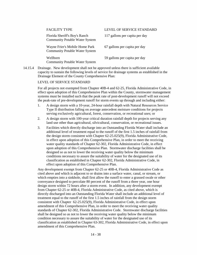
FACILITY TYPE LEVEL OF SERVICE STANDARD
Florida Sheriff's Boy's Ranch 117 gallons per capita per day Community Potable Water System Wayne Frier's Mobile Home Park 67 gallons per capita per day Community Potable Water System Wellborn 59 gallons per capita per day Community Potable Water System
14.15.4 Drainage. New development shall not be approved unless there is sufficient available capacity to sustain the following levels of service for drainage systems as established in the Drainage Element of the County Comprehensive Plan:
LEVEL OF SERVICE STANDARD
For all projects not exempted from Chapter 40B-4 and 62-25, Florida Administrative Code, in effect upon adoption of this Comprehensive Plan within the County, stormwater management systems must be installed such that the peak rate of post-development runoff will not exceed the peak-rate of pre-development runoff for storm events up through and including either: 1. A design storm with a 10-year, 24-hour rainfall depth with Natural Resources Service
Type II distribution falling on average antecedent moisture conditions for projects serving exclusively agricultural, forest, conservation, or recreational uses; or
2. A design storm with 100-year critical duration rainfall depth for projects serving any land use other than agricultural, silvicultural, conservation, or recreational issues.
3. Facilities which directly discharge into an Outstanding Florida Water shall include an additional level of treatment equal to the runoff of the first 1.5 inches of rainfall from the design storm consistent with Chapter 62-25.025(9), Florida Administrative Code, in effect upon adoption of this Comprehensive Plan, in order to meet the receiving water quality standards of Chapter 62-302, Florida Administrative Code, in effect upon adoption of this Comprehensive Plan. Stormwater discharge facilities shall be designed so as not to lower the receiving water quality below the minimum conditions necessary to assure the suitability of water for the designated use of its classification as established in Chapter 62-302, Florida Administrative Code, in effect upon adoption of this Comprehensive Plan.
Any development exempt from Chapter 62-25 or 40B-4, Florida Administrative Code as cited above and which is adjacent to or drains into a surface water, canal, or stream, or which empties into a sinkhole, shall first allow the runoff to enter a grassed swale or other conveyance designed to percolate 80 percent of the runoff from a three year, one hour design storm within 72 hours after a storm event. In addition, any development exempt from Chapter 62-25 or 40B-4, Florida Administrative Code, as cited above, which is directly discharged into an Outstanding Florida Water shall include an additional level of treatment equal to the runoff of the first 1.5 inches of rainfall from the design storm consistent with Chapter 62-25.025(9), Florida Administrative Code, in effect upon amendment of this Comprehensive Plan, in order to meet the receiving water quality standards of Chapter 62-302, Florida Administrative Code. Stormwater discharge facilities shall be designed so as not to lower the receiving water quality below the minimum condition necessary to assure the suitability of water for the designated use of its classification as established in Chapter 63-302, Florida Administrative Code, in effect upon amendment of this Comprehensive Plan.
14 - 38
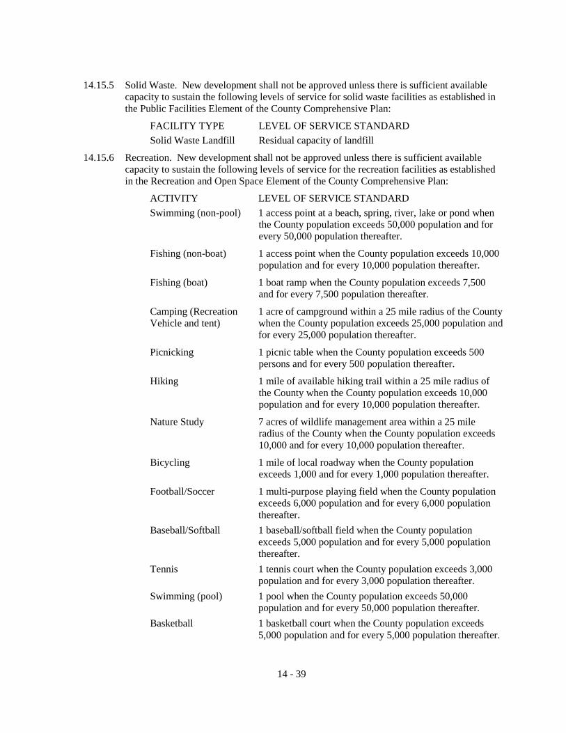
14.15.5 Solid Waste. New development shall not be approved unless there is sufficient available
capacity to sustain the following levels of service for solid waste facilities as established in the Public Facilities Element of the County Comprehensive Plan:
FACILITY TYPE LEVEL OF SERVICE STANDARD Solid Waste Landfill Residual capacity of landfill
14.15.6 Recreation. New development shall not be approved unless there is sufficient available capacity to sustain the following levels of service for the recreation facilities as established in the Recreation and Open Space Element of the County Comprehensive Plan:
ACTIVITY LEVEL OF SERVICE STANDARD Swimming (non-pool) 1 access point at a beach, spring, river, lake or pond when
the County population exceeds 50,000 population and for every 50,000 population thereafter.
Fishing (non-boat) 1 access point when the County population exceeds 10,000 population and for every 10,000 population thereafter.
Fishing (boat) 1 boat ramp when the County population exceeds 7,500 and for every 7,500 population thereafter.
Camping (Recreation 1 acre of campground within a 25 mile radius of the County Vehicle and tent) when the County population exceeds 25,000 population and for every 25,000 population thereafter.
Picnicking 1 picnic table when the County population exceeds 500 persons and for every 500 population thereafter.
Hiking 1 mile of available hiking trail within a 25 mile radius of the County when the County population exceeds 10,000 population and for every 10,000 population thereafter.
Nature Study 7 acres of wildlife management area within a 25 mile radius of the County when the County population exceeds 10,000 and for every 10,000 population thereafter.
Bicycling 1 mile of local roadway when the County population exceeds 1,000 and for every 1,000 population thereafter.
Football/Soccer 1 multi-purpose playing field when the County population exceeds 6,000 population and for every 6,000 population thereafter.
Baseball/Softball 1 baseball/softball field when the County population exceeds 5,000 population and for every 5,000 population thereafter.
Tennis 1 tennis court when the County population exceeds 3,000 population and for every 3,000 population thereafter.
Swimming (pool) 1 pool when the County population exceeds 50,000 population and for every 50,000 population thereafter.
Basketball 1 basketball court when the County population exceeds 5,000 population and for every 5,000 population thereafter.
14 - 39

ACTIVITY LEVEL OF SERVICE STANDARD Equipped Play Area 1 equipped play area when the County population exceeds
5,000 population and for every 5,000 population thereafter. Physical Exercise 1 physical exercise track when the County population exceeds
16,000 population and for every 16,000 population thereafter. Multi-purpose Court 1 court when the Handball/Racquetball population exceeds
5,000 population and for every 5,000 population thereafter.
14.15.7 Local and Regional Parks
ACTIVITY LEVEL OF SERVICE STANDARD Local Parks 2.0 acres per 1,000 population
Regional Parks 3.0 acres per 1,000 population
14.15.8 Public School Facilities
ACTIVITY LEVEL OF SERVICE STANDARD Elementary 100 percent of permanent Florida Inventory of School Houses
capacity as adjusted annually by the School Board to account for measurable programmatic changes.
Middle 100 percent of permanent Florida Inventory of School Houses capacity as adjusted annually by the School Board to account for measurable programmatic changes.
Middle/High 100 percent of permanent Florida Inventory of School Houses capacity as adjusted annually by the School Board to account for measurable programmatic changes.
High School 100 percent of permanent Florida Inventory of School Houses capacity as adjusted annually by the School Board to account for measurable programmatic changes.
14.16 PROPORTIONATE FAIR-SHARE TRANSPORTATION PROGRAM 14.16.1 Purpose and Intent The purpose of this section is to establish a method whereby the impacts of development on
transportation facilities can be mitigated by the cooperative efforts of the public and private sectors, to be known as the Proportionate Fair-Share Transportation Program, as required by and in a manner consistent with Section 163.3180(16), Florida Statutes.
14.16.2 Applicability
The Proportionate Fair-Share Transportation Program shall apply to all developments in the County that have been notified of a lack of capacity to satisfy transportation concurrency on a transportation facility in the County Concurrency Management System, including transportation facilities maintained by Florida Department of Transportation or another jurisdiction that are relied upon for concurrency determinations, pursuant to the concurrency requirements of this Article of the Land Development Regulations. The Proportionate Fair-Share Transportation Program does not apply to developments of regional impact using proportionate fair-share under Section 163.3180(12), Florida Statutes, or to developments exempted from concurrency as provided in the Comprehensive Plan and this Article of the Land Development Regulations, and/or Section 163.3180, Florida Statutes, regarding exceptions and de minimis impacts.
14 - 40

14.16.3 General Requirements
1. An applicant may choose to satisfy the transportation concurrency requirements of the County by making a proportionate fair-share contribution, pursuant to the following requirements: a. The proposed development is consistent with the Comprehensive Plan and
applicable land development regulations, and b. The Five-Year Schedule of Capital Improvements in the Capital Improvements
Element of the Comprehensive Plan or the long-term schedule of capital improvements for an adopted long-term Concurrency Management System includes a transportation improvement(s) that, upon completion, will satisfy the requirements of the Concurrency Management System. The provisions of paragraph (2) of this General Requirements subsection herein may apply if a project or projects needed to satisfy concurrency are not presently contained within the Capital Improvements Element of the Comprehensive Plan or an adopted long-term schedule of capital improvements for an adopted long-term Concurrency Management System.
2. The County may choose to allow an applicant to satisfy transportation concurrency through the Proportionate Fair-Share Transportation Program by contributing to an improvement that, upon completion, will satisfy the requirements of the Concurrency Management System, but is not contained in the Five-Year Schedule of Capital Improvements in the Capital Improvements Element or a long-term schedule of capital improvements for an adopted long-term Concurrency Management System, where the following apply: a. The County adopts, by resolution, a commitment to add the improvement to the
Five-Year Schedule of Capital Improvements in the Capital Improvements Element of the Comprehensive Plan or long-term schedule of capital improvements for an adopted long-term Concurrency Management System no later than the next regularly scheduled annual Capital Improvements Element update. To qualify for consideration under this section, the proposed improvement must be reviewed by the Local Planning Agency, and determined to be financially feasible pursuant to Section 163.3180(16)(b)1., Florida Statutes, consistent with the Comprehensive Plan, and in compliance with the provisions of this section. Financial feasibility for this section means that additional contributions, payments or funding sources are reasonably anticipated during a period not to exceed ten (10) years to fully mitigate impacts on the transportation facilities.
b. If the funds allocated for the Five-Year Schedule of Capital Improvements in the Capital Improvements Element of the Comprehensive Plan are insufficient to fully fund construction of a transportation improvement required by the Concurrency Management System, the County may still enter into a binding proportionate fair-share agreement with the applicant authorizing construction of that amount of development on which the proportionate fair-share is calculated if the proportionate fair-share amount in such agreement is sufficient to pay for one (1) or more improvements which will, in the opinion of the governmental entity or entities maintaining the transportation facilities, significantly benefit the impacted transportation system.
14 - 41

The improvement or improvements funded by the proportionate fair-share component must be adopted into the Five-Year Schedule of Capital Improvements in the Capital Improvements Element of the Comprehensive Plan or the long-term schedule of capital improvements for an adopted long-term schedule of capital improvements for an adopted long-term Concurrency Management System at the next regularly scheduled annual Capital Improvements Element of the Comprehensive Plan update.
3. Any improvement project proposed to meet the applicant’s fair-share obligation must meet design standards of the County for locally maintained roadways and those of the Florida Department of Transportation for the state highway system.
14.16.4 Intergovernmental Coordination
Pursuant to policies in the Intergovernmental Coordination Element of the Comprehensive Plan and applicable policies in the North Central Florida Strategic Regional Policy Plan, the County shall coordinate with affected jurisdictions, including Florida Department of Transportation, regarding mitigation to impacted facilities not under the jurisdiction of the County. An interlocal agreement may be established with other affected jurisdictions for this purpose.
14.16.5 Application Process
1. Upon notification of a lack of capacity to satisfy transportation concurrency, the applicant shall also be notified in writing of the opportunity to satisfy transportation concurrency through the Proportionate Fair-Share Transportation Program pursuant to the requirements of this section.
2. Prior to submitting an application for a proportionate fair-share agreement, a pre-application meeting shall be held to discuss eligibility, application submittal requirements, potential mitigation options, and related issues. If the impacted facility is on the Strategic Intermodal System, then the Florida Department of Transportation will be notified and invited to participate in the pre-application meeting.
3. Eligible applicants shall submit an application to the County that includes an application fee, as established by a fee resolution, as amended, by the County, and the following:
a. Name, address and telephone number of owner(s), developer and agent;
b. Property location, including parcel identification numbers;
c. Legal description and survey of property;
d. Project description, including type, intensity and amount of development;
e. Phasing schedule, if applicable; and
f. Description of requested proportionate fair-share mitigation method(s).
4. The County shall review the application and certify that the application is sufficient and complete within thirty (30) calendar days. If an application is determined to be insufficient, incomplete or inconsistent with the general requirements of the Proportionate Fair-Share Transportation Program as described in this section, then the applicant will be notified in writing of the reasons for such deficiencies within thirty (30) calendar days of submittal of the application. If such deficiencies are not remedied by the applicant within thirty (30) calendar days of receipt of the written
14 - 42

notification, then the application will be deemed abandoned. The Board of County Commissioners may, in its discretion, grant an extension of time not to exceed sixty (60) calendar days to cure such deficiencies, provided that the applicant has shown good cause for the extension and has taken reasonable steps to effect a cure.
5. Pursuant to Section 163.3180(16)(e), Florida Statutes, proposed proportionate fair-share mitigation for development impacts to facilities on the Strategic Intermodal System requires the concurrence of the Florida Department of Transportation. The applicant shall submit evidence of an agreement between the applicant and the Florida Department of Transportation for inclusion in the proportionate fair-share transportation agreement.
6. When an application is deemed sufficient, complete and eligible, the applicant shall be advised in writing and a proposed proportionate fair-share obligation and binding agreement will be prepared by the County and delivered to the appropriate parties for review, including a copy to the Florida Department of Transportation for any proposed proportionate fair-share mitigation on a Strategic Intermodal System facility, no later than sixty (60) calendar days from the date at which the applicant received the notification of a sufficient application and no fewer than fifteen (15) calendar days prior to the Board of County Commissioners meeting when the agreement will be considered.
7. The County shall notify the applicant regarding the date of the Board of County Commissioners meeting when the agreement will be considered for final approval. No proportionate fair-share agreement will be effective until approved by the Board of County Commissioners.
14.16.6 Determining Proportionate Fair-Share Obligation
1. Proportionate fair-share mitigation for concurrency impacts may include, without limitation, separately or collectively, private funds, contributions of land, and construction and contribution of facilities.
2. A development shall not be required to pay more than its proportionate fair-share. The fair market value of the proportionate fair-share mitigation for the impacted facilities shall not differ regardless of the method of mitigation.
3. The methodology used to calculate an applicant’s proportionate fair-share obligation shall be as provided for in Section 163.3180 (12), Florida Statutes, as follows:
The cumulative number of trips from the proposed development expected to reach roadways during peak hours from the complete build out of a stage or phase being approved, divided by the change in the peak hour maximum service volume (MSV) of roadways resulting from construction of an improvement necessary to maintain the adopted level of service (LOS), multiplied by the construction cost, at the time of developer payment, of the improvement necessary to maintain the adopted LOS. OR
Proportionate Fair-Share = S[[(Development Tripsi) / (SV Increasei)] x Costi ] Where:
Development Tripsi = Those trips from the stage or phase of development under review that are assigned to roadway segment “I” and have triggered a deficiency per the Concurrency Management System;
14 - 43

SV Increasei = Service volume increase provided by the eligible
improvement to roadway segment “I” per section E; Costi = Adjusted cost of the improvement to segment “I”. Cost
shall include all improvements and associated costs, such as design, right-of-way acquisition, planning, engineering, inspection, and physical development costs directly associated with construction at the anticipated cost in the year it will be incurred.
4. For the purposes of determining proportionate fair-share obligations, the County shall determine improvement costs based upon the actual cost of the improvement as obtained from the Capital Improvements Element of the Comprehensive Plan, or the Florida Department of Transportation Work Program. Where such information is not available, improvement cost shall be determined using one of the following methods.
a. An analysis by the County of costs by cross section type that incorporates data from recent projects and is updated annually and approved by the Board of County Commissioners. In order to accommodate increases in construction material costs, project costs shall be adjusted by the following inflation factor:
Costn = Cost0 x (1 + Cost_growth3yr)n
Where:
Costn = The cost of the improvements in year n;
Cost0 = The cost of the improvement in the current year;
Cost_growth3yr = The growth rate of costs over the last three years;
n = The number of years until the improvement is constructed.
The three-year growth rate is determined by the following formula:
Cost_growth3yr = [Cost_growth-1 + Cost_growth-2 + Cost_growth-3]/3
Where:
Cost_growth3yr = The growth rate of costs over the last three years;
Cost_growth-1 = The growth rate of costs in the previous year;
Cost_growth-2 = The growth rate of costs two years prior;
Cost_growth-3 = The growth rate of costs three years prior.
b. The most recent Florida Department of Transportation Transportation Costs report, as adjusted based upon the type of cross-section (urban or rural); locally available data from recent projects on acquisition, drainage and utility costs; and significant changes in the cost of materials due to unforeseeable events. Cost estimates for state road improvements not included in the adopted Florida Department of Transportation Work Program shall be determined using this method in coordination with the Florida Department of Transportation.
5. If the County has accepted an improvement project proposed by the applicant, then the value of the improvement shall be determined using one (1) of the methods provided in this section.
14 - 44

6. If the County has accepted right-of-way dedication for the proportionate fair-share
payment, credit for the dedication of the non-site related right-of-way shall be valued on the date of the dedication at one hundred twenty percent (120%) of the most recent assessed value by the County Property Appraiser or, at the option of the applicant, by fair market value established by an independent appraisal approved by the County and at no expense to the County. The applicant shall supply a drawing and legal description of the land and a certificate of title or title search of the land to the County at no expense to the County. If the estimated value of the right-of-way dedication proposed by the applicant is less than the County estimated total proportionate fair-share obligation for that development, then the applicant must also pay the difference. Prior to purchase or acquisition of any real estate or acceptance of donations of real estate intended to be used for the proportionate fair-share, public or private partners should contact the Florida Department of Transportation for essential information about compliance with federal law and regulations.
14.16.7 Proportionate Fair-Share Agreements
1. Upon execution of a Proportionate Fair-Share Agreement the applicant shall receive County concurrency approval. Should the applicant fail to apply for a development permit within twelve (12) months of the execution of the Proportionate Fair-Share Agreement, then the Proportionate Fair-Share Agreement shall be considered null and void, and the applicant shall be required to reapply.
2. Payment of the proportionate fair-share contribution is due in full prior to issuance of the final development order or recording of the final plat and shall be non-refundable. If the payment is submitted more than twelve (12) months after the date of execution of the Agreement, then the proportionate fair-share cost shall be recalculated at the time of payment based on the best estimate of the construction cost of the required improvement at the time of payment, pursuant to the Determining Proportionate Fair-Share Obligation subsection herein and adjusted accordingly.
3. All developer improvements authorized under this section must be completed prior to issuance of a development permit, or as otherwise established in a binding agreement that is accompanied by a security instrument that is sufficient to ensure the completion of all required improvements. Any required improvements shall be completed before issuance of building permits.
4. Dedication of necessary right-of-way for facility improvements pursuant to a proportionate fair-share agreement must be completed prior to issuance of the final development order or recording of the final plat.
5. Any requested change to a development project subsequent to a development order may be subject to additional proportionate fair-share contributions to the extent the change would generate additional traffic that would require mitigation.
6. Applicants may submit a letter to withdraw from the Proportionate Fair-Share Agreement at any time prior to the execution of the Proportionate Fair-Share Agreement. The application fee and any associated advertising costs to the County are non-refundable.
14 - 45
14.16.8 Appropriation of Fair-Share Revenues
1. Proportionate fair-share revenues shall be placed in the appropriate project account for funding of scheduled improvements in the Capital Improvements Element of the Comprehensive Plan, or as otherwise established in the terms of the Proportionate Fair-Share Agreement. At the discretion of the Board of County Commissioners, proportionate fair-share revenues may be used for operational improvements prior to construction of the capacity project from which the proportionate fair-share revenues were derived. Proportionate fair-share revenues may also be used as the fifty percent (50%) local match for funding under the Florida Department of Transportation’s Transportation Regional Incentive Program.
2. In the event a scheduled facility improvement is removed from the Capital Improvements Element of the Comprehensive Plan, then the revenues collected for its construction may be applied toward the construction of another improvement within that same corridor or sector that would mitigate the impacts of development pursuant to the requirements of this section.
Where an impacted regional facility has been designated as a regionally significant transportation facility in an adopted regional transportation plan as provided in Section 339.155, Florida Statutes, and then the County may coordinate with other impacted jurisdictions and agencies to apply proportionate fair-share contributions and public contributions to seek funding for improving the impacted regional facility under the Florida Department of Transportation’s Transportation Regional Incentive Program. Such coordination shall be ratified by the Board of County Commissioners through an interlocal agreement that establishes a procedure for earmarking of the developer contributions for this purpose.
SECTION 14.17 SPECIAL PERMITS FOR SOLID WASTE FACILITIES
The criteria set forth in this section apply to the siting of all solid waste facilities in the County, including solid waste transfer facilities, Class I landfills and Class III landfills (construction and demolition landfills). A special permit for the siting of a solid waste landfill shall be obtained from the Board of County Commissioners.
This section lists submissions required of applicants for new or expanded solid waste facilities, in the County, including solid waste transfer facilities, Class I landfills and Class III landfills (construction and demolition landfills) in order for the County to determine if the general siting criteria are met. All applicants shall demonstrate compliance with the criteria of this section and submit the listed submissions.
14.17.1 Title, Right or Interest
1. Standards: The applicant shall demonstrate to the County's satisfaction sufficient title, right or interest in all of the property which is proposed for development or use.
2. Submissions: The applicant shall submit evidence of sufficient title, right or interest.
14.17.2 Financial Ability
1. Standards:
a. The applicant shall have the financial ability to design, construct, operate, maintain, close and (if applicable) accomplish post-closure care of the solid waste facility in a manner consistent with all applicable requirements.
14 - 46

b. The applicant for a solid waste disposal facility shall provide adequate financial
assurance for closure, post-closure care, and for corrective action for known releases in compliance with the requirements of the Florida Department Environmental Protection.
2. Submissions:
The application shall include evidence that affirmatively demonstrates that the applicant has the financial ability to undertake the proposed project, including the following information, when appropriate:
a. Accurate cost estimates for the design, construction, operation, maintenance, closure and (if applicable) post-closure care of the solid waste facility.
b. Evidence that funds are or will be available to design, construct, operate, maintain, close and (if applicable) accomplish post-closure care of the solid waste facility, or to contract for the same, including the following: i. When a financial institution, governmental agency or other funding
agency is the funding source, the application shall include: (1) A letter from a financial institution, governmental agency, or other
funding agency indicating a commitment to provide a specified and sufficient amount of funds and the uses for which the funds may be utilized; or
(2) In cases where funding is required, but there can be no commitment of money until approvals are received, a letter of "intent to fund" from the appropriate funding institution. Evidence of financing shall be provided prior to project construction.
ii. When self-financing is a funding source for the solid waste facility, the application shall include:
(1) The most recent corporate annual report or most recent fiscal year financial statements indicating availability of sufficient funds to finance the proposed project, through self-financing, together with explanatory material interpreting the report;
(2) Evidence that funds are available and have been set aside for completion of the proposed project; or
(3) If the applicant is a governmental entity, evidence that the entity has the bonding or other capacity to finance the proposed project.
14.17.3 Technical Ability
1. Standards:
a. The applicant shall have the technical ability to design, construct, operate, maintain, close and (if applicable) accomplish post-closure care of the solid waste facility in a manner consistent with state requirements.
2. Submissions:
The application shall include evidence that affirmatively demonstrates that the applicant has the technical ability to design, construct, operate, maintain, close and (if applicable) accomplish post-closure care of the solid waste facility, including information such as the following:
14 - 47

a. A statement of the applicant's prior solid waste management experience or
appropriate training or both; and
b. A description of the personnel who will be employed to design, construct, operate, maintain, close and (if applicable) accomplish post-closure care of the proposed facility.
14.17.4 Provisions for Traffic Movement
1. Standards:
The applicant for a solid waste facility shall make adequate provisions for safe and uncongested traffic movement of all types into, out of, and within the proposed solid waste facility.
a. The major haul routes shall be able to safely accommodate the number, weight and types of vehicles transporting waste to and from the proposed solid waste facility.
b. The entrance and exit design for the proposed solid waste facility shall have safe sight distances in all directions and provisions for safe turning.
c. Improvements to roads or intersections that are necessary due to the establishment of the proposed solid waste facility shall be completed prior to initial operation of the solid waste facility, unless an alternative schedule is approved by the County and/or the Florida Department of Transportation.
d. Major interior travel lanes shall be designed to allow continuous and uninterrupted traffic movement without posing danger to pedestrians or other vehicles.
e. The facility road construction and maintenance shall provide safe traffic movement.
f. On-site circulation patterns shall be clearly defined.
2. Submissions:
The application shall contain evidence that roads and intersections in the vicinity of the proposed solid waste facility will safely and conveniently handle the traffic attributable to the facility. This evidence shall include the following: a. An estimate of the number, weight, and types of vehicles that will be
transporting waste to and from the proposed facility. b. A map clearly delineating the anticipated major haul routes to and from the
facility to be used by vehicles serving or using the solid waste facility, with a description of the road characteristics, including legal weight limits and restrictions.
c. An identification of all sections of roads and intersections along the projected haul routes that are:
i. Congested locations, or
ii. Not rated to handle the weights or types of vehicles expected to transport solid waste to or from the facility.
d. Identification of vehicle routing decisions that were made based on these limits and a description of any actions the applicant proposes to take.
14 - 48
e. A Florida Department of Transportation inventory and analysis of traffic
accidents on roads and at intersections within a quarter mile of the proposed solid waste facility entrances and exits during the most recent three (3)-year period. The inventory shall include identification of high accident locations and identification of feasible countermeasures based on discernible accident patterns at any high accident location.
f. Sight distances at the proposed solid waste facility entrances and exits and a copy of the Florida Department of Transportation access permit, if applicable, or if the solid waste facility entrance is not located on a state supported highway, evidence that a qualified professional engineer has certified that safe sights distances will exist in all directions. This review shall be conducted in conformance with the standards specified in A Policy on Geometric Design of Highways and Streets, 6th Edition, American Association of State Highway and Transportation Officials (2011); and the Manual of Uniform Minimum Standards For Design, Construction and Maintenance For Streets and Highways (Commonly known as the “Florida Greenbook”), State of Florida Department of Transportation (May 2011). Intersection sight distance is the length of roadway visible to the driver. It shall be measured from the intersection (at a point ten (10) feet back from the edge of the travel way) to the centerline of the opposing lane(s).
g. The nature of the interior roadways, intersections and parking facilities, including the following:
i. Road construction, number of lanes, width of road, speed limit, and traffic circulation of the proposed roads;
ii. Areas of pedestrian use;
iii. How circulation patterns will be defined; and
iv. How the facility roads will be maintained.
h. A traffic study, if required by the County. The County will require a traffic study if the application does not contain sufficient information to determine that all of the traffic standards of this section will be met. A traffic study may also be required if a traffic standard that is not met could possibly be corrected by application or design changes that require additional information. The County’s determination that a traffic study is required may be based solely on information or comments submitted to it by the Florida Department of Transportation.
3. Elements of a Traffic Study. A traffic study shall meet the requirements of this paragraph. The year for which the study results are to be characterized is the projected first year of full operation. If the proposed solid waste facility is a multi-phase project with a projected completion date more than five (5) years after the year of the study, the County may require that the study results be characterized for the year that corresponds to the opening of the first major phase or to the timing of transportation system improvements, such as a major bridge construction project.
At a minimum, the traffic study shall contain the following:
a. A brief description of the physical characteristics of the solid waste facility. This section shall identify the size of the facility site, general terrain features and unique terrain features.
14 - 49

b. A regional map showing the proposed solid waste facility, each road in the
vicinity of the proposed facility and proposed haul routes to and from the facility for the vehicles that will use or serve the facility.
c. A description of traffic increases that are expected from sources other than the proposed solid waste facility and that are likely to occur in the vicinity of the proposed solid waste facility during the study period. At a minimum, the study shall identify development or redevelopment proposals which have been approved, either locally or by the County, and development or redevelopment proposals for which complete applications have been filed with and accepted by a neighboring municipality or the County at the time of the traffic study.
d. Trip generation calculations for the proposed solid waste facility and for other proposed development and redevelopment projects in the vicinity of the proposed solid waste facility. If data from the “Trip Generation Guide” of the Institute of Transportation Engineers is not available for other proposed development and redevelopment projects, trip generation shall be estimated in accordance with a methodology approved by the Florida Department of Transportation.
e. A diagram of the traffic volume on roads and intersections in the vicinity of the proposed solid waste facility for both the estimated annual average daily traffic and the A.M./P.M. peak hour traffic, including turns during the peak hour. Traffic diagrams shall show the following:
i. Traffic attributable to the facility and other developments.
ii. Existing traffic volume. All traffic counts shall be actual counts whenever possible. Traffic counts from the Florida Department of Transportation may be used if not more than two (2) years old.
iii. Projected traffic volume for the hours required above at the time the facility will begin full operation.
iv. Documentation, including all new traffic counts and analysis worksheets, as to how the various volumes were derived to accompany the diagrams.
f. A capacity analysis shall be performed to determine the level of service for each road and intersection in the vicinity of the proposed solid waste facility. Capacity calculations shall be made for the thirtieth (30th) highest hour of traffic during the year that the facility would begin operation, or any other appropriate design hour approved by the Florida Department of Transportation. Where it is shown that the capacity analysis methodology will not accurately measure operating conditions or levels of service at a road or intersection, the County may require an applicant to analyze operating conditions of an intersection or road using another methodology acceptable to the Florida Department of Transportation.
g. The need for new traffic signals in the vicinity of the proposed solid waste facility shall be analyzed using the warrants in the Manual on Uniform Traffic Control Devices, U.S. Department of Transportation, Federal Highway Administration (2009).
14 - 50
h. A determination of the available sight distances in all directions at each
intersection in the vicinity of the proposed development. Intersection sight distance is the length of roadway visible to the driver. It shall be measured from the intersection (at a point ten (10) feet back from the edge of the travel way) to the centerline of the opposing lane(s).
i. If the study analyses indicate that unsatisfactory levels of service or unsafe conditions exist or will occur at intersections or on roads in the vicinity of the proposed development, a description of the measures recommended to remedy the deficiencies, including the following.
i. Recommended Improvements:
A description and diagram of the location, nature, and extent of recommended improvements to roads and intersections in the vicinity of the proposed development. Accompanying this list of improvements shall be preliminary cost estimates. Of the recommended improvements, those proposed for implementation shall be identified.
ii. Capacity Analysis after Improvement:
A description of the anticipated results of making these improvements.
j. A clear, concise summary of the study findings.
14.17.5 Fitting the Solid Waste Facility Harmoniously into the Natural Environment
1. Standards:
a. The solid waste facility shall have buffer strips of sufficient size and quality to adequately protect aquatic and wildlife habitat and the natural environment. The facility may not unreasonably adversely affect protected natural resources and rare, threatened and endangered plant and animal species.
b. The solid waste facility shall have a minimum of one-hundred (100) feet of buffer between the facility site and those locations and habitats listed above, unless otherwise approved or required by the County.
2. Submissions.
The applicant shall consult with the Florida Fish and Wildlife Conservation Commission to determine the likelihood of there being state or federally listed fish and wildlife species that could reasonably be affected by the construction and operation of Class I and Class III landfills. If such likelihood is determined, then the applicant shall have the proposed site surveyed using generally accepted biological protocols by a biologist familiar with the habitat and seasonal requirement for those listed species. The applicant shall submit the survey to the County.
a. The proposal shall include buffer areas. This information shall include:
i. The location and description of the locations, habitats, and species listed above that are within or adjacent to the facility site;
ii. The nature, location, width, and height of all buffer strips to be retained or enhanced;
iii. The nature, location, width, and topography of all buffer strips that need to be established to restore buffer functions in areas that will be disturbed;
14 - 51

iv. Provisions for the maintenance of all buffer strips and screens; v. A description of how buffer areas of sufficient area, width, and character
will be established, maintained or enhanced to protect the locations and habitats; and
vi. An explanation of how the proposed solid waste facility and activities will not unreasonably adversely affect protected natural resources.
b. The application shall identify all unusual natural areas on or adjacent to the facility site and shall include evidence that affirmatively demonstrates that the proposed facility will not unreasonably adversely affect protected natural resources.
14.17.6 No Unreasonable Adverse Effect on Existing Uses and Scenic Character
1. Standards:
The solid waste facility may not unreasonably adversely affect existing uses and scenic character. Specifically, the facility may not: a. Present a bird hazard to aircraft; b. Have an unreasonable adverse effect on the preservation of historical sites; c. Unreasonably interfere with views from established public viewing areas; d. Generate excessive noise at the property boundary or at any protected location; or e. Unreasonably adversely affect existing uses of property neighboring the
proposed solid waste facility. 2. Noise Standards*:
*Note - The sensitivity of the human ear to sounds of different frequencies is measured by the A-weighted decibel scale (dBA).
The following noise standards shall apply to all solid waste facilities. a. Sound Level Limits. The following hourly sound levels from routine operation
of a solid waste facility shall be less than or equal to; i. Sixty (60) dBA for daytime hours and fifty (50) dBA for nighttime hours
at the facility property boundary adjacent to an area for which the zoning is not predominantly commercial or industrial; or
ii. Seventy (70) dBA for daytime hours and sixty (60) dBA for nighttime hours at the facility property boundary adjacent to an area for which the zoning, or, is predominantly commercial or industrial.
b. Alternative levels. If the applicant chooses to demonstrate by measurement that the daytime or nighttime pre-development ambient sound environment at the location exceeds the daytime or nighttime limits above, by at least five (5) dBA, then the daytime or nighttime limits are five (5) dBA more than the measured daytime or nighttime pre-development ambient hourly sound level at the location of the measurement for the corresponding time period.
c. Existing Facilities. For any protected location near an existing solid waste facility, the hourly sound level limit for routine operation of the existing facility and all future expansions of that facility is the hourly sound level written above, or at the applicant's election, the existing hourly sound level from routine operation of the facility before any expansions plus three (3) dBA.
14 - 52
d. All equipment used in the construction of and maintenance activities at the
solid waste facility shall comply with applicable local and federal noise regulations, and include environmental noise control devices in proper working condition and maintained as originally provided with the equipment by its manufacturer.
e. Sounds associated with the following are exempt from the sound level limits of this section:
i. Routine engine sounds from registered and inspected motor vehicles:
(1) While operating on public rights-of-way, or
(2) That enter the facility to make a delivery or pickup and that are moving, starting or stopping, but not when they are parked with the engine running for over sixty (60) minutes in the facility.
ii. The unamplified human voice and other sounds of natural origin.
iii. Emergency maintenance and repairs.
iv. Facility and vehicle warning signals and alarms so long as used in appropriate circumstances.
v. Safety and protective devices installed in accordance with installation instructions for such devices.
vi. Boiler start-up, testing and maintenance operations occurring no more frequently than once per month.
vii. Test operations of emergency equipment occurring in the daytime and no more frequently than once per week.
viii. Major concrete pours that shall extend after 7:00 p. m., when started before 3:00 p. m.
ix. Landscaping activities.
x. Sound from a regulated development received at a protected location when the generator of the sound has been conveyed a noise easement for that location. This exemption shall only be for the specific noise, land and term covered by the easement.
3. Submissions:
Applications shall include evidence that affirmatively demonstrates that the proposed solid waste facility will not unreasonably adversely affect existing uses and scenic character, including the following information:
a. The nature, location, design, and size of all buffers and visual screens within those buffers to be established or retained;
b. A description of the existing land uses in the vicinity of the proposed solid waste facility, all airport runways within ten thousand (10,000) feet of the facility; all historic sites, protected locations and established public viewing areas within two thousand (2,000) feet;
14 - 53
c. A demonstration that the solid waste facility will comply with the noise
standards in paragraph 2 above and that the applicant will make adequate provision to control noise and the sound levels from each source resulting from the routine operation of the facility at the property boundary;
d. Evidence that acoustic enclosure for noise, buffer strips and screens, or other noise reduction measures have been considered and implemented in the design of the solid waste facility.
14.17.7 No Unreasonable Adverse Effect on Air Quality
1. Standards:
The solid waste facility may not unreasonably adversely affect air quality:
a. The applicant shall obtain an air emission permit if required by Florida Department of Environmental Protection. The air emissions produced from either point or non-point sources shall be in conformance with the current state requirements.
b. The applicant shall control fugitive dust and nuisance odor.
c. Open burning of solid waste other than clean or painted wood waste, is prohibited. Wood that has been treated and other wastes, such as tires or waste oil, shall not be open burned.
2. Submissions:
Applications shall include evidence that affirmatively demonstrates that the proposed facility will not unreasonably adversely affect air quality, including the following information, when appropriate:
a. Evidence that an air emission permit has been or will be obtained if required.
b. Description of the actions that the operator will undertake to control fugitive dust from the solid waste facility when a problem attributable to the facility occurs beyond the property boundary.
c. The identification of any sources of nuisance odors from the facility.
d. An estimation of the area that would be affected by the nuisance odor, based on general experience in dealing with the material or process that is the source of the odors.
e. Proposed systems for enclosure of nuisance odor-producing materials and processes, and proposed uses of technology to control, reduce or eliminate odors.
f. Evidence that the solid waste facility will not unreasonably alter climate if the facility has or is proposed to have water cooling towers.
14.17.8 No Unreasonable Adverse Effect on Surface Water Quality
1. Standards:
A solid waste facility:
a. May not discharge any water pollutants, directly or indirectly, that affect the state classification of a surface water body, as specified in Florida Statutes;
b. May not discharge any pollutant without first obtaining a Florida Department of Environmental Protection permit;
14 - 54

c. May not degrade water quality by contributing to the phosphorous
concentrations in waterbodies that are recognized by the state as an Outstanding Florida Water.
2. Submissions:
Applications shall include evidence that affirmatively demonstrates that there will be no unreasonable adverse effect on surface water quality, including evidence that:
a. The applicant will comply with all applicable Suwannee River Water Management District stormwater management standards.
b. A wastewater discharge permit has been obtained or will be obtained, if required by Florida Statutes.
14.17.9 No Unreasonable Adverse Effect on Other Natural Resources
1. Standards:
The solid waste facility may not have an unreasonably adverse effect on other natural resources in the County or in neighboring counties. The proposed solid waste facility:
a. Shall be permitted by the federal or state government for any activities that require a federal or state wetlands permit.
2. Submissions:
An application shall include the following information, when appropriate:
a. Complete information as to whether a federal or state wetlands permit is required and on whether a federal or state wetlands permit application has been submitted.
14.17.10 Soil Types That Are Suitable and Will Not Cause Unreasonable Erosion
1. Standards:
The solid waste facility shall be located on soils suitable for the nature of the undertaking and the facility shall not cause unreasonable sedimentation or erosion of soil. To meet this requirement:
a. The soils on the facility site shall be suitable for the proposed solid waste facility.
b. The design and implementation of erosion control measures shall ensure that:
i. Sediment caused by accelerated soil erosion shall be minimized from runoff water before it leaves the proposed solid waste facility site or enters a protected natural resource. Suitable erosion control measures shall be in place prior to any disturbance of soil.
ii. Any temporary or permanent structure designed and constructed for the conveyance of water around, through, or from the solid waste facility shall be designed to limit the water flow to a non-erosive velocity.
iii. All earth changes shall be designed, constructed, and completed so that the exposed area of any disturbed land is minimized and is limited to the shortest reasonable period of time possible given the construction requirements. Permanent soil erosion control measures for all slopes, channels, ditches, and disturbed land area shall be completed as specified by the County, after final grading has been completed. Seeding shall
14 - 55

occur within fifteen (15) calendar days of final grading, unless otherwise approved by the County because of seasonal conditions. When it is not possible or practical to immediately and permanently stabilize disturbed land, temporary stabilization measures will be implemented as approved by the County. In sensitive watersheds or on highly erodible soils or slopes of twenty (20) percent or greater, the County may require a more restrictive schedule for temporary and permanent stabilization of soil.
iv. When vegetative cover is to be established as a temporary or permanent erosion control measure:
(1) Plant species and seeding rates shall take into account soil, slope, climate, duration and use of the vegetative cover.
(2) Mulch shall be provided at rates appropriate to ensure a minimum of soil and seed loss until vegetative cover is established.
(3) Reseeding shall be done within a reasonable period of time if permanent vegetation is not established.
v. All development plans shall utilize existing topography and natural surroundings to the fullest extent possible.
2. Submissions
a. An application shall include a comprehensive erosion and sedimentation control plan that includes the following information:
i. A description and location of all proposed construction activities that may result in soil disturbance,
ii. A description and location of all existing and proposed on-site drainage,
iii. The timing and sequence of all proposed land disturbances,
iv. A description and location of all proposed temporary and permanent erosion and sedimentation control measures, including the timing and sequence of completion and an indication of the suitability of the proposed measures to address the problems that are expected,
v. Calculations for erosion control measures in accordance with best management practices, and
vi. A proposed program for the maintenance of all erosion and sedimentation control facilities that will remain after construction is completed.
b. Where applicable, the application shall include a report showing that the soils are suitable to the undertaking including:
i. Test pit and soil boring information, and
ii. An evaluation by an engineer, soil scientist, or other qualified individual.
14.17.11 No Unreasonable Risk That a Discharge to a Groundwater Aquifer Will Occur
1. Standards:
The proposed solid waste facility may not pose an unreasonable risk of discharge to a groundwater aquifer.
14 - 56

2. Submissions:
An application shall contain information demonstrating that the proposed solid waste facility will not pose unreasonable risk of discharge to a groundwater aquifer.
14.17.12 Adequate Provision for Utilities and No Unreasonable Adverse Effect on Existing or Proposed Utilities
1. Standards:
The applicant shall provide for adequate utilities and the proposed solid waste facility may not have an unreasonable adverse effect on existing or proposed utilities in the County or area served by those utilities.
a. There shall be adequate water supplies for the solid waste facility.
b. Appropriate sanitary wastewater disposal shall exist for the solid waste facility.
2. Submissions:
An application shall include evidence that affirmatively demonstrates that the applicant has made adequate provision for utilities, including water supplies, sewerage facilities and solid waste disposal, and that the proposed solid waste facility will not have an unreasonable adverse effect on existing or proposed utilities in the County or areas served by those utilities, including the following information, when appropriate:
a. Verification that the facility will be served by the appropriate utilities.
b. Evidence that a sufficient and healthful water supply will be provided.
c. The identification of all aspects of the proposed solid waste facility that require access to or use of utilities, along with the provisions that have been made to use those utilities and to comply with any requirements and provisions of the utility.
14.17.13 Not Unreasonably Cause or Increase Flooding
1. Standards:
A solid waste facility may not unreasonably cause or increase flooding on-site or on adjacent properties nor create an unreasonable flood hazard to a structure.
a. A solid waste facility may not be located in a one hundred one hundred (100)-year flood plain or restrict the flow of a one hundred (100)-year flood.
b. A solid waste facility shall include a stormwater management system that controls run-on and run-off, and infiltrates, detains, or retains water falling on the facility site during a storm of an intensity up to and including a twenty-five (25)-year, twenty-four (24)-hour storm, such that the rate of flow of stormwater from the facility after construction does not exceed the rate of outflow of stormwater from the facility site prior to the construction of the facility.
2. Submissions:
An application shall include evidence that affirmatively demonstrates that the facility will not unreasonably cause or increase flooding of the facility site or adjacent properties, will not create an unreasonable flood hazard, and will have no unreasonable effect on run-on, run-off, and/or infiltration relationships, including information such as the following, when appropriate:
14 - 57

a. The most recent Federal Emergency Management Agency one-hundred (100)-
year frequency floodplain map of the area.
b. A narrative describing how the facility site is oriented within the watershed, identifying downstream ponds, lakes, and mapped wetland areas, and addressing the effects of facility site runoff on the watershed and nearby properties. The narrative shall also identify areas, buildings and facilities that historically flood or which may be affected by the facility site run-off and shall discuss the assumptions used in determining run-off curve numbers, time of concentration and travel time calculations for each drainage sub-area.
c. Pre-construction drainage study plans showing existing contours, and all topographic features including but not limited to: buildings and facilities, natural and man-made drainage ways, streams, channels, culverts, cover type, elevation benchmarks and datum, catch basins, roads, drainage easements, hydrologic flow lines, hydrologic soil groups, and watershed boundaries (on and off site).
d. Post-construction or phased drainage study plans showing final or phased contours, all relevant existing contours, and all proposed topographic and other features including but not limited to: buildings and other facilities, natural and manmade drainage ways, streams, channels, culverts, catch basins, roads, drainage easements, cover type, elevation bench marks and datum, hydrologic flow lines, hydrologic soil groups, and final or phased watershed boundaries (on and off site).
e. Pre-construction stormwater calculations for twenty-five (25)-year, twenty- four (24)-hour storms including runoff curve numbers, time of concentration, and travel times for each sub-area.
f. Post-construction or phased stormwater calculations for twenty-five (25)-year, twenty-four (24)-hour storms including: run-on controls, runoff curve numbers, time of concentration, and travel times for each sub-area along with calculations for routing the stormwater through detention areas and detention basins.
g. Basin storage values and sizing calculations, including stage-storage curves and outlet velocities for each detention basin.
h. Outlet and spillway detail and sizing calculations for each detention basin.
14.17.14 Public Benefit Determination.
Except for facilities specifically exempted below, a solid waste disposal facility may to be located, established, constructed or expanded without a determination by the County that the proposed solid waste disposal facility or expansion provides a substantial public benefit.
1. Exemptions.
The following solid waste disposal facilities are not subject to the requirements of this section:
a. Facilities owned by the State, and
b. Facilities that were lawfully permitted on or before December 31, 2011.
2. Rebuttable Presumption of Public Benefit.
For the following solid waste disposal facilities, substantial public benefit is determined at the time of permitting employing a rebuttable presumption of public benefit:
14 - 58

a. Solid waste disposal facilities less than six (6) acres in size that accept only inert
fill, construction and demolition debris, debris from land clearing and wood wastes; and
b. Solid waste disposal facilities used exclusively for the disposal of waste generated by the owner of the facility except that the facility may accept, on a nonprofit basis, waste not generated by the owner provided that the amount so accepted does not exceed fifteen percent (15%) of all solid waste accepted on an annual basis.
14.17.15 Pre-Application Determination of Public Benefit. For all solid waste disposal facilities not described in the subsections above the County will
not accept for processing an application for a solid waste disposal facility subject to this requirement until the Board of County Commissioners makes the following determination. 1. Standard for public benefit determination. The Board of County Commissioners
shall find that the proposed solid waste disposal facility or expansion provides a substantial public benefit if the facility meets immediate, short-term, or long-term capacity needs of the County.
In making the determination of whether the facility provides a substantial public benefit, the Board of County Commissioners shall consider the written information in support of the application, and any other written information the Board of County Commissioners considers relevant.
2. Application procedure for public benefit determination. Prior to submitting an application for a siting of a new or expanded solid waste disposal facility, a person shall apply to the Board of County Commissioners for a determination of whether the proposed facility provides a substantial public benefit. At least ten (10) days prior to submitting an application for a determination of public benefit, the applicant shall give notice of intent to file the application. This notice shall be mailed by certified mail to the County. A public notice shall also be published once at least ten (10) days prior to submitting an application for a finding of public benefit in a newspaper of general circulation in the County.
The application for a determination of public benefit shall be made on a form provided by the County. It shall include a demonstration that the facility meets the standards in paragraph 1 above and a copy of the public notice.
At the time of filing with the County, a copy of the application, its supporting documents and all amendments to an application shall be filed by the applicant with the County.
The Board of County Commissioners shall accept written public comment on the application for twenty-one (21) days after the date of public notice. The Board of County Commissioners shall hold a public hearing to take public comments, and shall consider those comments in making the determination. The Board of County Commissioners shall issue a decision concerning a public benefit determination within sixty (60) days of receipt of the application.
14.17.16 Procedures for review of permit requests 1. Following a determination of public benefit and upon receipt of a permit application,
the Land Development Regulation Administrator shall determine within twenty-one (21) calendar days whether the application contains the required elements and is complete. If incomplete, the Land Development Regulation Administrator shall inform the applicant of the deficiencies and allow resubmittal of the application within ninety (90) days without repayment of the application fee.
14 - 59

2. Upon making a determination that the permit application is complete, the Land
Development Regulation Administrator shall send the application and associated submittals to the Suwannee River Water Management District for its review. The Water Management District shall provide to the County a written review of the application within (21) calendar days.
3. After receipt of the Water Management District written review or after expiration of the above time period for the Water Management District to complete their review, the application shall be placed on the agenda of the next regularly scheduled Planning and Zoning Board meeting, allowing for required public notice. The Planning and Zoning Board shall review the proposal and make a recommendation to the Board of County Commissioners.
4. The application shall then be placed on the agenda of the next regularly scheduled Board of County Commissioners meeting, allowing for required public notice. The Board of County Commissioners shall hold a quasi-judicial hearing on the application in accordance with applicable County procedures.
5. Notice of the public hearing by the Planning and Zoning Board and Board of County Commissioners on the Solid Waste Facility Special Permit shall, at least ten (10) days prior to the public hearings, be posted at all entrances to the proposed land application site abutting federal, state or County roads, easements, right-of-ways, or as otherwise directed by the Land Development Regulation Administrator to maximize notice to surrounding landowners.
6. Notice of the Planning and Zoning Board and Board of County Commissioners public hearings shall also be published once in a publication of general circulation at least ten (10) days prior to the public hearing.
14.17.17 Solid Waste Facility Cost Recovery
1. Cost recovery:
To the extent that any solid waste facility siting special permit requires additional review by County staff, County contractors, agents or consultants, the actual cost of such additional review shall be passed on to the applicant.
a. Professional review:
Cost for the County attorney and/or outside contractors, agents or consultants of the County shall be charged to the applicant in an amount equal to the actual hourly rate charged to the County. The term "additional review," as used herein above, includes all review services provided in circumstances in which the County utilizes the services of an outside contractor, agent or consultant for the application or item or other circumstances in which review or work by the County attorney exceeds a period of one (1) hour.
b. Administrative fee:
An administrative fee of three (3) percent of the recoverable costs shall be added as a surcharge to cover the County's cost in administering and billing cost recovery hereunder.
c. Preliminary deposit:
14 - 60

Persons who file a solid waste facility siting special permit application for
which cost recovery is applicable and necessitates additional review shall pay, prior to or at the time the application is filed or the review request is made, an initial preliminary deposit which shall be credited toward the charges for such review and processing, and shall pay additional deposits as may be required from time to time. The amount of the initial deposit for the different types of applications or review requests shall be commensurate with the anticipated cost recovery, and shall be established, and from time to time may be amended, by the County Administrator or his/her designee.
d. Application account.
i. Opening. When the person pays the initial deposit, a financial account for the application or review request (the "project account") will be opened and shall be maintained throughout the entire review process until: the person receives a certificate of occupancy; the development services or other applicable County department determines that no further action is necessary for the review and processing of the matter; or the applicant voluntarily withdraws the application or the request for review, and in such event the project account shall be closed.
ii. Closure. Once the project account is closed, any remaining funds that are not owed to the County shall be refunded to the person making the deposit no later than two (2) months after the closing date of the project account.
iii. Supplemental deposit. The project account will be monitored by the County on a periodic basis. Whenever the account balance is found by County staff to have become diminished to an inadequate level, a supplemental deposit will be required before any further review or processing continues. The person making the initial deposit will be notified when a supplemental deposit will be required. The amount of the supplemental deposit shall be fifty (50) percent of the initial deposit. Several supplemental deposits may be necessary depending on the complexity of the review request. Except as provided herein, any notification provided in this section for supplemental deposits from the County to a person initiating an application or a review request shall be made by certified letter to such person or his/her agent.
iv. Contacts; notification. It shall be the duty of persons who initiate applications or review requests to provide on the filed application or review request a continuously updated address where said persons or their agents may conveniently be reached for purposes of notification under this section. If an attempt to notify a person initiating an application or a review request or his/her agent is frustrated because the furnished addresses were incorrect or not up to date when the notification attempt was made, such frustrated attempt shall be deemed sufficient notice for purposes of complying with this section.
2. Applicability of provisions. The cost recovery required above shall not apply to applications or transactions that are originally initiated by or on behalf of the County.
14 - 61

3. Building permit fee schedule not affected. The schedule of building permit and
related fees established by resolution of the Board of County Commissioners shall not be affected by this section.
4. Interest charge; enforcement. Unpaid costs and fees payable to the County under this section, including unpaid costs and fees that exist at the time of the adoption of this subsection (6), which are more than thirty (30) days overdue shall be delinquent and shall accumulate interest at the rate of one and one-half (1.5) percent per month upon the unpaid balance until paid. Overdue costs, fees and interest accrued thereon may be collected and enforced in any manner that is allowed by law, and the County shall be authorized to recover reasonable attorney fees incurred in such collection.
14.17.18 Enforcement
1. In the event of failure to comply with any of the provisions contained herein, or with any condition placed on the siting of solid waste landfills, the Land Development Regulation Administrator may require the landfill owner to cease and desist or order such other suitable corrective measures on the part of such landfill owner. Such measures shall include, but are not limited to, the following: closure of the site, additional stabilization, permit revocation or suspension, and any other appropriate process deemed necessary for odor reduction, correction of nuisance problems and/or remedying of violation of this section.
2. In addition to any penalty provided by law for the violation of any of the provisions of this section, the Board of County Commissioners may bring suit in the appropriate court of competent jurisdiction to enjoin, restrain or otherwise prevent the violation of any of the provisions of this section in any manner as provided by law. Should the County be the prevailing party, the County shall be entitled to recover the costs of litigation, including reasonable attorneys fees.
3. The foregoing remedies shall not be exclusive, and the County may invoke any other remedies available pursuant to general law, special act or common law, including the general code enforcement provisions of the County.
14 - 62
ARTICLE FIFTEEN
ENFORCEMENT AND REVIEW

THIS PAGE LEFT BLANK INTENTIONALLY

ARTICLE FIFTEEN. ENFORCEMENT AND REVIEW
SECTION 15.1 COMPLAINTS REGARDING VIOLATIONS
Whenever the Land Development Regulation Administrator receives a written, signed complaint alleging a violation of these land development regulations, he or she shall investigate the complaint, take whatever action is warranted, and inform the complainant in writing what actions have been or will be taken.
SECTION 15.2 PERSONS LIABLE
The owner, tenant, or occupant of any building or land or part thereof and any architect, builder, contractor, agent, or other person who participates in, assists, directs, creates, or maintains any situation that is contrary to the requirements of these land development regulations may be held responsible for the violation and suffer the penalties and be subject to the remedies herein provided.
SECTION 15.3 PROCEDURES UPON DISCOVERY OF VIOLATIONS
1. If the Land Development Regulation Administrator finds that any provision of these land development regulations is being violated, he or she shall send a written notice to the person responsible for such violation, indicating the nature of the violation and ordering the action necessary to correct it. Additional written notices may be sent at the Land Development Administrator's discretion.
2. The final written notice (the initial written notice may be the final notice) shall state what action the Land Development Administrator intends to take if the violation is not corrected and shall advise that the Land Development Regulation Administrator's decision or order may be appealed to the Board of Adjustment in accordance with Section Article 12.
3. Notwithstanding the foregoing, in cases when delay would pose a danger to the public health, safety, or welfare, the Land Development Regulation Administrator may seek enforcement without prior written notice by invoking any of the penalties or remedies authorized in this Article.
SECTION 15.4 PENALTIES AND REMEDIES FOR VIOLATIONS
1. Violations of the provisions of these land development regulations or failure to comply with any of its requirements, including violations of any conditions and safeguards established in connection with grants of variances or special use or conditional-use permits, shall constitute a misdemeanor of the second degree, punishable as provided in Chapter 775, Florida Statutes, as amended. Any person, firm or corporation who violates these land development regulations, or fails to comply with any of its requirements, shall upon conviction of a misdemeanor of the second degree be fined or imprisoned, or both, as provided for in Chapter 125.69, Florida Statutes, and in addition, shall pay all costs and expenses involved in the case. Each day such violation continues shall be a separate offense.
2. Any act constituting a violation of the provisions of these land development regulations or a failure to comply with any of its requirements, including violations of any conditions and safeguards established in connection with the grants of variances or special-use permits, shall also subject the offender to the penalties provided above. If the offender fails to pay this penalty within ten (10) days after being cited for a violation, the penalty may be recovered by the County in a civil action in the nature of debt. A civil penalty may not be appealed to the Board of Adjustment if the offender was sent a final notice of violation in accordance with this Article and did not take an appeal to the Board of Adjustment within the prescribed time.
15 - 1

3. Each day that any violation continues after notification by the Land Development Regulation
Administrator that such violation exists shall be considered a separate offense for purposes of the penalties and remedies specified in this Article.
4. Any one (1), all, or any combination of the foregoing penalties and remedies may be used to enforce these land development regulations.
15 - 2

ARTICLE SIXTEEN
AMENDMENTS

THIS PAGE LEFT BLANK INTENTIONALLY

ARTICLE SIXTEEN. AMENDMENTS
These land development regulations, and Official Zoning Atlas, and other material as set out may from time to time be amended, supplemented, changed, or repealed. Procedures shall be as follows:
SECTION 16.1 INITIATION OF AMENDMENTS
A land development regulation amendment may be proposed by:
1. Board of County Commissioners; 2. Planning and Zoning Board; 3. Board of Adjustment; 4. Any department or Board of the County; 5. Any person other than those listed in 1, 2, 3, or 4 above; provided, however, that no such person
shall propose an amendment for the rezoning of property which he does not own except as agent or attorney for an owner.
All proposals for land development regulation amendments shall be submitted in writing to the office of the Land Development Regulation Administrator accompanied by all pertinent information which may be required by the Planning and Zoning Board for proper consideration of the matter, along with, for persons under 5 above, the payment of such fees and charges as have been established by the Board of County Commissioners (see Article 1). In the case of a petition for the rezoning of land, the Land Development Regulation Administrator shall post a sign advertising the petition for rezoning on a prominent position on said land in conformance with Article 13 herein.
SECTION 16.2 PLANNING AND ZONING BOARD REPORT
16.2.1 Procedure. It is the intent of these land development regulations that all proposed amendments shall be heard in the first instance by the Planning and Zoning Board. Within a reasonable time after a proposed amendment is filed, the Planning and Zoning Board shall submit its report and recommendation concerning the proposed amendment to the Board of County Commissioners.
Before making a recommendation concerning the proposed amendment, the Planning and Zoning Board shall hold a public hearing to consider the proposed zoning amendment in conformance with Article 13 of these land development regulations.
16.2.2 Nature and requirements of Planning and Zoning Board report. When pertaining to the rezoning of land, the report and recommendations of the Planning and Zoning Board to the Board of County Commissioners required by Section 16.2.1 above shall show that the Planning and Zoning Board has considered the proposed change in relation to the following, where applicable:
1. Conformity with the County's Comprehensive Plan and the effects upon the County's Comprehensive Plan.
2. The existing land use pattern.
3. The creation of an isolated district unrelated to adjacent and nearby districts.
4. The impact of the proposed change upon population density pattern and the load on public facilities such as schools, utilities, streets, etc.
5. The existing district boundaries in relation to existing conditions on the property proposed for change.
16 - 1

6. Changed or changing conditions which justify the recommended action on the proposed
amendment.
7. The impact of the proposed change upon living conditions in the neighborhood.
8. The impact of the proposed change upon traffic with particular regard to congestion or other public safety.
9. The impact of the proposed change upon drainage.
10. The impact of the proposed change upon light and air to adjacent areas.
11. The impact of the proposed change upon property values in the adjacent area.
12. The impact of the proposed change upon the improvement or development of adjacent property in accordance with existing regulations.
13. The granting of a special privilege to an individual owner as contrasted with the needs of the overall public welfare.
14. Substantial reasons, if any, why the property cannot be used in accordance with existing zoning.
15. The impact of the proposed change with regard to the scale of needs of the neighborhood or the County.
16. The availability of alternate, adequate sites in the County in districts already permitting such use.
When pertaining to other proposed amendments of these land development regulations. The Planning and Zoning Board shall consider:
1. The need and justification for the change.
2. The relationship of the proposed amendment to the purposes and objectives of the comprehensive planning program and to the County's Comprehensive Plan, with appropriate consideration as to whether the proposed change will further the purposes of these land development regulations and other ordinances, regulations, and actions designed to implement the County's Comprehensive Plan.
16.2.3 Status of Planning and Zoning Board report and recommendations. The report and recommendations of the Planning and Zoning Board required by Section 16.2.1 above shall be advisory only and shall not be binding upon the Board of County Commissioners.
SECTION 16.3 BOARD OF COUNTY COMMISSIONERS: ACTION ON PLANNING AND ZONING BOARD REPORT
Within a reasonable time after receiving the Planning and Zoning Board report and recommendation on a proposed zoning amendment, the Board of County Commissioners shall hold a public hearing to consider the proposed zoning amendment in conformance with Article 13 herein. The Board of County Commissioners shall take final action on the proposed land development regulation amendment by either approving or denying the proposed amendment.
16 - 2

SECTION 16.4 RELATIONSHIP OF AMENDMENTS TO THE COMPREHENSIVE PLAN
If the amendment requires the prior amendment of the County's Comprehensive Plan adopted pursuant to the Local Government Comprehensive Planning and Land Development Regulation Act (Chapter 163.3161 through 163.3215, Florida Statutes) action on an amendment to the County's Comprehensive Plan shall be taken prior to final action on such land development regulation amendment. However, this provision shall not prohibit the concurrent review and consideration of a Comprehensive Plan amendment and land development regulation amendment.
SECTION 16.5 LIMITATION ON SUBSEQUENT APPLICATION
No application by an owner of real property for an amendment to the Official Zoning Atlas for a particular parcel of property, or part thereof, shall be received by the Land Development Regulation Administrator until the expiration of twelve (12) calendar months from the date of denial of an application for an amendment to the Official Zoning Atlas for such property, or part thereof, unless the Board of County Commissioners specifically waives said waiting period based upon a consideration of the following factors:
1. The new application constitutes a proposed zoning classification different from the one proposed in the denied application.
2. Failure to waive said twelve (12) month waiting period constitutes a hardship to the applicant resulting from mistake, inadvertence, or newly discovered matters of consideration.
16 - 3

THIS PAGE LEFT BLANK INTENTIONALLY
16 - 4

APPENDIX A
Street Cross Section and Curb Standards ..................................................................................... A-1 Cul-de-Sac Detail ........................................................................................................................ A-2 Intersection Design Standards ...................................................................................................... A-3 Utility Location ........................................................................................................................... A-4 Certificate of Surveyor ................................................................................................................. A-5 Certificate of Subdivider's Engineer ............................................................................................ A-5 Certificate of Approval by County Health Department ............................................................... A-6 Certificate of Approval by the County Attorney ......................................................................... A-6 Certificate of Approval of the Board of County Commissioners ................................................ A-6 Certificate of Estimated Cost ....................................................................................................... A-7 Certificate of Tax Collector ......................................................................................................... A-7 Preliminary and Final Plat Size Specifications ............................................................................ A-8 Statement Required on Final Plat ................................................................................................ A-9

THIS PAGE LEFT BLANK INTENTIONALLY

A-1

CUL-DE-SAC DETAIL
A-2

INTERSECTION DESIGN STANDARDS
A-3
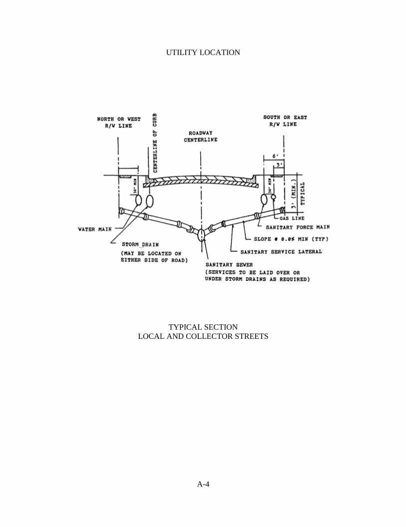
UTILITY LOCATION
TYPICAL SECTION LOCAL AND COLLECTOR STREETS
A-4

CERTIFICATE OF SURVEYOR KNOW ALL MEN BY THESE PRESENTS, that the undersigned, being a licensed and registered land
surveyor, as provided under Chapter 472, Florida Statutes and is in good standing with the Board of Land
Surveyors, does hereby certify that on he completed the survey of the lands as shown in
the foregoing plat or plan; that said plat is a correct representation of the lands therein described and
platted or subdivided; that permanent reference monuments have been placed as shown thereon as
required by Chapter 177, Florida Statutes, as amended; and that said land is located in Section ________,
Township _______, and Range ________, Suwannee County, Florida.
NAME DATE Registration Number
CERTIFICATE OF THE SUBDIVIDER'S ENGINEER THIS IS TO CERTIFY, that on , Registered Florida
Engineer, as specified within Chapter 471, Florida Statutes, License No. , does hereby
certify that all required improvements have been installed in compliance with the approved construction
plans and as applicable, any submitted "as built" blue prints in accordance with the requirements of the
Board of County Commissioners of Suwannee County, Florida.
(SEAL) Registered Florida Engineer
A-5

CERTIFICATE OF APPROVAL BY COUNTY HEALTH DEPARTMENT Examined on AND Approved by County Health Department CERTIFICATE OF APPROVAL BY THE ATTORNEY FOR SUWANNEE COUNTY, FLORIDA Examined on AND Approved as to Legal Form and Sufficiency by . County Attorney
CERTIFICATE OF APPROVAL BY BOARD OF COUNTY COMMISSIONERS OF SUWANNEE COUNTY, FLORIDA
THIS IS TO CERTIFY that on the foregoing plat was approved by the Board of County Commissioners for Suwannee County, Florida. Chairman Attest: Filed for record on: Clerk of the Circuit Court By Deputy Clerk
A-6

CERTIFICATE OF ESTIMATED COST I, , Registered Florida Engineer, as specified
within Chapter 471, Florida Statutes, License No. , do hereby estimate
that the total estimated cost of installing all required improvements for the proposed subdivision to be
titled is $_______________________.
(SEAL) Registered Florida Engineer
CERTIFICATE OF TAX COLLECTOR THIS IS TO CERTIFY that all payable ad valorem taxes have been paid and all tax sales against the land included within this plat have been redeemed. _______________________________________ Tax Collector
A-7

PRELIMINARY AND FINAL PLAT SIZE SPECIFICATIONS
SIZE OF SHEET FOR RECORD PLAT
A-8

STATEMENT REQUIRED ON FINAL PLAT
The following statement shall be required on all final plats:
“A building permit for the construction or location of any residential building or structure shall not be issued for less than one entire lot as depicted on this subdivision plat, exception as otherwise provided by law.”
A-9

THIS PAGE LEFT BLANK INTENTIONALLY
A-10

APPENDIX B
Commercial Neighborhood (CN) District Legal Descriptions Identified on the Official Zoning Atlas
Introduction ..................................................................................................... B-1 CN-1 ..................................................................................................... B-2 CN-2 ..................................................................................................... B-3 CN-3 ..................................................................................................... B-4 CN-4 ..................................................................................................... B-5 CN-5 ..................................................................................................... B-6 CN-6 ..................................................................................................... B-7 CN-7 ..................................................................................................... B-8 CN-8 ..................................................................................................... B-9 CN-9 ................................................................................................... B-10 CN-10 ................................................................................................... B-11 CN-11 ................................................................................................... B-12 CN-12 ................................................................................................... B-13 CN-13 ................................................................................................... B-14 CN-14 ................................................................................................... B-15 CN-15 ................................................................................................... B-16 CN-16 ................................................................................................... B-17 CN-17 ................................................................................................... B-18 CN-18 ................................................................................................... B-19 CN-19 ................................................................................................... B-20 CN-20 ................................................................................................... B-21 CN-21 ................................................................................................... B-22

THIS PAGE LEFT BLANK INTENTIONALLY

INTRODUCTION The following provides specific information for all the Commercial Neighborhood ("CN") districts within the unincorporated area of Suwannee County, Florida. This attachment shall depict specific data which cannot be accurately illustrated on the Official Zoning Atlas. Each "CN" district will be annotated chronologically (i.e., "CN-1", "CN-2", etc.) on the Official Zoning Atlas and supported by the particular parcel's legal description in this appendix.
B - 1
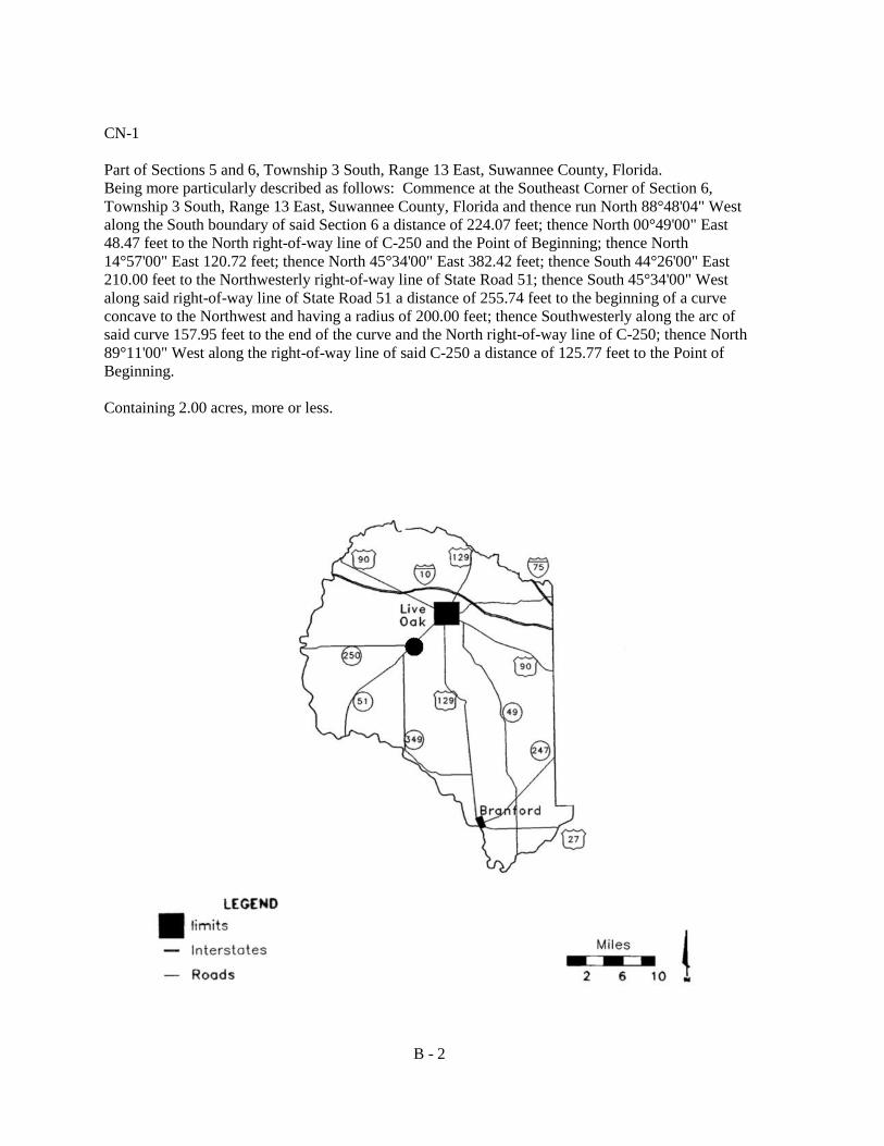
CN-1 Part of Sections 5 and 6, Township 3 South, Range 13 East, Suwannee County, Florida. Being more particularly described as follows: Commence at the Southeast Corner of Section 6, Township 3 South, Range 13 East, Suwannee County, Florida and thence run North 88°48'04" West along the South boundary of said Section 6 a distance of 224.07 feet; thence North 00°49'00" East 48.47 feet to the North right-of-way line of C-250 and the Point of Beginning; thence North 14°57'00" East 120.72 feet; thence North 45°34'00" East 382.42 feet; thence South 44°26'00" East 210.00 feet to the Northwesterly right-of-way line of State Road 51; thence South 45°34'00" West along said right-of-way line of State Road 51 a distance of 255.74 feet to the beginning of a curve concave to the Northwest and having a radius of 200.00 feet; thence Southwesterly along the arc of said curve 157.95 feet to the end of the curve and the North right-of-way line of C-250; thence North 89°11'00" West along the right-of-way line of said C-250 a distance of 125.77 feet to the Point of Beginning. Containing 2.00 acres, more or less.
B - 2

CN-2 A parcel of land lying in the North half (1/2) of Section 3, Township 3 South, Range 14 East, Suwannee County, Florida, being more particularly described as follows: For a point of reference commence at the Northeast corner of the Southeast quarter (SE 1/4) of the Northwest 1/4 of said Section 3; thence run South 00°05'24" East along the East line of said Southeast 1/4 of the Northwest 1/4 a distance of 273.32 feet to a point on the Southerly right-of-way line of the Seaboard Aid Line Railroad, said point also being the Point of Beginning; thence run South 57°53'46" East along said Southerly right-of-way line a distance of 372.06 feet; thence run South 32°06'14" West a distance of 205.00 feet to a point on the Northerly right-of-way of State Road 10 (U.S. Highway 90); thence run North 57°53'46" West along said right-of-way line a distance of 388.60 feet to the point of curvature of a curve concave to the Northeast, having a radius of 5,669.58 feet; thence run along and around said curve a chord bearing the distance of North 57°24'33" West 96.40 feet; thence run North 32°06'14" East a distance of 204.18 feet to a point on the Southerly right-of-way line of said railroad; thence run South 57°53'46" East along said right-of-way line a distance of 112.94 feet to the Point of Beginning. Said Parcel also being known as Blocks 6 & 7, Town of Houston, Suwannee, County, Florida. Containing 2.282 acres, more or less.
B - 3

CN-3 Begin at a point 470.00 feet South of the intersection of Mitchell Road and River Road for a point of reference. Run East 235.00 feet, North 255.00 feet, West to East right-of-way of the river road and South to the Point of Beginning, all being part of the Northwest 1/4 of the Southwest 1/4 of Section 14, Township 2 South, Range 11 East.
B - 4

CN-4 Part of the Northwest 1/4 of the Northwest 1/4 of Section 33, Township 1 South, Range 12 East, being more particularly described as follows: for a point of reference commence at the Northwest corner of said Section 33; thence run South 00°56'20" West along the West line of said Section 33, a distance of 308.65 feet to the Southerly right-of-way line of U.S. Highway 90; thence run South 62°25'00" East, along said Southerly right-of-way line, a distance of 22.55 feet to the Point of Beginning; thence continue South 62°25'00" East along said Southerly right-of-way line a distance of 85.00 feet; thence run North 62°25'00" West a distance of 85.00 feet; thence run North 00°21'00" East a distance of 100.00 feet to the Point of Beginning. Containing .17 acre, more or less.
B - 5
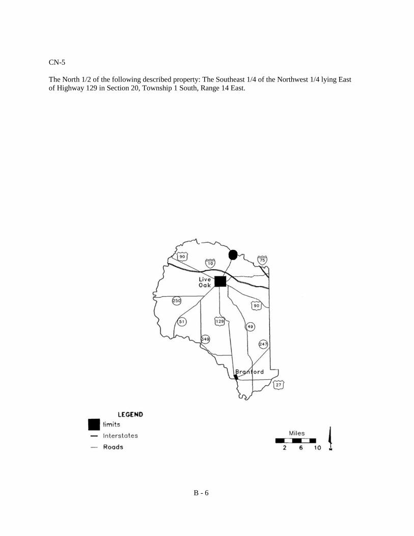
CN-5 The North 1/2 of the following described property: The Southeast 1/4 of the Northwest 1/4 lying East of Highway 129 in Section 20, Township 1 South, Range 14 East.
B - 6

CN-6 Five-acre tract of land located at the intersection of County Road No. 137 and State Road No. 247, situated in the East 1/2 of the Northeast 1/4 of Section 21, Township 5 South, Range 15 East, Suwannee County, Florida, generally described as follows: Begin at the intersection of the Westerly right-of-way line of County Road No. 137 with the Northwesterly right-of-way line of State Road 247 and run Northerly along the Westerly right-of-way line of County Road No. 137 a distance of 475.00 feet, more or less; thence run West 330.00 feet; thence Southerly parallel with the Westerly right-of-way line of County Road No. 137 a distance of 825.00 feet, more or less, but in all event, to the Northwesterly right-of-way line of State Road 247; thence run in a Northwesterly direction along the Northwesterly right-of-way line a distance of 475.00 feet, more or less, but in all event, to the Point of Beginning.
B - 7

CN-7 One acre in the Southwest corner of the Southeast 1/4 of Section 2, Township 3 South, Range 13 East, Suwannee County, Florida, lying North of Touchton Road and East of State Road 129.
B - 8

CN-8 Commence at the Point of Beginning of the centerline of State Road 51 and 250 which is near the Southwest corner of Section 5, Township 3 South, Range 13 East; thence run North 45°31'00" East along the centerline of State Road 51 a distance of 2,338.96 feet; thence run South 44°29'00" East 50.00 feet to a 2 inch iron pipe stake set on the Easterly boundary of the right-of-way of State Road 51 at the Point of Beginning. From such Point of Beginning run South 44°29'00" East 208.71 feet to an iron pipe stake; thence run North 44°29'00" West 208.71 feet to an iron pipe stake; thence run North 44°29'00" West 208.71 feet to an iron pipe stake on the Easterly boundary of the right-of-way of State Road 51; thence run South 45°31'00" East along the boundary 208.71 feet to the Point of Beginning in the East 1/2 of the Southwest 1/4 of said Section. Also commencing at the intersection of the centerline of State Road 51 and 250 which is near the Southwest corner of said Section 5 and running North 45°31'00" East along the centerline of State Road 51 a distance of 2,328.96 feet; thence run South 44°29'00" West 208.71 feet to an iron pipe stake; thence run South 45°31'00" West 208.71 feet to the Point of Beginning and being in the East 1/2 of the Southwest 1/4 of Section 5, Township 3 South, Range 13 East. Also known as the Barney Wainwright two-acre tract, together with store building and homesite on the East side of Highway 51.
B - 9
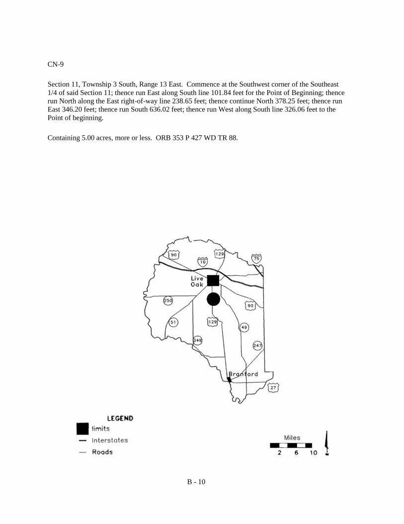
CN-9 Section 11, Township 3 South, Range 13 East. Commence at the Southwest corner of the Southeast 1/4 of said Section 11; thence run East along South line 101.84 feet for the Point of Beginning; thence run North along the East right-of-way line 238.65 feet; thence continue North 378.25 feet; thence run East 346.20 feet; thence run South 636.02 feet; thence run West along South line 326.06 feet to the Point of beginning. Containing 5.00 acres, more or less. ORB 353 P 427 WD TR 88.
B - 10

CN-10 Section 3, Township 4 South, Range 15 East. Commence at the Southeast corner of Southwest 1/4 and run North 97.40 feet to the North right-of-way of State Road 252; thence continue North 150.00 feet West 165.46 feet for the Point of Beginning; thence continue West 165.46 feet; thence South 147.41 feet to the North right-of-way; thence continue East 165.44 feet; thence North 148.02 feet to the Point of Beginning. ORB 217 P 145-147 WDYR88. .56 acre; and commence at the Southeast corner of the Southwest 1/4 and run North 97.40 feet to the North right-of-way of State Road 252 and the Point of Beginning; thence continue North 150.00 feet, West 165.46 feet, South 148.06 feet to the North right-of-way, East 165.42 feet to the Point of Beginning. ORB 217 P145-147 WD ORB 329 P 326.327 WD YR 1988. .56 acre; and East 220.00 feet of the East 1/2 of the Southeast 1/4 of the Southeast 1/4 of the Southwest 1/4 South of State Road 252 right-of-way. ORB 166 P 61 WD, ORBN 175 P 407 QCD and that part of the Southwest 1/4 of the Southeast 1/4 lying South of State Road 252 right-of-way ORB 244 P 33 QCD. .86 acre; and that part of the East 1/2 of the Southeast 1/4 of the Southeast 1/4 of the Southwest 1/4 South of State Road 252 right-of-way, less the East 220.00 feet ORB 167 P 365 WDORD 175406QCD. .05 acre.
B - 11

CN-11 Section 18, Township 4, Range 14 East. For a point of reference commence at the Southwest corner of the Northeast 1/4 and run North 88 East 794.93 feet to the East right-of-way line of U.S. Highway 129; thence North 05 West along East right-of-way 960.93 feet, continue along right-of-way North 84 East 27 feet; thence North 05 West along East right-of-way line 78.90 feet to the Point of Beginning; continue North 05 West along East right-of-way 150.00 feet; thence North 83 East 200.00 feet; thence South 05 East 150.00 feet; thence South 03 West 200.00 feet to the Point of Beginning. Containing .69 acre, more or less. ORB 241.p
B - 12
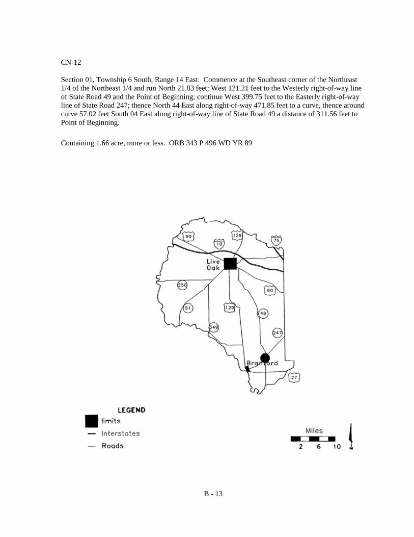
CN-12 Section 01, Township 6 South, Range 14 East. Commence at the Southeast corner of the Northeast 1/4 of the Northeast 1/4 and run North 21.83 feet; West 121.21 feet to the Westerly right-of-way line of State Road 49 and the Point of Beginning; continue West 399.75 feet to the Easterly right-of-way line of State Road 247; thence North 44 East along right-of-way 471.85 feet to a curve, thence around curve 57.02 feet South 04 East along right-of-way line of State Road 49 a distance of 311.56 feet to Point of Beginning. Containing 1.66 acre, more or less. ORB 343 P 496 WD YR 89
B - 13

CN-13 Section 13, Township 5 South, Range 13 East. Southeast 1/4 of the Northeast 1/4 lying Northwest of State Road 247 and beginning at the Southwest corner of the Southeast 1/4 of the Northeast 1/4 and run North 320.00 feet; thence East 150.00 feet; thence South 400.00 feet; thence East 300.00 feet; thence South 513.00 feet to County Road ?; thence Northwest along road 520.00 feet; thence North 300.00 feet to the Point of Beginning. Containing 10.88 acres, more or less. 1-3 ORB 190 P 67 OCD ORB 206 P 548 OCD.
B - 14

CN-14 Section 7, Township 6, Range 15 East. Begin of East side of County Road 49 right-of-way and Northwest corner of South 1/2 of the Northwest 1/4 of the Southwest 1/4 for a Point of Beginning; thence run South 330.00 feet; thence East 250.00 feet; thence North 330.00 feet; thence West 250.00 feet to the Point of Beginning. 1.72 acres, more or less. ORB 323 P 258 WD YR 88, ORB 348 P 604 OCD YR 89, ORB 359 P 734 WD YR 90 Section 7, Township 6 South, Range 15 East. Begin at the Northeast corner of said Section 7 and run West 105.99 feet to the West right-of-way line of County Road 49; thence South 582.86 feet to Point of Beginning; continue South along the right-of-way 113.14 feet to point of curve and 352.26 feet to North right-of-way of State Road 247; continue Southwest 140.89 feet; thence Northwest 210.00 feet; thence Northeast 368.98 feet to Point of Beginning. ORB 294 P 821-823 WD YR 86. ORB 31 P 885 DC YR 88
B - 15

CN-15 Section 17, Township 3 South, Range 15 East. Commence at the intersection of West boundary of Northwest 1/4 of the Northeast 1/4 and South right-of-way line of U.S. Highway 90 and run South 65 ̊East 65.71 feet to the Point of Beginning; thence South 500.52 feet to a point 60.00 feet East of the West boundary of said forth East 550.48 feet; thence North 36 East 244.11 feet to the South right-of-way line of U.S. Highway 90; thence run along right-of-way 793.12 feet to the Point of Beginning. Containing 6.03 acres, more or less. ORB 390 P 636 WD YR 91
B - 16

CN-16 Commence at the Northeast corner of Section 5, Township 3 South, Range 11 East, Suwannee County, Florida; thence run South 00°18'38" East along the East line of said Section 5 a distance of 1,315.31 feet to the intersection of the Northerly right-of-way line of County Road 136; thence run South 45°53'24" West along the Northerly right-of-way line of County Road 136 a distance of 943.57 feet to the point of curvature of a curve concave to the Westerly; thence run along said curve on a chord bearing of South 47°24'08" West, a chord distance of 300.33 feet, an arc distance of 300.36 feet, radius 5, 689.66 feet for the Point of Beginning; thence continue along said curve on a chord bearing of South 49°56'29" West, a chord distance of 203.87 feet, an arc distance of 203.88 feet to the point of curvature of a curve concave to the Westerly; thence run along said curve on a chord bearing of North 82°38'09" West, a chord distance of 36.13 feet, an arc distance of 40.37 feet, a radius of 25.00 feet to the P.T of curve, said P.T. being on the Northerly right-of-way line of Marvin Jones Boulevard; thence run North 36°22'17" West along said Northerly right-of-way line 343.87 feet; thence run North 67°37'43" East 245.99 feet; thence run South 34°36'26" East 296.37 feet to the Point of Beginning. Containing 1.79 acres, more or less.
B - 17
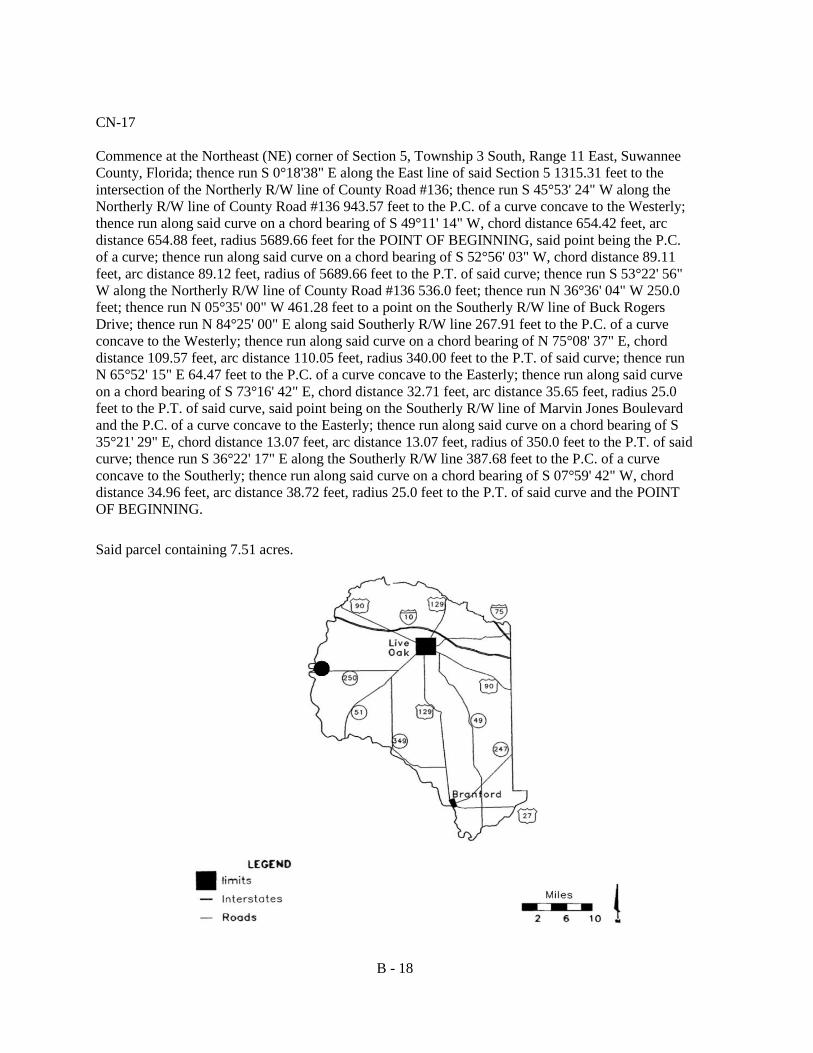
CN-17 Commence at the Northeast (NE) corner of Section 5, Township 3 South, Range 11 East, Suwannee County, Florida; thence run S 0°18'38" E along the East line of said Section 5 1315.31 feet to the intersection of the Northerly R/W line of County Road #136; thence run S 45°53' 24" W along the Northerly R/W line of County Road #136 943.57 feet to the P.C. of a curve concave to the Westerly; thence run along said curve on a chord bearing of S 49°11' 14" W, chord distance 654.42 feet, arc distance 654.88 feet, radius 5689.66 feet for the POINT OF BEGINNING, said point being the P.C. of a curve; thence run along said curve on a chord bearing of S 52°56' 03" W, chord distance 89.11 feet, arc distance 89.12 feet, radius of 5689.66 feet to the P.T. of said curve; thence run S 53°22' 56" W along the Northerly R/W line of County Road #136 536.0 feet; thence run N 36°36' 04" W 250.0 feet; thence run N 05°35' 00" W 461.28 feet to a point on the Southerly R/W line of Buck Rogers Drive; thence run N 84°25' 00" E along said Southerly R/W line 267.91 feet to the P.C. of a curve concave to the Westerly; thence run along said curve on a chord bearing of N 75°08' 37" E, chord distance 109.57 feet, arc distance 110.05 feet, radius 340.00 feet to the P.T. of said curve; thence run N 65°52' 15" E 64.47 feet to the P.C. of a curve concave to the Easterly; thence run along said curve on a chord bearing of S 73°16' 42" E, chord distance 32.71 feet, arc distance 35.65 feet, radius 25.0 feet to the P.T. of said curve, said point being on the Southerly R/W line of Marvin Jones Boulevard and the P.C. of a curve concave to the Easterly; thence run along said curve on a chord bearing of S 35°21' 29" E, chord distance 13.07 feet, arc distance 13.07 feet, radius of 350.0 feet to the P.T. of said curve; thence run S 36°22' 17" E along the Southerly R/W line 387.68 feet to the P.C. of a curve concave to the Southerly; thence run along said curve on a chord bearing of S 07°59' 42" W, chord distance 34.96 feet, arc distance 38.72 feet, radius 25.0 feet to the P.T. of said curve and the POINT OF BEGINNING. Said parcel containing 7.51 acres.
B - 18

CN-18 Beginning at the Northwest Corner of the Southwest Quarter (SW 1/4) of the Northwest quarter (NW 1/4) of Section 19, Township 01 South, Range 13 East for Point of Beginning. Thence run South 140 feet. Thence East to West right-of-way line of State Road 249. Thence run Northwest along Road right-of-way to Quarter Section line. Thence run West to Point of Beginning.
B - 19

CN-19 Commence at Mile Post No. R-689 on the center line of the Atlantic Coastline Railroad main track and run North 05°32'50" West along said center line of Atlantic Coastline Railroad 2,167.52 feet to the South line of Troy Street; thence North 84°27'10" East along said South line of Troy Street 166.00 feet to its intersection with the Easterly right-of-way line of State Road 249 (U.S. Highway 129); thence North 84°27'10" East along said South line of Troy Street 144.00 feet to the Point of Beginning; thence South 05°32'50" East 162.50 feet; thence East 105.00 feet; thence North 162.50 feet to the South right-of-way line of Troy Street; thence West along the South right-of-way line of Troy Street 105.00 feet to the Point of Beginning and said lands also being described as: Commence at the Northwest corner of Section 20, Township 5 South, Range 14 East, Suwannee County, Florida, and run South 89°23'14" East along the North line of said Section 20 a distance of 1,396.63 feet to the Easterly right-of-way line of State Road 249 (U.S. Highway 129); thence South 05°32'50" East along said right-of-way line 1,737.75 feet to the intersection of the South right-of-way line of Troy Street; thence North 84°27'10" East along said right-of-way line of Troy Street 144.00 feet to the Point of Beginning; thence South 05°32'50" East 162.50 feet; thence East 105.00 feet; thence North 162.50 feet to the South right-of-way line of Troy Street; thence West along said South right-of-way line of Troy Street 105.00 feet to the Point of Beginning, and said lands lying wholly within the Southeast 1/4 of the Northwest 1/4 of said Section 20, Township 5 South, Range 14 East, Suwannee County, Florida and being a part of a tract of land deeded to R.R. Barger and Delma Leona McClellan Barber by Atlantic Coast Line Railroad Company by deed dated December 9, 1958 in the Official Record Book 116, beginning at Page 169, Public Records of Suwannee County, Florida.
B - 20

CN-20 Commence at Mile Post No. R - 689 on the center line of the Atlantic Coastline Railroad main track and run North 05°32'50" West along said center line of Atlantic Coastline Railroad 2,167.52 feet to the South line of Troy Street; thence North 84°27'10" East along said South line of Troy Street 166.00 feet to its intersection with the Easterly right-of-way line of State Road 249 (U.S. Highway 129) and the Point of Beginning; thence North 84°27'10" East along said South line of Troy Street; thence South 05°32' 50" East 165.00 feet; thence South 84°27'10 West 144.00 feet to the Easterly right-of-way line of State Road 249 (U.S. Highway 129); thence North 05°32'50" West along said Easterly right-of-way line 165.00 feet to the Point of Beginning. Containing .55 acre, more or less, and said lands being also described as: Commence at the Northwest corner of Section 20, Township 5 South, Range 14 East, Suwannee County Florida, and run South 89°23'14" East along the North line of said Section 20 a distance of 1,396.63 feet to the Easterly right-of-way line of State Road 249 (U.S. Highway 129); thence South 05°32'50" East along said right-of-way line 1,737.75 feet to the intersection of the Southerly right-of-way line of Troy Street and the Point of Beginning; thence North 84°27'10" East along said Southerly right-of-way line of Troy Street 144 feet; thence South 05°32'50" East 165.00 feet; thence South 84°27'10 West 144 feet to said Easterly right-of-way line of State Road 249 (U.S. Highway 129); thence North 05°32'50" West along said Easterly right-of-way line of State Road 249 (U.S. Highway 129) 165.00 feet to the Point of Beginning. Said lands lying wholly within the Southeast 1/4 of the Northeast 1/4 of said Section 20, Township 5 South, Range 14 East, Suwannee County, Florida and being a part of a tract of land deeded to R.R. Barger and Delma Leona McClellan Barber by Atlantic Coast Line Railroad Company by deed dated December 9, 1958, recorded in Official Record Book 116, beginning at Page 169, Public Records of Suwannee County, Florida.
B - 21

CN-21 Commence at the Northwest Corner of Section 19, Township 6 South, Range 15 East; thence North 89̊35'17" East along the North line of said Section 19 a distance of 69.58 feet to the East right-of-way line of County Road 49; thence South 00°26'04" East along said right-of-way line, 1,034.07 feet; thence South 89°40'35" East 225.00 feet to the Point of Beginning; thence continue South 89°40'35" East 171.67 feet; thence South 05°12'36" East 394.81 feet to the Northerly right-of-way line of State Road 20; thence North 89°40'35" West along said right-of-way line 204.54 feet; thence North 00°26'04 West 393.00 feet to the Point of Beginning. Containing 1.70 acres, more or less.
B - 22

NORTH CENTRAL FLORIDA REGIONAL PLANNING COUNCIL
REGIONAL AND LOCAL GOVERNMENT PROGRAMS
STAFF
Scott R. Koons, AICP, Executive Director
Steven Dopp, Senior Planner
Sandra Joseph, Senior Planner
Michael DePalma, Associate Planner, Geographic Information Systems
Carmelita Franco, Administrative Planning Assistant