administrativeadministrative units units designdesign in in...
TRANSCRIPT

17.08.200717.08.2007
11
AdministrativeAdministrative UnitsUnits DesignDesign in in SupportSupport of of TerritorialTerritorial DevelopmentDevelopment in in TurkeyTurkeyTurkeyTurkeyA.C. AYDINOGLU, M. OZENDI, T. YOMRALIOGLUA.C. AYDINOGLU, M. OZENDI, T. YOMRALIOGLUOral session 3Oral session 3--2: SDI Database Development2: SDI Database DevelopmentAugust 8th, 15:00 August 8th, 15:00 –– 16:30 (Room: Galaxy 216:30 (Room: Galaxy 2))
KTU KTU GISLabGISLab, Trabzon, Trabzon--TurkeyTurkey
XXIII. XXIII. XXIII. InternationalInternationalInternational CartographicCartographicCartographic ConferenceConferenceConferenceICC 2007ICC 2007ICC 2007
AugustAugustAugust 040404---101010, 200, 200, 2007, 7, 7, MoscowMoscowMoscow, , , RussiaRussiaRussia, , ,
OverviewOverview
An introduction describing SDI conceptAn introduction describing SDI concept
AdministrativeAdministrative UnitUnit Data Data themetheme
DesigningDesigning AdministrativeAdministrative UnitUnit SpatialSpatial Data Data SetsSets
Case Studies supporting SDI development from local to Case Studies supporting SDI development from local to national levelnational level
ConclusionsConclusions
Arif Cagdas AYDINOGLUArif Cagdas AYDINOGLU01/01/1818

17.08.200717.08.2007
22
IntroductionIntroduction
Geographic Information (GI)Geographic Information (GI) has has economic / social / policy valueeconomic / social / policy value..
Geographic Information Geographic Information SystemsSystems ((GISGIS)) is is h ih i t dt d ll b till b ti ff t f ff t f changingchanging towardstowards ccollaborativeollaborative efforts for efforts for
data sharingdata sharing andand useuse..
Information Systems (IS)Information Systems (IS) have been rehave been re--conceptualized as conceptualized as IIII..
IInformationnformation InfrastructureInfrastructure (II)(II) proviprovidesdesintegrated solutions with the helping of integrated solutions with the helping of ICTsICTs andand controlcontrol varied technologies, varied technologies, policiespolicies standards standards
GIS
policiespolicies, standards , standards
SpatialSpatial Data Data InfrastructureInfrastructure (SDI)(SDI),,enablesenables the effective collection, the effective collection, management, management, andand access of access of GI.GI.
Arif Cagdas AYDINOGLUArif Cagdas AYDINOGLUN
etw
ork
Net
wor
k02/02/1818
……
……AddressAddress
Admin. UnitAdmin. Unit
MetadataMetadata
DATA PRODUCER / PROVİDERDATA PRODUCER / PROVİDER USERSUSERS
UserUser11
IntroductionIntroduction
……EşyükseltiEşyükselti
NehirNehir
MetaveriMetaveri
SoilSoilLand UseLand Use
……TopographyTopographyHydrographyHydrography
MetadataMetadata
GIS GIS P lP l
UserUser22
…………
MetadataMetadata
……
……
PortalPortalMatadataMatadata
CatalogCatalog
UserUsernn
Arif Çağdaş AYDINOGLUArif Çağdaş AYDINOGLU03/03/1818

17.08.200717.08.2007
33
ApplicationApplication andand InformationInformation ProductsProducts
BusinessBusiness NeedsNeedsIntroductionIntroduction
LayersLayers DatasetsDatasets
ComponentsComponents ofofA GIS Data ModelA GIS Data Model
Arif Çağdaş AYDINOGLUArif Çağdaş AYDINOGLU00/0000/00
ULUL TransportationIBIB Administrative Units
ARAR Land CoverHIHI Hidrography
TOTO TopographyGEGE Geodesy
MBMB Ownership/Address……
yy
AdministrationAdministration UnitUnit Data Data ThemeThemeAdministrative Unit Administrative Unit Data TData Themehemedetermines responsibility areas of related association/institutiondetermines responsibility areas of related association/institution, , surrounded by administrative boundaries,surrounded by administrative boundaries, and and have importance for managing a country or region effectively.have importance for managing a country or region effectively.
For example; For example; Trabzon ProvinceTrabzon ProvinceEsentepeEsentepe District, or District, or any institution can be any institution can be accepted as an accepted as an administrative unit with administrative unit with their boundaries. their boundaries.
Arif Çağdaş AYDINOGLUArif Çağdaş AYDINOGLU00/0000/00
ApplicationApplication AreasAreasUUsedsed as base layers on many thematic applications executed by different as base layers on many thematic applications executed by different
iinstitutionsnstitutions at at differentdifferent levelslevelsGeoreferencingGeoreferencing thethe data data withwith edgeedge--matchingmatchingPopulationPopulation andand EconomicEconomic AnalysisAnalysis
DeterminingDetermining regionalregional developmentdevelopment policiespolicies……
17.08.200717.08.2007
44
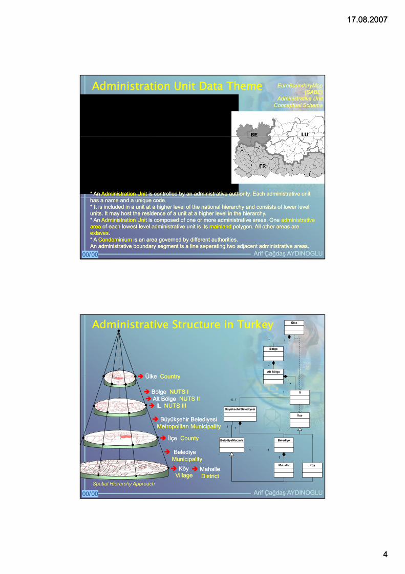
AdministrationAdministration UnitUnit Data Data ThemeThemeAdministration Unit
(The lowest level)Administration Unit
(Higher Level)
includes 0:1
includes 0:m
owned 1:1
EuroBoundaryMapEuroBoundaryMap(SABE) (SABE)
AdministrativeAdministrative UnitUnitConceptualConceptual SchemaSchema
Administration BoundaryAdministration Area
MainLand Island
Condominium
1:m
includes 1:1
includes 1:1
* * An An AAdministratidministrationon UUnit nit is controlled by an administrative authorityis controlled by an administrative authority. . Each administrative unit Each administrative unit
Arif Çağdaş AYDINOGLUArif Çağdaş AYDINOGLU00/0000/00
has a name and a unique code. has a name and a unique code. * * It is included in a unit at a higher level of the national hierarchy and consists of lower level It is included in a unit at a higher level of the national hierarchy and consists of lower level units.units. It may host the residence of a unit at a higher level in the hierarchy. It may host the residence of a unit at a higher level in the hierarchy. * * An An AAdministratidministrationon UUnitnit is composed of one or more administrative areas. One is composed of one or more administrative areas. One administrative administrative areaarea of each lowest level administrative unit is its of each lowest level administrative unit is its mainlandmainland polygon. All other areas arepolygon. All other areas areexexlaveslaves..* * A A CCondominiumondominium is an area governed by different authorities. is an area governed by different authorities. An administrative boundary segment is a line An administrative boundary segment is a line seperatingseperating two adjacent administrative areas. two adjacent administrative areas.
AdministrativeAdministrative StructureStructure in in TurkeyTurkey Ülke
Bölge
Alt Bölge
1*
1*
ÜlkeÜlke CountryCountry
İl
1*
İlçe
BüyüksehirBelediyesi
1
0..1
1*
1
1
Bölge Bölge NUTS INUTS IAlt Bölge Alt Bölge NUTS IINUTS IIİL İL NUTS IIINUTS III
Ülke Ülke CountryCountry
Büyükşehir BelediyesiBüyükşehir BelediyesiMetropolitanMetropolitan MunicipalityMunicipality
İlİl C tC t
Arif Çağdaş AYDINOGLUArif Çağdaş AYDINOGLU00/0000/00
Belediye
Mahalle Köy
1*
BelediyeMucavir
1 1
MahalleMahalleDistrictDistrict
Spatial Hierarchy Approach
Belediye Belediye MunicipalityMunicipality
İlçe İlçe CountyCounty
KöyKöyVillageVillage
17.08.200717.08.2007
55
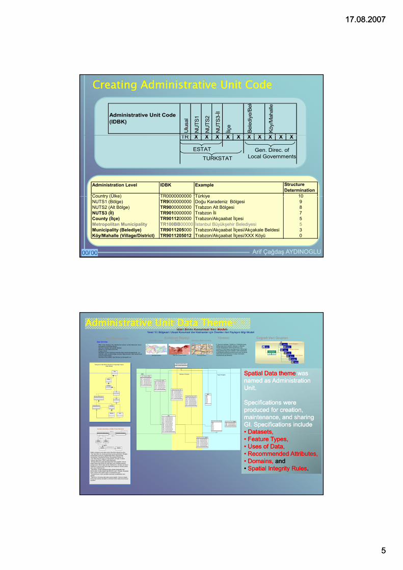
Creating Administrative Unit CodeCreating Administrative Unit Code
Ulu
sal
NU
TS1
NU
TS2
NU
TS3-İl
İlçe
Bele
diye
/Bel
d
Köy/
Mah
alle
TR X X X X X X X X X X
Administrative Unit Code (IDBK)
TR X X X X X X X X X X
ESTAT
TURKSTATGen. Direc. of
Local Governments
Administration Level IDBK Example Structure Determination
Country (Ülke) TR0000000000 Türkiye 10
Arif Çağdaş AYDINOGLUArif Çağdaş AYDINOGLU00/0000/00
Country (Ülke) TR0000000000 Türkiye 10NUTS1 (Bölge) TR9000000000 Doğu Karadeniz Bölgesi 9NUTS2 (Alt Bölge) TR9000000000 Trabzon Alt Bölgesi 8NUTS3 (İl) TR9010000000 Trabzon İli 7County (İlçe) TR9011200000 Trabzon/Akçaabat İlçesi 5Metropolitan Municipality TR100BB00000 İstanbul Büyükşehir Belediyesi 5Municipality (Belediye) TR9011205000 Trabzon/Akçaabat İlçesi/Akçakale Beldesi 3Köy/Mahalle (Village/District) TR9011205012 Trabzon/Akçaabat İlçesi/XXX Köyü 0
İdari Birim Konumsal Veri ModeliYerel / İl / Bölgesel / Ulusal Konumsal Veri Katmanları için Önerilen Veri Paylaşım Bilgi Modeli
Coğrafi Veri GruplarıYöntem Kullanım DüzeyiVeri Katmanlarıİdari Birimler
İİBS, İl, İlçe, Belediye, Köy, Mahalle idari alanları ve İdari Merkezleri, Kamu kurumlarının sorumluluk alanlarıİdari Sınır Haritası, Demografik HaritalarMerkezi ve Yerel Kamu KurumlarıPoligon, Noktaİdari Birim sınırları hiyerarşik anlamda düşey olarak bütünleştirilmeli, yol orta hattı, nehir ve parsel detayı sınırlarını takip etmelidir. İdari Alanlar kendi üzerine örtüşmemelidir.İdari Birim Kodu (İDBK), İdari Birimleri ait demografik veri
Ulusal/Bölgesel İl/İlçe Belediye/Mahalle/Köy
İdari Birim Haritası İl/İlçe Okur-Yazarlık Haritasi Numarataj Haritası
İl / İlçe Sınır Haritaları 1:25000 ve 1:100000'lik harita altlıklarından temin edilebilir. Belediye ve Mahalle sınırları Belediyelerin harita birimlerinden, köy sınırlarını İl Özel İdaresi veya Bayındırlık İl Müdürlüğü harita altlıklarından temin edilebilir. Farklı sistemlerde ve altlıklarda üretilmiş konumsal verinin aynı koordinat sisteminde bütünleştirilmesi ve düşey hiyerarşide modellenmesi gerekmetedir.
IBIBNUTS Bölgeleri
Merkezi İdareler
Yerel İdareler
BOLGBOLG
ABOLABOL
ILCEILCE
N3ILN3IL
BELDBELD
BEMUBEMU
MAKOMAKO
IBMEIBME
Her idari birim bir alana sahiptir
1 1
Her idari birim bir alana sahiptir
1 1
Türkiye’nin İdari Birim Alanlarının Hiyerarşik Yapısı UML Modeli
Ülke
-shape : esriFieldTypeGeometryMerkezi/Yerel Idare::feature
AdministrativeAdministrative UnitUnit Data Data ThemeTheme
SpatialSpatial DataData themetheme waswasBölge
Alt Bölge
1*
1*
İl
1*
İlçe
Belediye
Mahalle Köy
1*
BüyüksehirBelediyesi
1
0..1
1*
BelediyeMucavir
1
1
1 1
EuroBoundaryMap ve SABE Projesi Standardı
İdari Birim (Üst Düzey)İdari Birim (En Düşük Düzey)
-içerir 0:1
-IDBK : esriFieldTypeString-OIBK : esriFieldTypeString-ISIM : esriFieldTypeString-KAVE : esriFieldTypeString-KAKU : esriFieldTypeString-ALVA : esriFieldTypeInteger-GUTA : esriFieldTypeDate-GUTI : esriFieldTypeInteger
Merkezi/Yerel Idare::N3IL
-IDBK-OIBK-ISIM-KAVE-KAKU-ALVA-GUTA-GUTI
Merkezi/Yerel Idare::BELD
-IDBK : esriFieldTypeString-OIBK : esriFieldTypeString-ISIM : esriFieldTypeString-KAVE : esriFieldTypeString-KAKU : esriFieldTypeString-ALVA : esriFieldTypeInteger-GUTA : esriFieldTypeDate-GUTI : esriFieldTypeInteger
Merkezi/Yerel Idare::ILCE
-ISIM : esriFieldTypeString-IDBK : esriFieldTypeString-IDBT : esriFieldTypeString
Merkezi/Yerel Idare::BEMU
-IDBK : esriFieldTypeString-OIBK : esriFieldTypeString-ISIM : esriFieldTypeString-KAVE : esriFieldTypeString-KAKU : esriFieldTypeString-ALVA : esriFieldTypeInteger-GUTA : esriFieldTypeDate-GUTI : esriFieldTypeInteger
NUTS Bolgeleri::BOLG
-IDBK : esriFieldTypeString-OIBK : esriFieldTypeString-ISIM : esriFieldTypeString-KAVE : esriFieldTypeString-KAKU : esriFieldTypeString-ALVA : esriFieldTypeInteger-GUTA : esriFieldTypeDate-GUTI : esriFieldTypeInteger
NUTS Bolgeleri::ABOL
İİBS Yerel YönetimMerkezi Yönetim
-IDBK-OIBK-ISIM-KAVE-KAKU-ALVA-GUTA-GUTI
BBEL
-ULKO : esriFieldTypeString-NU1K : esriFieldTypeString-NU2K : esriFieldTypeString-NU3K : esriFieldTypeString-ILCK : esriFieldTypeString-BELK : esriFieldTypeString-MAKK : esriFieldTypeString-IDBK : esriFieldTypeString-IDBD : esriFieldTypeInteger-ISIM : esriFieldTypeString-IDBT : esriFieldTypeString-KAVE : esriFieldTypeString-KAKU : esriFieldTypeString-GUTA : esriFieldTypeDate-GUTI : esriFieldTypeSmallInteger
IDME
SpatialSpatial Data Data themetheme waswasnamednamed as as AdministrationAdministrationUnitUnit. .
SSpecificationspecifications were were produced for creation, produced for creation, maintenance, and sharing maintenance, and sharing GI. Specifications includeGI. Specifications include•• Datasets, Datasets,
-aittir 1:1
AnaKara AdaKara
-içerir 1:1 -içerir 0:m
İdariAlan
-içerir 1:1-içerir 1:1
İdariSınır-sınırlandırışmış 1:m
SABE veritabanınında ifade edilen İdari Birim Modeli’ne göre; * Her İdari Birim bir otorite tarafından kontrol edilmelidir. Örneğin; Fransa'daki Commune, İngiltere'deki Ward, Almanya'daki Germainde, Finlandiya'da Kunta, Slovenya'da Obcina..vb. * Her İdari Birimi bir isme ve koda sahiptir. Örneğin; İl olarak Trabzon İdari Birimi TR901 kodla ifade edilir. * Bir İdari Birim bir yada daha fazla İdari Alan içerebilir. Her en düşük düzey idari birimin bir idari alanı onun AnaKara alanıdır (poligonudur). Bütün diğer alanlar AdaKara'dır. Örneğin; bir köyün AnaKara’sı mevcut eden köye bağlı olan başka bir yerdeki yaylak olanı onun AdaKara’sıdır.* İdari Birim, ulusal hiyerarşide daha yüksek düzeydeki İdari Birim'e aittir ve daha düşük İdari Birim'ler içerir. Örneğin; Akçaabat ilçesi Trabzon İline aitken köyler ve belediyeler içerir.* Kondominyum, farklı otoriteler tarafından yönetilebilen idari alandır.* İdari Sınır, iki komşu idari alanı ayıran çizgidir. Yalnız en düşük düzey idari alanda varolabilir ve birimleri birden daha fazla düzeye ayırabilir.
-IDBK : esriFieldTypeString-OIBK : esriFieldTypeString-ISIM : esriFieldTypeString-KAVE : esriFieldTypeString-KAKU : esriFieldTypeString-ALVA : esriFieldTypeInteger-GUTA : esriFieldTypeDate-GUTI : esriFieldTypeInteger
Merkezi/Yerel Idare::MAKO
,,•• Feature Types, Feature Types, •• Uses of Data, Uses of Data, •• Recommended Attributes,Recommended Attributes,•• Domains, Domains, andand•• Spatial Integrity RulesSpatial Integrity Rules..
17.08.200717.08.2007
66
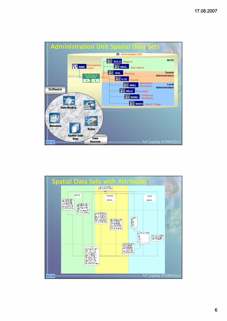
AdministrationAdministration UnitUnit SpatialSpatial Data Data SetsSetsIBIB Administrative Unit
NUTSBOLGBOLG
ABOLABOL
N3ILN3IL
IBMEIBME
Her idari birim bir Her idari birim bir
Regions
Sub-regions
Province
AdministrativeCenter
CentralAdministration
MetropolitanMunicipality
ILCEILCE
BELDBELD
BEMUBEMU
MAKOMAKO
alana sahiptir
1 1alana sahiptir
1 1 County
ContiguousMunicipality
BBELBBEL
Municipality
District / Village
Administration
LocalAdministrationSoftwareSoftware
Data Data ModelsModels
Arif Çağdaş AYDINOGLUArif Çağdaş AYDINOGLU00/0000/00
MetadataMetadata
SpatialSpatial DataDataSetsSets DataData
SourcesSources
RulesRules
SpatialSpatial Data Data SetsSets withwith AttributesAttributes
NUTS Central
Admin.
Local
Admin.
Arif Çağdaş AYDINOGLUArif Çağdaş AYDINOGLU00/0000/00
17.08.200717.08.2007
77
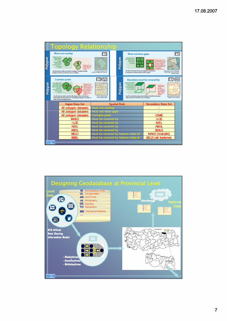
TopologyTopology RelationshipRelationship
Input Data Set Spatial Rule Secondary Data SetAllAll polygonpolygon datasetsdatasets Must not overlap --AllAll ll d t td t t M t t h
10/10/1818
AllAll polygonpolygon datasetsdatasets Must not have gaps --AllAll polygonpolygon datasetsdatasets Contains point IDMEIDME
MAKOMAKO Must be covered by ILCEILCEILCEILCE Must be covered by N3ILN3ILN3ILN3IL Must be covered by ABOLABOLABOLABOL Must be covered by BOLGBOLGBELDBELD Must be covered by feature class of MAKO (mahalle)MAKO (mahalle)BBELBBEL Must be covered by feature class of BELD (alt kademe)BELD (alt kademe)
Designing Geodatabase at Provincial LevelDesigning Geodatabase at Provincial LevelULUL TransportationIBIB Administrative Units
ARAR Land Cover
HIHI Hidrography
TOTO TopographyGEGE Geodesy
LocalLocalDataData
NationalNationalDataData
NSDINSDI
-- DistributionDistribution
MBMB Ownership/Address……
KTU GISLabKTU GISLabData Sharing Data Sharing Information ModelInformation Model ETLETL
06/06/1818
-- DönüştürmeDönüştürme-- GenelleştirmeGenelleştirme-- BütünleştirmeBütünleştirme
17.08.200717.08.2007
88
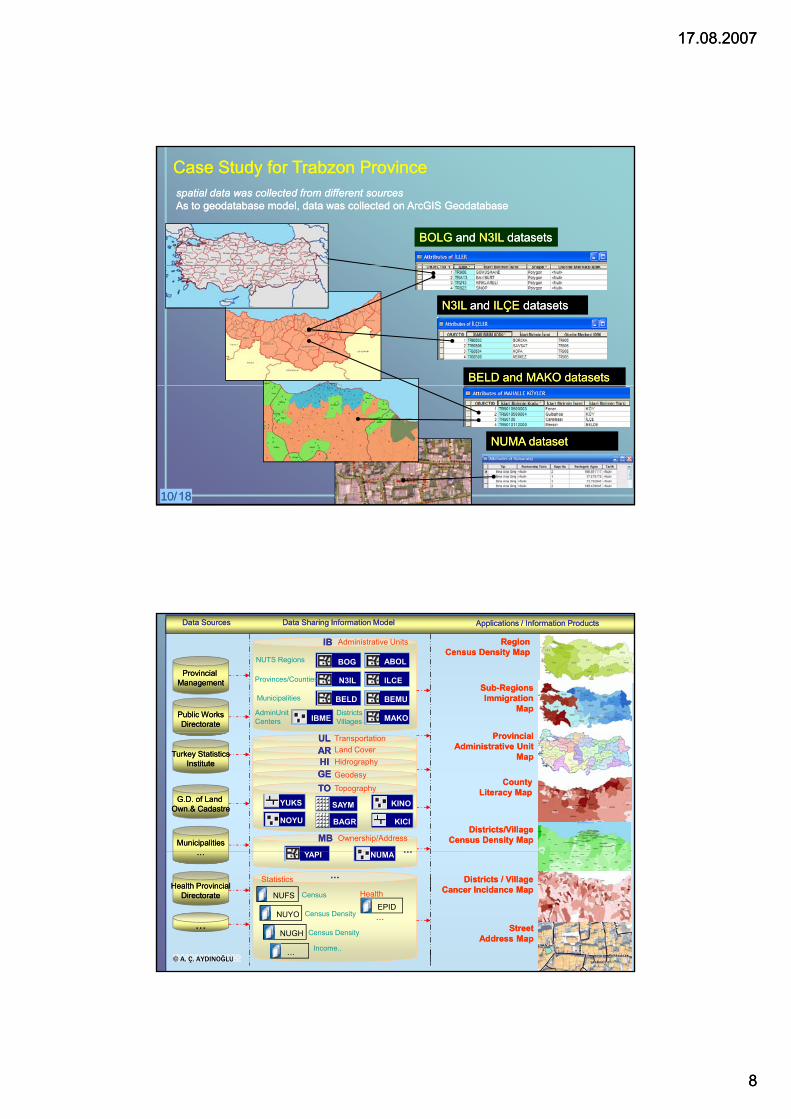
BOLGBOLG and and N3ILN3IL datasetsdatasets
CaseCase StudyStudy forfor Trabzon Trabzon ProvinceProvincespatial data was collected from different sourcesspatial data was collected from different sourcesAs to As to geodatabasegeodatabase model, data was collected on model, data was collected on ArcGISArcGIS GeodatabaseGeodatabase
N3ILN3IL and and ILÇE ILÇE datasetsdatasets
BELD and MAKO datasetsBELD and MAKO datasets
10/10/1818
NUMA datasetNUMA dataset
IBIB
BOG ABOL
BELD
ILCEN3IL
MAKOIBME
NUTS Regions
Provinces/Counties
Municipalities BEMU
Region Region Census Density MapCensus Density Map
SubSub--RegionsRegionsImmigration Immigration
MapMap
Applications / Information ProductsApplications / Information ProductsData Sharing Information Model Data Sharing Information Model Data SourcesData Sources
Provincial Provincial ManagementManagement
Public WorksPublic WorksDirectorateDirectorate
Administrative Units
DistrictsVillages
AdminUnit Centers
ULUL Transportation
CountyCountyLiteracy MapLiteracy Map
Districts/Village Districts/Village Census Density MapCensus Density Map
ProvincialProvincialAdministrative Unit Administrative Unit
MapMap
MunicipalitiesMunicipalities
G.D. of Land G.D. of Land Own.& CadastreOwn.& Cadastre
Turkey StatisticsTurkey StatisticsInstituteInstitute
MBMB Ownership/Address……
ARAR Land CoverHIHI Hidrography
TOTO Topography
GEGE Geodesy
BAGR KICINOYU
YUKS KINOSAYM
NUMAYAPI
………
……
NUFS
NUYO
NUGH
…
Census Density
Census Density
Income..
Census
Statistics Districts / VillageDistricts / VillageCancer Incidance MapCancer Incidance Map
© A. Ç. AYDINOĞLU
……NUMA
Health ProvincialHealth ProvincialDirectorateDirectorate
YAPI
……
HealthEPID
StreetStreetAddress MapAddress Map
17.08.200717.08.2007
99
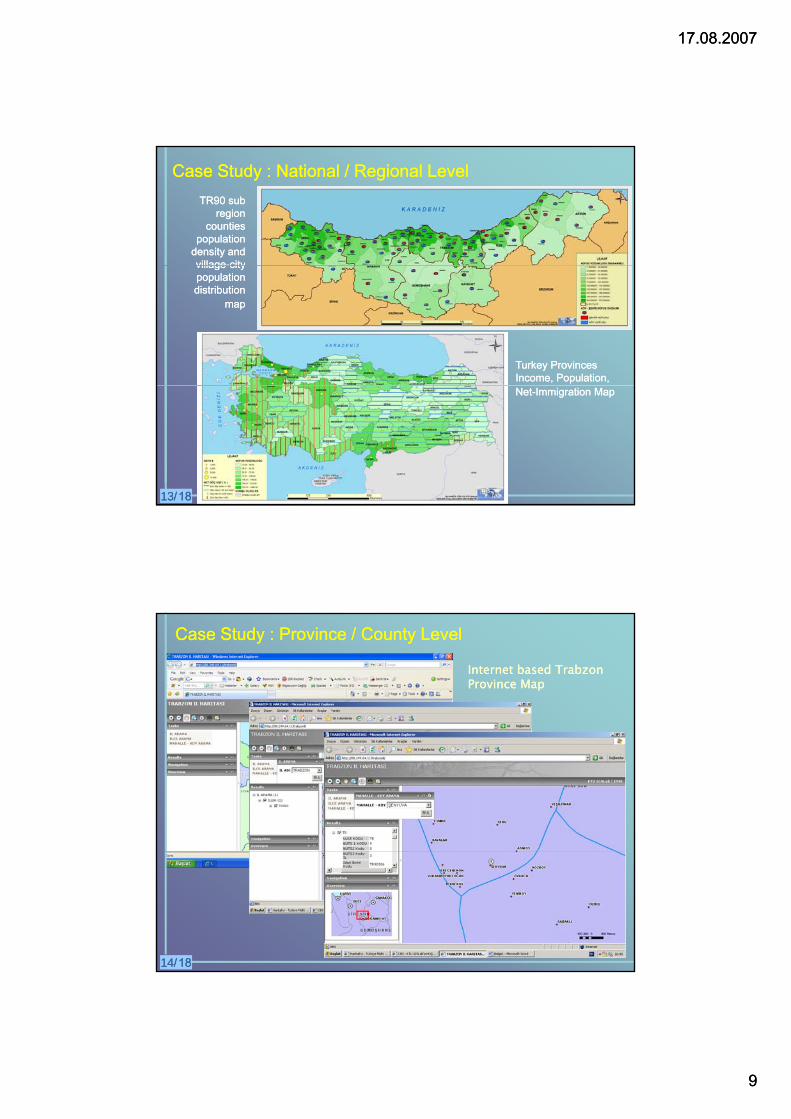
TR90 TR90 subsubregionregion
countiescountiespopulationpopulation
densitydensity andandvillagevillage--citycity
CaseCase StudyStudy : : NationalNational / / RegionalRegional LevelLevel
TurkeyTurkey ProvincesProvincesIncomeIncome, , PopulationPopulation, ,
villagevillage citycitypopulationpopulationdistributiondistribution
mapmap
NetNet--ImmigrationImmigration MapMap
13/13/1818
Internet Internet basedbased Trabzon Trabzon ProvinceProvince MapMap
CaseCase StudyStudy : : ProvinceProvince / / CountyCounty LevelLevel
14/14/1818
17.08.200717.08.2007
1010
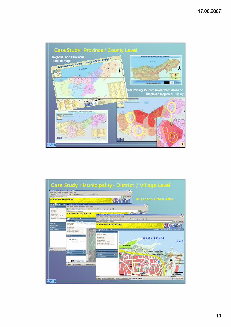
CaseCase StudyStudy: : ProvinceProvince / / CountyCounty LevelLevelRegional and Provincial Regional and Provincial Tourism MapsTourism Maps
3
Determining Tourism Investment Areas on Determining Tourism Investment Areas on BlackSea Region of TurkeyBlackSea Region of Turkey
15/15/1818
1
2
3
CaseCase StudyStudy : : MunicipalityMunicipality/ / DistrictDistrict / / VillageVillage LevelLevel
@Trabzon Urban Atlas@Trabzon Urban Atlas
16/16/1818
17.08.200717.08.2007
1111
CONCLUSIONSCONCLUSIONS
Public Public InstitutioInstitutionsns hahaveve produced spatial data on different formats and produced spatial data on different formats and standards in Turkey. Collecting and sharing spatial data coming from standards in Turkey. Collecting and sharing spatial data coming from different sources have difficulty. different sources have difficulty.
Especially, it is difficult to get District and Village Administrative data setsEspecially, it is difficult to get District and Village Administrative data setsEspecially, it is difficult to get District and Village Administrative data sets Especially, it is difficult to get District and Village Administrative data sets from local governments.from local governments.
To execute various thematic applications, Administrative Unit data theme To execute various thematic applications, Administrative Unit data theme should be modeled and combined as a part of SDI development from should be modeled and combined as a part of SDI development from national to local level.national to local level.
By this way, it is required to build Data Sharing Information Model as By this way, it is required to build Data Sharing Information Model as examined in this studyexamined in this study forfor allall data data themesthemes..
This approach enables a variety of applications This approach enables a variety of applications from census and from census and demography to public health and environment for planning, maintaining, demography to public health and environment for planning, maintaining, or rationalising activitiesor rationalising activities..
18/18/1818
Thanks for your listening…Thanks for your listening…Greetings from TrabzonGreetings from Trabzon
Arif Cagdas AYDINOGLU, Ress. Ass.Arif Cagdas AYDINOGLU, Ress. Ass.Karadeniz Technical UniversityKaradeniz Technical UniversityDept. Of Geodesy and Photog. EngineeringDept. Of Geodesy and Photog. EngineeringGISLab 61080 TRABZONGISLab 61080 TRABZON
www.gislab.ktu.edu.trwww.gislab.ktu.edu.tr
GISLab 61080 TRABZONGISLab 61080 TRABZONee--mail: [email protected]: [email protected]