addendum to the land use and development opportunities...
TRANSCRIPT

Addendum to the Land Use and Development Opportunities Technical Report
August 2011
WESTSIDE SUBWAY EXTENSION PROJECT


Land Use and Development Opportunities Technical Report
Addendum
W E S T S I D E E X T E N S I O N T R A N S I T C O R R I D O R S T U D Y August 2011 Page 1
SUMMARY
On October 28, 2010, the Metro Board selected the Westwood/VA Hospital Extension (Alternative 2 in the Draft EIS/EIR) as the Locally Preferred Alternative (LPA) and authorized the preparation of the Westside Subway Extension Final EIS/EIR (the Final EIS/EIR) to analyze the LPA. This alternative would extend HRT, in subway, approximately nine-miles from the existing Metro Purple Line Wilshire/Western Station to a Westwood/VA Hospital Station. A detailed description of the LPA is provided in Chapter 2 of the Final EIS/EIR.
This addendum supplements materials in the Westside Subway Extension Project Land Use and Development Opportunities Technical Report (the Report) dated August 2010 and supports the Final EIS/EIR. The LPA is referred to as Alternative 2 in this addendum and the Report. Modifications to the Report incorporated into this addendum reflect responses to comments on the Draft EIS/EIR and refinements to Alternative 2 as described in Chapter 2 of the Final EIS/EIR.
1.0 INTRODUCTION
No change.
2.0 PROJECT DESCRIPTION
Change The Project description has been refined as part of the Final EIS/EIR.
On October 28, 2010, the Metro Board selected the Westwood/VA Hospital Extension (Alternative 2 in the Draft EIS/EIR) as the Locally Preferred Alternative (LPA) and authorized the preparation of the Westside Subway Extension Final EIS/EIR (the Final EIS/EIR) to analyze the LPA. This alternative would extend HRT, in subway, approximately nine-miles from the existing Metro Purple Line Wilshire/Western Station to a Westwood/VA Hospital Station. The extension would include a total of seven new stations:
Wilshire/La Brea
Wilshire/Fairfax
Wilshire/La Cienega
Wilshire/Rodeo
Century City (Century City Santa Monica or Century City Constellation)
Westwood/UCLA (Westwood/UCLA On-Street or Westwood/UCLA Off-Street)
Westwood/VA Hospital (Westwood/VA Hospital South or Westwood/VA Hospital North)
The estimated one-way running time for the project would be approximately 15 minutes from the Wilshire/Western Station to the Westwood/VA Hospital Station. The extension would operate at headways of 4 minutes during peak periods and 10 minutes during off-peak periods. As part of the project, Metro is also planning

Land Use and Development Opportunities Technical Report
Addendum
W E S T S I D E S U B W A Y E X T E N S I O N Page 2 August 2011
several enhancements to the Division 20 Maintenance and Storage Facility.
The construction schedule for the Project is partially dependent on the timing of Federal funding availability. Two LPA construction scenarios are considered. Both scenarios will contain the same elements with differences only in the timing of when they are built and operational. The first construction scenario assumes that under the America Fast Forward (30/10) Scenario (Concurrent Construction), the LPA would open in its entirety to the Westwood/VA Hospital Station in 2022 with the three construction segments built concurrently (Wilshire/Western to Wilshire/La Cienega, Wilshire/La Cienega to Century City and Century City to Westwood/VA Hospital). The second construction scenario assumes that under the Metro Long Range Transportation Plan (LRTP) Scenario (Phased Construction), the LPA would open in three consecutive phases (Phase 1 to Wilshire/La Cienega, Phase 2 to Century City, and Phase 3 to Westwood/VA Hospital), with the entire LPA operational to the Westwood/VA Hospital Station in 2036.
A detailed description of the LPA is provided in Chapter 2 of the Final EIS/EIR.
3.0 REGULATORY FRAMEWORK
3.2 Local Land Use Policies
Add The following are additions of applicable land use policies for Section 3.2, Local Land Use Policies. The subsequent sections within Section 3.2 would be renumbered accordingly.
3.2.16 City of Los Angeles Historic Preservation Overlay Zones (HPOZ)
Los Angeles has developed an expansive program of Historic Preservation Overlay Zones (HPOZs) to identify and protect neighborhoods with distinct architectural and cultural resources. HPOZs, commonly known as historic districts, are a land use tool which provide for review of proposed exterior alterations and additions to historic properties within designated districts. The following HPOZs are within ½-mile of the proposed stations.
Hancock Park HPOZ - The Hancock Park HPOZ is bordered by Wilshire Boulevard and Melrose Avenue to the north and south and Rossmore Avenue and Highland Avenue to the east and west. The architecture of this primarily residential HPOZ is dominated by the Spanish Colonial Revival style residences with skilled craftsmanship, decorative detailing, and individuality. The residences incorporate the characteristic use of low-pitched red tile roofs, arched doors and windows, and smooth stucco exterior finishes provides visual continuity and cohesiveness to the neighborhood.
Carthay Circle HPOZ –The Carthay Circle HPOZ is bordered by Wilshire and Olympic Boulevards to the north and south and Fairfax Avenue and Schumacher Drive to the east and west. This development was the first subdivision in Los Angeles to be planned with underground utilities, maintaining the streetscape free of the clutter of telephone poles and electric wires. The architecture of this
Land Use and Development Opportunities Technical Report
Addendum
W E S T S I D E E X T E N S I O N T R A N S I T C O R R I D O R S T U D Y August 2011 Page 3
primarily residential HPOZ is dominated by the Spanish Colonial Revival style.
3.2.17 City of Los Angeles Community Design Overlay Districts (CDO)
Community Design Overlay Districts (CDO) provide guidelines and standards for public and private development projects in commercially zoned areas. The intent of the CDO is to provide guidance and direction in the design of new and rehabilitation of existing buildings and storefronts in order to improve the appearance, enhance the identity and promote the pedestrian environment of the District. The following CDO is within ½ mile of the proposed station areas. Miracle Mile Community Design Overlay District - the Miracle Mile CDO is located along Wilshire Boulevard from La Brea Avenue on the east to Fairfax Boulevard on the west. The goal of the Miracle Mile CDO is to preserve the unique Art Deco character of the District.
4.0 AFFECTED ENVIRONMENT
No change.
5.0 ENVIRONMENTAL IMPACT/ENVIRONMENTAL CONSEQUENCES
5.4.2.1 Division of an Established Community
Applicable Land Use Policies
Add The following goals and polices supplement and are added to Table 5-2.

Land Use and Development Opportunities Technical Report
Addendum
W E S T S I D E S U B W A Y E X T E N S I O N August 2011 Page 5
Table 5-2: Goals and Policy Consistency for Alternative 1
Goal and Policy Jurisdiction Identifying Policy Discussion
Automobile (VMT) Reduction
Expand the availability of transportation options throughout the county especially those that reduce automobile dependence
County of Los Angeles General Plan Alternative 1 would expand the availability of transportation options by establishing a heavy rail transportation system which would reduce automobile dependency and would continue to do so as multi-modal links throughout the region continue to be developed.
Increased Intensity of Development and Growth Along Transit Corridors
Promote the development of transit alignments and station locations that maximize transit service to activity centers and which permit the concentration of future growth and development around transit stations
City of Los Angeles, General Plan Framework, Land Use/Transportation Policy
Alternative 1 would support smart density within the transit corridor, where appropriate, and increase accessibility to commercial and activity centers. The existing and planned transit system provides the opportunity to concentrate development, affect the City’s form, and conserve the existing character of stable neighborhoods.
Provide incentives and development standards for residential and commercial uses in designated transit oriented districts
County of Los Angeles Transit Oriented District Ordinance
Alternative 1 would enable the creation of transit-oriented districts which would allow for increased smart development along a transit corridor.
Promote and develop transit oriented districts along major transit corridors
County of Los Angeles General Plan Alternative 1 would enable the creation of transit-oriented districts which would allow for increased smart development along an existing transit corridor.
Promote the efficient use of land through a more concentrated pattern of urban development, including the focusing of new urban growth into areas of suitable land
County of Los Angeles General Plan Alternative 1 would promote the efficient use of land by providing the opportunity for concentrated development in an appropriate location.
Cooperation and Joint Development Opportunities
Expand inter-jurisdictional cooperation to ensure a seamless, inter-modal, and multi-modal regional transportation system
County of Los Angeles General Plan Alternative 1 includes extensive public agency coordination across multiple jurisdictions to maximize the efficiency, and connectivity of the system.
Enhance Regional Connectivity
Require a maximum level of connectivity in transportation systems and community-level designs
County of Los Angeles General Plan Alternative 1 would increase the connectivity of the existing fixed guideway system and establishing a foundational base on which to build upon in the future.
Promote the development of an improved public transportation system to link regional centers and support urban revitalization
County of Los Angeles General Plan Alternative 1 would link Downtown Los Angeles to major activity centers in Westwood, Century City, West Hollywood and Beverly Hills.
Minimize Environmental Impacts
Support the development of a transportation system that will make a positive contribution to the improvement of air quality
County of Los Angeles General Plan Alternative 1 would include a mix of uses which support pedestrian activity and reduce the need for the automobile. Reduction in VMT would lead to an improvement in air quality.
Land Use and Development Opportunities Technical Report
Addendum
W E S T S I D E S U B W A Y E X T E N S I O N Page 6 August 2011
5.4.3 Adjacent or Surrounding Land Uses
Change The following footnote has been added to the fourth sentence of the first paragraph, “The net growth in SCAG employment and housing projections from the years 2010 to 2035 by transit analysis zone is also summarized.1
1Since the size of transit analysis zones varies, data from the transit analysis zones was included where more than 50 percent of the zone falls within ¼-mile of the station.
Change The following are modifications of and replace Figure 5-6 and 5-7.
1Since the size of transit analysis zones varies, data from the transit analysis zones was included where more than 50 percent of the zone falls within ¼-mile of the station.

Land Use and Development Opportunities Technical Report
Addendum
W E S T S I D E S U B W A Y E X T E N S I O N August 2011 Page 7
Figure 5-6: Century City 1/4-Mile Station Area

Land Use and Development Opportunities Technical Report
Addendum
W E S T S I D E S U B W A Y E X T E N S I O N Page 8 August 2011
Figure 5-7: Wilshire/Westwood 1/4-Mile Station Area

Land Use and Development Opportunities Technical Report
Addendum
W E S T S I D E S U B W A Y E X T E N S I O N August 2011 Page 9
5.5.3 Adjacent or Surrounding Land Uses
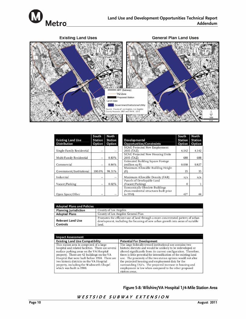
Change The following are modifications of and replace Figure 5-8.
Land Use and Development Opportunities Technical Report
Addendum
W E S T S I D E S U B W A Y E X T E N S I O N Page 10 August 2011
Figure 5-8: Wilshire/VA Hospital 1/4-Mile Station Area

Land Use and Development Opportunities Technical Report
Addendum
W E S T S I D E S U B W A Y E X T E N S I O N August 2011 Page 11
5.5.1 Regional Land Use and Development
Change The following are modifications of and replace Section 5.5.1.
Similar to Alternative 1, the Wilshire/VA Hospital Extension Alternative could have an indirect role in the pattern of growth and development within the study area by making those areas around the stations attractive as transit-oriented type development. In general, growth is constrained by access and circulation as well as land use controls within the Westside Corridor. The existing transportation network is constrained by the high volume of automobiles that are attracted to this job rich area. Alternative 2 would provide an alternative mode of access and circulation. As a result, future development in the Westside Corridor could occur in the form of transit-supportive land uses along the Wilshire Boulevard Corridor, and in particular, within a 1/4-mile radius from stations. SCAG forecasts 11,881 new housing units and 39,261 new jobs for the proposed station areas (1/4-mile radius) identified under Alternative 2. This represents approximately 8 percent of the new housing units and 14 percent of the new jobs within the Westside Corridor. The proposed project would serve the corridor by providing a linkage to the larger regional transportation network and expanded travel options and reduced congestion. Therefore, no direct or indirect adverse effects associated with regional land use would result.
6.0 CEQA DETERMINATION
No change.