adas map speed limits - tomtom
TRANSCRIPT

ADAS Map SpeedLimits Improve mandatory Intelligent Speed Assistance and vehicle safety ratings

Executive summaryEuropean countries are mandating Intelligent Speed
Assistance (ISA) – a safety function that uses speed
limit information to improve advanced driver assistance
system – for all new car models starting in 2022.
This whitepaper explains ISA and the overlap it shares
with NCAP vehicle safety ratings, which attribute the
best performance to map-based and fused systems.
In addition to speed limits, we look at how digital maps
can also be used to enhance ADAS, with the map
acting as a sensor.

Introduction to Intelligent Speed AssistanceTo increase the safety, comfort and efficiency of driving and advanced driver assistance systems (ADAS), more and more original equipment manufacturers (OEMs) are integrating map data, such as speed limit information, into their ADAS. An example of this is Intelligent Speed Assistance (ISA). ISA increases driver awareness of the current speed limit and thereby can reduce the likelihood of speeding.
According to the European Commission, speeding contributes to 30% of fatal road accidents1. The numbers are similar in the United States, where 26% of all traffic fatalities in 2018 were speeding-related, killing 9,378 people, as shown by the National Highway Traffic Safety Administration (NHTSA)2.
In Europe, legislation of the newly revised General Safety Regulation (661/2009/EC)3 is converging with the new car assessment program (NCAP) regarding usage of speed limit information. The vehicle safety ratings are used across Europe, Asia and Latin America, with the Euro NCAP being most well-known.
The European legislation has made ISA mandatory for all new vehicles (including cars, vans, trucks and buses) starting in 2022. By 2024, all vehicles types sold will be equipped with ISA. Latest draft ISA legislation indicates 90% accuracy is required, which likely cannot be achieved without digital map data. ISA acts as a speed limiter and can be actively implemented (preventing speeding by automatically decelerating) or passively (providing warnings only). These can also be summarized as Level 0 (passive) and Level 1 (active) driver assistance features, per SAE levels of driving automation5.
ISA can be implemented based on camera detection of speed limits along the road or map-based speed limits. Both have advantages and disadvantages, however, recent Euro NCAP vehicle safety ratings indicate map data is preferred. For a speed limit map, the applicable speed limit can be determined based on the car’s position using GPS technology. Since 2018, all cars in Europe are equipped with GPS, as this is a requirement of eCall.
In the U.S., the danger of speeding is recognized but not (yet) translated into mandatory technology or legislation for passenger vehicles. Rather, the focus is on education. NHTSA studies have confirmed the safety benefits of speed limiting devices. In 2016, NHTSA called for heavy-duty vehicles to be equipped with speed-limiting devices set to a specific maximum speed. Note that speed-limiting devices are different to ISA as they aim to reduce speeding based on the speed limit of the current road the car is driving.
in 2019 the Insurance Institute for Highway Safety (IIHS) urged NTHSA to move beyond education to address this. Hence, it can be expected that in the future, the U.S. will also adopt some form of ISA regulation.
1. https://ec.europa.eu/transport/road_safety/sites/roadsafety/files/specialist/knowledge/pdf/speeding.pdf2. https://www.nhtsa.gov/risky-driving/speeding3. https://eur-lex.europa.eu/legal-content/EN/TXT/PDF/?uri=CELEX:32019R2144&from=EN4. https://etsc.eu/wp-content/uploads/ETSC-ISA-infographic.pdf 5. https://www.sae.org/news/press-room/2018/12/sae-international-releases-updated-visual-chart-for-its-%e2%80%9clevels-of-driving- automation%e2%80%9d-standard-for-self-driving-vehicles
Figure 1: ISA infographic4

Vehicle safety rating and ISA requirementsNCAP and Euro NCAP specifically created the five-star safety rating system to help consumers, their families and businesses compare vehicles more easily and to help them identify the safest choice for their needs. The safety rating is determined from a series of vehicle tests, designed and carried out by Euro NCAP6. Euro NCAP safety ratings and European legislation for ISA have great overlap in terms of requirements, benefits and user experience.
The five-star NCAP ratings cover four different boxes, as visualized below. The score in each box is based on performance across various tests. For each box, a total score is normalized with respect to the maximum achievable score7. Of the four categories, speed limits and Intelligent Speed Assist are covered within the Safety Assist domain.
Within Safety Assist, three points can be earned for Speed Assistance. For a perfect five-star score, Euro NCAP prescribes the need for an “all-round performance”, therefore a minimum score must be achieved within Safety Assist. This means it is nearly impossible to achieve a five-star score with a low Speed Assistance score. Within Safety Assist, Euro NCAP assesses different functions of Speed Assistance: > informing the driver of the present speed limit;> warning the driver when the car’s speed is above the set speed threshold;> actively preventing the car from exceeding or maintaining the set speed;> accuracy of understanding and interpretation of conditional and implicit speed limits.
In addition to explicit speed limit signs posted next to roads, there are conditional and implicit speed limits. Examples of conditional speed limits are weather dependent, time dependent and vehicle specific. Examples of implicit speed limits include residential area, city and highway entry signs. Thanks to internal data sources, we know that approximately 60% of all speed limits in Europe are implicit speed limits.
Throughout 2019, Euro NCAP tested various features of 56 cars, including the required Safety Assist. Speed limit information is derived from a camera, digital map or a fusion of both. If both are not available, some points can be earned with a speed limiter that requires manual input. The tests found the following:
1. 26/56 tested cars had a camera-only system, whereas 17/56 incorporated map data. The remaining vehicles had neither camera nor map and were equipped only with a manual speed limiter input.
2. On average, map-based systems scored 2.9 out of maximum 3 points (Tesla 3 and Tesla X).
3. On average, camera-based systems scored 2.4 out of maximum 3 points.
4. The perfect score was achieved by a system fusing map data with camera input.
Adultoccupant
Vulnerableroad users
Childoccupant
Safetyassist
6. https://www.euroncap.com/en/about-euro-ncap/7. https://cdn.euroncap.com/media/58228/euro-ncap-assessment-protocol-overall-rating-v901.pdf
Figure 3: Example of weather-dependent speed limit in Germany
Figure 2: Euro NCAP rating categories

The findings show that map-based speed limits earn higher vehicle safety ratings. Euro NCAP prescribes maps be updated quarterly for six years.
We believe this is valuable input for the European legislation of ISA and possible future legislation in the U.S. The discrepancy of superior map-based systems can be explained by the implicit and conditional speed limits.
The 2019 Euro NCAP test results confirm this. Approximately 20% of the camera systems managed to detect time-dependent speed limits or implicit speed limits. In March 2020, the Netherlands introduced time-dependent speed limits for their complete highway network, for environmental reasons.
The main advantage of cameras is that they do not require connectivity, as map updates do. Second, most cars already have cameras onboard for other ADAS such as pedestrian detection, lane keeping and forward collision warnings.
Adverse driving scenarios – heavy rain, foliage and obstruction – that impact driver safety but are not reflected in test scores also need to be taken into consideration. Cameras may also detect signs from adjacent roads like highway exits, leading to incorrect or missing speed limit information. The advantage of a speed limit map is that it can provide speed limit information irrespective of driving conditions, if it is regularly updated.
Clearly, both cameras and maps have advantages and disadvantages as sole sources for ISA. Nienhuser, Gumpp, Zollner; 2009 tested the benefits of a fused (map + cameras) system and concluded with several benefits. For example, “The proposed fusion approach was implemented and evaluated on a qualitative base showing very promising results: The situation context aware fusion is able to deduce the correct effective speed limit even when one of the sensors fails.”8
Variable speed limit type
Camera
Rain- dependent speed limits
69%
Snow- dependent speed limits
81%
Distance-dependent speed limits
75%
Time-dependent speed limits
13%
Arrows
75%
Vehicle category
94%
Implicit (3) highway/city/ residential average
21%
Dynamic
94%
Average of all
56%
Figure 4: Time-dependent speed limits in the Netherlands
Table 1: Average correctness of camera-based speed limit detection.
8. https://ieeexplore.ieee.org/document/5164490

There are three distinct categories of ADAS that benefit from a map. Within each category there are many variants and different naming applied by OEMs. The three ADAS categories are:1. Longitudinal ADAS; e.g. ISA or Predictive Adaptive Cruise Control (ACC)2. Lateral ADAS: Lane Change Assist (LCA)3. Energy management planning for long routes
Longitudinal ADAS refers to functions that adapt vehicle speed accordingly. Predictive ACC, also known as Predictive Cruise Control or Predictive Powertrain Control9, incorporates almost all available map data to smoothen the ACC. For example, when approaching a sharp curve or steep descent, the car will decelerate accordingly. This has obvious safety, comfort and efficiency benefits. Equipped with theTomTom ADAS Map, Daimler Trucks was able to achieve 5% fuel savings. While Delphi Technologies proved that over 10% fuel savings can be achieved with a hybrid vehicle10.
Additional ADAS functions to improve road safetyUsing map data to further improve ADAS or enable additional use cases is not new. On the contrary, the ADASIS organization, which aims to standardize the interface between maps and ADAS ECUs, was founded in 2002. In the years thereafter, more and more cars and trucks incorporated speed limits, traffic signs, curvature, gradient, lane information and more.
The rationale behind map-enhanced ADAS is that the map acts as an additional sensor. The map complements camera and radar sensors, increasing sensor range and serving as a fallback when visibility is low. This allows ADAS to anticipate the road geometry ahead over the next few kilometers, improving predictiveness of the ADAS and increasing safety, comfort and efficiency. The TomTom ADAS Map contains the following key features: > Curvature and gradient > Traffic signs and speed limits > Lane information (lane count, dividers, connectivity, etc.)
Figure 5: TomTom ADAS Map features
9. https://www.thenewsmarket.com/news/tomtom-maps-help-trucks-to-save-fuel/s/9fe20d97-2c22-4d98-81cd-ccd2b0657bf110. https://www.delphi.com/newsroom/press-release/delphi-technologies-and-tomtom-adas-map-innovation-delivers-fuel-savings
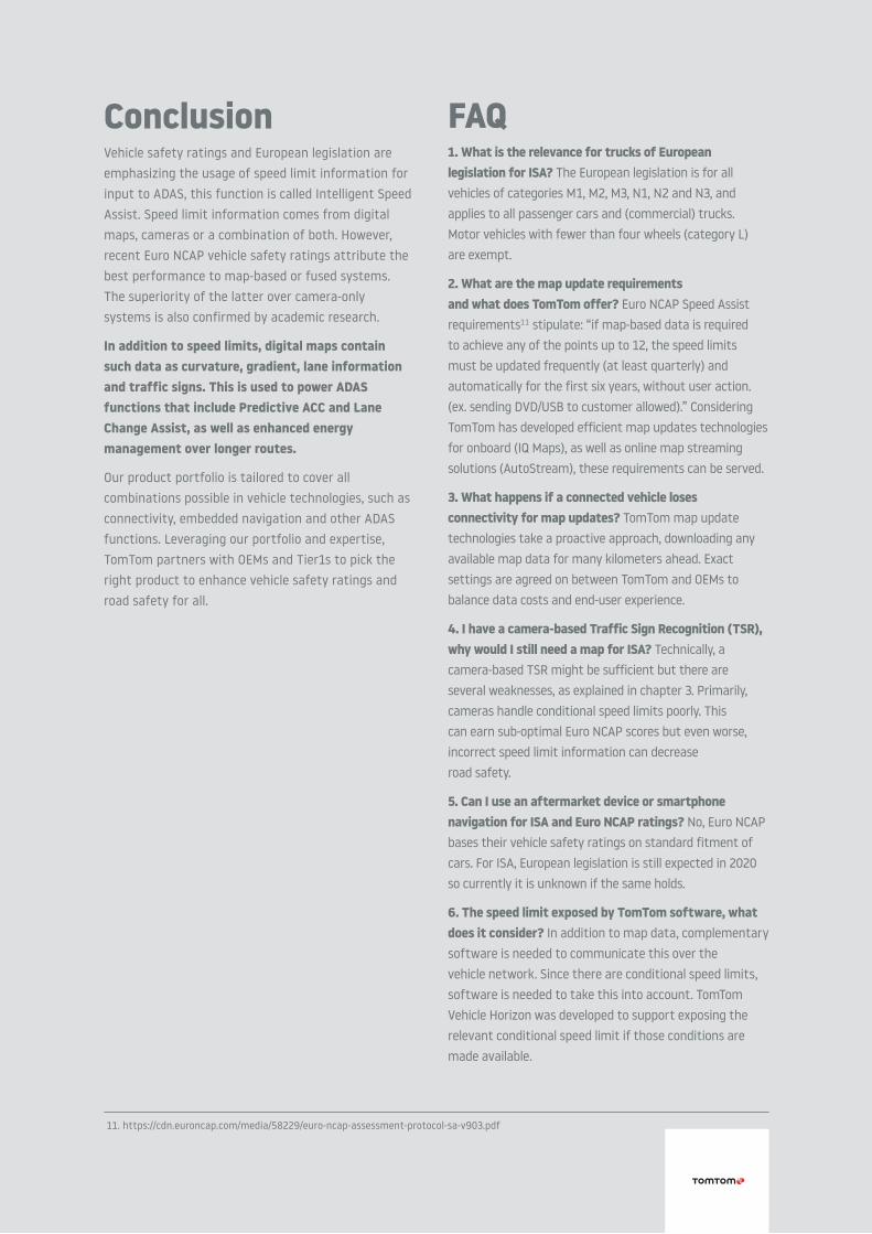
By complementing onboard sensors with ADAS Map data, the vehicle receives confirmation that there are four lanes, an additional left-lane split upcoming and what the legal path is to complete overtaking.
Lastly, for long routes (e.g. >50km) map data can be used to improve efficiency. Gradient and speed limits are used to more accurately predict energy consumption of different routes. This can be used to help hybrid vehicles manage energy consumption, switching back to the battery for low emission zones or road stretches with declining roads to recharge.
Considering the above use cases and ISA legislation, TomTom has transformed its portfolio to best service expanding customer needs.
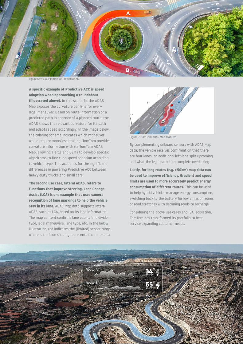
A specific example of Predictive ACC is speed adaption when approaching a roundabout (illustrated above). In this scenario, the ADAS Map exposes the curvature per lane for every legal maneuver. Based on route information or a predicted path in absence of a planned route, the ADAS knows the relevant curvature for its path and adapts speed accordingly. In the image below, the coloring scheme indicates which maneuver would require more/less braking. TomTom provides curvature information with its TomTom ADAS Map, allowing Tier1s and OEMs to develop specific algorithms to fine tune speed adaption according to vehicle type. This accounts for the significant differences in powering Predictive ACC between heavy-duty trucks and small cars.
The second use case, lateral ADAS, refers to functions that improve steering. Lane Change Assist (LCA) is one example that uses camera recognition of lane markings to help the vehicle stay in its lane. ADAS Map data supports lateral ADAS, such as LCA, based on its lane information. The map content confirms lane count, lane divider type, legal maneuvers, lane type, etc. In the below illustration, red indicates the (limited) sensor range, whereas the blue shading represents the map data.
Figure 7: TomTom ADAS Map features
Figure 6: visual example of Predictive ACC

TomTom offering for ISA and other map-based ADASThe TomTom product offering consists of both map content and map delivery software. The latter is needed to communicate the (updated) map data from the cloud towards the in-vehicle ECUs, which host the specific ADAS function. This includes the ADASIS v2 and lightweight ADASIS v2 mini horizon provider. To deliver incremental map updates, TomTom has developed intelligent map delivery services: AutoStream for map streaming and IQ Maps for automatic relevant onboard map updates. Also keep in mind the other technology components that are present in the car: embedded navigation, cellular connectivity and ADAS functions like Predictive ACC. The table below summarizes TomTom’s solutions across different scenarios.
Quality of TomTom ADAS Map As Level 1-2 driver assistance systems rely on the TomTom ADAS Map, quality is very important. TomTom had 95% quality targets since early 2020 and will further increase this from 2021 onwards.
The superior quality is also confirmed by internal product quality audits, as part of the stringent quality process. Benchmarking per Q3 2020 confirmed a much lower speed limit incorrectness rate compared to competition (specifically, HERE and Waze). Weighted for most driven roads, HERE’s incorrectness rate was approximately 50% higher whilst Waze’s error rate was more than 200% higher.
Available in vehicle
Not available
Embedded navigation
> Full ADAS Map; onboard storage or online map delivery
> Lightweight ADAS Map (only speed limits); onboard storage or online map delivery
> Full or lightweight ADAS Map with online map delivery
> Full or lightweight ADAS Map with onboard storage
> Full ADAS Map; onboard storage or online map delivery
> Lightweight ADAS Map (only speed limits); onboard storage or online map delivery
Cellular connectivity
ADAS
Table 2: Summary of TomTom ADAS products
FAQ1. What is the relevance for trucks of European legislation for ISA? The European legislation is for all vehicles of categories M1, M2, M3, N1, N2 and N3, and applies to all passenger cars and (commercial) trucks. Motor vehicles with fewer than four wheels (category L) are exempt.
2. What are the map update requirements and what does TomTom offer? Euro NCAP Speed Assist requirements11 stipulate: “if map-based data is required to achieve any of the points up to 12, the speed limits must be updated frequently (at least quarterly) and automatically for the first six years, without user action. (ex. sending DVD/USB to customer allowed).” Considering TomTom has developed efficient map updates technologies for onboard (IQ Maps), as well as online map streaming solutions (AutoStream), these requirements can be served.
3. What happens if a connected vehicle loses connectivity for map updates? TomTom map update technologies take a proactive approach, downloading any available map data for many kilometers ahead. Exact settings are agreed on between TomTom and OEMs to balance data costs and end-user experience.
4. I have a camera-based Traffic Sign Recognition (TSR), why would I still need a map for ISA? Technically, a camera-based TSR might be sufficient but there are several weaknesses, as explained in chapter 3. Primarily, cameras handle conditional speed limits poorly. This can earn sub-optimal Euro NCAP scores but even worse, incorrect speed limit information can decrease road safety.
5. Can I use an aftermarket device or smartphone navigation for ISA and Euro NCAP ratings? No, Euro NCAP bases their vehicle safety ratings on standard fitment of cars. For ISA, European legislation is still expected in 2020 so currently it is unknown if the same holds.
6. The speed limit exposed by TomTom software, what does it consider? In addition to map data, complementary software is needed to communicate this over the vehicle network. Since there are conditional speed limits, software is needed to take this into account. TomTom Vehicle Horizon was developed to support exposing the relevant conditional speed limit if those conditions are made available.
ConclusionVehicle safety ratings and European legislation are emphasizing the usage of speed limit information for input to ADAS, this function is called Intelligent Speed Assist. Speed limit information comes from digital maps, cameras or a combination of both. However, recent Euro NCAP vehicle safety ratings attribute the best performance to map-based or fused systems. The superiority of the latter over camera-only systems is also confirmed by academic research.
In addition to speed limits, digital maps contain such data as curvature, gradient, lane information and traffic signs. This is used to power ADAS functions that include Predictive ACC and Lane Change Assist, as well as enhanced energy management over longer routes.
Our product portfolio is tailored to cover all combinations possible in vehicle technologies, such as connectivity, embedded navigation and other ADAS functions. Leveraging our portfolio and expertise, TomTom partners with OEMs and Tier1s to pick the right product to enhance vehicle safety ratings and road safety for all.
11. https://cdn.euroncap.com/media/58229/euro-ncap-assessment-protocol-sa-v903.pdf
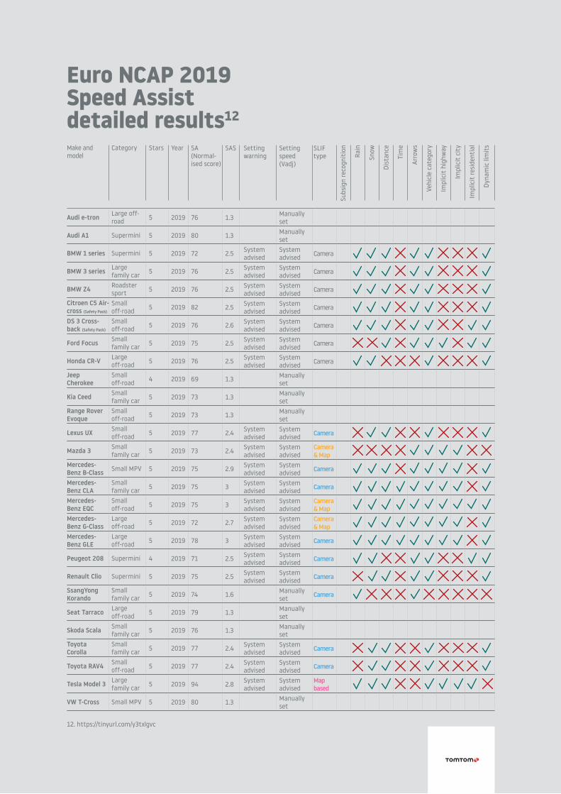
Euro NCAP 2019 Speed Assist detailed results12
Make and model
Audi e-tron
Audi A1
BMW 1 series
BMW 3 series
BMW Z4
Citroen C5 Air-cross (Safety Pack)
DS 3 Cross-back (Safety Pack)
Ford Focus
Honda CR-V
Jeep Cherokee
Kia Ceed
Range RoverEvoque
Lexus UX
Mazda 3
Mercedes-Benz B-ClassMercedes-Benz CLAMercedes-Benz EQCMercedes-Benz G-ClassMercedes-Benz GLE
Peugeot 208
Renault Clio
SsangYong Korando
Seat Tarraco
Skoda Scala
Toyota Corolla
Toyota RAV4
Tesla Model 3
VW T-Cross
Category
Large off-road
Supermini
Supermini
Largefamily carRoadster sportSmall off-roadSmall off-roadSmall family carLarge off-roadSmall off-roadSmall family carSmall off-roadSmall off-roadSmall family car
Small MPV
Small family carSmall off-roadLarge off-roadLarge off-road
Supermini
Supermini
Small family carLarge off-roadSmall family carSmall family carSmall off-roadLargefamily car
Small MPV
Stars
5
5
5
5
5
5
5
5
5
4
5
5
5
5
5
5
5
5
5
4
5
5
5
5
5
5
5
5
Year
2019
2019
2019
2019
2019
2019
2019
2019
2019
2019
2019
2019
2019
2019
2019
2019
2019
2019
2019
2019
2019
2019
2019
2019
2019
2019
2019
2019
SA (Normal-ised score)
76
80
72
76
76
82
76
75
76
69
73
73
77
73
75
75
75
72
78
71
75
74
79
76
77
77
94
80
SAS
1.3
1.3
2.5
2.5
2.5
2.5
2.6
2.5
2.5
1.3
1.3
1.3
2.4
2.4
2.9
3
3
2.7
3
2.5
2.5
1.6
1.3
1.3
2.4
2.4
2.8
1.3
Settingwarning
System advisedSystem advisedSystem advisedSystem advisedSystem advisedSystem advisedSystem advised
System advisedSystem advisedSystem advisedSystem advisedSystem advisedSystem advisedSystem advisedSystem advisedSystem advised
System advisedSystem advisedSystem advised
Settingspeed (Vadj)
ManuallysetManuallysetSystem advisedSystem advisedSystem advisedSystem advisedSystem advisedSystem advisedSystem advisedManuallysetManuallysetManuallysetSystem advisedSystem advisedSystem advisedSystem advisedSystem advisedSystem advisedSystem advisedSystem advisedSystem advisedManuallysetManuallysetManuallysetSystem advisedSystem advisedSystem advisedManuallyset
SLIFtype
Camera
Camera
Camera
Camera
Camera
Camera
Camera
Camera
Camera& Map
Camera
Camera
Camera& MapCamera& Map
Camera
Camera
Camera
Camera
Camera
Camera
Mapbased
Subs
ign
reco
gnit
ion
Rain
Snow
Dist
ance
Tim
e
Arro
ws
Vehi
cle
cate
gory
Impl
icit
hig
hway
Impl
icit
cit
y
Impl
icit
resi
dent
ial
Dyna
mic
lim
its
12. https://tinyurl.com/y3txlgvc