ad-hoc meeting unified analysis working group, vienna, april 15, 2008 gg s proposal for a sinex...
TRANSCRIPT

Ad-hoc Meeting Unified Analysis Working Group, Vienna, April 15, 2008 GG S
Proposal for a SINEX extension –meta data block
Bernd Richter, Carey NollWolfgang Schwegmann
GGOS DIS WG

Ad-hoc Meeting Unified Analysis Working Group, Vienna, April 15, 2008 GG S
Need of Metadata
• Meta data describes:– what is the content, – where one can find the data set, – when and by whom a particular set of data was collected.
• Meta data is essential for understanding information stored in data warehouses and has become increasingly important in XML-based Web applications.
Metadata does not contain data nor replace a data base

Ad-hoc Meeting Unified Analysis Working Group, Vienna, April 15, 2008 GG S
Use of Metadata
• The ISO 19115 standard for geographic metadata is widely used in the GIS world and recommended e.g. by FGDC, OGC and GEOSS.
• It is proposed to follow the same strategy for the GGOS to keep consistency with the main stream.
• Cross mapping allows the use of different metadata standards as long as the necessary information covers the requested formalities and are based on XML technology. E.g. the NASA proposed Directory Interchange Format (DIF) and ISO 19115 a crosswalk is provided .
Ad-hoc Meeting Unified Analysis Working Group, Vienna, April 15, 2008 GG S
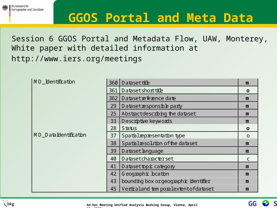
GGOS Portal and Meta Data
Session 6 GGOS Portal and Metadata Flow, UAW, Monterey, White paper with detailed information at http://www.iers.org/meetings
360 Dataset title m
361 Dataset short title o
362 Dataset reference date m
29 Dataset responsible party m
25 Abstract describing the dataset m 33 Descriptive keywords m
MD_Identification
28 Status o 37 Spatial representation type o
38 Spatial resolution of the dataset m
39 Dataset language m
40 Dataset character set c
41 Dataset topic category m 42 Geographic location m 43 bounding box or geographic identifier m
MD_DataIdentification
45 Vertical and temporal extent of dataset m

Ad-hoc Meeting Unified Analysis Working Group, Vienna, April 15, 2008 GG S
Ad-hoc Meeting Unified Analysis Working Group, Vienna, April 15, 2008 GG S

Ad-hoc Meeting Unified Analysis Working Group, Vienna, April 15, 2008 GG S
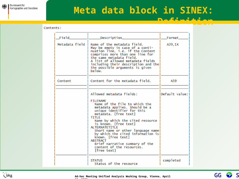
• Definition of an ISO meta data set containing 47 elements.
• The core meta data set is restricted to allow search, analyze, etc. and minimize the time necessary to create the set.
• Draft of a core meta data block for the SINEX-Format:– Introduction of a new block: FILE/METADATA
– Description of the Keyword-pair
Meta data block in SINEX: Definition
Ad-hoc Meeting Unified Analysis Working Group, Vienna, April 15, 2008 GG S
Meta data block in SINEX: Definition

Ad-hoc Meeting Unified Analysis Working Group, Vienna, April 15, 2008 GG S
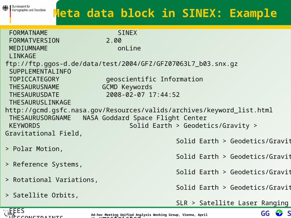
+FILE/METADATA*-------------------------------------------------------------------------------* Example for the contents of the SINEX FILE/METADATA Block for file* DGF07063L7_b03.snx.gz
*Metadata field Content* FILENAME DGF07063L7_b03.snx.gz TITLE GGOS-D DGFI SLR solution 2nd iteration version b03 (GFZ) ALTERNATETITLE GGOS-D DGFI SLR solution ABSTRACT Weekly SINEX file of DGFI SLR solution for GGOS-D (single technique solution). Standards, models and parameterization are chosen with respect to the GGOS-D conventions for the 2nd iteration. With the strict use of common standards within GGOS-D a consistent reprocessing and combination of the space geodetic techniques should be achieved. IDENTIFIER DGF07063L7_b03 STATUS completed LANGUAGE en CHARSET 8859part2 DATE 2007-11-13 13:46:18 DATETYPE creation
Meta data block in SINEX: Example
Ad-hoc Meeting Unified Analysis Working Group, Vienna, April 15, 2008 GG S
FORMATNAME SINEX FORMATVERSION 2.00 MEDIUMNAME onLine LINKAGE ftp://ftp.ggos-d.de/data/test/2004/GFZ/GFZ07063L7_b03.snx.gz SUPPLEMENTALINFO TOPICCATEGORY geoscientific Information THESAURUSNAME GCMD Keywords THESAURUSDATE 2008-02-07 17:44:52 THESAURUSLINKAGE http://gcmd.gsfc.nasa.gov/Resources/valids/archives/keyword_list.html THESAURUSORGNAME NASA Goddard Space Flight Center KEYWORDS Solid Earth > Geodetics/Gravity > Gravitational Field, Solid Earth > Geodetics/Gravity > Polar Motion, Solid Earth > Geodetics/Gravity > Reference Systems, Solid Earth > Geodetics/Gravity > Rotational Variations, Solid Earth > Geodetics/Gravity > Satellite Orbits, SLR > Satellite Laser Ranging FEES USECONSTRAINTS restricted USELIMITATION DATAQUALITY Input data: LAGEOS-1/2 SLR data provided by EDC Software: DOGS_OC 5.00 and DOGS_CS 4.08 Hardware: PC, dual core 2,4 GHz, 2Gbyte Mem, Linux, SuSE 10.3 REFSYSNAME ITRF2000
Meta data block in SINEX: Example

Ad-hoc Meeting Unified Analysis Working Group, Vienna, April 15, 2008 GG S
Selected keywords as used in the Global Change Master Directory (GCMD)
For full information please go to http://gcmd.gsfc.nasa.gov/Resources/valids/gcmd_parameters.html. Olsen, L.M., G. Major, K. Shein, J. Scialdone, R. Vogel, S. Leicester, H. Weir, S. Ritz, T. Stevens, M. Meaux, C.Solomon, R. Bilodeau, M. Holland, T. Northcutt, R. A. Restrepo, 2007 .NASA/Global Change Master Directory (GCMD) Earth Science Keywords. Version 6.0.0.0.0 GCMD Earth Science KeywordsTOPIC > TERM > VARIABLE_LEVEL_1
Solid Earth > Geodetics/Gravity > Crustal Motion Solid Earth > Geodetics/Gravity > Geoid Properties Solid Earth > Geodetics/Gravity > Gravitational Field Solid Earth > Geodetics/Gravity > Gravity Solid Earth > Geodetics/Gravity > Ocean Crust Deformation Solid Earth > Geodetics/Gravity > Polar Motion Solid Earth > Geodetics/Gravity > Reference Systems Solid Earth > Geodetics/Gravity > Rotational Variations Solid Earth > Geodetics/Gravity > Satellite OrbitsSolid Earth > Tectonics > Plate Boundaries Solid Earth > Tectonics > Plate Tectonics

Ad-hoc Meeting Unified Analysis Working Group, Vienna, April 15, 2008 GG S
GEOIDENTIFIER world WESTBL -180.0 EASTBL +180.0 NORTHBL +90.0 SOUTHBL -90.0 BEGIN 2007-03-04 12:57:12 END 2007-03-10 11:44:51 INDIVIDUALNAME Mueller, Horst, Dr ORGANISATIONNAME Deutsches Geodaetisches Forschungsinstitut (DGFI) ROLE originator PHONE ++49-89-23031-1277 FAX ++49-89-23031-1240 DELIVERYPOINT Alfons-Goppel-Straße 11 CITY Muenchen ADMINISTRATIVEAREA Bavaria POSTALCODE 80539 COUNTRY GERMANY EMAIL [email protected] CONTACTLINKAGE http://www.dgfi.badw.de MDSTANDARDNAME ISO 19115 MDSTANDARDVERSION 2003*--------------------------------------------------------------------------------FILE/METADATA
Meta data block in SINEX: Example

Ad-hoc Meeting Unified Analysis Working Group, Vienna, April 15, 2008 GG S
• Separate meta data block– To collect all information at a specific place
(easier to check completeness, make changes) – All keywords should be listed, even it is a zero
record to allow automated extraction.
• Draft of a core meta data block for the SINEX-Format:
– Will be send for comments to the Technique Services together with examples containing proposed keywords
• With the intension to insert the meta data block as soon as possible in regular solutions.
Meta data block in SINEX: Use

Ad-hoc Meeting Unified Analysis Working Group, Vienna, April 15, 2008 GG S
Meta data block: Bulletin A (IERS)