actions for global water and environmental sustainability
TRANSCRIPT

Second UN Special Thematic Session on Water and Disasters, 2015, The UN Headquarters, New York
International Symposium on Integrated Actions for Global Water and Environmental Sustainability -In line with the Commemoration of the 70th Anniversary of UNESCO, October 2015, Medan
Asia Water Cycle Symposium (AWCS2016), March 2016, Tokyo

IFI Side Event at the UNESCO IHP IC New Strategy for International Flood Initiative (IFI)Jun. 2016, Paris
IFI Side Event at the HELP 8th MeetingJakarta Statement: Strategic Implementation PlanOct. 2016, Jakarta
9th GEOSS Asia-Pacific SymposiumImplementation Plans in AsiaJan. 2017, Tokyo
Third UN Special Thematic Session on Water and Disasters Jul. 2017, The UN Headquarters, New York
"Water and Disasters in the Context of Climate Change - from the Mountains to the Islands"
3rd Asia-Pacific Water Summit, Dec. 2017, Yangon
Special Session “High-level panel: Water and Disasters”8th World Water Forum, Mar. 2018, Brazilia

Identification
Policy-making Community of Practice
1. Data Archiving
2. Model Development
3. Societal Benefit
Creation
Societal Change(land use , population)
Climate Change
Monitoring
Prediction
Tran
sdis
cipl
inar
y
Inte
rdis
cipl
inar
y
Cap
acity
Build
ing
����
�������
����
Damage Hazard Socio-Economic
International Cooperation
Platform on Water Resilience and Disasters
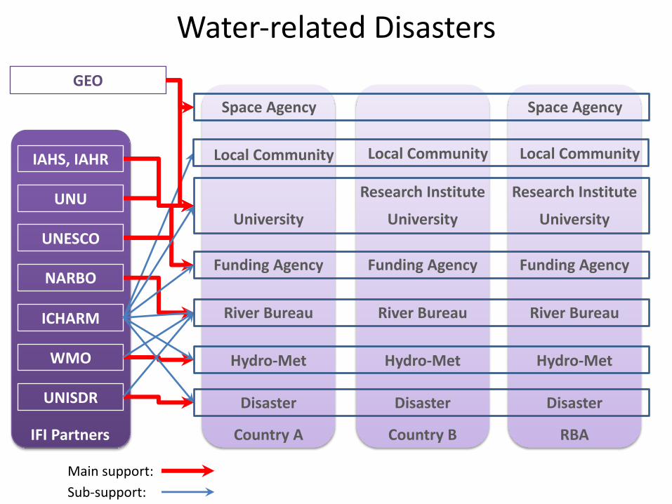
Country A
Hydro-Met
River Bureau
Disaster
University
Funding Agency
IFI Partners
UNISDR
WMO
UNESCO
ICHARM
UNU
IAHS, IAHR
Country B
Hydro-Met
River Bureau
Disaster
University
Funding Agency
Research Institute
Main support: Sub-support:
Local Community Local Community
Water-related Disasters
RBA
Hydro-Met
River Bureau
Disaster
University
Funding Agency
Research Institute
Local Community
NARBO
GEOSpace Agency Space Agency

Identification
Policy-making Community of Practice
1. Data Archiving
2. Model Development
3. Societal Benefit
Creation
Societal Change(land use , population)
Climate Change
Monitoring
Prediction
Tran
sdis
cipl
inar
y
Inte
rdis
cipl
inar
y
Cap
acity
Build
ing
����
�������
����
Damage Hazard Socio-Economic
International Cooperation
Platform on Water Resilience and Disasters

6
Integration: Hazard-Damage-Socio-economyEarly Waring: Flood, Land Slide, Drought
Climate Change Impact Assessment: Dynamical-Statistical Down-scaling
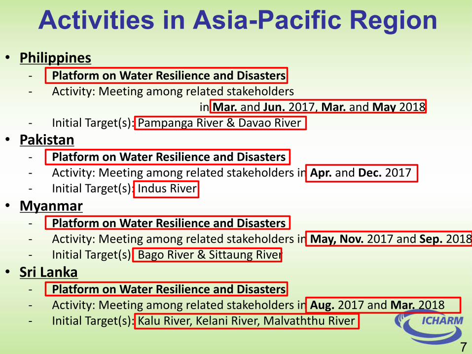
Activities in Asia-Pacific Region• Philippines
- Platform on Water Resilience and Disasters- Activity: Meeting among related stakeholders
in Mar. and Jun. 2017, Mar. and May 2018- Initial Target(s): Pampanga River & Davao River
• Pakistan- Platform on Water Resilience and Disasters- Activity: Meeting among related stakeholders in Apr. and Dec. 2017- Initial Target(s): Indus River
• Myanmar- Platform on Water Resilience and Disasters- Activity: Meeting among related stakeholders in May, Nov. 2017 and Sep. 2018- Initial Target(s): Bago River & Sittaung River
• Sri Lanka- Platform on Water Resilience and Disasters- Activity: Meeting among related stakeholders in Aug. 2017 and Mar. 2018- Initial Target(s): Kalu River, Kelani River, Malvaththu River
7

Activities for“Platform on Water Resilience and Disasters”
Philippines
Participated Stakeholders• DOST : Department of Science and Technology
• PAGASA : Philippine Atmospheric, Geophysical and Astronomical Services Administration
• DPWH : Department of Public Works and Highways
• OCD : Office of Civil Defense
• NEDA : National Economic and Development Authority
• PSA : Philippine Statistics Authority
• NAMRIA : National Mapping and Resource Information Authority
• UP (3) : University of Philippines (3)
Meetings on “Platform on Water Resilience and Disaster”;
l 13 March, 2017 at Metro Manila
l 15 June, 2017 at Metro Manila
l 18 September, 2017 at Hanoi
River Bureau
Hydro-Met
Disaster
Academia
Economy
Geology
Statistics
8
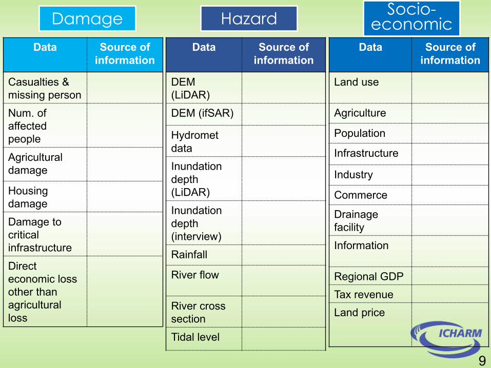
Data Source of information
Casualties & missing person
Num. of affected people
Agricultural damage
Housing damage
Damage to critical infrastructure
Direct economic loss other than agricultural loss
Damage Hazard Socio-economic
Data Source of information
DEM(LiDAR)
DEM (ifSAR)
Hydrometdata
Inundation depth (LiDAR)
Inundation depth (interview)
Rainfall
River flow
River crosssection
Tidal level
Data Source of information
Land use
Agriculture
Population
Infrastructure
Industry
Commerce
Drainage facility
Information
Regional GDP
Tax revenue
Land price
9

Data Source of information
Casualties & missing person
OCD
Num. of affected people
OCD
Agricultural damage
DA
Housing damage
OCD
Damage to critical infrastructure
DPWH, LGU
Direct economic loss other than agricultural loss
LGUNEDA
Damage Hazard Socio-economic
Data Source of information
DEM(LiDAR)
UP Mindanao
DEM (ifSAR) NAMRIA
Hydrometdata
PAGASA, ASTI, DREAM
Inundation depth (LiDAR)
UP Diliman, UP Mindanao
Inundation depth (interview)
PAGASA
Rainfall PAGASA
River flow DPWH, UP Mindanao
River crosssection
DPWH, UP Mindanao
Tidal level NAMRIA
Data Source of information
Land use LGUDOST
Agriculture PSA, DA
Population PSA
Infrastructure DPWH/LGU
Industry DTI
Commerce DTI
Drainage facility
DPWH/LGU
Information PSANEDA
Regional GDP PSA
Tax revenue BIR
Land price City Assessors Office
6Commitments by responsible agencies

Activities for“Platform on Water Resilience and Disaster”Pakistan
A meeting for establishment of “Platform on Water Resilience and Disaster”;l March 2-3, 2017 at PMD Headquarter, Islamabad
Participated Stakeholders• PMD : Pakistan Meteorological Department• PCRWR : Pakistan Council of Research in Water Resources• GCISC : Global Change Impact Studies Center• NARC : National Agriculture Research Centre• NDMA : National Disaster Management Authority• UET : University of Engineering and Technology• NUST : National University of Science and Technology 7
Meteorology
Water Resources
Climate Change
Agriculture
Disaster
AcademiaAcademia

11/1/18 12
Activities (UNESCO Pakistan Project)Indus-IFAS: flood forecasting system based on IFAS/RRI
INPUT DATA :• Rainfall data
(PMD ground-gauges, GSMaPand forecasted)
• Real-time observed discharges
OUTPUT DATA:
• Rainfall distribu-tion maps
• Hydro-graphs at specified locations
• Inundation extents in mid-low Indus
[m]0.0-0.50.5-1.01.0-2.02.0-3.03.0-5.05.0-6.06.0-7.5
FLOOD HAZARD
MAPPING
Inundation area by RRI
INPUT DATA CHALLENGES:
•Lack of trans-boundary data•Null-Low raingauges network density•Uncertainty
on snowmelt
8

Activities on“Platform on Water Resilience and Disaster”
Meetings on “Platform on Water Resilience and Disaster”;l May 9, 2017 at Nay Pyi Tawl November 1, 2017 at Nay Pyi Taw
Participated Stakeholders• DWIR : Directorate of Water Resources and Improvement of
River System• IWUMD : Irrigation and Water Utilization Management Department• DMH : Department of Meteorology and Hydrology• RRD : Relief and Resettlement Department• YTU : Yangon Technology University
Myanmar
9
River Management
Irrigation
Hydro-Meteorology
Disaster
Academia

WEB-DHM ModelSoil moisture
Discharge
Real Time System
~10 mins
~1 mins ~1 mins
~10-15 mins
~20-25 mins delay
Satellite products
Cloud Cover
Shortwave
LAI-FPAR
~ 5 mins
Climate and hydro in-situ data
Pressure
Temperature
Wind
Rainfall
Relative Humidity
Statistical model
Longwave
~1 min
RRI Model
Water levelDischarge
Inundation
Near real-time flood forecast system for the Bago RiverArchived data (JRA55)
Pressure
Temperature
Wind
Solar Radiation
Water-level
SATREPS,DMH, (IWUMD, DHP)
~10 mins
GSMAP, AMSAR2ALOS/PALSAR
User needs
IWUMD, DWIR,DMH, DDM
Dam operationOutflow
Water level
Capacity
IWUMD, DHPI
Cross-section
SATREPS, DWIR
Drainage structure IWUMD
Emergency case DMH
Real Time Processes
Output for stakeholders
Geoprocessing forcing
SATREPS,DMH
Routine operationIWUMD, DWIR, DMH, DHPI
High-resoDEM
SATREPS
Tide
- Remote monitoring /reducing site-visit loads
- Understand real situation- Investigate risk
- Issuing warning
Emergency responseDDM (EOC) 10
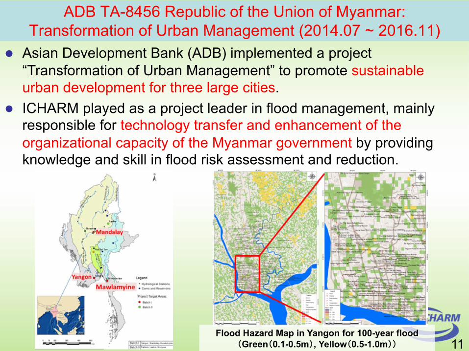
Flood Hazard Map in Yangon for 100-year flood�Green�0.1-0.5m�, Yellow�0.5-1.0m��
ADB TA-8456 Republic of the Union of Myanmar:Transformation of Urban Management (2014.07 ~ 2016.11)
l Asian Development Bank (ADB) implemented a project “Transformation of Urban Management” to promote sustainable urban development for three large cities.
l ICHARM played as a project leader in flood management, mainly responsible for technology transfer and enhancement of the organizational capacity of the Myanmar government by providing knowledge and skill in flood risk assessment and reduction.
11
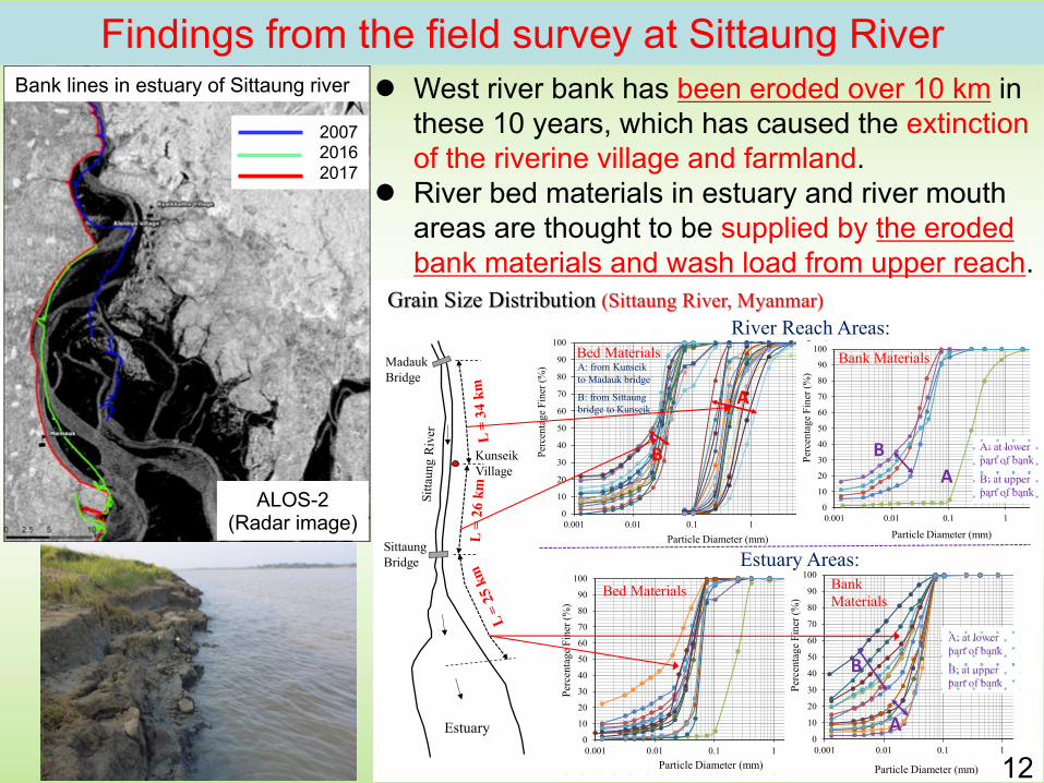
Estuary
Kunseik
Village
Sittaung
Bridge
Madauk
Bridge
0
10
20
30
40
50
60
70
80
90
100
0.001 0.01 0.1 1 10 100
Per
cen
tag
e F
iner
(%
)
Particle Diameter (mm)
S-1
S-2
S-4
S-5
S-6
S-7
S-9
S-10
S-11
S-12
S-16
S-17
S-24
0
10
20
30
40
50
60
70
80
90
100
0.001 0.01 0.1 1 10 100
Per
centa
ge
Fin
er (
%)
Particle Diameter (mm)
S-3
S-8
S-13
S-14
S-15
S-18
S-19
S-20
S-21
S-22
S-23
S-25
S-26
Estuary Areas:
A
B
Bed Materials Bank Materials
A: at lower part of bank
B: at upper part of bank
0
10
20
30
40
50
60
70
80
90
100
0.001 0.01 0.1 1 10 100
Per
cen
tag
e F
iner
(%
)Particle Diameter (mm)
S-1 S-2
S-3 S-4
S-5 S-6
S-7 S-9
S-11 S-12
S-13 S-14
S-16 S-18
S-21 S-22
S-23 S-24
S-25 S-26
S-27 S-28
S-29 S-30
S-31 S-32
S-37 S-38
S-40 S-41
S-42 S-43
S-47 S-49
A
B
River Reach Areas:
A: from Kunseik
to Madauk bridge
B: from Sittaungbridge to Kunseik
Grain Size Distribution (Sittaung River, Myanmar)
Bed Materials
0
10
20
30
40
50
60
70
80
90
100
0.001 0.01 0.1 1 10 100
Per
cen
tag
e F
iner
(%
)
Particle Diameter (mm)
S-19
S-20
S-33
S-34
S-36
Bank Materials
BA
A: at lower part of bank
B: at upper part of bank
Findings from the field survey at Sittaung RiverBank lines in estuary of Sittaung river
2007
2016
2017
l West river bank has been eroded over 10 km in
these 10 years, which has caused the extinction
of the riverine village and farmland.
l River bed materials in estuary and river mouth
areas are thought to be supplied by the eroded
bank materials and wash load from upper reach.
ALOS-2(Radar image)
12

Activities on “Platform on Water Resilience and Disasters”Sri Lanka
Meetings for establishment of “Platform on Water Resilience and Disaster”
l 1st Plenary Session on August 24, 2017l 2nd Plenary Session on March 28, 2018
Sri Lankan Minister joined at the 2nd Plenary Session
13
Post-Disaster Activities after flood and landslide of late May, 2017
Participated Stakeholders• ID : Irrigation Department• DMC : Disaster Management Center• MD : Meteorological Department• SD : Survey Department• NBRO : National Building Research Organization• MMWD : Ministry of Magapolis and Western Development
Irrigation
Disaster
Meteorology
Geological survey
Landslide
Urban
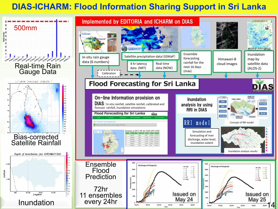
In-situ rain gauge data (6 numbers)
Satellite precipitation data�GSMaP�
�������������������������������������In-situ rainfall, satellite rainfall, calibrated and forecast rainfall, inundation simulations
������������������ ���������������������
ALOS © JAXA (2016)
�����������
�����������������������������
Simulation and forecasting of river
discharge, water level, inundation extent
Inundation analysis results
Concept of RRI model
Ensemble forecasting rainfall for the next 16 days (max)
Himawari-8 cloud images
Inundation map by satellite data (ALOS-2)
4 hr latency data (NRT)
Real time data (NOW)
Calibration
500mm
Bias-corrected Satellite Rainfall
Real-time Rain Gauge Data
Inundation
EnsembleFlood
Prediction
72hr11 ensembles
every 24hr Issued on May 24
Issued on May 25
DIAS-ICHARM: Flood Information Sharing Support in Sri Lanka
14
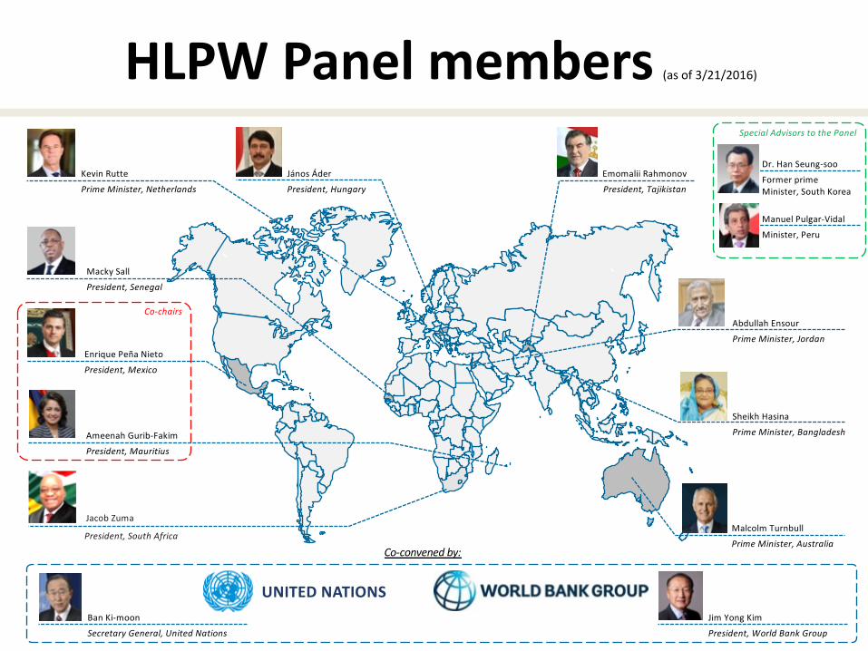
HLPW Panel members (as of 3/21/2016)
`Enrique Peña Nieto
President, Mexico
`
Macky Sall
President, Senegal
` `
`
`
`
Sheikh Hasina
Prime Minister, Bangladesh
János Áder
President, Hungary
Ameenah Gurib-Fakim
President, Mauritius
Abdullah Ensour
Prime Minister, Jordan
Malcolm Turnbull
Prime Minister, Australia
Kevin Rutte
Prime Minister, Netherlands
`Jacob Zuma
President, South Africa
`
Co-chairs
UNITED NATIONSJim Yong Kim
President, World Bank Group
Ban Ki-moon
Secretary General, United Nations
Co-convened by:
Dr. Han Seung-soo
Former prime Minister, South Korea
Manuel Pulgar-Vidal
Minister, Peru
Special Advisors to the Panel
`
Emomalii Rahmonov
President, Tajikistan

20


Identification
Policy-making Community of Practice
1. Data Archiving
2. Model Development
3. Societal Benefit
Creation
Societal Change(land use , population)
Climate Change
Monitoring
Prediction
Tran
sdis
cipl
inar
y
Inte
rdis
cipl
inar
y
Cap
acity
Build
ing
����
�������
����
Damage Hazard Socio-Economic
ICHARM
Platform on Water Resilience and Disasters
Upgrading Education
Hig
h-Le
vel P
ract
ition
erH
igh-
Leve
l Pol
icy-
Mak
er
ShortCourse
MasterCourse
PhDCourse
Higher EducationNational Graduate Research Institute for Policy Study (GRIPS)