acknowledgements - dlr portal
TRANSCRIPT


Acknowledgements
Content Developed By: Alan Ward - Science Systems and Applications Inc.
Designed By: Winnie Humberson - Science Systems and Applications Inc.
Edited By: Margaret Baguio – Texas Space Grant ConsortiumCharlotte Griner – Science Systems and Applications Inc.Michael King – NASA Goddard Space Flight CenterMargaret Srinivasan – Jet Propulsion Laboratory
Technical Input Provided By: Christoph Reigber – GeoForschungs Zentrum; Rick Fitzgerald, Bob Garnett, MarcImhoff – Goddard Space Flight Center;Ab Davis, MikeWatkins – Jet PropulsionLaboratory; Byron Tapley , John Ries, Don Chambers – University of Texas Centerfor SpaceResearch.
Front Cover Foreground:These images show three different views of the Earth's geoid – a surface of equal gravita-tional potential that, over the ocean, closely follows the sea surface. The geoid wasdetermined from data collected by previous satellite missions.Among these satellites isCHAMP, launched by the German research center GeoForschungs Zentrum (GFZ).CHAMP is the sister mission for GRACE and similar renderings will be accomplishedusing data from GRACE with an expected improvement in accuracy of several orders ofmagnitude.
Back Cover:This is a photograph of the two identical spacecraft in the environmental test facility atIABG in Ottobrunn, Germany. When deployed into space, the two craft will be uprightinside the launch vehicle. After launch, they will fly 500 km above the Earth and will beseparated by about 220 kilometers.

What is it? You can’t see it!
You can’t smell it! You can’t touch it!
But it’s there. In fact, it’s everywhere.
Gravity!While gravity is the weakest of the known basic forces in nature, such as magnetism andelectricity, its effects are the most far-reaching and dramatic. Gravity controls everythingfrom the motion of the ocean tides to the expansion of the entire Universe. To learnmore about the mysteries of gravity, twin satellites named GRACE—short for the GravityRecovery and Climate Experiment—are being launched to make detailed measurementsof Earth’s gravity field.This experiment could lead to discoveries about gravity and Earth’snatural systems, which could have far reaching benefits to society and the world’s popu-lation.
The GRACE Mission will be the inaugural flight of NASA’s Earth System SciencePathfinder Program (ESSP).A component of NASA’s Earth Science Enterprise (ESE), theESSP Missions are intended to address unique, specific, highly-focused scientific issues andprovide measurements required to support Earth science research.
The ESSP missions are an integral part of a dynamic and versatile program consisting ofmultiple Earth system science space flights. The ESSP program is characterized by rela-tively low to moderate cost, small to medium sized missions that are capable of beingbuilt, tested and launched in short-time intervals. These missions are capable of sup-porting a variety of scientific objectives related to Earth science, including the atmos-phere, oceans, land surface, polar ice regions and solid Earth. Investigations include devel-opment and operation of remote sensing instruments and the conduct of research inves-tigations data from these instruments. Subsequent launches are planned over the next fewyears.

If Earth were a smooth sphere composed of similar elements or ingredients, there wouldbe no need for a GRACE mission.The assumption made in most introductory Physicscourses that the acceleration due to Earth’s gravitational field has a constant value wouldindeed be correct—end of story.
Previous satellite observations have clearly demonstrated that our Earth isn’t smooth andhomogeneous and it really isn’t even a sphere! What’s more, the images shown above arejust instantaneous snapshots from one moment in time.The reality is that the gravity fieldconstantly changes with time, mostly due to variations in water content as it cyclesbetween the atmosphere, hydrosphere (oceans), lithosphere (beneath the surface) andcryosphere (polar ice and glaciers). By far the largest “lump” is the flattening observed atthe poles, called the Earth’s oblateness. The above profiles have removed the portion ofthe response due to oblateness in order to focus in on the other smaller anomalies thatexist. GRACE will reveal the broad features of the Earth’s gravitational field over land andsea; it will also allow for these smaller scale features to be identified and studied withunprecedented accuracy and it will show how the gravity field varies with time.
Why A Mission To Study Gravity?
“It’sa bumpy world”!!
Inreality,our worldis quite“bumpy”.Thisthree dimensional ren-dering simulates the gravitationalfield of the Earth magnified about a thousand times – withthe portion due to the Earth’s oblateness removed. It highlightssmaller scale variations in the gravity field, which GRACE will study with unprece-dented precision.The uneven distribution of mass on our planet Earth leads to theobserved fluctuations - bumpiness – in the gravitational field. (Graphic courtesy of JetPropulsion Laboratory.)
2

Gravity is the invisible force that pulls two masses together. The branch of science deal-ing with obtaining precise measurements of the Earth, mapping points on the surface, andstudying its gravitational field is known as geodesy. Producing a precise model of the fluc-tuations in gravity over the Earth’s surface has proven to be a formidable task. Currently,data from several dozen satellites must be combined to produce a model of Earth’s grav-itational field.These models do a good job at simulating the large-scale features of Earth’sgravitational field but cannot resolve finer-scale features or accurately describe the smallmonth-to-month variations in the gravity field associated with the hydrologic cycle.Theunique design of the GRACE mission (twin-satellites flying in formation) is expected tolead to an improvement of several orders of magnitude in these gravity measurementsand allow much improved resolution of the broad to finer-scale features of Earth’s grav-itational field over both land and sea.
GRACE 2002: A Scientific Geodesy
This is a plot of the Earth's geoid (surface of equal gravitational potential) produced by the EnhancedGravitational Model (EGM96), one of many models used for gravity studies. This model was developedby the Space Geodesy branch of NASA Goddard Space Flight Center in collaboration with the NationalImagery and Mapping Agency (NIMA) and The Ohio State University (OSU). Data from GRACE isexpected to allow for a quantum leap of several orders of magnitude in the precision of the geoid.Theimproved rendering of the geoid will have benefits for many disciplines that rely directly or indirectly onprecise measurements of the gravity field, including disciplines that study the Earth's climate.
3
180 90W 0 90E 180
60N
30N
0
30S
60S 60S
30S
0
30N
60N
mGal
-100 -50 0 50 100
180 90W 0 90E 180

The distribution of mass over the Earth is non-uniform. GRACE will determine thisuneven mass distribution by measuring changes in Earth's gravity field.The term mass isa way to talk about the amount of a substance in a given space, and is directly correlat-ed to the density of that substance. For example, a container filled with a more densematerial, like granite, has more mass than that same container filled with water. Becausemass and density are directly related, there is also a direct relationship between densityand gravity.An increase in density results in an increase in mass, and an increase in massresults in an increase in the gravitational force exerted by an object. Density fluctuationson the surface of the Earth and in the underlying mantle are reflected in variations in thegravity field. As the twin GRACE satellites orbit the Earth together, these gravity fieldvariations cause changes in the distance between the two.These changes will be meas-ured with unprecedented accuracy by the instruments aboard GRACE leading to a moreaccurate rendering of the gravitational field than has ever been possible to date.
GRACE will do more than just produce a more accurate gravitational field plot, howev-er.The measurements from GRACE have important implications for improving the accu-racy of many scientific measurements related to climate change – hence the “ACE” in ouracronym. Improvements to the accuracy of satellite altimetry, synthetic aperture radarinterferometry, and digital terrain models covering large land and ice areas – used inremote sensing applications and cartography - are expected to result from the improvedgravitational field measurements provided by GRACE.These techniques provide criticalinput to many scientific models used in oceanography, hydrology, geology and related dis-ciplines and, for this reason, the Earth Science community eagerly anticipates the GRACElaunch. Among the expected applications:
This schematic diagram from GFZillustrates the different forces thatwork to redistribute the mass ofthe Earth. Since mass changes andgravity changes are correlated.GRACE data will provide insighton how mass is being redistributedover the surface of the Earth.
4

By examining the slope of the ocean’s dynam-ic topography, which is the deviation of theocean surface from a level surface, scientistscan estimate the speed and direction of ocean
surface currents. Two measurements are needed to determine the ocean dynamic topog-raphy: sea surface height data from satellite altimeters and a model for the Earth’s geoid.In order to study ocean currents using dynamic topography measurements, the meas-urement must be very precise. Very precise sea height measurements are available fromsatellite altimeters such as TOPEX/POSEIDON and JASON but, at the moment, the geoidis not known precisely enough. Current measurements of the geoid simply lack the need-ed precision to be used to study ocean currents. GRACE promises to improve the res-olution of the geoid measurement by several orders of magnitude over the current bestestimate of the geoid and should therefore allow for advances in the study of ocean cur-rents using dynamic topography.
The Gulf Stream isan example of anocean current thatplays a critical role inregulating the Earth’sclimate by distribut-ing heat from thetropics to the poles.It has a moderatinginfluence on the cli-mate of NorthwestEurope, which wouldotherwise be muchcolder and harsh –akin to other loca-tions at the same lat-itude such asGreenland.Theimproved renderingof the geoid usingGRACE data shouldallow for improved
understanding of ocean currents such as the Gulf Stream.This particular image was produced by the MODISsensor onboard Terra on 2 May 2001.The image was provided by Liam Gumley of the MODIS AtmosphereTeam, University of Wisconsin-Madison Cooperative Institute for Meteorological Satellite Studies.
Studying ocean currents both nearthe surface and far beneath the waves
5

Understanding the ocean currents is important because the Earth’s oceans are huge heatreservoirs, and ocean currents transport that heat from the equatorial regions to thepoles and play a key role in regulating the Earth’s climate. Changes in the nature of thesecurrents can have a profound impact on weather all around the world. In addition, deepocean currents are a subject of particular interest to oceanographers and their impacton climate has not yet been fully determined. GRACE measurements of ocean masschanges are expected to shed considerable light on the magnitude and effect of deepocean currents.
This is a map that illustrates the heat exchange flux over the Earth’s oceans. A negative value indi-cates an area where heat is being lost by the ocean and a positive value represents heat beingabsorbed by the ocean. The heat exchange flux plays a critical role in regulating the Earth’s climateand data from GRACE should help to improve the accuracy of these measurements.
6

The primary cause of fluctuations in Earth’s gravita-tional field is movement of water over the surface ofthe Earth.The gravitational data collected by GRACEwill be combined with data from other NASA satel-
lites, aircraft and ground based measurements to study the movement of liquid waterover our home planet with a level of detail never before possible. Water moves in sig-nificant quantities throughout the Earth’s hydrologic or water cycle (see diagram) and ata rapid rate relative to other slower moving processes such as erosion. Therefore, thegravitational variations observed by GRACE are primarily attributable to the movementof water throughout the water cycle. This means that by combining measurements fromGRACE with measurements taken on the ground, scientists should be able to improvetheir models of the balance of water movement between the ocean and the land surface– through rainfall, deep soil moisture, and runoff. This can be done from continentalscales down to regional scales of a few hundred kilometers.
This diagram shows what is known as the water cycle. It illustrates how water, in solid liquidand vapor forms, circulates over, under and above the surface of the Earth. GRACE will haveunprecedented capability to detect variations in gravity; gravity fluctuations correlate with varia-tions in the density of the land surface below and can be exploited to track water movement.In effect, gravity becomes a tracer to track water movement our eyes cannot see. GRACE datamay lead to the identification of new sources of fresh water – which is particularly of interestfor populations located in arid regions of the Earth.
Tracking water movement onand beneath Earth’s surface
7

GRACE can tell us about the movement of solidwater as well – in the form of icecaps and glaciers. Asice depth increases, so too does the mass of the ice.GRACE data, when combined with height variations
measured through ground-based aircraft and satellite measurements (like the GLASinstrument on ICESat) will allow for improved computations of ice sheet mass balance.An important question in climate change studies is whether icecaps and glaciers areshrinking, and if the melting water is entering the ocean and contributing to sea level rise.By combining GRACE and ICESat measurements, one can measure and remove the con-tribution due to postglacial rebound, which is the response of the Earth to the ice loadduring the last Ice Age. The combination of data can also help separate changes in icedensity from changes in ice mass.
By combining the GRACE gravity field measurementwith surface elevation measurements (such as fromradar altimeters) scientists will be better equipped todistinguish between the mean ocean level changes due
to thermal expansion and those due to actual redistribution of water – again by lookingat gravity changes which correlate to mass changes. Both long-term ice sheet changes andthermal expansion of the oceans contribute to sea-level rise. Improved ability to distin-guish between these two phenomena should lead to more accurate assessments of theextent of sea-level rise expected to result from global warming.
More precise measurements of the Earth’s gravi-ty field, such as those provided by GRACE, shouldlead to an improved understanding of the dynam-ics of the inner structure of the Earth. For exam-
ple, the characteristics of the continental lithosphere are a subject of varying opinions.Questions remain regarding its thermal and compositional nature, thickness, and mechan-ical properties. GRACE can track variations in the lithosphere by looking at the impacton the Earth’s gravitational field. For example, GRACE will easily measure the slowrebounding of the Earth’s crust that is occurring now that the weight of the ice from thelast ice age is no longer present. Thus, GRACE should be able to distinguish betweencompeting models of the lower mantle viscosity and contribute to the understanding ofmantle convection.
Improving information on sea-level heights and sea-level rise
8
Tracking the movement andchanging mass of ice sheets
Tracking changes in the solid Earth

Place holder for Post -Glacial Rebound orMantle Convection with caption
9
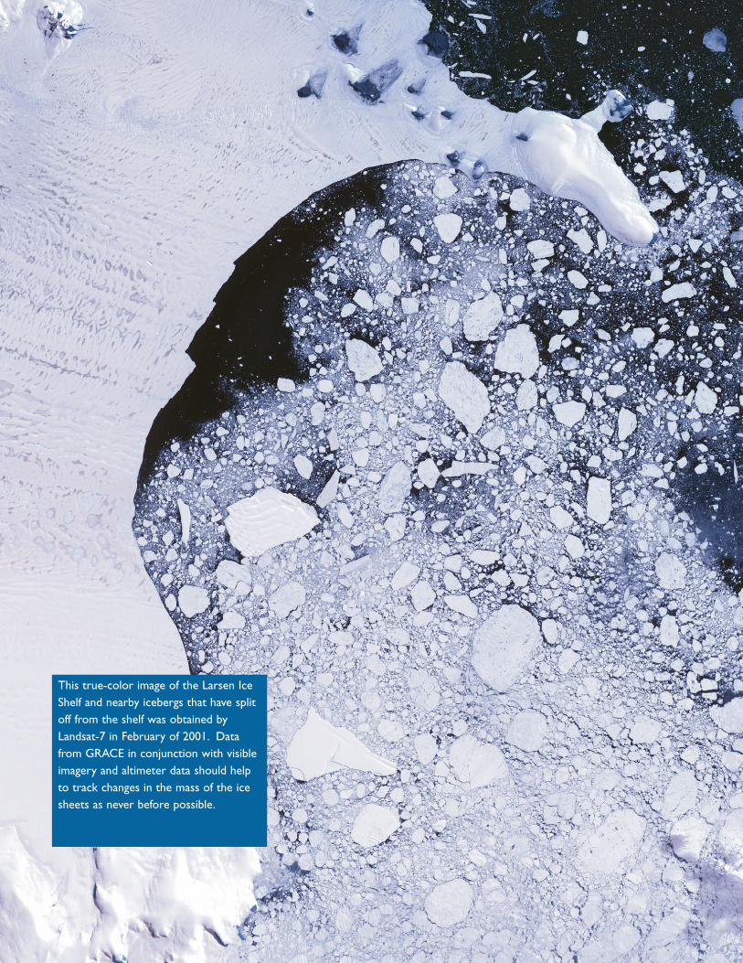
This true-color image of the Larsen IceShelf and nearby icebergs that have splitoff from the shelf was obtained byLandsat-7 in February of 2001. Datafrom GRACE in conjunction with visibleimagery and altimeter data should helpto track changes in the mass of the icesheets as never before possible.

The image above was obtained in March of 2001 by TOPEX/Poseidon and showssea-suface heights in the Pacific Ocean after the recent El Nino/La Nina. In theimage above, sea level height is being compared to its average value based on cli-matology. Areas toward the blue end of the spectrum represent anomalouslylow heights for March and areas toward the red end represent anomalously highheights for March. Data from GRACE is expected to improve our ability to pre-dict fluctuations in sea level height (which correlates to temperature) and to dis-tinguish how much of the height change is due to thermal expansion. This shouldhelp to more accurately assess the possible impact of sea level rise expectedfrom global warming.

12
Today's Numerical Weather Prediction models havereached a state where major improvements of mete-orological products will depend on more timely, pre-cisely, densely and evenly distributed key parameterssuch as pressure, temperature, and humidity. A limb
sounder on board GRACE will measure the amount by which the Global PositioningSatellite signal is distorted by the atmosphere. Scientists will use this data to develop keyatmospheric datasets to improve the understanding and modeling of the short-termweather.
Improving the accuracy of GPSmeasurements and productsderived from them
Occultation February 3, 199700:35 ITC Lat: 33.68 Lon: 12.79
60
40
20
0
Hei
ght
[km
]
Temperature [°C]
-100 -50 0 50
GFZ
UCAR
NCEP
The graphic illustrates the outputfrom a typical sounding measure-ment. This is a temperature profilefrom 3 February 1997. Data fromthree different sources is shown:GeoForschungZentrum (GFZ);National Center for EnvironmentalPrediction (NCEP); and UniversityCorporation for AtmosphericResearch (UCAR). The limb sounderon board GRACE is expected toimprove the accuracy of GPS meas-urements used for these retrievals,which should improve the accuracyof the profiles and contribute toimproved ability to predict the short-term weather.

Instrumentation
13
This is aschematicdiagramof the twoGRACEsatellites inorbit with the K-Band microwave beamconnecting them and tracking fluctua-tions in the distance between the twobodies. These fluctuations are used tomeasure changes in the gravitationalfield of the underlying surface.
Most satellite missions — like Terraand Aqua — carry a suite of sci-
entific instruments on board.GRACE is different becausefluctuations in the distancebetween the twin satellites are
used to derive the primarygravity measurement. So, for
GRACE, the satellites are the pri-mary instrument. GRACE will also carry
one additional instrument, a GPS limb sounderintended to correct for atmospheric andionospheric distortions to GPS measurements.
A sneak peak at the innards of a spacecraft! For the GRACE mission, the spacecraft itself is the maininstrument. This picture shows the GRACE spacecraft with the solar panels removed and gives a clearview of the various components. It was taken the Astrium test facility in Friedrichshafen, Germany.

The primary gravity measurement is made byrecording changes in the speed and distancebetween the two GRACE satellites. The twosatellites fly in formation over the Earth and the
precise speed of each satellite and the distance between them is constantly communi-cated via a microwave K-band ranging instrument. As the gravitational field changesbeneath the satellites - correlating to changes in mass of the surface beneath - the orbitalmotion of each satellite is changed. This change in orbital motion causes the distancebetween the satellites to expand or contract and can be measured using the K-bandinstrument. From this, the fluctuations in the Earth’s gravitational field can be determined.
Each day the GRACE mission will provideseveral hundred measurements of how thesignals from Global Positioning Satellites(GPS) are affected as they travel through theatmosphere. Just as light is refracted or
bends as it enters water, the GPS signals are refracted as they pass through the atmos-phere. By observing the signals in the atmosphere, profiles of the pressure, temperature,and humidity can be derived. These clues help the scientist predict the weather aroundthe Earth. The GPS receivers on the GRACE satellite track refracted signals from theGPS satellites as they rise or set through the Earth’s atmosphere (demonstrated in thediagram). The scientific term for this measurement is known as occultation and suchmeasurements will be made throughout the mission life to assist us in predicting globalweather.
The gravity measurement
This diagram illustrateshow the occultationprocess works. TheGRACE satellite tracksa GPS satellite as it“rises” and “sets”through the limb of theatmosphere, while asecond GPS satellite isused as a reference.
The limb-sounding technique for atmospheric correction of GPSmeasurements
14

Data Processingand ArchivingSystem development, data processingand archiving are performed in ashared Science Data System (SDS)between the Jet Propulsion Laboratory(JPL), the University of Texas Center forSpace Research (UTCSR), and theGeoForschungsZentrum Potsdam (GFZ).Telemetry data are received by the GRACERaw Data Center (RDC) at DLR in Neustrelitz.
The next level of data processing is performed primari-ly at JPL, where sensor calibration factors are applied, the dataare correctly time-tagged, quality control flags are added, and the data sample rate isreduced from the high rate data of previous levels. Data are sent to UTCSR and GFZ,where the mean gravity field is derived from the calibrated and validated data. Data arearchived for distribution at JPL's Physical Oceanography Distributed Active Data Center(PODAAC) and at GFZ 's Integrated System Data Center (ISDC). GRACE data include30-day mean gravity fields, as well as profiles of air mass, density, pressure, temperature,water vapor, and ionospheric electron content.
Education and Public OutreachThe GRACE mission benefits from and will build on the interest in oceanography thathas been growing in recent years with the heavy publicity of the El Niño phenomenon.GRACE provides a strong basis to draw public and classroom interest since new,extremely accurate models of the Earth’s gravity field will be generated.
The Texas Space Grant Consortium (TSGC) partners with the mission team to developand implement GRACE education and outreach. GRACE master teachers were select-ed from across the nation through an application and review process. These masterteachers have created interdisciplinary K-12 educational materials that meet the NationalEducational Standards to support the GRACE mission in the areas of Satellites, Gravity,Weather/Climate/Atmosphere, Oceans, and GRACE general mission facts and objectives.These master teachers have trained hundreds of teachers about the GRACE missionimpacting tens of thousands of students. These activities have been tested in classrooms
15

across the nation.When GRACE launches, the activities will be available to all educatorson the TSGC web site, http://www.csr.utexas.edu/grace/education/. In addition to class-room activities, an on-line GRACE activity guide, coloring book, and on-line quiz will beavailable for all interested.
Animations, photos and interviews with mission personnel will be available to all tradi-tional media outlets – television, print, and radio. Computer animation, showing thespacecraft deployments, orbit ground tracks, data collection, and real world applicationsof the data, is available. The GRACE web site will document, publicize, and expand themission’s science data including computer animations, downloadable educational materi-als, a frequently asked questions (FAQ) archive, and evaluation/ suggestion forms for feed-back. This information will be updated regularly.
GRACE will revolutionize the way we look at Earth, providing new benefits for 6-billionpeople living on this beautiful, blue planet. Through youth development and education wewill enhance our understanding of this dynamic world.
16

JPL
UTCSR
CU OSU KSC GSFC LaRC AMA
MITJHUAPLSS/L UL ONERA GFZ UB TUM DLR
AGmbH EGmbH AWI
IABG KSRC
DTUDLR/GSOC
Participating Institutions
United StatesAMA Analytical Mechanics Association, Inc. Hampton, VACU The University of Colorado Boulder, COGSFC Goddard Space Flight Center (NASA) Greenbelt, MDJPL Jet Propulsion Laboratory (NASA) Pasadena, CAJHUAPL Johns Hopkins University Applied Physics Lab. Laurel, MDKSC Kennedy Space Center (NASA) Cocoa Beach, VALaRC Langley Research Center (NASA) Hampton, VAMIT Massachusetts Institute of Technology Cambridge, MAOSU The Ohio State University Columbus, OHSS/L Space Systems/Loral Palo Alto, CAUTCSR University of Texas Center for Space Research Austin, TX
EuropeanAGmbH Astrium GmbH Friedrichshafen, GermanyAWI Alfred Wegener Institute for Polar and Marine Research Bremerhaven GermanyDLR Deutsches Zentrum fur Luft und Rumfahrt Bonn, GermanyDLR/GSOC DLR German Space Operations Center Oberpfaffenhofen, GermanyDTU The Technical University of Denmark Copenhagen, DenmarkEGmbH Eurockot GmbH Bremen, GermanyGFZ GeoForschungs Zentrum Potsdam, GermanyIABG IABG GmbH Ottobrunn, GermanyKSRC Khrunichev State Research and Production Space Center Moscow, RussiaONERA Office National d’Etudes et de Recherches Aerospatiale Paris, FranceTUM Technical University of Munich Munich, GermanyUB University of Bonn Bonn, GermanyUL University of Lyon Lyon, France
Key ParticipantsB. Tapley UTCSR, Principal Investigator (PI)C. Reigber GFZ, Co-PIA. Davis JPL, Project ManagerE. Konemann DLR, GRACE ManagerR. Fitzgerald GSFC, GRACE Mission ManagerM.M. Watkins JPL, Project Scientist
US Science TeamB. Tapley UTCSR, LeadS. Bettadpur UTCSRR. Gasparovic JHUAPLR.S. Gross JPLW.G. Melbourne JPLD. Porter JHUAPLC.K. Shum OSUJ. Wahr CUM.M. Watkins JPLC. Wunsch MIT
European Science TeamC. Reigber GFZ, LeadG. Balmino CNESK.H. Ilk UBN. Jakowski DLRP. Knudsen KSGY. Ricard ULR. Rummel TUMJ. Schroeter AWIP. Schwintzer GFZ
Science Teams/Key ParticipantsThe map below illustrates the locations of all the participants in the GRACE project. Clearly, theGRACE mission is truly an multi-national effort. It is a joint venture between NASA and theGerman Space Agency. Both a US and European Science Team have been established.Furthermore, institutions from five different countries are providing input, including governmentagencies, academia and private industry.
17

18
Technical Specifications

19

20


GRACEMission
Twins in orbit fly linked
by microwaves reveal
Earth Mass in motion