accessing cors data - geodesy€¦ · gzip386.exe executable file which contains the utility...
TRANSCRIPT
Positioning America for the Future
NATIONAL OCEANIC AND ATMOSPHERIC ADMINISTRATION
National Ocean Service
National Geodetic Survey
ACCESSING CORS DATA
Positioning America for the Future
NATIONAL OCEANIC AND ATMOSPHERIC ADMINISTRATION
National Ocean Service
National Geodetic Survey
ACCESSING CORS DATA &
METADATA
• Web address =
http://www.ngs.noaa.gov/CORS/
• Metadata = data about data
• CORSAGE = CORS Amiable Geographic
Environment

CORSAGE
CORS Web Page

Positioning America for the Future
NATIONAL OCEANIC AND ATMOSPHERIC ADMINISTRATION
National Ocean Service
National Geodetic Survey
CORSAGE
Network Map
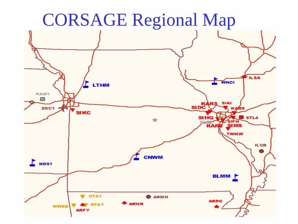
CORSAGE Regional Map

Positioning America for the Future
NATIONAL OCEANIC AND ATMOSPHERIC ADMINISTRATION
National Ocean Service
National Geodetic Survey
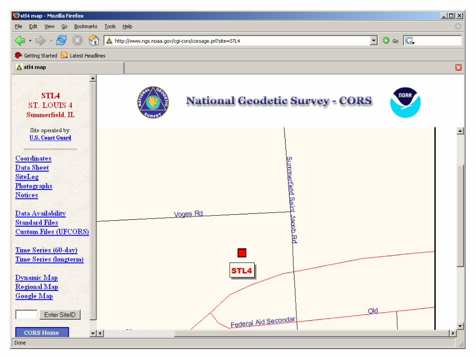
METADATA FOR A CORS SITE
• Coordinates (positions & velocities)
• Data availability profiles (charts showing
times for which data has been collected)
• Data sheets (descriptive information)
• Log files (descriptive information)
• Site photos
• Time series of positional coordinates
• Google Maps

BILLINGS 1 (BIL1), MONTANA
Retrieved from NGS DataBase on 01/10/01 at 09:45:16.
____________________________________________________________________________
| |
| NAD_83 POSITION (EPOCH 1997.0) |
| Transformed from ITRF97 (epoch 1997.0) position in Sep. 2000. |
| X = -1372156.022 m latitude = 45 58 16.23742 N |
| Y = -4223946.947 m longitude = 107 59 47.29949 W |
| Z = 4563650.156 m ellipsoid height = 874.381 m |
| |
| NAD_83 VELOCITY |
| Transformed from ITRF97 velocity in Sep. 2000. |
| VX = 0.0000 m/yr northward = 0.0000 m/yr |
| VY = 0.0000 m/yr eastward = 0.0000 m/yr |
| VZ = 0.0000 m/yr upward = 0.0000 m/yr |
|____________________________________________________________________________|
CORS POSITION & VELOCITY (NAD 83)

BILLINGS 1 (BIL1), MONTANA
Retrieved from NGS DataBase on 09/25/00 at 12:27:27.
____________________________________________________________________________
| |
| Antenna Reference Point(ARP): BILLINGS 1 CORS ARP |
| ------------------------------------------------- |
| PID = AI7658 |
| |
| |
| ITRF97 POSITION (EPOCH 1997.0) |
| Computed in Sept., 2000 using 12 days of data. |
| X = -1372156.567 m latitude = 45 58 16.26213 N |
| Y = -4223945.695 m longitude = 107 59 47.34150 W |
| Z = 4563650.195 m ellipsoid height = 873.698 m |
| |
| ITRF97 VELOCITY |
| Predicted with HTDP_2.4 in Aug., 2000. |
| VX = -0.0184 m/yr northward = -0.0106 m/yr |
| VY = -0.0020 m/yr eastward = -0.0169 m/yr |
| VZ = -0.0074 m/yr upward = 0.0000 m/yr |
| |
CORS POSITION & VELOCITY (ITRF)

Positioning America for the Future
NATIONAL OCEANIC AND ATMOSPHERIC ADMINISTRATION
National Ocean Service
National Geodetic Survey

Positioning America for the Future
NATIONAL OCEANIC AND ATMOSPHERIC ADMINISTRATION
National Ocean Service
National Geodetic Survey
BIL1 STATION LOG FILE

Positioning America for the Future
NATIONAL OCEANIC AND ATMOSPHERIC ADMINISTRATION
National Ocean Service
National Geodetic Survey
BIL1 STATION LOG FILE

Positioning America for the Future
NATIONAL OCEANIC AND ATMOSPHERIC ADMINISTRATION
National Ocean Service
National Geodetic Survey
CORS SITES PHOTO

Positioning America for the Future
NATIONAL OCEANIC AND ATMOSPHERIC ADMINISTRATION
National Ocean Service
National Geodetic Survey
Position Time Series (long-term)

Positioning America for the Future
NATIONAL OCEANIC AND ATMOSPHERIC ADMINISTRATION
National Ocean Service
National Geodetic Survey
POSITION TIME SERIES (last 60 days)
Positioning America for the Future
NATIONAL OCEANIC AND ATMOSPHERIC ADMINISTRATION
National Ocean Service
National Geodetic Survey
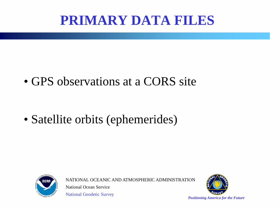
PRIMARY DATA FILES
• GPS observations at a CORS site
• Satellite orbits (ephemerides)

Positioning America for the Future
NATIONAL OCEANIC AND ATMOSPHERIC ADMINISTRATION
National Ocean Service
National Geodetic Survey
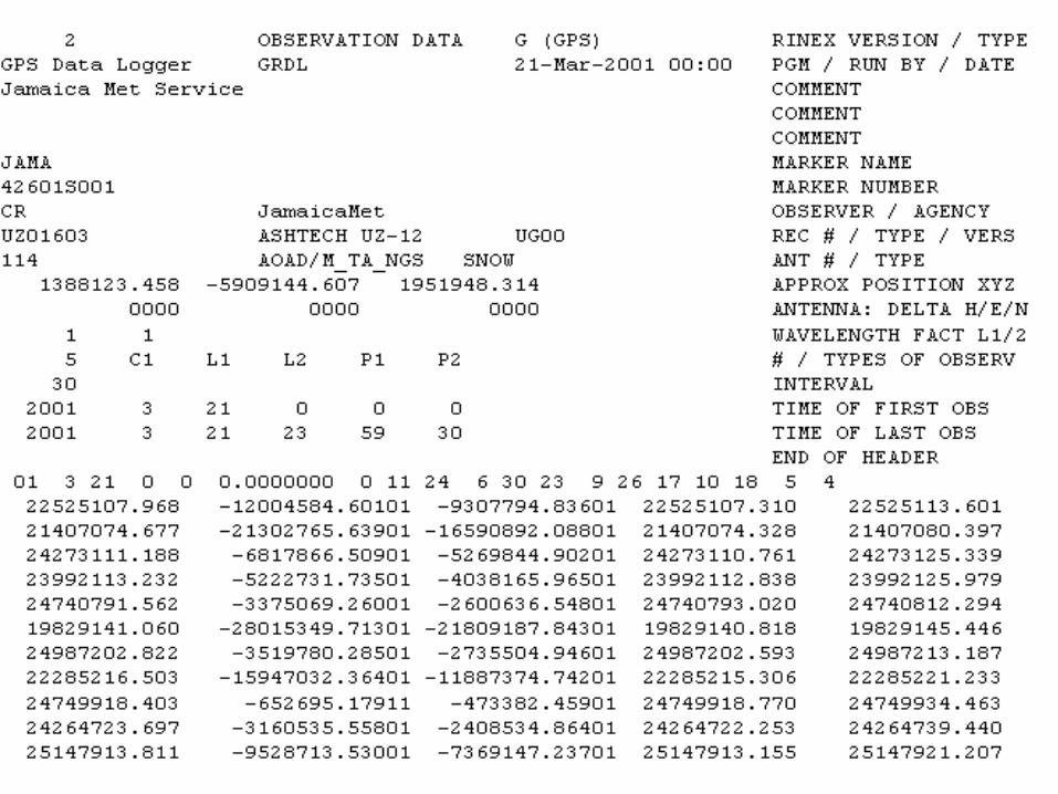
GPS Data – Rinex Format v2.20
• Data file spans
• hourly, daily, customized (UFCORS)
• Data collection rates
• 1sec, 5sec, 10sec, 15sec, and 30sec
• Data file life-time
• hourly: 2 days + today
• daily: permanently
Positioning America for the Future
NATIONAL OCEANIC AND ATMOSPHERIC ADMINISTRATION
National Ocean Service
National Geodetic Survey
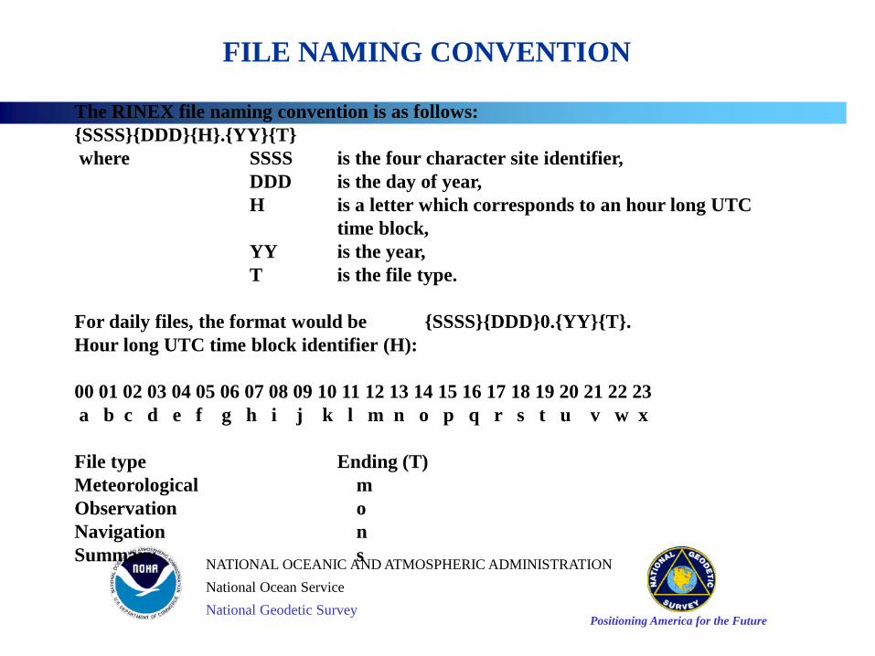
The RINEX file naming convention is as follows:
{SSSS}{DDD}{H}.{YY}{T}
where SSSS is the four character site identifier,
DDD is the day of year,
H is a letter which corresponds to an hour long UTC
time block,
YY is the year,
T is the file type.
For daily files, the format would be {SSSS}{DDD}0.{YY}{T}.
Hour long UTC time block identifier (H):
00 01 02 03 04 05 06 07 08 09 10 11 12 13 14 15 16 17 18 19 20 21 22 23
a b c d e f g h i j k l m n o p q r s t u v w x
File type Ending (T)
Meteorological m
Observation o
Navigation n
Summary s
FILE NAMING CONVENTION
Positioning America for the Future
NATIONAL OCEANIC AND ATMOSPHERIC ADMINISTRATION
National Ocean Service
National Geodetic Survey

Positioning America for the Future
NATIONAL OCEANIC AND ATMOSPHERIC ADMINISTRATION
National Ocean Service
National Geodetic Survey
NGS is one of the seven International GPS Service (IGS) Analysis Centers (AC) participating in the production of accurate GPS orbits:
Final Precise (~ 13 days latency)[accuracy < 4 cm]
Rapid (17 hours latency) [accuracy < 5 cm]
Ultra-Rapid (real-time) [accuracy < 25 cm]
Satellite positions in SP3 format are given (once
every 15 minutes) in current ITRFxx frame
NGS Satellite Ephemerideshttp://www.ngs.noaa.gov/GPS/GPS.html

Positioning America for the Future
NATIONAL OCEANIC AND ATMOSPHERIC ADMINISTRATION
National Ocean Service
National Geodetic Survey
Three ways to download CORS
Information
• Web-based User-Friendly CORS
(UFCORS)
• Web-based “Standard” download
• FTP (File Transfer Protocol)

UFCORS/STANDARD
UFCORS: a Web utility
enabling users to
• Obtain CORS data for an exact time interval
• Choose a sampling rate for the requested data
• Specify how the data files should be compressed
• Receive all associated data & metadata (coordinates, descriptive information, orbits)
• Receive information as soon as it is posted (GPS data are usually posted within an hour of the time these data are received by NOAA)

UFCORS - page 1

UFCORS - page 2

Standard Download
Positioning America for the Future
NATIONAL OCEANIC AND ATMOSPHERIC ADMINISTRATION
National Ocean Service
National Geodetic Survey
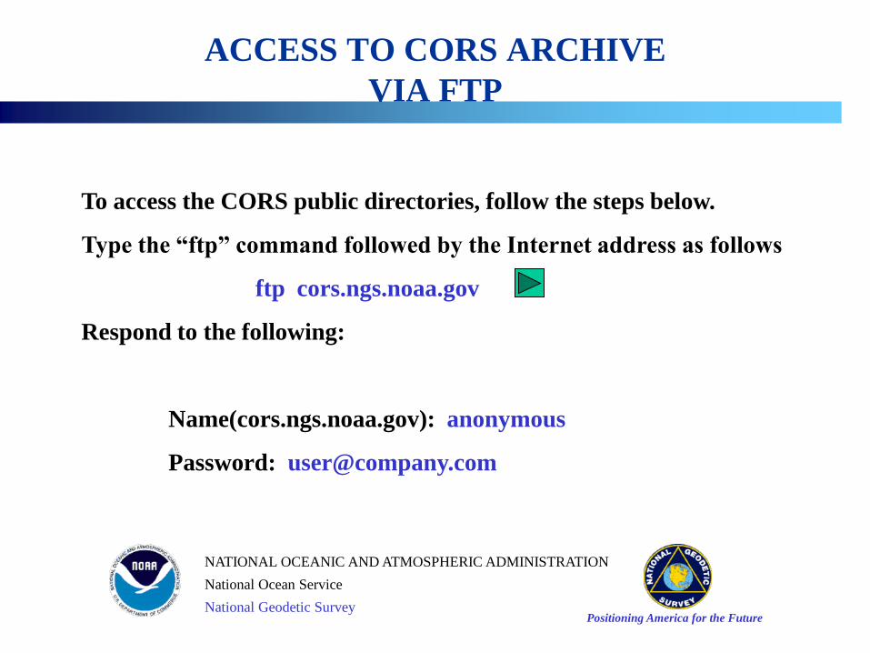
ACCESS TO CORS ARCHIVE
VIA FTP
To access the CORS public directories, follow the steps below.
Type the “ftp” command followed by the Internet address as follows
ftp cors.ngs.noaa.gov
Respond to the following:
Name(cors.ngs.noaa.gov): anonymous
Password: [email protected]

FTP is a user interface to the File Transfer Protocol. FTP copies files
over a network connection between the local ``client'' (user) computer
and a remote ``server'' computer. FTP runs on the client computer.
The user's system must have access to the INTERNET and support the File
Transfer Protocol (FTP). Some useful ftp commands are given below.
ascii set ascii transfer type
binary set binary transfer type
bye terminate ftp session and exit
cd change remote working directory
dir list contents of remote directory
get retrieve one file
help print local help information
mget retrieve multiple files
mput send multiple files
prompt force interactive prompting on multiple commands
put send one file
quit terminate ftp session and exit
show display the contents of an ASCII file
* Actual commands may vary among operating systems.
FILE TRANSFER PROTOCOL (FTP)

Positioning America for the Future
NATIONAL OCEANIC AND ATMOSPHERIC ADMINISTRATION
National Ocean Service
National Geodetic Survey
You will arrive at the ftp command level indicated by the prompt “ftp>”. If you
have trouble, type “help” to print local help information or review the section
FILE TRANSFER PROTOCOL for help with additional commands.
The following sub-directories contain additional files and information
- coord NAD83 and ITRF positional information.
- graphics CORS network maps.
- itrf Files on the IERS Terrestrial Reference Frame.
- rinex Rinex data files.
- station_log Station information, antenna specifications, and site contacts.
- utilities Programs for manipulating the RINEX files.
DIRECTORIES

Positioning America for the Future
NATIONAL OCEANIC AND ATMOSPHERIC ADMINISTRATION
National Ocean Service
National Geodetic Survey
File Transfer Protocol
(FTP)

Positioning America for the Future
NATIONAL OCEANIC AND ATMOSPHERIC ADMINISTRATION
National Ocean Service
National Geodetic Survey
File Transfer Protocol
(FTP)

Positioning America for the Future
NATIONAL OCEANIC AND ATMOSPHERIC ADMINISTRATION
National Ocean Service
National Geodetic Survey
RINEX files on the CORS file server are stored in a gzip compressed mode.
These compressed files will have the extension .gz . An example is given
below.
ais12330.98o.gz
All compressed files and executables should be transferred in binary mode.
Text files should be transferred in ascii mode.
Before downloading files using the FTP protocol, set the transfer mode by
typing “binary” or “ascii” at the ftp prompt. Then use “get” or “mget” to
retrieve the files.
FILE COMPRESSION FORMAT

Positioning America for the Future
NATIONAL OCEANIC AND ATMOSPHERIC ADMINISTRATION
National Ocean Service
National Geodetic Survey
Several DOS based utility programs are available to manipulate the RINEX
data files. Versions also exist for other platforms such as Silicon
Graphics (sgi), Sun Microsystems (sun), and Hewlett Packard (hp).
decimate.exe Utility program to decimate 5 second data to a user
specified rate.
gzip386.exe Executable file which contains the utility "gzip.exe".
inflate.exe Self-extracting utility program to uncompress files with
the ".Z" extension.
interpo.exe Utility program to interpolate between data epochs. Please
read the documentation for this utility for more details.
join24pc.exe Utility program to join two or more hourly RINEX
observation or navigation files.
SOFTWARE / RINEX UTILITIES

Positioning America for the Future
NATIONAL OCEANIC AND ATMOSPHERIC ADMINISTRATION
National Ocean Service
National Geodetic Survey
INTERPO Interpolate RINEX observational data at faster rates
using Neville’s algorithm for polynomial interpolation.
interpo -i <input file> -o <output file> [ -s <start time>
-e < end time>] -n <interpolation interval>
* Fields between [ ] are optional.
interpo -i ais1030a.96o -o ais1030a.out -n 5