about this file: this file was created by scanning the ... · about this file: this file was...
TRANSCRIPT

AUTHORS
William G. Robbins is a professor in the Department of History at Oregon State University in Corvallis,Oregon. Donald W. Wolf is a graduate research assistant for Rangeland Resources at Oregon StateUniversity in Corvallis, Oregon.
Landscape and the IntermontaneNorthwest: An EnvironmentalHistory
William G. Robbins and Donald W. Wolf
From Volume III: Assessment
Pail F. Hessburg, Science Team Leader and TechnicalEditor
Eastside Forest Ecosystem HealthAssessment
Richard L. Everett, Assessment Team Leader
Published by:U.S. Department of Agriculture, Forest ServicePacific Northwest Research StationGeneral Technical Report PNW-GTR-319February 1994
In cooperation with:U.S. Department of Agriculture, Forest ServicePacific Northwest Region

ABSTRACT
Robbins, William G.; Wolf, Donald W. 1994. Landscape and the intermontane northwest: an environmentalhistory. Gen. Tech. Rep. PNW-GTR-319. Portland, OR: U.S. Department of Agriculture, Forest Service,Pacific Northwest Research Station. 32 p. (Everett, Richard L., assessment team leader; Eastside forestecosystem health assessment; Hessburg, Paul F., science team leader and tech. ed., Volume III: assess-ment.)
Traces the natural and cultural processes involved in shaping the environment in the intermontane northwestfrom the Indian period of domination to the present. Emphasizes the increasing influence of humans asmodifiers of landscapes and ecosystems, especially with the coming of the market system to the region andthe onset of the industrial era. Focuses on the unique aspects of ecological change in the intermontane region:the very recent extension of the market system to the area; and the very rapid expansion of human-inducedenvironmental disturbance over very extensive areas in a very brief span of time.
Keywords: Environment, modification, market system, cultural stability, fire, horse, reconnaissance surveys,railroads, Euro-americans, Native Americans, timber, sawmills, grazing.
Landscape and the Intermontane Northwest:
An Environmental History1
by
William G. Robbins and Donald W. Wolf
1A report for the USDA Forest Service, Pacific Northwest Research Station, Supplemental Agreement PNW 93-0304, “Historical Perspectives onHuman Use of Eastside Forest Ecosystems.”

1
The strong tendency to be concerned only with the present or near futurecarries with it the serious danger that . . . we shall fail to put enough weighton the long-term and secondary effects of our actions; that we shall do furtherdamage to the very machinery of resource production that we seek to repair.
E. I. Kotok2
From time immemorial, people have been great modifiers of the ecological niches they occupy. Thatobservation is also a proper fit for the prehistoric period in North America, where archaeologicalevidence shows purposeful human manipulation of the environment to be an incontestable fact.3 Indeed,the great weight of scientific evidence and hypotheses argues against the notion of the Americas as apristine, Edenlike world where the human imprint was barely perceptible.4 Scholarly research in the lasttwo decades indicates the existence of sizable prehistoric populations in the Western Hemisphere andconsiderable human modification to forest, riverine, prairie, and basin landscapes. Amerindian peopleinfluenced the extent and composition of forests, established and expanded grassland areas, and alteredlandscapes through a myriad of human devices. According to geographer William Denevan, the impor-tant question is “the form and magnitude of environmental modification rather than ... Whether ...Indians lived in harmony with nature with sustainable systems of resource management.”5
Although it is generally acknowledged that human environmental influences in prehistoric NorthAmerica were considerable, it is now widely understood that the Columbian encounter triggered vastbiological and technological changes with worldwide repercussions. After the event of 1492, a develop-ing global network of economic and biological exchanges emerged whose “international energy flows,”according to Karl Butzer, favored the emerging centers of the industrial revolution; as the industrializ-ing sector expanded its technological reach, forces were set in motion that introduced immense socialand environmental changes worldwide.6 To point out the obvious, succeeding modes of production-hunting/ fishing/gathering, peasant agriculture, and the industrial/postindustrial mode-have increasedthe extent and scope of the human influence in the natural world.7
Both natural and cultural processes have been involved in shaping the environments about us. Butculture became a factor in environmental change only with the emergence of modern humans during themidpoint of the last glacial period, say 40,000 B.P. (before the present), when they were in the processof colonizing most of the earth. For thousands of years, however, population numbers and technologicalpractices limited the human imprint on global change. With the exception of a possible role in Pleisto-cene extinctions, therefore, human-induced environmental change on a broad scale was limited. Butwith warming conditions and the northward advance of forest ecosystems and plant life during the early
2E. I. Kotok, “The Ecological Approach to Conservation Programs,” in Renewable Natural Resources, Section IV (circa 1950), 472 (copy inlibrary, Blue Mountain Natural Resources Institute, La Grande, Oregon.
3For a select number of scholars who argue this point, see Carl O. Sauer, “Man in the Ecology of Tropical America,” Proceedings of the NinthPacific Science Congress 20 (1957), 104-10; Sauer, “Man’s Dominance by Use of Fire,” Geoscience and Man 10 (1975), 1-13; William Cronon,Changes in the Land: Indians, Colonists, and the Ecology of New England (New York; Hill and Wang, 1983); and Richard White, Land Use,Environment. and Social Change: The Shaping of Island County, Washington (Seattle: University of Washington Press, 1980).
4For an excellent review, see Karl W. Butzer, “The Americas Before and After 1492: An Introduction to Current Geographical Research,” Annals ofthe Association of American Geographers 82, 3 (1992), 345-366.
5William M. Denevan, “The Pristine Myth: The Landscape of the Americas in 1492,” Annals of the Association of American Geographers 82, 3(1992), 370.
6Butzer, “The Americas Before and After 1492,” 346.
7Neil Roberts, The Holocene: An Environmental History (New York: Basil Blackwell, 1989), 5.
2
Holocene (10,000 to 5,000 B.P.), the human impress on the natural world became much more noticeable.The more favorable climatic conditions expanded the range of ecological niches suitable to human habita-tion and allowed for people to manipulate plant and animal species to their advantage. But more thananything else, it was the advent of Neolithic agriculture that accelerated the human role in environmentalchange in many parts of the world.8
Several archaeological finds, including one at Oregon’s Fort Rock Cave (13,000 B.P.) on the periphery ofthe Great Basin,9 indicate that humans first entered the greater Pacific Northwest10 during the late Pleisto-cene, when glaciers still covered much of the mountainous country of the interior. Before the dramaticwarming of the climate between 11,000 and 9,000 B.P., now-extinct animals-the giant ground sloth, thegiant bison, the camel, and the horse-were still present in North America. Those species intermingled withpresent-day animals-antelope, deer, mountain sheep, and a variety of bird life.11 For reasons that are stillsubject to great controversy, several of those late Pleistocene mammals became extinct; whether thehuman presence in North America (and in the Pacific Northwest) is responsible for those extinctionsremains an open question.12
As the great glaciers of the late Pleistocene receded, they unleashed a series of catastrophic floods throughthe upper-Columbia River drainage when Lake Missoula periodically burst through its dam of glacial ice.The scouring effects of that huge volume of water created the channeled scablands of eastern Washington,including the famous Grand Coulee. The most recent of those floods probably occurred some time after13,000 B.P. With the recession of the glaciers, spruce, fir, and other conifers appeared over broad areas ofthe interior country, and when the climate began to warm after 11,000 B.P., the conifers themselvesreceded to higher elevations.13
With the onset of the modern era (about 500 B.P.), human-manipulated agricultural ecosystems hadreplaced natural ones in many parts of the world.14 But economic, environmental, and ecological changestaking place elsewhere were delayed in the Pacific Northwest. Until the very recent past, the region wasbeyond the reach-or at best on the periphery-of the immense market-induced ecological exchanges thatwere taking place in the post-Columbian world. Euro-American penetration and conquest on this far edgeof North America, therefore, has been of very recent duration, extending back little more than two centu-ries. Indeed, what is striking about the region is the very recent and very rapid pace of human-inducedenvironmental disturbance over very extensive areas in a very brief span of time.15
8ibid., 57-113.
9For a brief account of the Fort Rock and other Northwest archaeology excavations, see L. S. Cressman, The Sandal and the Cave: The Indians ofOregon (1962; Corvallis: Oregon State University Press, 1981).
10This reference is to the physiographic region that embraces the present states of Washington, Oregon, and Idaho, northern California and Nevada,western Montana, and southern British Columbia. The greater Columbia River system also provides a definitive outline for the region.
11C. Melvin Aikens, Archaeology of Oregon (Portland: Oregon State Office, U. S. Department of the Interior, Bureau of Land Management, 1986),9-10.
12Roberts, The Holocene, 67; Donald K. Grayson, “Pleistocene Avifaunas and the Overkill Hypothesis,” Science 195 (1977), 691-93; and Paul S.Martin, “Pleistocene Overkill,” Science 179 (1973), 969.
13Aikens, Archaeology of Oregon, 41-42; and Hunn, Nch’i-wan , 19-21.
14Roberts, The Holocene, 122.
15Carlos Schwantes argues that “geographical isolation fundamentally shaped the course of Pacific Northwest history.” Geography conspired tokeep the Northwest “beyond the reach of Europe and the rest of North America” and thereby “contributed to a pronounced time lag in its historicaldevelopment.” See Schwantes, The Pacific Northwest: An Interpretive History (Lincoln: University of Nebraska Press, 1989), 19.
3
For the interior Northwest, the hunting-gathering way of life remained dominant until Europeans beganto impose a new set of cultural arrangements on the landscape. The Pacific Northwest was an anomalyin one other respect: Neolithic agricultural practices were absent during the Indian period of domina-tion. “Therefore,” according to fisheries and wildlife scientist Dean Shinn, “we are still relatively closeto the early history of the region, and to the events which caused environmental change there.”16
That historical configuration of events and circumstances provides exceptional opportunities for study-ing precontact landscapes, for learning about ecological conditions at the onset of large-scaleEuro-American migration, and for placing the human-induced changes that have taken place in theindustrial age in a broader perspective. In brief, the telescoping of the postcontact history of the regioninto such a brief span of time makes it possible to discern-through conventional historical records(journals, diaries, government surveys, and travel accounts)-much about ecological conditions at thetime of the entry of Euro-Americans. That scholars are increasingly turning to pollen and soil recordsand traditional archaeological evidence further enriches the potential for building a realistic profile oflandscapes and environments.
Once the postglacial regime established itself-with the exception of the cataclysmic explosion of MountMazama (about 6,000 B.P.)-environmental conditions in the intermontane Northwest remained rela-tively17 stable for at least 10,000 years. For the Plateau culture area of the interior Northwest, thearchaeological record indicates a consensus of sorts: cultural and social changes were modest until thehistoric period, with subsistence patterns centered largely on terrestrial and riverine environments. Onlythe northward spread of Spanish horses in the early 18th century, the entry of the market-oriented furtrade in the early 19th century, and ravages of the exotic epidemic diseases that followed disrupted thatstability.18
But relative social and cultural stability does not imply the absence of native influence in the naturalworld. Indeed, extensive archaeological and other historical evidence suggests quite the opposite.Native Americans in the Pacific Northwest inhabited a humanized landscape-ecosystems that werepurposefully modified to meet their subsistence needs. Richard White argues that native people onPuget Sound’s Whidbey Island used fire as a tool to enhance the growing of bracken and camas, staplevegetables in their diet. “Rather than being major Indian food sources because they dominated theprairies,” he concludes, “camas and bracken more likely dominated the prairies because they weremajor Indian food sources.”19 There is abundant evidence to indicate equally human-influenced land-scapes elsewhere in the Pacific Northwest.
16Dean A. Shinn, “Historical Perspectives on Range Burning in the Inland Pacific Northwest,” Journal of Range Management 33 (November1980), 418-19. For the absence of Neolithic agriculture in the Pacific Northwest, see Butzer, “The Americas Before and After 1492,” 348; White,Land Use. Environment. and Social Change, 14-34; Philip Drucker, Indians of the Northwest Coast (Garden City, New York: Natural HistoryPress, 1955), 35-55; and Cressman Sandal and the Cave 40-54. For a discussion of the food-gathering practices of the Palouse Indians, seeClifford E. Trafzer and Richard D. Scheuerman, Renegade Tribe: The Palouse Indians and the Invasion of the Indian Pacific Northwest (Pullman:Washington State University Press, 1986), 7-9.
17That is not to deny what the anthropologist Eugene Hunn calls “the biogeographical consequences of climatic change.” But, he points out,changes in climatic patterns required adjustments in hunting and gathering strategies rather than dramatic economic and social change. See Hunn,Nch’i-Wana “The Big River:” Mid-Columbia Indians and Their Land (Seattle: University of Washington Press, 1990), 19. Richard White makesthe same argument for the native people of Puget Sound, who had been in a “relatively stable and productive environment” for centuries before thearrival of white settlers. See White, “The Altered Landscape: Social Change and the Land in the Pacific Northwest,” in Regionalism and thePacific Northwest, William G. Robbins, Robert J. Frank, and Richard E. Ross, eds. (Corvallis: Oregon State University Press, 1983), 114-115.
18Hunn, Nch’i-wana 21; and Hunn, “The Plateau,” in The First Oregonians, Carolyn M. Buan and Richard Lewis, eds. (Portland: Oregon Councilfor the Humanities, 1991), 14.
19White, Land Use, Environment. and Social Change, 21; and White, “The Altered Landscape,” 111. William Cronon illustrates a similar case forsouthern New England where the Indian use of fire may have been even more frequent and pronounced. The area’s forests were park-like withintermittent openings, “not because the trees naturally grew thus, but because the Indians preferred them so.” See Cronon, Changes in the Land:Indians. Colonists and the Ecology of New England (New York: Hill and Wang, 1983), 49.
4
Native-modified landscapes through the use of fire extended well beyond the Puget and Willamette lowlandsto the eastern slopes of the Cascade Range, where Indians used fire as an effective tool to enhance theproduction of a variety of foodstuffs, including nutritious herbs and shrubs, black mountain huckleberry, andits near relatives, blueberry and grouseberry. Those fire-created niches also attracted browsing animals likedeer and elk, sources of protein for the Indian diet.20 The widespread practice of burning created an artificialforest environment of open glades and park-like settings, a descriptive refrain that runs through virtually allof the 19th century travel and survey literature.
Except for the extremely arid regions of North America, the historian Stephen Pyne contends that grasslandenvironments were also the result of the Indian’s calculated and routine use of fire. From the coastal plain ofMassachusetts southward to Florida and westward to Texas, from California’s great Central Valley toOregon’s Willamette Valley, grasslands flourished as a consequence of Indian incendiary activity.21 Nativeinfluences in modifying grassland environments in the “Great Columbia Plain22 region of eastern Washingtonand across the high-desert country of eastern Oregon is also too obvious to ignore
Some evidence indicates that early Pleistocene hunters in the Northwest used burning thousands of yearsago, and references to fires and burned landscapes run everywhere through the early literature of the region.Although historical sources do not reveal with any precision the ratio between human and naturally causedfires in the interior Pacific Northwest before large-scale white settlement, evidence suggests that Indianincendiarism was a significant factor in the burning of both grassland and forest. For desert ecosystems, LeeEddleman contends, “human caused fires were of greater consequence.” Other writers agree: fire “was anatural component of the native ecosystem.”23 Early 19th century travel accounts mention fire with suchregularity as to create a mental picture of a ravaged, charred, ruined land.
As with much of the early literature of the Pacific Northwest, the journals of Lewis and Clark revealed thecomplexities of Indian environmental influence, especially the important role of fire to the horsemountedhunter-gatherers of the interior country. On the return trip upriver in the spring of 1806, Meriwether Lewisreported the plains of the Columbia covered with a “rich verdure of grass and herbs from four to nine incheshigh.” As the party drew closer to the Walla Walla River, the journal entries refer to a unique set of observa-tions: the absence of firewood; the Indian use of shrubs for fuel; an abundance of roots for human consump-tion; and favorable assessments of grass for horses. Writing some distance up the Walla Walla River, WilliamClark remarked that “great portions of these bottoms has been latterly burnt which has entirely distroyed(sic) the timbered growth.”24
The native people readily fired arid landscapes just as they did the Willamette and Puget lowlands to enhancehunting and the gathering of roots and berries. Hudson’s Bay Company operative Peter Skene Ogden, leadinga trapping party through the upper Crooked River and into the Harney Basin in 1826 and 1827, repeatedlyreferred to a country “overrun by fire,” with the finger of guilt pointed to what he deemed were nativeculprits. But Ogden’s greatest disappointment about those summer conflagrations centered on the widespreaddestruction of beaver habitat (and beaver):
20Hunn, “Nch’i-wana “The Big River,” 130-131.
21Stephen J. Pyne, Fire in America: A Cultural History of Wildland and Rural Fire (Princeton: Princeton University Press, 1982), 84-85. InOregon’s Willamette Valley native people used fire in a substantial way to dramatically alter the landscape for their own purposes. See Peter G.Boag, Environment and Experience: Settlement Culture in Nineteenth-Century Oregon (Berkeley: University of California Press, 1992), 12-15.
22This is the title of Donald Meinig’s The Great Columbia Plain: A Historical Geography,1805-1910 (Seattle: University of Washington Press,1968), still the best book of its kind for the Pacific Northwest.
23Shinn, “Historical Perspectives on Range Burning in the Inland Pacific Northwest,” 415-417; Lee Eddleman, “Oregon’s High Desert-Legacy forToday,” in Oregon’s High Desert: The Last 100 Years, Special Report 841 dune 1989) Agricultural Experiment Station, Oregon State University,Corvallis, Oregon, and USDA Agricultural Research Service, 2; and J. B. Kauffman and D.B. Sapsis, “The Natural Role of Fire in Oregon’s HighDesert,” in ibid.,15.
24Thwaites, Original Journals of the Lewis and Clark Expedition, vol. 3, P. 345-346.
5
Many small streams have been discovered in the mountains and were notlong since well supplyed with beaver but unfortunately the Natives havedestroyed them all and probably by the aid of fire which is certainly a mostdestructive mode of exterpating them for scarcely ever one escapes par-ticularly when the streams are not wide, and from what I have seen in thismy last years travels I will venture to assert without exaggeration theNatives have destroyed and principally by fire upwards of sixty thousandbeavers and of this number not a Hundred have reached any establishmentbut all have been lost.25
As the explorer/fur-trader extraordinaire, Ogden saw the regional landscape through a sharply differentcultural lens from that of the Paiutes of eastern Oregon. The Indian habit of burning for Indian purposes,in his view, was irrational because it led to the destruction of beaver, an animal with a commodity value indistant markets.26
John Kirk Townsend, Philadelphia-based naturalist and traveler on the Oregon Trail, provides one of themost vivid accounts of Indian burning practices in the Columbia River country. When the party campedabout 15 miles below the mouth of the Umatilla River on the evening of September 3, 1835, Townsendreported that Indians had “fired the prairie” on the opposite side of the river, thereby brilliantly lightingthe night-sky:
Here I am sitting cross legged on the ground, scribbling by the light of thevast conflagration with as much ease as if I had a ton of oil burning by myside; but my eyes are every moment involuntarily wandering from thepaper before me, to contemplate and admire the grandure (sic) of thedistant scene. The very heavens themselves appear ignited, and the frag-ments of ashes and burning grass-blades, ascending and careering aboutthrough the glowing firmament, look like brilliant and glorious birds letloose to roam and revel amidst this splendid scene.
Standing on a hilltop at the mouth of the Walla Walla River the following spring, the Reverend SamuelParker described a landscape “covered with the fresh green of spring vegetation.” Just a few miles to thenorth at the juncture of the Snake River he remarked again about “the fresh verdure, which is springingup, luxuriantly, at this early season.”27
Looking toward the Columbia River from the western slopes of the Blue Mountains in mid-October 1840,United States Army reconnaissance officer John C. Fremont reported that “smoky and unfavorable”weather conditions obstructed “far views with the glass.” But before descending to the Walla Walla River,
25M. A. Davies, ed., Peter Skene Ogden’s Snake Country Journals, 1826-27 (London: Hudson’s Bay Record Society, 1961), 7, 9, 19, 118, and126-127.
26Explorer and discovery accounts of the Americas dating from the time of Columbus, according to Richard White, appraised objects in thephysical environment in terms of their value as commodities. See White, “Discovering Nature in North America,” Journal of American History 79(December 1992), 879-880.
27John Kirk Townsend, Narrative journey across the Rocky Mountains (1839; Lincoln: University of Nebraska Press, 1978), 246; and SamuelParker, Journal of an Exploring Tour Beyond the Rocky Mountains (1838; Minneapolis: Ross and Haines, 1967), 272 and 274. Passing up theColumbia River on April 17, 1806, Meriwether Lewis reported “a rich verdure of grass and herbs from four to nine inches high and exhibits abeautiful seen (sic) particularly pleasing after having been so long imprisoned in the mountains and those impenetrably thick forests of theseacoast.” See Reuben Gold Thwaites, ed., Original Journals of the Lewis and Clark Expedition 1804-1806 (New York: Antiquarian Press Ltd.,1959), vol. 3, p. 286. In the same entry, Lewis noted that the Indians burned shrubs because of the absence of firewood, that grasses providedexcellent grazing for horses, and that burned-over areas were superb grounds for gathering roots.
6
Fremont observed what he deemed to be the salutary aftereffects of burning: “the grass very green andgood; the old grass having been burnt off early in the autumn.” Although both culture and nature wereresponsible for shaping the environment of the intermontane region, the preponderance of evidencesuggests that culture was a major cause of incendiarism.28
Although the bulk of this discussion has focused on the Indian use of fire in arid landscapes, cultureevidently played a major role in the ecology of the intermontane forests as well. For the greater BlueMountains area, early travel accounts-many of them Oregon Trail narratives-provide copious testimony tothe ecologically intrusive presence of Native Americans throughout the region. Stories of fire and ash arestrewn along the section of the trail from the juncture of the Boise and Snake rivers to the Columbia. Afterleaving the Grande Ronde Valley in a northwesterly direction through the Blue Mountains in late Augustof 1834, John Kirk Townsend remarked about the stately pine trees with an undergrowth of “servicebushes and other shrubs.” What most offended Townsend, however, was the burned grass and trees“blasted by the ravaging fires of the Indians. These fires are yet smoldering, and the smoke from themeffectually prevents our viewing the surrounding country.”29
The ubiquitous and controversial Captain Benjamin Bonneville crisscrossed the Snake River/Blue Moun-tain country in 1834 and later made his notes available to Washington Irving, who wrote an account ofBonneville’s travels. According to Irving’s version, during the summer months the captain witnessed “theseason of setting fires to the prairie,” with fire and smoke virtually everywhere. Bonneville’s troop subse-quently spent two weeks camped in the Grande Ronde Valley because fires in the surrounding hillsblocked egress from the area.30
Passing through the high country dividing the Powder River and Grande Ronde valleys in August 1835,the missionary Jason Lee described a landscape “covered with a heavy growth of pitch pine, very large,tall, and beautiful.” The only distracting feature to the Methodist was the evidence of fire that “hadrecently been making its destructive ravages over the whole mountain.” After ascending the Blue Moun-tains and traveling across the summit, Lee reported the party’s vision obscured “by smoke, which was [so]dense that we could discern objects only a few yards.” Four years later, Thomas Jefferson Farnhamfollowed the west bank of the Snake River and then moved into the hills along a small stream whereIndians had recently burned the countryside. The following day, Farnham described an atmosphere filledwith smoke “as in Indian summer-time in the highlands of New England.”31
By the time the large emigrant train of 1843 was enroute to the Willamette Valley, newcomers travelingthrough the interior Northwest were becoming familiar with late-summer Indian fires. The trapper JamesClyman, who accompanied an 1844 emigrant party to Fort Boise and then pressed on ahead to Oregon,observed “verry Smoky” weather in the Powder River Valley and even worse conditions in the GrandeRonde Valley where, “Indians as is their habit . . . set fire to the grass.” Passing northward from the
28Donald Jackson and Mary Lee Spence, eds., The Expeditions pf John Charles Fremont, vol. 1 (Chicago: University of Chicago Press, 1970), 550-551; and Lee Eddleman, “Oregon’s High Desert-Legacy For Today, 2. Except for these early first-hand accounts, no body of solid “data” exists toprove the case one way or the other.
29Townsend, Narrative Journey Across the Rocky Mountains, 163.
30Washington Irving, The Adventures of Captain Bonneville U.S.A.. in the Rocky Mountains and the Far West: Digested from His Journal, andIllustrated from Various Other Sources (1837; Norman: University of Oklahoma Press, 1961), 339-341.
31Archer Butler Hulbert and Dorothy Printup Hulbert, eds., The Oregon Crusade: Across land & Sea to Oregon (Denver: Colorado College, 1935),178; and Farnham, An 1839 Wagon Train Journal, 73.
7
Powder River, Clyman’s group “nearly suffocated with smoke & dust,” and upon descending into theGrande Ronde Valley, they witnessed “the whole mountains which surround this vally (sic) completelyenveloped in fire and Smoke.”32
Much of the scientific and technical literature on the influence of fire in shaping ecosystems in thePacific Northwest has an ironic twist. Virtually all writers recognize that Indians used fire as a tool tofashion grassland and forest environments for a variety of purposes. But once acknowledging that fact,those same writers move on to discussions of “fire and its role in the pristine environment” as if nativepeople had no existence, except as part of nature itself. One authority on fire history, while conceding“significant Indian influence,” refers to nineteenth-century forests as “unmanaged” and “natural”environments. In other words, before the advent of modern forest management, Northwest woodlandswere neither humanized nor culturally proscribed places. As Richard White has observed: “perhaps themost important decision Europeans made about American nature. . . was that they were not part of it,but Indians were.” Moreover, he argues, even when the newcomers encountered human-influencedecosystems, they “tended to deny that Indians could have created them.”33
By the early 19th century, native people in the interior Northwest had acquired sizable numbers ofhorses, with some tribes-the Yakima, Cayuse, and Nez Perce-possessing especially large herds. Thediffusion of horses across western North America originated in the Spanish colonies in what is NewMexico. When the Pueblo Indians revolted in 1680 and drove the Spanish out of the Rio Grande coun-try, they liberated the Spaniards’ horses, which quickly spread northward along both sides of the RockyMountains. Horses were passed along the western slope from the Utes to the Shoshones on the upperSnake River, to the Flatheads by 1720, and most likely to the Nez Perce and Cayuse in the 1730s.34 Thatthe acquisition of horses dramatically increased Indian mobility (and thereby Indian economic andsocial life) is well known; what is more difficult to discern is the extent and magnitude of ecologicalchange that should be attributed to the horse. Until the large-scale settler movement to the Northwest inthe 1840s, the horse represented, along with fire, an Indian-mediated presence in the landscape.
The early and numerous journal references to the abundance of Indian horses indicates that the humaninfluence in shaping intermontane ecosystems assumed forms other than fire. Struggling through thesnow-clad Blue Mountains to the north of the Grande Ronde Valley in the winter of 1811-1812, theAstorian Wilson Price Hunt observed on every side of their route “horse-trails used by Indians.” Whenparty members reached the Umatilla River, they visited an Indian camp of 34 lodges with an estimated
32James Clyman, Journal of a Mountain Man (Missoula: Mountain Press Publishing Company, 1984). The expedition led by Captain John C.Fremont through the Snake River, Blue Mountains, and Columbia River area about two weeks behind the Great Migration of 1843 made referenceto “recently burnt and blackened” surroundings, “smoky and unfavorable” weather, and grasslands “having been burnt off early in the autumn.”See Jackson and Spence, eds., The Expeditions of John Charles Fremont, vol. 1, p. 542, 550-551.
33James A. Young and B. Abbott Sparks, Cattle in the Cold Desert (Logan: Utah State University Press, 1985), 27; James K. Agee, “The HistoricalRole of Fire in Pacific Northwest Forests,” in Natural and Proscribed Fire in Pacific Northwest Forests, John D. Walstad, Steven R. Radosevich,and David V. Sandberg, eds. (Corvallis: Oregon State University Press, 1990), 26-27; and White, “Discovering Nature in North America,” 882.One Forest Service employee recalled that in 1909 the Siskiyou forest “was largely as the Indians had left it. It had lots of game in the mountainsand fish in the rivers,” indications of a relatively pristine environment. But then the writer proceeded to tell of using old Indian trails through areaswhere “practically all the forest had been burned over.” See Henry E. Haefner to Gifford Pinchot, Gifford Pinchot Papers, Series B, Container 986,Manuscript Division, Library of Congress.
34Francis Haines, “The Northward Spread of Horses Among the Plains Indians,” American Anthropologist 40 (1938), 434-35; J. Orin Oliphant,“History of the Livestock Industry in the Pacific Northwest,” Oregon Historical Quarterly 49 (1948), 13; and Hunn, Nch’i-wana “The Big River,”22-26. For many Indian people, according to Eugene Hunn, horses continue to symbolize the “old” way of life: “Several hundred run wild over theYakima Reservation foothills. The tribe protects them against the urgings of stockmen who see wild horses as economic competitors” (p. 26).
8
2000 horses. Moreover, villagers with copper kettles and pots about their lodges and dressed in robes ofbison and buckskin leggings indicated extensive travel by horseback or trade with distant peoples.Passing down the arid stretch of the Columbia River between the Umatilla and the Great Falls (CeliloFalls) in September of 1834, John Kirk Townsend reported seeing “large bands of Indian horses.” Those“beautiful animals . . . almost as wild as deer” and marked with “strange hieroglyphic looking charac-ters” to indicate ownership.”35
Five years later, Thomas Jefferson Farnham met a Cayuse family in the Blue Mountains, returning froma buffalo hunt to the east. The man and woman and their two children had seventeen horses in tow,“splendid animals,” Farnham noted, “as large as the best horses of the States, well knit, deep and widein the shoulders.” When he reached the south bank of the Columbia River, he noticed that “groups ofIndian horses occasionally appeared.” And at the onset of the settler movement to the Willamette Valleyin the early 1840s, the inveterate preacher-traveler Samuel Parker recorded in his journal that he sawseveral “bands of Indian horses” as well as deer and antelope.36
When his reconnaissance troop reached the Walla Walla River in October of 1843, John C. Fremontobserved “several hundred horses grazing on the hills, ... and as we advanced on the road we met otherbands, which the Indians were driving out to pasture also on the hills.” A month later; journeyingthrough the eastern slope of the Cascade Range, he reported a village of Nez Perce “who appeared to becoming from the mountains, and had with them fine bands of horses.” Fellow army officer MajorOsborne Cross, on the Umatilla River in September 1849, witnessed everywhere “large droves ofhorses, . . . stout, well built, and very muscular.” And a decade later in the Grande Ronde Valley GeorgeBelshaw observed “quantities of Indians and Poneys” (sic) in “this butiful valet’” (sic).37
That Parker and other observers lumped horses, deer, and antelope as part of the natural world points toanother problem in distinguishing between the natural and unnatural. Horses, of course, were unlikedeer and antelope: they were unnatural to the region; they were Indian cultural adaptations of therelatively recent past; they were large grazing ungulates; and, as an alien introduction, they unquestion-ably represented a new and intrusive agent in their adopted environments.38 Because human agency wasresponsible for the introduction of horses, Indian use of the animals should be considered anotherculturally engendered force in shaping the landscape of the Indian Northwest.
35”Wilson Price Hunt’s Diary of his Overland Trip Westward to Astoria in 1811-12,” in The Discovery of the Oregon Trail, Robert Stuart’sNarratives, Philip Ashton Rollins, ed. (New York: Charles Scribner’s Sons, 1935), 301-302; and Townsend, Narrative Journey Across the RockyMountains, 283. Nearly every Oregon Trail travel account mentions the great number of Indian horses on both sides of the Blue Mountains.Writing from a camp on the Walla Walla river in 1843, James Nesmith mentioned great difficulty in the morning hunting down their cattle andhorses, “the later (sic) having wandered off and the Indian horses being so numerous made it difficult for us to find our own.” See NesmithAnkeny, The West as I Knew It (Lewiston: R. G. Bailey, 1953), 27. Early booster publications also mentioned that Indians raised “horses in vastnumbers, and of a very superior quality,” perhaps as an enticement to spur further emigration. See Lansford W. Hastings, The Emigrants’ Guide toOregon and California (1845; Princeton: Princeton University Press, 1932), 46.
36Farnham, An 1839 Wagon Train Journal, 74-75; and Parker, Journal of an Exploring Tour Beyond the Rocky Mountains, 281.
37Jackson and Spence, eds., The Expeditions of John Charles Fremont, vol. 1, p. 551 and 584; Raymond W. Settle, ed., The March of the MountedRiflemen as Recorded in the Journals of Major Osborne Cross and George Gibbs and the Official Report of Colonel Loring (Glendale, CA: ArthurH. Clark Co, 1940), 229; George Belshaw, Diary of the Oregon Trail, 1853 (Eugene: Lane County Historical Society, 1960), n.p. John W. Evans,who has compiled an excellent volume of the early travel accounts on this section of the Oregon Trail, contends that Indians fired the prairie in thelate summer to ensure “an abundance of new grass for their horse herds.” See Evans, Powerful Rocky, 29n.
38Although the literature on Indian horse herds as agents of ecological change is not large, a growing body of evidence suggests that the ecologicalinfluence of the rapid spread of horses in western North America was considerable. See Richard White, The Roots of Dependency: SubsistenceEnvironment, and Social Change Among the Choctaws, Pawnees, and Navajo (Lincoln: University of Nebraska Press, 1983), 100, and 247-248;and Dan Flores, “Bison Ecology and Bison Diplomacy: The Southern Plains from 1800 to 1850,” Journal of American History 78 (1991), 481.
9
After the United States established sovereignty over the country south of the 49th parallel in 1846, thegovernment undertook a series of boundary, military road, and railroad surveys, with many of theinvestigations centering on the Cascades. Those inquiries provide further evidence of ecosystemsheavily influenced by human activity. The reports of the Northwest Boundary Survey Commission offeran excellent cross-sectional description of the transition in forest types on the western and easternslopes of the Cascade Range. On the western side, the timber was dense, “being a heavy growth of pineand fir that in many places stands over a fallen forest not yet decayed.” But east of the summit, thecommission noted “the timber becomes more open, and survey operations less difficult.”39
At the far eastern extreme of Washington Territory, a reconnaissance group under the command ofCaptain John Mullan examined feasible routes for both military and railroad passage eastward throughthe Bitterroot Mountains. In the lower Snake River country, the command frequently traded with localIndian villages for salmon and other supplies and used the numerous Indian trails to traverse canyonsand to gain access to the plateau above. The Indians lived in permanent villages, but the army officialsnoted that their lodges were covered with buffalo skins and mats, indications of trade and travel east ofthe mountains. On the slopes above the Palouse River, the Indians harvested service berries, wildcurrants, and gooseberries in great abundance; the “luxuriant bunch grass” that grew everywhere pro-vided excellent feed for the surveyors’ horses. Above the scattered groves of trees along the riverbottom was “a slightly undulating prairie, destitute of timber.” Standing atop Steptoe Butte close to thepresent border with Idaho in the summer of 1860, expedition topographer Theodore Kolecki describedthe vast area around the mountain as “rolling prairie, very much resembling a stormy sea” with pinetimber commencing four or five miles to the east and stretching to the Bitterroot Mountains.40
Lieutenant Henry L. Abbott’s survey in the autumn of 1854 of a prospective railroad route from theSacramento Valley to the Columbia River furnished detailed descriptions of fire-nurtured landscapes,firsthand observations of Indian burning practices, and frequent reference to sizable Indian horse herds.Through the entire route of their travel on the eastern flank of the Cascades from Klamath Lake north-ward, the Abbott survey found “excellent bunch grass, whortleberries, elder berries and service berries,”biotic specimens that thrive in the aftermath of fire. A decade later, officials of the Oregon CentralMilitary Wagon Road surveyed a route from Eugene southeast through the Cascade Range to theheadwaters of the Deschutes River. Although the party struggled through the dense forests on thewestern slope, east of the summit the country was flat, with the higher elevations “covered with blackpine, clover grass in abundance, and great quantities of meadow grounds.” The surveyors observedplaces where the forest had been “killed by fire” but found little evidence of undergrowth, either in theblack pine or in the yellow pine timber to the southeast. When the group came upon The Dalles-FortKlamath trail, the surveyors saw signs where a large band of horses had camped the previous night “andfrom the character of the horse tracks and mockasin (sic) tracks accompanying think it is Indians.”41
39Archibald Campbell to William H. Seward, Secretary of State, February 3, 1869, Records Relating to the First Northwest Boundary SurveyCommission, 1853-69, The National Archives, Washington, DC, Microcopy T-606, Roll 1, Image 0539.
40Captain John Mullan, Report on the Construction of a Military Road from Fort Walla Walla to Fort Benton (Washington: General Printing Office,1863), 103-04.
41Reports of Explorations and Surveys. to Ascertain the Most Practicable and Economical Route for a Railroad from the Mississippi River to thePacific Ocean 1854-55, Vol. vi, Report of Lieut. Henry L. Abbott, Explorations for a Railroad Route, from the Sacramento Vallyy to the ColumbiaRiver, 1855 (Washington: Beverly Tucker, Printer, 1857. 33 Cong., 2d Sess., Senate Ex. Doc. 78, reprinted in Bert and Margie Webber, Railroad-ing in Southern Oregon and the Founding of Medford (Fairfield, WA: Ye Galleon Press, 1985), 194-200; and diary of B. J. Pengra, entries for July1865, in Stephen Dow Beckham, The Oregon Central Military Wagon Road: A History and Reconnaissance, USDA, Forest Service, PacificNorthwest Region, Willamette National Forest, Heritage Research Associates, Report 6, Vol. 1 (1981), 28-34.
10
The descriptions of landscape in the official reports for the eastern slope of the Washington Cascades readmuch the same: dense underbrush and thickly spaced trees in the higher elevations, gradually giving wayto open spaces and a clean understory in the ponderosa-dominated stands at lower elevations. The botani-cal section of the 1855 railroad surveys through the northern Cascades (known as the “Stevens Report”)42
portrays a forested landscape similar to descriptions south of the Columbia River. The representation ofthe ponderosa-dominated areas is especially striking:
There is [so] little underbrush in these forests that a wagon may be drawnthrough them without difficulty, forming a striking contrast to the densethickets of the western slopes . . . . the level terraces, covered everywherewith good grass and shaded by fine symmetrical trees of great size,through whose open foliage the sun’s rays penetrate with agreeablemildness, give to these forests the appearance of an immense ornamentalpark.
The ponderosa zone, according to the Stevens report, extended eastward from Mount Adams about 12miles and varied in elevation between 2500 and 5000 feet. At higher elevations in the month of August,the survey party encountered “a profusion of berries of several kinds, which the Indians were engaged incollecting.” The report also mentioned large forest fires at lower elevations.43
But what is most striking about the mid-century railroad survey narratives are their similarity to the turn-of-the-century forest reserve reports and the United States Geological Survey (USGS) investigations. Withthe exception of newly introduced grazing ungulates to the forests-sheep and cattle-and the continuedinfluence of natural and human-caused fire, the forested landscape looked much the same. In brief, marketinfluences in the forest environment of the interior Northwest were still very limited. On the lower slopesof the central Oregon Cascades, a USGS investigation headed by H. D. Langille observed forests “of puregrowth . . . [which] are generally open, without much litter or undergrowth, and for those reasons arealmost immune from fire.” In the yellow pine country, the report continued, “the forest floor is often asclean as if it had been cleared, and one may ride or even drive without hindrance. As the hills are ap-proached the brush increases.” The investigators estimated that in the “yellow-pine region bordering thetimberless area of eastern Oregon” 10 percent of the timbered area had burned recently, 90 percent of theforest “at some remote period.”44
John B. Leiberg’s survey of the southern Cascades at the turn of the century acknowledged both theinfluence of native burning practices and the effects of fire during the early period of white settlement.The composition of the forest in the area surveyed indicated “without any doubt the prevalence of wide-spread fires throughout the region long before the coming of the white man.” But the fires during theIndian period of occupancy “were not of such frequent occurrence nor of such magnitude as they havebeen since the advent of the white man.” Fires associated with the early settler period, however, were“more numerous and devastated much larger areas.” When settlers learned that burning the forestattracted game, Leiberg surmised, they set the woods on fire. The role of fire in the stands of yellow pine
42The survey through the northern Cascades is usually referred to as the Stevens Report because the Washington territorial governor and Indianagent, Isaac Stevens, was in charge of the survey.
43J. G. Cooper and G. Suckley, The Natural History of Washington (New York: Bailliere Brothers, 1859), 9-11. This privately published volumeincludes segments of the larger report.
44H. D. Langille, Fred G. Plummet, Arthur Dodwell Theodore F. Rixon, and John B. Leiberg, Forest Conditions in the Cascade Range ForestReserve, Oregon, United States Geological Survey, Department of the Interior, Professional Paper 9, Series H., Forestry, 6 (Washington: Govern-ment Printing Office, 1903), 78 and 87.
11
on the eastern slope was clear because of the “noticeable and striking” absence of young growth andunderbrush. “The yellow pine,” Leiberg concluded, “is by all odds the best fire-resisting tree in thesylva of the North Pacific slope.”45
Finally, in a Division of Forestry inquiry into the influence of sheep grazing in the Cascade Mountains,Frederick V. Coville affords yet another turn-of-the-century examination of what must be recognized asa humanized landscape. Indian people were “the first manipulators of forest fires in this region,” ac-cording to Coville, both in the Willamette Valley, where they annually burned the savannah grasslandsand in the Cascades where Indian burning practices created what he termed, “fire glades.” He thought itwas an incontestable fact that “at certain seasons it was their custom to set fires in the mountainsintentionally and systematically (author’s emphasis).” In traveling the length of the Cascades, Covilleconcluded, “evidences of fire, recent or remote,” had touched every township of forest land. He alsoreported two relatively new sources of fires-from road building and industrial activity. In the latterinstance, he recounted the story of one fire that had burned 15,000 to 18,000 acres in the vicinity of theheadwaters of Wood River in the Fort Klamath region. The conflagration began when a camp of mensplitting shakes set several small fires to keep mosquitoes away.46
Coville’s example of the Wood River fire was only one instance of widespread settler-caused firesduring the 19th century. “Fires during the early days of settlement,” one USGS survey reported, were“more numerous and devastated much larger areas .... [but] As time has passed, the frequency of forestfires in the region has diminished.” With the increasing commodity value attached to standing timber inthe early 20th century, the effort to reduce and eliminate fire gained momentum, eventually assumingthe form of the Smokey Bear grand crusade to prevent fire.47
With the arrival of ever-increasing numbers of Euro-Americans after 1800, the several millennia ofrelative48 cultural and ecological stability in the Pacific Northwest began to erode. Possessed withunique cultural, social, and economic attributes, the newcomers initiated dramatic cultural and biologi-cal modifications that continue to the present day. The aging ex-president John Quincy Adams, speakingon the floor of the House of Representatives in 1846 in favor of settling the Oregon boundary question,may have expressed that newly emerging set of convictions best: “We claim that country-for what? Tomake the wilderness blossom as a rose, to establish laws, to increase, to multiply, and subdue the earth,which we are commanded to do by the first behest of God Almighty.”49
The intruders, slowly at first and then with gathering momentum, imposed on the indigenous people andthe regional landscape a markedly different cultural vision, one that led to the gradual-and sometimesspectacular-modification of ecosystems both east and west of the Cascade Range. In the words of onescientist, the last 150 years have witnessed “an unprecedented acceleration” in the ever-changingecosystems of the region. According to Richard White, as the factor most responsible for precipitatingthose changes, “white settlement destroyed the Indian Northwest.”50
45Twenty-First Annual Report of the United States Geological Survey to the Secretary of the Interior, 1899-1900, Part V, Forest Reserves, John B.Leiberg, “Cascade Range and Ashland Forest Reserves and Adjacent Regions,” 277-78 and 288.
46Frederick V. Coville, Forest Growth and Sheep Grazing in the Cascade Mountains of Oregon, USDA, Division of Forestry, Bulletin 15 (1898),19-20, 29-30, and 33.
47Leiberg, “Cascade Range and Ashland Forest Reserves and Adjacent Regions,” 227; Eddleman, “Oregon’s High Desert-Legacy for Today,” 2;and Pyne, Fire in America, 161-67.
48Here I refer again to Eugene Hunn’s argument that no profound changes had occurred in plateau Indian life for at least 10,000 years. See Hunn,Nch’i-Wana “The Big River”, 19.
49Congressional Globe, 29 Cong., lst sess. (February 9, 1846), 342.
50Buechner, “Some Biotic Changes in the State of Washington,” 154.
12
The worldwide expansion of market capitalism was the great driving force in transforming the humanand natural world of the Pacific Northwest. First came the fur men in their quest for beaver pelts,deliberately creating “fur deserts” in one instance to drive competitors away from the region. Thedecimation of the beaver population occurred early in the Euro-American presence in the Northwest,with consequences to riparian ecosystems that scientists are only beginning to understand today. The furtraders also unknowingly trafficked in other items that brought ecological change, primarily the intro-duction of exotic plants to the interior country and human contagions that devastated native popula-tions. To anthropologist Eugene Hunn, “the history of Indian-white relations in the Columbia Plateauhas been first and foremost a history of the ravages of disease . . . which drastically reduced aboriginalpopulations.”51 And, he might have added, opened the way for the repeopling of the region.
In both instances-the intentional and accidental introduction of exotic plant and animal species-agricul-turalists were in the vanguard of ecological change in North America.52 Farmers, whether their activitieswere subsistence or commercial, created their own artificial, human-imposed ecosystems on the landsthey touched. Westering Euro-Americans brought with them cultural habits and practices and familiarplants and animals; the combined effects of that mix began the slow and then the accelerated transfor-mation of their newly adopted environments. For the interior of the Pacific Northwest, where much ofthat transformation has taken place in the last century, the end result has been a decisively alteredlandscape.
It all began, of course, in very innocent and benign fashion. The short-lived Astorian fur trade ventureat Spokane House planted what was purportedly a “thriving” garden in 1814; when the NorthwestCompany shortly took over the post, it raised wheat and potatoes and kept chickens and pigs. But thegreatest expansion of agricultural activity during the fur-trade period was the Hudson’s Bay Company’seffort to become self-sufficient; that is, George Simpson’s directive that the company supply its ownmeat and dairy products and grow its own vegetable and grain crops. After the British governmentforced a merger with the Northwest Company in 1821, the Bay Company established Fort Colvilleabove Kettle Falls on the Columbia River, an operation that cultivated 370 acres and raised thousandsof bushels of wheat by the time the United States and England negotiated the boundary treaty in 1846.Other company posts-Fort Nez Perces or Walla Walla and Fort Okanogan-produced little in the way offood stuffs for export, although the former was a busy center for purchasing horses from the Indians.53
Where climate and soil permitted, the evidence shows clearly that native people readily adopted theagricultural practices of the newcomers. Indian villagers on Puget Sound were growing potatoes inseveral locations by the 1830s, and Samuel Parker reported in 1836 that the Spokane Indians werecultivating a small field with potatoes, peas, beans, and other vegetables.54 Protestant and Catholicgroups who began establishing missionary posts in the region during the 1830s expanded the tillableacreage in the next two decades. Although those early agricultural practices did little to disturb existingecosystems, they were the opening wedge to great ecological change. Moreover, by the 1840s thePacific Northwest was on the eve of tremendous change with the movement of white emigrants alongthe Oregon Trail but a portent of things to come. The great catalyst for the transformation of the interiorNorthwest was the California gold rush.
51To keep American fur traders away from the company’s valuable Columbia River country, Hudson’s Bay Company officer George Simpsonordered Peter Skene Ogden to create a “fur desert” in the huge drainage of the Snake River. See Schwantes, The Pacific Northwest, 60-62.As many as 50,000 native people may have occupied the 260,000 square miles of the Columbia River country. For these estimates andIndian population losses, see Hunn, Nch’i-Wana “The Big River”, 31-32.
52For an elaboration of this idea, see White, Land Use, Environment, and Social Change, 35-53.
53James R. Gibson, Farming and the Frontier: The Agricultural Opening of the Oregon Country, 1786-1846 (Seattle: University of WashingtonPress, 1985), 15-18, and 45.
54White, Land Use, Environment, and Social Change, 32-33; Parker, Journal of an Exploring Tour Beyond the Rocky Mountains, 288.
13
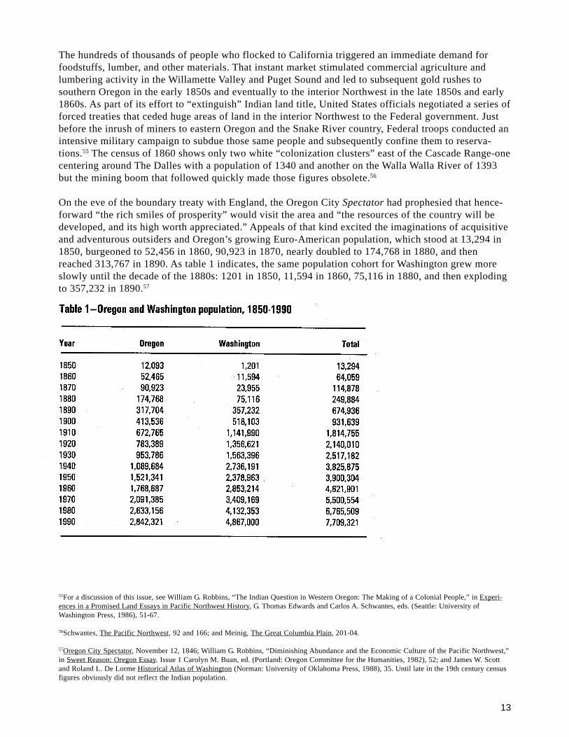
The hundreds of thousands of people who flocked to California triggered an immediate demand forfoodstuffs, lumber, and other materials. That instant market stimulated commercial agriculture andlumbering activity in the Willamette Valley and Puget Sound and led to subsequent gold rushes tosouthern Oregon in the early 1850s and eventually to the interior Northwest in the late 1850s and early1860s. As part of its effort to “extinguish” Indian land title, United States officials negotiated a series offorced treaties that ceded huge areas of land in the interior Northwest to the Federal government. Justbefore the inrush of miners to eastern Oregon and the Snake River country, Federal troops conducted anintensive military campaign to subdue those same people and subsequently confine them to reserva-tions.55 The census of 1860 shows only two white “colonization clusters” east of the Cascade Range-onecentering around The Dalles with a population of 1340 and another on the Walla Walla River of 1393but the mining boom that followed quickly made those figures obsolete.56
On the eve of the boundary treaty with England, the Oregon City Spectator had prophesied that hence-forward “the rich smiles of prosperity” would visit the area and “the resources of the country will bedeveloped, and its high worth appreciated.” Appeals of that kind excited the imaginations of acquisitiveand adventurous outsiders and Oregon’s growing Euro-American population, which stood at 13,294 in1850, burgeoned to 52,456 in 1860, 90,923 in 1870, nearly doubled to 174,768 in 1880, and thenreached 313,767 in 1890. As table 1 indicates, the same population cohort for Washington grew moreslowly until the decade of the 1880s: 1201 in 1850, 11,594 in 1860, 75,116 in 1880, and then explodingto 357,232 in 1890.57
55For a discussion of this issue, see William G. Robbins, “The Indian Question in Western Oregon: The Making of a Colonial People,” in Experi-ences in a Promised Land Essays in Pacific Northwest History, G. Thomas Edwards and Carlos A. Schwantes, eds. (Seattle: University ofWashington Press, 1986), 51-67.
56Schwantes, The Pacific Northwest, 92 and 166; and Meinig, The Great Columbia Plain, 201-04.
57Oregon City Spectator, November 12, 1846; William G. Robbins, “Diminishing Abundance and the Economic Culture of the Pacific Northwest,”in Sweet Reason: Oregon Essay. Issue 1 Carolyn M. Buan, ed. (Portland: Oregon Committee for the Humanities, 1982), 52; and James W. Scottand Roland L. De Lorme Historical Atlas of Washington (Norman: University of Oklahoma Press, 1988), 35. Until late in the 19th century censusfigures obviously did not reflect the Indian population.
14
For the interior region, gold findings were the immediate catalyst for the inrush of people in the early1860s. The ubiquitous “dust” seemed to be everywhere-on several tributaries of the Snake River, along thestreamsides in Oregon’s Blue Mountain country, and farther east in emerging mining districts likeMontana’s Last Chance Gulch. The sudden increase in the flow of human traffic up the Columbia Riverspurred the organization of the Oregon Steam Navigation Company (which soon gained a monopoly onriver transportation); boomed the city of Portland as a major entrepôt for the interior country; expandedthe economic possibilities for The Dalles and Walla Walla, satellite towns to Portland; and led to theestablishment of several fledgling communities-Lewiston, Boise City, and Baker City-as “jumping-off”places for the mines.58
That rush of activity in the 1860s to extract minerals from the streams and mountainous slopes of theinterior Columbia system was the great opening wedge in the culturally induced transformation of inter-montane ecosystems. Mining, especially the 19th century variety, was ecologically disruptive: entirehillsides sluiced away; watercourses silted; and riparian habitats destroyed. The demand for timber for avariety of construction purposes-including trusses for mine tunnels and wooden viaducts to carry water-brought the first large-scale cutting of inland forests. Within a year after gold was discovered in the JohnDay Valley (June 1862), a sawmill was supplying lumber to miners for flumes and sluices.59
Theodor Kirchoff, who passed through the mining country around Mormon Creek in 1868, offered aglimpse of the new ecological reckoning that was dawning in the eastern country: “elevated troughs, longsluices, uprooted ground, raw piles of sand and tailings, heaps of cleanly washed stone, and water formining rushes in ditches and wooden conduits among boulders and trees.” In Rye Valley, Kirchoff sawevidence of shafts and tunnels with piles of tailings on the slopes and “miles of ditches, carrying water towash gold.” What is interesting about those observations is the rapidity with which the larger, moreheavily capitalized operators with more intrusive forms of technology-hydraulic pipe, reservoirs, and longcanals-had replaced the shallow placer miners who relied primarily on the pan and sluice. And it should benoted, this transformation in the regional landscape was well underway before the coming of railroads andsteam-powered dredges. The most notable of those early ditching efforts was the construction of a nearly100-mile waterway from Burnt River to placer deposits near the Malheur River in 1870. During the mostproductive years of mining activity in the 1860s, the region sprouted a series of shortlived boom towns;among the many were Sparta, Cornucopia, Auburn, and Susanville.60
The great transportation arterial to the interior mining regions was, of course, the Columbia River. At theonset of the gold rush, boats moving upriver from Portland reported 15,000 passengers in 1861, 24,500 in1862, and 22,000 the following year. Although gold-rush populations were notoriously fluid, the historianDorothy Johansen estimates that, at the peak of the rush, the population of eastern Washington was75,000. And for the first time since the heyday of the fur trade, traffic began to move downriver as well,this time in the form of the metal-turned-commodity extracted from the streambeds and hillsides ofthe interior. The Oregon Steam Navigation Company estimated that its monthly shipments of gold toPortland averaged $400,000 during the 1860s. Other market items were beginning to travel the same route
58For general sources on the development of mining in the interior Northwest, see Schwantes, The Pacific Northwest, 106, and 172-74; Meinig,The Great Columbia Plain, 208-14; Oscar O. Winther, The Great Northwest: A History (1947; New York: Alfred A. Knopf, 1968), 220-226; andDorothy Johansen, Empire of the Columbia (1957; New York: Harper and Row, 1967), 265-268.
59Jerry Mosgrove, The Malheur National Forest: An Ethnographic History, USDA, Forest Service, Pacific Northwest Region (1980), 35-41.
60Theodor Kirchoff, Oregon East. Oregon West. 1863-1872, ed., trans., and Introduction by Frederic Trautmann (Portland: Oregon HistoricalSociety, 198, 85-86; Mosgrove, The Malheur National Forest, 173; and An Illustrated History of Baker, Grant, Malheur, and Harvey Counties(n.p., Western Historical Publishing Company, 1902), 137-166.
15
as well; in 1867, Walla Walla merchants experimented in shipping both flour and wheat to Portland.Aided by newly constructed portage railroads at the rapids and the great falls of the Columbia, thosefirst shipments foreshadowed what would soon become a literal torrent of downriver grain.61
The external forces driving the ecological transformation of the interior Northwest, hence, were two-fold: the thousands of newly arrived immigrants who stayed on to make their homes in the small townsand surrounding countryside, and the external market demand for the commodities that attracted them tothe region in the first place. The sharp increase in the flow of traffic through the region boosted thepopulation of The Dalles from 252 people in 1856 to more than 2500 in 1864, with a much largertransient group staying for brief periods. Walla Walla, a small village on Mill Creek, was the transferpoint for the movement of people and supplies to the Snake River mining country. The dusty settlementsoon had the largest population in Washington, and for a time the community rivaled Olympia in itsclaims to serve as the territorial capital. Astride the best overland route to the interior, Walla Wallaenjoyed the advantages of early settlement and provided, in Donald Meinig’s words, “an ever expandingscale and variety of businesses and services.”62
While miners, incipient wheat farmers, and town builders were reordering their immediate landscapes,the activities of stockmen were beginning the dramatic alteration of the grassland ecology in the interiorNorthwest. In a movement that paralleled the mining push east of the Cascades, entrepreneurs beganmoving large numbers of cattle and sheep onto the prairies and grasslands of eastern Oregon and easternWashington. Soaring beef prices in the mining districts brought cattlemen and their herds to the creeksand grassy lowlands in the vicinity of The Dalles and several more eastern valleys linked to the Colum-bia: John Day, Umatilla, Walla Walla, and Yakima. Trailing not far behind were the sheep men, whocame with flocks that eventually numbered in the thousands.63 Cattle and sheep grazed throughout theintermontane Northwest by the 1870s, with perhaps Oregon’s southeastern quadrant supporting thelargest and most spectacular cattle herds.
In their excellent study of the influence of domestic livestock on arid environments, James A. Youngand B. Abbott Sparks provide expert witness to the consequences for original plant communities:
The vegetation of the pristine sagebrush/grasslands was rather simpleand extraordinarily susceptible to disturbance. The potential of theenvironment to support plant and animal life was limited by lack ofmoisture and often by accumulations of salts in the soil. The nativevegetation lacked the resilience, depth, and plasticity to cope withconcentrations of large herbivores. The plant communities did not bendor adapt; they shattered.
The large number of cattle and sheep consumed grasses that provided a major fuel source for the annualfires that swept the arid interior. The result was the eventual proliferation of big sagebrush and juniper,the virtual elimination of the perennial bunch grasses, and their replacement by exogenous annualgrasses .64 It would be accurate to say that before railroads penetrated the interior Northwest in the1880s, extensive alterations to the regional ecology had already taken place on the grasslands.
61Johansen, Empire of the Columbia, 267 and 279; and W. D. Lyman, An Illustrated History of Walla Walla County, Washington (Walla Walla: W.H. Lever, 1901), 101.
62Lyman, An Illustrated History of Walla Walla County, 57; Schwantes, The Pacific Northwest, 106; and Meinig, The Great Columbia Plain,215-217.
63Meinig, The Great Columbia Plain, 220-222.
64James A. Young and B. Abbott Sparks, Cattle in the Cold Desert (Logan: Utah State University Press, 1985), xxi, 27-28; and Stephen Whitney, ASierra Club Naturalist’s Guide: The Pacific Northwest (San Francisco: Sierra Club Books, 1989), 254-255.
16
But the problem of determining cause and effect between human-induced activity and its consequencesis not always a simple exercise in observation. As a seasonal employee of the Bureau of Forestry in1902, William T. Cox participated in a study “to ascertain the source and cause of the annual deposits ofsand left by the Columbia, which blows out, forming dunes which bury railroads, orchards, vineyards,and fields of alfalfa.” The youthful disciple of Gifford Pinchot took his job seriously, traversing thePalouse, Walla Walla, Yakima, Wenatchee, Chelan, Methow, Okanogan, Umatilla, John Day, andDeschutes valleys to account for the drifting and blowing sand. “It was pretty evident,” Cox laterreported, “that the real cause of the trouble with sand along the Columbia came from crowding of theranges and breaking up of the sod by sheep and horses.” During the early years of settlement, theColumbia River carried “practically no sand;” nor could the problem be attributable to cattle. Theculprits, according to Cox, were horses and sheep that caused the Columbia and Snake rivers to develophuge deposits of sand which commenced “to blow inland after the annual subsidence of the streams.”65
Even a casual perusal of the early observer accounts of the mid-Columbia country would have sug-gested alternative explanations to that cause-and-effect relation. Traveling southeastward from theWalla Walla River on his return trip to the United States in July 1812, Robert Stuart witnessed highwinds and blowing sand “sufficiently to produce an almost suffocating effect.” David Douglas, after anighttime of rain in the same vicinity in June 1826, found “great relief, the atmosphere being cool andthe sand prevented from blowing.” The level plain around him, he remarked, was “destitute of timberand comprised of “gravel and sand.” Nathaniel Wyeth, enroute down the Columbia to make his fortunein the fur trade in 1832, left the Hudson’s Bay Company post at Fort Walla Walla and soon encountered“a furious wind” where “the sand flew so as to obscure the air.”66
The accounts of wind and blowing and drifting sand mounted with each successive visitor to the mid-Columbia River region. John Kirk Townsend, who reached the junction of the Walla Walla and theColumbia River during the low-water month of September, saw high and rocky banks “interrupted bybroad, level sandy beaches.” Thomas Farnham outdid all others in his rhetorical sketches of adesert-like country of “vast rolling swells of sand and clay” as worthless as the “wastes of Arabia.” Butthe more widely read Fremont described the mid-Columbia/Walla Walla terrain best: “a plain of baresands, from which the air was literally filled with clouds of dust and sand, . . . this place being one ofthe several points on the river which are distinguished for prevailing high winds.”67
Fremont’s account also provides an alternative explanation for the deposits of sand visible during theperiod William Cox called “the annual subsidence of the streams.” Moving down the Columbia Riverfrom Fort Walla Walla on October 31, 1843, the lieutenant and his entourage toiled through “loose deepsand .... the stream being interspersed with many sand bars (it being the season of low water).”68 Coxwas probably correct in claiming that some rangelands were being overgrazed; however, his assumptionthat overgrazing contributed to the problem of sand in the river and elsewhere would appear to be wideof the mark. Solid evidence suggests that the “drifting and blowing sand” may have been around sincethe midHolocene, or at least since the climate of the interior Northwest began to warm.
65Statement Regarding W. T. Cox’s Experiences and Observations in Forestry, 974, File “Cox, W. T.,” Gifford Pinchot Papers, Collections of theManuscript Division, Library of Congress. For a brief account of William T. Cox’s career as state forester in Minnesota, see William G. Robbins,American Forestry: A History of National, State, and Private Cooperation (Lincoln: University of Nebraska Press, 1985, 67-72.
66Rollins, ed., The Discovery of the Oregon Trail 75; Davies, ed., Douglas of the Forests, 70; and F. G. Young, ed., The Correspondence andJournals of Captain Nathaniel J. Wyeth. 1831-6 (Eugene: University Press, 1899, 173.
67Townsend, Narrative Journey Across the Rocky Mountains, 172; Farnham, Travels in the Great Western Prairies, 79; and Jackson and Spence,eds., The Expeditions John Charles Fremont, Vol. 1, 553.
68Statement regarding W. T. Cox’s Experiences and Observations in Forestry, 5; and Jackson and Spence, eds., The Expeditions of John CharlesFremont, Vol. 1, p. 555.
17
The industrial revolution came to the interior Pacific Northwest with the rail networks that linked the regionto national and international markets in the decade of the 1880s. First in England and western Europe andthen in the United States, industrial capitalism marked the onset of increasingly intrusive patterns of humanactivity in the natural world. In terms of heavily capitalized and broadly based transportation and extractiveenterprises, the railroad represented a vastly accelerated move to take advantage of the natural bounty of theintermontane region. At the same moment, distant places like Chicago, New York, Minneapolis-St. Paul, andeven London, Berlin, and Paris assumed increasing importance to what took place in the interior Northwest.If “history happened fast” in the region, then steel rails were the transcendent vehicle for that quickeningpace of activity.
The rapid building of railroads through eastern Oregon and eastern Washington during the 1880s introducedeconomic, social, and environmental changes that were revolutionary in their consequences. Increases inpopulation, the formation of new counties, the spectacular expansion in the acreage of cultivated land, andthe advent of large-scale industrial mining enterprises were all part of the story. Rail construction through theWalla Walla Valley and around the fringes of the Columbia plain led to an increase in wheat production tomore than 2,500,000 acres within a decade. It is important to emphasize that this expansion in tillableacreage marked the emergence of commercial agriculture in a large way, with successful farmers adoptingthe most improved machinery of the age. Through those commercial developments, wheat-the classic frontiercash crop-replaced the native bluebunch wheatgrass and Idaho fescue on the arid grasslands of the PalouseHills. One Washington State University scientist concludes that most of the arable land in the Palouse wasunder cultivation by 1910.69 Wheat was an exotic; as such, its cultivation eliminated native plants, flora, andgrasses. In short, the market was reshaping the ecology of the Palouse Hills.
The industrial transformation of forest ecosystems in the interior Northwest came more slowly. Distance, theabsence of a viable means of transportation, and still sizable timber stands closer to markets in the GreatLakes states limited regional harvests; hence, most logging and milling of lumber before 1900 was directedto local demand. On the fringes of the Columbia plain, mills at Spokane Falls, Coeur d’Alene, Colville,Colfax, Walla Walla, and Yakima cut timber for booming local construction activity. The relation betweenthe up-river forests and the downstream settlements on the Palouse River provides an interesting case studyof the reciprocal ties between different landscapes. The forests were sources of firewood and fencing mate-rial as well as lumber for building purposes. The first crude mill began operating on the river in 1871, sawingonly for nearby construction needs. Those early mills, without access to distant markets, prospered andsuffered with the expansion and contraction of the local economy. Lumber capitalists from the Great LakesStates, who began arriving shortly after the turn of the century, subsequently absorbed most of the earlyenterprises. By that time, the local mills had exhausted the timber that could be easily felled and floateddownriver.70
The cutting and milling of timber in eastern Oregon follows a similar pattern. Several small sawmills wereestablished in the booming mining districts in the John Day; Burnt River, and Powder River valleys in the1860s to cut lumber for building materials and timbers for bridge, sluice, and mine construction. The modestproductive capacity of those early mills was sufficient to meet the demands of the boom-and-bust miningeconomy between 1860 and 1880. Although much of the easily accessible timber adjacent to the fledglingmining communities had been cut, the vast interior of the Blue Mountain forests was still untouched. Themanipulations and maneuvers of distant capitalists, however, soon altered that relatively slow pace ofactivity.
69Oliphant, “History of the Livestock Industry in the Pacific Northwest,” 4-5; Johansen, Empire of the Columbia, 317-318; Whitney, A Sierra ClubNaturalist’s Guide, 255; and Helmut K. Buechner, “Some Biotic Changes in the State of Washington, Particularly During the Century, 1853-1953”Research Studies, State College of Washington 21 (1953), 168-169.
70John Fahey, The Inland Empire: Unfolding Years. 1879-1929 (Seattle: University of Washington Press, 1986), 188-189; Robert Wayne Swanson,“A History of Logging and Lumbering on the Palouse River, 1870-1905” (M. A. Thesis, Washington State University, 1958), 2, 13, 17, 45; andKeith C. Peterson, Company Town: Potlatch, Idaho, and the Potlatch Lumber Company (Pullman: Washington State University Press, 1987), 6-12.
18
The completion of a transcontinental railroad in 1884, linking the Columbia River-via the Blue Moun-tains and Grand Ronde Valley-to the Union Pacific Railroad at Huntington on the Snake River, acceler-ated the pace of industrial activity in the forests of eastern Oregon.71 Using a variety of tactics, includ-ing dummy entrymen, David Eccles, a western lumberman, began purchasing blocks of timber in theearly 1880s to supply railroad ties for the construction of the Union Pacific subsidiary, the OregonShort Line. With a group of associates, Eccles incorporated the Oregon Lumber Company in 1889, soonto emerge as the leading producer of western pine lumber in the State.72
To tap the timber wealth of the southern Blue Mountains, Eccles and his partners formed a subsidiarycorporation, the Sumpter Valley Railroad Company, and constructed a narrow-gauge line 19 miles upthe Powder River. The first logs rolled down the route to Baker City and the company’s state-of-the-artmill on August 1, 1890, thus establishing a regimen for harvesting, transporting, and milling timber thatlasted through the Second World War. In the succeeding years, the railroad pushed deeper into themountains, and by 1910, the line extended 80 miles to Prairie City and the John Day Valley. In the late1890s, mining boomed throughout the Sumpter Valley region, creating business for the Oregon LumberCompany, especially in mine timbers, and bringing a huge volume of traffic for the railroad. Eventually,several operators built small sawmills in Sumpter to cut timbers and lumber for the mines. But therailroad’s long-term, bread-and-butter traffic centered on the area’s impressive timber stands.73
The population growth for Baker County between 1880 and 1910 reflects the increased human activityalong the extensive Sumpter Valley Railroad and its several spur lines. As table 2 indicates, both miningand lumbering operations attracted people to the area, with the county’s population growing from 4616in 1880 to 18,076 in 1910: The expanding population base and an increasingly sophisticated and pro-ductive technology suggest the influence of industrial activity in transforming the landscape of thesouthern Blue Mountain region. The railroad was itself an intrusive force-linking resources, processingfacilities, and markets-enabling lumbermen to gain access to stands remote from manufacturing sites.When he conducted a reconnaissance through the region for the Federal government in the early 20thcentury, H. D. Langille reported that “the destruction of the timber [was] almost complete” along muchof the Oregon Lumber Company’s railroad.74
71Randall V. Mills, “A History of Transportation in the Pacific Northwest,” Oregon Historical Quarterly 45 (1946), 291-292; and Enoch A. Bryan,Orient Meet Occident: The Advent of the Railways to the Pacific Northwest (Pullman: Students Book Corporation, 1936), 162-163. Henry Villard,the financial guru behind the Oregon Railway and Navigation Company, also engaged in the wholesale advertising and promotion of thesettlement of the Powder River Valley and adjacent areas. See James B. Hedges, Henry Villard and the Railways of the Northwest (1930; NewYork: Russell & Russell, 1967), 123-126.
72Mallory Hope Ferrell, Rails. Sagebrush, and Pine: A Garland of Railroad and Logging Days in Oregon’s Sumpter Valley (San Marino, CA:Golden West Books, 196, 9-13; Mosgrove, The Malheur National Forest, 71; Baker City Record Courier, November 7, 1946; and Shirley T.Moore, ed., Sumpter Valley Railway, USDA Forest Service, Wallowa-Whitman National Forest, Pacific Northwest Region, n.d., n.p.
73Ferrell, Rails, Sagebrush, and Pine, 13-33.
74Langille is quoted in Mosgrove, The Malheur National Forest, 71.
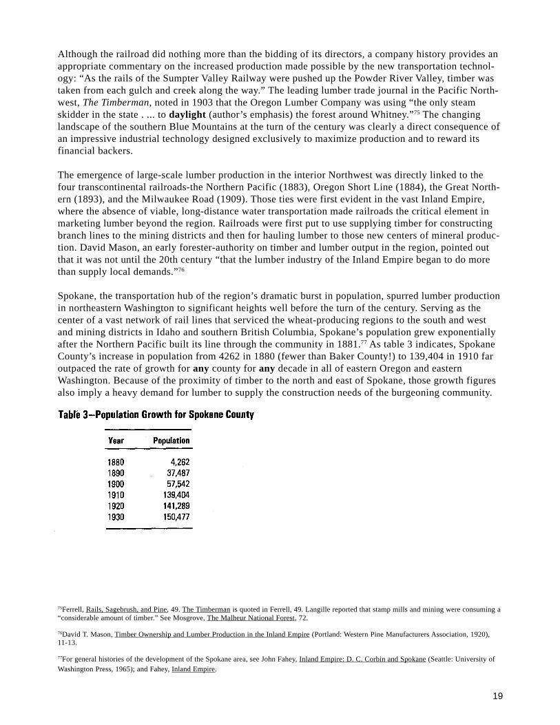
19
Although the railroad did nothing more than the bidding of its directors, a company history provides anappropriate commentary on the increased production made possible by the new transportation technol-ogy: “As the rails of the Sumpter Valley Railway were pushed up the Powder River Valley, timber wastaken from each gulch and creek along the way.” The leading lumber trade journal in the Pacific North-west, The Timberman, noted in 1903 that the Oregon Lumber Company was using “the only steamskidder in the state . ... to daylight (author’s emphasis) the forest around Whitney.”75 The changinglandscape of the southern Blue Mountains at the turn of the century was clearly a direct consequence ofan impressive industrial technology designed exclusively to maximize production and to reward itsfinancial backers.
The emergence of large-scale lumber production in the interior Northwest was directly linked to thefour transcontinental railroads-the Northern Pacific (1883), Oregon Short Line (1884), the Great North-ern (1893), and the Milwaukee Road (1909). Those ties were first evident in the vast Inland Empire,where the absence of viable, long-distance water transportation made railroads the critical element inmarketing lumber beyond the region. Railroads were first put to use supplying timber for constructingbranch lines to the mining districts and then for hauling lumber to those new centers of mineral produc-tion. David Mason, an early forester-authority on timber and lumber output in the region, pointed outthat it was not until the 20th century “that the lumber industry of the Inland Empire began to do morethan supply local demands.”76
Spokane, the transportation hub of the region’s dramatic burst in population, spurred lumber productionin northeastern Washington to significant heights well before the turn of the century. Serving as thecenter of a vast network of rail lines that serviced the wheat-producing regions to the south and westand mining districts in Idaho and southern British Columbia, Spokane’s population grew exponentiallyafter the Northern Pacific built its line through the community in 1881.77 As table 3 indicates, SpokaneCounty’s increase in population from 4262 in 1880 (fewer than Baker County!) to 139,404 in 1910 faroutpaced the rate of growth for any county for any decade in all of eastern Oregon and easternWashington. Because of the proximity of timber to the north and east of Spokane, those growth figuresalso imply a heavy demand for lumber to supply the construction needs of the burgeoning community.
75Ferrell, Rails, Sagebrush, and Pine, 49. The Timberman is quoted in Ferrell, 49. Langille reported that stamp mills and mining were consuming a“considerable amount of timber.” See Mosgrove, The Malheur National Forest, 72.
76David T. Mason, Timber Ownership and Lumber Production in the Inland Empire (Portland: Western Pine Manufacturers Association, 1920),11-13.
77For general histories of the development of the Spokane area, see John Fahey, Inland Empire: D. C. Corbin and Spokane (Seattle: University ofWashington Press, 1965); and Fahey, Inland Empire.
20
Because Spokane dominated retail trade with its extensive hinterland, the city occupied an importantposition in the lumber business of the Inland Empire. Two large sawmills operated along the SpokaneRiver before 1900; one of them, the Sawmill Phoenix, located in Spokane proper, shipped its logs on theSpokane Falls and Northern Railroad from timberlands near present-day Springdale. But when themajor railroads lowered shipping rates in 1894, local lumber brokers began purchasing lumber fromPuget Sound producers, practices that continued until the early 20th century, when Great Lakes lumbercapitalists began looking to the Pacific Northwest for virgin stands of timber.78
Brisk regional construction activity, especially in bustling Spokane, continued to drive the lumbermarket in northeastern Washington until the First World War. But a slowdown in mining enterprises andrail construction brought an end to the economic boom, and the population of Spokane County grew byfewer than 2000 people between 1910 and 1920. It is ironic that the economic slowdown occurredsimultaneously with the end of the massive transfer of timberland from public to private ownership,much of it to buyers from the Great Lakes States. David Mason points out, by 1909 forests that had notbeen transferred to the private sector were in National Forests .79
Historians and the public alike have celebrated the huge land purchases of Frederick Weyerhaeuser andhis cohorts at the turn of the century. Although he is not as well known, F. A. Blackwell, who worked inMinnesota lumber camps as a youth, may represent the more typical early 20th century lumberman.Blackwell began purchasing timberlands in northern Idaho and northeastern Washington until he hadamassed holdings in excess of 100,000 acres. And he was innovative at the production end, building alarge flume that hurtled logs into a stream leading to Spirit Lake. In time, Blackwell was runningsizable mills at Spirit Lake and Ione, operations linked to the Northern Pacific main line near Coeurd’Alene by 106 miles of steam railroad. But Blackwell’s purchases and expansion in production facili-ties came in the midst of Spokane’s greatest period of growth. When the regional economy slowed justbefore the Great War, Blackwell turned up victim to the economic shakeout and lost control ofeverything-timberlands, railroads, production facilities, and townsites.80
Blackwell’s story was symptomatic of larger problems in the interior Northwest where economics andecology intermixed in a symbiotic bond as a consequence of the feverish speculation in timberlandpurchases in the early 20th century. Inland Empire lumbermen aggressively sought buyers in distanteastern markets in a desperate effort to pay off their indebtedness after the downturn in the localeconomy. Those measures, however, failed to resolve their problems in the long run, because the lumbermarket remained glutted-except for a blip or two-for the entire period between 1910 and the outbreak ofthe Second World War. David Mason captured that veritable “catch-22” situation for Inland Empireproducers at the end of the First World War:
The lumber industry is not in a stable condition. This is made evident bythe exceedingly small profits in the business, the existence of muchunused milling capacity while additional capacity is being developed,and the constant tendency to- cut more lumber than the market willabsorb. The principal cause of instability is the great pressure to liqui-date the stumpage investment.81
7
8Fahey, Inland Empire, 189.
79Fahey, The Inland Empire, 201; and Mason, Timber Ownership and Lumber Production in the Inland Empire, 16-17.
80Craig E. Holstine, “A History of the Colville National Forest” (M.A. thesis, Washington State University, 1978), 35-37; and Fahey, The InlandEmpire, 194-197.
81Fahey, The Inland Empire, 201; and Mason, Timber Ownership and Lumber Production in the Inland Empire, 13-14. For an extended discussionof the industry’s problems with overproduction, see William G. Robbins, Lumberjacks and Legislators: Political Economy of the U.S. LumberIndustry, 1890-1941 (College Station: Texas A & M University Press, 1982), 5-12.
21
Less observable in the lumber producers’ cash-flow statistics are the consequences for forest landsthroughout the Pacific Northwest. For the interior region, the pursuit of the bottom line meant production-driven business practices that focused on taking only the best and most marketable timber from the woodsand leaving huge amounts of debris on the ground. Waste, as Richard White has indicated, had littleeconomic meaning in an age when the supply of timber seemed inexhaustible and perpetually gluttedmarkets confronted the operator. The result of those practices is evident in some of the worst forest fires inthe region’s history, fires fed in part by the accumulation of heavy fuels lying on the ground. In contrastwith earlier conflagrations, the fires that burned through logging debris were hot, consuming duff, seed-lings, and standing trees alike. In truth, the new fire regimes represented a much more intrusive element inthe forest ecosystem.82 Those new conditions also underscore the degree to which economics and ecologywere entwined in the industrial age.
If the railroad represented the opening wedge of the industrial revolution in the Inland Empire, the comingof steel rails to central and south-central Oregon had an even more dramatic effect in redesigning theregional landscape. Until the railroad reached Klamath Falls in 1909 and Bend in 1911, distant marketshad little effect on the great ponderosa forests that stretched along the eastern slope of Oregon’s CascadeRange. The effect of those newly built and efficient transportation arterials was to link those magnificentstands of ponderosa pine with outside markets, thus setting in motion the large-scale industrial productionof lumber in the region. The Bend Bulletin heralded the “opening up” of this last great western pine regionand the building of state-of-the-art facilities to mill the lumber as a “dream” become “actuality.” Theeuphoria of the time and the setting emphasized pride in the volume of timber harvested and uninhibitedboasting about the production records established in the mills. Less obvious in the historical literaturewere the changes taking place in the forested outback, beyond the towns and logging camps of centralOregon.83
In the struggle for profits in volatile and often glutted markets, the central Oregon districts possessedcertain advantages over their eastern Washington counterparts: two-thirds of the central Oregon timberwas privately owned; the area had relatively more even terrain; it was closer to California markets; and ithad a greater volume of forest in pure stands of ponderosa pine. In its congressionally mandated forestsurveys in the mid-1930s, the Forest Service found “pure or nearly pure” stands of ponderosa “reachingthrough the whole north-south extent of the State and from the lower slopes of the Cascades on the west toopen desert lands on the east.” And when the rails reached those virgin stands, other competitors werequick to notice. Ralph H. Bockmier, an eastern Washington producer, observed that the “Oregon competi-tion,” especially the mills at Bend and Klamath Falls, created competitive problems in the ponderosa tradeimmediately after the First World War.84
The population figures for the leading timber-producing counties in eastern Oregon and eastern Washing-ton reflect that southward shift in lumber production (see appendices A and B). Oregon’s newly created(1915) Deschutes County grew from 9622 in 1920 to 14,749 in 1930, and even during the decade of theGreat Depression, a period of slow national growth, the population of the county increased by more than25 percent. The influence of the railroads on Bend, the center of manufacturing in Deschutes County, isequally striking: 536 people in 1910 and 5414 in 1920. The population increases for Klamath County,where the Weyerhaeuser Company opened a huge mill in 1929, are even more impressive: 8554 in 1910;11,413 in 1920; and 32,407 in 1930.85
82White, Land Use, Environment and Social Change, 88-91; and Pyne, Fire in America, 336-342.
83Thomas R. Cox, “Closing the Lumberman’s Frontier: The Far Western Pine Country,” (manuscript copy in the author’s possession), 1; and PhilipCogswell, Jr., “Deschutes Country Pine Logging,” in High and Mighty, Select Sketches about the Deschutes Country, Thomas Vaughan, ed.(Portland: Oregon Historical Society, 1981), 236-241.
84USDA Forest Service, Forest Statistics for Klamath County, Oregon, Forest Survey, Pacific Northwest Forest Experiment Station (February 1,1936), 1; and Ralph H. Bockmier, Sr., “Inland Empire Lumber Industry over a Period of Sixty Years, 1900-1965.” Typescript, R. H. BockmierLumber Corporation, 1967, in Washington State University Archives, Cage 387, p. 16-18; and Fahey, The Inland Empire, 207.
85Cogswell, “Deschutes Country Pine Logging,” 241.
22
During those same decades, Washington’s leading lumber-producing counties-Chelan, Ferry, Kittitas, andStevens-all lost population, with some operators and workers shifting to the more active pine countrysouth of the Columbia River.86 Other mitigating factors (for example, mining) may explain the decliningpopulation in those counties; however, in an age of still labor-intensive activity in the lumber industry, thehuge volume of production of the Oregon pine mills tells most of the story. Beginning in 1925 when thefirst aggregate figures are available, the timber harvests in eastern Oregon far outstripped those for easternWashington. Indeed, Klamath County’s lumber output in 1925 alone nearly equaled the total productionfor all of eastern Washington.87
Technology, natural competitive advantages over rival producing regions, and the virtual absence of anyconstraints on private timber harvesting (except for the market), contributed to the halcyon years oflumber production in the pine belt from Bend southward to Klamath Falls. But more than any other factor,the splendid, nearly pure stands of ponderosa pine explain the booming productivity of the area’s mills.The USGS survey of the volume of sawtimber on the eastern slopes of the Cascades in 1900 indicated atotal of 1,450,420 acres in “yellow pine;” of that huge quantity, only 33,700 acres had been logged.Moreover, the mid-1930s Forest Survey for Klamath County noted that the richest commercial belt oftimber grew on terrain ideally suited to railroad and truck-road construction, much of it within a 30-mileradius of Klamath Falls. The survey also underscored the importance of the market in remaking the area’sforest ecosystem: ponderosa pine comprised more than 96 percent of the total production between 1925and 1934.88
The opening of the Weyerhaeuser Company’s big mill in 1929 helped sustain the Klamath cut, even duringthe doldrums of the Great Depression. The county’s total output remained above 300- and 400 hundredthousand board feet for most of the period, with the exception of 1932 when it dropped to 196,591.Production then rose to more than 600,000 board feet in 1936, remained above that figure through theearly years of the Second World War, dropped gradually to a postwar average of about 200,000 board feetthrough the early 1960s, and then began an upward swing, triggered in part by Weyerhaeuser’s decision toabandon select logging.89 The move toward clearcutting-to what managers termed more cost-effective,“even-aged” stands-meant the abandonment of the mixed-aged forests that reflected selective harvesting.In its place, the company began to practice intensified forest management on its cutover lands.
Eventually, weak lumber prices and a decline in the supply of old-growth pine curtailed production atWeyerhaeuser’s Klamath Falls sawmill, one of the largest in Oregon. The company announced that itwould lay off nearly half of its 450 employees in mid-1985, citing the reduced volume of large ponderosapine as a precipitating factor. The Portland Oregonian reported that the harvests of Klamath timberincluded stands that dated before the American Revolution. The hemorrhage of mill closures that occurredelsewhere in the ponderosa region in the 1980s included the complete shutdown of Weyerhaeuser’s largemill in the small town of Bly.90 Markets, corporate business strategies, and the management decisions
86Bockmier, “Inland Empire Lumber Industry,” 26; and Fahey, The Inland Empire, 207.
87Brian R. Wall, Log Production in Washington and Oregon: An Historical Perspective, USDA Forest Service, Resource Bulletin PNW-42 (1972),1519, and 30-45.
88John B. Leiberg, “Cascade Range and Ashland Forest Reserves and Adjacent Regions, Twenty-First Annual Report of the United StatesGeological Survey to the Secretary of the Interior, 1899-1900, Part V, Forest Reserves, 273; and Forest Statistics for Klamath County, Oregon 3-6.
89Wall, Log Production in Washington and Oregon, 41; and Cox, “Closing the Lumberman’s Frontier,” 12.
90Portland Oregonian, February 21, 1985.
23
of public land agencies affected the volume and species of logs flowing to the mills. In the long run,however, in the Klamath country as elsewhere, the heavy flow of market-selected species to the millsforged both a depressed local economy and a newly fashioned forest landscape. The industrial age provedagain the close integration of the seemingly separate worlds of economics and ecology.
But it is Bend that provides the more fascinating story of the conjuncture between culture and nature,between economics and ecology, between a thriving and bustling lumber town and its timbered wealth.Bend’s large-volume pine manufacturers, according to historian Thomas Cox, “represented the last,spectacular flowering of the old order,” a production system predicated on liquidating standing timber asquickly as markets and the technical ability to produce permitted. The story of the Brooks-Scanlon andShevlin-Hixon operations parallels that of other Great Lakes lumber capitalists who began purchasinglarge tracts of timber in the Pacific Northwest in the early years of the 20th century. Through mergers andbuyouts, Shevlin-Hixon had amassed more than 200,000 acres of prime ponderosa timber when its im-mense mill began sawing lumber on March 3, 1916; Brooks-Scanlon, with a small but rapidly expandingacreage, opened milling facilities with a similar productive capacity the following month. The BendBulletin was ecstatic about those developments:
The dream, Bend, the sawmill and lumbering center of Central Oregon isnow an actuality .... After years of “watchful waiting” by men who werepossessed with faith that one day saws would be humming and that thevast area of Deschutes timber would be manufactured at Bend, they havetoday to take a 10-minute walk from the center of town to see that realiza-tion of their dreams.91
Each of the large pine manufacturing facilities employed about 600 men, with a ratio of perhaps twoworkers engaged in the logging end of the business for every mill operative.92 The continually expandingcutting capacity of the plants eventually reached 200 million board feet a year, a prodigious amount, theimpressive volume of timber tributary to Bend notwithstanding. For nearly three decades, the town and thesurrounding countryside bustled with the kind of activity that prompted the Forest Service to boldlyproclaim: “The history of the economic development of Deschutes County is largely the history of itslumber industry.”93 A strong case can be made that Bend was the most timber-dependent community inOregon, or at least until the timber began to run out and entrepreneurs launched an effort to capitalize on aresource of another kind, namely snow.
The relatively even terrain provided a showcase of sons for experimenting with new, highly productivetechnological devices in the woods. Railroads spanned out from Bend in three directions to the rich standsof ponderosa pine, where loggers began using the highly efficient steam-powered McGiffert loader tohoist logs onto flatcars. The subsequent development of the Ledgerwood skidder and the gasoline-poweredcaterpillar tractor further advanced the volume of timber that loggers were able to move in a single day.And then at the close of the Second World War, the companies quickly turned to the most revolutionary
91Cox, “Closing the Lumberman’s Frontier,” 3-4; and Cogswell, “Deschutes Country Pine Logging,” 238-246. The Bend Bulletin, March 3, 1916.The Bulletin is cited in Cogswell.
92I made a similar calculation for the ratio of workers employed in sawmill and logging operations on Coos Bay during the days of steampoweredlogging. That ratio changed with the introduction of the chain saw and gasoline-driven engines to the woods. See William G. Robbins, Hard Timesin Paradise Coos Bay Oregon 1850-1986 (Seattle: University of Washington Press, 1988), 41.
93Cogswell, “Deschutes Country Pine Logging,” 246-47; and Philip A. Briegleb, Forest Statistics for Deschutes County, Oregon, USDA ForestSeance, Pacific Northwest Forest Experiment Station (May 18, 1936), 6.
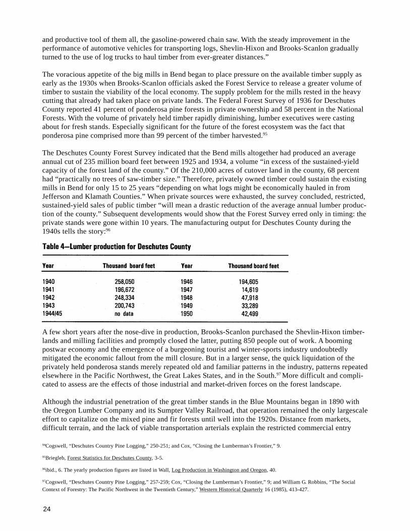
24
and productive tool of them all, the gasoline-powered chain saw. With the steady improvement in theperformance of automotive vehicles for transporting logs, Shevlin-Hixon and Brooks-Scanlon graduallyturned to the use of log trucks to haul timber from ever-greater distances.”
The voracious appetite of the big mills in Bend began to place pressure on the available timber supply asearly as the 1930s when Brooks-Scanlon officials asked the Forest Service to release a greater volume oftimber to sustain the viability of the local economy. The supply problem for the mills rested in the heavycutting that already had taken place on private lands. The Federal Forest Survey of 1936 for DeschutesCounty reported 41 percent of ponderosa pine forests in private ownership and 58 percent in the NationalForests. With the volume of privately held timber rapidly diminishing, lumber executives were castingabout for fresh stands. Especially significant for the future of the forest ecosystem was the fact thatponderosa pine comprised more than 99 percent of the timber harvested.95
The Deschutes County Forest Survey indicated that the Bend mills altogether had produced an averageannual cut of 235 million board feet between 1925 and 1934, a volume “in excess of the sustained-yieldcapacity of the forest land of the county.” Of the 210,000 acres of cutover land in the county, 68 percenthad “practically no trees of saw-timber size.” Therefore, privately owned timber could sustain the existingmills in Bend for only 15 to 25 years “depending on what logs might be economically hauled in fromJefferson and Klamath Counties.” When private sources were exhausted, the survey concluded, restricted,sustained-yield sales of public timber “will mean a drastic reduction of the average annual lumber produc-tion of the county.” Subsequent developments would show that the Forest Survey erred only in timing: theprivate stands were gone within 10 years. The manufacturing output for Deschutes County during the1940s tells the story:96
A few short years after the nose-dive in production, Brooks-Scanlon purchased the Shevlin-Hixon timber-lands and milling facilities and promptly closed the latter, putting 850 people out of work. A boomingpostwar economy and the emergence of a burgeoning tourist and winter-sports industry undoubtedlymitigated the economic fallout from the mill closure. But in a larger sense, the quick liquidation of theprivately held ponderosa stands merely repeated old and familiar patterns in the industry, patterns repeatedelsewhere in the Pacific Northwest, the Great Lakes States, and in the South.97 More difficult and compli-cated to assess are the effects of those industrial and market-driven forces on the forest landscape.
Although the industrial penetration of the great timber stands in the Blue Mountains began in 1890 withthe Oregon Lumber Company and its Sumpter Valley Railroad, that operation remained the only largescaleeffort to capitalize on the mixed pine and fir forests until well into the 1920s. Distance from markets,difficult terrain, and the lack of viable transportation arterials explain the restricted commercial entry
94Cogswell, “Deschutes Country Pine Logging,” 250-251; and Cox, “Closing the Lumberman’s Frontier,” 9.
95Briegleb, Forest Statistics for Deschutes County, 3-5.
96ibid., 6. The yearly production figures are listed in Wall, Log Production in Washington and Oregon, 40.
97Cogswell, “Deschutes Country Pine Logging,” 257-259; Cox, “Closing the Lumberman’s Frontier,” 9; and William G. Robbins, “The SocialContext of Forestry: The Pacific Northwest in the Twentieth Century,” Western Historical Quarterly 16 (1985), 413-427.
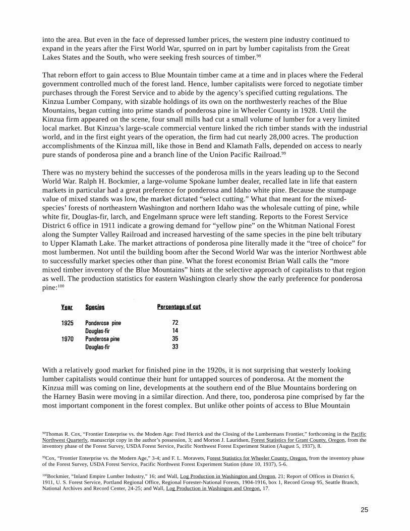
25
into the area. But even in the face of depressed lumber prices, the western pine industry continued toexpand in the years after the First World War, spurred on in part by lumber capitalists from the GreatLakes States and the South, who were seeking fresh sources of timber.98
That reborn effort to gain access to Blue Mountain timber came at a time and in places where the Federalgovernment controlled much of the forest land. Hence, lumber capitalists were forced to negotiate timberpurchases through the Forest Service and to abide by the agency’s specified cutting regulations. TheKinzua Lumber Company, with sizable holdings of its own on the northwesterly reaches of the BlueMountains, began cutting into prime stands of ponderosa pine in Wheeler County in 1928. Until theKinzua firm appeared on the scene, four small mills had cut a small volume of lumber for a very limitedlocal market. But Kinzua’s large-scale commercial venture linked the rich timber stands with the industrialworld, and in the first eight years of the operation, the firm had cut nearly 28,000 acres. The productionaccomplishments of the Kinzua mill, like those in Bend and Klamath Falls, depended on access to nearlypure stands of ponderosa pine and a branch line of the Union Pacific Railroad.99
There was no mystery behind the successes of the ponderosa mills in the years leading up to the SecondWorld War. Ralph H. Bockmier, a large-volume Spokane lumber dealer, recalled late in life that easternmarkets in particular had a great preference for ponderosa and Idaho white pine. Because the stumpagevalue of mixed stands was low, the market dictated “select cutting.” What that meant for the mixed-species’ forests of northeastern Washington and northern Idaho was the wholesale cutting of pine, whilewhite fir, Douglas-fir, larch, and Engelmann spruce were left standing. Reports to the Forest ServiceDistrict 6 office in 1911 indicate a growing demand for “yellow pine” on the Whitman National Forestalong the Sumpter Valley Railroad and increased harvesting of the same species in the pine belt tributaryto Upper Klamath Lake. The market attractions of ponderosa pine literally made it the “tree of choice” formost lumbermen. Not until the building boom after the Second World War was the interior Northwest ableto successfully market species other than pine. What the forest economist Brian Wall calls the “moremixed timber inventory of the Blue Mountains” hints at the selective approach of capitalists to that regionas well. The production statistics for eastern Washington clearly show the early preference for ponderosapine:100
With a relatively good market for finished pine in the 1920s, it is not surprising that westerly lookinglumber capitalists would continue their hunt for untapped sources of ponderosa. At the moment theKinzua mill was coming on line, developments at the southern end of the Blue Mountains bordering onthe Harney Basin were moving in a similar direction. And there, too, ponderosa pine comprised by far themost important component in the forest complex. But unlike other points of access to Blue Mountain
98Thomas R. Cox, “Frontier Enterprise vs. the Modem Age: Fred Herrick and the Closing of the Lumbermans Frontier,” forthcoming in the PacificNorthwest Quarterly, manuscript copy in the author’s possession, 3; and Morton J. Lauridsen, Forest Statistics for Grant County, Oregon, from theinventory phase of the Forest Survey, USDA Forest Service, Pacific Northwest Forest Experiment Station (August 5, 1937), 8.
99Cox, “Frontier Enterprise vs. the Modern Age,” 3-4; and F. L. Moravets, Forest Statistics for Wheeler County, Oregon, from the inventory phaseof the Forest Survey, USDA Forest Service, Pacific Northwest Forest Experiment Station (dune 10, 1937), 5-6.
100Bockmier, “Inland Empire Lumber Industry,” 16; and Wall, Log Production in Washington and Oregon, 21; Report of Offices in District 6,1911, U. S. Forest Service, Portland Regional Office, Regional Forester-National Forests, 1904-1916, box 1, Record Group 95, Seattle Branch,National Archives and Record Center, 24-25; and Wall, Log Production in Washingon and Oregon, 17.

26
timber, the forested slopes fronting the arid basin country were largely in public ownership.101 For theprudent lumberman, therefore, the assurance of cutting rights to National Forest timber was a prerequisiteto investment.
Fred Herrick, a Michigan-born lumberman who made a fortune and became a buccaneer of sorts in Idaho’swhite-pine country, initiated the move into the southern Blue Mountains. Juggling railroad constructionwith the promise of cutting rights to nearly a billion board feet of National Forest timber, Herrick com-pleted a Union Pacific line from Crane to Burns in 1924 and continued building the promised road north-ward until he reached the end of his financial rope. The Forest Service canceled Herrick’s timber contract,disqualified him from future bidding, and eventually awarded a new contract to the Chicago-based EdwardHines Lumber Company. Hines quickly completed the railroad up the Silvies River to Seneca and builtalmost overnight a modern, electrically operated plant of steel construction that cut its first pine log onJanuary 27, 1930.102
The opening of the Hines mill boosted the population of Burns to 2599 by 1930, an increase of 154percent. Skirting on the verge of bankruptcy during the early years of the Depression, the company eventu-ally profited through its Forest Service contract and through the continued purchase of additional stands ofprivate timber. And where Shevlin-Hixon was able to parlay its holdings into 34 years of operations, theHines Lumber Company played out its hand as Harney County’s only major industrial complex and largestemployer for 50 years. During that period the mill provided work for a largely static county population,one that had begun to decline by the 1970s. Finally, with a depressed lumber market and an inefficient andobsolete plant badly in need of renovation, the Hines Lumber Company closed its doors in 1980, devastat-ing Harney County and putting nearly 1000 people out of work.103 The old Hines’ facilities subsequentlyreopened, but under new management with a drastically reduced work force.
With the ending of the Second World War and improved markets for lumber other than pine, the gap inmanufacturing volume between eastern Oregon and eastern Washington narrowed. Much of the increasedproduction in Washington had to do with accessibility to the mixed fir and pine forests on the easternslope of the Cascade Range. Yakima, Kittitas, Chelan, Okanogan, and Ferry counties all reported increasesin log production at the onset of the 1950s. But unlike the industrial activity in Oregon’s booming pinebelt before the war, the increased output in eastern Washington took place in the midst of some localeconomies that were more diversified. Yakima County, which has set the pace for Washington in fruitproduction for most of the 20th century, also led the State’s eastern counties in wood manufacturingduring the 1960s.104
But production records suggest neither economic nor environmental stability. Industrial technology, thefactor largely responsible for increases in output during the 20th century, has exerted an extraordinaryinfluence in reshaping landscapes. In the corporate executive’s account books, industrial technology alsohas contributed mightily to reducing labor as a factor in production. For the highly productive timbercounties in eastern Washington, the influence of mechanized technology-as elsewhere in the PacificNorthwest-is clearly evident. As table 5 illustrates, there is no direct correlation between production andpopulation for the period from 1930 to 1970. Indeed, for Ferry County, log production rose dramaticallywhile a net decline in population actually occurred. And although the population of Okanogan Countyincreased slightly during the same period, its volume of log production nearly doubled.
101F. L. Moravets, Forest Statistics of Harney, County, Oregon, from the inventory phase of the Forest Survey, USDA Forest Service, PacificNorthwest Forest Experiment Station (May 7, 1936), 3-5.
102Cox, `”Frontier Enterprise vs. the Modern Age,” 5-8, and 13-19; and Moravets, Forest Statistics for Harney County.,Oregon, 6.
103Moravets, Forest Statistics for Harney, Oregon, 7; and Portland Oregonian , November 30, 1980.
104Wall, Log Production in Washington and Oregon, 21.
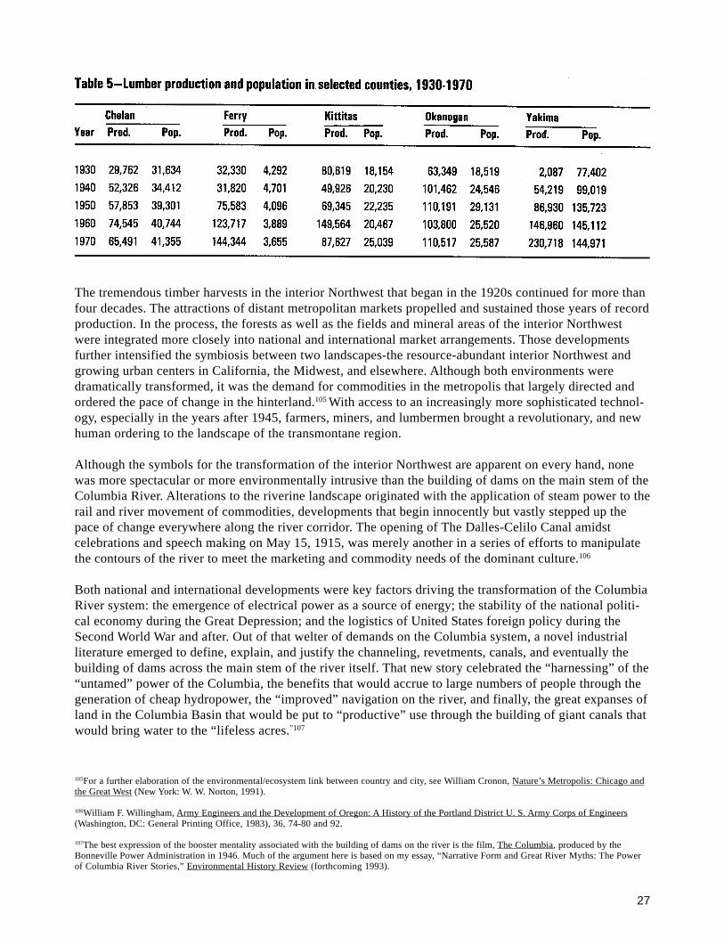
27
The tremendous timber harvests in the interior Northwest that began in the 1920s continued for more thanfour decades. The attractions of distant metropolitan markets propelled and sustained those years of recordproduction. In the process, the forests as well as the fields and mineral areas of the interior Northwestwere integrated more closely into national and international market arrangements. Those developmentsfurther intensified the symbiosis between two landscapes-the resource-abundant interior Northwest andgrowing urban centers in California, the Midwest, and elsewhere. Although both environments weredramatically transformed, it was the demand for commodities in the metropolis that largely directed andordered the pace of change in the hinterland.105 With access to an increasingly more sophisticated technol-ogy, especially in the years after 1945, farmers, miners, and lumbermen brought a revolutionary, and newhuman ordering to the landscape of the transmontane region.
Although the symbols for the transformation of the interior Northwest are apparent on every hand, nonewas more spectacular or more environmentally intrusive than the building of dams on the main stem of theColumbia River. Alterations to the riverine landscape originated with the application of steam power to therail and river movement of commodities, developments that begin innocently but vastly stepped up thepace of change everywhere along the river corridor. The opening of The Dalles-Celilo Canal amidstcelebrations and speech making on May 15, 1915, was merely another in a series of efforts to manipulatethe contours of the river to meet the marketing and commodity needs of the dominant culture.106
Both national and international developments were key factors driving the transformation of the ColumbiaRiver system: the emergence of electrical power as a source of energy; the stability of the national politi-cal economy during the Great Depression; and the logistics of United States foreign policy during theSecond World War and after. Out of that welter of demands on the Columbia system, a novel industrialliterature emerged to define, explain, and justify the channeling, revetments, canals, and eventually thebuilding of dams across the main stem of the river itself. That new story celebrated the “harnessing” of the“untamed” power of the Columbia, the benefits that would accrue to large numbers of people through thegeneration of cheap hydropower, the “improved” navigation on the river, and finally, the great expanses ofland in the Columbia Basin that would be put to “productive” use through the building of giant canals thatwould bring water to the “lifeless acres.”107
105For a further elaboration of the environmental/ecosystem link between country and city, see William Cronon, Nature’s Metropolis: Chicago andthe Great West (New York: W. W. Norton, 1991).
106William F. Willingham, Army Engineers and the Development of Oregon: A History of the Portland District U. S. Army Corps of Engineers(Washington, DC: General Printing Office, 1983), 36, 74-80 and 92.
107The best expression of the booster mentality associated with the building of dams on the river is the film, The Columbia, produced by theBonneville Power Administration in 1946. Much of the argument here is based on my essay, “Narrative Form and Great River Myths: The Powerof Columbia River Stories,” Environmental History Review (forthcoming 1993).
28
From the time of the great New Deal public works programs of the 1930s until the salmon crisis of recentyears, much of the public has viewed that definition of the “working river” in a positive light. The applica-tion of engineering skill and scientific expertise, the promoters argued, heralded a bright new future inwhich the contours of the land would be enhanced to benefit humankind. Journalists like RichardNeuberger singled out for heroic effort the construction workers who braved the heights of Grand CouleeDam to expand opportunity in “the last great frontier of this country.” The giant Federal projects on theriver, Neuberger claimed, would transform an area that supported “desert weeds and bushes, coyotes andrattlesnakes and prairie dogs” into a land of poplar trees, corn fields, farmhouses, and small communi-ties.108
For Richard Neuberger and others of his age, the natural world of the free-flowing Columbia River had tobe put to productive economic use to serve the larger social good. The popular Oregon journalist, statelegislator, and United States senator was an exemplary spokesperson for his time and place, expressingattitudes and values that eventually became articulated into public policy. The result was a sustainedperiod of construction on the river and its major arterials that lasted for more than 30 years, activities thattransformed the landscape of the Great River of the West, remaking it into a managed, regulated, andhighly productive waterway for its industrial users. The environmental writer, Marc Reisner, calls it “themost fateful transformation that has ever been visited on any landscape, anywhere.”109
The literature on the building of Columbia River dams is but part of a larger body of writing that extolledthe efficacy and civic duty to intervene in the natural world for human betterment. And for doubters whoraised questions about consequences or environmental effects, the experts assured that technical solutionswere at hand. If the dams blocked anadromous fish from spawning grounds, then downstream hatcherieswould solve the problem. If the rate of timber harvesting appeared to exceed what were deemed sustain-able rates, then hybrid seedlings, eliminating vegetative competition, keeping fire from the forest-or whatwas termed “intensified forest management”-would enable both sustainable forestry and an increasedvolume of harvesting. Whether it be the Columbia River, the rich wheat-growing country in the Palouse,or timber stands on the National Forests, engineering and science were widely believed the solution to theseeming contradiction between increased productivity and sustainability. For several decades after theSecond World War, few voices were raised in objection to that article of faith.
But in an age where environmental limits are more widely recognized, scientists, policy makers, andothers are beginning to understand that streams, forests, and soils do not have an unlimited capacity forincreased yield. Awareness is growing that the industrial world has wrought spectacular transformations toecosystems, some of which people are only beginning to grasp. And it is increasingly apparent that thevery symbol of industrial production, the machine, has been an intrusive force both in the natural worldand in our economic life. Evidence abounds on every hand of the environmental and economic influenceof technology in the fishing industry and in the harvesting of grain crops, as well as in the woods. Al-though mechanization has been a blessing in alleviating much of the drudgery associated with labor, andincreased production has improved the quality of life for many people, it has come with a price.
With the exception of the fur trade, the full force of the market revolution in the Pacific Northwestcoincided with the advent of the industrial era. As such, the region’s experiences with human-craftedmachines provide fertile ground for studying the environmental consequences of industrial practices. That
108Richard Neuberger, Our Promised Land (1938; Moscow, Idaho: University of Idaho Press, 1989), 353-357.
109Marc Reisner, Cadillac Desert: The American West and its Disappearing Water (New York: Viking Penguin, 1986), 166 and 172. ForNeuberger’s enthusiasm for engineering works on the Columbia River, see Paul C. Pitzer, “Visions, Plans, and Realities: A History of theColumbia Basin Project” (Ph.D. dissertation, University of Oregon, 1990).
29
is especially true for the most important historical industrial undertaking in the Northwest, the logging andmilling of timber. Although the machine was an important component in logging operations as early as1900, it moved into the woods with gusto during the 1930s when operators were switching from steam tothe infinitely more mobile gasoline-powered engines. Although steam power was a highly efficient way totransport logs, it was also labor intensive, requiring large crews to fuel the steam boilers on the yardingmachines and other equipment.110 In contrast, the introduction of gasoline-driven yarding machines, thedevelopment of the caterpillar tractor, and the adoption of the log truck vastly increased the ability tomove a huge volume of timber. Those devices also narrowed the technological gap between logging andsawmilling operations. Finally, the widespread use of the chain saw by 1950 served as the capstone to atechnological environment that was far removed from the days of bull teams, steam-powered donkeyengines, and logging railroads. The production statistics speak for themselves.
An environmental side to that equation is obvious. Logging with bull-teams and horses was relativelybenign to forest environments east and west of the Cascade Range. But the introduction of the steamdonkey, first developed in the redwood and Douglas-fir country and quickly adapted to pine logging,greatly increased human-induced disturbance to eastside forest environments. In fact, because of the easierterrain, pine loggers may have more readily adopted mechanized equipment. The coming of the machine tothe woods of the interior Northwest, therefore, had both economic and ecological dimensions: it speededthe rate of timber harvesting and led to the rapid growth of communities; and it contained the seeds ofsocial dislocation and environmental disruption when the timber was gone. It should also be rememberedthat logging practices on the private timberlands of Oregon and Washington had no restraints until theSecond World War (and then they were minimal and usually went unenforced).
To accommodate the use of the practical and cost-effective steam and gasoline-powered machines, loggersand foresters developed new harvesting procedures-clearcutting the entire area within reach of the yardingmachine’s system of cables. Cutting practices, in effect, were adapted to technology. Indeed, a good casecan be made that the machine and the markets that made its use profitable became the chief determinant inreshaping the forest environment. Science, insofar as it was used to answer to the needs of the machine,became an ally of production and capital markets.111
The new postwar marketing conditions, which were unlike anything the industry had ever experienced,helped spur further technological innovation. Whereas the lumberman’s chief complaint before the SecondWorld War was overproduction-the dumping of too much timber on a saturated market-by the close of the1940s producers were struggling mightily to keep pace with demand. Those new marketing arrangementsplaced a premium on the most modern and productive forms of technology. The consequences wereextensive alterations to forest landscapes everywhere, and widespread and unprecedented increases indisturbances to forest ecosystems. By 1950, most scientists and public officials were treating the forest asa thoroughly commodified part of nature. The complex and extensive ecosystems of plant life, animals,and microorganisms were simplified to quantifiable board-feet measurements to satisfy the needs of thehour.
Nothing is new in the commodity calculus attached to natural resources; viewing forests, rivers, grass-lands, and mineral-rich mountain slopes for their commodity value has a long and hallowed tradition inAmerican history. To be sure, treating complex ecosystems as goods to be modified at will or brokered inthe marketplace has contributed to problems with our rivers and woodlands, but there is much more tothe story. Since the coming of Euro-Americans to the Pacific Northwest, the dominant culture has playedout a production-driven end game based on the assumption that more fish could be pumped from the
110For a discussion of the reduction in the labor force during the latter 1940s, see Robbins, Hard Times in Paradise, 130-131.
111For a more detailed discussion of this argument, see the author’s essay, “The ‘Luxuriant Landscape’: The Great Douglas Fir Bioregion,” OregonHumanities (Winter 1990), 2-7.

30
river, more kilowatt hours of electricity could be generated from dams, and more board feet of timber couldbe grown in the forests if only rational engineering and scientific approaches were brought to the task.
Today, mounting evidence tells us that something has gone amiss, that we cannot have unlimited hydropowerproduction and fish too, that we cannot endlessly manipulate forest ecosystems to produce more wood fiber.The best of the present work in the ecological sciences, much of it carried on in the region’s land-grantcolleges and in range and forest research stations, is based on a sound reckoning with the environmentalchanges that have occurred in the last century. Scientists are beginning to understand the wisdom of foresterEdward I. Kotok, who cautioned nearly 50 years ago that too much emphasis was being placed on the endproduct rather than on “the maintenance or creation of a healthy, well-balanced biological complex that byits nature is conducive to favorable vegetative growth, water relations, and the support of animal life.”112
In terms of places long occupied by humans, the landscape of the Pacific Northwest is a short-lived enter-prise, say 20,000 years as a median benchmark. As a place dominated by Euro-Americans, the time framenarrows to roughly 150 years; for the intermontane Northwest, a century. East of the Cascade Range-as in themore westerly country-complex ecosystems have been drastically modified and simplified. In the aridcountry of the Inland Empire, cheatgrass and other annual bromegrasses have replaced bluebunch wheatgrasson land used exclusively for grazing. Elsewhere on the plateaus and gentle slopes of the Palouse, a monocul-ture crop, wheat, has replaced everything else. And in the Blue Mountains to the south, true fir andDouglas-fir have replaced some of the area once covered by great stands of ponderosa pine.113
With the exception of drought, windstorm, and lightening-caused fires, the spectacular changes to thelandscape of the interior Northwest during the last century have been human-induced. The striking historicalfeature of this story is the abbreviated number of years in which those alterations have taken place, espe-cially the accelerating rate of modification during the last few decades. As public citizens, we all have muchto learn about the history of that complex ecological and economic web that is part of our daily lives.
112Kotok, “The Ecological Approach to Conservation Programs,” 471.
113Buechner, “Some Biotic Changes in the State of Washington,” 169; Boyd E. Wickman, Forest Health in the Blue Mountains: The Influence ofInsects and Disease, USDA Forest Service, PNW Research Station, General Technical Report, PNW-GTR-295 (March 1992), 2; and BlueMountains Natural Resources Institute Annual Report, USDA Forest Service, PNW Region (October 1, 1991 - September 30, 1992), 3.

31
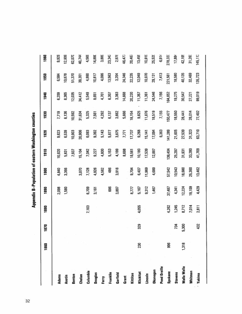
32
33
Robbins, William G.; Wolf, Donald W. 1994. Landscape and the intermontanenorthwest: an environmental history. Gen. Tech. Rep. PNW-GTR-319. Portland,OR: U.S. Department of Agriculture, Forest Service, Pacific Northwest ResearchStation. 32 p. (Everett, Richard L., assessment team leader; Eastside forestecosystem health assessment; Hessburg, Paul F., science team leader and tech.ed., Volume III: assessment.)
Traces the natural and cultural processes involved in shaping the environment in theintermontane northwest from the Indian period of domination to the present. Empha-sizes increasing influence of humans as modifiers of landscapes and ecosystems,especially with the coming of the market system to the region and the onset of theindustrial era. Focuses on the unique aspects of ecological change in the intermont-ane region: the very recent extension of the market system to the area; and the veryrapid expansion of human-induced environmental disturbance over extensive areas ina very brief span of time.
Keywords: Environment, modification, market systems, cultural stability, fire, horse,reconnaissance surveys, railroads, Euro-Americans, Native Americans, timber,sawmills, grazing.
The Forest Service of the U.S. Department ofAgriculture is dedicated to the principal of multipleuse management of the Nation’s forest resourcesfor sustained yields of wood, water, forage, wildlife,and recreation. Through forestry research, coopera-tion with the States and private forest owners, andmanagement of the National Forests and NationalGrasslands, it strives-as directed by Congress toprovide increasingly greater service to a growingNation.
The U.S. Department of Agriculture is an EqualOpportunity Employer. Applicants for all Departmentprograms will be given equal consideration withoutregard to age, race, color, sex, religion, or nationalorigin.
Pacific Northwest Research Station333 S.W. First AvenueP.O. Box 3890Portland, Oregon 97208-3890

34
U.S. Department of AfriculturePacific Northwest Research Station333 S.W. First AvenueP.O. Box 3890Portland, OR 97208
Official BusinessPenalty for Private Use, $300
do NOT detach label