abdel-moniem el-shorbagy - unplanned settlements in saudi
TRANSCRIPT

Unplanned Settlements in Saudi Arabia.
The Case of Al-Sabeel District, Jeddah
Abdel-Moniem EL-SHORBAGY*1 * Corresponding author
1 Effat University, College of Architecture and Design, Jeddah, SAUDI ARABIA
E-mail: [email protected]
DOI: 10.24193/JSSP.2020.2.03 https://doi.org/10.24193/JSSP.2020.2.03
K e y w o r d s: Al-Sabeel district, Jeddah, unplanned settlements, infrastructure, community participation
A B S T R A C T
1. INTRODUCTION
Unplanned settlements, slums, and informal
settlements have varying interpretations and meanings
based on the socioeconomic, political, and mainly
historical circumstances. The United Nations has
defined slums as overcrowded residential areas,
characterized by dilapidated housing and lack of
essential services such as drinking water and sanitation
(UNESCAP, 2015).
From a broader perspective, unplanned
settlements are built areas not authorized by the
government and illegally settled, while slums denote
substandard dwellings in terms of services and
infrastructure, building materials, and method of
construction (UN-Habitat, 2015). They have also been
categorized as “the most deprived form” of settlements,
which may not necessarily be illegal (Drakakis-Smith,
1981). Thus, an unplanned settlement specific definition
depends on its scale and existing urban context and it is
not necessarily to be categorized as a slum, while its
residents might not be poor (Minnery et al., 2013).
However, it was estimated that approximately one
billion persons are living in slums worldwide, and this
number is expected to double by 2030 (UN-Habitat,
2016). Out of one billion persons, about 881 million are
living in slums in developing countries. The highest
number is recorded in Asia followed by Africa and Latin
America and the Caribbean. In 2015, it was estimated
that approximately 25% of the world’s urban population
continued to make their home in an urban slum (UN-
Habitat, 2015).
Centre for Research on Settlements and Urbanism
Journal of Settlements and Spatial Planning
J o u r n a l h o m e p a g e: http://jssp.reviste.ubbcluj.ro
Unplanned settlements represent a twentieth-century phenomenon that has been steadily growing on the periphery of almost all cities
in the world. These areas are usually overpopulated and characterized by inadequate housing, unpleasant living conditions. Jeddah, a
second major city in Saudi Arabia, consists of many unplanned settlements and slums, which affect the future development of its urban
and social fabric. This paper intends to explore some essential issues relating to the issues of unplanned settlements in Jeddah through
the study, analysis, and assessment of the built environment of Al-Sabeel district, one of the oldest districts in Jeddah. The main
objective of this research is to investigate the major physical problems of the deteriorated areas of the district. Thus, the primary
purpose is to define a set of recommendations for the upgrading of future unplanned settlements, which will help these informal areas
to improve and gradually integrate into the existing urban fabric of the city. Regarding methodology, a qualitative research approach
was adopted, which included a literature review, a face-to-face interviews, and field visits to document the physical condition of the
built environment of the district. The outcome of the study represents a set of recommendations that indicate the importance of
community participation approach as a means of improving the physical condition of the urban environment of Al-Sabeel district.

Abdel-Moniem EL-SHORBAGY
Journal of Settlements and Spatial Planning, vol. 11, no. 2 (2020) 81-94
82
Urbanization represents one of the most
critical transformative drivers of the 21st century.
Around 54% of the world’s population is living in urban
cities and it was estimated that, by 2050, approximately
70% of the world’s population would be living in urban
areas (World Cities Report, 2016). Urbanized cities are
characterized by unprecedented population growth
accompanied by economic change, social and cultural
activities, and appropriate livability. However, the
nature of urbanization creates several planning
challenges, including the provision of sufficient housing
and services, health, education, and infrastructure.
Thus, the adoption of a New Urban Agenda to achieve
world sustainable urbanization for the next twenty
years was the primary outcome of the United Nations
Conference on Housing and Sustainable Urban
Development (Habitat III) in Quito, Ecuador in 2016.
This agenda represents a shared vision for a better and
more sustainable future, and if well managed,
urbanization could be a common and useful tool for
sustainable development for both developing and
developed countries. In this context, sustainable
urbanization and cities are seemingly weaved together
to achieve socioeconomic, cultural, and environmental
goals (UN-Habitat 3, 2015).
Joan Clos, Under-Secretary-General of the
United Nations, believes that if urbanization is not
structured, it will adversely affect the future of cities in
the developing countries. He argues that this form of
urbanization could be the driver behind the formation
of slums and unplanned settlements, which represent
the most affordable housing solutions to one-third of
the global urban population today. Clos also discusses
that this type of unplanned urbanization would obstruct
cities from implementing their agenda in economic
development and social prosperity (UN-Habitat, 2012).
Thus, the growing phenomena of setting up informal
settlements could be perceived as the logical
consequences of urbanization, which allows their
residents for housing, services, and infrastructure
(Minnery et al., 2013). However, many international
policy approaches addressed the problem of these
unplanned settlements by suggesting the strategy of
demolition and replacement. The demolition approach
is perhaps not the appropriate solution because it
creates more problems than it solves. For example, it
would disturb the life of inhabitants, who represent an
essential factor of the urban economy and contribute to
the economic growth of their cities (UN-Habitat, 2003).
Another essential strategy is the slum
upgrading approach that has been adopted by many
countries worldwide as a critical component of their
urban planning programs. They invest in upgrading
both the buildings’ physical condition and
infrastructure systems such as electricity, water,
sanitation, and sewage. Also, the upgrading approach
concurrently develops the road network and solves the
problems of block accessibility. One of the significant
examples of slum upgrading is Zwelisha, a newly
upgraded settlement north of Durban, South Africa. The
outcome of the upgrade process in Zwelisha was
successful due to the imperative role of the community,
who participated in achieving a remarkable
improvement to tenure security and wellbeing (Patel,
2013). Another pioneering upgrading program was
carried out by Surabaya city in Indonesia. In 1969, the
city initiated the Kampung Improvement Program
(KIP), which became a model for slum upgrading
nationally and internationally. The main goal of the KIP
was to put the residents of the Kampung slum at the
heart of the upgrading development, provide them with
the necessary services and infrastructure, and offering
livelihood opportunities. This program became one of
the significant examples of successful slum upgrading
in the world (Das A., King, R., 2019).
The upgrading approach has also been
adopted by some Arab countries such as Egypt, Tunisia,
and Morocco. In 2008, Egypt issued the Unified
Building Law, which deals with issues far wider than
urban structures and their locations. It aims not only to
reorganize the approach to strategic urban planning but
also to create future visions for Egyptian cities. The
Unified Building Law emphasizes that informal areas
will not be demolished; they will be considered as part
of the urban fabric of the city, and they will be provided
with statutory benefits of facilities and investments to
cope with the planned and serviced areas of the city.
Representative examples that employed the strategy of
upgrading approach also include Manshiet Nasser and
Ezbet el Haggana, the largest long-standing informal
areas in Cairo (UN-HABITAT, 2011). Over the last few
decades, Saudi Arabia has faced many challenges
because of the enormous population growth of
unplanned settlements, particularly in major cities such
as Jeddah and Riyadh. Saudi Arabia is one of the largest
countries in the Arab world, which encompasses an area
of approximately 2,149,690 km2 and a population of
approximately 34,490,879 inhabitants (total number of
population of Saudi is of 20,768,627). However, the
density is of approximately 15.5 persons/sq km. Jeddah
is a large city with an area of approximately 5460 km².
It is the second-most populous city in the kingdom,
with a population estimated around 4,076,000 as of
2017, which is almost 12% of the total population of
Saudi Arabia (World Population Review, n.d.).
Jeddah is the home to the largest port on the
Red Sea, which represents the main gateway to the two
holy cities of Makkah and Madinah. The analysis of the
city of Jeddah has shown significant problems of the
urban structure, including the isolation of the historic
area from the rest of the city, moving the center of
urban structure to the north of the city, the excessive
imbalance between urban growth and sprawl, and, most
importantly, the spatial segregation of the unplanned
settlements, which in some cases turned into urban
slums (Karimia, 2012). Although Jeddah is currently
Unplanned Settlements in Saudi Arabia. The Case of Al-Sabeel District, Jeddah
Journal of Settlements and Spatial Planning, vol. 11, no. 2 (2020) 81-94
83
enjoying unprecedented growth and is undergoing
massive urban development, it faces substantial urban
challenges. The significant expansion of the
uncontrolled and unplanned settlements in the last
century has created complicated problems that affected
the urban fabric and infrastructure of the city (UNICEF,
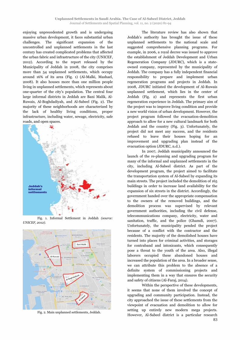
2012). According to the report released by the
Municipality of Jeddah in 2008, the city comprises
more than 54 unplanned settlements, which occupy
around 16% of its area (Fig. 1) (Al-Malki, Mashael,
2008). It also houses more than one million people
living in unplanned settlements, which represents about
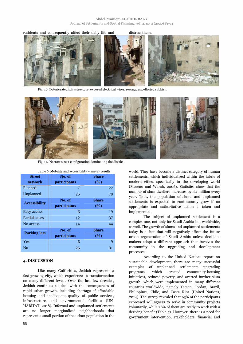
one-quarter of the city’s population. The central four
large informal districts in Jeddah are Bani Malik, Al-
Ruwais, Al-Boghdadiyah, and Al-Sabeel (Fig. 2). The
majority of these neighborhoods are characterized by
the lack of healthy living conditions, proper
infrastructure, including water, sewage, electricity, safe
roads, and open spaces.
Fig. 1. Informal Settlement in Jeddah (source:
UNICEF, 2012).
Fig. 2. Main unplanned settlements, Jeddah.
The literature review has also shown that
Jeddah’s authority has brought the issue of these
unplanned settlements to the national scale and
suggested comprehensive planning programs. For
example, in 2006, a royal decree was issued to approve
the establishment of Jeddah Development and Urban
Regeneration Company (JDURC), which is a state-
owned company, represented by the municipality of
Jeddah. The company has a fully independent financial
responsibility to prepare and implement urban
regeneration programs and projects in Jeddah. In
2008, JDURC initiated the development of Al-Ruwais
unplanned settlement, which lies in the center of
Jeddah (Fig. 2) and represents the first urban
regeneration experience in Jeddah. The primary aim of
the project was to improve living condition and provide
a new world vision of urban development. However, the
project program followed the evacuation-demolition
approach to allow for a new cultural landmark for both
Jeddah and the country (Fig. 3). Unfortunately, the
project did not meet any success, and the residents
refused to leave their houses hoping for an
improvement and upgrading plan instead of the
evacuation option (JDURC, n.d.).
In 2007, Jeddah municipality announced the
launch of the re-planning and upgrading program for
many of the informal and unplanned settlements in the
city, including Al-Sabeel district. As part of the
development program, the project aimed to facilitate
the transportation system of Al-Sabeel by expanding its
main streets. The project included the demolition of 165
buildings in order to increase land availability for the
expansion of six streets in the district. Accordingly, the
government handed over the appropriate compensation
to the owners of the removed buildings, and the
demolition process was supervised by relevant
government authorities, including the civil defense,
telecommunications company, electricity, water and
sanitation, traffic, and the police (Ghamdi, 2007).
Unfortunately, the municipality pended the project
because of a conflict with the contractor and the
residents. The majority of the demolished houses have
turned into places for criminal activities, and storages
for contraband and intoxicants, which consequently
pose a threat to the youth of the area. Also, illegal
laborers occupied these abandoned houses and
increased the population of the area. In a broader sense,
we can attribute this problem to the absence of a
definite system of commissioning projects and
implementing them in a way that ensures the security
and safety of citizens (Al-Faraj, 2014).
Within the perspective of these developments,
it seems that none of them involved the concept of
upgrading and community participation. Instead, the
city approached the issue of these settlements from the
viewpoint of evacuation and demolition to allow for
setting up entirely new modern mega projects.
However, Al-Sabeel district is a particular research

Abdel-Moniem EL-SHORBAGY
Journal of Settlements and Spatial Planning, vol. 11, no. 2 (2020) 81-94
84
topic because of its unique location in Jeddah city
center. It represents a reliable tool for gaining a more
in-depth insight into the complex urban phenomenon
of unplanned settlements in Jeddah. Al-Sabeel district
also allows for the opportunity to explore their changing
physical characteristics and their consequences on the
urban structure of the city. Although Al-Sabeel faces
many different interrelated problems including, socio-
economic, environmental, poverty, poor planning,
safety and violence, health, and wellbeing, this research
will focus on the physical condition of the district’s built
environment. The main objective of this research is to
identify the essential issues related to the issue of
unplanned settlements in Jeddah through the study,
analysis, and assessment of the built environment of Al-
Sabeel, namely building conditions, streets network,
and infrastructure problems. The primary purpose of
this study is to define a set of recommendations for
upgrading the physical condition of Al-Sabeel district
and future unplanned settlements in Saudi Arabia.
Fig. 3. New proposal for Al-Ruwais unplanned settlement (the evacuation-demolition approach) (source: JDURC, n.d.).
2. METHODOLOGY OF THE STUDY
This research represents a preliminary study
aiming to identify the physical condition of the built
environment in Al-Sabeel district. The study adopted a
qualitative research methodology based on an in-depth
understanding of the physical built environment of the
district provided by the rich experience of residents and
their own social situations. Also, the qualitative
research relies heavily on purposive sampling strategy,
which refers to the deliberate selection of specific
settings from which researchers can learn extensively
about the issues under examination (Carpenter, C. M.,
Suto, M., 2008). This methodology can provide
essential information about the physical condition of
the existing buildings in Al-Sabeel District. The
research methodology consisted in three phases; an
extensive literature review, a face-to-face interview with
the residents of the area, and field visits to document
and analyze the physical condition of the existing
buildings in a specific study-zone.
a). The study began with collecting the
appropriate literature review data and the available
information that relates to the research topic and sheds
light on the general context of slum problems and
upgrading programs.
b). The study also consisted in carrying out
some 32 face-to-face interviews with the district’s
residents to identify the challenges they face. The
interviewees responded to a pre-prepared questionnaire
survey that was structured on four main aspects,
namely general information, building physical
condition, infrastructure problems, and mobility and
accessibility difficulties (Appendix A). The main
intention of the questionnaire was to explore the
residents’ daily problems, as well as their personal
opinions about the physical environment of their
district. The research employed the survey interviews as
the method of data collection. Data was further
analyzed and interpreted to draw recommendations and
conclusions. Although the number of interviewees was
relatively small, it managed to reflect the actual context
and image of the area and enriched us with a realistic
response to the residents’ living conditions.
c). The last phase included the selection of a
small sample study-zone, which was systematically and
thoroughly investigated (Fig. 4). The field study was
conducted on foot by the author and took place from 22

Unplanned Settlements in Saudi Arabia. The Case of Al-Sabeel District, Jeddah
Journal of Settlements and Spatial Planning, vol. 11, no. 2 (2020) 81-94
85
December 2019 to 7 January 2020. The primary
purpose of the field study was to develop an actual
image of the present situation in the area and collect as
much data as possible. The study-zone included 40
houses (Fig. 5), for which the author mapped their
physical condition, recorded their heights and
materials. Notes were also taken about the
infrastructure condition, such as water, sewage,
electricity, and the road network (Appendix B).
Fig. 4. Al-Sabeel district and the study area (source:
Google maps).
Fig. 5. Distribution of houses within the study area.
The outcome of the field study expresses both
the author’s observation of the physical conditions of
the district and the results of the analysis based on
residents’ responses to the questionnaire. Although the
site visits allowed for a useful observation of the
physical built environment, the residents provided the
most valuable insights into the lacking services,
facilities, and needs for better living conditions.
3. DESCRIPTIVE ANALYSIS OF THE EXISTING
URBAN CONTEXT
Jeddah has a significant rate of migration from
other regions in Saudi Arabia, which contributes to the
growth of the unplanned settlements. It seems that the
development of low-cost housing in Jeddah cannot
accommodate all migrants, and consequently, they find
a home in these informal residential areas. The
approximate population of Al-Sabeel District is 50625
inhabitants with a population density of
62019 people/sq km (Appendix C). Al-Sabeel has a
significant number of expatriates; the majority of them
are of African and Yemeni nationalities. They try to
create their living environment, as best adapted to their
economic capacity and cultural background, with hopes
for modernization and urban development (Arab News,
2015). The literature review, observation during site
visits, and the results of the interviews with the
residents highlighted numerous different problems and
critical issues that affect the living conditions in Al-
Sabeel district. However, overcrowding, dilapidated
buildings, small size dwellings, and inadequate streets
are the main features of the district. The majority of
streets are unnamed, including the main streets
connecting the district with the city’s road network.
There is also a clear shortage of facilities and services
such as schools and medical centres and a lack of open
spaces and green areas, as it is confirmed by 88% of the
survey participants (Table 1). In general, Al-Sabeel, as a
neighborhood, is not well-planned, unhealthy, and
ultimately unsafe.
Table 1. Responses of residents regarding the
existing services in Al-Sabeel District.
Schools, clinics, open spaces, and
green areas
No. of participants
Share (%)
Yes 2 6 No 28 88 Do not know 2 6
3.1. Site location and road network
Al-Sabeel lies in the southern region of Jeddah
and occupies about 816,273 sq m. The district is
bordered by four main roads, King Fahd Road in the
northwest, King Khaled road in the southeast, Old
Makkah road in the northeast, and the unnamed street-
1 in the southwest.
Fig. 6. Site location and the main streets in Al-Sabeel
District.
There are two main internal streets; unnamed
street-2 and unnamed street-3, which connect King
Khaled road and King Fahd road. Also, there is another
unnamed twisting street-4, which connects Old Makkah

Abdel-Moniem EL-SHORBAGY
Journal of Settlements and Spatial Planning, vol. 11, no. 2 (2020) 81-94
86
road and the unnamed street-1. Al-Sabeel is
characterized by crowded internal narrow streets and
high density of buildings, which in many cases obstruct
the access to the essential street network. However, the
road network of Al-Sabeel reflects a variety of street
types, which vary in width, length, and functions (Fig.
6). Thus, there is a critical need to address part of these
prevalent road network problems by innovative
approaches that provide solutions and identify new
opportunities.
3.2. Al-Sabeel land use
Al-Sabeel neighborhood comprises many
different land uses, including residential, commercial,
mixed commercial/residential, and public facilities and
utilities. According to residents and the observation of
the field study, residential buildings occupy most of the
land in the district, while commercial buildings,
storages, and industrial buildings hold only a small
share.
The field study also recorded significant
deficiencies regarding areas providing entertainment
and social life, along with the lack of roads, streets,
lanes, and parking lots.
3.3. Building conditions
The majority of the buildings in Al-Sabeel
district is mostly poor and tends to get worse. The
survey results show that 66% of the buildings are in
poor physical condition, and many of them are about to
collapse (Fig. 7).
Fig. 7. Examples of buildings with deteriorated physical condition.
Fig. 8. Buildings of different heights in Al-Sabeel District.
Fig. 9. Construction materials used for buildings in Al-Sabeel District.

Unplanned Settlements in Saudi Arabia. The Case of Al-Sabeel District, Jeddah
Journal of Settlements and Spatial Planning, vol. 11, no. 2 (2020) 81-94
87
Also about 28% of the buildings are in fair
condition but need renovation, while only 6% of them
are in good condition (Table 2).
This apparent contradiction among buildings
of various levels of quality creates an unpleasant and
disharmonious visual effect. The height varies as well
(Fig. 8), but the most of them are one and two storey
buildings representing 41% and 44% of the total
number, according to the responses of participants.
Three-storey buildings represent about 9%, while the
four-storey ones represent only 6% (Table 3).
Many of Al-Sabeel buildings have been built
illegally using many different construction materials
(Fig. 9). While 63% of the buildings are built with
cement blocks, for 28% of them reinforced concrete was
used. Other supporting building materials such as
stone, mud, and metal could be found and they were
found in about 9% of the cases (Table 4).
Table 2. Residents’ response regarding the physical
condition of their buildings.
Building condition
No. of participants
Share (%)
Poor 21 66
Fair 9 28
Good 2 6
Table 3. Building heights – results of the survey.
Number of floors
No. of participants
Share (%)
1 floor 13 41
2 floors 14 44
3 floors 3 9
4 floors 2 6
Table 4. Building materials – survey results.
Building material No. of
participants Share (%)
Reinforced concrete 9 28
Cement block 20 63
Brick 0 0
Wood 0 0
Metal 0 0
Others 3 9
3.4. Infrastructure and hygiene problems
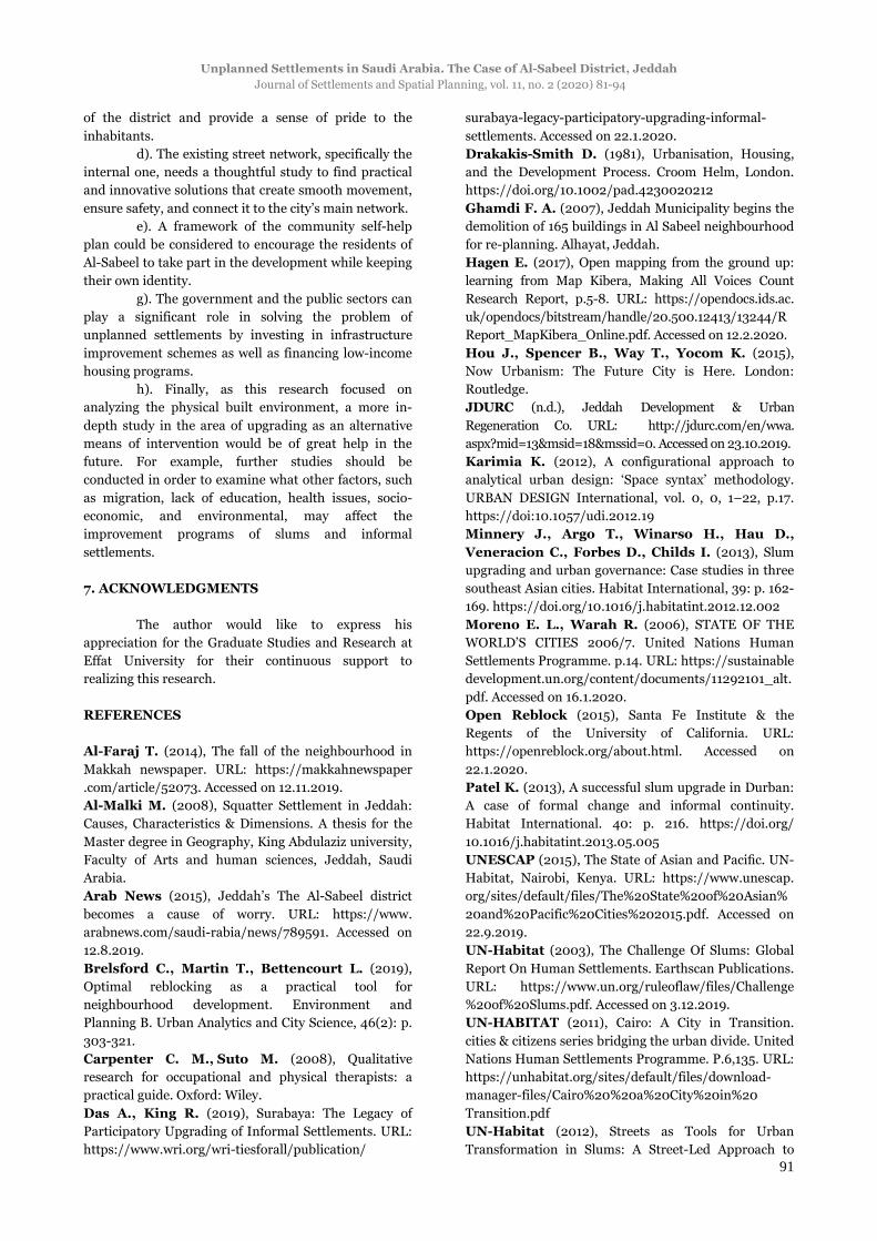
Al-Sabeel is characterized by extremely
deteriorated infrastructure and hygiene problems,
which are responsible for the creation of an unhealthy
and polluted environment for the residents (Fig. 10).
For example, 56% of the respondents declared that
many areas of the district are characterized by a bad
smell coming from the uncollected rubbish, which
exposes residents to health issues. Also, 53% of the
survey participants agreed that the exposed electrical
wires are common features of almost all buildings,
which causes fear of sudden fire or hazards causing
death. Furthermore, 69% of them believe that water
and sewage piping systems are improper, inadequate,
and affect the safety of their buildings. Residents
confirmed that many streets are flooded with sewage
water, which creates an unhealthy contaminated
environment (Table 5).
Table 5. The residents’ responses regarding the
existing infrastructure and hygiene condition.
Rubbish No. of
participants Share (%)
Collected 12 38
Uncollected 18 56
Burnt 2 6
Electrical wires No. of
participants Share (%)
Power box 6 19
Hidden in walls 9 28
Exposed outside the house 17 53
Water and sewage pipes No. of
participants Share (%)
Good 2 6
Fair 3 9
Deteriorated 22 69
Flooding streets 5 16
3.5. Mobility, accessibility, and open spaces
Street networks have always been an essential
tool that links and integrates the unplanned settlements
to the overall system of the city. Site visits to Al-Sabeel
district proved that there is a remarkable lack of public
transport services and other facilities to be used during
emergencies, such as fire, ambulance, and police
vehicles.
Examination of the road network (Fig. 4)
shows that the district is connected to the city main
road network through two internal streets, but the
many obstacles here do not allow easy access to these
internal streets from the other numerous narrow streets
and lanes (Fig. 11).
While 78% of the survey participants believe
that the district’s street network is unplanned in
general, 44% of them stated that their houses lack any
access to the main roads, and 37% have only partial
access to the streets from their blocks. Besides, 81% of
the interviewees confirmed that the district lacks
parking lots, and consequently, cars block the narrow
lanes for any emergencies (Table 6).
However, the absence of appropriately
connected streets and lack of parking areas creates
several problems that affect the mobility of the
Abdel-Moniem EL-SHORBAGY
Journal of Settlements and Spatial Planning, vol. 11, no. 2 (2020) 81-94
88
residents and consequently affect their daily life and distress them.
Fig. 10. Deteriorated infrastructure, exposed electrical wires, sewage, uncollected rubbish.
Fig. 11. Narrow street configuration dominating the district.
Table 6. Mobility and accessibility – survey results.
Street network
No. of participants
Share (%)
Planned 7 22
Unplanned 25 78
Accessibility No. of
participants Share (%)
Easy access 6 19
Partial access 12 37
No access 14 44
Parking lots No. of
participants Share (%)
Yes 6 9
No 26 81
4. DISCUSSION
Like many Gulf cities, Jeddah represents a
fast-growing city, which experiences a transformation
on many different levels. Over the last few decades,
Jeddah continues to deal with the consequences of
rapid urban growth, including shortage of affordable
housing and inadequate quality of public services,
infrastructure, and environmental facilities (UN-
HABITAT, 2018). Informal and unplanned settlements
are no longer marginalized neighborhoods that
represent a small portion of the urban population in the
world. They have become a distinct category of human
settlements, which individualized within the fabric of
modern cities, specifically in the developing world
(Moreno and Warah, 2006). Statistics show that the
number of slum dwellers increases by six million every
year. Thus, the population of slums and unplanned
settlements is expected to continuously grow if no
appropriate and authoritative action is taken and
implemented.
The subject of unplanned settlement is a
complex one, not only for Saudi Arabia but worldwide,
as well. The growth of slums and unplanned settlements
today is a fact that will negatively affect the future
urban regeneration of Saudi Arabia unless decision-
makers adopt a different approach that involves the
community in the upgrading and development
processes.
According to the United Nations report on
sustainable development, there are many successful
examples of unplanned settlements upgrading
programs, which created community-housing
initiatives, reduced poverty, and averted further slum
growth, which were implemented in many different
countries worldwide, namely Yemen, Jordan, Brazil,
Philippines, Chile, and Costa Rica (United Nations,
2014). The survey revealed that 63% of the participants
expressed willingness to serve in community projects
voluntarily, while 28% of them are ready to work with a
deriving benefit (Table 7). However, there is a need for
government intervention, stakeholders, financial and

Unplanned Settlements in Saudi Arabia. The Case of Al-Sabeel District, Jeddah
Journal of Settlements and Spatial Planning, vol. 11, no. 2 (2020) 81-94
89
political support, and experts to help in planning work
activities. Slum upgrading is not only about extensively
involving the residents in the development of their
district but also about growing the whole community’s
ability to sustain itself. Although the concept of
upgrading is not new, it holds promising results that
can help with the problems of Al-Sabeel’s built
environment.
Table 7. Future upgrading and self-help
participation – survey results.
Future upgrading projects
No. of participants
Share (%)
Yes 0 0
No 32 100
Community participation
No. of participants
Share (%)
Yes voluntarily 20 63
Yes with a deriving benefit
9 28
No 3 9
More broadly, this paper indicates that Al-
Sabeel settlement needs immense efforts to be
recognized and visible in the public sphere. Although
Jeddah municipality has made essential attempts to
improve Al-Sabeel’s built environment, the government
should also define a set of strategies that would
promote more social inclusion in the city. The central
core of this argument is to bring the upgrading concept
and community participation approach to the level of
corporate discourse, to be expansive and encompassing.
Officials should have the vision to explore the potential
of community to be able to provide them with the
appropriate solutions. Hou et al. (2015) believe that
unplanned settlements embrace the potential of
extraordinary design innovation, where scarcity and
adversity breed ingenuity and resilience, and where
nothing exists, everything is possible. Unplanned
settlements have the potential to provide better living
conditions, but they still face various challenging issues
that need revolutionary solutions so as to achieve a
better habitable environment for people. As cities are
moving towards becoming smart in the future, they can
also play a vital role in transforming these areas into
lively neighborhoods and integrate them into broader
urban development systems. Renovating these
settlements with street networks, green spaces, and
upgraded infrastructure would improve the physical
living conditions and quality of people’s lives, as well as
reducing the associated health risks. One of the
advanced solutions is to adopt the technological and
digital applications that can cause a notable change in
their future living conditions. The study showed that Al-
Sabeel district is dense with buildings, which in many
cases, block access to the essential streets network and
hinder residents’ movement. However, this problem
could be overcome through innovative approaches that
provide solutions and identify new opportunities, such
as Map Kibera. It is one of the earliest digital
technology and development projects expressing the
significant interplay between technology and local slum
communities. This project depends on trained young
people from the community to survey their
neighborhoods, and track roads using GPS devices, and
then editing the map online in a computer laboratory.
This technology has created the first open map of the
Kibera slum in Nairobi in 2009 (Hagen, 2017). Another
significantly advanced technology is the ‘open Reblock’
that creates a web-based platform to simplify the
process of improving slum living conditions. This
project intended to develop the existing street network
of slums with the least-disruptive processes to provide
access to their entire infrastructure (Open Reblock,
2015). The tool uses an algorithm to identify the best
and simple reorganization of a cluster of blocks so that
it can get access to the street. The ‘open Reblock’ was
used successfully in Epworth neighborhood of Harare,
in Zimbabwe, as well as in Khayelitsha, a township in
Cape Town, South Africa (Brelsford, 2019).
Although these innovative solutions, which
depend on smart applications, can play an essential role
in the implementation of Al-Sabeel’s upgrading road
network, they must not be imposed on the district, but
instead, they should be rooted in the urban context of
the area and serve the realities of residents’ living
conditions. However, the cornerstone of Al-Sabeel’s
upgrading process is its residents, who conveyed a
single overarching need, which is the improvement of
the physical environment that can produce a very
positive impact on their lives. The analysis shows that
the residents voiced their concerns to play a role in the
urban upgrading of their district. Thus, without
reducing the cultural distance between the
policymakers and members of Al-Sabeel’s residents,
there will be a lack of understanding of the essential
components of the upgrading processes. Therefore, the
authority in Jeddah needs to fully exploit the
community’s ability to contribute, to some extent, to the
implementation of any proposed upgrading project. The
standpoint of this discussion is that the engine of
change is the residents of Al-Sabeel, who should be
mobilized to help in the development process, and
without a strategy for long-term participation, no
project will be truly sustainable.
5. CONCLUSION
The authority in Jeddah has undertaken many
noteworthy steps towards the improvement of living
conditions in many of the unplanned settlements,
including Al-Sabeel, but they could not keep pace with
the rapid population growth in these areas. The growth
of these unplanned settlements could be attributed to

Abdel-Moniem EL-SHORBAGY
Journal of Settlements and Spatial Planning, vol. 11, no. 2 (2020) 81-94
90
the lack of sustainable housing policy in Jeddah. The
government has enough resources allocated to improve
and maintain the infrastructure and services, but they
have faced many problems and obstacles that delayed
the development of these areas. Meanwhile, several
organizations made efforts and investments to control
the growth of the unplanned areas, but without
consideration to a sustainable urban development
proposal to solve the problem. In this context,
government policies and strategies involving the
demolition of informal settlements and slums need to
be critically questioned. While the objectives of
unplanned settlements and slum upgrading of the city
of Jeddah can be understood as part of a broader ideal
urban development model, the lives of residents, who
are disadvantaged and already marginalized, remain
flawed. For example, what is reflected in Al-Ruwais
proposal (Fig. 3) is the shift towards modern, visually
attractive vertical housing instead of the existing local
urban patterns, which is based on the residents’ views
on their livelihoods. Thus, Jeddah’s authority needs to
understand the implications of the residents’ lives when
applying the replacement approach and to address and
consider their concerns.
Al-Sabeel’s unplanned settlement has its
individuality, and it indeed differs from other slums in
Jeddah. It represented a culture of deficiency and was
noticeable for its lack of civic amenities, which stood
out against the backdrop of the progressive character of
Jeddah city. The strength of a slum or unplanned
settlement lies in its physical infrastructure, including
street connectivity, access to improved sanitation,
tapped water, sewerage, and power supply. Therefore,
the city of Jeddah should adopt a broader challenge of
ensuring equity in the provision of these infrastructures
and services. In addition, the poor living condition in
Al-Sabeel’s deteriorating built environment affects the
health of people mentally and physically and can cause
diseases. Also, as these deteriorating areas remain
isolated from the rest of the urban society, they will
create serious social and deviant behavioral problems
such as crime, vandalism, drug abuse, alcoholism and
crime. However, Al-Sabeel settlement should not only
be studied in the context of its physical condition but
also the social dimension, which requires an
interdisciplinary approach, should be considered. There
is still a need for more in-depth investigations of the
social structure of the district, which is beyond the
scope of this paper. Thus, extensive research is needed
to help and support the government to find appropriate
solutions to this pressing problem.
In this regard, the importance of community
participation approach as a means of improving the
physical condition of the urban environment and
uplifting residents from a degrading quality of life is
recommendable. Hence, the authority and other
stakeholders should abandon the prevailing idea of
slum clearance, and the construction of a new housing
approach. Instead, they should determine what works
for such unplanned settlements and tailor a specific
development plan that would correspond to their
contextual situation. In addition, the urban authority
needs to develop innovative ideas to solve the district’s
problems and improve the physical environment.
Also, Al-Sabeel residents should not be seen
just as beneficiaries but as the primary stakeholders, as
well as the focal point of developing the physical built
environment. Finally, while the collected survey data
provide a considerable measure of the physical status of
the built environment of Al-Sabeel, it is often not
precise enough due to difficulties in identifying and
interviewing a more significant portion of the residents.
However, the survey’s results of this research may not
be necessarily generalized for all the informal
settlements of Saudi Arabia and hence requires the
inclusion of other representative case studies for slums
and unplanned settlements.
No doubt, improving living conditions in
unplanned settlements is a critical challenge that
Jeddah will face over the next few decades, and Al-
Sabeel settlement may remain vulnerable to being
designated for redevelopment and eviction by the
government.
6. RECOMMENDATION
The study covered the analysis of the physical
context of Al-Sabeel, which is an essential component of
what constitutes a healthy environment for the
community. The survey has brought essential issues
that affect the physical condition of the district and
have an impact on the welfare of the residents, such as
lack of properly connected street network, dilapidated
houses and deteriorated infrastructure. These problems
should be viewed within the context of finding
appropriate minimum intervention solutions, without
replacing or removing the entire district. The following
are some of the recommendations that could mitigate
the problems that residents face and provide valuable
insights towards the development and upgrading of
similar unplanned settlements.
a). Local authorities should be actively
involved in implementing infrastructure projects with a
vision of sustaining the wellbeing of the district’s
inhabitants.
b). Jeddah municipality should manage the
upgrading of Al-Sabeel district by consulting the
residents in the proposed renovation plans and
considering their sense of place and social network.
c). The government should consider the
demolition of the abandoned, dilapidated houses, which
evoke fear and a rapid decline in the health and welfare
of the community. The demolition of these houses
represents a potential opportunity to preserve the land
and establish new open green spaces or parking areas.
They will also help enhancing the environmental quality
Unplanned Settlements in Saudi Arabia. The Case of Al-Sabeel District, Jeddah
Journal of Settlements and Spatial Planning, vol. 11, no. 2 (2020) 81-94
91
of the district and provide a sense of pride to the
inhabitants.
d). The existing street network, specifically the
internal one, needs a thoughtful study to find practical
and innovative solutions that create smooth movement,
ensure safety, and connect it to the city’s main network.
e). A framework of the community self-help
plan could be considered to encourage the residents of
Al-Sabeel to take part in the development while keeping
their own identity.
g). The government and the public sectors can
play a significant role in solving the problem of
unplanned settlements by investing in infrastructure
improvement schemes as well as financing low-income
housing programs.
h). Finally, as this research focused on
analyzing the physical built environment, a more in-
depth study in the area of upgrading as an alternative
means of intervention would be of great help in the
future. For example, further studies should be
conducted in order to examine what other factors, such
as migration, lack of education, health issues, socio-
economic, and environmental, may affect the
improvement programs of slums and informal
settlements.
7. ACKNOWLEDGMENTS
The author would like to express his
appreciation for the Graduate Studies and Research at
Effat University for their continuous support to
realizing this research.
REFERENCES
Al-Faraj T. (2014), The fall of the neighbourhood in
Makkah newspaper. URL: https://makkahnewspaper
.com/article/52073. Accessed on 12.11.2019.
Al-Malki M. (2008), Squatter Settlement in Jeddah:
Causes, Characteristics & Dimensions. A thesis for the
Master degree in Geography, King Abdulaziz university,
Faculty of Arts and human sciences, Jeddah, Saudi
Arabia.
Arab News (2015), Jeddah’s The Al-Sabeel district
becomes a cause of worry. URL: https://www.
arabnews.com/saudi-rabia/news/789591. Accessed on
12.8.2019.
Brelsford C., Martin T., Bettencourt L. (2019),
Optimal reblocking as a practical tool for
neighbourhood development. Environment and
Planning B. Urban Analytics and City Science, 46(2): p.
303-321.
Carpenter C. M., Suto M. (2008), Qualitative
research for occupational and physical therapists: a
practical guide. Oxford: Wiley.
Das A., King R. (2019), Surabaya: The Legacy of
Participatory Upgrading of Informal Settlements. URL:
https://www.wri.org/wri-tiesforall/publication/
surabaya-legacy-participatory-upgrading-informal-
settlements. Accessed on 22.1.2020.
Drakakis-Smith D. (1981), Urbanisation, Housing,
and the Development Process. Croom Helm, London.
https://doi.org/10.1002/pad.4230020212
Ghamdi F. A. (2007), Jeddah Municipality begins the
demolition of 165 buildings in Al Sabeel neighbourhood
for re-planning. Alhayat, Jeddah.
Hagen E. (2017), Open mapping from the ground up:
learning from Map Kibera, Making All Voices Count
Research Report, p.5-8. URL: https://opendocs.ids.ac.
uk/opendocs/bitstream/handle/20.500.12413/13244/R
Report_MapKibera_Online.pdf. Accessed on 12.2.2020.
Hou J., Spencer B., Way T., Yocom K. (2015),
Now Urbanism: The Future City is Here. London:
Routledge.
JDURC (n.d.), Jeddah Development & Urban
Regeneration Co. URL: http://jdurc.com/en/wwa.
aspx?mid=13&msid=18&mssid=0. Accessed on 23.10.2019.
Karimia K. (2012), A configurational approach to
analytical urban design: ‘Space syntax’ methodology.
URBAN DESIGN International, vol. 0, 0, 1–22, p.17.
https://doi:10.1057/udi.2012.19
Minnery J., Argo T., Winarso H., Hau D.,
Veneracion C., Forbes D., Childs I. (2013), Slum
upgrading and urban governance: Case studies in three
southeast Asian cities. Habitat International, 39: p. 162-
169. https://doi.org/10.1016/j.habitatint.2012.12.002
Moreno E. L., Warah R. (2006), STATE OF THE
WORLD’S CITIES 2006/7. United Nations Human
Settlements Programme. p.14. URL: https://sustainable
development.un.org/content/documents/11292101_alt.
pdf. Accessed on 16.1.2020.
Open Reblock (2015), Santa Fe Institute & the
Regents of the University of California. URL:
https://openreblock.org/about.html. Accessed on
22.1.2020.
Patel K. (2013), A successful slum upgrade in Durban:
A case of formal change and informal continuity.
Habitat International. 40: p. 216. https://doi.org/
10.1016/j.habitatint.2013.05.005
UNESCAP (2015), The State of Asian and Pacific. UN-
Habitat, Nairobi, Kenya. URL: https://www.unescap.
org/sites/default/files/The%20State%20of%20Asian%
20and%20Pacific%20Cities%202015.pdf. Accessed on
22.9.2019.
UN-Habitat (2003), The Challenge Of Slums: Global
Report On Human Settlements. Earthscan Publications.
URL: https://www.un.org/ruleoflaw/files/Challenge
%20of%20Slums.pdf. Accessed on 3.12.2019.
UN-HABITAT (2011), Cairo: A City in Transition.
cities & citizens series bridging the urban divide. United
Nations Human Settlements Programme. P.6,135. URL:
https://unhabitat.org/sites/default/files/download-
manager-files/Cairo%20%20a%20City%20in%20
Transition.pdf
UN-Habitat (2012), Streets as Tools for Urban
Transformation in Slums: A Street-Led Approach to

Abdel-Moniem EL-SHORBAGY
Journal of Settlements and Spatial Planning, vol. 11, no. 2 (2020) 81-94
92
Citywide Slum Upgrading. United Nations Human
Settlements Programme: Nairobi. URL: https://www.
ohchr.org/Documents/Issues/Housing/InformalSettle
ments/UNHABITAT_StreetsasToolsforUrbanTransfor
mationinSlums.pdf. Accessed on 18.1.2020.
UN-Habitat (2015), Habitat III Issue Papers 22-
Informal Settlements. Nairobi, Kenya. URL:
https://unhabitat.org/wp-content/uploads/2015/04/
Habitat-III-Issue-Paper22_Informal-Settlements.pdf.
Accessed on 18.10.2019.
UN-Habitat 3 (2015), United Nations General
Assembly. New Urban Agenda. URL: http://habitat3.
org/the-newurban-agenda/. Accessed on 18.11.2019.
UN-Habitat (2016), Slum Almanac 2015/2016-
Tracking the Lives of Slum Dwellers. Nairobi, Kenya.
URL: https://unhabitat.org/wp-content/uploads/2016/
02-old/Slum%20Almanac%2020152016_EN.pdf.
Accessed on 25.10.2019.
UN-HABITAT (2018), Future Saudi Cities
Programme. Ministry of Municipal and rural Affairs.
p.4, 6, 19. URL: https://www.futuresaudicities.org/cpi-
reports/CPI%20Profile%20for%20Jeddah.pdf.
Accessed on 14.9.2019.
UNICEF (2012), Upgrading Informal Settlement in
Jeddah. THE STATE OF THE WORLD’S CHILDREN,
p.65. URL: https://www.unicef.org/sowc2012/pdfs/
SOWC-2012-Focus-On-Upgrading-informal-
settlements.pdf. Accessed on 22.8.2019.
United Nations (2014), Sustainable Development in
action: Human Settlements: Towards Sustainable
Communities. Department of Public Information. URL:
https://www.un.org/esa/sustdev/csd/csd12/backgroun
der_hs.pdf. Accessed on 14.10.2019.
World Cities Report (2016), Urbanization and
Development: Emerging Futures. UN-Habitat, Nairobi,
Africa. URL: https://unhabitat.org/wp-content/
uploads/2014/03/WCR-%20Full-Report-2016.pdf.
Accessed on 23.10.2019.
World Population Review (n.d.). URL: http://world
populationreview.com/countries/saudi-arabia-
population/. Accessed on 16.2.2020.
APPENDIX A. Urban Unplanned
Settlements in Saudi Arabia, Case Study: AL-
Sabeel District, Jeddah Questionnaire – Face-
to-face interview
This questionnaire intends to investigate the
physical condition and common problems of Al-Sabeel
district in Jeddah City. The questionnaire is divided
into four sections, including personal information,
building physical conditions, infrastructure problems,
and mobility and accessibility. The outcome of the
questionnaire will help to analyze and assess the built
environment of the district. All information mentioned
in this questionnaire will be strictly confidential.
A. General Information
1. Your name
2. Have the residents of the district been informed
about any future upgrading project?
Yes – No
3. What is the prevailing building type in the district?
4. Would you participate in a self-help community
project to improve the district’s physical condition?
Yes voluntarily – Yes with deriving benefit -
No
B. Building physical condition
1. What is the building material for your house?
Reinforced concrete – Cement block - Brick –
Wood – Metal - Others
2. How many floors in your house?
One floor – Two floors – Three floors – Four
floors
3. What is the physical condition of your house?
Poor – Faire – Good
C. Infrastructure and Hygiene problems
What is the status of the district’s infrastructure and
hygiene conditions?
1. Rubbish
Collected – Partially collected – Uncollected -
Burnt
2. Electrical wires
Power-box – Hidden in walls – Exposed
outside the house.
3. Water and sewage pipes
Good - Fair – Deteriorated – Flooding streets
D. Mobility, accessibility, and Open spaces
1. Street network
Planned – Unplanned
2. Are all the internal streets and lanes have access to
the main road?
Easy access – Partial access – No access
3. Are there parking lots for the resident’s cars?
Yes - No
E. Services
1. Are there adequate schools, clinics, open spaces, and
gardens for social life activities?
Yes – No – Do not know

Unplanned Settlements in Saudi Arabia. The Case of Al-Sabeel District, Jeddah
Journal of Settlements and Spatial Planning, vol. 11, no. 2 (2020) 81-94
93
APPENDIX B. Number of residents/unit & Buildings’ height, material, and physical condition.
Building Condition No. Person
Height/ Floor
Material Poor Fair Good
1 12 2 Cement Block √
2 12 2 Reinforced Concrete √
3 6 1 Cement Block √
4 6 1 Cement Block √
5 6 1 Cement Block √
6 24 4 Reinforced Concrete √
7 12 2 Reinforced Concrete √
8 12 2 Cement Block √
9 12 2 Cement Block √
10 12 2 Cement Block √
11 12 2 Reinforced Concrete √
12 12 2 Cement Block √
13 12 2 Cement Block √
14 6 1 Reinforced Concrete √
15 12 2 Reinforced Concrete √
16 12 2 Cement Block √
17 18 3 Reinforced Concrete √
18 12 2 Cement Block √
19 12 2 Reinforced Concrete √
20 12 2 Reinforced Concrete √
21 24 4 Reinforced Concrete √
22 6 1 Cement Block √
23 6 1 Cement Block √
24 6 1 Cement Block √
25 6 1 Cement Block √
26 6 1 Cement Block √
27 6 1 Cement Block √
28 6 1 Cement Block √
29 6 1 Cement Block √
30 6 1 Cement Block √
31 6 1 Cement Block √
32 6 1 Cement Block √
33 6 1 Cement Block √
34 18 3 Reinforced Concrete √
35 12 2 Reinforced Concrete √
36 18 3 Reinforced Concrete √
37 12 2 Cement Block √
38 6 1 Cement Block √
39 12 2 Cement Block √
40 12 2 Cement Block √
Total 420 28 10 2
% 70 25 5

Abdel-Moniem EL-SHORBAGY
Journal of Settlements and Spatial Planning, vol. 11, no. 2 (2020) 81-94
94
APPENDIX C. Calculations of the density of Al-Sabeel district.
Calculations Source Area of Al-Sabeel District 816273 m2 = 0.816273 Km2 Google map
Area of the study zone 6772 m2 Google map
Study zone population 420 person Appendix B
The approximate population of Al-Sabeel 816273 / 6772 x 420 = 50625 persons
The density of Al-Sabeel district 50625 / 816273 x 1000000 = 62019 persons/Km2