abacus datagraphics ltd. - table of...
TRANSCRIPT

AbaData User’s Guide V1.17 Page 1
TABLE OF CONTENTS Overview.......................................................................................................................... 4 Abacus Website ............................................................................................................... 5
About Us ................................................................................................................... 5 Products & Services ................................................................................................... 5 Learn ........................................................................................................................ 5 Support ..................................................................................................................... 5 News & Events .......................................................................................................... 6 Careers ..................................................................................................................... 6 Contacts ................................................................................................................... 6
AbaData Page ................................................................................................................. 7 Installing MapGuide Viewer......................................................................................... 7 Other Available Downloads ....................................................................................... 11
Adobe Acrobat Reader ........................................................................................ 11 AutoDesk DWF Viewer ........................................................................................ 11
Login To AbaData .................................................................................................... 12 Using AbaData .............................................................................................................. 13 Location Boxes ........................................................................................................ 13 Company Filter ........................................................................................................ 15 Map Display ............................................................................................................ 16 Pipelines .......................................................................................................... 16 Wells ............................................................................................................... 22 Culture ............................................................................................................. 38 Spills/Complaints................................................................................................ 42 Facilities ........................................................................................................... 44 Parcel Mapping .................................................................................................. 45 Disposition Mapping ............................................................................................ 46 Title Mapping .................................................................................................... 46 Waypoints ........................................................................................................ 46 Aerial Photos ..................................................................................................... 46 Satellite Photos .................................................................................................. 46 Crown Mineral Text (Deeper Rights) ...................................................................................... 46 Crown Mineral Text (Shallow Rights) ..................................................................................... 46 Crown Mineral Agreements .................................................................................................... 47 County Map ............................................................................................................................. 47 Telus Trenches ....................................................................................................................... 48 WCSS Area Boundaries ......................................................................................................... 48 WCSS Control Points .............................................................................................................. 48 Save Map ........................................................................................................................ 50 Reports ................................................................................................................... 51 High Pressure Labeling ............................................................................................ 65 Create Single .................................................................................................... 65 Create Group .................................................................................................... 65 Move ............................................................................................................... 66 Delete .............................................................................................................. 66 Draw Leader ..................................................................................................... 66

Page 2 AbaData User’s Guide V1.17
Details .................................................................................................................... 67 Create ............................................................................................................. 67 Remove ........................................................................................................... 68 Remove All ....................................................................................................... 68 GPS Tools ............................................................................................................... 69 GPS Receiver Settings ........................................................................................ 69 Installing GpsGate Software ................................................................................. 69 Installing Garmin GPS Driver ................................................................................ 71 Start Tracking .................................................................................................... 71 Pause .............................................................................................................. 72 Stop ................................................................................................................ 72 Zoom to Coordinates ........................................................................................... 72 Get Coordinates ................................................................................................. 73 Clear Points ...................................................................................................... 73 Waypoints ............................................................................................................... 74 Add Waypoint .................................................................................................... 74 Add Waypoint Sign ................................................................................................................. 75 Add Inspection ........................................................................................................................ 77 Delete .............................................................................................................. 77 Export to File ..................................................................................................... 77 Import from File.................................................................................................. 77 Import from GPS ................................................................................................ 78 User Water Wells ..................................................................................................... 79 Add Well .......................................................................................................... 79 Add Quarter............................................................................................................................. 80 Delete .............................................................................................................. 80 Distance Markers ..................................................................................................... 81 From Point ........................................................................................................ 81 From Line ......................................................................................................... 81 Remove Markers ................................................................................................ 81 Create Dimension Label ...................................................................................... 82 Measure Long Distance .......................................................................................................... 82 Create Buffer Area Label ..................................................................................... 83 Drawing .................................................................................................................. 84 Defaults ............................................................................................................ 84 Toggle ..................................................................................................................................... 84 Draw Line ......................................................................................................... 84 Draw Polygon .......................................................................................................................... 85 Add Text .......................................................................................................... 86 Add Road Label ................................................................................................. 86 Edit ................................................................................................................. 87 Move ............................................................................................................... 87 Remove ........................................................................................................... 87 Export Polygon ........................................................................................................................ 87 Import Polygon ........................................................................................................................ 87 Add Approximate Work Area .................................................................................................. 87 Direction Map .......................................................................................................... 89 Crown Mineral Agreements Search ................................................................................. 94
AbaData User’s Guide V1.17 Page 3
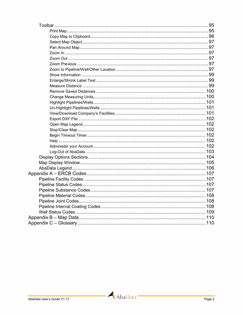
Toolbar ................................................................................................................... 95 Print Map .......................................................................................................... 95 Copy Map to Clipboard ........................................................................................ 96 Select Map Object .............................................................................................. 97 Pan Around Map ................................................................................................ 97 Zoom In ........................................................................................................... 97 Zoom Out ......................................................................................................... 97 Zoom Previous .................................................................................................. 97 Zoom to Pipeline/Well/Other Location ..................................................................... 97 Show Information ............................................................................................... 99 Enlarge/Shrink Label Text .................................................................................... 99 Measure Distance .............................................................................................. 99 Remove Saved Distances .................................................................................. 100 Change Measuring Units .................................................................................... 100 Highlight Pipelines/Wells .................................................................................... 101 Un-Highlight Pipelines/Wells ............................................................................... 101 View/Download Company’s Facilities .................................................................... 101 Export DXF File ............................................................................................... 102 Open Map Legend ............................................................................................ 102 Stop/Clear Map ................................................................................................ 102 Begin Timeout Timer ............................................................................................................ 102 Help .............................................................................................................. 102 Administer your Account .................................................................................... 102 Log-Out of AbaData .......................................................................................... 103 Display Options Sections ........................................................................................ 104 Map Display Window .............................................................................................. 105 AbaData Legend .................................................................................................... 106 Appendix A – ERCB Codes ......................................................................................... 107 Pipeline Facility Codes ........................................................................................... 107 Pipeline Status Codes ............................................................................................ 107 Pipeline Substance Codes ...................................................................................... 107 Pipeline Material Codes .......................................................................................... 108 Pipeline Joint Codes............................................................................................... 108 Pipeline Internal Coating Codes .............................................................................. 108 Well Status Codes ................................................................................................. 109 Appendix B – Map Data ............................................................................................... 110 Appendix C – Glossary ................................................................................................ 110

Page 4 AbaData User’s Guide V1.17
OVERVIEW & OTHER RESOURCES This document is designed to guide you through the setup and general use of AbaData. AbaData is a Web-based oilfield mapping program that uses current information to graphically display the location of oilfield facilities within Alberta. Additionally, information relative to these facilities can be easily accessed and printed. For a complete list of the datasets available, please refer to the AbaData product page on the Abacus Datagraphics Ltd. Website: www.abacusdatagraphics.com/abadata.asp. This document provides a description of each selection tool and information layer in AbaData. However, there are other help documents available on the Abacus Datagraphics website, or within the program itself that provide step-by-step usage instructions. Check the following Websites for help documents or video tutorials for more help with AbaData’s many features and functions:
www.abacusdatagraphics.com/help.asp www.abacusdatagraphics.com/video.asp
While logged in to AbaData, hover the cursor over the question mark icons to view available help material as in the image below:
Alternatively, click the Help button in the AbaData toolbar to view support options:

AbaData User’s Guide V1.17 Page 5
ABACUS WEBSITE Abacus Datagraphics’s website address is www.abacusdatagraphics.com. When this Website is entered in Internet Explorer you will come to the following page:
The website offers information on Abacus Datagraphics Ltd. and our various products and services.
This area contains general information about Abacus Datagraphics Ltd.
This area provides information about the products and services we provide, including AbaData, AbaData Lite, AbaData GPS, AbaData Direction Map, Equipment Management and Pipeline Signs.
This section includes information about the various AbaData training opportunities available, including lunch and learn sessions, demonstrations and training sessions.
This area contains information on the various AbaData support options, including contact information and site search. This menu also includes links to the Video and Help pages, where video tutorials and help files in PDF format are available.

Page 6 AbaData User’s Guide V1.17
This area contains company news and developments, including information on the various trade shows we attend. This menu includes a link to the AbaData Developments Web page, where recent AbaData modifications and new features are listed.
This area provides information on the various career possibilities at Abacus Datagraphics Ltd.
This section contains our contact information and a map of downtown Red Deer.

AbaData User’s Guide V1.17 Page 7
ABADATA PAGE The AbaData Page, accessible through the Products & Services menu, contains the information necessary to use the AbaData program.
This page has links to AbaData required software and available downloads.
The most important aspect of this page is the reference to MapGuide Viewer, which is a program that allows you to view the AbaData maps. MapGuide Viewer must be downloaded and installed on your computer before you can use AbaData.
INSTALLING MAPGUIDE VIEWER:
1) Click on the MapGuide Viewer icon.

Page 8 AbaData User’s Guide V1.17
2) The File Download screen will appear. Clicking on the Run button will begin the installation automatically. Clicking on the Save button means you will have to save the file on your computer, then browse to it and double-click on the mgcontrol6.5SP1.exe file to begin the installation.
3) The MapGuide Viewer program will begin to download. This should only take a few seconds (on a high-speed connection).
4) Once the download is complete, a warning will appear from Microsoft indicating
the publisher of the program could not be verified, click the Run button to continue with the installation.

AbaData User’s Guide V1.17 Page 9
5) The Setup screen will appear. Click Next to begin the installation.
6) On this screen, you must choose where to install the MapGuide Viewer. You can
click on the Browse button to select a different location, or you can accept the default. Click the Next button to continue.

Page 10 AbaData User’s Guide V1.17
7) On this screen, simply click the Next button to continue, the Back button to change any previous settings, or the Cancel button to stop the installation.
8) Once the installation is complete, the following screen will appear. Click the
Finish button to the close the installer.
AbaData User’s Guide V1.17 Page 11
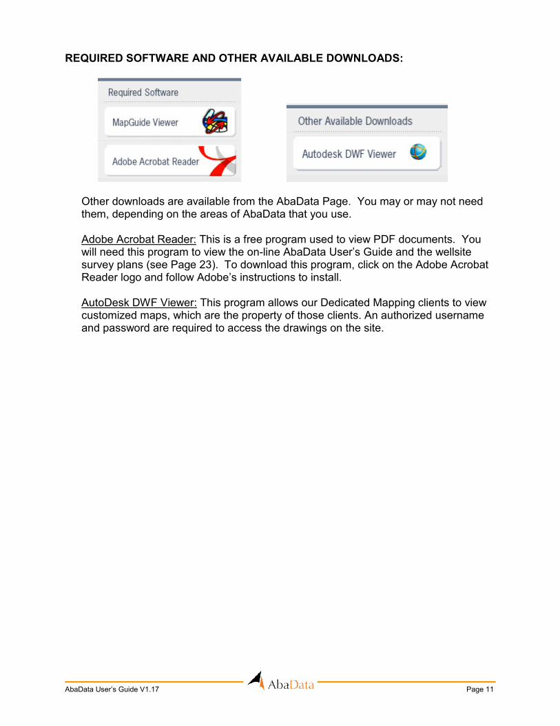
REQUIRED SOFTWARE AND OTHER AVAILABLE DOWNLOADS:
Other downloads are available from the AbaData Page. You may or may not need them, depending on the areas of AbaData that you use.
Adobe Acrobat Reader: This is a free program used to view PDF documents. You will need this program to view the on-line AbaData User’s Guide and the wellsite survey plans (see Page 23). To download this program, click on the Adobe Acrobat Reader logo and follow Adobe’s instructions to install.
AutoDesk DWF Viewer: This program allows our Dedicated Mapping clients to view customized maps, which are the property of those clients. An authorized username and password are required to access the drawings on the site.

Page 12 AbaData User’s Guide V1.17
LOGIN TO ABADATA: Once all the necessary installations have been completed, enter your username and password in the fields under Client Login on the Abacus Datagraphics Ltd. Home page.
If you’d like AbaData to remember your username and password for future logins, ensure the settings in Internet Explorer are configured to remember passwords. For example, in Internet Explorer 7, click on Internet Options then on the Content tab, then on AutoComplete Settings. You can then check the boxes next to “User names and passwords on forms” and “Prompt me to save passwords.”

AbaData User’s Guide V1.17 Page 13
USING ABADATA: If you have logged in with a valid username and password and MapGuide Viewer has been successfully installed, you will see the following page when AbaData starts.
The following sections will outline and explain the functions and options available along the left-hand side of the screen. LOCATION BOXES:
The Location Boxes are used to zoom the map to the area you are interested in viewing. The location is made up of four parts.
Enter the section number you would like to view in this box. This box can be left empty if you wish to view the entire township. If a two-digit number is entered, the cursor will automatically jump to the township box.

Page 14 AbaData User’s Guide V1.17
Enter the township number you would like to view in this box. If a three-digit number is entered, the cursor will automatically jump to the range box.
Enter the range number you would like to view in this box. If a two-digit number is entered, the cursor will automatically jump to the meridian box.
Enter the meridian number (west of) you would like to view in this box.
Clicking on the BC button will bring up the window above, and you’ll be able to enter locations in British Columbia.
Once the necessary location boxes are filled in, click on the GO button. The map will then change to display the area specified.
ERCB PLATS:
Once you have a location typed in the location boxes, you may view the applicable ERCB Pipeline Plat. To do this, click on the ERCB PLATS text located just above and right of the GO button. A list of all the available ERCB Plats associated with the location typed in the location boxes will open. Click on the plat you wish to view and it will open in PDF format. The ERCB Plats available in AbaData are updated in the middle of every month.

AbaData User’s Guide V1.17 Page 15
COMPANY FILTER:
The optional Filter by Company function is used to highlight the selected company’s facilities on the map. When a company is selected in this filter, all wells that are licenced to that company appear in red and all pipelines that are licenced to that company appear in the color corresponding to the substance of the line. All wells and pipelines not licenced to the selected company (termed foreign) are shown in black. To use the filter, you can either simply scroll down until you find the desired company or you can start to type the company name in the box. Please type slowly to give the page an opportunity to refresh after each letter. The company list will then change according to what you enter. Example:
Typing the letters “enc” into the box will change the contents of the company list to those company names starting with “enc.” In this example, facilities licenced to EnCana Corporation or EnCana Oil & Gas Co. Ltd. will be shown in colour.
To select multiple companies, simply hold down the CTRL key while clicking on the company names. If the top line “----Select one or more of the following----” is selected, all pipelines will be in color and all wells will be black. Click the Company Code link in the heading to enter a company’s Business Associate Code number (as determined by the ERCB), if known.

Page 16 AbaData User’s Guide V1.17
MAP DISPLAY:
The Map Display options are used to change the appearance of the map, and to add or remove objects or layers from the display. The changes will take place as soon as the box has been checked or unchecked.
The checkbox shown above turns on and off all pipelines on the map. Clicking on the Options text opens the Pipeline Options window (pictured on the next page) to allow more specific pipeline changes.

AbaData User’s Guide V1.17 Page 17
The High Pressure checkbox turns on and off the ERCB high-pressure pipelines. When the pipelines are turned on, you can double-click on a pipeline graphic to open the Pipeline Information window, which shows the ERCB information associated with the pipeline as pictured below.

Page 18 AbaData User’s Guide V1.17
ATTACHED FILES:
Users are able to attach files directly to a pipeline licence and line number. When this is done, the file is saved on the Abacus Datagraphics server, and is accessible to any user logging in with the same username and password the person who attached the file used. The files can be of any type (Word document, spreadsheet, image etc.) and can also be organized in groups to aid in keeping track of them. OPTIONS: View Company Info: This function will open the Company Information window showing the company’s contact information.
View Installation Info: This function will open the Pipeline Installation
window showing all pipeline installations for the specific licence number being viewed.
View Entire Licence: This function will generate a Pipeline Report (see Page 52) for all pipelines with the same licence number as the pipeline being viewed.

AbaData User’s Guide V1.17 Page 19
View Licence Ticket: This function will open a printable report of the pipeline’s licence information in ticket format. View Spill Incidents: This function will open a spill report window showing all ERCB spills and complaints associated with the selected pipeline’s licence number. Highlight Line: This function will highlight the selected pipeline. Highlight Entire Licence: This function will highlight all pipelines with the same licence number as the selected pipeline. Print Screen: This function will print the ERCB Pipeline Information screen (this function exists is on all information screens). Close Screen: This function will close the ERCB Pipeline Information screen (this function exists on all information screens).
The User-Defined Labels checkbox turns on and off the user-defined ERCB high-pressure pipeline labels. These labels can be used when the default labels are not sufficient or the area is too crowded. For information on creating user-defined labels see Page 65.
The Default Labels With checkbox pictured above turns on and off the default ERCB high-pressure pipeline labels. The program will automatically create a label for each pipeline, placing it in on the longest segment of the line. The information shown in both the default and user-defined labels depend on the options selected. All selected information will display in the labels. Note: To avoid creating lengthy, illegible pipeline labels, limit the selections above to required information only.
The Filter by Licence Date options shown above allows you to filter ERCB high-pressure pipelines by specific pipeline licence dates. For example, if you wish to see only pipelines licenced in January of 2006 you would enter the dates as in the image above.

Page 20 AbaData User’s Guide V1.17
The Filter by Substance options shown above allows you to filter ERCB high-
pressure pipelines by specific pipeline substances. You can select one or more of the substances in the image, and only the pipelines containing those substances will display on the map.
This checkbox allows you to filter ERCB high-pressure pipelines based on the material of the pipelines. If you only wanted to see pipelines made of Aluminum or Fibreglass, select the checkboxes in front of those materials.
This checkbox allows you to filter ERCB high-pressure pipelines by a range of pipeline outside diameters (OD). For example, if you wish to see only pipelines with an outside diameter between 88.9 and 114.3, you would enter the numbers as in the image above.
The Filter by Status checkbox shown above lets the user filter ERCB high-pressure pipelines according to the status of the pipeline. When using this filter you may select one or more status boxes.
The Low Pressure checkbox turns on and off low-pressure pipelines. These pipelines that belong to the many gas co-ops in Alberta. When the pipelines are turned on, you can double-click on a pipeline to open the Low Pressure Pipeline Contact Information window, which shows the contact information of the gas co-op that owns the pipeline as shown on the next page.

AbaData User’s Guide V1.17 Page 21
This checkbox turns on and off the low-pressure pipeline labels. The labels show the name of the co-op that owns the pipeline. A label will be placed on each line segment.
This checkbox turns on and off the user-defined low-pressure pipeline labels. These labels can be used when the default labels are too crowded. For information on creating user-defined labels see Page 65.
This checkbox turns on and off the irrigation pipelines and canals. The map shows irrigation facilities owned by the 13 irrigation districts in the province, provided by the provincial government.
This checkbox turns on and off the irrigation pipeline labels. A label will be placed on each line segment.
This checkbox turns on and off the user-defined irrigation pipeline labels. These labels can be used when the default labels are too crowded. For information on creating user-defined labels see Page 65.
This checkbox turns on and off the pipelines owned by Alberta Water Co-Ops.
This checkbox turns on and off the irrigation pipeline labels. A label will be placed on each line segment.
This checkbox turns on and off the user-defined irrigation pipeline labels. These labels can be used when the default labels are too crowded. For information on creating user-defined labels see Page 65.

Page 22 AbaData User’s Guide V1.17
This checkbox turns on and off all ERCB wells, including new wells licenced each day. Clicking on the Options text opens the Well Options window, which allows the user to more selectively view ERCB well data.
This checkbox will turn on and off those wells that are newly licenced and/or spudded. These wells are updated daily.

AbaData User’s Guide V1.17 Page 23
This checkbox turns on and off the ERCB wells. For horizontal wells, the down-hole line and bottom-hole locations are also shown on the map. When the wells are turned on, you can double-click on a well to open the Well Information window, which shows the ERCB information associated with the well.
Wells can have one or more events (revisions). To view a different event for a well, simply change the number in the Event drop-down list. ATTACHED FILES:
As with pipelines, users can attach documents to the well information screen, saving the files on the Abacus server to be accessed by others using the same username and password. OPTIONS: Open Well Plat: This function will open the survey plat (or wellsite survey drawing) for the selected well. All well survey plats available in Alberta have been associated with their respective wells.

Page 24 AbaData User’s Guide V1.17
Request Divestco Log: For more information about Divestco Logs please contact Abacus Datagraphics Ltd. Create CBM Report: This function will create a CBM Well report from the well location. See CBM well report option for more information. Add To Custom Well List: This function will add the specific well to a Custom Well List category. See the custom well list options for more information. View DST Files: This function will only appear for wells that have DST files. (.pdf, .pas) This function allows you to view all the DST Files for this well. MORE INFO: The following options are available from the More Info drop-down list. Licencee Info: This function will open the Company Information window showing the licencee’s contact information.
Production Data: This function will open the Well Production Data window showing the production data for the well being viewed.
Simply select the year and month of interest from the drop-down lists
and the production data will be updated on the screen.
AbaData User’s Guide V1.17 Page 25
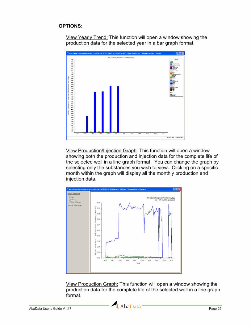
OPTIONS: View Yearly Trend: This function will open a window showing the
production data for the selected year in a bar graph format.
View Production/Injection Graph: This function will open a window showing both the production and injection data for the complete life of the selected well in a line graph format. You can change the graph by selecting only the substances you wish to view. Clicking on a specific month within the graph will display all the monthly production and injection data.
View Production Graph: This function will open a window showing the
production data for the complete life of the selected well in a line graph format.

Page 26 AbaData User’s Guide V1.17
View Injection Graph: This function will open a window showing the
injection data for the complete life of the selected well in a line graph format.
View Annual Production Totals: This function will open a report
displaying the annual production totals for the complete life of the selected well.
Licensing Data: This function will open the Well Licensing Data window
showing more detailed licensing information for the well.

AbaData User’s Guide V1.17 Page 27
Drilling Occurrence Data: This function will open the Well Drilling Occurrence Data window.
Tops & Markers Data: This function will open the Well Tops & Markers Data window.
Log Data: This function will open the Well Log Data window.
Page 28 AbaData User’s Guide V1.17
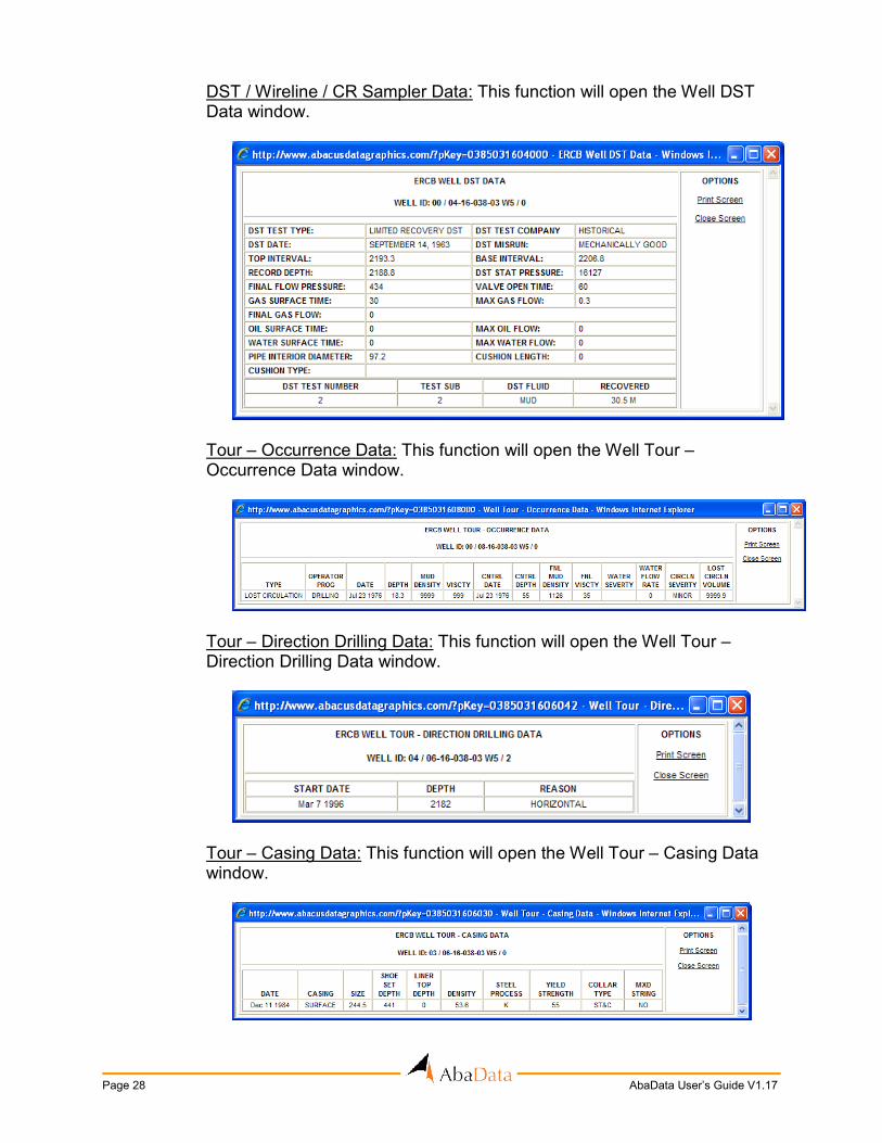
DST / Wireline / CR Sampler Data: This function will open the Well DST Data window.
Tour – Occurrence Data: This function will open the Well Tour – Occurrence Data window.
Tour – Direction Drilling Data: This function will open the Well Tour – Direction Drilling Data window.
Tour – Casing Data: This function will open the Well Tour – Casing Data window.

AbaData User’s Guide V1.17 Page 29
Tour – Cementing Data: This function will open the Well Tour – Cementing Data window.
Tour – Cores Cut Data: This function will open the Well Tour – Cores Cut Data window.
Tour – Perforation / Treatment Data: This function will open the Well Tour – Perforation / Treatment Data window.
Tour – Initial Production Data: This function will open the Well Tour – Initial Production Data window.
Page 30 AbaData User’s Guide V1.17
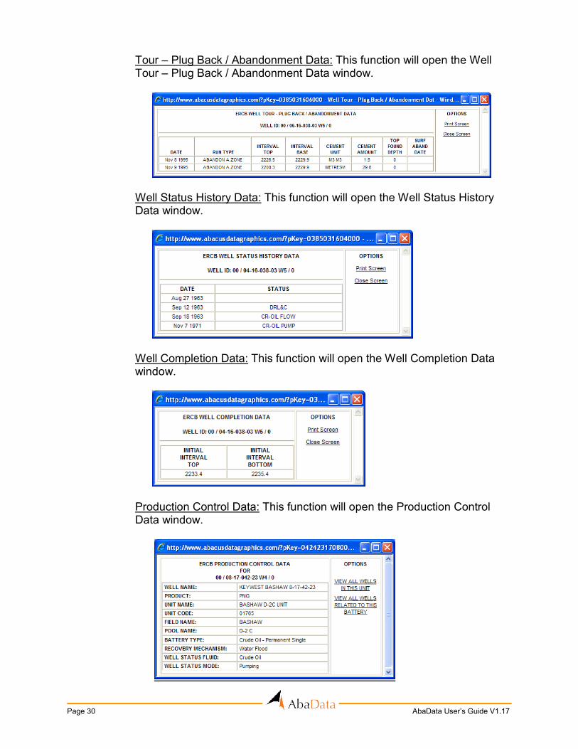
Tour – Plug Back / Abandonment Data: This function will open the Well Tour – Plug Back / Abandonment Data window.
Well Status History Data: This function will open the Well Status History Data window.
Well Completion Data: This function will open the Well Completion Data window.
Production Control Data: This function will open the Production Control Data window.

AbaData User’s Guide V1.17 Page 31
All Data: This function will open the Well Data window, which contains all data for the selected well.
The Label checkbox turns on and off the ERCB Well labels. These labels contain the LSD and section information. The With Company checkbox will modify the ERCB well labels. If the box is checked, a shortened version of the company name will be added to the labels.
This checkbox turns on and off the ERCB well down-hole lines and bottom-hole locations.
This option will display the wellhead symbol at either the surface or the downhole position, depending on which is selected. This only affects the directional wells.
This option will display the wellhead label at either the surface or the downhole position, depending on which is selected.

Page 32 AbaData User’s Guide V1.17
This option will determine which event is shown by default on the well double-click screen, depending on which is selected.
This checkbox will turn on and off the symbols you have chosen to represent specific unique well identifiers (UWID numbers). To add unique well identifiers represented by a symbol to the custom well list, click on Manage.
You can add unique well identifiers to the custom well list either by entering each one manually or adding a whole file of them at once.
To add a file containing unique well identifiers click on Upload File, then select the file you would like to add to your list. The file you select must be in .txt format and follow this format: EE/LL-SS-TTT-RRWX/R,CATEGORY NAME
ie. 00/01-18-039-03W5/0,test
00/02-33-039-03W5/2,test 02/02-33-039-03W5/0,test 00/04-30-039-03W5/0,meter 00/04-32-039-03W5/0,meter 00/04-33-039-03W5/0,meter 03/04-04-039-03W5/0,abacus 00/04-08-039-03W5/0,abacus 02/04-08-039-03W5/0,abacus
Once your file is uploaded you are able to customize your information.

AbaData User’s Guide V1.17 Page 33
You can select which categories will be shown on your map by clicking the checkbox under Show either on or off. Clicking on View Wells will allow you to see a list of wells in the specific category and from there you may choose to add more wells to the list or remove existing ones. To delete an entire category from your list, click Delete beside the category you want to remove. Each category in your file will automatically be given a symbol. To change these symbols, simply click on the ones you would like to change one at a time. The following box will appear allowing you to choose a symbol:
To add a category of unique well identifiers to your list manually instead of through a file, click on Add Category. Once you have given your category a name it will appear in your custom well list. At this point you do not yet have any wells in your category. To add wells to your category, click View Wells. You now have the choice to upload a file containing unique well identifiers for that specific category by clicking Upload file. You may add each well manually by clicking Add Well and entering in the location or you can add all the wells from a land location by clicking on Add Wells in Quarter and entering in the locations. Remember if you are uploading a file it must be in .txt formation and follow this format: EE/LL-SS-TTT-RRWX/R ie. 00/01-18-039-03W5/0
00/01-18-039-03W5/2

Page 34 AbaData User’s Guide V1.17
Now that you have your categories with their unique well identifiers, you can customize your information the same way you would with information uploaded from a file.
This checkbox allows you to filter to show only wells which have been indicated by the ERCB to have H2S content.
This checkbox allows you to filter to show only wells which have Drill Stem Testing reports attached to them. (These are in .pdf and .pas format)
This checkbox allows you to filter to show only wells have not had any production reported for them.
The Filter by Status options allow you to filter ERCB wells by specific statuses. You can select one or more of the statuses shown above, resulting in only the wells with those statuses showing on the map.
These options allow you to filter both the ERCB and newly-licenced wells by specific licence dates. For example, if you wish to see only wells licenced in January of 2005 you would enter the dates as shown above. In the same manner, you can filter wells by spud date, rig-release date or on-production date.

AbaData User’s Guide V1.17 Page 35
This checkbox will turn on and off water wells. When the wells are turned on, you can double-click on a well to open the Water Well Information window (shown below) to view information associated with the well.
OPTIONS:
Well Lithology: This function will open lithology information about the well.

Page 36 AbaData User’s Guide V1.17
Well Chemistry: This function will open chemistry information about the well.
Well Comments: This function will open comments about the well.
Production Tests: This function will open the production tests for the well.
This checkbox will turn on and off user water wells. When the wells are turned on, you can double-click on a well to open the User Water Well Information window, which shows information associated with the well.

AbaData User’s Guide V1.17 Page 37
This checkbox will turn on and off the Alberta Environment monitoring wells. When the wells are turned on, you can double-click on a well to open the Monitor Well Information window to view information associated with the well.
These checkboxes will turn on and off the labels for water wells or user water wells. The water well labels show the Alberta Environment water well number, and the user water well labels show the latitude and longitude of the well on the map.
Use this checkbox to remove water wells from the map screen that do not have chemistry data available.
This checkbox will turn on and off the distance lines on your map when creating CBM reports. See the CBM well report option for more information.
The Control Wells checkbox will turn on the CBM Control Wells layer. There is also an option to choose either desorption control wells or pressure and flow control wells by making the selection as above. Control wells can be filtered by zone by selecting a zone in the dropdown list pictured below:

Page 38 AbaData User’s Guide V1.17
This checkbox turns on and off the culture layers. Clicking on the Options link opens the Culture Options window to allow more specific culture changes. For more detailed descriptions and images of each layer, refer to the Culture help documents at www.abacusdatagraphics.com/help.asp.
Default Layers:
Checkbox Activates Layer Type Related Data Available On
All roads, including paved highways and gravel roads
Line Hover (major roads only)
Bridge icons Point Double-click
City and Town boundaries
Polygon N/A
Water bodies Polygon Hover (major water
bodies only)
Watercourses which show on 1:1000000 map
Line N/A

AbaData User’s Guide V1.17 Page 39
Indian Reserves Polygon N/A
Parks, recreation areas, forest reserves, wildlife reserves
Polygon N/A
Township, section, quarter-section grid
Line N/A
Township, section, quarter-section text
Text N/A
Environmental Data: Checkbox Activates Layer
Type Related Data Available On
Historical sites and areas
Polygon Hover
Exploration-restricted areas
Polygon Hover
Natural sub-region boundaries
Polygon Hover
Seed zone boundaries
Polygon Hover
Wildlife zone boundaries
Polygon Hover
Provincial ESA boundaries
Polygon Hover
Environment Canada weather stations
Point Double-click
SRD areas Polygon N/A
Fish & Wildlife boundaries
Polygon N/A
Local IRPs Polygon N/A
Sub-Regional IRPs
Polygon N/A
Planning Regions
Polygon N/A

Page 40 AbaData User’s Guide V1.17
Canada Land Inventory Data: Checkbox Activates Layer Type Related Data
Available On
CLI Agriculture Polygon Hover
CLI Forestry Polygon Hover
CLI Ungulates Polygon Hover
CLI Recreation Polygon Hover
CLI Waterfowl Polygon Hover
Alberta Geological Survey Data:
Checkbox Activates Layer Type Related Data
Available On
AGS Bedrock Geology
Polygon Hover
AGS Stream Sediment Chemistry
Point Double-click
AGS Sand and Gravel Deposits
Polygon Double-click
AGS Waste Disposal Siting
Polygon Hover
AGS Drift Thickness
Line Hover
AGS Kimberlite Pipes
Point Hover
AGS Fault Lines Line Double-click
Surface and Soil Data: Checkbox Activates Layer Type Related Data
Available On
AGRASID Soil Data
Polygon Hover/Double-click
Contour lines Line Hover
Trapline boundaries and text
Line/Text N/A

AbaData User’s Guide V1.17 Page 41
Crown Land Polygon N/A
County boundaries and labels
Line/Text N/A
Township and Range road labels
Text N/A
User-defined road labels (see P. 71)
Text N/A
Wildlife Unit boundaries
Line N/A
Forest Mgmt. Agreement boundaries
Polygon Hover
Forest Management Unit boundaries
Polygon Hover
Non-Permit Area boundaries
Polygon N/A
Forest Protection Area boundaries
Polygon N/A
Forest Land Use Zones
Polygon N/A
Forest Recreation area boundaries
Polygon N/A
Cutlines Line N/A
Water Crossing Restriction lines
Line Hover
Other Data: Checkbox Activates Layer Type Related data
Available On
Groundwater Protection
Text N/A
Drilling Spacing Units
Line/Text Hover
Airstrip sites Point Double-Click
Hospital sites Point Hover
Coal Mines Point Double-Click
Coal Holes Point Double-Click
Alberta Survey Control Markers
Point Double-Click
Landfill sites Point Double-Click

Page 42 AbaData User’s Guide V1.17
ERCB Waste disposal sites
Point Double-Click
Transportation districts
Polygon N/A
This checkbox turns on and off the ERCB Spills and Complaints. All spills and complaints reported to the ERCB are shown on the map, in the LSD where the incident occurred. Clicking on the Filter text opens the Spills / Complaints Filter screen, which allows you to filter by year, licence number, company, complaint type or release type. Click on the white letters in the heading to navigate to the section of spill or complaint types that begin with that letter.

AbaData User’s Guide V1.17 Page 43
When the Spills/Complaints are turned on, you can double-click on a symbol to open the Spill/Complaint Information window, which contains all spill and complaint incidents in the specified LSD as shown below.
OPTIONS: View Licensee Info: This function will open the Company Information window showing the contact information for each licensee reporting a spill or complaint.

Page 44 AbaData User’s Guide V1.17
This checkbox turns on and off the facilities, such as gas plants, compressors, etc. A facility symbol is placed in the center of each LSD that has a licenced or non-licenced facility. Clicking on the Filter text opens the Facilities Filter screen, which allows you to filter by operator, licencee, facility type or battery type. Click on the white letters in the heading to navigate to the section of facility types that begin with that letter.
You can double-click on the facility symbol to open the Facility Information window, which contains the ERCB information for each facility in the LSD. Certain licenced batteries also show the flaring, venting, and production data. You can also click to view a well list of all wells associated with batteries.

AbaData User’s Guide V1.17 Page 45
OPTIONS:
View Licencee/Operator Info: This function will open the Company Information window showing the contact information for each licencee.
This checkbox turns on and off the parcel mapping. The parcel mapping shows the boundaries of all of the registered plans of survey in the province, including Federal land.
Selecting the Report text opens a window that gives you the option of viewing plan numbers for a specific location and particular date fields as illustrated in the image below.
Page 46 AbaData User’s Guide V1.17
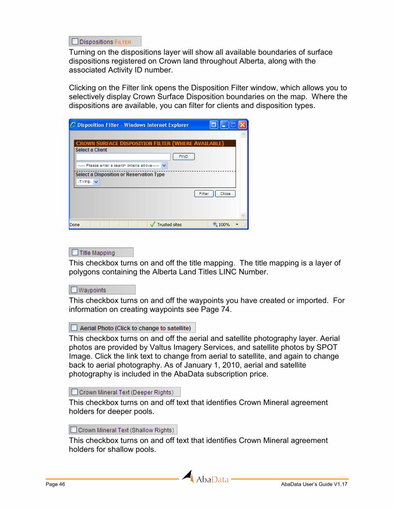
Turning on the dispositions layer will show all available boundaries of surface dispositions registered on Crown land throughout Alberta, along with the associated Activity ID number. Clicking on the Filter link opens the Disposition Filter window, which allows you to selectively display Crown Surface Disposition boundaries on the map. Where the dispositions are available, you can filter for clients and disposition types.
This checkbox turns on and off the title mapping. The title mapping is a layer of polygons containing the Alberta Land Titles LINC Number.
This checkbox turns on and off the waypoints you have created or imported. For information on creating waypoints see Page 74.
This checkbox turns on and off the aerial and satellite photography layer. Aerial photos are provided by Valtus Imagery Services, and satellite photos by SPOT Image. Click the link text to change from aerial to satellite, and again to change back to aerial photography. As of January 1, 2010, aerial and satellite photography is included in the AbaData subscription price.
This checkbox turns on and off text that identifies Crown Mineral agreement holders for deeper pools.
This checkbox turns on and off text that identifies Crown Mineral agreement holders for shallow pools.

AbaData User’s Guide V1.17 Page 47
This checkbox turns on and off the Crown Mineral agreement boundaries. When the agreements are turned on you can double-click on an agreement to open the Crown Mineral Agreements Detail Report, which shows the details of the Agreement (below).
Clicking on the Filter text opens the Crown Mineral Agreements Filter screen, which allows you to filter the agreements by their expiry year and zone.
This checkbox turns on and off the maps of rural municipalities where available. These include counties, municipal districts and special areas. The county map layer appears in the map window, and line or point-based layers (e.g. pipelines, wells) will appear over the county map image. This dataset includes the most recent county maps available.

Page 48 AbaData User’s Guide V1.17
When you check the County Map checkbox, the county map for the area in your map window will appear if the map is available. Clicking on the Set County text opens up a window that allows you to change which map is selected from the list of available maps, but does not zoom the map window to the selected county.
This checkbox turns on and off the TELUS Trench lines. Clicking on the Options text opens the Telus Options window to allow you to turn on and off the labels for the trenches. Telus Trench lines are current to January, 2010, as updates are no longer being provided by Telus.
This checkbox turns on and off the WCSS (Western Canadian Spill Services) area boundaries. When the areas are turned on you can double-click on a specific area to open the WCSS Area Information window, which shows the area contact and equipment information.
This checkbox turns on and off the WCSS control points. When the control points are turned on you can double-click on a control point to open the WCSS Control Point Information window shown below.
From this window, you can also open the Control Point map (in PDF format), which shows a direction map to the control point and more detailed information.

AbaData User’s Guide V1.17 Page 49
Clicking the Search link opens the Search for WCSS Control Point window, which allows you to search for a specific control point.
On this screen you can either enter the control point name or click on the link
to view and choose from a list of all control points. You can then either zoom the map to the control point or open the PDF control point map directly.

Page 50 AbaData User’s Guide V1.17
SAVE MAP:
This feature is designed to allow a user to save the current view of a map, in order to open and view it at a later time. All objects within the map window will be saved including default and user-defined labels, map details, distance markers, drawn objects, etc. In order to save a map, simply click the Save Map link. This will open the Save Map window where you must enter a unique description for the map. You also have the options of creating groups in the save map category or sharing the saved map with other AbaData users.
You can view your maps by clicking on the View Saved Maps for this User text. This will open the View Saved Files window, which displays all maps and groups saved for the current user.
To view a map, select the file you wish to view and click the Open button. By clicking once on a group name, all the maps saved within that group will show up in the right column.

AbaData User’s Guide V1.17 Page 51
To delete a map, select the file you wish to delete and click the Delete button. Clicking the View Saved Maps shared from other Users link will open a list of all maps shared with you from other users.
REPORTS:
Reports are designed to retrieve and print the data attached to the map objects. There are three ways to access these reports.
1) The first method is to select one or more objects on the map and then click on the
type of report that you wish to generate. Selecting objects can be done by creating a window containing the objects or selecting them one at a time while holding down the SHIFT key. You can also use the highlight tool on the toolbar to select objects, which can then be reported on.
2) The second method is to select one or more quarter sections and then click on the type of report that you wish to generate. This will create a report of all the requested map objects (e.g. pipelines, wells) that are within the selected quarter sections. If you are zoomed past a certain map width, entire townships will be highlighted, rather than quarter sections.
3) Some reports can be generated at a provincial level. In order to access information for the entire Alberta database from the reports section, do not select any objects or land area from the map. Instead, select the report you wish to generate. If the report item you select is not available at a provincial level, an alert will appear indicating you must select an item off the map in order to proceed.
Clicking the Options text opens the Report Options window (see following page) and allows you to customize some of the reports.

Page 52 AbaData User’s Guide V1.17
Currently, users are only able to make changes to the pipeline, well and well production reports. Simply check the boxes to select fields that you would like to display on the report. Any reports generated will only contain the selected fields.
The following report format would be generated by selecting pipeline graphics displayed on the map screen, then clicking the Pipelines link in the Reports section.
Note: This report gives you the option to select any pipeline licence and line number on the report to highlight that segment on the map screen. If the user has no pipeline graphics selected on the map screen, and clicks the Pipelines link in the Reports section, an options screen will appear as shown on the next page and the report would contain data pulled from the entire Alberta database.

AbaData User’s Guide V1.17 Page 53
The following report format is generated when the user selects well icons or an area containing wells on the map screen.
The following option screen opens when the user clicks the Wells link in the Reports section when no wells are selected on the map screen, and the report data is pulled from the entire Alberta database. Well reports can be accessed for Saskatchewan by clicking on the ‘Saskatchewan Well Report’ button.

Page 54 AbaData User’s Guide V1.17
Water well reports as shown below can only be created when an area containing water wells (or one or more water well icons) is selected on the map screen.

AbaData User’s Guide V1.17 Page 55
The following report format is be generated when the user selects an area on the map screen and clicks on the Companies link in the Reports section.
The options screen below opens when the user clicks the Companies link in the Reports section when no selection had been made on the map screen, and the report includes data from the entire Alberta database.
The following report format is generated when the user has selected facility icons or an area containing facilities on the map screen.

Page 56 AbaData User’s Guide V1.17
The following options screen opens when the user has not selected an area or facility icons on the map screen, and the report includes data from the entire Alberta database.
The following report is generated when the user has selected an area containing Spills/Complaints icons on the map screen.

AbaData User’s Guide V1.17 Page 57
The following options screen opens when the user clicks the Spills/Complaints link in the reports section when no selection is made on the map screen. The report contains data from the entire Alberta database.
The following land status report format is generated when an area is selected on the map screen.
Page 58 AbaData User’s Guide V1.17
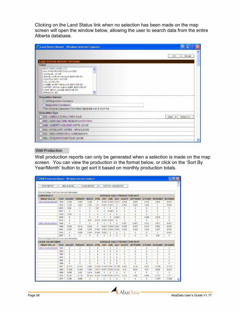
Clicking on the Land Status link when no selection has been made on the map screen will open the window below, allowing the user to search data from the entire Alberta database.
Well production reports can only be generated when a selection is made on the map screen. You can view the production in the format below, or click on the ‘Sort By Year/Month’ button to get sort it based on monthly production totals.

AbaData User’s Guide V1.17 Page 59
Crown Mineral Agreement reports are generated when at least one quarter section is
selected on the map screen. The user must also select an agreement number to view details as shown below.
For more information about Divestco Logs please contact Abacus Datagraphics Ltd.

Page 60 AbaData User’s Guide V1.17
Title Mapping reports are generated when an area containing at least one title is selected on the map screen. The report is a .txt file containing all selected Alberta Land Titles LINC Numbers. This file can then be used to perform a search of the Alberta government Spin 2 database at: https://alta.registries.gov.ab.ca/spinii/logon.aspx
This report will return all the water well lithology information for all wells selected on
the map.
All water well chemistry reports will be brought up for wells selected on the map.
(ERCB Strike Area/Field/Pool) Board Order reports are generated when at least one quarter section is selected on
the map screen.

AbaData User’s Guide V1.17 Page 61
Clicking on this report option will open the following screen:
From this screen you may choose to create your CBM Well report by either typing in the Coordinates of the center of the location you are interested in or by selecting a specific point on the map with your cursor. Once you have specified your location another window will open letting you specify the different radiuses to base the report on.
You may change the values in the boxes or leave them the same, and click OK. A report like the one below will then be created.

Page 62 AbaData User’s Guide V1.17
You will also find a diagram on your map with radius lines colour-coded according to the distance from the selected well or point.
This checkbox will allow you to see how far away each water well is from the centre location you have selected for your report. Distance lines running from the center location to the water wells will appear on your map clearly labeling the distance from the selected point or well. CBM Well Reports can also be created by double-clicking on an ERCB well symbol then selecting the Create CBM Report option.
This report enables the user to get information on nearest airstrips, hospitals, CBM control wells, weather stations, oilfield waste management facilities, landfills, localities or Alberta Survey Control Markers. If CBM Control Wells is selected, the report will contain the two nearest control wells for each zone. Otherwise, the report will contain the five nearest items from the centre of the current map screen.

AbaData User’s Guide V1.17 Page 63
If you have an area selected on the map, this will generate a report of all waypoints within the selected area. If you do not have an area selected, the following window will open, allowing you to specify which waypoints and waypoint signs appear in the report.
This report allows you to see newly-licenced wells at a provincial scale for selected companies or for a date range, using the options screen shown below. Newly-licenced wells are updated in AbaData on a daily basis.
You may choose to see the newly-licenced wells on the map, or have the wells listed in report format.

Page 64 AbaData User’s Guide V1.17
This tool creates a list of all files attached to the selected map objects. The options available are shown below. For more details on attaching files, please refer to Page 18.
Landfill reports are generated when a selection is made on the map screen containing one or more landfill symbols. The report will appear as in the image below.
The DST Report will provide DST information for all wells selected on the map.
With Historical Sites turned on in the Culture Options, this report will provide information on any land area that has a Historical Resource Value associated with it.
With the exception of Title Mapping reports, all AbaData reports can be viewed in a Microsoft Excel spreadsheet. Clicking on the View in Excel button will open an Excel spreadsheet with the report data in it. You then have the option to save this spreadsheet to your computer so that it can be manipulated.

AbaData User’s Guide V1.17 Page 65
HIGH PRESSURE LABELING:
High Pressure Labeling is used to create custom labels for ERCB high-pressure pipeline graphics, when the default labels are not sufficient.
This function allows you to create a single pipeline label. To do this, click on the Create Single function and then click on the pipeline you would like to label. This will change the cursor to a pointing hand. Next, click on the point that you would like to be the center of the label. The label will automatically take the same rotation as the pipeline selected.
This function allows you to create labels for multiple pipelines. It was designed for groups of lines that run parallel to each other. To create a group label, first click on the Select button on the toolbar. Next, click on the pipelines (and press the SHIFT key) in the order that you want the labels to appear. When all the lines are selected, click on the Create Group function. This will change the cursor to a line and plus symbol. Next, click on the point that you would like to be the start of the labels. Then, click on a second point creating a line, the rotation of which will be the rotation of the label.

Page 66 AbaData User’s Guide V1.17
This function allows you to change the location of any label (default or user-defined).
To do this, click on the Move function, and then click on the label you would like to move. This will change the cursor to a pointing hand. Finally, click on the location you would like the label moved to.
This function allows you to delete one or more labels (default or user-defined). To do
this, simply click on the Delete function and then select the labels you would like to delete.
This function allows you to create a leader, which associates a group label with a
group of pipelines. To do this, click on the Draw Leader function. Then, click on one side of the group of pipelines and again on the other side. Finally, double-click on the group label. To delete a leader, use the Delete function following the same procedures as deleting a label.

AbaData User’s Guide V1.17 Page 67
DETAILS:
Details are useful in extremely congested areas where it is impossible to have all the pipelines labeled visibly. When a detail is created, it will automatically be assigned a number that will be used to reference between the detail and the main map. Detail information is not saved, so when you log out of AbaData, all details will be lost and will need to be recreated if you require them again.
Click the Create function to create a detail. This will change the cursor to a rectangle. Click and hold the point that will become the top-left corner of the detail, then drag the cursor to the point that will become the bottom-right corner of the detail. Release the mouse button and the detail will open in a new window.

Page 68 AbaData User’s Guide V1.17
On the Map Detail window, you have the option to turn on or off the map labels and to modify the contents of the high-pressure labels (by clicking on the Options text).
There is also the option to create user-defined high- pressure labels by using the functions under the High Pressure Labeling heading. These functions work exactly the same as on the main map (see Page 65).
The Print and Select buttons on the toolbar work the same as those described in the Toolbar section (see Page 95 and Page 96).
A box will be drawn around the detail area on the main map and a label added identifying the detail.
When the detail is printed from the detail window, a title will appear that corresponds to the label shown on the main map. This allows you to print multiple details of the same area, without confusing the different prints. You can re-open the detail window by double-clicking anywhere in the detail box on the main map.
This function is used to remove details from the map one at a time. Simply click on the detail you wish to remove then click on the Remove function.
This function is used to remove all details from the map. Simply click on the Remove All function and all details will be erased.

AbaData User’s Guide V1.17 Page 69
GPS TOOLS:
The GPS Tools are designed for use with a laptop computer and a GPS receiver in the field. However, some of the tools are applicable to an office environment. An Internet connection is required in order to use AbaData on a laptop computer.
GPS Receiver Settings: The following lists the procedures used to install a Garmin GPS 18 receiver or other
Garmin GPS with a USB cable and Franson GPS Gate. Install GpsGate:
GpsGate is a program that takes the Garmin USB signal from a Garmin GPS and translates it into a signal that can be used by AbaData to show user locations on the map. Contact Abacus Datagraphics to set up a GPS Gate licence. Once you have received a copy of GpsGate, double-click on the GpsGate.exe file and follow the prompts to install the program on your computer. You should now have this icon on the desktop:
Double-click on the icon. The following window should open:

Page 70 AbaData User’s Guide V1.17
Click on the Advanced Setup button to open this window:
Under the Set input box, click on the arrow and select Garmin USB. Then click on
the Open button to the right. Then click on the Output tab.
Click on the arrow to the right of the top window to bring up a directory and select Virtual Com Port. Click on the Add button. Select GPS in Browser and click OK. The window should now look like the one above.

AbaData User’s Guide V1.17 Page 71
Close the Settings window and click once on the GpsGate icon in the lower right menu bar of your computer. Choose License Key. The following window should appear:
Cut and paste the e-mail and license key information supplied by Abacus into the two boxes exactly as it appears in the document provided. You should see a message indicating your licence key is OK.
Install the Garmin GPS Driver: Using the file provided to you by Abacus, or one that has been downloaded from the www.garmin.com Website, double click on the Garmin USB Drivers icon that looks like the one below:
. Follow the prompts to install the driver on your system, plugging in your GPS unit when prompted.
This function is used to start the GPS Tracking utility. When this function is started, the GPS Tracking Options window will open.
On this screen you may either enter your destination or center the map on your current location.

Page 72 AbaData User’s Guide V1.17
If you choose to enter a destination, the map will change to show your current position as an arrow, and the destination as a star. As you get closer to your destination, the map will zoom in and re-center. If you choose to center the map on your location, the width of the map will be determined by the option selected in the View section.
This function pauses the tracking function once it has started. When the tracking first
starts, there are some changes made to the map. All layers are turned off except for the culture and the waypoints. If you wish to turn on other layers or change the view, you must pause the tracking. Once you have made your changes to the map, click the Start Tracking function to restart tracking.
This function stops GPS tracking.
This function is used to center the map at specified coordinates. The Zoom to Coordinates screen will open for you to enter the desired coordinates.
You have the option to enter the coordinates in either latitude/longitude or meters. You also have the option to change the width that the map will be zoomed to. Clicking OK will zoom the map to the coordinates entered, marking it with an X. You can double-click on the X symbol to view the coordinates again.

AbaData User’s Guide V1.17 Page 73
This function allows you to view the coordinates for a specific point on the map. Clicking on the function will change the cursor to a pointing hand. Click on the point of interest on the map and the Get Coordinates screen will open, showing the coordinates in both latitude/longitude and meters.
The point clicked will be marked with an X. You can double-click on the X symbol to view the coordinates again.
This function will remove both the GPS tracking symbol and any X symbols that have been added to the map through the Zoom to Coordinates and Get Coordinates functions.

Page 74 AbaData User’s Guide V1.17
WAYPOINTS:
Waypoints allow you to add and save information attached to user-defined symbols
on the map. Each Waypoint contains a waypoint number, latitude/longitude coordinates and comments.
This function adds a waypoint to the map. Clicking on the function will open the Add
Waypoint screen below. From there you may enter in the coordinates of the waypoint, or click on the Select Point From Map button and click the point on the map where you would like to add the waypoint.
Once you have selected a waypoint location, the Waypoint information screen will
open.

AbaData User’s Guide V1.17 Page 75
The Waypoint information box is split into five tabs, which display different information and allow different functions to occur.
This tab displays general information on the waypoint, including comments, the
waypoint symbol selected, waypoint number, date added and what group the waypoint is in.
The latitude and longitude values are populated from the point entered or clicked on the map and displayed under the coordinates tab. The program calculates and displays the information in four different coordinate systems.
Under attached files you may attach any file saved on your computer to the
waypoint. That file can then be accessed from the waypoint from any computer logged in with the same username and password.
Add users under the Share With tab to make the waypoint viewable to other users
who have usernames in the AbaData system.
Using the waypoint alert feature allows you to enter a time-sensitive message into
the system. When the selected alert time arrives, you will be notified when you log in to the program.
This function adds a waypoint sign to the map. Clicking on the function will open the Add Waypoint Sign screen. You may enter coordinates, or click on the Select Point From Map button and click the point on the map where you would like to add the waypoint sign.

Page 76 AbaData User’s Guide V1.17
Once you have selected a point or entered the coordinates, the Add Waypoint Sign screen will open.
This tab shows the waypoint sign symbol type, comments, the date the sign was approved, erected, or removed and in which group the sign is included.
The latitude and longitude values are populated from the point entered or clicked on the map and displayed under the coordinates tab. The program calculates and displays the information in four different coordinate systems.
Add users under the Share With tab to make the waypoint viewable to other users
who have usernames in the AbaData system.

AbaData User’s Guide V1.17 Page 77
Double-clicking on a waypoint sign symbol on the map screen will open the Edit Waypoint Sign window.
This screen allows you to update or edit the Waypoint Sign information. While in this screen the following can be done:
Clicking on this button will allow you to add a New Inspection record for the sign.
This function can be used to edit an existing Inspection record. Under the Waypoints menu on the left side of the AbaData Screen, you can work with your waypoints and waypoint signs. You may:
This function is used to delete one or more selected Waypoints or Waypoint Signs.
This function is used to export all Waypoints or Waypoint Signs to an ASCII text file, containing the waypoint #, coordinates, grouping information and comments. You may wish to use this file in your company’s own GIS system.
This function is used to import waypoints into the mapping from an ASCII text file. The import file for Waypoints must be a comma-delimited file with the following format: [Waypoint #],[Latitude decimal degrees],[Longitude decimal degrees],[Latitude degrees],[Latitude minutes],[Latitude seconds],[Longitude degrees],[Longitude minutes],[Longitude seconds],[10TM northing],[10TM easting],[UTM northing],[UTM easting],[UTM zone],[Symbol #],"[Date Added]","[Group Name]","[Waypoint Comments]"

Page 78 AbaData User’s Guide V1.17
The import file for Waypoint Signs must be a comma-delimited file with the following format: [Waypoint #],[Latitude decimal degrees],[Longitude decimal degrees],[Latitude degrees],[Latitude minutes],[Latitude seconds],[Longitude degrees],[Longitude minutes],[Longitude seconds],[10TM northing],[10TM easting],[UTM northing],[UTM easting],[UTM zone],[Symbol #],[MM/DD/YYYY],[MM/DD/YYYY],[MM/DD/YYYY], "[Group Name]","[Waypoint Comments]" Once a file in the correct format has been specified, the waypoints will be drawn and saved on the map.
This allows you to import waypoints directly from a Garmin GPS into the AbaData program. In order to do this, you first need to download the Garmin Communicator Plugin, which can be accessed on the Garmin website: http://www8.garmin.com/products/communicator/

AbaData User’s Guide V1.17 Page 79
USER WATER WELLS:
User water wells are designed to allow you to add and save water well locations to the map. Each user water well consists of a water well number, a latitude/longitude location, and comments.
This function allows you to add new user water wells to the map. Clicking on the function will open a window giving you the option of adding the new well by entering the coordinates or by selecting a point on the map, which will open the Add Well screen.
The Owner Name box is where you enter the name of the owner of the well. You must enter a value in this box.
The Well # box will automatically contain the next available number. This number is
used to label the well. The Date Proofed box will automatically contain the current date. However, you are
able to change it to any valid date if you wish. You can add any other relevant details in the Comments box.
The Test/Not Tested option is meant to denote whether the well has been tested.

Page 80 AbaData User’s Guide V1.17
Once all the necessary information is entered, click the OK button to save the well. The well can then be accessed whenever the User Water Well layer is turned on.
Double-clicking on the purple user water well symbol will open the well information,
and allow you to upload a file attachment.
This function allows you to designate a quarter-section that contains no water wells on the map. First select the quarter-section(s) that you wish to add then click Add Quarter. This will open the Add Quarter screen.
The date proofed will automatically appear as the current date, however you are able
to change it to any valid date if you wish. The Entered By box is where you enter your name.
You can add any other relevant details in the Comments box.
Once all the necessary information is entered, click the OK button to save the quarter(s). The quarter(s) can then be accessed whenever the User Water Well layer is turned on.
This function is used to delete one or more selected quarter sections. To do this, simply click on the Delete function and then click on the quarters you would like to delete.
AbaData User’s Guide V1.17 Page 81
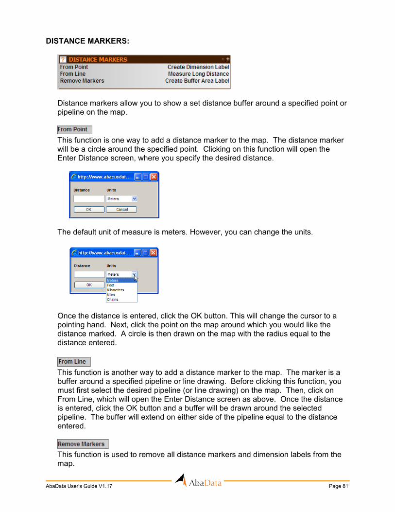
DISTANCE MARKERS:
Distance markers allow you to show a set distance buffer around a specified point or pipeline on the map.
This function is one way to add a distance marker to the map. The distance marker will be a circle around the specified point. Clicking on this function will open the Enter Distance screen, where you specify the desired distance.
The default unit of measure is meters. However, you can change the units.
Once the distance is entered, click the OK button. This will change the cursor to a pointing hand. Next, click the point on the map around which you would like the distance marked. A circle is then drawn on the map with the radius equal to the distance entered.
This function is another way to add a distance marker to the map. The marker is a buffer around a specified pipeline or line drawing. Before clicking this function, you must first select the desired pipeline (or line drawing) on the map. Then, click on From Line, which will open the Enter Distance screen as above. Once the distance is entered, click the OK button and a buffer will be drawn around the selected pipeline. The buffer will extend on either side of the pipeline equal to the distance entered.
This function is used to remove all distance markers and dimension labels from the map.

Page 82 AbaData User’s Guide V1.17
This function allows you to create a label for a distance marker. This function will always create the label for the distance marker that was last created. Clicking on the function will change your cursor to a line. First, click on the center of the distance marker. Then, click on the outside edge of the distance marker where you would like the label to be drawn. This will draw the label as shown below.
This function allows you to measure a long distance on the map. This distance usually stretches across more than one screen. Clicking on this function will open the Measure Long Distance window.
To determine the segment start point, latitude and longitude values can be entered in the text boxes or the Pick Point button can be clicked and the user can select a point on the map. The segment end point can then be entered in the same manner.
The segment length and total distance length will be displayed. The user can then click the Next Point button and the end point of the last segment will become the next segment’s start point. The user can also start fresh by clicking the Clear button.
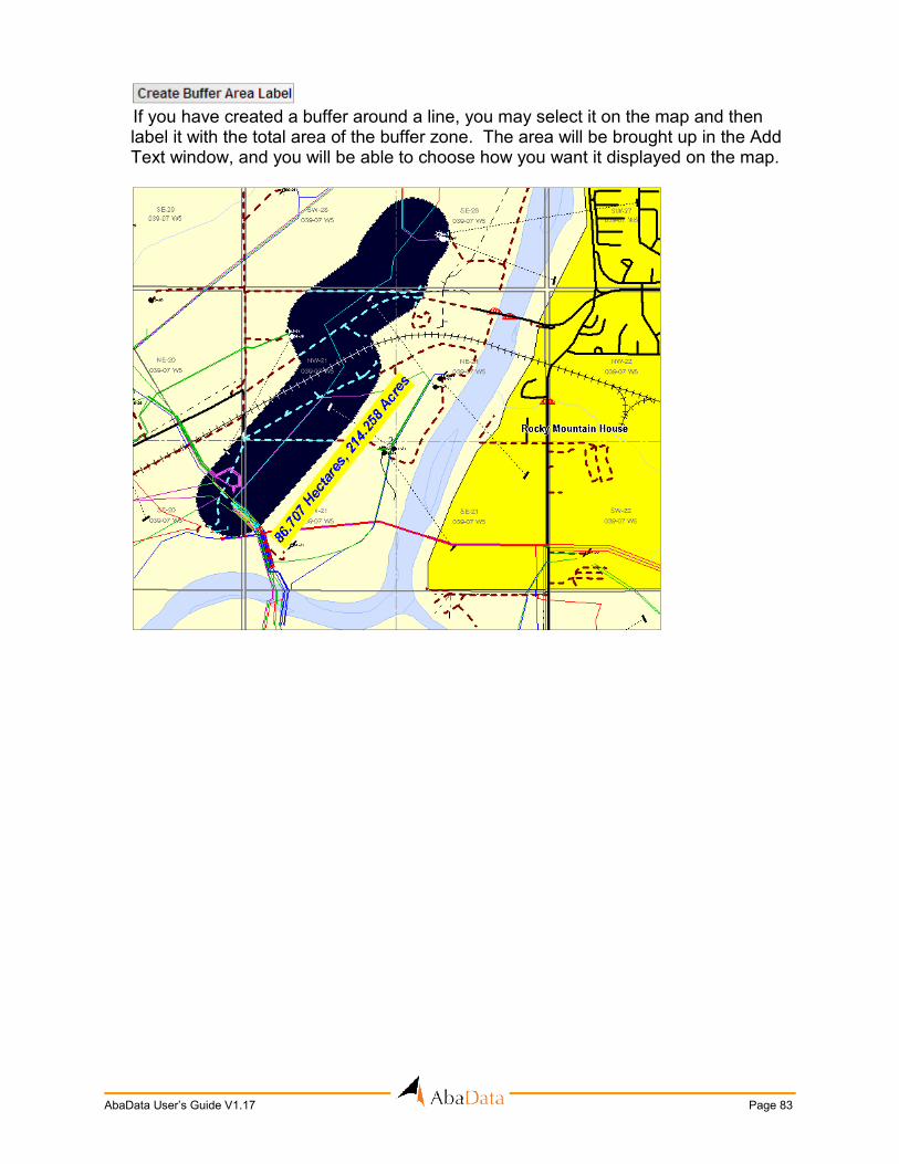
AbaData User’s Guide V1.17 Page 83
If you have created a buffer around a line, you may select it on the map and then label it with the total area of the buffer zone. The area will be brought up in the Add Text window, and you will be able to choose how you want it displayed on the map.

Page 84 AbaData User’s Guide V1.17
DRAWING:
The Drawing function allows you to draw objects on the map.
Clicking on the Defaults link will open up a window allowing you to create new default settings for drawing objects. Once the defaults are set, those settings will be reflected when you open one of the drawing options.
This allows the user to toggle on and off any drawing that has been done on the map screen.
This function is used to draw a line on the map. Clicking on the function will open the Draw Line Options screen, where you can specify the style, color, and thickness of the line.

AbaData User’s Guide V1.17 Page 85
Once your options have been selected, click the OK button. This will change your cursor to a line. Next, click on the desired points on the map where you would like the line to be drawn. Double-click to end the draw function. All lines will remain on the map only until the session is ended.
This function is used to draw a polygon on the map. Clicking on the function will open the Draw Polygon Options screen, where you can specify the polygon type, label, style and color.

Page 86 AbaData User’s Guide V1.17
Once your options have been selected, click the OK button. This will change your cursor to either a polygon or a circle (depending on the shape type selected). Next, click the desired points on the map where you would like the polygon to be drawn. All polygons will remain on the map only until the session is ended.
This function is used to add text to the map. Clicking on the function will open the Add Text Options screen, where you can specify the text to add, the size, style, text colour, background colour and borders.
Once all values have been entered, click the OK button. This will change your cursor to a line. Next, click two points on the map, which will form the text’s location and rotation. All text drawn will only remain on the map for the current session of the program.
This function is used to add user-defined road labels to the map. These labels will be saved and will be visible during future sessions. The User Road Labels option must be turned on (see Page 40) to add new labels. To add a label, first click on the Add Road Label function. This will change your cursor to a line. Next, click on two points on the map, which will form the location and rotation of the label. This will open the Road Labels window where you will enter the label text.

AbaData User’s Guide V1.17 Page 87
Once the desired text is entered, click the OK button to add the label to the map.
This function is used to edit the attributes of a drawing object. First, select the object
you wish to edit. Then, click on the Edit link, which will open the object’s options screen. Make your desired changes and click the OK button, which will re-draw the object.
This function is used to either re-draw or move a drawing object on the map. First,
select the object you wish to move. Then, click the Move link. Your cursor will change and you’ll be able to re-draw the object.
This function is used to remove one or more drawing objects from the map.
This function allows you to export the coordinates of a polygon into a text file. Simply select the polygon you wish to export and click on the Export Polygon function. This will open the File Download screen allowing you to either open the file directly or save it to your computer.
This function is used to import a polygon to the map from an ASCII text file. The import file must be a comma-delimited file with the following format: [point #], [longitude], [latitude], “[label]” Once a file in the correct format has been specified, the polygon will be drawn on the map.
This function is used to add an approximate work area label to the map. You can
mark the work area with either a box or a circle and then add a label with an arrow identifying it.
This function is used to draw a box on the map identifying a work area. Clicking on this function will change your cursor to a box, allowing you to draw a box on the map.

Page 88 AbaData User’s Guide V1.17
This function is used to draw a circle on the map identifying a work area. Clicking
on this function will change your cursor to a circle, allowing you to draw a circle on the map.
This function is used to add a label to the map identifying the work area drawn. Clicking on this function will change your cursor to a line, allowing you to click the starting and ending points of the arrow. The text “Approx Work Area” will be added to the end of the label.

AbaData User’s Guide V1.17 Page 89
DIRECTION MAP:
This function is used to create a road map to a specific location. Direction maps can be created to a legal land description, city or locality, lake, park, or reserve in Alberta or Saskatchewan. Clicking on the Direction Map function will open the Create Direction Map window.
There are several options available on this screen.
This option controls whether or not the yellow background color will display on the direction map.
This option controls whether or not the township and range road labels will display on the direction map.

Page 90 AbaData User’s Guide V1.17
This option controls whether or not the township and section grid lines will display on the direction map.
This option controls whether or not the ERCB wells will display on the direction map. You also have the option to turn on or off the well labels and add the company name to the labels.
This option controls whether or not a user’s waypoints will display on the direction map.
This checkbox controls whether or not the latitude and longitude values of the first location will appear in the title when the direction map is printed.
You can enter as many as 30 legal land description numbers. Simply enter the desired number in the # of Locations box. This will change the screen to allow you to enter that number of locations. You have the choice to enter a name for the location (facility) if you wish. This name will appear in the label of the location on the direction map. The LSD, section, township, range, and meridian must be entered for each location.
You can also choose to create the direction map using one of the options above. Simply select the desired option and the drop-down list on the right will be populated with all locations relevant to the type (city/locality, lake, park or reserve) selected.
You can also create a map based on the last reported location of a tracked vehicle, if you are a VTA user. Select a vehicle in the drop-down menu to do so. This is an optional component of Direction Map.

AbaData User’s Guide V1.17 Page 91
Once all options have been set, click the Create button. Your direction map will open in a new window.
The map title on this screen will also appear on the printed map. You have the option to change this title if you wish.
There are several options on the toolbar that allow you to change the appearance of the direction map.
This button is used to print the direction map. Clicking on the Print button opens a print dialog window, where you can pick the desired printer and paper options.

Page 92 AbaData User’s Guide V1.17
Clicking the OK button on this screen will print the map.
This button is used to copy the current view of the map to the computer’s clipboard. It works in the same manner as the Copy Map button described in the Toolbar section (see Page 96).
This button is used to navigate around the direction map. It works in the same manner as the Pan button described in the Toolbar section (see Page 97).
This button is used to zoom into an area of the direction map. It works in the same manner as the Zoom In button described in the Toolbar section (see Page 97).
This button is used to zoom out of the direction map. It works in the same manner as the Zoom Out button described in the Toolbar section (see Page 97).
This button is used to restore the previous view of the direction map. It works in the same manner as the Zoom Previous button described in the Toolbar section (see Page 97).
This button is used to enlarge the Well labels. It works in the same manner as the Enlarge Label Text button described in the Toolbar section (see Page 99).
AbaData User’s Guide V1.17 Page 93
This button is used to measure distances on the map. It works in the same manner as the Measure Distance button described in the Toolbar section (see Page 99).
This button is used to remove saved distances from the map. It works in the same manner as the Remove Saved Distances button described in the Toolbar section (see Page 100).
This button is used to switch the measuring units. It works in the same manner as the Change Measuring Units button described in the Toolbar section (see Page 100).
This button is used to show the aerial photography from Valtus on the direction map. It works in the same manner as the Aerial Photos checkbox in the Map Display section (see Page 46).
This button is used to show the satellite photography on the direction map. It works in the same manner as the Satellite Photos checkbox in the Map Display section (see Page 46).
This button is used to open the Map Legend screen. The legend shows what the various wellhead symbols mean.
Vehicle Tracking Interface Click this icon to open the Abacus VTA Interface, which allows the user to track or follow tracking units on the map screen. This is an optional component of Direction map.
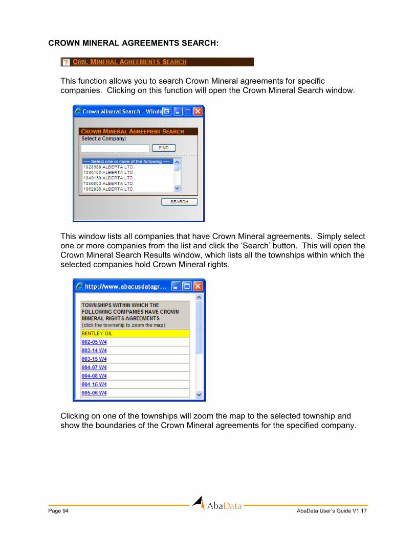
Page 94 AbaData User’s Guide V1.17
CROWN MINERAL AGREEMENTS SEARCH:
This function allows you to search Crown Mineral agreements for specific companies. Clicking on this function will open the Crown Mineral Search window.
This window lists all companies that have Crown Mineral agreements. Simply select one or more companies from the list and click the ‘Search’ button. This will open the Crown Mineral Search Results window, which lists all the townships within which the selected companies hold Crown Mineral rights.
Clicking on one of the townships will zoom the map to the selected township and show the boundaries of the Crown Mineral agreements for the specified company.

AbaData User’s Guide V1.17 Page 95
TOOLBAR:
The toolbar is used to perform various tasks on the map display window.
This button is used to print the map. Clicking on the Print Map button opens the Map Print Setup screen.
This screen allows you to enter a title for the map and set the following print options:
1) Color or Black & White – This option controls whether pipelines are printed in color (as shown on map) or all in black.
2) Background Color – This option controls whether or not the yellow background of the map will be printed.
3) Title Block – This option controls whether or not the map is printed inside of a title block. The title block includes a black border, north arrow and legend.
4) Label Legend and ERCB Dates – This checkbox controls whether a legend for pipeline labels and the ERCB data current-to date displays on the map.
5) Print to Scale – This option controls whether or not the map is printed to scale. If so, you must specify the print scale you wish to use.
6) Defined Sizes – These options allow the user to select a defined paper size and print a scaled map. Map symbols and graphics will scale to the selected size as well.
Once the desired options are set, click the OK button. This will open a print dialog box, where you can pick the desired printer and paper options.
Print Map

Page 96 AbaData User’s Guide V1.17
Clicking the OK button on this screen will print the map.
This button is used to copy the current view of the map to the computer’s clipboard. You can then open a program like Microsoft Paint and paste the image from the clipboard. This would allow you to then create an image file of the map. Clicking on the Copy Map to Clipboard button opens the Map Copy Setup screen.
This screen allows you to set the following options:
1) Color or Black & White – This option controls whether pipelines are shown in color (as shown on map) or all in black.
2) Background Color – This option controls whether or not the yellow background of the map will be shown.
3) Label Legend and ERCB Dates – This checkbox controls whether a legend for pipeline labels and the ERCB data current-to date displays on the map.
Once the desired options are set, click the OK button, which will send the map to the clipboard.
Copy Map to Clipboard

AbaData User’s Guide V1.17 Page 97
This button has two main purposes. 1) The first is to obtain quick information on certain objects on the map. If you click
the Select button and then hover the cursor over a map object (i.e. high pressure pipeline), information about the object will appear in a pop-up window.
2) The second purpose is to select map objects. There are two ways to select
objects. The first is to click the Select button, then move the cursor over the object and left click (or double-click). To add more objects to the selection, hold down the SHIFT key and click on another object. The second way to select is to click the Select button, then click and drag the cursor to draw a window. All objects within this window will be selected.
This button is used to navigate around the map. First, click the Pan button, then click and hold on the map. Then, drag the cursor in the direction that you want to slide the map. Release the mouse button and the map will regenerate to show the new area.
This button is used to focus in on an area of the map. There are two ways to do this. The first way is to click on the Zoom In button, then click anywhere on the map. This will zoom in the map by a preset amount and center it on the location that the cursor was clicked. The second way is to click the Zoom In button, then click and drag the cursor to draw a window. This will zoom in the map to the area that was windowed.
This button is used to reveal areas outside of the current map view. To do this click on the Zoom Out button then click anywhere on the map. This will zoom out the map by a preset amount and center it on the location that the cursor was clicked.
This button is used to restore the previous view of the map. It will undo the last pan or zoom operation. To do this, simply click on the Zoom Previous button.
This button is used to zoom the map to a specific high-pressure ERCB pipeline, ERCB well, field, ERCB Unit, location, waypoint LINC number or ERCB facility. Clicking on the button opens the Zoom Options window as shown on the following page.
Select Map Object
Pan Around Map
Zoom In
Zoom Out
Zoom Previous
Zoom to Pipeline/Well/Other Location

Page 98 AbaData User’s Guide V1.17
First select what type of map item you wish to zoom to. Following the instruction below will prompt the program to zoom to the map area and in some cases highlight the item you zoomed to.
If Zoom to Pipeline is selected, the licence number and line number (or just the licence number) of the desired high-pressure pipeline must be entered. Click OK and the line or lines will be highlighted on the map.
To zoom to a well enter the licence number of the desired well. Click OK and the map screen will adjust and the well will be highlighted.
If Zoom to Field/Pool is selected, first select a Field from the dropdown, and a then select a Pool once that list has been populated. Click OK and all the wells drawing from the specified Field and Pool will be highlighted.
When a unit is selected from the dropdown menu and OK is selected, the program will zoom to a unit area and all the wells associated to that unit will be highlighted.

AbaData User’s Guide V1.17 Page 99
If Zoom to Location is selected, a location type and name must be entered. Click the OK button and the map will zoom to the specified location. If the Culture is not turned on under Map Display, the location may not be labelled on the map.
To zoom to a Waypoint, Waypoints must be checked on under ‘Map Display’. On the left side, select a group and then the waypoints box will be populated will all the waypoints available in that group. Click OK and the map will zoom to that waypoint.
To zoom to a Title LINC No., Title Mapping must be checked in the Map Display section. Type a known LINC number and the map will zoom to and centre on the specified title. This function can take a few minutes to complete.
When a facility licence number is entered in this field, the map will zoom to the LSD where that facility is located and the facility will be highlighted on the map.
This button is used to open the Information screens associated with certain map objects. To do this, first select a map object and then click on the Show Information button. Using this button has the same function as double-clicking on a map object.
This button is used to enlarge the pipeline and well label text to make the labels more readable.
This button will allow you to shrink the label text back to its original size.
This button is used to measure distances on the map. Clicking on this button will open the Measure Distance dialog box. From this screen you have the option to either save the distance measured on the map or simply have it display in a fly-over.
Show Information
Enlarge Label Text
Shrink Label Text
Measure Distance

Page 100 AbaData User’s Guide V1.17
If you select Yes, your cursor will change to a line. Click on the point that you would like to begin measuring from. Next, drag the cursor to the next point and continue clicking on as many points as you would like. To end the measure command, double-click on the map. This will draw the line on the map with each segment distance and total distance shown.
If you select No, your cursor will change to a pointer. Click on the point that you would like to begin measuring from. Next, drag the cursor to the next point and continue clicking on as many points as you would like. The measure command will keep track of two distances, the distance from the last click to the current cursor position, and the overall distance. To end the measure command, double-click on the map.
This button will remove all distances saved on the map. To do this, simply click on the Remove Saved Distances button.
This button is used to switch the measuring units between USA units (feet) and Metric units (meters). Clicking this button will open the map Preferences screen.
All areas that are shaded out should be ignored on this screen.
Remove Saved Measurements
Change Measuring Units

AbaData User’s Guide V1.17 Page 101
This button is used to highlight pipelines and well sites. To do this, first click on the Highlight button and the cursor will change to the pointer. Then, click on the pipeline or well that you wish to highlight. To highlight multiple objects, simply continue clicking on pipelines or wells. To exit highlight mode, click on any other map function, like the Select button.
This button is used to un-highlight pipelines and well sites. To do this, simply click the Un-Highlight button and all pipelines and wells that were highlighted will be un-highlighted.
This button is used to view all pipelines, wells and licenced or operated facilities for a particular company – or to download a company’s pipeline, well or production data from the entire Alberta database. Clicking on this button will open the View Company’s Facilities window.
Simply select the desired company from the drop-down list and choose whether you would like to view pipeline and/or wells and/or licenced facilities and/or operated facilities. To view the facilities, click the Zoom to Province link in the View Options list. You can then add the Alberta township grid if needed. Clicking the Download Pipeline Info function will open the File Download screen allowing you to download an Excel spreadsheet containing ERCB pipeline information for the selected company.
Highlight Pipelines/Wells
Un-Highlight Pipelines/Wells
View/Download Company's Facilities

Page 102 AbaData User’s Guide V1.17
Clicking the Download Well Info function will open the File Download screen allowing you to download an Excel spreadsheet containing ERCB Well Information for the selected company. Clicking on the Clear All function will clear all pipelines, wells, and township grid lines from the map screen.
This button is used to create and download an AutoCAD DXF file of the map data. This function will export the current map view. To use this function, first zoom the map to the view you wish to export, then simply click the Export DXF File button. This will open the File Download screen allowing you to either open the file directly or save it to your computer. Note: The only layers available to download are the pipelines (including labels), wells, roads, waypoints, and township/section grid lines and text.
This button is used to open the Map Legend screen. The legend defines the various pipeline, wellhead and culture layer symbols. The legend also contains links to documents containing information on environmental datasets and Canada Land Inventory classes and codes. The environmental and CLI layers are found in the Culture section.
This button is used to perform two tasks. The first is to cancel any function that is currently processing on the map. The second purpose is to clear any selections. If there are any objects selected, clicking this button will unselect the objects.
This button is used to designate how long (in minutes) you would like your session to stay active while it is idle. If not designated, your session will stay active for 20 minutes.
Click this button to access AbaData support information, or to open the AbaData User’s Guide in PDF format. You must have Adobe Acrobat Reader (see Page 11) installed on your computer to access this document.
This button is used to view and change the default settings of AbaData. Clicking this button will open the Default Display Options window, which has several options that you can set as defaults. The values entered on this window will become the default values when AbaData first opens.
Export DXF File
Open Map Legend
Stop/Clear Map
Begin Timeout Timer
View AbaData Support Options
Administer Your Account

AbaData User’s Guide V1.17 Page 103
Once all settings have been entered, click on the Save button to save them as defaults. The default changes will take affect the next time you login to AbaData. If at any time, when making changes, you would like to go back to the previously saved defaults, click the Reset button.
This button is used to end your session of AbaData. If you do not use the Log Out button, your AbaData session will be active until it times out, which will block other users from logging in with the same username and password.
Log Out of AbaData
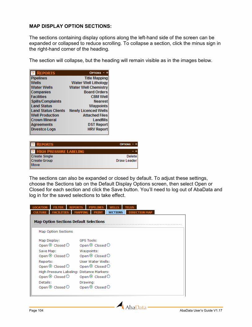
Page 104 AbaData User’s Guide V1.17
MAP DISPLAY OPTION SECTIONS: The sections containing display options along the left-hand side of the screen can be expanded or collapsed to reduce scrolling. To collapse a section, click the minus sign in the right-hand corner of the heading. The section will collapse, but the heading will remain visible as in the images below.
The sections can also be expanded or closed by default. To adjust these settings, choose the Sections tab on the Default Display Options screen, then select Open or Closed for each section and click the Save button. You’ll need to log out of AbaData and log in for the saved selections to take effect.

AbaData User’s Guide V1.17 Page 105
MAP DISPLAY WINDOW:
The Map Display window is the section of the screen where the map is displayed. In order to view the map, you must have first installed the Autodesk Mapguide Viewer (see Page 7).
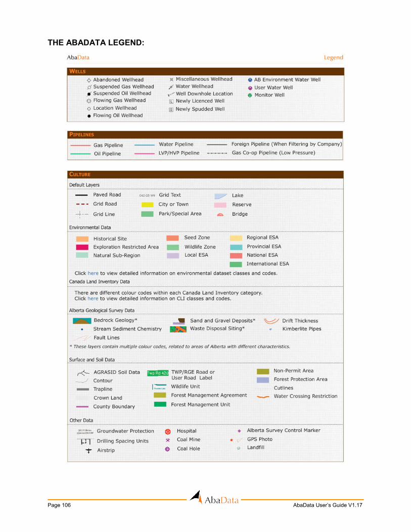
Page 106 AbaData User’s Guide V1.17
THE ABADATA LEGEND:

AbaData User’s Guide V1.17 Page 107
APPENDIX A – ERCB CODES
PIPELINE FACILITY CODES: Code Description B Battery BE Blind End CP Chemical Plant CS Compressor Station CO Consumer CK Creek ES Experimental Station GP Gas Processing Plant IP Injection / Disposal Facility LA Lake LH Line Heater (Category C or D) LR Oil Loading and Unloading Terminal MR Meter / Regulation Station MS Meter Station PP Petrochemical Plant PL Pipeline PS Pump Station PT Pipeline Terminal RE Reservoir RI River RF Refinery RS Regulator Station S Satellite SC Storage Cavern ST Storage Tank TF Tank Farm WE Well
PIPELINE STATUS CODES:
Code Description A Abandoned D Discontinued O Operating P To Be Constructed R Removed
PIPELINE SUBSTANCE CODES:
Code Category Description CO Crude Oil Blended crude bitumen, crude oil, synthetic crude oil FG Fuel Gas Fuel gas FW Fresh Water Potable water, surface water HV HVP Products Butane, ethylene, propane, pentanes, liquid ethane LV LVP Products Condensate, diesel fuel, gasoline, heating oil,
hydrocarbon diluents, kerosene, solvents MG Miscellaneous Gases Air, ammonia, carbon dioxide, ethane, helium, hydrogen,
nitrogen, steam

Page 108 AbaData User’s Guide V1.17
ML Miscellaneous Liquids Ammonia, caustic, glycol, methanol, polymer, sulphur, carbon dioxide
NG Natural Gas Methane, natural gas with < 10 mol/kmol of H2OE Oil Well Effluent Multiphase fluids
S content
SG Sour Natural Gas Natural gas with > 10 mol/kmol of H2SW Salt Water Produced water
S content
PIPELINE MATERIAL CODES: Code Description A Aluminum F Fibreglass G Composite P Polyethylene S Steel V Polyvinyl chloride
PIPELINE JOINT CODES: Code Description A Thru-Kote Welded B Butt Fusion C Bonded E Twin Lock F Flanged G Solvent Welded H High Energy Welded K Crimp Kote L Sure Lok M Mechanical Coupling P Pronto Lock R Triple Seal S Socket Fusion T Threaded W Welded Z Zap-Lok
PIPELINE INTERNAL COATING CODES: Code Description C Cement E Expanded Polyethylene G Grouted L Free Standing P Polyvinyl Chloride T Thin Film U Uncoated
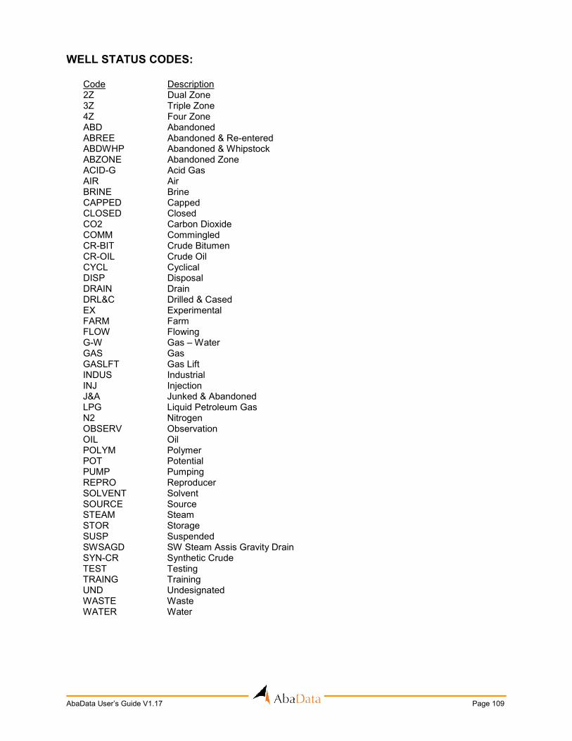
AbaData User’s Guide V1.17 Page 109
WELL STATUS CODES: Code Description 2Z Dual Zone 3Z Triple Zone 4Z Four Zone ABD Abandoned ABREE Abandoned & Re-entered ABDWHP Abandoned & Whipstock ABZONE Abandoned Zone ACID-G Acid Gas AIR Air BRINE Brine CAPPED Capped CLOSED Closed CO2 Carbon Dioxide COMM Commingled CR-BIT Crude Bitumen CR-OIL Crude Oil CYCL Cyclical DISP Disposal DRAIN Drain DRL&C Drilled & Cased EX Experimental FARM Farm FLOW Flowing G-W Gas – Water GAS Gas GASLFT Gas Lift INDUS Industrial INJ Injection J&A Junked & Abandoned LPG Liquid Petroleum Gas N2 Nitrogen OBSERV Observation OIL Oil POLYM Polymer POT Potential PUMP Pumping REPRO Reproducer SOLVENT Solvent SOURCE Source STEAM Steam STOR Storage SUSP Suspended SWSAGD SW Steam Assis Gravity Drain SYN-CR Synthetic Crude TEST Testing TRAING Training UND Undesignated WASTE Waste WATER Water
Page 110 AbaData User’s Guide V1.17
APPENDIX B – MAP DATA
PROJECTION: The AbaData map is in 10TM NAD83 Centered on 115.
PIPELINE & WELL DATA: All pipeline and well data comes from the ERCB and locations as shown on AbaData are to be considered approximate.
APPENDIX C – GLOSSARY
ERCB – The Alberta Energy Resources Conservation Board. Government agency responsible for regulating the Alberta oil and gas industry.