aaib bulletin: 8/2012 g-bwhf ew/c2012/01/03...aaib bulletin: 8/2012 g-bwhf ew/c2012/01/03 a witness...
TRANSCRIPT
13© Crown copyright 2012
8/2012 AAIB Bulletin: G-BWHF EW/C2012/01/03
ACCIDENT
Aircraft Type and Registration: Piper PA-31-325 Navajo C/R, G-BWHF
No & Type of Engines: 1 Lycoming TIO-540-F2BD piston engine 1 Lycoming LTIO-540-F2BD piston engine
Year of Manufacture: 1976
Date & Time (UTC): 18 January 2012 at 1117 hrs
Location: Long Mountain near Welshpool Airport, Powys
Type of Flight: Private
Persons on Board: Crew - 2 Passengers - None
Injuries: Crew - 2 (Fatal) Passengers - N/A
Nature of Damage: Aircraft destroyed
Commander’s Licence: Airline Transport Pilot’s Licence
Commander’s Age: 55 years
Commander’s Flying Experience: 11,164 hours (of which 375 were on type) Last 90 days - 3.0 hours Last 28 days - 2.0 hours
Information Source: AAIB Field Investigation
Synopsis
The commander was carrying out a flight to re-familiarise himself with the aircraft. After departing Welshpool and flying in the local area, he rejoined the circuit, was on the base leg and configured for landing when the aircraft struck cloud covered trees on the upper slope of Long Mountain. The aircraft then impacted a grass field where it caught fire. Both pilots were fatally injured.
History of the flight
The commander had retired from flying Commercial Air Transport operations with an airline in August 2011. He had recently renewed his single pilot Instrument Rating and Multi Engine Piston (Land) planes rating and his intention was to continue flying part-time. He
had been invited to fly G-BWHF, which was privately
operated for business purposes, but his last flight in this
aircraft was on 10 November 1998. Accordingly, he
planned to conduct a re-familiarisation flight.
The commander was accompanied by another pilot
who was not a flight instructor but had recent
experience of flying the aircraft and was familiar
with the aerodrome. A webcam recorded the pilots
towing the aircraft to the refuelling point, refuelling it
and carrying out pre-flight preparations. There were
no witnesses to any briefings which may have taken
place.
14© Crown copyright 2012
8/2012 AAIB Bulletin: G-BWHF EW/C2012/01/03
The commander first started the right engine, which initially ran roughly and backfired before running smoothly. The left engine started normally. The second pilot took his place in the front right seat.
The aircraft taxied to the holding point of Runway 22, and was heard by witnesses to be running normally. A witness who lived adjacent to the airfield but could not see the aircraft heard the power and propeller checks being carried out, three or four times instead of once per engine as was usual. The engines were heard to increase power and the witness observed the aircraft accelerate along the runway and takeoff at 1105 hrs. It climbed straight ahead and through a small patch of thin stratus cloud, the base of which the witness estimated was approximately 1,000 ft aal. The aircraft remained visible as it passed through the cloud and continued climbing. The witness turned away from the aircraft to continue working but stated that apart from the unusual number of run-up checks, the aircraft appeared and sounded normal.
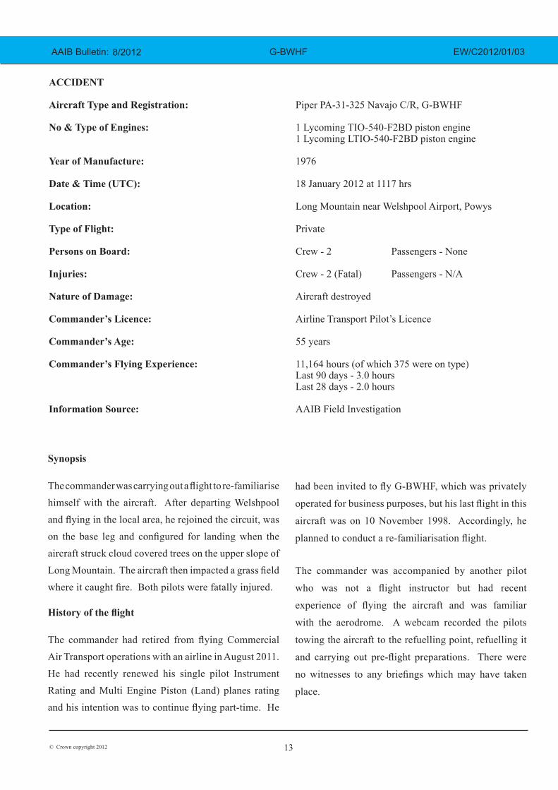
The pilot of a Robinson R22 helicopter which departed Welshpool at 1015 hrs described weather to the south of the aerodrome as drizzle with patches of broken stratus at 600-700 ft aal. He was able to climb the helicopter between the patches of stratus until, at 1,500 ft, he was above the tops of the cloud. Visibility below the cloud was approximately 5-6 km but, above the cloud, it was in excess of 10 km. He
noted that the top of Long Mountain was in cloud and his passenger took a photograph of the Long Mountain area which is shown at Figure 1.
The R22 returned to the airfield and joined left hand downwind for Runway 22. As it did so, its pilot heard a transmission from the pilot of the PA-31 stating that he was rejoining for circuits. The R22 pilot transmitted his position in order to alert the PA-31, then continued around the circuit and called finas before making his approach to the runway, landing at about 1115 hrs.
The PA-31 track is shown at Figure 2. After passing overhead Welshpool, it made a descending left circuit, becoming established on a left hand, downwind leg for Runway 22.
1047 hrs at GPS Alt 2,450 ft
Figure 1
Photograph taken by the R22 passenger showing the area of Long Mountain, covered in cloud in the upper part of the picture, approximately 30 minutes
before the accident
15© Crown copyright 2012
8/2012 AAIB Bulletin: G-BWHF EW/C2012/01/03
A witness approximately 3.5 nm northeast of the accident site saw the aircraft coming towards him with both propellers turning. It made a turn to the left with the engines apparently at a high power setting and, as it passed over Long Mountain, commenced a descent. He could not recall whether he could still hear the engines as the aircraft descended. He then lost sight of it behind the rising ground of Long Mountain.
A search was initiated when the aircraft failed to return to Welshpool. Its wreckage was located in an open field on the west slope of Long Mountain.
There were no witnesses to the actual impact with the trees or surface of the field but the sound was heard by a witness in the wood who stated that the engines were audible immediately prior to impact. The accident, which was not survivable, occurred at 1117 hrs. Both pilots were fatally injured.
Meteorological information
The Met Office provided an aftercast for the Welshpool area covering the time of the accident. At 1200 hrs, a weak cold front was lying west to east over Welshpool Airport. The nearest observations showed a west south-westerly surface wind at about 10 kt. To the west of the front, visibility was 8 km, and cloud broken with a base at 400 ft and broken with a base at 1,500 ft. Surface temperature and dew point were both 9°C. To the east visibility was 50 km and the lowest cloud layer was broken with a base at 1,200 ft. The temperature was 12°C and the dew point 9°C.
A more detailed indication of the weather in the area of Welshpool Airport at the time of the accident was provided by the R22 pilot. He described two distinct layers of stratus cloud, the lower of which had a base between 600 and 800 ft aal and tops at about 1,500 ft aal when he departed, approximately one hour before the
accident. This lower layer covered the tops of hills including Long Mountain but in the valleys there were small, well isolated patches of thin stratus with the same base as that covering the tops of the hills. The second, higher layer had a base between 3,000 and 4,000 ft aal. Visibility below the cloud was approximately 5 to 6 km and in excess of 10 km between the broken layers.
The R22 pilot reported that weather improved during his flight with the lower base rising to 1,000 ft aal as he joined the downwind leg. There were large gaps between the patches of cloud, which “easily” allowed him to remain VMC during his climb and descent above the lower layer of stratus.
Webcam images indicated a gradual improvement in the weather with patches of blue sky visible as the accident aircraft taxied. Two witnesses recalled being on the edge of the town in sunshine at about the time of the accident and seeing smoke from the accident site just below or at about the same level as the base of the cloud covering the top of Long Mountain.
Pilot background and experience
The aircraft commander started flying in 1989 and worked as a Flight Instructor before gaining a professional licence. His commercial flying commenced on a Cessna Citation business jet before moving to airline operations on the HS 748, followed by 10 years flying the Airbus A320 and Boeing 737. He retired from airline flying in August 2011 and, following a period of training, renewed his Flight Instructor (FI), Single Engine Piston (SEP) (land), Multi Engine Piston (MEP) (land) ratings and single pilot Instrument Rating (IR) in the last quarter of 2011 and January 2012. Prior to embarking on his commercial flying career, the commander had operated from Welshpool Airport.

16© Crown copyright 2012
8/2012 AAIB Bulletin: G-BWHF EW/C2012/01/03
The pilot occupying the front right seat was familiar with the local area and had operated from Welshpool for approximately 27 years. He flew several different types of aircraft and had amassed a total of 17,590 flying hours of which 2,177 hours were flying the PA-31 and 2,119 were flying G-BWHF. He had flown 348 hours in the last 90 days and 61 hours in the last 28 days. He was familiar with operating in and out of Welshpool Airport both by day and night. He had recently returned from multi-crew training in the USA where he attended a Rockwell Turbo Commander six monthly type recurrent training and revalidation course.
Aerodrome information
Welshpool Airport is known as Mid Wales Airport and is located 2 nm south of the town of Welshpool in the Severn valley. It has a single asphalt runway orientated 04/22, 1,020 m long and 18 m wide. It is equipped with a NDB and a DME, neither of which was in operation on the day of the accident. A commercially available flight guide for the aerodrome gave its elevation as 233 ft and included the following information:
‘The aerodrome is located in the River Severn Valley with high ground on each side of the valley. Pilots are advised not to descend below safety height until on the final approach after having positively identified the runway.’
It also carries a warning of high ground which states:
‘High Ground – 400’aal, 633’ amsl 1600 m to W, and 250’ aal, 483’ amsl 1500 m to E.’
Long Mountain is located approximately 2 nm north-east of Welshpool Airport and rises to a height
of 1,338 ft amsl, which includes a 28 ft mast 1,200 m south of the accident site. The highest adjacent terrain is to the east of the accident site and has an elevation of 1,280 ft.
Weight and Centre of Gravity
The following weight and centre of gravity calculations are based on estimated weights for the crew, fuel and items of aircraft and personal equipment onboard. The resulting weight and centre of gravity were approximations used in the flight trial described below.
The weight at takeoff was estimated as 5,724 lbs with 130 lbs of fuel used during the start, taxi and 12-minute flight. The estimated weight at the time of the accident was 5,594 lbs with the corresponding centre of gravity for both weights of 127.4 inches aft of the datum. The maximum permitted gross takeoff weight was 6,500 lbs and the fore and aft centre of gravity limits for both estimated weights were 126.4 inches and 138 inches aft of the datum respectively.
Based on these calculations, the aircraft was being operated within the maximum permitted all-up weight and within the centre of gravity range, close to the forward centre of gravity limit.
Medical and pathological information
Post-mortem examinations of both pilots revealed that they had died of severe multiple injuries caused when the aircraft struck the ground. The crash forces were outside the range of human tolerance and therefore the impact was not survivable. There was no evidence of any pre-existing condition that may have contributed to the accident and toxicology showed no evidence of drugs or alcohol in either occupant.

17© Crown copyright 2012
8/2012 AAIB Bulletin: G-BWHF EW/C2012/01/03
Recorded information
The Clee hill radar recorded the aircraft’s position and Mode C altitude1 approximately every eight seconds. The first radar return was recorded at 1106:37 hrs, just
Footnote
1 Mode C altitude assumes a QNH of 1013 hPa. This was corrected to the reported airport QFE of 1013 hPa by adding 233 ft to the radar altitude to produce an altitude amsl.
over 1 nm from the end of Runway 22, at an altitude of 1,433 ft amsl. The aircraft climbed to 3,223 ft amsl, tracking to the south of the aerodrome before turning in the opposite direction (Figure 2).
Figure 2
G-BWHF radar track (Map terrain elevations are shown in metres)
© Crown copyright. All rights reserved Department for Transport 100039241 2012
N
G-BWHF radar track
Accident
site Welshpool
Airport
Turning point
Altitude 3,233 ft
1,733 ft
First radar
return
Radar Groundspeed (kt)
Terrain elevation under track (ft)
Figure 2
G-BWHF radar track (Map terrain elevations are shown in metres)© Crown copyright. All rights reserved Department for Transport 100039241 2012
18© Crown copyright 2012
8/2012 AAIB Bulletin: G-BWHF EW/C2012/01/03
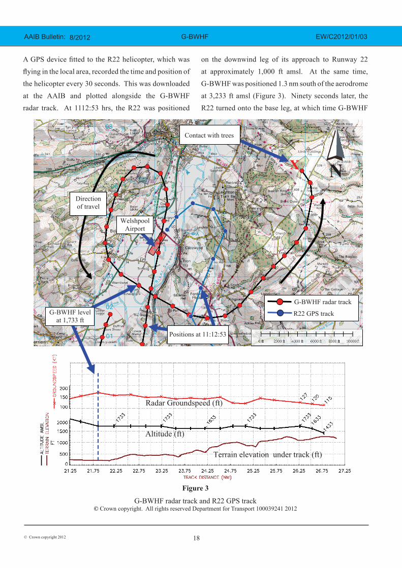
A GPS device fitted to the R22 helicopter, which was flying in the local area, recorded the time and position of the helicopter every 30 seconds. This was downloaded at the AAIB and plotted alongside the G-BWHF radar track. At 1112:53 hrs, the R22 was positioned
on the downwind leg of its approach to Runway 22 at approximately 1,000 ft amsl. At the same time, G-BWHF was positioned 1.3 nm south of the aerodrome at 3,233 ft amsl (Figure 3). Ninety seconds later, the R22 turned onto the base leg, at which time G-BWHF
Figure 3
G-BWHF radar track and R22 GPS track© Crown copyright. All rights reserved Department for Transport 100039241 2012
Figure 3
G-BWHF radar track and R22 GPS track
© Crown copyright. All rights reserved Department for Transport 100039241 2012
Positions at 11:12:53
X
G-BWHF radar track
R22 GPS track
Direction of travel
Welshpool Airport
Contact with trees
N
G-BWHF level at 1,733 ft
Radar Groundspeed (ft)
Altitude (ft)
Terrain elevation under track (ft)

19© Crown copyright 2012
8/2012 AAIB Bulletin: G-BWHF EW/C2012/01/03
was north of the airfield commencing a 180° turn and starting to descend.
At 1115:26 hrs, G-BWHF levelled off at 1,733 ft amsl (1,500 ft aal) just to the south of the aerodrome. Thirty seconds later the aircraft turned to the left and flew over the southern tip of Long Mountain, maintaining altitude as it did so but over rising terrain.
The last three radar returns show the aircraft turning to the left towards the accident site. Between the penultimate and last radar return, the recorded altitude reduced by 200 ft. The final radar return, at 1117:34 hrs, indicated an aircraft groundspeed of 115 kt, an altitude of 1,433 ft and a terrain clearance of 157 ft. The position of the first contact with the trees was 315 m from the last radar return with an estimated tree elevation of 1,339 ft amsl.
Engineering investigation
The aircraft
The aircraft was a Piper PA-31-325 Navajo C/R, fitted with two counter-rotating turbocharged Lycoming TIO-540-F2BD engines, driving three-bladed Hartzell variable pitch propellers. The aircraft’s log books indicated that, at the time of the accident, the aircraft had a total time in service of 5,480 hours. Both engines had been overhauled in August 2011 and had both accumulated 48 hours operation since overhaul. The aircraft had undergone a scheduled maintenance inspection in October 2011 and had a current Airworthiness Review Certificate when the accident occurred. The aircraft was equipped with two Garmin GNS430 GPS displays although the equipment manufacturer confirmed that neither unit had been modified to provide terrain warnings.
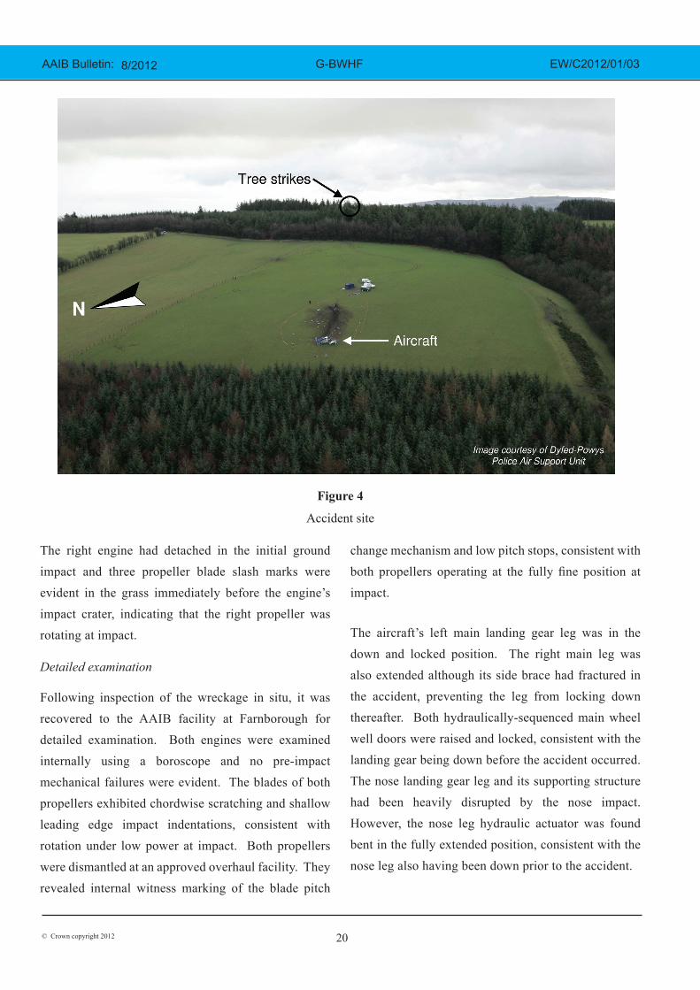
Accident site
The accident site was located on the top of Long Mountain. The aircraft had flown into an area of pine trees on the crest of the ridge, before impacting open ground on the downward-sloping westerly face of the ridge (Figure 4).
The aircraft’s left wing had struck two 80 ft pine trees approximately 20 ft below treetop height, causing the outer 2.2 m of the left wing, outboard of the left flap, to fragment and detach. Witness marks on the severed tree trunks indicated that the roll attitude of the aircraft at impact with the trees was wings level.
The wreckage trail, from the point of the initial tree strikes to the aircraft’s final resting position, was 230 m in length and was orientated on a heading of 298°M. Parts of all major sections of the structure and flying controls were identified at the accident site. The first ground impact scar was 185 m beyond the initial tree strike and had been made by the right wingtip; it was 20 cm wide and the narrowness of this mark indicated that the roll angle at ground impact was approximately 90° right wing low. The ground impact marks and distribution of the wreckage indicated that following the right wingtip strike, the right engine hit the ground and detached, shortly after which the aircraft impacted heavily on its nose. The absence of any significant ground scars between the nose impact crater and the main wreckage indicated that the aircraft then bounced a distance of 34 m, before finally coming to rest facing uphill. The wings were resting in a leading edge down orientation and the majority of the fuselage was lying inverted, with the tail furthest up the slope. An intense fuel fire had consumed approximately 60% of the aircraft, including the majority of the fuselage and empennage.
20© Crown copyright 2012
8/2012 AAIB Bulletin: G-BWHF EW/C2012/01/03
The right engine had detached in the initial ground impact and three propeller blade slash marks were evident in the grass immediately before the engine’s impact crater, indicating that the right propeller was rotating at impact.
Detailed examination
Following inspection of the wreckage in situ, it was recovered to the AAIB facility at Farnborough for detailed examination. Both engines were examined internally using a boroscope and no pre-impact mechanical failures were evident. The blades of both propellers exhibited chordwise scratching and shallow leading edge impact indentations, consistent with rotation under low power at impact. Both propellers were dismantled at an approved overhaul facility. They revealed internal witness marking of the blade pitch
change mechanism and low pitch stops, consistent with both propellers operating at the fully fine position at impact.
The aircraft’s left main landing gear leg was in the down and locked position. The right main leg was also extended although its side brace had fractured in the accident, preventing the leg from locking down thereafter. Both hydraulically-sequenced main wheel well doors were raised and locked, consistent with the landing gear being down before the accident occurred. The nose landing gear leg and its supporting structure had been heavily disrupted by the nose impact. However, the nose leg hydraulic actuator was found bent in the fully extended position, consistent with the nose leg also having been down prior to the accident.
Figure 4
Accident site
21© Crown copyright 2012
8/2012 AAIB Bulletin: G-BWHF EW/C2012/01/03
The left and right wing flaps were symmetrically
deployed and 10 threads were visible on the flap actuator
screw jacks on both flaps. The aircraft manufacturer
confirmed that this number of visible threads equated
to a flap deflection of 10°, which is an intermediate
position between flaps retracted and a fully deflected
setting of 25°.
Due to disruption caused by ground impact and
subsequent fire damage, it was not possible to confirm
flying control continuity in the cockpit section of the
aircraft. Continuity of the flying controls was traced
between the wing front spar station to the individual
control surfaces. All breaks in the control runs could
be attributed to either mechanical overload sustained
during the accident or intentional cuts made during the
recovery of the wreckage. The rudder trim tab was
observed to be in a neutral position. With the elevator
in a neutral position the elevator trim tab was set to 13°
trailing edge down, providing ‘nose up’ pitch trim.
It was not possible to determine the positions of the
fuel tank selector controls and fuel distribution valves
due to their disturbance as the aircraft broke up in the
accident. No fuel samples were taken from the aircraft’s
fuel system as all the fuel onboard had either leaked
or burned off in the post-accident fire. However, a
helicopter had refuelled with avgas from the same fuel
pump used by G-BWHF on two occasions; once on the
day preceding the accident and immediately after the
accident had occurred. The pilot of this helicopter did
not report any fuel quality problems.
Steel components from both the upper and lower halves
of the cabin entry door were identified in the wreckage.
The steel latch pin that locks the lower door to the
fuselage, whilst also retaining the upper door when
both door halves are closed, was found in the latched
position, indicating that the cabin door was closed and locked prior to the accident.
Whilst the majority of the aircraft’s instruments were consumed in the post-accident fire, fragments of some instruments had been thrown clear of the aircraft following the ground impact. These included the face of the commander’s primary altimeter, on which the subscale was set to 1014 mb. The face of the fuel flowmeter exhibited impact witness marks made by the fuel flow needles, indicating that at impact the gauge was displaying a fuel flow rate of 20 USG/Hr to both engines. Due to their fire-damaged condition it was not possible to establish rotational damage on either the electrical or vacuum driven gyro instruments. The left vacuum pump was examined and there was no evidence of pre-impact failures. The right vacuum pump had been destroyed by fire.
Flight trial
A Civil Aviation Authority test pilot carried out a flight trial using a PA-31-310, G-BEZL. The tested PA-31 differed from the accident aircraft in having engines 15 hp less powerful than the PA-31-325 which both rotated the same way rather than counter-rotating. The trial aircraft had also been modified by the fitting of a small sensor turret under its nose. This was likely to have increased the airframe drag compared to a standard aircraft but, according to the test pilot, by a “relatively negligible” amount in the gear and flap down configuration tested.
The trial takeoff weight was 5,800 lbs and CG 128” aft of datum.
Trials were completed with the gear down and the flaps pre-set before take-off to replicate the accident aircraft at the time of the crash. Mixture was fully rich and cowl flaps open. The following manoeuvres were flown:
22© Crown copyright 2012
8/2012 AAIB Bulletin: G-BWHF EW/C2012/01/03
● Straight and Level with Power For Level Flight
at 108, 110, 115, 120 KIAS
● Descents at 20/20 USG/hr fuel flow at 115 and
120 KIAS
● Descent/Level flight at 20/20 USG/hr with
elevator at accident trim
● Elevator Fixed & variable nose-up/nose-down
trim
● Rate 1 turns left & descents from Straight and
Level to replicate base turn
● Trim change assessed with change of rpm
settings
A reference measurement was used to set the trim tab to
the same position as on the accident aircraft. This was
marked on the test aircraft trim indicator and then used
to set up the test point. The aircraft was then set up with
20 USG/hr fuel flow on each engine and a descending
flight path noted. At 115 KIAS approximately 3 lbs
push force was required to prevent the nose from rising
and to maintain the airspeed. If this push force was
not applied the aircraft tended to remain in the level
flight attitude with the airspeed decreasing. The
centre of gravity on the test aircraft was approximately
half an inch aft of the accident aircraft but this small
difference would not account for the noticeable push
force required. Although different aircraft might trim
differently it is evident that the accident aircraft was
unlikely to be in a nose-down trim configuration and
releasing the controls in the lead up to the accident
would not have been responsible for pitching the
aircraft nose-down.
The aircraft elevator position was marked in straight and
level flight at 115 KIAS. The control column was then
held fixed and the electric elevator trimmer operated,
such that the trim tab would behave like a small elevator,
in the opposite sense to the trim input indicated in the
cockpit. When trimmed fully nose-down the controls
required approx 5 lbs push force to hold them fixed
but the aircraft remained in level flight. When trimmed
nose-up there was a noticeable nose-down attitude
change despite a similar force being applied to hold the
control column fixed.
With the aircraft trimmed at 115 KIAS in a “downwind”
configuration at 2,400 rpm and 27/27 MAP set, the prop
pitch controls were advanced briskly to fully fine. No
pitch change was evident.
The descending turn prior to the accident would have
required a deliberate reduction in power and would
have required a pitch trim change. There was no
evidence that the elevator trim applied at the time of
accident would have contributed to a nose-down pitch
change had the control column been inadvertently
released.
Analysis
The aircraft commander was properly qualified to
carry out the private flight, the purpose of which was
to re-familiarise himself with G-BWHF. Having not
flown the PA-31 for some years, he was accompanied
by another pilot who was not a flight instructor but
had recent experience of flying the aircraft. Although
both pilots had a multi-crew background, the aircraft
was normally flown as a single pilot operation. It is
probable that the flight was being conducted as a single
pilot operation but with the second pilot available to
assist if required rather than fulfilling any instructional
function. There were no witnesses to any crew briefing
which may have taken place.
23© Crown copyright 2012
8/2012 AAIB Bulletin: G-BWHF EW/C2012/01/03
The weather had improved during the morning and cloud was thin enough to see through as evidenced by a witness who saw the aircraft take off. Visibility above the cloud was better than below, but even below, the cloud flight was possible under VFR. The circuit was wider than normal but this may have been an effort not to conflict with the Robinson helicopter or to give more time for the commander’s first approach.
The aircraft made a descending left turn over the aerodrome and joined the downwind leg of the circuit. At some point the flap was set to about 10°, the landing gear was lowered and the propellers set to fully fine. During this configuration change, the elevator would normally have been re-trimmed nose-up. The witness who saw the aircraft coming towards him could not see the cloud covering Long Mountain but could clearly see the aircraft which, given his location, placed the aircraft above and clear of the cloud.
The flight trial demonstrated that the trimmed state of the aircraft would have required a forward control column input to achieve the nose-down attitude described by
the witness. The flight trial established that, if the elevator was jammed, the application of nose-up trim would have resulted in the aircraft pitching nose-down. However, there was no evidence of the elevator having been jammed although it is probable that impact and fire would have destroyed any such evidence.
The investigation did not determine whether the nose-down attitude was the result of a jammed elevator or an attempt to reduce height. Both pilots would have been aware of the proximity of Long Mountain but may have thought they had cleared the high ground. It is unlikely that they would have deliberately entered the cloud but may have misjudged their height above it and inadvertently entered the top of the cloud which was obscuring the trees.
Conclusion
The aircraft struck the tops of the trees located on the upper slope of Long Mountain, while descending for a visual approach to land on Runway 22 at Welshpool Airport. The trees were probably not visible to the pilots because of cloud covering the upper slopes.