a vision for the future
TRANSCRIPT

Urban Planning | Urban Design | Landscape Architecture
TIM NOTT economic analysis + strategy
Stawell Town Plan A Vision for the Future
Prepared by Hansen Partnership, Tim Nott & Martyn Group for Northern Grampians Shire Council MARCH 2021
STAWELL STRUCTURE PLAN
Adopted by Council - April 2021
Stawell Structure Plan
Hansen Partnership Pty Ltd, Tim Nott & Martyn Group2
Contents
Version Draft-1 Draft for Exhibition Final for Briefing Final for Adoption
Issue Date 16.10.2020 26.11.2020 08.02.2021 17.03.21
1.0 Introduction 3
2.0 Background & Context 42.1 About Stawell 4
2.2 Population & Profile 6
2.3 Policy Context 7
2.4 Community & Stakeholder Feedback 8
2.5 Drivers of Change & Guiding Issues 9
3.0 Vision & Principles 103.1 Vision Statement 10
3.2 Principles 10
4.0 Structure Plan Elements 124.1 Urban Structure, Character & Identity 14
4.2 Residential Development 17
4.3 Employment & Economic Development 21
4.3 Activity Centres 25
4.4 Access & Movement 28
4.5 Natural Environment & Landscape 32
4.6 Community Facilities & Open Space 35
4.7 Services & Utilities 38
5.0 Implementation 39
5.1 Implementation Table 40
5.2 Strategic / Further Investigation Sites 43

Stawell Structure Plan
Hansen Partnership Pty Ltd, Tim Nott & Martyn Group 3
1.0 Introduction
Stawell is going through an exciting period of change. Planning for and harnessing this change is vitally important for securing the positive community benefits that will arise and ensuring the unique qualities of Stawell endure.
The Western Highway duplication will mean that the proud historic gold mining town will be the first stop from Melbourne and the last stop from Adelaide. This will enhance the accessibility of Stawell from Melbourne and decrease travel times as it becomes the tourism and economic gateway to the Grampians National Park and Western Victoria.
As a result, Stawell’s unique qualities, such as the Stawell Gift, Australia’s longest running foot race, will be on display like never before. New opportunities will also open up, with unique and iconic opportunities such as the Stawell Underground Physics Laboratory already finding a home in Stawell. The great regional connections are already a key driver of investment in the township that will only be enhanced.
This Structure Plan therefore comes at an important time to ensure a roadmap is in place that will provide a clear direction to navigate the township through this exciting period. A proactive response is required that anticipates rather than reacts to change.
Project OverviewThis project forms part of the broader Stawell Town Plan project which is seeking to achieve Council’s long-term strategic ambition to make Stawell a better place to live, work, invest and visit (Council Plan 2017-2021).
The Town Plan project includes two components: the current document which is a Structure Plan for the township of Stawell; and an Urban Design Framework, which has identified a vision and directions for future investment and development along the Western Highway, with an ambition to enhance the arrival experience into Stawell.
The Stawell Structure Plan sets out a long-term vision for the township and provides a roadmap to guide the future planning of the area over the next 20 to 30 years. The plan establishes a framework and outlines key directions and opportunities for change to foster the future growth and development of the township.
Hansen Partnership, Tim Nott Economics and Martyn Group have been engaged by Northern Grampians Shire Council to undertake this project on behalf of Council with input provided by the Victorian Planning Authority (VPA).
What is a Structure Plan?A Structure Plan is a long-term plan to guide Council decisions about future development on private and public land within a town or centre. It outlines a vision and key objectives and strategies to implement its goals in line with community expectations. Key outcomes of a structure plan can result in changes to the Planning Scheme to provide direction on the assessment of planning permit applications and amendments to the Planning Scheme. It can also provide input into Council’s program of works and projects and assist with advocating for public funding.
Why is a Structure Plan Needed?Stawell is the main regional economic and service centre within Northern Grampians Shire. There are a number of exciting projects and changes occurring in Stawell that could lead to significant economic and employment opportunities. The creation of a new Structure Plan has come at an important time to ensure that the community can be at the forefront of this change and help facilitate its image.
The Structure Plan will guide the type and location of future development and growth in Stawell and seeks to outline a long-term strategic vision so that important opportunities for the Shire are seized and enhanced.
The purpose of the structure plan will be to:
▪ Identify locations for new residential development, including opportunities for infill housing.
▪ Focus on key access roads and traffic management solutions in the township.
▪ Confirm the key economic and employment opportunities of the town.
▪ Identify the key characteristics and features of the township that should be protected.
▪ Embed a network of public open space and community facilities.
Underpinning this will be ensuring that the valued heritage character and environmental values of the town are protected.
Structure of DocumentThe structure of this document is broken into four main sections.
▪ The first section outlines the background information that has informed the development of this plan including relevant statistics, strategies and policies, and previous background work undertaken. The key issues and drivers of change are summarised.
▪ The second section outlines the vision and key principles underpinning the structure plan.
▪ The third section outlines the main objectives and strategies of the structure plan and the actions required for its implementation.
▪ The fourth section outlines an implementation plan.
Project Process to Date ▪ Phase 1: Background Analysis & Discussion Paper outlining an understanding of
existing conditions and identification of issues and opportunities (June 2020).
▪ Phase 2: Preparation of an Urban Design Framework for the Western Highway (October 2020).
▪ Phase 3: Preparation of a Structure Plan for the township of Stawell (current).
VISION & PRINCIPLES
STRUCTURE PLAN
ELEMENTS
OBJECTIVESIdentifies the key overarching
directions for each strcuture plan element.
The Vision and Principles define the overarching aspirations to guide the long term growth and development of Stawell and are embedded
within each of the Structure Plan elements.
+Urban Structure, Character & Identity
+Residential Development+Employment & Economic
Development+Activity Centres
+Access & Movement+Natural Environment &
Landscape+Community Facilities & Open
Space+Services & Utilities
BACKGROUND ANALYSIS Identifies the background information that has informed the Structure Plan and summaries the key Drivers of Change and
Guiding Issues .
IMPLEMENTATION Outlines a plan to implement the various actions identified through
the Structure Plan, with key mechanisms, responsibilities, and timing identified.
STRATEGIESOutlines how the objectives will be
achieved for each structure plan element.
ACTIONSSets out tangible actions to
implement the strategies for each structure plan element.

Stawell Structure Plan
Hansen Partnership Pty Ltd, Tim Nott & Martyn Group4
2.0 Background & Context
This section outlines the context of the Stawell and the key issues and drivers of change that have informed the preparation of this structure plan.
2.1 About StawellStawell is located within the Wimmera Region of Victoria, approximately 236km to the west of Melbourne. It is the main settlement in the Northern Grampians Shire. According to the 2016 Census, Stawell had a residential population of 6,052 persons. The town sits to the northeast of the Grampians National Park and plays a large role in regional tourism.
The closest major townships to Stawell are Ararat (30km to the south) and Horsham (67km to the north) which are both accessed along the Western Highway. Stawell is located at the intersection of a number of highways and is therefore the focal point of the surrounding region. The Western Highway is currently being duplicated between Ararat and Stawell.
The township of Stawell has historically serviced mining and agricultural industries operating in the region. While it continues to service these industries, it also services the local community and tourism activity in the broader Grampians region. The historic mining activity remains socially and economically important for the township, with the Stawell Gold Mine continuing to function.
The town centre first developed along Longfield Street, now known as the Western Highway, adjacent to Pleasant Creek where gold was first discovered in 1853. Several historic buildings still exist in this area including the former shire hall office (1866) and the original courthouse (1860), which now operates as a local history museum.
The historical growth of the town has resulted in a complex structure with a variety of land uses developing at different times in various locations. The resulting urban structure comprises of a number of grid patterned areas converging on key movement routes. The CBD is the main anchor for commercial and retail activity situated along a meandering Main Street which is lined with fine grain attractive Victorian terrace buildings.
The landscape and environmental character of Stawell is underpinned by the many bushland reserves surrounding the township and the present views to the surrounding Grampians National Park. High points in the township and surrounds include the Big Hill Lookout, offering panoramic views across Stawell, the Big Hill Parklands and Gardens Reserve. Proud public gardens throughout Stawell contribute to its strong public amenity.
Stawell is well-renowned for the annual hosting of the Stawell Gift which brings many visitors and tourists to the area each year. The event represents the proud sporting history of the town which is still present today with significant regional sporting facilities and an active community.

Figure 1 - Study Area

Stawell Structure Plan
Hansen Partnership Pty Ltd, Tim Nott & Martyn Group6
2.2 Population & Profile
Stawell has a total population of 6,032 residents (ABS 2016). This is just under half of the Northern Grampian Shire’s total population of 12,570 persons. In terms of the wider Stawell district/catchment area, the estimated residential population is 8,109.
Historic ABS data reveals that the population of Stawell has remained relatively stable over the 15 year period between 2001 and 2016. Victoria in Futures (VIF2019) anticipates a slight population decline of 0.4% per year between 2019 and 2036 within the wider catchment area. This would result in a total decline of 519 residents over that period and a total estimated population of 7,590 residents in 2036.
The median age of Stawell is 47 years, compared to 37 years in Victoria. The older population cohort (i.e. those over 65 years in age) is greater than the State-wide percentage for this age group (15.6%). Since 2006, the resident population of those aged 65 and over increased by 5.3%. This demonstrates that, similar to other regional centres, Stawell has an aging demographic.
Stawell is becoming more diverse with 7.4% of the population now born overseas, an increase of 32% 10 years ago.
In terms of households, 61.4% are comprised of family households, 34.9% single person households, and 3.7% group households. The average household size is 2.2 persons. Of the families in Stawell, 33.4% are couple families with children and 48.6% are couple families without children.
Having regard to private dwelling ownership, 42.2% own outright, 27.4% own with a mortgage, and 26.3% rent.
6,0322016
2011
2006
6,1506,035
47 37STAWELL VICTORIA
5.3%65+ 65+
33.4% 3.7%48.6% 34.9%
Fully Owned Mortgage
Rent (Private)
42.2% 27.4%
26.3%Rent (Social
Housing)
4.1%
10 YEARS
32%
Population Household Composition
Housing Tenure
Born Overseas
Median Age
Aging Population
Statistics Snapshot

Stawell Structure Plan
Hansen Partnership Pty Ltd, Tim Nott & Martyn Group 7
2.3 Policy Context
The Structure Plan has been prepared having regard to a range of existing State, regional and local policies and strategies as outlined within background documentation and the Planning Policy Framework (PPF) and Local Planning Policy Framework (LPPF) of the Northern Grampians Shire Planning Scheme.
The below provides a summary of key policy across a range of strategic themes.
Settlement and Housing Stawell is the Shire’s largest urban centre (district town) and a key service hub for the Wimmera Southern Mallee region. State and local policy seeks to ensure Stawell is supported and promoted as a key service hub for the Wimmera Southern Mallee region and supports the majority of all growth in the Shire.
Stawell’s cohesive relationship with Ararat, as recognised in State policy and the existing Local Area Strategic Framework Plan, provides the opportunity to develop the towns as a sub-regional cluster of housing, employment and service provision.
A key policy priority is to accommodate population growth within Stawell. It has capacity to accommodate the majority of projected housing growth within the Shire whilst recognising potential land use conflicts between rural zones and land identified for housing development. It has a complex township structure with a variety of land uses developing over time resulting in conflicts between uses such as industry and residential areas.
The Northern Grampians Shire Housing Needs and Residential Land Supply Assessment (2018) outlines recommendations to address residential land supply in Stawell, which include diversification of the housing mix (townhouses and aged care village style development), increasing greenfield land supply in serviceable locations, and reducing and rationalising the Rural Living Zones close to Stawell.
Economic Development Key to Council’s current vision for Stawell is encouraging commercial, retail and industrial development within the key centre to generate jobs and stimulate economic growth across the region. State policy also seeks to promote and provide for an ongoing supply of industrial land in Stawell, together with other regional and sub-regional hub locations.
Stawell’s proximity to the Grampians National Park makes it a key gateway location for tourism. Policy supports integrated retail and tourism investment in Stawell to capitalise on its gateway status.
Policies and strategies note that Stawell has a surplus of underutilised industrial land, notably, the Western Stawell Business Precinct, which should be targeted as a clear area for investment and future expansion.
The regional economic significance of Stawell Gold Mine as Victoria’s largest operating mine should be promoted and supported.
Transport and InfrastructureIn terms of transport infrastructure, policy recognises the importance of the Western Highway for urban development, economic growth and tourism in the Shire. Policy seeks to encourage development of land to support the duplication of the Western Highway to Stawell and also encourages development to support the service business centre function of the Highway.
The importance of the passenger and freight rail infrastructure to the community and local economy is highlighted. The Stawell Aerodrome is also recognised as a valuable regional and strategic economic asset and major emergency response base. As such, policy supports its continued operation and future expansion.
Environment Environmental policy seeks to protect and conserve significant natural environments and landscapes of the region, including the Grampians and lake Lonsdale to the west of Stawell, and the surrounding waterways including Pleasant Creek and Concongella Creek.
Local policy specifically recognises the Grampians National Park as a major natural feature and tourist attraction.
Policy also seeks to manage environmental risk from bushfire, landslides, flooding and salinity.
Planning Controls Review A 2018 Planning Scheme Review was undertaken into the Northern Grampians Shire Planning Scheme.
Relevant outcomes noted:
▪ The need for a review of the General Residential Zone (GRZ) application, noting its lack of strategic intent and anomalies in its application.
▪ The rationalisation and review of the Rural Living Zone (RLZ), to consider application of the Restructure Overlay on some of these areas to address older, smaller rural subdivisions.
▪ The rationalisation of the commercial zones near Pleasant Creek to align with property boundaries.
▪ The preparation of a Western Highway Land Use Strategy and Urban Design Framework to review the zoning and overlay regime on the Western Highway Precinct at Stawell, having regard to its development potential and the Western Highway Duplication Project.
▪ The preparation of a Structure Plan for Stawell to analyse opportunities and constraints and review the zoning and overlay regime to align with current environmental constraints.

Stawell Structure Plan
Hansen Partnership Pty Ltd, Tim Nott & Martyn Group8
2.4 Community & Stakeholder Feedback
Community and stakeholder consultation has been integral to the development of this structure plan. Sessions were held with the community and an online portal with a survey was set up following the preparation of the Discussion Paper.
Key themes arising from this consultation have been outlined below.
Character and IdentityThere is a real sense of pride about Stawell’s valued and celebrated qualities including its history and heritage buildings, the Stawell Gift, parks and gardens, gold mine, views to the Grampians and attractive town centre. It was considered that these attractions and history should be strongly conserved and promoted.
The potential naming of the precinct around the Western Highway / Seaby Street intersection as ‘Pleasant Creek’ was suggested through the project. This issue is beyond the scope of the Structure Plan and could be considered through another forum such as a Council meeting.
HeritageHeritage buildings and sites are a real asset to Stawell, particularly along Main Street and places connected to the town’s gold mining history. Promotion of the town’s heritage was seen as key to stimulating economic and tourism growth.
HousingSignificant deficiencies in both supply and diversity of housing were repeatedly raised. Residents noted a lack of rental vacancies, low-cost housing, and downsizing options. It was also highlighted that there are minimal houses for sale, and no construction or subdivision activity due to existing constraints.
Traffic & MovementThe good regional connections to Stawell were highlighted. There was strong support for the signalisation of the Seaby Street / Western Highway intersection due to safety reasons. Residents were also keen for active transport to be promoted through town (e.g. town centre ‘circuit’ linking key destinations such as parks and facilities) as well as improvements and promotion of rail trails
EconomicThe diverse industry base was seen as a real asset to the town as well as the good commercial and industrial land supply. There was an optimism of potentially significant economic and local employment opportunities from key initiatives such as the dark matter lab, abattoir, gold mine and town centre investment. It was also highlighted that an emphasis should be placed on addressing the Western Highway’s attractiveness and function to draw visitors to the town centre.
Community Services & FacilitiesStawell was seen as being rather well-serviced, with residents highlighting that the range of community facilities, such as health services, and open spaces, are a key attractor for new residents. There was an understanding however that there is a lack of youth services, limited range of activities for this demographic, and deficient job pathways and training opportunities to encourage young people to remain in Stawell. Stawell Town Plan Student Art Project, June 2020

Stawell Structure Plan
Hansen Partnership Pty Ltd, Tim Nott & Martyn Group 9
2.5 Drivers of Change & Guiding Issues
Based on the background work and consultation carried out as part of this project (please refer to the Stawell Structure Plan & Urban Design Framework Discussion Paper August 2020), a number of key issues and drivers of change have been identified. These are considered to be the key influences on Stawell that the Structure Plan has sought to respond to. They have been summarised as follows.
WESTERN HIGHWAY DUPLICATION
The Western Highway will bring significant economic benefits as Stawell becomes the first township based service hub when travelling from Melbourne and will form part of the fastest route to the Grampians.
TOURISM
Stawell benefits from key regional tourism strengths forming part of the gateway to the Grampians and the well-renowned yearly Stawell Gift. It also attracts significant visitor numbers from passing traffic on route between Melbourne and Adelaide.
COMMUNITY PRIDE
There is a real sense of community pride in the history and identity of Stawell, particularly it’s sporting role and heritage qualities. Ensuring these qualities endure is vital for protecting the special features that attract people to Stawell.
MAJOR PROJECTS
Large projects such as the proposed Nectar farm glass-houses and the Dark Matter underground laboratory have the potential to generate significant local employment opportunities.
CHANGING POPULATION
There has been a persistent slight decline in the population of Stawell over the last 30 years. This is likely to continue into the future. Similar to other regional centres, it has an ageing population, and difficulties retaining young workers.
AVAILABLE COMMERCIAL AND INDUSTRIAL LAND
Stawell appears to have a sufficient amount of existing commercial and industrial land to meet likely demand over the next 15 or more years. There is however a range of underutilised land and vacant buildings that could be invested in.
GOOD SUPPORTING SERVICES
Stawell has a good range of community services and facilities with some facilities available that would usually be found in much larger settlements. This range situates the town well to accommodate further population growth.
LACK OF HOUSING
It has been repeatedly raised throughout this project that Stawell currently lacks a sufficient supply and diversity of housing. This is one of the key issues facing Stawell. The housing market is not currently providing for a range of housing that responds to the diverse needs of the existing community and prospective future residents. Limited greenfield and infill development has occurred in recent years.
Stawell Structure Plan
Hansen Partnership Pty Ltd, Tim Nott & Martyn Group10
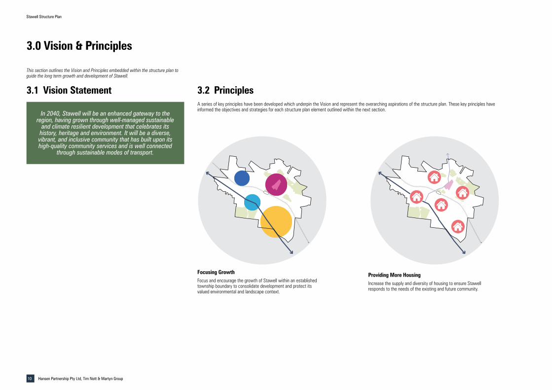
3.1 Vision Statement 3.2 Principles
In 2040, Stawell will be an enhanced gateway to the region, having grown through well-managed sustainable
and climate resilient development that celebrates its history, heritage and environment. It will be a diverse, vibrant, and inclusive community that has built upon its high-quality community services and is well connected
through sustainable modes of transport.
A series of key principles have been developed which underpin the Vision and represent the overarching aspirations of the structure plan. These key principles have informed the objectives and strategies for each structure plan element outlined within the next section.
Focusing GrowthFocus and encourage the growth of Stawell within an established township boundary to consolidate development and protect its valued environmental and landscape context.
Providing More HousingIncrease the supply and diversity of housing to ensure Stawell responds to the needs of the existing and future community.
This section outlines the Vision and Principles embedded within the structure plan to guide the long term growth and development of Stawell.
3.0 Vision & Principles
Focusing Growth Providing More Housing Celebrating IdentityFocusing Growth Providing More Housing Celebrating Identity

Stawell Structure Plan
Hansen Partnership Pty Ltd, Tim Nott & Martyn Group 11
Responding to Climate ChangeAdopt best practice principles when responding to climate challenges and sustainability to embed climate resilience into the community and future growth of Stawell.
Celebrating IdentityCelebrate and enhance the unique defining characteristics of the town that are strongly valued by the community such as its sporting history, heritage places, and many parks and gardens.
Enhancing the GatewayReinforce Stawell as the tourism and economic gateway to the Grampians National Park and region by, amongst other things, building on the opportunities provided by the Western Highway duplication project which will enhance accessibility to the town.
Focusing Growth Providing More Housing Celebrating IdentityEnhancing the Gateway Reinforcing Two Centres Responding to Climate Change Enhancing the Gateway Reinforcing Two Centres Responding to Climate ChangeEnhancing the Gateway Reinforcing Two Centres Responding to Climate Change
Reinforcing Two CentresRetain the primacy of the town centre for commercial development and local convenience while providing opportunities along the Western Highway in line with its strong tourism role.
Protecting the Environment Moving through Stawell Enhancing the EconomyProtecting the Environment Moving through Stawell Enhancing the EconomyProtecting the Environment Moving through Stawell Enhancing the Economy Servicing the Community
Protecting the EnvironmentProtect and enhance the valued environmental setting of Stawell from it’s Iron Bark bushland setting to its prominent views to the Grampians.
Moving through StawellProvide a safe transportation network for all users that builds on existing connections and prioritise sustainable and space efficient transport.
Building the EconomyEnhance the local economy by building on its strategic strengths, road, rail and air connections, and ensuring sufficient land is available to support economic growth.
Servicing the Community
Enhance connections between the great range of community facilities and ensure new development provides further facilities and infrastructure.

Stawell Structure Plan
Hansen Partnership Pty Ltd, Tim Nott & Martyn Group12
4.0 Structure Plan Elements
This section outlines the Structure Plan for Stawell, which identifies a roadmap for the growth and development of the town over the next 20-30 years. It is broken into a number of key elements which each have a range of objectives, strategies, and actions to assist with implementation. Each element has been informed by the overarching directions provided by the Vision and Principles.
The key elements are outlined as follows:
▪ Urban Structure, Character & Identity
▪ Residential Development
▪ Employment & Economic Development
▪ Activity Centres
▪ Access & Movement
▪ Natural Environment & Landscape
▪ Community Facilities & Open Space
▪ Services & Utilities
The overall Structure Plan is outlined in Figure 2.
Each Structure Plan Element has been structured so that it can be read as a standalone section and defines separate objectives, strategies, and actions.
The structure of each section is outlined as follows:
▪ Overview: provides a general discussion of the key themes and issues of each element to assist with understanding the topic and approach taken.
▪ Objectives: defines high level statements that provide direction for each structure plan element.
▪ Strategies: outlines key ways in which the objectives should be achieved.
▪ Actions: sets out key tangible actions to implement the strategies such as further Council works and strategic projects.

Stawell Structure Plan
Hansen Partnership Pty Ltd, Tim Nott & Martyn Group 13
DEEP LAND NATURE
CONSERVATION RESERVE
TO ADELAIDE
TO HALLS GAP
TO MELBOURNE
BIG HILL PARKLANDS & GARDENS RESERVE
STAWELL GOLD MINE
NORTH PARK STAWELL SPORTS &
AQUATIC CENTRE
STAWELL RACECOURSE
STAWELL GRAMPIANS
CARAVAN PARK
STAWELL AIRPORT
STAWELL WASTEWATER TREATMENT
PLANT
ILLAWARRA NATURE
CONSERVATION RESERVE
RIFLE RANGE BUSHLAND RESERVE
WILDCAT HILL BUSHLAND RESERVE
STAWELL CEMETERY
STAWELL STATION
ALBION BUSHLAND RESERVE
STAW
ELL A
VOCA
ROA
D
GRAMPIANS ROAD
GILCHRIST ROAD
POM
ONAL
ROAD
HORSHAM ROAD
WESTERN HIGHW
AY
DONALD-STAWELL ROAD
PATRICK ST
LOND
ON R
OAD
SEAB
Y ST
PLAY
FORD
ST
SCALLAN ST
SLOA
NE S
T
HINE
S RO
AD
GRAN
T ST
HOUSTON ST
BARNES ST
CLIFTON AVE
NEWINGTON ROAD
BYRNE ST
CROWLANDS ROAD
Stawell Structure Plan
Future Urban Structure
Project Ref: Dwg No.:Scale:Date:
2019.648SP-001
20000 at A305.02.2021
Settlement Boundary
Town Centre
Stawell Residential Area
Priority Residential Infill Area
Strategic Residential Development Sites
Commercial Areas
Mixed Use Area
Community Uses
Open Space / Parklands
Bushland Reserve
Established industrial areas
Industrial Area Expansion
Strategic Tourism Site
Utility
Treatment Plant ESO Buffer
Passive open space to be formalised
Western Highway
State Declared Road
Local Connector Road
Township GatewayProposed Signalised
Intersection
Proposed future level crossing upgrade.
Primary Pedestrian Network
Regional Cycling Priority
High Amenity Streetscapes
Rail Corridor
Stawell Railway StationKey Destination -
Community Facility
Key Intersection
Western Highway Interchange
Legend
Rural Planting Corridor
Key Destination- Landscape & Environment
Existing and Proposed Activity Node
Potential LDRZ Growth
Residential Growth Area
Urban Growth Area
Rezone to LDRZ
Figure 2 - Future Urban Structure

Stawell Structure Plan
Hansen Partnership Pty Ltd, Tim Nott & Martyn Group14
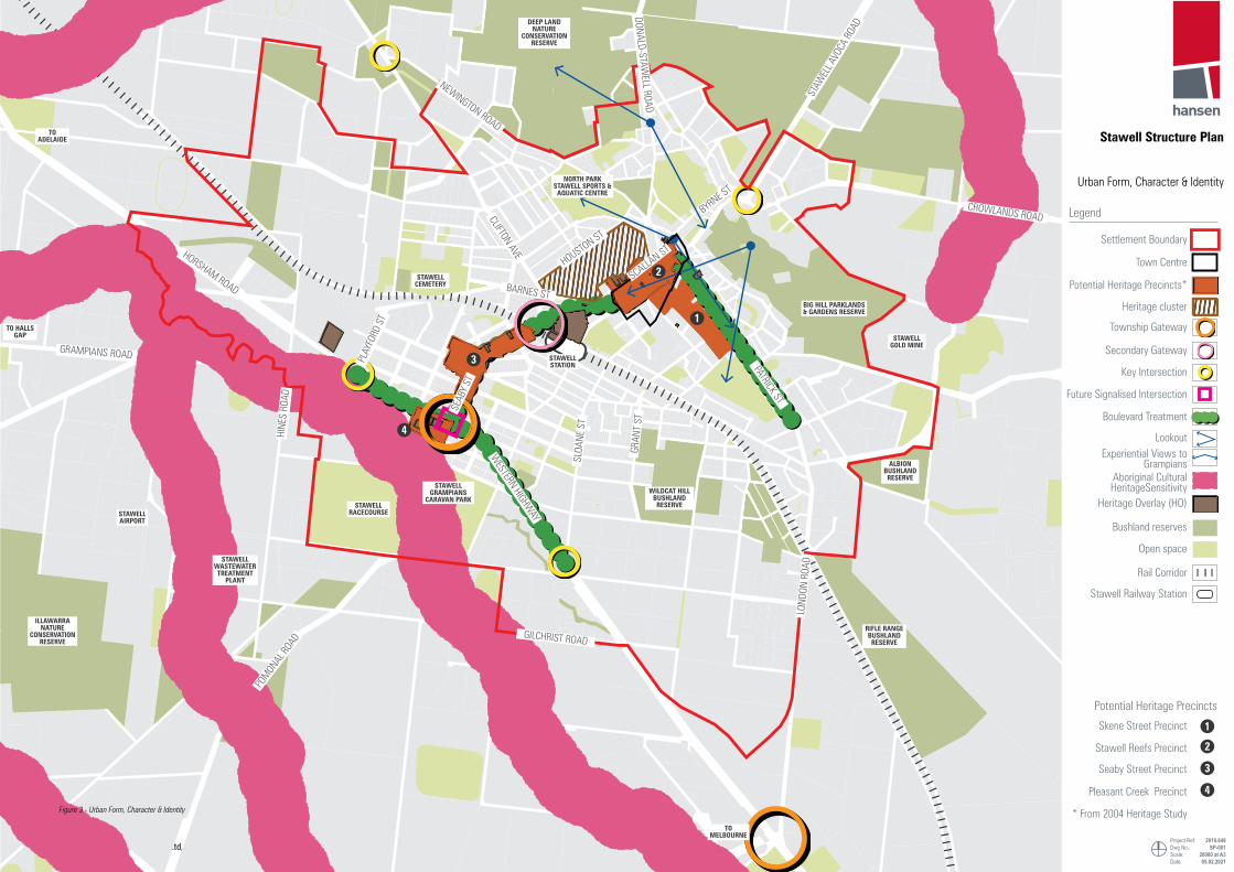
4.1 Urban Structure, Character & Identity
OverviewThis section looks at ways to ensure that, while Stawell may develop and change, the important characteristics that make it a great place to live and work are protected, enhanced, and celebrated.
Township BoundaryThe structure plan is focused on encouraging the growth and development of the town. An important consideration to help guide and focus this growth is defining a township boundary. Without a clearly defined township boundary, surrounding valued environmental features and productive agricultural land can be put at risk from development. It also helps to provide certainty around where development and growth is expected.
A clear township boundary can help to:
▪ Protect important environmental features by limiting the encroachment of development and the fragmentation of land at the outskirts.
▪ Promote a compact urban form through the consolidation of growth around existing services and infrastructure.
▪ Provide certainty to the community and developers about the limits to township growth.
There are a number of constraining elements limiting the growth of Stawell. The following considerations have been used to define the boundary:
▪ The environmental constraints to the north, east, and west of the town and the associated vegetation and bushfire risk.
▪ Topographical features, land form, and the landscape context. In particular, Pleasant Creek to the south of the township.
▪ Existing and future land uses and their proximity to the town centre. In particular, the significant amount of Rural Living Zone (RLZ) surrounding the township.
The township boundary is outlined on Figure 3 and is defined as follows:
▪ To the east, the boundary is defined by London Road and the number of bushland reserves such as Albion Bushland Reserve and the JJ Kingston Wildflower Sanctuary.
▪ To the north, the boundary is defined by the northern bushlands and the adjoining Rural Living Zone land. To the north west, the boundary ends at the industrial land associated with the abattoir and the quarry.
▪ To the west, the boundary is limited by the industrial land along the Western Highway and the Illawarra Bushland Reserve. South of Pleasant Creek the boundary is defined by Hines Road and the western extent of the Stawell Racecourse.
▪ To the south, Pleasant Creek forms a logical conclusion to the settlement. There are however a number of existing uses that logically form part of the township that are already beyond the creek such as the Stawell Racecourse and Cycling Track. Directly to the west of the Western Highway, Holloway Road and Gilchrist Road form the southern boundary. To the east of the Western Highway, the proposed interchange at London Road forms the southern-most extent of the boundary.
It is considered that the township boundary will provide for the sufficient growth of the town over the next 20 to 30 years at least and should therefore be fixed. Should the supply of residential land become constrained, then the boundary can be reviewed.
HeritageStawell is located on Djabwurung country. The Registerd Aboriginal Party for land to the north west of the Western Highway is the Barengi Gadjin Land Council Aboriginal Corporation. Pleasant Creek and it’s tributaries is recognised as a place of Aboriginal Cultural Heritage Sensitivity. There are also a number of cultural heritage places within and surrounding Stawell such as a number of scarred trees.
Stawell contains many significant post-contact heritage places and buildings. These places strongly underpin the local character and identity of Stawell, particularly within the CBD along Main Street, but also within residential areas. These attributes enrich the experience of Stawell and are a valued characteristic by the community.
The Northern Grampians Shire Heritage Study completed in 2004 undertook an audit of all heritage places within the Shire. The recommendations of this study have not been implemented into the Planning Scheme.
The study identifies 432 heritage places in total in Stawell and four potential heritage precincts. Of these 432 places, the following is noted:
▪ 14 have individual State significance and should have a Heritage Overlay applied.
▪ 204 have individual local significance and should have a Heritage Overlay applied.
▪ 63 have contributory significance within a heritage precinct.
▪ A large number of residential heritage places with individual significance are located to the north west of the CBD, particularly along Childe Street, Campbell Street, and Clifton Avenue. This has been identified as a ‘Heritage Cluster’ on Figure 3.
Currently only 18 places are covered by the Heritage Overlay within Stawell and 88 places, predominantly north of the CBD, are currently included within the Victorian Heritage Database.
The study also identifies four Heritage Precincts recommended for a Heritage Overlay:
▪ Skene Street Precinct: located to the south of the CBD.
▪ Stawell Reefs Heritage Precinct: Main Street and surrounds.
▪ Seaby Street Heritage Precinct: land along a portion of Seaby near Johnson and Smith Streets.
▪ Pleasant Creek Heritage Precinct: land to the southwest of the Seaby Street intersection with the Western Highway.
These heritage places should be protected and enhanced for the enjoyment, character and identity they provide to Stawell. The recommendations of the study should therefore be reviewed and updated and implemented into the Planning Scheme as a priority. The Structure Plan has identified the potential heritage precincts on Figure 3. These locations have also informed priority locations for infill residential development as outlined in Section 4.2 to ensure they are sufficiently protected.
Consideration could be given to the preparation of a character study for Stawell that identifies residential areas containing significant character elements or where new development is impacting on the character of the location. Such a study helps to balance the needs of housing growth and neighbourhood character considerations. It can then help to inform residential zoning changes that identify more significant areas, in terms of character, as well as locations that are better placed to accommodate further infill development, where the character considerations are not as great.
However, this project has concluded that the protection of heritage assets is of the highest priority for protecting Stawell’s character. As outlined in the next section, Stawell has not seen very much infill development in the past and therefore the erosion of neighbourhood character in the town is not currently a pressing issue. As such, the preparation of a neighbourhood character study for the town is not the highest priority. Rather, protecting heritage assets and ensuring measures are in place to encourage, as much as possible, infill housing is of greater priority.
Gateways & EntrancesKey gateways and entrances to Stawell are important for defining the character and identity of the town in defining the arrival and exit. Ensuring these entrances are enhanced through a high quality public realm, street tree planting, and build form is therefore important for providing the first impressions of Stawell.
There are a number of key entrances to Stawell that play an important role in marking the entrance to Stawell. Figure 3 has defined the key primary and secondary gateways and a number of key intersections where a focus should be placed on signage, public realm improvements, and high quality built form.
These include:
▪ Primary Gateway: the intersection of Seaby Street and the Western Highway is identified as the primary gateway to Stawell that marks the main entrance for visitors and locals. The intersection with London Road marks a key entrance for local traffic and residents.
▪ Secondary Gateway: the intersection of Seaby Street, Napier Street and the train line mark an inner secondary gateway. This will be heavily characterised as the key gateway to the Central Park precinct and will be enhanced by the redevelopment of the former Waites Robson Site as a ‘Gift Gateway’.
▪ Key intersections: there are a number of key intersections that also play a gateway role such as the intersections of Sloane Street and Playford Street along the Western Highway, Seaby Street / Barnes Street, Seaby Street / Patrick Street, and Navarre Road / Crowlands Road to the north.
A number of key ‘Boulevard Streets’ have been identified where public realm improvements and a high amenity outcome is sort:
▪ The Western Highway, from Sloane Street to Playford Street.
▪ Seaby Street, connecting the caravan park to the town centre.
▪ Patrick Street, from Byrne Street to Oregan Street.

Stawell Structure Plan
Hansen Partnership Pty Ltd, Tim Nott & Martyn Group 15
OBJECTIVES
O1.1To define a long-term township boundary to consolidate township growth around existing services and to protect the valued landscape and environmental context.
O1.2To protect and enhance the significant, unique and valued characteristics and heritage of Stawell to reflect community values and help attract new visitors and residents.
O1.3 To provide a sense of arrival to Stawell along key routes through defined gateways and entrances.
O1.4 To enhance connections to surrounding landscapes including the Grampians, Pleasant Creek corridor, and surrounding bushland reserves.
STRATEGIES
S1.1Maintain and focus new development with the township boundary. Review the township boundary as needed and only amend if township growth becomes constrained.
S1.2
Focus public realm upgrades and landscaping opportunities within gateway locations and key boulevards as outlined in Figure 3 and ensure built form is of a high standard within these prominent locations. Consider the establishment of tree lined boulevards along key entrances.
S1.3Retain significant views to the Grampians National Park for the important landscape back drop they provide, particularly along key corridors and public spaces.
S1.4 Support suitable public art that celebrates Stawell’s history and identity and encourages visitors to explore the town.
S1.5
Ensure aboriginal cultural heritage is protected and recognised and that any new development, particularly in greenfield sites, is in accordance with the requirements of the Aboriginal Heritage Act 2006 and the Aboriginal Heritage Regulations 2018. This includes any heritage sites not yet listed on the Victorian Aboriginal Heritage Register.
S1.5Ensure the Heritage Overlay is appropriately applied to identified heritage assets and precincts and avoid the unnecessary demolition of individually significant heritage places and places with contributory significance.
S1.6
Ensure extensions and additions to heritage places, and development within heritage precincts and adjoining heritage places, is sympathetic to the heritage significance and contributory elements. Provide clear guidelines for heritage buildings, addressing adaptive reuse, colour schemes, signage, demolition and new buildings and works.
S1.7Celebrate the aboriginal and post-contact heritage narrative of Stawell through any prepared signage strategy that identifies and interprets key heritage places and leads people through the story of Stawell.
ACTIONS
A1.1Include the township boundary in Local Policy to provide certainty and clarity for future growth opportunities and to ensure development avoids more sensitive locations.
A1.2Review and update the Heritage Study 2004 and implement findings into the Northern Grampians Shire Planning Scheme, particularly the identified heritage precincts within Stawell.
A1.3 Develop a signage strategy and landscape plan for the Western Highway in line with the Urban Design Framework.
A1.4
Consider the application of the Neighbourhood Residential Zone (NRZ) to land within the potential Skene Street Heritage Precinct. A character study for the town could be considered at some point in the future if housing growth through infill housing creates problems for the character of the town.
A1.5 Prepare a street tree planting guide for the establishment of boulevards along key entrances and gateways as defined on Figure 3.
A1.6
Undertake mapping of known and potential aboriginal cultural heritage places within the town in consultation with the Barengi Gadjin Land Council Aboriginal Corporation and provide information about the area’s history.
Stawell Structure Plan
Hansen Partnership Pty Ltd, Tim Nott & Martyn Group16
DEEP LAND NATURE
CONSERVATION RESERVE
TO ADELAIDE
TO HALLS GAP
TO MELBOURNE
BIG HILL PARKLANDS & GARDENS RESERVE
STAWELL GOLD MINE
NORTH PARK STAWELL SPORTS &
AQUATIC CENTRE
STAWELL RACECOURSE
STAWELL GRAMPIANS
CARAVAN PARK
STAWELL AIRPORT
STAWELL WASTEWATER TREATMENT
PLANT
ILLAWARRA NATURE
CONSERVATION RESERVE
RIFLE RANGE BUSHLAND RESERVE
WILDCAT HILL BUSHLAND RESERVE
STAWELL CEMETERY
STAWELL STATION
ALBION BUSHLAND RESERVE
1
2
3
4
STAW
ELL A
VOCA
ROA
D
GRAMPIANS ROAD
GILCHRIST ROAD
POM
ONAL
ROAD
HORSHAM ROAD
WESTERN HIGHW
AY
DONALD-STAWELL ROAD
PATRICK ST
LOND
ON R
OAD
SEAB
Y ST
PLAY
FORD
ST
SCALLAN ST
SLOA
NE S
T
HINE
S RO
AD
GRAN
T ST
HOUSTON ST
BARNES ST
CLIFTON AVE
NEWINGTON ROAD
BYRNE ST
CROWLANDS ROAD
Stawell Structure Plan
Urban Form, Character & Identity
Project Ref: Dwg No.:Scale:Date:
2019.648SP-001
20000 at A305.02.2021
Legend
Potential Heritage Precincts
Heritage Overlay (HO)
Settlement Boundary
Town Centre
Township Gateway
Potential Heritage Precincts*
Heritage cluster
* From 2004 Heritage Study
Future Signalised Intersection
Key Intersection
Secondary Gateway
Boulevard Treatment
LookoutExperiential Views to
Grampians
Bushland reserves
Aboriginal Cultural HeritageSensitivity
Open space
Waterbodies
Rail Corridor
Stawell Railway Station
Skene Street Precinct
Stawell Reefs Precinct
Seaby Street Precinct
Pleasant Creek Precinct
1
2
3
4
Figure 3 - Urban Form, Character & Identity

Stawell Structure Plan
Hansen Partnership Pty Ltd, Tim Nott & Martyn Group 17
DEEP LAND NATURE
CONSERVATION RESERVE
TO ADELAIDE
TO HALLS GAP
TO MELBOURNE
BIG HILL PARKLANDS & GARDENS RESERVE
STAWELL GOLD MINE
NORTH PARK STAWELL SPORTS &
AQUATIC CENTRE
STAWELL RACECOURSE
STAWELL GRAMPIANS
CARAVAN PARK
STAWELL AIRPORT
STAWELL WASTEWATER TREATMENT
PLANT
ILLAWARRA NATURE
CONSERVATION RESERVE
RIFLE RANGE BUSHLAND RESERVE
WILDCAT HILL BUSHLAND RESERVE
STAWELL CEMETERY
STAWELL STATION
ALBION BUSHLAND RESERVE
1
2
3
4
STAW
ELL A
VOCA
ROA
D
GRAMPIANS ROAD
GILCHRIST ROAD
POM
ONAL
ROAD
HORSHAM ROAD
WESTERN HIGHW
AY
DONALD-STAWELL ROAD
PATRICK ST
LOND
ON R
OAD
SEAB
Y ST
PLAY
FORD
ST
SCALLAN ST
SLOA
NE S
T
HINE
S RO
AD
GRAN
T ST
HOUSTON ST
BARNES ST
CLIFTON AVE
NEWINGTON ROAD
BYRNE ST
CROWLANDS ROAD
Stawell Structure Plan
Urban Form, Character & Identity
Project Ref: Dwg No.:Scale:Date:
2019.648SP-001
20000 at A305.02.2021
Legend
Potential Heritage Precincts
Heritage Overlay (HO)
Settlement Boundary
Town Centre
Township Gateway
Potential Heritage Precincts*
Heritage cluster
* From 2004 Heritage Study
Future Signalised Intersection
Key Intersection
Secondary Gateway
Boulevard Treatment
LookoutExperiential Views to
Grampians
Bushland reserves
Aboriginal Cultural HeritageSensitivity
Open space
Waterbodies
Rail Corridor
Stawell Railway Station
Skene Street Precinct
Stawell Reefs Precinct
Seaby Street Precinct
Pleasant Creek Precinct
1
2
3
4
4.2 Residential DevelopmentOverviewOne of the key issues facing Stawell is a lack in the supply and diversity of housing. The current housing market is not providing a range of housing that responds to the diverse needs of the existing community and prospective future residents. Key issues beyond the planning system are also creating barriers to the supply of new housing such as construction cost difficulties and a lack of capital growth.
The current supply of housing in Stawell is generally made up of an aging stock of detached single storey dwellings. While the population of Stawell has been stable for a number of years, the current market lacks sufficient supply for key population cohorts such as down-sizers, young professionals and families, renters, and short and long term options. In particular, and similar to other regional centres, Stawell has an ageing population, which will increase the proportion of lone person and couple households.
Providing opportunities for new housing also has the ability to attract new residents. Stawell is a well serviced town providing a range of essential community facilities that could reasonably support a further increase in population. Increasing the supply and diversity of housing is therefore essential to ensure Stawell can grasp the exciting opportunities that it is presented with.
The residential land supply assessment undertaken as part of this study (please refer to Discussion Paper) notes that there is currently a range vacant residentially zoned land that could accommodate further residential development to meet demand over the coming years (see below). While some of the main issues go beyond the planning system, clearer direction is required to provide a greater level of certainty regarding future housing development opportunities within Stawell.
The future supply of housing in Stawell should be made up of both greenfield and infill housing. The form of this future housing should also have consideration for, social and affordable housing, retirement and aged care, and worker accommodation.
Greenfield DevelopmentProviding opportunities for greenfield development is important for ensuring a balanced housing mix. It is likely that a large portion of housing growth in Stawell will be made up of this type of development.
Significant environmental constraints to the north, east, and west limit the potential expansion of greenfield development in Stawell. The structure plan therefore acknowledges the need to accommodate this form of development in less sensitive locations.
The most logical expansion of greenfield development is to the south of the township at the end of Sloane Street where the majority of existing vacant residentially zoned land is located. There is also a significant portion of existing Rural Living Zone (RLZ) land stretching towards London Road to the east and the Western Highway to the south where further long term urban growth should be directed. The land is relatively unfragmented in large ownership patterns, has limited vegetation, and is generally flat. The land is also well accessible along Sloane Street and forms a logical expansion of the town.
The highest priority location for accommodating growth is the existing GRZ land abutting Sloane Street. Council’s own development venture on a 8ha portion of this land presents a significant development enabling project for the area that will help to extend essential services to the growth front. It will also be an exemplar project with net zero emissions, mixed housing types, and sustainable building typologies.
The Urban Growth Area has been identified on Figure 4. Further analysis of the growth area is provided on the following page. Before any decision is made regarding the future zoning and development of the land, further investigations of the land are required as detailed on the following page.
Infill DevelopmentOpportunities for infill housing within existing established residential areas should be strongly supported across the township. Infill development close to the town centre increases housing choice close to existing services, reduces reliance on car trips, and results in a more sustainable and consolidated urban form. This type of housing has the benefit of increasing housing diversity that can cater for changing demographics, particularly for residents wishing to downsize, young workers, and renters.
There are a number of suitably sized and positioned lots within Stawell containing aging single dwellings that have great potential to provide redevelopment opportunities for dual occupancy and multi-unit development. Many lots also have dual frontages at the front and rear of the site which can assist with supporting more than one dwelling on a lot.
While infill housing should be supported across the majority of existing residentially zoned land, an ‘Infill Priority’ location has been identified on Figure 4. The priority infill locations have been identified based on their relative proximity to the CBD and existing services, lot sizes and configuration, existing housing stock, and that they avoid locations that may have higher heritage or character values.
In these locations Council should strongly support well designed and considered development that is sympathetic to the existing character. Council should consider establishing a fast track approval process for applications that provide strong compliance with ResCode and are generally consistent with neighbourhood character.
Opportunities that enhance the range of social and affordable options as well as aged care and retirement housing should be strongly encouraged. Stawell currently has some great examples of aged care and retirement housing. Increasing the range of alternative housing will ensure the market can appropriately respond to all housing needs.
Strategic Development SitesThere are a number of vacant or underutilised landholdings within Stawell either located within or outside a residential zone that may have the potential to provide significant infill housing opportunities. These landholdings have been identified on Figure 4 and consist of public and privately owned land.
Further investigations should be undertaken into these landholdings to determine their suitability for residential development. If considered suitable Council should work with landowners to facilitate residential or mixed use development where appropriate.
These sites are further discussed in Section 5.2.
Low Density and Rural Lifestyle DevelopmentStawell contains a range of Low Density Residential Zone (LDRZ) land that provides a rural lifestyle housing opportunity. This type of housing is an attractive option for some people that can diversify the housing stock. It does however require large amounts of land and should therefore not be oversupplied. Where it is provided, it should be focused within the township boundary.
There is currently approximately 26 vacant LDRZ lots in Stawell containing varying levels of constraints. Two main locations have been identified to accommodate further potential LDRZ land as shown on Figure 4.
The identified land to the east of Hines Road is currently located within the GRZ. This land is not considered to be appropriate for further general residential growth due to access limitations, its relation to the rest of the township, flooding and environmental constraints from Pleasant Creek, and its proximity to the wastewater treatment plant and surrounding irrigated land. It could however provide a limited amount of low density housing due to its attractive location along the Pleasant Creek corridor. Further options for LDRZ land could also be explored south of existing LDRZ land along London Road. This is further discussed on the following page.
There is also a large portion of Rural Living Zone (RLZ) land surrounding the town. An audit and rationalisation of this RLZ land should be undertaken as part of a broader rural land use strategy for the Shire. Some of this land allows for subdivision of lot sizes as small as 4ha which could result in quasi-low density residential development in inappropriate locations that is better suited within the township boundary.
Potential Number of new dwellings on currently vacant residential land
Zone Area Vacant LotsPotential New
Dwellings
GRZ 58ha 146 687
LDRZ 17ha 26 26
Total 74ha 172 713
10 NEW HOUSES / YEAR172 VACANT LOTS90.6% DETACHED HOUSING

Stawell Structure Plan
Hansen Partnership Pty Ltd, Tim Nott & Martyn Group18
Future interchange
Key road links
Potential Neighbourhood Activity Centre
Western Highway interface
Potential ‘green links’ / habitat corridors
Potential future park locations
Consider Old Landfill buffer requirements
Potential water feature
WESTERN HIGHW
AY
LOND
ON R
OAD
SLOA
NE S
T
HIGH
ST OLD
LANDFILL
WILDCAT HILL
BUSHLAND RESERVE
MOSSMAN PARK
BUSHLAND RESERVE
LONDON BUSHLAND RESERVE
POTENTIAL LDRZ
ALREADY ZONED
RESIDENTIAL
The main long term growth front of Stawell has been identified south of the township along Sloane Street. It is likley that this land can accommodate the majority of Stawell’s greenfield development demand over the next 30 years and beyond.
The 135ha precinct has the potential to accommodate approximately 800 to 1,200 new dwellings based on a high level yield assessment that assumes a residential Net Development Area (NDA) equal to 60% of the entire precinct and residential density of 10 to 15 dwellings per net hectare. This is based on a very high level assessment and subject to further detailed investigations to determine the actual NDA and density.
It is important that this land is planned cohesively for long term growth and is protected from subdivision and development that would jeopardise its future growth potential. Rezoning should be undertaken sequentially as demand dictates.
Further investigations must be undertaken into this land to understand the likely opportunities and constraints and before any decisions are made with the view to preparing a Development Plan Overlay (DPO) for the entire precinct. This will help to ensure the land develops cohesively and in a logical manner.
Key matters have been identified on the adjacent figure and further outlined as follows:
▪ Work with the Department of Transport to determine an appropriate landscape buffer along the Western Highway interface. Currently, a 100m buffer has been utilised to existing GRZ land based on an old planning policy.
▪ Avoid creating further road connections to the Western Highway. However, allow for new east-west connections between Sloane Street and London Road.
▪ Determine an appropriate location for a neighbourhood activity centre to provide local retail and service needs. This is likely to be along Sloane Street near the corner of the Western Highway however consideration should be given to the Western Highway interface and how further commercial land in this area will impact on the main commercial core of the Western Highway Precinct at Seaby Street.
▪ Explore the need for further Low Density Residential Zone land south of existing land along London Road. This should not be at the expense of this land forming part of long-term general residential supply.
▪ In consultation with the EPA, investigate and determine the actual buffer requirements to the old land fill site at 2-14 Hears Street based on localised conditions for sensitive uses.
▪ Determine long term infrastructure requirements and upgrades to support the precinct and determine whether any innovative and sustainable precinct level approaches to service provision can be provided.
▪ Indicate preferred locations for open space that builds on the surrounding open space network and creates connections across the landscape.
▪ Sensitively respond to the existing vegetation and environmental features of the area by incorporating such features into the plan through the creation of habitat corridors.
▪ Undertake hydrological study to understand drainage requirements and consider incorporating a water feature along Pleasant Creek tributary.
Urban Growth Area

Stawell Structure Plan
Hansen Partnership Pty Ltd, Tim Nott & Martyn Group 19
OBJECTIVES
O2.1To encourage the development of a diverse and sustainable range of housing that responds to the evolving and changing needs of the community and new residents.
O2.2 To ensure a sufficient amount of land is available for residential development to meet demand over the next 15 years.
O2.3
To increase the amount of infill housing close to the town centre that takes advantage of existing services, facilities, open space, utilities, and sustainable transport whilst also protecting neighbourhood character values.
O2.4 To focus new greenfield development within Stawell’s township boundary to the south of the town centre to avoid more sensitive locations.
O2.5 To provide for a range of housing that responds to a diverse tenures and increases the mix of affordable, social, and retirement options.
O2.6 To ensure new development is provided with an appropriate range of community facilities and takes advantage of existing infrastructure.
STRATEGIES
S2.1
Support infill development opportunities across the township with a particularly strong emphasis on the priority locations identified in Figure 4. Council should take an active role in supporting new development that achieves the community’s desire for new and diverse housing.
S2.2Infill housing should be site responsive, respect the character and heritage of the area, limits amenity impacts within the neighbourhood, and be sustainably designed.
S2.3Direct new greenfield development into the identified ‘Urban Growth Area’ area south of the town along Sloane Street. A priority should be placed on the existing GRZ land in this location.
S2.4Development of new greenfield sites should provide for a range of lot sizes, densities, and housing types which reflect the needs of the community.
S2.5Ensure land identified for urban growth is not further fragmented and subdivided. Protect the RLZ land in the south east for further long term residential growth by increasing the minimum subdivision size of the RLZ2.
S2.6Actively encourage the provision of retirement and aged care housing to support aging in place particularly within walking distance of the CBD and civic and health precincts.
S2.7Support a mix of housing on strategic development sites within the CBD, such as ‘shop top’ apartment-style housing, to further increase the diversity of housing stock.
S2.8Alternative sustainable forms of infrastructure provision should be supported that would result in the more efficient uptake of land and that would increase sustainability outcomes.
S2.9Encourage dwellings on Low Density Residential Zone to be compatible with their rural surrounds having regard to setbacks from main roads, height, materiality and design.
S2.10 Encourage the provision of social and affordable housing in new development.
ACTIONS
A2.1
Undertake the following residential zone changes:
▪ Rezone the north east section of the ‘Residential Growth Area’ where appropriate to the GRZ following further investigations into the buffer requirements for the former landfill site at 2-14 Hears Street.
▪ Rezone GRZ land along Pickering Road and RLZ land to the north of Holloway Road Central to the LDRZ.
▪ Increase the minimum subdivision size for the RLZ2 land within the ‘Long Term Urban Growth Area’ to 40ha discourage the fragmentation of this land.
A2.2
Further investigate land marked as ‘Urban Growth Area’ to understand the likely opportunities and constraints of this land to accommodate long term housing supply. Facilitate rezoning as demand arises and once opportunities are understood. A Development Plan Overlay (DPO) should be applied to the land to ensure it develops cohesively and in a logical manner as identified on the previous page.
A2.3Consider establishing a development facilitation process at Council that seeks to fast track infill housing development and works with developers and landowners to under key constraints to development.
A2.4Further investigate the range of strategic development sites outlined in Figure 4. Work with landowners to identify constraints and opportunities and determine whether the sites are suitable for increased housing.
A2.5
Undertake a Rural Land Use Strategy or an update to the Northern Grampians Rural Living Study that includes an audit and rationalisation of the Rural Living Zone (RLZ) land surrounding Stawell and other RLZ land within the Shire.

Stawell Structure Plan
Hansen Partnership Pty Ltd, Tim Nott & Martyn Group20
STAW
ELL A
VOCA
ROA
D
GRAMPIANS ROAD
GILCHRIST ROAD
POM
ONAL
ROAD
HORSHAM ROAD
WESTERN HIGHW
AY
DONALD-STAWELL ROAD
PATRICK ST
LOND
ON R
OAD
SEAB
Y ST
PLAY
FORD
ST
SCALLAN ST
SLOA
NE S
T
HINE
S RO
AD
GRAN
T ST
HOUSTON ST
BARNES ST
CLIFTON AVE
NEWINGTON ROAD
BYRNE ST
CROWLANDS ROAD
DEEP LAND NATURE
CONSERVATION RESERVE
TO ADELAIDE
TO HALLS GAP
TO MELBOURNE
BIG HILL PARKLANDS & GARDENS RESERVE
STAWELL GOLD MINE
NORTH PARK STAWELL SPORTS &
AQUATIC CENTRE
STAWELL RACECOURSE
STAWELL GRAMPIANS
CARAVAN PARK
STAWELL AIRPORT
STAWELL WASTEWATER TREATMENT
PLANT
ILLAWARRA NATURE
CONSERVATION RESERVE
RIFLE RANGE BUSHLAND RESERVE
WILDCAT HILL BUSHLAND RESERVE
STAWELL CEMETERY
STAWELL STATION
ALBION BUSHLAND RESERVE
1
2
3
4
Stawell Structure Plan
Residential Development
Project Ref: Dwg No.:Scale:Date:
2019.648SP-001
20000 at A305.02.2021
hansen partnership pty ltdmelbourne | vietnam
level 4 136 exhibition stmelbourne vic 3000
t 61 3 9654 8844 f 61 3 9654 8088 e [email protected]
w hansenpartnership.com.au
Settlement Boundary
Priority Infill
Town Centre
Potential & Existing Strategic Development Sites
Potential LDRZ Growth
Residential Growth Area
Urban Growth Area
Rezone to LDRZ
Skene Street Heritage Precinct
Stawell Reefs Heritage Precinct
Seaby Street Heritage Precinct
Pleasant Creek Heritage Precinct
Heritage Building Cluster
Residential AreaLow Density Residential
Area
Legend
Potential Heritage Precincts*
Mixed Use Area
Open Space
Bushland Reserve
Waste Water Treatment Plant ESO
Airfield DDO
Train line
* From 2004 Heritage Study)
Stawell Railway Station
1
2
3
4
Figure 4 - Residential Development

Stawell Structure Plan
Hansen Partnership Pty Ltd, Tim Nott & Martyn Group 21
STAW
ELL A
VOCA
ROA
D
GRAMPIANS ROAD
GILCHRIST ROAD
POM
ONAL
ROAD
HORSHAM ROAD
WESTERN HIGHW
AY
DONALD-STAWELL ROAD
PATRICK ST
LOND
ON R
OAD
SEAB
Y ST
PLAY
FORD
ST
SCALLAN ST
SLOA
NE S
T
HINE
S RO
AD
GRAN
T ST
HOUSTON ST
BARNES ST
CLIFTON AVE
NEWINGTON ROAD
BYRNE ST
CROWLANDS ROAD
DEEP LAND NATURE
CONSERVATION RESERVE
TO ADELAIDE
TO HALLS GAP
TO MELBOURNE
BIG HILL PARKLANDS & GARDENS RESERVE
STAWELL GOLD MINE
NORTH PARK STAWELL SPORTS &
AQUATIC CENTRE
STAWELL RACECOURSE
STAWELL GRAMPIANS
CARAVAN PARK
STAWELL AIRPORT
STAWELL WASTEWATER TREATMENT
PLANT
ILLAWARRA NATURE
CONSERVATION RESERVE
RIFLE RANGE BUSHLAND RESERVE
WILDCAT HILL BUSHLAND RESERVE
STAWELL CEMETERY
STAWELL STATION
ALBION BUSHLAND RESERVE
1
2
3
4
Stawell Structure Plan
Residential Development
Project Ref: Dwg No.:Scale:Date:
2019.648SP-001
20000 at A305.02.2021
hansen partnership pty ltdmelbourne | vietnam
level 4 136 exhibition stmelbourne vic 3000
t 61 3 9654 8844 f 61 3 9654 8088 e [email protected]
w hansenpartnership.com.au
Settlement Boundary
Priority Infill
Town Centre
Potential & Existing Strategic Development Sites
Potential LDRZ Growth
Residential Growth Area
Urban Growth Area
Rezone to LDRZ
Skene Street Heritage Precinct
Stawell Reefs Heritage Precinct
Seaby Street Heritage Precinct
Pleasant Creek Heritage Precinct
Heritage Building Cluster
Residential AreaLow Density Residential
Area
Legend
Potential Heritage Precincts*
Mixed Use Area
Open Space
Bushland Reserve
Waste Water Treatment Plant ESO
Airfield DDO
Train line
* From 2004 Heritage Study)
Stawell Railway Station
1
2
3
4
4.3 Employment & Economic DevelopmentOverview Key to underwriting the continued success of Stawell will be ensuring local employment opportunities are protected and enhanced to meet the need of current and future residents.
As a regional centre, Stawell has many great economic advantages to support continued employment and investment opportunities within the town, such as:
▪ It will be the first and last stop from Melbourne to Adelaide with the duplication of the Western Highway making it the gateway to the region and Grampians National Park.
▪ It is located nearby other major regional centres such as Ararat and Horsham.
▪ It has great road and rail links within the region.
▪ The Stawell Airport is the region’s major aviation hub and emergency response base.
These advantages have driven recent investment with major projects such as the Bulgana Green Power Hub and the associated Nectar Farms project which will establish a major intensive horticultural facility powered by renewable energy.
The Structure Plan recognises the importance of providing for and encouraging additional employment opportunities, as well as driving broader economic growth.
Local Employment ContextStawell is currently presented with a number of significant economic growth opportunities. Major projects such as the Nectar glass-houses and the Dark Matter Underground Laboratory have the potential to generate significant employment in the local economy, directly and indirectly. Notably, over the period between 2011 and 2016, there was growth in local manufacturing and health services. There also appears to be strong growth in health, tourism, professional services, education and social support sectors
In other areas, the economic prospects of the town are mixed. Some industries such as retailing are experiencing broader changes that have the potential to adversely affect employment. Limited educational opportunities also create issues with retaining and attracting young workers.
The key industries for Stawell and the district are:
▪ Mining - given the long-established gold mine just outside of town.
▪ Agriculture - given extensive farming practices within the region.
▪ Manufacturing - the Frew Group abattoir is the largest local employer. There are also a small range of other significant regional manufacturing enterprises making bricks, steel and wine.
▪ Arts, recreation, accommodation and food service - all are related to the strong tourism industry in the region.
▪ Public services and health care – as a result of the concentration of these services in Stawell which service a wider district catchment.
Commercial Land The town centre is the main commercial core of Stawell containing 70% of all retail floorspace. It is the key service and retail centre for residents and should remain as such. Commercial activity along the Western Highway will predominantly be driven by visitor services in line with regional tourism growth as the gateway to the Grampians. Strengthening the commercial and retail role of these two centres is vital for ensuring their continued vitality and sustainability in the long term. This is further discussed in Section 4.4.
There is likely to be a sufficient amount of commercially zoned land across the town to cater for any retail or commercial growth over the coming years. A number of strategic sites have been highlighted in Section 4.4 where this should be focused.
Based on background modelling (please refer to the Discussion Paper), there is not currently a need to expand the existing boundaries of the commercially zoned land. The town centre can accommodate the likely expansion of activity in its vacant building stock and with judicious use of existing vacant sites (please refer to Figure 6 ‘Commercial Infill Sites’). Approximately 20% of Commercial 2 Zone land along the Western Highway is currently vacant and several low intensity uses and non-conforming housing that could be redeveloped.
Should vacant spaces continue, maintaining the vibrancy of the centre by seeking new activities, will be essential. This could involve attracting more professional services and developing a much stronger visitor offering, which might include arts and crafts market, regional produce, and show-casing artisans and artists. Notably the community has highlighted a lack of restaurants and night life in Stawell. Uses and activities that would increase the activity within the town centre should be strongly encouraged.
The Former Pleasant Creek Hospital site has been highlighted as a strategic site and is recognised in existing planning policy as a key redevelopment site. Options for this redevelopment is explored further in Section 4.4.
Industrial LandThe majority of industrial land within Stawell is focused within the Western Stawell Business Precinct (land generally west of Griffith Street). A smaller precinct is also located at the south east end of the Western Highway. Much of the industrial land within Stawell is undeveloped. However, a significant portion of this land is used by the Frew Group for livestock holding pens or constrained by vegetation. The amount of vacant and available industrial land is approximately 16 hectares.
Based on the current take up rate of industrial land (approximately 0.23ha per year) further Industrial land beyond that already zoned is unlikely to be required for the next 15 years at least. This is also factoring in circumstances in which more land is required for a larger project opportunities.
The Western Stawell Business Precinct is the town’s major industrial precinct containing the majority of all industrial land within Stawell. It contains some of the most significant businesses and employers of the town including the Frewstal Abattoir, brickworks including Krause Bricks, and manufacturers such as Action Steel.
Future industrial development should be consolidated and focused within the precinct to further embed it as the main centre of employment and to bring a sense of renewal to the underutilised precinct. A comprehensive Master Plan was prepared for the precinct in 2015. It provides a clear framework to support the subdivision and development of the precinct with clear guidance on land use, subdivision, access and
Western Stawell Business Precinct Master Plan, Echelon 2015Largest Industry Employers in Stawell
18.8% 14.4% 10.5% 9.8% 8.3%
Health Care & Social Assistance
Accommodation & Food Services
Manufacturing Retail Trade
Public Administration & Safety

Stawell Structure Plan
Hansen Partnership Pty Ltd, Tim Nott & Martyn Group22
movement, and streetscapes. This document should be reviewed and implemented into the Northern Grampians Shire Planning Scheme with a Development Plan Overlay (DPO) applied to the precinct, or a number of the key sub-precincts, to assist with development and ensure it occurs in a logical manner.
While there is a sufficient supply of industrial zone land within the Western Stawell Business Precinct to accommodate likely demand, nevertheless, it is important to identify preferred locations for further land supply even if it is not rezoned immediately. This is important in circumstances where general demand may run ahead of expectations, to provide choice in the market, or where a large amount of industrial land is required that cannot be accommodated currently. It also ensures that if any strategic employment opportunities arise, sufficient land has already been identified to accommodate this growth.
Due to the constraints surrounding the Western Stawell Business Precinct limiting expansion opportunities to the north west, an area of land to the west of the existing IN1Z land in the south of the town along Gilchrist Road has been identified for further investigation for long term industrial growth (Figure 5).
The choice of industrial property is currently limited, particularly for smaller firms requiring immediate occupation or for firms requiring high quality premises. There appear to be few small industrial allotments or buildings for sale. Small businesses will usually seek a rapid solution to their space requirements. There may be a case for development of a suitably located industrial estate on this land which is able to provide small serviced allotments or small industrial buildings to cater for this segment of the market should sufficient space not be available in the Western Stawell Business Precinct.
TourismStawell is the gateway to the Grampians National Park. This will only be enhanced by the duplication of the Western Highway. Strengthening this gateway role is a key driver of this Structure Plan and the Urban Design Framework.
Stawell has significant tourism strengths. Regional tourism projects such as the Peaks Trail in the Grampians, which is being promoted as one of Victoria’s four iconic long-distance footpaths, will bring more visitors to the area. The iconic Stawell Gift is at the heart of Stawell’s identity that brings thousands of visitors to the town each year. The Underground The Dark Matter lab will be another unique and iconic marker that will be assisted by an information centre in the town centre.
Further major events should be supported in the town to increase the number of visitors to the area outside of the Stawell Gift.
Prior to the COVID-19 pandemic, visitation to the Grampians tourism region had been growing strongly at between 6% and 10% per year. While international tourism visitation may take time to recover over the coming years, domestic visitation opportunities will likely be strong with restrictions on international travel likely to continue.
The expansion of visitor services, accommodation, cultural events, and things that celebrate the many unique qualities of Stawell and its local produce will be a priority for harnessing the opportunities presented by Stawell’s tourism advantages. A number of key strategies and strategic sites have been identified to help support this such as establishing a gateway feature and information hub at the intersection of Seaby Street and the Western Highway, that seeks to draw visitors into the town, and upgrading Federation Park as a key stopover point for visitors. A site at the western end of the Western Highway has also been identified where some form of tourism related development should be further investigated with the land owner. The site potentially represents a good opportunity to provide a low density tourism development (accommodation, tourism attraction etc.), building on the natural surrounds, Pleasant Creek interface, and proximity to the Grampians Road turn off.
It is also recommended that the Grampians Rail Trail be extended to Federation Park. Currently the trail starts at a small car park on the Grampians Road, 700 metres south of the Western Highway. An entrance at Federation Park would increase exposure and accessbility for the 11km disused trail linking Stawell to a stone quarry at Heatherlie at the base of the Grampians, with potential for a future link to Halls Gap. This is discussed further in Section 4.7.

Stawell Structure Plan
Hansen Partnership Pty Ltd, Tim Nott & Martyn Group 23
OBJECTIVES
O3.1 To ensure a sufficient supply of industrial and commercial land is available to support future industry and local employment.
O3.2
To support and attract a diverse business base that builds on the strengths of Stawell such as tourism, agricultural and food processing, health care and support services, logistics, aviation, mining, sport and recreation, equine, and retail and trade.
O3.3To strengthen the tourism gateway role of Stawell by building on its locational strengths with respect to the Grampians National Park and western Victoria, and supporting existing and new events in the town.
O3.4To support business activity through the life cycle and ensure sufficient opportunity is provided for the establishment of small and local businesses.
O3.5 To avoid the encroachment of new employment land on productive agricultural land and valued environmental and landscape features.
STRATEGIES
S3.1
Maintain the primacy of the CBD as the focus for new retail, commercial, and local convenience activity with the Western Highway providing a secondary role as the focus for tourism and larger format commercial and retail activity.
S3.2 Support the health precinct as a key employee within the town and the location of new supporting services.
S3.3Consider the establishment of small business incubator programs and/ or spaces close to the city centre with temporary and permanent office spaces.
S3.4Protect the long-term viability of agricultural production through the maintenance of a township boundary to minimise further fragmentation of land.
S3.5Support redevelopment options for the Former Pleasant Creek Hospital site that considers uses related to tourism and accommodation, community uses, event spaces, and food and beverage.
S3.6 Discourage use and development surrounding the Stawell Aerodrome that could impact on the efficient operation and safety of the airport.
Industrial
S3.7Intensify, focus and encourage new development on vacant, consolidated or underutilised land within the Western Stawell Business Precinct and support the implementation of 2015 Master Plan.
S3.8Support the attraction of smaller businesses to Stawell by encouraging the subdivision of existing industrial zoned land into parcels appropriate for supporting such businesses.
S3.9 Improve connections to the Western Stawell Business Precinct, particularly along Playford Street and Lake Road.
S3.10Ensure industrial development fronting onto the Western Highway is of a high quality, in line with the Urban Design Framework, which supports the corridor’s role as the gateway to Stawell.
S3.11 Ensure appropriate landscape buffers are provided between industrial and sensitive land uses.
S3.12Ensure odour and other buffers are reflected in the planning scheme where needed around industrial areas in line with EPA requirements to avoid inappropriate development.
S3.13 Focus long term growth of industrial land within the area marked for long term growth along Gilchrist Road (Figure 5) in line with demand.
Tourism
S3.14Support a range of tourist accommodation, particularly along the Western Highway. Identify locations within proximity of Stawell that could support boutique accommodation on surrounding rural land.
S3.15Support the revitalisation of the Pleasant Creek Historic Precinct as a bold gateway node at the Seaby Street intersection with the Western Highway as outlined within the Western Highway Urban Design Framework.
S3.16
Support opportunities for the vacant land on the south west corner of Seaby Street and the Western Highway that would create a gateway to Stawell, incorporating landscaping and signage that celebrates the surrounding heritage buildings, broader township and regional tourism context of the Grampians.
S3.17 Encourage opportunities for a wide range of entertainment and cultural activities and support new events seeking to establish in Stawell.
S3.18
Improve signage, particularly along the Western Highway to direct visitors to key locations within the town such as the town centre. Support the creation of a gateway at the Pleasant Creek Historic Precinct & Seaby Street Intersection as envisaged within the Western Highway Urban Design Framework.
S3.19
Support the revitalisation of Federation Park to enhance its role as a premier visitor rest stop along the Western Highway as envisioned by the Western Highway Urban Design Framework. Seek to locate campervan parking and an electric vehicle charging station in the park.
ACTIONS
A3.1 Apply a Development Plan Overlay (DPO) to the Western Stawell Business Precinct based on the 2015 Master Plan.
A3.2 Further investigate land identified for long term industrial growth along Gilchrist Road and facilitate the rezoning of land in response to demand.
A3.3 Investigate ways to facilitate development by working with land owners to understand the constraints to developing existing vacant industrial land.
A3.4Implement the Northern Grampians Shire Economic Development Strategy once completed. Undertake a Tourism Strategy for the Shire that identifies Stawell as a tourism gateway.
A3.5 Further investigate the revitalisation of Federation Park as envisioned by the Western Highway Urban Design Framework.
A3.6
Work with owners of the former Pleasant Creek Hospital site to explore opportunities for the precinct focused on tourism and accommodation, community uses, event spaces, and food and beverage. Consider the preparation of a masterplan specifically for the site and implement through a Development Plan Overlay (DPO) and updated Clause 22.01 (Pleasant Creek Estate).
A3.7Further investigate the potential of establishing a tourism and information hub at the Pleasant Creek Historic Precinct as outlined within the Western Highway Urban Design Framework.
A3.8 Explore options for the location of a tourism related hub at 14 Horsham Road Stawell.
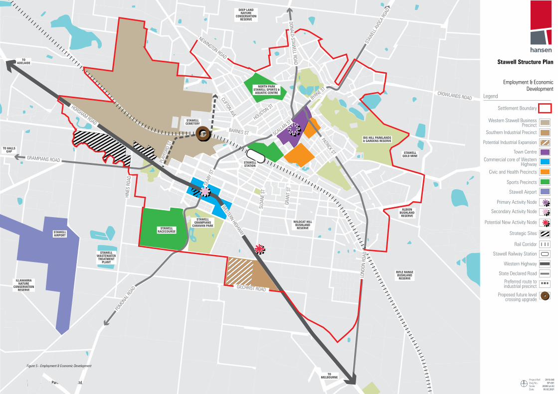
Stawell Structure Plan
Hansen Partnership Pty Ltd, Tim Nott & Martyn Group24
DEEP LAND NATURE
CONSERVATION RESERVE
TO ADELAIDE
TO HALLS GAP
TO MELBOURNE
BIG HILL PARKLANDS & GARDENS RESERVE
STAWELL GOLD MINE
NORTH PARK STAWELL SPORTS &
AQUATIC CENTRE
STAWELL RACECOURSE
STAWELL GRAMPIANS
CARAVAN PARK
STAWELL AIRPORT
STAWELL WASTEWATER TREATMENT
PLANT
ILLAWARRA NATURE
CONSERVATION RESERVE
RIFLE RANGE BUSHLAND RESERVE
WILDCAT HILL BUSHLAND RESERVE
STAWELL CEMETERY
STAWELL STATION
ALBION BUSHLAND RESERVE
STAW
ELL A
VOCA
ROA
D
GRAMPIANS ROAD
GILCHRIST ROAD
POM
ONAL
ROAD
HORSHAM ROAD
WESTERN HIGHW
AY
DONALD-STAWELL ROAD
PATRICK ST
LOND
ON R
OAD
SEAB
Y ST
PLAY
FORD
ST
SCALLAN ST
SLOA
NE S
T
HINE
S RO
AD
GRAN
T ST
HOUSTON ST
BARNES ST
CLIFTON AVE
NEWINGTON ROAD
BYRNE ST
CROWLANDS ROAD
Stawell Structure Plan
Employment & Economic Development
Project Ref: Dwg No.:Scale:Date:
2019.648SP-001
20000 at A305.02.2021
Settlement Boundary
Legend
Western Stawell Business Precinct
Southern Industrial Precinct
Potential Industrial Expansion
Town CentreCommercial core of Western
Highway
Civic and Health Precincts
Sports Precincts
Stawell Airport
Strategic Sites
Primary Activity Node
Rail Corridor
Stawell Railway Station
Western Highway
State Declared Road
Proposed future level crossing upgrade
Preferred route to industrial precinct
Secondary Activity Node
Potential New Activity Node
Figure 5 - Employment & Economic Development

Stawell Structure Plan
Hansen Partnership Pty Ltd, Tim Nott & Martyn Group 25
4.4 Activity CentresOverviewThis section seeks to reinforce the hierarchy, role and values of Stawell’s activity centres. It seeks to ensure the valued characteristics of the historic Town Centre are protected, enhanced and celebrated, while building on the complementary role that activity along the Western Highway can play as envisaged by the Western Highway Urban Design Framework (UDF).
Town Centre
Role & Activity The historic town centre will be retained as Stawell’s heart with Main Street reinforced as Stawell’s primary activity spine. Works along the Western Highway in conjunction with the Stawell Western Highway UDF will serve to promote the town centre as ‘Stawell’ through wayfinding, signage and township image initiatives.
Main Street will continue to be defined by fine-grain retail and commercial buildings, with the anchor retail of Woolworths to its rear. The township precinct is well serviced by complementary civic, community, health and education functions within its periphery. The Town Centre is well positioned to service these land uses as well as Stawell residents and visitors.
Vacant and underutilised land parcels and buildings present opportunity for new activities that complement the existing functional network of the town centre. The utilisation of vacant buildings at the north east end of Main Street should be actively encouraged to create further activity at that end of the street. Future activity within the town centre should capitalise on economic initiatives such as the Dark Matter Lab – to ensure future initiatives have a public face and promote the history and future of Stawell. Initiatives in food and beverage industry should be encouraged to support local employment within the town centre as well as local residents and visitors. Outdoor dining opportunities should be strongly encouraged. Large expanses of car parking that support 9am-5pm and Monday-Friday services present as opportunities to explore temporary activity initiatives such as markets and festivals to attract visitors to the town centre in off-peak times.
The natural assets of Stawell and the Grampians also present opportunity for new activities within the town centre. Views to the Grampians and historic township from the key vantage point of Big Hill present opportunity for a formalised tourism destination. This could include improved visitor information about the assets forming the view, as well as visitor facilities.
MovementThe Town Centre will continue to be a pedestrian friendly environment with many of its streets forming part of the proposed Primary Pedestrian Network. Main Street will continue to be reinforced as a pedestrian oriented area, through its designation as a High Amenity Pedestrian Area to retain and reinforce its pedestrian safety and permeability for a wide ranging audience including children, elderly members of the community while catering for a range of mobility requirements.
Pedestrian permeability achieved through mid-block links and at-grade parking will be retained. Future infill development on double fronted lots where pedestrian links exist, should retain permeability to contribute to a walkable village environment.
While the historic fabric and scenic attributes of the town centre signpost the arrival into the heart of Stawell, wayfinding gestures could be improved at its periphery to signpost the arrival into the town centre for both vehicles and pedestrians. For vehicles, this should occur towards the intersection of Seaby and Main Street in the south, and Patrick and Byrne Streets to the north.
At the pedestrian scale, the intersection of Main and Patrick Street presents a key arrival opportunity due to views to historic buildings framed by the meandering alignment of the street. The intersection is currently complex and could be ‘tidied’ in order to improve pedestrian and mobility movement from the north, feeding into Main Street.
Refer to Section 4.5 for further information regarding Access & Movement.
Built Form & DevelopmentVacant sites with frontage to commercial streets in the town centre present opportunities for commercial infill development that contributes to the vibrancy of the town centre and complements the existing land use patterns. Infill development on these sites should respect the grain, rhythm and scale of the prevailing urban form, particularly along Main Street. New development should be recessive to the prevailing 1-2 storey street wall along Main Street and retain view lines to heritage and landmark buildings from key public realm locations.
Development at key town centre entrance locations (eg. corner of Scallan and Byrne Street) should contribute to making an attractive entrance statement to the town centre through architectural and design excellence that celebrates the identity of Stawell and the region.
In addition to commercial infill development, providing housing opportunities closer to the town centre has the benefit of locating new development close to existing services and for reducing reliance on car trips. To date Stawell has witnessed limited medium density development catering for alternative housing such as townhouses or unit development. This type of housing has the benefit of increasing housing diversity within the town to cater for changing demographics, particularly for residents wishing to downsize.
Surrounding the town centre are medium density housing opportunities within walking distances of the Main Street commercial spine and periphery community and civic land uses.
There are few site-specific Heritage Overlays covering historic buildings within the town centre, with limited planning controls in Stawell that recognise and seek to protect areas that may have significant heritage and character features. These elements should be appropriately identified and protected with the appropriate planning and development tools. Potential heritage precincts in the town centre have previously been identified as the Skene Street Precinct and Stawell Reefs Precinct.
Public RealmWithin the town centre, Main Street currently presents as the central public realm asset owed to its wide brick footpaths, curb outstands, tree plantings and building awnings. The public realm quality of Main Street is key to the identity of the town centre, which is strengthened by its historic buildings forming the termination of views through the meandering alignment of the street.
Seaby Street and Patrick Street have been designated as ‘High Amenity Streetscapes’ as they form key arrival routes for vehicles and pedestrians, dotted with significant heritage buildings on approach. Rows of canopy tree plantings are encouraged along these streets, forming attractive green corridors that feed into main street. Further, the public realm quality of Main Street will filter into the surrounding ‘primary pedestrian network’ streets that will contribute to a unified image within the Town Centre precinct.
On the periphery of the Town Centre is a diverse range of open spaces comprising active and passive parks and bushland reserves. The Structure Plans seeks to formalise connectivity between these to form an open space network – through upgrading connections between them via high amenity streetscapes and identifying the primary pedestrian network. This includes upgrading and promoting walking tracks within Big Hill Parklands, particularly to the Big Hill lookout. Additionally, completing ‘missing links’ in the open space offering will seek to complete the network such as formalising open space around the Grant Street damns.
Western Highway PrecinctThe Western Highway Precinct contains existing land uses that support the Stawell Town Centre and region. The role of the Western Highway as the key gateway to the town and region should be strengthened. The Structure Plan in conjunction with the Western Highway UDF seeks to achieve this by consolidating activities into precincts. Secondary neighbourhood scale activity centres will service local residents within a walking catchment, as well encouraging visitors to stop and engage with Stawell. These are located at:
▪ The Pleasant Creek Historic Precinct – where new the UDF prescribes guidelines that encourages commercial and tourism development in association with future Seaby Street intersection upgrades; and
▪ Sloane Street Precinct – where a potential Neighbourhood Activity Centre will service future growth areas (see section 4.2 – Residential Development) with potential frontage to the Western Highway however accessed via Sloane Street.
Refer to the Western Highway Urban Design Framework for further details.

Stawell Structure Plan
Hansen Partnership Pty Ltd, Tim Nott & Martyn Group26
OBJECTIVES
O4.1To recognise the different roles of the town centre and Western Highway Precinct and focus commercial and retail activity in these centres compatible with their role.
O4.2To reinforce the traditional Town Centre anchored by Main Street as the ‘heart’ of Stawell and support new uses within the centre that complement local and regional tourism activities..
O4.3To consolidate retail, tourism and commercial activities into distinct precincts along the Western Highway in line with the Urban Design Framework.
O4.4To encourage new activity nodes in large, vacant land parcels within the Town Centre and in conjunction with the natural assets and broader landscape setting.
O4.5To encourage new activities through adaptive reuse of existing buildings and facilities and new uses that contribute to a vibrant Town Centre outside of weekday business hours.
O4.6 To create vibrant and active streets within the Town Centre.
STRATEGIES
S4.1
Focus long term commercial and retail development on the strategic development sites in the town centre identified on Figure 6 to help facilitate the redevelopment and regeneration of the town centre. Consider mixed use options on larger sites that can provide housing within the town centre.
S4.2Support uses that seek to establish in existing vacant buildings at the north east end of Main Street to increase activity along this section of the street which contains significant heritage assets.
S4.3 Protect the built and environmental heritage of the city while encouraging the adaptation and reuse of heritage buildings within the CBD.
S4.4Ensure that infill commercial development orients towards and engages with the High Amenity Pedestrian Area and the Primary Pedestrian Network with active ground level frontages.
S4.5Ensure that car parking areas are located away from primary commercial frontages in order to maximise continuous street edges in the Town Centre.
S4.6
Support opportunities within the Town Centre that seek to establish a ‘food and beverage hub’ celebrating cuisine in the local region and provides hospitality training opportunities as a key activity generator. Opportunities that encourage outdoor dining should be explored.
S4.7 Encourage the provision of cycling facilities within the town centre as an attractive visitor and resting location for tourist/regional cyclists.
S4.8
Focus large format and bulky retailing at appropriate locations along the Western Highway that are of a high quality design in accordance with the Western Highway Urban Design Framework. Assist with the consolidation of commercial lots along Western Highway to accommodate larger commercial opportunities
ACTIONS
A4.1Prepare a Design and Development Overlay (DDO) for the Western Highway Precinct based on the Western Highway Urban Design Framework.
A4.2 Consider the preparation of a Town Centre Master Plan to define a vision for the centre and guide development.
A4.3 Consider options for the former Tafe building along Seaby Street.

Stawell Structure Plan
Hansen Partnership Pty Ltd, Tim Nott & Martyn Group 27
P
BIG HILL PARKLANDS & GARDENS RESERVE
CATO PARK
SHOWGROUNDS
CENTRAL PARK
NORTH PARK STAWELL SPORTS & AQUATIC CENTRE
STAWELL STATION
PATRICK ST
MAIN ST
SCALLAN ST
VICTORIA ST
MAIN ST
KOFOED ST
CLIFTON AVE
NAPIER STREET
MAUDE STREET
SLOANE ST
ST. GEORGES ST WIMMERA ST
WIM
MERA ST
GRANT ST
BARNES ST
BYRNE S
T
P
PP
Commercial Core
Mixed Use Area
Civic Precinct
Health Precinct
School
Commercial infill opportunity
Residential infill opportunity
Community interest site
Activity node opportunity
Commercial building
Hertiage building (under HO)
Potential heritage precinct
Key public realm destination
Key views to Grampians
Car parking
Key commercial area car park
Reinforce commercial spine
Anchor retail destination
Active open space
Passive open space
Bushland reserve
Open space network
Open space opportunity
High Amenity Pedestrian Area
Proposed primary pedestrian network
Pedestrian crossing
School crossing
Existing pedestrian link
Strenghten trail connection
Promote trail entrance
Maintain pedestrian permeability
Key vehicle route
Activity Centre gateway
Signage/wayfinding opportunity
Potential intersection improvements (pedestrians)
eg. info centre, food hub
Legend
P
Key recreational destinationFigure 6 - Town Centre

Stawell Structure Plan
Hansen Partnership Pty Ltd, Tim Nott & Martyn Group28
4.5 Access & Movement
OverviewThis section outlines the key access and movement considerations of the Structure Plan. A range of issues and opportunities have been identified in relation to access and movement in the Stawell. For a summary, please refer to the Discussion Paper.
Key to the recommendations outlined within this section is the identification of safe, attractive and connected walking and cycling networks that create direct routes between key origins and destinations such as open space, recreational facilities, schools and commercial areas and external networks. A number of important road interventions are also identified.
WalkingIn order to improve pedestrian accessibility, and move toward a high quality, accessible and connected pedestrian environment within Stawell, the development of an enhanced primary pedestrian network is recommended. Identifying the priority areas of focus and the appropriate level of infrastructure and service on this network will help contribute to:
▪ Improving pedestrian safety and access between the Town Centre, Central Park, Cato Park, Showgrounds, Sports and Aquatic Centre and Railway Station as well as other key attractors such as schools, Maud St Dams, Library, open space, and the recreational pathways.
▪ Addressing perceptions of safety across the network and encouraging a greater uptake of walking for residents and visitors within Stawell.
▪ Promoting walking as an alternative to short car trips for access to/from and across Stawell Town Centre
Further reinforcing the High Amenity Pedestrian Area within the town centre that supports reallocation of street space used for on-street car parking to uses such as widened footpaths, street trading, public space and gathering areas.
There are opportunities to identify and implement an expanded primary pedestrian network and recognise key linkages within Stawell (as shown in Figure 7) which incorporate an enhanced level of service for walking, based around:
▪ High quality, DDA compliant footpaths with safe, dedicated crossing points on desire lines;
▪ Measures to address perceptions of safety, including clear sightlines, lighting, active surveillance, active frontages and minimising conflict between pedestrians and other transport users;
▪ Improved public realm, including pause points incorporating facilities such as seating and shade; and
▪ Implementation of wayfinding strategies including directional signage and markers.
When addressing access for pedestrians, it is also important to consider the demand for other forms of personal mobility, in particular mobility scooters. Providing a DDA compliant primary network will ensure that safe access is provided for all users.
CyclingCycling presents a number of advantages over other modes of transport. Individuals benefit from the fact that cycling is a healthy and cheap form of transport that can often prove to be faster than other transport modes and also allows cyclists to avoid traffic congestion. For society, the advantages of cycling include environmental sustainability (no direct emissions of pollutants, CO2 or noise), relatively low-cost infrastructure requirements and improvements in public health.
Cycling uptake and growth in modeshare is driven by perceptions of safety, comfort and consistent facilities for cyclists. Cycle networks are only as good as the weakest link and are often let down by lack of priority or provision for cyclists at conflict points, such as intersections, around public transport hubs and on arterial road corridors.
It has been recognised in background studies and reports, and confirmed though on-site investigations and analysis, that bicycle access to/from and within Stawell could be improved. There are impediments to safety and access within the area, including the major rail and road barriers and a lack of safe, continuous on-street infrastructure.
Although gaps in the cycling network constrain the coverage and attractiveness of cycling as a mode, the centre is in close proximity to strong regional connections, such as the Grampians Rail Trail which links Stawell to the base of the Grampians, with potential for a future link to Halls Gap.
There are numerous quiet roads around Stawell that are utilised for cycling which has led to high participation in the local community. The mixed terrain is recognised as being suitable for several road cycling markets, evidenced by the exceptionally high level of road cycling activity around the Grampians National Park.
There is an opportunity to better connect Stawell with the surrounding area as well as providing more effective links to/from the Town Centre. A similar approach to identifying and prioritising pedestrian pathways has been taken with cycle access planning, to provide safe, dedicated routes that, where possible minimise conflict between cyclists and other modes of transport (including pedestrian).
The cycling network has been based on the Department of Transport proposed Strategic Cycling Corridors with additional links added to connect this network to regional and local attractors and pathways. Where possible, the recommended cycling network avoids State Declared Roads to minimise potential conflict between cyclists and heavy vehicles. However, it is recognised in some cases these roads also provide the most direct and desirable connection. Therefore, two infrastructure treatment types are also recommended:
▪ Dedicated on-street laneways on the State Declared Road network
▪ Shared facilities combined with some dedicated infrastructure (where appropriate) on local streets.
These treatment types are shown in the table opposite.
Implementing the infrastructure upgrades necessary to realise this cycling network could create a range of attractive access and route options to/from and within Stawell.
State Declared Road Local Roads & Connectors
Treatment Response
Continuous on-street infrastructure, not necessarily protected but linking key origins/destinations
On-street lanes and markings or safe off-street environments providing local connections.
Benefits
▪ Facilitates the safer movement of cyclists and driver awareness through visually delineated cycling zones within the road reserve.
▪ Cycle lanes enable cyclists to ride safely at their preferred speed without interference from prevailing traffic conditions.
▪ Local streets are designed for slower vehicle speeds to increase the ease of movement between vehicles, cyclists and pedestrians.
▪ Design treatments reduce perception of vehicle dominance and improve driver awareness.
▪ Increased opportunities for additional public space and landscape which can be enhanced with street furniture and community gardens.
▪ Vertical speed control elements manage traffic speeds and reinforce pedestrian-friendly, safe speeds. These devices may be appropriate on a range of street types, but are most widely applied along neighbourhood, residential, or low-speed streets where freight traffic is discouraged.
Possible Design Treatment
▪ On-road cycle lane (with buffer).
▪ On-road cycle lane (no buffer).
▪ NOTE: Traffic calming measures may be applied at mid-block location, or at intersecting side streets to reduce vehicle speeds and improve pedestrian safety.
▪ Priority for cyclists and pedestrians at traffic signals
▪ Kerb extension.
▪ Vertical (raised) speed control.
▪ Material/ line marking treatment (interim measure).
▪ Local Area Traffic Management (vehicle restriction).

Stawell Structure Plan
Hansen Partnership Pty Ltd, Tim Nott & Martyn Group 29
Public TransportPublic transport services are strong drivers of pedestrian activity and need to be well connected to an effective pedestrian network. It is important to note that all public transport trips have a walking component, so improvements to pedestrian facilities can make both these modes of sustainable transport more attractive choices for access throughout Stawell.
There are opportunities to improve public transport infrastructure and services to/from and within the study area. However, it is also recognised that this type of investment is usually demand driven, and the priority is on identifying actions or investment that can be led by Council and ensure the most efficient use of existing facilities.
Therefore a focus should be placed on providing safe, high quality pedestrian access to and from services and stations, and public realm improvements around these hubs to improve the travel experience and attractiveness of this transport mode.
Town CentreInvestment by Council into pedestrian improvements across the town centre, in particular within the Main Street precinct, have improved safety and permeability in the town centre, and this has been reflected in this area being designated as a High Amenity Pedestrian Area. This designation recognises the importance and role of pedestrian safety and access in creating a successful and vibrant town centre environment.
Given the emphasis on encouraging active travel, and to complement and support these actions, it is recommended a 30kph speed limit be considered in the sections of Main Street recognised as a High Amenity Pedestrian Area. Council actions have already moved towards supporting pedestrian movement and the aim is to further reinforce Main Street as an attractive town centre.
A reduction in speed limit to 30kph within this area and associated engineering design support would not be likely to adversely affect vehicle travel time or patterns (other network changes notwithstanding), improve safety for all road users and enable the introduction of design measures that improve local amenity and enable greater walking and cycling.
Vehicle AccessThe Western Highway and arterial network including Seaby Street (C221) Alfred Street/Darlington Road (C238), in particular, provide effective regional traffic access routes to and from Stawell. However, while these components of the network perform an effective arterial road role, this presents some conflict with the local role and successful operation of Stawell town centre. In carrying higher volumes of traffic at a relatively high (60kph) speed limit, the Declared Road network also creates a barrier to access, particularly for active transport users.
The primary actions to guide the Structure Plan are:
▪ Support the efficient and safe movement of vehicles on the Declared Road network to provide strong access pathways to/from Stawell and connections with regional destinations.
▪ Retain local accessibility and discourage movements of heavy vehicles and traffic without an origin or destination on the local network, while still providing for site servicing to support local business.
▪ Separate primary walking and cycling networks from through traffic and heavy vehicles where possible
▪ Use local area traffic management treatments to minimise commercial traffic entering local residential streets.
▪ Create a safe and efficient road freight link across the Melbourne-Adelaide rail line.
Lake Road Level CrossingThe layout and positioning of the existing Lake Road level crossing, in relation to its intersections with both Abattoir Road and Wilson Street, make it difficult for vehicles coming from these locations to use the level crossing adequately and safely. Previous studies have observed that this would have the likely outcome of a high proportion of heavy vehicles utilising Griffiths Street level crossing on an alternative route between the Western Highway and the Abattoir.
In 2014 a Council commissioned investigation identified where a new/realigned section of Lake Road could be constructed to cross the railway line. One option considered creating a new crossing along an extended Saleyards Road connecting directly to the abattoir. Another option considered upgrading the current crossing by realigning it close to 90 degrees, before intersecting directly with Abattoir Road, approximately 200 metres towards Adelaide from the current Lake Road level crossing. Relocation of the rail crossing 200 metres to the west could significantly reduce the durations for which the boom barriers and flashing lights would be in operation, shorten and significantly increase the convenience with which truck movements could be made between Western Highway and the Frewstall Abattoir and potential future development, and reduce heavy vehicle movements along Griffiths Street.

Stawell Structure Plan
Hansen Partnership Pty Ltd, Tim Nott & Martyn Group30
OBJECTIVES
O5.1
To provide a safe transportation network for all users by minimising conflict between pedestrians, cyclists, and vehicles and addressing perceived threats to safety on the network related to lack of space, speeding vehicles, crossing points, lighting, and sightlines.
O5.2To prioritise sustainable and space efficient transport and determine safe, attractive and connected walking and cycling networks, and improve links to sustainable transport infrastructure.
O5.3To identify and provide enhanced connectivity to community facilities and services, including support services, health, educational, cultural and arts hubs
O5.4To recognise the role of the street network in providing site access and servicing requirements for existing business operations and consider impact of all initiatives on existing residents and employees.
STRATEGIES
S5.1
Focus pedestrian infrastructure improvements within the Primary Pedestrian Network (Figure 7) to increase connections between key locations through high quality footpath design, increased safety measures such as lighting, improved public realm treatment, pause points incorporating facilities such as seating and shade, and directional signage.
S5.2Investigate opportunities to improve links to open space and sustainable transport infrastructure through wayfinding, street design, and a potential new signalised pedestrian and cyclist crossing of the Western Highway
S5.3 Address barriers to pedestrian movement through minimising conflict between pedestrians and other transport users.
S5.4 Explore options for improved wayfinding which could include directional signage and local information along key routes.
S5.5
Explore upgraded cycle facilities or infrastructure on key links along the identified cycle network (Figure 7), but also provide safe cycle environments across the street network, particularly on low speed local traffic streets which may provide a local access function.
S5.6Ensure bicycle connections are provided to Stawell with the surrounding regional area and provide more effective links to/from and through the Town Centre
S5.7Provide safe, dedicated cycling routes that, where possible, minimise conflict between cyclists and other modes of transport (including pedestrian).
ACTIONS
A5.1 Explore the signalisation of Seaby Street with the Department of Transport as part of the Western Highway upgrades.
A5.2Investigate the potential introduction of a 30kph speed limit along Main Street given the emphasis on reinforcing active travel on this key component of the primary pedestrian network.
A5.3 Advocate to State Government for the realignment of the Lake Road level or creation of a new crossing along an extended Saleyards Road.
A5.4Identify improved pedestrian infrastructure and crossings along the primary pedestrian network such as the intersection of Main Street and Patrick Street.
A5.5 Identify and partner with the Department of Transport to provide the infrastructure for the proposed cycling network.
A5.6 Investigate opportunities for locating electric vehicle recharging stations across the town such as Federation Park and the Albion Car Park.
S5.8
Support upgraded cycling facilities or infrastructure on key links along the identified cycle network (Figure 7), but also provide safe cycle environments across the street network, particularly on low speed local traffic streets which may provide a local access function.
S5.9
Ensure public transport infrastructure is connected to the primary pedestrian network, to improve access to services and provide opportunities for increased user safety and public realm around these facilities
S5.10
Ensure bus routes consider existing and potential drivers of bus patronage, such as schools and town centre, minimise duplication of services and seek to improve reliability and minimise conflict with other vehicles in these areas.
S5.11 Support interventions within Main Street that would further emphasise and encourage its role as a pedestrian priority zone.
S5.12 Provide safe and efficient access to regional networks, including the Western Highway, from the town centre.
S5.13 Provide appropriate vehicle access routes to support proposed future land use change and development such as the southern urban growth area.
S5.14Reduce the potential for commercial and industrial traffic to travel on local residential streets. In particular, minimise the need for heavy traffic to utilise Griffith street as a means of access to the abattoir.

Stawell Structure Plan
Hansen Partnership Pty Ltd, Tim Nott & Martyn Group 31
DEEP LAND NATURE
CONSERVATION RESERVE
TO ADELAIDE
TO HALLS GAP
TO MELBOURNE
TO MELBOURNE
BIG HILL PARKLANDS & GARDENS RESERVE
STAWELL GOLD MINE
NORTH PARK STAWELL SPORTS &
AQUATIC CENTRE
STAWELL RACECOURSE
STAWELL GRAMPIANS
CARAVAN PARKSTAWELL AIRPORT
STAWELL WASTEWATER TREATMENT
PLANT
ILLAWARRA NATURE
CONSERVATION RESERVE
RIFLE RANGE BUSHLAND RESERVE
WILDCAT HILL BUSHLAND RESERVE
STAWELL CEMETERY
STAWELL STATION
ALBION BUSHLAND RESERVE
STAW
ELL A
VOCA
ROA
D
GRAMPIANS ROAD
GILCHRIST ROAD
POM
ONAL
ROAD
HORSHAM ROAD
WESTERN HIGHW
AY
DONALD-STAWELL ROAD
PATRICK ST
LOND
ON R
OAD
SEAB
Y ST
PLAY
FORD
ST
SCALLAN ST
SLOA
NE S
T
HINE
S RO
AD
GRAN
T ST
HOUSTON ST
BARNES ST
CLIFTON AVE
NEWINGTON ROAD
BYRNE ST
CROWLANDS ROAD
Stawell Structure Plan
Access & Movement
Project Ref: Dwg No.:Scale:Date:
2019.648SP-001
20000 at A302.05.2021
Settlement Boundary
Western Highway
State Declared Road
Local Connector Road
Township GatewayProposed Signalised
Intersection
Proposed future level crossing upgrade.
Primary Pedestrian NetworkProposed Strategic Cycling
Corridor
High Amenity Streetscapes
Rail Corridor
Stawell Railway StationKey Destination -
Communiuty Facility
Key Intersection
Key Intersection - improvement
Western Highway Interchange
Legend
Regional Cycling ‘Launch Pad’
Tourism Cycling Connection
Rural Planting Corridor
Key Destination- Landscape & Environment
Figure 7 - Access & Movement

Stawell Structure Plan
Hansen Partnership Pty Ltd, Tim Nott & Martyn Group32
4.6 Natural Environment & Landscape
OverviewThis Structure Plan seeks to ensure that the significant environmental setting of Stawell is adequately protected and recognised as fundamental to its landscape character and for supporting environmental functions.
Environment & LandscapeThe identity and context of Stawell is underpinned by it’s environmental and landscape setting. The many surrounding bushland reserves, Pleasant Creek and its tributaries, and the ever-present Grampians National Park not only provide a rural quality and recreational backdrop to the town but also provide important ecological and biodiversity services.
The range of bushland reserves that ‘embrace’ the town and the Pleasant Creek environs traversing the southern extent of the town are predominantly made up of the depleted Box Ironbark Forest Ecological Vegetation Class (EVC61). State government mapping identifies the vegetation within and the surrounding reserves as having high strategic biodiversity importance.
Currently the Pleasant Creek corridor and its tributaries is located within multiple zones, is within public and private ownership, and it’s significance is not recognised by an overlay. It is an important environmental and recreational spine to the township that needs to be protected and enhanced.
Protecting environmental assets must be a whole of community and Council commitment. The Structure Plan seeks to ensure that the growth of Stawell is appropriately managed to ensure the protection of these environmental assets. The retention of existing native vegetation and the inclusion of new vegetation is encouraged. Consideration is also given to the integration of wildflife habitat corridors into parklands and reserves.
Climate Resilience & Sustainable DesignClimate change is resulting in drier and hotter conditions that are increasing the severity and frequency of extreme weather events such as droughts, bushfire and flooding. Appropriate strategies and actions are needed to underpin the resilience and responsiveness of the Stawell community and to ensure Council is in a position to support best practice responses to climate challenges.
Stawell is exposed to a number of environmental threats that are worsening as a result of climate change. Most of the land surrounding Stawell is identified as having a high bushfire risk and is located within a Bushfire Management Overlay (BMO). Sections of land along Pleasant Creek are also identified as being subject to the 1 in 100 year flooding event.
It is important to shore up climate resilience by outlining policies and strategies that seek to:
▪ Avoid development and township growth in inappropriate locations.
▪ Help reduce energy consumption through the promotion of sustainable energy consumption and an urban from that supports sustainable transport.
▪ Promote Environmentally Sustainable Design in new development.
▪ Improve stormwater runoff through encouraging Water Sensitive Urban Design.
▪ Increase canopy coverage and promote native wildlife habitat.
Council’s housing project at the end of Sloane Street has the potential to be an exemplar of new development within the town that will set a standard for environmentally conscious and sustainable design.

Stawell Structure Plan
Hansen Partnership Pty Ltd, Tim Nott & Martyn Group 33
OBJECTIVES
O6.1
To value and protect the significant environmental and landscape surrounds, such as Pleasant Creek and the many bushland reserves, and ensure that new development does not inappropriately impact upon the positive ecological and biodiversity benefits they provide.
O6.2 To respond appropriately to the environmental risks of bushfire, flooding, and contamination.
O6.3To encourage a climate resilient township that responds to the increasing severity of environmental risks and supports new development that is environmentally sustainably designed.
O6.4 To increase tree canopy coverage across the town to reduce the urban heat island effect and to enhance biodiversity corridors.
O6.5To protect and enhance views to the Grampians National Park for the important landscape back drop it provides to Stawell, particularly along key corridors and public spaces.
STRATEGIES
S6.1
Limit the expansion of the township within the established boundary to limit further encroachment within surrounding environmental features such as the many bushland reserves to promote a more compact urban form and to avoid areas of environmental risk.
S6.2
Protect, enhance and support the health and quality of the Pleasant Creek environs and its tributaries by ensuring that land uses and development within and abutting the corridor respond appropriately to its environmental features.
S6.3
Encourage the retention of native vegetation and ensure new development on large sites considers the movement of wildlife across landscapes and the importance of native vegetation in providing these links.
S6.4Where possible ensure green corridors between green spaces are created to support the movement of wildlife and to link up key recreation assets (Figure 8).
S6.5
Ensure public realm and open space upgrades includes a native vegetation palette to enhance the biodiversity credentials of the town. Retain significant roadside native vegetation where possible, particularly along key boulevards as identified within Figure 3.
S6.6 New public realm works should include best practice Water Sensitive Urban Design.
S6.7
Ensure that new development, particularly within new residential estates, meets best practice Environmentally Sustainable Design (ESD) in terms of:
▪ Energy efficiency
▪ Water Sensitive Urban Design (WSUD)
▪ Waste management
▪ Landscaping and building materials.
Innovative approaches to ESD should be strongly encouraged.
S6.8
Support the transfer of the Pleasant Creek corridor and its tributaries creek into public ownership as part of the development of land abutting these key waterways such as the potential future industrial land along Gilchrist Road.
S6.9Require detailed site specific ecological and environmental investigations when considering the rezoning of land for future residential, commercial, and industrial development in line with future growth areas.
S6.10 Avoid development in areas at risk of bushfire and flooding risk and ensure that flood mapping is up to date.
S6.11Ensure that new development does not unreasonably impact on significant views to the Grampians National Park from key areas of public open space and corridors.
S6.12 Ensure the significance of key environmental areas is correctly reflected in the zoning of public land.
S6.13Ensure existing and new vegetation does not unacceptably increase bushfire risk and recognise the increasing risk posed by a warming climate.
ACTIONS
A6.1
Undertake a zoning audit of all public land with environmental significance and ensure that it is located within the correct public zone, such as land associated with Pleasant Creek, south of Federation Park included within the GRZ. Refer to Section 5.1 for further examples.
A6.2
Consider the need for a Pleasant Creek Environs Strategy which considers the many uses along the corridor, its environmental values, and development on abutting land. Such a strategy should determine the appropriate application of an overlay to the corridor and environs such as an Environmental Significance Overlay (ESO).
A6.3 Consider the application of the Environmental Audit Overlay (EAO) to potentially contaminated sites as identified through Council’s study.
A6.4 Investigate options for incentive programs to increase the take up of onsite stormwater and rainwater retention systems.
A6.5 Work with local community groups to assist with initiatives to enhance the environmental performance of key environmental assets.

Stawell Structure Plan
Hansen Partnership Pty Ltd, Tim Nott & Martyn Group34
DEEP LAND NATURE
CONSERVATION RESERVE
TO ADELAIDE
TO HALLS GAP
TO MELBOURNE
BIG HILL PARKLANDS & GARDENS RESERVE
STAWELL GOLD MINE
NORTH PARK STAWELL SPORTS &
AQUATIC CENTRE
STAWELL RACECOURSE
STAWELL GRAMPIANS
CARAVAN PARK
STAWELL AIRPORT
STAWELL WASTEWATER TREATMENT
PLANT
ILLAWARRA NATURE
CONSERVATION RESERVE
RIFLE RANGE BUSHLAND RESERVE
WILDCAT HILL BUSHLAND RESERVE
STAWELL CEMETERY
STAWELL STATION
ALBION BUSHLAND RESERVE
STAW
ELL A
VOCA
ROA
D
GRAMPIANS ROAD
GILCHRIST ROAD
POM
ONAL
ROAD
HORSHAM ROAD
WESTERN HIGHW
AY
DONALD-STAWELL ROAD
PATRICK ST
LOND
ON R
OAD
SEAB
Y ST
PLAY
FORD
ST
SCALLAN ST
SLOA
NE S
T
HINE
S RO
AD
GRAN
T ST
HOUSTON ST
BARNES ST
CLIFTON AVE
NEWINGTON ROAD
BYRNE ST
CROWLANDS ROAD
Stawell Structure Plan
Natural Environment & Landscape
Project Ref: Dwg No.:Scale:Date:
2019.648SP-001
20000 at A305.02.2021
H
H
L
H
Settlement Boundary
Town Centre
Tree Density
Legend
Rail Corridor
Stawell Railway Station
Waterbodies
High Point
Slope
H
Bushland Reserve
Open Space / Parkland
Bushfire Management Overlay (BMO)
Land Subject To Inundation Overlay (LSIO)
Flooding Overlay (FO)
Significant Waterway Environs
Potential Habitat Corridors
Figure 8 - Natural Environment & Landscape

Stawell Structure Plan
Hansen Partnership Pty Ltd, Tim Nott & Martyn Group 35
4.7 Community Facilities & Open Space
OverviewStawell has a good range of existing community facilities and open space. This has become an attractive feature that has drawn new residents to the town, particularly older residents looking for a lifestyle change in a location with good access to health facilities and retirement living options.
Community FacilitiesHealth services have been increased in recent years with the development of Grampians Community Health providing facilities and services in addition to Stawell Regional Health.
A number of perceived gaps in the delivery of community services were identified through community consultation, including:
▪ Services and activities for teenager and younger adults.
▪ Lack of local education opportunities for young adults due to closure of Tafe.
▪ Ensuring a focus is continued to be placed on services for the ageing population.
▪ The need for more community and cultural events and a lack of performing arts and spaces to accommodate.
This feedback has been worked into the key objectives and strategies of the structure plan. Due to the good range of existing facilities, the focus of the Structure Plan is on increasing connections and ensuring upgrades to existing facilities and infrastructure are acknowledged rather than identifying land for new facilities.
Open Space NetworkStawell’s proud sporting history, based around the Stawell Gift, is key to the identity of the town with local sporting clubs playing a strong role in the community. Due to this history, it has a significant range of sporting facilities based around North Park and Central Park and excellent public parks such as Cato Park.
This Structure Plan does not seek to resolve the details of how different open space assets within the township are used and developed. This is guided by Council’s Open Space Strategy, which identifies key recommendations and actions in relation to the provision of open space. Rather, the Structure Plan collates and builds on these actions as they relate to Stawell and considers connections between spaces and how they relate to the broader directions of this plan in terms of long term development.

Stawell Structure Plan
Hansen Partnership Pty Ltd, Tim Nott & Martyn Group36
OBJECTIVES
O7.1 To support a range of well located and accessible community facilities that meets the needs of the diverse community.
O7.2 To recognise Stawell as a regional sporting centre with high quality facilities and an active community.
O7.3 To reinforce Stawell as a regional hub of high quality health services and facilities.
O7.4To provide a high-quality and strong open space network that is well connected, inclusive, and multi-functional, and provides a range of active and passive recreational opportunities.
STRATEGIES
S7.1 Locate new health facilities within or close to existing health and civic precincts as identified on Figure 9.
S7.2 Support locating cultural and arts facilities within Stawell in response to the community’s desire for a performing arts centre.
S7.3
Investigate the establishment of a youth centre within Stawell that provides a range of youth services, facilities, and entertainment. There are a number of strategic sites identified for further investigation that could incorporate a youth centre.
S7.4
Support the development of community arts spaces and innovative arts and cultural projects and initiatives which highlight the cultural heritage of Stawell such as street art and murals and public art at key gateways and landmarks.
S7.5 Celebrate the sporting identity of Stawell and promote Central Park as a regional athletics venue.
S7.6Retain and enhance the recreational capacity of existing bushland reserves and consider the formalisation of trails and facilities where appropriate.
S7.7
Integrate the open space network with environmental reserves and seek to create ‘green links’ between areas of open space that increases accessibility as well as supporting wildlife corridors. Indicative links have been shown on Figure 8.
S7.8 Increase access to community facilities and green space through improved cycling and footpath infrastructure as identified on Figure 9.
S7.9
Support the recommendations of the Stawell Parks Precinct Master Plan such as:
▪ Consider the long term expansion of Cato Park onto adjoining residential land to the south along Napier Street.
▪ Consider vacant DHHS land associated with Maud Street Dams as a dog park or community gardens in line with masterplan.
S7.10Ensure new residential and urban growth areas are provided with new open space and community facilities that meets the community’s needs in line with the Guidelines for Precinct Structure Planning.
S7.11
Support the development of the former Waites Robson site on the corner of Frayne Street and Seaby Street that creates a ‘Gateway to the Gift’ in line with the vision outlined in the Jeavons Landscape Architects multi-use design that celebrates the gift. Consider expanding out to the traffic island on the corner of Napier and Seaby Street to create a larger landmark location that celebrates the sporting precinct.
S7.12Support the revitalisation of Federation Park to enhance its role and amenity as a premier visitor rest stop along the Western Highway as envisioned by the Western Highway Urban Design Framework.
ACTIONS
A7.1
Investigate the extension of the Grampians Rail Trail to Federation Park to create an entrance and increase exposure and accessibility. Work with cycling groups to identify a future potential route that could lead visitors further into town from Federation Park.
A7.2
Investigate and advocate for the redevelopment of the Stawell Skate Park and consider relocating to a different location that can support a larger facility. Investigate suitable locations for a BMX track that is co-located with other similar facilities.
A7.3
Further investigate upgrades to facilities at Big Hill lookout to promote it as a key tourism destination that celebrates views to the historic buildings and structures and the Grampians. Upgraded seating, public amenities, signage information regarding visible features of the view, and better connections to Main Street should be explored.
A7.4 Work with youth service groups to understand the need for a youth centre and other ways to support youth services and activities.
A7.5 Undertake a zoning audit of arrange of community facilities and rezoning to appropriate public zones. Refer to Section 5.1 for further details.
A7.6 Investigate options for the former Federation Tafe building on the corner of Sloane and Skene Street.
A7.7
Investigate the potential of informal vegetated public land to determine its potential to be incorporated into the public open space network. Such land includes vegetated land between Smith Street and Cooper Street east of Seaby Street. Options for the co-location of housing on this land could also be explored.
A7.8 Investigate opportunities for outdoor gym and exercise equipment within existing parks as directed by Council’s Open Space Strategy.
A7.9 Continue to work with community groups to ensure adequate spaces and facilities are available to meet their needs.

Stawell Structure Plan
Hansen Partnership Pty Ltd, Tim Nott & Martyn Group 37
DEEP LAND NATURE
CONSERVATION RESERVE
TO ADELAIDE
TO HALLS GAP
TO MELBOURNE
BIG HILL PARKLANDS & GARDENS RESERVE
STAWELL ARBORETUM
JJ KINGSTON WILDFLOWER SANCTUARY
STAWELL GOLD MINE
NORTH PARK STAWELL SPORTS &
AQUATIC CENTRE
STAWELL RACECOURSE
STAWELL GRAMPIANS
CARAVAN PARK
STAWELL AIRPORT
STAWELL WASTEWATER TREATMENT
PLANT
ILLAWARRA NATURE
CONSERVATION RESERVE
RIFLE RANGE BUSHLAND RESERVE
WILDCAT HILL BUSHLAND RESERVE
STAWELL CEMETARY
FEDERATION PARK
CENTRAL PARK
CATO PARK
STAWELL HARNESS
STAWELL STATION
ALBION BUSHLAND RESERVE
STAW
ELL A
VOCA
ROA
D
GRAMPIANS ROAD
GILCHRIST ROAD
POM
ONAL
ROAD
HORSHAM ROAD
WESTERN HIGHW
AY
DONALD-STAWELL ROAD
PATRICK ST
LOND
ON R
OAD
SEAB
Y ST
PLAY
FORD
ST
SCALLAN ST
SLOA
NE S
T
HINE
S RO
AD
GRAN
T ST
HOUSTON ST
BARNES ST
CLIFTON AVE
NEWINGTON ROAD
BYRNE ST
CROWLANDS ROAD
Stawell Structure Plan
Community Facilities & Open Space
Project Ref: Dwg No.:Scale:Date:
2019.648SP-001
20000 at A305.02.2021
Settlement Boundary
Legend
Town Centre
Rail Corridor
Stawell Railway Station
Waterbodies
Pedestrian Tracks & Trails
Potential location for active / passive open space
400m walking distance
Key open spaces
Key cycle routes
Open space opportunity
Active open space
Passive open space
Bushland reserve
Recreational facility
Education
Health
Aged Care / Retirement
Other
Churches
Kindergarten / Childcare
Playground
Public Toilets
Gallery / Museum
Library
Primary Pedestrian Network
Figure 9 - Community Facilities & Open Space

Stawell Structure Plan
Hansen Partnership Pty Ltd, Tim Nott & Martyn Group38
4.8 Services & Utilities
OverviewEnsuring the structure plan is consistent with the provision of essential services to Stawell is important for coordinating service provision strategies and for highlighting any required upgrades. Key service providers have been contacted through the development of this Structure Plan who have provided high level input on strategic growth areas.
The authorities who manage essential services within Stawell are:
▪ GWM Water - potable water and sewerage.
▪ Powercor - electricity
▪ Telstra - telecommunications
▪ NBN Co. - National Broadband Network
▪ Council - drainage
Predominantly, Stawell’s existing urban areas are well serviced by existing infrastructure. Such infrastructure can likely adequately support any infill development opportunities.
The identified urban growth areas however will require significant upgrades and augmentation. Council have already tendered the extension of existing essential services to its development site along Sloane street which is strategically important for enabling the further development of this growth front.
Continued planning and ongoing liaison with service providers will be required through the implementation of this Structure Plan.
OBJECTIVES
O8.1To ensure that essential services for water, sewerage, electricity, and telecommunications are provided to the existing and future community in a timely manner.
O8.2To encourage alternative, sustainable and innovative approaches to the provision of essential services where barriers inhibit connecting to reticulated services.
O8.3 To ensure new development is staged appropriately to enable the appropriate provision of services.
STRATEGIES
S8.1 Ensure new development limits stormwater run off and increases water quality.
S8.2 Support the undergrounding of existing services where possible.
S8.3 Avoid sensitive development encroaching within the Stawell Waste Water Treatment Plant buffer.
S8.4 Continue to support the extension of essential services to the urban growth area along Sloane Street.
S8.5 Support drainage alignments that are designed to also support environmental and recreational functions.
S8.6Require the preparation of a servicing plan that addresses how drainage and essential services will be provided to development within the ‘Long Term Urban Growth’ area.
ACTIONS
A8.1Continue to consult and work collaboratively with service providers through the implementation of this Structure Plan and the timing and staging of development.
A8.2 Continue to implement the planned extension of essential services to the urban growth area along Sloane Street.

Stawell Structure Plan
Hansen Partnership Pty Ltd, Tim Nott & Martyn Group 39
5.0 Implementation
This section outlines a plan to implement the various actions identified through the Structure Plan, with key mechanisms, responsibilities, and timing identified.
The implementation of the Structure Plan will require both Planning Scheme Amendments to the Northern Grampians Shire Planning Scheme and other actions to ensure the vision is implemented. It will require ongoing monitoring and review to ensure it is consist with ongoing changes within the town and local and State planning policy.
The Structure Plan will be implemented by:
▪ Planning Scheme Amendments: key changes to various controls and policies of the Northern Grampians Shire Planning Scheme.
▪ Further Investigations: there are a range of actions that require further investigation to understand the implications before a decision can be made.
▪ Advocacy Work: Council plays an active role in advocating for various funds from State Government and other agencies to contribute to projects across the shire.
▪ Council Works Program: ongoing Council capital works and strategic projects.
Statutory ImplementationIn terms of Planning Scheme Amendments, as identified in the Implementation Table, the Structure Plan will involve changes across the following aspects of the Northern Grampians Shire Planning Scheme:
▪ Zones: the Structure Plan recommends a number of zoning changes which will alter the statutory land use implications for various parcels of land. Further investigations are required to undertake a number of rezonings.
▪ Overlays: it is recommended that the application of a number of overlays be further considered to help guide development within the town such as a Design and Development Overlay along the Western Highway and a Development Plan Overlay to the urban growth area to ensure land logically develops.
▪ Local Policy: changes to local planning policy will ensure consistency in Council decision making to ensure key objectives and strategies of this document are considered. Actual policy changes will depend on the restructuring of local policy as part of the Planning Policy Framework translation currently underway.
Initially the plan will need to be adopted by Council and then embedded within the Northern Grampians Shire Planning Scheme through updates to local planning policy with the strategic directions of the plan.

Stawell Structure Plan
Hansen Partnership Pty Ltd, Tim Nott & Martyn Group40
5.1 Implementation Table
The table below collates the key actions identified within this document and assigns the following:
▪ Mechanism: how the action will be implemented.
▪ Responsibility: who is responsible for its implementation.
▪ Timing: whether it is a short term (0 to 2 years), medium term (3 to 5 years), or long term action (6 years plus).
Action Mechanism Responsibility Timing
Urban Form, Character, and Identity
A1.1 Include the township boundary in Local Policy to provide certainty and clarity for future growth opportunities and to ensure development avoids more sensitive locations. Planning Scheme Amendment Council Planning Department Short Term
A1.2 Review and update the Heritage Study 2004 and implement findings into the Northern Grampians Shire Planning Scheme, particularly the identified heritage precincts within Stawell. Planning Scheme Amendment Council Planning Department Short Term
A1.3 Develop a signage strategy and landscape plan for the Western Highway in line with the Urban Design Framework. Council Works Council Planning Department Medium Term
A1.4 Consider the application of the Neighbourhood Residential Zone (NRZ) to land within the potential Skene Street Heritage Precinct. A character study for the town could be considered at some point in the future if housing growth through infill housing creates problems for the character of the town. Further Investigation Council Planning Department Medium Term
A1.5 Prepare a street tree planting guide for the establishment of boulevards along key entrances and gateways as defined on Figure 3. Council Works Capital Works Team Short Term
A1.6 Undertake mapping of known and potential aboriginal cultural heritage places within the town in consultation with the Barengi Gadjin Land Council Aboriginal Corporation and provide information about the area’s history. Council Works Council / Barengi Gadjin Land
Council Medium Term
Residential Development
A2.1
Undertake the following residential zone changes:
▪ Rezone the north east section of the ‘Residential Growth Area’ where appropriate to the GRZ following further investigations into the buffer requirements for the former landfill site at 2-14 Hears Street.
▪ Rezone GRZ land along Pickering Road and RLZ land to the north of Holloway Road Central to the LDRZ.
▪ Increase the minimum subdivision size for the RLZ2 land within the ‘Long Term Urban Growth Area’ to 40ha discourage the fragmentation of this land.
Planning Scheme Amendment Council Planning Department Short Term
A2.2Further investigate land marked as ‘Urban Growth Area’ to understand the likely opportunities and constraints of this land to accommodate long term housing supply. Facilitate rezoning as demand arises and once opportunities are understood. A Development Plan Overlay (DPO) should be applied to the land to ensure it develops cohesively and in a logical manner as identified on page 18.
Further Investigation Council Planning Department Medium Term
A2.3 Consider establishing a development facilitation process at Council that seeks to fast track infill housing development and works with developers and landowners to under key constraints to development. Further Investigation Council Planning Department Medium Term
A2.4 Further investigate the range of strategic development sites outlined in Figure 4. Work with landowners to identify constraints and opportunities and determine whether the sites are suitable for increased housing. Further Investigation Council Planning Department Medium Term
A2.5 Undertake a Rural Land Use Strategy or an update to the Northern Grampians Rural Living Study that includes an audit and rationalisation of the Rural Living Zone (RLZ) land surrounding Stawell and other RLZ land within the Shire. Further Investigation Council Planning Department Medium Term
Employment & Economic Development
A3.1 Apply a Development Plan Overlay (DPO) to the Western Stawell Business Precinct based on the 2015 Master Plan. Planning Scheme Amendment Council Planning Department Short Term
A3.2 Further investigate land identified for long term industrial growth along Gilchrist Road and facilitate the rezoning of land in response to demand. Further Investigation Council Planning Department Long Term
A3.3 Investigate ways to facilitate development by working with land owners to understand the constraints to developing existing vacant industrial land. Council Works Council / Landowners Medium Term
A3.4 Implement the Northern Grampians Shire Economic Development Strategy once completed. Undertake a Tourism Strategy for the Shire that identifies Stawell as a tourism gateway. Council Works Council Short Term
A3.5 Further investigate the revitalisation of Federation Park as envisioned by the Western Highway Urban Design Framework. Further Investigation Council Medium Term

Stawell Structure Plan
Hansen Partnership Pty Ltd, Tim Nott & Martyn Group 41
A3.6Work with owners of the Former Pleasant Creek Hospital site to explore opportunities for the precinct focused on tourism and accommodation, community uses, event spaces, and food and beverage. Consider the preparation of a masterplan specifically for the site and implement through a Development Plan Overlay (DPO) and updated Clause 22.01 (Pleasant Creek Estate).
Further Investigation Council / Landowners Long Term
A3.7 Further investigate the potential of establishing a tourism and information hub at the Pleasant Creek Historic Precinct as outlined within the Western Highway Urban Design Framework. Further Investigation Council / Landowners Medium Term
A3.8 Explore options for the location of a tourism related hub at 14 Horsham Road Stawell. Further Investigation Council / Landowners Long Term
Activity Centres
A4.1 Prepare a Design and Development Overlay (DDO) for the Western Highway Precinct based on the Western Highway Urban Design Framework. Planning Scheme Amendment Council Planning Department Short Term
A4.2 Consider the preparation of a Town Centre Master Plan to define a vision for the centre and guide development. Further Investigate Council Medium Term
A4.3 Consider options for the former Tafe building along Seaby Street. Further Investigate Council Medium Term
Access & MovementA5.1 Explore the signalisation of Seaby Street with the Department of Transport as part of the Western Highway upgrades. Advocacy Council / Department of Transport Short Term
A5.2 Investigate the potential introduction of a 30kph speed limit along Main Street given the emphasis on reinforcing active travel on this key component of the primary pedestrian network. Further Investigation Council Medium Term
A5.3 Advocate to State Government for the realignment of the Lake Road level or creation of a new crossing along an extended Saleyards Road. Advocacy Council / State Government Short TermA5.4 Identify improved pedestrian infrastructure and crossings along the primary pedestrian network such as the intersection of Main Street and Patrick Street. Further Investigate Council Medium TermA5.5 Identify and partner with the Department of Transport to provide the infrastructure for the proposed cycling network. Further Investigate Council / Department of Transport Medium TermA5.6 Investigate opportunities for locating electric vehicle recharging stations across the town such as Federation Park and the Albion Car Park. Further Investigate Council Medium TermNatural Environment & Landscape
A6.1
Undertake a zoning audit of all public land with environmental significance and ensure that it is located within the correct public zone, such as:
▪ Land associated with Pleasant Creek, south of Federation Park: rezone from GRZ to PCRZ.
▪ Northern section of Albion Bushland Reserve to the north of Leviathan Road: rezone from RLZ to PCRZ.
▪ Rifle Range Bushland Reserve: rezone from FZ to PCRZ.
▪ Mossman Park Bushland Reserve: rezone from LDRZ to PCRZ.
▪ Illawarra H15 Bushland Reserve and surrounding Crown land to the south: rezone from IN1Z and RLZ to PCRZ
▪ Eastern side of Three Jacks Company Mine along Darlington Road: rezone from RLZ to PCRZ.
Planning Scheme Amendment Council Planning Department Short Term
A6.2 Consider the need for a Pleasant Creek Environs Strategy which considers the many uses along the corridor, its environmental values, and development on abutting land. Such a strategy should determine the appropriate application of an overlay to the corridor and environs such as an Environmental Significance Overlay (ESO). Further Investigation Council Planning Department Medium Term
A6.3 Consider the application of the Environmental Audit Overlay (EAO) to potentially contaminated sites as identified through Council’s study. Planning Scheme Amendment Council Planning Department Short TermA6.4 Investigate options for incentive programs to increase the take up of onsite stormwater and rainwater retention systems. Further Investigation Council Medium TermA6.5 Work with local community groups to assist with initiatives to enhance the environmental performance of key environmental assets. Council Works Council / Community Groups Medium TermCommunity Facilities & Open Space
A7.1 Investigate the extension of the Grampians Rail Trail to Federation Park to create an entrance and increase exposure and accessibility. Work with cycling groups to identify a future potential route that could lead visitors further into town from Federation Park. Council Works Council Medium Term
A7.2 Investigate and advocate for the redevelopment of the Stawell Skate Park and consider relocating to a different location that can support a larger facility. Investigate suitable locations for a BMX track that is co-located with other similar facilities. Advocacy Council Short Term
A7.3Further investigate upgrades to facilities at Big Hill lookout to promote it as a key tourism destination that celebrates views to the historic buildings and structures and the Grampians. Upgraded seating, public amenities, signage information regarding visible features of the view, and better connections to Main Street should be explored.

Stawell Structure Plan
Hansen Partnership Pty Ltd, Tim Nott & Martyn Group42
A7.4 Work with youth service groups to understand the need for a youth centre and other ways to support youth services and activities. Further Investigation Council Short Term
A7.5
Undertake a zoning audit of arrange of community facilities and rezoning to appropriate public zones, such as:
▪ DHHS land to south of hospital along Grant Street – investigate for dog park or community garden and consider rezoning to PUZ.
▪ Skene Street School.
▪ Explore the potential of Crown land between Cooper Street and Smith Street east of Seaby Street for a more formalised park with potential housing.
▪ Small parcels of Central Park
▪ Macpherson Smith Residential Care – fix zoning – some in PUZ and some still in GRZ
Planning Scheme Amendment Council Planning Department Short Term
A7.6 Investigate options for the former Federation Tafe building on the corner of Sloane and Skene Street. Further Investigation Council Short Term
A7.7 Investigate the potential of informal vegetated public land to determine its potential to be incorporated into the public open space network. Such land includes vegetated land between Smith Street and Cooper Street east of Seaby Street. Options for the co-location of housing on this land could also be explored. Further Investigation Council Medium Term
A7.8 Investigate opportunities for outdoor gym and exercise equipment within existing parks as directed by Council’s Open Space Strategy. Further Investigation Council Long TermA7.9 Continue to work with community groups to ensure adequate spaces and facilities are available to meet their needs. Council Works Council On GoingServices & UtilitiesA8.1 Continue to consult and work collaboratively with service providers through the implementation of this Structure Plan and the timing and staging of development. Further Investigation Council Planning Department OngoingA8.2 Continue to implement the planned extension of essential services tot he urban growth area along Sloane Street. Council Works Council Short Term

Stawell Structure Plan
Hansen Partnership Pty Ltd, Tim Nott & Martyn Group 43
5.2 Strategic / Further Investigation Sites
A number of strategic sites requiring further investigation have been identified throughout this report (Please refer to Figure 10 for a summary). These sites potentially contain significant strategic development potential that should be further explored. The below table collates these sites and suggests further work and the potential future development that should be further considered.
Site Site Details Potential Development Comments / Actions
Former Pleasant Creek Hospital
Ownership: private
Size: 4.6ha
Description: site of heritage listed Former Pleasant Creek Hospital
Consider uses related to tourism and accommodation, community uses, event spaces, food and Beveridge.
▪ Work with land owners to understand the future use and development potential of the site.
▪ Consider rezoning to C2Z.
▪ Consider the preparation of a master plan and application of a DPO to the site to facilitate integrated development.
22-28 Sloane Street Ownership: private
Size: 3,642sqm
Description: vacant C1Z land
Commercial development
Event space in interim
▪ Largest vacant opportunity site within the CBD posing significant development potential.
▪ Direct connection with CBD along Bayliss Street frontage.
▪ Explore options with landowner.
Darlington Lane Ownership: DELWP managed Crown land
Size: 8ha
Description: vacant land with mining related history
Residential development ▪ Work with DELWP to understand the future use and development potential of the site.
▪ Potential contamination.
Gray Street Ownership: private
Size: 0.9ha
Description: vacant GRZ land
Medium density residential development ▪ Contains an existing permit for the subdivision of 11 lots.
▪ Work with landowner to understand constraints.
MUZ Rail Land Ownership: DELWP managed Crown land
Size: 2ha
Description: vacant land associated with the train line reserve along Wakeham Street
Medium density residential development ▪ Work with DELWP to understand the future use and development potential of the site.
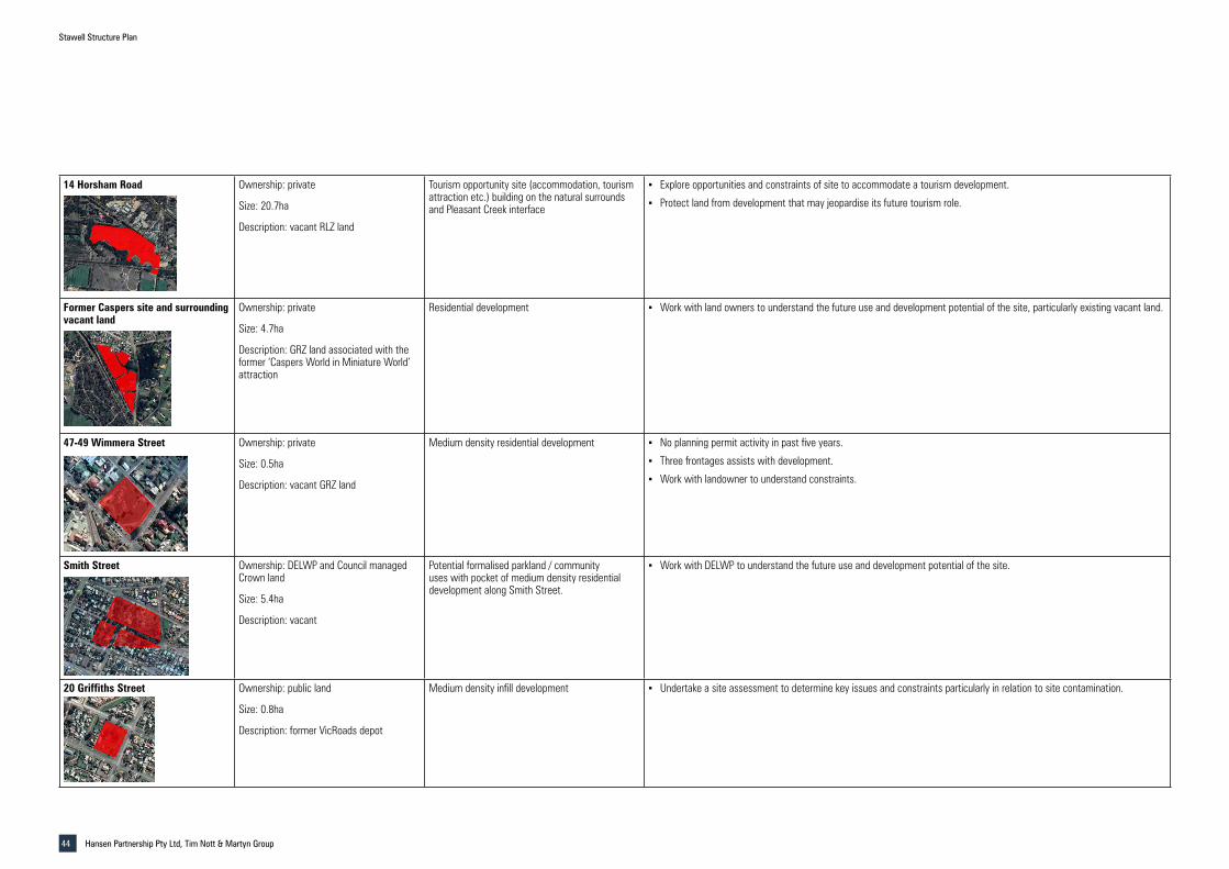
Stawell Structure Plan
Hansen Partnership Pty Ltd, Tim Nott & Martyn Group44
14 Horsham Road Ownership: private
Size: 20.7ha
Description: vacant RLZ land
Tourism opportunity site (accommodation, tourism attraction etc.) building on the natural surrounds and Pleasant Creek interface
▪ Explore opportunities and constraints of site to accommodate a tourism development.
▪ Protect land from development that may jeopardise its future tourism role.
Former Caspers site and surrounding vacant land
Ownership: private
Size: 4.7ha
Description: GRZ land associated with the former ‘Caspers World in Miniature World’ attraction
Residential development ▪ Work with land owners to understand the future use and development potential of the site, particularly existing vacant land.
47-49 Wimmera Street Ownership: private
Size: 0.5ha
Description: vacant GRZ land
Medium density residential development ▪ No planning permit activity in past five years.
▪ Three frontages assists with development.
▪ Work with landowner to understand constraints.
Smith Street Ownership: DELWP and Council managed Crown land
Size: 5.4ha
Description: vacant
Potential formalised parkland / community uses with pocket of medium density residential development along Smith Street.
▪ Work with DELWP to understand the future use and development potential of the site.
20 Griffiths Street Ownership: public land
Size: 0.8ha
Description: former VicRoads depot
Medium density infill development ▪ Undertake a site assessment to determine key issues and constraints particularly in relation to site contamination.

STAW
ELL A
VOCA
ROA
D
GRAMPIANS ROAD
GILCHRIST ROAD
POM
ONAL
ROAD
HORSHAM ROAD
WESTERN HIGHW
AY
DONALD-STAWELL ROAD
PATRICK ST
LOND
ON R
OAD
SEAB
Y ST
PLAY
FORD
ST
SCALLAN ST
SLOA
NE S
T
HINE
S RO
AD
GRAN
T ST
HOUSTON ST
BARNES ST
CLIFTON AVE
NEWINGTON ROAD
BYRNE ST
CROWLANDS ROAD
DEEP LAND NATURE
CONSERVATION RESERVE
TO ADELAIDE
TO HALLS GAP
TO MELBOURNE
BIG HILL PARKLANDS & GARDENS RESERVE
STAWELL GOLD MINE
NORTH PARK STAWELL SPORTS &
AQUATIC CENTRE
STAWELL RACECOURSE
STAWELL GRAMPIANS
CARAVAN PARK
STAWELL AIRPORT
STAWELL WASTEWATER TREATMENT
PLANT
ILLAWARRA NATURE
CONSERVATION RESERVE
RIFLE RANGE BUSHLAND RESERVE
WILDCAT HILL BUSHLAND RESERVE
STAWELL CEMETERY
STAWELL STATION
ALBION BUSHLAND RESERVE
Stawell Structure Plan
Strategic / Further Investigation Sites
Project Ref: Dwg No.:Scale:Date:
2019.648SP-001
20000 at A305.02.2021
hansen partnership pty ltdmelbourne | vietnam
level 4 136 exhibition stmelbourne vic 3000
t 61 3 9654 8844 f 61 3 9654 8088 e [email protected]
w hansenpartnership.com.au
Settlement Boundary
Potential Strategic / Further Investigation Sites
Legend
Figure 10 - Strategic / Further Investigation Sites

Urban Planning | Urban Design | Landscape Architecture
TIM NOTT economic analysis + strategy