a user-centric system-of-systems approach for delivery of...
TRANSCRIPT

Ground System Architectures Workshop 200923 -26 March 2009
Morris BrillRon Lowther, Ph.D.
Northrop Grumman Corporation
A User-Centric System-of-Systems Approach for
Delivery of Actionable Earth Environmental Data
NORTHROP GRUMMAN ©2009

NORTHROP GRUMMAN ©2009
Ground System Architectures Workshop 20092 of 1222 of 12
Societal Benefit AreasDisasters Health Energy Climate Water Weather Ecosystems Agriculture Biodiversity
The Challenge: Connect Users to Environmental Data Providers for Disaster Response
NOAA Weather & ClimateOperational weather systems
Oceanic & Atmospheric Sciences
DOEClimate Modeling
NASA EOSEarth Observing Satellites
EPAAir & Water Quality
NSFEarth Science Research
State GovernmentsEnvironmental & Natural
Resource
USGSLand & Ecosystems
AcademiaEarth System Science

NORTHROP GRUMMAN ©2009
Ground System Architectures Workshop 20093 of 12
Global Earth Observation System-of-System (GEOSS):An Environmental Enterprise Paradigm for Benefiting Society
• GEOSS Implementation Plan has identified nine different user communities, called “Societal Benefit Areas” (SBA), that are responding to the challenges posed by climate and technology change.
• Each SBA has unique needs and capabilities but can share common services and approaches through a network of community portals.
• Our focus is on disaster response and management
• To be developed over ten years
• GEOSS AIP programs are coordinated by the Open Geospatial Consortium (OGC)
• 2007-08 Phase 1 demonstrated GEO Portal and Clearinghouse solutions (now IOC)
• 2008-09 Phase 2 augments IOC with “persistent” services to support SBAs and GEOSS Infrastructure
• Pilots address data and information architecture interoperability and user support
• Implemented using international standards
Figure: Group on Earth Observations, “Architecture Implementation Pilot (AIP) Phase 2: IOC Augmentation Call for Participation (CFP), Annex B – Architecture”, June 2008

NORTHROP GRUMMAN ©2009
Ground System Architectures Workshop 20094 of 12
What are we building? A Hurricane and Flooding Disaster Response Scenario
This segment of GEOSS architecture for service and component providers
Global Earth Observations System-of-System Common Infrastructure
Developed on AIP Phase 1
Community Portal links to GEO Portal
Develop Disaster Response Community Portal
Contribute to Disaster Response scenario catalog
Register services!
Uses data from Regional Climate Centers
Space Weather Prediction CenterNational Drought Mitigation Center
National Hurricane Center
Develop Disaster Response services to OGC standards
Figure: Group on Earth Observations, “Architecture Implementation Pilot (AIP) Phase 2: IOC Augmentation Call for Participation (CFP), Annex B – Architecture”, June 2008

NORTHROP GRUMMAN ©2009
Ground System Architectures Workshop 20095 of 12
Disaster Cycle is the Workflow for Hurricane and Flooding Disaster Response
Disaster Cycle
• Users exercise the workflow represented by the Disaster Cycle
• Cycle consists of seven overlapping activities
• Hurricane and flooding scenarios step through this cycle
• Uses real data taken from Katrina, Ike, etc.
• Formally bringing together community data providers to share vital environmental data with end users
Figure: Group on Earth Observations, “Architecture Implementation Pilot (AIP) Phase 2: IOC Augmentation Call for Participation (CFP), Annex B – Architecture”, June 2008
Data is organized by cycle activity &
Community of Practice
Community Data Providers
NORTHROP GRUMMAN ©2009
Ground System Architectures Workshop 20096 of 12
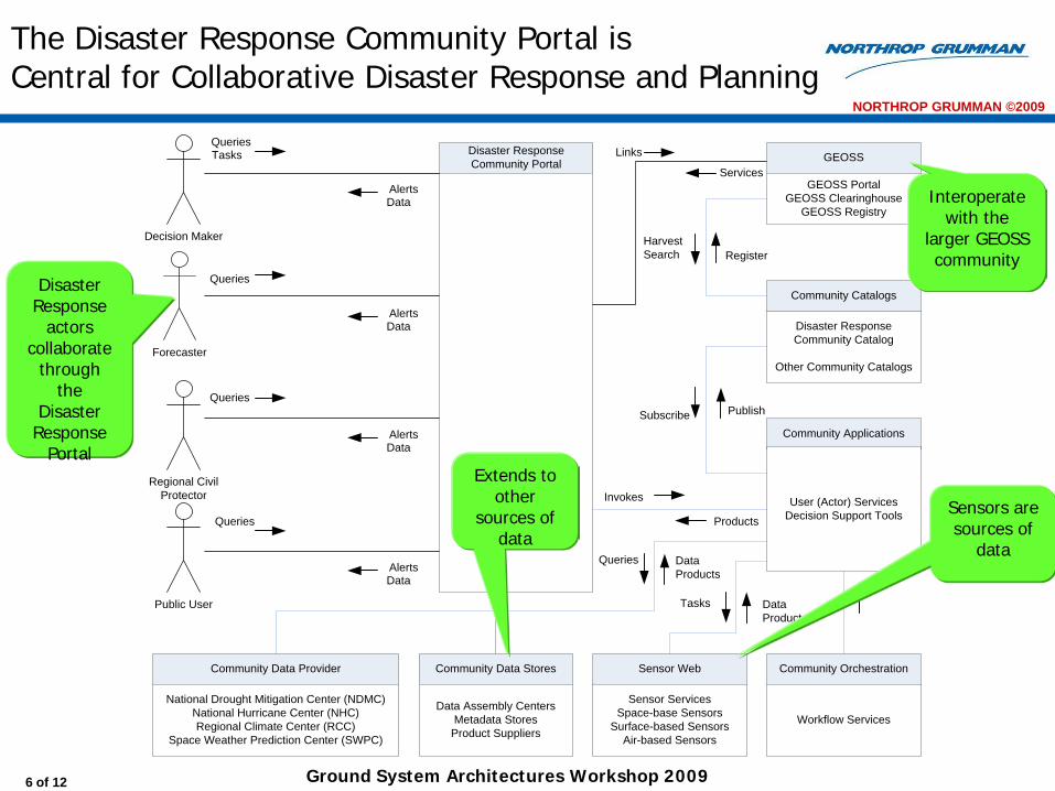
The Disaster Response Community Portal isCentral for Collaborative Disaster Response and Planning
Forecaster
Decision Maker
Regional CivilProtector
Public User
Community Data Provider
National Drought Mitigation Center (NDMC)National Hurricane Center (NHC)Regional Climate Center (RCC)
Space Weather Prediction Center (SWPC)
GEOSS
GEOSS PortalGEOSS Clearinghouse
GEOSS Registry
Disaster Response Community Portal
QueriesTasks
AlertsData
Queries
Services
Community Catalogs
Disaster Response Community Catalog
Other Community Catalogs
RegisterHarvestSearch
Community Applications
User (Actor) ServicesDecision Support Tools
Community Orchestration
Workflow Services
Invokes
Publish
AlertsData
Community Data Stores
Data Assembly CentersMetadata Stores
Product Suppliers
Queries
Queries
AlertsData
AlertsData
Products
DataProducts
Queries
Sensor Web
Sensor ServicesSpace-base Sensors
Surface-based SensorsAir-based Sensors
Tasks DataProducts
Links
Subscribe
Disaster Response
actors collaborate
through the
Disaster Response
Portal
Sensors are sources of
data
Interoperate with the
larger GEOSS community
Extends to other
sources of data

NORTHROP GRUMMAN ©2009
Ground System Architectures Workshop 20097 of 12
The Community Portal is the Gateway to Disaster Response Activities
• Disaster Response Community Portal “virtually integrates” an earth environmental system-of-systems using data and services.
• Developed using open source and OGC standards
• Updated as new storms (disasters) are identified
Links to key data providers:• Regional Climate Centers• National Drought Mitigation Centers• Space Weather Prediction Center
Links to GEO Web PortalsLinks to Communities of Practice

NORTHROP GRUMMAN ©2009
Ground System Architectures Workshop 20098 of 12
Our Disaster Response Scenario Steps Through All Activities of the Disaster Cycle
Activity Scenario Step User (Primary) Storyline Proposed Data and Source(s) Proposed Service(s)
Mitigation
Community Data Providers investigate and monitor area drought, flooding, and climate conditions
Forecaster Forecasters at regional and community levels are hard at work laying down the foundation for data that needed from data providers to determine effects of hurricane activity later in the season. We provide some examples of Forecasters extracting current drought and climate information from data currently available. We are especially focused on the Louisiana (LA) and Texan Gulf Coast in this scenario
NDMC – Current and forecast conditions products for the gulf coast—TX (e.g., Houston/Harris County, LA)
RCC – Current climate data (precipitation totals over last 30-31 days as of the start of hurricane season –1 June; show as a percentage of normal May month)
WGRFC – Current flood data
LMRFC – Flood Data Harris County – Floodplain
data
NDMC & RCC (ACIS) – WMS
WGRFC– Tabular data provided via website – WCS
Warning
Forecaster begins tracking storm and posts projected track, watches, and warnings
Forecaster The Forecaster is monitoring hurricane progress. One of the data points used is IR and visible images taken by space-based sensors. In our example, we show GOES-East images in a loop of 30-minute updates. Certainly, a variety of sources are available including the NHC. Today, we can use NOAAPort but certainly, GEONETCast includes GOES-E data that will be available on GEONETCast-Americas in the future.
NHC AVI
Event: Tasking
Storm gathers strength resulting in an upgrade of storm to a CAT I storm
Forecaster The Forecaster upgrades the storm category to a CAT 1 hurricane and issues an alert that alerts the Response COP and the Public that Hurricane Victoria is on a path to land somewhere along the TX, LA Gulf coast.
NHC – Hurricane Alert RSS
Event: Tracking &
Response Preparation
Decision Maker at Regional Decision Support Center (RDSC) engages the Response Team COP including Regional Civil Protector, Forecaster
Decision Maker The Decision Maker is shown using the Disaster Response Community Portal to share an image of the path of the storm. He is shown using the Portal’s chat capability to communicate with the Response Team.
Community Portal WMS WCS CAP
Decision Maker alerts COP of space weather detection of a solar flare--prediction of wide-area blackouts of HF radio communications
Decision Maker The Decision Maker receives a warning indicating a period of intense solar activity that may impact HF and VHF communications thereby posing a communications issue for emergency responders (245 MHz, 410 MHz). The Decision Maker issues a warning to the Response COP
The Decision Maker monitors TEC and frequency 1.4 GHz for potential impact to GPS navigation.
SWPC WMS WFS
Event: Disaster
Prediction & Response
Preparation
Evacuation orders were mostly followed but extensive coastal damage and flooding of oil refinery areas occurred as extensive flooding occurs in area
Civil Protector Civil Protection takes the upper hand during this activity. In this step, the Civil Protector has access to high resolution imagery that shows extensive flooding in oil refinery and storage tank holding areas.
WGRFC – Flood data WCS
Recovery & Assessment
Forecaster tracks the storm as it passes over the area slowing slightly upon landfall before it heads northward with torrential rains falling in river basins that flow toward the coast
Forecaster Forecaster tracks where heavy rainfall might still be falling. This greatly affects flooding patterns in the area. The Forecaster keeps monitoring the bayous in the Houston area for signs of cresting. There is a USGS sensor on the Buffalo Bayou that runs through downtown Houston. USGS sensor data is shared with the National Weather Service.
RCC NHC WGRFC – Flood data
WMS, WCS
Mitigation
Post-event analysis of data and products by Community Data Providers
Civil Protector The storm and aftermath events have passed. We are now back in the Mitigation activity of the Disaster Cycle. The Civil Protector will be reviewing the timeline of events, forecasts, types and timeliness of warnings, issuance and obeyance of evacuation orders, etc. to glean lessons learned. Here we see the Civil Protector looking at the timeline of events on the Community Portal.
Community Portal Timeline AVI of storm and
flooding

NORTHROP GRUMMAN ©2009
Ground System Architectures Workshop 20099 of 12
Disaster Cycle Workflow Embedded inCommunity of Practice Portal
• CONOPS based approach couples the community data providers (the data they provide), interoperability with the GEOSS community, and the collaboration necessary for effective disaster response
• Each Community of Practice is unique and addresses the needs of the users responding to the disaster
• Each Community of Practice scrapes the specific data that it requires for effective response Disaster Cycle Figure: Group on Earth Observations,
“Architecture Implementation Pilot (AIP) Phase 2: IOC Augmentation Call for Participation (CFP), Annex B – Architecture”, June 2008

NORTHROP GRUMMAN ©2009
Ground System Architectures Workshop 200910 of 12
Summary
• The Community-of-Practice is user driven, each is as unique as the disaster response it services
• User needs are matched with environmental data providers—environmental data providers are motivated to be matched with users—a marketplace for information sharing
• Information sharing is transparent to the internal operations of the environmental or community data provider
• Workflow must be embedded into the design of the Community of Practice Portal to organize disaster response
• Open source and standards based approaches are meeting the needs of the environmental community

NORTHROP GRUMMAN ©2009
Ground System Architectures Workshop 200911 of 12
Thank You
Authors
Morris Brill
Ronald Lowther, Ph.D.
Northrop Grumman
One Space Park
Redondo Beach, CA 90278
Point-of-Contact
Morris Brill
310.813.2638
1212
12/01/08127-8-08NORTHROP GRUMMAN PROPRIETARY LEVEL I1212 of 12 Ground System Architectures Workshop 2009