a smart indoor navigation system over ble€¦ · 1 a smart indoor navigation system over ble...
TRANSCRIPT
978-1-7281-1184-1/19/$31.00 ©2019 IEEE
2019 8th International Conference on Modern Circuits and Systems Technologies (MOCAST)
1
A Smart Indoor Navigation System over BLEAbdelrahman M. Sawaby§, Hesham M. Noureldin§, Mayada S. Mohamed§, Maryam O. Omar§, Nahed S.
Shaaban§, Noha N. Ahmed§, Samar M. ElHadidy§, Reham S. Hussein§, Ali H. Hassan§, and Hassan Mostafa§†§Electronics and Communications Engineering Department, Cairo University, Giza 12613, Egypt
†Nanotechnology and Nanoelectronics Program, Zewail City of Science and Technology, Sheikh Zayed, 12588,Egypt
Email: [email protected], [email protected], and [email protected]
Abstract—Navigation is the process of the user positioningand redirecting to their desired destination. Nowadays, peoplemajority use Global Positioning System (GPS) for outdoor navi-gation process. However, the lack of GPS signal reception insidethe buildings makes indoor navigation process an interestingchallenge. In this paper, a new indoor navigation system basedon Bluetooth Low Energy (BLE) is proposed. Moreover, a moreefficient routing technique based on A* algorithm is utilized.Finally, a local web application for navigation through the thirdfloor, building 8, Faculty of Engineering, Cairo University isdemonstrated.
Index Terms—GPS, Indoor Navigation System, Bluetooth LowEnergy, A* Algorithm, iBeacon.
I. INTRODUCTION
The Global Positioning System (GPS) is the most commonsatellite navigation system. However, GPS has its limitations.GPS satellites fail to accurately determine the user’s positioninside buildings due to the lack of the reception. Therefore,an alternate method should be considered to achieve indoornavigation on a smartphone.
Due to the rapid growth of people dependency on smart-phones to solve their daily problems. One of these problems isindoor navigation. Indoor navigation systems help people, whoare unfamiliar with the inner structure of the building, to movefreely inside these buildings. Moreover, indoor navigationsystems are very helpful, especially at tourist attractions.Tourists, for instant, will have a better experience if they canmove freely and confidently inside a museum. In addition, theyare very helpful in shopping malls and airports. Also, somestores can provide specific information about products on saleor available promotions while navigating users to the requireddestination.
It is preferable to use simple and common technologywith indoor navigation systems. Using methods based onthe magnetic field provides high accuracy, but it is priceyand cannot be easily made available to the public. So, mostpositioning systems tend to rely on Radio Frequency (RF)signals such as those emitted by Wi-Fi Access Points andBluetooth devices. It is easy to use these methods becausenowadays, nearly all mobile phones are equipped with bothWi-Fi and Bluetooth adapters.
The objective of this project is to build a robust and flexibleBLE based indoor navigation system that meets the followingcriteria. The application should locate users’ position accu-rately. The application also should not require any expensive
infrastructural changes to obtain accurate positioning data.Clients will not be interested in large investments unless theyfinancially benefit from it. It is also recommended to have aneasy-to-use User Interface (UI) that displays navigation hintscorrectly based on the user’s current state.
II. BACKGROUND
In this section, several indoor positioning systems are dis-cussed. Most of these systems are based on Radio Frequencytechnologies. One of the earliest location systems is ActiveBadge [1]. In this system, a badge is pinned to the user;each badge emits infrared signals every ten seconds. Certainreceivers receive these signals then send them to a centralserver. But, there are several shortcomings of this system,the accuracy of the location depends on the number of thereceivers. Also, the range of the infrared signals is short[1].There are other location systems like mTag[1] that is based onRFID (Radio Frequency Identifier), and other famous systemssuch as RADAR, PlaceLab, and Herecast that use Wi-Fi[1].
There are several techniques for indoor positioning likethe trilateration method, fingerprinting technique, and Cell-ID technique. There are several proposed papers that usedifferent techniques. Tushar Gothivarekar and Ajay Motwanihave presented a paper [2] for an indoor navigation systemthat uses a different technique. They used Wi-Fi insteadof BLE and fingerprinting technique for indoor positioning.Fingerprinting technique in more accurate than trilateration,but is not accurate in determining the precise position inselected cell size.
Min-Seok Choi and Beakcheol Jang also proposed a moreaccurate technique for indoor positioning [3]. They usedfingerprinting technique and to improve the accuracy, K-NNalgorithm and moving average filter are used. They tested dif-ferent techniques in the same situation. The results show thatthe accuracy of this method is 86%, which is better than theaccuracy of fingerprinting method 72.58%, and triangulationmethod 45.63%.
There are other researches like “Indoor Location Trackingusing Received Signal Strength Indicator” [4]. This researchuses the received signal strength indicator (RSSI) from Bea-cons to calculate the distance from the user and each Beacon.After calculating the distances, trilateration method is appliedto determine the user’s location.

2019 8th International Conference on Modern Circuits and Systems Technologies (MOCAST)
2
Trilateration
Particle filterStore the position in
the database
A* Algorithm
Display route
Figure 1. The proposed indoor navigation system Flow
III. PROPOSED INDOOR NAVIGATION SYSTEM
Fig. 1 portrays the proposed indoor navigation systemflow. Firstly, the scanner (smartphone) reads the packets fromiBeacons where the minimum number is three iBeacons. Ifthe scanner received less than three points, Trilateration willignore these readings and take the previous three readings ofpackets, then sends it to the server to pass through the sameflow shown in Fig. 1.
A. TrilaterationTrilateration[4] is used to find an unknown location from
at least three known locations. Trilateration uses the distancesfrom each of the known locations to determine the coordinateof the unknown location [4]. The distances between referencepoints (Beacons location) and the unknown point (User’slocation) can be treated as the radii of the circles withcenters at every reference point. Thus, unknown location isthe intersection of all the spherical surfaces as shown in Fig.2. The distance between the beacons and the smart-phone iscalculated by measuring the Received Signal Strength (RSS)that comes from the Beacons.
db
(Xc, Yc)
(Xa, Ya)
(Xb, Yb)
da
dc
Sphere b
Sphere a
Sphere c
Figure 2. Trilateration Estimation which shows the concentric circles used bythe RSSI ranging technique to calculate the position using R1, R2, R3. Themobile node is at the center-point of all three circles of each anchor node[4].
There are three nodes that are randomly allocated withknown location R1(Xa, Ya), R2(Xb, Yb), R3(Xc, Yc). Node (x,y) at unknown coordinates can be calculated using referencenodes R1, R2, and R3 and the distances da, db, dc and betweenthe reference nodes and the unknown target node.
B. Particle FilterA Bayesian filter is used to determine the state of any
system that changes with time using a sequence of noisy
measurements made on the system [5]. The particle filteris a way of implementing the recursive Bayesian filter byMonte Carlo simulations. The key feature here is to representthe required posterior density function by a set of randomsamples with associated weights and to compute estimatesbased on these samples and weights. The particle filter is usedto increase the accuracy of determining the user’s position.If the trilateration is used only, the accuracy will not behigh, and this might cause some problem in narrow structuredbuildings[3].
C. A* Algorithm
To reach the destination, knowing only the position is notenough. Thus determining the shortest route to the destinationis very important.
A* algorithm[6] is an extension of the Dijkstra’s algorithm.Dijkstra’s algorithm[7] is slower compared to A* becauseDijkstra’s improves an initial approximation (cost) of eachnode repeatedly. Due to this, it takes more time to reach thetarget node.
Let’s assume that we have someone who wants to get frompoint A (green cell) to point B (red cell). Let’s assume thata wall separates the two points (blue cells). This is illustratedbelow in Fig. 3.
A B
Figure 3. The map is divided into small cells; the starting cell is colored withgreen and the ending cell is colored with red.
108
28 80
94
24 70
80
20 60
94
24 70
108
28 80
94
24 70
74
14 50
60
10 50
74
14 60
94
24 70
80
20 60
60
10 50
A60
10 50
108
38 70
74
24 50
54
14 40
40
10 30
54
14 40
94
34 60
74
34 40
88
38 50
82
72 10
74
54 20
74
44 30
88
48 40
68
68 00
68
58 10
74
54 20
88
58 30
82
72 10
88
68 20
102
72 30
80
20 60
74
24 50
Figure 4. The map after A* Algorithm, each cell has three numbers, G islocated in the lower left of the cell, H is located in the lower right of the celland F is located in the higher left of the cell. There is also an arrow in eachcell pointing towards the cell that gives it the lowest F. The shortest path isdonated by the boxes with the yellow boarder.
The first thing you should notice is that the search area isdivided into square grids (cells). Simplifying the search area isthe first step in pathfinding. This particular method reduces thesearch area to a simple two-dimensional array. Each item inthe array represents one of the cells, and its status is recordedas available or unavailable. The route is found by figuring out
2019 8th International Conference on Modern Circuits and Systems Technologies (MOCAST)
3
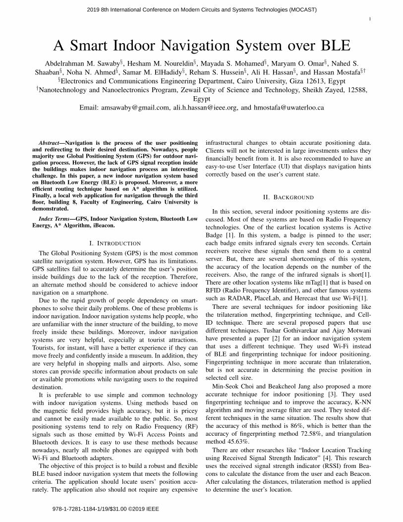
which cells we should take to get from A to B. The first thingto do now is finding the shortest route between these two cells.Here are the main parameters for selecting the shortest pathbased on A* algorithm:
• G is the cost to move from the starting cell to a certaincell through the route specified.
• H is the cost to move from a certain cell to the endingcell. It is only possible to move vertically or horizontallyregardless of the obstacles.
• F is the sum of G and H.The first step is to calculate F for all the adjacent cells to thestarting cell except for the unavailable cells (wall). Then moveto the cell that has the lowest F. This process is repeated untilthe ending cell is reached.
The map after A* algorithm would be similar to the mapshown in Fig. 4. Then, to determine the shortest route, startfrom the ending cell and move from this cell to its parent,or move in the same direction of the arrow, this should moveyou all the way back to the starting cell. The shortest path isdonated by the boxes with the yellow boarder. Note that thepointer in a cell points towards the cell that gave it the lowestvalue of F.
IV. PROPOSED SYSTEM HARDWARE IMPLEMENTATION
There are several technologies for indoor navigation, butthe most used technologies are Wi-Fi and Bluetooth. Under-standing these technologies is essential to choose which oneto implement as a smartphone application or any other kindof micro-location system.
A Wi-Fi Technology is a good alternative to GPS insidebuildings. It is preferable to use Wi-Fi because there areWi-Fi access points already installed in many buildings. Thestrength of the Wi-Fi signals (received signal strength indica-tion (RSSI)) and the MAC address (media access control) aresignificant. Although the Wi-Fi range is wide (up to 100m)[8], the accuracy of this technology is not high (5-15m). Onthe other hand, Bluetooth is more accurate.
A. Bluetooth Low Energy (BLE)
In the last few years, a lot of things happened on theBluetooth market. The concept of this technology is not new,the Bluetooth technology itself has been well-known sincethe 1990s. But recently a whole new application scenario hasoccurred, originating from the energy saving Bluetooth versionBLE (Bluetooth Low Energy). Bluetooth is another goodalternative to GPS. The BLE can detect the user’s positionaccurately up to 1m. And it is compatible with both iOS andAndroid. In addition, the power consumption is low. On theother hand, the BLE technology requires additional hardware.
B. Estimote iBeacons
They are tiny, low-power computers that can be attachedto walls or objects. Using proximity technologies, they detecthuman presence through their mobile phones and trigger pre-programmed actions delivering contextual and personalizedexperiences [9]. Beacons are small, often inexpensive devices
that provide a more accurate location within a narrow rangethan GPS or Wi-Fi proximity. Beacons transmit small amountsof data through Bluetooth up to 50 meters, so they are oftenused for indoor localization technology.
Estimote Beacons broadcast tiny packets of data containingtheir Mac Address and iBeacon ID. Information about thesignal strength (RSSI and RSSI per Meter (A)) is defined atthe scanner to be used in determining the position [10] so thatthe phone can determine which beacon it hears and how farit is. The size of iBeacons ID is 20 bytes and is divided intothree sections:
• UUID (16 bytes).• Major number (2 bytes).• Minor number (2 bytes).Each kind of beacons has the same UUID, for example,
all Proximity Beacons have the same UUID (B9407F30-F5F8-466E-AFF9-25556B57FE6D) and all stickers have thesame UUID, and the major and minor numbers are used todifferentiate between different beacons. You can change major,minor or UUID from estimate application but you must be theowner of the beacons, or the owner can transfer the beaconsto your account so that you can change any parameter. In thisapplication, a constant number for the major of each kind ofthe beacons is set as follows.
• Estimote Beacons Major = 150.• Sticker Beacons Major = 151.• Location Beacons Major = 153.
C. Raspberry PiRaspberry Pi is a low-cost, basic computer that was orig-
inally intended to help spur interest in computing amongschool-aged children. There are several versions of the Rasp-berry Pi, but the version that is used in this project is RaspberryPi 3. The Raspberry Pi acts as a scanner. The scanner code iswritten with Python. It receives the packet through DongleBluetooth USB which is connected to Raspberry PI. Thisdongle can detect any Bluetooth device not only Beacons.Therefore, the packets need to be filtered to consider onlyBeacons packets. After receiving the Beacons packets, theRaspberry Pi extracts the Beacons ID, RSSI and RSSI permeter (A), then sends them to the local host, which is thelaptop in this case. The connection between the computer andthe Raspberry Pi is established using SSH communication.The local host then analyses these data and then calculate thedistance between the Raspberry Pi and each Beacon.
V. PROPOSED SYSTEM SOFTWARE IMPLEMENTATION
A. BackendThe backend or the server side is basically how the site
works, updates and changes. This refers to everything the usercan’t see in the browser, like database and servers. Backenddevelopment is essential in creating a dynamic site. A dynamicsite is a site that changes continuously and updates in realtime. A database is required for a dynamic site to workproperly. PHP is the main language used in web developing. Itis the server-side programming language. Since the databaseunderstands this language, PHP helps us to send and getrequests from and to the database like MySQL.

2019 8th International Conference on Modern Circuits and Systems Technologies (MOCAST)
4
1) LAMP: The LAMP platform consists of four compo-nents that are structured in a layered way [11] as shown inFig. 5. Each layer or component is essential for the entiresoftware stack to work.
User LinuxApache
web server
PHP
MySQL
Figure 5. LAMP platform
• Linux is the lowest-level layer in the LAMP platform. Itprovides the operating system and runs each of the othercomponents.
• Apache is the web server. Apache provides the mechanicsfor getting a web page to a user. It is used together withPHP to create dynamic pages.
• MySQL provides the data-storage side of the LAMPsystem.
• PHP is a simple and efficient programming language thatprovides the glue for all the other parts of the LAMPsystem.
PhpMyAdmin is used to create the database. PhpMyAdminis a free and open source administration tool for MySQL.MySQL database is used to store information about the placesinside the building and their coordinates and the number ofpeople who visited these places. The database is written withPHP and JavaScript.
Figure 6. Locally Hosted Website Interface Page
B. Front End
The front end is considered as everything the user sees.When the user opens the web page to use BLE indoornavigation system, the web page detects his place and askshim to enter his destination. Then the system will show thepath he will go through to reach his destination easily. The webpage is designed with PHP and JavaScript. It is created on alocal host. The web page is capable of communicate with thedatabase to find the user’s location and his destination; thenthrough the A* algorithm code, which is written with Python,it detects the shortest path then displays it to the user.
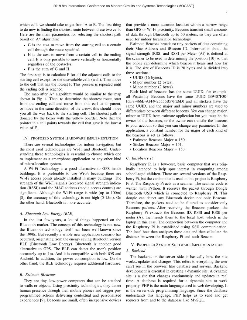
VI. EXPERIMENTAL RESULTS
The proposed indoor navigation system is launched as apilot trial on the third floor, building 8, Faculty of Engineering,
Figure 7. The shortest path displayed. This is the map of the third floor,building 8, Faculty of Engineering, Cairo University
Cairo University. Firstly, the users need to sign in/sign upon a locally hosted website as shown in Fig. 6. Follow-ing that the web application asks the user for the requireddestination; then the shortest path is calculated. Moreover,Fig. 7 shows the shortest path between two points wherethe user is being tracked by Beacons to make sure thathe/she is following the shortest path for the destination.And Demos are located at (https://youtu.be/DAG6lTr0Wt4 -https://youtu.be/kk1UsJZOqT0).
VII. CONCLUSION
Indoor navigation systems have a promising future, espe-cially with the increased use of smartphones. In this paper, asmart indoor navigation system over BLE is demonstrated.The proposed system utilizes a Raspberry Pi board as ascanner. While using estimote iBeacons for floor planningthe scanned area. Moreover, the users’ position is determinedthen navigated based on A* algorithm. Finally, a low-powerconsumption is achieved using BLE and iBeacons with a goodnavigation accuracy using A* algorithm.
REFERENCES
[1] H. K. Fard, Y. Chen, and K. K. Son, “Indoor positioning of mobiledevices with agile ibeacon deployment,” in Electrical and ComputerEngineering (CCECE), 2015 IEEE 28th Canadian Conference on,pp. 275–279, IEEE, 2015.
[2] T. Gothivarekar, A. Motwani, C. Pathak, S. Yadav, A. Perupalli, andP. Gauda, “Indoor navigation system,” International Journal of AppliedEngineering Research, vol. 3, no. 1, pp. 147–151, 2015.
[3] M.-S. Choi and B. Jang, “An accurate fingerprinting based indoorpositioning algorithm,” International Journal of Applied EngineeringResearch, vol. 12, no. 1, pp. 86–90, 2017.
[4] C.-C. Pu, C.-H. Pu, and H.-J. Lee, “Indoor location tracking usingreceived signal strength indicator,” in Emerging communications forwireless sensor networks, InTech, 2011.
[5] N. Bergman, “Recursive bayesian estimation,” Department of ElectricalEngineering, Linköping University, Linköping Studies in Science andTechnology. Doctoral dissertation, vol. 579, p. 11, 1999.
[6] P. E. Hart, N. J. Nilsson, and B. Raphael, “A formal basis for the heuristicdetermination of minimum cost paths,” IEEE transactions on SystemsScience and Cybernetics, vol. 4, no. 2, pp. 100–107, 1968.
[7] E. W. Dijkstra, “A note on two problems in connexion with graphs,”Numerische mathematik, vol. 1, no. 1, pp. 269–271, 1959.
[8] M. Herrera Vargas et al., “Indoor navigation using bluetooth low energy(ble) beacons,” 2016.
[9] Estimote, Inc., Estimote, Inc. - Indoor location with bluetooth beaconsand mesh, 2018.
[10] C. Pu, Development of a new collaborative ranging algorithm for rssiindoor location tracking in wsn. PhD thesis, PhD Thesis, DongseoUniversity, South Korea, 2009.
[11] IBM, Introduction to LAMP Technology, 2018.