a report that identifies the transport demand and ... · a report that identifies the transport...
TRANSCRIPT


A report that identifies the transport demand and strategic rationale
for a North South heavy vehicle freight corridor between the Fleurieu, Murraylands and Barossa Valley and Mid North regions.

Contents 1. Introduction 2. Executive Summary 3. Methodology 4. Relevant Studies/Support
4.1. Murray Mallee Local Government Transport Strategy 4.2. Central Local Government Region of SA – Regional Transport Strategy 4.3. Southern Hills Local Government Association – Regional Transport Strategy 4.4. South Australian Freight Council – Principles and Priorities 4.5. South Australia’s Draft Transport Plan 4.6. South Australia’s State Strategic Plan and State Infrastructure Plan 4.7. (SA) South Central Area Consultative Committee 4.8. Barossa Riverland Mid North Area Consultative Committee
5. Stakeholder Consultation
5.1. Transport Operators 5.2. Transport Users 5.3. Stakeholders
6. Strategic Rationale Regional North South Transport Corridor
6.1. Purpose 6.2. Regional significance 6.3. Economic benefits 6.4. Community benefit 6.5. Road owner benefit 6.6. Access benefits 6.7. Safety benefits 6.8. Environmental benefits
7. Review of MMLGA Multi Criteria Analysis 8. Draft Business Case 9. Footnotes Appendices
A. Transport Operator Contact Database B. Transport User Contact Database C. Stakeholder Contact Database D. Transport Operator Survey Tool E. Stakeholder Survey Tool F. Transport User Survey Tool
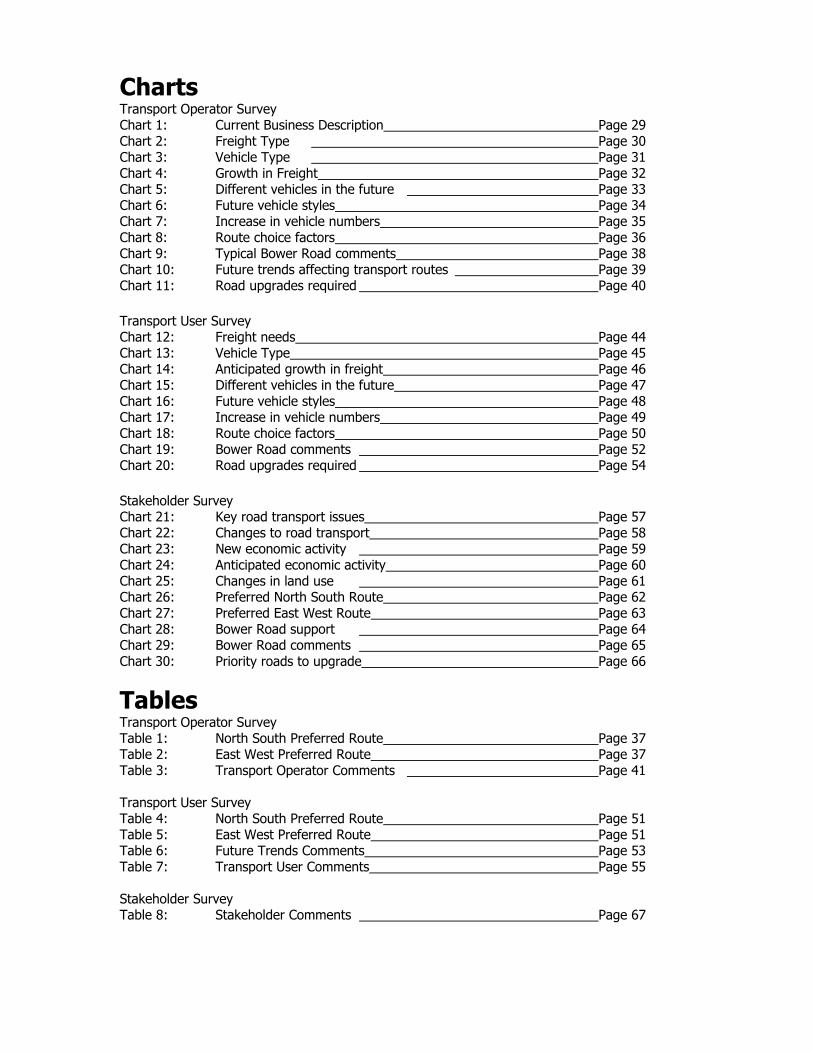
Charts Transport Operator Survey Chart 1: Current Business Description Page 29 Chart 2: Freight Type Page 30 Chart 3: Vehicle Type Page 31 Chart 4: Growth in Freight Page 32 Chart 5: Different vehicles in the future Page 33 Chart 6: Future vehicle styles Page 34 Chart 7: Increase in vehicle numbers Page 35 Chart 8: Route choice factors Page 36 Chart 9: Typical Bower Road comments Page 38 Chart 10: Future trends affecting transport routes Page 39 Chart 11: Road upgrades required Page 40 Transport User Survey Chart 12: Freight needs Page 44 Chart 13: Vehicle Type Page 45 Chart 14: Anticipated growth in freight Page 46 Chart 15: Different vehicles in the future Page 47 Chart 16: Future vehicle styles Page 48 Chart 17: Increase in vehicle numbers Page 49 Chart 18: Route choice factors Page 50 Chart 19: Bower Road comments Page 52 Chart 20: Road upgrades required Page 54 Stakeholder Survey Chart 21: Key road transport issues Page 57 Chart 22: Changes to road transport Page 58 Chart 23: New economic activity Page 59 Chart 24: Anticipated economic activity Page 60 Chart 25: Changes in land use Page 61 Chart 26: Preferred North South Route Page 62 Chart 27: Preferred East West Route Page 63 Chart 28: Bower Road support Page 64 Chart 29: Bower Road comments Page 65 Chart 30: Priority roads to upgrade Page 66
Tables Transport Operator Survey Table 1: North South Preferred Route Page 37 Table 2: East West Preferred Route Page 37 Table 3: Transport Operator Comments Page 41 Transport User Survey Table 4: North South Preferred Route Page 51 Table 5: East West Preferred Route Page 51 Table 6: Future Trends Comments Page 53 Table 7: Transport User Comments Page 55 Stakeholder Survey Table 8: Stakeholder Comments Page 67
Regional North South Transport Corridor FINAL Report February 2006
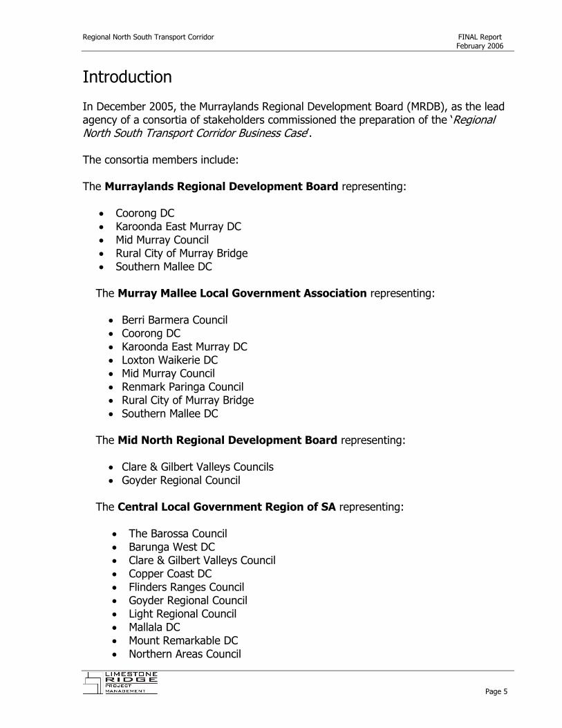
Introduction In December 2005, the Murraylands Regional Development Board (MRDB), as the lead agency of a consortia of stakeholders commissioned the preparation of the ‘Regional North South Transport Corridor Business Case’. The consortia members include: The Murraylands Regional Development Board representing:
• Coorong DC • Karoonda East Murray DC • Mid Murray Council • Rural City of Murray Bridge • Southern Mallee DC
The Murray Mallee Local Government Association representing:
• Berri Barmera Council • Coorong DC • Karoonda East Murray DC • Loxton Waikerie DC • Mid Murray Council • Renmark Paringa Council • Rural City of Murray Bridge • Southern Mallee DC
The Mid North Regional Development Board representing:
• Clare & Gilbert Valleys Councils • Goyder Regional Council
The Central Local Government Region of SA representing:
• The Barossa Council • Barunga West DC • Clare & Gilbert Valleys Council • Copper Coast DC • Flinders Ranges Council • Goyder Regional Council • Light Regional Council • Mallala DC • Mount Remarkable DC • Northern Areas Council
Page 5

Regional North South Transport Corridor FINAL Report February 2006
• Orroroo/Carrieton DC • Peterborough DC • Port Pirie Regional Council • Wakefield Regional Council • Yorke Peninsula DC
Department of Transport and Urban Planning
The Regional North South Transport Corridor Business Case is an assessment of the current and future demand for heavy vehicle freight transport between the Fleurieu, Murraylands and Barossa Valley and Mid North regions. The Regional North South Transport Corridor Business Case did not (generally) take into consideration the relative assessment processes of key funding partners and/or (generally) the prioritisation processes associated with road grants. This report acknowledges the significant work, resourcing and effort deployed by the trio of representative local government associations, namely the Murray Mallee, Central Region and Southern and Hills in the preparation of Regional Transport Strategies. This report does not attempt to duplicate these efforts as they are largely current and reflect existing and future conditions. This report does however, collate the evidence across the three plans, together with State Government input and stakeholder consultation about the proposed Regional North South Transport corridor. Together, the collation of these resources form the basis for the preparation of a draft Business Case that will provide the basis/model for the respective local government partners (notably the Rural City of Murray Bridge, Mid Murray Council, Regional Council of Goyder) in the preparation of funding applications to support the progression and implementation of the Regional North South corridor. The draft Business Case included in this application can be adapted to highlight the strategic impetus and transport demand for the proposed upgrades. However, engineering, technical and cost specifications are not included as they are considered the domain of the respective local government applicants and shall be adapted to suit the respective road/funding application.
Page 6
Regional North South Transport Corridor FINAL Report February 2006
Page 7

Regional North South Transport Corridor FINAL Report February 2006
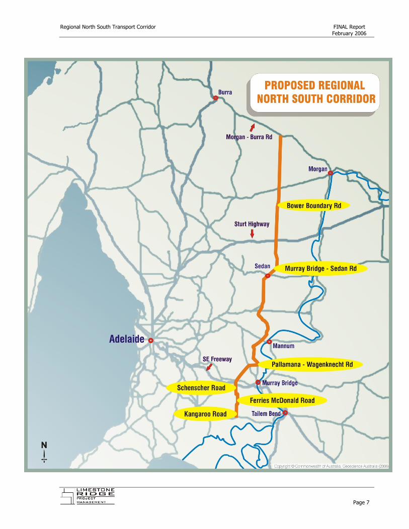
2. Executive Summary The Regional North South Transport corridor is a cross regional strategic transport route of national, state and regional significance that has been clearly identified by the project consortia as:
Kangaroo Rd, Ferries McDonald Road Schenscher Road, Pallamana – Wagenknecht Road Mannum-Mur ay Bridge Road, Sedan, Cambrai, Bower Boundary Road.
,, r
To date, Kangaroo Road, Ferries McDonald and Bower Boundary Road are not sealed, whereas, Schenscher, Pallamana-Wagenknecht Roads and the Mannum, Sedan, Cambrai route are sealed and generally in good condition. To this end, the purpose of the Regional North South Transport Corridor project was to identify the strategic impetus and transport demand for proposed upgrades to both Ferries McDonald Road and the Bower Boundary Road. Upgrading of the nominated roads will enable the establishment of a Regional North South Transport Corridor that will:
• Create a transport route of regional and state strategic significance for not only South Australia, but also of national significance to support interstate freight access;
• Support a diverse cross section of industry needs and service a broad catchment
area;
• Link three major state and national freight corridors, namely the South East Freeway, the Sturt Highway and the Morgan to Burra Road.
The proposed Regional North South Transport Corridor has significant support and strategic merit and this is evidenced in this report by:
• 80% of the transport operators that responded to the SA Metro (Heavy Vehicle) Bypass Survey identifying clearly that they would used the proposed corridor.
• 62% of the transport users that responded to the SA Metro (Heavy Vehicle)
Bypass Survey identifying clearly that they would use the proposed corridor.
• 86% of the transport stakeholders that responded to the SA Metro (Heavy Vehicle) Bypass Survey identifying clearly that they support the development of the proposed corridor.
Page 8

Regional North South Transport Corridor FINAL Report February 2006
• The South Australian Freight Council increasing the priority ranking of the
proposed Regional North South Transport Corridor from a low priority to a high priority project in February 2006.
• The Bureau of Transport and Regional Economics (BTRE) forecasting a doubling
of the freight transport task over the 20 years to 2020.
• The Murray Mallee Local Government Association ranking Ferries McDonald and Bower Boundary Roads as their number one and two project priorities within the current Murray Mallee Regional Transport Strategy.
• The Central Local Government Region of SA has given in principle high priority
support to the Bower Boundary Road (subject to industry confirmation and the evidence contained within this report) within the current Central Local Government Region of SA Transport Strategy.
• The Southern Hills Local Government Association identifying Ferries McDonald
Road as their first priority for Strategic Pool R2R2 funding in 2006.
• Confirmed support by both the (SA) South Central Area Consultative Committee and the Barossa Mid North Area Consultative Committee that the proposed Regional North South Transport Corridor is of strategic national, state and regional importance to their broader communities and of strategic economic value.
• A quadrupling of transport demand associated with the intensive animal
industry sector over the next decade as evidenced by the ‘Future Infrastructure and Development Requirements to Intensive Livestock Growth in South Australia’ Report.
• The former South Australian Draft Transport Plan identifying in April 2003 that
the focus for freight transport needs to be moved away from towns in the Adelaide Hills to make better use of investment at the Monarto Interchange on the freeway and between Murray Bridge and the Sturt Highway.
• A variety of acknowledgements within the State Infrastructure Plan that cross
regional freight must be supported. The combination of the above stakeholder consultation, strategic review of key transport plans and changing industry patterns have identified strong strategic rationale and transport demand for the proposed Regional North South Transport Corridor. This evidence can now influence government road prioritisation processes.
Page 9
Regional North South Transport Corridor FINAL Report February 2006
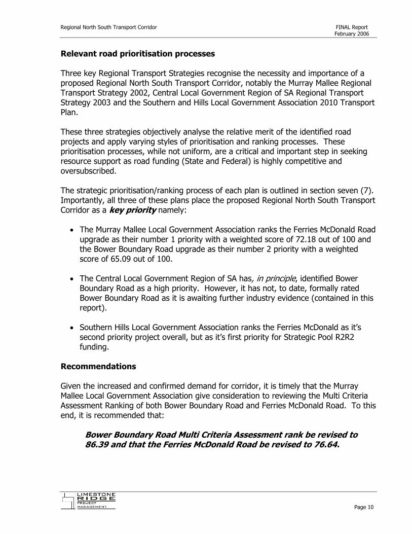
Relevant road prioritisation processes Three key Regional Transport Strategies recognise the necessity and importance of a proposed Regional North South Transport Corridor, notably the Murray Mallee Regional Transport Strategy 2002, Central Local Government Region of SA Regional Transport Strategy 2003 and the Southern and Hills Local Government Association 2010 Transport Plan. These three strategies objectively analyse the relative merit of the identified road projects and apply varying styles of prioritisation and ranking processes. These prioritisation processes, while not uniform, are a critical and important step in seeking resource support as road funding (State and Federal) is highly competitive and oversubscribed. The strategic prioritisation/ranking process of each plan is outlined in section seven (7). Importantly, all three of these plans place the proposed Regional North South Transport Corridor as a key priority namely:
• The Murray Mallee Local Government Association ranks the Ferries McDonald Road upgrade as their number 1 priority with a weighted score of 72.18 out of 100 and the Bower Boundary Road upgrade as their number 2 priority with a weighted score of 65.09 out of 100.
• The Central Local Government Region of SA has, in principle, identified Bower
Boundary Road as a high priority. However, it has not, to date, formally rated Bower Boundary Road as it is awaiting further industry evidence (contained in this report).
• Southern Hills Local Government Association ranks the Ferries McDonald as it’s
second priority project overall, but as it’s first priority for Strategic Pool R2R2 funding.
Recommendations Given the increased and confirmed demand for corridor, it is timely that the Murray Mallee Local Government Association give consideration to reviewing the Multi Criteria Assessment Ranking of both Bower Boundary Road and Ferries McDonald Road. To this end, it is recommended that:
Bower Boundary Road Multi Criteria Assessment rank be revised to 86.39 and that the Ferries McDonald Road be revised to 76.64.
Page 10

Regional North South Transport Corridor FINAL Report February 2006
It is further recommended that the:
Murray Mallee Local Government Association give urgent attention to the review of these Multi Criteria Assessment Rankings given the imminent announcement of the 2006 Auslink funding.
Similarly, the Central Local Government Region of SA, Regional Transport Strategy, has not, to date, formally rated the Bower Boundary Road. It is acknowledged that, inprinciple, Bower Boundary Road shall be rated as a high priority, and that the formal rating has not occurred due to the need for industry and evidentiary confirmation. To this end, it is recommended that the:
it
Central Local Government Region of SA give urgent attention to formally rating the Bower Boundary Road project to facilitate due consideration of the project in the imminent 2006 Auslink funding round.
The proposed Regional North South Transport Corridor is acknowledged and supported in an adhoc and un-coordinated manner within a range of third party plans and reports, notably the Strategic Infrastructure Plan for South Australia (Regional Overview); the Intensive Livestock Growth in SA Report; and South Australia’s Freight Transport Infrastructure Repot. And, while the project consortia have identified the national, state and regional significance of the proposed corridor, and this has been evidenced by this report, to date, there has been little formal co-ordination to ensure that the project is formally acknowledged by (particularly) State and Federal governments. Therefore, it is important that this report be utilised to support future lobbying by the combined local government associations to ensure that that Corridor becomes a reality. To this end, it is recommended that:
The project consort a form a Cross Regional (North South Transport Corridor) Working Party to lobby the State and Federal Governmen s for the implementation of the Regional North South Transport Corridor.
More specifically, the proposed Regional North South Transport corridor is recognised in general comments throughout the Strategic Infrastructure Plan for South Australia;
Page 11

Regional North South Transport Corridor FINAL Report February 2006
however it does not feature as a project or a priority. Therefore it is recommended that:
The Cross Regional (North South Transport Corridor) Working Party ensure that the proposed Regional North South Transport Corridor be immediately identified as a key cross regional project in the Strategic Infrastructure Plan for South Australia.
Above: Bower Boundary Road
Page 12

Regional North South Transport Corridor FINAL Report February 2006
3. Methodology The expressed aim of the Regional North South Business Case is to produce a ‘report that identifies the transport demand and strategic rationale for a Regional North South heavy vehicle freight corridor between the Fleurieu, Murraylands and Barossa Valley and Mid North regions ’ . To this end, the Invitation to Apply detailed five key consultancy activities that were required to deliver this information included:
1. Desk top research and analysis of strategic transport statements and strategies (relevant to the Regional North South corridor).
2. Key stakeholder consultation – 1:1 consultations with a range of key
stakeholders. 3. Transport user consultation – 1:1 consultations with a range of key industry
(transport users) stakeholders. 4. Transport industry consultation – 1:1 consultations with transport operators
within the subject region. 5. Written survey to the broader business and transport industry as
identified and deemed necessary and including Melbourne to Perth to Melbourne transport users.
At a meeting held in Morgan, on the 5th of December, 2005, with a number of the key project partners present, it was determined that the purpose of the Regional North South Business case was to clearly identify road user preference for the specific corridor that encapsulated Bower Boundary Road in the north and Ferries McDonald Road in the south. Further, it was identified that much work had been done by the three Regional Local Government Associations in the identification of strategic transport demand (via their Regional Transport Strategies) and that the Business Case should confirm the strategic impetus for the proposed corridor and build a cross regional case based on the combined evidence, that was largely pre-existing. Therefore, this project focused on reviewing stakeholder demand for the Regional North South corridor and the collation of existing evidence to support a case for the proposed Regional North South Corridor. With this in mind the aforementioned consultancy activities were deployed in the following manner.
Page 13

Regional North South Transport Corridor FINAL Report February 2006
1. Desk top research and analysis of strategic transport statements and
strategies (relevant to the Regional North South corridor).
The desk top research and analysis of strategic transport statements involved the interrogation of the following key documents:
• Murray Mallee Local Government Transport Strategy • Central Local Government Region of SA – Regional Transport Strategy • Southern Hills Local Government Association – Regional Transport Strategy • South Australian Freight Council – Principles and Priorities • South Australia’s Draft Transport Plan • South Australia’s State Strategic Plan and State Infrastructure Plan
The analysis and relevance of these documents to the case for the proposed Regional North South corridor are discussed in Section 4 of this report.
2. Key stakeholder consultation – 1:1 consultations with a range of key
stakeholders. A stakeholder survey was commissioned in mid December 2005. Key stakeholders were contacted by telephone and requests for information were supported by an email survey. A list of key contacts made is included in Appendix B and the results of this consultation are summarised in Section 5.3 of this report.
3. Transport user consultation – 1:1 consultations with a range of key industry (transport users) stakeholders. Similarly, a transport user survey was commissioned in mid December 2005. Key transport users were contacted by telephone and requests for information were supported by an email survey. A list of key contacts made is included in Appendice C and the results of this consultation are summarised in Section 5.2 of this report.
4. Transport industry consultation – 1:1 consultations with transport operators within the subject region. To support the written survey (activity 5), a range of follow up calls were made to transport operators. These transport operators were drawn from the database that was created for activity 5.
5. Written survey to the broader business and transport industry as identified and deemed necessary and including Melbourne to Perth to Melbourne transport users.
Page 14

Regional North South Transport Corridor FINAL Report February 2006
A transport operator survey was commissioned in mid December 2005. A database of approximately 1000 operators was assembled and the surveys were distributed during the week of 12th December 2005. The transport operator database is appended to this report in electronic format and a summary of the responses is detailed in Section 5.1 of this report. In addition to the key consultancy activities outlined in the brief, the following activities were undertaken to support the project.
6. Intensive animal industry review Beyond the scope of industry information collected by the Strategic Transport Demand statements included in each of the Local Government Associations Regional Transport Strategies, it became apparent that the intensive animal industry was significantly driving increased transport demand. Therefore, the impact of the potential industry growth has been sourced and summarised from the ‘Future Infrastructure and Development Requirements relating to Intensive Livestock Growth in South Australia’ Final Report, August 2005. This summary is detailed in Section 6.3 of this report.
7. Review of Murray Mallee Multi Criteria Analysis for the subject roads The Regional North South Business Case Invitation to Apply provided that:
The Regional North South Business Case will not take into consideration the relative assessment processes of key funding partners and prioritisation processes associated with road grants. Rather, the Regional North South Business Case will identify the strategic importance of such a corridor and preferred routes of t avel and utilisation of existing transport corridors.
r
However, during the course of the research, it was identified that the assessment for the Bower Boundary Road had significantly changed from the original assessment. Thus, this report makes recommendations on the review of the Murray Mallee LGA Multi Criteria rankings for both Bower Boundary Road and Ferries McDonald Road. This is detailed in Section 7 of this report.
8. Preparation of a draft Business Case The core objective of the Regional North South Business Case is outlined in the Invitation to Apply namely:
Page 15
Regional North South Transport Corridor FINAL Report February 2006
The information collected by the Regional North South Business Case will support future strategic road assessment processes (Aus Link Funding, Roads to Recovery & Special Local Roads Program) but primarily, external grant application processes (eg. Regional Development Infrastructure Fund and private investor attraction).
Thus, this report includes an outline of a Draft Business Case for the Regional North South Corridor. Given that the Regional North South Corridor traverses four local government areas, the financial costings and localised information has not been included as this shall be provided by the relevant local government partner at the time of actual submission to the relevant funding partners. The Draft Business Case outline is contained within this report at Section 8.
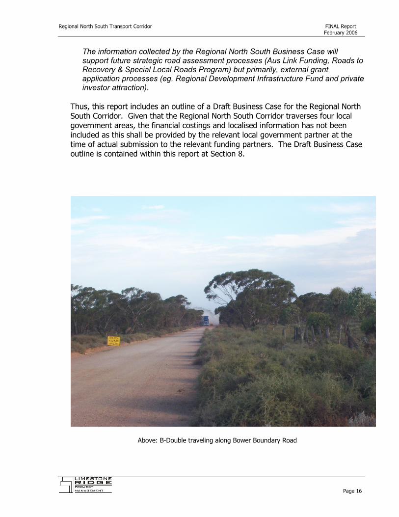
Above: B-Double traveling along Bower Boundary Road
Page 16

Regional North South Transport Corridor FINAL Report February 2006
4. Relevant studies 4.1 Murray and Mallee Local Government Transport Strategy The Murray and Mallee Local Government Association (MMLGA) commissioned the Murray and Mallee Regional Transport Strategy in 2002. The Murray and Mallee Regional Transport Strategy is ‘intended for use as a living reference document and as an assessment tool to assist in determining investment priorities and infrastructure planning, with a view to enhancing economic developmentin the region
i’.
The Murray and Mallee Regional Transport Strategy was developed in three distinct phases, namely: • An analysis of existing conditions and key transport issues for the region; • Identification of future regional economic activity and associated transport
demand; and • The development of the strategic regional transport plan for the Murray and
Mallee region. During 2003, the Murray and Mallee Regional Transport Strategy was endorsed by the Association and has subsequently provided the framework for road transport improvements within the broader Murray and Mallee region. The Murray and Mallee Regional Transport Strategy has served the region well with a number of improvements instigated since it’s inception, including the completion of the Monarto Interchange, sealing of Pallamana Road, Karoonda – Yumali Road, upgrading of Flagstaff Road intersection. More recently, the Murray and Mallee Local Government Regional Transport Committee considered both the review of the Murray and Mallee Regional Transport Strategy and the inclusion of new roads within the Strategy. In September 2005 the Committee recommended to the MMLGA that the existing Murray and Mallee Regional Transport Strategy be maintained and that a review would not take place. Subsequently, at the December 2005 meeting, the MMLGA resolved that as the Member Council’s first road of preference had not been amended (with the exception of the Berri Barmera Council to include McKay Road in preference to Jury Road) that the first Roads of preference and their ranking be maintained.
Page 17
Regional North South Transport Corridor FINAL Report February 2006
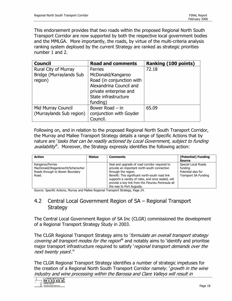
This endorsement provides that two roads within the proposed Regional North South Transport Corridor are now supported by both the respective local government bodies and the MMLGA. More importantly, the roads, by virtue of the multi-criteria analysis ranking system deployed by the current Strategy are ranked as strategic priorities number 1 and 2. Council Road and comments Ranking (100 points) Rural City of Murray Bridge (Murraylands Sub region)
Ferries McDonald/Kangaroo Road (in conjunction with Alexandrina Council and private enterprise and State infrastructure funding)
72.18
Mid Murray Council (Murraylands Sub region)
Bower Road – in conjunction with Goyder Council.
65.09
Following on, and in relation to the proposed Regional North South Transport Corridor, the Murray and Mallee Transport Strategy details a range of Specific Actions that by nature are ‘tasks that can be readily actioned by Local Government subject to funding availability’
,ii. Moreover, the Strategy expressly identifies the following action:
Action Status Comments (Potential) Funding
Source Kangaroo/Ferries MacDonald/Wagenknecht/Schenscher Roads through to Bower Boundary Road.
Seal and upgrade of road corridor required to provide an important north-south connection through the region. Benefit: This significant north-south road link supports a variety of roles, and once sealed, will provide a key link from the Fleurieu Peninsula all the way to Port Augusta.
Special Local Roads funding Potential also for Transport SA Funding
Source: Specific Actions, Murray and Mallee Regional Transport Strategy, Page 24.
4.2 Central Local Government Region of SA – Regional Transport
Strategy The Central Local Government Region of SA Inc (CLGR) commissioned the development of a Regional Transport Strategy Study in 2003. The CLGR Regional Transport Strategy aims to ’formulate an overall transport strategy covering all transpo t modes for the region’r
iii and notably aims to ‘identify and prioritise major transport infrastructure required to satisfy ‘regional transport demands over the next twenty years’.iv
The CLGR Regional Transport Strategy identifies a number of strategic impetuses for the creation of a Regional North South Transport Corridor namely: ‘growth in the wine industry and wine processing within the Barossa and Clare Valleys will result in
Page 18
Regional North South Transport Corridor FINAL Report February 2006
increased local and cross regional north-south heavy vehicle movements through the region’ and ‘local and cross regional traffic growth is also likely to occur due to expansions in the manufacturing, mining, livestock, pig and feed industries (SAMAG, Olympic Dam expansion, Murray Basin sands, Eudunda 250,000 animal piggery) particularly east-west movements and north-south movements’v. In relation to the proposed Regional North South Transport Corridor, the CLGR Regional Transport Strategy identifies a number of strategic developments that are required to facilitate industry expansion within the region and that will impact on the regional transport network within 0-5 years. Of particular note, the Strategy identifies the ‘Eudunda Intensive Animal precinct (250,000 animal piggery) near Bower Border Road – Directly impacts on Bower-Borde Road and Eudunda-Bower Road. Indirectly impacts on Eudunda-Kapunda and Eudunda-Marrabel Roads’
rvi
To date, the Bower Boundary Road project has not be formally rated by the CLGR Regional Transport Strategy. However, the project has ‘in principle’ support to be ranked as a high priority project, subject to the provision of industry evidence. It is further noted, that at the time of this report, that the CLGR was in the final stages of a tender process to undertake a detailed review the CLGR Regional Transport Strategy. It is anticipated that the revised CLGR Regional Transport Strategy shall include a quantitative prioritisation assessment of the recommended road projects in preference to the existing model.
Page 19
Regional North South Transport Corridor FINAL Report February 2006
4.3 Southern Hills Local Government Association – Regional Transport Strategy
The Southern Hills Local Government Association (SHLGA) commissioned the 2010 Transport Plan in 2001. The SHLGA Transport Plan is a ‘method of determining priorities for funding transport improvements over the Southern and Hills egion. It is a more detailed plan for improvements than an overall State plan and takes into consideration existing conditions, as well as the existing and future demands of the regional transport network.’
r
f
)
tt t
vii
The SHLGA Transport Plan is further supported by the 2010 Transport Plan Addendum that assesses ‘at a very broad level the identification of and need for a notional north-south road corridor east of Adelaide between Fleurieu Peninsula/Kangaroo Island or Langhorne Creek and the Barossa, particularly for heavy commercial vehicles.’viii
In the first instance, the primary SHLGA Transport Plan supports the proposed (Ferries McDonald – Bower Rd) Regional North South Transport corridor through its endorsement of the Local Road Network Action Plan that ranks the sealing of the Ferries McDonald Road (Rural City of Murray Bridge) at number 5 and further expresses that ‘these roads should be upgraded or constructed within the next three to five years depending on the source and amount o available funds’ix. However, the SHLGA Transport Plan addendum explores a range of localised Regional North South transport corridors to facilitate the transportation of (primarily) wine and timber from the Fleurieu to and from the Barossa Valley. A range of options are explored within the addendum with two route preferences recommended, namely:
Route 3B (Mt Barker, Nairne, Woodside, Mt Pleasant/Williamstown) is the recommended north-south corridor between Langhorne Creek/McLaren Vale and the Barossa for a general freight route, excluding B-doubles. Route 4B, (Strathablyn, Callington, Monarto, Palmer, Mt Pleasant, Eden Valley which comes a close second in the evaluation, is recommended as the B-double route between Langhorne Creek and the Barossa.x
The SHLGA Transport Plan addendum acknowledges:
The small difference in the priori y ranking between Routes 3B and 4B highlight the need for further more detailed investiga ion and public consul ation and acceptance of these routes and their relative benefits and impacts.xi
At years end (2005) Transport SA was completing a safety audit of the recommended routes and had not publicly released the findings of the audit.
Page 20

Regional North South Transport Corridor FINAL Report February 2006
It is important to note that the above localised north-south corridors and the assessment of the SHLGA Transport Plan addendum is very much targeted at two primary industry uses namely the transportation of wine grapes and forestry products. The SHLGA Transport Plan highlights a significant existing and future transport demand driven by the seasonal (April and May) transportation of grapes to the Barossa, at night, by semi trailers. Specifically, the transportation of grapes during vintage 2001 amounted to 28 786 tonnes or more than 60% of the harvest from Langhorne Creek. Anticipated volumes for the 2006 vintage are anticipated to double, to a total production of 80 249 tonnes. The SHLGA Transport Plan addendum makes further predictions on the growth in transport demand by the Forestry industry. While this growth is not disputed, the Forestry plantations ‘ take about 10 to 12 years before the first cut is undertaken’ and ‘the impact of carting this amount of timber has not been determined and further investigations are required to identify the best method of export and routes to be used’’xii. This uncertainty in transport demand is largely due to the fact that decisions on processing have not yet been taken. It is further important to note that at the Barossa Council meeting on the 17th January that a unanimous motion was carried to the effect:
The Barossa Council supports the heavy transport north-south route through Cambrai and Sedan to the Sturt Highway and not through Palmer, Tungkillo, MtPleasant, Springton and Eden Valley or through Williamstown and that the Southern and Hills Local Government Associa ion be advised of Council’s decision.
txiii
This report does not seek to debate the merits of the localised SHLGA Transport Plan Addendum, but rather focus discussions on the regional north south transport corridor (Fleurieu – Mid North). As can be identified from the evidence on the previous page, the localised north south report is driven by the needs of two industry sectors, whereas the subject Regional North South corridor has broader industry appeal and certainly extends an existing B-Double route. Further, the outcome of the safety audit conducted by Transport SA will have future bearing on the funding of such improvements (namely State sponsored) and as such should not be considered as a threat/compromise to the subject Regional North South corridor. Of importance to this report, is the assessment (and subsequent prioritisation) of the Ferries McDonald Rd by the SHLGA.
Page 21

Regional North South Transport Corridor FINAL Report February 2006
To this end, at it’s meeting on the 17th of January, the SHLGA Roads Working Party identified that the remaining priority 1 projects of the SHLGA 2010 Transport Plan were namely:
Priority Road Comment
3 Waterport Road Completed 2006
4 Nangkita Road Priority 1 SLRP 2005 – 2006 (Stage 2) priority 1 SLRP 2006 – 2007 (Stage 3 -completed) Two intersections possibly a Strategic Pool R2R2 2006 application
5 Ferries McDonald Road
Strategic Pool R2R2 2006 application
6 Tiers Road Reconstruction completed AHC
7 Airport Road Priority 2 SLRP 2006 – 2007
Verbal discussions with the Executive Officer of the SHLGA have confirmed that an application for Ferries McDonald Road shall be pursued within the anticipated Auslink round in mid to late February.
Page 22
Regional North South Transport Corridor FINAL Report February 2006
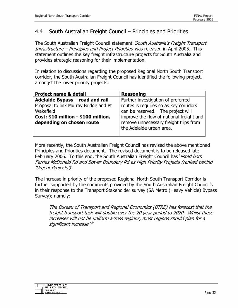
4.4 South Australian Freight Council – Principles and Priorities The South Australian Freight Council statement ‘South Australia’s Freight Transport Infrastructure – Principles and Project Priorities’ was released in April 2005. This statement outlines the key freight infrastructure projects for South Australia and provides strategic reasoning for their implementation. In relation to discussions regarding the proposed Regional North South Transport corridor, the South Australian Freight Council has identified the following project, amongst the lower priority projects: Project name & detail Reasoning Adelaide Bypass – road and rail Proposal to link Murray Bridge and Pt Wakefield Cost: $10 million - $100 million, depending on chosen route
Further investigation of preferred routes is requires so as key corridors can be reserved. The project will improve the flow of national freight and remove unnecessary freight trips from the Adelaide urban area.
More recently, the South Australian Freight Council has revised the above mentioned Principles and Priorities document. The revised document is to be released late February 2006. To this end, the South Australian Freight Council has ‘listed both Ferries McDonald Rd and Bower Boundary Rd as High P iority Projects (ranked behind ‘Urgent Projects’)’.
r
)
The increase in priority of the proposed Regional North South Transport Corridor is further supported by the comments provided by the South Australian Freight Council’s in their response to the Transport Stakeholder survey (SA Metro (Heavy Vehicle) Bypass Survey); namely:
The Bureau of Transport and Regional Economics (BTRE has forecast that the freight transport task will double over the 20 year period to 2020. Whilst these increases will not be uniform across regions, most regions should plan for a significant increase.xiv
Page 23

Regional North South Transport Corridor FINAL Report February 2006
4.5 South Australia’s Draft Transport Plan The South Australian Draft Transport Plan was released in April 2003 and while the Plan is not now considered current, it provides a good insight to the objectives of State Government in consultation with broader industry and stakeholders. The comments outlined below can not be taken as reflective of the current views of Government; however, in absence of any further public comment they provide a starting point for discussions. The South Australian Draft Transport Plan was released to:
provide a guiding framework for transport decision in South Australia for the next 15 years, over three, five-year phases. This will be fur her supported by fundamental links made between the Transport Plan the State Planning Strategy and the South Australian Economic Development Plan.
t,
f
xv
In relation to the case for a Regional North South Transport corridor, the Draft Transport Plan identified that:
The focus for freight transport needs to be moved away from towns in the Adelaide Hills to make better use of investment at the Monarto Interchange on the freeway and between Murray Bridge and the Sturt Highway. North-south freight will be attracted away from Mount Barker through targeted rural road investments. This will eliminate, in the short-term, the need for both a Mount Barker bypass and additional access to the South East freeway.xvi
The South Australian Draft Transport Plan further details a Regional North South Transport corridor as a possibility when thinking ‘outside the square’ in relation to the ‘Gateway to Economic Development and Jobs – Maintaining Freight Competitiveness’. In particular the Plan comments:
Some interstate road and rail traffic that enters Adelaide via the Adelaide Hills is destined for the northern suburbs and for regional and interstate locations to the north of Adelaide. An alternative route between Murray Bridge and the north of Adelaide would reduce the need for this tra fic to pass through the metropolitan area.
While the above comments are indeed promising and support much of the work of this report, it is important to note that the South Australian Draft Transport Plan has been withdrawn from public circulation and at this point is provided only for reference. The South Australian Draft Transport Plan has, to some degree, been superseded by the release of the South Australian Strategic Plan and the South Australian State Infrastructure Plan.
Page 24

Regional North South Transport Corridor FINAL Report February 2006
4.6 South Australia’s State Strategic Plan and State Infrastructure Plan The South Australian State Strategic Plan was released in March 2004 and details six key objectives that are: Growing prosperity; Improving wellbeing; Attaining sustainability; Fostering creativity; Building communities; and Expanding opportunity. Within the six key objectives a further 79 targets are established for the State that detail key measures that will benchmark progress over time. Transport infrastructure is identified within the State Strategic Plan viz target T5.11 that is:
Build and maintain infrastructure to develop and support sustainable communities in regions.
r
xvii
And, this will be measured by the State’s performance against the State Infrastructure Plan. The State Infrastructure Plan is supported by a Regional Overview that provides a framework for infrastructure development throughout the entire State, with due emphasis placed on each region of South Australia. In relation to the proposed Regional North South Transport corridor, the State Infrastructure Plan provides the following comments:
Murray Mallee
‘Future economic g owth will require efficient transportation links. A priority is therefore to identify and upgrade local linking freight routes, which will improve the efficiency of freight handling and transfer, the level of service to the major highway links and road safety.’xviii
Mid North and Yorke Peninsula
‘Upgrading of the Bower Boundary Road may be required if the Roberstown intensive animal precinct is developed’.xix
Barossa, Adelaide Hills, Northern Adelaide Plains, Fleurieu Peninsula & Kangaroo Island
‘The key transport issues in the region are largely the result of tensions and conflicts that occur due to the competing needs of freight, tourism, commuters and local and regional travel.’xx
Page 25

Regional North South Transport Corridor FINAL Report February 2006
However, to date, the State Infrastructure Plan does not reflect the proposed Regional North South Transport corridor in any of the identified project lists. To this end, a coordinated effort by the three local government associations would ensure that the proposed corridor be listed due to its strategic and economic benefits. 4.7 (SA) South Central Area Consultative Committee The (SA) South Central Area Consultative Committee (SCACC) is a non-profit, community-based organisation funded by the Australian Government to facilitate change and development in the South Central region. SCACC, works in partnership with local communities to support their ideas to encourage regional growth. The SCACC advocates for the region on economic, social and environmental issues, and facilitates whole of Government responses to issues and opportunities. Through community consultation, SCACC has identified the key result areas of wine, food, tourism, water and community well-being. The SCACC 2004-2007 Strategic Regional Plan identifies one of the major economic issues for the South Central Region as ‘inadequate regional business services, such as freight’xxi. Further, the Strategic Plan also identifies infrastructure as a major constraint and notes a key issue as ‘the poor quali y of roads in many parts of the region…….and the ineffective freight corridors….which have not kept pace with transportdevelopments’
t
xxii. Within the above strategic context, the SCACC has considered the proposed Regional North South Corridor and at it’s meeting on the 6th of February 2006 it formally moved:
The South Central Area Consultative Committee receives and endorses the North/South Business Case draft report and supports the proposed funding application to the Local Government Transport Advisory Panel for Auslink funding as a project of strategic significance.xxiii
4.8 Barossa Riverland Mid North Area Consultative Committee In a similar manner to the (SA) South Central Area Consultative Committee, the Barossa Riverland Mid North Area Consultative Committee (BRMACC) exists to provide a vital conduit between communities, business and government and are uniquely placed to respond to issues in their region. The BRMACC Strategic Regional Plan 2004-2007 identifies two overarching themes of infrastructure and sustainability that will underpin all regional development activities in the Barossa Riverland Mid North region over the next three years. More specifically, the BRMACC Strategic Regional Plan identifies four target areas and key initiatives to
Page 26

Regional North South Transport Corridor FINAL Report February 2006
support the overarching themes. Of relevance to the proposed Regional North South corridor, the Strategic Regional Plan aims to:
• Imp ove regional infrastructure, such as telecommunications, transport and roads, child care and waste management.
r
xxiv
• Support and encourage the development of specific industry and investment
zones.xxv
The BRMACC has had the opportunity to consider the Preliminary Report of the Regional North South Transport Corridor and determine a formal position in regards to their support. Final positioning on the proposal is anticipated by the end of February 2006.
Above: Pallamana/Wagenknecht Road Intersection
Page 27
Regional North South Transport Corridor FINAL Report February 2006
5. Stakeholder consultation 5.1 Transport Operators Methodology A written transport operator (SA Metro Heavy Vehicle Bypass) survey was commissioned in mid December 2005. A database of approximately 1000 operators was assembled and the surveys were distributed during the week of 12th December 2005. Operators were able to respond to the survey by a range of simple ‘tick and flick’ questions and were able to return the survey by reply paid post. In total 115 responses were received which represents a response rate of 11.5%, but more importantly the responses cover a broad cross section of transport operators. The transport operator database is appended to this report in electronic format and a summary of the responses is detailed in the following section. Transport Operator Survey Response Summary A broad range of transport operators responded to the survey, with a noticeable number from the livestock, grain/fodder and general freight sub sectors. Collectively the operators identified that the average annual volume of freight, per operator, is 75,000 tonnes, with just fewer than 25% currently bypassing Adelaide. The most common vehicle type in use is an Articulated Semi Trailer, with an anticipated move towards B-Doubles and an increase in freight volumes in the order of 10-20% over the next five years. Further, the operators identified a future increase of between 10-20% in vehicle numbers. Road safety, fuel consumption and travel time were identified as the most important factors in deciding on appropriate routes. In relation to the proposed Regional North South transport corridor, and specifically the Bower Boundary Road extension, 80% of all operators identified that they would use the route, with this route also identified by 14 and 20% of operators as a current Regional North South and East West (respectively) route. In relation to future trends, operators clearly identified (25% of all responses) that more B-Double and Road Train access would be sought with rising costs noted as a future concern.
Page 28

Regional North South Transport Corridor FINAL Report February 2006
Current business Question 1 asked operators to ‘Describe your current business’ in terms of their transport operations. Operators could identify more than one style of operation and generally the responses covered a good range of transport styles.
Q1.(Operators) Describe your current business
0
10
20
30
40
50
60
70
Local State Interstate Other
Type of Transport
Num
ber o
f res
pons
es
Above: Chart 1 ‘Current business description’
Page 29

Regional North South Transport Corridor FINAL Report February 2006
Freight type Question 2 asked ‘What type of freight do you carry?’. Respondents to the survey were generally evenly spread, with a noticeable number of carriers providing livestock, grain/fodder and general freight services.
Q2.(Operators) What type of freight do you carry?
0
5
10
15
20
25
30
35
40
45
Livestock Refridgerated Grain/Fodder Fresh Produce General Timber/Wood Motor Vehicles HeavyMachinery
Other
Type of freight
Num
ber o
f res
pons
es
Above: Chart 2 ‘Freight Type’
Page 30

Regional North South Transport Corridor FINAL Report February 2006
Average freight volumes Question 3 asked the Operators to identify their current freight volumes. Given the relative survey sample size and variability of load types, the averaged response to this question is at best indicative. Noting this, the average freight volume across operators was 75,000 tonnes. % of freight that bypasses Adelaide Question 4 asked Operators to identify the percentage of current freight that bypasses Adelaide. The Operators collectively identified that the average volume of freight bypassing Adelaide was just under 25% at 24.05%. Again, given that a formal bypass of Adelaide does not yet exist this is an indicative figure only, but provides a useful benchmark. Type of vehicles currently used Question 5 asked the operators to identify their current vehicles. Operators were able to identify more than one style. Not unexpected, the most common category of vehicles were Articulated Semi’s and B-Doubles.
Q5.(Operators) What type of vehicles does your business currently run?
0
20
40
60
80
100
120
140
160
180
200
B- Doubles Articulated Semi's Rigid Truck Road Train Truck & TrailerCombo
Van MAD Combos &MAP
Type of Vehicle
Res
pons
es
Above: Chart 3 ‘Vehicle Type’
Page 31
Regional North South Transport Corridor FINAL Report February 2006
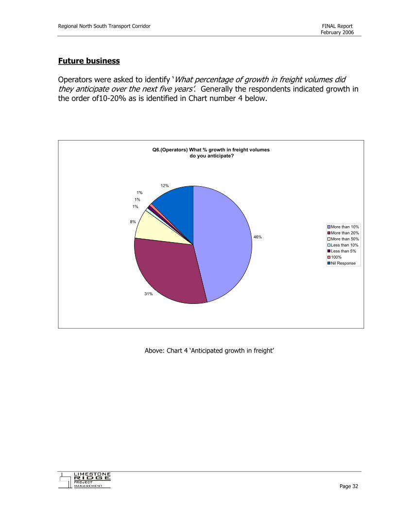
Future business Operators were asked to identify ‘What percentage o growth in freight volumes did they anticipate over the next five years’. Generally the respondents indicated growth in the order of10-20% as is identified in Chart number 4 below.
f
Q6.(Operators) What % growth in freight volumes do you anticipate?
46%
31%
8%
1%
1%
1%
12%
More than 10%More than 20%More than 50%Less than 10%Less than 5%100%Nil Response
Above: Chart 4 ‘Anticipated growth in freight’
Page 32

Regional North South Transport Corridor FINAL Report February 2006
Future vehicle use Operators were asked if they ‘would use a different style o vehicle in the fu u e’. 25% of respondents identified that they would, whereas 65% indicated no change and 10% did not respond.
f t r
Q7.(Operators) Will you use a different style of vehicle?
Yes25%
No65%
No Response10%
Above: Chart 5 ‘Different vehicle in the future’
Page 33

Regional North South Transport Corridor FINAL Report February 2006
Future vehicle styles The Operators that identified that they would move to new vehicle styles were asked to identify their preferred future vehicles. Operators were able to nominate more than one vehicle, with the results clearly identifying a preference for larger vehicles, notably B-Doubles.
Q7a.(Operators) If yes to Q7, What type of vehicles are you most likely to use more of in the future?
Van B-Double Rigid Truck Road Train Truck & TrailerCombo
B-Triple Articulated Semi Other
Type of vehicle
Above: Chart 6 ‘Future vehicle types’
Page 34

Regional North South Transport Corridor FINAL Report February 2006
Future increase in vehicle numbers Operators were asked to identify the anticipated future increase in vehicle numbers. Generally operators indicated a 10-20% increase in vehicle numbers.
Q8.(Operators) What increase in vehicle numbers do you anticipate in the future?
Nil6% Less than 10%
3%
10%46%More than 20%
20%
More than 50%2%
No repsonse23%
Above: Chart 7 ‘Increase in vehicle numbers’
Page 35

Regional North South Transport Corridor FINAL Report February 2006
Route preferences Operators were asked to identify the five most important factors that affect route choice from a list of 14 options. Road safety followed by travel time, fuel consumption and travel time and distance and vehicle wear were the highest ranked factors that affect route choice.
Q9 (Operators) Select 5 of the most important factors that affect your route choice
0
10
20
30
40
50
60
70
80
Road S
afety
Terrain
Fuel C
onsu
mption
Travel
Time
Travel
Distan
ce
Operat
or Stre
ss/Effic
iency
Roads
ide A
menitie
s
Vehicl
e Wea
r
Load
Safe
ty
Load
Shif
ting
Produc
t Dam
age
Factors important to route
Res
pons
es
Above: Chart 8 ‘Route choice factors’
Page 36

Regional North South Transport Corridor FINAL Report February 2006
North South preferred routes Question 10 asked operators to identify their current preferred route to move freight North South from Port Augusta to Tailem Bend. Three clear choices emerged and Table 1 below identifies that the current preferred route is via Adelaide and the South East Freeway. Identified North South route % of responses Port Augusta – Adelaide Suburbs – South East Freeway 76% Port Wakefield, Dublin, Gawler, Angaston, Sedan, Truro, Murray Bridge
14 %
Port Augusta, Balaklava, Tungkillo, Palmer, Tailem Bend 10%
Above: Table 1 ‘North South Preferred Route’ East West preferred routes Question 11 asked operators to identify their current preferred route to move freight East West from Victorian border to the Western border. Three clear choices emerged and Table 2 below identifies that the current preferred route is via Adelaide and the South East Freeway. Identified East West route % of responses Port Augusta – Adelaide Suburbs – South East Freeway 75% Port Wakefield, Dublin, Gawler, Angaston, Sedan, Truro, Murray Bridge
20%
Port Augusta, Balaklava, Tungkillo, Palmer, Tailem Bend 4%
Above: Table 2 ‘East West Preferred Route’
Page 37

Regional North South Transport Corridor FINAL Report February 2006
Proposed North South Corridor Critical to the development of the Business Case for the proposed Regional North South Corridor was the question to operators:
‘If a fully sealed ‘B Double Standard’ Adelaide Met o Bypass was created that offered a connection from Murray Bridge through to Pt Pirie via Sedan (linking the South East Freeway, Sturt Highway and the Burra – Morgan Road) would you use it?’
r
80% of respondents clearly identified that YES they would use the proposed corridor. Limited comments were received on the proposed corridor, but those they chose to make a comment were generally enthusiastic. Chart 9, below, summarises the comments.
Q 12a.(Operators) Bower Road Comments
Excellent Idea, 3, 5%
Suggest Road Train Standard, 3, 5%
Wouldn't Use, 3, 5%
Not Applicable, 3, 5%
No Comment, 52, 80%
Above: Chart 9 ‘Typical Bower Road Comments’
Page 38

Regional North South Transport Corridor FINAL Report February 2006
Future trends Operators were asked an open question with regards to the future trends, within the industry, that may influence their future requirements for transport routes. Largely, the operators identified increasing demand for B-Double and Road Train access. Chart 10 summarises the operator responses.
Q 13. (Operators) What changes or future trends are occurring in your industry that may influence your current or furture
requirements for transport routes?
No Comment53%
Not Applicable8%
More B-Double, Road Train access/standard
25%
Costs/Rego/Fuel8%
Safety3%
Road Condition comments3%
Above: Chart 10 ‘Future trends affecting transport routes’
Page 39

Regional North South Transport Corridor FINAL Report February 2006
Road upgrade priorities The transport operators identified a range of roads requiring attention across the subject regions. Chart 11 summarises these responses.
Q 14. (Operators) What roads would you like to see upgraded?
Sturt Highway14%
Barrier Highway4%
Mallee Highway7%
Barossa Valley Highway10%
Not Applicable5%
No Comments40%
Barossa/Burra Roads10%
Port Wakefield Road5%
Princes Highway1%
Highway 14%
Above: Chart 11 ‘Road upgrades required’
Page 40
Regional North South Transport Corridor FINAL Report February 2006
General operator comments The final response for the operators was an open ended question that sought input on heavy freight transport in the subject regions. The operator responses are listed in Table below and are generally broad reaching and individualized and do not present a common theme. These responses are perhaps better managed at a localised level, rather than across the proposed Regional North South corridor. Roads are generally sub standard for heavy vehicles .i.e. Gawler-Clare & Barrier Highway to Broken Hill is a disgrace.
Remove the red tape war between Councils and TSA regarding RAV (B-double access) Councils need to move into the 21st Century. Stop using transport as the meat in the sandwich.
We don't use these roads
Open more B-Double routes eg: Karoonda Council area
To transfer traffic of this size and weight through hilly terrain is crazy and dangerous for all road users. If this is to go ahead the route needs to be planned well with distance & road level (i.e. Hilly) taken into consideration.
Adelaide to Broken Hill is rough and we avoid it as much as possible.
Toilet facilities in the major truck parking bays We are a bus company and carry very little freight. We operate a fixed route service to Adelaide, so this survey does not really apply to us. Re-alignment & major upgrade to Mallee Highway. B-Double parking bay/rest area to be upgraded and greater increase in number. There has been a gradual increase in B-Double & single units on Mallee Highway over the years, without any major upgrading done at all.
Roads at moment not good enough to cope with heavy transport.
The By-pass needs to come in closer to Adelaide, maybe Gawler so as to take traffic out of Adelaide. More Road Train access Upgrading Eden valley to Mount Pleasant to Tungkillo to Palmer to get to Murray Bridge from Barossa Valley (ie Passing Lanes - zero at present) B-Doubles need to have access to all roads for delivery to farms, for delivery of livestock, bulk products, grain etc. Access must be 12 monthly.
Upgrade one or two main freight routes for safe operation of B-Doubles. Tailem Bend to Karoonda Rd - B-double route. Build the bypass and have local and metro roads from Heavy transport usage. Not enough parking bays, especially near industrial areas for splitting B-doubles A lot more double lane roads or passing lanes or widening of existing roads Adelaide Bypass via Murray Bridge, Mount Pleasant, Williamstown, Gawler, Mallala, Dublin, would provide access to stock markets as well as North South freight.
Road maintenance - parking bays
Try to keep out of hills and cities - Better roads Consideration for over height loads as well. A 5.5m clearance would help us & our Clients. Parking bays/ Rest areas
Need more parking bays The whole infrastructure is woefully inadequate. Hard to say where to start! Decent road building skill would be a start, even the new roads are bad. Generally there are needed wider roads, more parking bays and more passing lanes throughout the Region A lot of roads in the Mid North are in desperate need of repairs.
M/Bridge, Sedan, Truro route already heavily used, everyone could only benefit if upgraded.
Sedan to Burra Rd intersecting on the Sturt Highway would be ideal truck stop servicing all directions. I'm a road user & I am in the BP Tailem Bend. Whilst most questions are not relevant to me , I want to endorse the idea, keeping trucks out of then Suburbs would be safer, < pollution, maybe < accidents, reduce the levels of (perceived) frustration for to
Page 41

Regional North South Transport Corridor FINAL Report February 2006
Regarding Heavy Freight vehicles small towns (Nil to 10 population) with speed restrictions - this is ridiculous for B-Doubles, by the time they get going again there is another town. They make more noise slowing down than if they just kept going.
Standardise Barossa rail line.
State Govt to give more funds to Local Govt so that other roads upgraded as produce comes from farms before accessing freight routes to T/Bend to Pt Adelaide/Dublin etc. When accidents block the Dukes Highway - must - should have alternative sealed routes
A rail survey was undertaken, where the line left M/Bridge (on the Adelaide side) via the Eastern side of the range, Palmer Sedan etc, came out North of Adelaide & there were no curve speeds, no gradients, greater 1 in 100 , but it was found too costly to Maybe you should look at a route between Sedan and Port Wakefield as a lot of freight moves in and out of the Yorke Peninsula as well. Need to get B-Doubles direct from Angaston to Sedan without going back to Truro. More areas to park for B-Doubles & Road Trains for rest periods
B-Double axle weights do not exceed single axle weights, so why is there such restrictions on these vehicles. Access consideration to the many distributors/manufacturers in the area - Most are high weight products: road transport operates at maximum GCM. Some opportunities for value-adding hay and grain at lower north processing plants is made less viable at present due to no "short cut" to these areas I would have thought proposed by-pass should start at Tarlee, so traffic can use either Barrier Highway or Main North Rd - Not everybody wants to end up at Burra. Need large parking bays for road train & B-doubles right through the Mid North of SA. Jamestown to Pt Pirie & Jamestown thru the Murraylands area. Better B-double & road train access to all areas
Above: Table 3 Operator Comments
Page 42
Regional North South Transport Corridor FINAL Report February 2006
5.2 Transport Users Methodology A written transport user (SA Metro Heavy Vehicle Bypass) survey was commissioned in mid December 2005. A database of 57 transport users was assembled and direct telephone contact was made during the December/January period. A written survey was forwarded by email directly after the telephone contact. Transport users were able to respond to the survey by fax or email. Follow up calls were made during the later half of January and in total 14 responses were received, representing a 25% response rate. The database of transport users contacted is appended to this report (Appendix B) and a summary of the responses is detailed in the following section. Transport User Survey Response Summary A good cross section of users of transport services responded to the survey, with a significant number seeking transport for fresh produce. Collectively, the transport users identified that on an annual average, 60 000 tonnes of their product was moved by road freight, with around 10% bypassing Adelaide. Similar to the response from the transport operators, the users responded that the most common current vehicle was an Articulated Semi, but stronger growth in transport demand was predicted by the user, upwards of 10 – 50% in the next five years. B-Doubles are clearly the preferred modes of transport in the future, with more than 36% of users identifying that their freight styles would change. Similarly, vehicle numbers are anticipated to increase with 67% of transport users anticipating an increase between 10 and more than 50%. Not unsurprisingly, the transport users were more concerned with product damage in relation to route choices. In relation to the proposed Regional North South corridor, 62% of transport users supported the primary Bower Boundary Road extension with this route being specifically identified as an existing Regional North South (7%) and an East West (15%) corridor. The transport users identified product safety and larger vehicle movements as key future trends. A number of localised roads and issues were identified within the survey, but these did not translate into common trends or issues and are best dealt with at a local level.
Page 43

Regional North South Transport Corridor FINAL Report February 2006
Freight needs The Transport Users were asked to describe their current freight needs. A cross section of needs were evident in the responses that are summarised below in Chart 12.
Q2. (Users) What are your freight needs?
0
1
2
3
4
5
6
7
8
9
Fresh Produce Livestock Refridgerated General/Other
Type of freight
Above: Chart 12 ‘Freight needs’
Average freight volumes The transport users were asked to provide details on their freight volumes on an annual basis. Given the relatively small sample, this figure is highly subjective, but provides an indication of the average volume of 60,166 Tonnes per annum. % of freight that bypasses Adelaide The transport users were asked to estimate the volume of freight that bypasses Adelaide. Again this average is highly variable and indicative only, but the average of all transport users freight that currently bypasses Adelaide was just over 10% at 10.38%.
Page 44
Regional North South Transport Corridor FINAL Report February 2006
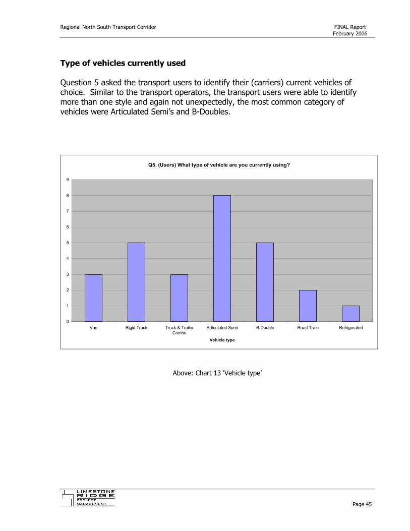
Type of vehicles currently used Question 5 asked the transport users to identify their (carriers) current vehicles of choice. Similar to the transport operators, the transport users were able to identify more than one style and again not unexpectedly, the most common category of vehicles were Articulated Semi’s and B-Doubles.
Q5. (Users) What type of vehicle are you currently using?
0
1
2
3
4
5
6
7
8
9
Van Rigid Truck Truck & TrailerCombo
Articulated Semi B-Double Road Train Refrigerated
Vehicle type
Above: Chart 13 ‘Vehicle type’
Page 45

Regional North South Transport Corridor FINAL Report February 2006
Future transport user business needs The transport users were asked to identify ‘what percentage of growth in freight volumes will your business gene ate over the next 5 years’? Significant growth in the demand for freight can be anticipated as 75% of the transport users identified, collectively, growth between 10 and more than 50% growth in freight over the next five years.
r
Q6. (Users) What % growth in freight volume do you anticipate?
23%
31%
31%
15%
No response/nil10%More than 20%More than 50%
Page 46

Regional North South Transport Corridor FINAL Report February 2006
Future vehicle styles Transport users were asked if they or their carrier ‘would use a different style of vehicle in the future’. 36% of respondents identified that they would, whereas 55% indicated no change and 55% did not respond.
Q7. (Users) Will you use a different style of vehicle?
Yes36%
No55%
Other9%
Page 47

Regional North South Transport Corridor FINAL Report February 2006
Future vehicle type Question 7a asked the transport operators to identify future vehicle styles which identified a clear move towards larger vehicles, notably B-Doubles.
Q 7a. (Users) If yes, what type of vehicle are you most likely to use in the future?
0
0.5
1
1.5
2
2.5
3
3.5
Articulated Semi B-Double B-Triple
Above: Chart 16 ‘Future vehicle styles’
Page 48

Regional North South Transport Corridor FINAL Report February 2006
Vehicle number increase The transport users were asked to predict what percentage increase in vehicle numbers either they or their carriers would affect over the next five years.
Q8. (Users) What % increase in vehicle numbers do you anticipate?
8%
42%
17%
8%
25%
0%10%More than 20%More than 50%No response
Above: Chart 17 ‘Increase in vehicle numbers’
Page 49

Regional North South Transport Corridor FINAL Report February 2006
Route preferences The transport users were asked to nominate the five most important factors that contribute to route choice. Chart 18 identifies that Product Damage, Road Safety, Load Safety, Travel Distance and equally Travel Time and Fuel Consumption were the most important aspects of route choice for the Transport Users.
Q9. (Users) 5 most important route choices
0
1
2
3
4
5
6
7
8
9
10
Road S
afety
Terrain
Travel
Time
Produc
t Dam
age
Vehicl
e Wea
r
Fuel C
onsu
mption
Load
Safe
ty
Load
Shif
ting
Travel
Distan
ce
Operat
or Stre
ss/ef
ficien
cy
Vehicle Type
Res
pons
es
Above: Chart 18 ‘Route Choice Factors’
Page 50

Regional North South Transport Corridor FINAL Report February 2006
North South preferred routes Question 10 asked transport users (or their carriers) to identify their current preferred route to move freight North South from Port Augusta to Tailem Bend. Three clear choices emerged and Table 4 below identifies that the current preferred route is via Adelaide and the South East Freeway. Identified North South route Responses Port Augusta – Adelaide Suburbs – South East Freeway 23% No comments 70% Proposed Regional North South Corridor 7%
Above: Table 4 ‘Users - North South Preferred Route’ East West preferred routes Question 11 asked transport users (or their carriers) to identify their current preferred route to move freight East West from Victorian border to the Western border. Three clear choices emerged and Table 5 below identifies that the current preferred route is via Adelaide and the South East Freeway. Identified East West route % of responses Port Wakefield – Adelaide Suburbs – South East Freeway 23% No comments 62% Proposed Regional North South Corridor 15%
Above: Table 5 ‘User - East West Preferred Route’
Page 51

Regional North South Transport Corridor FINAL Report February 2006
Proposed North South Corridor Critical to the development of the Business Case for the proposed Regional North South Corridor was the question to operators:
‘If a fully sealed ‘B Double Standard’ Adelaide Met o Bypass was created that offered a connection from Murray Bridge through to Pt Pirie via Sedan (linking the South East Freeway, Sturt Highway and the Burra – Morgan Road) would you/your carriers use it?’
r
62% of respondents clearly identified that YES they would use the proposed corridor. Limited comments were received on the proposed corridor, but those they chose to make a comment were generally enthusiastic. Chart 19, below, summarises the comments.
Q12. Comments on Bower Road
Agree to Bypass15%
No comment/Not Appl70%
Other15%
Above: Chart 19 ‘Bower Road Comments’
Page 52

Regional North South Transport Corridor FINAL Report February 2006
Future trends Transport users were asked an open question with regards to the future trends, within the industry, that may influence their future requirements for transport routes. Given the predominance of poultry processors that responded to the survey, it was not surprising to see that product and and food safety featured significantly in the responses. Similar to the operator response to this question, larger vehicle movements are also anticipated by the transport users. The transport user responses are list below in Table 6: Product and food safety Increased(poultry) product from Edinburgh Park & Bolivar Plants along with a new hatchery for Monarto Animal welfare & the need to make sure that routes are as smooth & efficient as possible. Constant stopping can cause problems. Food safety is an ever increasing issue & safe & viable transport is intrinsically part thereof. More interstate requirements of stock. Egg industry under extreme pressure from interstate market dumping/oversupply - industry future uncertain. The chicken meat industry is expected to double in less than 10 years. Quicker routes to processing plants are required. Allocation of new rural sites for growing poultry. Larger vehicle movements Bigger trucks and trailers Favour routes that take road trains. Increased use of central distribution centres reduces small vehicle deliveries. Road transport (long haul) too inefficient. Increased use of rail containers.
Above: Table 6 ‘Future Trends – Comments’
Page 53
Regional North South Transport Corridor FINAL Report February 2006
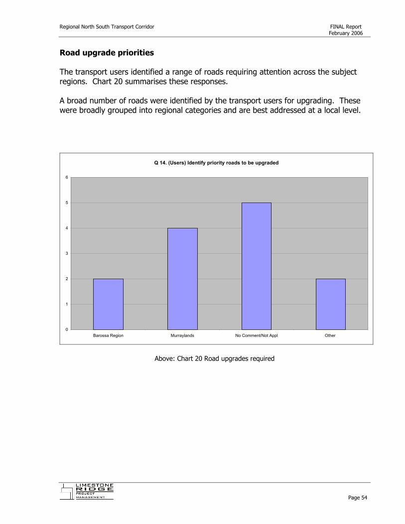
Road upgrade priorities The transport users identified a range of roads requiring attention across the subject regions. Chart 20 summarises these responses. A broad number of roads were identified by the transport users for upgrading. These were broadly grouped into regional categories and are best addressed at a local level.
Q 14. (Users) Identify priority roads to be upgraded
0
1
2
3
4
5
6
Barossa Region Murraylands No Comment/Not Appl Other
Above: Chart 20 Road upgrades required
Page 54
Regional North South Transport Corridor FINAL Report February 2006
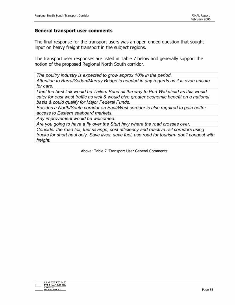
General transport user comments The final response for the transport users was an open ended question that sought input on heavy freight transport in the subject regions. The transport user responses are listed in Table 7 below and generally support the notion of the proposed Regional North South corridor. The poultry industry is expected to grow approx 10% in the period. Attention to Burra/Sedan/Murray Bridge is needed in any regards as it is even unsafe for cars. I feel the best link would be Tailem Bend all the way to Port Wakefield as this would cater for east west traffic as well & would give greater economic benefit on a national basis & could qualify for Major Federal Funds. Besides a North/South corridor an East/West corridor is also required to gain better access to Eastern seaboard markets. Any improvement would be welcomed. Are you going to have a fly over the Sturt hwy where the road crosses over. Consider the road toll, fuel savings, cost efficiency and reactive rail corridors using trucks for short haul only. Save lives, save fuel, use road for tourism- don't congest with freight.
Above: Table 7 ‘Transport User General Comments’
Page 55

Regional North South Transport Corridor FINAL Report February 2006
5.3 Stakeholders Methodology A written transport stakeholder survey (SA Metro Heavy Vehicle Bypass) was commissioned in mid December 2005. A database of 44 key transport stakeholders was assembled and direct telephone contact was made during the December/January period. A written survey was forwarded by email directly after the telephone contact. Transport stakeholders were able to respond to the survey by fax or email. Follow up calls were made during the later half of January and in total 22 responses were received, representing a 50% response rate. The database of transport users contacted is appended to this report (Appendix C) and a summary of the responses is detailed in the following section. Transport Stakeholder Survey Response Summary The transport stakeholders identified a broad range of key issues for freight across the broader region, with ‘roads not being designed for heavy transport’ identified as the key issue. Similarly, the transport stakeholders identified that larger volumes, vehicles and freight patterns would impact on their region within the next five years. Growth within the Agribusiness industry sector is a clear driver of change for the transport stakeholders, with 50% of responses relating to this sector. Similarly, agribusiness is anticipated to continue to drive growth, second only to the expansion of existing industry. The transport stakeholders identified changes in intensive farming, horticulture and industry as significant land use changes within the subject region. 86% of the transport stakeholders supported the Bower Boundary Road extension to the Regional North South corridor, with 18% supporting the corridor for current (East West) use. Similar to the transport users, the stakeholders had a variety of opinions on the roads within the region to be upgraded as a priority and this should be managed by the relevant regional transport strategies.
Page 56

Regional North South Transport Corridor FINAL Report February 2006
Key road transport issues Stakeholders were asked to identify the ‘key road transport (heavy freight) within their region’.
Q2 (Stakeholders) Key road transport issues
0
2
4
6
8
10
12
Lack of sealedroads
Roads notdesigned for HT
Permit vehicleaccess
Targeted roadupgrade
Road safetyissues
Seasonal roaduse
Changing roaduse
Congestion Funding
Key issues
Num
ber
Above: Chart 21 ‘Key road transport issues’
Page 57

Regional North South Transport Corridor FINAL Report February 2006
Anticipated changes to road transport Stakeholders were asked to identify anticipated changes to road transport within their region. Vehicle size, volume and changed freight patterns were clear themes.
Q3. (Stakeholders) Identify any anticipated changes to road transport for your region
0
1
2
3
4
5
6
7
Increased vehicle size Changing transportpatterns (East/West)
Increased freightvolumes
Demand for north southtraffic movements
Speed/safety controls Not applicable
Anticipated changes
Num
ber
Above: Chart 22 ‘Changes to Road Transport’
Page 58

Regional North South Transport Corridor FINAL Report February 2006
New economic activity The transport stakeholders clearly identified agribusiness (pork, poultry, grains and livestock) as clear drivers of new economic activity within the last five years.
Q4.(Stakeholders) New economic activity within the last five years
Agribusiness growth50%
Salt production5%
Increased use of HT10%
Viticulture5%
N/A20%
Mining5% Horticultural growth
5%
Above: Chart 23 ‘New economic activity’
Page 59

Regional North South Transport Corridor FINAL Report February 2006
Anticipated economic activity Future economic activity is anticipated through the expansion of existing industry and continued agribusiness growth, with the mining industry also anticipated to drive growth.
Q5 (Stakeholders) Anticipated economic activity
0
1
2
3
4
5
6
7
Expan
sion o
f exis
ting i
ndus
try
Agribu
sines
s grow
th
Touris
m expa
nsion
Horticu
ltural
expa
nsion
Viticult
ural e
xpan
sion
Forestr
y grow
th
Buildin
g/con
struc
tion
Mining
Transp
ort/Lo
gistic
sN/A
Nature of activity
Res
pons
es
Above: Chart 24 ‘Anticipated economic activity’
Page 60

Regional North South Transport Corridor FINAL Report February 2006
Significant land use changes The transport stakeholders supported earlier comments on agribusiness as a prime driver of growth by identifying intensive farming, horticulture and industry as major influences to land use change.
Q6 (Stakeholders) Identify any significant land use changes
0
2
4
6
8
10
12
Intensive farming Intensivehorticulture
Intensive industry Residentialgrowth
Increased trafficdemand
Forestry Mining N/A
Land use change
Res
pons
es
Above: Chart 25 ‘Changes in land use’
Page 61
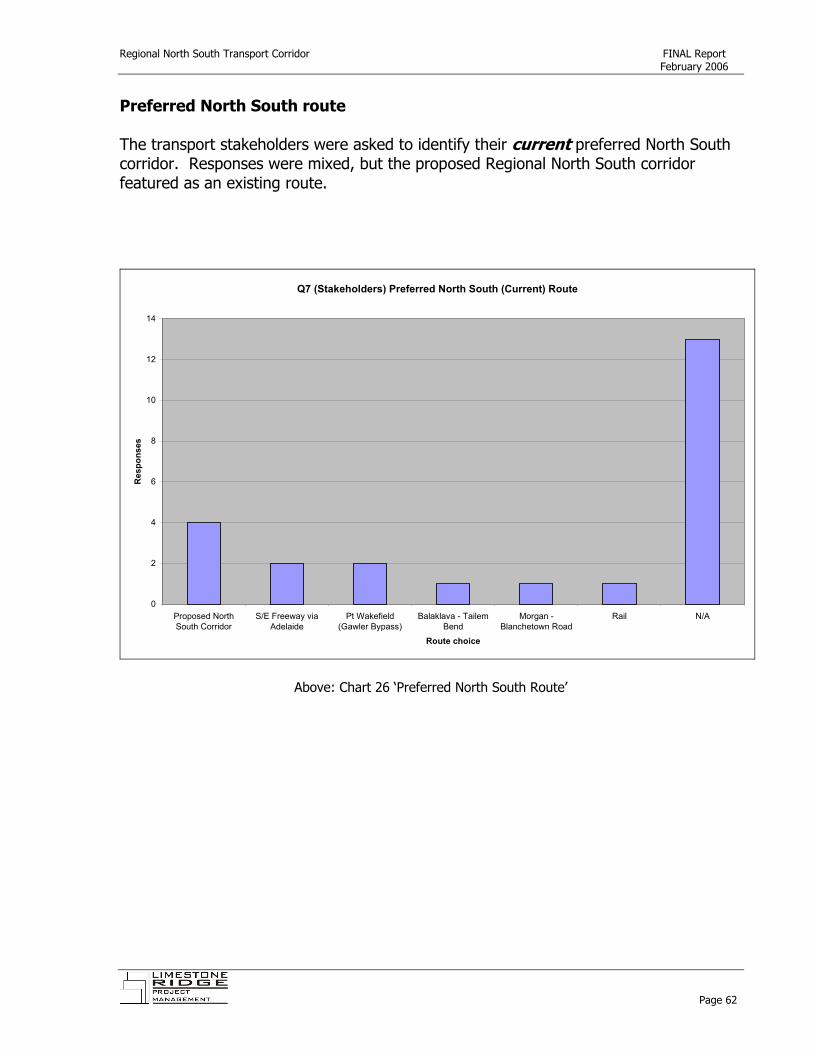
Regional North South Transport Corridor FINAL Report February 2006
Preferred North South route The transport stakeholders were asked to identify their current preferred North South corridor. Responses were mixed, but the proposed Regional North South corridor featured as an existing route.
Q7 (Stakeholders) Preferred North South (Current) Route
0
2
4
6
8
10
12
14
Proposed NorthSouth Corridor
S/E Freeway viaAdelaide
Pt Wakefield(Gawler Bypass)
Balaklava - TailemBend
Morgan -Blanchetown Road
Rail N/A
Route choice
Res
pons
es
Above: Chart 26 ‘Preferred North South Route’
Page 62

Regional North South Transport Corridor FINAL Report February 2006
Preferred East West Route The transport stakeholders were also asked to identify existing preferred East West routes. The South East Freeway via Adelaide featured as did the proposed Regional North South corridor.
Q8 (Stakeholders) Preferred East West (Current) Route
Proposed North South Corridor with E/W extensions
18%
South East Freeway23%
Yumali-Karoonda-BowHill5%
N/A54%
Above: Chart 27 ‘Preferred East West Route’
Page 63
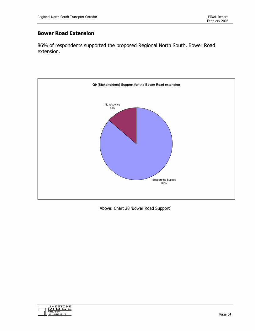
Regional North South Transport Corridor FINAL Report February 2006
Bower Road Extension 86% of respondents supported the proposed Regional North South, Bower Road extension.
Q9 (Stakeholders) Support for the Bower Road extension
Support the Bypass86%
No response14%
Above: Chart 28 ‘Bower Road Support’
Page 64

Regional North South Transport Corridor FINAL Report February 2006
Bower Road Comments Additional comments on the Bower Boundary Road extension were received, and were positive and supportive of the concept.
Q9a (Stakeholders) Bower Road comments
More direct route/different route28%
Support - Advantages / Beneficial
17%
No comments55%
Above: Chart 29 ‘Bower Road Comments’
Page 65

Regional North South Transport Corridor FINAL Report February 2006
Priority Roads to upgrade A broad range of roads were identified by the transport stakeholders for upgrading, therefore they were broadly grouped into regional categories and are best dealt with by the relevant regional transport strategies.
Q10 (Stakeholders) Roads to be upgraded as a priority
Murraylands24%
Mid North 24%
SHLGA Inner North South5%
Proposed North South19%
N/A28%
Above: Chart 30 ‘Priority roads to upgrade’
Page 66

Regional North South Transport Corridor FINAL Report February 2006
Other comments The transport stakeholders were given the opportunity to make any further comments/suggestions on heavy freight within the broader subject region. These comments are listed below.
Again upgraded Rest Area - Solar lighting & toilets
Tailem Bend as a Rail/Freight terminal. Logistics make common sense to go Karoonda/Bow Hill/Morgan. The Southern Hills LGA have adopted a Transport Plan that supports the creation of a heavy transport route from Langhorne Creek to the Barossa Valley using Kangaroo Rd, Ferries McDonald Rd, Monarto Rd, Pallamana Rd, M/Bridge to Palmer Rd, Palmer to Tungkillo Rd
Suggest that this report includes consultation with Balco & Patrick’s along with the Office of the North, the Pickard group.
Will also provide additional transport route to connect North-South (heavy) traffic currently which may be using longer roads or roads subject to high mix of traffic users (i.e. tourism/grain/heavy/commuter). Peterborough to Highway 1 via Gladstone not suitable for A-doubles due to lack of passing lanes.
I feel the best link would be Tailem Bend all the way to Port Wakefield as this would cater for East West traffic as well and would give greater economic benefit on a national basis and could qualify for major Federal funds. Great Idea.
The North South proposal is a "must do" project of extreme economic importance to SA and the Transport industry apart from safety issues.
Above: Table 8 ‘Stakeholder Comments’
Page 67

Regional North South Transport Corridor FINAL Report February 2006
6. Strategic Rationale (Regional North South Transport Corridor)
The Regional North South Transport Corridor has for a number of years been identified by the trio of Local Government Associations, namely: Murray Mallee, Central Region. As such, the concept of the Regional North South Transport Corridor is identified within each of the respective Regional Transport Strategies. The current Regional Transport Strategies are significant estimations of the current and future demand for transport within a subject region. This Section identifies and draws upon a range of sources to quantify the strategic rationale for such a corridor. Within the context of this report, the key project partners have identified the Regional North South Corridor as:
Kangaroo Rd, Ferries McDonald Road Schenscher Road, Pallamana – Wagenknecht Road Mannum-Mur ay Bridge Road, Sedan, Cambrai, Bower Boundary Road.
,, r
The Northern and Southern extremes of this corridor are not yet sealed, therefore this Section focuses on the specific merits of these roads as support for the Draft Business Case. Importantly, this section is modelled using the Murray Mallee Regional Transport Strategy – Multi-Criteria Analysis tool. This tool is used by the Murray Mallee Local Government Association to assess the relative strategic merits of road projects identified within the Murray Mallee Regional Transport Strategy. The methodology and process utilised is further described in Section 7. 6.1. Purpose Bower Boundary Road Ferries McDonald Road
Primary and secondary purpose Freight (with sealing could also include Social as a secondary purpose)
Freight/Social
6.2. Regional significance Bower Boundary Road Ferries McDonald Road
Community significance Is considered of community significance given links to Burra-Morgan Road and Sturt Highway that facilitate social interaction.
Is considered of community significance given links to Murray Bridge, Monarto and the South East Freeway, particularly given the number of smaller rural allotments placed along the road.
Regional significance Regional significance Is considered of regional significance given the
Regional significance Is considered of regional significance given the
Page 68

Regional North South Transport Corridor FINAL Report February 2006
new Goyder Enterprise Zone (intensive animal precinct) at the northern end of Bower Boundary Road in terms of new economic activity.
future potential impact of the relocation of Peat Soils to the southern end of Ferries McDonald Road and the increase in economic activity.
State significance Is considered of State significance given the potential growth in the intensive animal industry (pork/chicken) north south and south north movements, together with the livestock industry moving stock south to T&R Pastoral (Murray Bridge) and north to Dublin.
Is considered of State significance given the improved access to the Langhorne Creek wine region (and endorsement by the SHLGA as the entry to the Eastern North South corridor); the positioning of Peat Soils on the southern end of the corridor (as an environmentally strategic business that provides benefit to the State).
6.3. Economic benefits The trio of local government associations (Murray Mallee, Central and Southern Hills) has invested significant resources in the identification of future transport demand and planning across their respective regions. The key aspects (in relation to the benefit of the proposed Regional North South corridor) of these three individual transport strategies are summarised below. This summary clearly identifies the potential economic benefit that would be supported by the upgrade of the Regional North South corridor. The State Government in partnership with the network of Regional Development Board’s has also sponsored significant research into the growth of the intensive animal industry within South Australia. This research identifies the potential for significant movement of pigs and poultry across the proposed Regional North South corridor, particularly as the Murraylands and Mid North regions stand to gain most significantly by growth in these industries. Regional Transport Plans – Anticipated economic and industry growth summary
Murray Mallee Local Government Association • It is projected that there will be over a 40% increase in grapes entering the
Riverland region for processing, especially from the Langhorne Creek area.xxvi • Sheep and cattle from the region have generally been transport to the
markets in Dublin. The significant growth of T&R Pastoral at Murray Bridge however, has seen an increase in the transport of livestock directly from the region to Murray Bridge as well as from the Dublin market and interstate.xxvii
• It is expected that associated with the expansion of T&R Pastoral and the establishment of Big River Pork, there will be a change in transport movements; with an increase in livestock delivered to Murray Bridge rather than to other South Australian regions.xxviii
Page 69

Regional North South Transport Corridor FINAL Report February 2006
• Pig production in the region is expected to continue to increase, and the establishment of Big River Pork has resulted in more pigs being transported into Murray Bridge for processing than Victoria.xxix
• A timber processing plant is also based at Monarto South and primarily manufactures fence posts. The timber processed at this plant is transported from other regions within South Australia.xxx
• The Mid Murray Council has advised that targets for upgrade of its transport infrastructure include the Bower Boundary Road……which would assist in providing a better link between Port Augusta and Melbourne and also a bypass of Adelaide… this is seen to have direct industry benefit to the livestock industry.xxxi
Central Local Government Association • About 80% of wine produced in the Clare and Barossa wine regions moves
towards Adelaide; the balance moves to New South Wales. The Barossa to Langhorne Creek Link……will become more significant as regional and cross regional wine freight routes.xxxii
• Intensive livestock production is expanding. The proposed development of intensive piggeries for up to 250,000 animals on land adjacent to the Bower Border Road east of Roberstown could also have implications for cross regional transport both in terms of feed in and animals out. About 1 million animals per year could eventually leave the site bound for abattoirs at Murray Bridge or Port Wakefield via the region road network.xxxiii
• Local and cross- regional traffic growth is also likely to occur due to expansions in the manufacturing, mining, livestock, pig and feed industries (SAMAG, Olympic Dam expansion, Murray Basin sands, Eudunda 250,000 animal piggery) particularly east-west movements and north-south movementsxxxiv.
Southern Hills Local Government Association • There are large demands for north south movement of grapes and timber
within the Mount Lofty ranges. This has resulted in significant increase in heavy vehicle movements occurring over a short period of time (particularly for grapes).xxxv
• Other livestock deliveries would be to markets in Adelaide, to the Dublin Sale Yards or to abattoirs in Murray Bridge, Strathalbyn and Lobethal. Development of single item abattoirs are under construction or being planned for areas within the Region (Murray Bridge for pigs). This together with the increased movements to Dublin is likely to result in an increase in cross regional movements of livestock, particularly in and through Murray Bridge.xxxvi
• The location of future industrial development is likely to be concentrated around Strathalbyn, Monarto and Murray Bridge. Good connections to the
Page 70

Regional North South Transport Corridor FINAL Report February 2006
existing transport system, particularly the Freeway and rail infrastructure, are required to maximise business efficiency.
• North South links through Murray Bridge are being increasingly utilised to detriment of town centre.xxxvii
Intensive Animal Industry – Anticipated Growth The State Departments for Primary Industries & Resources (PIRSA) and Transport Energy & Infrastructure together with the Yorke, Mid North, Murraylands and Barossa Light Regional Development Boards commissioned the ‘Future Infrastructure and Development Requirements to Intensive Livestock Growth in South Australia’ Report in 2005. This report significantly identifies the growth prospects of both the intensive pig and poultry industries over the next decade to 2015. The report predicts ‘in line with the planned expansion in processing of chickens and pigs it is expected that there will be substantial expansion of intensive livestock production….. in areas within a 100-120km radius of the existing processing facilities’xxxviii. To this end, the existing, major, processing facilities are located at Burton (Inghams), Wingfield (Adelaide Poultry), Cavan (Gourmet Poultry), Port Wakefield (Primo) and Murray Bridge (Big River Pork). In relation to the chicken meat industry the report predicts (based on the ‘Strategic Directions for South Australian Poultry Industry’) that ‘state production will increase by more than 250% in gross food revenue….125% increase in numbe of grow out birds (40 million to 90 million); and 8% increase in Australian per capita consumption’
r
ft
xxxix. In relation to the pork industry the report predicts (based on the ‘South Australian Pork Industry’s Strategic Plan for 2010’) that ‘state production will increase by 50% in volume to fully utilise current processing plant capacity’xl. The report makes specific and targeted predictions about the transport needs for both industry sectors and identifies the following: ‘The volume of heavy transport trucks carrying live or processed meat to and from abattoirs will quadruple in the next decade. The size of trucks, particularly those carrying poultry or pork to interstate markets, will increase to B Double rigs carrying 34 tonnes A ‘ring route to the east of the city (and east of the ranges) to link southern outer-metropolitan Adelaide to the Barossa Valley and the Mid North ( rom Coorong District Council to Palmer near Murray Bridge to Sedan to Angaston to Por Wakefield) willassist the speed of transporting product in live and processed form, avoid disruption to
Page 71

Regional North South Transport Corridor FINAL Report February 2006
city motorists and residents, and provide less stress to the livestock which occurs in slow moving hot vehicles.’xli
Further, the report recommends that: ‘Department of Transport, Energy & Infrastructure considers the development of a suitable road, alternative route via Adelaide City, for semi trailer and B Double trucks to use in transporting livestock to and from regional areas east and north of Adelaide and processed product to market in Sydney and Melbourne. This north-south corridor may provide greater efficiencies and safety in transport movements.’xlii
A. Road User Benefit Bower Boundary Road Ferries McDonald Road
Reduce delays and operating costs for heavy vehicles Upgrade will provide significant reduction in delays and operating costs for heavy vehicles when sealed. Terrain is flat, open and provides long uninterrupted stretches and avoids unnecessary metropolitan traffic for transport moving north south & south north.
Upgrade will provide significant reductions in delays and operating costs for the wine and soil industry in transferring product to market as it will improve the existing surface.
Direct access to major industrial developments The Bower Boundary Road provides direct access to the Goyder Enterprise Zone for intensive animal production. Further the upgrade provides north south and south north access to major meat processing facilities at Murray Bridge, Dublin, Port Wakefield and Northern Adelaide.
The Ferries McDonald Road upgrade provides access for the Langhorne Creek vignerons to the processing facilities of the Barossa Valley and the transportation of some grain to silos at Monarto and Murray Bridge.
Facilitate higher classification of freight movements The Bower Boundary Road will provide access for B-Double Transport that support northern and southern livestock, pig and poultry industry’s.
The Ferries McDonald Road will provide access for B-Double and Heavy Vehicle transport that supports the wine and grains industry and the emerging timber industry.
Facilitate intermodal transport operations The Bower Boundary Road upgrade provides some opportunities to facilitate intermodal transport operations by supporting the delivery of primary products to processors for international export (eg. Pork to Singapore by air).
The Ferries McDonald Road upgrade provides some opportunities to facilitate intermodal transport operations by supporting the delivery of wine to international export markets by air.
Assist export of products by improving quality and reducing impacts of dust The Bower Boundary Road upgrade will significantly improves the export of products (livestock/pigs/poultry) by reducing dust (through sealing) and maintaining constant traffic flow and stress on the animals.
The Ferries McDonald Road provides some improvement to the export of products by reducing dust and therefore quality of fruit for wine production.
Provide direct access to new industrial precincts The Bower Boundary Road provides direct access to the new Goyder Enterprise Zone for intensive animal production.
The Ferries McDonald Road potentially provides access to the proposed Peat Soils site.
Page 72
Regional North South Transport Corridor FINAL Report February 2006
B. Community benefit Bower Boundary Road Ferries McDonald Road
Benefit regional employment and sustain communities. The Bower Boundary Road upgrade shall support a significant increase in employment opportunities and the size of the local community within the region by increasing access to the Goyder Enterprise Zone.
The Ferries McDonald Road upgrade shall support an increase in employment opportunities through the establishment of Peat Soils on the southern end of the road.
Assist attraction of economic investment to the region. The Bower Boundary Road upgrade shall directly assist in the attraction of substantial economic investment (including power and water augmentation) in the region aligned with the Goyder Enterprise Zone.
The Ferries McDonald Road upgrade shall assist in the attraction of further economic investment in the broader region by reducing travel times and improving the product quality of goods transported.
C. Road owner benefit Bower Boundary Road Ferries McDonald Road
Reduce the road maintenance effort. The Bower Boundary Road experiences significant and rapid deterioration in times of dry weather. Unofficial B-Double and Heavy Vehicle use also contribute to the deterioration of the road. The proposed upgrading shall reduce road owner maintenance (grading etc). Unofficial B-Double use is anticipated to increase as the Goyder Enterprise Zone is progressively developed and transport demand grows.
The Ferries McDonald Road requires frequent maintenance due to traffic (of all aggregated classes) volumes.
6.4. Access benefits Bower Boundary Road Ferries McDonald Road
Reduce traffic congestion The development of a North South Transport corridor will provide the opportunity to reduce unnecessary, metropolitan access by heavy vehicles, particularly movement of livestock, pigs and poultry.
The development of a North South Transport corridor will provide the opportunity to reduce unnecessary, metropolitan access by heavy vehicles, particularly seasonal bulk grapes and timber.
Link areas of particular land uses to strategic routes The Bower Boundary Road will link the new Goyder Enterprise Zone (for intensive animal keeping) with both southern and northern B-Double routes providing particularly intrastate transfer to processing facilities at Dublin, Port Wakefield, Northern Adelaide and Murray Bridge. The Bower Road upgrade shall also provide a strategic link for livestock and pigs
The Ferries McDonald Road upgrade shall link Langhorne Creek vignerons with processing facilities in the Barossa Valley and Riverland.
Page 73

Regional North South Transport Corridor FINAL Report February 2006
traveling from northern areas of the State for processing in Murray Bridge.
Provide a higher standard alternative route The Bower Boundary Rd upgrade shall provide an improved alternative route for B-Double transport of livestock and other goods that will ensure that they arrive at their destination in premium condition.
The Ferries McDonald Road upgrade shall provide an improved alternative route for B-Double or heavy commercial vehicle transport of wine grapes to ensure that they arrive at their destination in premium condition.
Complement the existing arterial road network The North South corridor, including the Bower Boundary Rd upgrade will complement existing B-Double routes and support heavy vehicle access to key arterial roads namely the Sturt Highway, Morgan-Burra Road (in the North) and the South East Freeway (in the South).
The North South corridor, including the Bower Boundary Rd upgrade will complement existing B-Double routes and support heavy vehicle access to key arterial roads namely the Sturt Highway, Morgan-Burra Road (in the North) and the South East Freeway (in the South).
Provide improved access to key population centres The North South corridor does not provide improved access to key population centres.
The North South corridor does not provide improved access to key population centres.
Ensure communities are not dislocated by flooding The North South corridor does not ensure that communities are not dislocated by flooding.
The North South corridor does not ensure that communities are not dislocated by flooding.
Act as a collector road for local or heavy traffic The Bower Boundary Road upgrade will facilitate the collection of a range of heavy commercial vehicles, carrying a range of products, and funnel transport to the northern and southern regions of the State and provide an opportunity for unnecessary transport to bypass metropolitan Adelaide.
The Bower Boundary Road upgrade will facilitate the collection of a range of heavy commercial vehicles, carrying a range of products, and funnel transport to the northern and southern regions of the State and provide an opportunity for unnecessary transport to bypass metropolitan Adelaide.
Provide all weather access Provide all weather access The Bower Boundary Road upgrade shall facilitate all weather access to the North South Transport corridor and significantly enhance road conditions that are currently adversely affected by weather.
Provide all weather access The Bower Boundary Road upgrade shall facilitate all weather access to the North South Transport corridor and significantly enhance road conditions that are currently adversely affected by weather.
Provide access to other types of transport, bus, rail, air The Bower Boundary Road upgrade will provide some access to other types of transport, notably tourist bus operation.
The Ferries McDonald Rd upgrade facilitates some access to other types of transport, namely freight distribution at Monarto and wine to air transport.
6.5. Safety benefits Bower Boundary Road Ferries McDonald Road
Reduce conflicts between tourist, freight and commuter traffic The Bower Boundary Road upgrade provides a significant opportunity to reduce conflicts between tourist and freight traffic by channeling heavy commercial traffic (particularly livestock/pigs & poultry) away from heavily populated and tourist oriented
The Ferries McDonald upgrade provides some opportunity to reduce conflicts between tourist and freight traffic by providing a suitable corridor for use by both tourist, freight and commuter traffic.
Page 74

Regional North South Transport Corridor FINAL Report February 2006
areas. Contribute to safer travel and reduce accidents
The upgrade of the Bower Boundary Road provides a significant opportunity to provide safer travel and reduce accidents by the improvement of a road surface that rapidly deteriorates in adverse weather conditions.
The upgrade of the Ferries McDonald Road provides an opportunity to provide safer travel, for all users, and reduce accidents by the improvement of a road surface that is prone to deterioration.
Provide safe overtaking opportunities and reduce frustration and fatigue Given that the Bower Boundary Road is nearly 60km of straight road, the proposed upgrade shall facilitate safe overtaking opportunities and frustration and fatigue.
The upgrade of 20 kms of Ferries McDonald Road provides some opportunity to improve safety and driver frustration.
Reduce exposure to travel risk There are some travel risks (such as conflict between heavy vehicles passing) associated with the Bower Boundary Road that are mitigated by the proposed upgrade.
There are limited travel risks associated with the Ferries McDonald Road upgrade.
Provide access for school buses The Bower Boundary Road upgrade provides an opportunity to improve access for school buses.
The Ferries McDonald Road upgrade provides an opportunity to improve access for school buses.
Provide access for emergency services The Bower Boundary Road upgrade provides an opportunity to improve access for emergency services.
The Ferries McDonald Road upgrade provides an opportunity to improve access for emergency services.
Remove traffic from City/Town areas Remove traffic from City/Town areas The Bower Boundary Road provides an opportunity to channel heavy vehicle transport through lowly populated areas and avoid unnecessary access to the City.
Remove traffic from City/Town areas The Ferries McDonald Road upgrade will remove heavy commercial traffic from key population centres such as Mt Barker and Strathalbyn.
Reduce road roughness and potential dust hazards The Bower Boundary Road will dramatically improve the road condition and dust hazards currently experienced in dry weather and exacerbated by ‘unofficial’ use of this corridor by heavy vehicle transport.
The Ferries McDonald Road will improve the road condition and dust hazard for all transport users on this Road.
Reduce the impact of roadside hazards The upgrade of Bower Boundary Road shall include vegetation removal and road widening as appropriate and as such reduce the impact of roadside hazards.
There are limited roadside hazards that will be affected by the upgrade of Ferries McDonald Road.
6.6. Environmental benefits Bower Boundary Road Ferries McDonald Road
Reduce environmental pollution, air, noise, water The Bower Boundary Road is currently unsealed and subject to rapid deterioration in particularly dry weather. With the implementation of the new Goyder Enterprise
The Ferries McDonald Road upgrade shall support the establishment of Peat Soils, a processor of organic waste. The proposed upgrade shall improve the amenity of the road
Page 75

Regional North South Transport Corridor FINAL Report February 2006
Zone to the north the anticipated increase in transport shall exacerbate this situation.
and facilitate reductions in environmental pollution through waste management practices employed by Peat Soils.
Minimise impact of heavy vehicles on local community The Bower Boundary Road is in a sparsely populated area in semi-arid area of the State. B-Double and heavy commercial traffic through this area will encourage the reduction in unnecessary transport through local and town areas as carriers will link to the proposed ‘North South’ corridor.
The Ferries McDonald Road is in a low density population area that features rural living allotments and broad acre farming. B-Double and heavy commercial traffic through this area will encourage the reduction in unnecessary transport through local and town areas as carrier’s link to the proposed ‘North South’ corridor.
Reduce reliance on road transport and encourage other forms of transport The proposed upgrade will have little impact on the reduction of road transport, but will provide increased efficiency by enabling B-Double transportation of goods.
The proposed upgrade will have little impact on the reduction of road transport, but will provide increased efficiency by enabling B-Double transportation of goods.
Above: Upgrade to Pallamana Road
Page 76
Regional North South Transport Corridor FINAL Report February 2006
7. Summary of MMLGA Multi Criteria Analysis The previous section outlined the Strategic Rationale for the proposed Regional North South Transport Corridor and in particular, the Ferries McDonald Road and the Bower Boundary Road. Deliberately this Section was framed in accordance with the criteria utilised by the Multi Criteria Analysis tool that underpins the Murray Mallee Local Government Association, Regional Transport Strategy. In the following two tables, the strategic rationale is assessed using the weighted scoring technique deployed by this analysis strategy. The MMLGA Multi Criteria Analysis tool was developed to provide a quantitative assessment process to strategically rank the identified road projects within the Murray Mallee Regional Transport Strategy. The tool is modeled on guidelines developed through the Roads Infrastructure Database Project, for application for Special Local Roads Funding. The tool assigns a specific score to each of the assessment criteria and this is then weighted in terms of relative importance. The use of the MMLGA Multi Criteria Analysis tool provides an objective assessment of the various road projects and is able to clearly identify strategic priorities for funding. The tool is also designed such that the assessment can be revised from time to time as and when either the Road Strategy is revised, or as in this case, when there are strategic shifts in the application and use of particular road projects. The Central Local Government Region applies a different, more qualitative, methodology in it’s assessment and prioritisation of road projects. To date, the Bower Boundary Road project has not been rated by the Central Local Government Region Road Transport Strategy, however, in principle, it would be ranked as a high priority for action, subject to industry confirmation of both use and demand. Whereas, the Southern Hills Local Government Association utilises a model similar to the MMLGA Multi Criteria Analysis tool that assesses the road projects against both a strategic framework and a regional transport goals and evaluation criteria. This assessment tool then differs as it then applies and assesses the relative priority (urgency) of the respective projects. Given the differing assessment methodologies of the three local government associations, it is recommended that the MMLGA Multi Criteria Assessment tool be utilised to re-assess the strategic importance of the remaining road projects (namely Bower Boundary Rd and Ferries McDonald Rd) in an objective manner. Section 6 provided an analysis of the strategic rationale for the proposed Regional North South Corridor with a particular focus on both Bower Boundary Rd and Ferries McDonald Rd. This Section (7) now applies the quantitative weighting methodology of
Page 77

Regional North South Transport Corridor FINAL Report February 2006
the MMLGA Multi Criteria Assessment tool and assesses the relative priorities of both road projects. The following two pages detail this analysis and it is evident that the strategic ranking of both projects has changed significantly since the last assessment in December 2002. In particular, with the advent of the Goyder Enterprise Zone (intensive animal keeping) the northern Bower Boundary Road precinct, stakeholder feedback, increased economic development opportunities, and the future ability for B-Doubles to access this corridor, the ranking for both roads increases, with Bower Boundary Road, increasing significantly.
Above: Northern end of Bower Boundary Road (Morgan-Burra Road Intersection)
Page 78

Regional North South Transport Corridor FINAL Report February 2006
Road Name: Bower Boundary Road Traffic Volume (AADT): Mid Murray/Goyder To add Length of Road: 60.2 km Upgrade Cost: $15m (Estimate) Primary Purpose: Freight
Benefit Influencing
Factor
Weighting (%)
Specific Criteria Specific Score
Existing Weighted
Score
Revised Weighted
Score
Secondary Purpose
10 No Secondary Purpose 1 Secondary Purpose 2 Secondary Purpose
0 5
10
5
5
Regional Significance
25 Community Significance Regional Significance State Significance
8.33 8.33 8.33
8.33 8.33
4
8.33 8.33 8.33
Economic Benefits
6.67 Road User Benefit Reduce delays and operating costs for heavy vehicles? Provide direct access to major industrial developments, freight generators and specific facilities such as grain silos, wineries, processing plants? Facilitate a higher classification of freight movements (eg commercial to B-Double) Facilitate intermodal transport operations – rail, air, sea? Assist export of products by improving quality and reducing impacts of dust etc? Provide direct access to new industrial precincts?
1.11
1.11
1.11 1.11
1.11 1.11
1.11
0
1.11 0
1.11 0
1.11
1.11
1.11 0.3
1.11 1.11
6.67 Community Benefit Benefit regional employment and sustain communities? Assist attraction of economic investment to region?
3.33 3.33
0 0
3.33 3.33
6.67 Road Owner Benefit Reduce the road maintenance effort?
6.67
3.33
6.67
Access Benefits 15 Reduce traffic congestion Link areas of particular land uses to strategic routes Provide a higher standard alternative route Complement the existing arterial road network Provide improved access to key population centre’s Ensure communities are not dislocated by flooding Act as collector road for local or heavy traffic Provide all weather access Provide access to other types of transport – Bus, Rail, Air?
1.67 1.67 1.67 1.67 1.67 1.67 1.67 1.67 1.67
0 1.67 1.67 1.67
0 0
1.67 1.67
0
1.67 1.67 1.67 1.67
0 0
1.67 1.67 0.56
Safety Benefits 20 Reduce conflicts between tourist, freight and commuter traffic Contribute to safer travel and reduce accidents Provide safe overtaking opportunities and reduce frustration and fatigue Reduce exposure to travel risk Provide access for school buses Provide access for emergency services Remove traffic from city/town areas Reduce road roughness and potential dust hazards Reduce the impact of roadside hazards
2.22
2.22 2.22
2.22 2.22 2.22 2.22 2.22 2.22
2.22
2.22 2.22
2.22 2.22 2.22
0 2.22 2.22
2.22
2.22 2.22
2.22 2.22 2.22 2.22 2.22 2.22
Environmental Benefits
10 Reduce environmental pollution – Air, Noise, Water? Minimise impact of heavy vehicles on local community Reduce reliance on road transport and encourage other forms of transport
3.33 3.33 3.33
3.33 3.33
0
3.33 3.33
0
TOTAL 100 100 65.09 86.39
Page 79

Regional North South Transport Corridor FINAL Report February 2006
Road Name: Ferries McDonald Road Traffic Volume (AADT): RCMB To add Length of Road: RCMB Check Approx 20km Upgrade Cost: $3m (Total) Primary Purpose: Freight
Benefit Influencing
Factor
Weighting (%)
Specific Criteria Specific Score
Existing Weighted
Score
Revised Weighted
Score
Secondary Purpose
10 No Secondary Purpose 1 Secondary Purpose 2 Secondary Purpose
0 5
10
10
10 Regional Significance
25 Community Significance Regional Significance State Significance
8.33 8.33 8.33
8.33 8.33
0
8.33 8.33 4.00
Economic Benefits
6.67 Road User Benefit Reduce delays and operating costs for heavy vehicles? Provide direct access to major industrial developments, freight generators and specific facilities such as grain silos, wineries, processing plants? Facilitate a higher classification of freight movements (eg commercial to B-Double) Facilitate intermodal transport operations – rail, air, sea? Assist export of products by improving quality and reducing impacts of dust etc? Provide direct access to new industrial precincts?
1.11
1.11
1.11 1.11
1.11 1.11
1.11
1.11
1.11 0.3
0 0
1.11
1.11
1.11 0.3
0
0.56 6.67 Community Benefit
Benefit regional employment and sustain communities? Assist attraction of economic investment to region?
3.33 3.33
3.33
2
3.33
2 6.67 Road Owner Benefit
Reduce the road maintenance effort?
6.67
6.67
6.67 Access Benefits 15 Reduce traffic congestion
Link areas of particular land uses to strategic routes Provide a higher standard alternative route Complement the existing arterial road network Provide improved access to key population centre’s Ensure communities are not dislocated by flooding Act as collector road for local or heavy traffic Provide all weather access Provide access to other types of transport – Bus, Rail, Air?
1.67 1.67 1.67 1.67 1.67 1.67 1.67 1.67 1.67
1.67 1.67 1.67 1.67
0 0
1.67 1.67 1.00
1.67 1.67 1.67 1.67
0 0
1.67 1.67 1.00
Safety Benefits 20 Reduce conflicts between tourist, freight and commuter traffic Contribute to safer travel and reduce accidents Provide safe overtaking opportunities and reduce frustration and fatigue Reduce exposure to travel risk Provide access for school buses Provide access for emergency services Remove traffic from city/town areas Reduce road roughness and potential dust hazards Reduce the impact of roadside hazards
2.22
2.22 2.22
2.22 2.22 2.22 2.22 2.22 2.22
1.11
2.22 1.11
0
2.22 2.22 2.22 2.22
0
1.11
2.22 1.11
0
2.22 2.22 2.22 2.22
0 Environmental Benefits
10 Reduce environmental pollution – Air, Noise, Water? Minimise impact of heavy vehicles on local community Reduce reliance on road transport and encourage other forms of transport
3.33 3.33 3.33
2.22 3.33
0
2.22 3.33
0
TOTAL 100 100 72.18 76.74
Page 80

Regional North South Transport Corridor FINAL Report February 2006
8. Draft Business Case
1. Proposal
2. Background
2.1 Existing Conditions
• Describe the existing conditions of the road eg • Width, length • Sealed/unsealed • Horizontal, vertical alignment • Width and quality of shoulders • Surface condition (summer, winter) • Accident statistics (where relevant)
2.2 Role and Function
• State the role and function of the road, eg Freight route, tourist route,
social route (or a combination). • Significance of the road to the region (regional, sub-regional or local). • The linkage the connection provides between destinations (eg between
major townships, between grape growing areas and crushing plants). • The volume of general and commercial traffic that the road carries.
3. Proposed Upgrade
3.1 Introduction 3.2 Benefits of the Upgrade
For example: reduced time, improved safety, reduced dust, reduced maintenance
3.3 Impacts of the Upgrade For example: land acquisition, tree removal
3.4 Other considerations Stakeholder consultation
3.5 Environmental impacts
4. Financial information/Economic Evaluation
4.2 Costs State the total cost of the proposal, and the level of road standard that this cost will achieve
4.3 Benefits
Page 81
Regional North South Transport Corridor FINAL Report February 2006
Provide further discussion regarding the benefits of the proposal; quantifying where possible, the cost savings of these benefits (eg travel time and vehicle operating cost savings, accident savings per annum)
5. Concluding Statement
Provide a final statement reinforcing (as appropriate): • The importance of the proposal for which funding is being sought • That the benefits of the proposal outweigh the impacts • That the proposal represents value for money, and • That there is strong stakeholder/community support for the proposal
Appendix A Locality Plan Appendix B Plans/Cross Sections of Existing Road Appendix C Photographs of Existing Road Appendix D Traffic Volumes Appendix E Proposed Concept for Upgrade Appendix F Copy of Completed Assessment Matrix (or relevant funding criteria) Appendix G Cost Estimate/Economic Evaluation
Page 82

Regional North South Transport Corridor FINAL Report February 2006
9. Footnotes i Murray and Mallee Regional Transport Strategy, Executive Summary, December 2002. ii Murray and Mallee Regional Transport Strategy, Regional Transport Action Plan, December 2002,Page 16 iii Central Local Government Region of SA – Regional Transport Strategy, Final Report March, 2003 ivIbid. v Central Local Government Region of SA – Regional Transport Strategy, Page 24 vi Ibid, Page 39. vii Southern Hills Local Government Association – 2010 Transport Plan, Page 1. viii Southern Hills Local Government Association – 2010 Transport Plan Addendum, Page 31. ix Southern Hills Local Government Association – 2010 Transport Plan, Page 1 x Southern Hills Local Government Association – 2010 Transport Plan Addendum, page v xi Ibid. xii Ibid, page 25. xiii The Barossa Council, Minutes of Council Meeting held on 17th January 2006, 2006/08 xiv South Australian Freight Council response to the SA Metro (Heavy Vehicle) Bypass Survey, January 2006 xv South Australia’s Draft Transport Plan, April 2003, pg 2 xvi South Australia’s Draft Transport Plan, April 2003, pg 50 xvii South Australia Strategic Plan, March 2004, pg 49 xviii Strategic Infrastructure Plan for South Australia, Regional Overview, May 2005, pg 29 xix Ibid, pg 42 xx Ibid, pg 51 xxi South Central Area Consultative Committee, 2004-2007 Strategic Regional Plan, pg 3 xxii Ibid. xxiii Letter to Mr Peter Campbell, 14th February 2006, from the (SA) South Central Area Consultative Committee xxiv Barossa Riverland Mid North Regional Strategic Plan 2004-2007 xxv Barossa Riverland Mid North Regional Strategic Plan 2004-2007 xxvi Murray and Mallee Regional Transport Strategy, Existing Conditions Report, pg 15 xxvii Ibid, pg 20 xxviii Ibid, pg 23 xxix Ibid, pg 56 xxx Ibid, pg 26 xxxi Ibid, pg 43 xxxii Regional Transport Strategy Study, Central Local Government Region of SA Inc, pg 14 xxxiii Ibid, pg 15 xxxiv Ibid, pg 24 xxxv 2010 Transport Plan, Southern and Hills Local Government Association, pg 4 xxxvi Ibid, pg 28 xxxvii Ibid, Appendix A, Rural City of Murray Bridge response. xxxviii Intensive Livestock Growth in SA, Final Report, pg 3 xxxix Ibid, pg 4 xl Ibid, pg 5 xli Ibid, pg 21 xlii Ibid, pg 30
Page 83