a possible new mississippi valley–type mineral occurrence near … · 266 manitoba geological...
TRANSCRIPT
266 Manitoba Geological Survey
A possible new Mississippi Valley–type mineral occurrence near Pemmican Island in the north basin of Lake Winnipegosis,
Manitoba (NTS 63B12 and 13, 63C9 and 16)by J.D. Bamburak and K. Klyne1
GS-26
Bamburak, J.D. and Klyne, K. 2004: A possible new Mississippi Valley–type mineral occurrence near Pemmican Island in the north basin of Lake Winnipegosis, Manitoba (NTS 63B12 and 13, 63C9 and 16); in Report of Activities 2004, Manitoba Industry, Economic Development and Mines, Manitoba Geological Survey, p. 266–278.
1 Klyne Exploration, P.O. Box 184, Swan River, Manitoba R0L 1Z0
SummaryManitoba has been investigated for over 30 years by government and mining company
geologists interested in finding Mississippi Valley–type (MVT) Pb-Zn mineralization. A joint study by Klyne Exploration and the Manitoba Geological Survey, underway since 2001, has focused on the MVT potential of the north basin of Lake Winnipegosis, near the northeast end of Pemmican Island. Drilling in 2004 inter-sected 15 cm of sulphide-bearing dolomite, grading 4.59% Zn, 0.41% Pb, 0.014% Cu, 10.4% Fe and 14.05% S, at a depth of about 15 m below lake level. The mineralization is situated• within dolomite of the Cedar Lake Formation (Silurian Interlake Group);• below the argillaceous Devonian Ashern Formation and the pre–Middle Devonian unconformity, with associated
karst development;• adjacent to the faulted eastern margin of the buried Precambrian Superior Boundary Zone;• on the southwest flank of the Precambrian Severn Arch;• near the edge of the composite Elk Point–Williston sedimentary basin; and• on the southeast limb of the Moose Lake Syncline.
IntroductionThe study area is located in the north basin of Lake Winnipegosis, which is defined, for the purpose of this report,
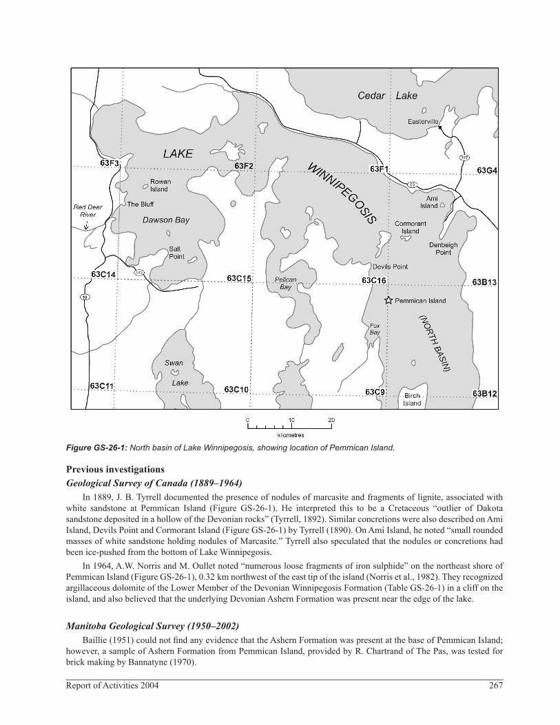
as that part of the lake situated north of Birch Island and extending westward to include Dawson Bay, as depicted in Figure GS-26-1.
As documented by Gale and Conley (2000), the potential for Mississippi Valley–type (MVT) Pb-Zn mineral occurrences within Paleozoic carbonate rocks of Manitoba has been suggested by many geologists over the past 30 years. Various companies (Gulf Minerals Canada Limited, Husky Oil Limited, Canadian Nickel Company, Limited, and Cominco Ltd.) have attempted to search for Paleozoic MVT Pb-Zn deposits in the province (Bamburak et al., 2000). Fedikow et al. (1998) discussed the potential for sediment-hosted disseminated sulphide deposits (Au, PGE and base metals).
Geological settingJackson and Beales (1967) stated that the most striking structural features associated with Pb-Zn orebodies are that
the mineralization occurs near the margin of sedimentary basins and at the edge of major synclines. Further, Anderson and Macqueen (1982) commented that MVT deposits tend to be found on arches between basins.
The study area, in west-central Manitoba, is situated within the Paleozoic outcrop belt, on the northeast margin of the composite Elk Point–Williston sedimentary basin (600 km southwest of the Severn Arch axis) and on the southeast limb of the Moose Lake Syncline (Figure GS-26-2). The latter is also coincident with the Precambrian Superior Boundary Zone (SBZ), as depicted by McCabe (1967).
Most of the eastern portion of the north basin of Lake Winnipegosis is located within the Silurian outcrop belt (Figure GS-26-3). The Interlake Group (Table GS-26-1) occupies this portion of the outcrop belt. The Silurian beds were exposed to a major erosional event before deposition of the overlying Middle Devonian Ashern Formation.
The western portion of the north basin of Lake Winnipegosis is underlain by the Devonian outcrop belt (Figure GS-26-3), which includes the Ashern, Winnipegosis and Dawson Bay formations (Table GS-26-1). The Prairie Evaporite above the Winnipegosis Formation has been removed through salt solution and the overlying beds have collapsed onto the Winnipegosis Formation (Norris et al., 1982).
267Report of Activities 2004
Figure GS-26-1: North basin of Lake Winnipegosis, showing location of Pemmican Island.
Previous investigationsGeological Survey of Canada (1889–1964)
In 1889, J. B. Tyrrell documented the presence of nodules of marcasite and fragments of lignite, associated with white sandstone at Pemmican Island (Figure GS-26-1). He interpreted this to be a Cretaceous “outlier of Dakota sandstone deposited in a hollow of the Devonian rocks” (Tyrrell, 1892). Similar concretions were also described on Ami Island, Devils Point and Cormorant Island (Figure GS-26-1) by Tyrrell (1890). On Ami Island, he noted “small rounded masses of white sandstone holding nodules of Marcasite.” Tyrrell also speculated that the nodules or concretions had been ice-pushed from the bottom of Lake Winnipegosis.
In 1964, A.W. Norris and M. Oullet noted “numerous loose fragments of iron sulphide” on the northeast shore of Pemmican Island (Figure GS-26-1), 0.32 km northwest of the east tip of the island (Norris et al., 1982). They recognized argillaceous dolomite of the Lower Member of the Devonian Winnipegosis Formation (Table GS-26-1) in a cliff on the island, and also believed that the underlying Devonian Ashern Formation was present near the edge of the lake.
Manitoba Geological Survey (1950–2002)Baillie (1951) could not find any evidence that the Ashern Formation was present at the base of Pemmican Island;
however, a sample of Ashern Formation from Pemmican Island, provided by R. Chartrand of The Pas, was tested for brick making by Bannatyne (1970).

268 Manitoba Geological Survey
Figure GS-26-2: Major structural features and geology of the Williston and Elk Point basins, Manitoba and vicinity (modified from Fedikow et al., 2004).

269Report of Activities 2004
Figure GS-26-3: Geological setting of Pemmican Island in the north basin of Lake Winnipegosis. Precambrian domain boundaries after Pilkington and Thomas (2001).
In 1969, a small well-rounded pebble of almost pure galena was found in the NE ¼, Sec. 26, Twp. 14, Rge. 1, E 1st Mer., near the town of Balmoral (Figure GS-26-2), 250 km southeast of Pemmican Island and 35 km northeast of Winnipeg. McCabe (1969) suggested that the pebble might have been glacially transported from a site, possibly in Manitoba, similar to the Phanerozoic Pine Point deposit in the Northwest Territories. In response to the discovery of the pebble, the Manitoba Geological Survey carried out two lines of investigation:• Detailed geochemical sampling of about 6300 department drillcore samples from the Paleozoic outcrop belt of
southwestern Manitoba was carried out from 1980 to 1985 (Gale and Conley, 2000).• Three hundred and seventy-two backhoe pits were dug and sampled for overburden and Quaternary stratigraphic
analysis and heavy-mineral study, extending in the up-ice direction from where the galena erratic was found (Nielsen, 1989).Gale and Conley (2000) reported that the maximum Pb concentration (200 ppm) in the drillcore samples was
obtained from the Winnipegosis Formation (Table GS-26-1). The highest Zn (740 ppm) and Ni (120 ppm) values were from the Red River Formation. The maximum Cu value was 710 ppm from the St. Martin Complex, and the maximum F

270 Manitoba Geological Survey
Table GS-26-1: Generalized stratigraphic section for southern Manitoba, with asterisks showing times of karst events (McRitchie, 1991).
271Report of Activities 2004
value was 1100 ppm from the Ashern Formation. The maximum Fe value (5.7%) was from the Dawson Bay Formation. Gale and Conley also reported that the heavy-mineral investigation of Nielsen’s samples did not show any sphalerite or galena and that “systematic geochemical anomalies” were not identified.
In 2001, a 203.3 m corehole (M-1-01) was drilled by the Manitoba Geological Survey on the west shore of Denbeigh Point (Figure GS-26-1), 25 km northeast of Pemmican Island (Bezys and Bamburak, 2001). The hole was drilled to provide a continuous stratigraphic corehole for detailed geochemical sampling to compare with the results of Gale and Conley (2000). Analytical results from the sampling are described in the ‘Denbeigh Point corehole M-1-01 analyses’ section.
Bamburak et al. (2002) described the results of geochemical sampling of rounded Fe-sulphide concretions and angular Fe-sulphide slabs (with dolomite clasts), found along the waterline of Pemmican Island in 2001 and 2002. Maximum analytical values from all samples were 62.2% Fe, 36.4% S, 1.18% Ni, 0.76% Zn, 3670 ppm As, 1100 ppm Pb and 813 ppm Co. It was also noted that the sample containing 1100 ppm Pb also had 1700 ppm Zn. A Thompson-type nickel anomaly in the Precambrian basement was believed to account for the high Ni value. McRitchie (1995) and Hosain and Bamburak (2002) documented the results of exploration for Thompson-type mineralization within the buried southwestern extension of the Thompson Nickel Belt.
Cominco Ltd. (1970–1971)In 1970, Cominco Ltd. conducted a geological and geochemical program in the vicinity of Easterville and Denbeigh
Point (Figure GS-26-1) to locate Pb-Zn mineralization. Cominco was attracted to the north basin of Lake Winnipegosis by the reported occurrence of “massive botryoidal marcasite” on an island near Denbeigh Point. The occurrence “was considered as encouragement with regard to Pb-Zn mineralization in the Paleozoic section.” In October of the same year, however, Cominco reported that, “Despite the fact that islands and the shoreline around Denbeigh Point were intensively searched, no evidence was found of marcasite mineralization, in either float or outcrop”, and further work on the MVT potential of the area was not recommended (Assessment File 91785, Manitoba Industry, Economic Development and Mines, Winnipeg).
Husky Oil Limited (1970–1971)Husky Oil Limited hired Questor Surveys Limited to conduct a combined INPUT airborne electromagnetic and
magnetic survey in the Dawson Bay area in 1970. As a result of the survey, Husky drilled four mineral exploration coreholes southeast of Red Deer Lake (Figure GS-26-1) in 1971 (A.F. 91776, 92239). Although intense brecciation was noted in all holes by McCabe and Bannatyne (1971), no significant mineralization was found and no further work was recommended (A.F. 91776).
Gulf Minerals Canada Limited (1975–1976)In 1975 and 1976, Gulf Minerals Canada Limited conducted a systematic search for base metal deposits along the
rim of the Western Canada Sedimentary Basin by examining oilwell cuttings. As a result of finding anomalous values of Pb and Zn in the cuttings, Gulf decided to focus on the vicinity of Minitonas (Figure GS-26-3; A.F. 92192). Additional criteria for the selection of the Minitonas area by Gulf were• the projected trend of the SBZ beneath Paleozoic and Mesozoic cover from aeromagnetic data;• the distribution of Winnipegosis Formation (Table GS-26-1) reefs;• post-Devonian solution of the Prairie Evaporite and probable collapse structures;• the Silurian Interlake Group unconformity with the overlying Middle Devonian Ashern Formation, and the possible
development of karst topography; and• the presence of circular structures on the Earth Resources Technology Satellite mosaic (A.F. 92116).
During November 1975, Gulf Minerals conducted a four-hole drilling program on the claims. Pyrite was found as fillings in fractures and vugs, and occasionally associated with fossils. A small crystal of sphalerite was noted at 429.2 m in hole 13-10-36-26W1.
A total of 1481.3 m of core were analyzed for Cu, Pb and Zn, over 3 m lengths. A sandy and shaly bed in the Interlake Group (Table GS-26-1) returned the maximum values for the three elements. The bed is present in three of the holes, and the metal content increases toward the north. The highest Cu analysis (182 ppm) came from the
272 Manitoba Geological Survey
Winnipegosis Formation in hole 1-28-36-26W1. The interval from 341.4 to 353.6 m in hole 15-32-36-26W1, in the Interlake Group, returned average values of 297 ppm Cu and 294 ppm Zn, with maximum values of 721 ppm Cu and 690 ppm Zn occurring from 347.5 to 350.5 m. Nevertheless, Gulf Minerals concluded that, because sampled intervals did not have significant base metal content, further work was not warranted (A.F. 92116).
Canadian Nickel Company Limited (Canico; 1979–1983)In 1979–1980, a literature search by Canico indicated that the Dawson Bay area (Figure GS-26-1) met its criteria
for MVT Pb-Zn deposition, by having the following features:• presence of Devonian Formation (Table GS-26-1) reefs• presence of unconformities• proximity to evaporite deposits• location of major faults (A.F. 93877)
During 1980, Canico collected and analyzed about 1000 soil, rock and water samples near Dawson Bay. Numerous anomalies, resulting from the analyses, coincided with the western boundary of the SBZ (Figure GS-26-3). The boundary was recognized from magnetic and gravity maps, and was interpreted by Canico as a reactivated fault that localized the development of reefs during the Devonian.
Over the next two years, Canico carried out photogeological interpretation; airborne electromagnetic test flying; seismic testing; magnetometer, resistivity and IP surveys; and basal till and subcrop sampling. This work was followed up in 1981 with 189 km of reconnaissance airborne electromagnetic survey, a marine reflection-seismic survey and a 1600-sample soil sampling program. The airborne electromagnetic survey showed that the overburden and limestone have variably high conductivity. The magnetic survey indicated the presence of weak magnetic highs from the Precam-brian basement. The seismic survey equipment was incapable of penetrating the carbonate bedrock to any significant depth; however, several probable, small-scale, fault-like structures were detected in the lake bottom. The soil samples were analyzed for Pb, Zn, Ag and occasionally Hg. More than 80% of the anomalous Pb, Zn and Ag sites were situated near the mouth of the Red Deer River and within four areas near the shore of Salt Point (Figure GS-26-1). Most of the sample sites on the islands in Dawson Bay were anomalous. One goethitic carbonate sample, taken near The Bluff (Figure GS-26-1), returned 0.16% Pb and 0.12% Zn. A carbonate sample from Rowan Island gave a value of 265 ppm Pb (A.F. 93877).
In 1982, a test of resistivity and induced polarization (IP) surveys, a basal till and subcrop sampling program, and a time-domain IP survey were carried out. The IP test, conducted in two areas with anomalously high Pb and Zn geochemical values, indicated that valid results could be obtained despite the high conductivity of the soils and rocks. The 63-sample basal till survey confirmed most of the geochemical anomalies. The time-domain IP survey indicated an anomaly on the north side of Salt Point (A.F. 93878).
In 1983, IP, magnetometer and detailed geochemical surveys were carried out in five areas. Three areas were situated on The Bluff claims and two on the Salt claims. Numerous IP anomalies and well-defined zones high in Pb and Zn were found in all five areas. The anomalous zones were recommended for drilling (A.F. 92829).
Five 80 m holes (63546–63550) were drilled on the Salt and The Bluff claim blocks, based upon• the presence of well-defined IP anomalies; and• their coincidence or proximity to Pb and/or Zn geochemical anomalies (A.F. 92830).
According to Canico, Pb-Zn mineralization was not recognized in any of the holes and only sporadic occurrences of pyrite and marcasite (up to 10%) were found in the Lower Dawson Bay Formation (Table GS-26-1) limestone. A 1.86 m interval (in hole 63549) within Winnipegosis inter-reef bituminous dolomite, located over the western boundary of the SBZ, contained up to 3% pyrite as fine specks, but no mineralization was found in the reef facies. Further work on the property was not recommended (A.F. 92830).
Present studyDenbeigh Point corehole M-1-01 analyses
Corehole M-1-01 was drilled vertically on the west shore of Denbeigh Point (Figure GS-26-1) to investigate strata of Silurian age and older. Chemical analyses of the core, usually at 1 m intervals, showed relatively low values of base-metal mineralization throughout the 203 m long core. The highest values for Cu (78 ppm) and Ni (34 ppm)
273Report of Activities 2004
occurred at a depth of 2.0–2.5 m, within the Cedar Lake Formation of the Interlake Group (Table GS-26-1).The Winnipeg Formation, at the bottom of the hole, averaged 22 ppm Cu and 20 ppm Ni at a depth of
201.1–201.3 m; this interval contained pyrite and marcasite, and had the highest contents of Zn (20 ppm), Pb (22 ppm), Fe (2.8%) and S (2.5%) in the hole.
Slightly elevated Zn values (16 and 13 ppm) corresponded to bituminous partings within the lower beds of the Stony Mountain Formation (Table GS-26-1). Slightly elevated values for Cu (ranging from 19 to 24 ppm in 13 samples) occurred in the uppermost beds of the Stony Mountain Formation.
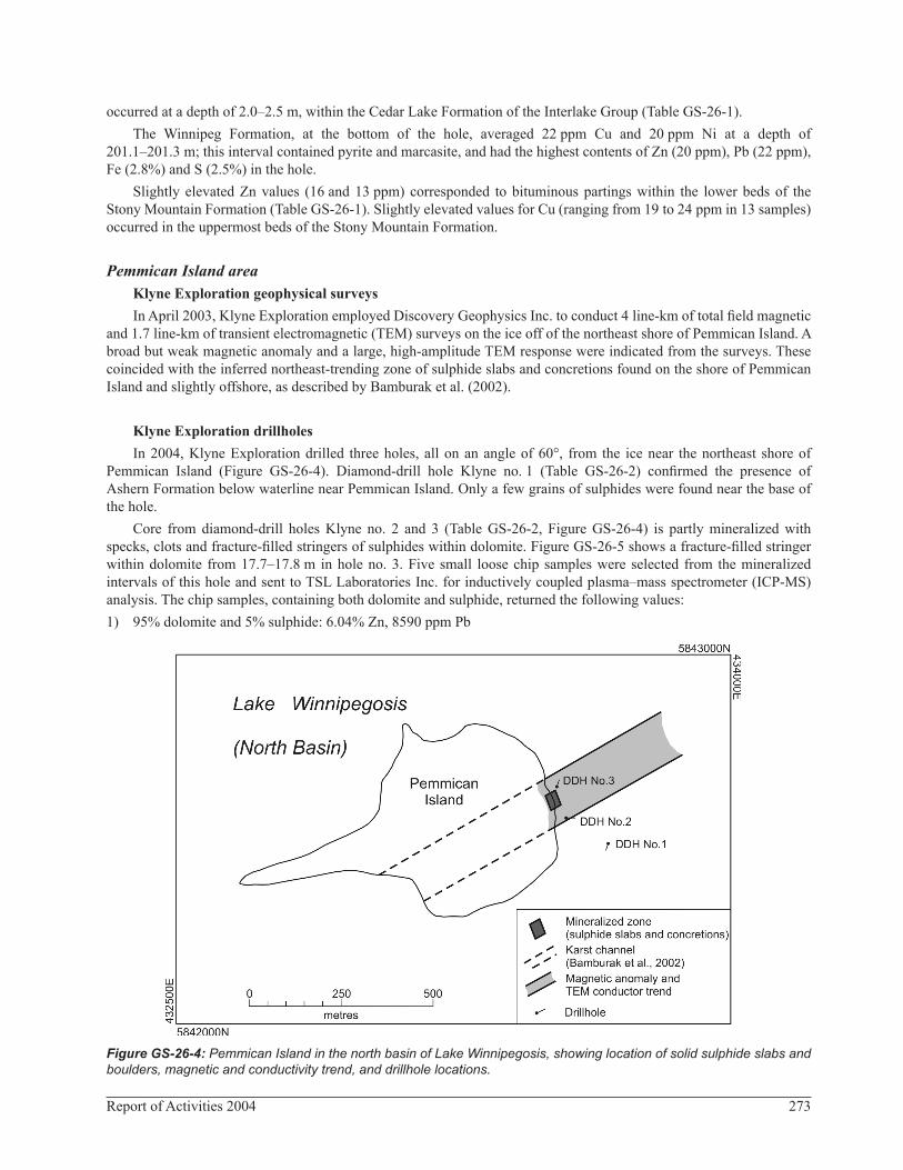
Pemmican Island areaKlyne Exploration geophysical surveysIn April 2003, Klyne Exploration employed Discovery Geophysics Inc. to conduct 4 line-km of total field magnetic
and 1.7 line-km of transient electromagnetic (TEM) surveys on the ice off of the northeast shore of Pemmican Island. A broad but weak magnetic anomaly and a large, high-amplitude TEM response were indicated from the surveys. These coincided with the inferred northeast-trending zone of sulphide slabs and concretions found on the shore of Pemmican Island and slightly offshore, as described by Bamburak et al. (2002).
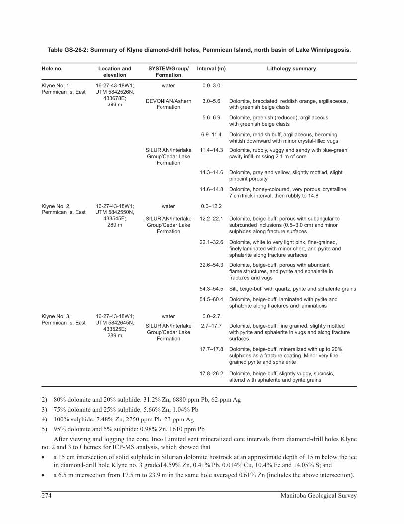
Klyne Exploration drillholesIn 2004, Klyne Exploration drilled three holes, all on an angle of 60°, from the ice near the northeast shore of
Pemmican Island (Figure GS-26-4). Diamond-drill hole Klyne no. 1 (Table GS-26-2) confirmed the presence of Ashern Formation below waterline near Pemmican Island. Only a few grains of sulphides were found near the base of the hole.
Core from diamond-drill holes Klyne no. 2 and 3 (Table GS-26-2, Figure GS-26-4) is partly mineralized with specks, clots and fracture-filled stringers of sulphides within dolomite. Figure GS-26-5 shows a fracture-filled stringer within dolomite from 17.7–17.8 m in hole no. 3. Five small loose chip samples were selected from the mineralized intervals of this hole and sent to TSL Laboratories Inc. for inductively coupled plasma–mass spectrometer (ICP-MS) analysis. The chip samples, containing both dolomite and sulphide, returned the following values:1) 95% dolomite and 5% sulphide: 6.04% Zn, 8590 ppm Pb
Figure GS-26-4: Pemmican Island in the north basin of Lake Winnipegosis, showing location of solid sulphide slabs and boulders, magnetic and conductivity trend, and drillhole locations.
274 Manitoba Geological Survey
Table GS-26-2: Summary of Klyne diamond-drill holes, Pemmican Island, north basin of Lake Winnipegosis.
Hole no. Location and elevation
SYSTEM/Group/ Formation
Interval (m) Lithology summary
Klyne No. 1, Pemmican Is. East
16-27-43-18W1;UTM 5842526N,
433678E; 289 m
water 0.0–3.0
DEVONIAN/Ashern Formation
3.0–5.6 Dolomite, brecciated, reddish orange, argillaceous, with greenish beige clasts
5.6–6.9 Dolomite, greenish (reduced), argillaceous, with greenish beige clasts
6.9–11.4 Dolomite, reddish buff, argillaceous, becoming whitish downward with minor crystal-filled vugs
SILURIAN/Interlake Group/Cedar Lake
Formation
11.4–14.3 Dolomite, rubbly, vuggy and sandy with blue-green cavity infill, missing 2.1 m of core
14.3–14.6 Dolomite, grey and yellow, slightly mottled, slight pinpoint porosity
14.6–14.8 Dolomite, honey-coloured, very porous, crystalline, 7 cm thick interval, then rubbly to 14.8
Klyne No. 2, Pemmican Is. East
16-27-43-18W1; UTM 5842550N,
433545E; 289 m
water 0.0–12.2
SILURIAN/Interlake Group/Cedar Lake
Formation
12.2–22.1 Dolomite, beige-buff, porous with subangular to subrounded inclusions (0.5–3.0 cm) and minor sulphides along fracture surfaces
22.1–32.6 Dolomite, white to very light pink, fine-grained, finely laminated with minor chert, and pyrite and sphalerite along fracture surfaces
32.6–54.3 Dolomite, beige-buff, porous with abundant flame structures, and pyrite and sphalerite in fractures and vugs
54.3–54.5 Silt, beige-buff with quartz, pyrite and sphalerite grains
54.5–60.4 Dolomite, beige-buff, laminated with pyrite and sphalerite along fractures and laminations
Klyne No. 3,Pemmican Is. East
16-27-43-18W1;UTM 5842645N,
433525E; 289 m
water 0.0–2.7
SILURIAN/Interlake Group/Cedar Lake
Formation
2.7–17.7 Dolomite, beige-buff, fine grained, slightly mottled with pyrite and sphalerite in vugs and along fracture surfaces
17.7–17.8 Dolomite, beige-buff, mineralized with up to 20% sulphides as a fracture coating. Minor very fine grained pyrite and sphalerite
17.8–26.2 Dolomite, beige-buff, slightly vuggy, sucrosic, altered with sphalerite and pyrite grains
2) 80% dolomite and 20% sulphide: 31.2% Zn, 6880 ppm Pb, 62 ppm Ag3) 75% dolomite and 25% sulphide: 5.66% Zn, 1.04% Pb4) 100% sulphide: 7.48% Zn, 2750 ppm Pb, 23 ppm Ag5) 95% dolomite and 5% sulphide: 0.98% Zn, 1610 ppm Pb
After viewing and logging the core, Inco Limited sent mineralized core intervals from diamond-drill holes Klyne no. 2 and 3 to Chemex for ICP-MS analysis, which showed that• a 15 cm intersection of solid sulphide in Silurian dolomite hostrock at an approximate depth of 15 m below the ice
in diamond-drill hole Klyne no. 3 graded 4.59% Zn, 0.41% Pb, 0.014% Cu, 10.4% Fe and 14.05% S; and• a 6.5 m intersection from 17.5 m to 23.9 m in the same hole averaged 0.61% Zn (includes the above intersection).

275Report of Activities 2004
Lead isotope analysisAnalysis of Pb isotopes from known MVT and other massive sulphide deposits have proven useful in determining
the genesis of these deposits. Figure GS-26-6 is a plot of the 206Pb/204Pb versus 207Pb/204Pb values for Upper Mississippi Valley–type (UMV), and Pine Point and Flin Flon deposits from Gale and Conley (2000). The purpose of the plot was to determine the possible origin of the Balmoral glacially transported pebble described by McCabe (1969), which triggered MVT investigations throughout southern Manitoba in the 1970s and 1980s.
In order to determine the possible origin of the Pemmican Island mineralization, George Gale of the Manitoba Geological Survey selected four samples for possible Pb isotope analysis and sent them to Activation Laboratories Ltd. These samples of dolomite and sulphide were analyzed for Pb, as the first step in the process. The results were as follows:1) 50% dolomite and 50% sulphide: 3.146% Pb2) 75% dolomite and 25% sulphide: 0.335% Pb3) 40% dolomite and 60% sulphide: 2.417% Pb4) 70% dolomite and 30% sulphide: 2.927% Pb
Sample 1 was selected for Pb isotope analysis. The results are shown in Table GS-26-3 and Figure GS-26-6, together with those of the Balmoral pebble and the Flin Flon galena sample from Gale and Conley (2000).
Figure GS-26-5: Fracture-filled sulphide stringer in dolomite, diamond-drill hole Klyne no. 3, Pemmican Island.
Figure GS-26-6: Lead isotope determinations for a Pemmican Island corehole sample, the Balmoral pebble, Pine Point, Upper Mississippi Valley–type (UMV) and Flin Flon galena samples (modified from Gale and Conley, 2000).

276 Manitoba Geological Survey
Table GS-26-3: Results of Pb isotope analysis on sulphide samples, Pemmican Island and Flin Flon.
Sample 206Pb/204Pb 207Pb/204Pb 208Pb/204PbPemmican Island 23.3 16.3 46.0
Balmoral pebble 18.48 15.68 39.03
NREP 1 Flin Flon 15.404 15.217 34.983
NREP 2 Flin Flon 15.417 15.210 34.983
Enzyme LeachSM soil samplingIn September 2004, three double Enzyme LeachSM soil samples were collected from three shallow holes on the
east shore of Pemmican Island, to test whether a distinct geochemical signature is present within the mineralized zone. compared to samples collected north and south of the zone. If successful, this method could be used to detect Pb-Zn mineralization on the mainland.
Fox Bay and Ami Island investigationsThe shoreline of the east half of Fox Bay (Figure GS-26-1), located on the west shore of the north basin of Lake
Winnipegosis southwest of Pemmican Island, was checked for sulphide mineralization in September 2004. Although a few small sulphide nodules were found on the shore, there did not seem to be sufficient numbers of them to warrant further work.
The shoreline of Ami Island, lying northwest of Pemmican Island near Denbeigh Point, was also investigated in an attempt to find the sulphides reported by Tyrrell (1892). A small fracture zone containing marcasite-pyrite was located on the west shore, adhering to chert and dolomite of the Silurian Cedar Lake Formation. More work is required to determine the potential of this showing, but it does imply that there is a northeast trend to the sulphide occurrences, parallel to the SBZ, within the north basin of Lake Winnipegosis.
DiscussionThe eastern boundary of the buried Superior Boundary Zone (SBZ), in the vicinity of Pemmican Island, is placed
along the east side of a northeast-trending zone of low magnetization, where it is adjacent to the relatively high magnetic signatures of the Berens River domain (Figure GS-26-3). Due to its sharply contrasting magnetic signatures, this contact is assumed to be a fault that separates the Archean rocks from the SBZ. This fault would be a southwestward continuation of a fault depicted on an inset map of the Grand Rapids 1:250 000-scale compilation map (Manitoba Industry, Trade and Mines, 2002), which is situated immediately to the north of the study area. Reactivation of the basement fault during the Phanerozoic would have provided avenues for mineralized fluid migration from basement into the overlying sedimentary rock, where the right conditions of pressure and temperature would have resulted in deposition of metallic minerals, such as Cu, Pb and Zn.
According to Porter and Fuller (1959) and Andrichuk (1959), secondary infilling of pore spaces by calcite and clay likely occurred at the pre–Middle Devonian unconformity in Manitoba and Saskatchewan. This infilling should have provided truncation-type stratigraphic traps within porous carbonate rocks and karst features of the upper Interlake Group. Further, the Ashern Formation redbeds probably formed a secondary caprock or seal to prevent upward movement of (hydrocarbon and/or hydrothermal?) fluids along the unconformity. Theiede and Cameron (1978) showed that the highest concentrations of Cu, Pb and Zn within the Elk Point Evaporite sequence occurred in the green shale and red dolomitic shale of the Ashern Formation, below the massive nodular dolomite of the Winnipegosis Formation. They also concluded that large tonnages of Cu, Pb and Zn may be present within the Elk Point Group.
The analytical results for drillcore samples from the holes drilled northeast of Pemmican Island, reported herein, show Pb-Zn values in Paleozoic carbonate rock several orders of magnitude above those previously obtained in provincial government and mineral-exploration company investigations. The setting for the Pb-Zn mineralization, at the edge of the Elk Point sedimentary basin, corresponds well with the setting of known Mississippi Valley–type occurrences in the United States and Canada. For comparison, two other Canadian MVT occurrences, in the same setting, are described:• The Pine Point mining district is located 800 km north of Edmonton (1300 km northwest of the study area; Figure
GS-26-2) on the south side of Great Slave Lake in the Northwest Territories. Within the district, over 87 deposits were defined within a 65 km by 24 km area. From these deposits, at least 36 orebodies were mined by Pine Point
277Report of Activities 2004
Mines Ltd. (controlled and operated by Cominco Ltd.) from late 1964 until June 1987 (Rhodes et al., 1984).• Canadian Occidental Petroleum Ltd. and Saskatchewan Mining Development Corporation carried out Project Wapa
(Figure GS-26-2), 24 km south of La Ronge and 450 km northwest of the study area, from 1976 to 1981. Geochemical analyses of 1600 core samples from 49 drillholes in Middle Devonian hydrothermal dolomite showed values as high as 2850 ppm Pb, but usually in the range 100–600 ppm. These Pb values were accompanied by up to 355 ppm Zn and 3900 ppm F. Visible galena was noted to occupy a zone (10 km long by 5 km in wide) that coincided with the Precambrian Stanley Fault. The project was abandoned in 1981 after shallow drilling (<100 m) failed to locate ore (Campeau and Kissin, 1988; Kent, 1996).From the present study, it is concluded that a new MVT mineral occurrence has been found in Manitoba, but
extensive investigations will be required to determine the economic potential of this occurrence.
Economic considerationsAlthough metallic mineralization was noted on the shores of islands in the north basin of Lake Winnipegosis as early
as 1889, it is an area of the province that is relatively unexplored for its mineral potential. As a result of the present study, however, Manitoba now has the first evidence of Mississippi Valley–type (MVT) Pb-Zn mineralization in the north basin of Lake Winnipegosis. This discovery may attract major mining companies to renew MVT exploration programs in the province, last carried out over 20 years ago.
AcknowledgmentsGeorge Gale of the Manitoba Geological Survey is heartily thanked for obtaining the Pb isotope results for the
Pemmican Island drillcore sample. Maureen McFarlane and Bonnie Lenton are gratefully acknowledged for preparation of the figures used in this report. George Gale, Ruth Bezys and Heather Groom are thanked for reviewing the manuscript, and Bob Davie for editing the text.
ReferencesAnderson, G.M. and Macqueen, R.W. 1982: Ore deposit models, 6. Mississippi Valley–type lead-zinc deposits;
Geoscience Canada, v. 9, no. 2, p. 108–117.Andrichuk, J.M. 1959: Ordovician and Silurian stratigraphy and sedimentation in southern Manitoba, Canada; Bulletin
of the American Association of Petroleum Geologists, v. 43, p. 2333–2398.Baillie, A.D. 1951: Devonian geology of Lake Manitoba–Lake Winnipegosis area; Manitoba Department of Mines and
Natural Resources, Mines Branch, Publication 49-2, 72 p.Bamburak, J.D., Hosain, I.T., Fedikow, M.A.F. and Dobrzanski, E. 2000: Investigations on the Camperville gravity low
(parts of NTS 62N/E and 63C/E); in Report of Activities 2000, Manitoba Industry, Trade and Mines, Manitoba Geological Survey, p. 202–209.
Bamburak, J.D., Hosain, I.T. and Klyne, K. 2002: Phanerozoic solid-sulphide occurrence containing Devonian dolomite breccia clasts, Pemmican Island, Lake Winnipegosis (NTS 63B12NW), Manitoba; in Report of Activities 2002, Manitoba Industry, Trade and Mines, Manitoba Geological Survey, p. 131–143.
Bannatyne, B.B. 1970: The clays and shales of Manitoba; Manitoba Department of Mines and Natural Resources, Mines Branch, Geological Survey, Publication 67-1, p. 16, 17.
Bezys, R.K. and Bamburak, J.D. 2001: Stratigraphic investigations and corehole drilling program, 2001; in Report of Activities 2001, Manitoba Industry, Trade and Mines, Manitoba Geological Survey p. 159–163.
Bezys, R.K. and McCabe, H.R. 1996: Lower to Middle Paleozoic stratigraphy of southwestern Manitoba; Geological Association of Canada–Mineralogical Association of Canada, Joint Annual Meeting, May 27–29, 1996, Winnipeg, Manitoba, Field Trip Guidebook B4, 92 p.
Campeau, R.M. and Kissin, S.A. 1988: Project Wapa: evaluation of a lead-zinc occurrence in Middle Devonian carbonates of northern Saskatchewan; Geoscience Canada, v. 15, no. 2, p. 106–108.
Fedikow, M.A.F., Bezys, R.K., Bamburak, J.D. and Conley, G.G. 1998: Geochemical database for Phanerozoic black shales in Manitoba; Manitoba Energy and Mines, Geological Services, Open File Report OF98-2, 123 p.

278 Manitoba Geological Survey
Fedikow, M.A.F., Bezys, R.K., Bamburak, J.D., Hosain, I.T. and Abercrombie, H.J. 2004: Prairie-type microdissemi-nated mineralization in the Dawson Bay area, west-central Manitoba (NTS 63C14 and 15); Manitoba Industry, Economic Development and Mines, Manitoba Geological Survey, Geoscientific Report GR2004-1, 76 p.
Gale, G.H. and Conley, G.G. 2000: Metal contents of selected Phanerozoic drill cores and the potential for carbonate-hosted Mississippi Valley–type deposits in Manitoba; Manitoba Industry, Trade and Mines, Manitoba Geological Survey, Open File Report OF2000-3, 126 p.
Hosain, I.T. and Bamburak, J.D. 2002: Interpretation of Thompson-type geophysical signatures (NTS 63B and 63F) and the possible cause of the Camperville gravity low (NTS 62N and 63C), west-central Manitoba; in Report of Activities 2002; Manitoba Industry, Trade and Mines, Manitoba Geological Survey, p. 117–130.
Jackson, S.A. and Beales, F.W. 1967: An aspect of sedimentary basin evolution: the concentration of Mississippi Valley–type ores during late stages of diagenesis; Bulletin of Canadian Petroleum Geology, v. 15, no. 4, p. 383–433.
Kent, D.M. 1996: Mississippi Valley–type mineralization in Lower Devonian Lower Elk Point strata, south La Ronge area, central Saskatchewan: a case history; in Minexpo ’96 Symposium – Advances in Saskatchewan Geology and Mineral Exploration, Saskatchewan Geological Society, Special Paper 14, p. 141–152.
Manitoba Industry, Trade and Mines 2002: Grand Rapids, NTS 63G; Manitoba Industry, Trade and Mines, Manitoba Geological Survey, Bedrock Geology Compilation Map Series, NTS 63G, scale 1:250 000.
McCabe, H.R. 1967: Tectonic framework of Paleozoic formations in Manitoba; Canadian Institute of Mining and Metallurgy, Annual Western Meeting, Transactions, v. 70, p. 180–189.
McCabe, H.R. 1969: An occurrence of galena in float: Winnipeg area; in Summary of Geological Field Work 1969, Manitoba Department of Mines and Natural Resources, Mines Branch, Geological Paper 69-4, p. 125.
McCabe, H.R. and Bannatyne, B.B. 1971: Stratigraphic and industrial minerals core hole programme; in Summary of Geological Field Work 1971, Manitoba Department of Mines, Resources and Environmental Management, Mines Branch, Geological Paper 71-6, p. 62.
McRitchie, W.D. 1991: Caves in Manitoba’s Interlake region; Speleological Society of Manitoba, Winnipeg, Manitoba, 150 p.
McRitchie, W.D. 1995: Mineral development potential in Manitoba – nickel in the southwest extension of the Thompson Nickel Belt; Manitoba Energy and Mines, Geological Services, Economic Geology Report ER95-2, 29 p.
Nielsen, E. 1989: Quaternary stratigraphy and overburden geochemistry in the Phanerozoic terrane of southern Manitoba; Manitoba Energy and Mines, Geological Services, 78 p.
Norris, A.W., Uyeno, T.T. and McCabe, H.R. 1982: Devonian rocks of the Lake Winnipegosis–Lake Manitoba outcrop belt, Manitoba; Manitoba Energy and Mines, Publication 77-1; Geological Survey of Canada, Memoir 392, 280 p.
Pilkington, M. and Thomas, M.D. 2001: Magnetic and gravity maps with interpreted Precambrian basement, Manitoba; Geological Survey of Canada, Open File 3739, 4 sheets at 1:1 500 000 scale.
Porter, J.W. and Fuller, J.G.C.M. 1959: Lower Paleozoic rocks of the northern Williston Basin and adjacent areas; Bulletin of the American Association of Petroleum Geologists, v. 43, p. 124–189.
Rhodes, D., Lantos, E.A., Lantos, J.A., Webb, R.J. and Owens, D.C. 1984: Pine Point orebodies and their relationship to the stratigraphy, structure, dolomitization, and karstification of the Middle Devonian barrier complex; Economic Geology, v. 79, p. 991–1055.
Theiede, D.S. and Cameron, E.N. 1978: Concentration of heavy metals in the Elk Point evaporite sequence, Saskatch-ewan; Economic Geology, v. 73. p. 405–415.
Tyrrell, J.B. 1890: The Cretaceous of Manitoba; American Journal of Science, v. XL, no. 237, p. 227–232.Tyrrell, J.B. 1892: Report on North-Western Manitoba; in Annual Report of the Geological Survey of Canada (1890–91),
v. V, pt. 1, p. 153E–171E.