a points list for study green corridor -...
TRANSCRIPT

1
A Points List for Study Requirements and Discussion for the
Potential Enhancement of the
Green Corridor to encourage Public Usage
And Long Term Maintenance and Support
Paul R Wonnacott
July 2013

2
The General Footprint
The area to be directly included by the proposal. In this case it the main parts of the Green Corridor has been in existence and open to the public since 2011. It is under the purview of the Singapore Land Authority. As expected some original recovery works had been carried in grassing and stabilising the old track bed once the rails, sleepers and gravel had been removed. The old Tanjong Pagar Railway Station is still in existence, in good architectural order as a scheduled Ancient Monument , but disassociated by fencing from the Green Corridor and only opened for specific occasions. It will be proposed to include access from the Green Corridor to parts of the station and potential car parking facilities.
The Proposed Area to be encompassed
1. Part of Tanjong Pagar Railway Station. 2. Access from Pay Carpark 3. Path from Station to old track entry behind Silat Walk 4. Old Track between Silat Walk through to rear of Kranji Water Reclamation Plant 5. Footpath access along Mandai River from Kranji MRT to rear of Kranji Water Reclamation Plant 6. Various existing entry footpaths along the route to be protected.
Parties expected to be involved
1. Rail Corridor Partnership 2. Nature Society Singapore 3. Singapore Land Authority 4. National Parks Board (NParks) 5. Supporters of “We Support The Green Corridor” 6. Potential formation of “Green Corridor Trust” 7. Singapore Tourist Board 8. Various existing landowners of entry footpaths along the route.
Assumptions
1. The Rail Corridor Partnership should be discouraged from promoting interests, which are not conducive to the current natural status of the Green Corridor but may be encouraged to utilise parts of the Tanjong Pagar station to display and execute some of the proposed projects it has garnered from competitions and submissions from various parties.
2. Singapore Land Authority transfer the land title to NParks. Currently SLA operates as the custodian of the unallocated land belonging to the Singapore Government. As such its land bank can be allocated at any time for any reason for any project or development without prior resort to public opinion. It is therefore desirable that more permanency to the land can be obtained by way of transfer.
3. National Parks Board (NParks) accept the transferred land from SLA with the undertaking that the Green Corridor remain a natural environment as evolved throughout its existing history and that only sensitive maintenance such as trimming the pathway and drainage of muddy areas such as under some overhead bridges.

3
4. Nature Society Singapore encourages and supports the formation of “Green Corridor Trust” by NParks and affiliate support to the Trust. This trust would then contain members who are able to provide voluntary manpower, publicity, fundraising activities, encourage sponsorship etc in support of the Green Corridor operational maintenance where applicable. As such a “trust” it would be feasible to allow the authorities to rent space to the trust at a “peppercorn rent” which will aid the long term survival of the Green Corridor.
5. Supporters of “We Support the Green Corridor” are a facebook group which has a list of “Likes”, comments and contributions from regular users etc. These persons will have some interests and potential input to the long term existence of the Green Corridor. They should be invited to participate individually within the Nature Society Singapore and/or The Green Corridor Trust.
6. Singapore Tourist Board would be expected to support and promote the Green Corridor as a walking route to study the natural flora and fauna together with provision of leaflets placed in Hotels and Visitor Centres etc. Pictorial content of such together with editorial can be provided by voluntary existing resources.
7. Various other landowners whose land contains existing access to the Green Corridor be requested to agree to allow continued access and that signage be placed identifying the designated route. The signage be provided and installed in agreement with NParks/The Green Corridor Trust.

4
Long Term Expectations and Actions
1. The Land be administered by NParks .
2. The Green Corridor Trust should be a registered charitable organisation partially funded by NParks
and would comprise of a group of Volunteers and/or sponsors and NParks seconded/appointed
officers. They will work with NParks to provide voluntary assistance in day to day maintenance and
operations as available and under the guidance of NParks through these appointed officers.
3. That part of Tanjong Pager Station be allocated as a visitor centre and cafe for the Green Corridor.
This facility potentially operated by part time volunteers of The Green Corridor Trust with full time
management support. Providing
(a) A seated area serving refreshments.
(b) A counter sales of bottled water and other acceptable drinks and refreshments for consumption
by public offsite such as along the Green Corridor
(c) Snacks and drinks should only be packed in brown paper bags and that plastic bags are not
employed. Keeping within the “Green” ideology brown paper bags if carelessly discarded along
the green corridor will bio-degrade quickly without harm to the environment.
(d) Visitor Centre would operate a gift shop in keeping within the theme of ecology and of the Green
Corridor objectives. Part of the sales would include but not be limited to...
(a) Maps and guides to Singapore and the region.
(b) Pictures and calendars of Singapore attractions and wildlife including from the Green
Corridor.
(c) Books and gifts in support of the Green Corridor and Nature Society Singapore including
items such as NSS Pocket Guides.
(d) Cycle Hire of all suitable equipment for use along the Green Corridor when the hirer does
not wish to use his/her own equipment.
Note: All carriers and bags provided or charged be made from paper or natural fibres. No Plastic
bags.
4. Currently Access by Motor vehicle is not possible due to large concrete blocks placed at the
locations of the original crossing gates or by the installation of the standard green metal barriers. In
order to allow for long term care and maintenance of the corridor it will be advantageous to install
offset railings allowing for public foot or cycle access (maybe later with pushchair or motorised
invalid cart). As vehicles such as a John Deere Wide Tyre Lightweight Dumper Buggy or similar
equipment used by the trust may need access then in one set of railings has an acceptable lockable
gate installed. Access by key holders of The Green Corridor Trust staff.
5. Funds be raised or support from Tote Board 4D to construct a lightweight bridge to replace the
demolished rail bridge across the waterway behind 10 Mile Junction to allow for continuity of the
corridor from Hillview to Mandai River.

5
6. Steps/ramps to be installed at Hillview to replace the demolished low bridge and allow proper
continuity of the corridor. Either down to street level or elevated overhead but with ramping
consistent with Bicycles and potential wheelchair usage.
7. Re-establish access from the Mandai River footpath opposite Kranji MRT by realignment of the new
locked gate by Kranji Lodge.
8. A team of volunteers be able to coordinate updated information on status and news from the Green
Corridor to be published on a website and/or phone app. Funding for this to be provided from cafe/shop and cycle rent profits.
9. A team of volunteers from the Green Corridor Trust can guard against encroachment. It's a sad fact but one of the biggest threats to the walk is encroachment. This takes many forms from tipping of rubbish (non organic and even garden rubbish) to householders who may try to extend their gardens into the walk or building on the boundary, which can have a catastrophic effect on the immediate ecology or to outright hiving off of land by authorities of this valuable resource for other purposes. For that reason, the Green Corridor Trust will make a point of challenging any threat to the land, which is after all designated as Green Corridor and therefore rightfully a resource for all of us. It should not be regarded by greedy opportunists as land that can be plundered and spoiled.

6
Studies and References
Dr Beeching was chairman of British Railways Board from 1961 – 1965. He proposed in a paper The
Reshaping of British Railways (1963) the closure of over 8,000 Km of railway lines and some 2,360 railway
stations as being uneconomical to remain operational. The majority of these were closed and many lines
and stations remained abandoned. Since then some of these routes have since reopened for operations,
sections taken on and operated as heritage stream railways using trust members and volunteers or been
opened for country walks and/or incorporated into the British National Cycle Network. In some cases even
the local authority has taken on the maintenance and public access as maintained corridors with little
additional additions except in some cases tarmac walkways and lighting in tunnels. In order for this to be
accomplished many localised interested parties have consulted and been involved the reuse of redundant
lines in their areas and those including cycling coordinated with NCN.
There have been a number of successful partnerships between authorities, the public and trusts in the UK.
Some projects have involved the cleansing and restoration of the rail-track bed and goods sidings from
ground contamination cause by years of chemical, oil and grease deposits during operations and later by
illegal dumping or fly tipping of industrial waste.
The following guidelines published by Rugby Borough Council after the opening of Great
Central Way walk including the old platform of Rugby Central Station
Do it yourself walking routes, Developing your own urban walk route
One of the best ways to incorporate walking into your life is by walking near to the area in which you live.
The Council publishes three leaflets covering much of the town centre area (the "Pathway to a Healthier Lifestyle" leaflets), but why not work out your own route? It's a good idea to obtain a street map, even if you know the area well, to look at the area immediately around where you live. An urban health walk should ideally contain a variety of elements to give you what you want
• Stay local - if you do this, you do away with the necessity to travel by car. • Make it circular - possibly fairly obvious, but where you can, avoid going over the same ground
twice in order to maximise interest. • Keep it fairly short and simple - if it's not too long, for instance if it takes about 20-30 minutes,
there is more chance you'll be able to slot it into everyday life easily without upsetting your daily routines. If you want to, you can always work out two or three routes and do more than one if you're feeling in need of more of a challenge. Keeping it short also means it also won't matter too much about weather conditions, which you can normally predict over such a short time. Once you've worked out your first route, you can always amend it later on.
• Keep it clean - if you keep most of it to paved paths, it's easier to do without worrying about footwear for muddy conditions.
• Make it safe - a very important aspect to consider. Safety may seem obvious, but it's worth thinking about anything that might make your route unsafe. Basically you need to work out a route and assess any point at which you might encounter a hazard (something with the potential to cause you harm), what might happen if you did, and then if necessary amend the route in order to remove the potential hazards.

7
• Aspects to consider are:
Path surfaces - try to keep mostly to pavements to give you good surfaces without trip hazards or slippery surfaces. Don't rule out routes on grass or similar surfaces, but make sure you have routes appropriate to differing weather conditions.
Roads are likely to be the major hazard encountered in any walk, but it's hard to avoid crossing them at some point. When you do, make sure that you choose a specific crossing point, such as a traffic light controlled crossing, a zebra crossing, or a crossing point with a central road refuge, that will enable to you to do it safely.
If you are walking by yourself, make the route in areas you know you will feel comfortable in.
• Incorporate variety - most areas of Rugby are in reach of an open space of some sort, which may be a sports field, but could also be a footpath by allotments, a cemetery, or a nature reserve like the Great Central Walk. It's surprising what you'll discover about the area you live in.
• Make it useful - you might want to incorporate a visit to the shops for instance, or to play areas if you intend taking children, making it the incentive for them to go on the walk.
• Incorporate a small challenge - this will vary according to your requirements, but it's a good idea to incorporate a change in terrain such as a hill, to allow you to raise your effort levels and maximise the health benefits. Make it in the middle of the walk to allow you to warm up before tackling it.
• Add interest - many parts of Rugby have at least one point of interest, and some, many more. If you've got the time, try and find out something about points on the route. Within a very short distance close to the town centre, for instance, you'll find the field where the game of Rugby started, the spot where the Riot Act was last read in England (apart from the last time you read it to your children, that is!), and the house where the man who invented holography (such as those found on bank cards) lived.
• Incorporate a rest point - you may feel you need this if you cannot walk too far in one go, but it's sometimes good to have a nice place to stop, which might be in the park. The other thing you may wish to consider is a place you can use a toilet if the route is a long one, or somewhere to obtain a drink (if you're not carrying one)
What are the benefits of local urban walking?
• You don't need transport to get to the start • They can be easily incorporated into everyday life • You can tailor them to your own requirements and state of health • You can do it at your own pace, alone or in company • You will get to know your local area better • You can do it easily with friends or family to make it a social event • You get fitter, and it's free!

8
PICTURE BOOK
A footpath lined with trees marks the former railway route to the west of Otley, between what were the old
Milnerwood and Burley Junctions, West Yorkshire, England
The remains of Rugby Central Station on the former Great Central Railway, one of many stations and lines that were
closed under the Beeching Axe

9
The Monsal Trail
Typical Low Cost Replaceable Eco Wooden Signage as used in the Peak District National Park
The disused station at Hassop 1976

10
The restored station at Hassop 2010
MONSAL TRAIL CYCLE HIRE
Come and enjoy the traffic free Monsal Trail with our range of bicycles, tag-a-longs and child seats. Give
the whole family a great day out in the beautiful Peak District, and now the spectacular tunnels are opening
there's nothing to stop you!
For those feeling less active, why not relax in the cafe or browse the book shop and gift area.
For more information, please call 01629 810 588.

11
HIRE OPTIONS
2 hrs 4 hrs All day 2 days
Additional
days
Adult Bike £10 £14 £17 £27 £10
Junior Bike £6 £10 £12 £20 £8
Buggy/Tag-a-long £6 £10 £12 £20 £8
Baby Seat £2 £3 £4 £6 £2
Electric Bike £15 £20 £25 £40 £15
Tandem £20 £28 £34 £54 £20
Adult Trikes and Kids Scooters available too.
New and used bikes are available to purchase.
ELECTRIC BICYCLE NETWORK
Our electric bikes are a 'must try'... you won't be disappointed. The pedal assist makes for
effortless cruising and feels like riding a gentle yet powerful wave.
Please ask our staff for more information, or go to:
www.electricbicyclenetwork.com

12

13

14
Railway Path user advice by Durham County Council, Northumberland and Durham,
United Kingdom
Path Standing Signage

15
Typical Hardwood Post Profile
100 x 100 x 3000 mm
Install with 500 mm below ground surface
A 3 pointer post
(180 degree – direction to Tanjong Pagar and Mandai River)
(90 degree - Exit to Street, Buses)Table to be defined

16
Parkland Walk
The Parkland Walk is a 4.5-mile (7.2 km) linear green walkway, in the London Boroughs of Haringey and Islington, which follows the course of the railway line which used to run between Finsbury Park through Stroud Green, Crouch End, Highgate and Muswell Hill to Alexandra Palace.
It is a Local Nature Reserve and a Site of Metropolitan Importance for Nature Conservation. It was declared a Local Nature Reserve in 1990 and is London's longest LNR.
The great variety of plant life sustains a wide range of animals. Twenty two species of butterfly have been recorded. Hedgehogs benefit from the proximity of adjacent homes and occasional feedings from homeowners. Foxes are plentiful and muntjac (a small species of deer) are seen occasionally. A colony of slow-worms thrive along the grassy embankment. More than sixty species of bird have been seen along the walk and many breed here. Parkland Walk is known to be an important site for bats in the London context, providing important foraging habitat and an excellent dark commuting route. A significant bat roost is known to exist in the vicinity.
17
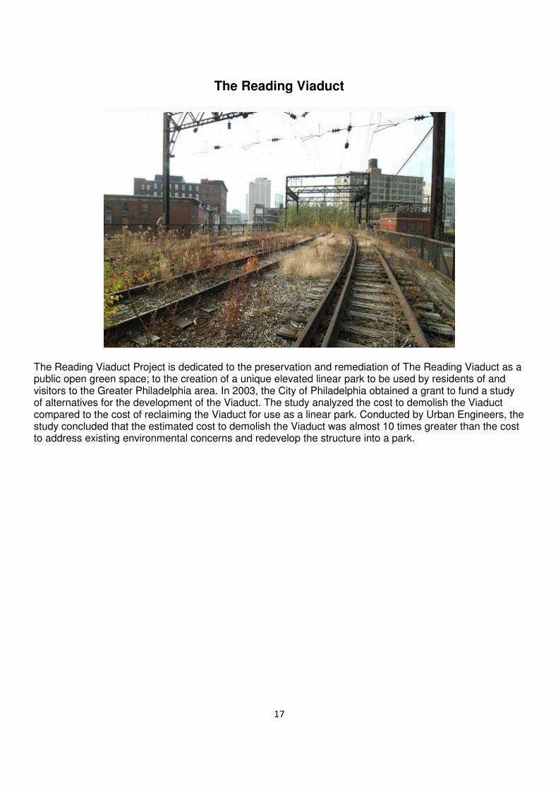
The Reading Viaduct
The Reading Viaduct Project is dedicated to the preservation and remediation of The Reading Viaduct as a public open green space; to the creation of a unique elevated linear park to be used by residents of and visitors to the Greater Philadelphia area. In 2003, the City of Philadelphia obtained a grant to fund a study of alternatives for the development of the Viaduct. The study analyzed the cost to demolish the Viaduct compared to the cost of reclaiming the Viaduct for use as a linear park. Conducted by Urban Engineers, the study concluded that the estimated cost to demolish the Viaduct was almost 10 times greater than the cost to address existing environmental concerns and redevelop the structure into a park.

18
High Line – New York City, USA
The High Line – New York
The High Line is a public park built on an historic freight rail line elevated above the streets on Manhattan’s West Side. It is owned by the City of New York, and maintained and operated by Friends of the High Line. Founded in 1999 by community residents, Friends of the High Line fought for the High Line’s preservation and transformation at a time when the historic structure was under the threat of demolition. It is now the
non-profit conservancy working with the New York City Department of Parks & Recreation to make sure the High Line is maintained as an extraordinary public space for all visitors to enjoy. In addition to overseeing maintenance, operations, and public programming for the park, Friends of the High Line works to raise the
essential private funds to support more than 90 percent of the park’s annual operating budget, and to advocate for the preservation and transformation of the High Line at the Rail Yards, the third and final
section of the historic structure, which runs between West 30th and West 34th Streets.

19
The Little River Rail Trail, New Zealand
The Little River Rail Trail is a cycling and walking track on Banks Peninsula in the Canterbury region of New Zealand's South Island. The rail trail utilises the formation of the Little River Branch railway, which ran from a junction with the Southbridge Branch from Hornby via Lincoln to Little River. The railway closed on 30 June 1962 and the formation had remained largely undisturbed until the early 2000s, when a trust was formed to revitalise it for public use.

20
http://www.naturalengland.org.uk/ourwork/enjoying/countrysidecode/
http://app.toteboard.gov.sg/web/Common/homepage.aspx
http://docs.lawsociety.org.sg/Legal-info-charities/index.php/getting-started/types-of-legal-structures/charitable-trust
http://www.bbc.co.uk/news/uk-13571482 is a video for electric bike on Mondail Trail
http://www.disused-stations.org.uk/h/hassop/index.shtml
www.electricbicyclenetwork.com
http://en.wikipedia.org/wiki/Parkland_Walk
http://www.parkland-walk.org.uk/
http://www.railwaypaths.org.uk/
http://readingviaduct.org/
http://en.wikipedia.org/wiki/High_Line_%28New_York_City%29
http://www.thehighline.org/
http://en.wikipedia.org/wiki/Promenade_plant%C3%A9e
http://www.paris.fr/english/parks-woods-gardens-and-cemeteries/gardens/promenade-
plantee/rub_8212_stand_34230_port_18987
http://www.littleriverrailtrail.co.nz/fastpage/fpengine.php/templateid/1

21
Back here in Singapore there have recently been a number of issues noted with respect to the Green Corridor.
1. Bulit Timah Railway Station has not been restored after 2 years despite it being hired out to
Mediacorp to shoot TV program.
2. Comments re muddy situation under bridges especially that beside Cold Storage Jelita have not been addressed directly by SLA.
3. The unannounced closure of the traditional footpath from Kranji MRT to the Green Corridor along the side of the Mandai River. This has been caused by the sudden installation of locked gates by Kranji Lodge. It provides no security currently as public can walk through the carpark on the other side of the river and walk across the bridge installed by Kranji Lodge. Both access and egress should be remain possible by public walkers.
Comments in the press
http://www.todayonline.com/voices/take-action-we-lose-our-rail-
corridor
Take action before we lose our Rail Corridor
From
Nick McHugh
-
09 July 2013
For years, the old Rail Corridor was a strong line of steel running from Tanjong Pagar to the Causeway. The
tracks were removed in 2011, leaving a ribbon of green open to runners, walkers, photographers and
cyclists.
As it threads its way between condominiums and expressways, it is easy to see how tenuous its continued
existence is. In a city where the car is king and development is fast-paced and constant, that this corridor
exists at all is a gift to be cherished.
It will need protection to survive amid the concrete and steel. Yet, people are already disrespecting the trail,
blocking it, abusing it and even parking vehicles on it. Recently, teams have been felling trees and leaving
them across the track. If the trees do need clearing, surely they could be felled parallel to the track so people
can pass?
This may seem like a minor point, but if the track gets blocked, people would stop using it and it would fall
into disrepair. Then, it is a matter of time until the “unused land” gets turned into parking lots, buildings and
shopping centres.

22
Over the past two years, those trimming trees for businesses, condos and housing estates have dumped
branches on the sidings. These raised areas used to provide an alternative route when the track was muddy.
Now, thanks to the dumping, they are overgrown and impassable.
Increasingly, lorries, vans and other vehicles are parking in the middle of the track and using it as access to
building sites, which are creeping closer. The heavy vehicles block the way and cause ruts that fill with
water.
In several areas, most notably between Holland and the bridge over Bukit Timah, the track is so muddy it is
nearly impassable. There is over 30 cm of stagnant water under some of the bridges — during a dry period.
During rainy weather, it gets a lot worse.
Further north, the removal of the old rail bridges means there is a need to cross busy roads. In one area, there
is no way over a canal; the track comes to a dead end, meaning a long trip back and a detour.
The agency in charge of maintaining and protecting the Rail Corridor should stop people from felling trees
across it, dumping rubbish on the sidings and parking all over it.
The whole length, and not only sections, must be kept clear so people can continue using and enjoying the
track. If parts become unusable and the edges get nibbled away, we risk losing it entirely, in which case
there would be no getting it back.
• Paul R Wonnacott · Southend College of Technology
I posted this issue last year on "We Support the Green Corridor". SLA gave assurance that this would be
tackled.
No action until now.
Reply · Like · Follow Post · 19 hours ago
• Jack Lin · Top Commenter
Instead of depending to agencies, why not roll up your sleeves and do it yourselves? Get volunteers and
sponsors for shovels and fill these muddy spots. Use the old rail rocks to path a way.
You cant just push the blame away.
Reply · 4 · Like · Follow Post · 21 hours ago
• Patrick Ching Toon Goh
I took part in the Green Corridor run held last year. I didn't run but just walked all the 10 km distance with
my wife.
Although the day was dry, it was already wet and muddy in some parts due to rain a few days before.
During the walk, which we thoroughly enjoyed despite the heat and humidity, I thought it was really
pleasant and 'different'.
It was like a 'lung' corridor. Shielded in most parts by trees and tall bushes to contain its natural self.

23
I thought how nice it would be if it could be kept as it was, cleaned up a bit, level up some parts and improve
drainage somewhat to keep it dry enough after light showers....
No need for the powers that be to build artificial structures (which Singapore is much famous for) and
change it's naturalness (like the gardens across the waters from Gardens by the Bay, where all the beautiful
mature trees were completely uprooted, the land scraped bare and rebuilt into another artificial garden).
Reply · 2 · Like · Follow Post · 20 hours ago
• Anvil Den · Follow · Top Commenter · University of Toronto
There has been a lot of resistance on development along the Corridor. It might just be well in the interest for
powers that be to leave things as it is and often turning a blind eye... With all the activities described which
will only erode huge sections over time, it might be in the hope that soon people will all but forget what
these once were. When complains and discontent ensues by then.. its easy to simply fence up more state land
and sell off to the next highest bidding developer? Ok I'm prone to be negative and skeptical...
Reply · 2 · Like · Follow Post · 22 hours ago
• Matthew John Allen
Great letter, totally agree. It's getting to the point where the neglect and lack of maintenance seems
deliberate, so that the authorities can roll out ''underuse' and 'dengue risk' arguments in order to break it up.
If that's not the case, let's get some interim maintenance there while the masterplan is drawn up!
Reply · 2 · Like · Follow Post · Yesterday at 11:40am
•
Nick McHugh
Yes, that's my concern. Neglecting it and not promoting its use is not only the easiest thing to do, but
also the most profitable. Once it's overgrown and underutilised, nobody will question the need to
break it up and build on it.
Reply · 1 · Like · 23 hours ago
•
Anvil Den · Follow · Top Commenter · University of Toronto
oops commented along the same line before seeing this. Looks like I'm not the only one :)
Reply · Like · 22 hours ago
•

24
Billy Mallard
I did my part, running there as often as possible when I lived in Singapore. Run the railway, y'all!
Clear the weeds, scare the cobras and save your greenery!
Reply · 1 · Like · 17 hours ago
• Matthew Teo · Moore Theological College
What If we divide it into 12 sections or so and have 12 groups adopt each section...we may lots of fun and
funds doing this!
Reply · 2 · Like · Follow Post · 20 hours ago
• Lewis Loh · Top Commenter · University of Western Australia
The exact spot described.
https://www.facebook.com/photo.php?fbid=10151513094092797&set=a.10151463440337797.1073741830.
641827796&type=1&relevant_count=1
Reply · 1 · Like · Follow Post · 22 hours ago
• Sarah Ann Rigden
Yes come on guys get active on this one. Green corridors are an investment into the future.
Reply · 1 · Like · Follow Post · 21 hours ago
• Weera Chak · Singapore, Singapore
Like some long term hidden agenda out of sight out of mind.wahla for sale next.
Reply · 1 · Like · Follow Post · 21 hours ago
• James Wong · Woodlands, Singapore
Yeah.. Totally agree with the writer.
Reply · 1 · Like · Follow Post · Yesterday at 11:06am
• Heng Cho Choon · University of London International Programmes
good idea
Reply · 1 · Like · Follow Post · Yesterday at 6:41am
• Kerry Cracknell

25
I agree wholeheartedly and would be interested in joining a volunteer group to do some work clearing the
line. I've run the Green Corridor a few times, but not recently due to work and the kids being on school
holidays, but I was hoping to take the kids walking along there later this month. Looks like it might be a bit
of a challenge though, now. If anyone who knows what they are doing could organise a group to help clear
the corridor, I'd be interested in helping out!
Reply · Like · Follow Post · 2 hours ago
• Tobias Wilson · Singapore, Singapore
Did anyone else do the green corridor run earlier this year?
http://www.greencorridorrun.com.sg/
It was a great way to showcase the corridor, sad that it's fallen back into disrepair.