a performance based approach to dolomite risk management ... +p6 papers/p6-3... · 1 a performance...
TRANSCRIPT

1
A performance based approach to dolomite risk management David B. Buttrick,
1 Nicole Y.G. Trollip,
2 Ronald B. Watermeyer.
3 Nicolaas D. Pieterse,
4 Abraham
A. Gerber.5
Environmental Earth Sciences: Volume 64, Issue 4 (2011), Page 1127-1138
Abstract: Urban development commonly disturbs the meta-stable conditions in the dolomite environment which can lead to sinkhole formation. 650 sinkholes, which manifested from 1984 to 2004 in an approximately 3,700 ha urbanized environment, located on dolomite land south of Pretoria in South Africa, was analyzed in the absence of risk mitigation measures. A 4 year period post the implementation of a comprehensive risk management system was also analyzed. This research permitted a timely review of the Buttrick et al. (J South African Inst Civil Eng 43(2):27-36, 2001) methodology for dolomite land hazard identification which is commonly used in stability analysis and the development of risk mitigation strategies in Southern Africa. The research confirmed this methodology and demonstrated that the approach to the mitigation of hazards through risk management can improve the hazard rating of dolomite land. The research provided much needed data and insights to refine and expand upon the current South African methodology to cover the full spectrum of developments in a manner which is capable of being included in legislative frameworks governing the development of dolomite land, both locally and internationally.
Key words: Dolomite · Sinkhole · Risk management · Urban development · Land usage
Introduction Sinkholes occur worldwide. In the United States they are common in southern Indiana, southwestern Illinois, Missouri, Kentucky, Tennessee, Florida and Pennsylvania. Sinkholes are the most characteristic feature of karst topography i.e., landscapes where the bedrock comprises a highly soluble calcium carbonate rock, for example, limestone or dolomite. Dolomite land constitutes approximately 23 % of South Africa’s most populous province, Gauteng. Urban development usually results in a disturbance of the meta-stable conditions in the dolomite environment that can result in sinkhole formation. Such events commonly have negative social and financial implications in the affected and immediately surrounding areas. Entire communities have, for example, had to be relocated due to severe ground instability. Currently, a community of approximately 30,000 households is being relocated to safer ground in a dolomite area west of Johannesburg at a cost exceeding US $600 million. Risk avoidance measures such as prohibiting development of any kind on areas underlain by dolomite land is not practically feasible as between 4 and 5 million South Africans currently reside or work on such land. Risk mitigation measures are therefore required. Karst terrain hazard mapping, in countries such as USA, England, Spain, Belgium, and South Africa, is one of the mitigation measures that has evolved (Waltham et al. 2005). Dolomite hazard assessment is an empirical science that relies heavily on past experience and the review of historical records. The method of hazard classification predominantly applied in South Africa today is set out in a paper by Buttrick et al. (2001). This method requires hypothesizing the impact of future human activities on the hazard for sinkhole formation within a dolomite karst environment in the
1 Director, VGI consult, Email: [email protected], Postal Address: P.O. Box 604, Fourways, Johannesburg,
2055, South Africa 2 Engineering Geologist, VGI consult, Email: [email protected], Postal Address: P.O. Box 604, Fourways,
Johannesburg , 2055, South Africa 3 Director, Soderlund and Schutte, Civil and Structural Engineers, Email: [email protected], Postal
Address: P.O. Box 119, Parklands, Johannesburg, 2121, South Africa. Tel +27 447 1027: mobile +27 82 460 5963 4 Chief Engineer (Civil); National Department of Public Works, Email address: [email protected]; Postal
Address: Private Bag X65, Pretoria, 001, South Africa 5 Director, VGI consult, Email: [email protected], Postal Address: P.O. Box 604, Fourways, Johannesburg
2055, South Africa

2
context of the dewatering or non-dewatering scenarios in the dolomite aquifer. Based on the geotechnical information gathered, a site is zoned in the context of eight defined inherent hazard classes. Risk mitigation strategies are commonly developed around these inherent hazard classes. The occurrence of 650 sinkholes, which developed over a 20-year period from 1984 to 2004, in a 3,700 ha urbanized environment located south of Pretoria in the Gauteng Province of South Africa, has been comprehensively documented prior to the development and implementation of a risk management strategy. Records of sinkhole formation after the implementation of a comprehensive risk mitigation strategy are also available. This data set permits an analysis and a timely review of the methodology most commonly used in stability analysis in Southern Africa and emerging risk management strategies. This paper accordingly presents: • an overview of current South African practice and the nature and inherent characteristics of the
research area; • research findings following a comprehensive analysis of the data sets within the research area
in the period 1984 - 2004 when no risk mitigation measures were in place and the period post 2004 when mitigation measures were put in place; and
• conclusions drawn regarding the effectiveness of current practice and suggested improvements. The research considers only the impact of the ingress of water on stability, as the groundwater level in the research area is currently maintained at its original level and dewatering of the underlying aquifer is not occurring.
Current approach to risk mitigation on dolomite land in South Africa
Key concepts The method for dolomite land hazard assessment in South Africa, which was developed by Buttrick et al. (2001) and which is commonly applied in South Africa, is now built around three fundamental concepts, namely, hazard, inherent hazard and hazard rating. Hazard in the context of dolomite land refers to the event or source of potential harm (i.e., sinkhole) that manifests, and the inherent hazard is a reflection of the geological susceptibility of a karst area to an event (sinkhole) and is determined by the properties of the dolomite profile. The scale of the hazard is expressed as small, medium, large and very large e.g., medium-size sinkhole (See Table 1). The inherent hazard of a site refers to the possibility for a certain size sinkhole occurring within the postulated scenario of land use and dewatering or non-dewatering of the underlying dolomite aquifer. The inherent hazard is dependent on the mobilizing potential (e.g., erodibility) of the blanketing layer (soil and rock that overlies a potential receptacle or void) and the nature of the mobilizing agencies which in turn is influenced by future land use. Accordingly, it must be assumed that the site is developed and treated inappropriately, i.e., assuming that all mobilizing agencies are operative. In short, to assess the inherent hazard, one must assume that the mobilizing agencies are acting on the subsurface profile of a site. Inherent hazard is rated in three categories (low, medium or high) and a site (profile) retains its inherent hazard classification irrespective of the recommended or actual development on surface. This assessment process attempts to establish the “in-service behavior” of the specific dolomite environment, geological, and geohydrologic setting. The hazard rating is expressed as tolerable where the number of events experienced is less than and including 0.1 events per hectare per 20 years and intolerable where the number of events experienced exceeds 0.1 events per hectare per 20 years. The assessment of hazard rating is based on the hazard, the inherent risk, socio-economic factors (including type of development, density of development, level of servicing, precautionary and remedial measures and level of risk management) and on time.

3
Table 1 Sinkhole sizes [after Buttrick et al. (2001)]
Maximum diameter of surface manifestation (m) Terminology
< 2 Small-size sinkhole
2-5 Medium-size sinkhole
5-15 Large-size sinkhole
> 15 Very large-size sinkhole
Methodology for determining the hazards and inherent risk The method of hazard zoning described by Buttrick et al. (2001) requires that the available information, geophysical data, borehole data and geohydrologic information gathered during an investigation is collated and reviewed. This permits the formulation of a perspective concerning the characterization of the stability of a site. The predominant mobilizing agencies considered in the investigation are major groundwater level fluctuations (>6 m), ingress water, ground vibrations, and gravity. Use is made of a generalized list of evaluation factors to evaluate the risk of sinkhole formation, namely, receptacle development, mobilizing agencies (and in particular ingress water from leaking services), potential sinkhole development space, nature of the blanketing layer, mobilization potential of the blanketing layer, and bedrock morphology. Any voids or cavities in the dolomite bedrock or in the overburden capable of receiving mobilized materials are regarded as receptacles or disseminated receptacles. Receptacles are assumed to be present as no reliable geophysical tool exists to determine the location of these features. Consequently, the information gathered from pneumatic percussion boreholes, including penetration times, air loss, hammer action, etc., combined with geophysical and geological information are used to formulate an impression of the degree of cavity development. The potential sinkhole development space, where used, refers to the expected maximum size sinkhole that conservatively may be anticipated to be generated if sustained ingress of water were to occur. This factor is related to the depth of the receptacles or disseminated receptacles. Geophysical surveys, particularly the gravity survey, combined with borehole logging information strongly guide the appraisal of this factor. The nature of the material covering the receptacles, be they above or in the dolomite bedrock, determines the susceptibility of the subsurface material to erosion by ingress water. The presence of materials such as shales or intrusives, which can act as aquitards, serves to reduce the mobilization potential and enhance the stability. In the case of dramatic groundwater level fluctuations, the susceptibility of the soil material to mobilization (i.e., consolidation settlement or ravelling and arch failure - sinkhole formation, due to pore pressure changes in soils), is strongly influenced by the level of the original groundwater level in the subsurface profile. Buttrick (1992) and Buttrick et al. (2001) provide guidance on the evaluation and determination of the hazard. The hazard of sinkhole formation is expressed in three broad categories, namely, in terms of low, medium, and high hazard areas (see Table 2). Thereafter, the land is characterized in terms of eight standard inherent hazard classes. These classes denote the chance of a sinkhole occurring as well as its likely size (diameter). The larger the inherent hazard class number, the greater the chance of a sinkhole occurring and the larger its potential size, should it occur (see Table 3).

4
Table 2 Inherent hazard characterization and anticipated number of sinkholes [after Buttrick et al. (2001)]
Inherent risk characterization Ground-movement eventsa
Low 0 up to and including 0.1 events per hectare per 20 years anticipated but occurrence of events cannot be excluded.
Medium Greater than 0.1 and less than and equal to 1.0 events per hectare per 20 years.
High Greater than 1.0 event anticipated per hectare per 20 years.
a That have occurred per hectare in a 20-year period in the "type" areas (statistics based on a lack of dolomite risk management)
Table 3 Definition of each inherent hazard class [after Buttrick et al. (2001)]
Risk management strategies Broadly, risk may be managed on dolomite land by: • placing restrictions on land use, based on the inherent hazard classes,
• ensuring appropriate development, • establishing requirements for (see Table 4):
Inherent hazard class Characterization of area
Class 1 areas
Areas characterized as reflecting a low inherent susceptibility of sinkhole formation (all sizes).
Class 2 areas
Areas characterized as reflecting a medium inherent susceptibility of small-size (<2 m diameter) sinkhole formation.
Class 3 areas Areas characterized as reflecting a medium inherent susceptibility of up to medium-size (2-5 m diameter) sinkhole formation.
Class 4 areas Areas characterized as reflecting a medium (2-5 m diameter) inherent susceptibility of up to large-size (5-15 m diameter) sinkhole formation.
Class 5 areas Areas characterized as reflecting a high inherent susceptibility of small-size (2 m diameter) sinkhole formation.
Class 6 areas Areas characterized as reflecting a high inherent susceptibility of up to medium-size (2-5 m diameter) sinkhole formation.
Class 7 areas Areas characterized as reflecting a high inherent susceptibility of up to large-size (5-15 m diameter) sinkhole formation.
Class 8 areas Areas characterized as reflecting a high inherent susceptibility of up to very large-size (>15 m diameter) sinkhole formation.

5
Table 4 Dolomite area designations [after Buttrick et al. (2001) and Watermeyer et al. (2008)]
Dolomite area designation
a
Description
D1 No precautionary measures are required to support development.
D2 Only general precautionary measures that are intended to prevent the concentrated ingress of water into the ground are required to support development.
D3 Precautionary measures in addition to those pertaining to the prevention of concentrated ingress of water into the ground are required to support development, i.e., selection of pipe materials and joint type that minimizes joints, is impact resistant and flexible, wet services placed above ground, limitation on wet service entries to buildings, provision of water tight services, restrictions on the placement of wet services in the vicinity of buildings and the design of buildings in which people congregate, work or sleep to enable safe evacuation in the event of sinkhole formation.
D4 Precautionary measures described for dolomite area designation D3 are unlikely to reduce the hazard rating to tolerable levels so as to support development or are considered to be uneconomic or impractical to reduce the hazard rating to tolerable levels so as to support development.
aDolomite area designations indicate the levels of precautionary measures required to support development. They relate to the precautionary measures required to improve the hazard rating associated with a parcel of land with a particular inherent hazard class to an acceptable level. In other words, they indicate what needs to be done to a parcel of land to support development
• the installation of below ground infrastructure, particularly water-bearing services;
• the construction of above groundwater-bearing structures;
• the design of buildings and structures to allow the safe evacuation of occupants and users in the event of a hazard occurring.
• establishing requirements for: • the management and monitoring of surface drainage and dewatering;
• the maintenance of water-bearing structures and services; and
• the development of risk management systems to mitigate the hazards associated with the
developments on such land that are implemented by local authorities and owners of buildings and infrastructure (Watermeyer et al. 2008).
Information and data pertaining to the research area Location and land use The research area comprises three parcels of land, located to the immediate south and south-south west of central Pretoria in Gauteng Province and encompasses an area of approximately 3,700 ha. The site is a mixed use development consisting of commercial structures, warehousing, hangars, workshops, offices, specialized residential accommodation, normal residential development, roads, public open spaces and tracts of undeveloped land. Sinkhole formation In the research area, 650 sinkholes have developed as a result of ingress of water from leaking services, poor storm water management practices, and ponding of water during a 20-year period from 1984 to 2004.

6
Data set
A database was established over a 4-year period of gathering basic data and intensive research. ArcInfo
® was utilized as the basic GIS operational system with Microsoft Excel and CAD as the relational
database systems. The following 11 primary superimposed data sets contained in a geographical information system (GIS) database of the research area were analyzed using a basic GIS information platform and data sets either collectively or separately: • Aerial photographic coverage. • Ground contours derived from topographic maps (1:50,000 scale series) and
1:1:10,000 scale orthophotographs issued by the Chief Directorate: Surveys and Mapping, Department of Land Affairs.
• Geological maps (1:50,000 scale series) issued by the Geological Survey of South Africa (Council
for Geoscience). • Gravity survey information on a 30 m grid spacing. • Borehole data (More than 2,700 boreholes had been drilled in the research area. These
boreholes are typically located on significant gravity fields and anomalies to characterize the subsurface geological conditions and to gather information concerning the geohydrology. In addition, boreholes were drilled around sinkholes to determine the cause of events and on the footprint areas of new structures).
• Regional groundwater information showing groundwater compartments and groundwater
elevations published by the Department of Water Affairs. • Sinkhole information i.e., data concerning sinkholes from a variety of sources including reports,
research [Schoning (1990), Buttrick (1992) and Kleywegt (1987)], files, photographs and personal records.
• Records of damaged structures from a variety of sources including reports, files, photographs and
personal records. • Condition, piping material, diameter and location of water-bearing infrastructure including storm
water, sewer, and water reticulation. • Information about buildings, structures, specialized structures, facilities, roads, etc. • Records about and positions of abandoned services. Regional geology and geohydrology
The research area is located on dolomite and chert of the Malmani Subgroup, Chuniespoort Group, of the Transvaal Supergroup which is fully described by Brink (1979). In the northernmost sector of the site, younger Pretoria Group rocks overlie the dolomite. Younger Karoo age rocks also occur in sub-areas of the research area. During pre-Karoo times the dolomite weathered to great depth along fault planes and fracture zones, resulting in deep subsurface valleys. These palaeokarst valleys and various depressions in the Malmani Subgroup, were sometimes in-filled with Karoo age strata. Various cycles of erosion in post-Karoo times cut across both the dolomite and Karoo strata with remnant Karoo strata remaining as isolated inliers, which progressively settled into sockets produced by the continuous weathering of dolomite. Some post-Transvaal intrusions occur in the area (Brink 1979).
7
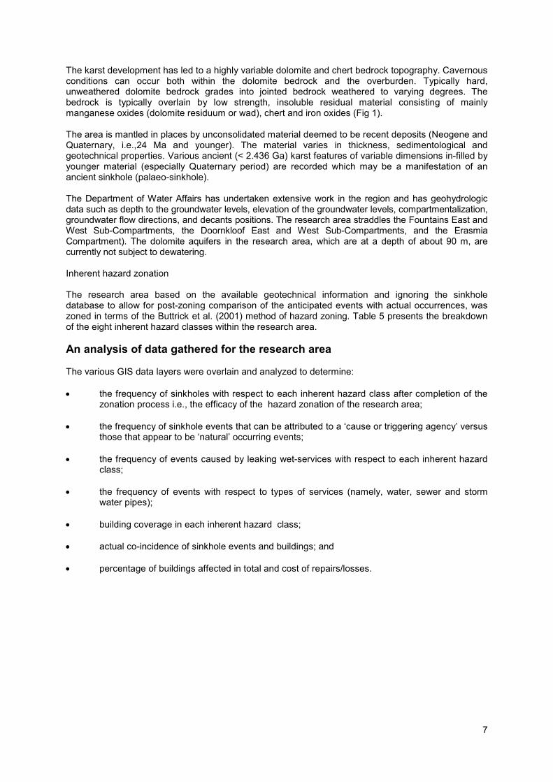
The karst development has led to a highly variable dolomite and chert bedrock topography. Cavernous conditions can occur both within the dolomite bedrock and the overburden. Typically hard, unweathered dolomite bedrock grades into jointed bedrock weathered to varying degrees. The bedrock is typically overlain by low strength, insoluble residual material consisting of mainly manganese oxides (dolomite residuum or wad), chert and iron oxides (Fig 1). The area is mantled in places by unconsolidated material deemed to be recent deposits (Neogene and Quaternary, i.e.,24 Ma and younger). The material varies in thickness, sedimentological and geotechnical properties. Various ancient (< 2.436 Ga) karst features of variable dimensions in-filled by younger material (especially Quaternary period) are recorded which may be a manifestation of an ancient sinkhole (palaeo-sinkhole). The Department of Water Affairs has undertaken extensive work in the region and has geohydrologic data such as depth to the groundwater levels, elevation of the groundwater levels, compartmentalization, groundwater flow directions, and decants positions. The research area straddles the Fountains East and West Sub-Compartments, the Doornkloof East and West Sub-Compartments, and the Erasmia Compartment). The dolomite aquifers in the research area, which are at a depth of about 90 m, are currently not subject to dewatering. Inherent hazard zonation The research area based on the available geotechnical information and ignoring the sinkhole database to allow for post-zoning comparison of the anticipated events with actual occurrences, was zoned in terms of the Buttrick et al. (2001) method of hazard zoning. Table 5 presents the breakdown of the eight inherent hazard classes within the research area.
An analysis of data gathered for the research area The various GIS data layers were overlain and analyzed to determine: • the frequency of sinkholes with respect to each inherent hazard class after completion of the
zonation process i.e., the efficacy of the hazard zonation of the research area; • the frequency of sinkhole events that can be attributed to a ‘cause or triggering agency’ versus
those that appear to be ‘natural’ occurring events; • the frequency of events caused by leaking wet-services with respect to each inherent hazard
class; • the frequency of events with respect to types of services (namely, water, sewer and storm
water pipes); • building coverage in each inherent hazard class; • actual co-incidence of sinkhole events and buildings; and • percentage of buildings affected in total and cost of repairs/losses.

8
Figure 1: Conceptual diagram of the karst landscape.
Table 5 The inherent hazard classes identified in the research area together with the area of each zone
Inherent hazard class Research area
Hectares ((1ha = 10,000 m2) Percentage of total
1 451.8 12.21
2 1.3 0.04
3 20 0.54
4 419 11.34
5 37.3 1.01
6 565.9 15.31
7 500.9 13.55
8 1,687.6 45.64
Undifferentiated (borrow areas, etc.)
13.1 0.36
Total 3,696.9 100

9
Findings of the research
Frequency of sinkholes with respect to inherent hazard classes during the period 1984 - 2004 Table 6 presents the number of sinkhole events in each of the eight inherent hazard classes in the research area over a 20-year period where no dolomite risk management strategies were implemented. Table 6 also presents the concentration of events in each of the eight inherent hazard classes expressed in terms of density of events per hectare and interprets this concentration in terms of inherent hazard characterization and hazard rating. Sinkhole events occurred in all inherent hazard classes, except those areas characterized by low inherent hazard conditions. As anticipated, there is a preponderance of sinkholes in the high inherent hazard class areas, particularly in the inherent hazard class 6, 7 and 8 areas. However, there are significantly larger tracts of land in the high inherent hazard class categories within the research area. As the area covered by each inherent hazard class is not equal, the number of events per inherent hazard class needs to be related to the number of hectares of each inherent hazard class for comparative purposes. Frequency of sinkhole events with respect to various water-bearing infrastructures Of 650 events over the 20-year period, 643 (99 %) were found to be directly attributable to leaking services or humans’ negative influence. Seven events fell in open land and could not be ascribed to any particular triggering agency. Of the 643 events, 51 occurred in an area of multiple services and the triggering of these events cannot be ascribed to one single, particular service e.g., sewer or water pipeline, etc. A total of 169 events were recorded on the 128 km of water and bulk water pipelines. This translates to 1.32 events per kilometer of water pipeline (see Table 7). The typical pipe materials related to these events were steel pipes and galvanized steel pipes. Leaks were commonly recorded at the joints of steel pipes. Pipes of less than 50 mm in diameter were the principal source of leaks. Unprotected pipes rapidly corroded in the aggressive soils constituting the subsurface dolomite profile. In addition many of these pipes are more than 50 years old, far exceeding their anticipated lifespan.
Table 6 The distribution and interpretation of sinkhole events within the research area over a 20- year period
Inherent
hazard class
Area (ha)
Number of events
Events per hectare over 20
years
Inherent susceptibility in terms of Table 2
Hazard ratinga
1 451.8 0 0 Low Tolerable
2 1.3 2 1.4 Medium Tolerable
3 20 1 0.05 Medium Tolerable
4 419 28 0.07 Medium Tolerable
5 37.3 10 0.27 High Intolerable
6 565.9 67 0.12 High Intolerable
7 500.9 170 0.34 High Intolerable
8 1,687.6 372 0.22 High Intolerable
Undifferentiated – (borrow areas, etc.)
13.1
- -
Total 3,697.6 650 - - a In terms of the Buttrick et al. (2001) method of risk mitigation, appropriate development and risk management can on some inherent hazard classes change the hazard rating from “intolerable” to “tolerable”. No such mitigation measures were applied within the research area over the research period 1984 - 2004.

10
Table 7 Events on all various infrastructures in the different inherent hazard classes
Inherent hazard class
Inherent hazard of sinkhole formation
(see Table 2)
169 events on water pipelines
(%)
167 events on sewer lines
(%)
255 events on storm water
systems (%)
643 events on all services
(%)
1 Low 0 0 0 0
2
Medium
0 0 0 0
3 0 0 0 0
4 3 3 1 2
5
High
1 2 2 1
6 4 6 5 5
7 38 33 32 34
8 54 56 60 58
Total 100 100 100 100
A total of 167 events were recorded on the 108 km of sewer pipelines. This translates to 1.85 events per kilometer of pipeline (Table7). Ground stability problems are noted to occur on clay pipes with spigot and socket joints, unplasticized polyvinyl chloride that had been poorly joined or placed on poorly compacted backfill in trenches and pipelines where poor workmanship is evident. A total of 255 events were reported on the 225 km of storm water pipelines. This translates to 1.13 events per kilometer of storm water system (see Table 7). Sinkholes typically occurred: • on lined and unlined canals and drainage ditches; • on concrete pipelines; • on lined canals where the joints were not appropriately sealed; • on prefabricated canals that were not placed on compacted bases, resulting in differential
settlement over time, culminating in leaks; • in areas of poor maintenance, particularly where silting-up had occurred; and • where storm water discharged directly into the ground near foundations due to the absence of
adequate drainage canals. Table 7 indicates that 98 % of sinkhole events linked to water-bearing infrastructure occurs in high inherent hazard class areas. Sinkhole events relating to buildings The coverage of the research area by commercial, residential, other structures and infrastructure was estimated at 53.7 % of the total site (see Table 8).

11
Table 8 Summarized data concerning coverage structures and infrastructure
Description Parameter
Number of buildings 5,550
Area of urbanization in hectares 1,969 ha
Area of total site 3,697ha
Area of urbanization as percentage of total site
53.7 ≈ 54 %
Average building size 319 m
2
Maximum building size 16,000 m2
Table 9 Number of events co-incident with buildings
Inherent hazard class
Inherent hazard of sinkhole formation
(see Table 2)
Number of events
Events (%)
Total events
(%)
1 low 0 0 0
2
medium
0 0 6.09
3 2 0.81
4 13 5.28
5
high
1 0.41 93.91
6 17 6.91
7 121 49.2
8 92 37.4
Total 246 100 100
246 of the total 650 sinkhole events were found to have caused damage to buildings (see Table 9). An analysis of the data indicated the following: • an occupancy of one person per 30 m² of building;
• structures are predominantly single or double storey; • 38 % of all events recorded coincide with structures and impact negatively on the stability and
integrity of the buildings; • despite 38 % of events coinciding with structures, no loss of life or injury has occurred due to
ground subsidence; and • typically damage is sustained from sinkholes that are larger than 5 - 6 m in diameter.

12
The damage to buildings sustained during the period 1984 - 2004 may be summarized as follows: • 246 sinkholes resulted in the loss of 220,331 m
2 of buildings;
• 12 % of all the buildings were affected;
• losses amount to approximately US $250 million, based on an average cost of construction of
US $1,400/m2; and
• damages per ground movement event averaged approximately US $80,000.
The impact of risk management and mitigation strategies post 2004 Risk management is commonly understood to be the culture, processes and structures that are directed towards the effective management of potential opportunities and adverse effects. In the context of dolomite land the opportunities represent the development potential of such land and the adverse effects relate to hazards in the form of sinkholes. Once the extent of the problem in the research area was established, a 4 year period of significant engineering intervention followed from 2004 to 2008. A dolomite risk management strategy was put in place i.e., a process of utilizing scientific, planning, engineering and social processes, procedures and measures to manage an environmental hazard. It encompasses policies and procedures set in place to reduce the likelihood of sinkholes occurring on dolomite land. Risk mitigation strategies were employed, based on those outlined by Watermeyer et al. (2008). This has had a significant impact on the occurrence of ground instability events in the research area. Ground movement events were reduced from 50 events per year in the early 2000s prior to implementing risk management strategies to 5 per year, i.e., a 90 % reduction in events. This reduction should be seen in the context of the rigor with which the strategy was applied. Under the current dolomite risk management regime the hazard rating which was previously “intolerable” can now be considered “tolerable”.
Observations
Characterization of the land in terms of inherent hazard classes The characterization of inherent hazard classes 1, 3, 4, 5, 6, 7 and 8 falls well within the threshold frequencies, suggesting that the inherent hazard zonation methodology is applied conservatively and appropriately to the geological conditions in the research area. The assessor’s expression of the hazard occurring has proven to be ‘acceptable’ in predicting problem areas from a stability and development perspective. The exception is the inherent hazard class 2 area, which shows an unusually high frequency of events exceeding the limits of a medium inherent hazard area i.e., the number of events fall outside the defining limits of >0.1 and ≤1. Inherent hazard class 2 is always difficult to assess due to the unique geological conditions or setting deemed necessary to qualify land as falling in this class. A conclusion can be drawn that the “in-service” behavior of the geological conditions are misunderstood or were not viewed conservatively, resulting in geological conditions more susceptible to sinkhole formation being included in this inherent hazard class. However, the area of land falling within inherent hazard class 2 within the research area is small in relation to the seven other classes and consequently the overall results may be skewed. The most significant findings in the characterization of the research area relate to the low inherent hazard areas. The lack of events in low inherent hazard areas indicates that confidence in the positive role of aquitards such as shale and intrusive rock in the blanketing layer in preventing subsurface erosion, and precluding sinkhole formation, is justified.

13
The distribution of sinkholes Kirsten et al. (2009) have postulated that sinkholes can occur randomly and have explored basic probability concepts relating to a sinkhole coinciding with a house or a family group in order to establish recommendations regarding maximum densities for residential development. This research, however, shows that statistically sinkholes do not occur randomly in a non-dewatering scenario. Sinkholes are more likely to occur randomly in delineated high inherent hazard areas in a dewatering scenario where the groundwater level is significantly lowered, than in the non-dewatering scenario where the groundwater level only undergoes natural seasonal fluctuations and the triggering mechanism is ingress of water. It is highly significant that although only 54 % of the total research area is urbanized, 99 % of the 650 sinkholes occurred in association with leaking infrastructure or poor drainage and 38 % coincided with buildings. It is reasonable therefore to accept that sinkholes are spatially coincident with a service rather than away from a service. However, it is obviously not known where on the service the leak and consequently the sinkhole can occur. Consequently, events occur randomly along the line of the service, to a degree, with a large number of events typically concentrated near a structure as there is a significant preponderance of sinkholes clustered at the points where infrastructure servicing buildings enter the structures. The exception is in the low inherent hazard class 1 areas where no events were recorded and no buildings sustained damage due to sinkhole formation. Clearly spatially random incident generation such as that of Kirsten et al. (2009) may underestimate co-incidence with structures. This research clearly demonstrates that the probability of an event coinciding with a structure is significant in medium and high inherent hazard class areas. The research accordingly supports the approach outlined in the discussion of Buttrick et al. (2001) to design the foundations where the hazard of sinkhole formation is medium or high, such that the formation of a sinkhole within or adjacent to the footprint will not cause toppling or sliding failure and there is sufficient time for occupants to escape from such buildings. Statistically problems are overwhelmingly associated with the service “corridors” i.e., a twenty meter corridor or zone on either side of the actual service. Those areas with an absence of water bearing infrastructure and characterized by effective and efficient storm water drainage can accordingly be reasonably expected to be free of events. This finding permits a shift in thinking with respect to the development of sites on less favorable dolomite land. Less favorable land can potentially be developed provided that projects are meticulously planned and appropriately designed and stringent risk management systems are applied. Impact on sinkhole formation This research has emphasized that dolomite risk management has a significant impact on reducing the probability of sinkhole formation. Risk management reduced sinkhole formation in the research area by 90 % over a 4 year period. The application of risk management strategies can change the hazard rating from ‘intolerable’ to ‘tolerable’ and as a result should be made mandatory in urban areas, particularly where existing urban areas straddle high inherent hazard areas. Taking into account the average cost of repairing a sinkhole of approximately U$ 80,000 per event the degeneration of services must be avoided as the costs of rehabilitation will far exceed the cost of appropriate annual dolomite risk management and maintenance interventions. Application of similar risk management strategies outside of South Africa A dolomite risk management strategy, based on the methodology applied in the research area, has recently been put in place in the Minas Gerais Province of Brazil. Anecdotal evidence suggests that the application of this strategy is yielding similar outcomes to those in the study area after 2004. A revised approach to dolomite land hazard assessment in South Africa Buttrick et al’s (2001) method for dolomite land hazard assessment in South Africa comprises: • a zoning system, based on the Method of scenario supposition (Buttrick and Van Schalkwyk 1998),
which relates the inherent hazard characterization of an area to suitable or appropriate types of development;

14
• dolomite area designations for townships which links inherent hazard classes to precautionary measures and house foundation systems so that account could be taken of the impact of subsurface conditions of residential townships and stand density on hazard rating;
• broad recommendations on types of development in order to maintain tolerable hazard rating; • minimum requirements and mandatory precautionary measures in areas underlain by dolomites;
and • matters to be considered when establishing and maintaining a risk management system. The research confirmed the methodology and provides much needed data and insights to refine and expand upon the approach. It is proposed that the methodology be updated in terms of the performance approach outlined by Watermeyer et al. (2008). The design objectives, qualitative and quantitative requirements and compliance methods, following the research outcomes, can be formulated as indicated in Table 10. Design standards for dolomite area designations and minimum requirements for dolomite risk management systems can be established in standards set by institutions such as the National Department of Public Works or national standardization bodies. Land designated as having a dolomite designation D4 can be developed in accordance with the precautionary measures specified by an engineer provided that such measures are independently reviewed and accepted by two peers who are not business associates of such a person and who do not have a vested interest in the development of such land. Alternative compliance methods can be considered as the performance requirements which need to be met are comprehensively described in the first three levels in Table 10. The deductive framework proposed in Table 10 needs to be implemented by suitably qualified and experienced persons. Accordingly, it may be necessary to put in place a licensing scheme to ensure that those that apply the deductive framework have peer assessed competencies to interpret and understand the geological and geohydrological setting and determine the hazard, the inherent hazard of dolomite land, appropriate development and water precautionary measures in relation to the hazard, procedures for the rehabilitation of sinkholes and appropriate dolomite risk management strategies. Designers of buildings, infrastructure and services might also have to be licensed.
Table 10 A four-level hierarchical performance based approach to the development of dolomite land [after Watermeyer et al. (2008)]
Level Statement
Level 1: design objective
The hazard rating associated with the formation of sinkholes in dolomite land is within acceptable levels and the current land usage does not compromise the future use of such land.
Level 2: qualitative requirement
The land usage of dolomite land shall present a tolerable hazard rating of sinkhole formation.
Level 3: quantitative requirements
The statistical occurrence of sinkhole events is less than or equals to 0.1 events per hectare over a 20-year period.
Level 4: compliance methods
Parcels of dolomite land shall be developed in accordance with the relevant provisions of Table 11, where the inherent hazard classes are based on the outcomes of a geotechnical site investigation conducted in accordance with methodology described by Buttrick et al. (2009) provided that: (a) the infrastructure on such land is developed in accordance with the provisions of
Table 12; (b) the owners of the infrastructure located on parcels of land categorized as D2, D3
or D4 in terms of Table 4, establish and implement appropriate dolomite risk management strategies;
(c) the owners of developments located on parcels of land categorized as C1-C8, RL 1-3, or RH1-RH3 (see Table 11) and the developers of parcels of land categorized as RN1-RN4 establish and implement appropriate dolomite risk management strategies; and
(d) the local authorities in whose jurisdiction developments on dolomite land fall, establish, implement and maintain a dolomite risk management strategy.

15
Conclusions The research supports the method for dolomite land hazard and hazard assessment in South Africa, as proposed by Buttrick et al. (2001). The data and insights obtained from the research enable the deductive framework contained within this methodology to be expanded with confidence to deal with a full spectrum of potential development types and to extend the concept of dolomite area designations for housing to the full range of building and infrastructure types. This modified method for dolomite land hazard assessment lends itself to being cast into a four level performance-based standard which in turn can readily be used to establish a legislative framework for the development of dolomites in South Africa. The proposed performance-based approach to dolomite risk management, which has flowed out of the research and rigorous application of a risk management strategy within the research area, has potential international applications in limiting sinkhole formation associated with urban development. Table 11 Proposed approach to the development of dolomite land
Land usage Development preconditions
Code Description
Agricultural, recreational and private and public open spaces
A1 Agriculture that requires intensive irrigation excluding flood irrigation. IH1-4_D2; IH5-6_D3; IH7-8_D3/D4
A2 Agriculture that requires limited irrigation. Botanical gardens, sports fields, driving ranges, golf courses, parkland and public open space.
IH1-4_D2; IH5-6_D3; IH7-8_D3/D4
A3 Agriculture or public open spaces that does not require irrigation in any form or the storage of water.
IH1-8_D1/D2
Commercial and miscellaneous non-residential usages
C1 Places of detention, police stations, hospitals, hostels, hotels and institutional homes for the handicapped or aged.
IH1-5_D3 + FPI; IH6-8_D4
C2 Railway stations, shops, wholesale stores, offices. IH1_D2 + FPI; IH2-6_D3 + FPI; IH7-8_D4;
C3 Places of worship, theatrical, indoor sports or public assembly venues, other institutional land uses, such as universities, schools, colleges, libraries, exhibition halls and museums.
IH1-D2 + FPI; IH2-5_6D3 + FPI; IR6-8_D4
C4 High rise commercial developments. IH1_D2 + FPI; IH2-6_D3 + FPI; IH7-8_D4
C5 Light (dry) industrial developments, dry manufacturing, commercial uses such as warehousing, packaging, etc.
IH1_D2 + FPI; IH2-7_D3 + FPI; IH8-D4
C6 Fuel depots, processing plants or any other areas for the storage of liquids.
IH1_D2 + FPI/ D3 + FPI; IH2-5_D3 + FPI; IH6-8_D4
C7 Outdoor storage facilities, stock yards, container depots, etc. IH1_D2 + FPI; IH2-7_D3 + FPI; IH8_D4
C8 Waste sites, cemeteries, slimes dams, etc. IH1_D2 + FPI; IH2-4_D3 + FPI; ; IH5-8_D4
C9 Parking areas IH1_D2/D3; IH2-7_D3; IH8_D3

16
C10 Parking garages IH1_D2/D3; IH2-5_D3 + FPI; IH6-8_D4
Low rise dwelling units (≤3 storeys)
RL1 80-120 units per hectare evenly distributed and a population not exceeding 600 people per hectare.
IH1_D2 + FPI/D3 + FPI; IH2-8_D4
RL2 40-80 units per hectare evenly distributed and a population not exceeding 400 people per hectare.
IH1_D2 + FPI/D3 + FPI; IH2-4_D3 + FPI; IH5-8_D4
RL3 40 units per hectare evenly distributed, and a population of ≤200 people per hectare.
IH1_D2 + FPI; IH2-4_D3 + FPI; IH5-8_D4
Dwelling houses
RN1 26-60 per hectare with stands larger than 150 m2, and a population of
≤300 people per hectare. IH1_D2/D3: IH2_D3; IH3-4_D4; IH5-8_D4
RN2 10-25 per hectare with stands no smaller than 300 m2, and a
population of ≤200 people per hectare. IH1_D2/D3; IH2_D3; IH3_D4; IH4_D3; IH5-8_D4
RN3 2-10 stands per hectare with 1,000 to 4,000 m2
stands, and a population of ≤60 people per hectare.
IH1_D2/D3; IH2-4_D3; IH5_D3 + FPI\D4; IH6-8_D4
RN4 <2 stands per hectare with stands >4000 m2, and a population of ≤25
people per hectare. IH1_D2/D3; IH2-4_D3; IH5_D3 + FPI\D4; IH6-8_D4
High rise dwelling units (>3 Storeys)
RH1 population of ≤1500 people per hectare. IH1_D2 + FPI/D3 + FPI; IH2-8_D4
RH2 coverage ratio of ≤0,4, no higher than 10 storeys, and a population of ≤800 people per hectare.
IH1_D2 + FPI;/D3 + FPI; IH2-4_D3+ FPI; IH5_D3+ FPI/D4; IH6-8_D4
RH3 coverage ratio of ≤0,3, no higher than 10 storeys, and a population of ≤600 people per hectare.
IH1_D2 + FPI; IH2-4_D3+ FPI; IH5_D3+ FPI/D4; IH6-8_D4
IH Inherent hazard class; D2 and D3 have the meaning assigned in Table 4; FPI a footprint investigation; coverage ratio footprint area / site area
Table 12 Permissible infrastructure type based on inherent hazard class and dolomite area designations
Infrastructure type Development preconditionsa
Code Description
I1 Trunk roads (national and regional roads which facilitate inter city travel) and primary distributor roads (major arterial roads forming the primary network for an urban area as a whole), railway lines, power lines.
IH1_D2; HR2-8_D3
I2 Bulk pipelines including water, sewer, fuel and gas lines.
IH1_D2; IH2-8_D3
I3 Reservoirs and public swimming pools. IH1-4_D3; IH5-6_D3/D4; IHD7-8_D4
I4 Attenuation and retention ponds for storm water management and artificial lakes.
IH1_D3; IH2-6_D3/D4; IH7-8_D4
I5 Dams IH1-2_D3; IH3-8_D4
I6 Runways IH1-8_D3
I7 Slimes dams and waste disposal facilities IH1-4_D3; IH5-5_D3/D4; IH7-8_D4
IH Inherent hazard class; D2 and D3 have the meaning assigned in Table 4

17
References Brink ABA (1979) Engineering geology of Southern Africa. Building Publications, Pretoria, pp 179-248 Buttrick DB (1992) Characterisation and appropriate development of sites on dolomite. PhD thesis, University of Pretoria Buttrick D and Van Schalkwyk A (1998). Hazard and risk assessment for sinkhole formation on dolomite land in South Africa. Env Geol 36 (1-2): 170-178. Buttrick DB, Van Schalkwyk A, Kleywegt RJ, Watermeyer RB (2001) Proposed method for dolomite land hazard and risk assessment in South Africa. J South African Inst Civil Eng 43(2):27-36 Kirsten HAD, Heath GJ, Venter IS, Trollip NYG, Oosthuizen AC (2009). The issue of personal safety on dolomite: a probability based evaluation with respect to single-storey residential houses. J South African Inst Civil Eng 51 (1): 26–36 Kleywegt R (1987) “Keynote address”. Seminar on the engineering geological evaluation of sites on dolomite. S. A. Geological Survey, Pretoria, 7 Sep 1987 Schoning WL (1990) “Verspreiding van sinkgate en versakkings in die dolomitgebiede suid van Pretoria”. MSc Thesis, University of Pretoria. Waltham RB, Bell F, and Culshaw (2005) Sinkholes and subsidence. Karst and cavernous rocks in engineering and construction. Springer-Praxis, London Watermeyer RB, Buttrick DB, Trollip NYG, Gerber AA, Pieterse N (2008) A performance based approach to the development of dolomite land”. In: Proceedings of the Geotechnical Division of SAICE’s Conference on Problem Soils in South Africa, 3-4 Nov, Midrand, pp167-174.