a oaks baseline park analysis · 16/05/2016 · profile from advantage oakland: “horse farms,...
TRANSCRIPT

UPDATED: 5/16/2016 4:05:15 PM
ADDISON OAKS BASELINE PARK ANALYSIS

ADDISON OAKS COUNTY PARK BASELINE PARK ANALYSIS
Page 2 of 57
UPDATED: 5/16/2016 4:05:15 PM
CONTENTS
Park Location ................................................................................................................................................................. 4
Community Context ....................................................................................................................................................... 4
Oakland County ......................................................................................................................................................... 5
Addison Township ..................................................................................................................................................... 5
Oakland Township ..................................................................................................................................................... 6
Drive-Time Service Area ............................................................................................................................................ 6
Site Analysis ................................................................................................................................................................. 11
Parcel Analysis ......................................................................................................................................................... 11
Physical Characteristics............................................................................................................................................ 12
Regional Context ...................................................................................................................................................... 12
Land Use .................................................................................................................................................................. 13
Park History ................................................................................................................................................................. 15
Early History ............................................................................................................................................................. 15
Past Master Plans .................................................................................................................................................... 17
Grant History ........................................................................................................................................................... 21
Park-Wide Planning Units ............................................................................................................................................ 22
1. Natural Resources ................................................................................................................................................ 23
2. Park Entrances, Roadways and Parking ............................................................................................................... 27
3. Maintenance, Utilities and Security ..................................................................................................................... 28
4. Technology ........................................................................................................................................................... 28
5. Non-Recreational Features .................................................................................................................................. 28
6. Park Trails and Regional Connectivity .................................................................................................................. 29
Location-Specific Planning Units .................................................................................................................................. 30
7. Adams Lake Beach and Picnic Area...................................................................................................................... 31
8. Buhl Lake Boating and Fishing Area ..................................................................................................................... 32
9. Disc Golf Course ................................................................................................................................................... 33
10. Recreation Pavilion and Entertainment Area .................................................................................................... 33
11. Campground Area .............................................................................................................................................. 34
12. Lake George Road Fields .................................................................................................................................... 35
13. Conference Center Area .................................................................................................................................... 35
Park Operation Planning Units .................................................................................................................................... 37
14. Organized Programs and Events ........................................................................................................................ 37
15. Data Collection and Management ..................................................................................................................... 38

ADDISON OAKS COUNTY PARK BASELINE PARK ANALYSIS
Page 3 of 57
UPDATED: 5/16/2016 4:05:15 PM
Park Maps .................................................................................................................................................................... 39
References ................................................................................................................................................................... 55
Notes ........................................................................................................................................................................... 57
TABLES
Table 1: Population Trends - 25-minute drive-time of Addison Oaks ........................................................................... 8 Table 2: Race and Ethnicity - 25 minute drive-time of Addison Oaks............................................................................ 8 Table 3: Market Potential – 25-minute drive-time of Addison Oaks ............................................................................. 9 Table 4: Parcel Table for Addison Oaks ....................................................................................................................... 11 Table 5: Natural Features at Addison Oaks ................................................................................................................. 23
FIGURES
Figure A: Day Use and Camping Median Drive-Time Map............................................................................................. 7 Figure B: Population by Age – 25-minute drive-time of Addison Oaks ......................................................................... 8 Figure C: Natural Features Map ................................................................................................................................... 26 Figure D: Park map showing location of planning units 7-13 ...................................................................................... 30 Figure E: Addison Sections 33, 34 and 35 and Oakland Section 4 Historic Plat Maps ................................................. 40 Figure F: Acquisition Grant Map .................................................................................................................................. 47 Figure G: Development Grant Map ............................................................................................................................. 48 Figure H: Trail Map – Addison Main and South ........................................................................................................... 49 Figure I: Mountain Bike Trail Map – Addison Main ..................................................................................................... 50 Figure J: Fat Bike Trail Map – Addison Main ................................................................................................................ 51 Figure K: Trail Map – Addison East .............................................................................................................................. 52 Figure L: Campsite Map ............................................................................................................................................... 53 Figure M: Site plan for Buhl Lake Boat and Fishing Area improvements .................................................................... 54

ADDISON OAKS COUNTY PARK BASELINE PARK ANALYSIS
Page 4 of 57
UPDATED: 5/16/2016 4:05:15 PM
Park Location Addison Oaks County Park is a 1,140-acre park located in the northeast corner of Oakland County in Addison and Oakland Townshipsi.
Park Contact Information 1480 West Romeo Road Leonard, MI 48367 Park Office: 248-693-2432 www.DestinationOakland.com
Other Park Addresses 700 West Romeo Road (Addison Oaks East)
Township and Range T5N, R11E, Sections 33-35 (Addison Township) and T4N, R11E, Section 4 (Oakland Township)
Community Context Addison Oaks is a regional park that draws day-use visitors from a multi-county area and a camping destination that draws visitors from as far away as Ontario. The characteristics of Addison Oaks are unique and reflect the geological and ecological character of Oakland County and the rural character of the local communities. It is important to understand the park within the context of its communities – Michigan, Oakland County, Addison Township and Oakland Township – for multiple reasons:
To convey a ‘sense of place’ that is harmonious and complementary to the local environment
To ensure that Oakland County Parks is not duplicating services provided by local recreational authorities or by the private, non-profit, or larger regional/state providers
i See Planning Map Set, page 3 – Location Map
Addison Township
Oakland Township

ADDISON OAKS COUNTY PARK BASELINE PARK ANALYSIS
Page 5 of 57
UPDATED: 5/16/2016 4:05:15 PM
To collaborate with units of governments and organizations related to the Oakland County Parks mission to manage open space and natural areas and provide recreational facilities and programs on an inter-community, county and/or multi-county basis
To develop facilities and programs that contribute to the implementation of local and county plans To ensure compliance with local and county regulations
Oakland County Oakland County is located in southeast Michigan, approximately 20 miles northwest of Detroit, and covers 907 square miles (SEMCOG, 2015). The estimated population in 2015 was 1,242.304. In 2010-2015, median household income was $66,426. An estimated 10% of the population lives in poverty1 (U.S. Census Bureau, 2015).
According to Advantage Oakland, Oakland County employs nearly 690,000 workers with more than 260,000 commuting from outside the county. The top three employment sectors are Professional and Business Services (26%), Trade, Transportation and Utilities (18%), and Private Education and Health Services (16%). The county is home to nearly 1,000 firms from 39 foreign countries (EDCA).
Within the county, there are 30 cities, 21 townships, and 11 incorporated villages, in urban, suburban, and rural landscapes. The county is home to the headwaters of five major rivers, the Clinton, Flint, Huron, Rouge, and Shiawassee Rivers, all of which are important to the long-term health of the Great Lakes Ecosystem. Many diverse ecosystems are located in the county due to the area’s complex topography and geological history and are an important element in the character of the county (OCPRC, 2013).
Oakland County Parks and Recreation Oakland County Parks and Recreation (OCPR) provides parks and recreation services within the geographic boundaries of Oakland County, but are also open to visitors to the county. Since 1966, OCPR has expanded and diversified the park system from four parks to thirteen, now totaling over 6,700 acres. Key attractions include managed natural areas, nature centers, waterparks, golf courses, conference centers, campgrounds, fairgrounds and over 65 miles of park trails. OCPR also offers a variety of entertaining and educational recreation programs and services for various ages and abilities (OCPRC, 2013).
Addison Township The majority of Addison Oaks County Park is located in Addison Township in the northeast quadrant of Oakland County. The township covers 35.52 square miles. The estimated population in 2014 was 6,503. In 2010-2014, median household income was $76,745. An estimated 9% of the population lives in poverty (U.S. Census Bureau, 2015).
Profile from Advantage Oakland: “Horse farms, working farms and estates, cornfields, lakefront homes and youth camps comprise the landscape of the Township of Addison. Addison Oaks County Park, Lakeville Lake, Secord Lake and a nature preserve provide extensive recreation opportunities for the rural lifestyle here, where it is common to see groups of horseback riders along the road. A good portion of the 12.2 mile Polly Ann Trail crosses through Addison Township offering a variety of hiking, skiing, and horseback riding opportunities. Upland Hills Farm and School are prominent fixtures of this scenic community. Golfing enthusiasts should not miss the offerings at the Mulberry Hills and Copper Hills Golf and Country Clubs. Private recreational offerings include the Elks Club Lodge and Echo Grove Camp located at the center of the Township. The Rochester Riding Academy and Stable is also located in this horse lover's paradise (OCPEDS, 2011).” Echo Grove Salvation Army Camp is also located in Addison Township.

ADDISON OAKS COUNTY PARK BASELINE PARK ANALYSIS
Page 6 of 57
UPDATED: 5/16/2016 4:05:15 PM
Oakland Township The southern portion of Addison Oaks County Park is located in the Oakland Township in the northeast quadrant of Oakland County. The township covers 36.30 square miles. The estimated population in 2014 was 18,820. In 2010-2014, median household income was $118,969. An estimated 3% of the population lives in poverty (U.S. Census Bureau, 2015).
Profile from Advantage Oakland: “Oakland Township strives to stay beyond the reach of congestion and overcrowding, maintaining a rural setting. However, everything one would want in the way of culture, recreation, and shopping is nearby. Driving the backroads of Oakland Township one can imagine being in rural New England. The Township is firmly established as a high quality residential area. Paint Creek Trail follows its namesake through hills, fields, woodlands, and marshes. The trail connects the Village of Lake Orion with the City of Rochester. Part of the Bald Mountain State Recreation Area is located in the Township and Stony Creek Metropark is nearby; both contribute to the rural development character of this community.” (OCPEDS, 2011)
Drive-Time Service Area This purpose of this section is to outline the geographic area that draws the majority of visitors to a specific park or facility (drive-time service area) and describe the demographic and socio-economic characteristics of the people who live there.
The drive-time analysis is conducted using park visitor home zip codes that are collected at the point-of-sale. Please see the 2015 Annual Dashboard and Data Book for a detailed description of drive-time analysis methods (OCPRC, 2015). The median drive-time – indicating that half of all visitors drive for a specific length of time or less – is used to approximate the service area for each park and facility. In 2015, the median drive time combined for campers and day use visitors was 25 minutes.

ADDISON OAKS COUNTY PARK BASELINE PARK ANALYSIS
Page 7 of 57
UPDATED: 5/16/2016 4:05:15 PM
Figure A: Day Use and Camping Median Drive-Time Map

ADDISON OAKS COUNTY PARK BASELINE PARK ANALYSIS
Page 8 of 57
UPDATED: 5/16/2016 4:05:15 PM
Population and Income Trends Population and income profiles are generated for the drive-time service area using Esri2 ArcGIS Online. The estimated population in the drive-time service area in 2015 was 258,812 with a 0.63% annual increase in population forecast between 2015 and 2020. The population is becoming more diverse in race and ethnicity. The population profile and forecast reflects an aging population with the population 65 and older increasing by 22% from 2015 to 2020. Median age is 40.9 in 2015 and forecast to be 41.7 in 2020. The median household income in 2015 is estimated at $75,171 and is forecast to increase at an annual rate of 2.97% between 2015 and 2020.
Table 1: Population Trends - 25-minute drive-time of Addison Oaks Summary Census 2010 2015 2020
Population 252,457 258,812 267,049 Households 95,101 98,182 101,483 Families 68,509 69,947 71,817 Average Household Size 2.62 2.60 2.60 Owner Occupied Housing Units 74,076 75,347 77,701 Renter Occupied Housing Units 21,025 22,834 23,782 Median Age 39.7 40.9 41.7
Trends: 2015 - 2020 Annual Rate of Change Area State National
Population 0.63% 0.15% 0.75% Households 0.66% 0.21% 0.77% Families 0.53% 0.06% 0.69% Owner Occupied Housing Units 0.62% 0.19% 0.70% Median Household Income 2.97% 2.79% 2.66%
Figure B: Population by Age – 25-minute drive-time of Addison Oaks
Table 2: Race and Ethnicity - 25 minute drive-time of Addison Oaks Census 2010 2015 2020 Race and Ethnicity Number Percent Number Percent Number Percent
White Alone 218,772 86.7% 219,249 84.7% 220,572 82.6% Black Alone 14,167 5.6% 16,444 6.4% 19,223 7.2% American Indian Alone 664 0.3% 698 0.3% 745 0.3% Asian Alone 11,015 4.4% 13,255 5.1% 15,914 6.0% Pacific Islander Alone 52 0.0% 69 0.0% 83 0.0% Some Other Race Alone 3,134 1.2% 3,642 1.4% 4,194 1.6% Two or More Races 4,653 1.8% 5,455 2.1% 6,319 2.4% Hispanic Origin (Any Race) 10,674 4.2% 12,364 4.8% 14,400 5.4%

ADDISON OAKS COUNTY PARK BASELINE PARK ANALYSIS
Page 9 of 57
UPDATED: 5/16/2016 4:05:15 PM
Market Potential Index – Recreation and Pet-Related Expenditures Esri's Market Potential Index (MPI) measures the relative likelihood of the adults or households in the specified trade area to exhibit certain consumer behavior or purchasing patterns compared to the U.S. An MPI of 100 represents the U.S. average.
Table 3: Market Potential – 25-minute drive-time of Addison Oaks
Product / Consumer Behavior Percent of Population MPI
Bicycling (Road) in past 12 months 12.4% 126 Canoeing Kayaking in past 12 months 6.6% 123 Fishing (Fresh Water) in past 12 months 13.4% 108 Hiking in past 12 months 12.1% 121 Jogging/Running in past 12 months 14.9% 117 Walking for Exercise in past 12 months 32.1% 115 Horseback Riding in past 12 months 2.9% 118 Overnight Camping Trip in past 12 months 14.2% 112 Households owning 1 dog 27.0% 113 Households owning 2 or more dogs 16.8% 105
Tapestry Segmentationi Tapestry Segmentation classifies neighborhoods into 67 unique segments based not only on demographics but also socioeconomic characteristics. It describes US neighborhoods in easy-to-visualize terms to help understand residents’ lifestyle choices, what they buy, how they spend their free time, and to help identify best customers, optimal sites, and underserved markets.ii
The Esri Dominant Tapestry Map shows the tapestry segments within and surrounding the drive-time radius and provides a list of the Tapestry segments with hyperlinks to detailed descriptions. The top five Tapestry segments within the drive-time radius are shown below. Each segment name is hyper-linked to the detailed Esri profile. After the name, we show the percentage of households that are included in each segment – within the drive-time radius and nationally. The Tapestry segment summary from the Esri profile is included with each entry.
Savvy Suburbanites (1D) Describes 19.6% of households within the drive-time radius; 3.0% of households in the U.S.
Savvy Suburbanites residents are well educated, well read, and well capitalized. Families include empty nesters and empty nester wannabes, who still have adult children at home. Located in older neighborhoods outside the urban core, their suburban lifestyle includes home remodeling and gardening plus the active pursuit of sports and exercise. They enjoy good food and wine, plus the amenities of the city’s cultural events.
Green Acres (6A) Describes 9.6% of households within the drive-time radius; 3.2% of households in the U.S.
The Green Acres lifestyle features country living and self-reliance. They are avid do-it-yourselfers, maintaining and remodeling their homes, with all the necessary power tools to accomplish the jobs. Gardening, especially growing vegetables, is also a priority, again with the right tools, tillers, tractors, and riding mowers. Outdoor living also features a variety of sports: hunting and fishing, motorcycling, hiking and camping, and even golf. Self-described conservatives, residents of Green Acres remain pessimistic about the near future yet are heavily invested in it. i See Planning Map Set, pages 21-22 – Esri Dominant Tapestry Map ii http://www.esri.com/data/tapestry

ADDISON OAKS COUNTY PARK BASELINE PARK ANALYSIS
Page 10 of 57
UPDATED: 5/16/2016 4:05:15 PM
Soccer Moms (4A) Describes 8.8% of households within the drive-time radius; 2.8% of households in the U.S.
Soccer Moms is an affluent, family-oriented market with a country flavor. Residents are partial to new housing away from the bustle of the city but close enough to commute to professional job centers. Life in this suburban wilderness offsets the hectic pace of two working parents with growing children. They favor time-saving devices, like banking online or housekeeping services, and family-oriented pursuits.
Professional Pride (1B) Describes 8.7% of households within the drive-time radius; 1.6% of households in the U.S.
Professional Pride consumers are well-educated career professionals that have prospered through the Great Recession. To maintain their upscale suburban lifestyles, these goal oriented couples work, often commuting far and working long hours. However, their schedules are fine-tuned to meet the needs of their school age children. They are financially savvy; they invest wisely and benefit from interest and dividend income. So far, these established families have accumulated an average of 1.5 million dollars in net worth, and their annual household income runs at more than twice the US level. They take pride in their newer homes and spend valuable time and energy upgrading. Their homes are furnished with the latest in home trends, including finished basements equipped with home gyms and in-home theaters.
Comfortable Empty Nesters (5A) Describes 4.9% of households within the drive-time radius; 2.5% of households in the U.S.
Residents in this large, growing segment are older, with more than half of all householders aged 55 or older; many still live in the suburbs where they grew up. Most are professionals working in government, health care, or manufacturing. These Baby Boomers are earning a comfortable living and benefitting from years of prudent investing and saving. Their net worth is well above average (Index 363). Many are enjoying the transition from child rearing to retirement. They value their health and financial well-being.

ADDISON OAKS COUNTY PARK BASELINE PARK ANALYSIS
Page 11 of 57
UPDATED: 5/16/2016 4:05:15 PM
Site Analysis Parcel Analysis Addison Oaks County Park is composed of 6 parcels totaling 1,140 acres. There is a leased house at 1480 W. Romeo Road. Copies of all documents cited in the Parcel Analysis are maintained in the Planning and Resource Development files. Table 4: Parcel Table for Addison Oaks
Parcel ID Acres Deed/ Lease/ Easement / Agreement Liber and Page
05-33-100-004 524.94 1969 – Open Space Land Program Grant #OSA-106 (700 acres Acquisition)
NA
1969 - Deed (same as -001) 5417/175
2002, 2005 – Detroit Edison Easement 26358/585;
35365/639
2009-Sprint Tower Agreement 41493/749
05-33-200-001 174.96 1969 – Open Space Land Program Grant #OSA-106 (700 acres Acq.)
NA
1969- Deed (same as -004) 5417/175
1966-Consumers Power R-O-W gas main Easement 4971/93
1991- Concord Telecom, Fanch Cablevision, MI Bell Tel. Co., Detroit Edison Easement
12150/701
2002 OC/Detroit Edison Easement 26358/577 & 581
2004-Detroit Edison Easement , underground 32613/320
10-04-100-006 93.35 1989 – MNRTF Acquisition Grant Agreement – Grant #TF89-002
NA
1991- Deed 11935/568;
11939/008 (survey clarification)
1992 – State of Michigan Mineral Deed 12425/073
05-34-300-004;
05-34-400-002;
05-35-301-001
285.93
41.12
18.83
2005 - Deed 36428/681
05-35-301-001 1987- 60’ Easement to Rochester Road 10014/044
1997- Survey 17179/751

ADDISON OAKS COUNTY PARK BASELINE PARK ANALYSIS
Page 12 of 57
UPDATED: 5/16/2016 4:05:15 PM
Physical Characteristics Geologyi The property lies within the Washtenaw Subsection Ecoregion3 and the Jackson Interlobate Subsubsection4. This area is found between three glacial lobes and is characterized by ice-contact topography5 and glacial deposits6 (Albert, 1995). The types of glacial forms identified on the property are end moraine7 and till8.
Soilsii Soil maps indicated fifteen soil types on the property, ranging from poorly-drained to well-drained soils. Notable soils are sandy loams on the uplands and slopes, and loams and mucks in wetlands and low areas.
Topographyiii The landscape of the park, influenced by the area’s glacial history, has slopes ranging from 0-15% and elevations from 940’ to 1,100’.
Hydrographyiv Three connected lakes, Buhl Lake, Adams Lake and Milk House Pond are the main water features of the park. Adams Lake has water control structures at the north and southwest ends. Buhl Lake’s outlet weir is at the southeast end. The largest lake, 37-acre Buhl Lake, was a smaller pond that had been dredged and enlarged in the past. Stumps from cut trees can still be observed. There are many small permanent and ephemeral streams and hillside springs that feed into wetlands and ponds. The Kohn Drain runs along the east end of Addison Oaks East. Many wetlands, both permanent and ephemeral (vernal ponds) are found throughout the park.
Presettlement Plant Communitiesv Presettlement plant community information gives a landscape level perspective based on the federal General Land Office (GLO) surveys conducted in the mid-1800s. The Presettlement vegetation in Addison Oaks is predominantly black oak barren with areas of shrub swamp, emergent marsh, wet prairie, and mixed conifer swamp (Comer & Albert, 1997).
Regional Context Potential Natural Areasvi Michigan Natural Features Inventory (MNFI) has identified a Priority One Natural Area9 over a large portion of Addison East and the eastern park of Addison Main. A Priority Two Natural Area is identified through the middle of Addison Main.
Watershedvii Addison Oaks is within the Clinton River Watershed and Stony Creek Subwatershed. The Stony/Paint Subwatershed Management Plan has been approved by the Michigan Department of Environmental Quality and meets the US
i See Planning Map Set, page 4 – Surface Geology ii See Planning Map Set, page 5 – Soils iii See Planning Map Set, page 6 – Ten Foot Contours iv See Planning Map Set, page 7 – Hydrography v See Planning Map Set, page 8 – Presettlement Vegetation vi See Planning Map Set, page 9 – MNFI Potential Natural Area vii See Planning Map Set, page 10 – Oakland County Subwatersheds
ADDISON OAKS COUNTY PARK BASELINE PARK ANALYSIS
Page 13 of 57
UPDATED: 5/16/2016 4:05:15 PM
Environmental Protection Agency’s nine required elements. Implementation of the Plan is facilitated by the Clinton River Watershed Councili.
Green Infrastructureii Most of Addison Oaks County Park is included in Oakland County’s Green Infrastructure Vision. Excluded areas include campgrounds, developed areas around Buhl Lake and old fields in the southern and western portion of the park. Addison Oaks is directly connected to Bald Mountain State Recreation Area (MDNR) and Cranberry Lake Preserve (Oakland Township Parks and Recreation Commission). Other parks and preserved natural areas in close proximity include Lost Lake Park (Oakland Township Parks and Recreation Commission), and Lakeville Swamp (Michigan Nature Association).
Land Useiii Zoning The park is zoned R-Recreation/Conservation (Oakland Twp.) and REC-Recreation (Addison Twp.).
Current Land Use Current land use is focused on recreation and natural resource management.
Surrounding Land Use The major surrounding land use is single family residential. Much of the surrounding land is in a fairly natural state (woodlands, wetlands, old fields). Some agriculture and commercial/office is also noted. Surrounding properties include:
North of Park 2 large parcels (85 and 88 acres) owned by Griswald Holding Co. The Polly Ann Trail is 1.8 miles north of the park along Lake George Road. The former Grand Trunk
Western railroad corridor is a 14-mile non-motorized trail that runs through Oxford Township, Village of Oxford, Orion Township, Addison Township and Village of Leonard. It is open year round for hiking, jogging, biking, walking, cross-country skiing, and horseback riding.
Northeast of Park Hidden Lake Estates (residential) Lakeville Swamp Nature Sanctuary, owned and managed by the Michigan Nature Association, is
located 2.2 miles to the northeast
South of Park Woodlands Mobile Home Estates is located across Romeo Road from the main park entrance Charter Township of Oakland’s Cranberry Lake Park with parking and trail entrance on West Romeo
Road connects with the Addison Oaks Connector Trail. A conservation easement on the north portion of Cranberry Lake Park is held by Six Rivers Land Conservancy.
Southwest of Park State of Michigan’s Bald Mountain Recreation Area
West of Park Upland Hills Farm, a rural educational facility
i www.crwc.org ii See Planning Map Set, page 11 – Green Infrastructure iii See Planning Map Set, page 12 – 2015 Land Use

ADDISON OAKS COUNTY PARK BASELINE PARK ANALYSIS
Page 14 of 57
UPDATED: 5/16/2016 4:05:15 PM
Addison Oaks Christmas Tree Farm, a private family-run business
Northwest of Park Wright Development, residential golf course development
Past Land Usei Historical aerial photographs provide a snapshot of past land uses and of the development of the park over the decades.
1940 Aerial Photograph Majority of park consists of open fields and farmland bordered by tree rows Large woodlands exist through the north, central, southwest corner of Addison Main: south end of
Addison South; and east half of Addison East Orchards observed south of Adams Lake. Two smaller orchards found northwest of Adams Lake and
east of Walker Road Large areas of connected open and forested wetlands throughout Kohn Drain at east end visible
1963 Aerial Photograph Structures visible at NE corner of Oakland Township parcel Wooded area increased at N end of Addison Main and throughout Addison East Pond /open wetland east of entrance road is visible Mill pond is visible
1974 Aerial Photograph Buhl Lake expanded and connected to Adams Lake Orchard south of Adams Lake no longer visible Land use surrounding similar to 1940’s, except trailer parks south and northeast of park
1980 Aerial Photograph Sewage lagoon is visible
1990 Aerial Photograph Camping areas and Day Use Parking Lot are visible
2000 Aerial Photograph Group camping areas are visible
2012 Aerial Photograph Non-developed areas are mostly wooded, both uplands and wetlands, with scattered large open
fields Drive to new contact station and new camping areas are visible
i See Planning Map Set, pages 13-20 for views of the park from 1940 through 2015

ADDISON OAKS COUNTY PARK BASELINE PARK ANALYSIS
Page 15 of 57
UPDATED: 5/16/2016 4:05:15 PM
Park History Early History Cultural Resources Survey A cultural resources survey was conducted of northeast quadrant of Addison Main in 1980 by Richard B. Stamps and Candice Benn of Oakland University in Rochester in 1980. The report concluded that no prehistoric or historic archaeological sites were found in the immediate project area and none had been described in the literature. The report notes that the brick fragments, charcoal and possible fire-cracked rock (FCR)10 found in the area were probably associated with the historic house site located east of the project area. Review of Oakland County historical atlases dated 1872, 1896 and 1908 indicated two side-by-side structures located in the area currently known as Walker Road Field. The report concluded that park development should have no adverse impact upon cultural resources in the area and further field investigation was not recommended. However, the report also indicated that care should be taken in the area where fragments were found and a qualified archaeologist consulted if additional evidence is found. (Stamps & Benn, 1980)
Early Ownership – Section 33i The U.S. government deeded the land in Section 33 to Dennis Snyder of New Jersey in 1833. Portions of the Snyder property were purchased by Peter Shoemaker in 1838 and a farmhouse and tenants home built. Snyder’s son, Abram, made significant improvements to the remaining Snyder property. Abram Snyder raised horses, sheep and cows on the property. When Abram Snyder died, his wife Emma, daughter Laura and son-in-law Bert Layton inherited the land. The Laytons called the Snyder property Maple Leaf Farm. (OCPR, 1995). The Beardsley family leased the farm from 1917 to around 1927. Interviews with family members describe the large farmhouse and indicate that it burned down at some point (date uncertain) after they moved out. A smaller house on Walker Road was rented to another tenant family (Stafford, 1993).
Abram Snyder farm in Section 33 ca. 1877 (Durant, 1877)
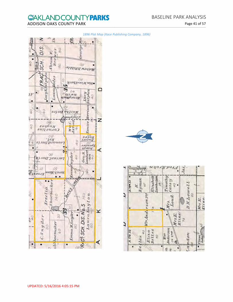
i See Figure E: Addison Sections 33, 34 and 35 and Oakland Section 4 Historic Plat Maps – pp. 40-46

ADDISON OAKS COUNTY PARK BASELINE PARK ANALYSIS
Page 16 of 57
UPDATED: 5/16/2016 4:05:15 PM
Photo: Construction of the Buhl home (current Conference Center) in 1927
Buhl Estate In 1927, Detroit industrialist Lawrence D. Buhl purchased the property belonging to both the Snyder and Shoemaker families. The Buhls hired a popular builder of the era, Robert O. Derrick, to design their distinctive Tudor home. He recycled beams from 14 barns to frame the home and outbuildings. The home featured hard wood floors, marble fireplaces, pewter sconces, imported stones, antique furnishings and valuable paintings. Also built on the property were horse stables (current Maintenance Building), two root cellars, heifer barns, a granary, chicken coops, servants quarters and outbuildings for guests, a greenhouse, caretaker house (current Rental House) and rearing pens for pheasants. Also in the 1920s, the three ponds were cleaned out and a pool, bathhouse and tennis courts constructed. (OCPR, 1995)
Tudor Hills Gun Club and Game Preserve In 1965 the Buhls sold the estate to a local dentist, Dr. D.J. Boucher. It became his residence and was later established as the Tudor Hills Gun Club and Game Preserve. Ownership of the property passed from Boucher to state receivership in June 1969. The next month it was sold to the Oakland County Parks and Recreation Commission and named Addison Oaks County Park, opening to the public in 1971. (OCPR, 1995)
NOTE: History profiles of other areas of the park: Addison sections 34 and 35 and Oakland section 4 are being developed.

ADDISON OAKS COUNTY PARK BASELINE PARK ANALYSIS
Page 17 of 57
UPDATED: 5/16/2016 4:05:15 PM
Schematic Design from 1978 Master Plan
Past Master Plans 1978 Master Plan This plan for Addison Oaks County Park was developed by Bills/Childs Associates for the Oakland County Parks and Recreation Commission (Bills/Childs Associates, 1978). The overall goals for the 1978 plan were expressed as four design criteria:
1. The Master Plan design approach is to ultimately provide an interesting variety of recreational facilities with their locations heavily influenced by the complexion of the site’s natural resources. The selection and planned location of these facilities minimizes impairment of the park site’s highly desirable natural environment.
2. Park facilities will be designed insofar as possible to function on a four-season basis, with primary use based on a one day time factor. Exception would be camping and conferences.
3. All facilities including proposed revenue-producing installations will be designed to serve a variety of age and interest groups. Addison Oaks will emphasize family activities in concert with those concepts developed in other Commission parks.
4. The implementation of the Master Plan will require a phased construction schedule depending largely on the availability of financing together with priorities established by the Parks and Recreation Commission. The land plan must be in a position, through design, to assist in providing an orderly schedule for such priorities.

ADDISON OAKS COUNTY PARK BASELINE PARK ANALYSIS
Page 18 of 57
UPDATED: 5/16/2016 4:05:15 PM
1978 Sketch of Proposed Trolley Station and Country Store
Implementation of Plan The park in 1978 consisted of the original 700 acre parcels acquired in 1969. Much of the site was still cleared from recent agricultural activities. Structures included the Buhl house and related buildings and the Concession building. Recreational activities available included: picnicking, swimming, fishing, hiking, playground games, primitive camping, bicycling, snowmobile trails, tobogganing, and ice-skating, as well as conference and banquet facilities. A lagoon-type sewage treatment system had been constructed in 1975.
1978 Master Plan Concepts Implemented 1978 Master Plan Concepts Not Implemented Contact station (different location from plan) Picnic area (different location from plan) Preserved natural areas in parts of west side of
park Camping facilities in northeast quadrant Dump station (different location from plan) Heated laundry and restrooms Boat and bicycle concession on Buhl Lake Arboretum
Winter recreation facilities with heated shelter in northwest quadrant
Road realignment from Romeo Road Trolley line throughout park Athletic areas in northwest quadrant Trolley station and country store Two emergency exits to Drahner Road Relocation of swimming beach to Buhl Lake Conversion of maintenance building to
conference center overnight lodging 18-Hole golf course with club house (in existing
Concession building) Nature center New service and maintenance building

ADDISON OAKS COUNTY PARK BASELINE PARK ANALYSIS
Page 19 of 57
UPDATED: 5/16/2016 4:05:15 PM
Schematic Design from 1992 Master Plan
1992 Park Master Plan This plan for Addison Oaks County Park was developed by Pollack Design Associates for the Oakland County Parks and Recreation Commission (Pollack Design Associates, 1992). The overall goals for the 1992 plan were as follows:
1. Prepare the base for future recreation needs 2. Seek to be self-sufficient in managing facilities and operations 3. Preserve and conserve prime natural areas 4. Retain the existing character of estate grounds by refining the image around the conference center 5. Enhance day use and camping areas 6. Resolve land-use conflicts and facilities and operations concerns

ADDISON OAKS COUNTY PARK BASELINE PARK ANALYSIS
Page 20 of 57
UPDATED: 5/16/2016 4:05:15 PM
Implementation of Plan The park in 1992 consisted of the original 700 acre parcels acquired in 1969 plus the acquisition in 1991 of 93 acres to the south. According to the plan, “To date Addison Oaks has been an important place for banquets, receptions and conferences; swimming; picnicking; play, and related day use activities; overnight camping; trail use; special events, and; the conservation of natural areas. Although nature does not dominate at Addison Oaks, nature is an essential feature.”
1992 Master Plan Concepts Implemented 1992 Master Plan Concepts Not Implemented Road realignment to new contact station Contact station with short-term trailer parking Expansion and fencing of sewage lagoon Expansion of camping facilities, individual and
group Natural resource stewardship Restrooms, boat docks, play areas, pavilions,
volley ball courts
New entrance located farther east on Romeo Road
Golf course and club house located in south end of park
Beach relocation to Buhl Lake Nature center / pavilion Conference Center road realignment New maintenance facilities associated with
golf course or located on west side of park
Outcomes This section compares a selection of park statistics between the time of the preparation of the 1992 Master Plan and the current planning effort:
Park Statistics: 1992 and 2014 44% increase in total acreage (793 to 1,140 acres) 107% increase in number of campsites (84 to 174)
Attendance Outcomes: 1990 and 2013 45% increase in total participation (124,659 to 181,340) 57% increase in campers (42,684 to 67,124) 80% increase in day use visitors (46,141 to 83,279) -14% decrease in Conference Center visitors (35,834 to 30,937)
Financial Outcomes: 1992 and 2014i 21% increase in total revenue ($546,466 to $661,910) 41% increase in Park revenue ($392,093 to $553,087) -30% decrease in Conference Center revenue ($154,373 to $108,823) 11% increase in total expenseii 2% increase in Park expense ($1,299.830 to $1,329,739) 168% increase in Conference Center expense ($72,064 to 121,264)
i Actuals (Fiscal Services Data); 1992 data adjusted for inflation per Consumer Price Index ii Depreciation was added to expense after 2003; total decrease in personnel expense of -14%

ADDISON OAKS COUNTY PARK BASELINE PARK ANALYSIS
Page 21 of 57
UPDATED: 5/16/2016 4:05:15 PM
Grant History Addison Oaks County Park was established with support from an Open Space Land Program grant in 1969. Since that initial acquisition, Oakland County Parks and Recreation has implemented four major grant projects for acquisition or development. Each of these grant projects is accompanied by a grant agreement that stipulates certain restrictions on the subject property.
In addition, OCPR has been awarded a Recreation Passport grant that will be implemented in 2015. In 1991, Addison Township received a Michigan Equity Program grant that contributed to repairs and restoration of the Conference Center.
Acquisition Grantsi 1969: Open Space Land Program #OSA-106 Project Scope: Acquisition of 700 acres to establish park Final Grant Amount: $312,900.63
1989: Michigan Natural Resources Trust Fund #TF89-002 Project Scope: Acquisition of 93 acres Final Grant Amount: $279,304.08
Development Grantsii 1977: Land and Water Conservation Fund #26-01023 R1 Project Scope: Trailer campground; water and electrical; street lighting; gravel drive. Changes since Grant Implementation: This original campground was replaced in 1986-1987 with modern RV campground units. Final Grant Amount: $242,000.00
1991: Recreation Bond Program #BF91-025 Project Scope: Sewage lagoon renovation; lift stations (2); sewer pipe; sewage irrigation Final Grant Amount: $220,000.00
2006: Michigan Natural Resources Trust Fund #TF07-030 Project Scope: Construction of the Addison Oaks Connector Trail Final Grant Amount: $228,800.00
2012: Recreation Passport Program #RP12-406 Project Scope: Universal boat launch and fishing pier – implementation pending Awarded Grant Amount: $45,000.00
Grants to Other Entities 1991: Michigan Equity Program #91-084 (to Addison Township) Project Scope: Conference Center restoration Final Grant Amount: $59,240.00
i See Figure F: Acquisition Grant Map – p. 47 ii See Figure G: Development Grant Map – p. 48

ADDISON OAKS COUNTY PARK BASELINE PARK ANALYSIS
Page 22 of 57
UPDATED: 5/16/2016 4:05:15 PM
Park-Wide Planning Units Addison Oaks Major Park Regions
Addison Main is the area where camping and the majority of recreational use take place. Addison Main consists of two parcels of land (total of 700 acres) that were purchased with support from the Open Space Land Program (Grant #OSA-106) in 1969. It is the site of a former family estate and a private hunt club.
Addison East comprises three parcels (total of 346 acres) that were purchased in 2005 from the Sullivan family. It features the Addison Connector Trail, natural resources conservation and mowed hiking trails.
Addison South (93 acres) consists of old farm fields and hedgerows. Its main recreational feature is a network of equestrian trails. The area has potential for wetland restoration. The property was purchased in 1991 with funding from the Michigan Natural Resources Trust Fund.
Addison Main
Addison South
Addison East
ADDISON OAKS COUNTY PARK BASELINE PARK ANALYSIS
Page 23 of 57
UPDATED: 5/16/2016 4:05:15 PM
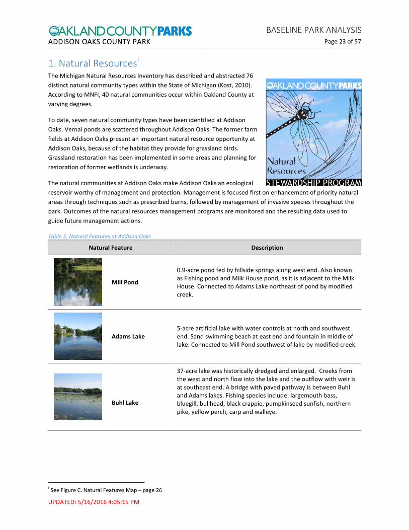
1. Natural Resourcesi The Michigan Natural Resources Inventory has described and abstracted 76 distinct natural community types within the State of Michigan (Kost, 2010). According to MNFI, 40 natural communities occur within Oakland County at varying degrees.
To date, seven natural community types have been identified at Addison Oaks. Vernal ponds are scattered throughout Addison Oaks. The former farm fields at Addison Oaks present an important natural resource opportunity at Addison Oaks, because of the habitat they provide for grassland birds. Grassland restoration has been implemented in some areas and planning for restoration of former wetlands is underway.
The natural communities at Addison Oaks make Addison Oaks an ecological reservoir worthy of management and protection. Management is focused first on enhancement of priority natural areas through techniques such as prescribed burns, followed by management of invasive species throughout the park. Outcomes of the natural resources management programs are monitored and the resulting data used to guide future management actions.
Table 5: Natural Features at Addison Oaks
Natural Feature Description
Mill Pond
0.9-acre pond fed by hillside springs along west end. Also known as Fishing pond and Milk House pond, as it is adjacent to the Milk House. Connected to Adams Lake northeast of pond by modified creek.
Adams Lake 5-acre artificial lake with water controls at north and southwest end. Sand swimming beach at east end and fountain in middle of lake. Connected to Mill Pond southwest of lake by modified creek.
Buhl Lake
37-acre lake was historically dredged and enlarged. Creeks from the west and north flow into the lake and the outflow with weir is at southeast end. A bridge with paved pathway is between Buhl and Adams lakes. Fishing species include: largemouth bass, bluegill, bullhead, black crappie, pumpkinseed sunfish, northern pike, yellow perch, carp and walleye.
i See Figure C. Natural Features Map – page 26
ADDISON OAKS COUNTY PARK BASELINE PARK ANALYSIS
Page 24 of 57
UPDATED: 5/16/2016 4:05:15 PM
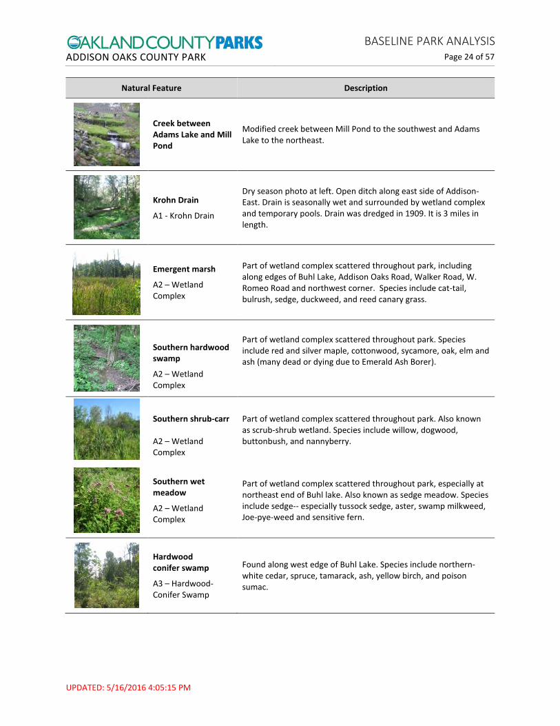
Natural Feature Description
Creek between Adams Lake and Mill Pond
Modified creek between Mill Pond to the southwest and Adams Lake to the northeast.
Krohn Drain
A1 - Krohn Drain
Dry season photo at left. Open ditch along east side of Addison-East. Drain is seasonally wet and surrounded by wetland complex and temporary pools. Drain was dredged in 1909. It is 3 miles in length.
Emergent marsh
A2 – Wetland Complex
Part of wetland complex scattered throughout park, including along edges of Buhl Lake, Addison Oaks Road, Walker Road, W. Romeo Road and northwest corner. Species include cat-tail, bulrush, sedge, duckweed, and reed canary grass.
Southern hardwood swamp
A2 – Wetland Complex
Part of wetland complex scattered throughout park. Species include red and silver maple, cottonwood, sycamore, oak, elm and ash (many dead or dying due to Emerald Ash Borer).
Southern shrub-carr A2 – Wetland Complex
Part of wetland complex scattered throughout park. Also known as scrub-shrub wetland. Species include willow, dogwood, buttonbush, and nannyberry.
Southern wet meadow
A2 – Wetland Complex
Part of wetland complex scattered throughout park, especially at northeast end of Buhl lake. Also known as sedge meadow. Species include sedge-- especially tussock sedge, aster, swamp milkweed, Joe-pye-weed and sensitive fern.
Hardwood conifer swamp
A3 – Hardwood-Conifer Swamp
Found along west edge of Buhl Lake. Species include northern-white cedar, spruce, tamarack, ash, yellow birch, and poison sumac.

ADDISON OAKS COUNTY PARK BASELINE PARK ANALYSIS
Page 25 of 57
UPDATED: 5/16/2016 4:05:15 PM
Natural Feature Description
Dry-mesic southern forest
A4 – Woodland Complex
Found on ridges and upper slopes. Also known as oak-hickory forest. Species include oak (white, black, red), maple, elm, hickory, ash, wild black cherry and sassafras.
Mesic southern forest
A4 – Woodland Complex
Found on lower slopes. Also known as mixed-deciduous woods or beech-maple forest. Species include maple, American beech, elm, ash, oak, and basswood.
Old field
A5 – Old field
50% of Addison-Main was historically under cultivation, although has not been farmed since 1980. Degraded habitat at Oakland Township parcel. Large areas include Lake George Fields, Walker Road field and equestrian trails which include hedgerows. Mowed once per year.
Grassland restoration
A6 – Grassland restoration
Native grassland demonstration at northeast portion of Addison-Main. Native grass and forb seed mix and perennial plugs planted.
Vernal pool
A7 – Vernal Pools
Scattered temporary pools, including at southwest corner and along mountain bike trail in the woodlands. Species include red maple, elm, ferns and duckweed. Animal species include wood frog, red-backed salamander and blue-spotted salamander.

ADDISON OAKS COUNTY PARK BASELINE PARK ANALYSIS
Page 26 of 57
UPDATED: 5/16/2016 4:05:15 PM
Figure C: Natural Features Map
A1 A2
A2
A1
A5
A4
A3
A2
A2
A5
A4
A5 A7
A5
A6
A4
A5
A2
Milk House Pond
Buhl Lake
Adams Lake

ADDISON OAKS COUNTY PARK BASELINE PARK ANALYSIS
Page 27 of 57
UPDATED: 5/16/2016 4:05:15 PM
2. Park Entrances, Roadways and Parkingi Addison Main has the main vehicle entrance into the park. Addison East has a separate vehicle entrance and parking lot. Addison South access off Kline Road into the southernmost field and Addison Main access off Lake George Road on the west side are used mostly for maintenance.
The Entrance Drive is located north of Romeo Road. The former contact station (constructed 1989) is located at the end of the Entrance Drive; it is currently used as an office and storage by the Oakland County Deputies that patrol the park.
Addison Boulevard splits off of the Entrance Drive fairly close to the Main Entrance and leads to the Contact Station. The Contact Station (constructed 2003) has a vehicle window, walk-up entrance, and parking spaces for guests. The Day Use Parking Lot, located just north of the Contact Station has an area designated for horse trailer parking. Just north of the Contact Station and at the south end of the Day Use Parking Lot, the Entrance Drive and Addison Boulevard are linked by a maintenance drive and small parking area. At this point, Addison Boulevard makes a turn to the east, then continues north.
Walker Road Field on the east side of Addison Boulevard provides overflow parking for park special events. Buhl Lake Lane provides access to the Buhl Lake Boating and Fishing Area from Addison Boulevard. A maintenance drive off Addison Boulevard provides access to the Recreation and Entertainment Area. Within the campground, there are multiple named lanes and cul-de-sacs
Within the Historic Buhl Estate, the Conference Center Drive is a pair of one-way drives that provide access to the Conference Center; two parking lots serve guests and staff.
Non-motorized access into the park is available via the Addison Connector Trail from Oakland Township’s Cranberry Lake Park. Pedestrian gates are located on Lake George Road (indirect access to Michigan Department of Natural Resources’ Bald Mountain State Recreation Area), at Walker Road, and at the Addison East parking lot.
Accessibility improvements are being made to the north end of the Day Use Parking Lot in FY2016, creating nine accessible parking spaces, with two van-accessible, and connecting with access routes to the Beach Building and Timber Ridge Pavilion.
i See Figure L: Campsite Map for a list and locations of roads and parking areas within Addison Oaks – p. 53

ADDISON OAKS COUNTY PARK BASELINE PARK ANALYSIS
Page 28 of 57
UPDATED: 5/16/2016 4:05:15 PM
3. Maintenance, Utilities and Security Maintenance and Utilities The maintenance building is located in the former stables (see Conference Center Area). Recent projects include the implementation of environmental best practices including drain mapping, dye testing, and hazardous materials management.
The Sewage Lagoon is located east of the Contact Station Drive. The lagoon system treats and infiltrates sanitary waste from Addison Oaks facilities, including restrooms and camper dump station. Addison Oaks contracts with the Water Resources Commissioner’s office to maintain, inspect, and operate the lagoon and leach fields. The Buhl Lake Bridge and Dam is a water control structure and a section of the Buhl Lake Loop.
The Addison Oaks water tower is located west of the Conference Center. It is not used as a water reservoir. Its main function is to serve as a landmark and add to the scenery. Results of structural inspections indicate that the water tower is structurally sound.
Security Oakland County Sherriff’s Deputies patrol the park during open hours with increased presence for high capacity days and special events. Vehicle, bike and equestrian patrols are provided. In addition to the Deputies’ responsibility for rule enforcement, and the safety and welfare of visitors – the Deputies are important public relations ambassadors in the park. They also provide emergency medical assistance and liaison with 911 Dispatch as needed. The former contact station now serves as the Deputies Office.
4. Technology Addison Oaks has one T111 line into the park. The only location for Wi-Fi is the Area C restroom building. It is needed for the ice machine, but is also available for pedestrians and nearby campers.
5. Non-Recreational Features A 1600-square foot residential house is located within the Conference Center Area. It is rented to a caretaker who receives a 30% discount from market rate. The house was constructed in 1940. According to the inspection report from May 19, 2015, the house is in an overall good condition, with minor repairs recommended (OCPRC/FM, 5/19/2015).
A 195-foot high monopole cell tower is located near the Lake George maintenance entrance. The license agreement with Sprint includes a 20-foot wide ingress/egress corridor between the maintenance gate and the tower.

ADDISON OAKS COUNTY PARK BASELINE PARK ANALYSIS
Page 29 of 57
UPDATED: 5/16/2016 4:05:15 PM
Addison Connector Trail
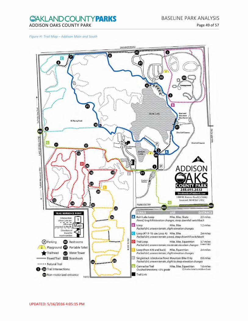
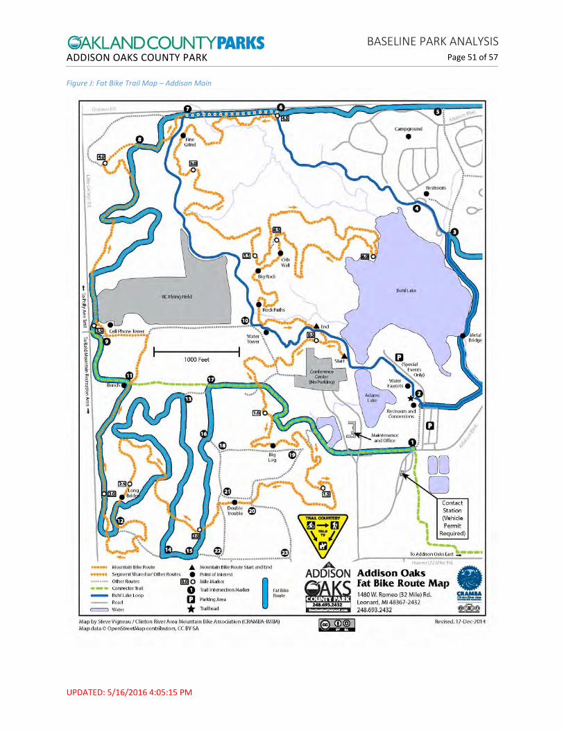
6. Park Trails and Regional Connectivityi Addison Oaks features over 20 miles of trails for hiking, mountain biking, skating, cross-country skiing (trails are not groomed), snow-shoeing, fat-tire bicycling, horseback riding and geocaching and has multiple opportunities for connections with the regional trails of the Oak Routes trail network.
Strong local partnerships have aided the development of Addison Oaks’ trail system – including the Clinton River Area Mountain Bike Association (CRAMBA) for development and maintenance of mountain-bike and fat-bike trails and Oakland Township for connectivity with Cranberry Lake Township Park and its trail system.
Addison Connector Trail – 2.4-mile crushed limestone and boardwalk trail traverses the entire park. Grade is less than 5%. Non-motorized entrances are on the west side of Addison Main and south side of Addison East. Designated uses
are hiking, biking and equestrian. The Addison Oaks Connector Trail is integrated into Oakland Township’s trail plan with a safe crossing provided over Romeo Road to Oakland Township’s Cranberry Lake Park.
Buhl Lake Loop – This is a 2.5-mile paved loop trail that makes a wide circle around Buhl Lake and provides non-motorized access to most facilities within Addison Main. Some sections of the trail have long elevation changes and there is one steep downhill switchback. The trailhead is located at the Beach Complex. Designated uses are hiking, biking, skating, and cross-country skiing in winter (ungroomed).
Campground Trail Loop – This trail is a 1.2-mile packed dirt loop around the Campground. It has uneven terrain and slight elevation changes in places. Designated uses are hiking and biking.
Mountain Bike Trails – The single-track mountain bike trail loops total a distance of 6.8 miles. Substrate is packed dirt. The terrain is uneven with slight to steep elevation changes providing appropriate challenges for mountain bikers. The trailhead is located at the Beach Complex. Designated use is limited to mountain biking. Trail planning and maintenance is done in partnership with the Clinton River Area Mountain Bike Association.
Equestrian Trails – There are two equestrian trail loops located in the southwest corner of Addison Main and in Addison South. The “D” Loop is 3.7 miles round trip and the “E” Loop is 2.4 miles. The surface is packed dirt. Terrain is uneven with elevation changes. The trailhead is located at the Beach Complex. Designated uses are hiking and equestrian (“D” Loop also allows biking).
Mowed Trails – Two mowed trails are available at Addison East (total 2.05 miles).
i See Figures H-K: Trail Maps – pp. 49-52

ADDISON OAKS COUNTY PARK BASELINE PARK ANALYSIS
Page 30 of 57
UPDATED: 5/16/2016 4:05:15 PM
Location-Specific Planning Units Figure D: Park map showing location of planning units 7-13
11. Campground Area
7. Adams Lake Beach and Picnic Area
10. Recreation and Entertainment Area
9. Disc Golf Course
12. Lake George Fields
13. Conference Center Area
8. Buhl Lake Boating and Fishing Area

ADDISON OAKS COUNTY PARK BASELINE PARK ANALYSIS
Page 31 of 57
UPDATED: 5/16/2016 4:05:15 PM
Aerial View of Addison Oaks looking northwest
7. Adams Lake Beach and Picnic Area Adams Lake is a 5-acre lake created from dredged wetlands with water controls at north and southwest ends. It has a sand beach at east end and a fountain in the middle. It is a shallow lake which makes it difficult to attain the water clarity desired by swimmers. As of 2015, the beach is not staffed with lifeguards and is signed “swim at your own risk”. An inflatable waterslide is erected in the open field between the Beachfront and Lakeview pavilions from Memorial Day to Labor Day.
The Beach Buildingi is open during park hours for access to restrooms and vending machines. From Memorial Day to Labor Day, waterslide tickets and a limited selection of pre-packaged food and drinks are sold from the Beach Building. The trailhead for the Buhl Lake Loop and Mountain Bike Trails is located next to the Beach Building. North of the Beach Concession is open space with a playground and three picnic pavilions, Beachfront Pavilion, Lakeview Pavilion and Timber Ridge Pavilion. The pavilion areas also include volleyball and horseshoes.
South of the Beach Building is a grassy, shaded area with picnic tables and grills scattered throughout. The small structure located on the edge is referred to as the “Old Boathouse”. This building was the original contact station for the park and was moved to its current location to be used as a boat rental facility. Boat rental has since moved to Buhl Lake and the building is used for storage and has no recreational purpose. An old backstop is located just south of the maintenance drive.
i The Beach Building is also referred to by staff as the Beach Concession or Concession Building. There is not an official name for this building.

ADDISON OAKS COUNTY PARK BASELINE PARK ANALYSIS
Page 32 of 57
UPDATED: 5/16/2016 4:05:15 PM
Photo of Buhl Lake Boating and Fishing Area
8. Buhl Lake Boating and Fishing Area Buhl Lake is a 37-acre spring-fed pond created by expanding an existing small pond with dredging. It has a weir at outlet. Tree stumps left from expanding the pond remain. The lake is used for boating and fishing; swimming is not allowed. Buhl Lake is accessed by pedestrians and non-motorized vehicles via the Buhl Lake trail from the Day Use Parking Lot or by vehicle from Addison Boulevard and turning west at Buhl Lake Lane. The lake can also be accessed from the camper cabins, which all have trails down to the water.
Buhl Lake is open for fishing; all methods, seasons and species are allowed in accordance with DNR fishing regulations. There is a wooden fishing dock located at the south end of Buhl Lake that can be accessed from Buhl Lake Trail. Boats and bicycles are rented from a small building with a walk-up window. A nearby storage shed houses bicycles. Bicycles include mountain bikes and hand-operated bicycles Boats available include canoes, kayaks and paddle-boats (one paddleboat is hand-operated). Aluminum boat docks were installed in 2012.
OCPRC was awarded a Michigan Recreation Passport Grant in 2013 for installation of an accessible kayak launch, replacement of existing fishing dock with an accessible dock, and completion of access routes connecting amenities. The work on this project is being completed in FY2016i.
i See Figure M: Buhl Lake Boating and Fishing improvements for a schematic of the area and its amenities – p. 54

ADDISON OAKS COUNTY PARK BASELINE PARK ANALYSIS
Page 33 of 57
UPDATED: 5/16/2016 4:05:15 PM
9. Disc Golf Course The Walker Road Area consists mainly of the 24-hole Addison Oaks Disc Golf Course, accessed from the Day Use Parking Lot. The Disc Golf Course is well-used in all four seasons. A large clearing, referred to as Walker Road Field, is incorporated in the Disc Golf Course and also used for special event overflow parking. The Campground Dump Station is located in this area. The course has been rated as #12 in Michigan by The Disc Golf Scenei.
10. Recreation Pavilion and Entertainment Area This area is north of the Buhl Lake Boating and Fishing Area and at the south end of the Campground. It is the center of the Campground Recreation Program. Volunteers – Campground Hosts – lead activities such as games and arts and crafts. Campground Recreation and its themed weekends are a draw for families to camp at Addison Oaks. Musical events are offered at a gazebo surrounded by portable bleachers. A permanent Recreation Pavilion was constructed in FY2015 that includes storage space, vending machine space, and an access route to the Buhl Lake Loop.
i https://www.discgolfscene.com/courses/Addison_Oaks_County_Park

ADDISON OAKS COUNTY PARK BASELINE PARK ANALYSIS
Page 34 of 57
UPDATED: 5/16/2016 4:05:15 PM
Aerial View of Addison Oaks Campground looking north
11. Campground Area The modern campgrounds in Areas A, B and C provide 132 campsites. Area D with 42 campsites is known as the rustic camping area because of the wooded and secluded nature of the campsites. Picnic tables, fire-pits, water, and electrical hook-ups are also available for each campsite in all four areas. 17 campsites in Area A (the inner ring of campsites) were converted to pull-through campsites in 2015 – enabling campers to pull their recreational vehicle (RV) rigs through the site instead of backing in. Also in 2015, 3 campsites in Area B and 15 campsites in Area C were identified as “premium” due to their proximity to restrooms, play areas and other amenities.
Areas 1 through 6 are group campsites, which also have picnic pavilions and horseshoe pits. Together they provide an additional 90 individual campsites.
Six cabins are located along the northeast shore of Buhl Lake. Four of the cabins accommodate up to four persons and there are two six-person cabins. The cabins are furnished. Cabins 5 and 6 are identified as accessible. Two yurts – tent-like structures with circular lattice walls, cone-shaped roof, and an outer fabric shell – were constructed in Area D (sites 161 and 162) in 2013. The Addison Oaks yurts accommodate 6 persons and are fully furnished for a more luxurious camping experience.
There are two modern restroom and shower facilities in Areas A and C. The Area A facility has a laundry. Area D is served by pit toilets. One play structure is located on the west side of Section B. The dump station located at the campground entrance is available to RV users without charge. A convenient ‘honeywagon’ service is available once a week to campers for an additional fee. Firewood is available for sale at the Contact Station.

ADDISON OAKS COUNTY PARK BASELINE PARK ANALYSIS
Page 35 of 57
UPDATED: 5/16/2016 4:05:15 PM
Aerial View of Addison Oaks looking southeast
12. Lake George Road Fields This area contains several open fields separated by wooded areas. The fields are used for radio-controlled model airplane flying and for star-gazing. Stargazing activities are supported by a telescope platform. There is also a horse corral for equestrians using the trails. An open storage area for landscape materials is located in this area.
13. Conference Center Area The former Buhl family home is the location of the Addison Oaks Conference Center, where social and professional gatherings are hosted in an elegant, stately atmosphere. Detroit industrialist Lawrence D. Buhl hired Robert O. Derrick in 1927 to design their Tudor-style summer home. Derrick designed several buildings in the Detroit area that are on the National Historic Register, including the Henry Ford Museum in Dearborn, Hibbard Apartment Building in Detroit, and several homes in Grosse Pointe. The Conference Center underwent a major interior renovation in 2013.
The Maintenance Building was constructed to serve as stables, garages, and chauffeur quarters for the Buhl family. When the property was used as the Tudor Hills Gun Club and Game Preserve, it also housed dog kennels (Stafford, 1993).
The Maintenance Building is situated between two arms to the one-way Conference Center Drive. An assessment conducted in 2014 concluded that the one way entry drive and site circulation appears to be an original feature and is historically significantly feature of the site and the design. It is similar to other estates of the period, which intentionally created an experience of arrival, entrance and procession would be experienced as it would be at any

ADDISON OAKS COUNTY PARK BASELINE PARK ANALYSIS
Page 36 of 57
UPDATED: 5/16/2016 4:05:15 PM
true English estate. Preserving the historic context in which the structure sits is nearly as important as preserving the historic structure (Campbell, 4/29/2014).
The Pool House was constructed by the Buhl Family as part of their estate. The pool was filled in by Oakland County Parks soon after the park was acquired. A structural analysis conducted in 1994 described the underground issues that are causing settling of the foundation and wall cracks and forecast costs for stabilizing the structure (Uzman, 1994). Currently the Pool House is locked and fenced to discourage trespass and is part of the visual landscape of the Conference Center grounds.
The Milk House was built from the foundation of an earlier wooden milk house. It was used as a warming shed by the Buhl children ice-skating on the pond (Stafford, 1993). Oakland County Parks renovated the structure in 1991 with funding assistance from the Oakland County Parks Foundation. It is an important part of the visual landscape of the Conference Center grounds. The building is locked and the interior not accessed by the public. The small Milk House Pond is connected with Adams Lake by a creek.
The Pool House was constructed mid-20th century by the Buhl Family. The swimming pool has been filled in and the building is unused and in poor condition. The Rental House is the former estate caretaker’s house and is currently rented to a Parks’ staff member who provides services when the park is closed.
The Park House was constructed to serve as a caretaker’s house for the Buhl family estate. The Park House is currently rented to a Park’s staff person and family. There is a recognized benefit of having park staff residing on site and available for emergencies when the park is closed. According to the inspection report from May 19, 2015, the house is in an overall good condition, with minor repairs recommended (OCPRC/FM, 4/21/2016).
Photos clockwise from upper left: Conference Center, Maintenance Building, Pool House, Park House, Milk House

ADDISON OAKS COUNTY PARK BASELINE PARK ANALYSIS
Page 37 of 57
UPDATED: 5/16/2016 4:05:15 PM
Park Operation Planning Units 14. Organized Programs and Events Activities at Addison Oaks enrich the visits of daytime and overnight park visitors and draw new visitors into the park. Organized programs and events at Addison Oaks include:
EVENTS ORGANIZED BY OAKLAND COUNTY PARKS
Campground Recreation Program These are weekend programs targeted to campers at Addison Oaks and also designed to be a draw for families. Examples of family-friendly activities include: craft activities, bicycle parades, face painting, hayrides, live music or DJs, and magic shows.
Special Events Special events that are organized and promoted by Oakland County Parks at Addison Oaks include 4th of July Fireworks, Light up the Night, and Boo Bash.
EVENTS ORGANIZED BY EXTERNAL ORGANIZATIONS These events are arranged with the park supervisor. Organizers are generally responsible for paying fees associated with facility reservation and rental or temporary use permit depending on the type of use. All participants are expected to pay vehicle entry fees at the resident rate.
Fall Equestrian Camping Weekend The last camping weekend of the year is reserved for equestrians. This event started in 2014 and is organized by the Addison Trail Riders.
Races Races are generally organized by external organizations, such as the Clinton River Mountain Bike Association, in partnership with the park. Types of races include mountain bike races and fat tire bike races.
Disc Golf Tournaments Disc Golf Tournaments are organized by external organizations, such as Broken Oak Disc Golf Clubi and Motor City Chain Gangii, in coordination with the park.
Radio-Controlled Flying Radio-controlled flying in the park is organized by external organizations, including the Romeo Sky Hawks and the Greater Detroit Soaring and Hiking Society, in partnership with the park. These events are open to members of the flying clubs who are covered under Academy of Model Aeronautics (AMA) insurance.
Astronomy The Oakland Astronomy Club organizes star-gazing events in coordination with the park.
i https://www.discgolfscene.com/clubs/Broken_Oak_DGC ii https://www.discgolfscene.com/clubs/Motor_City_Chain_Gang

ADDISON OAKS COUNTY PARK BASELINE PARK ANALYSIS
Page 38 of 57
UPDATED: 5/16/2016 4:05:15 PM
15. Data Collection and Management Estimates for monthly and annual numbers of park visits to Addison Oaks are compiled from three data sources: Main Entrance vehicle entries, Campground point-of-sale data, and Conference Center head counts.
Vehicles entering via the main entrance are manually counted by contact station staff and calculations conducted monthly to estimate the number of park visits (OCPRC, 2015, pp. 36-39).
Camping visits are estimated using information on dates of occupancy and camping party size collected at point-of-sale. Calculations are conducted monthly (OCPRC, 2015, p. 40).
Number of visits to the Conference Center incorporate head counts conducted by Oak Management staff who host events at the facility.

ADDISON OAKS COUNTY PARK BASELINE PARK ANALYSIS
Page 39 of 57
UPDATED: 5/16/2016 4:05:15 PM
Park Maps A standard set of planning maps are provided in a separate document - the Planning Map Set. This section provides other park maps, such as trails, campsites, and golf course features, which are specific to this park.

ADDISON OAKS COUNTY PARK BASELINE PARK ANALYSIS
Page 40 of 57
UPDATED: 5/16/2016 4:05:15 PM
Figure E: Addison Sections 33, 34 and 35 and Oakland Section 4 Historic Plat Maps
1872 Plat Map (F.W. Beers and Co, 1872)
ADDISON OAKS COUNTY PARK BASELINE PARK ANALYSIS
Page 41 of 57
UPDATED: 5/16/2016 4:05:15 PM
1896 Plat Map (Kace Publishing Company, 1896)

ADDISON OAKS COUNTY PARK BASELINE PARK ANALYSIS
Page 42 of 57
UPDATED: 5/16/2016 4:05:15 PM
1908 Plat Map (Geo A. Ogle and Co., 1908)

ADDISON OAKS COUNTY PARK BASELINE PARK ANALYSIS
Page 43 of 57
UPDATED: 5/16/2016 4:05:15 PM
1947 Plat Map (W.S. McAlpine Map Company, 1947)

ADDISON OAKS COUNTY PARK BASELINE PARK ANALYSIS
Page 44 of 57
UPDATED: 5/16/2016 4:05:15 PM
1975 Plat Map (Rockford, 1975)

ADDISON OAKS COUNTY PARK BASELINE PARK ANALYSIS
Page 45 of 57
UPDATED: 5/16/2016 4:05:15 PM
1985 Plat Map (Rockford, 1985)
ADDISON OAKS COUNTY PARK BASELINE PARK ANALYSIS
Page 46 of 57
UPDATED: 5/16/2016 4:05:15 PM
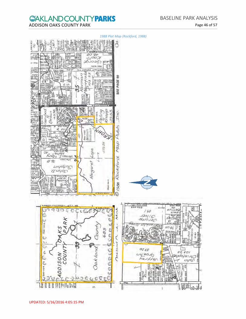
1988 Plat Map (Rockford, 1988)

ADDISON OAKS COUNTY PARK BASELINE PARK ANALYSIS
Page 47 of 57
UPDATED: 5/16/2016 4:05:15 PM
Figure F: Acquisition Grant Map

ADDISON OAKS COUNTY PARK BASELINE PARK ANALYSIS
Page 48 of 57
UPDATED: 5/16/2016 4:05:15 PM
Figure G: Development Grant Map
ADDISON OAKS COUNTY PARK BASELINE PARK ANALYSIS
Page 49 of 57
UPDATED: 5/16/2016 4:05:15 PM
Figure H: Trail Map – Addison Main and South

ADDISON OAKS COUNTY PARK BASELINE PARK ANALYSIS
Page 50 of 57
UPDATED: 5/16/2016 4:05:15 PM
Figure I: Mountain Bike Trail Map – Addison Main
ADDISON OAKS COUNTY PARK BASELINE PARK ANALYSIS
Page 51 of 57
UPDATED: 5/16/2016 4:05:15 PM
Figure J: Fat Bike Trail Map – Addison Main

ADDISON OAKS COUNTY PARK BASELINE PARK ANALYSIS
Page 52 of 57
UPDATED: 5/16/2016 4:05:15 PM
Figure K: Trail Map – Addison East

ADDISON OAKS COUNTY PARK BASELINE PARK ANALYSIS
Page 53 of 57
UPDATED: 5/16/2016 4:05:15 PM
Figure L: Campsite Map

ADDISON OAKS COUNTY PARK BASELINE PARK ANALYSIS
Page 54 of 57
UPDATED: 5/16/2016 4:05:15 PM
Figure M: Site plan for Buhl Lake Boat and Fishing Area improvements
ADDISON OAKS COUNTY PARK BASELINE PARK ANALYSIS
Page 55 of 57
UPDATED: 5/16/2016 4:05:15 PM
References Albert, D. A. (1995). Gen. Tech. Rep. NC-178. Regional Lanscape Ecosystems of Michigan, Minnesota and
Wisconsin: a working map and classification, Tech. Rep. NC-178. St. Paul, MN: U.S. Department of Agriculture, Forest Service, North Central Forest Experiment Station.
Bills/Childs Associates. (1978). A Plan for Addison Oaks County Park. Waterford, Michigan: Oakland County Parks and Recreation.
Campbell, R. (4/29/2014). Design Inspiration and Characteristics of the Buhl Estate at Addison Oaks. Waterford: MI: Oakland County Economic Development and Community Affairs.
CNAHC. (2014, March 8). Glossary of Ecological Terms. Retrieved from California Native American Heritage Commission: http://www.nahc.ca.gov/glossory.html
Comer, P., & Albert, D. (1997). Vegetation circa 1800 Maps. Michigan Natural Features Inventory.
Durant, S. W. (1877). History of Oakland County, Michigan. Philadelphia, PA: L.H. Everts & Co.
EDCA. (n.d.). Facts & Stats. Retrieved from Advantage Oakland - Economic Development & Community Affairs: https://www.oakgov.com/advantageoakland/business/Pages/county-profile-default.aspx
F.W. Beers and Co. (1872). Oakland County . Retrieved from http://www.historicmapworks.com/Atlas/US/7617/Oakland+County+1872/
Geo A. Ogle and Co. (1908). Standard Atlas of Oakland County, Michigan . Geo A. Ogle and Co. Retrieved from http://www.historicmapworks.com/Atlas/US/7659/
Kace Publishing Company. (1896). Illustrated Atlas of Oakland County . Retrieved from http://www.historicmapworks.com/Atlas/US/32464/Oakland+County+1896/
Kost, M. (2010). Report Number 2007-21. Version 1.2. Natural Communities of Michigan: Classification and Description. Lansing, MI: Michigan Natural Features Inventory.
OCPEDS. (2011). Community Profile: Addison Township. County of Oakland, Michigan: Oakland County Planning and Economic Development Services.
OCPEDS. (2011). Community Profile: Oakland Township. County of Oakland, Michigan: Oakland County Planning and Economic Development Services.
OCPR. (1995). Addison Oaks County Park History for 1995 Park Districts Forum. Waterford, Michigan: Oakland County Parks and Recreation .
OCPRC. (2013). Five-Year Parks and Recreation Master Plan 2013-2017. Waterford, MI: Oakland County Parks and Recreation Commission.
OCPRC. (2015). Annual Dashboard and Data Book. Waterford, MI: Oakland County Parks and Recreation Commission.

ADDISON OAKS COUNTY PARK BASELINE PARK ANALYSIS
Page 56 of 57
UPDATED: 5/16/2016 4:05:15 PM
OCPRC/FM. (4/21/2016). Rental Inspection Report 1480 W Romeo Road Leonard MI. Waterford, MI: Oakland County Parks and Recreation Commission.
OCPRC/FM. (5/19/2015). Property Management Report - Addison Oaks 1480 W Romeo Road.
OCPRC/PRD. (2016). Addison Oaks Baseline Park Analysis. Waterford, MI: Oakland County Parks and Recreation Commission.
Pollack Design Associates. (1992). Addison Oaks County Park - 1992 Master Plan. Waterford, Michigan: Oakland County Parks and Recreation Commission.
Rockford. (1975). Oakland County Michigan Atlas and Plat Book. Rockford, IL: Rockford Map Publishers, Inc. .
Rockford. (1985). Oakland County Michigan Land Atlas and Plat Book. Rockford, IL: Rockford Map Publishers, Inc. .
Rockford. (1988). Oakland County Michigan Land Atlas and Plat Book. Rockford, IL: Rockford Map Publishers, Inc. .
SEMCOG. (2015). Community Profiles. Retrieved from Southeast Michigan Council of Governments: http://semcog.org/Data-and-Maps/Community-Profiles
Stafford, B. (1993). Addison Oaks County Park Historical Research Project. Waterford: Oakland County Parks and Recreation Commission.
Stamps, R. B., & Benn, C. (1980). A Cultural Resources Survey of the Northeast Portion of the Addison Oaks County Park, Oakland County. Rochester, Michigan: Oakland University.
U.S. Census Bureau. (2015). Quick Facts. Retrieved from United States Census Bureau: http://www.census.gov/quickfacts/
Uzman, Z. N. (1994). Addison Oaks' Pool Building Structural Analysis. Waterford: Oakland County Parks and Recreation Commission.
W.S. McAlpine Map Company. (1947). Oakland County . W.S. McAlpine Map Co. Retrieved from http://www.historicmapworks.com/Atlas/US/10602/Oakland+County+1947/

ADDISON OAKS COUNTY PARK BASELINE PARK ANALYSIS
Page 57 of 57
UPDATED: 5/16/2016 4:05:15 PM
Notes 1 How the Census Bureau Measures Poverty: “Following the Office of Management and Budget's (OMB) Statistical Policy Directive 14, the Census Bureau uses a set of money income thresholds that vary by family size and composition to determine who is in poverty. If a family's total income is less than the family's threshold, then that family and every individual in it is considered in poverty. The official poverty thresholds do not vary geographically, but they are updated for inflation using Consumer Price Index (CPI-U). The official poverty definition uses money income before taxes and does not include capital gains or noncash benefits (such as public housing, Medicaid, and food stamps).” Invalid source specified. 2 Esri builds ArcGIS, which “connects people with maps, data, and apps through geographic information systems (GIS). It is a location platform that’s accessible to anyone, anywhere, anytime”. http://www.esri.com/about-esri#what-we-do 3 Ecoregion: An ecoregion (ecological region), sometimes called a bioregion, is an ecologically and geographically defined area that is smaller than an ecozone and larger than an ecosystem. Ecoregions cover relatively large areas of land or water, and contain characteristic, geographically distinct assemblages of natural communities and species. 4 Sub-subsection: Based on differences in climate, bedrock geology, glacial landform, and soils, the section, subsection, and sub-subsection levels of an ecoregion represent areas with distinctive natural conditions affecting species composition and productivity). 5 Ice-Contact Topography: This is a general term that refers to glacier-modified landscapes and includes many specific types of landforms, such as kames, eskers, moraines, kettles and outwash, among others. 6 Glacial Deposits: This refers to the rock and soil that is picked up and transported by glaciers as they create new landscapes and are eventually deposited by melting and retreating glaciers. 7 End Moraine: A glacial form consisting of a ridge or hill created from built-up till. 8 Till: Poorly-sorted sediment from melting glacial ice. 9 Potential Natural Area: Important ecological natural communities dominated by native vegetation identified by the Michigan Natural Features Inventory (MNFI). These sites represent the least disturbed natural areas remaining in the county. Initial delineation was done through aerial photo interpretation, with emphasis placed on intactness, wetlands and wetland complexes, riparian corridors, and forested tracts. Prioritization (ranked Priority One, Two and Three) is based on size, core area, stream corridors, land connectivity, vegetation quality, fragmentation and restorability of surrounding lands. 10 Fire-cracked rock (FCR): Burned rocks, typically fractured during intense heating in a firehearth or remnants of rocks associated with cooking. Fairly common to prehistoric archaeological sites (CNAHC, 2014). 11 T1 Line: A dedicated fiber optic line for telephone and internet that transfers digital signals at 1.544 megabits per second.