a negotiated framework for rehabilitation of riparian ... · a negotiated framework for...
TRANSCRIPT

Karisa Charles, Negotiated Rehabilitation of Riparian Zones; 46th ISOCARP Congress, 2010
1
A negotiated framework for rehabilitation of riparian zones in Nairobi city: the case of Mathare river valley
Karisa Charles
1. Introduction
The term riparian is frequently used to mean the interface between land and a flowing surface water body. Older and more classical riparian interpretations identify primarily woody vegetation associated only with lotic (surface of flowing water) systems. More recent interpretations include a broader view involving both lotic and lentic (sub-surface of flowing water) systems, lentic systems, surface and sub-surface water influences as well as human–induced activities that affect the woody and emergent vegetation. The roles of riparian areas vary from ecological, aesthetic or theatrical roles, commercial roles to other general non-consumptive uses. However, since these functions often do not entail large-scale constructions, such areas have been perceived as underutilized and have been subject to spontaneous encroachment and illegal occupation, mostly by the urban poor. The perceived open access triggers dense settlement devoid of supporting infrastructure whose ultimate effect on the receiving environment is degrading.
Over the years, the Nairobi riparian areas have come under intense pressure from various sources, namely human settlements, industrial activity, and urban agriculture. The main causes of degradation of the riparian environment in Nairobi have been noted as habitat loss, solid waste, liquid waste, and raw sewage. The riparian reserves of the three Nairobi Rivers (Mathare, Ngong, and Nairobi) feature numerous informal settlements without adequate sewerage and sanitation services. More often than not, the rivers are used for discharging raw sewage. In addition to contributions of raw sewage from informal settlements, most of the industries find it cheaper to discharge their effluent into the rivers without any satisfactory treatment. The Nairobi River Basin is home to more than 50% of Kenya’s manufacturing and service enterprises and is the most polluted river basin in the country (UNEP, 2003).
2. Policy and regulatory approaches and their results
Several policy approaches and interventions have been explored on Nairobi riparian areas with mixed results; with exception of few visible pilot results such as the Kijabe-Globe roundabout, a larger part remains problematic and unintervened.
2.1 Government-led interventions
The government has attempted through its various line agencies to resolve the problem of riparian occupation and degradation by addressing several components:
i. Land issues: These mainly touch on access to usable land and security of tenure, especially by the urban poor. The distribution of land is highly skewed that has seen 55% of the city population crammed in about 6% of urban land, mainly informal settlements (USAID 1993). The government has explored various options like drawing memoranda with

Karisa Charles, Negotiated Rehabilitation of Riparian Zones; 46th ISOCARP Congress, 2010
2
communities squatting of government land (case of Kambi Moto) as well as land sharing with communities squatting on private land (Mukuru) in order to regularize security of tenure and expand land area under the low income, but with little success. Most of the landless have found easy target in riparian areas as land for settlement.
ii. Land use planning and development control: for a long time, these two components have been the responsibility of the Ministry of Lands and the Local Authority (City council), respectively. Recently (2008), the Ministry of Nairobi metropolitan Development was established to handle strategic issues. Since the year 2000 that saw the expiry of the poorly implemented Nairobi Metropolitan Growth strategy, the city has not had a comprehensive plan, and most planning and development control activities have been ad hoc and disjointed. This, coupled with low institutional capacity, has seen difficulties in controlling development in riparian areas.
iii. Housing and shelter improvement: Like access to land, housing delivery has been skewed with 80% of new housing going towards middle and high income category. The average demand-supply gap stands at about 67%; the government has attempted to fill the low-income housing through both low-income housing (NHC) and slum upgrading (KENSUP) programmes, again with minimal impacts so far. Thus, dense and unserviced shanties continue to infest riparian areas.
iv. Environmental management: prior to 1999 when the Environmental Management and Co-ordination Act (EMCA) came into operation, this component was hazily spread across various institutions including the City Council, Ministries in charge of Environment, Water, Health, Agriculture, and Industrialization. However, with EMCA, the National Environment Management Authority (NEMA) is the lead environmental management agency that works in collaboration with the other relevant institutions. However, inadequate capacity has seen ineffectiveness in enforcing environmental regulations and the continued degradation of riparian areas is just one of the indicators.
2.2 Collaborative Approaches
These have involved the government, multinational agencies, and civil society organizations mainly through the partnership model and has seen the inception of several pilot projects. The Nairobi River Basin Project (1999) is a multi-partner initiative spearheaded by UNEP in a joint undertaking with the Government of Kenya, UN-Habitat, UNDP, the private sector and civil society. The main objective of Nairobi River Basin Programme (NRBP) is a restored riverine ecosystem with clean water for the capital city and a healthier environment for the people of Nairobi. The specific objectives of the NRBP are to rehabilitate, restore and manage the Nairobi River ecosystem in order to provide; improved livelihoods, especially for the poor, enhanced biodiversity, and a sustainable supply of water for domestic, industrial, recreational and emergency uses (Government of Kenya [GoK], 2008). Its components are anchored on pollution control, waste management, urban greening, community participation, public awareness, capacity building, and legislation as they relate to the Nairobi River Basin system. The projected has resulted in awareness and clean-up campaigns, creation and publication of database on the Nairobi river basin, including thematic maps on the status of pollution.

Karisa Charles, Negotiated Rehabilitation of Riparian Zones; 46th ISOCARP Congress, 2010
3
2.3 Challenges in management of riparian areas
i. Fragmented legislation: There exist numerous Acts and by-laws that regulate activities related to rivers and riparian areas but they prescribe varying measures on the same subjects. A visible example lies in provisions for riparian reserves, where the Survey Act takes its measurements from the high water mark level, whereas the Physical Planning Act starts from the edge of the river (See Table 2.1 below).
GoK, Various Acts/City Council of Nairobi, 2007
ii. Institutional overlaps and bottlenecks: there have been areas of overlap of mandatory roles that have resulted in duplication of and sometimes conflicting activities across institutions. A typical example is between NEMA and the City Council of Nairobi, where environmental approvals by one party have not always been in regard of the other’s concerns causing conflict either in implementation or enforcement.
iii. Inadequate capacity: despite having a clear vision and understanding of what needs to be done, many actors are still unable to operationalize such actions to significant levels due to inadequacy in equipment and technical expertise, human resource, and financial aspects.
iv. Lack of database: there is very scanty baseline information on riparian areas that interventions by various actors would be based on. Both government and non-governmental agencies have identified this as a major setback in the management of riparian reserves. The bulk of the information is outdated and in most cases not digitized.
v. Lack of land bank: The bulk of riparian areas are occupied by human settlements and other economic activities that will need relocation to pave way for rehabilitation. However, there is hardly any appropriate land reserve within the city to relocate these activities without drastic adverse effects. The little land available is of low quality, not serviced, and far from employment areas. Thus, any suggestions to relocate people to such areas are likely to be strongly resisted.
vi. Low level of awareness: there is minimal understanding of the implications of dense occupation and intense exploitation of riparian reserves by the occupying communities. Most of the lessons are acquired through adversities such as flooding, otherwise the indirect and cumulative side-effects go unnoticed. Likewise, it is difficult to promote the need for riparian conservation from the ecological services perspective since this does not have immediate and direct effect on the occupants of such areas and such functions have to compete with other pressing needs like shelter.
Table 1: Statutory provisions (Kenya) on riparian width Statute/institution Recommended riparian width (in metres) Water Act (2002) Minimum 6m and max. 30m from edge of river
EMCA Minimum 6m and max. 30m from edge of river Agriculture Act 6-10; sometimes ad hoc Physical Planning Act Minimum 2m in height and max. 30m horizontal from edge of river Survey Act Minimum 30m for tidal rivers only. No mention of other smaller
rivers. Measurement from high water mark Local Government Act Ad hoc to a planner’s discretion: 3m, 6m; in some instances it is
taken as equal to width of the river or twice the width of the river. City Council by-laws City Council bylaws put a maximum of 30m from high water mark
Karisa Charles, Negotiated Rehabilitation of Riparian Zones; 46th ISOCARP Congress, 2010
4
3. The Mathare river valley
3.1 Location and Physiography
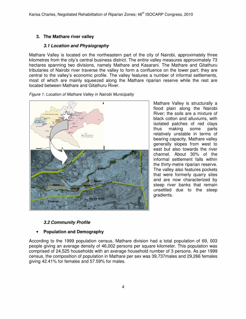
Mathare Valley is located on the northeastern part of the city of Nairobi, approximately three kilometres from the city’s central business district. The entire valley measures approximately 73 hectares spanning two divisions, namely Mathare and Kasarani. The Mathare and Gitathuru tributaries of Nairobi river traverse the valley to form a confluence on the lower part; they are central to the valley’s economic profile. The valley features a number of informal settlements, most of which are mainly squeezed along the Mathare riparian reserve while the rest are located between Mathare and Gitathuru River.
Figure 1: Location of Mathare Valley in Nairobi Municipality
Mathare Valley is structurally a flood plain along the Nairobi River; the soils are a mixture of black cotton and alluviums, with isolated patches of red clays thus making some parts relatively unstable in terms of bearing capacity. Mathare valley generally slopes from west to east but also towards the river channel. About 30% of the informal settlement falls within the thirty-metre riparian reserve. The valley also features pockets that were formerly quarry sites and are now characterized by steep river banks that remain unsettled due to the steep gradients.
3.2 Community Profile
• Population and Demography
According to the 1999 population census, Mathare division had a total population of 69, 003 people giving an average density of 46,002 persons per square kilometer. This population was comprised of 24,525 households with an average household number of 3 persons. As per 1999 census, the composition of population in Mathare per sex was 39,737males and 29,266 females giving 42.41% for females and 57.59% for males.

Karisa Charles, Negotiated Rehabilitation of Riparian Zones; 46th ISOCARP Congress, 2010
5
• Socio-political profile
Mathare valley settlements largely fall under informal, low-cost housing (slum upgrading), and private commercial housing, mainly in form of tenements. Both the informal and formal settlements feature landlordism. The informal settlements are structured into villages whose identity revolves on ethnicity or tenure status. For instance in one of the villages, Kosovo, structure owners are manly located to the west while the eastern part mainly occupied by tenants. The main ethnic enclaves are those of Kikuyu, Kamba, and Luo communities. Politically, Mathare is influenced by three centres of power, namely, the local administration (chief’s office); civic authority/local government (the ward office headed by the Councillor), and parliamentary (the Constituency office headed by the Member of Parliament). Politically, Mathare residents have experienced many challenges, including sporadic violence and proliferation of organized gangs and outlawed sect movements such as mungiki.
• Economic activities
The economy of Mathare Valley is largely informal; the main areas that the community engages in include micro-commercial enterprises – petty traders in kiosks and hawkers in food products, used clothing, furniture, beauty products, liquor joints, and salons and berber shops; agricultural activities - ranging from crop farming (maize, beans, coco yams, bananas, tomato, and sugar cane) to animal/livestock keeping (chicken, ducks, goats, sheep, and pigs); recycling - remnants of burnt charcoal, pieces of wood, waste paper, polythene bags, and scrap metal that are mostly sold to dealers; and micro-industry – includes open air motor garages, furniture marts, metal works, and traditional liquor brewing (chang’aa) at the riverfront where the river water is used as a coolant in the distillation process.
3.3 Key Infrastructure
Roads; The network and hierarchy of roads in Mathare Valley are crude and vaguely-defined typical of the prevalent informal settlements. These are mainly structured by housing layouts and in most cases also serve open space functions.
Water Supply; In Nairobi only about 24% of all informal settlements households have access to piped water, in form of public water taps (APHRC 2002). Contamination of piped water due to infiltration of foul waters through the broken pipes is common.
Sanitation challenges in the informal settlements hinge on human waste disposal, provision of bathrooms, and solid waste, and wastewater management. Provision of sanitation is faced with lack of land for cesspools/septic tanks, lack of a local sewer line, and unsuitable soils for construction of pit latrines or soak-away pits. A trunk sewer along the Nairobi river traverses the villages of Mathare with some sewer manholes falling inside dwelling structures which poses serious management challenges, but it is also high risk regarding human health in case of overspills of raw sewage. Electricity: Only about 32% of households are legally connected with metred electricity; however through informal extensions, up to 80% of the household at least feature electric lighting. For other energy functions like cooking, the community relies on alternative sources such as charcoal (53%), paraffin (43%), and others (4%) such as gas, wood, and saw dust (field survey, 2009).
Karisa Charles, Negotiated Rehabilitation of Riparian Zones; 46th ISOCARP Congress, 2010
6
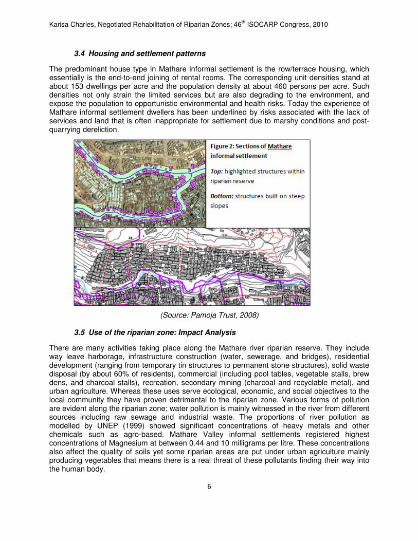
3.4 Housing and settlement patterns
The predominant house type in Mathare informal settlement is the row/terrace housing, which essentially is the end-to-end joining of rental rooms. The corresponding unit densities stand at about 153 dwellings per acre and the population density at about 460 persons per acre. Such densities not only strain the limited services but are also degrading to the environment, and expose the population to opportunistic environmental and health risks. Today the experience of Mathare informal settlement dwellers has been underlined by risks associated with the lack of services and land that is often inappropriate for settlement due to marshy conditions and post-quarrying dereliction.
(Source: Pamoja Trust, 2008)
3.5 Use of the riparian zone: Impact Analysis
There are many activities taking place along the Mathare river riparian reserve. They include way leave harborage, infrastructure construction (water, sewerage, and bridges), residential development (ranging from temporary tin structures to permanent stone structures), solid waste disposal (by about 60% of residents), commercial (including pool tables, vegetable stalls, brew dens, and charcoal stalls), recreation, secondary mining (charcoal and recyclable metal), and urban agriculture. Whereas these uses serve ecological, economic, and social objectives to the local community they have proven detrimental to the riparian zone. Various forms of pollution are evident along the riparian zone; water pollution is mainly witnessed in the river from different sources including raw sewage and industrial waste. The proportions of river pollution as modelled by UNEP (1999) showed significant concentrations of heavy metals and other chemicals such as agro-based. Mathare Valley informal settlements registered highest concentrations of Magnesium at between 0.44 and 10 milligrams per litre. These concentrations also affect the quality of soils yet some riparian areas are put under urban agriculture mainly producing vegetables that means there is a real threat of these pollutants finding their way into the human body.

Karisa Charles, Negotiated Rehabilitation of Riparian Zones; 46th ISOCARP Congress, 2010
7
Inadequate waste collection, transportation, and disposal coupled with poor sanitation facilities often compound the health risks by causing parasitic infections through direct contact, providing breeding/feeding sites for disease vectors, allowing faecal matter to become part of the household waste stream, and increasing risk of acute respiratory infection as a result of burning of waste. Occasionally residents, especially children, injure themselves from broken glass, tins, wire, scrap metal, razor blades, and rusty nails which can lead to tetanus infection. Thus, inadequate waste management has long-term health, economic, and environmental impacts for the general population in Mathare Valley. Based on the unplanned human settlement, vulnerability to adversity is espoused by the highly inadequate infrastructure but worsened by qualities of the location, such as the settlements on steep slopes of former quarrying sites and within the flood line. Other hazards arise from the structure of the settlements, such as risks of spreading fire; health risks from poor indoor air quality and the dumping of waste by the residents as well as those of neighboring settlements such as Eastleigh; and unstable building structures that are prone to collapse as they are built on poor soils using substandard materials.
4. Towards a negotiated approach to riparian rehabilitation
The negotiated approach explores workable variations and adaptations as opposed to blanket application of mainstream regulations. The model advocates for place specific considerations to delineation of the riparian buffer based on triangulation of objectives, site characteristics, and existing regulations.
4.1 Physiographic
Various physiographic considerations are necessary in determining a riparian buffer:
Major physical features (rivers, mountains, ridges, forests/watersheds e.t.c): the geographic size of a watershed and a river can significantly influence the size of a riparian buffer. Mathare valley lies on the upper side of the Nairobi river basin and Athi river watersheds. Mathare Valley drains approximately 42 square miles compared to 320 square miles for the entire Nairobi river basin (Ministry of Water Development, 1992). Thus due to its size and location with respect to the watershed, a smaller buffer could work for Mathare river. Slope: steeper river banks tend to convey more water and may need wider buffers; there is significant slope variability in Mathare valley with areas like Kosovo being steeper than Mathare 4B. This strongly signals that a uniform riparian buffer may not be appropriate. Soil and Geology: more permeable soils allow for a smaller buffer and so are rocky soils that are not easily eroded. Mathare valley has a mixture of both thus raising the possibilities of a smaller buffer. Vegetation: this can slow down water and increase the rate of infiltration into the ground, thus reducing flooding and preventing urban run-off from storming the river. Thus, higher vegetation cover can reduce the size needed for an effective buffer. Mathare Valley has the conducive conditions for supporting a wide range of vegetation types.

Karisa Charles, Negotiated Rehabilitation of Riparian Zones; 46th ISOCARP Congress, 2010
8
4.2 Morphological
Stream profile: straight river channels will behave differently from meandering; the latter, which is more natural, will have erosion taking place on the outside bend and deposition on the inside hence a larger buffer on the former. Settlement pattern: the distribution of building structures and density of settlement need to be analyzed with respect to the river. Porosity of the settlement as structured by cadastral and street structure will also be critical; the more porous settlements will work with smaller buffers. Position of water table: studies will be necessary to establish the depth of the water table and whether there have shifts of the same; such shifts could be influenced by abstraction of ground water or land use activities such as quarrying. A higher water table will require a wider riparian buffer. Land use structure: the historic and existing land uses should be analyzed to establish their effects on river channel width and run-off patterns. Transect studies at different sections of the river will be necessary to establish whether there exist a health transition between the hard and soft landscape.
4.3 Functional
Flooding history: the mean annual discharges and flow patterns need to be analyzed alongside flooding history to determine extreme high water marks. A realistic setback can then be scaled from this point. Activity areas/Zones: This recognizes the city as an economic and social entity and will map out existing and potential areas of intense activity against those devoid of activity so as to generate a riparian buffer that serves both social and economic needs. Utility services: The laying of utility services such as trunk or local sewers and industrial outflow infrastructure must be considered to generate a riparian buffer that serves both ecological and human needs. Fragile/protected areas: all areas that are fragile or accommodate aspects of special interest such as unique habitats will need mapping and safeguarding to avoid ecological degradation.
4.4 Regulatory (institutional & legislative harmonization)
There is need to review all institutional and legislative provisions touching on management of riparian areas for purposes of harmonization to eliminate limiting overlaps and conflicts that complicate the management of riparian areas. This will necessitate revisions and even repeal of sections of key legislation.
Karisa Charles, Negotiated Rehabilitation of Riparian Zones; 46th ISOCARP Congress, 2010
9
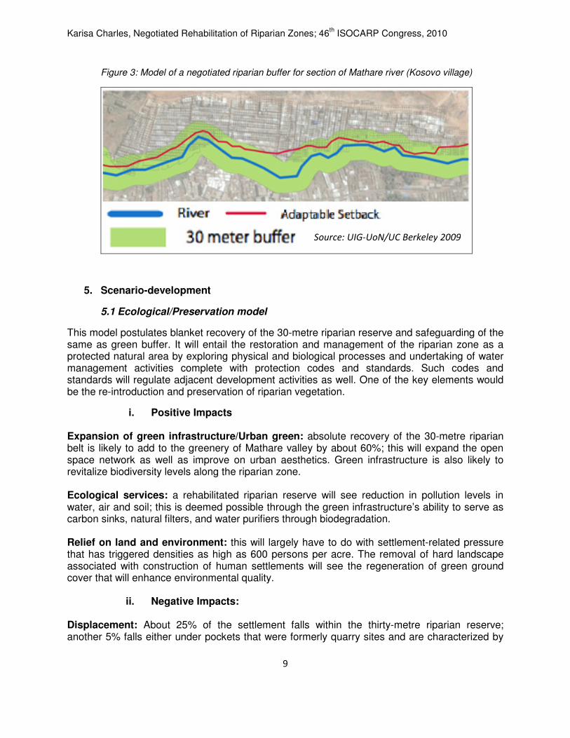
Figure 3: Model of a negotiated riparian buffer for section of Mathare river (Kosovo village)
5. Scenario-development
5.1 Ecological/Preservation model
This model postulates blanket recovery of the 30-metre riparian reserve and safeguarding of the same as green buffer. It will entail the restoration and management of the riparian zone as a protected natural area by exploring physical and biological processes and undertaking of water management activities complete with protection codes and standards. Such codes and standards will regulate adjacent development activities as well. One of the key elements would be the re-introduction and preservation of riparian vegetation.
i. Positive Impacts
Expansion of green infrastructure/Urban green: absolute recovery of the 30-metre riparian belt is likely to add to the greenery of Mathare valley by about 60%; this will expand the open space network as well as improve on urban aesthetics. Green infrastructure is also likely to revitalize biodiversity levels along the riparian zone. Ecological services: a rehabilitated riparian reserve will see reduction in pollution levels in water, air and soil; this is deemed possible through the green infrastructure’s ability to serve as carbon sinks, natural filters, and water purifiers through biodegradation. Relief on land and environment: this will largely have to do with settlement-related pressure that has triggered densities as high as 600 persons per acre. The removal of hard landscape associated with construction of human settlements will see the regeneration of green ground cover that will enhance environmental quality.
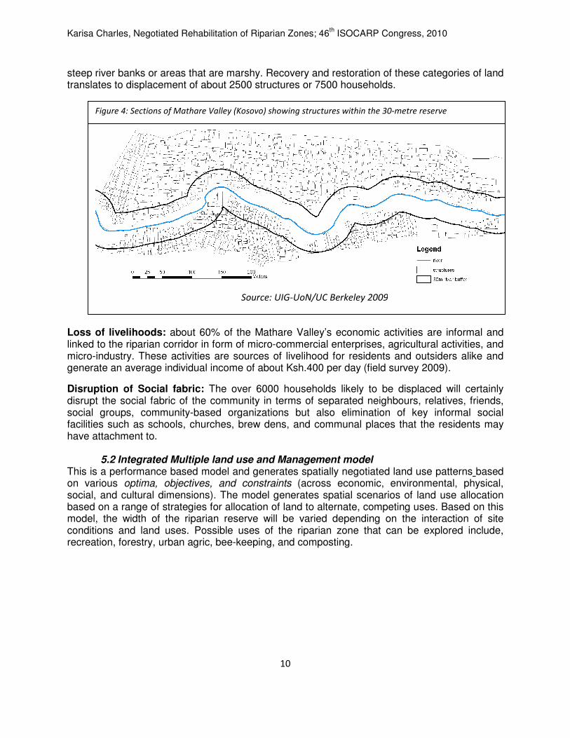
ii. Negative Impacts: Displacement: About 25% of the settlement falls within the thirty-metre riparian reserve; another 5% falls either under pockets that were formerly quarry sites and are characterized by
Source: UIG-UoN/UC Berkeley 2009
Karisa Charles, Negotiated Rehabilitation of Riparian Zones; 46th ISOCARP Congress, 2010
10
steep river banks or areas that are marshy. Recovery and restoration of these categories of land translates to displacement of about 2500 structures or 7500 households. Loss of livelihoods: about 60% of the Mathare Valley’s economic activities are informal and linked to the riparian corridor in form of micro-commercial enterprises, agricultural activities, and micro-industry. These activities are sources of livelihood for residents and outsiders alike and generate an average individual income of about Ksh.400 per day (field survey 2009).
Disruption of Social fabric: The over 6000 households likely to be displaced will certainly disrupt the social fabric of the community in terms of separated neighbours, relatives, friends, social groups, community-based organizations but also elimination of key informal social facilities such as schools, churches, brew dens, and communal places that the residents may have attachment to.
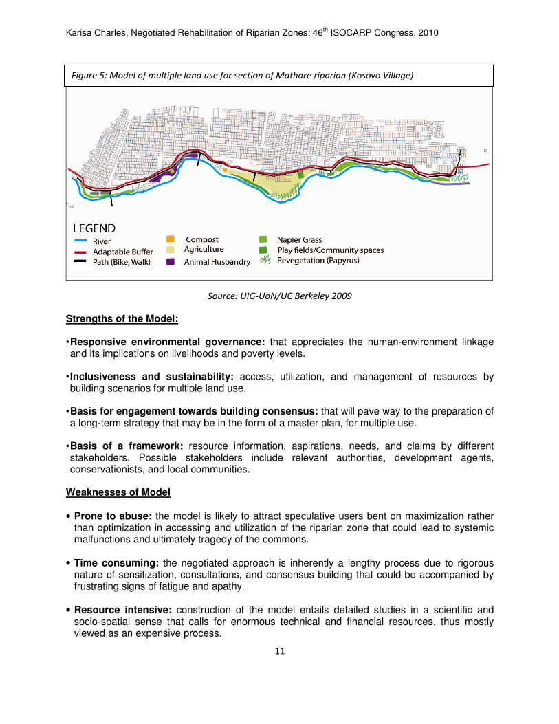
5.2 Integrated Multiple land use and Management model This is a performance based model and generates spatially negotiated land use patterns based on various optima, objectives, and constraints (across economic, environmental, physical, social, and cultural dimensions). The model generates spatial scenarios of land use allocation based on a range of strategies for allocation of land to alternate, competing uses. Based on this model, the width of the riparian reserve will be varied depending on the interaction of site conditions and land uses. Possible uses of the riparian zone that can be explored include, recreation, forestry, urban agric, bee-keeping, and composting.
Figure 4: Sections of Mathare Valley (Kosovo) showing structures within the 30-metre reserve
Source: UIG-UoN/UC Berkeley 2009
Karisa Charles, Negotiated Rehabilitation of Riparian Zones; 46th ISOCARP Congress, 2010
11
Source: UIG-UoN/UC Berkeley 2009
Strengths of the Model: • Responsive environmental governance: that appreciates the human-environment linkage and its implications on livelihoods and poverty levels.
• Inclusiveness and sustainability: access, utilization, and management of resources by building scenarios for multiple land use.
• Basis for engagement towards building consensus: that will pave way to the preparation of a long-term strategy that may be in the form of a master plan, for multiple use.
• Basis of a framework: resource information, aspirations, needs, and claims by different stakeholders. Possible stakeholders include relevant authorities, development agents, conservationists, and local communities.
Weaknesses of Model
• Prone to abuse: the model is likely to attract speculative users bent on maximization rather than optimization in accessing and utilization of the riparian zone that could lead to systemic malfunctions and ultimately tragedy of the commons.
• Time consuming: the negotiated approach is inherently a lengthy process due to rigorous nature of sensitization, consultations, and consensus building that could be accompanied by frustrating signs of fatigue and apathy.
• Resource intensive: construction of the model entails detailed studies in a scientific and
socio-spatial sense that calls for enormous technical and financial resources, thus mostly viewed as an expensive process.
Figure 5: Model of multiple land use for section of Mathare riparian (Kosovo Village)
Karisa Charles, Negotiated Rehabilitation of Riparian Zones; 46th ISOCARP Congress, 2010
12
5.3 Operationalization of Model: Consensus building
It would be appropriate that a broad spectrum of parties be involved if the riparian reserve is to be restored and managed sustainably. Failures to take on board the various stakeholders, and more so the local community, is likely to drain significant momentum from this initiative and even risk sabotage at the worst. The study revealed that the community in Mathare is currently not involved in riparian reserve conservation, although it was initially responsible for ensuring that the reserve was free from building and construction activities - a system that had been introduced by the area District Officer in 2000. However, this community effort ceased mainly due to threats emanating from land and property-related socio-political unrest that included the advent of criminal gangs. The level of awareness about the importance of the riparian reserve only became a common term after the famous statement by the Minister of Environment that sought to ensure that the riparian reserves are protected and the rivers in Nairobi cleaned. After the communication from the Minister, several civil society organizations such as Pamoja Trust and research institutions such as the University of Nairobi have been engaging the community in sensitization exercises where the community is given information on the riparian reserve, its legal implications, and its environmental significance but also going a step further in helping the local communities in visualization of different desirable scenarios for utilization of riparian areas, including alternative human settlement patterns. The ultimate objective is to equip the community with the necessary awareness to enable them to engage the mandated authorities and other stakeholders in meaningful negotiations regarding the rehabilitation of the riparian zone that will avoid confrontation, forceful evictions, and loss of livelihoods. The civil society organizations and research institutions will also act as go-betweens to facilitate the negotiations between the government and the community through various urban planning and management forums. The key steps in pushing this agenda forward include sensitization and impact assessment, proper survey and delineation of an adaptive riparian buffer, options for resettlement of the affected human activities, rehabilitation and management of vacated riparian area, and co-ordination of the management of the riparian area.
6. Conclusion
Although there is a broad consistency about the general widths recommended for riparian areas, there are differences depending on the aims being sought, location and its characteristics, and the regulatory framework that governs the area. Recommendations should be arranged according to the desired function of the riparian zone and site characteristics that should also be considered to influence the width required to achieve different management objectives. These characteristics include slope, soil texture and erodibility, size of the watershed, drainage area, bank height, adjacent land use and existing vegetation, stream size, geology and hydrology of the area, seasonal and yearly climate patterns, elevation, gradient, upland vegetation, prior land management, and water use patterns. Above all, it is important to consult locally specific information, regulations, and expertise on the characteristics of riparian areas before making decisions about how best to manage them. The above challenges can be reduced by engaging in certain activities:
• Integrated planning linking environmental (riparian) with land use, including human settlements; riparian areas must be viewed in the context of the entire landscape. Institutional capacity building, including operational and financial strengthening

Karisa Charles, Negotiated Rehabilitation of Riparian Zones; 46th ISOCARP Congress, 2010
13
• Partnerships bringing together the public, private, and civil society.
• Public awareness and participation of communities and civil society organizations in riparian Management that will enhance social responsibility.
• Using the livelihoods framework in developing the strategies for management of riparian areas in order to decrease the vulnerability of the urban poor.
• Creating networks and linkages in order to consolidate and integrate different initiatives into a comprehensive strategy for effective management of riparian zones.
• System integration and optimization that will entail addressing the importance of synergies among various land uses at a landscape level.
References
City Council of Nairobi, (2007): Nairobi Environmental Outlook; Nairobi; Government printers.
Price P; Lovett S; & Lovett J (2004): ‘Managing riparian widths’, Fact Sheet 13; Canberra; Land & Water Australia Republic of Kenya (2008): Nairobi Rivers Rehabilitation and Restoration Programme (Draft Report); Ministry of Environment and Mineral Resources (Unpublished) UC Berkeley; University of Nairobi; Pamoja Trust (2009): Collaborative Slum Planning and Upgrading (unpublished) UNDP (2007): Best Practices for Environmental Conservation for the Nairobi River Basin Programme (Unpublished) UNEP (1999): Save the Nairobi River, Nairobi River Basin Programme; Nairobi; UNEP/ROA http://www.unep.org/roa/Nairobi_River/Webpages/