a military logistics and transportation security application
TRANSCRIPT

A Military Logistics and Transportation Security Application

IRRIS Integrates and manages extensive data sources across multiple agencies and organizations.
• Data availability is extremely scalable based on user requirements
• Query engines provide unlimited flexibility in creating detailed data reports
• More than 100 data layers are currently available in the IRRIS data warehouse


Infrastructure data layers provide a means to make important decisions about assets vital to
transportation and national security.
Infrastructure layers include:• Highways, bridges, and local roads• Rail data, STRACNET and Priority rail line status, and
information about rail embargoes & closures• Ports and military installations• Mass transit networks• Dams and water plants• Nuclear plants and energy facilities• Communications nodes• Emergency response facilities


Intelligent mapping capabilities allow users to visualize spatial relationships and interact with data in an
intuitive, graphical way.
• IRRIS interacts with real-time data that can be queried, making it a powerful, dynamic geographic information system (GIS)
• Detailed reports are available for specific map features and layer categories
• Specialized map tools calculate distance between selected points, annotate the map with custom text, export map data, determine lat/long coordinates, and display map data in tool tips
• The "Save Map" tool preserves all user map settings and layers, cutting display times dramatically


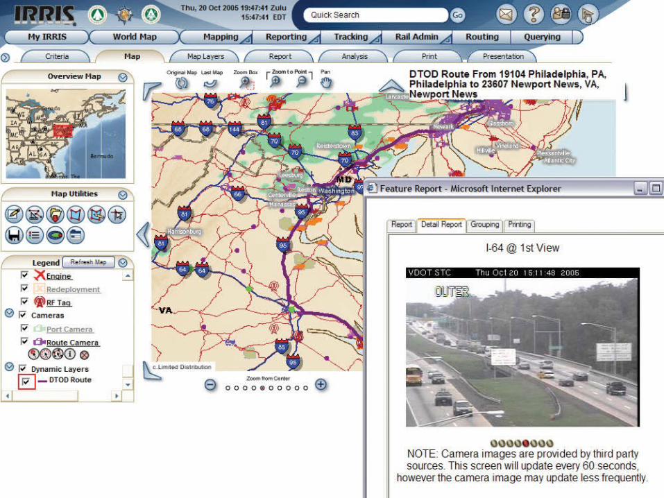
Routing provides turn-by-turn driving directions with total drive time, mileage, and maps.
• Choose the fastest or shortest route • Re-route HazMat and oversized/overweight vehicles• Avoid specified road types • Re-route around blockages such as incidents, accidents,
construction, and weather events

Every day, IRRIS tracks thousands of containers internationally by truck, rail, and ocean vessel.
• Locate and manage assets in near-real time• Match supply with demand• View multi-modal In-Transit Visibility (ITV) data• Use the highly detailed reporting and querying tools to
provide Total Asset Visibility (TAV)• Access archived tracking data• Assign vehicles to predetermined routes and receive
alerts if the vehicle stops, deviates from the planned route, etc.
• Analyze carrier performance, manage in-transit vehicles, and explore specific cargo movements


Live traffic and weather data allows IRRIS users to identify and receive alerts about traffic speeds,
incidents, and local weather.
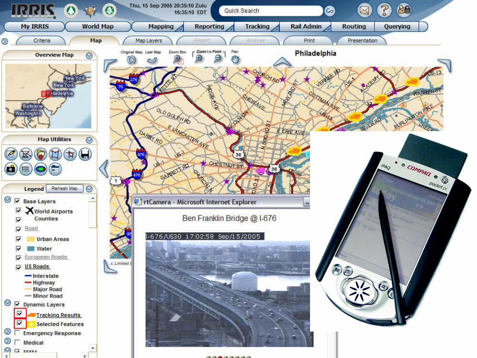
• Real-time traffic cameras provide a live view of traffic flow
• IRRIS uses integrated weather radar and real-time weather data is received via dedicated satellite receivers
• IRRIS can access weather forecasts for storm warning details
• The system can also provide alerts regarding individual vehicle status
• IRRIS knows where current weather is in relation to the roadway, allowing intelligent decision making about traffic and routing


Users can define rules of notification for given spatial areas and/or tracked vehicles.
• IRRIS provides custom alert and notification interfaces to create rules in the context of the application
• Weather – Notification of weather and traffic events along a route
• Route Adherence – Assignment of a shipment to a route and alerting if the driver deviates from the specified route
• Tracking – selection of an area or map feature to alert users when a tracked object is near or within the boundaries of that feature


IRRIS users can receive alerts about traffic, weather, and road conditions from their current location on cell
phone, PDA, and other wireless devices.
• Search, retrieve, and use data with live information in wireless format
• On cell phone, users can run tracking queries and build maps
• On PDA, users can make maps, run tracking and other queries, build routes, edit data, and calculate plumes

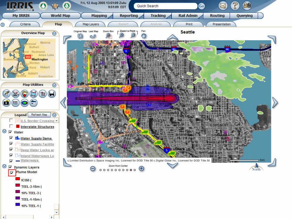
Model and display map-based plume analysis depicting the effects of hazardous material releases based on agent type, volume, wind speed, and wind direction.
• Working with Defense Threat Reduction Agency (DTRA), IRRIS models the effects of hazardous materials and weapons of mass destruction on any geographic area by displaying color-coded plumes on the map
• Users can select mode of transportation (road, rail, sea) carrying hazardous materials
• Plume models can display hazard predictions for the interaction between explosives and bio chemicals
• Plume models display Emergency Response Planning Guidelines, Temporary Emergency Exposure Limits, and Immediately Dangerous to Life or Health guidelines

Spatial analyses allow users to determine how many and which roads, facilities, and/or points of interest
exist near or within a map feature or area.
• Spatial operators allow users to search for features that touch, contain, are contained by, are within a certain distance of, or overlap by intersect a point, line, or area on the map
• Spatial querying helps answer questions such as "How many hospitals are located within a five-mile radius of this vehicle crash site?"
