a method for retrieving soil moisture in tibet region by utilizing microwave index from trmm/tmi...
TRANSCRIPT
This article was downloaded by: [UOV University of Oviedo]On: 16 October 2014, At: 05:00Publisher: Taylor & FrancisInforma Ltd Registered in England and Wales Registered Number: 1072954 Registeredoffice: Mortimer House, 37-41 Mortimer Street, London W1T 3JH, UK
International Journal of RemoteSensingPublication details, including instructions for authors andsubscription information:http://www.tandfonline.com/loi/tres20
A method for retrieving soil moisturein Tibet region by utilizing microwaveindex from TRMM/TMI dataK. B. Mao a b c , H. J. Tang a , L. X. Zhang b e , M. C. Li d , Y. Guo b
& D. Z. Zhao da Key Laboratory of Resources Remote Sensing and DigitalAgriculture, MOA , Hulunber Grassland Ecosystem Observation andResearch Station , Institute of Agricultural Resources and RegionalPlanning , Chinese Academy of Agricultural Sciences , Beijing100081, Chinab State Key Laboratory of Remote Sensing Science , JointlySponsored by the Institute of Remote Sensing Applications ofChinese Academy of Sciences and Beijing Normal University ,Beijing, 100101, Chinac Graduate School of Chinese Academy of Sciences , Beijing,100049, Chinad International Institute for Earth System Science , NanjingUniversity , Nanjing 210093, Chinae The Center of Remote Sensing and GIS , Beijing NormalUniversity , Beijing, 100875, ChinaPublished online: 29 Apr 2008.
To cite this article: K. B. Mao , H. J. Tang , L. X. Zhang , M. C. Li , Y. Guo & D. Z. Zhao (2008) Amethod for retrieving soil moisture in Tibet region by utilizing microwave index from TRMM/TMIdata, International Journal of Remote Sensing, 29:10, 2903-2923, DOI: 10.1080/01431160701442104
To link to this article: http://dx.doi.org/10.1080/01431160701442104
PLEASE SCROLL DOWN FOR ARTICLE
Taylor & Francis makes every effort to ensure the accuracy of all the information (the“Content”) contained in the publications on our platform. However, Taylor & Francis,our agents, and our licensors make no representations or warranties whatsoever as tothe accuracy, completeness, or suitability for any purpose of the Content. Any opinionsand views expressed in this publication are the opinions and views of the authors,

and are not the views of or endorsed by Taylor & Francis. The accuracy of the Contentshould not be relied upon and should be independently verified with primary sourcesof information. Taylor and Francis shall not be liable for any losses, actions, claims,proceedings, demands, costs, expenses, damages, and other liabilities whatsoever orhowsoever caused arising directly or indirectly in connection with, in relation to or arisingout of the use of the Content.
This article may be used for research, teaching, and private study purposes. Anysubstantial or systematic reproduction, redistribution, reselling, loan, sub-licensing,systematic supply, or distribution in any form to anyone is expressly forbidden. Terms &Conditions of access and use can be found at http://www.tandfonline.com/page/terms-and-conditions
Dow
nloa
ded
by [
UO
V U
nive
rsity
of
Ovi
edo]
at 0
5:00
16
Oct
ober
201
4

A method for retrieving soil moisture in Tibet region by utilizingmicrowave index from TRMM/TMI data
K. B. MAO{{§, H. J. TANG{, L. X. ZHANG{**, M. C. LI", Y. GUO{ and
D. Z. ZHAO"
{Key Laboratory of Resources Remote Sensing and Digital Agriculture, MOA,
Hulunber Grassland Ecosystem Observation and Research Station, Institute of
Agricultural Resources and Regional Planning, Chinese Academy of Agricultural
Sciences, Beijing 100081, China
{State Key Laboratory of Remote Sensing Science, Jointly Sponsored by the Institute of
Remote Sensing Applications of Chinese Academy of Sciences and Beijing Normal
University, Beijing, 100101, China
§Graduate School of Chinese Academy of Sciences, Beijing, 100049, China
"International Institute for Earth System Science, Nanjing University, Nanjing 210093,
China
**The Center of Remote Sensing and GIS, Beijing Normal University, Beijing, 100875,
China
(Received 23 June 2006; in final form 23 April 2007 )
According to simulation analysis of the advanced integral equation model
(AIEM), there is a good linear relationship between emissivity and soil moisture
under conditions of given roughness. The normalized difference of emissivities at
19.35 GHz and 10.65 GHz with vertical polarization can partly eliminate the
influence of roughness and the squared correlation coefficient is about 0.985.
This paper uses the normalized brightness temperature for retrieving soil
moisture in Tibet from TRMM/TMI data. This method avoids parametrizing the
land surface temperature which is a key parameter for the computation of
emissivity. We make some sensitivity analysis for the atmosphere which is the
main influence factor for our method. The analysis results indicate that our
method is very good for clear days but is not very good when there is rainfall. We
evaluate our algorithm by using the ground truth data obtained from GAME-
Tibet and the retrieval error of soil moisture is about 0.04m3 m23 relative to
experimental data. The analysis indicates that the relationship obtained from the
theoretical model should be revised through the local ground measurement data
because the method is still influenced by roughness and vegetation. After making
a regression revision, the retrieval error of soil moisture is under 0.02m3 m23.
Finally, we retrieve the soil moisture in Tibet from TRMM/TMI data, and the
distribution trend of retrieval results is consistent with the real world.
1. Introduction
Many studies have shown that soil moisture is an important parameter in numerical
weather-prediction models that leads to a significant forecasting improvement in the
physics of land surface processes on regional and global scales, which combine the
*Corresponding author. Email: [email protected]
International Journal of Remote Sensing
Vol. 29, No. 10, 20 May 2008, 2903–2923
International Journal of Remote SensingISSN 0143-1161 print/ISSN 1366-5901 online # 2008 Taylor & Francis
http://www.tandf.co.uk/journalsDOI: 10.1080/01431160701442104
Dow
nloa
ded
by [
UO
V U
nive
rsity
of
Ovi
edo]
at 0
5:00
16
Oct
ober
201
4

results of all surface-atmosphere interactions and energy fluxes between atmosphere
and the ground (Njoku and Li 1999). The surface soil moisture is an important
bridge between land surface and atmosphere, which directly influences the exchange
of energy. But it is very difficult to obtain the soil moisture by ground measurement
in both time and space, especially at large spatial scales; microwave remote sensing
from satellite overcomes these problems (Owe et al. 2001). Thus microwave
radiometry has been proved to be one of the best methods to retrieve soil moisture
during the last 25 years.
Microwave observations are sensitive to soil moisture through the effects of the
moisture on the dielectric constant, and hence the emissivity, of the soil (Wang and
Schmugge 1980, Njoku et al. 2003). Wang (1985) and Njoku and Patel (1985)
investigated the potential of the 6.6 and 10.65 GHz channels of the Scanning
Multichannel Microwave Radiometer (SMMR) for soil moisture monitoring. These
studies were followed by others (Choudhury and Golus 1988, Owe et al. 1988, Jackson
et al. 1990, 1993, 1997, 2001, 2002, Owe et al. 1992, Kerr and Njoku 1993, Griend and
Owe 1994). Vegetation and surface roughness reduce the sensitivity of microwave
observations of soil moisture and many studies indicate that vegetation and roughness
effects become more pronounced at higher frequencies (Jackson et al. 1982, Wigneron
et al. 2004). Hence, low frequency (like L band) is more suitable for soil moisture
sensing. The C band is still sensitive to soil moisture although it is more influenced by
vegetation and surface roughness than the L band (Jackson and Schmugge 1991).
Paloscia et al. (2001) proposed an algorithm based on the sensitivity to moisture of
both the brightness temperature and the polarization index for retrieving soil moisture
from microwave data from SMMR and the Special Sensor Microwave/Imager (SSM/
I) satellites. Owe et al. (2001) proposed a methodology for retrieving surface soil
moisture using the polarization difference index from satellite microwave radiometer
data. Gu et al. (2002), Bindlish et al. (2003) and Gao et al. (2006) made several studies
for retrieving soil moisture from TRMM/TMI.
Although microwave radiometry at 1.4 GHz has been proved to be one of the
most promising passive remote sensing techniques for retrieving soil moisture
(Schwank et al. 2005), some problems do exist: 1) the spatial resolution is lower at
low frequency than at high frequency; 2) we want to know how soil moisture
changes with time but the archive of low-frequency (1.4 GHz) satellite data is quite
limited; 3) the low frequency (1.4 GHz) microwave data does not resolve the
vegetation problem although the influence of the atmosphere is quite small and
vegetation is semitransparent. As we all know, almost all pixels for passive
microwave satellite data at the present time are mixed pixels. Although many
passive remote sensing experiments and studies have been carried out at small scale
(Owe et al. 1988, Matzler 1990, Griend and LoSeen 1995, Wigneron et al. 2004,
Schwank et al. 2005), no one has managed to successfully resolve the vegetation
problem at large scale. Many studies used the v – t model to eliminate the influence
of vegetation (Jackson and O’Neill 1990, Jackson and Schmugge 1991, Kerr and
Njoku 1993, Njoku 1997, Njoku and Li 1999).
This method has some limitations, for example, the NDVI value of 1000 pixels is
equal to 0.4 in a passive microwave image, but the distribution and types of vegeta-
tion are different (from the uniformity to at random, from grass to forest). How much
will the error be if we use one method to deal with the influence of vegetation.
Many people have studied land surface heterogeneity and found that the
inherently large footprint of microwave satellite observations has serious
2904 K. B. Mao et al.
Dow
nloa
ded
by [
UO
V U
nive
rsity
of
Ovi
edo]
at 0
5:00
16
Oct
ober
201
4

consequences for geophysical parameters retrieval from inhomogeneous surfaces
(Griend et al. 2003, Burke et al. 2004). The new SMOS (soil moisture and ocean
salinity) soil moisture algorithm will use a vegetation differentiation within the
footprint (Kerr et al. 2001). Low frequency and high frequency data should be used
at the same time when we retrieve soil moisture from mixed pixels (especially
including vegetation). The low frequency can obtain the information about the soil
moisture and the high frequency can mainly obtain information about the
vegetation. However, there is a positive relationship between vegetation water
content and soil moisture which will determine the unique signal at different
frequencies for different distributions and types of vegetation for different pixels.
In this study, we have used the normalized brightness temperature which partly
eliminates roughness effects to retrieve soil moisture in Tibet from TRMM/TMI
data, and we have revised the retrieval result using in situ measurement data to
improve the retrieval accuracy.
2. Data and study region
The TRMM Microwave Imager (TMI) is aboard ‘‘The Tropical Rainfall Measuring
Mission (TRMM)’’ satellite including the first precipitation radar (PR) to be flown in
space, along with a 9-channel SSM/I-like passive microwave imager (TMI), an
AVHRR-like visible-infrared radiometer (VIRS), a lightning sensor and a cloud
sensor, which is a joint project between the United States (NASA’s Goddard Space
Flight Center) and Japan (the National Space Development Agency). The TMI is a
multi-channel passive radiometer whose signals in combination can measure rainfall
quite accurately over oceans and somewhat less accurately over the land. The TMI is
based on the design of the highly successful Special Sensor Microwave/Imager (SSM/
I) which has been flying continuously on Defense Meteorological Satellites since 1987.
The TMI measures the intensity of radiation at five separate frequencies: 10.65, 19.35,
22.235, 37 and 85.5 GHz. The spatial resolution of the 10.65GHz data is about 50 km
and the TRMM orbit yields a swath width of 158.5 km, and can provide data between
238u and + 38u latitude which covers Tibet completely. The antenna beam views the
Earth surface with 49u at nadir and the ground surface incidence angle is 52.8u at the
earth’s surface. More information can be found in the TRMM user handbook (2001),
Bindlish et al. (2003) and the Goddard Earth Sciences Data and Information Services
Center (2005).
Tibet is our study region which is known as the ‘‘roof of the world’’ (77–87uE and
25–34uN), whose high altitude and vast expanses of plateau make it the starting
point for the East Asia monsoon climate and a regulator of the global climate. It is
also the source of a large number of Chinese rivers. Construction and protection of
the ecological environment in this area are vital to the ecological environment of the
whole of China which is affected by both natural and human factors. The trend of
global climate towards dry and hot weather results in ecological devastation there.
On the other hand, human activities such as farming, popular tourism and various
construction work also contribute to the devastation. The GEWEX Asian Monsoon
Experiment (GAME) was carried out to understand the role of the Asian monsoon
in the global energy and water cycles and in the global climate system and many
methods were developed for long-range forecasting. Soil moisture is an important
influence factor, so soil moisture experiments (1997–1998) were one of the most
important parts of the GEWEX Asia Monsoon Experiment which can be used to
evaluate the soil moisture retrieval algorithm for TRMM/TMI data. GTDC
A method for retrieving soil moisture in Tibet region 2905
Dow
nloa
ded
by [
UO
V U
nive
rsity
of
Ovi
edo]
at 0
5:00
16
Oct
ober
201
4

(ground truth data collection) used two methods to obtain measurement data in
GAME-Tibet. One method is small scale and the range is about 60 m660 m, the
other is middle scale (the red box in figure 1) and the range is 1 km61 km. There are
about 11 observation systems. The purpose of SMTMS (Soil Moisture and
Temperature Measurement System) observation is to monitor parameters (like soil
moisture and temperature) for hydrological values which provide the soil moisture
from 0.04 m to 1.96 m soil depth. The soil moisture and soil temperature are
recorded every hour.
A lot of meaningful studies about the surface energy budget have been done
(Tanaka et al. 2001, Ma et al. 2002). The surface conditions (like roughness,
topograghy, soil type and vegetation) of Tibet region are very complex and the
details can be found in several references (http://monsoon.t.u-tokyo.ac.jp/tibet/,
Tanaka et al. 2001, Ma et al. 2002).
3. Description of AIEM model
In the development of a microwave model, the small perturbation method (SPM) is
valid for slightly rough surfaces, and the Kirchhoff approximation (KA) is suitable
for rougher surfaces (Ulaby et al. 1986, Fung 1994). In order to simulate the ‘‘real
world’’, Fung et al. (1992, 1994) proposed an integral equation model (IEM) which
is in agreement with the SPM for slightly rough surfaces and with the KA for
rougher surfaces. Although the IEM is better than previous models, it still involves
some assumptions. In order to overcome the shortcomings of the IEM, Chen et al.
(2000, 2003) extended and advanced the IEM. The advanced integral equation
model (AIEM) is one of the best models to simulate the emission characteristic of a
rough surface and has been demonstrated to have a wider application range for
surface roughness than the conventional models such as the small perturbation
model, the physical model and the geometrical optical model (Fung 1994). The
improvements were mainly done by overcoming some weak assumptions in the
original IEM model development. For example, the complementary field
Figure 1. GAME-Tibet (Game-Tibet POP/IOP Dataset CD, January 2001).
2906 K. B. Mao et al.
Dow
nloa
ded
by [
UO
V U
nive
rsity
of
Ovi
edo]
at 0
5:00
16
Oct
ober
201
4

coefficients were rederived to keep the absolute phase terms in the surface Green’s
function and its gradient, leading to more complete, and thus more accurate,
expressions for the multiple scattering (Chen et al. 2000) and single-scattering terms
(Chen et al. 2003) and a physical-based transition function that naturally connects
these two approximations was included in the new version of the AIEM model (Wu
et al. 2001, Chen et al. 2003). Many comparisons of the AIEM with a three-
dimensional (3-D) Monte Carlo model simulated data (Chen et al. 2003, Shi et al.
2005) showed a significant improvement in more accurate calculation of surface
emission signals over a wide range of surface dielectric, roughness, and sensor
frequencies.
4. Derivation of a simple retrieval approach using model simulations
The microwave radiometer measures the thermal emission of the ground and its
transfer from the ground through the atmosphere to the remote sensor. According
to the Rayleigh-Jeans approximation to the Planck function, the intensity of
brightness temperature of the radiation observed by the radiometer can be written as
Tbp t, mð Þ~ 1{vð Þ 1{e{t=m� �
TczepTse{t=mzt 1{tð Þ 1{ep
� �T;
a z 1{tð ÞT:a ð1Þ
where P stands for horizontal (H) or vertical (V) polarization, m5cosh, ep is the
emissivity, and t (the equivalent optical depth) and v (the single scattering albedo)
are two important parameters that characterize the absorbing and scattering
properties of vegetation, Ts is the land surface temperature, Tc is the average
temperature of the vegetation, Tbp (t, m) is the brightness temperature of
the radiation received by the sensor at an angle h, t is the transmittance of the
atmosphere, T:a is the upwelling average atmospheric temperature, T;
a is the
downwelling average atmospheric temperature. The centimetre wave band is hardly
influenced by the atmosphere. The transmittance(t) for microwaves is very high and
approximates to 1 even when the atmospheric water vapour content is about
5 gcm22 (Ulaby et al. 1986), so the influence of the atmosphere can be omitted and
equation (1) can be simplified to
Tbp t, mð Þ~ 1{vð Þ 1{e{t=m� �
TczepTse{t=m ð2Þ
Paloscia and Pampaloni (1984, 1988) defined the microwave polarization index as
MPDI t, mð Þ~ Tbv{Tbh
12
TbvzTbhð Þð3Þ
Submitting equation (2) into (3), we can get
MPDI t, mð Þ~ evTbsv{ehTbshð Þe{t=m
1{womegað Þ 1{e{t=m
� �Tcz
12
evTbsvzehTbshð Þe{t=m
ð4Þ
For bare soil, the t50, ep5Tp/Ts, and we can have
MPDI 0, mð Þ~ ev{ehð Þ12
evzehð Þð5Þ
A method for retrieving soil moisture in Tibet region 2907
Dow
nloa
ded
by [
UO
V U
nive
rsity
of
Ovi
edo]
at 0
5:00
16
Oct
ober
201
4

After assuming Tc5Ts, es~12
evzehð Þ and some other conditions (like albedo)
(Paloscia and Pampaloni 1988), equation (4) can be written as:
MPDI t, mð Þ&MPDI 0, mð Þe{t=m ð6Þ
The MPDI is mainly used to describe the characteristics of vegetation through the
difference between different polarization at the same frequency. Meesters et al.
(2005) made more analysis about the MPDI. We write MPDI as PDI (equation (7)),
and the only difference is that p/q is V or H at the same or different frequency. In
equation (5), the emissivity is mainly influenced by two factors (Ulaby et al. 1986,
Fung 1994). The first is soil moisture and the other is roughness which includes sig
(root mean square height) and cl (correlation length). The influence of soil moisture
and roughness will be analysed through simulation of the AIEM. The influence of
different soil types is small for emissivity (Fung 1994), so the key point is how to
eliminate the influence of roughness and vegetation for accurately retrieving soil
moisture.
PDI~ep{eq
� �
12
epzeq
� �~2 Tp{Tq
� �
TpzTq
~2DT
TpzTq
ð7Þ
The change of emissivity (ef) is determined by the dielectric constant which is
mainly influenced by the soil moisture and roughness (Wang and Schmugge 1980,
Njoku et al. 2003). Many studies (Paloscia and Pampaloni 1984, Pampaloni and
Paloscia 1985, Choudhury and Tucker 1987) have proved that the difference of
polarization (DT) is positive with the soil moisture. On the other hand, soil moisture
can be derived by using plants as indicators by using the microwave polarization
index (Jackson 1982, Cmaillo and Schmugge 1983, Calvet et al. 1994). Seen from
equation (6), the difference of MPDI between bare soil and vegetation is a
coefficient. In this study, we will utilize the PDI to retrieve soil moisture. The first
step is that we build a database through the simulation of theory model for most
conditions. After obtaining the relationship between soil moisture and PDI from the
database, we will make a revision for retrieval algorithm according to the
experiment data in situ field which will improve retrieval accuracy.
Many people (Schmugge et al. 1974, Eagleman and Lin 1976, Wang and
Choudhury 1981, Tsang et al. 1982, Wang et al. 1983) have found that a linear
relationship can be built between brightness temperature and soil moisture. These
data obtained from experiments are very limited and cannot describe all conditions.
So these relationships are mainly empirical and mainly suitable for local regions. We
use the AIEM model to simulate the relationship between soil moisture roughness
and emissivity at different frequencies, for the TRMM/TMI sensor: 10.65, 19.35,
22.235, 37, 85.5GHz), which can partly overcome the difficulty that the
measurement data in situ is not enough.
The commonly used Gaussian correlation function was utilized in the simulation
since it is a better approximation for high-frequency microwave measurements than
that of the exponential correlation function. In order to analyse conveniently, we
just give a part of the simulation results under different given conditions. Figure 2
shows the relationship between soil moisture and emissivity at different frequencies
under given roughness conditions (sig52; cl56) and h552.8u. Seen from figure 2,
there is an approximately linear relationship between soil moisture and emissivity
for vertical and horizontal polarization. The horizontal polarization is more
2908 K. B. Mao et al.
Dow
nloa
ded
by [
UO
V U
nive
rsity
of
Ovi
edo]
at 0
5:00
16
Oct
ober
201
4

sensitive than vertical polarization. So the horizontal polarization is better for
retrieving soil moisture than vertical polarization under this condition. However, the
lower frequency is more sensitive to soil moisture and so it is more suitable to
retrieve soil moisture.
In order to conveniently analyse the influence of roughness on emissivity, we set
the frequency equal to 10.65GHz. Figure 3 shows the simulation relationship
between rms height and emissivity under given correlation length (cl56), h552.8ufor different soil moisture content. Figure 4 shows the simulation relationship
between correlation length and emissivity for a given rms height (sig52) and
h552.8u and different soil moisture content. It can be seen from figure 3 and figure 4
Figure 2. The relationship between soil moisture and emissivity at different frequency.
A method for retrieving soil moisture in Tibet region 2909
Dow
nloa
ded
by [
UO
V U
nive
rsity
of
Ovi
edo]
at 0
5:00
16
Oct
ober
201
4
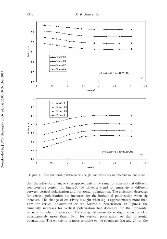
that the influence of sig or cl is approximately the same for emissivity at different
soil moisture content. In figure 3, the influence trend for emissivity is different
between vertical polarization and horizontal polarization. The emissivity decreases
for vertical polarization but increases for the horizontal polarization when sig
increases. The change of emissivity is slight when sig is approximately more than
1 cm for vertical polarization or the horizontal polarization. In figure 4, the
emissivity increases for vertical polarization but decreases for the horizontal
polarization when cl increases. The change of emissivity is slight when the cl is
approximately more than 10 cm for vertical polarization or the horizontal
polarization. The emissivity is more sensitive to the roughness (sig and cl) for the
Figure 3. The relationship between rms height and emissivity in different soil moisture.
2910 K. B. Mao et al.
Dow
nloa
ded
by [
UO
V U
nive
rsity
of
Ovi
edo]
at 0
5:00
16
Oct
ober
201
4

horizontal polarization than for the vertical polarization. For retrieving soilmoisture, the lower sensitivity to the roughness makes it more suitable for retrieving
soil moisture. Seen from this point, vertical polarization is better than horizontal
polarization for retrieving soil moisture. The simulation results are similar for
different frequencies (like 19.35GHz).
It can be seen from the simulation analysis above that the horizontal polarization
is more sensitive to soil moisture, and more sensitive to roughness than the vertical
polarization. Under given roughness conditions, we can build a relationship betweensoil moisture and emissivity. Of course, we can also build a relationship between
brightness temperature and soil moisture because there is a linear relationship
Figure 4. The relationship between correlation length and emissivity in different soilmoisture.
A method for retrieving soil moisture in Tibet region 2911
Dow
nloa
ded
by [
UO
V U
nive
rsity
of
Ovi
edo]
at 0
5:00
16
Oct
ober
201
4

between emissivity and brightness temperature when the land surface temperature is
known. Many empirical methods for retrieving soil moisture are built on these
conditions (Schmugge et al. 1986, Ahmed 1995, Paloscia et al. 2001). These retrieval
methods are mainly suitable for local regions; however, the roughness changes in
different seasons or when there is some rainfall. In order to make the method for
retrieving soil moisture more practical, we simulate the relationship between soil
moisture and emissivity under the assumption that the roughness is changed in a
range (sig:0.25–3.1, cl:5–30) by the AIEM model, and build a database which
includes most conditions on Earth. The 22.235GHz is much more influenced by the
water vapour content in the atmosphere and the low frequency is more suitable for
retrieving soil moisture, so we obtain the simulation data when h552.8u between soil
moisture and emissivity at 10.65 and 19.35 GHz.
Figure 5 shows the simulation results when h552.8u where we have made a
regression for simulation data and obtained the relationship, as in table 1. It can be
seen from figure 5 and table 1 that the squared correlation coefficient (R2) is very
high and the accuracy decreases with the increase of frequency. We find that the
vertical polarization is more suitable for retrieving soil moisture because the
roughness influence is greater for horizontal polarization than vertical polarization,
which can be proved by R2 and figure 5. On the other hand, the influence of
vegetation structure is greater for horizontal polarization than for vertical
polarization, so the microwave polarization index is used to describe the vegetation
(Pampaloni and Paloscia 1985, Choudhury and Tucker 1987).
In fact, the different soil conditions and different view angles have some influence
on the emissivity, but we find that the influence is small for the normalized
polarization index (PDI ) after the simulation analysis. Figure 6 is derived from
equation (7) and the simulation data and the regression results shown in table 2.
Table 1. The relationship between soil moisture and emissivity.
Frequency (GHz) Number of Set Equation R2
e 10.65V 1584 SM520.67937 + 0.54084 e10.65V21.21069 e 10.65V2
0.95
e 10.65H 1584 SM50.9639721.44992 e10.65H + 0.40156 e 10.65H2
0.864
e 19.35V 1584 SM520.26618 + 2.92229 e19.35V22.64512 e 19.35V2
0.939
e 19.35H 1584 SM50.941621.22773 e19.35H + 0.18324 e 19.35H2
0.867
(note: e is emissivity)
Table 2. The relationship between soil moisture and difference of different frequency.
Frequency (GHz) Number of Set Equation R2
PDI 10.65V–10.65H 1584 SM50.0149 + 0.5274 PDI1 + 0.1977 PDI 12
0.504
PDI 19.35V–10.65V 1584 SM50.0339 + 3.91 PDI2 + 130.7795 PDI 22
0.985
PDI 19.35H–10.65H 1584 SM520.017 + 3.2993 PDI3 + 34.1996 PDI 32
0.72
PDI 19.35V–19.35H 1584 SM520.0124 + 0.5793 PDI4 + 0.2023 PDI 42
0.529
2912 K. B. Mao et al.
Dow
nloa
ded
by [
UO
V U
nive
rsity
of
Ovi
edo]
at 0
5:00
16
Oct
ober
201
4

Figure 5. The relationship between soil moisture and emissivity. (a) sig:0.2523.1, cl:5.0231,theta552.8, fre510.65VGHz; (b) sig:0.2523.1, cl:5.0231, theta552.8, fre510.65VGHz; (c)sig:0.2523.1, cl:5.0231, theta552.8, fre519.35VGHz; (d) sig:0.2523.1, cl:5.0231,theta552.8, fre519.35VGHz.
A method for retrieving soil moisture in Tibet region 2913
Dow
nloa
ded
by [
UO
V U
nive
rsity
of
Ovi
edo]
at 0
5:00
16
Oct
ober
201
4

Figure 6. The relationship between soil moisture and PDI.
2914 K. B. Mao et al.
Dow
nloa
ded
by [
UO
V U
nive
rsity
of
Ovi
edo]
at 0
5:00
16
Oct
ober
201
4

It can be seen from figure 6(a), (b) and (d) that none of the PDIs for different
polarizations at 10.65GHz, for different polarizations at 19.35GHz or for horizontal
polarization at these two frequencies can eliminate the effect of surface roughness.However, figure 6(c) shows that PDI frequency 19.35GHz and 10.65GHz vertical
polarization can partly eliminate the influence of roughness and the squared
correlation coefficient (R-square) is about 0.985. The difference of same polarization
at different frequency can eliminate more influence of roughness than the different
polarization at same frequency, which can be known from figure 3 and 4 because the
influence of roughness for same polarization at different frequency is similar (see
figure 3 and figure 4). So equation (8) can be more accurately used to retrieve soil
moisture from bare soil.
SM~0:0339z3:91PDI19:35VGHz{10:65VGHzz130:7795PDI219:35VGHz{10:65VGHz ð8Þ
In equation (7), the emissivity can be obtained from the brightness temperature.
Thus, we can use the normalized difference of brightness temperature of TRMM/
TMI at frequencies of 19.35V GHz and 10.65V GHz, instead of the normalized
difference of the emissivity (ef) to retrieve soil moisture. For vegetation, the
influence is similar because the vertical polarization is not very sensitive to the
structure of vegetation. We can obtain the soil moisture through making a revisionwhich can be know from equations (5) and (6) because the relationship of MPDI
between bare soil and vegetation is an exponent function. However, there is little
information about soil moisture that can be obtained at frequencies above 10GHz
when the surface is covered by vegetation (O’Nell et al. 1984). Under this condition,
we assumed the vegetation as bare soil and the vegetation water content is positive
with soil moisture. The same polarization difference between 19.35GHz (V) and
10.65GHz (V) can also partly eliminate the influence of many factors such as
roughness, the structure of vegetation and topography and reflect the change of soilmoisture through vegetation, which can be known from O’Nell et al. (1984). Every
pixel is mixed for large scale passive microwave data in Tibet and the real condition
is very complicated, but the sensitivity of the PDI for bare soil and for vegetation is
similar. In order to improve retrieval accuracy, we need to use measurement data in
situ to revise the retrieval result. The best method is that we make a revision for
every pixel or small region in application.
5. Sensitivity analysis for retrieval method
Sensitivity analysis is necessary in many applications. From the retrieval
equation (8), the sensitivity is determined by PDI19.35VGHz–10.65VGHz which is given
by equation (7). In fact, the sensitivity is determined by the numerator (DT) becausethe denominator is very large. For the numerator, the error is made up of two parts.
One is the sensor sensitivity, and the other is the influence of the atmosphere. For
channels at frequency 19.35GHz and 10.65GHz, the sensitivity is usually less than
1 K and it varies with time (TRMM user handbook 2001, Goddard Earth Sciences
Data and Information Services Center 2005). We assume the sensitivity is 0.7 K
when T19.35 and T10.65 are between 273K and 320K, so that the difference of
brightness temperature at 19.35GHz and 10.65GHz should be between 0 and 1.4K.
For the sensor channel, the sensitivity of the retrieval method is between 0% and6.5%. Of course, the retrieval error is zero or under 3.25% (half of 6.5%) because the
noise should be at random (The sensor or data should be calibrated if not) at
A method for retrieving soil moisture in Tibet region 2915
Dow
nloa
ded
by [
UO
V U
nive
rsity
of
Ovi
edo]
at 0
5:00
16
Oct
ober
201
4
frequency 19.35GHz and 10.65GHz. This means that the retrieval error of soil
moisture is zero or under 3.25% even if there is no information about the ground
target.
For the influence of atmosphere, the transmittances of frequency 19.35GHz and
10.65 are very high and approximate to I even if the water vapour content is about
5 g cm22 (Ulaby et al. 1986). The value of the transmittance at 19.35GHz is lower
than at 10.65GHz though they are both very high. However, the difference of
brightness temperature at different frequencies can partly eliminate the influence of
the atmosphere. Of course, the 19.35GHz frequency will become sensitive when
there is rainfall, so the 19.35 GHz channel can also be utilized to monitor the rain
rate. Thus, our retrieval method will become sensitive when there is rain. In order to
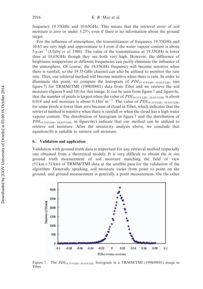
illuminate this point, we compute the histogram of PDI19.35VGHz–10.65VGHz (see
figure 7) for TRMM/TMI (1998/09/01) data from Tibet and we retrieve the soil
moisture (figures 9 and 10) for this image. It can be seen from figure 7 and figure 6c,
that the number of pixels is largest when the value of PDI19.35VGHz–10.65VGHz is about
0.018 and soil moisture is about 0.15m3 m23. The value of PDI19.35VGHz–10.65VGHz
for some pixels is lower than zero because of cloud in Tibet, which indicates that the
retrieval method is sensitive when there is rainfall or when the cloud has a high water
vapour content. The distribution of histogram in figure 7 and the distribution of
PDI19.35VGHz–10.65VGHz in figure 6(c) indicate that our method can be utilized to
retrieve soil moisture. After the sensitivity analysis above, we conclude that
equation (8) is suitable to retrieve soil moisture.
6. Validation and application
Validation with ground truth data is important for any retrieval method (especially
one obtained from a theoretical model). It is very difficult to obtain the in situ
ground truth measurement of soil moisture matching the field of view
(51 km651 km) of TRMM/TMI data at the satellite pass for the validation of the
algorithm. Generally speaking, soil moisture varies from point to point on the
ground, and ground measurement is generally a point measurement. On the other
Figure 7. The PDI19.35VGHz–10.65VGHz histogram in a TRMM/TMI (1998/09/01) image inTibet.
2916 K. B. Mao et al.
Dow
nloa
ded
by [
UO
V U
nive
rsity
of
Ovi
edo]
at 0
5:00
16
Oct
ober
201
4

hand, precisely locating the pixel of the measured ground in TRMM/TMI data is
also a problem. There are so many difficulties in obtaining ground truth data that
validation with the use of ground truth data is quite difficult.
In this study, we select the Intensive Observation Period (IOP) of GAME/Tibet in
1998 to make some validation of the retrieval method. We use the soil moisture at
0.04m (the red box in figure 1) to validate the retrieval method because the highfrequency penetrates the soil surface very little. More information about the data
can be found from http://monsoon.t.utokyo.ac.jp/tibet/. A program was written to
read the brightness temperature data from TRMM/TMI 1B data (1998/08/01 and
1998/08/31) by setting the range (Lat: 31,35u, Lon: 91,94u, see figure 1) according
to the range of field experiment and many pixels were obtained. We retrieved the soil
moisture for these pixels by using the retrieval equation mentioned above. The
retrieval result is not very good during rainfall days because the 19.35GHz
frequency is sensitive to rain. So we just selected the data from clear days between1998/08/01 and 1998/08/31. Some experimental sites are not matched well with the
single pixel because of the satellite scanning characteristics, and we just select the
best approximation in range and the average value of the experimental sites to make
some analysis. Some data is obviously in error and has been deleted because there
was some influence of rainfall or cloud. The comparison between results obtained
from the TRMM/TMI data and the field data is shown in figure 8. It can be seen
from figure 8, the retrieval soil moisture is underestimated by about 0.04m3 m23 by
our method because the influence of atmosphere for 19.35GHz is more than for10.65GHz. On the other hand, the vegetation also has an important influence.
The relationship between measured ground soil moisture and retrieval soil
moisture in figure 8 can be represented by:
SMG~1:045SMRz0:024 R2~0:901 ð9Þ
SMR is the soil moisture retrieved using equation (8), SMG is the soil moisture
measured in the ground. We may use equation (9) which was obtained by regressing
Figure 8. The relationship between measured ground soil moisture and retrieval soilmoisture.
A method for retrieving soil moisture in Tibet region 2917
Dow
nloa
ded
by [
UO
V U
nive
rsity
of
Ovi
edo]
at 0
5:00
16
Oct
ober
201
4

the retrieval results and the measurement data to improve the retrieval accuracy.
The average retrieval error is about 0.02m3 m23 after revision. In order to provide
an example of the method in ation and to confirm our method in practice in Tibet,
we retrieve soil moisture from TRMM/TMI (1998/09/01) images in Tibet, and make
a distribution map of soil moisture with the same range of soil moisture content, see
figure 9. If the value of PDI19.35VGHz–10.65VGHz is lower than zero, we set it as zero.
We make the colour as red if the value of retrieval soil moisture is larger than 0.5. It
can be seen from figure 9 that the distribution condition of soil moisture is
reasonable. The black grid in figure 9 is the experiment site shown as a red grid in
figure 1.
We know that the retrieval method underestimates soil moisture content in
validation, so equation (9) is used to make a revision. The revision soil moisture is
shown in figure 10. We have performed a statistical analysis for figure 10. The value
of the soil moisture in most of the area is between 5–20% (see table 3). Of course, we
need to stress that our retrieval algorithm is mainly suitable for bare soil and under
conditions without rain. There may be some large retrieval error when the NDVI is
very large and there has been rainfall.
Figure 9. Retrieval of soil moisture by using equation (8).
Figure 10. Retrieval soil moisture revised by equation (9).
2918 K. B. Mao et al.
Dow
nloa
ded
by [
UO
V U
nive
rsity
of
Ovi
edo]
at 0
5:00
16
Oct
ober
201
4

7. Conclusion
On the basis of the radiative transfer equation, we briefly analyse the radiance
characteristics of microwave and the microwave polarization index. The emissivity
of soil is very sensitive to soil moisture, so microwave remote sensing is one of the
best methods for the retrieval of soil moisture.
According to the simulation analysis of AIEM, we can retrieve soil moisture
through difference of brightness temperature for given roughness, but this method is
empirical and mainly suitable for local regions. After analysing the relationship
between the emissivity and soil moisture by utilizing the simulation data of AIEM
under a wide range of conditions, we build a relationship between soil moisture and
the normalized difference at different frequency which can partly eliminate the
influence of roughness and atmosphere. The analysis indicates that the vertical
polarization index at 19.35GHz and 10.65 GHz can partly eliminate the influence of
roughness and the value of R2 is about 0.985, which indicates that our method is
very good. This method should be revised by in situ local measurement data because
it is still influenced by roughness. The same polarization difference between
19.35GHz (V) and 10.65GHz (V) can also partly eliminate the influence of many
factors (like the structure of vegetation and topography) and reflect the change of
soil moisture through the vegetation. Every pixel is mixed for large scale passive
microwave data in Tibet and so we use the measurement data in situ to improve
retrieval accuracy. The best method is that we make a revision for every pixel or
small region in application. On the other hand, although there is a positive
relationship between soil moisture and vegetation water content, the relationship is
very difficult to quantify accurately because the influence of the vegetation is too
complex. We evaluate our method by experimental data in GAME/Tibet, and the
retrieval error of soil moisture is about 0.04m3 m23 relative to experiment data.
After making a regression revision, the retrieval error of soil moisture is about
0.02m3 m23. This indicates that we need to make a revision after building a
relationship through simulation data because there is some difference between the
theoretic model and the real world. However, the theoretical model is not perfect
and cannot cover all the conditions. The sensitivity analysis indicated that our
method is not very sensitive to the influence factor (roughness, sensor noise), but the
retrieval results will not be very good when there has been rainfall.
Finally, further study is needed and the accuracy needs to be improved when the
value of the NDVI (vegetation) is very large and the weather (cloud and rainfall) is
not very good. The retrieval error is larger in a mixed pixel including water than in
other pixels. We suggest that the low frequency and high frequency should be
simultaneously used because almost every pixel of the large scale of TRMM/TMI is
mixed.
Acknowledgment
The authors would like to thank the following people for their various help with
this study: Jiancheng Shi, University of California, Santa Barbara, A. K. Fung,
Table 3. The distribution of pixels in different soil moisture range.
Rang of soil moisture 0–0.1 0.1–0.2 0.2–0.3 0.3–0.4 .0.4Number of pixels 8609 3349 773 305 363Percent 64.25% 25% 5.80% 2.27% 2.70%
A method for retrieving soil moisture in Tibet region 2919
Dow
nloa
ded
by [
UO
V U
nive
rsity
of
Ovi
edo]
at 0
5:00
16
Oct
ober
201
4

University of Texas, Kun-Shan Chen, Center for Space and Remote Sensing
Research, National Central University. They would also like to thank the
anonymous reviewers for their valuable comments, which greatly improved the
presentation of this paper.
Thanks are also due to NASA for providing TRMM/TMI data, the Department
of Civil Engineering University of Tokyo, providing the GAME-Tibet POP/IOP
Dataset CD. This work was sponsored by the National Natural Science Foundation
of China (Grant No: 90302008&40571101); basic research work of Central Scientific
Research Institution for Public Welfare; Project 863 of China: (Grant no.
2006AA10Z241&2007AA10Z230) and Sponsored by the Open Fund of Key
Laboratory of Resources Remote Sensing and Digital Agriculture, MOA.
ReferencesAHMED, N.U., 1995, Estimating soil moisture from 6.6 GHz dual polarization, and/or satellite
derived vegetation index. International Journal of Remote Sensing, 16, pp. 687–708.
BURKE, E.J., SHUTTLEWORTH, W.J. and HOUSER, R., 2004, Impact of horizontal and vertical
heterogeneities on retrievals using multiangle microwave brightness temperature data.
IEEE Transactions on Geoscience and Remote Sensing, 42, pp. 1495–1501.
BINDLISH, R., JACKSON, T.J., WOOD, E., GAO, H., STARKS, P., BOSCH, D. and LAKSHMI, V.,
2003, Soil moisture estimates from TRMM microwave imager observations over the
southern United States. Remote Sensing of Environment, 85, pp. 507–515.
CALVET, J.C., WIGNERON, J.P., MOUGIN, E., KERR, Y.H. and BRITO, J.S., 1994, Plant water
content and temperature of the Amazon forest from satellite microwave radiometry.
IEEE Transactions on Geoscience and Remote Sensing, 32, pp. 397–408.
CHEN, K.S., WU, T.D.T., TSANG, L., LI, Q., SHI, J.C. and FUNG, A.K., 2003, Emission of
Rough Surfaces Calculated by the Integral Equation Method With Comparison to
Three-Dimensional Moment Method Simulation. IEEE Transactions on Geoscience
and Remote Sensing, 41, pp. 90–101.
CHEN, K.S., WU, T.D. and FUNG, A.K., 2000, A note on the multiple scattering in an IEM
model. IEEE Transactions on Geoscience and Remote Sensing, 38, pp. 249–256.
CHOUDHURY, B.J. and GOLUS, R.E., 1988, Estimating soil wetness using satellite data.
International Journal of Remote Sensing, 9, pp. 1251–1257.
CHOUDHURY, B.J. and TUCKER, C.J., 1987, Monitoring global vegeation using Nimbus-7
37 GHz data some emrical relation. International Journal of Remote Sensing, 9, pp.
1085–1090.
CALVET, J.C., WIGNERON, J.P., MOUGIN, E., KERR, Y.H. and BRITO, J.S., 1994, Plant water
content and temperature of the Amazon forest from satellite microwave radiometry.
IEEE Transactions on Geoscience and Remote Sensing, 32, pp. 397–408.
CMAILLO, P.T. and SCHMUGGE, T.S., 1983, Estimating soil moisture storage in the root zone
from surface measurements. Soil Science, 135, p. 245.
EAGLEMAN, J.R. and LIN, W.C., 1976, Remote sensing of soil moisture by a 21-cm passive
radiometer. Journal of Geophysical Research, 81, pp. 3660–3666.
FUNG, A.K., LI, Z. and CHEN, K.S., 1992, Backscattering from a randomly rough dieletric
surface IEEE Transactions on Geoscience and Remote Sensing, 30, pp. 356–369.
FUNG, A.K., Microwave Scattering and Emission Models and Their Applications, Artech
House Inc. 1994.
GAO, H., E. WOOD, F., DRUSCH, M., JACKSON, T. and BINDLISH, R., 2006, Using TRMM/
TMI to retrieve soil moisture over the southern United States from 1998 to 2002.
Journal of Hydrometeorology, 7, pp. 23–38.
GODDARD EARTH SCIENCES DATA AND INFORMATION SERVICES CENTER, DISTRIBUTED
ACTIVE ARCHIVE CENTER. TRMM Microwave Imager (TMI) LEVEL 1B
Calibrated Brightness Temperature (TB) Product [EB]. October 28, 2005.
2920 K. B. Mao et al.
Dow
nloa
ded
by [
UO
V U
nive
rsity
of
Ovi
edo]
at 0
5:00
16
Oct
ober
201
4

GRIEND vAN DE, A.A. and OWE, M., 1994, Microwave vegetation optical depth and inverse
modeling of soil emissivity using Nimbus/SMMR satellite observations. Meteorology
and Atmospheric Physics, 54, pp. 225–239.
GRIEND vAN DE, A.A., OWE, M., RUITER, J.D. and GOUWELEEUW, B.T., 1996, Measurement
and behavior of dual-polarization vegetation optical depth and single scattering
albedo at 1.4 and 5 GHz microwave frequencies. IEEE Transactions on Geoscience and
Remote Sensing, 34, pp. 957–965.
GRIEND vAN DE, A.A., WIGNERON, J.P. and WALDTEUFEL, P., 2003, Consequences of surface
heterogeneity for parameter retrieval from 1.4-GHz multiangle SMOS observations.
IEEE Transactions on Geoscience and Remote Sensing, 41, pp. 803–811.
GU, S., GAO, H., ZHU, Y., ZHAO, B., LU, N. and ZHANG, W., 2002, Remote sensing land
surface wetness by use of TRMM/TMI microwave data. Meteorology and
Atmospheric Physics, 80, pp. 59–63.
JACKSON, T.J., SCHMUGGE, T. and WANG, J., 1982, Passive microwave remote sensing
of soil moisture under vegetation canopies. Water Resources Research, 18, pp.
1137–1142.
JACKSON, T.J. and O’NEILL, P.E., 1990, Attenuation of soil microwave emissision by corn and
soybeans at 1.4 and 5 GHz. IEEE Transactions on Geoscience and Remote Sensing, 28,
pp. 978–980.
JACKSON, T.J. and SCHMUGGE, T.J., 1991, Vegetation effects on the microwave emission from
soils. Remote Sensing of Environment, 36, pp. 203–219.
JACKSON, T.J., 1993, Measuring surface soil moisture using passive microwave remote
sensing. Hydrological Processes, 7, pp. 139–152.
JACKSON, T.J., 1997, Soil moisture estimation using special satellite microwave/imager
satellite data over a grassland region. Water Resources Research, 33, pp. 1485–1484.
JACKSON, T.J. and HSU, A.Y., 2001, Soil moisture and TRMM microwave imager
relationships in the South Great Plians 1999 (SGP99) experiment. IEEE
Transactions on Geoscience and Remote Sensing, 39, pp. 1632–1642.
JACKSON, T.J., GASIEWSKI, A.J., OLDAK, A., KLEIN, M., NJOKU, E.G., YEVGRAFOV, A.,
CHRISTIANI, S. and BINDLISH, R., 2002, Soil moisture retrieval using the C-band
polarimetric scanning radiometer during the southern great plains 1999 experiments.
IEEE Transactions on Geoscience and Remote Sensing, 40, pp. 2151–2161.
KERR, Y.H. and NJOKU, E.G., 1993, On the use of passive microwaves at 37 GHz in remote
sensing of vegetation. International Journal of Remote Sensing, 14, pp. 1931–1943.
KERR, Y.H., WALDTEUFEL, P., WIGNERON, J.P., MARTINUZZI, J.M., FONT, J. and
BERGER, M., 2001, Soil moisture retrieval from space: The soil moisture and ocean
salinity (SMOS) mission. IEEE Transactions on Geoscience and Remote Sensing, 39,
pp. 1729–1735.
LOSEEN, D., CHEHBOUNI, A., NJOKU, E. and SAATCHI, S., A modeling study on the use of
passive microwave data for the monitoring of sparsely vegetated land surfaces, in
Proc. IEEE Geoscience and Remote Sensing Symp. (IGARSS’95), Florence, Italy.
MA, Y.M., TSUKAMOTO, O., WANG, J.M., HIROHIKO, I. and ICHIRO, T., 2002, Analysis of
aerodynamic and thermodynamic parameters over the grassy marshland surface of
Tibetan plateau. Progress in Natural Sciences, 12(1), pp. 36–40.
MATZLER, C., 1990, Seasonal evolution fo microwave radiation from an oat field. Remote
Sensing of Environment, 31, pp. 161–173.
MEESTERS, A.G.C., DE JEU R. A., M. and OWE, M., 2005, Analytical derivation of derivation
of the vegetation optical depth from the microwave polarization difference index.
IEEE Transactions on Geoscience and Remote Sensing Letters, 2, pp. 121–123.
NATIONAL SPACE DEVELOPMENT AGENCY OF JAPAN, EARTH OBSERVATION CENTER. TRMM
Users Handbook [EB], February 2001.
NJOKU, E.G., AMSR Land Surface Parameters: Algorithm Theoretical Basis Document
Version 2.0, November 10, 1997.
A method for retrieving soil moisture in Tibet region 2921
Dow
nloa
ded
by [
UO
V U
nive
rsity
of
Ovi
edo]
at 0
5:00
16
Oct
ober
201
4

NJOKU, E.G. and LI,LI, 1999, Retrieval of land surface parameters using passive microwave
meaurements at 6–18 GHz. IEEE Transactions on Geoscience and Remote Sensing, 37,
pp. 79–93.
NJOKU, E.G., JACKSON, T.J., LAKSHMI, V., CHAN, T.K. and NGHIEM, S.V., 2003, Soil
moisture retrieval from AMSR-E. IEEE Transactions on Geoscience and Remote
Sensing, 41, pp. 215–229.
NJOKU, E.G. and PATEL, I.R., Observations of the seasonal variability of soil moisture and
vegetation cover over Africa using satellite microwave radiometry, in Proc. ISLSCP
Conf., Rome, Italy, Dec. 2–6, 1985; Eur. Space Agency, Paris, France, ESA SP-248,
1986.
O’NELL, P.E., JACKSON, T.J., BLANCHARD, B.J., WANG, J.R. and GOULD, W., 1984, Effects of
corn stalk orientation and water content on passive microwave sensing of soil
moisture. Remote Sensing of Environment, 16, pp. 55–67.
OWE, M., RICHARD DE, J. and WALKER, J., 2001, A methodology for surface soil moisutre
and vegetation optical depth retrieval using the microwave polarization difference
index. IEEE Transactions on Geoscience and Remote Sensing, 39, pp. 1643–1654.
OWE, M., CHANG, A. and GOLUS, R.E., 1988, Estimating surface soil moisture from satellite
microwave measurements and a satellite-derived vegetation index. Remote Sensing of
Environment, 24, pp. 131–345.
OWE, M., GRIEND, A.V. and CHANG, A.T.C., 1992, Surface moisture and satellite microwave
observations in semiarid southern Africa. Water Resource Research, 28, pp. 829–839.
PAMPALONI, P. and PALOSCIA, S., 1985, Experimental relationship between microwave
emission and vegetation feafures. International Journal of Remote Sensing, 6, pp.
315–323.
PALOSCIA, S. and PAMPALONI, P., 1988, Microwave polarization index for monitoring
vegetation growth. IEEE Transactions on Geoscience and Remote Sensing, 26, pp.
617–621.
PALOSCIA, S., GIOVANNI, M., SANTI, E. and KOIKE, T., 2001, A multifrequency algorithm for
the retrieval of soil moisture on a large scale using microwave data from SMMR and
SSM/I satellites. IEEE Transactions on Geoscience and Remote Sensing, 39, pp.
1655–1661.
PALOSCIA, S. and PAMPALONI, P., 1984, Short communications microwave remote sensing of
plant water stress. Remote Sensing of Environment, 16, pp. 249–255.
SCHWANK, M., MATZLER, C., GUGLIELMETTI, M. and FLUHLER, H., 2005, L-band radiometer
measurements of soil water under growing clover grass. IEEE Transactions on
Geoscience and Remote Sensing, 43, pp. 2225–2237.
SCHMUGGE, T., GLOERSEN, P., WILHEIT, T.T. and GEIGER, F., 1974, Remote sensing of soil
moisture with microwave radiometers. Journal of Geophysical Research, 79, pp.
317–323.
SCHMUGGE, T.J., O’NEILL, P.E. and WANG, J.R., 1986, Passive Microwave Soil Moisture
Research(J). IEEE Transactions on Geoscience and Remote Sensing, GE-24, pp. 12–20.
SHI, J.C., JIANG, L.M., ZHANG, L.X., CHEN, K.S., WIGNERON, J.P. and ANDRE, C., 2005, A
parameterized multifrequency-polarization surface emission model. IEEE
Transactions on Geoscience and Remote Sensing, 43, pp. 2831–2841.
TANAKA, L., HIROHIKO, I., TAIICHI, H., ICHIRO, T. and MA, Y.M., 2001, Surface energy
budget at amdo on Tibetan Plateau using GAME/Tibet IOP’98 data. Journal of the
Meteorological Society of Japan, 79(1B), pp. 505–517.
TRMM Data Users Handbook, National Space Development Agency of Japan, Earth
Observation Center, February 2001 (http://www.eorc.jaxa.jp/TRMM/document/text/
handbook_e.pdf).
TSANG, L. and NEWTON, R.W., 1982, Microwave emission from soils with rough surfaces.
Journal of Geophysical. Research, 87, pp. 9017–9024.
ULABY, F.T., MOORE, R.K. and FUNG, A.K., Microwave Remote Sensing: Active and Passive
Dedham, MA: Artech House, 1986, vol. 3.
2922 K. B. Mao et al.
Dow
nloa
ded
by [
UO
V U
nive
rsity
of
Ovi
edo]
at 0
5:00
16
Oct
ober
201
4

WANG, J.R. and CHOUDHURY, B.J., 1981, Remote sensing of soil moisture content over bare
field at 1.4 GHz frequency. Journal of Geophysical Research, 86, pp. 5277–5282.
WANG, J.R., O’NEILL, P.E., JACKSON, T.J. and ENGMAN, E.T., 1983, Multifrequency
measurements of the effects of soil moisture, soil texture, and surface roughness.
IEEE Transactions on Geoscience and Remote Sensing, 21, pp. 44–51.
WIGNERON, J.P., PARDE, M., WALDTEUFEL, P., CHANZY, A., KERR, Y., SCHMIDL, S. and
SKOU, N., 2004, Characterizing the dependence of vegeation model parameters on
crop structure, incidence angle, and polarization at L-band. IEEE Transactions on
Geoscience and Remote Sensing, 42, pp. 416–425.
WANG, J.R. and SCHMUGGE, T.J., 1980, An empirical model for the complex dielectric
permittivity of soil as a function of water content. IEEE Transactions on Geoscience
and Remote Sensing, 39, pp. 288–295.
WANG, J.R., 1985, Effect of vegetation on soil moisture sensing observed from orbiting
microwave radiometers. Remote Sensing of Environment, 17, pp. 141–151.
WU, T.D., CHEN, K.S., SHI, J. and FUNG, A.K., 2001, A transition model for the reflection
coefficient in surface scattering. IEEE Transactions on Geoscience and Remote
Sensing, 39, pp. 2040–2050.
A method for retrieving soil moisture in Tibet region 2923
Dow
nloa
ded
by [
UO
V U
nive
rsity
of
Ovi
edo]
at 0
5:00
16
Oct
ober
201
4