a location strategy for safe communities · a location strategy for safe communities . jeff...
TRANSCRIPT

A Location Strategy for Safe Communities Jeff Baranyi, Esri
Technical Demonstration
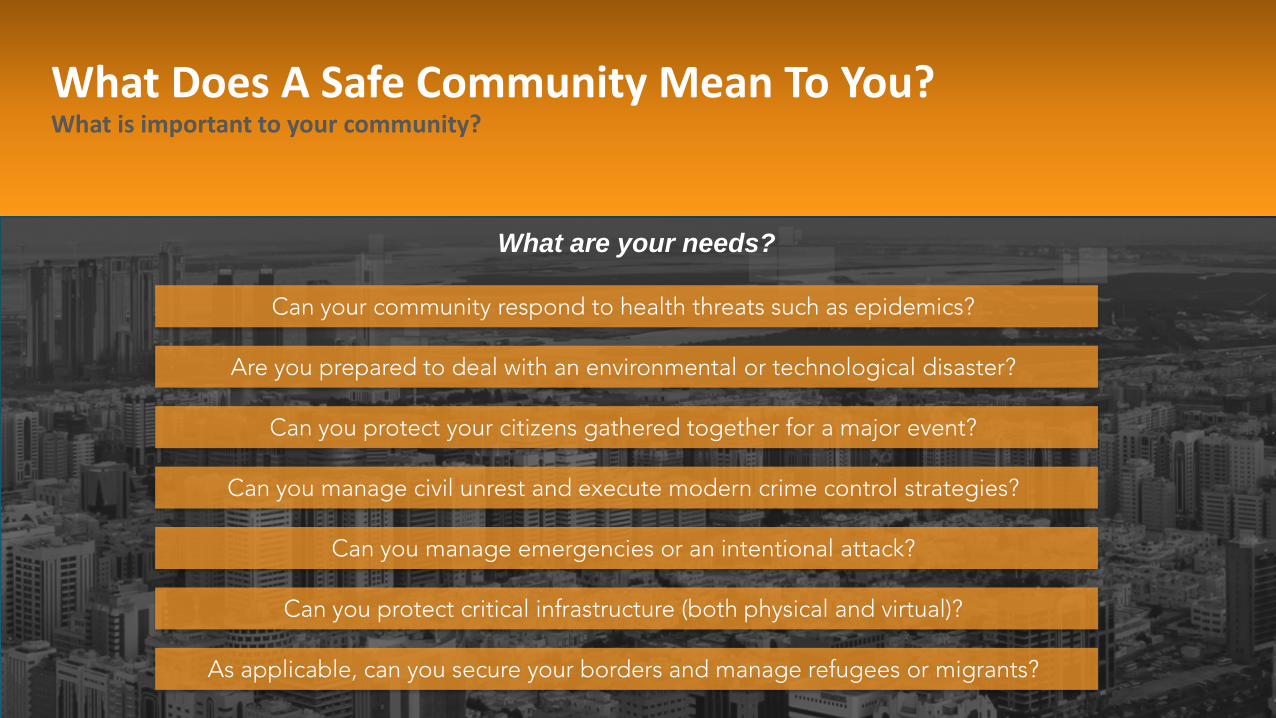
As applicable, can you secure your borders and manage refugees or migrants?
Can you protect critical infrastructure (both physical and virtual)?
Can you manage emergencies or an intentional attack?
Can your community respond to health threats such as epidemics?
Are you prepared to deal with an environmental or technological disaster?
Can you protect your citizens gathered together for a major event?
Can you manage civil unrest and execute modern crime control strategies?
What are your needs?
What Does A Safe Community Mean To You? What is important to your community?

Border Security and Migrant/Refugee Management
Physical and Virtual Critical Infrastructure Protection
Intentional attacks and Terrorism
Outbreaks, Epidemics, and other Public Health Emergencies
Environmental or Technological Disaster
Protection of Citizens During Major Events
Civil Unrest and Modern Crime Control Strategies
Location is a Critical Part of the need
Where is the migration path?
Where is the facility protection?
Where is the attack / threat?
How vast is the outbreak?
Where, what, and who is impacted?
Where are the crowds?
Where are they headed?
What Does A Safe Community Mean To You? What role does location play in each of these questions?
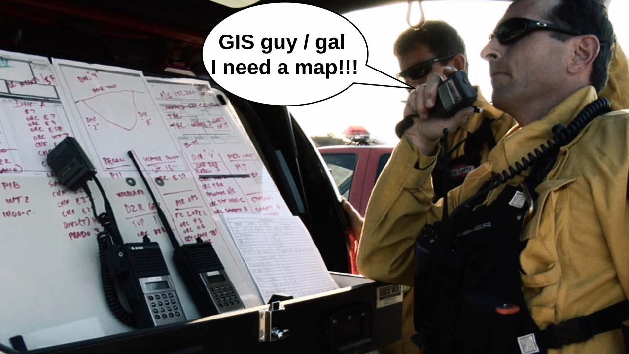
GIS guy / gal I need a map!!!


Photo Credit: Ryan Lanclos

Photo Credit: http://www.cgpgrey.com

Photo Credit: FFPM Peter Hanna Baltimore City Fire Department

Location Challenges Faced by First Responders
…I can’t wait for the GIS guy to come on duty to get the information I need…
…my limited communication tools are frustrating and sometimes endangering citizens, media and my own staff…
...my inability to visualize information is hurting my ability to make effective real-time decisions…
…my personnel are at risk because I can’t get information in and out of the field…
…I’m struggling to analyze my data to find operational improvements and cost savings….
…I know I need that information, but I don’t even think we are keeping it….
Insufficient Self-Service Mapping
No Mapping Capability for Communications
No Situational Awareness & Real-Time Mapping
Insufficient Mapping for Field Staff
No Spatial Analysis Capability
Ineffective Management of Location Data

Capabilities of a Location Strategy
Enable everyone with maps
Communicate with internal and external stakeholders
Support real-time decision-making & situational awareness
Get info in and out of the field
Analyze, predict, and improve performance
Collect, manage, and share asset and resource data

Desktop Web Device
Server Online Content and Services
Portal
Web Map
How? The ArcGIS Platform

Source Materials
Data from Esri
CSV
Spreadsheet
Basemaps
ArcGIS Desktop
Databases
Sensor & Real-Time Data
3D Data
Data from ArcGIS Online
How do I get data into a web map?

Source Materials
Web Map
Data from Esri
CSV
Spreadsheet
Basemaps
ArcGIS Desktop
Databases
Sensor & Real-Time Data
3D Data
• Analysis • Styling • Filter & Query • Pop-Ups • Notes • Security
Data from ArcGIS Online
What does a web map do?
Source Materials
Web Map
Apps
Data from Esri
Dashboards
Mobile Apps
Desktop Apps
Web Apps
CSV
Spreadsheet
Basemaps
ArcGIS Desktop
Databases
Sensor & Real-Time Data
3D Data
• Analysis • Styling • Filter & Query • Pop-Ups • Notes • Security
Data from ArcGIS Online
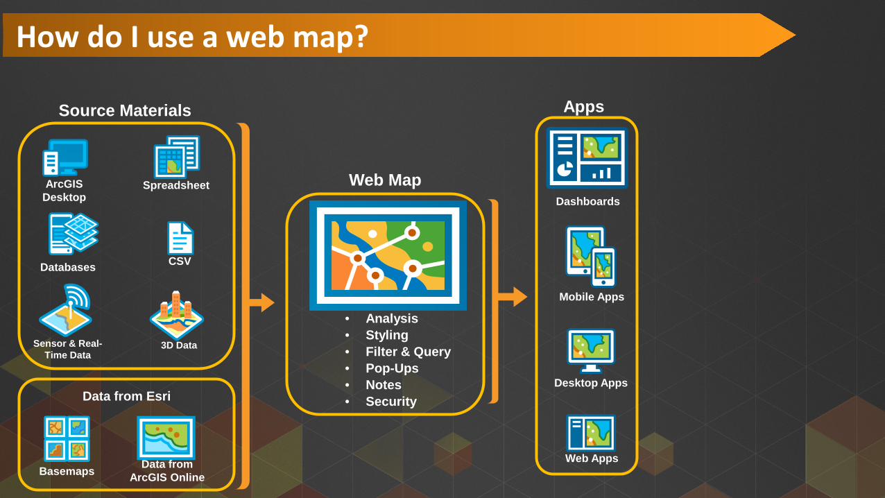
How do I use a web map?

Source Materials
Web Map
Apps Capabilities
Data from Esri
Dashboards
Mobile Apps
Desktop Apps
Web Apps
CSV
Spreadsheet
Basemaps
ArcGIS Desktop
Databases
Sensor & Real-Time Data
3D Data
• Analysis • Styling • Filter & Query • Pop-Ups • Notes • Security
Situational Awareness
Analytics Field Mobility
Data Management
Self Service
Stakeholder Communications
Data from ArcGIS Online
Why do I need different apps?

Location Enablement
Stakeholder Communication
Situational Awareness
Field Mobility
Analytics Data Management
Additional Solution Template Apps Are Available
Location Capabilities Needed By
First Responders
Solution Templates for: • Emergency Management • Law Enforcement • Health • Defense • Fire & Emergency Services
http://solutions.arcgis.com

Location Enablement
Situational Awareness
Field Mobility
Analytics Data Management
A Location Strategy Initial Operating Capability
• Collector for ArcGIS
• Operations Dashboard
• Story Maps
Location Capabilities Needed By
First Responders
ArcGIS App
Stakeholder Communication
