a lake management plan for elizabeth lake · pdf filea lake management plan for elizabeth lake...
TRANSCRIPT

A LAKEMANAGEMENT PLANFOR ELIZABETH LAKEAND LAKE MARY
KENOSHA COUNTYWISCONSIN
S O U T H E A S T E R N W I S C O N S I N R E G I O N A L P L A N N I N G C O M M I S S I O N
COMMUNITY ASSISTANCEPLANNING REPORT NO. 302
volume two
ALTERNATIVE AND
RECOMMENDED PLANS
A
A
A
A
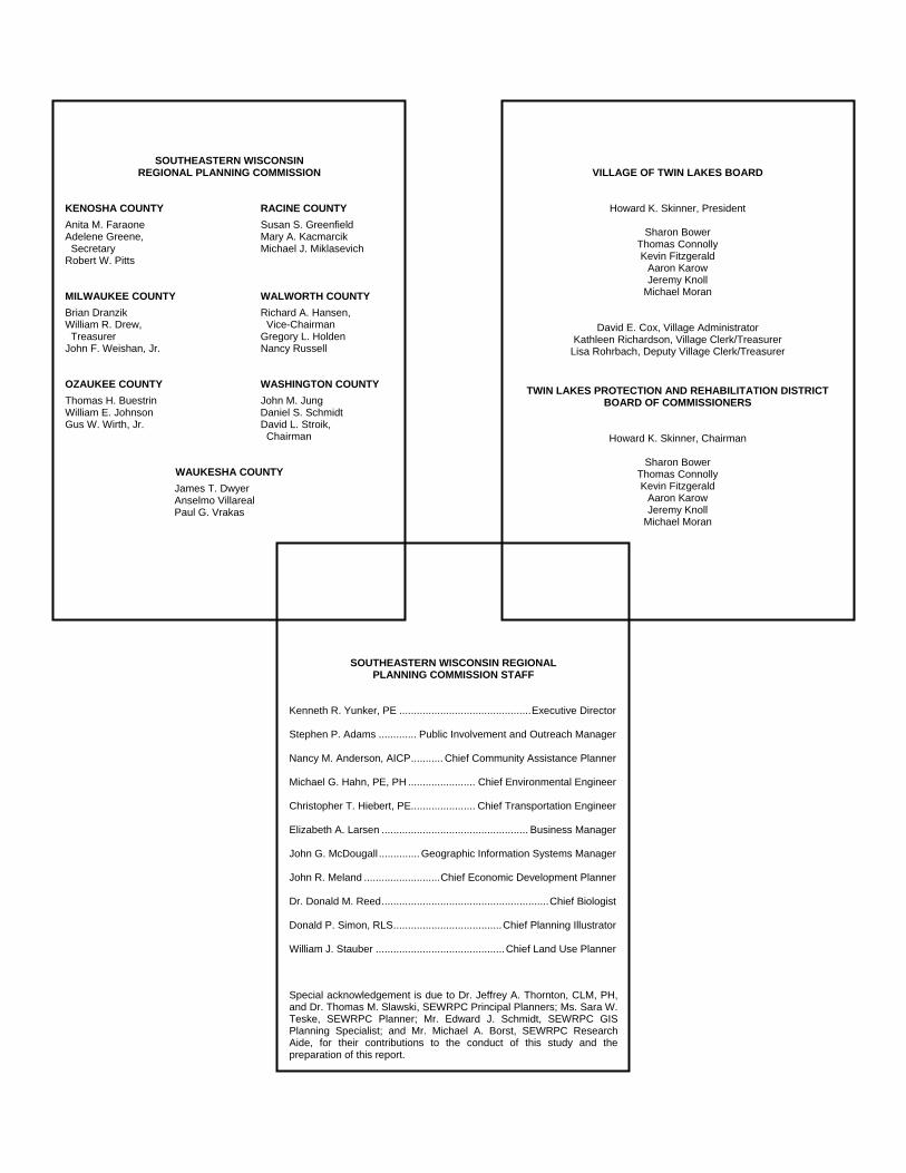
VILLAGE OF TWIN LAKES BOARD
Howard K. Skinner, President
Sharon Bower Thomas Connolly Kevin Fitzgerald
Aaron Karow Jeremy Knoll
Michael Moran
David E. Cox, Village Administrator Kathleen Richardson, Village Clerk/Treasurer
Lisa Rohrbach, Deputy Village Clerk/Treasurer
TWIN LAKES PROTECTION AND REHABILITATION DISTRICT BOARD OF COMMISSIONERS
Howard K. Skinner, Chairman
Sharon Bower Thomas Connolly Kevin Fitzgerald
Aaron Karow Jeremy Knoll
Michael Moran
SOUTHEASTERN WISCONSIN REGIONAL PLANNING COMMISSION
KENOSHA COUNTY RACINE COUNTY
Anita M. Faraone Susan S. Greenfield Adelene Greene, Mary A. Kacmarcik Secretary Michael J. Miklasevich Robert W. Pitts MILWAUKEE COUNTY WALWORTH COUNTY
Brian Dranzik Richard A. Hansen, William R. Drew, Vice-Chairman Treasurer Gregory L. Holden John F. Weishan, Jr. Nancy Russell OZAUKEE COUNTY WASHINGTON COUNTY
Thomas H. Buestrin John M. Jung William E. Johnson Daniel S. Schmidt Gus W. Wirth, Jr. David L. Stroik, Chairman
WAUKESHA COUNTY
James T. Dwyer Anselmo Villareal Paul G. Vrakas
SOUTHEASTERN WISCONSIN REGIONAL PLANNING COMMISSION STAFF
Kenneth R. Yunker, PE ............................................. Executive Director Stephen P. Adams ............. Public Involvement and Outreach Manager Nancy M. Anderson, AICP ........... Chief Community Assistance Planner Michael G. Hahn, PE, PH ....................... Chief Environmental Engineer Christopher T. Hiebert, PE...................... Chief Transportation Engineer Elizabeth A. Larsen .................................................. Business Manager John G. McDougall .............. Geographic Information Systems Manager John R. Meland .......................... Chief Economic Development Planner Dr. Donald M. Reed ......................................................... Chief Biologist Donald P. Simon, RLS ..................................... Chief Planning Illustrator William J. Stauber ............................................ Chief Land Use Planner
Special acknowledgement is due to Dr. Jeffrey A. Thornton, CLM, PH, and Dr. Thomas M. Slawski, SEWRPC Principal Planners; Ms. Sara W. Teske, SEWRPC Planner; Mr. Edward J. Schmidt, SEWRPC GIS Planning Specialist; and Mr. Michael A. Borst, SEWRPC Research Aide, for their contributions to the conduct of this study and the preparation of this report.

COMMUNITY ASSISTANCE PLANNING REPORT NUMBER 302
A LAKE MANAGEMENT PLAN FOR ELIZABETH LAKE AND LAKE MARY
KENOSHA COUNTY, WISCONSIN
Volume Two
ALTERNATIVE AND RECOMMENDED PLANS
Prepared by the
Southeastern Wisconsin Regional Planning Commission W239 N1812 Rockwood Drive
P.O. Box 1607 Waukesha, Wisconsin 53187-1607
www.sewrpc.org The preparation of this publication was financed in part through a grant from the Wisconsin Department of Natural Resources Lake Management Planning Grant Program.
July 2009
$20.00

This Page Intentionally Left Blank

iii
TABLE OF CONTENTS
Page
Chapter I—BACKGROUND AND SUMMARY OF INVENTORY FINDINGS ............................. 1
Introduction ......................................................... 1 Inventory and Analysis Findings ......................... 2
Physical Description ..................................... 2 Tributary Area ............................................... 2 Water Budget ................................................ 3 Population ..................................................... 3 Land Use and Zoning .................................... 3 Water Quality ................................................ 3 Pollutant Loadings ........................................ 4 Aquatic Plants ............................................... 4 Fishery .......................................................... 5 Natural Resource Base .................................. 5 Recreational Use ........................................... 5
Chapter II—ALTERNATIVE AND
RECOMMENDED WATER QUANTITY MANAGEMENT MEASURES FOR THE TWIN LAKES ................................................ 7
Introduction ......................................................... 7 Consideration of Lake Water Level Issues .......... 7 Structures that Control Lake Levels .................... 8 Past and Present Lake
Level Agreements, Policies, and Ordinances .................................. 8
1968 Dam Agreement ................................... 8 1983 Warranty Deed ..................................... 9 Dam Board Policy (1999) ............................. 9
General Policy Statement ....................... 9 Dam Board Installation
and Removal ....................................... 10 Designation of Official
Staff Gauges ........................................ 10 Board Operation during
the Recreational Season ...................... 10 2004 Slow-No-Wake Ordinance ................... 10 October 2008 Village “Dam
Management Policy” ................................. 11 Review of Available Lake Level Data ................ 11
Reporting of Lake Levels .............................. 12 Recommended Strategy for Future
Lake Level Data Collection ............................. 12 Legal Issues Related to Lake Levels ................... 13
Legal Issues in Wisconsin ............................. 13
Page
State Guidance Related to Dams, Water Levels, and Flow ....................... 13
Ordinary High Water Mark ..................... 16 Legal Issues in Illinois ................................... 16
Alternative Lake Levels and Operating Ranges ............................................. 17
Criteria of WDNR Chapter 130 ..................... 17 Public Rights Criterion b.:
Protecting Natural Resources and Criterion d.: Allowing Controlled Fluctuations for Resource Management ................... 18
Public Rights Criterion c.: Preserving Acceptable Conditions for Navigation ................... 19
Safety, Health, and Property Criterion a.: Minimizing Property Damage ................................. 20
Threats to Shore Protection Structures ...................................... 21
Summary Regarding Minimizing Property Damage........................... 21
Safety, Health, and Property Criterion f.: Minimizing Economic Loss .................................... 21
Summary of Proposals and Opinions Regarding the Optimal Range in Lake Levels ......................... 21
Recommended Lake Level Range ....................... 22 Possible Spillway Configurations .................. 22
Chapter III—ALTERNATIVE
AND RECOMMENDED LAKE WATER QUALITY MANAGEMENT MEASURES ..................... 25
Introduction .......................................................... 25 Land Use Management and Zoning ..................... 25
Development in the Tributary Area ............... 25 Alternatives ............................................. 25 Recommended Measures ........................ 26
Development in the Shoreland Zone ............. 26 Alternatives ............................................. 26 Recommended Measures ........................ 26
Stormwater Management on Development Sites ................................ 27
Alternatives ............................................. 27 Recommended Measures ........................ 27

iv
Page
Protection of Environmentally Significant Lands ....................................... 27
Alternatives ............................................ 27 Recommended Measures ........................ 28
Pollution Abatement ............................................ 28 Nonpoint Source Pollution Abatement ......... 29
Alternatives ............................................ 29 Recommended Measures ........................ 30
Rural Nonpoint Source Controls ...... 31 Urban Nonpoint Source Controls ..... 32 Development Area
Nonpoint Source Controls ............ 33 Public Sanitary Sewerage
System Management ................................. 34 Recommended Measures ........................ 34
Onsite Sewage Disposal System Management ................................. 34
Recommended Measures ........................ 35 Water Quality Monitoring ................................... 35
Alternatives ............................................ 35 Recommended Measures ........................ 36
Water Quality Improvement Measures................ 36 Alternatives ................................................... 36
Phosphorus Precipitation and Inactivation ................................... 36
Nutrient Load Reduction ........................ 36 Hydraulic and Hydrologic
Management for Water Quality and Habitat Improvement .................... 37
Drawdown ........................................ 37 Water Level Stabilization ................ 38 Dredging .......................................... 38
Recommended Measures .............................. 39 Fisheries Management ......................................... 40
Alternatives ................................................... 40 Monitoring .............................................. 40 Habitat Protection ................................... 40 Shoreline Protection ............................... 41 Modification of
Species Composition ........................... 42 Recommended Measures .............................. 42
Habitat Protection ................................... 42
Page
Shoreline Protection ................................ 42 Species Modification .............................. 44 Regulations and Public Information ....... 44
Aquatic Plant Management .................................. 45 Alternatives ................................................... 45
Aquatic Herbicides .................................. 45 Aquatic Plant Harvesting ........................ 46 Manual Harvesting .................................. 49 Biological Controls ................................. 50 Lake Bottom Covering ............................ 51 Public Informational Programming ........ 52
Recommended Measures ............................... 53 Recreational Use Management ............................ 54
Alternatives ................................................... 55 Recommended Measures ............................... 55
Public Informational and Educational Programming ................................ 55
Alternatives ................................................... 55 Recommended Measures ............................... 56
Institutional Development .................................... 56 Current Lake Management Structure ............ 56
Twin Lakes Protection and Rehabilitation District.......................... 57
Lakes and Recreation Association of Twin Lakes, Inc. .............................. 57
Recommended Measures ............................... 57 Chapter IV—RECOMMENDED
MANAGEMENT PLAN FOR THE TWIN LAKES ....................................... 59
Introduction .......................................................... 59 Recommended Lake Level Range ....................... 62 Land Use Management and Zoning ..................... 67 Pollution Abatement ............................................ 68 Water Quality Monitoring .................................... 69 Fisheries Management ......................................... 69 Aquatic Plant Management .................................. 70 Recreational Use Management ............................ 71 Public Informational and
Educational Programs ....................................... 71 Institutional Development .................................... 71 Plan Implementation and Costs ............................ 72
LIST OF APPENDICES
Appendix Page
A 1968 Dam Agreement between Valentine H. Christmann and the Village of Twin Lakes .............. 79 B 1983 Warranty Deed Conveying the Elizabeth Lake Dam to the Village of Twin Lakes ................ 85

v
Appendix Page
C 1999 Dam Board Policy ................................................................................................................... 91 D Village of Twin Lakes Boating Ordinance No. 2004-6-3 ................................................................ 95 E Village of Twin Lakes Dam Management Policy: October 2008 .................................................... 99 F Levels of Elizabeth Lake (1992-2008) and Lake Mary (1995-2008) ............................................... 103 G Nonpoint Source Pollution Control Measures .................................................................................. 139
Table G-1 Generalized Summary of Methods and Effectiveness of Nonpoint Source Water Pollution Abatement ......................................................... 140
Table G-2 Alternative Groups of Diffuse Source Water Pollution Control Measures Proposed for Streams and Lake Water Quality Management ..................................... 144
LIST OF TABLES Table Page
Chapter IV 1 Selected Characteristics of Alternative Lake Management Measures for Twin Lakes .................... 60 2 Recommended Management Plan Elements for Twin Lakes ........................................................... 64 3 Estimated Costs of Recommended Lake Management Measures for Twin Lakes .......................... 73
LIST OF FIGURES Figure Page
Chapter III 1 Recommended Alternatives for Shoreline Erosion Control ............................................................. 43 2 Plant Canopy Removal with An Aquatic Plant Harvester ................................................................ 49
LIST OF MAPS Map Page
Chapter II 1 Locations of Reference Bench Marks Recommended to Be Used for
Surveys Related to Lake Levels and to the Elizabeth Lake Dam and Spillway ............................... 14
Chapter IV 2 Recommended Lake Management Plan Elements for Twin Lakes .................................................. 63

This Page Intentionally Left Blank

Chapter I
BACKGROUND AND SUMMARY OF INVENTORY FINDINGS
INTRODUCTION
The Twin Lakes are comprised of two connected waterbodies, the upstream Lake Mary and Elizabeth Lake, both located within the civil division limits of the Village of Twin Lakes in Kenosha County. Lake Mary is a 297-acre waterbody located within U.S. Public Land Survey Sections 20, 21, and 28, Township 1 North, Range 19 East, Kenosha County. Elizabeth Lake is a 638-acre waterbody located within U.S. Public Land Survey Sections 28, 29, 32, and 33, Township 1 North, Range 19 East, Kenosha County; the southernmost extreme of the Lake extends into McHenry County, Illinois. Both Lakes are augmented by weirs which serve to maintain water levels in the Lakes; however, under most conditions, the spillway weir at the Elizabeth Lake outlet controls the levels of both Lakes. The total tributary area draining to the Lakes is about 8.1 square miles in areal extent, with about 2.25 square miles of the tributary area draining only to Lake Mary. While the tributary basin has historically encompassed large tracts of agricultural land, increasing portions of the tributary area are in urban land usage and the trend toward urban development remains ongoing. The Lakes provide a range of complementary recreational services to the lake-oriented neighborhoods and wider community within the Village of Twin Lakes, and are a popular destination for recreational users from both the Milwaukee and Chicago metroplexes. Continuing changes within the areas tributary to the Twin Lakes have created a range of current concerns among this lake-centered community, which include surface water use conflicts, siltation and sedimentation, especially of bays and adjacent to wetland areas, lake water levels, protection of environmentally valuable areas, and abundant aquatic plant growths in the shallower portions of the lake basins. In addition, present and future urban-density development within the areas tributary to the Lakes is perceived to have impacted the Lakes and their ecosystems, and remain a cause for concern within the community. Other issues raised by lake residents and users include concern over variable water quality conditions and potential contamination of lake waters by nonpoint source pollution, especially from stormwater runoff. These issues have been quantified to the extent possible and documented in the lake and tributary area inventory, comprising Volume One of this lake management plan for the Twin Lakes. Based upon these documented issues, identified in the aforementioned inventory, this volume sets forth alterna-tive and recommended management actions for the Lakes and their tributary areas. This plan represents an ongoing commitment of the Twin Lakes Protection and Rehabilitation District (TLPRD) and the Village of Twin Lakes to sound environmental planning with respect to the Lakes, and to the protection of their water quality and ecosystem integrity. This plan describes both tributary area management and in-lake management measures that may be applied to enhance the water quality conditions, biological communities, and recreational opportunities in the Lakes.

2
This plan is intended to provide the recommended means to achieve the following current water use objectives of the Twin Lakes:
1. Providing water quality suitable for full-body contact recreational use and the maintenance of a healthy fishery and other desirable forms of aquatic life;
2. Significantly reducing the severity of the nuisance problems associated with deposition of silt sediments, and excessive aquatic plant and algal growths which constrain or preclude intended water uses at sites throughout the Lakes;
3. Protecting and rehabilitating the aquatic flora and fauna;
4. Improving opportunities for both active and passive water-based recreation, navigation and human use; and
5. Maintaining and improving the hydrologic functioning of the Lakes to promote a healthy native flora and fauna and multiple human uses.
This plan should serve as a practical guide over time for achieving these objectives in a technically sound manner. INVENTORY AND ANALYSIS FINDINGS
Physical Description The Twin Lakes are comprised of two connected waterbodies: Lake Mary and Elizabeth Lake. Lake
Mary is a drained lake that flows into Elizabeth Lake through a narrow outlet over a low concrete weir; Elizabeth Lake is a through-flow lake with both a defined inflow, from Lake Mary and outflow which drains across a concrete dam to the Elizabeth Lake Drain, which flows into the North Branch of Nippersink Creek.
Lake bottom sediment types along the shoreline of Lake Mary consist of sand along about 32 percent of the shoreline, gravel and rubble along about 24 percent of the shoreline, and soft sediments along the remainder. In Elizabeth Lake, gravel is found along about 70 percent of the shoreline, sand along about 5 percent of the shoreline, and soft sediments along the remainder.
The shoreline of Lake Mary is more than 90 percent developed for residential uses; about 60 percent of Elizabeth Lake shoreline is similarly developed, with the balance being comprised of extensive stretches of wetlands.
The water levels of the Twin Lakes are influenced by local precipitation patterns, runoff conditions, and groundwater levels and rates of groundwater flow. Lake surface elevations in Lake Mary ranged from 793.2 feet above the National Geodetic Vertical Datum of 1929 (NGVD-29) to 795.1 feet NGVD-29. Lake surface elevations in Elizabeth Lake are maintained by a dam, which was reconstructed in 1984, and ranged between 793.0 and 795.1 feet NGVD-29.
Tributary Area Less than 1 percent of the total land area tributary to the Twin Lakes is covered by well-drained soils;
86 percent of the tributary area is covered by moderately drained soils; and poorly- or very-poorly drained soils cover the remaining 14 percent of the combined tributary area.
Nearly 45 percent of the lands within the total tributary area of the Twin Lakes are covered by soils categorized as having few limitations for onsite sewage disposal systems, which would suggest a limited likelihood of extensive nonpoint source pollution of the Lakes from land-based contaminant sources. Currently, all of the shorelands of the Twin Lakes are served by public sanitary sewer services operated by the Village of Twin Lakes.

3
Water Budget Long-term water budgets for the Twin Lakes were computed using U.S. Geological Survey (USGS)
data, as well as long-term climatic data from the National Weather Service (NWS) and the National Oceanic and Atmospheric Administration (NOAA). It is estimated that, annually, about 2,155 acre-feet of water enter Lake Mary, about 45 percent of which enters through direct precipitation onto the lake surface, 32 percent as the result of surface runoff, and about 23 percent through groundwater inflow. In Elizabeth Lake, about 6,414 acre-feet enter the Lake annually, of which about 45 percent enters as surface runoff, 28 percent enters as direct precipitation, about 17 percent enters as groundwater inflow, and about 10 percent enters as inflow from Lake Mary.
Of the inflows to Lake Mary, about 38 percent evaporates from the lake surface, 29 percent is discharged to Elizabeth Lake, and about 33 percent goes into groundwater recharge. In Elizabeth Lake, about 49 percent of the inflow leaves by way of evaporation, 20 percent is lost to groundwater recharge, and 31 percent flows out through the Elizabeth Lake Drain at the south end of the Lake.
Due to the relatively short hydraulic residence times of waters in the Twin Lakes—of less than two years—it would be expected that the Twin Lakes would allow nutrients and pollutants to be flushed from the Lakes fairly rapidly and the Lakes would, consequently, respond rapidly as nutrient inputs are altered.
Population The 2000 resident population in the area tributary to the Twin Lakes was estimated to be 7,182
persons. The population living within the tributary area within Wisconsin, estimated to be 3,774 persons, increased by about 23 percent over the 1990 population and by about four and one-half times the population living in the tributary area during 1963.
The 2000 resident population occupied approximately 2,599 dwelling units within the area tributary to the Twin Lakes. The 1,430 dwelling units reported from the tributary area within Wisconsin during 2000 represent an increase of about 30 percent over the number of households reported in 1990.
Land Use and Zoning As of 2000, approximately 1,646 acres, or about 22 percent of the tributary area to the Twin Lakes,
were in urban land uses, with the dominant urban land use being residential use, encompassing about 1,125 acres or about 68 percent of the urban land area in the watershed. Commercial, industrial, governmental and institutional, transportation, communications and utilities, and recreational lands comprised the balance of the urban lands.
As of 2000, approximately 5,878 acres, or about 78 percent of the tributary area to the Twin Lakes, were in rural land uses, with the dominant rural land use being agricultural, encompassing about 4,288 acres or about 57 percent of the rural lands in the tributary area. Woodlands, wetlands, surface water, and open lands comprised the largest portion of the balance of the rural lands.
Agricultural land uses are expected to continue to decline as urban-density residential and related development continues within the drainage area.
Water Quality Physical and chemical characteristics of the Twin Lakes have been measured as part of the Wisconsin
Department of Natural Resources (WDNR) Self-Help Monitoring Program periodically since 1987 and again from 1991 through 2006. These data continue to be collected under the auspices of the University of Wisconsin-Extension (UWEX) Citizen Lake Monitoring Network (CLMN). Additional data have been acquired through the WDNR Base Line Monitoring Program, between 1999 and 2006, and through the USGS Trophic State Index (TSI) monitoring program, between 1995 and 1997.

4
The Twin Lakes are dimictic, mixing completely twice per year during spring and fall, and exhibiting winter and summer stratification.
Water clarity in Lake Mary, measured as Secchi-disk transparency during the period from 1995 through 1997, averaged 13.1 feet in spring, 11.5 feet in summer, and 8.2 feet in fall; Secchi-disk readings for Elizabeth Lake during the same time period averaged 8.2 feet in spring, 9.5 feet in summer, and 8.2 feet in late summer. These values are higher than those reported from other lakes in the Southeastern Wisconsin Region, which typically have average water clarity measurements that are below that of other lakes statewide.
Chlorophyll-a concentrations in Lake Mary during the current study period ranged from 3.7 to 5.3 micrograms per liter (µg/l), with an average of 4.3 µg/l; in Elizabeth Lake, concentrations ranged from 4.6 to 5.8 µg/l, with an average of 5.4 µg/l. Concentrations above 10 µg/l generally result in a visible green coloration of the water, especially during spring when the maximum concentrations are recorded. The Twin Lakes measurements indicated good water quality.
Total phosphorus concentrations reported by the USGS during spring overturn of the current study period averaged about 0.011 milligrams per liter (mg/l) in Lake Mary and 0.014 mg/l in Elizabeth Lake. The seasonal gradients of phosphorus concentration in the Twin Lakes indicate that there may be internal loading of phosphorus from the bottom sediments of the Lakes.
Values for total phosphorus concentrations generally do not exceed the Southeastern Wisconsin Regional Planning Commission (SEWRPC)-recommended water quality guideline value of 0.020 mg/l for recreational use and maintenance of warmwater fish and aquatic life, indicating good water quality.
Data for mean annual phosphorus concentrations, chlorophyll-a concentrations, and Secchi-disk readings indicate that the Twin Lakes should be classified as oligo-mesotrophic waterbodies. Mesotrophic lakes, being moderately fertile, are capable of supporting abundant aquatic plant growth and productive fisheries; mesotrophic conditions are typical of inland lakes in the Southeastern Wisconsin Region. Oligotrophic lakes, being nutrient-poor, characteristically support relatively few aquatic plants and often do not contain very productive fisheries, but provide excellent opportunities for swimming, boating, and waterskiing.
Pollutant Loadings Nonpoint sources of phosphorus and sediments to the Twin Lakes were dominated by inputs from
rural, agricultural lands within the area tributary to the Lakes, which accounted for about one-half of the total phosphorus and sediment loads to the Lakes. Although agricultural land uses are a declining form of land use within the watersheds, it is anticipated that such land uses will remain the single largest contributor of sediments to the Lakes during the planning period, although the sources of the phosphorus loads to the Lakes under year 2035 land use conditions will shift to more urban sources.
Urban land uses generated inputs of nonpoint source metals, as well as more than one-tenth of the nonpoint source phosphorus loads under year 2000 land use conditions and more than one-quarter of the phosphorus loads under forecast year 2035 conditions.
Direct deposition of nutrients and particulates (sediment) onto the surfaces of Lake Mary and Elizabeth Lake accounted for the balance of the nonpoint source contaminant inputs to the Lakes.
Aquatic Plants The Twin Lakes support healthy and diverse aquatic macrophyte communities, albeit relatively
sparse, except in those portions of the lake basins having more of a wetland character. Over time, the dominant submerged macrophyte in the Twin Lakes has been muskgrass (Chara sp.).
5
Eurasian water milfoil (Myriophyllum spicatum) is found in both the Twin Lakes, but is more abundant in Elizabeth Lake.
Aquatic plant management in the Twin Lakes has historically been achieved through applications of chemical herbicides and manual control measures.
Fishery WDNR fisheries surveys suggest a relatively diverse fish population in the Lakes, with 17 species of
fishes being recorded. Largemouth bass, smallmouth bass, walleye, and northern pike were important gamefish. A wide range of panfish, the most dominant species being bluegill, was also present.
Stocking of smallmouth bass, walleye, and northern pike has taken place fairly regularly on Lake Mary since 1975 and on Elizabeth Lake since 1974.
Natural Resource Base In 1985, wildlife habitat covered about 927 acres, or 18 percent of the area tributary to the Twin
Lakes within Wisconsin. Of the current area of wildlife habitat, about 269 acres, or about 5 percent, of the area tributary to the Twin Lakes in Wisconsin were rated as high-value habitat capable of supporting a diverse population of wildlife, with adequate land area and appropriate vegetative cover for nesting, cover, and subsistence, and minimal levels of disturbance.
Wetlands covered about 3 percent of the area tributary to the Twin Lakes; woodlands covered about 4 percent of the area tributary to the Twin Lakes.
Within the immediate vicinity of the Twin Lakes, there are two specially designated natural areas and one area of critical species habitat recommended for protection in the adopted regional natural areas and critical species habitat protection and management plan;1 namely, the Elizabeth Lake Lowlands, the Twin Lakes themselves, and Hamilton Woods.
Primary environmental corridors, or contiguous lands containing the majority of the high-value woodlands, wetlands, and wildlife habitat and surface waters delineated by SEWRPC, comprised about 6 percent of the area tributary to the Twin Lakes.
Recreational Use As of 2008, there were three public recreational boating access sites on the Twin Lakes, providing
each of the Twin Lakes with adequate public recreational boating access, pursuant to Chapter NR 1 of the Wisconsin Administrative Code.
During September 2006, approximately 1,482 watercraft were observed to be docked, moored, or trailered on and around the Twin Lakes. Of these, about 467 were powerboats, about 346 craft were pontoon boats, about 89 were fishing boats, and 244 were personal watercraft. The balance was comprised of paddleboats, sailboats, rowboats, canoes, and similar nonmotorized watercraft. Lake Mary appears to be utilized more for power boating and associated uses such as water skiing; Elizabeth Lake tends to be utilized more by anglers.
In a recreational rating system developed by the WDNR to characterize the recreational value of inland lakes, Lake Mary received 62 out of a possible total of 72 points and Elizabeth Lake received a total of 70 out of a possible 72 points. These scores indicate that the Lakes provide: a wide range of
_____________ 1SEWRPC Planning Report No. 42, A Regional Natural Areas and Critical Species Habitat Protection and Management Plan for Southeastern Wisconsin, September 1997.

6
recreational opportunities, including angling; some areas of moderately good swimming substrate; boat launching sites supported by good water quality and adequate depth conditions for boating; and, aesthetic viewing opportunities.
Based upon these inventory findings, lake management actions appear warranted to maintain and preserve the aesthetic, recreational, and natural resource functions served by the Twin Lakes. Consequently, Chapter II of this volume presents an overview of alternative and recommended water quantity management measures from which feasible alternatives are identified, Chapter III presents an overview of alternative and recommended water quality management measures from which feasible alternatives are identified, and Chapter IV summarizes the recom-mended lake management plan.
7
Chapter II
ALTERNATIVE AND RECOMMENDED WATER QUANTITY MANAGEMENT MEASURES
FOR THE TWIN LAKES INTRODUCTION
Based upon a review of the inventories and analyses set forth in Chapters II through VI of Volume One of this report, two major groups of issues were identified requiring consideration in the formulation of alternative and recommended lake management measures. These issue groups are related to: 1) water quantity management primarily associated with the operations of the Elizabeth Lake dam, and 2) watershed and water quality management, including aquatic plant and fisheries management elements. The management measures associated with each of these major issue groups are enumerated and evaluated in Chapters II and III of Volume Two. In this Chapter, alternative measures to manage water surface elevations within Lake Mary and Elizabeth Lake are presented, focusing primarily on those measures which can be implemented by the Twin Lakes Protection and Rehabilitation District (TLPRD) and the Village of Twin Lakes. CONSIDERATION OF LAKE WATER LEVEL ISSUES
The water levels of Lake Mary and Elizabeth Lake influence many aspects of the Twin Lakes and affect both the human community and underlying ecosystem, including:
The potential for flooding of low-lying houses along the shore;
Use of piers;
The ecology of the Lakes, including the littoral zone, adjacent wetlands, and the fishery;
Recreational use of the Lakes for power boating, canoeing and kayaking, use of personal water craft, angling, and passive enjoyment; and
The stability of shorelines.
To some degree, these factors benefit from different lake level regimes and, thus, are sometimes in conflict. Even within general categories, there may be conflicting goals; for example, in the recreational category, power boating and use of personal watercraft would benefit from higher water levels, while canoeing and kayaking could be accomplished within a wider range of water levels and they would not necessarily be adversely affected by low water levels. Similarly, the use of piers could be constrained by either too high or too low water levels. The

8
stability of shorelines is another category that exhibits potential conflicts in that natural shorelines and shoreline protection measures would generally benefit from lower water levels during winter, which would result in reduced exposure to ice pressures. Conversely, in situations where the toes or foundations of revetments or seawalls are subjected to ice pressures as a result of a drawdown, such structures might be damaged by lower water levels during the winter. These same structures also could be adversely affected by an overwinter drawdown if there is significant groundwater pressure behind the structures; in this case, the removal of counter-acting water pressures from the lakeward side of the structures could compromise the structures. Consequently, water surface elevation management is an issue of concern. STRUCTURES THAT CONTROL LAKE LEVELS
The control structure, or dam, at the outlet of Elizabeth Lake is located in the Village of Richmond, Illinois, on land owned by the Village of Twin Lakes. Access to the dam is through land owned by the Richmond Hunting Club, Inc. The dam consists of sections of earthen embankment on either side of a concrete spillway. The concrete spill crest is 5.7 feet long (perpendicular to the direction of outflow from the lake). Lake levels are controlled by inserting or removing a 10-inch high metal “board” that slides into slots in the concrete spillway abutments. When the board is in place, it rests on the spillway crest. As-built drawings of the dam prepared in 1983 by Charles R. Skala, P.E., for a rehabilitation project, indicate that the elevation of the concrete crest is 792.68 feet above NGVD-29 and the top of the “board” is at elevation 793.51 feet above NGVD-29. Outflow from Elizabeth Lake, and under most conditions from Lake Mary, is controlled by this dam. The outlet structure for Lake Mary is a low concrete sill that is a remnant of a former boat ramp that has been largely removed. Elevations along the nonlevel crest were surveyed by the SEWRPC staff and found to range from 793.2 to 793.9 feet above NGVD-29. Thus, there is a relatively small difference in elevation between the Elizabeth Lake spillway with the “board” in place and the crest of the Lake Mary spillway. On some occasions, flow has actually been observed from Elizabeth Lake into Lake Mary. In general, during periods of higher lake levels the water surface of both Lakes is approximately equal and the Elizabeth Lake dam is the primary control on the level. PAST AND PRESENT LAKE LEVEL AGREEMENTS, POLICIES, AND ORDINANCES
1968 Dam Agreement A July 1, 1968, “Dam Agreement” between Valentine H. Christmann, the owner of the dam that impounded Elizabeth Lake at the time of the agreement, and the Village of Twin Lakes is the first known document that establishes operational parameters for the Elizabeth Lake spillway and the plank that could be inserted above the fixed spillway crest (see Appendix A). The Agreement granted the Village “the exclusive control, management, and operation of (the) dam for a period of ten (10) years, two (2) months, and ten (10) days, extending from July 1, 1968 to September 10, 1978” in exchange for an annual payment of $2,500 from the Village to Mr. Christmann. The Agreement notes that the elevation of the top of the 10-inch high plank that can be inserted to raise the lake level above the fixed, concrete crest of the dam spillway is “793.52 feet mean sea level,” and it states that that water level elevation “is sought to be maintained by the continued existence and operation of such dam and spillway.” The Agreement also gives the Village the “right and power to maintain the present plank and to replace the same if and when necessary so as to maintain the present existing level of Elizabeth Lake during the periods from May 1st to September 10th of each year; that from September 10th to the following May 1st the ten-inch plank … will be removed enabling the discharge of water directly over the concrete top surface of the spillway.” The Agreement granted the Village the option of extending the lease at the same terms for an additional five years. Such a lease extension would have been in effect from September 11, 1978 through September 10, 1983.
9
1983 Warranty Deed There is no known documentation of any extension of the 1968 lease agreement; however, the next known legal document related to the dam was executed near the end of the five-year extension period established in the “Dam Agreement.” That document is a July 19, 1983, “Warranty Deed,” that transferred ownership of the land on which the dam is located and two access easements from The Nature Conservancy to the Village of Twin Lakes (see Appendix B). The Deed establishes the condition that “the Village shall take no action which would raise the backwater height above 793.52 feet, mean sea level, which corresponds to the top of the 10” plank presently on the dam unless actions are required by law.” Dam Board Policy (1999) This policy, which is set forth in Appendix C, was apparently written by the Twin Lakes Protection and Rehabilitation District Lake Committees.1 This policy document includes: 1) a “general policy statement,” 2) recommendations that specific dates be established for installing and removing the 10-inch high board in the dam at the outlet to Elizabeth Lake, 3) a recommendation that official staff gauges be designated for determining lake levels, and 4) recommendations on the circumstances under which the board should be removed during the recreation season and the length of time that the board should be removed. Two copies of the “Dam Board Policy” were provided to the Commission staff. One was provided by Ms. Judy Jooss, the resident who reads and records the levels of Elizabeth Lake, and one was provided by Mr. Gerald Wrench, a resident who has been active in issues related to lake levels, both of whom formerly served on the Lake Committees and later the Lake Steering Council. The documents are identical except as follows. The version provided by Ms. Jooss was dated 1999 and included a July 8, 2000, “addendum” that stated:
“There has been a lot of confusion about who directs whom to place the dam board. Tom Porps2 and Judy Jooss today agreed that after consulting each other about lake level and weather conditions one of them would notify either Dorothy Sandona (village clerk) or David Cox (village administrator) to direct Public Works to remove or replace the board.”
The version provided by Mr. Wrench did not include the July 8, 2000, addendum or the 1999 date in the document title, but it did include a typewritten note that the policy was “approved 12-13-99.” The approving body was not specified, but it was presumably the Lake Committees. General Policy Statement The general policy statement noted that lake levels should not be established at a high level at the beginning of summer in an effort to offset the effects of a possible drought later in the summer. The statement also included an evaluation of the effects of water levels on shorelines and wetlands, indicating that:
Low water levels in winter lessen ice damage to shorelines,
_____________ 1The Lake Committees were established by the Board of Commissioners of the Twin Lakes Protection and Rehabilitation District, which is comprised of the Village of Twin Lakes trustees, as an advisory mechanism to facilitate public interaction with the Lake District Board of Commissioners. The Board of Commissioners of the Twin Lakes Protection and Rehabilitation District, however, retained decision-making authority pursuant to Chapter 33 of the Wisconsin Statutes. These Lake Committees later became united under the Lake Protection and Rehabilitation District Steering Council, which remained advisory to the Board of Commissioners of the Twin Lakes Protection and Rehabilitation District.
2Tom Porps is the resident who was recording the elevations of Lake Mary at the time that the “Dam Board Policy” was issued.

10
Low water levels do not damage wetlands,
High water levels cause erosion damage, especially when coupled with windy conditions,
High water levels create conditions during which islands of wetlands have been observed to break loose from the adjacent land and float into the Lake, creating a boating hazard.
Dam Board Installation and Removal The policy suggests that the Village of Twin Lakes Public Works Department install the dam board on May 1 and remove the board on September 15, annually, unless the Lake Committees decide otherwise. As noted, the Lake Committees were an advisory body to the Board of Commissioners of the Twin Lakes Protection and Rehabilitation District. Designation of Official Staff Gauges The policy suggests that the elevation reference points set by the U.S. Geological Survey (USGS) (one in the bed of Elizabeth Lake and one in the bed of Lake Mary) be the official gauges for determination of lake elevations. Board Operation during the Recreational Season In this section of the policy, it is stated that “[t]he Lake District Annual Meeting authorized Judy Jooss and Tom Porps to jointly determine when the board should be placed & removed.” Additionally, the policy called for:
Establishment of a maximum Elizabeth Lake level that would trigger a decision to remove the board, and an “opinion” is offered that the Elizabeth Lake level should not be allowed to rise “more than 6 inches above the surveyed sea level of the dam.” Based on the common usage of that terminology by those in the Lake community, it is assumed that the elevation referred to is the top of dam board at an elevation of 793.51 feet above NGVD-29, plus 0.5 foot, or a maximum elevation of 794.01 feet above NGVD-29.
Always lowering the lake level as determined from the USGS elevation reference mark by a minimum of three inches before the board is replaced.
Considering if weather conditions and forecasts warrant lowering the lake level by more than three inches.
In the event of a rapid rise in the lake level, resulting from intense rains, waiting a few days before removing the board to limit the impact on areas downstream of the Elizabeth Lake dam.
2004 Slow-No-Wake Ordinance A June 23, 2004, Village Ordinance No. 2004-6-3 (see Appendix D) requires that boats be operated at slow-no-wake speeds when the levels of Elizabeth Lake and/or Lake Mary exceed 11.5 inches above the top of the dam board. Thus, the slow-no-wake elevation could be established as an elevation of 793.51 feet above NGVD-29, plus 0.96 foot, or 794.47 feet above NGVD-29. A May 23, 2004 Emergency Board meeting of the Village of Twin Lakes Board of Trustees had previously adopted Village Ordinance No. 2004-5-3 which established the slow-no-wake elevation at nine inches above the top of the dam board. That depth above the board corresponds to a Lake elevation of 794.27 feet above NGVD-29. In any event, that interim slow-no-wake elevation was superseded by the June 23, 2004, Village ordinance. Plots of the lake level data collected by the resident monitors (Judy Jooss on Elizabeth Lake, and Tom Porps and Bruce and Reta Nagle on Lake Mary) indicate a “temporary no-wake” elevation of 794.325 feet above NGVD-29.

11
According to the Village Administrator, that no-wake elevation was incorrectly enforced from 2004 through July 2008. October 2008 Village “Dam Management Policy” On October 20, 2008, the Village Board, whose members also serve as the Twin Lakes Protection and Rehabilitation District Board of Commissioners, issued a dam management policy (see Appendix E). The purpose of the policy was to manage the dam that controls lake levels to assist in maintaining appropriate levels and to prevent implementation of slow-no-wake orders due to high lake water levels. The policies address the following:
Setting the slow-no-wake elevation at 794.5 feet above NGVD-29 (essentially the same as the current level),
Establishing which officials should direct the Village Department of Public Works to install or remove the dam board,
Establishing guidelines for removing and installing the dam board that are related to lake elevations in feet above NGVD-29, and
Assigning authority for taking lake level measurements to the Village Sewer Department, and specifying the frequency of those measurements.
REVIEW OF AVAILABLE LAKE LEVEL DATA
Lake level readings for both Elizabeth Lake and Lake Mary have been recorded by citizen volunteers since 1992 under the WDNR Self-Help Lake Monitoring Program. From 1992 to 1995, one staff gauge was installed each year at the Jooss residence (1154 Lucille Avenue) on Elizabeth Lake, and one at the Porps residence (280 W. Park Drive) on Lake Mary.3 In 1992, Judy Jooss and James Baxa, another area resident, performed a field survey to enable the staff gauges to be correlated with a common vertical datum, the National Geodetic Vertical Datum of 1929 (NGVD-29). Beginning in 1995, the U.S. Geological Survey (USGS) established a reference mark in the bed of each lake: one in Elizabeth Lake at the Jooss residence, and one in Lake Mary at the Porps residence. The USGS surveyed the elevations of those reference marks in feet above the NGVD-29, although the gauges themselves were marked in increments beginning at 0 feet. The citizen observers measured the lake levels in feet above the reference marks and added those measurements to the reference mark elevations to obtain Lake elevations in feet above the NGVD-29. Lake level plots for each year and for the entire 1992-2008 period for Elizabeth Lake and the entire 1995-2008 period for Lake Mary are set forth in Appendix F. Review of the data for Elizabeth Lake indicates that in the 17-year period for which data are available, the slow-no-wake elevation of 794.47 feet above NGVD-29, as specified in the 2004 Village ordinance, was exceeded in 1993 (for about one month), 2000 (for about three weeks), 2004 (for about 10 days), 2007 (for about five weeks), and 2008 (for about seven weeks). In recent years, the time period during which slow-no-wake conditions were enforced may differ from these estimated durations because, as noted previously, an incorrect slow-no-wake elevation of 794.325 feet above NGVD-29 was enforced for a time.
_____________ 3Beginning in June of 1995, the Lake Mary water level readings were taken by Bruce and Reta Nagle, using the reference mark in the lakebed at the Porps residence.

12
For the 1992-2008 period, for which data are available, the level of Elizabeth Lake has ranged from 793.0 feet above NGVD-29 to 795.2 feet above NGVD-29, and the level of Lake Mary has ranged from 793.3 feet above NGVD-29 to 795.2 feet above NGVD-29. Thus, lake levels have fluctuated over about a two-foot range. Reporting of Lake Levels As documented above, slow-no-wake levels that have been established in the past were stated in terms of a depth of water above the top of the dam board. As a result, the lake levels measured by the two citizen volunteers have often been characterized in that manner. Levels also have been reported as depths relative to the spillway crest at the Lake Mary outlet. As noted previously, a past application of the slow-no-wake depth to an incorrect elevation for the top of the dam board resulted in the imposition of slow-no-wake restrictions at lake levels lower than those intended by the Village ordinance. In addition, there have been several surveys conducted in attempts to ensure that the reference marks used to establish Lake elevations were correctly tied to NGVD-29. Recent surveys conducted for the Village were accomplished using global positioning system (GPS) technology. While such technology represents the state-of-the-art in surveying practice for establishing horizontal control, it is not considered to be sufficiently accurate for establishing vertical control, or for checking the accuracy of vertical bench marks established using traditional leveling techniques. In addition, some of the elevation reference marks used in those surveys were brass caps set in the ground. Such caps are not considered to be sufficiently accurate for use as bench marks because they are not stable and may be subject to vertical movement as a result of frost heaves and settling. SEWRPC staff performed field surveys in October and November 2008 for the purpose of checking the elevations of the USGS reference marks used by the two citizen volunteers to establish lake levels in NGVD-29. Those surveys verified that the elevations of those reference marks are within 0.1 foot of the elevations established by the USGS when the reference marks were established in 1995. RECOMMENDED STRATEGY FOR FUTURE LAKE LEVEL DATA COLLECTION
The following recommendations are made by the SEWRPC staff regarding the collection and reporting of lake level data:
The past practice of referring to depths above the top of the dam board should be discarded and all lake levels should be reported in feet above NGVD-29,4
Permanent lake level gauges should be established at the Elizabeth Lake boat launch and Lance Park. Each April, the elevations of those gauges should be surveyed in feet above the NGVD-29 by a land surveyor registered in the State of Wisconsin, using spirit level equipment appropriate for Second-Order, Class II leveling,
To facilitate the annual verification survey of the lake level gauges, reference bench marks should be established near each Lake gauge. The elevation of the reference bench mark at Lance Park should be established using Reference Bench Mark (RBM) UE, 29 C at the Village Hall and the elevation of the reference bench mark at the Elizabeth Lake boat launch location should be established using RBM
_____________ 4The Village of Twin Lakes implemented this recommendation during late-2008, while this plan was in draft form.
13
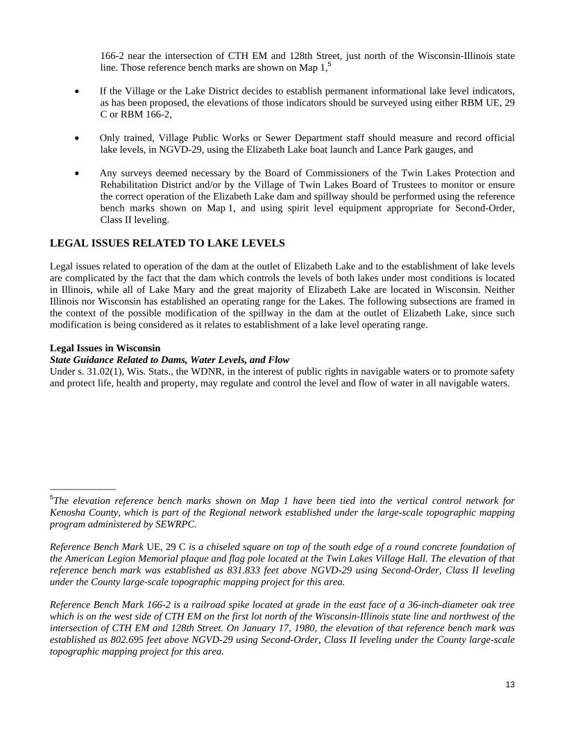
166-2 near the intersection of CTH EM and 128th Street, just north of the Wisconsin-Illinois state line. Those reference bench marks are shown on Map 1,5
If the Village or the Lake District decides to establish permanent informational lake level indicators, as has been proposed, the elevations of those indicators should be surveyed using either RBM UE, 29 C or RBM 166-2,
Only trained, Village Public Works or Sewer Department staff should measure and record official lake levels, in NGVD-29, using the Elizabeth Lake boat launch and Lance Park gauges, and
Any surveys deemed necessary by the Board of Commissioners of the Twin Lakes Protection and Rehabilitation District and/or by the Village of Twin Lakes Board of Trustees to monitor or ensure the correct operation of the Elizabeth Lake dam and spillway should be performed using the reference bench marks shown on Map 1, and using spirit level equipment appropriate for Second-Order, Class II leveling.
LEGAL ISSUES RELATED TO LAKE LEVELS
Legal issues related to operation of the dam at the outlet of Elizabeth Lake and to the establishment of lake levels are complicated by the fact that the dam which controls the levels of both lakes under most conditions is located in Illinois, while all of Lake Mary and the great majority of Elizabeth Lake are located in Wisconsin. Neither Illinois nor Wisconsin has established an operating range for the Lakes. The following subsections are framed in the context of the possible modification of the spillway in the dam at the outlet of Elizabeth Lake, since such modification is being considered as it relates to establishment of a lake level operating range. Legal Issues in Wisconsin State Guidance Related to Dams, Water Levels, and Flow Under s. 31.02(1), Wis. Stats., the WDNR, in the interest of public rights in navigable waters or to promote safety and protect life, health and property, may regulate and control the level and flow of water in all navigable waters.
_____________ 5The elevation reference bench marks shown on Map 1 have been tied into the vertical control network for Kenosha County, which is part of the Regional network established under the large-scale topographic mapping program administered by SEWRPC.
Reference Bench Mark UE, 29 C is a chiseled square on top of the south edge of a round concrete foundation of the American Legion Memorial plaque and flag pole located at the Twin Lakes Village Hall. The elevation of that reference bench mark was established as 831.833 feet above NGVD-29 using Second-Order, Class II leveling under the County large-scale topographic mapping project for this area.
Reference Bench Mark 166-2 is a railroad spike located at grade in the east face of a 36-inch-diameter oak tree which is on the west side of CTH EM on the first lot north of the Wisconsin-Illinois state line and northwest of the intersection of CTH EM and 128th Street. On January 17, 1980, the elevation of that reference bench mark was established as 802.695 feet above NGVD-29 using Second-Order, Class II leveling under the County large-scale topographic mapping project for this area.

15
While it appears that WDNR has authority to establish operating ranges for Elizabeth Lake and Lake Mary, the situation is complicated because the Elizabeth Lake Dam is located in Illinois. State of Illinois agencies and the U.S. Army Corps of Engineers Chicago District have the authority to regulate the dam rather than the WDNR. Because the dam is the primary control mechanism for water levels, the WDNR’s ability to regulate water levels for Elizabeth Lake and Lake Mary is limited. A proposal related to establishing legal operating ranges for the Lakes would have to be reviewed, evaluated, and approved under a coordinated, joint process involving the appropriate State of Illinois agencies, the U.S. Army Corps of Engineers Chicago District, and the WDNR, with Illinois agencies assuming a leading role in the process. Viewpoints from the dam owner and lake residents would also be given consideration. The situation is further complicated because jurisdiction by the State of Illinois over the Elizabeth Lake Dam is primarily directed toward satisfaction of dam safety criteria, rather than toward establishment of an operating range for lake levels. In considering an appropriate operating range for the Lakes, it is instructive to refer to Chapter 130, “Water Levels and Flow,” of the WDNR Waterway and Wetland Handbook (referred to as the “Handbook”). Chapter 31 of the Wisconsin Statutes empowers the WDNR to regulate and control the level of water and flow to protect public rights in navigable waters. Chapter 130 of the Handbook states that “[g]enerally it is in the interest of public rights to:
a. Maintain natural scenic beauty.
b. Protect natural resources such as fish and game habitat.
c. Preserve acceptable conditions for navigation and its incidents.
d. Allow controlled fluctuations in level for resource management.
e. Insure that stream flow is relatively undiminished in quantity or quality.
f. Maintain water quality standards by ordering flow release amounts or scheduling flow releases from dams.”
Chapter 31 of the Wisconsin Statutes also charges the WDNR with regulating and controlling level and flow in navigable waters “to promote safety and protecting life, health and property.” In this respect, Chapter 130 states that, under that standard, WDNR “may regulate and control water level and flow to:
a. Minimize damage to property resulting from flowing, erosion or ice action;
b. Prevent failure of a structurally inadequate dam;
c. Assure effective operation of on-site sewage disposal system;
d. Prevent pollution sources from contaminating a lake or impoundment;
e. Assure that a stream has sufficient flow to assimilate waste and maintain water quality standards;
f. Minimize economic losses resulting from too much or too little water;
g. Allow dam maintenance or inspection;
h. Minimize the possibility of exposing potentially contaminated or unsightly bottom materials or creating stagnant water areas or undesirable odors associated with decaying bottom material;

16
i. Insure that stream flow is relatively undiminished in quantity or quality.” (Same as Item e. in the preceding list related to public rights.)
Ordinary High Water Mark According to WDNR water regulation and zoning staff, an ordinary high water mark (OHWM) of 795 feet above NGVD-29 has been established for Lake Mary, but an official OHWM has not been surveyed for Elizabeth Lake. Determination of the location of the OHWM is the responsibility of the WDNR staff. One of the legal applications of the OHWM is for locating the extent of the shoreland zone under Chapter 30 of the Wisconsin Statutes. Legal Issues in Illinois Because outflow from Elizabeth Lake enters the Illinois stream called the “Elizabeth Lake Drain,” issues related to outflows from the Lake, and possible changes to the outflow regime of the Lake, were evaluated in the context of the relevant State of Illinois regulations. Illinois policies and regulations related to regulation of water levels and flows differ significantly from those in place in Wisconsin. Public waters in Illinois are defined and listed in Title 17, “Conservation,” of the Illinois Administrative Code, Chapter I: Department of Natural Resources, Subchapter h: Water Resources, Part 3704: Regulation of Public Waters. Based on the information in Part 3704, and on corroborating conversations with Illinois Department of Natural Resources (IDNR) staff, only those waterbodies that are specifically listed in Part 3704 are considered to be public waters under Illinois law. The waterbodies with such designation do not include many smaller streams, such as the Elizabeth Lake Drain. Based on review of pertinent portions of the Illinois Administrative Code, and discussion with IDNR staff, it was determined that Part 3702: Construction and Maintenance of Dams is the portion of the Code that is applicable to evaluation of Elizabeth Lake water level issues and outflows from the Lake to the Elizabeth Lake Drain. If the Village of Twin Lakes or the Twin Lakes Protection and Rehabilitation District were to reconstruct, or modify, the spillway of the dam at the outlet of Elizabeth Lake, such modification would have to be accomplished in compliance with the requirements of Part 3702. Also, as noted previously, the U.S. Army Corps of Engineers Chicago District has a regulatory role in reviewing and approving proposed modifications to the dam. The dam size and hazard classification determines the required spillway design flood that must be safely passed by the dam. Based on the size criteria set forth in Part 3702, the dam would be classified as being of intermediate size based on its estimated normal impounding capacity of 8,860 acre-feet (6,900 acre feet in Elizabeth Lake and 1,960 acre feet in Lake Mary).6 Based on review of aerial photographs of the lands along the Elizabeth Lake Drain downstream of the dam, and on the low height of the dam (approximately five feet or less), a preliminary conclusion can be made that the dam would be classified as a low hazard, or Class III, structure. As defined in Part 3702, a dam would be classified as “low hazard” if there is a low probability for loss of life and if minimal economic loss would be expected due to failure of the dam structure, regardless of the water level elevation of the pool impounded by the dam. Part 3702 requires that a Class III, intermediate size dam be designed to have a total spillway design capacity to safely store and pass the 100-year recurrence interval flood.
_____________ 6Part 3702 defines an intermediate size dam as one that has an impounding capacity (with the lake water surface at the top of the dam embankment) greater than 1,000 acre feet and less than 50,000 acre-feet. The dam at the outlet from Elizabeth Lake essentially impounds water in both Elizabeth and Mary Lakes, thus the impounding capacity of the dam is the total volume in both Lakes. Since the normal volume impounded by the dam falls in the lower end of the range for an intermediate size dam, the greater impounded volume with the water level at the top of the dam embankment (roughly one foot above the “normal” Lake level over the combined Lake area of about 950 acres) would be roughly 1,000 acre-feet greater than the “normal” volume, and would still fall within the intermediate size range.

17
If the Village or Lake District were to propose modification of the spillway, it would be necessary to perform detailed hydrologic and hydraulic analyses for design of the proposed spillway, according to State of Illinois standards, and it may be necessary to perform a dam failure evaluation or analysis, depending on specific requirements established by IDNR. According to the requirements of Section 3702.40(b)(7)(F), those analyses would also have to demonstrate “that, for floods up to the 100-year frequency flood, the pool elevation will not be increased above existing conditions.” Thus, that condition, along with the requirement to safely pass the 100-year flood outflow, establishes flow criteria for the dam spillway, notwithstanding the provisions of the afore-referenced 1968 Dam Agreement. Illinois Administrative Code Title 17, Part 3708: Floodway Construction in Northeastern Illinois, which includes McHenry County where the dam is located, sets forth certain flow requirements for designated public flood control projects (i.e., those that are “operated and maintained by a public agency to reduce flood damages to existing buildings and structures”). Public flood control projects are required to create no increase in “flood heights outside the project right-of-way or easements for all flood events up to and including the 100-year frequency event.” Since the Elizabeth Lake dam, and the Lakes themselves, are not part of a public flood control project as defined in the Code, modifications to the dam spillway would not be required to be designed to avoid downstream flow increases. In addition, according to IDNR staff (personal communication with William Boyd) maintaining or lowering lake levels would generally be positive from the standpoint of dam safety. ALTERNATIVE LAKE LEVELS AND OPERATING RANGES
The scope of work for this lake management planning program, as agreed to by the Twin Lakes Protection and Rehabilitation District, states that the lake level evaluation will include “[r]eview of available data on lake level variations in the Twin Lakes … to determine an appropriate level above or below which recreational uses of the Lakes are likely to be impaired. In particular, this review will seek to identify the level above which slow-no-wake restrictions would be implemented to minimize shoreland loss and flooding of shoreland properties. If necessary, this analysis will inform dam operating protocols and be communicated to the Village of Twin Lakes as a basis from which Village staff can draft refinements to the Village Code of Ordinances governing water-based recreational use of the Twin Lakes. To the extent necessary, these data also will inform refinements to the established operating levels of the weirs that augment the levels in both Lakes.” The evaluation presented in this report subsection was developed in that context. As noted previously, over the 1992-2008 period for which data are available, the level of Elizabeth Lake has ranged from 793.0 feet above NGVD-29 to 795.1 feet above NGVD-29, and the level of Lake Mary has ranged from 793.2 feet above NGVD-29 to 795.1 feet above NGVD-29. Thus, lake levels fluctuated over about a two-foot range. Lake District members and Village officials have expressed the desire that the range in fluctuation of lake levels be narrowed. That criterion guided the evaluation of lake levels set forth in this report, subject to legal, public safety, and natural resource constraints, as described below. Criteria of WDNR Chapter 130 A recommended lake level range was developed considering the State of Wisconsin criteria set forth in Chapter 130 of the WDNR Waterway and Wetland Handbook that were listed previously. Criteria are set forth relative to protecting public rights and relative to promoting safety and protecting life, health, and property. There are no similar criteria established within the State of Illinois, thus, the Wisconsin criteria are considered to be the best available to apply to the evaluation of lake levels. Of the public rights criteria, maintaining natural and scenic beauty, insuring that streamflow is relatively undiminished in quantity or quality, and maintaining water quality standards through flow releases (Criteria a., e., and f. listed previously) should each be met relatively equally for the range of lake level modifications anticipated. Thus, Criterion b., regarding protecting natural resources, Criterion c., related to preserving acceptable conditions for navigation, and Criterion d., concerning controlled fluctuations for resource management bear directly on the issue of modifying the operating range for lake levels.

18
Of the safety, health, and property criteria, Criterion b., which is related to preventing failure of a structurally inadequate dam, would be considered during any subsequent spillway modification design studies, but it would not be a direct consideration in setting a recommended operating range; Criterion c., related to onsite sewage disposal systems, and Criterion e., regarding sufficient flow to assimilate wastes, are not applicable because the Village is served by a sanitary sewerage system and a wastewater treatment plant that do not discharge to the Elizabeth Lake Drain; Criterion d., concerning pollution sources, is not directly applicable to the lake level issue; Criterion g., regarding dam maintenance and inspection, and Criterion h., related to exposure of bottom materials or creation of stagnant water areas, would both be satisfied under any operating range considered; and Criterion i., regarding undiminished streamflow should each be met relatively equally for the range of lake level modifications anticipated. Therefore, Criterion a., regarding minimizing property damage from flowing water, erosion, or ice and Criterion f., related to minimizing economic losses bear directly on the issue of modifying the operating range for lake levels. Public Rights Criterion b.: Protecting Natural Resources and Criterion d.: Allowing Controlled Fluctuations for Resource Management As shown on Map 18 in Volume One of this plan, there are substantial areas of wetlands located along the western shores of both Elizabeth Lake and Lake Mary. Those areas include the 48-acre Elizabeth Lake Lowlands, located just north of the Wisconsin-Illinois State line, that consist of sedge meadow, shallow marsh, and shrub-carr. That wetland extends along the shore of Elizabeth Lake into the McHenry County, Illinois, Conservation District’s State-designated Elizabeth Lake Nature Preserve, which is designated as being of statewide ecological significance. As stated in Chapter NR 103, “Water Quality Standards for Wetlands,” of the Wisconsin Administrative Code, wetlands have numerous beneficial functional values, including:
“(a) Storm and flood water storage and retention and the moderation of water level fluctuation extremes;
(b) Hydrologic functions including the maintenance of dry season streamflow, the discharge of groundwater to a wetland, the recharge of groundwater from a wetland to another area and the flow of groundwater through a wetland;
(c) Filtration or storage of sediments, nutrients or toxic substances that would otherwise adversely impact the quality of other waters of the state;
(d) Shoreline protection against erosion through the dissipation of wave energy and water velocity and anchoring of sediments;
(e) Habitat for aquatic organisms in the food web including, but not limited to fish, crustaceans, mollusks, insects, annelids, planktonic organisms and the plants and animals upon which these aquatic organisms feed and depend upon for their needs in all life stages;
(f) Habitat for resident and transient wildlife species, including mammals, birds, reptiles and amphibians for breeding, resting, nesting, escape cover, travel corridors and food; and
(g) Recreational, cultural, educational, scientific and natural scenic beauty values and uses.”
It is evident from this list that preservation of the wetlands adjacent to, and within the area tributary to, the Twin Lakes is an important factor in protecting the Lake ecosystem. Significant portions of those wetlands are located between elevations 794 and 796 feet above NGVD-29, while other large areas are at somewhat higher elevations between elevation 796 and 798 feet above NGVD-29. The wetlands are affected by lake levels in two ways: 1) the lake levels directly influence groundwater levels in the immediate vicinity of each Lake, and 2) periodic high lake levels would inundate the lower-lying portions of the wetlands. A general groundwater level regime has been established over time through the fluctuation in lake

19
levels over the range from about 793 to 795 feet above NGVD-29. Also, that range of lake levels resulted in periodic flooding of the lowest-lying wetland areas. Such fluctuations are desirable for maintenance of a healthy, diverse, native wetland plant community. The most important component of the lake level range as it relates to maintenance of wetlands is the lower range that occurs more frequently. During a telephone conversation with the SEWRPC staff during preparation of the plan, the McHenry County, Illinois, Conservation District staff indicated that the Conservation District would prefer that the water levels in the Elizabeth Lake Nature Preserve be maintained closer to historical conditions, which they characterize as lower, more-stable levels. That characterization is borne out by inspection of aerial photographs of the area from 1939 to the present, with the 1939 photos indicating more land area and a smaller Elizabeth Lake area in Illinois. In a February 24, 2009, letter to David Cox, the Twin Lakes Village Administrator, the McHenry County Conservation District provided additional comments on the plan. In that letter, the District staff noted that “the District owns and manages a sedge meadow on the east portion of the Lake Elizabeth Nature Preserve where a population of State Endangered Small Yellow Lady Slipper (Cypripedium parviflorum var. makasin) exists on the tops of tussock sedges. This species cannot tolerate high water levels and seems to flourish in lower water levels.” In their letter, the District also points out that their “records indicate that a level of 794.0 NGVD-29 level is the threshold for flooding of the bog in the northwest portion of the Lake Elizabeth Nature Preserve. … The bog and its associated (threatened and endangered) species cannot tolerate flooded conditions for long periods of time, therefore establishing a normal lake level range above 794.0 NGVD-29 would be unacceptable.” The McHenry County letter recommends “establish(ing) an operation range for Lake Elizabeth of levels between 793.5 and 794.0 NGVD-29.” Review of spring through fall long-term lake level data collected since 1995 indicate that lake levels have rarely fallen below elevation 793.5 feet above NGVD-29 and that they have, on average, not exceeded elevation 794.5 feet above NGVD-29. Thus, lake levels between 793.5 and 794.5 feet above NGVD-29 would be consistent with the wetland regime that has been established over time, and would, through the reduction in the higher range of water levels, at least partially meet the McHenry County Conservation District goal of achieving lower water levels overall. A one-foot lake level range between 793.5 feet above NGVD-29 and 794.5 feet above NGVD-29 represents an appreciable reduction in the 2.2-foot range over which lake levels have been observed to fluctuate over the long-term. Since Elizabeth Lake levels are required to be maintained at or above elevation 793.5 feet above NGVD-29 based on both the 1968 “Dam Agreement” and the 1983 “Warranty Deed,” and since observed Lake elevations have ranged up to 795.2 feet above NGVD-29 during the period from 1992 through 2008, establishing a lake level operating range between 793.5 and 794.5 feet above NGVD-29 will result in attainment of levels in the lower range of those experienced in the past 18 years. On balance, the proposed range would represent a significant improvement in the lake level regime as it relates to the issues raised by the Conservation District. During the January 28, 2009, joint meeting of the Lake Protection and Rehabilitation District Board of Commissioners and the Steering Council at which the SEWRPC staff presented the preliminary draft of this plan, Mr. Wrench noted that terns do not nest in the area along Elizabeth Lake near Mad Dan’s when the bogs are flooded above elevation 794.5 feet above NGVD-29. Based on that comment, lake levels between 793.5 and 794.5 feet above NGVD-29 would not hinder nesting by terns. Public Rights Criterion c.: Preserving Acceptable Conditions for Navigation Under normal conditions, no significant constraints on navigation within the Lakes by recreational boats and other watercraft were identified under this plan. However, during high water level periods, such as occurred in 1993, 2000, 2004, 2007, and 2008, slow-no-wake conditions were enforced by the Village, and recreational use of the Lakes was curtailed. Under slow-no-wake conditions, water skiing and the operation of personal watercraft (PWCs) are essentially prohibited, significantly reducing the recreational use of the Lakes. Another factor associated with high lake levels is compromised accessibility of piers, which also tends to limit recreational boating on the Lakes and which may also affect recreational uses of the Lakes in addition to water skiing and operation of personal watercraft since piers that are underwater may restrict access to fishing boats as well as ski boats. On July 23, 2008, when the levels of Elizabeth Lake and Lake Mary were at elevation 794.6 feet above NGVD-29, or 0.1 foot above the slow-no-wake elevation as set forth in the 2004 Village ordinance,

20
SEWRPC staff made a field reconnaissance to check the status of piers relative to the high lake levels. Of the 225 piers observed along Elizabeth Lake, about 25 percent were classified as “underwater,” which was defined as having the lake level at or very near the pier deck level; about 45 percent were classified as “threatened,” which was defined as having the lake level within three to six inches of the pier deck, and, therefore, being subject to deck flooding from wind-generated waves; and about 30 percent were classified as “OK,” which was defined as having decks well above the lake level. On that same date, of the 231 piers observed along Lake Mary, about 20 percent were classified as “underwater,” about 30 percent were classified as “threatened,” and about 50 percent were classified as “OK.” For both Lakes combined, of the 456 piers observed, about 25 percent were classified as “underwater,” about 35 percent were classified as “threatened,” and about 40 percent were classified as “OK.” An additional issue was identified regarding access by duck hunters to the southern wetland/Elizabeth Lake areas in McHenry County, Illinois, in the County’s Elizabeth Lake Nature Preserve. In contrast to the slow-no-wake and pier access issues, duck hunter access would generally be enhanced with higher lake levels. The water skiing and personal water craft usage and the pier access issue could all be adequately addressed by establishing a lake level below 794.5 feet above NGVD-29. Duck hunting access would be provided if the lake level was maintained at or above an elevation of 793.5 feet above NGVD-29. Thus, navigational/recreational/ access issues could be adequately addressed through maintenance of a lake level range from 793.5 to 794.5 feet above NGVD-29. Safety, Health, and Property Criterion a.: Minimizing Property Damage Two main potential sources of property damage were identified during the course of this study. The first, which could also impact personal safety, is potential flooding of low-lying, habitable structures along the Lakes. The second, and perhaps more extensive source of possible property damage, although one that would not directly impact personal safety, is damage to shore protection structures. Threats to Habitable Structures To assess the potential for damage to habitable structures, two-foot elevation contours, largely developed from digital terrain model (DTM) data obtained by SEWRPC and Kenosha County, were overlain onto year 2005 color, digital orthophotographs also obtained by SEWRPC and Kenosha County. Since lake levels in the approximately 17-year period for which data are available have reached a maximum elevation of 795.1 feet above NGVD-29, it was decided that identification of habitable structures at elevation 796 feet above NGVD-29, or lower, would adequately define the potential hazard from high lake levels.7 Twenty-four habitable structures were identified as being at or below elevation 796 feet above NGVD-29. Those structures are located along, or near, the western shores of Elizabeth Lake and Lake Mary and along Park Drive on the southern shore of Lake Mary. These structures represent a very small proportion of the hundreds of structures along, or near, the shorelines of the Lakes. An additional consideration regarding the potential for flood-related property damage and threats to safety is habitable structures located within the one-percent-annual-probability (100-year recurrence interval) floodplain as designated by the Federal Emergency Management Agency (FEMA). Based on the July 31, 2007, preliminary FEMA flood insurance study (FIS) for Kenosha County, the one-percent-probability elevation for Elizabeth Lake and Lake Mary is 795.1 feet above NGVD-29. That elevation is the same as that set forth in the December 1, 1981, FEMA FIS for the Village of Twin Lakes. It was determined that there is one habitable structure along the western shore of Elizabeth Lake and one along the western shore of Lake Mary that is in the one-percent-probability floodplain. Those structures also are included in the 24 habitable structures that were identified as being at, or below, elevation 796 feet above NGVD-29, noted above.
_____________ 7Wind-induced wave action at a time of high Lake levels could create a hazard at elevations above the Lake level.

21
High lake levels pose the greatest property-damage and safety threat at the two structures in the one-percent-probability floodplain, since those are the lowest structures along the Lake shorelines. At the other 22 structures at or below elevation 796 feet above NGVD-29, the threat would be greatest for twelve structures that are directly adjacent to one of the Lakes and that are most susceptible to the effects of wind-induced waves. The remaining 10 structures are buffered somewhat from the effects of waves because they are either located along a backwater area that would not be as directly affected by waves, are set back somewhat from the Lakes, or are separated from the Lakes by higher ground. Threats to Shore Protection Structures Damage to shore protection structures is another water level-related threat. An inventory of WDNR Chapter 30 permits for shore protection structures along the shorelines of the Twin Lakes was obtained. Those records indicate that from 1965 through August 2008, WDNR issued 188 permits for shore protection structures. Of that total, 77 were designated as being along the Lake Mary shoreline, 101 were located along Elizabeth Lake, and 10 were designated as “Twin Lakes.” The types of structures installed included: riprap, riprap with vegetated armoring, biological shore protection, seawalls, and replacement of seawalls with riprap. As noted previously, under current operating procedures for the dam at the Elizabeth Lake outlet, the 10-inch high board is removed in the fall and reinserted in the spring. This winter drawdown was instituted for two main reasons: 1) to create storage volume in the Lakes to accommodate snowmelt and spring rainfall, and 2) to reduce ice pressure that can damage shore protection structures. As noted previously, winter drawdown could reduce damage to shoreline protection structures, or, under certain conditions, could cause damage. Summary Regarding Minimizing Property Damage Threats to property and public safety could be addressed by establishing a lake level below 794.5 feet above NGVD-29 and by providing additional spillway capacity at the dam at the outlet from Elizabeth Lake. That could be accomplished through the addition of an auxiliary spillway, or through the replacement of the existing spillway with another one of a different configuration. However, it must be recognized that flood events exceeding an elevation of 794.5 feet above NGVD-29 or exceeding the one-percent-annual probability stage of 795.1 feet above NGVD-29, can occur. Thus, while the flooding threat can be reduced, it can never be completely eliminated. Modification of the spillway would have to be accomplished according to the requirements of Part 3704 of the Illinois Administrative Code and would also necessitate revision of the FEMA flood insurance studies for both Kenosha County, Wisconsin and McHenry County, Illinois. Safety, Health, and Property Criterion f.: Minimizing Economic Loss This criterion is directly related to the Public Rights Criterion c.: Preserving Acceptable Conditions for Navigation Safety, Health, and to the Property Criterion a.: Minimizing Property Damage. Establishing conditions conducive to the maintenance of the full range of boating activities on the Lakes, including enabling the “Aquanuts” water ski shows to be conducted during the summer season, enhances the local economy and minimizes potential economic losses associated with a loss of business at boating-related concerns. It also enhances the economic viability of other local businesses that indirectly benefit from water-based recreation on the Lakes. In addition, achieving lake levels that reduce potential flood-related damages and damages to shoreline protection structures would minimize economic losses to shoreland residents and property owners. The suggested establishment of a Lake operating range from 793.5 to 794.5 feet above NGVD-29 would contribute to minimizing economic loss. SUMMARY OF PROPOSALS AND OPINIONS REGARDING THE OPTIMAL RANGE IN LAKE LEVELS
In reviewing documents related to lake level issues, and during meetings with Village officials, Village staff, and current or former Steering Council members, SEWRPC staff assembled the following information on various preferred lake level ranges:

22
The 1999 “Dam Board Policy” (see Appendix C) which implies that the maximum lake level should be 794.0 feet above NGVD-29.
The October 2008 proposed Village “Dam Management Policy” which establishes lake level elevations of 793.8 and 794.1 feet above NGVD-29 as guidelines to be considered for dam board installation and removal, respectively.
The February 22, 2004, document written by Gerald Wrench, a former Steering Council member, for one of the Steering Council Committees indicates a target lake level range of between 793.5 and 794.5 feet above NGVD-29.
The notes from an August 19, 2008, meeting involving Mr. David Cox, the Village Administrator; Mr. Robert Livingston, the Chair of the Twin Lakes Steering Council; Mr. Gerald Wrench; and the SEWRPC staff, in which Mr. Livingston is reported to have said that, to accommodate all forms of recreational boating and to protect property, the optimal lake level range would be from 794.1 to 794.4 feet above NGVD-29.
The notes from a September 15, 2008, meeting involving Mr. Howard Skinner, the Village President; Mr. David Cox; Attorney Reince Priebus, the Village Attorney; and the SEWRPC staff, Mr. Skinner is reported to have stated that the optimal Lake operating range would be from 793.52 to 794.5 feet above NGVD-29.
RECOMMENDED LAKE LEVEL RANGE
Based on the evaluation presented in the preceding subsections, it is concluded that the criteria adopted for the lake level analysis can best be satisfied through maintenance of the lake levels between elevations 793.5 feet and 794.5 feet above NGVD-29, reducing the lake level range observed over the past 17 years from about two feet to about one foot. Slow-no-wake restrictions would not be imposed unless the lake levels exceeded elevation 794.5 feet above NGVD-29. Achievement of the recommended range cannot be guaranteed, but, it could generally be achieved with appropriate modifications to the spillway at the Elizabeth Lake dam. Because the highest lake levels have generally occurred during those periods when the dam board is out, attaining a lower “maximum” elevation would require the addition of an auxiliary spillway, or replacement of the existing spillway with another one of a different configuration. The 1968 “Dam Agreement” and the 1983 “Warranty Deed” (both described previously and set forth in Appendix A and Appendix B, respectively) require that a water level elevation of 793.52 feet above NGVD-29 be maintained. That stipulation must be considered in designing the spillway modifications needed to control outflows from Elizabeth Lake to meet the target operational range. Possible Spillway Configurations The February 22, 2004, Steering Council Committee document referred to previously included suggestions for modifying the Elizabeth Lake dam spillway to achieve a narrower range of lake levels than has been achieved with the current spillway and dam board operational regimes. The spillway proposal set forth in that document called for keeping the 10-inch-high board in place permanently in the principal spillway and for constructing an auxiliary spillway that would be “V-shaped” when viewed from the upstream or downstream perspective. It was proposed that the low point of the spillway crest be at an elevation of 794.0 feet above NGVD-29 and that the spillway crest slope from the center at an elevation of 794.0 feet to an elevation of 794.5 feet above NGVD-29 over a distance of 10 feet in both directions from the center, resulting in a total crest length of 20 feet. This spillway was presented as a concept that could provide the ability to pass more flow prior to the lake level reaching the elevation of the earthen embankment that is part of the dam. This proposal was not developed based on an engineering analysis. Under this concept, the total spillway discharge capacity would be increased over current conditions and lake levels would generally be held to a lower elevation during periods of higher flow. The spillway configuration was based on the objective of passing more flow within the elevation constraints
23
proposed in the February 2004 document (generally limiting lake levels to a range from 793.5 to 794.5 feet above NGVD-29). In 2008, Mr. Bruce Nagle, the citizen lake level monitor for Lake Mary, provided the SEWRPC staff with several alternative spillway configurations that would increase the discharge capacity of the Elizabeth Lake spillway and allow for a winter drawdown below an elevation of 793.5 feet above NGVD-29. These configurations also were not developed based on an engineering analysis. Each of these included a 10-inch-high removable board that would be at least as long as the existing board. Each configuration called for the provision of additional spillway discharge capacity by having the spillway crest slope away from the bottom or the top of each side of the board. Each of these proposals has merit, and the concepts that they set forth could be refined through engineering analysis to design a spillway that generally would enable the attainment of an operating range of between 793.5 feet and 794.5 feet above NGVD-29. Preliminary hydraulic calculations by the SEWRPC staff indicate that the “V-shaped” spillway proposal may not provide sufficient additional hydraulic capacity to reliably maintain an upper lake level of 794.5 feet above NGVD-29. Thus, if the Village decides to proceed with consideration of adding an auxiliary spillway, alternative configurations should be evaluated during the preliminary engineering phase. While the proposal to maintain a removable “dam board” has been met with some opposition because of past problems that are at least in part related to unauthorized manipulation of the board, and which stem from a lack of institutional control on spillway operations, the flexibility to intervene to provide some control over discharges from the spillway is important to reliably operate within the recommended target range of 793.5 feet to 794.5 feet above NGVD-29. An operable principal spillway that functions in a similar manner to the existing spillway, but which can be operated more easily by the Village could be designed. During certain flow conditions, it may be necessary to increase spillway capacity to avoid raising lake levels above 794.5 feet above NGVD-29. That operational flexibility could be maintained by utilizing a spillway “board” that can be removed under strictly prescribed conditions, or by redesigning the principal spillway to have a more-readily operable gate that would replace the board. Either the gate or the board should be secured so that only authorized Village of Twin Lakes Public Works personnel could operate them. Although not envisioned under the recommended operating regime with lake levels being maintained between elevations 793.5 feet and 794.5 feet above NGVD-29, maintenance of the existing board, or replacement with a gate, would offer the flexibility to lower lake levels below 793.5 feet above NGVD-29 if conditions warranted. That principal spillway should operate in conjunction with an auxiliary spillway, as suggested by Mr. Wrench and Mr. Nagle. If the Village decides to proceed with the addition of an auxiliary spillway, the precise configuration of the auxiliary spillway and possible improvements in the operation of the existing principal spillway should be determined by the Village Engineer through hydrologic and hydraulic analyses. These analyses should be conducted during the preliminary engineering and design phases. Dam and spillway modifications may require permits from both the IDNR and the Chicago District of the USCOE. Consistent with applicable State of Illinois regulations related to dam safety as described previously, and in keeping with sound engineering practice, the following issues should be addressed during the preliminary engineering and design phases:
The hazard and size classification of the Elizabeth Lake dam based on the criteria set forth in Illinois Administrative Code Title 17, Part 3702 should be verified. It is the understanding of the SEWRPC staff that the State of Illinois has not assigned a hazard classification to the dam; however, based on review of available information, it appears that the dam would be classified as an intermediate size, low hazard (Class III) structure.
Detailed hydrologic and hydraulic analyses for design of the proposed spillway should be prepared according to State of Illinois standards. It may be necessary to perform a dam failure evaluation or analysis, depending on specific requirements established by IDNR.
24
Adequate total spillway capacity should be provided to meet the criteria of Part 3702. Based upon the preliminary assessment of the dam as an intermediate size, low hazard structure, the total spillway capacity should be adequate to safely pass the 100-year flood outflow. It should be possible to meet that requirement through addition of an auxiliary spillway.
The spillway analyses should demonstrate “that, for floods up to the 100-year frequency flood, the pool elevation will not be increased above existing conditions,” in accordance with the requirements of Section 3702.40(b)(7)(F), Title 17, “Conservation,” of the Illinois Administrative Code, Chapter I: Department of Natural Resources, Subchapter h: Water Resources, Part 3704: Regulation of Public Waters.
If the operating range is narrowed as recommended, less of the available floodwater storage capacity of the Twin Lakes would be utilized, and flows released downstream could increase somewhat. Since the Elizabeth Lake dam, and the Lakes themselves, are not part of a public flood control project as defined in the Illinois Administrative Code, the spillway would not be required to be designed to avoid downstream flow increases. However, in consideration of downstream interests, the spillway design should minimize adverse downstream consequences related to flow increases. Downstream hydraulic structures along the Elizabeth Lake Drain, such as the road crossings on the Richmond Hunt Club, Inc. property and the STH 173 culvert, affect the water surface elevations along the Drain.8 High tailwater elevations on the downstream side of the Elizabeth Lake dam, resulting from the backwater effects of downstream hydraulic structures, coupled with the reduced hydraulic capacity of the downstream channel, could restrict the hydraulic capacity achievable at the Elizabeth Lake dam, even with the addition of an auxiliary spillway. Those effects also should be considered in the spillway analysis and design. As noted previously in this chapter, the McHenry County Conservation District asked that a narrower operating range be established under which Elizabeth Lake levels would vary between elevation 793.5 and 794.0 feet above NGVD-29. It is recommended that the likely frequency with which the lake levels would fall in that range be evaluated during the preliminary engineering phase of the spillway design project and that the Conservation District be provided with that information. In addition, the February 24, 2009 letter from the Conservation District asked that they be allowed to review future spillway options that may be considered by the Village of Twin Lakes and the Twin Lakes Protection and Rehabilitation District, with particular interest in how those spillway configurations relate to fish passage and maintenance of base flow in the Elizabeth Lake Drain downstream from the dam. Based on the SEWRPC staff’s assessment of likely spillway configurations to be considered, it does not appear that those configurations would adversely affect base flow or would promote fish passage from downstream to upstream. It is recommended that the Village and the Protection and Rehabilitation District consider base flow and fish passage during preliminary engineering for possible spillway modifications, and that they offer the Conservation District an opportunity to review conceptual spillway configurations.
_____________ 8On September 10, 2008, the U.S. Army Corps of Engineers Chicago District issued an order requiring that the Richmond Hunt Club, Inc. resolve a violation involving “the discharge of dredged or fill material into the waters of the United States.” The order relates to the unauthorized construction by the Hunt Club of a dam/water control structure and a road crossing in the Elizabeth Lake Drain downstream from the Elizabeth Lake dam. Based on file information provided by the USCOE and an April 27, 2009, telephone conversation with the USCOE regulatory staff, it is the understanding of the SEWRPC staff that the dam/water control structure has been removed, that a permit will be obtained for the roadway and associated culvert with the road, and that the culvert will be properly sized. Those actions should serve to reduce water levels in the Elizabeth Lake Drain downstream of the Elizabeth Lake dam.

25
Chapter III
ALTERNATIVE AND RECOMMENDED LAKE WATER QUALITY MANAGEMENT MEASURES
INTRODUCTION
Based upon a review of the inventories and analyses set forth in Chapters II through VI of Volume One of this report, two major groups of issues were identified requiring consideration in the formulation of alternative and recommended lake management measures. These issue groups are related to: 1) water quantity management primarily associated with the operations of the Elizabeth Lake dam, and 2) watershed and water quality management, including aquatic plant and fisheries management elements. The management measures associated with each of these major issue groups are enumerated and evaluated in Chapters II and III of Volume Two. In this Chapter, alternative measures to manage water quality in Lake Mary and Elizabeth Lake are presented. A watershed-based approach to water quality management forms the basis for the alternatives assessed. The water quality issues addressed include: 1) land use, runoff management, and pollution control, including stormwater and wastewater management measures; 2) in-lake water quality management; 3) management of aquatic biota; and, 4) management of human water uses, including recreational use management and informational programming measures. The management measures considered herein are focused primarily on those measures which are applicable to the Twin Lakes Protection and Rehabilitation District (TLPRD) and to the Village of Twin Lakes. LAND USE MANAGEMENT AND ZONING
A basic element of any water quality management effort for a lake is the promotion of sound land use development and management strategies in the tributary area. The type and location of future urban and rural land uses in the area tributary to the Twin Lakes will determine, to a large degree, the character, magnitude, and distribution of nonpoint sources of pollution; the location and nature of wastewater treatment facilities; the practicality of, as well as the need for, stormwater management practices; and, consequently, to some degree, the water quality of the waterbodies. Development in the Tributary Area Alternatives The level of development envisioned in the regional land use plan for the area tributary to the Twin Lakes includes continuing urban development, generally on large, suburban-density lots. Careful review of applicable zoning ordinances to incorporate levels and patterns of development consistent with the plan within the tributary area is considered a viable option for the management plan. Changes in the zoning ordinances could be considered to better reflect the land use patterns recommended in the regional land use plan. One feasible option would be giving consideration to minimizing the areal extent of development by providing specific provisions and incentives to cluster residential development on smaller lots, while preserving portions of the open space on each

26
property or group of properties considered for development, utilizing the principles of conservation development.1 In addition, periodic review of building codes and subdivision requirements to ensure best practices and review of development plans for consistency with applicable stormwater and wastewater management practices, as described below, are considered viable options. Recommended Measures It is recommended that the impact of future land use development on the Twin Lakes be minimized through review and modification of the applicable zoning ordinance regulations and zoning district maps to address the control of shoreland redevelopment, and the related intensification of use, if not specifically addressed in the existing zoning codes. Changes in zoning ordinances are recommended to minimize the areal extent of development by providing specific provisions and incentives for the clustering of residential development on smaller lots within conservation subdivisions, thus, preserving significant portions of the open space within each property or group of properties considered for development. In addition, periodic review of county and local government ordinances by Kenosha and Walworth Counties, the Villages of Twin Lakes and Genoa City, and the Towns of Randall and Bloomfield is recommended. Such review should be undertaken to ensure consistency with current nonpoint source pollution abatement practices, including stormwater management practices. Similar reviews by McHenry County, the Villages of Richmond and Spring Grove, and the Town of Burton in Illinois are to be encouraged, especially with respect to those lands that drain to Elizabeth Lake. Development in the Shoreland Zone Alternatives Existing 2000 and planned 2035 land use patterns, and existing zoning regulations in the area tributary to the Twin Lakes, have been described in Chapter II in Volume One of this report. If the recommendations set forth in the adopted regional land use plan are followed,2 under year 2035 conditions, some additional urban residential development within the area tributary to the Twin Lakes would occur. Much of this residential development is likely to occur on agricultural lands. Infilling of existing platted lots and some backlot development, as well as the redevelopment and reconstruction of existing single-family homes and commercial structures on lakefront properties, also may be expected to occur. Recent surveillance indicates that this type of development is currently occurring. Accordingly, given the potential impact of lakeshore development on the lake resources, land use development or redevelopment proposals around the shorelines of the Twin Lakes and within the area tributary to the waterbodies should be evaluated for potential impacts on the waterbodies, as such proposals are advanced. Recommended Measures Maintenance of the historic low- and medium-density residential character of the shorelines of the Twin Lakes to the maximum extent practical is recommended. It is further recommended that lakefront developments, as well as setback and landscaping provisions, be carefully reviewed by the Village of Twin Lakes. Such review would address specific shoreland zoning requirements, and could consider the stormwater and urban nonpoint source pollution abatement practices proposed to be included in shoreland development activities. Provision for shoreland buffers—such as those required pursuant to the Village of Twin Lakes Ordinance No. 2005-8-1, creating Chapter 17.38 of the Twin Lakes Code of Ordinances, that establishes shoreline setbacks and provides for vegetated shoreline buffer strips—along with use of appropriate and environmentally friendly landscaping practices and inclusion of stormwater management measures that provide water quality benefits, are practices to be encouraged.
_____________ 1See SEWRPC Planning Guide No. 7, Rural Cluster Development Guide, December 1996.
2SEWRPC Planning Report No. 48, A Regional Land Use Plan for Southeastern Wisconsin: 2035, June 2006; see also Mid-America Planning Services, Inc., Town of Randall and Village of Twin Lakes—Smart Growth Comprehensive Plan: 2005-2024, March 2005.

27
Stormwater Management on Development Sites Alternatives With respect to stormwater management on development sites, Kenosha County does not have specific erosion control and stormwater management ordinances, although such ordinances have been adopted by the Village of Twin Lakes. These ordinances reflect current best practices insofar as the determination of stormwater flows, mitigation of flooding potentials, and control of contaminants from land use activities are concerned. Periodic review of these ordinances and their provisions for consistency with best management practices, and to ensure their currency with the state-of-the-art, undertaken on a regular basis to facilitate control of urban-source contaminants that would likely be delivered to the Lakes, is considered a viable option. Where onsite detention/retention of stormwater is considered as a management practice, adoption of good shorescaping and shoreland management practices is considered a viable option.3 Any such practices should conform to the requirements of the NR 151 suite of stormwater management requirements, both for pre-development and post-development conditions; the Village of Twin Lakes stormwater management ordinance should be examined for consistency with the model ordinance set forth in Chapter NR 152 of the Wisconsin Administrative Code. It is recommended that Kenosha and Walworth Counties, the Towns of Randall and Bloomfield, and the Villages of Twin Lakes and Genoa City take an active role in promoting urban nonpoint source pollution abatement. Actions to promote urban nonpoint source pollution abatement would include the conduct of specific stormwater management planning within specific portions of the tributary area located within each municipality where further urban development or redevelopment is anticipated. Such a planning program should include a review of the stormwater management ordinances, to ensure that the ordinance provisions reflect state-of-the-art runoff and water quality management requirements, and to ensure that there is harmony between the ordinances governing urban-density development in each of the municipalities draining to the Twin Lakes. Adoption by all riparian municipalities of common stormwater management ordinance provisions is strongly recommended. Recommended Measures The Village of Twin Lakes currently holds an MS4 General Stormwater Permit issued by the Wisconsin Department of Natural Resources (WDNR)—Permit No. WI-S050075-1—in terms of which the Village undertakes an ongoing program of outreach and public involvement, discharge detection and elimination, and pollution prevention and control activities. Currently, this program is executed principally by the Village building inspector and Village engineer, in accordance with the provisions of the Village stormwater management plan.4 Projects impacting the Twin Lakes have been, and continue to be, supported in part by the Twin Lakes Protection and Rehabilitation District (TLPRD). These projects address specific stormwater conveyances discharging to the Lakes, amongst which the management of agricultural runoff and implementation of water quality improvement practices in the vicinity of Esch Road, draining to Elizabeth Lake, is a recent example. Periodic review of this plan and its accomplishments is recommended; annual reporting is required pursuant to the general permit requirements as set forth in Chapter NR 216 of the Wisconsin Administrative Code. Protection of Environmentally Significant Lands Alternatives Environmentally significant lands within the area tributary to Lake Mary and Elizabeth Lake include wetlands, woodlands, and wildlife habitat areas. Nearly all of these areas within the Twin Lakes tributary area are included in the environmental corridors and isolated natural resource features delineated by the Southeastern Wisconsin Regional Planning Commission (SEWRPC). Upland areas, woodlands, and wildlife habitat areas, currently, are protected primarily through local land use regulation, while wetlands enjoy a wider range of protections set forth in State and Federal legislation.
_____________ 3See University of Wisconsin-Extension, Publication No. GWQ045, Storm Water Basins: Using Natural Landscaping for Water Quality and Esthetics, 2005.
4Earth Tech, Inc., Stormwater Management Plan prepared for the Village of Twin Lakes, Wisconsin, January 2004.

28
Wetland protection can be accomplished through land use regulation and, in cases where land use regulations may not offer an adequate degree of protection, through public acquisition of sensitive sites. These wetland areas are currently protected to a degree by current zoning and regulatory programs administered by the U.S. Army Corps of Engineers, Wisconsin Department of Natural Resources (WDNR), and county and municipal authorities under one or more of the Federal, State, county, and local regulations. Some of the wetland, woodland, and wildlife habitat areas within the area tributary to the Twin Lakes have been recommended specifically for public acquisition in the adopted regional natural areas and critical species habitat management and protection plan.5 These lands include the 48 acres of the privately owned Elizabeth Lake Lowlands and the 18 acres of Hamilton Woods.6 Public acquisition of these lands by the WDNR in the case of Elizabeth Lake Lowlands, and by the Village of Twin Lakes in the case of Hamilton Woods, as recommended in the adopted regional natural areas and critical species habitat protection and management plan, is considered a viable option. Wetlands adjacent to lakes and streams help enhance water quality conditions, while preserving desirable open space characteristics for residents of the area to participate in a wide range of resource-oriented recreational activities, and to avoid the creation of new environmental and developmental problems as urbanization proceeds within the watershed. In parallel with such protection and preservation, the use of natural and native vegetation as shoreline protection is required pursuant to Chapter NR 328 of the Wisconsin Administrative Code as best practice along lake shorelines where such measures are feasible. Consequently, protection and enhancement of shoreland wetlands is recommended. Recommended Measures Nearly all wetland areas in the Twin Lakes tributary area are included in the environmental corridors delineated by the SEWRPC and protected under one or more of the existing Federal, State, county, and local regulations. Consistent and effective application of the provisions of these regulations is recommended. In addition, the implementation of the recommendations set forth in the adopted park and open space plan for Kenosha County,7 and adopted regional natural areas and critical species habitat protection and management plan,8 would complement the protection and preservation of these environmentally sensitive lands. POLLUTION ABATEMENT
All human activities upon the land surface result in some degree of mobilization of contaminants and modification of surface runoff patterns that can affect lakes and streams, their quality, and biotic conditions. Many human activities can be mitigated, to a large extent, by undertaking sound land use planning, appropriate nonpoint source pollution abatement measures, and individual action by an informed public. In the first instance, sound land use development and management in the tributary area, and protection of environmentally sensitive lands, are the fundamental building blocks for protecting lake and stream water quality and habitat, and preserving human use opportunities that will support a broadly based recreational and residential community. In addition, specific nonpoint source pollution control and abatement measures should be integrated into land use regulations and promoted by a far-reaching informational and educational program within the area tributary to individual lakes and streams.
_____________ 5SEWRPC Planning Report No. 42, A Regional Natural Areas and Critical Species Habitat Protection and Management Plan for Southeastern Wisconsin, September 1997.
6Ibid.
7SEWRPC Community Assistance Planning Report No. 131, A Park and Open Space Plan for Kenosha County, Wisconsin, November 1987.
8SEWRPC Planning Report No. 42, op. cit.

29
Nonpoint Source Pollution Abatement Alternatives Recent studies of the potential impact of riparian landscaping activities on nutrient loadings to lakes in southeastern Wisconsin have suggested that urban residential lands can contribute up to twice the mass of phosphorus to a lake when subjected to an active program of urban lawn care than similar lands managed in a more natural fashion.9 The application of agrochemicals to such lands, in excess of the plant requirements, therefore, results in enhanced nutrient loading directly to the adjacent waterbodies. To address these concerns, some communities, such as the portion of the Town of West Bend served by the Big Cedar Lake Protection and Rehabilitation District, have purchased bulk lots of phosphorus-free lawn and garden fertilizers for resale to riparian landowners. Alternatively, a number of communities have enacted turf management or fertilizer control ordinances. To this end, the State of Wisconsin has promulgated guidance for turf nutrient management targeted at residential lands, parks, and high use areas, such as golf courses and parks.10 Other communities have relied on informational programs to encourage landowners to reduce the use of phosphorus fertilizers in southeastern Wisconsin. In the case of the Twin Lakes, the Village of Twin Lakes has enacted a ban on the use of phosphate-containing fertilizers in residential areas. Further, the Village of Twin Lakes, like other communities within the Region, has adopted shoreline management guidelines and ordinances that encourage or require the use of vegetative shoreland buffers to intercept runoff and associated contaminant loads generated in the immediate lakeshore area. Such actions limit the mass of nutrients entering waterways from the land surface, and mitigate the negative consequences of excessive nutrient inputs to aquatic ecosystems, including consequences, such as excessive aquatic plant and algal growths. In addition to urban residential areas, commercial, industrial, and recreational lands can be major sources of phosphorus-rich runoff due to their use of agrochemicals. While the State turf management guidance recognizes the need for use of fertilizers in high-traffic areas, such as public parks and golf courses, the guidance recommends that such applications be targeted to the high-traffic areas and not generally applied throughout the recreational sites.11 Within the area tributary to the Twin Lakes, agricultural lands remain an important land use. As a consequence of nutrient export in the form of agricultural produce, agricultural operations need to replace these nutrients and engage in other agrochemical-based practices to ensure crop quality and production levels. This need underlies the fact that agriculture remains the single largest source of nutrients to the Lakes. Nevertheless, the widespread adoption of integrated nutrient and pest management practices within the industry as a consequence of nonpoint source pollution abatement programs implemented by the U.S. Department of Agriculture (USDA) and Wisconsin Department of Agriculture, Trade and Consumer Protection (WDATCP), among others, has contributed to improved agrochemical management within the agricultural industry. In the Fox River watershed, these practices have been promoted by WDATCP, the WDNR, county land and water conservation departments, and University of Wisconsin-Extension (UWEX). Tributary area management measures may be used to minimize nonpoint source pollutant loadings from the watershed by locating development within a tributary basin in accordance with sound planning principles and practices. Beyond such actions, specific interventions may be required to control the mass of contaminants, generated by various types of land use activity, which are transported to the Lakes. Rural sources of contaminants arise as pollutants transported by runoff from cropland and pastureland; urban sources include contaminants transported by runoff from residential, commercial, industrial, transportation, and recreational land uses, and from
_____________ 9U.S. Geological Survey Water-Resources Investigations Report No. 02-4130, Effects of Lawn Fertilizer on Nutrient Concentration in Runoff from Lakeshore Lawns, Lauderdale Lakes, Wisconsin, July 2002.
10Wisconsin Department of Natural Resources, Technical Standard No. 1100, Turf Nutrient Management, 2006.
11Ibid.

30
construction activities. Alternative, tributary area-based nonpoint source pollution control measures considered in this report are based upon the recommendations set forth in the regional water quality management plan12 and in the Kenosha County land and water resource management plan.13 The regional water quality management plan recommended that the nonpoint source pollutant loadings from the areas tributary to the Twin Lakes be reduced by up to 25 percent in urban areas and by up to 25 percent in rural areas, in addition to implementation of urban construction erosion controls and streambank erosion controls. Onsite sewage disposal system management practices also are recommended where appropriate and applicable. In this regard, it is noted that the Village of Twin Lakes is served by a public sanitary sewerage system. As set forth in Chapter IV in Volume One of this report, the most readily controllable loadings are associated primarily with runoff from urban lands within the area tributary to the Lakes and from urbanizing lands throughout the tributary area that are linked to the Lakes by way of streams and stormwater drainage systems. These loadings constituted about 40 percent of the total phosphorus and about 10 percent of the sediment loadings to Lake Mary, about 26 percent of the total phosphorus and about 3 percent of the sediment loadings to Elizabeth Lake, and 100 percent of the heavy metals loadings to both of the Twin Lakes, based upon 2000 land uses. Phosphorus loadings from the remainder of the tributary area, and from direct deposition onto the lake surfaces, contributed the balance of the total loadings. The contributions of phosphorus, sediment, and heavy metals from urban lands are expected to increase as agricultural lands are progressively converted to urban uses. In the case of the annual phosphorus loads to the Lakes, urban land uses are forecast to contribute more than one-half of the total annual loads under year 2035 land use conditions. Urban lands will remain the source of the annual heavy metal loadings to the Lakes. While some proportion of these contaminant loads may be attenuated as a consequence of the extensive wetland areas, the ability of these wetlands to assimilate pollutants is wholly dependent upon the maintenance of their structure and function within their ecosystems. These features can be overwhelmed by inappropriate land uses that result in the degradation of the wetlands, diminishing their ability to capture contaminants, or creating contaminant loads of such magnitude that the wetlands are overloaded. Thus, the control of nonpoint sources of water pollution at their sources is an important consideration. Properly applied, such controls can reduce the pollutant loadings to a lake by about 25 percent or more. Appendix G presents a list of alternative nonpoint source pollution management measures that could be considered for use in the Twin Lakes area to reduce loadings from nonpoint sources of pollution. Information on the cost and effectiveness of the measures is also presented in Appendix G. It should be noted that appropriate public informational programming, described below, provides a means of disseminating information on various nonpoint source control measures that can be targeted to specific sectors of the community. Many of the measures are low-cost or no-cost measures that can be implemented by individual landowners. Selected measures are discussed below. Recommended Measures Nonpoint source pollution abatement controls in the tributary area are recommended to be achieved through a combination of rural agricultural nonpoint controls, urban stormwater management, and construction erosion controls. The implementation of the land management practices described below may be expected to result in a _____________ 12SEWRPC Planning Report No. 30, A Regional Water Quality Management Plan for Southeastern Wisconsin: 2000, Volume One, Inventory Findings, September 1978; Volume Two, Alternative Plans, February 1979; and Volume Three, Recommended Plan, June 1979; SEWRPC Memorandum Report No. 93, A Regional Water Quality Management Plan for Southeastern Wisconsin: An Update and Status Report, March 1995.
13SEWRPC Community Assistance Planning Report No. 255, A Land and Water Resource Management Plan for Kenosha County: 2000-2004, September 2000.

31
reduction in nonpoint source pollutants that is considered to be the maximum practicable given the findings of the inventories and analyses compiled during the planning effort. These measures are consistent with the recommended measures set forth in the Kenosha County land and water resource management plan.14 Rural Nonpoint Source Controls Upland erosion from agricultural and other rural lands is a contributor of sediment to streams and lakes. Estimated phosphorus and sediment loadings from croplands, woodlots, pastures, and grasslands in the area tributary to the Twin Lakes were presented in Chapter IV in Volume One of this report. These data were utilized in determining the pollutant load reduction that could be achieved, the types of practices needed, and the extent of the areas to which the practices need to be applied within the area tributary to the Twin Lakes. Based upon the pollutant loading analysis set forth in Chapter IV in Volume One of this report, a total annual phosphorus load of 315 pounds is estimated to be contributed to Lake Mary and 816 pounds to Elizabeth Lake. Of the mass of phosphorus entering Lake Mary, it is estimated that 172 pounds per year, or about 55 percent of the total loading, were contributed by runoff from rural land. In addition, it is estimated that about 138 tons of sediment, or about 74 percent of the total annual sediment load to Lake Mary, were contributed by agricultural lands in the tributary area. As of 2000, such lands comprised about 614 acres, or about 40 percent of the area tributary to Lake Mary. By 2035, these areas are expected to diminish to about 170 acres, or about 10 percent, of the area tributary to the Lake. Of the mass of phosphorus entering Elizabeth Lake, it is estimated that 543 pounds per year, or about 66 percent of the total loading, were contributed by runoff from rural land. In addition, it is estimated that 427 tons of sediment, or about 85 percent of the total annual sediment load to Elizabeth Lake, were contributed by agricultural lands in the tributary area. As of 2000, such lands comprised about 1,900 acres, or about 50 percent of the area tributary to Lake Elizabeth. By 2035, these areas are expected to diminish to about 1,150 acres, or about 30 percent, of the area tributary to the Lake. While agricultural land uses are anticipated to be a declining form of land use within the area tributary to the Twin Lakes, the agricultural operations that remain within the tributary area will continue to contribute a significant proportion of the sediment load to the waterbody. Tables 14 through 17 in Volume One, Chapter IV, of this report suggests that, based upon estimated contaminant loadings, agricultural land uses will continue to contribute 40 percent of the total sediment load, or about 40 tons of sediment annually, to Lake Mary, and 60 percent of the total sediment load, or about 260 tons of sediment annually, to Elizabeth Lake. Thus, detailed farm conservation plans are likely to continue to be required to adapt and refine erosion control and nutrient and pest management practices for individual farm units. Generally prepared with the assistance of staff from the USDA Natural Resources Conservation Service (NRCS) or County Land Conservation Departments, such plans identify desirable tillage practices, cropping patterns, and rotation cycles. The plans also consider the specific topography, hydrology, and soil characteristics of the farm; identify the specific resources of the farm operator; and articulate the operator objectives of the owners and managers of the land. It is recommended that the Towns of Bloomfield and Randall, in coordination with the WDNR and Kenosha and Walworth Counties, develop a strategy to address nonpoint source pollution primarily from agricultural activities within the drainage area in Wisconsin. In addition, it is recommended consideration be given to cropping patterns and crop rotation cycles, with attention to the specific topography, hydrology, and soil characteristics for each farm. A reduction of about 25 percent in the nonpoint source loading from rural lands could provide up to about a 20 percent reduction in total phosphorus loading to Lake Mary and up to about a 22 percent reduction in total phosphorus loading to Elizabeth Lake under current land use conditions. Implementation of the recommendations and work planning activities set forth in the Kenosha County land and water resource management plan would constitute a major step toward implementation of these lake management recommendations. In Wisconsin, the _____________ 14SEWRPC Community Assistance Planning Report No. 255, op. cit.

32
cost of the needed measures will vary depending upon the details of the recommended farm conservation plans, for which efforts, as promulgated in Chapters NR 153 and NR 154 of the Wisconsin Administrative Code, cost-share funding may be available to encourage installation of appropriate land management measures. In Illinois, it is recommended that the Illinois Department of Natural Resources (IDNR), Illinois Environmental Protection Agency (IEPA), McHenry County, and the Town of Burton develop a parallel strategy to address nonpoint source pollution primarily from agricultural activities within the drainage area tributary to Elizabeth Lake. Urban Nonpoint Source Controls As of 2000, established urban land uses comprised about 1,145 acres, or about 20 percent, of the area tributary to the Twin Lakes. The annual phosphorus loading from these urban lands was estimated to be 334 pounds, or about 20 percent of the total load of phosphorus to the Lakes. This is anticipated to increase to about 705 pounds of phosphorus, or about 60 percent of the total load of phosphorus under planned year 2035 land use conditions. Those urban source pollutant loadings that are most controllable include runoff from the residential lands adjacent to the Lakes and urban runoff from areas with a high proportion of impervious surface. The potential also exists within the Twin Lakes tributary area for significant construction site erosion impacts if development continues in the tributary area as has been the recent trend. Potentially applicable urban nonpoint source control measures include stormwater management measures, such as wet detention basins, grassed swales, and good urban “housekeeping” practices. Generally, the application of low-cost urban housekeeping practices may be expected to reduce nonpoint source loadings from urban lands by about 25 percent. Public informational programs can be developed to encourage good urban housekeeping practices, to promote the selection of building and construction materials which reduce the runoff contribution of metals and other toxic pollutants, and to promote the acceptance and understanding of the proposed pollution abatement measures and the importance of lake water quality protection. Urban housekeeping practices and source controls include restricted use of fertilizers and pesticides, improved pet waste and litter control, the substitution of plastic for galvanized steel and copper roofing materials and gutters, proper disposal of motor vehicle fluids, increased leaf collection, and continued use of reduced quantities of street deicing salt. Particular attention also should be given to reducing pollutant loadings from high-pollutant loading areas, such as commercial sites, parking lots, and material storage areas. To the extent practicable, parking lot stormwater runoff should be diverted to areas covered by pervious soils and appropriate vegetation, rather than being directly discharged to surface waters. Material storage areas may be enclosed or periodically cleaned, and diversion of stormwater away from these sites may further reduce pollutant loadings. Street sweeping, increased catch basin cleaning, stream protection, leaf litter and vegetation debris collection, and stormwater storage and infiltration measures can enhance the control of nonpoint source pollutants from urban and urbanizing areas, and reduce urban nonpoint source pollution loads by up to about 50 percent. As has been noted in Volume One, Kenosha County does not have specific erosion control and stormwater management ordinances; rather, these concerns are managed through local government ordinances. As of 2006, the Village of Twin Lakes in Kenosha County, Walworth County, and the Village of Genoa City in Walworth County all had specific ordinances governing construction site erosion control; the Town of Bloomfield in Walworth County used the county ordinance. While these measures limit the potential impacts of new development, they do not address impacts from existing land uses nor do they address the cumulative impacts of past development. Therefore, additional measures to reduce nonpoint source pollution from existing development would appear to be warranted. Proper design and application of structural urban nonpoint source control measures, such as grassed swales and detention basins, requires the preparation of a detailed stormwater management system plan that addresses stormwater drainage problems and recommends controls on nonpoint sources of pollution. These measures should be supported by appropriate ordinances at all levels that are consistent with the current Wisconsin Administrative Code provisions governing stormwater management, and, to the extent practicable, with the best practices adopted within the profession.
33
In addition to the adoption of stormwater management ordinances, the most viable measures to control urban nonpoint sources of pollution appear to be good urban land management and urban housekeeping practices. Such practices consist of fertilizer and pesticide use management, litter and pet waste controls, and management of leaf litter and yard waste. The Village of Twin Lakes has adopted a phosphorus fertilizer control ordinance that prohibits the use of fertilizers containing phosphorus within the urban areas of the Village. The promotion of this ordinance requires an ongoing public informational program. It is recommended that the TLPRD, in cooperation with the Village, take the lead in sponsoring such programming for the Twin Lakes community through regular public informational meetings and mailings. The district should also ensure that relevant literature, available through the University of Wisconsin–Extension (UWEX) and the WDNR, is made available at these meetings, and at the local public library and government offices. As an initial step in carrying out the recommended urban practices, it is recommended that a fact sheet identifying specific residential land management measures beneficial to the water quality of the Twin Lakes be prepared and distributed to property owners. This fact sheet could be distributed by the Village of Twin Lakes, with the assistance of the UWEX and Kenosha County Park Division of the Department of Public Works office. The recommended measures may be expected to provide about a 25 percent reduction in urban nonpoint source pollution runoff and up to about a 5 percent reduction in total phosphorus loadings to Lake Mary and up to about a 3 percent reduction in total phosphorus loadings to Elizabeth Lake. Cost-share funding for stormwater management actions may be available under NR 153 targeted runoff management grant program, NR 155 urban nonpoint source water pollution abatement and storm water management grant program, and the Chapter NR 120 nonpoint source pollution abatement program. Development Area Nonpoint Source Controls Development areas can generate significantly higher pollutant loadings than established areas of similar size. Development areas include a wide array of activities, including urban renewal projects, individual site development within the existing urban area, and new land subdivision development. The regional land use plan envisions only limited new urban development within the tributary area. However, as previously noted, some large-lot, suburban-density development is currently taking place in the area tributary to the Twin Lakes, together with the redevelopment of existing, platted lakefront lots. During this process of land conversion and redevelopment, construction sites generally produce suspended solids and phosphorus loads at rates several times higher than those of established urban land uses. Control of sediment loss from construction sites can be provided by measures set forth by the WDNR in their construction erosion control handbook and in stormwater management and construction erosion control standards prepared by the WDNR in cooperation with the State of Wisconsin Standards Oversight Council.15 These controls are temporary measures taken to reduce pollutant loadings from construction sites during stormwater runoff events. Construction erosion controls may be expected to reduce pollutant loadings from construction sites by about 75 percent. While such practices are expected to have only a minimal impact on the total pollutant loading to the Lakes, due to the relatively small amount of land proposed to be developed, such controls are important pollution control measures that can abate localized short-term loadings of phosphorus and sediment from the tributary area and upstream watershed. Control measures include such revegetation practices as temporary seeding, mulching, and sodding; and such runoff control measures as filter fabric fences, straw bale barriers, storm sewer inlet protection devices, diversion swales, sediment traps, and sedimentation basins. It is recommended that the counties and local units of government continue efforts to control soil erosion attendant to construction activities in accordance with existing ordinances. As noted in Chapter III of Volume One, construction site erosion control ordinances have been adopted throughout the tributary area of the Twin Lakes, either as stand-alone ordinances or as part of the building and zoning codes. Enforcement of the ordinances _____________ 15Wisconsin Department of Natural Resources, Wisconsin Construction Site Best Management Practices Handbook, April 1994, and http://www.dnr.state.wi.us/org/water/wm/nps/stormwater/techstds.htm.

34
is generally considered effective. Construction site erosion controls may include the use of silt fences, sedimentation basins, rapid revegetation of disturbed areas; the control of “tracking” from the site; and careful planning of the construction sequence to minimize the areas disturbed. Construction site erosion control is particularly important in minimizing the more severe localized short-term nutrient and sediment loadings to the Twin Lakes that can result from uncontrolled construction sites. Consideration should be given to incorporating construction site erosion control measures into a formal stormwater management system serving larger develop-ments following construction.
Construction site erosion control measures may be expected to reduce the phosphorus loading from that source by about 75 percent. Because of the potential for development in the tributary area to the Twin Lakes, it is important that adequate construction erosion control programs be in place. The costs for construction site erosion control will vary depending upon the amount of land under construction at any given time. Typical costs are $250 to $500 per acre under development. Public Sanitary Sewerage System Management At the present time, most of the lands directly tributary to Lake Mary and Elizabeth Lake are served by public sanitary sewerage services operated by the Village of Twin Lakes.16 Even so, the regional water quality management plan recommends that the sewerage needs in such areas be periodically reevaluated in light of changing conditions. The sewer service area plan for the Village of Twin Lakes has been periodically refined, with the current refinement dating from June 2007. Recommended Measures For those portions of the area tributary to the Twin Lakes served by a public sanitary sewerage system, it is recommended that the local units of government assume the lead in providing public informational and educational programs to encourage affected property owners to use their sewerage systems appropriately and wisely. In an analogous recommendation, stenciling of storm drains and related informational programming encourages residents to dispose of waste products safely, avoiding discharge directly to the surface waters or indirectly through the wastewater treatment works to the environment. Onsite Sewage Disposal System Management Portions of the area tributary to the Twin Lakes continue to utilize onsite wastewater treatment systems for the treatment of sanitary and household wastewaters. As reported in Chapter IV in Volume One of this report, total phosphorus loadings from onsite sewage disposal systems are estimated to contribute only a minor proportion of the total phosphorus load to the Lakes, which proportion is anticipated to continue to decline as public sanitary sewerage services are extended within the tributary area, as recommended in the adopted regional water quality management plan17 and sewer service area plans.18 In addition to lake water quality considerations, sewage disposal options in the area have implications for groundwater quality and property values. Thus, onsite sewage disposal is an important consideration in the portions of the tributary area not within the planned public sanitary sewer service area. Two basic alternatives are available for the abatement of pollution from onsite sewage dis-posal systems: continued reliance on, and management of, the onsite sewage disposal systems, and, alternatively, the expansion of the existing public sanitary sewer system.
_____________ 16SEWRPC Community Assistance Planning Report No. 149, Sanitary Sewer Service Area for the Village of Twin Lakes, Kenosha County, Wisconsin, May 1987, as amended.
17SEWRPC Memorandum Report No. 93, op. cit.
18See SEWRPC Amendment to Community Assistance Planning Report No. 30, op. cit.; Amendment to SEWRPC Community Assistance Planning Report No. 149, op. cit.

35
Recommended Measures Where onsite sewage disposal systems are anticipated to remain the primary wastewater treatment method, it is recommended that an onsite sewage disposal system management program be carried out, including the conduct of an ongoing informational and educational effort and periodic inspections of the systems to ensure their effective operation. Homeowners in areas served by onsite systems should be advised of the rules, regulations, and system limitations governing onsite sewage disposal systems, and should be encouraged to undertake preventive maintenance programs. Typical costs for a basic inspection and maintenance service range from about $100 to $200 per year, although more extensive programs could be more expensive. The costs of the informational programming typically have been included within the operating budget of the Counties. It should be noted that, as of 2008, consideration was being given by the Wisconsin Legislature to extending this inspection program to all onsite sewage disposal systems. WATER QUALITY MONITORING
The reduction of external nutrient loadings to the Twin Lakes by the measures described above should help to prevent further deterioration of lake water quality conditions. These measures, however, may not completely eliminate existing water quality and lake-use problems. In mesotrophic lakes, the nutrients previously delivered to, and retained in, such lakes can result in excessive aquatic macrophyte growth and/or occasional algae blooms, which can result in restricted water use potentials, even after the implementation of tributary area-based management measures. Given that the Twin Lakes fall within the mesotrophic range, the awareness of in-lake rehabilitation techniques is of value. The applicability of specific in-lake rehabilitation techniques is highly dependent on lake-specific characteristics. The success of any lake rehabilitation technique can seldom be guaranteed, and because of the relatively high cost of applying most techniques, a cautious approach to implementing in-lake rehabilitation techniques is generally recommended. Certain in-lake rehabilitation techniques should be applied only to lakes in which: 1) nutrient inputs have been reduced below the critical level; 2) there is a high probability of success in applications of the particular technology to lakes of similar size, shape, and quality; and, 3) the possibility of adverse environmental impacts is minimal. Finally, it should be noted that most in-lake rehabilitation techniques require the issuance of permits from appropriate State and Federal agencies prior to implementation. As discussed in Chapter IV in Volume One of this report, water quality information for the Twin Lakes has been compiled during the current study period through efforts involving the USGS and WDNR/UWEX. The continued acquisition and analysis of relevant water quality data is the foundation for the implementation of an informed program of in-lake management. The data acquired provide an ongoing record of the short-term effects and long-term benefits of the lake management measures implemented in and around the Twin Lakes. These data, also, permit modification of the management measures as required to address changing conditions in the Lakes and their watersheds, and support the process of adjustment of the measures being implemented known as “adaptive management.” Alternatives The WDNR has supported Self-Help Monitoring Program volunteers who have acquired water clarity data on the Twin Lakes over a period of several years, as summarized in Chapter IV of Volume One. This program currently is supported by the UWEX as the Citizen Lake Monitoring Network (CLMN), and citizen monitoring of the Twin Lakes is ongoing. Because pollution tends to reduce water clarity, Secchi-disk transparency measurements are generally considered one of the key parameters in determining the overall quality of a lake’s water, as well as a lake’s trophic status. Secchi-disk measurement data are added to the WDNR-sponsored data base containing lake water quality information for those lakes in Wisconsin that participate in the CLMN. These data are accessible on-line through the WDNR and UWEX websites. The UWEX also offers an expanded monitoring program that involves collecting data on several key physical and chemical parameters in addition to the Secchi-disk measurements. Under the expanded program, samples of lake water are collected by volunteers at regular intervals and analyzed for total phosphorus and chlorophyll-a
36
concentrations by the State Laboratory of Hygiene (SLOH). Data collection also is more extensive, including temperature and dissolved oxygen concentrations, which, consequently, places more of a burden on the volunteers. However, the additional data provide significantly more insight into the functioning of the sampled lakes. The USGS offers an extensive water quality monitoring program, within which Federal field personnel conduct a series of approximately five monthly samplings beginning with the spring turnover. Samples are analyzed by the SLOH for an extensive array of physical and chemical parameters. These data have been summarized in Chapter IV in Volume One of this report. The USGS also offers an array of other specialist services, including groundwater modeling and monitoring. An alternative to the USGS program is the analytical services provided by the Water and Environmental Analysis Laboratory (WEAL) of the University of Wisconsin-Stevens Point (UWSP). However, this program requires volunteers to obtain and transmit the water quality samples to the laboratory. In both cases, the WDNR offers Chapter NR 190 Small Grant funding that can be applied for to defray the costs for laboratory analysis and sampling equipment. Recommended Measures Ongoing water quality monitoring by volunteer monitors, supplemented by periodic more-detailed water quality monitoring, is recommended for the Twin Lakes. WATER QUALITY IMPROVEMENT MEASURES
This group of in-lake management practices includes a variety of measures designed to directly modify the magnitude of either a water quality determinant or biological response. Specific measures aimed at managing aquatic plants and the fisheries are separately considered below. Alternatives Phosphorus Precipitation and Inactivation Nutrient inactivation is a restoration measure that is designed to limit the biological availability of phosphorus by chemically binding the element in the lake sediments using a variety of divalent or trivalent cations, highly positively charged elements. Aluminum sulfate (alum), ferric chloride, and ferric sulfate are commonly used cation sources. The use of these techniques to remove phosphorus from nutrient-rich lake waters is an extension of common water supply and wastewater treatment processes. Costs depend on the lake volume and type and dosage of chemical used. Approximately 100 tons of alum, costing about $150 per ton, can treat a lake area of about 40 acres. Effectiveness depends, in part, on the ability of the alum flocculent to form a stable “blanket” on the lakebed; to wit, on flushing time, turbulence, lake water acidity (pH), and rate of continued sedimentation. Impacts can include the release of toxic quantities of free aluminum into the water. The resulting improved water clarity can also encourage the spread of rooted aquatic plants. In the case of the Twin Lakes, nutrient inactivation is not considered a viable option for the Twin Lakes due to the paucity of soft sediments, low level of internal loading, and relatively low overall pollutant loading rates, all of which mediate against the effective use of nutrient inactivation. Nutrient Load Reduction Nutrient diversion is a restoration measure which is designed to reduce the trophic state or degree of over-feeding of a waterbody and thereby control the growth response of the aquatic plants in the system. Control of nutrients in surface water runoff in the tributary area, as described in the tributary area management section above, is generally preferable to attempting such control within a lake. In-lake control of nutrients generally involves removal of contaminated sediments or encapsulation of nutrients by chemical binding. Costs are generally high, involving an engineered design and usually some form of pumping or excavation. Effectiveness is variable, and impacts include the rerelease of nutrients into the environment. While some limited deepening of specific areas within the Lakes may be warranted for navigational purposes, especially in the constructed channels and small embayments adjacent to the main lake basins, the widespread use of in-lake nutrient load reduction measures is not warranted in the Twin Lakes, especially given that internal loading from the lake sediments is not an important nutrient source to the water column. As noted in Chapter IV in Volume One of this report, the good

37
agreement between predicted and observed phosphorus concentrations in the Lakes strongly suggests that the external nutrient load to the Lakes accounts for the entire phosphorus concentration in the Lakes’ water columns. Hydraulic and Hydrologic Management for Water Quality and Habitat Improvement This group of in-lake management measures consists of actions designed to modify the depth of water in the waterbody to create, enhance, or modify water quality and habitat. The presence of the two small outlet control structures—one located in the connecting channel between Lake Mary and Elizabeth Lake, the other located in the outflow stream that carries water from the south end of Elizabeth Lake to the Elizabeth Lake Drain—provide an opportunity to manipulate surface water levels within the Lakes; however, it should be noted that the lake level-water quantity management elements of these actions have been discussed and evaluated in Chapter II of this report. Consequently, the objectives of water quantity manipulation as discussed in this Chapter are to enhance a particular class of recreational uses, or to control the types and densities of organisms within a waterbody, through drawdown, water level stabilization, and/or dredging. Drawdown Drawdown refers to a the manipulation of lake water levels, especially in impounded lakes, in order to change or create specific types of habitat and thereby manage species composition within a waterbody. Drawdown may be used to control aquatic plant growth and to manage fisheries. With regard to aquatic plant management, periodic drawdowns can reduce the growth of some shoreland plants by exposing the plants to climatic extremes, while the growth of others is unaffected or enhanced. Both desirable and undesirable plants are affected by such actions. Costs are primarily associated with loss of use of the waterbody surface area during drawdown, provided there is a means of controlling water level in place, such as a dam or other outlet control structure. Effectiveness is variable with the most significant side-effect being the potential for increased plant growth. Drawdown can also affect the lake fisheries both indirectly, by reducing the numbers of food organisms, and directly, by reducing available habitat and desiccating (drying out) eggs and spawning habitat. In contrast, increasing water levels, especially during spring, can provide enhanced fish breeding habitat for some species, such as pike and muskellunge, and increase the food supply for opportunistic feeders, such as bass, by providing access to terrestrial insects, for example. Costs are primarily associated with loss of use. Effectiveness is better than for aquatic plant control, but the potential for side-effects remains high given that undesirable fish species may also benefit from water level changes. Sediment exposure and desiccation by means of lake drawdown has been used as a means of stabilizing bottom sediments, retarding nutrient release, reducing macrophyte growth, and reducing the volume of bottom sediments. During the period of drawdown, the exposed sediments are allowed to oxidize and consolidate. It is believed that by reducing the sediment oxygen demand and increasing the oxidation state of the surface layer of the sediments, drawdown may retard the subsequent movement of phosphorus from the sediments. Sediment exposure may also curb sediment nutrient release by physically stabilizing the upper flocculent, sediment-water interface zone of the sediments which plays an important role in the exchange reaction and mixing of the sediments with the overlying water. Drawdown may, thus, deepen the lake by dewatering and compacting the bottom sediments. The amount of compaction depends upon the organic content of the sediment, the thickness of sediment exposed above the water table, and the timing and duration of the drawdown. Possible improvements resulting from a lake drawdown include reduced turbidity from wind action, improved gamefishing, an opportunity to collect fish more effectively in fish removal programs, an opportunity to improve docks and dams, and an opportunity to clean and repair shorelines and deepen areas using conventional earth-moving equipment. Limited, over-winter drawdowns sometimes are considered in order to limit shoreland damage by ice and ice movements during the winter months. In contrast, depending on the timing and duration of the drawdown, drawbacks include loss of fish breeding habitat, loss of benthic food organisms, and disruption of waterfowl feeding and roosting patterns. Increased turbidity and unpleasant odors from rotting organic matter may occur during the period of the drawdown. Other adverse impacts of lake drawdown include algal blooms after reflooding, loss of use of the lake during the
38
drawdown, changes in species composition, and a reduction in the density of benthic organisms following drawdown and reflooding. In some drawdown projects, it has been found that several years after reflooding, flocculent sediments began to reappear because of algae and macrophyte sedimentation. Therefore, to maintain the benefits of a drawdown project, a lake may have to be drawn down every five to 10 years to recompact any new sediments. Because of the unpredictability of the results, the impairment of recreational uses, and the temporary nature of the beneficial effects of a drawdown, drawdown is not considered a viable option for the Twin Lakes. Specifically, the low elevations of the outlet structures serving Lake Mary and Elizabeth Lake make any significant drawdown impracticable. Further, there is some anecdotal evidence from Elizabeth Lake that an overwinter drawdown, that drops the lake surface water elevation below the toe of the shoreline protection structures, contributes to the failure of these structures and/or to ice damage to these structures associated with ice heaves. Water Level Stabilization Water level fluctuations are a significant concern of the Twin Lakes users. While water level management in a lake is a common technique for managing fish and aquatic macrophytes, the consequences of manipulating lake water levels can be both beneficial and deleterious. The major impacts from the standpoint of riparian owners are that the fluctuating water levels affect shoreline erosion and interfere with proper pier height and placement and the correct placement of shoreline protection structures. Periodic changes in precipitation and weather patterns between years often result in fluctuation of water loads to a lake. These fluctuations in turn can affect lake levels. Most plant and animal species can cope with this level of water surface fluctuation without experiencing the consequences, both positive and negative, noted above. Heavy snowfall and record rainfall within the Twin Lakes drainage area during 2008, as noted in Chapter III of Volume One, have led to significant concerns regarding shoreland erosion and property flooding damage among the owners of low-lying properties. Nevertheless, while artificial stabilization of the water surface is not considered a viable option for the Twin Lakes, as noted above, it is desirable from the point of view of aquatic habitat that water level fluctuations be maintained within natural limits. Dredging Sediment removal is a restoration measure that is carried out using a variety of techniques, both land-based and water-based, depending on the extent and nature of the sediment removal to be carried out. For larger-scale applications, a barge-mounted hydraulic or cutterhead dredge is generally used. For smaller-scale operations a shore-based drag-line system is typically employed. Both methods are expensive, especially if a suitable disposal site is not located close to the dredge site. Costs for removal and disposal begin at between $10 and $15 per cubic yard, with the cost of sediment removal alone beginning at between $3.00 and $5.00 per cubic yard. Effectiveness of dredging varies with the effectiveness of tributary area controls in reducing or minimizing the sediment sources. Federal and State permits are required for use of this option. Dredging in the Twin Lakes could be accomplished using several different types of equipment, including a hydraulic cutterhead dredge mounted on a floating barge in deeper water areas; a bulldozer and backhoe equipment in the shoreland area, especially if the Lakes were drawn down; and a clamshell, or bucket, dragline dredge from the shoreline. While the use of conventional earth-moving equipment and shore-based draglines has some advantages over hydraulic dredging, particularly since these methods would not require large disposal and dewatering sites in close proximity to the project area, these methods would be dependent, to some extent, on the drawdown of the Lakes. Reducing the water level in the Lakes would be especially advantageous for dragline dredging, because it would not require the removal of shoreland trees, resulting in less disturbance of the shoreline to provide access for trucks and equipment. Likewise, reduced water levels would allow conventional construction equipment access to the littoral portions of the Lakes. Given the potential recreational use impacts of a drawdown during the summer and winter recreational seasons, use of these methods is not considered feasible. Hydraulic cutterhead dredging is the most commonly employed method in the United States. The dredge is typically a rotating auger or cutterhead on the end of an arm that is lowered to the sediment-water interface.
39
Sediment excavated by the cutterhead is pumped as a slurry of 10 to 20 percent solids by a centrifugal pump to the disposal site. This pumping usually limits the distance between the lake and disposal site to less than a mile, even using intermediate booster pumps. Because of the large volume of slurry produced, a relatively large disposal site is typically required. Water returned from the disposal site, whether returned to the lake or a stream, would have to meet effluent water quality standards of the State and would be subject to State permitting. Dredging is the only restoration technique that directly removes the accumulated products of degradation and sediment from a lake system and can return a lake to a younger “age.” If carried to the extreme, dredging can be used, in effect, to construct a new lake with a size and depth to suit the management objectives. Dredging has been used in other lakes to increase water depth; remove toxic materials; decrease sediment oxygen demand, prevent fish winterkills and nutrient recycling; restore fish breeding habitat; and decrease macrophyte growth. The objective of a dredging program at the Twin Lakes would be to increase water depth to maintain recreational boating access and increased public safety. Even so, dredging may have serious, though generally short-term, adverse effects on the Lakes. These adverse effects could include increased turbidity caused by sediment resuspension, toxicity from dissolved constituents released by the dredging, oxygen depletion as organic sediments mix with the overlying water, water temperature alterations, removal of native plant seeds, and destruction of benthic and fisheries habitats. There may also be impacts at upland spoil disposal sites, such as odor problems, restricted use of the site, and disturbances associated with heavy truck traffic. In the longer term, disruption of the lake ecosystem by dredging can encourage the colonization of disturbed portions of the lakebed by less desirable species of aquatic plants and animals, including Eurasian water milfoil, which is present in the Twin Lakes. In addition, while dredging can result in an immediate increase in lake depth, such increases may be short-lived if the sources of sediment being deposited in the lake are not controlled within the area tributary to the lake. The sediment load reaching the Twin Lakes comes from both urban and agricultural lands within the area tributary to the Lakes. Sediment also may be generated from streambank and shoreland erosion. Many of these sources can be effectively controlled through the adoption, implementation, and maintenance of recommended control measures within the tributary area. Such practices should be implemented in the area tributary to the Lakes, as noted above, regardless of the likely conduct of any dredging project. Dredging of lakebed material from the navigable waters of the State requires a Chapter 30 permit to be issued by the WDNR and a Federal Chapter 404 permit to be issued by the U.S. Army Corps of Engineers. In addition, current solid waste disposal regulations define dredged material as a solid waste. Chapter NR 180 of the Wisconsin Administrative Code requires that any dredging project of over 3,000 cubic yards submit preliminary disposal plans to the WDNR for review and potential solid waste licensing of the disposal site. Because sodium arsenite was applied to the Twin Lakes during the 1950s and 1960s, as noted in Chapter V in Volume One of this report, sediment samples may need to be analyzed to determine the extent and severity of any residual arsenic contamination. Recommended Measures It is recommended that the dams be regularly inspected for proper operation and that the lake levels be monitored and controlled by the Village of Twin Lakes. Staff gauges are currently in place for this purpose, but they should be inspected annually to ensure that the elevations remain accurate. It is further recommended that, as noted in Chapter II of the Volume, consideration be given to the reconstruction of the Elizabeth Lake water level control structure to minimize the need for human interventions in the management of lake water surface elevations. Lake levels are recommended to be maintained between the elevations of 793.5 feet and 794.5 feet above NGVD-29. Because of the considerations noted above, extensive widespread dredging of the Twin Lakes is not considered a viable alternative at this time, although limited dredging may be a viable option for the maintenance of public recreational boating access in specific targeted areas, such as constructed channels and shallow embayments.

40
FISHERIES MANAGEMENT
The Twin Lakes, like most mesotrophic waterbodies, provide an environment that is capable of producing productive, warmwater fisheries. Currently, adequate water quality, dissolved oxygen levels, and diverse plant communities exist for the maintenance of a sportfish population in the Lakes. Winterkill is currently not a problem. As described in Chapter V in Volume One of this report, WDNR fisheries surveys conducted in the Twin Lakes have indicated that the waterbodies support relatively large and diverse fish communities, with bluegill being the most abundant fish reported in the most recent survey of Lake Mary, completed in 2004.19 Given the intensity of recreational use of these waterbodies, fisheries management measures are indicated. Applicable management measures are reviewed below, focusing on habitat management and shoreland protection. Alternatives Monitoring A baseline fishery survey in Lake Mary was recently conducted in 2004 by the WDNR, and a similar survey of Elizabeth Lake was conducted during 2008. Future surveys should have the following objectives:
1. To identify changes in fish species composition that may have taken place in the Lakes since the previous surveys;
2. To permit any changes in fish populations, species composition and condition factors to be related to such known interventions as stocking programs, water pollution control activities, and aquatic plant management programs;
3. To refine and update information on fish spawning areas, breeding success, and survival rates;
4. To confirm the lack of disturbance by roughfish populations; and,
5. To determine the need for, and inform the timing of, any additional stocking of northern pike, smallmouth bass, walleyed pike, and/or other gamefish species, as appropriate, by the WDNR, in order to maintain a continuing, viable sportfishery.
This action could provide a sound basis for the TLPRD and the WDNR to continue the stocking program and to revise, as may be found necessary, the current fishing regulations regarding the size and number of fish to be taken seasonally. Should roughfish population increases be shown to warrant intervention, conduct of “carp out” events is recommended. Habitat Protection Habitat protection refers to a range of conservation measures designed to maintain existing fish spawning habitat, including measures, such as restricting recreational use and other intrusions into gravel-bottomed shoreline areas during the spawning season. For bass this is mid-April to mid-June. Use of natural vegetation in shoreland management zones and other “soft” shoreline protection options aids in habitat protection. Costs are generally low, unless the habitat is already degraded. Modification of aquatic plant management operations, if utilized, may be considered to support restoration and protection of native aquatic plant beds, and maintenance of fish breeding habitat during the early summer period. Effectiveness is variable depending in part on community acceptance and enforcement. Generally, it is more effective to maintain a good habitat than to restore a habitat after it is degraded.
_____________ 19WDNR enhancement services have not been available to Elizabeth Lake due to a lack of adequate public recreational boating access, as defined in Chapter NR 1 of the Wisconsin Administrative Code, although, with the provision of additional public recreational boating access by the Village of Twin Lakes at a recently acquired site, a fisheries survey is proposed to be conducted in Elizabeth Lake during 2008.

41
Protection and provision of habitat should be a primary focus of any fisheries management program. The environmentally valuable areas identified within the Lakes and its tributary area, as described in Chapter V in Volume One of this report, are the most important areas to be protected. In addition, limiting or restricting certain activities in these areas of the Lakes will prevent significant disturbance of fish nests and aquatic plant beds. There are five WDNR-designated sensitive areas currently delineated within the Twin Lakes: two sensitive areas are located in Elizabeth Lake and three sensitive areas are located in Lake Mary. In Lake Mary, there is a small area at the northern end of the Lake and two areas in the large bay on the western side of the Lake; and, in Elizabeth Lake, there is one area along the northwestern shoreline adjacent to a large wetland complex and another at the southern end of the Lake. Within such areas, aquatic plant management measures may be restricted, and dredging, filling, and the construction of piers and docks are commonly discouraged. Outside of the designated areas, these activities may be expedited with respect to required permitting. It also should be noted that water level fluctuations other than those consequent to natural climatic variability and water quality conditions can affect fish habitat and the breeding success of fishes. In this regard, the maintenance of Lake water levels within natural limits, and the maintenance of good water quality, cannot be overemphasized as fish habitat protection measures. Shoreline Protection Shoreline protection refers to a group of measures designed to reduce and minimize shoreline loss due to erosion by waves, ice, or related actions of the water. Much of the shoreline of the Twin Lakes is protected by some type of structural measure. Four shoreline erosion control techniques were in use in 2008: vegetative buffer strips, rock revetments, wooden and concrete bulkheads, and beaches. Maintenance of a vegetated buffer strip immediately adjacent to the Lake is the simplest, least costly, and most natural method of reducing shoreline erosion. This technique employs 1) natural vegetation, rather than maintained lawns, within five to 10 feet of the lakeshore and 2) the establishment of emergent aquatic vegetation from two to six feet lakeward of the shoreline. Desirable plant species that may be expected and encouraged to invade a buffer strip, or which could be planted, include arrowhead (Sagittaria latifolia), cattail (Typha spp.), common reed (Phragmites communis), water plantain (Alisma plantago-aquatica), bur-reed (Sparganium eurycarpum), and blue flag (Iris versicolor) in the wetter areas; and jewelweed (Impatiens biflora), elderberry (Sambucus canadensis), giant goldenrod (Solidago gigantea), marsh aster (Aster simplex), red-stem aster (Aster puniceus), and white cedar (Thuja occidentalis) in the drier areas. In addition, trees and shrubs, such as silver maple (Acer saccharinum), American elm (Ulmus americana), black willow (Salix nigra), and red-osier dogwood (Cornus stolonifera) could become established in the shoreland area. These plants will develop a more extensive root system than turf grass and the aboveground portion of the plants will protect the soil against the erosive forces of rainfall and wave action. On individual properties, a narrow, 10- to 30-foot-wide path to the Lakes could be maintained as lake access for boating, swimming, fishing, scenic viewing, and other activities. A vegetative buffer strip would also serve to trap nutrients and sediments washing into the Lakes via direct overland flow. This alternative can be undertaken by individual landowners and would involve only minimal cost as it is incorporated into the property landscaping scheme. In August of 2005, the Village of Twin Lakes adopted ordinance provisions to establish setback requirements for shoreline structures and encourage the development of natural vegetative buffer strips along the shorelines. Such laws, and the enforcement of them, are considered an essential element to the establishment of measures to provide for long-term protection of the Lakes and ensure continuation of the Lakes as a valuable resource element in the area. Rock revetments, or riprap, are a highly effective method of shoreline erosion control applicable to many types of erosion problems, especially in areas of low banks and shallow water. Many of these structures are already in place along the shores of the Twin Lakes. The technique involves the shaping of the shoreline slope; the placement of a porous filter material, such as sand, gravel, pebbles, or geosynthetic fabric on the slope; and, the placement of rocks on top of the filter material to protect the slope from the actions of waves and ice. The advantages of rock revetments are that they are highly flexible and not readily weakened by movements caused by settling or ice expansion, they can be constructed in stages, and they require little or no maintenance. The disadvantages of rock revetments are that they limit some uses of the immediate shoreline. The rough, irregular rock surfaces are unsuitable for walking; require a relatively large amount of filter material and rocks to be

42
transported to the lakeshore; and can cause temporary disruptions and contribute sediment to the lake. If improperly constructed, revetments may fail because of washout of the filter material. As noted above, anecdotal evidence from Elizabeth Lake also suggests that low water levels can exacerbate the effect of ice heaves on such shoreline protection structures. A rock revetment is estimated to cost $25 to $35 per linear foot. Modification of Species Composition Species composition management refers to a group of conservation and restoration measures that include selective harvesting of undesirable fish species and stocking of desirable species designed to enhance the angling resource value of a lake. These measures also include water level manipulation, both to aid in the breeding of desirable species, for example, increasing water levels in spring to provide additional breeding habitat for pike, and to disadvantage undesirable species, for example, drawing a lake down to concentrate forage fish and increase predation success and also to strand juveniles and desiccate the eggs of undesirable species. Costs, as with water level management above, are primarily associated with loss of use; effectiveness is good, but by no means certain; and side effects include collateral damage to desirable fish populations. More extreme measures include organized fishing events and selective cropping of certain fish species, poisoning, and enhancement of predation by stocking. In lakes with an unbalanced fishery, dominated by carp and other roughfish, chemical eradication has been used to manage the fishery. Lake drawdown is often used along with chemical treatments to expose spawning areas and eggs and concentrate fish in shallow pools, thereby increasing their availability to anglers, commercial harvesters, or chemical eradication treatments. Fish barriers are usually used to prevent reintroduction of undesirable species from upstream or downstream, and the habitat thus created will benefit the desired gamefish populations. Chemical eradication is a drastic, costly measure and the end result may be highly unpredictable. Although effectiveness is generally good, such extreme measures are not considered viable for the Twin Lakes. Recommended Measures Ongoing fisheries monitoring by the WDNR is recommended for the Twin Lakes as the basis for the conduct of fisheries management interventions and assessment of their effectiveness. Habitat Protection The habitat protection measures recommended for the Twin Lakes are designed to avoid disturbances in fish breeding areas during spring and autumn by appropriately managing nuisance aquatic plants and maintaining stands of native aquatic plants. In particular, this recommendation extends to, and includes, any Chapter NR 107 sensitive areas that may be identified by the WDNR and located in the Lakes, although at the time of the printing of this document there were no such State designated sensitive areas in either of the Twin Lakes. Nevertheless, it is recommended that environmentally sensitive lands, including wetlands along the lakeshore and in the tributary area, be preserved. To this end, note is made of the McHenry County conservancy lands at the southern extreme of Elizabeth Lake, which have established a high level of protection of the riparian wetland areas upstream of the dam. Similarly, the Village of Twin Lakes has adopted shoreland wetland zoning ordinance requirements that have established a high level of protection of the extensive wetland system on the northwestern shores of Elizabeth Lake. Additional shoreland wetlands, known as the Elizabeth Lake Lowlands and located on the southwestern shore of Elizabeth Lake, are recommended in the regional natural areas and critical species habitat protection and management plan for protection as a natural area of countywide or regional importance. These areas contribute to the available aquatic and terrestrial habitat in and around the Twin Lakes. Shoreline Protection The use of vegetated buffer strips and riprap, as shown in Figure 1, is recommended, especially in those areas subject to significant wind-wave, boat-wake, and ice-scour erosion. In those portions of the Lakes subject to direct action of wind waves and ice scour, the use of riprap would provide a more robust means of stabilizing shorelines, while elsewhere along the lakeshore creation of vegetated buffer strips would provide, not only shoreline erosion protection, but also enhanced shoreland habitat for fish and wildlife. In this regard, it should be noted that the selection of appropriate shoreland protection structures is subject to the provisions of Chapter NR 328 of the

43
Figure 1
RECOMMENDED ALTERNATIVES FOR SHORELINE EROSION CONTROL
NOTE: Design specifications shown herein are for typical structures. The detailed design of shoreline protection structures
must be based upon analysis of local conditions. Source: SEWRPC.

44
Wisconsin Administrative Code. Where recreational boating traffic is a concern, use of the long-form worksheet, included in Chapter NR 328, is recommended, as this form takes into account boat wakes, as well as wind waves, in determining the shoreline erosion intensity index, which, in turn, determines the type of shoreline protection that can be permitted. Adoption of the vegetated buffer strip method is recommended to be used in lakeshore areas and on tributary waterways wherever practical in order to maintain habitat value and the natural ambience of the lakeshore. Continued maintenance of existing revetments and other protection structures also is recommended. Conversion of vertical bulkheads to sloping revetments or to natural vegetated shoreline or combinations is recommended to be considered where potentially viable at such time as major repairs are found necessary. Revetments and natural shorelands provide habitat for shoreland dwelling organisms and allow passage of amphibians to and from the Lakes. Natural vegetated buffer strips should be considered for shorelines wherever practical. Guidance provided in the proposed Chapter NR 328 of the Wisconsin Administrative Code sets forth a methodology for determining appropriate shoreline protection structures for inland lakes based upon wind-wave action, wind fetch, substrate type, and boat-wake action.20 In addition to the foregoing measures, it also is recommended that the Village of Twin Lakes continue to enforce existing shoreland setback requirements, and construction site erosion control and stormwater management provisions, set forth in the Village Code of Ordinances. Provision of informational materials to shoreland property owners to encourage protection, restoration and/or maintenance of shoreland vegetation is recommended, as set forth in the informational and educational programming element of this plan. To the extent that the Town of Randall and Kenosha County have jurisdiction in portions of the drainage area to the Lakes outside of the Village of Twin Lakes, enforcement of setback, construction site erosion control, and stormwater management requirements within the drainage area also is recommended. Periodic review of these requirements for currency and consistency with the requirements of the Wisconsin Administrative Code is strongly recommended. Species Modification As noted in Chapter V in Volume One of this report, the Twin Lakes are currently managed for warmwater sportfish; selective stocking has been undertaken historically by the WDNR, with northern pike, smallmouth bass and walleye being stocked. Continued fish stocking by the WDNR is recommended, subject to monitoring and creel surveying data collected from the Lakes by the WDNR. Supplemental stocking by other interested parties may be warranted, subject to WDNR permitting. Additional fish population control measures do not appear to be warranted at this time, although monitoring of roughfish populations should continue. Regulations and Public Information To reduce the risk of overharvest, the WDNR has placed restrictions on the number and size of certain fish species caught by anglers. The open season, size limits, and bag limits for the fish species of the Twin Lakes are given in Table 27 in Volume One of this report. Enforcement of these regulations is critical to the success of any sound fish management program. Special note should be taken of measures established under Section NR 19.05 of the Wisconsin Administrative Code for the control of viral hemorrhagic septicemia (VHS) within the State of Wisconsin. Among other provisions, the VHS control regulations created by Emergency Rule during 2007 and amended during 2008 limit the transportation of live aquatic organisms between lakes and their use as bait organisms within the waters of the State without appropriate permits from the WDNR, applicable to anglers and bait dealers, among others.
_____________ 20It should be noted that a short form worksheet for determining the appropriate shoreland protection structure for a specific site is available on the WDNR website. This form, however, does not allow consideration of boat-wake impacts; hence, use of the long-form worksheet set forth in Chapter NR 328 of the Wisconsin Administrative Code is recommended.

45
AQUATIC PLANT MANAGEMENT
Aquatic plant management refers to a group of management and restoration measures aimed at both removal of nuisance vegetation and manipulation of species composition in order to enhance and provide for recreational water use. Generally, aquatic plant management measures are classified into four groups: physical measures, which include lake bottom coverings and water level management; mechanical removal measures, which include harvesting and manual removal; chemical measures, which include using aquatic herbicides; and biological control measures, which in turn include the use of various organisms, such as insects. All of these measures are stringently regulated and require State permits available through the WDNR pursuant to Chapters NR 107 and NR 109 of the Wisconsin Administrative Code. Costs of aquatic plant management measures range from minimal—for manual removal of plants using rakes and hand-pulling—to upwards of $100,000—for the purchase of a mechanical plant harvester and ancillary equipment, the operational costs for which can approach $10,000 to $20,000 per year, depending on staffing and operating policies. Harvesting is likely to be the measure most applicable to larger, deeper areas while chemical controls may be best suited to use in confined areas and for initial control of invasive plants. Planting of native plant species is largely experimental in lakes, but can be considered as a specialized technique, especially in the shoreland management zone at the water’s edge. Physical controls and mechanical harvesting may have side effects in the expansion of plant habitat and the spread of reproductive vegetative fragments. Periodic reconnaissance surveys of aquatic plant communities and periodic updates of in-place aquatic plant management plans are valuable data gathering tools in the determination of any aquatic plant management actions and, as such, are considered viable options.21 Alternatives Aquatic Herbicides Chemical treatment with aquatic herbicides is a short-term method of controlling heavy growths of aquatic macrophytes and algae. Chemicals are applied to the growing plants in either liquid or granular form. The advantages of using chemical herbicides to control aquatic macrophyte growth are the relative ease, speed, and convenience of application. Herbicides also offer a degree of selectivity, targeting specific types of aquatic plants. However, the disadvantages associated with chemical control include the following:
1. The short-term, lethal effects of chemicals are relatively well known. However, properly applied, chemical applications should not result in such effects. Potential long-term, sublethal effects, especially on fish, fish-food organisms, and humans, are relatively unknown.
2. The elimination of macrophytes eliminates their competition with algae for light and nutrients. Algal blooms may then develop unless steps are taken simultaneously to control the sources of nutrient input.
3. Since much of the dead plant materials are left to decay in the lake, nutrients contained in them are rapidly released into the water and fuel the growth of algae. The decomposition of the dead plant material also consumes dissolved oxygen and increases the potential for fishkills. Accretion of additional organic matter in the sediments as a result of decomposition also increases the organic content of the soils and predisposes the sediments toward reintroduction of other (or the same) nuisance plant species. Long-term deposition of plant material may result in the need for other management measures, such as dredging.
_____________ 21See, for example, Aron and Associates, Twin Lakes Aquatic Plant Management Plan Reassessment, 2005.

46
4. The elimination of macrophyte beds destroys important cover, food sources, and spawning areas for desirable fish species.
5. Adverse impacts on other aquatic organisms may be expected. At the concentrations used for macrophyte control, Diquat has been known to kill the zooplankton Daphnia and Hyalella, both important fish foods. Daphnia is the primary food for the young of nearly all fish species found in the Region’s lakes.22
6. Areas generally must be treated again in the following season and weedbeds may need to be treated more than once in a summer, although certain herbicides may give relief over a period of up to three years in some lakes.
7. Many of the chemicals available often affect nontarget, desirable species, such as water lilies, as well as the target “weeds,” such as Eurasian water milfoil, as both species are dicotyledons which share similar biological characteristics.
The advantages and disadvantages of chemical macrophyte control also apply to the chemical control of algae. Copper, the active ingredient in most algicides, may accumulate in the bottom sediments, where excessive amounts are toxic to fish and benthic animals. Fortunately, copper is rapidly eliminated from human systems and few cases of copper sensitivity among humans are known.23 Costs of chemical treatments vary widely. Large, organized treatments are more efficient and tend to decrease unit costs for commercial applications compared to individual treatments. Other factors, such as the type of chemical used and the number of treatments needed, are also important. Estimated costs for lakes in southeastern Wisconsin range from $240 to $480 per acre. Chemical treatments must be permitted by the State under Chapter NR 107 of the Wisconsin Administrative Code. Because there is a demonstrated need to control aquatic plants in selected areas of the Twin Lakes, chemical treatment is considered to be a viable management option best suited for nearshore areas of the Lakes, around piers and structures. Widespread use of chemical herbicides is not considered a viable option. Aquatic Plant Harvesting Aquatic macrophytes are mechanically harvested with specialized equipment consisting of a cutting apparatus which cuts up to five feet below the water surface and a conveyor system that picks up the cut plants and hauls them to shore. Advantages of macrophyte harvesting include the following:
1. Harvesting removes the plants from the lake. The removal of this plant biomass decreases the rate of accumulation of organic sediment. A typical harvest of submerged macrophytes from eutrophic lakes in southeastern Wisconsin can yield between 140 and 1,100 pounds of biomass per acre per year.24
2. Harvesting removes plant nutrients, including nitrogen and phosphorus, which would otherwise “refertilize” the lake as the plants decay. A typical harvest of submerged macrophytes from eutrophic
_____________ 22P.A. Gilderhus, “Effects of Diquat on Bluegills and Their Food Organisms,” The Progressive Fish-Culturist, Vol. 2, No. 9, 1967, pp. 67-74.
23J.A. Thornton, and W. Rast, “The Use of Copper and Copper Compounds as an Algicide,” Copper Compounds Applications Handbook, H.W. Richardson, ed., Marcel Dekker, New York, 1997.
24James E. Breck, Richard T. Prentki, and Orie L. Loucks, editors, Aquatic Plants, Lake Management, and Ecosystem Consequences of Lake Harvesting, Proceedings of Conference at Madison, Wisconsin, February 14-16, 1979.
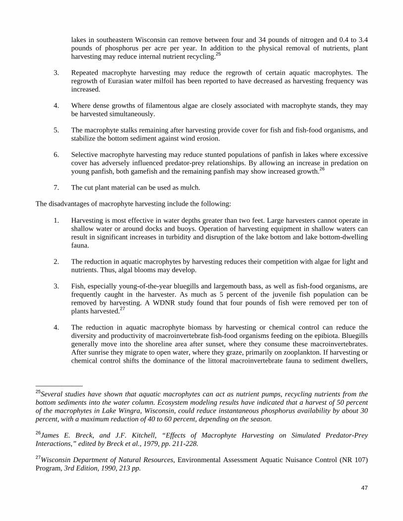
47
lakes in southeastern Wisconsin can remove between four and 34 pounds of nitrogen and 0.4 to 3.4 pounds of phosphorus per acre per year. In addition to the physical removal of nutrients, plant harvesting may reduce internal nutrient recycling.25
3. Repeated macrophyte harvesting may reduce the regrowth of certain aquatic macrophytes. The regrowth of Eurasian water milfoil has been reported to have decreased as harvesting frequency was increased.
4. Where dense growths of filamentous algae are closely associated with macrophyte stands, they may be harvested simultaneously.
5. The macrophyte stalks remaining after harvesting provide cover for fish and fish-food organisms, and stabilize the bottom sediment against wind erosion.
6. Selective macrophyte harvesting may reduce stunted populations of panfish in lakes where excessive cover has adversely influenced predator-prey relationships. By allowing an increase in predation on young panfish, both gamefish and the remaining panfish may show increased growth.26
7. The cut plant material can be used as mulch.
The disadvantages of macrophyte harvesting include the following:
1. Harvesting is most effective in water depths greater than two feet. Large harvesters cannot operate in shallow water or around docks and buoys. Operation of harvesting equipment in shallow waters can result in significant increases in turbidity and disruption of the lake bottom and lake bottom-dwelling fauna.
2. The reduction in aquatic macrophytes by harvesting reduces their competition with algae for light and nutrients. Thus, algal blooms may develop.
3. Fish, especially young-of-the-year bluegills and largemouth bass, as well as fish-food organisms, are frequently caught in the harvester. As much as 5 percent of the juvenile fish population can be removed by harvesting. A WDNR study found that four pounds of fish were removed per ton of plants harvested.27
4. The reduction in aquatic macrophyte biomass by harvesting or chemical control can reduce the diversity and productivity of macroinvertebrate fish-food organisms feeding on the epibiota. Bluegills generally move into the shoreline area after sunset, where they consume these macroinvertebrates. After sunrise they migrate to open water, where they graze, primarily on zooplankton. If harvesting or chemical control shifts the dominance of the littoral macroinvertebrate fauna to sediment dwellers,
_____________ 25Several studies have shown that aquatic macrophytes can act as nutrient pumps, recycling nutrients from the bottom sediments into the water column. Ecosystem modeling results have indicated that a harvest of 50 percent of the macrophytes in Lake Wingra, Wisconsin, could reduce instantaneous phosphorus availability by about 30 percent, with a maximum reduction of 40 to 60 percent, depending on the season.
26James E. Breck, and J.F. Kitchell, “Effects of Macrophyte Harvesting on Simulated Predator-Prey Interactions,” edited by Breck et al., 1979, pp. 211-228.
27Wisconsin Department of Natural Resources, Environmental Assessment Aquatic Nuisance Control (NR 107) Program, 3rd Edition, 1990, 213 pp.

48
the macroinvertebrate component of the bluegill diet could be restricted.28 This would increase predation pressure on zooplankton and reduce the growth rate of the panfish; it could eventually lead to undesirable ramifications throughout the food web in a lake.
5. Macrophyte harvesting may influence the community structure of macrophytes by favoring such plants as milfoil (Myriophyllum spp.) that propagate from cut fractions. This may allow these plants to spread into new areas through the rerooting of the cut fractions.
6. Certain species of plants, such as coontail, are difficult to harvest due to lack of root system.
7. The efficiency of macrophyte harvesting is greatly reduced around piers, rafts, and buoys because of the difficulty in maneuvering the harvesting equipment in those restricted areas. Manual methods have to be used in these areas.
8. High capital and labor costs may be associated with harvesting programs. Macrophyte harvesting on the Twin Lakes could be conducted through cooperative agreements among various municipalities or be contracted to a private company. These costs are largely staff costs and operating costs such as fuel, oil, and maintenance. The cost of new harvesting equipment, including the harvester, transporter, conveyor, and vehicle, would be about $282,500.
Harvesting programs should be designed to provide optimal benefits and minimal adverse impacts. Small fish are common in dense macrophyte beds, but larger fish, such as largemouth bass, do not utilize these dense beds.29 Narrow channels may be harvested to provide navigational access and “cruising lanes” for predator fish to migrate into the macrophyte beds to feed on smaller fish. “Shared access” lanes may also be cut, allowing several residents to use the same lane. Increased use of these lanes should keep them open for longer periods than would be the case if a less directed harvesting program was followed. “Clear cutting” of aquatic plants and denuding the lake bottom of flora should be avoided. However, top cutting of plants such as Eurasian water milfoil, as shown in Figure 2, is suggested, as this technique allows native aquatic plants to successfully compete with the Eurasian water milfoil by providing access to sunlight below the Eurasian water milfoil canopy. Water depth, numbers and arrangement of docks and moored boats, and nature of bottom substrate are important factors when considering mechanical harvesting. Most harvesting equipment is large and not well-suited to close operation around docks and moored boats where precise control of movement is needed. Areas of shallow depth—two to three feet or less containing muck or other soft, loose bottom materials—are generally not considered to be well suited to harvesting, as the equipment tends to churn up these bottom materials, creating turbid water conditions, affecting established benthic communities and fragmenting rooted aquatic macrophytes. Additionally, plants, such as Eurasian water milfoil, which propagate through the spread of plant fragments, may actually be given a reproductive advantage as a result of the chopping action of harvesting equipment. Mechanical harvesting is best suited to areas free of docks and moored watercraft or recreational equipment, where lake bottom materials are firm and water is of sufficient depth to offer a degree of protection against potential lake bottom disruption by harvester equipment. The harvest of water lilies and emergent native plants should be avoided. Protecting native aquatic plant communities from disturbances can help prevent Eurasian water milfoil from spreading within a lake. Recent studies show that native plants can effectively compete with Eurasian water milfoil. However, the nonnative invasive species tends to outcompete native plants when the lake’s ecosystem is
_____________ 28James E. Breck, et. al., op. cit.
29S. Nichols, Wisconsin Department of Natural Resources Technical Bulletin No. 77, Mechanical and Habitat Manipulation for Aquatic Plant Management: A Review of Techniques, 1974.
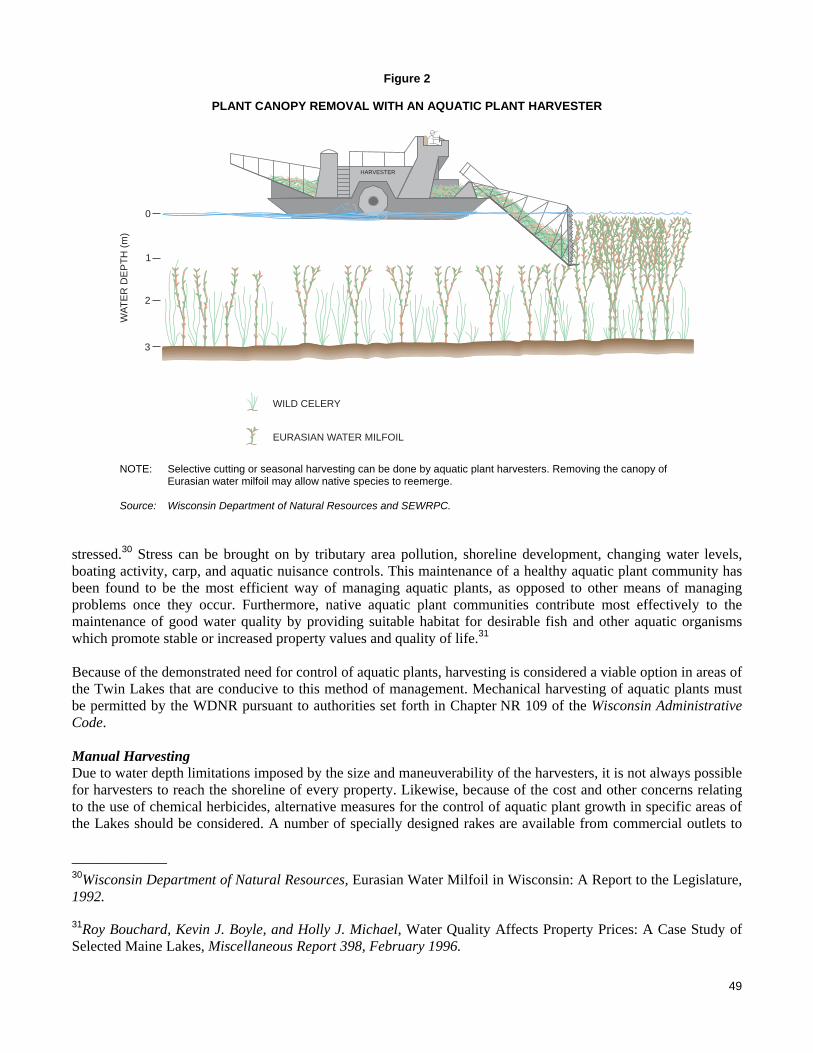
49
Figure 2
PLANT CANOPY REMOVAL WITH AN AQUATIC PLANT HARVESTER
HARVESTER
0
1
2
3
WA
TE
RD
EP
TH
(m)
WILD CELERY
EURASIAN WATER MILFOIL
NOTE: Selective cutting or seasonal harvesting can be done by aquatic plant harvesters. Removing the canopy of Eurasian water milfoil may allow native species to reemerge.
Source: Wisconsin Department of Natural Resources and SEWRPC.
stressed.30 Stress can be brought on by tributary area pollution, shoreline development, changing water levels, boating activity, carp, and aquatic nuisance controls. This maintenance of a healthy aquatic plant community has been found to be the most efficient way of managing aquatic plants, as opposed to other means of managing problems once they occur. Furthermore, native aquatic plant communities contribute most effectively to the maintenance of good water quality by providing suitable habitat for desirable fish and other aquatic organisms which promote stable or increased property values and quality of life.31 Because of the demonstrated need for control of aquatic plants, harvesting is considered a viable option in areas of the Twin Lakes that are conducive to this method of management. Mechanical harvesting of aquatic plants must be permitted by the WDNR pursuant to authorities set forth in Chapter NR 109 of the Wisconsin Administrative Code. Manual Harvesting Due to water depth limitations imposed by the size and maneuverability of the harvesters, it is not always possible for harvesters to reach the shoreline of every property. Likewise, because of the cost and other concerns relating to the use of chemical herbicides, alternative measures for the control of aquatic plant growth in specific areas of the Lakes should be considered. A number of specially designed rakes are available from commercial outlets to _____________ 30Wisconsin Department of Natural Resources, Eurasian Water Milfoil in Wisconsin: A Report to the Legislature, 1992.
31Roy Bouchard, Kevin J. Boyle, and Holly J. Michael, Water Quality Affects Property Prices: A Case Study of Selected Maine Lakes, Miscellaneous Report 398, February 1996.

50
assist lakefront homeowners in manually removing aquatic plants from the shoreline area. The TLPRD could acquire a number of these rakes, which could be made available to lakefront property owners upon request. The advantages of these rakes are that they are easy and quick to use, and result in an immediate result, in contrast to chemical treatments that involve a waiting period. This method also removes the plants from the lake avoiding the accumulation of organic matter on the lake bottom. Manual harvesting is feasible in only very limited areas and is not practical for large-scale use. Nevertheless, manual harvesting does offer a reasonable level of aquatic plant control in the vicinity of docks and piers, and is therefore considered a viable option. Manual harvesting beyond a 30-foot-wide recreational corridor, or within a WDNR-delineated environmentally sensitive area, must be permitted by the WDNR pursuant to authorities set forth in Chapter NR 109 of the Wisconsin Administrative Code. Pursuant to the provision of this Chapter, piers and other recreational areas must be placed within the 30-foot-wide recreational corridor. Biological Controls Another alternative approach to controlling nuisance weed conditions, in this particular case Eurasian water milfoil, is biological control. Classical biological control has been successfully used to control both weeds and herbivorous insects.32 Recent documentation states that Eurhychiopsis lecontei, an aquatic weevil species, has the potential as a biological control agent for Eurasian water milfoil. In 1989, the weevil was discovered during a study investigating a decline of Eurasian water milfoil growth in a Vermont pond. Eurhychiopsis proved to have significant negative effects on Eurasian water milfoil in the field and in the lab. The adult weevil feeds on the milfoil causing lesions which make the plant more susceptible to pathogens, such as bacteria or fungi, while the weevil larvae burrows in the stem of the plant causing enough tissue damage for the plant to lose buoyancy and collapse.33 The few studies that have been done since that time have indicated the following potential advantages to use of this weevil as a means of Eurasian water milfoil control:
1. Eurhychiopsis lecontei is known to cause fatal damage to the Eurasian water milfoil plant and over a period of time has the potential to cause a decrease in the milfoil population.
2. Eurhychiopsis lecontei larvae are easy to produce.
3. Eurhychiopsis lecontei are not known to cause damage to existing native aquatic plants.
The potential disadvantages of using Eurhychiopsis lecontei include:
1. Relatively little experience in southeastern Wisconsin in the use of biological control agents for the management of Eurasian water milfoil. The studies done on Eurhychiopsis suggest that, while the weevil is usually present in lakes infested with Eurasian water milfoil, it is only effective periodically when its populations grow to a level sufficient to cause significant damage to the milfoil plant stems.34
_____________ 32C.B. Huffacker, D.L. Dahlsen, D.H. Janzen, and G.G. Kennedy, Insect Influences in the Regulation of Plant Population and Communities, 1984, pp. 659-696; C.B. Huffacker and R.L. Rabb, editors, Ecological Entomology, John Wiley, New York, New York, USA.
33Sally P. Sheldon, “The Potential for Biological Control of Eurasian Water Milfoil (Myriophyllum spicatum) 1990-1995 Final Report,” Department of Biology, Middlebury College, February 1995.
34The use of Eurhychiopsis sp. on an experimental basis to control Eurasian water milfoil was monitored in selected Wisconsin lakes by the WDNR and the UWSP from 1995 through 1998. These results indicated mixed success, suggesting that this organism has specific habitat requirements that limit its utility as a Eurasian water milfoil control agent within Wisconsin.

51
2. Since the upper portion of the Eurasian water milfoil plant is preferred by the weevil, harvesting would have to be extremely limited or not used at all in conjunction with this type of aquatic plant management control. The studies done on Eurhychiopsis also suggest that the organism is susceptible to wash-off from the plant stem by boat wakes and wind waves, and that the organisms are subject to predation by bluegill and other fishes.
3. Adequate overwintering habitat, consisting of natural shoreland areas, must be present to ensure continuity of the Eurasian water milfoil weevil. Extensive lengths of shoreland protection structure may limit the ability of the organisms to survive from year-to-year.
Relatively few studies concerning the use of Eurhychiopsis lecontei as a means of aquatic plant management control have been completed. Such cases have resulted in variable levels of control, and, although priced competitively with aquatic herbicides, the use of Eurhychiopsis lecontei is not considered a viable option for the Twin Lakes at this time. Use of biological control agents must be permitted by the State under Chapter NR 109 of the Wisconsin Administrative Code. In contrast, the use of biological control agents, such as the purple loosestrife beetles, Hylobius transversovittatus, Galerucella pusilla, Galerucella calmariensis, Nanophyes brevis, and Nanophyes marmoratus, is recommended to control infestations of purple loosestrife (Lythrum salicaria) in wetlands and along shorelands. These biological control agents have been shown to be beneficial in a variety of circumstances throughout the Southeastern Wisconsin Region. The use of other biological control agents is prohibited in Wisconsin; the use of the grass carp, Ctenopharyng-odon idella, for aquatic plant control is expressly prohibited. A variation of the biological control philosophy is the introduction of aquatic plants into potentially suitable areas of habitat in order to restore or create competition or fill vacant ecological niches in lake ecosystems. Within lakes, this planting approach has been used rarely and generally in an experimental manner.35 The planting of wetland plant species along shorelines and within the littoral zones of lakes is an established management measure for shoreland protection. This latter measure is recommended for consideration in the Twin Lakes, as has been noted in terms of fisheries habitat creation and enhancement, above. Lake Bottom Covering Lake bottom covers and light screens provide limited control of rooted plants by creating a physical barrier which reduces or eliminates the sunlight available to the plants. They have been used to create swimming beaches on muddy shores, to improve the appearance of lakefront property, and to open channels for motorboats. Sand and gravel are usually readily available and relatively inexpensive to use as cover materials, but plants readily recolonize areas so covered in about a year. Synthetic materials, such as polyethylene, polypropylene, fiberglass, and nylon, can provide relief from rooted plants for several years. The screens are flexible and can be anchored to the lakebed in spring or draped over plants in summer. The advantages of bottom covers and screens are that control can be confined to specific areas, the covers and screens are usually unobtrusive and create no disturbance on shore, and the covers are relatively easy to install over small areas. The disadvantages of bottom covers and screens are that they do not reduce eutrophication of the
_____________ 35See, for example, Donald H. Les and Glenn Guntenpergen, “Laboratory Growth Experiments for Selected Aquatic Plants, Final Report, July 1989 – June 1990 (Year 1),” Report to the Wisconsin Department of Natural Resources, June 1990; and,Wisconsin Department of Natural Resources, “Environmental Assessment: Improvement of the Water Quality and Fisheries Habitat of LacLaBelle [sic] and the Lower Oconomowoc River,” s.d., for documentation of the attempt to “seed” various pondweed species into Lac La Belle. This experience is documented in SEWRPC Community Assistance Planning Report No. 47, 2nd Edition, A Water Quality Management Plan for Lac La Belle, Waukesha County, Wisconsin, May 2007.

52
lake, they are expensive, they are difficult to spread and anchor over large areas or obstructions, they can slip on steep grades or float to the surface after trapping gases beneath them, and they may be difficult to remove or relocate. Screens and covers should not be used in areas of strong surf, heavy angling, or shallow water where there is motorboat traffic. They also should not be used where aquatic vegetation is desired for fish and wildlife habitat. To minimize interference with fish spawning, screens should be placed before or after spawning. A permit from the WDNR is required for use of sediment covers and light screens. Permits require inspection by the WDNR staff during the first two years, with subsequent permits issued for three-year periods. Annual removal of such barriers is generally required as a permit condition. The estimated cost of lake bottom covers that would control plant growth along a typical shoreline property, an area of about 700 square feet, ranges from $100 for burlap to $300 for Aquascreen®. Placement of lake bottom screens requires a WDNR permit pursuant to Chapter 30 of the Wisconsin Statutes. Because of the limitations involved, placement of lake bottom covers as a method to control aquatic plant growth is not a viable option for the Twin Lakes. Use of sand blankets and pea gravel deposits has also been proposed as a physical barrier to aquatic plant growth in certain situations. Placement of materials on the bed of a navigable lake or waterway also requires a WDNR permit pursuant to Chapter 30 of the Wisconsin Statutes, and the use of these materials is generally confined to the creation and augmentation of swimming beaches. Use of these materials for aquatic plant management purposes is not a viable option as deposition of sediments above the sand or gravel layer limits the longer-term viability of this technique. Public Informational Programming Aquatic plant management usually centers on the eradication of nuisance aquatic plants for the improvement of recreational lake use. The majority of the public views all aquatic plants as “weeds” and residents often spend considerable time and money removing desirable plant species from a lake without considering their environ-mental impacts. As shown in Table 20 in Chapter V in Volume One of this report, many aquatic plants have positive ecological value within the lake ecosystem, and most native aquatic plants rarely interfere with human water uses. Thus, public information is an important component of an aquatic plant management program and should include informational programming on:
1. The types of aquatic plants in the Twin Lakes and their value to water quality, fish, and wildlife.
2. The preservation of existing stands of desirable plant species.
3. The identification of nuisance species and the methods of preventing their spread.
4. Alternative methods for controlling existing nuisance plants, including the positive and negative aspects of each method.
An organized aquatic plant identification/education day is one method of providing hands-on education to lake residents. Other sources of information and technical assistance include the WDNR and the UWEX. The aquatic plant species lists provided in Tables 21 and 22 of Chapter V in Volume One of this report, and the illustrations of common aquatic plants present in the Twin Lakes, appended to Volume One of this report as Appendix A, may serve as a checklist for individuals interested in identifying the plants near their residences. Residents can observe and record changes in the abundance and types of plants in their part of a lake on an annual basis. Of the submerged floating and free-floating aquatic plant species found in the Twin Lakes, Eurasian water milfoil is one of the few species likely to cause lake-use problems. Eurasian water milfoil, unlike most aquatic plants, can reproduce from fragments and often forms dense, monotypic beds with little habitat value for fish or waterfowl. Lakeshore residents should be encouraged to collect fragments that wash ashore after storms and, especially, from weekend boat traffic. The plant fragments can be used as mulch on flower gardens or ornamental planting areas.

53
Likewise, lake users should be encouraged to inspect boats and trailers, both prior to launch and following recovery, as Eurasian water milfoil and other aquatic plants can be transported between lakes as fragments on boats and boat trailers. This effort also limits the likelihood of transporting zebra mussel, Dreissena polymorpha, between lakes and into new areas of the Lakes. To prevent unwanted introductions of plants and invasive aquatic animals into lakes, boaters should remove all plant fragments from their boats and trailers when exiting a lake, and allow wet wells, engine water jackets, and bilges to dry thoroughly for up to one week. Alternatively, boaters can run their vessels through a car wash, where high-pressure, high-temperature water sprays can remove and destroy organisms, such as the zebra mussel juveniles (veligers).36 Providing the opportunity for the removal of plant fragments at the boat landings on the Twin Lakes, and provision of signage at the boat landing, including provision of disposal containers at the boat landing, may help motivate boaters to utilize this practice. Posters and pamphlets are available from the WDNR and UWEX that provide information and illustrations of milfoil, zebra mussel, and other nonnative aquatic species; discuss the importance of removing plant fragments from boats; and, remind boaters of their duty in this regard. Removal of bait organisms from live wells, and the aforementioned precautions to prevent the transportation of nuisance aquatic plants between lakes, also can limit the transportation of other organisms such as the VHS virus, as noted above. Such actions would be consistent with the legal requirements set forth in Chapters NR 19 and NR 109 of the Wisconsin Administrative Code. Recommended Measures It is recommended that aquatic macrophyte surveys be conducted at about five-year intervals, depending upon the observed degree of change in the aquatic plant communities. This interval is consistent with the requirements of Chapters NR 107 and NR 109 of the Wisconsin Administrative Code, which govern permitting for various types of aquatic plant management measures. In addition, information on the aquatic plant control program should be recorded and should include descriptions of major areas of nuisance plant growth; areas chemically treated and/or harvested; and, in areas where harvesting is conducted, species harvested and amounts of plant material removed from the Lakes. Note also should be taken of the species and approximate numbers of fish and invertebrates, if any, caught in the harvest. It is further recommended that a daily harvester log, containing this information, be maintained. This information, in conjunction with the conduct of the recommended aquatic macrophyte surveys, will allow evaluation of the effectiveness of the aquatic plant control program over time and allow adjustments to be made in the program to maximize its benefit. To enhance the use of the Twin Lakes while maintaining the quality and diversity of the biological communities, the following recommendations are made:
1. Reconnaissance surveys of the aquatic plant communities in the Twin Lakes are recommended to be conducted periodically and the approved aquatic plant management plan should be updated every three to five years.
2. Mechanical harvesting is recommended as a possible future management method should the need arise. As indicated in Chapter V of Volume One, this will, in the long-term, help to maintain good water quality conditions by removing plant materials which are currently contributing to an accumulation of decomposing vegetation and associated nutrient recycling.
3. In areas where harvesting occurs, it is recommended that shared-access channels be harvested to minimize the potential detrimental effects on the fish and invertebrate communities. Directing boat traffic through these common channels would help to delay the regrowth of vegetation in these areas. Additionally, surface harvesting is recommended, cutting to a depth to remove the surface canopy of
_____________ 36See Wisconsin Department of Natural Resources Publication No. PUBL-WR-383 95-REV., Zebra Mussel Boater’s Guide, 1995; Wisconsin Department of Natural Resources Publication No. PUBL-WR-463 96-REV., The Facts...On Eurasian Water Milfoil, February 1996.

54
nonnative aquatic plants, such as the Eurasian water milfoil. This should provide a competitive advantage to the low-growing native plants present in the Lakes. By not disturbing the low-growing species which generally grow within one to two feet of the lake bottom and in relatively low densities, leaving the root stocks and stems of all cut plants in place, the resuspension of sediments in the Twin Lakes will be minimized, and some degree of cover will continue to be provided for panfish populations which support the gamefish populations in the Lakes. Further, cutting should not be broad-based, but focused on boating channels and selected navigation areas.
4. It is recommended that the use of chemical herbicides be limited to controlling nuisance growths of nonnative species in shallow water around docks and piers. It is recommended that chemical applications, if required, be made by licensed applicators in early spring, subject to State Chapter NR 107 permitting requirements, to maximize their effectiveness on nonnative plant species, while minimizing impacts on native plant species and acting as a preventative measure to reduce the development of nuisance conditions. Such use should be evaluated annually and the herbicide applied only on an as-needed basis. Only herbicides that selectively control milfoil, such as 2,4-D and fluridone, should be used. Algicides, such as Cutrine Plus, are not recommended because there are few significant, recurring filamentous algal or planktonic algal problems in the Twin Lakes and valuable macroscopic algae, such as Chara and Nitella are killed by this product.
5. The control of rooted vegetation between adjacent piers and docks is recommended to be left to the riparian owners concerned. The TLPRD and the Village of Twin Lakes may wish to obtain informational brochures regarding shoreline maintenance, such as information on hand-held specialty rakes made for this specific purpose, to inform residents of the control options available.
6. The ongoing collection of aquatic plant fragments and other debris along shoreline areas is recommended.
7. It is recommended that ecologically valuable areas be excluded from aquatic plant management activities, especially during fish spawning seasons in early summer and autumn. The aquatic plant management limitations set forth within the five WDNR-delineated, Chapter NR 107 sensitive areas—reproduced in Appendix B of Volume One—are incorporated herein by reference.
8. It is further recommended that the TLPRD and the Village of Twin Lakes conduct public informational programming on the types of aquatic plants in the Twin Lakes; on the value of, and the impacts of, these plants on water quality, fish, and on wildlife; and on alternative methods for controlling existing nuisance plants, including the positive and negative aspects of each method. This program can be incorporated into the comprehensive informational and educational programs that also would include information on related topics, such as water quality, recreational use, fisheries, and onsite sewage disposal systems.
The recommended aquatic plant management measures represent a continuation of the current aquatic plant management program conducted by the TLPRD and the Village of Twin Lakes. RECREATIONAL USE MANAGEMENT
Regulatory measures provide a basis for controlling lake use and use of the shorelands around a waterbody. On land, shoreland zoning, requiring setbacks and shoreland buffers can protect and preserve views both from the water and from the land, controls development around a lake to minimize its environmental impacts and manages public and private access to a waterbody. On water, recreational use zoning can provide for safe and multiple-purpose use of lakes by various groups of lake users and protect environmentally sensitive areas of a lake. Use zoning can take the form of allocating times of use, such as the annual fishing season established by the State, or areas of use, wherein the types or rate of use is controlled, as in the case of shallow water, slow-no-wake speed limits. A key issue in zoning a waterbody for use is equity; the same rules must apply to both riparian owners/residents and off-lake users. This condition is usually met in situations where use zoning is motivated by
55
the protection of fish habitat, for example, as both on- and off-lake users would appreciate an enhanced fishery. Costs are relatively low, associated with creating and posting the ordinance, and effectiveness can be good with regular/consistent enforcement. Costs increase for measures requiring buoyage. Alternatives Currently, watercraft are restricted to slow-no-wake speeds within 100 feet of pierheads; personal watercraft or jetskis® are restricted to slow-no-wake speeds within 200 feet of shore and 100 feet of other watercraft.37 The 100 foot to 200 foot nearshore zone typically coincides with water depths of less than five feet. Demarcation of Eurasian water milfoil control areas, and similar environmentally valuable or sensitive areas of the Lakes is recommended. It is also recommended that the Village of Twin Lakes continues to enforce the recreational boating ordinance appended hereto as Appendix B in Volume One of this report. Recreational use management measures applicable to the Twin Lakes also include the implementation of slow-no-wake regulations during periods of high water. These regulations are designed to protect human lives and property, the latter especially being the focus in the low-lying areas of the lake shores. As discussed in Chapter II of this Volume, the Village of Twin Lakes had periodically implemented such slow-no-wake regulations through a Village ordinance, most recently during June and July of 2008. Recommended Measures With respect to boating ordinances applicable to the Twin Lakes, it is recommended that current levels of enforcement be maintained. In addition, recreational boating access users should be made aware of the presence of the exotic invasive species Eurasian water milfoil within the Twin Lakes. Appropriate signage has been placed at the public recreational boating sites, and supplemental materials on the control of invasive species should be made available to the public. These materials could be provided to riparian householders by means of mail drops or distribution of informational materials at public buildings, such as municipal buildings and the public library, and to nonriparian users by means of informational materials provided at the entrance to all municipal public recreational boating access sites. In addition, it is recommended that disposal bins be made available at the public recreational boating access sites for disposal of plant materials and other refuse removed from watercraft using the public recreational boating access sites. PUBLIC INFORMATIONAL AND EDUCATIONAL PROGRAMMING
Alternatives Educational and informational brochures and pamphlets, of interest to homeowners and supportive of the recreational use and shoreland zoning regulations, are available from UWEX and the WDNR for distribution by both local governments and nongovernmental organizations to interested parties. These cover topics, such as beneficial lawn care practices and household chemical use guidelines. These brochures could be provided to homeowners through local media, direct distribution, or targeted school or public library displays. Many of these ideas can be integrated into ongoing, larger-scale municipal activities, such as anti-littering campaigns, recycling drives, and similar pro-environment activities. The TLPRD publishes a periodic newsletter and both the Village and lake management district maintain internet websites to inform electors, property owners, and other interested individuals of the District’s activities. In addition to public informational programming, or informal educational programming, discussed above, there are a number of school-based educational opportunities that the community can utilize at the middle school level and at the high school level. Such programming as Project WET are available from and supported by the UWEX and provide youth the opportunity to experience “hands on” the aquatic environment and become better informed about current and future lake issues and concerns. Such programs are considered a viable option. _____________ 37Wisconsin Department of Natural Resources Publication No. PUBL-LE-301 2006, Wisconsin Boating Regulations, 2006.

56
Finally, reporting of water quality sampling results to the public should be continued and participation in the UWEX CLMN should be continued. Volunteer monitoring under the auspices of the CLMN involves citizens in taking Secchi-disk transparency readings in the Lakes at regular intervals. The Lake Coordinator of the WDNR-Southeast Region can assist in enlisting volunteers in this program. The information gained at first hand by the public during participation in this program increases the credibility of the proposed changes in the nature and intensity of use to which the Lakes are subjected. Recommended Measures It is recommended that the TLPRD and the Village of Twin Lakes assume the lead in the development of a public informational and educational program. Participation by the Town of Randall should be encouraged. This program should deal with various lake management-related topics, including onsite sewage disposal system management, water quality management, land management, groundwater protection, aquatic plant management, fishery management, invasive species, and recreational use. Educational and informational brochures and pamphlets, of interest to homeowners and supportive of the recreational use and shoreland zoning regulations, are available from the WDNR and the UWEX. These cover topics, such as beneficial lawn care practices and household chemical use. Such brochures should be provided to homeowners through local media, direct distribution, or targeted library and civic center displays. Such distributions can also be integrated into ongoing, larger-scale activities, such as lakeside litter collections, which can reinforce anti-littering campaigns, recycling drives, and similar environmental protection activities. Given the extent of public interest in the Twin Lakes, it is recommended that the Village of Twin Lakes consider offering regular informational programs on the Lakes and issues related thereto. Such programming can provide a mechanism to raise awareness of the lake issues, and provide a focal point from which to distribute the informational materials referred to above. The Village of Twin Lakes and the municipalities are also encouraged to take an active role in encouraging the local school districts to adopt and utilize lake-related educational programs, such as a Pontoon Classroom or Project WET, as a means of more closely linking students to the lake environment. The cost for conducting this informational and educational program is estimated to be $1,200 per year. INSTITUTIONAL DEVELOPMENT
While lake management activities fall under the general powers of municipalities, in the case of the Village of Twin Lakes pursuant to Section 61.34(1), Wisconsin Statutes, other public and private organizational alternatives exist for the management of lakes in the State of Wisconsin.38 Private lake organizations have the option to be incorporated, generally as nonstock, not-for-profit corporations under Chapter 181, Wisconsin Statutes. Public lake organizations include special-purpose units of government that are created as public inland lake protection and rehabilitation districts under Subchapter IV of Chapter 33, Wisconsin Statutes, and utility districts created pursuant to Subchapter VIII of Chapter 66, Wisconsin Statutes. The specific type (or types) of organization created is based upon the decision of the community. Current Lake Management Structure In the case of the Twin Lakes, general oversight of lake management activities is provided by the TLPRD, whose governing board, pursuant to Section 33.23(1), Wisconsin Statutes, is the Village Board of the Village of Twin Lakes. A citizen-based steering council oversees the activities of several citizen-based committees which perform numerous lake-oriented activities and functions, and provides a liaison function between the TLPRD and the community. A citizen-based nongovernmental organization, the Lakes and Recreation Association of Twin Lakes, Inc., (LARA), also serves the Twin Lakes community. LARA is incorporated in the State of Wisconsin as a Chapter 181, nonstock, not-for-profit corporation.
_____________ 38See University of Wisconsin-Extension Publication No. G3216, The Lake in Your Community, 1986.

57
Twin Lakes Protection and Rehabilitation District Currently, there is no formal procedural mechanism through which the citizen-based steering council, noted above, can interact directly with the TLPRD Board of Commissioners. To improve communication and create a more productive relationship between the TLPRD Board of Commissioners and the electors and property owners of the District, as well as to develop a greater sense of community involvement and support for District policies, the following alternatives may be considered; namely, 1) the granting of self-governance to the TLPRD through the petitioning process provided in Sections 33.23(3) and 33.28, Wisconsin Statutes, or 2) the development and adoption of a formal reporting procedure to enable the citizen steering council to interact with the TLPRD Board of Commissioners during their regularly scheduled meetings. This latter alternative has been adopted by several public inland lake protection and rehabilitation districts within the Southeastern Wisconsin Region, including the Big Muskego Lake Management District formed by the City of Muskego in Waukesha County and the Paddock Lake Management District formed by the Village of Paddock Lake in Kenosha County. Creation of such an interactive liaison mechanism validates the existence of the citizen steering council and improves the likelihood of success of District-sponsored events, activities and policies by encouraging a sense of community and partnership between the citizenry and the Lake District Board of Commissioners. This alternative also enables the municipality to focus on the broader range of concerns facing the community, while simultaneously focusing on lake protection and rehabilitation issues in an effective and meaningful way. Both of these options are considered feasible. Lakes and Recreation Association of Twin Lakes, Inc. The LARA is incorporated in the State of Wisconsin as a Chapter 181, nonstock, not-for-profit corporation. This nongovernmental organization has, as its mission, the following: “to protect the lakes located in the Village of Twin Lakes and lake rights of all the property owners through information, communication and publication of an email newsletter and maintaining a web site on current issues while providing continuing support to the Lake District Committees.” It is intended that LARA supplement the work of the Lake Management District by promoting: understanding and awareness of the “facts behind lake issues;” sound, practical governance and support on lake issues; common lake goals for the betterment of the entire watershed through “common sense solutions and social awareness;” policies based on preserving and protecting the lakes while maintaining high levels of safety for the residents and visitors who come to use the lakes; and, balanced decision making by the community. Issues of concern are identified by the members of the Association at their annual meeting, which generally is held immediately prior to that of the Lake Management District, and shared through periodic newsletters published by the Association. LARA encourages it membership to participate in the annual meeting of the District, and to become involved in the various advisory committees established by the District. LARA has been a positive force in encouraging the citizens of the Twin Lakes community to become involved with lake issues. Continuing the ongoing partnership between LARA and the Twin Lakes Protection and Rehabilitation District, including the citizen-based Steering Council and its committees, is recommended. Recommended Measures In order to create a more productive relationship between the TLPRD board and the citizens of the District, and to improve communication between the property owners and electors of the District and the Board of Commissioners, it is recommended that a formal reporting mechanism be developed between the TLPRD and the citizen-based steering council. As of 2008, this recommendation had been implemented through the appointment of Lake District Commissioners to each of the Committees and to the Steering Council, so as to facilitate communication between the Board of Commissioners and the citizen advisory committees. Additionally, during the 2008 annual meeting of the District, the citizen chairperson of the Steering Council actively participated in the conduct of the annual meeting of the TLPRD. This formal relationship between the committees, Steering Council, and Lake District Board of Commissioners should be maintained. In this regard, it is suggested that the quarterly Commissioner meetings required pursuant to Section 33.28(6) of the Wisconsin Statutes be held in conjunction with the monthly meetings of the Steering Council, and that both meetings allow an exchange of views. It should be noted, however, that during the quarterly Lake District Board of Commissioner meetings only the Lake District Commissioners would be able to vote on motions or resolutions, even if the discussion includes the views of the Lake Steering Council members.

This Page Intentionally Left Blank

59
Chapter IV
RECOMMENDED MANAGEMENT PLAN FOR THE TWIN LAKES
INTRODUCTION
This chapter presents a recommended management plan for the Twin Lakes. The plan is based upon the inven-tories and analyses of land use and land and water management practices, pollution sources in the area tributary to Lake Mary and Elizabeth Lake—known as the Twin Lakes—the physical and biological quality of the waters of the Lakes, recreational use and population forecasts, and an evaluation of alternative lake management measures, set forth in Volume One. The recommended plan sets forth means for: 1) managing lake water surface elevations, with a primary focus in the role of the Elizabeth Lake dam; 2) providing water quality conditions suitable for full-body contact recreational use and the maintenance of healthy communities of warmwater fishes and other aquatic life, with a primary focus on land use management measures; 3) reducing the severity of existing or perceived problems which constrain or preclude desired water uses, with a primary focus on fisheries and aquatic plant management measures; 4) improving opportunities for water-based recreational activities, with a primary focus on maintaining adequate public recreational boating access as defined in Chapter NR 1 of the Wisconsin Administrative Code; and, 5) protecting environmentally sensitive areas within and adjacent to the Lakes. The elements of the recommended plan were selected from among the alternatives described in Chapters II and III of this volume, and evaluated on the basis of those feasible alternatives, set forth in Table 1, that may be expected to best meet the foregoing lake management objectives. Analyses of water quality and biological conditions, summarized in Chapters IV and V of Volume One, indicate that the general condition of the waters of the Twin Lakes is very good. There appear to be few impediments to water-based recreation, although access by recreational watercraft is limited in some portions of the Lakes by water depths and growths of aquatic macrophytes, as summarized in Chapter VI of Volume One. Nevertheless, based upon a review of the inventory findings and consideration of planned developments within the area tributary to the Lakes, as set forth in, inter alia, the adopted Kenosha County land and water resource management plan, regional land use plan, regional water quality management plan, and regional natural areas and critical species habitat protection and management plan, measures will be required to continue to protect and maintain the high quality of the Lakes for future lake users.1 Therefore, this plan sets forth recommendations for land use management, including protection of environmentally sensitive lands in the area tributary to the Twin _____________ 1SEWRPC Community Assistance Planning Report No. 255, A Land and Water Resource Management Plan for Kenosha County: 2000-2004, September 2000; SEWRPC Planning Report No. 30, A Regional Water Quality Management Plan for Southeastern Wisconsin: 2000, Volume One, Inventory Findings, September 1978; Volume Two, Alternative Plans, February 1979; and Volume Three, Recommended Plan, June 1979; SEWRPC Memorandum Report No. 93, A Regional Water Quality Management Plan for Southeastern Wisconsin: An Update and Status Report, March 1995; SEWRPC Planning Report No. 42, A Regional Natural Areas and Critical Species Habitat Protection and Management Plan for Southeastern Wisconsin, September 1997; SEWRPC Planning Report No. 48, A Regional Land Use Plan for Southeastern Wisconsin: 2035, June 2006.

60
Table 1
SELECTED CHARACTERISTICS OF ALTERNATIVE LAKE MANAGEMENT MEASURES FOR TWIN LAKES
Plan Element Subelement Alternative Management Measure
Considered Viable for Inclusion in
Recommended Lake Management Plan
Dam Operations and Management
Elizabeth Lake dam Reference all lake levels in the framework of the National Geodetic Vertical Datum of 1929 (NGVD-29)
Yes
Establish permanent lake level gauges at the Elizabeth Lake boat launch and Lance Park; verify their elevations annually using reference bench marks established using the existing reference bench marks shown on Map 1 of this volume (elevations listed in footnote 6 on page 13)
Yes
Train Village of Twin Lakes Public Works Department staff to read the gauges; record lake levels daily
Yes
Reference all survey work to appropriate benchmarks; use Second Order, Class II leveling for determination of elevations
Yes
Establish lake surface elevation operational programs to maintain the levels of Elizabeth Lake, to the extent practicable, at between 793.5 feet and 794.5 feet above NGVD-29
Yes
Provide auxiliary spillway capacity to supplement the existing spillway capacity at the Elizabeth Lake outlet based upon a thorough hydrologic and hydraulic analysis, in a manner designed to minimize downstream consequences of flood events, and in conformance with the requirements of the applicable State of Illinois dam safety regulations
Yes
Consider downstream hydrologic and hydraulic effects in the design and analyses associated with providing additional spillway capacity at the Elizabeth Lake dam
Yes
Implement slow-no-wake boating ordinance provisions on Elizabeth Lake at lake surface elevations of greater than 794.5 feet above NGVD-29
Yes
Land Use Zoning Implement regional land use plan within tributary area Yes
Maintain existing density management in lakeshore areas to the extent practicable; consider conservation development principles for new development
Yes
Develop and implement consistent stormwater management ordinances and practices in all riparian communities; periodically review stormwater ordinances
Yes
Protecting environmentally significant lands
Implement regional natural areas and critical species habitat protection and management plan recommendations within tributary area
Yes
Pollution Abatement General nonpoint source pollution abatement
Implement regional water quality management plan and County land and water resource management plan recommendations within the watershed; consider integrated nutrient and pest control at Twin Lakes CC and Nippersink CC
Yes
Rural nonpoint source controls
Develop farm conservation plans that encourage conservation tillage, contour farming, contour strip cropping, crop rotation, grassed waterways, and pasture and streambank management in agricultural areas of the tributary area
Yes
Urban nonpoint source controls
Promote urban housekeeping practices, public educational programming, and grassed swales
Yes
Implement additional urban nonpoint source controls, including street sweeping, catch basin cleaning, leaf litter and garden refuse collection, materials storage facility protection, and stormwater management measures in urban areas of the tributary area
Yes

61
Table 1 (continued)
Plan Element Subelement Alternative Management Measure
Considered Viable for Inclusion in
Recommended Lake Management Plan
Pollution Abatement (continued)
Developing Area nonpoint source controls
Enforce construction site erosion control ordinances requiring soil stabilization, surface roughening, barriers, diversion swales, sediment traps, and detention/retention/infiltration basins
Yes
Public sanitary sewerage system management
Conduct periodic review of sewer service area needs within sewered areas of the tributary area
Yes
Onsite sewage disposal system management
Implement onsite sewage disposal system management, including inspection and maintenance protocols
Yes
Water Quantity Habitat protection and water quality management
Drawdown No Water level stabilization No Dredging Yes
Water Quality Water quality monitoring
Continue participation in WDNR Self-Help monitoring program and periodic participation in the USGS Trophic State Index (TSI) water quality monitoring program; alternatively, consider participation in University of Wisconsin-Stevens Point TSI monitoring program or WDNR Expanded Self-Help Program
Yes
Water quality improvement
Conduct alum treatment to achieve phosphorus inactivation in lake sediments
No
Promote nutrient load reduction within the Lake basin through sediment management
No
Aquatic Biota Fisheries Protect fish habitat Yes management Maintain shoreline and littoral zone fish habitat by
maintaining existing shoreline structures and repair as necessary using vegetative means insofar as practicable (reconstruction may require WDNR Chapter 30 permits)
Yes
Continue stocking of selected game fish species and monitor rough fish populations
Yes
Enforce size and catch limit regulations Yes Chemical eradication of rough fish populations No
Aquatic plant management
Use (limited) aquatic herbicides for control of nuisance plants such as Eurasian water milfoil and purple loosestrife
Yesa
Consider mechanical harvesting of aquatic macrophytes to provide navigational channels and fish lanes, control nuisance plants and to promote growth of native plants
Yesb
Manually harvest aquatic plants from around docks and piers where feasible
Yes
Conduct periodic aquatic plant reconnaissance surveys and periodically update aquatic plant management plan
Yes
Employ biological controls using inocula of Eurasian water milfoil weevils
No
Use sediment covers to shade out aquatic plant growth around piers and docks
No
Collect floating plant fragments from shoreland areas to minimize rooting of Eurasian water milfoil
Yes
Continue to monitor populations of invasive species; continue current efforts to control purple loosestrife and Eurasian water milfoil
Yes
Water Use - - Enforce boating regulations to maximize public safety; improve signage
Yes
Develop time and/or space zoning schemes to limit surface use conflicts
No

62
Table 1 (continued)
Plan Element Subelement Alternative Management Measure
Considered Viable for Inclusion in
Recommended Lake Management Plan
Ancillary Management Measures
Public Informational and Educational Programming
Conduct public informational programming utilizing seminars and distribution of informational materials
Yes
Support participation of schools in Project WET, Adopt-A-Lake, pontoon classrooms, etc.
Yes
Conduct public informational and educational programming on aquatic plants and options for their management
Yes
Encourage methods of preventing unwanted intrusions of invasive biota at public recreational boat access
Yes
Institutional Development - - Create a self-governing TLPRD board through selection of board members pursuant to Chapter 33, Wisconsin Statutes
Yes
Develop a formal reporting mechanism through which the citizen-based steering committee can interact with the current TLPRD board
Yes
aLimited areas when necessary to control exotic, invasive species. bIn areas where water depth, bottom substrate material, and dock/moored watercraft densities are within desirable limits to promote the effectiveness of this method of aquatic plant management. Source: SEWRPC.
Lakes; water level management; pollution abatement; water quality monitoring and improvement; aquatic plant and fisheries management; recreational water use management; and informational programming. These measures complement and refine the watershedwide land use controls and management measures recommended in the adopted regional water quality management plan2 and Kenosha County land and water resource management plan.3 The recommended management measures for the Twin Lakes are graphically summarized on Map 2, and are listed in Table 2. The recommended plan measures are more fully described in the following paragraphs. The recommended management agency responsibilities for tributary area land management also are set forth in Table 2. RECOMMENDED LAKE LEVEL RANGE
Based on the evaluation presented in Chapter II, it is concluded that the criteria adopted for the lake level analysis can best be satisfied through maintenance of the levels of Elizabeth Lake between elevations 793.5 feet and 794.5 feet above the National Geodetic Vertical Datum of 1929 (NGVD-29). Under most conditions, outflow from Lake Mary also is controlled by this dam. Establishing these operational levels reduces the Lake level range observed over the past 17 years by about one foot. Lake levels exceeding the elevation of 794.5 feet above NGVD-29 would invoke the Village of Twin Lakes high water level slow-no-wake boating restrictions.
_____________ 2SEWRPC Planning Report No. 30, op. cit.; see also, SEWRPC Memorandum Report No. 93, op. cit.
3SEWRPC Community Assistance Planning Report No. 255, op. cit.

5’
10’
5’
5’
5’
5’
10’
15’
20’
25’
5’10’
15’20’
25’
30’
32’
5’
5’
10’
15’20’
25’
5’
5’10’
5’
5’
8’
10’
15’
20’
25’
25’
33’
5’8’10’
15’20’
25’
30’
5’
5’
4’5’
CT
H P
LANCE DR.
CTH O
MUSIAL RD.
SUNSET DR.
LIT
TL
E Z
ER
FA
S D
R.
128TH ST CTH CK
E.
LAKE
SH
OR
E
DR.
CT
H E
MW
.PARK
DR.
CTH HM
WIL
MO
T
DR.
MA
TT
HE
W A
VE
.
WA
LD
EC
K DR.
104TH ST.
395T
H A
VE
110TH ST.
.LE EV ALIC
UL
WISCONSIN
ILLINOIS
KENOSHA CO.
MCHENRY CO.
LANCE DR.MAIN ST.
BAY V
IEW
AV
E.
LEGION DR.
LA
KE
AV
E.
CT
H Z
WIL
MO
NT
A
VE
.
E.
LA
KE
SHO
RE
DR.
395T
H A
VE
93RD ST CTH Z
BU
RL
ING
TO
N A
VE
0 1200 2400 FEET
GRAPHIC SCALE
Source: SEWRPC.
DATE OF PHOTOGRAPHY: APRIL 2005
Map 2
RECOMMENDED LAKE MANAGEMENT PLAN ELEMENTS FOR TWIN LAKES
WATER DEPTH CONTOUR IN FEET
MONITORING SITE, CONTINUE
PARTICIPATION IN UWEX CLMN PROGRAM
MAINTAIN DAM, MODIFY AS NECESSARY
TO SUPPORT LAKE SURFACE ELEVATION
AT 793.5 - 794.5 FEET NGVD-29
MAINTAIN PUBLIC RECREATIONAL
BOATING ACCESS
PROTECT ENVIRONMENTAL CORRIDORS,
WETLANDS, AND WOODLANDS
PROMOTE GOOD HOUSEKEEPING
PRACTICES IN DRAINAGE AREA
MAINTAIN HISTORIC LAKEFRONT DENSITIES;
OBSERVE GUIDELINES IN REGIONAL PLAN
PERIODICALLY REVIEW SEWER SERVICE
AREA FACILITIES PLAN
CONTROL NONNATIVE SPECIES, NR-109
DESIGNATED INVASIVE SPECIES CHEMICAL
CONTROL: HIGH PRIORITY
RIPARIAN ZONE: CONTROLS PLANTS AS
REQUIRED FOR ACCESS
MANUAL CONTROL: HIGH PRIORITY
CHEMICAL CONTROL: MODERATE PRIORITY
HABITAT AREAS: CONTROL LIMITED TO
NONNATIVE SPECIES AS NECESSARY
OPEN WATER: NO CONTROL
20’
WATER QUALITY MONITORING
DAM OPERATIONS
RECREATIONAL USE
LAND USE MANAGEMENT
AQUATIC PLANT MANAGEMENT
63
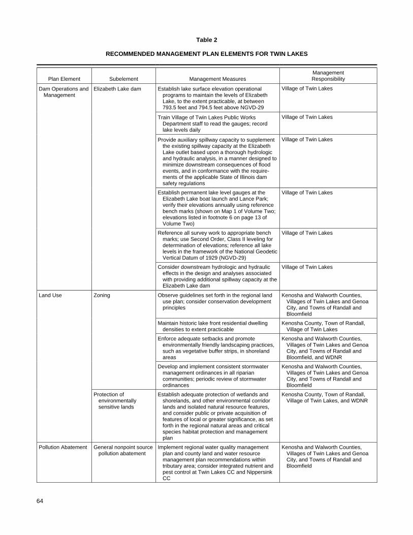
64
Table 2
RECOMMENDED MANAGEMENT PLAN ELEMENTS FOR TWIN LAKES
Plan Element Subelement Management Measures Management Responsibility
Dam Operations and Management
Elizabeth Lake dam Establish lake surface elevation operational programs to maintain the levels of Elizabeth Lake, to the extent practicable, at between 793.5 feet and 794.5 feet above NGVD-29
Village of Twin Lakes
Train Village of Twin Lakes Public Works Department staff to read the gauges; record lake levels daily
Village of Twin Lakes
Provide auxiliary spillway capacity to supplement the existing spillway capacity at the Elizabeth Lake outlet based upon a thorough hydrologic and hydraulic analysis, in a manner designed to minimize downstream consequences of flood events, and in conformance with the require-ments of the applicable State of Illinois dam safety regulations
Village of Twin Lakes
Establish permanent lake level gauges at the Elizabeth Lake boat launch and Lance Park; verify their elevations annually using reference bench marks (shown on Map 1 of Volume Two; elevations listed in footnote 6 on page 13 of Volume Two)
Village of Twin Lakes
Reference all survey work to appropriate bench marks; use Second Order, Class II leveling for determination of elevations; reference all lake levels in the framework of the National Geodetic Vertical Datum of 1929 (NGVD-29)
Village of Twin Lakes
Consider downstream hydrologic and hydraulic effects in the design and analyses associated with providing additional spillway capacity at the Elizabeth Lake dam
Village of Twin Lakes
Land Use Zoning Observe guidelines set forth in the regional land use plan; consider conservation development principles
Kenosha and Walworth Counties, Villages of Twin Lakes and Genoa City, and Towns of Randall and Bloomfield
Maintain historic lake front residential dwelling densities to extent practicable
Kenosha County, Town of Randall, Village of Twin Lakes
Enforce adequate setbacks and promote environmentally friendly landscaping practices, such as vegetative buffer strips, in shoreland areas
Kenosha and Walworth Counties, Villages of Twin Lakes and Genoa City, and Towns of Randall and Bloomfield, and WDNR
Develop and implement consistent stormwater management ordinances in all riparian communities; periodic review of stormwater ordinances
Kenosha and Walworth Counties, Villages of Twin Lakes and Genoa City, and Towns of Randall and Bloomfield
Protection of environmentally sensitive lands
Establish adequate protection of wetlands and shorelands, and other environmental corridor lands and isolated natural resource features, and consider public or private acquisition of features of local or greater significance, as set forth in the regional natural areas and critical species habitat protection and management plan
Kenosha County, Town of Randall, Village of Twin Lakes, and WDNR
Pollution Abatement General nonpoint source pollution abatement
Implement regional water quality management plan and county land and water resource management plan recommendations within tributary area; consider integrated nutrient and pest control at Twin Lakes CC and Nippersink CC
Kenosha and Walworth Counties, Villages of Twin Lakes and Genoa City, and Towns of Randall and Bloomfield

65
Table 2 (continued)
Plan Element Subelement Management Measures Management Responsibility
Pollution Abatement (continued)
Rural nonpoint source controls
Promote sound rural land management practices to reduce soil loss and contaminant loadings through preparation of farm conservation plans in accordance with the county land and water resource management plans
USDA, WDATCP, and Walworth and Kenosha counties
Urban nonpoint source controls
Promote sound urban housekeeping and yard care practices through informational programming; implement stormwater management measures
Twin Lakes Protection and Rehabilitation District, Kenosha County, Town of Randall, Village of Twin Lakes
Developing Area nonpoint source controls
Install construction site erosion control measures as required by local ordinance; enforce construction site erosion control and stormwater management ordinances; review ordinances for concurrency with proposed NR 152
Walworth County, Villages of Twin Lakes and Genoa City, Town of Bloomfield, private landowners, and WDNR
Develop adequate construction site erosion control and stormwater management ordinances
Kenosha County and Town of Randall
Onsite sewage system management
Implement onsite sewage disposal system management, including inspection and maintenance, in those portions of the watershed not served by public sanitary sewerage systems
Kenosha and Walworth County and private landowners
Public sanitary sewerage system management
Implement refined regional water quality management plan recommendations to provide sanitary sewerage services to selected areas of the Twin Lakes tributary area; provide informational programming encouraging wise use of public systems; conduct periodic review of sewer service area needs
Village of Twin Lakes
Water Quality Water quality monitoring Continue participation in WDNR Self-Help monitoring program and periodic participation in U.S. Geological Survey TSI or WDNR Expanded Self-Help monitoring programs
WDNR, USGS, Village of Twin Lakes and Twin Lakes Protection and Rehabilitation District
Aquatic Biota Fisheries management Conduct periodic fish surveys to determine management and stocking needs; continue stocking; conduct periodic creel census; enforce size and catch limit regulations
WDNR
Protect fish habitat, including environmentally sensitive lands such as wetlands
Village of Twin Lake, WDNR, individuals
Maintain existing shoreline structures and repair as necessary using vegetative means insofar as practicable; reconstruction may require WDNR Chapter 30 permits
Kenosha County, Town of Randall, Village of Twin Lakes, WDNR, and private landowners
Aquatic Plant Management
Conduct periodic reconnaissance surveys of aquatic plant communities and update aquatic plant management plan every three to five years
WDNR, TLPRD, Village of Twin Lakes
Consideration to future mechanical harvesting of boating channels, navigation lanes and fish cruising lanes as necessary
Limited use of aquatic herbicides for control of nuisance aquatic plant growth where necessary; specifically target Eurasian water milfoila
Manually harvest around piers and docks as necessaryb
Private landowners
Collect floating plant fragments from shoreland areas to minimize rooting of Eurasian water milfoil and deposition of organic materials in Lake

66
Table 2 (continued)
Plan Element Subelement Management Measures Management Responsibility
Water Use - - Maintain recreational boating access from the public access sites pursuant to Chapter NR 7 guidelines; enforce and periodically review boating regulations
WDNR, TLPRD, Village of Twin Lakes
Maintain signage at public access sites regarding invasive species; provide disposal containers for disposal of plant material removed from watercraft
Elizabeth Lake Implement slow-no-wake boating ordinance provisions on Elizabeth Lake at lake surface elevations of greater than 794.5 feet above NGVD-29
Village of Twin Lakes
Ancillary Measures Public informational and educational programming
Continue to provide informational material and pamphlets on lake-related topics; consider offering public informational programming on topics of lake-oriented interest and education
TLPRD, Village of Twin Lakes, Town of Randall, WDNR, and UWEX
Encourage inclusion of lake studies in environmental curricula (e.g., Pontoon Classroom, Project WET, Adopt-A-Lake)
Village of Twin Lakes School District, UWEX, WDNR, and TLPRD
Ancillary Measures (continued)
Institutional Development
Develop a formal reporting mechanism through which the citizen-based steering committee can interact with the current TLPRD board
TLPRD
aUse of aquatic herbicides requires a WDNR permit pursuant to Chapter NR 107 of the Wisconsin Administrative Code. bManual harvesting beyond a 30 linear foot width of shoreline harvesting is subject to WDNR permitting pursuant to Chapter NR 109 of the Wisconsin Administrative Code. Mechanical harvesting could be considered by the Twin Lakes Management District should the area of aquatic plant growth warrant the possible use of larger-scale aquatic plant management measures. Such a determination should be based upon the conduct of future aquatic plant surveys; use of mechanical harvesting is subject to WDNR permitting pursuant to Chapter NR 109 of the Wisconsin Administrative Code. Source: SEWRPC.
The recommended water level range generally could be achieved with appropriate modifications to the spillway at the Elizabeth Lake dam. Because the highest Lake levels have generally occurred during those periods when the dam board is out, attaining a lower “maximum” elevation would require the addition of an auxiliary spillway, or replacement of the existing spillway with another one of a different configuration. An operable principal spillway, that functions in a similar manner to the existing spillway but that can be operated more easily by the Village, should be designed. Only authorized Village of Twin Lakes Public Works and Sewer Department personnel should operate the spillway. The principal spillway should operate in conjunction with an auxiliary spillway. The precise configuration of the auxiliary spillway and possible improvements in the operation of the existing principal spillway should be determined by the Village Engineer utilizing appropriate hydrologic and hydraulic analyses during the preliminary engineering and design phases. Consistent with applicable State of Illinois regulations related to dam safety as described previously, and in keeping with sound engineering practice, the following issues should be addressed during the preliminary engineering and design phases:
The hazard and size classification of the Elizabeth Lake dam based on the criteria set forth in Illinois Administrative Code Title 17, Part 3702 should be verified. Based on a review of available information, it appears that the dam would be classified as an intermediate size, low hazard (Class III) structure.

67
Detailed hydrologic and hydraulic analyses for design of the proposed spillway should be prepared according to State of Illinois standards. It may be necessary to perform a dam failure evaluation or analysis, depending on specific requirements established by IDNR.
Adequate total spillway capacity should be provided to meet the criteria of Title 17, “Conservation,” of the Illinois Administrative Code, Chapter I: Department of Natural Resources, Subchapter h: Water Resources, Part 3704: Regulation of Public Waters. Based upon the preliminary assessment of the dam as an intermediate size, low hazard structure, the total spillway capacity should be adequate to safely pass the 100-year flood outflow. It should be possible to meet that requirement through addition of an auxiliary spillway.
The spillway analyses should demonstrate “that, for floods up to the 100-year frequency flood, the pool elevation will not be increased above existing conditions,” in accordance with the requirements of Section 3702.40(b)(7)(F), Title 17, “Conservation,” of the Illinois Administrative Code, Chapter I: Department of Natural Resources, Subchapter h: Water Resources, Part 3704: Regulation of Public Waters.
With respect to the collection and reporting of lake level data, the following additional recommendations should be considered:
The past practice of referring to depths above the top of the dam board should be discarded and all lake levels should be reported in feet above NGVD-29.
As called for in the September 2008 proposed Village “Lake Level Management Goals and Policy,” permanent Lake level gauges should be established at the Elizabeth Lake boat launch and Lance Park and subjected to an annual verification survey of the Lake level gauges, using reference bench marks established near each Lake gauge.
Only trained, Village Public Works Department staff should measure and record official lake levels, in NGVD-29, using the Elizabeth Lake boat launch and Lance Park gauges.
Any surveys deemed necessary by the Board of Commissioners of the Twin Lakes Protection and Rehabilitation District and/or by the Village of Twin Lakes Board of Trustees to monitor or ensure the correct operation of the Elizabeth Lake dam and spillway should be performed using the reference bench marks shown on Map 1 in Chapter II of this Volume, and using spirit level equipment appropriate for Second-Order, Class II leveling.
LAND USE MANAGEMENT AND ZONING
A fundamental element of a sound management plan and program for the Twin Lakes is the promotion of a sound land use pattern within the area tributary to the Lakes. The recommended land use plan for the area tributary to the Twin Lakes under buildout conditions is described in Chapter III in Volume One of this report.4 The framework for the plan is the regional land use plan as prepared and adopted by the Southeastern Wisconsin Regional Planning Commission (SEWRPC). The recommended land use plan envisions that urban land use development within the area tributary to the Twin Lakes will occur primarily at low densities and only in areas which are covered by soils suitable for the intended use; which are not subject to special hazards, such as flooding; and which are not environmentally sensitive, that is, not encompassed within the SEWRPC-delineated environmental corridors described in Chapter V in Volume One of this report.
_____________ 4See also SEWRPC Planning Report No. 48, op. cit.

68
Maintenance of the historic low- and medium-density residential character of the shorelines of the Twin Lakes to the maximum extent practical is recommended. It is further recommended that lakefront developments, as well as setback and landscaping provisions, be carefully reviewed by the Village of Twin Lakes. Such review would address specific shoreland zoning requirements, and could consider the stormwater and urban nonpoint source pollution abatement practices proposed to be included in shoreland development activities. Provision for shoreland buffers—such as those required pursuant to the Village of Twin Lakes Ordinance No. 2005-8-1, creating Chapter 17.38 of the Twin Lakes Code of Ordinances, that establishes shoreline setbacks and provides for vegetated shoreline buffer strips—along with use of appropriate and environmentally friendly landscaping practices and inclusion of stormwater management measures that provide water quality benefits, are practices to be encouraged. Adoption by all riparian municipalities of common stormwater management ordinance provisions is strongly recommended. The Village of Twin Lakes currently holds an MS4 General Stormwater Permit issued by the Wisconsin Department of Natural Resources (WDNR)—Permit No. WI-S050075-1—in terms of which the Village undertakes an ongoing program of outreach and public involvement, discharge detection and elimination, and pollution prevention and control activities. Currently, this program is executed principally by the Village building inspector and Village engineer, in accordance with the provisions of the Village stormwater management plan.5 Periodic review of this plan and its accomplishments is recommended; annual reporting is required pursuant to the general permit requirements as set forth in Chapter NR 216 of the Wisconsin Administrative Code. Periodic review of county and local government ordinances by Kenosha County, the Village of Twin Lakes, and the Town of Randall should be undertaken to ensure consistency with current nonpoint source pollution abatement practices, including stormwater management practices. Similar reviews by McHenry County and the Village of Richmond in Illinois are to be encouraged, especially with respect to those lands that drain to Elizabeth Lake. POLLUTION ABATEMENT
The recommended tributary area land management measures are specifically aimed at reducing the water quality impacts on the Twin Lakes of nonpoint sources of pollution within the tributary area. These measures are set forth in the aforereferenced regional water quality management plan. As indicated in the lake and tributary area inventory, the only significant sources of phosphorus loading to the Lake that are subject to potential controls are rural and urban nonpoint sources in the tributary area; groundwater sources and direct deposition onto the surfaces of the Lakes through precipitation and dry fallout are not considered to be readily controlled. All of the lakeshore areas of the Twin Lakes are currently served by a public sanitary sewerage service system that conveys waste-water away from the Lakes. Nonpoint source pollution abatement controls in the tributary area are recommended to be achieved through a combination of rural agricultural nonpoint controls, urban stormwater management, and construction erosion controls. The implementation of the land management practices may be expected to result in a reduction in nonpoint source pollutants that is considered to be the maximum practicable given the findings of the inventories and analyses compiled during the planning effort. These measures are consistent with the recommended measures set forth in the Kenosha County land and water resource management plan.6 As an initial step in carrying out the recommended urban practices, it is recommended that a fact sheet identifying specific residential land management measures beneficial to the water quality of the Twin Lakes be prepared and distributed to property owners. This fact sheet could be distributed by the Village of Twin Lakes, with the assistance of the UWEX and Kenosha County Park Division of the Department of Public Works office.
_____________ 5Earth Tech, Inc., Stormwater Management Plan prepared for the Village of Twin Lakes, Wisconsin, January 2004.
6SEWRPC Community Assistance Planning Report No. 255, op. cit.

69
It is recommended that Kenosha and Walworth Counties, and the Towns of Bloomfield and Randall continue efforts to control soil erosion attendant to construction activities in accordance with existing ordinances. As noted in Chapter III, Walworth County has adopted construction site erosion control ordinances; Kenosha County has not yet adopted construction site erosion control ordinance requirements outside of the County’s building code. Enforcement of the ordinances is generally considered effective. The provisions of these ordinances apply to all development, except single- and two-family residential construction. The single- and two-family construction erosion control is to be carried out as part of the building permit process. WATER QUALITY MONITORING
Continued water quality monitoring of the Twin Lakes is recommended. Ongoing participation of volunteer lake monitors under the auspices of the UWEX Citizen Lake Monitoring Network (CLMN), previously the WDNR Self-Help Monitoring Program, is recommended. In addition, periodic participation in the U.S. Geological Survey (USGS) Trophic State Index (TSI) monitoring program should be considered. This latter program provides a more-detailed analysis of the lake waters and can contribute to greater insights into the environmental health of the Lakes. FISHERIES MANAGEMENT
A baseline fishery survey in Lake Mary was recently conducted in 2004 by the WDNR, and a similar survey of Elizabeth Lake was proposed to be conducted in Elizabeth Lake during 2008. Future surveys are recommended to 1) identify changes in fish species composition that may have taken place in the Lakes since the previous surveys; 2) refine and update information on fish spawning areas, breeding success, and survival rates; and, 3) determine the need for, and inform the timing of, any additional stocking of northern pike, smallmouth bass, walleyed pike, and/or other gamefish species, as appropriate, by the WDNR, in order to maintain a continuing, viable sportfishery and limit the impacts of rough fish on the Lake fisheries. Habitat protection measures are recommended for the Twin Lakes to avoid disturbances in fish breeding areas during spring and autumn by appropriately managing nuisance aquatic plants and maintaining stands of native aquatic plants. In addition, it is recommended that environmentally sensitive lands, including wetlands along the lakeshore and in the tributary area, be preserved. To this end, note is made of the McHenry County conservancy lands at the southern extreme of Elizabeth Lake, which have established a high level of protection of the riparian wetland areas upstream of the dam. Similarly, the Village of Twin Lakes has adopted shoreland wetland zoning ordinance requirements that have established a high level of protection of the extensive wetland system on the northwestern shores of Elizabeth Lake. Additional shoreland wetlands, known as the Elizabeth Lake Lowlands located on the southwestern shore of Elizabeth Lake, are recommended in the regional natural areas and critical species habitat protection and management plan for protection as a natural area of countywide or regional importance. These areas contribute to the available aquatic and terrestrial habitat in and around the Twin Lakes. Use of vegetated buffer strips is recommended for shoreline protection in lakeshore areas and on tributary waterways wherever practical in order to maintain habitat value and the natural ambience of the lakeshore. Continued maintenance of existing revetments and other protection structures also is recommended. Conversion of vertical bulkheads to sloping revetments or to natural vegetated shoreline or combinations is recommended to be considered where potentially viable at such time as major repairs are found necessary. In addition to the foregoing measures, it also is recommended that the Villages of Twin Lakes and Richmond continue to enforce existing shoreland setback requirements, and construction site erosion control and stormwater management provisions, set forth in each Village Code of Ordinances. Provision of informational materials to shoreland property owners to encourage protection, restoration and/or maintenance of shoreland vegetation is recommended, as set forth in the informational and educational programming element of this plan. To the extent that the Town of Randall and Kenosha and McHenry Counties have jurisdiction in portions of the drainage area to the Lakes outside of the Villages of Twin Lakes and Richmond, enforcement of setback, construction site erosion control, and stormwater management requirements within the drainage area also is recommended. Periodic review

70
of these requirements for currency and consistency with the requirements of the Wisconsin Administrative Code is strongly recommended for those municipalities and counties within the State of Wisconsin. AQUATIC PLANT MANAGEMENT
It is recommended that aquatic macrophyte surveys be conducted at about five-year intervals, depending upon the observed degree of change in the aquatic plant communities. This interval is consistent with the requirements of Chapters NR 107 and NR 109 of the Wisconsin Administrative Code, which govern permitting for various types of aquatic plant management measures. In addition, information on the aquatic plant control program should be recorded and should include descriptions of major areas of nuisance plant growth; areas chemically treated and/or harvested; and, in areas where harvesting is conducted, species harvested and amounts of plant material removed from the Lakes. Note also should be taken of the species and approximate numbers of fish and invertebrates, if any, caught in the harvest. It is further recommended that a daily harvester log, containing this information, be maintained. This information, in conjunction with the conduct of the recommended aquatic macrophyte surveys, will allow evaluation of the effectiveness of the aquatic plant control program over time and allow adjustments to be made in the program to maximize its benefit. To enhance the use of the Twin Lakes while maintaining the quality and diversity of the biological communities, the following recommendations are made:
1. Reconnaissance surveys of the aquatic plant communities in the Twin Lakes are recommended to be conducted periodically and the approved aquatic plant management plan should be updated every three to five years.
2. It is recommended that the use of chemical herbicides be limited to controlling nuisance growths of nonnative species in shallow water around docks and piers. Chemical applications, if required, must be made by licensed applicators in early spring, subject to Chapter NR 107 permitting requirements. Treatments should be evaluated annually and herbicides applied only on an as-needed basis. Only herbicides that selectively control milfoil, such as 2,4-D and fluridone, should be used. Algicides, such as Cutrine Plus, are not recommended because there are few significant, recurring filamentous algal or planktonic algal problems in the Twin Lakes and valuable macroscopic algae, such as Chara and Nitella are killed by this product.
3. The control of rooted vegetation between adjacent piers and docks is recommended to be left to the riparian owners concerned. The Twin Lakes Protection and Rehabilitation District (TLPRD) and the Village of Twin Lakes may wish to obtain informational brochures regarding shoreline maintenance, such as information on hand-held specialty rakes made for this specific purpose, to inform residents of the control options available.
4. The ongoing collection of aquatic plant fragments and other debris along shoreline areas is recommended.
5. It is recommended that ecologically valuable areas be excluded from aquatic plant management activities, especially during fish spawning seasons in early summer and autumn.
6. It is further recommended that the TLPRD and the Village of Twin Lakes conduct public informa-tional programming on the types of aquatic plants in the Twin Lakes; on the value of, and the impacts of, these plants on water quality, fish, and on wildlife; and on alternative methods for controlling existing nuisance plants, including the positive and negative aspects of each method. This program can be incorporated into the comprehensive informational and educational programs that also would include information on related topics, such as water quality, recreational use, fisheries, and onsite sewage disposal systems.

71
The recommended aquatic plant control areas are shown on Map 2. The control measures in each area are designed to optimize desired recreational opportunities and to protect the aquatic resources. The recommended aquatic plant management plan represents a continuation of the current aquatic plant management program con-ducted by the TLPRD and the Village of Twin Lakes.
RECREATIONAL USE MANAGEMENT
It is recommended that current levels of enforcement of the boating ordinances applicable to the Twin Lakes be maintained. In addition, recreational boating access users should be made aware of the presence of the exotic invasive species Eurasian water milfoil within the Twin Lakes. Appropriate signage should be placed at the public recreational boating sites, and supplemental materials on the control of invasive species should be made available to the public. In addition, it is recommended that disposal bins be made available at the public recreational boating access sites for disposal of plant materials and other refuse removed from watercraft using the public recreational boating access sites. PUBLIC INFORMATIONAL AND EDUCATIONAL PROGRAMS
It is recommended that the TLPRD and the Village of Twin Lakes assume the lead in the development of a public informational and educational program. This programming should deal with various lake management-related topics, including onsite sewage disposal system management, water quality management, land management, groundwater protection, aquatic plant management, fishery management, invasive species, and recreational use. Educational and informational brochures and pamphlets are available from the WDNR and the UWEX. These cover topics such as beneficial lawn care practices and household chemical use. Such brochures should be provided to homeowners through local media, direct distribution, or targeted library and civic center displays. Such distributions can also be integrated into ongoing, larger-scale activities, such as lakeside litter collections, which can reinforce anti-littering campaigns, recycling drives, and similar environmental protection activities. It also is recommended that the Village of Twin Lakes or TLPRD consider offering regular informational programs on the Lakes and issues related thereto. Such programming can provide a mechanism to raise awareness of the lake issues, and provide a focal point from which to distribute the informational materials referred to above. The Village of Twin Lakes and the municipalities are also encouraged to take an active role in encouraging the local school districts to adopt and utilize lake-related educational programs, such as a Pontoon Classroom or Project WET, as means of more closely linking students to the lake environment. INSTITUTIONAL DEVELOPMENT
In the case of the Twin Lakes, general oversight of lake management activities currently is provided by the TLPRD pursuant to the provisions of Section 33.23 of the Wisconsin Statutes. This Board of Commissioners is advised through a formally established system of committees coordinated by a Lake Steering Council comprised of the Committee chairpersons and a member-at-large, who serves as the Chairperson of the Steering Council. These Committees are tasked with developing specific advice for consideration by the Steering Council within the following areas of concern to the Lakes community: boating safety and user conflicts; communications, education and youth; water quality, lake habitat, fish and fishing; aquatic plants and natural and invasive species; shoreline protection and rehabilitation; and, stormwater management and nonpoint pollution mitigation. The Committees are comprised of self-nominated volunteers engaged through the annual meeting of the TLPRD. In order to create a more productive relationship between the TLPRD board and the citizens of the District, and to improve communication between the property owners and electors of the District and the Board of Commissioners, it is recommended that a formal reporting mechanism be developed between the TLPRD and the citizen-based steering council. As of 2008, this recommendation had been implemented through the appointment of Lake District Commissioners to each of the Committees and to the Steering Council, so as to facilitate communication between the Board of Commissioners and the citizen advisory committees. Additionally, during the 2008 annual meeting of the District, the citizen chairperson of the Steering Council actively participated in the

72
conduct of the annual meeting of the TLPRD. This formal relationship between the committees, Steering Council, and Lake District Board of Commissioners should be maintained. In this regard, it is suggested that the quarterly Commissioner meetings required pursuant to Section 33.28(6) of the Wisconsin Statutes be held in conjunction with the monthly meetings of the Steering Council, and that both meetings allow an exchange of views. It should be noted, however, that during the quarterly Lake District Board of Commissioner meetings only the Lake District Commissioners would be able to vote on motions or resolutions, even if the discussion includes the views of the Lake Steering Council members. PLAN IMPLEMENTATION AND COSTS
The actions recommended in this plan largely represent an extension of ongoing actions being carried out by the TLPRD, the Villages of Twin Lakes and Richmond, and Kenosha and McHenry Counties, in cooperation with neighboring municipalities and State agencies. The recommended plan introduces few new elements, although some of the plan recommendations represent refinements of current programs. This is particularly true in the case of the fisheries and aquatic plant management programs, where the field surveys recommended in this plan will permit more-efficient management of these resources. The establishment of adequate public recreational boating access on Elizabeth Lake, consistent with the requirements of Chapter NR 1 of the Wisconsin Administrative Code, during the planning period, ensures that both Lake Mary and Elizabeth Lake are eligible for State of Wisconsin enhancement services and can access various lake management planning and protection grants, among other State grant programs. This eligibility has contributed to, inter alia, the development of the public recreational boating access sites on the Lakes and to the implementation of stormwater management programs within the Village. Generally, aquatic plant and fisheries management practices and public awareness campaigns currently imple-mented by the Village of Twin Lakes, the TLPRD, and local municipalities, are recommended to continue with refinements, as proposed herein. Some aspects of these programs lend themselves to citizen involvement through participation in the UWEX CLMN volunteer monitoring program, and identification with environmentally sound owner-based land management activities. It is recommended that the TLPRD and the Village of Twin Lakes, in cooperation with the local municipalities, assume the lead in the promotion of such citizen actions, with a view toward building community commitment and involvement in lake management programs. Assistance is generally available from agencies such as the WDNR, the County UWEX office, and SEWRPC. The suggested lead agency or agencies for initiating program-related activities, by plan element, are set forth in Table 2, and the estimated costs of these elements, linked to possible funding sources where such are available, are summarized in Table 3. In general, it is recommended that the TLPRD and the Village of Twin Lakes continue to provide a coordinating role for community-based lake management actions, in cooperation with the appropriate local government units.

73
Table 3
ESTIMATED COSTS OF RECOMMENDED LAKE MANAGEMENT MEASURES FOR TWIN LAKES
Estimated Cost 2000-2020a
Plan Element Management Measure Capital
Annual Operation andMaintenance
Potential Funding Sourcesb
Dam Operations and Manage-ment
Establish the levels of Elizabeth Lake at between 793.5 feet and 794.5 feet above NGVD-29
- - - - Village
Train Village of Twin Lakes Public Works Department staff to record lake levels daily
- - - - Village
Provide auxiliary spillway capacity to supplement the existing spillway capacity at the Elizabeth Lake outlet
- -c - - Village
Land Use Observe regional and county land use plan guidelines; consider conservation development principles
- - - - County, Towns
Density management in the shoreland zone; enforce adequate setbacks and promote environmentally friendly landscaping practices in shoreland areas
- - - - County, Towns
Develop and implement consistent stormwater management ordinances in all riparian communities; periodic review of stormwater ordinances
- - - - County, Towns
Protection of environmentally sensitive lands and environmental corridors
- - - - WDNR Lake Protection Grant and Stewardship Grant Programs, TLPRD
Pollution Abatement
Implement regional and county land and water resource management plans
- -d - -d County, USDA EQIP, WDNR/WDATCP Runoff Management Program
Rural nonpoint source controls - -d - -d County, WDNR/WDATCP Runoff Management Program
Urban nonpoint source controls - -d - -d County, WDNR/WDATCP Runoff Management Program
Construction site erosion controls and storm water management ordinances
- -d $250-$500/acred
Municipalities, county, private firms, individuals
Stormwater management systems developed where appropriate densities exist; use conservation subdivision designs
- - - - County, Towns
Public sanitary sewer system management - - - - County, Towns, local sanitary districts
Onsite sewage system management - -d $100-$200d County, Towns, local sanitary districts
Water Quality Continue participation in WDNR Self-Help Water Quality Monitoring Program; consider participation in WDNR Expanded Self-Help program, USGS monitoring program; or University of Wisconsin-Stevens Point Environmental Task Force TSI monitoring program
- - $5,500e TLPRD, USGS, WDNR
Water Quantity Maintain outlet structure and monitor water levels
- - - - Village of Twin Lakes, ILDNR

74
Table 3 (continued)
Estimated Cost 2000-2020a
Plan Element Management Measure Capital
Annual Operation andMaintenance
Potential Funding Sourcesb
Aquatic Biota Conduct periodic fish surveys and continue stocking of selected game fish; enforce size and catch limit regulations
- - - - WDNR
Protect fish habitat - - - - TLPRD, individuals
Maintain shoreline and littoral zone fish habitat
- - - - County, TLPRD, individuals, WDNR
Maintain existing shoreline protection structures and use vegetative means insofar as practical
- - - - County, TLPRD, individuals, WDNR
Encourage shoreline restoration projects through informational programming and demonstration sites
- - - - County, TLPRD, individuals, WDNR
Conduct periodic reconnaissance surveys of aquatic plant communities; continue to monitor invasive species
- - $1,500f WDNR Lake Management Planning Grant Program, TLPRD
Update aquatic plant management plan every three to five years
- - $1,500f WDNR Lake Management Planning Grant Program, TLPRD
Use (limited) aquatic herbicides for control of nuisance plants such as Eurasian water milfoil and purple loosestrife
- - $1,000/acreg TLPRD, individuals
Consider mechanically harvesting aquatic macrophytes to provide navigational channels and fish lanes, control nuisance plants and to promote growth of native plants, if future conditions warrant this type of management
- - $8,500h WDNR Lake Management Planning Grant Program, TLPRD
Manually harvest aquatic plants from around docks and piers where feasible
$100 $100 TLPRD, individuals
Collect floating plant fragments from shoreland areas to minimize rooting of Eurasian water milfoil
- - - - TLPRD, individuals
Water Use Enforce regulations governing the operation of watercraft; improve signage and materials at public recreational access site to aid in the identification and control of exotic species; provide disposal containers for disposal of plant material removed from watercraft
$700 $300 Towns, TLPRD, WDNR
Maintain recreational boating access from the public access sites pursuant to Chapter NR 7 guidelines
- - - - Village of Twin Lakes, WDNR
Ancillary Management Measures
Provide and conduct programming on aquatic plants and various management measures
- - - - WDNR Lake Management Planning Grant Program, TLPRD
Public informational and educational programming: seminars, programs, Project WET, Adopt-A-Lake
- - $1,200 TLPRD, UWEX, WDNR/WAL Lakes Partnership, school districts

75
Table 3 (continued)
Estimated Cost 2000-2020a
Plan Element Management Measure Capital
Annual Operation andMaintenance
Potential Funding Sourcesb
Institutional Development
Establish a formal reporting mechanism for the citizen-based steering committee to the TLPRD
- - - - TLPRD
Total - - $800 $18,700 - -
aAll costs expressed in January 2002 dollars. bUnless otherwise specified, USDA is the U.S. Department of Agriculture, USGS is the U.S. Geological Survey, WDNR is the Wisconsin Department of Natural Resources, WDATCP is the Wisconsin Department of Agriculture, Trade and Consumer Protection, County is Kenosha and Walworth Counties, Towns is the Towns of Bloomfield and Randall, UWEX is the University of Wisconsin-Extension, and WAL is the Wisconsin Association of Lakes, TLPRD is the Twin Lakes Protection and Rehabilitation District. cTo be determined under recommended design study. dCosts vary with the amount of land under development during any given year. eMonitoring by the USGS can be cost-shared between the Federal agency and local cooperators; the WDNR Self-Help Monitoring Program involves no cost but does entail a time commitment from the volunteer. fCost-share assistance may be available for lake management planning studies under the NR 190 Lake Management Planning Grant Program. gCost-share assistance may be available from the Wisconsin Waterways Commission Recreational Boating Facilities Grant Program. hBased on contract minimum in 2004 and 2005. Source: SEWRPC.

This Page Intentionally Left Blank

APPENDICES

This Page Intentionally Left Blank

79
Appendix A
1968 DAM AGREEMENT BETWEEN VALENTINE H. CHRISTMANN AND THE VILLAGE OF TWIN LAKES

This Page Intentionally Left Blank

81
DAM AGREEMENT
THIS AGREEMENT made and entered into, effective as of
July 1, 1968, by and between. VALENTINE H. CHRISTMANN of KenihlOrth,
Illinois, hereinafter referred to as the OWNER, and the VILLAGE OF
TWIN lAKES, a l-lisconsin municipality, hereinafter referred to as
the LESSEE,
WIT N E SSE T H:
WHEREAS, Valentine H. Christmann is the owner of certain
lands constituting part of:
Section 10, township 46 north, range 8 east of the 3rd principal meridian in McHenry County, Illinois
through which a natural water course extends being the outlet
from Lake Elizabeth, an inland lake lying principally within
the Village of Twin Lakes, Wisconsin;
WHEREAS, the level of said Lake Elizabeth has heretofore
been established on behalf of said Village at 793.52 feet mean
seal level corresponding to the top of the lO-inch plank across
the dam or the spillway hereinafter referred to, which level is
sought to be maintained by the continued existence and operation
of such dam or spillway which is located and has heretofore been
in operation on said owner's lands and across the water course
constituting the outlet from Lake Elizabeth; a reference bench
mark on top of the right abutment at elevation 793.94 feet mean
sea level;
WHEREAS, said owner asserts that the back waters above
said dam and across part of his lands and adjacent holdings impairs
his use of said land resulting in substantial loss of income.
NOW THEREFORE, in settlement of the existing dispute
involving the future pf said dam and avoiding the threatened
removal and destruction thereof, the parties hereto agree as
follows:
1. The owner hereby grants to said Village of Twin
Lakes the exclusive control, management and operation of such dam

82
- 2 -
for a period of ten (10) years, two (2) months and ten (10) days,
extending from July 1, 1968 to September 10, 1978, in considera
tion whereof, the said Village of Twin Lakes agrees to pay said
owner an annual fee of $2,500.00, payable annually in advance on
the first day of July of each year during the term of this agree
ment and of any extension thereof. The annual payment for the
final year of this lease or of any extension thereof shall cover
the period from July 1st to September 10th.
2. The Village of Twin Lakes shall have the option of
extending this lease for an additional term of five (5) years on
the same terms and conditions set forth herein, upon notice to
the owner of the exercise of such option prior to the expiration
of the primary term.
3. The owner hereby acknowledges receipt of the sum of
$2,500.00 in payment of the first yearfs charge hereunder.
4. The President of the Village of Twin Lakes, or his
appointee, shall have the right at all reasonable times to enter
upon said plaintiffls lands for the purpose of inspecting the
operation of said dam, regulating the flow of water or the making
of any and all necessary or proper repairs thereto.
5. It is expressly understood that the Village is
given the right and power to maintain the present plank and to
replace the same if and when necessary so as to maintain the
present existing level of Lake Elizabeth during the periods from
May 1st to September 10th of each year; that from September 10th
to the following May 1st the ten-inch plank, or in the event of
its replacements, such plank or its replacement will be removed
enabling the discharge of water directly over the concrete top
surface of the spillway.
6. The owner hereby agrees to promptly dig or construct
a pond for the watering of cattle on the two neighboring fa~.

83
- 3 -
7. The owner agrees that he will not permit any diver
sion of water or by-passage of water around the dam which may
adversely effect or destroy the effectiveness of the dam in main
taining the existing and recommended level of Lake Elizabeth as
provided her ein .
8. This agreement shall bind the parties hereto, their
respective heirs, assigns and successors.
IN WITNESS WHEREOF tha parties hereto have caused this
instrument to be signed and sealed by Valentine H. Christmann,
Owner, and by the Village of Twin Lakes, by A. W. Fischer, its f./<·
President, and Jean Erickson, its Clerk, on this ;0 '--day of •
July, 1968.
STATE OF WISCONSIN)
COUNTY OF KENOSHA ~ SSe
VILLAGE OF TWIN LAKES
By: /?Ji( ~-k. (SEAL) A. ~ischer, ~ident ,
( I (- // Y. 1.J. ."f· r, .' t(. td.i,/J (SEAL)
,~an Erickson, Clerk .~
/ (I;
Personally came before me, this /(.; . -day of July, 1968,
A. W. Fischer, President, and Jean Erickson, Clerk, of the Village
of Twin Lakes, a Wisconsin municipality, to me known to be the
persons who executed the foregoing instrument, and to me known
to be such President and Clerk of said municipality, and that
they executed the foregoing instrument as such office~on behalf
of said Village, by its authority.
// ~ ~" :Zt~ t!~. Notary Public, Kenosha Co., My con:mission
Wis.

84
- 4 -
STATE OF ILLINOIS) ) ss.
COUNTY OF McHENRY)
Personally aame before me, this ~6 day of July, 1968,
Valentine H. Christmann, to me known to be the person who executed
the foregoing instrument and acknowledged the same.
Notary Public, My cOIIIlIission cJ2c~.:3 - /9t I'"

85
Appendix B
1983 WARRANTY DEED CONVEYING THE ELIZABETH LAKE DAM TO THE VILLAGE OF TWIN LAKES

This Page Intentionally Left Blank

87
W.ll.R.RANTY DEED
The Grant'Dr_ rile ifature Conservancy, a non-profit corporation organized
and existill!] unci'er and by virtue of the laws of the District of Columbia whioA
has its principal office at 1800 N. Kent, Arlington, Virginia 22209 and which is duly authorized to transact business in the State of Illinois, for and in
consideration af th~ sum of ten dollars (~10.00) and other good and valuable consideration and pursuant to authority given by its Board of Governors hereby conveys and warrants to the Vill~ge of Twin Lakes, a Wisconsin municipality, the fo11o l"ling described property in the County of McHenry, State of Illinois, to-wit :
The South 40 feet of the North 418.91 feet of the West 150 feet of the 'East 526.82 feet of the West Half of the Northeast Quarter of Section la, Township 46 North, Range 8 Ea~t of the Third Principal Meridian, in McHenry County, Illinois. ~;:U'-\. IA DLj-\D-'2C6-=l
Conveying a10ng with the above-described. property one non~exclusive
access easement for use by pedestrian and vehicular traffic over and across the property described in Exhibit A attached hereto and incorporated by
reference herein and another floo-exclusive access easement over and across the' property descri bed in Exh ibi·t !i attached hereto and incorporated by reference herein. Th,lt .eiisemant over the" property described in Exhibit B attached hereto shall be su_bject to ttr-a foTlOl";ng terms and conditions:
2.
3.
4.
and
That prior nntification of the use of said easement be given to Richmond Hunters, a partnership, its agents, employees, or managers of the said intended use;
That said use shall be restricteed to regular business hours;
That the 1ocation of said use shall be as directed by Richmond ~unt~rs, it~ agents~ employees or manager in such places as 'supervised by them.
That said use sh~11 be upon the then existing improved or unimproved roads only.
Subject to the express condition and restriction that the Village shall
take no action which would raise the backwater height above 793.52 feet, mean sea level, which corresponds to the top of t~e 10· plank presently on the dilln unless actions are required by law. The Village also agrees to indemnify and
hold the Conservancy harmless from any and· all costs, liability and expenses
arisi~g out of ownership, operation or maintenance of the dam. Further, the
Village understands that. the Conservancy makes no warranty or guarantee regarding the condition or safety of the dam for any purpose whatsoever; and

88
- 2 -
Subject to the following conditions and restrictions which shall run with the land:
1. No commercial hunting or trapping shall be permitted on, upon and within the above-described property unless such activities are required for ecological management of the property as a nature preserve.
2. No legal action shall be initiated against Richmond Hunters, a partnership, with the fntent of interfering with the current existing use of the adjoining property as a game farm and hunting preserve and recreation area or with use of the adjoining property for residential purposes, provided that such use is lawful and will not adversely affect the use and preservation of the property as a nature preserve.
3. For a period of seven (7) years from the date hereof, Richmond Hunters, a partnership, is permitted to remove certain planted trees and nursery stock, which are not indigenous to the subject property and which are abutting, adjacent to and surrounding the above-described property;
and
Subject to that easement for access and for hunting, fishing, picnicking,
hiking and walking, granted to Chicago Title and Trust Company, not individually but as Trustee under a Trust Agreement dated May 18, 1983 and known as Trust No. 1083648, by the grantor herein dated the 15th day of July,
1983; and
Subject to an unrecorded lease between Valentine H. Christmann and the
Village of TI'/in Lakes; and
Subject to all other rights, restrictions and easements of record and to
real property taxes due in 1983 and thereafter; and
Reserving to the Grantor The Nature Conservancy for itself and for its
successors and assigns an access easement over and across the property conveyed herein for use by pedestrian and vehicular traffic.
This transaction is exempt under the proviSions of paragraph b, Section 4
of the Real Estate Transfer Tax Act.
Permanent Tax Index Number:
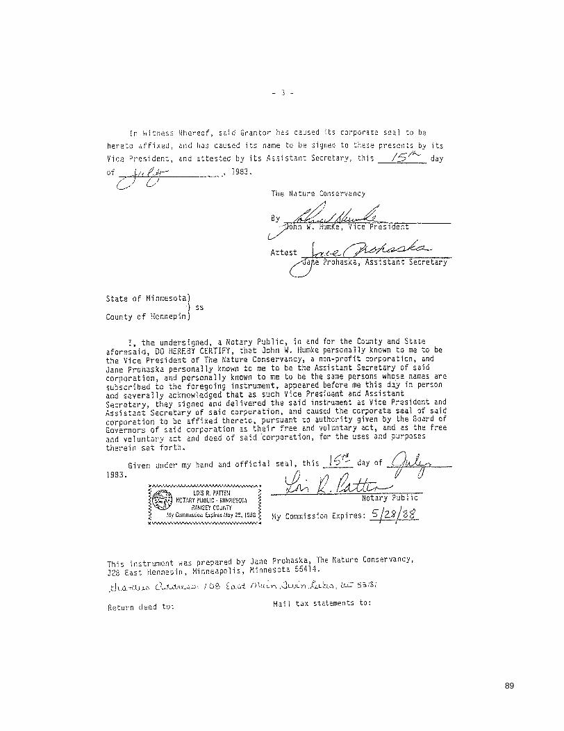
89
- ] -
In Witness
hereto affixed, Vice President,
Whereof, sai d Grantor has caused its corporate sea 1 to be and has caused its name to be signed to these presents by its and attested by its Assistant Secretary, this /~~ day
of61c,tr
State of Minnesota) ) ss
County of Hennepin)
, 1983.
The Nature Conservancy
I, the undersigned, a Notary Public, in and for the County and State aforesaid, DO HERE8Y CERTIFY, that John W. Humke personally known to me to be the Vice President of The Nature Conservancy, a non-profit corporation, and Jane Prohaska personally known to me to be the Assistant Secretary of said corporation, and persona11y known to me to be the same persons whose names are subscribed to the foregoing instrument, appeared before me this day in person and severally acknowledged that as such Vice President and Assistant Secretary, they signed and delivered the said instrument as Vice President and Assistant Secretary of said corporation, and caused the corporate seal of said corporation to be affi~ed thereto. pursuant to authority given by the Board of Governors of said corporation as their free and voluntary act, and as the free and voluntary act and deed of said corporation, for the uses and purposes therein set forth.
Given under my hand and official 1983.
seal" this It;~ day of 9+ ~r2.~
Notary Pub 1 i c
My Commission Expires: 5/2.2/3'8 J I
This instrument was prepared by Jane Prohaska, The Nature Conservancy, 328 East Hennepin, Minneapolis, Minnesota 55414.
}:JU1.-Lluc. (.l,j,-"t}LU':)· / Ol:> t ct.ui nl«(~n ,JLu~n . ..G.du.;:), Lt.J: 5311,1
Return deed to: Mail tax statements to:

This Page Intentionally Left Blank

Appendix C
1999 DAM BOARD POLICY
91

This Page Intentionally Left Blank
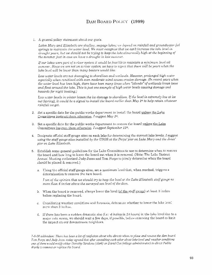
93
DAM BOARD POLICY (1999)
1. A general policy statement about our goals.
La!'ws Mary and Elizabeth are shallow, seepage lakes; we depend on rainfall and groundwater-fed springs to maintain the water level. JiVe must recognize that we can't increase the lahe level in drou,ght years, but we should not be trying to keep the lake abnormally high at the beginning of the summer just in case we have a drought in late summer.
If our lakes were part of a river system it would be feasible to maintain a minimum level all summer. Since we are not on a river system we have to expect that there will be years when the lake level will be lower than many boaters would lihe.
Low water levels are not damaging to shorelines and weUands. However, prolonged high water especially when combined with even moderate wind causes erosion damage. (In recent years when the water level has been high, there have been many times when "islands" of wetlands break loose and float around the lake. This is just one example of high water levels causing damage and hazards for night boating.)
Low water levels in winter lessen the ice damage to shorelines. If the level is extremely low at ice out (spring), it would be a signal to install the board ear her than May 1st to help retain whatever rainfall we get.
2. Set a specific date for the public works department to install the board unless the Lake Committees instruct them otherwise. I suggest May 1st.
3. Set a specific date for the public works department to remove the board unless the Lake Committees instruct them otherwise. I suggest September 151h.
4. Designate official staff gauge sites on each lake for determining the current lake levels. I suggest using the staff gauge sites installed by the USGS at the Porps' pier on Lake Mary and the Jooss' pier on Lake Elizabeth.
5. Establish some general guidelines for the Lake Committees to use to determine when to remove the board and how long to leave the board out when it is removed. (Note: The Lake District Annual Meeting authorized Judy Jooss and Tom Porps to jointly determine when the board should be placed & removed.)
a. Using the official staff gauge sites, set a maximum level that, when reached, triggers a determination to remove the dam board.
I am of the opinion that we should try to keep the level at the Lake Elizabeth staff gauge no more than 6 inches above the surveyed sea level of the darn.
b. When the board is removed, always lower the level (at the staff gauge) at least 3 inches before replacing the board.
c. Considering weather conditions and forecasts, determine whether to lower the lake level more than 3 inches.
d. If there has been a sudden dramatic rise (i.e.: 4 inches in 24 hOl.as) in the lake level due to a major rain storm, we should wait a few days, if possible, before removing the board to limit the impact on our downstream neighbors.
7-8-00 addendum: There has been a lot of confi,sion about who directs whom to place and remove the dam board Tom Porps and Judy Jooss today agreed that after consulting each other about lake level and weather conditions one a/them would notify either Dorothy Sandona (clerk) or David Cox (village administrator) to direct Public Works to remove or replace the board.

This Page Intentionally Left Blank
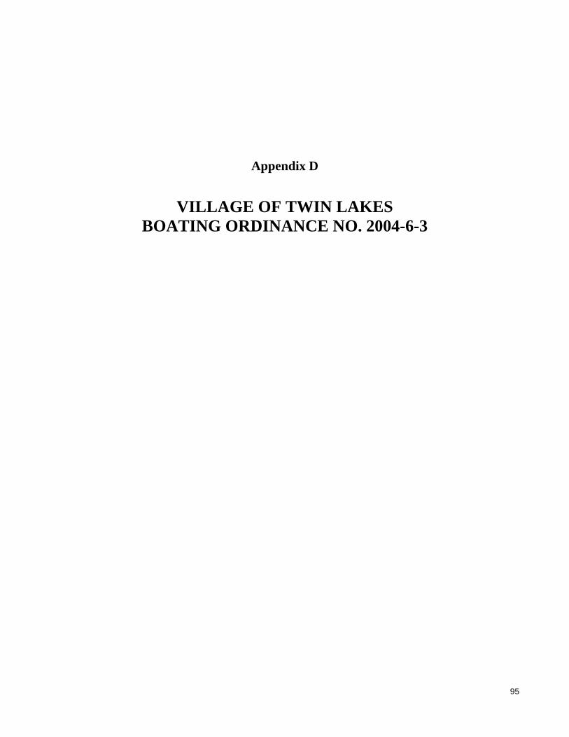
Appendix D
VILLAGE OF TWIN LAKES BOATING ORDINANCE NO. 2004-6-3
95

This Page Intentionally Left Blank

97
VILLAGE OF TWIN LAKES
ORDINANCE NO. 2004-6-3
An Ordinance to Amend Section 8.36.050 of the Twin Lakes Code of Ordinances
Pertaining to Boating and Water Code and Additional Traffic Rules
WHEREAS, the continuous and umeasonable rains have raised the levels of Lake Mary and Lake Elizabeth to such a point as to cause erosion damage to shorelines and damage to adjacent property, and
WHEREAS, the power boats traveling on said lakes cause wakes, which do further damage to the shoreline and adjacent property, and
WHEREAS, the Village Board hereby declares, pursuant to 166.23 of the Wisconsin Statutes, an emergency in the Village and in particular on the lakes and desires to prohibit the use of water craft causing wakes.
SECTION I Section 8.36.050 (E) of the Twin Lakes Code of Ordinances pertaining to Additional Traffic Rules is hereby amended to read as follows:
8.36.050 A.
Additional traffic rules. No person shall operate a motor boat at a speed in excess of slow-no-wake between the hours of sunset or eight (8:00) p.m., whichever occurs earliest, and nine (9:00) a.m., unless the operator of such boat has obtained a permit for a special activity as provided in Section 8.36.100. Further, no person shall operate a motor boat at a speed in excess of slow-no-wake at any time upon the waters of Lake Elizabeth when the water level exceeds 11.5 inches above the sea level elevation corresponding to the dam board as measured at the staff gauge at the Jooss Household and no person shall operate a motor boat at a speed in excess of slow-no-wake at any time upon the waters of Lake Mary when the water level exceeds 11.5 inches above the sea level elevation corresponding to the dam board as measured at the staff gauge at the Porps Household.
SECTION II All ordinance or parts of ordinances contravening the tem1S and conditions ofthi8 ordinance are hereby to that extent repealed.
SECTION III TlLis ordinance shall take effect immediately upon passage as provided by law, and the Village Clerk shall so amend the Village of Twin Lakes Code of Ordinances, and shall indicate the date and number of this creating ordinance herein.
Abstained
VI AGE OF TWIN LAKES )
;ft£C'1"---" Cathleen Zamazal,
G:ICOMMONIWPDOCSIADMINlOrdinanccsIOrctinance 2004-6-3 (Slow-No Wake-Moditicd).wpd Amends Code 10 implement temporary slow-no wake on both lakes at atl times

This Page Intentionally Left Blank

99
Appendix E
VILLAGE OF TWIN LAKES DAM MANAGEMENT POLICY: OCTOBER 2008

This Page Intentionally Left Blank

101
VILLAGE OF TWIN LAKES 108 East Main Street • P.O. Box 1024 • Twin Lakes, Wisconsin 53181
Phone (262) 877-2858 • Fax (262) 877-4019
DAM MANAGEMENT POLICY I PURPOSE
To outline the policies and procedures for management ofthe Village-owned dam below Lake Elizabeth in Illinois iIi otderto a~sist in the maintenance of appropriate lak~levels and preventimplementationof slow, no wake or other limited boatiilgdueto high water.
II POLICIES 1 The intendedlevelat which Slow, No Wake regulations would be implemented
will «ortespondto a sea level elevationof 794.5 feet.. . ... 2 .• Installation or removal of the dam bOard shall be perfonned by the Department of
Public Works uporidireCtionoftheVillage President or the Village Administrator based on the consehsus ofth~VillagePresident,the TrusteeCh~irperson of the Village Board's Lake IUanningandProtectionCommittee, aIld Chairperson of the Lake DistrictSteeriflg Council or their respective designees from their respective
. poard or committee. 3 The.President, Trustee, and Steering Council Chairpers9n will consider as a
guideline the sealevel elevation of794.1 feet for renibval of the dam board and will consider as a guideline the sea ievel elevati6n hf 793.8 feet for installation of the dam board. In addition, they will consider the near term weather forecast as well as the season of the year when detennining whether to remove or install the darn board. . ....
4 •. SewerDepartment employees shailbedifected to take lake Ievelni~asurements at / the appropriate gauge locations and to report those readings to the Village Admiriistrator's Office for recording. Said readings shall be taken on Mondays, any day the darh board is installed or removed, and on other days as directed, unle~s the lake is icebolYld. The Sewer Department shaUalso report the amount of precipitatjon that occurred since the laSt reading.
S Any time boating is limited on the lakes due to high water levels, readings must be taken more frequently.
• h.. ••
III THESE POLICIES ARE EFFECTIVE IMMEDIATELY AND MAYBE REVIEWED AND CHANGED AT ANY TIME.
BY ORDER OF VILLAGE BOARD
DATE: 10-20-2008
G:\COMMON\WPDOCSIADMIN\Policy Dam Management.ddiPeople Working Together" www.villageoftwinlakes.net
REVISED: ______ _

This Page Intentionally Left Blank

Appendix F
LEVELS OF ELIZABETH LAKE (1992-2008) AND LAKE MARY (1995-2008)
103

This Page Intentionally Left Blank

Ele
vation
infe
etabove
NG
VD
29
795.5
795.0
794.5
794.0
793.5
793.0
792.5
792.0
791.5
1992
Figure F-1
ELIZABETH LAKE LEVELS: 1992-2008
1993 1994 1995 1996 1997 19991998 20012000 2002 20042003 2005 20072006 2008
Year
Ele
vation
infe
etabove
NG
VD
29
795.5
795.0
794.5
794.0
793.5
793.0
792.5
792.0
791.5
Figure F-2
ELIZABETH LAKE LEVELS: 1992
January February March April May June July August September October November December
Month
Source: Citizen monitors, Village of Twin Lakes, and SEWRPC.
Source: Citizen monitors, Village of Twin Lakes, and SEWRPC.
RECOMMENDED LAKE LEVEL RANGE
RECOMMENDED LAKE LEVEL RANGE
105

Ele
vation
infe
etabove
NG
VD
29
795.5
795.0
794.5
794.0
793.5
793.0
792.5
792.0
791.5
Figure F-3
ELIZABETH LAKE LEVELS: 1993
Ele
vation
infe
etabove
NG
VD
29
795.5
795.0
794.5
794.0
793.5
793.0
792.5
792.0
791.5
Figure F-4
ELIZABETH LAKE LEVELS: 1994
January February March April May June July August September October November December
Month
January February March April May June July August September October November December
Month
Source: Citizen monitors, Village of Twin Lakes, and SEWRPC.
Source: Citizen monitors, Village of Twin Lakes, and SEWRPC.
RECOMMENDED LAKE LEVEL RANGE
RECOMMENDED LAKE LEVEL RANGE
106

Ele
vation
infe
etabove
NG
VD
29
795.5
795.0
794.5
794.0
793.5
793.0
792.5
792.0
791.5
Figure F-5
ELIZABETH LAKE LEVELS: 1995
Ele
vation
infe
etabove
NG
VD
29
795.5
795.0
794.5
794.0
793.5
793.0
792.5
792.0
791.5
Figure F-6
ELIZABETH LAKE LEVELS: 1996
January February March April May June July August September October November December
Month
January February March April May June July August September October November December
Month
Source: Citizen monitors, Village of Twin Lakes, and SEWRPC.
Source: Citizen monitors, Village of Twin Lakes, and SEWRPC.
RECOMMENDED LAKE LEVEL RANGE
RECOMMENDED LAKE LEVEL RANGE
107

Ele
vation
infe
etabove
NG
VD
29
795.5
795.0
794.5
794.0
793.5
793.0
792.5
792.0
791.5
Figure F-7
ELIZABETH LAKE LEVELS: 1997
Ele
vation
infe
etabove
NG
VD
29
795.5
795.0
794.5
794.0
793.5
793.0
792.5
792.0
791.5
Figure F-8
ELIZABETH LAKE LEVELS: 1998
January February March April May June July August September October November December
Month
January February March April May June July August September October November December
Month
Source: Citizen monitors, Village of Twin Lakes, and SEWRPC.
Source: Citizen monitors, Village of Twin Lakes, and SEWRPC.
RECOMMENDED LAKE LEVEL RANGE
RECOMMENDED LAKE LEVEL RANGE
108

Ele
vation
infe
etabove
NG
VD
29
795.5
795.0
794.5
794.0
793.5
793.0
792.5
792.0
791.5
Figure F-9
ELIZABETH LAKE LEVELS: 1999
Ele
vation
infe
etabove
NG
VD
29
795.5
795.0
794.5
794.0
793.5
793.0
792.5
792.0
791.5
Figure F-10
ELIZABETH LAKE LEVELS: 2000
January February March April May June July August September October November December
Month
January February March April May June July August September October November December
Month
Source: Citizen monitors, Village of Twin Lakes, and SEWRPC.
Source: Citizen monitors, Village of Twin Lakes, and SEWRPC.
RECOMMENDED LAKE LEVEL RANGE
RECOMMENDED LAKE LEVEL RANGE
109

Ele
vation
infe
etabove
NG
VD
29
795.5
795.0
794.5
794.0
793.5
793.0
792.5
792.0
791.5
Figure F-11
ELIZABETH LAKE LEVELS: 2001
Ele
vation
infe
etabove
NG
VD
29
795.5
795.0
794.5
794.0
793.5
793.0
792.5
792.0
791.5
Figure F-12
ELIZABETH LAKE LEVELS: 2002
January February March April May June July August September October November December
Month
January February March April May June July August September October November December
Month
Source: Citizen monitors, Village of Twin Lakes, and SEWRPC.
Source: Citizen monitors, Village of Twin Lakes, and SEWRPC.
RECOMMENDED LAKE LEVEL RANGE
RECOMMENDED LAKE LEVEL RANGE
110

111
Ele
vation
infe
etabove
NG
VD
29
795.5
795.0
794.5
794.0
793.5
793.0
792.5
792.0
791.5
Figure F-13
ELIZABETH LAKE LEVELS: 2003
Ele
vation
infe
etabove
NG
VD
29
795.5
795.0
794.5
794.0
793.5
793.0
792.5
792.0
791.5
Figure F-14
ELIZABETH LAKE LEVELS: 2004
January February March April May June July August September October November December
Month
January February March April May June July August September October November December
Month
Source: Citizen monitors, Village of Twin Lakes, and SEWRPC.
Source: Citizen monitors, Village of Twin Lakes, and SEWRPC.
RECOMMENDED LAKE LEVEL RANGE
RECOMMENDED LAKE LEVEL RANGE

Ele
vation
infe
etabove
NG
VD
29
795.5
795.0
794.5
794.0
793.5
793.0
792.5
792.0
791.5
Figure F-15
ELIZABETH LAKE LEVELS: 2005
Ele
vation
infe
etabove
NG
VD
29
795.5
795.0
794.5
794.0
793.5
793.0
792.5
792.0
791.5
Figure F-16
ELIZABETH LAKE LEVELS: 2006
January February March April May June July August September October November December
Month
January February March April May June July August September October November December
Month
Source: Citizen monitors, Village of Twin Lakes, and SEWRPC.
Source: Citizen monitors, Village of Twin Lakes, and SEWRPC.
RECOMMENDED LAKE LEVEL RANGE
RECOMMENDED LAKE LEVEL RANGE
112

Ele
vation
infe
etabove
NG
VD
29
795.5
795.0
794.5
794.0
793.5
793.0
792.5
792.0
791.5
Figure F-17
ELIZABETH LAKE LEVELS: 2007
Ele
vation
infe
etabove
NG
VD
29
795.5
795.0
794.5
794.0
793.5
793.0
792.5
792.0
791.5
Figure F-18
ELIZABETH LAKE LEVELS: 2008
January February March April May June July August September October November December
Month
January February March April May June July August September October November December
Month
Source: Citizen monitors, Village of Twin Lakes, and SEWRPC.
Source: Citizen monitors, Village of Twin Lakes, and SEWRPC.
RECOMMENDED LAKE LEVEL RANGE
RECOMMENDED LAKE LEVEL RANGE
113

114
Ele
vation
infe
etabove
NG
VD
29
795.5
795.0
794.5
794.0
793.5
793.0
792.5
Figure F-19
LAKE MARY LEVELS: 1995-2008
1995 1996 1997 19991998 20012000 2002 20042003 2005 20072006 2008
Year
Ele
vation
infe
etabove
NG
VD
29
795.5
795.0
794.5
794.0
793.5
793.0
792.5
Figure F-20
LAKE MARY LEVELS: 1995
January February March April May June July August September October November December
Month
Source: Citizen monitors, Village of Twin Lakes, and SEWRPC.
Source: Citizen monitors, Village of Twin Lakes, and SEWRPC.
RECOMMENDED LAKE LEVEL RANGE
RECOMMENDED LAKE LEVEL RANGE

Ele
vation
infe
etabove
NG
VD
29
795.5
795.0
794.5
794.0
793.5
793.0
792.5
Figure F-21
LAKE MARY LEVELS: 1996
Ele
vation
infe
etabove
NG
VD
29
795.5
795.0
794.5
794.0
793.5
793.0
792.5
Figure F-22
LAKE MARY LEVELS: 1997
January February March April May June July August September October November December
Month
January February March April May June July August September October November December
Month
Source: Citizen monitors, Village of Twin Lakes, and SEWRPC.
Source: Citizen monitors, Village of Twin Lakes, and SEWRPC.
RECOMMENDED LAKE LEVEL RANGE
RECOMMENDED LAKE LEVEL RANGE
115
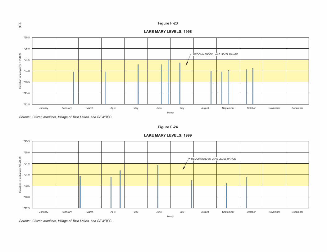
Ele
vation
infe
etabove
NG
VD
29
795.5
795.0
794.5
794.0
793.5
793.0
792.5
Figure F-23
LAKE MARY LEVELS: 1998
Ele
vation
infe
etabove
NG
VD
29
795.5
795.0
794.5
794.0
793.5
793.0
792.5
Figure F-24
LAKE MARY LEVELS: 1999
January February March April May June July August September October November December
Month
January February March April May June July August September October November December
Month
Source: Citizen monitors, Village of Twin Lakes, and SEWRPC.
Source: Citizen monitors, Village of Twin Lakes, and SEWRPC.
RECOMMENDED LAKE LEVEL RANGE
RECOMMENDED LAKE LEVEL RANGE
116

Ele
vation
infe
etabove
NG
VD
29
795.5
795.0
794.5
794.0
793.5
793.0
792.5
Figure F-25
LAKE MARY LEVELS: 2000
Ele
vation
infe
etabove
NG
VD
29
795.5
795.0
794.5
794.0
793.5
793.0
792.5
Figure F-26
LAKE MARY LEVELS: 2001
January February March April May June July August September October November December
Month
January February March April May June July August September October November December
Month
Source: Citizen monitors, Village of Twin Lakes, and SEWRPC.
Source: Citizen monitors, Village of Twin Lakes, and SEWRPC.
RECOMMENDED LAKE LEVEL RANGE
RECOMMENDED LAKE LEVEL RANGE
117
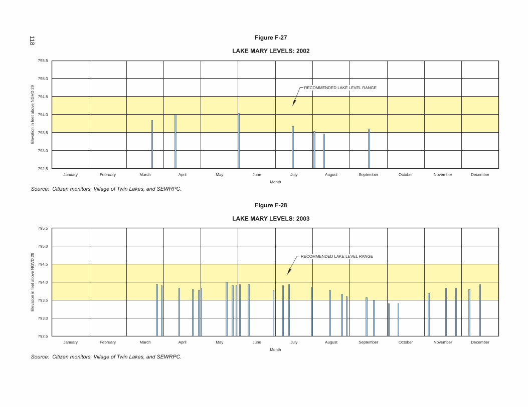
Ele
vation
infe
etabove
NG
VD
29
795.5
795.0
794.5
794.0
793.5
793.0
792.5
Figure F-27
LAKE MARY LEVELS: 2002
Ele
vation
infe
etabove
NG
VD
29
795.5
795.0
794.5
794.0
793.5
793.0
792.5
Figure F-28
LAKE MARY LEVELS: 2003
January February March April May June July August September October November December
Month
January February March April May June July August September October November December
Month
Source: Citizen monitors, Village of Twin Lakes, and SEWRPC.
Source: Citizen monitors, Village of Twin Lakes, and SEWRPC.
RECOMMENDED LAKE LEVEL RANGE
RECOMMENDED LAKE LEVEL RANGE
118
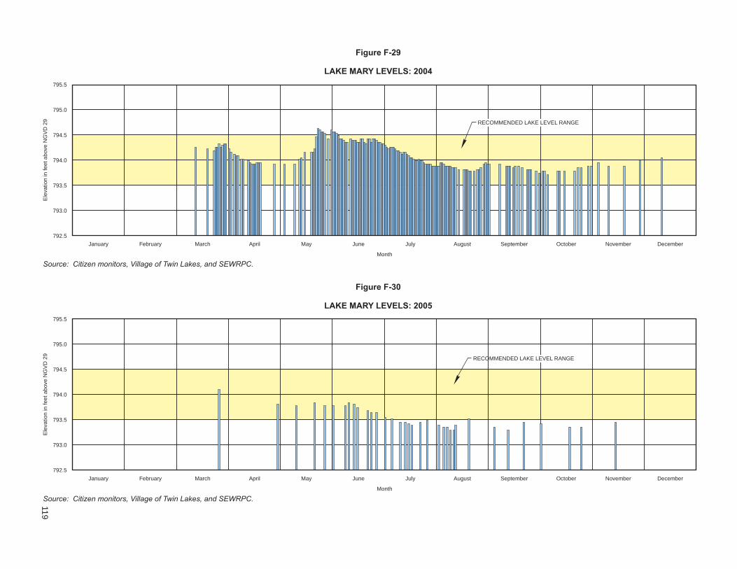
Ele
vation
infe
etabove
NG
VD
29
795.5
795.0
794.5
794.0
793.5
793.0
792.5
Figure F-29
LAKE MARY LEVELS: 2004
Ele
vation
infe
etabove
NG
VD
29
795.5
795.0
794.5
794.0
793.5
793.0
792.5
Figure F-30
LAKE MARY LEVELS: 2005
January February March April May June July August September October November December
Month
January February March April May June July August September October November December
Month
Source: Citizen monitors, Village of Twin Lakes, and SEWRPC.
Source: Citizen monitors, Village of Twin Lakes, and SEWRPC.
RECOMMENDED LAKE LEVEL RANGE
RECOMMENDED LAKE LEVEL RANGE
119

Ele
vation
infe
etabove
NG
VD
29
795.5
795.0
794.5
794.0
793.5
793.0
792.5
Figure F-31
LAKE MARY LEVELS: 2006
Ele
vation
infe
etabove
NG
VD
29
795.5
795.0
794.5
794.0
793.5
793.0
792.5
Figure F-32
LAKE MARY LEVELS: 2007
January February March April May June July August September October November December
Month
January February March April May June July August September October November December
Month
Source: Citizen monitors, Village of Twin Lakes, and SEWRPC.
Source: Citizen monitors, Village of Twin Lakes, and SEWRPC.
RECOMMENDED LAKE LEVEL RANGE
RECOMMENDED LAKE LEVEL RANGE
120

121
Ele
vation
infe
etabove
NG
VD
29
795.5
795.0
794.5
794.0
793.5
793.0
792.5
Figure F-33
LAKE MARY LEVELS: 2008
January February March April May June July August September October November December
Month
Source: Citizen monitors, Village of Twin Lakes, and SEWRPC.
RECOMMENDED LAKE LEVEL RANGE

This Page Intentionally Left Blank

123
Appendix G
NONPOINT SOURCE POLLUTION CONTROL MEASURES Nonpoint, or diffuse, sources of water pollution include urban sources such as runoff from residential, commer-cial, industrial, transportation, and recreational land uses; construction activities; and onsite sewage disposal systems and rural sources such as runoff from cropland, pasture, and woodland, atmospheric contributions, and livestock wastes. These sources of pollutants discharge to surface waters by direct overland drainage, by drainage through natural channels, by drainage through engineered stormwater drainage systems, and by deep percolation into the ground and subsequent return flow to the surface waters. A summary of the methods and estimated effectiveness of nonpoint source water pollution control measures is set forth in Table G-1. These measures have been grouped for planning purposes into two categories: basic practices and additional. Application of the basic practices will have a variable effectiveness in terms of level of pollution control depending upon the subwatershed area characteristics and the pollutant considered. The additional category of nonpoint source control measures has been subdivided into four subcategories based upon the relative effectiveness and costs of the measures. The first subcategory of practices can be expected to result generally in about a 25 percent reduction in pollutant runoff. The second and third subcategory of practices, when applied in combination with the minimum and additional practices, can be expected to generally result in up to a 75 percent reduction in pollutant runoff, respectively. The fourth subcategory would consist of all of the preceding practices, plus those additional practices that would be required to achieve a reduction in ultimate runoff of more than 75 percent. Table G-1 sets forth the diffuse source control measures applicable to general land uses and diffuse source activities, along with the estimated maximum level of pollution reduction which may be expected upon imple-mentation of the applicable measures. The table also includes information pertaining to the costs of developing the alternatives set forth in Chapter II of this volume.1 These various individual nonpoint source control practices are summarized by group in Table G-2. Of the sets of practices recommended for various levels of diffuse source pollution control presented in Table G-2, not all practices are needed, applicable, or cost-effective for all watersheds, due to variations in pollutant loadings and land use and natural conditions among the watersheds. Therefore, it is recommended that the practices indicated as needed for nonpoint source pollutant control be refined by local level nonpoint source control practices planning, which would be analogous to sewerage facilities planning for point source pollution abatement. A locally prepared plan for nonpoint abatement measures should be better able to blend knowledge of current problems and practices with a quickly evolving technology to achieve a suitable, site-specific approach to pollution abatement.
_____________ 1Costs are presented in more detail in the following SEWRPC Technical Reports: No. 18, State of the Art of Water Pollution Control in Southeastern Wisconsin, Volume Three, Urban Storm Water Runoff, July 1977, and Volume Four, Rural Storm Water Runoff, December 1976; and No. 31, Costs of Urban Nonpoint Source Water Pollution Control Measures, June 1991.

124
Table G-1
GENERALIZED SUMMARY OF METHODS AND EFFECTIVENESS OF NONPOINT SOURCE WATER POLLUTION ABATEMENT
Applicable Land Use Control Measuresa Summary Description
Approximate Percent Reduction of
Released Pollutantsb Assumptions for
Costing Purposes
Urban Litter and pet waste control ordinance
Prevent the accumulation of litter and pet wastes on streets and residential, commercial, industrial, and recreational areas
2 to 5 Ordinance administration and enforcement costs are expected to be funded by violation penalties and related revenues
Improved timing and efficiency of street sweeping, leaf collection and disposal, and catch basin cleaning
Improve the scheduling of these public works activities, modify work habits of personnel, and select equipment to maximize the effectiveness of these existing pollution control measures
2 to 5 No significant increase in current expenditures is expected
Management of onsite sewage treatment systems
Regulate septic system installation, monitoring, location, and performance; replace failing systems with new septic systems or alternative treatment facilities; develop alternatives to septic systems; eliminate direct connections to drain tiles or ditches; dispose of septage at sewage treatment facility
10 to 30 Replace one-half of estimated existing failing septic systems with properly located and installed systems and replace one-half with alternative systems, such as mound systems or holding tanks; all existing and proposed onsite sewage treatment systems are assumed to be properly maintained; assume system life of 25 years. The estimated cost of a septic tank system is $5,000 to $6,000 and the cost of an alternative system is $10,000. The annual maintenance cost of a disposal system is $250. An in-ground pressure system is estimated to cost $6,000 to $10,000 with an annual operation and maintenance cost of $250. A holding tank would cost $5,500 to $6,500, with an annual operation and maintenance cost of $1,800
Increased street sweeping On the average, sweep all streets in urban areas an equivalent of once or twice a week with vacuum street sweepers; require parking restrictions to permit access to curb areas; sweep all streets at least eight months per year; sweep commercial and industrial areas with greater frequency than residential areas
30 to 50 Estimate curb-miles based on land use, estimated street acreage, and Commis-sion transportation planning standards; assume one street sweeper can sweep 2,000 curb-miles per year; assume sweeper life of 10 years; assume residential areas swept once weekly, commercial and industrial areas swept twice weekly. The cost of a vacuum street sweeper is approximately $120,000. The cost of the operation and maintenance of a sweeper is about $25 per curb-mile swept
Increased leaf and clippings collection and disposal
Increase the frequency and efficiency of leaf collection procedures in fall; use vacuum cleaners to collect leaves; implement ordinances for leaves, clippings. and other organic debris to be mulched, composted, or bagged for pickup
2 to 5 Assume one equivalent mature tree per residence, plus five trees per acre in recreational areas; 75 pounds of leaves per tree; 20 percent of leaves in urban areas not currently disposed of properly. The cost of the collection of leaves in a vacuum sweeper and disposal is estimated at $180 to $200 per ton of leaves
Increased catch basin cleaning Increase frequency and efficiency of catch basin cleaning; clean at least twice per year using vacuum cleaners; catch basin installation in new urban development not recommended as a cost-effective practice for water quality improvement
2 to 5 Determine curb-miles for street sweeping; vary percent of urban areas served by catch basins by watershed from Commission inventory data; assume density of 10 catch basins per curb-mile; clean each basin twice annually by vacuum cleaner. The cost of cleaning a catch basin is approximately $10
Reduced use of deicing salt Reduce use of deicing salt on streets; salt only intersections and problem areas; prevent excessive use of sand and other abrasives
Negligible for pollutants addressed in this plan, but helpful for reducing chlorides and associated damage to vegetation
Increased costs, such as for slower transportation movement, are expected to be offset by benefits, such as reduced automobile corrosion and damage to vegetation

125
Table G-1 (continued)
Applicable Land Use Control Measuresa Summary Description
Approximate Percent Reduction of
Released Pollutantsb Assumptions for
Costing Purposes
Urban (continued) Improved street maintenance and refuse collection and disposal
Increase street maintenance and repairs; increase provision of trash receptacles in public areas; improve trash collection schedules; increase cleanup of parks and commercial centers
2 to 5 Increase current expenditures by approximately 15 percent
Parking lot stormwater temporary storage and treatment measures
Construct gravel-filled trenches, sediment basins, or similar measures to store temporarily the runoff from parking lots, rooftops, and other large impervious areas; if treatment is necessary, use a physical-chemical treatment measure, such as screens, dissolved air flotation, or a swirl concentrator
5 to 10 Design gravel-filled trenches for 24-hour, five-year recurrence interval storm; apply to off-street parking acreages. For treatment, assume four-hour detention time. The capital cost of stormwater detention and treatment facilities is estimated at $40,000 to $80,000 per acre of parking lot area, with an annual operation and maintenance cost of about $200 per acre
Onsite storage—residential Remove connections to sewer systems; construct onsite stormwater storage measures for subdivisions
5 to 10 Remove roof drains and other connections from sewer system wherever needed; use lawn aeration, if applicable; apply dutch drain storage facilities to 15 percent of residences. The capital cost would approximate $500 per house, with an annual operation and maintenance cost of about $25
Stormwater Infiltration—urban Construct gravel-filled trenches for areas of less than 10 acres or basins to collect and store temporarily stormwater runoff to reduce volume, provide groundwater recharge and augment low stream flows
45 to 90 Design gravel-filled trenches or basins to store the first 0.5 inch of runoff; provide at least a 25-foot grass buffer strip to reduce sediment loadings. The capital cost of stormwater infiltration is estimated at $12,000 for a six-foot-deep, 10-foot-wide trench, and at $70,000 for a one-acre basin, with an annual maintenance cost of about $10 to $350 for the trench and about $2,500 for the basin
Stormwater storage—urban Store stormwater runoff from urban land in surface storage basins or, where necessary, subsurface storage basins
10 to 35 Design all storage facilities for a 1.5-inch runoff event, which corresponds approximately to a five-year recurrence interval event, with a storm event being defined as a period of precipitation with a minimum antecedent and subsequent dry period of from 12 to 24 hours; apply subsurface storage tanks to intensively developed existing urban areas where suitable open land for surface storage is unavailable; design surface storage basins for proposed new urban land, existing urban land not storm sewered, and existing urban land where adequate open space is available at the storm sewer discharge site. The capital cost for stormwater storage would range from $35,000 to $110,000 per acre of basin, with an annual operation and maintenance cost of about $40 to $60 per acre
Stormwater treatment Provide physical-chemical treatment which includes screens, microstrainers, dissolved air flotation, swirl concentrator, or high-rate filtration, and/or disinfection, which may include chlorination, high-rate disinfection, or ozonation to stormwater following storage
10 to 50 To be applied only in combination with stormwater storage facilities above; general cost estimates for microstrainer treatment and ozonation were used; some costs were applied to existing urban land and proposed new urban development. Stormwater treatment has an estimated capital cost of from $900 to $7,000 per acre of tributary drainage area, with an average annual operation and maintenance cost of about $35 to $100 per acre
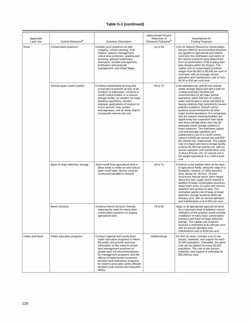
126
Table G-1 (continued)
Applicable Land Use Control Measuresa Summary Description
Approximate Percent Reduction of
Released Pollutantsb Assumptions for
Costing Purposes
Rural Conservation practices Includes such practices as strip cropping, contour plowing, crop rotation, pasture management, critical area protection, grading and terracing, grassed waterways, diversions, woodlot management, fertilization and pesticide management, and chisel tillage
Up to 50 Cost for Natural Resources Conservation Service (NRCS) recommended practices are applied to agricultural and related rural land; the distribution and extent of the various practices were determined from an examination of 56 existing farm plan designs within the Region. The capital cost of conservation practices ranges from $3,000 to $5,000 per acre of rural land, with an average annual operation and maintenance cost of from $5.00 to $10 per rural acre
Animal waste control system Construct streambank fencing and crossovers to prevent access of all livestock to waterways; construct a runoff control system or a manure storage facility, as needed, for major livestock operations; prevent improper applications of manure on frozen ground, near surface drainageways, and on steep slopes; incorporate manure into soil
50 to 75 Cost estimated per animal unit; animal waste storage (liquid and slurry tank for costing purposes) facilities are recommended for all major animal operations within 500 feet of surface water and located in areas identified as having relatively high potential for severe pollution problems. Runoff control systems recommended for all other major animal operations. It is recognized that dry manure stacking facilities are significantly less expensive than liquid and slurry storage tanks and may be adequate waste storage systems in many instances. The estimated capital cost and average operation and maintenance cost of a runoff control system is $100 per animal unit and $25 per animal unit, respectively. The capital cost of a liquid and slurry storage facility is about $1,000 per animal unit, with an annual operation and maintenance cost of about $75 per unit. An animal unit is the weight equivalent of a 1,000-pound cow
Base-of-slope detention storage Store runoff from agricultural land to allow solids to settle out and reduce peak runoff rates. Berms could be constructed parallel to streams
50 to 75 Construct a low earthen berm at the base of agricultural fields, along the edge of a floodplain, wetland, or other sensitive area, design for 24-hour, 10-year recurrence interval storm; berm height about four feet. Apply where needed in addition to basic conservation practices; repair berm every 10 years and remove sediment and spread on land. The estimated capital cost of base-of-slope detention storage would be $500 per tributary acre, with an annual operation and maintenance cost of $25 per acre
Bench terraces Construct bench terraces, thereby reducing the need for many other conservation practices on sloping agricultural land
75 to 90 Apply to all appropriate agricultural lands for a maximum level of pollution control. Utilization of this practice would exclude installation of many basic conservation practices and base-of-slope detention storage. The capital cost of bench terraces is estimated at $1,500 per acre, with an annual operation and maintenance cost of $100 per acre
Urban and Rural Public education programs Conduct regional and county-level public education programs to inform the public and provide technical information on the need for proper land management practices on private land, the recommendations for management programs, and the effects of implemented measures; develop local awareness programs for citizens and public works officials; develop local contract and education efforts
Indeterminate For first 10 years, includes cost of one person, materials, and support for each 25,000 population. Thereafter, the same cost can be applied for every 50,000 population. The cost of one person, materials, and support is estimated at $55,000 per year

127
Table G-1 (continued)
Applicable Land Use Control Measuresa Summary Description
Approximate Percent Reduction of
Released Pollutantsb Assumptions for
Costing Purposes
Urban and Rural (continued)
Construction erosion control practices
Construct temporary sediment basins; install straw bale dikes; use fiber mats, mulching, and seeding; install slope drains to stabilize steep slopes; construct temporary diversion swales or berms upslope from the project
20 to 40 Assume acreage under construction is the average annual incremental increase in urban acreage; apply costs for a typical erosion control program for a construction site. The estimated capital cost and operation and maintenance cost for construction erosion control is $250 to $5,500 and $250 to $1,500 per acre under construction, respectively
Materials storage and runoff control facilities
Enclose industrial storage sites with diversion; divert runoff to acceptable outlet or storage facility; enclose salt piles and other large storage sites in crib and dome structures
5 to 10 Assume 40 percent of industrial areas are used for storage and to be enclosed by diversions; assume existing salt storage piles enclosed by cribs and dome structures. The estimated capital cost of industrial runoff control is $2,500 per acre of industrial land. Material storage control costs are estimated at $75 per ton of material
Stream protection measures Provide vegetative buffer zones along streams to filter direct pollutant runoff to the stream; construct streambank protection measures, such as rock riprap, brush mats, tree revetment, jacks, and jetted willow poles, where needed
5 to 10 Apply a 50-foot-wide vegetative buffer zone on each side of 15 percent of the stream length; apply streambank protection measures to 5 percent of the stream length. Vegetative buffer zones are estimated to cost $21,200 per mile of stream and streambank protection measures cost about $37,000 per stream mile
Pesticide and fertilizer application restrictions
Match application rate to need; eliminate excessive applications and applications near or into surface water drainageways
0 to 3 Cost included in public education program
Critical area protection Emphasize control of areas bordering lakes and streams; correct obvious erosion and other pollution source problems
Indeterminate Indeterminate
aNot all control measures are required for each subwatershed. The characteristics of the watershed, the estimated required level of pollution reduction needed to meet the applicable water quality standards, and other factors will influence the selection and estimation of costs of specific practices for any one subwatershed. Although the control measures costed represent the recommended practices developed at the regional level on the basis of the best available information, the local implementation process should provide more detailed data and identify more efficient and effective sets of practices to apply to local conditions. bThe approximate effectiveness refers to the estimated amount of pollution produced by the contributing category (urban or rural) that could be expected to be reduced by the implementation of the practice. The effectiveness rates would vary greatly depending on the characteristics of the watershed and individual diffuse sources. It should be further noted that practices can have only a “sequential” effect, since the percent pollution reduction of a second practice can only be applied against the residual pollutant load which is not controlled by the first practice. For example. two practices of 50 percent effectiveness would achieve a theoretical total effectiveness of only 75 percent control of the initial load. Further, the general levels of effectiveness reported in the table are not necessarily the same for all pollutants associated with each source. Some pollutants are transported by dissolving in water and others by attaching to solids in the water; the methods summarized here reflect typical pollutant removal levels. cFor highly urbanized areas which require retrofitting of facilities into developed areas, the costs can range from $400,000 to $1,000,000 per acre of storage. Source: SEWRPC.

128
Table G-2
ALTERNATIVE GROUPS OF DIFFUSE SOURCE WATER POLLUTION CONTROL MEASURES PROPOSED FOR STREAMS AND LAKE WATER QUALITY MANAGEMENT
Pollution Control Category
Level of Pollution Control
Practices to Control Diffuse Source Pollution from Urban Areasa
Practices to Control Diffuse Source Pollution from Rural Areasb
Basic Practices Variable Construction erosion control; onsite sewage disposal system management; streambank erosion control
Streambank erosion control
25 percent Public education programs; litter and pet waste control; restricted use of fertilizers and pesticides; construction erosion control; critical areas protection; improved timing and efficiency of street sweeping, leaf collection, and catch basin cleaning; material storage facilities and runoff control
Public education programs; fertilizer and pesticide management; critical area protection; crop residue management; chisel tillage; pasture management; contour plowing; livestock waste control
Additional Diffuse Source Control Practices
50 percent Above, plus: Increased street sweep- ing; improved street maintenance and refuse collection and disposal; increased catch basin cleaning; stream protection; increased leaf and vegetation debris collection and disposal; stormwater storage; stormwater infiltration
Above, plus: crop rotation; contour strip-cropping; grass waterways; diversions; wind erosion controls; terraces; stream protection
75 percent Above, plus: An additional increase in street sweeping, stormwater storage and infiltration; additional parking lot stormwater runoff storage and treatment
Above, plus: Base-of-slope detention storage
More than 75 percent Above, plus: Urban stormwater treatment with physical-chemical and/or disinfection treatment measures
Bench terracesc
aGroups of practices are presented here for general analysis purposes only. Not all practices are applicable to, or recommended for, all lake and stream tributary watersheds. For costing purposes, construction erosion control practices, public education programs, and material storage facilities and runoff controls are considered urban control measures and stream protection is considered a rural control measure. bIn addition to diffuse source control measures, lake rehabilitation techniques may be required to satisfy lake water quality standards. cThe provision of bench terraces would exclude most basic conversation practices and base-of-slope detention storage facilities. Source: SEWRPC.