a guide to caribbean vegetation types - conservation … · a guide to caribbean vegetation types:...
TRANSCRIPT
A Guide to Caribbean
Vegetation Types:
Preliminary Classification System and Descriptions
Written by
Alberto E. Areces-Mallea, Alan S. Weakley, Xiaojun Li, Roger G. Sayre,
Jeffrey D. Parrish, Camille V. Tipton and Timothy Boucher
Edited by
Nicole Panagopoulos
A Guide to Caribbean Vegetation Types: Preliminary Classification System and
Descriptions
Copyright © 1999 The Nature Conservancy. Reproduction of this publication for
educational or other non-commercial purposes is authorized without prior
permission of the copyright holder. Reproduction for resale or other commercial
purposes is prohibited without prior written permission of the copyright holder.
Cover by Margaret Buck
Production by Nicole Panagopoulos
The mission of The Nature Conservancy is to preserve the
plants, animals and natural communities that represent the
diversity of life on Earth by protecting the lands and waters
they need to survive.

Table of Contents
Acknowledgments .................................................................................. 1
Executive Summary .............................................................................. 3
Chapter One .......................................................................................... 9
Vegetation Classification and Vegetation Mapping of the
Caribbean Islands—A Review
Background .......................................................................................... 9
General Classification Systems Applicable to Caribbean
Tropical Vegetation ....................................................................... 10
Major Vegetation Classification Systems and Vegetation
Maps for the Greater Caribbean .................................................... 11
Major Vegetation Classification Systems and Vegetation
Maps for Islands or Groups of Islands .......................................... 14
Aruba, Bonaire, and Curaçao .................................................................. 14
Bahamas (Including Turks and Caicos) .................................................. 14
Bermuda ................................................................................................. 14
Cayman Islands ...................................................................................... 14
Cuba ........................................................................................................ 15
Hispaniola ............................................................................................... 16
Jamaica ................................................................................................... 17
The Lesser Antilles ................................................................................. 18
Puerto Rico and the Virgin Islands ......................................................... 19
Trinidad and Tobago .............................................................................. 21
Chapter Two ........................................................................................... 23
The International Classification of Ecological
Communities (ICEC)
Overview .............................................................................................. 23
Classification Units versus Mapping Units .......................................... 24
Chapter Three ....................................................................................... 25
Standardized Terminology for Classifying Vegetation
Chapter Four ......................................................................................... 41
Vegetation of the Caribbean Islands: Formations
Conclusion ............................................................................................. 55
Appendices

Appendix One .................................................................................................. 59
Vegetation of the Caribbean Islands: Descriptions of Alliances and Associations
Appendix Two .................................................................................................. 137
Caribbean Vegetation Classification References
Appendix Three ............................................................................................... 163
Members of the Caribbean Vegetation Ecology Working Group

Acknowledgments
The project team would like to extend our thanks to the many individuals
and institutions which have made the production of this work possible. Our
appreciation goes to The New York Botanical Gardens, the International Institute
of Tropical Forestry, the United States Geological Survey, Neil Sealey, Ethan
Freid, and the Departamento de Inventario de Recursos Naturales (DIRENA, a
government mapping agency in the Dominican Republic) for their help in
providing maps. John de Freitas, Director of the Netherlands Antilles
Conservation Data Center, supplied important data for the Lesser Antilles, and
Dayle Barry and Stevie Henry of the U.S. Virgin Islands Conservation Data
Center furnished essential data on the Islands. Members of the International
Institute of Tropical Forestry who made the October 1998 workshop a success
are: Ariel Lugo, Bill Edwards, Olga Ramos, Carlos Rodriguez, and Janet Rivera.
Larry Tieszen, Eric Woods, and Zhiliang Zhu of the EROS Data Center and Gina
Green, Carol Mayes, and John Tschirky of the Caribbean Division of The
Conservancy have provided significant support throughout the project. Thanks
also to Bruce Potter and Jean Pierre Bacle of Island Resources Foundation, who
provided support at the project concept phase. Eva Vilarrubi, also from The
Conservancy, and Margaret Buck provided assistance in the publication of this
document. We would especially like to thank Susan Vidal and Ken Gorton, who
were instrumental in the compilation of the island maps.
Lastly, we would like to commend the support provided by the
Caribbean Vegetation Ecology Working Group, for their help at an October 1998
workshop in refining and correcting our earlier maps, and sending in subsequent
corrections from their respective institutions. The members of this group
include:
Alberto Areces-Mallea The New York Botanical Garden
Dayle Barry U.S. Virgin Islands Conservation Data Center
Luis Beltrán Burgos Puerto Rico Natural Heritage Program
Tim Boucher The Nature Conservancy
Gary Breckon University of Puerto Rico Biology Department
Daniel Dávila Casanova Puerto Rico Natural Heritage Program
Olasee Davis University of the Virgin Islands
William Edwards International Institute of Tropical Forestry
Julio C. Figueroa Colón International Institute of Tropical Forestry
Ethan Freid Miami University of Ohio
Elanor Gibney Virgin Islands specialist
Stevie Henry U.S. Virgin Islands Conservation Data Center
Richard Howard Harvard University Herbaria

Duane Kolterman University of Puerto Rico Biology Department
Xiaojun Li The Nature Conservancy
Eric Lindsay Department of Planning and Natural
Resources—U.S. Virgin Islands
Kevel Lindsay Island Resources Foundation
Carol Mayes The Nature Conservancy—U.S. Virgin Islands
Rudy O’Reilly USDA Natural Resources—Conservation
Science
Jeffrey Parrish The Nature Conservancy
George Proctor U.S. National Herbarium, Smithsonian Institute
Vicente Quevedo Bonilla Puerto Rico Natural Heritage Program
Olga Ramos International Institute of Tropical Forestry
Gary Ray Virgin Islands specialist
Enrique del Risco Instituto de Investigaciones Forestales—Cuba
Carlos Rodriguez International Institute of Tropical Forestry
Roger Sayre The Nature Conservancy
Susan Solander U.S. Fish & Wildlife Service
Larry Tieszen EROS Data Center, USGS
Alan Weakley The Nature Conservancy
Contact information for this group can be found in Appendix Three.
This publication was made possible through support provided by the Office of the Environment, Bureau for Latin America and the Caribbean, U.S. Agency for International Development, under terms of Grant No. LAG-00-A-95-00026-00. The opinions expressed herein do not necessarily reflect the views of the U.S. Agency for International Development.

Executive Summary
Background Stretching almost 6,800 km. and composed of a chain of over 1,000
islands, the West Indies have been and continue today to be a center of evolution
and ecological diversity. Their geologic histories are varied: some islands are
young and still actively volcanic, others older uplifts of fossilized coral reefs,
others are but vestiges of once massive volcanic mountain chains which formed
large land masses that have been at varying times interconnected and isolated.
This complex history has led to the presence of many unique vegetation types
which provide habitat for an astonishing diversity of flora and fauna, some of
which is endemic to the region, and an alarming proportion of which is also
highly threatened. Ultimately, our ability to protect this vast array of species and
communities is dependent at the coarse level on our ability to target and conserve
representative examples of these vegetation types. Conserving biological
diversity at the level of natural communities is an important complementary
approach to single-species conservation efforts because natural communities
contain important assemblages of species and the habitats that support these
species.
Improved conservation of the distinct natural vegetation types that occur
on Caribbean islands is greatly facilitated if these vegetation types are accurately
understood, described, and mapped in a manner that is accepted and respected by
the diversity of countries, cultures, and peoples that make up the Caribbean
today. The Caribbean Vegetation Classification and Atlas Project has been a key
step towards characterizing the natural vegetation and landcover of the region,
island-by-island, based on a newly derived standardized vegetation and
classification system.
After an exhaustive review of existing vegetation classification systems, the Working Group and project team developed a standardized vegetation classification system and set of maps which characterize the vegetation types of the Caribbean in a scientifically consistent manner.
This Project has involved the following key steps:
review of existing vegetation classification efforts
convening of a Caribbean Vegetation Ecology Working Group
development of a Standard Classification System for the
Caribbean
production of a Vegetation and Landcover Atlas following the
newly derived standard classification system

Rev iew o f Prev ious C las s i f i ca t ion Ef for t s Many distinguished botanists have visited the West Indies over the past
centuries, but most botanical expeditions and research efforts have targeted
individual islands. In fact, no comprehensive flora or detailed vegetation map
exists for the whole region. As a result of this situation, very few regional
vegetation studies have been conducted which cover the entire Caribbean
archipelago and which are sufficiently detailed to be of practical value in the
assessment of vegetation community status and distribution.
arious systems of classification have, however, been proposed for the
vegetation of a few groups of Caribbean islands, or for individual
islands themselves. Extensive library research was conducted
throughout the project to produce a comprehensive list of published papers (over
700 references, presented in Appendix Two) dealing with vegetation
classification and vegetation mapping in the Caribbean islands. Nine different
classification systems were found that had relevance to the Caribbean and had
been developed at larger scales (e.g., worldwide, or for the tropics of the Western
Hemisphere), yet none of these had sufficient detail to prove useful for
landscapes with the high variability and degree of endemism that exists in the
Caribbean. Over 20 different classification systems were reviewed that dealt with
the vegetation of individual islands (e.g., Cuba, Jamaica, or Hispaniola) or
smaller groups of islands (e.g. Trinidad and Tobago, the Bahamas, and the U.S.
Virgin Islands/Puerto Rico). Yet none of these could be extrapolated across the
entire Caribbean to provide a classification structure for assessments of
conservation status or distribution of vegetation types. An extensive review of
Caribbean vegetation classification efforts can be found in Chapter One.
Adop t ing a S tandard ized Class i f i ca t i on Sys t em To develop a standardized classification system that enables regional
scale comparisons of vegetation condition and distribution, a Caribbean
Vegetation Ecology Working Group was convened. This group provided advice
and data on vegetation types and distributions from the different island nations to
adopt and approve a standard vegetation classification system. The Working
Group, composed of 30 vegetation experts, identified the International
Classification of Ecological Communities (ICEC) system (see Chapter Two) as
an appropriate standard from which to work. This system has been selected by
the United States Federal Geographic Data Committee (FGDC 1997) as the
standard for describing vegetation communities in the United States. This
vegetation classification system is international in design and concept, and is
being developed for vegetation communities throughout the Americas.
V

Originally developed by ecologists from The Nature Conservancy in
partnership with scientists from the network of Natural Heritage Programs,
Conservation Data Centers, government agencies, and academia, this
classification system is based on earlier work by the United Nations Educational
Scientific Cultural Organization (UNESCO 1973) and Driscoll et al (1984).
Scientifically sound, consistent, and flexible, the system can be used to classify
all types of vegetated communities, from natural to anthropogenic. One of its
principal strengths is the standardized classification approach, enabling scientists
from different areas to assess and compare the distribution and condition of
vegetation types using a common “currency.” The classification system also
permits these assessments and comparisons to be made at multiple levels of
detail, depending on the amount and quality of data on vegetation
patterns that are available.
The ICEC describes vegetation types in several hierarchical
levels. The upper levels in the hierarchy are defined by vegetation
structure, and the finer levels are defined by vegetation composition.
The ICEC is further described in Chapter Two.
Class i f i ca t ion Resu l t s A total of 104 vegetation formations were recognized for the
Caribbean region—24 of which are new to the ICEC system. These 104
units are estimated to cover about 95% of the theoretical total number of
vegetation formations potentially existing in the Caribbean islands. Descriptions
of the Caribbean vegetation formations were developed, arranged with respect to
their subordinate position within each major category of the ICEC system. Each
standard term corresponding to a formation was accompanied by a short,
abbreviated name both in English and Spanish, to be used as a mapping label.
The most important formations—according to this new Caribbean system—were
crosslisted with their equivalent vegetation units used in previous local or
regional classification systems in the Caribbean, and a table with 438
components was developed. This effort, presented in Chapter Four, reconciled
21 of the most important vegetation systems used throughout the Caribbean
islands.
A detailed, preliminary system of classification of the vegetation
communities of the Caribbean Islands at the more precise alliances and
associations level was also developed. Given the complexity of an archipelago
that is considered one of the richest in the world in terms of plants species and
communities, this was an extraordinary task. The new Caribbean vegetation
system, based upon FGDC's classification standards recognized, named, and
described 187 alliances. In addition, 199 associations were recognized and
named. More than 90% of the associations were also briefly described, based on
The hierarchical
structural units are:
Class
Subclass
Group
Subgroup
Formation
Alliance
Association
the knowledge of the Vegetation Ecology Experts Working Group (See
Appendix Three). This classification effort is estimated to have included about
50% of the theoretical total number of vegetation alliances and about 30% of all
associations present in the Caribbean islands, many of which are still to be
defined, named, and described. We estimate that there are about 350 vegetation
alliances and 750 to 800 vegetation associations for the West Indian Islands.
The Car ibbean Vege ta t ion A t la s To develop the Atlas, vegetation types at the formation level were
mapped and organized into an atlas of Caribbean vegetation. This selection of
existing vegetation maps of the West Indies covering most islands was digitally
reproduced, and the polygons labeled with the original vegetation unit
information. Depending upon island size and complexity of vegetation,
working scales for these maps were determined individually, ranging from
relatively small (1:500,000) to relatively large (1:24,000). These maps were
carefully studied, then their mapping units were “crosswalked” (relabeled) to
reconcile them with the standardized classification. Only the names were
changed; the actual mapped areas for each of the vegetation types were not
altered. The resulting atlas, available at
http://edcintl.cr.usgs.gov/igdn/tnc/metadata.html, although limited by the
quality of the original data, provides the first ever consistently labeled and
classified map of the vegetation units of the Caribbean.
Poten t ia l Uses o f t he C las s i f i ca t ion Sys t em
and the A t la s These final products will support Caribbean conservation
practitioners in biodiversity conservation-related reporting, analysis,
planning, monitoring, and decision making on both the site and regional scales.
Although limited by currently available data, the classification and Atlas can be
used for regional vegetation assessments, cross-regional comparisons of
vegetation distribution, and other environmental applications (e.g., disaster
preparedness, ecological restoration, and sustainable development projects) at
regional scales. The products should also prove useful for similar applications at
finer scales, both national and local (e.g., protected area network design, site
conservation planning). The utility of the Atlas as a regional framework for
economic, social, and natural resource development projects is potentially great.
Nex t S t eps The Atlas represents a comprehensive attempt to map Caribbean
vegetation in a systematic fashion. It is a compilation of existing maps where
vegetation has been relabeled into a singular, regional, standardized classification
system. It is widely acknowledged, however, that some existing national
…the
classification
and Atlas can
be used for
regional
vegetation
assessments,
cross-regional
comparisons of
vegetation
distribution,
and other
environmental
applications…

vegetation maps for Caribbean islands may be out-of-date, erroneous, or lacking
information.
To improve the accuracy of the Atlas, the authors are currently acquiring
recent satellite imagery to update the island-by-island vegetation maps. This
second phase of Caribbean vegetation mapping will also include a regional
conservation assessment based on a Gap Analysis to identify unprotected or
underprotected vegetation types. Field verification of mapped vegetation types
will also be conducted during this second phase, and refinement of the vegetation
classification system itself as necessary.
REFERENCES
Driscoll, R.E. et al. 1984. An ecological land classification framework for the
United States. USDA Forest Service, Misc. Pub. 1439. Washington, DC:
U.S. Department of Agriculture, Forest Service.
Federal Geographic Data Committee. 1997. Vegetation classification standard,
FGDC-STD-005. Web address:
http://www.fgdc.gov/Standards/Documents/Standards/Vegetation.
Grossman, D. H., D. Faber-Langendoen, A. S. Weakley, M.
Anderson, P. Bourgeron, R. Crawford, K. Goodin, S. Landaal,
K. Metzler, K. D. Patterson, M. Pyne, M. Reid, and L. Sneddon.
1998. International classification of ecological communities:
terrestrial vegetation of the United States. Volume I. The National
Vegetation Classification System: development, status, and
applications. The Nature Conservancy, Arlington, Virginia.
UNESCO. 1973. International Classification and Mapping of Vegetation, Series
6, Ecology and conservation. Paris.

Chapter One Vegetation Classification and
Vegetation Mapping of the Caribbean Islands—A Review
Background The West Indies constitute a complex chain of more than 1,000 islands
stretching nearly 4,800 kilometers south from the Bahamas, extending east
through Cuba, Jamaica, Hispaniola, Puerto Rico, and the Virgin Islands; curving
due south to Grenada and Trinidad; and ending with a westward tail comprised of
Aruba, Bonaire, and Curaçao. They are divided primarily into three main
geographical units:
This last group consists of an outer chain of islands composed of low coral and
limestone arranged in a north-south direction from Anegada to Barbados, and an
inner chain of steep volcanic islands which reach their peak in Dominica. The
Lesser Antilles are further subdivided into the Leeward Islands, extending from
the Virgin Islands to Guadeloupe, and the Windward Islands, stretching south
from Dominica to Grenada.
Many distinguished botanists have visited the West Indies since the
seventeenth century. The history of botanical interest in the Caribbean islands has
been a long one, but it has been devoted primarily to the studies of individual
islands from the times of Christopher Columbus to the nationalistic studies of
island groups of more recent years (Howard 1973). In fact, no comprehensive
flora or detailed vegetation map exists for the whole region. A project on the
Flora of the Greater Antilles with an introductory chapter on vegetation has been
initiated by the New York Botanical Gardens, but much remains to be done to
make this document available. As a result of this situation, very few regional
vegetation studies have been produced to cover the entire Caribbean archipelago,
none of them is sufficiently detailed to be of current practical value. However,
a) the Bahama Bank assemblage, located
southeast of the Florida peninsula
b) the partially elevated platform of the
Greater Antilles, which supports a
mature volcanic range peaking in
Hispaniola and sloping west to Cuba and
Jamaica and east to Puerto Rico
c) the Lesser Antilles

various systems of classification have been proposed for the vegetation of some
groups of Caribbean islands or for individual islands.
G e n e r a l C l a s s i f i c a t i o n S ys t e m s A p p l i c a b l e t o
C a r i b b e a n T r o p i c a l V e g e t a t i o n
Attempts to characterize and differentiate tropical vegetation ecosystems
have generally involved grouping observations into classes, the members of
which share common characteristics. This grouping may be followed by attempts
to relate classes to underlying environmental conditions. However, generally
acceptable classifications of tropical vegetation have proved somewhat elusive.
As De Laubenfels (1975) pointed out, when external factors such as climate and
soil are used as criteria, the resulting categories have lack validity. In fact, where
vegetation characteristics reflect external factors, it makes more sense to use the
vegetation characteristics as classifiers (Wadsworth 1997). Because of the great
variety of physiognomic and environmental characteristics used to classify
vegetation for various purposes, however, no classification has yet proven to be
the most useful in all circumstances.
At the turn of the century, A. F. W. Schimper developed a system of
classification in which plant communities were named reflecting general
moisture and temperature regimes and local soil conditions as climatic or edaphic
“formations.” He defined “woodland” as vegetation dominated by woody plants,
and included “forest” (if closed), “bushwood” (if shrubs were more abundant
than trees), and “shrubwood” (if entirely of shrubs). In the tropics, Schimper
(1903) recognized five woodland categories of climatic vegetation units, and six
categories of edaphic units (see Appendix Two). Although Schimper somewhat
underestimated edaphic influences on vegetation types in the wet tropics, where
they are less evident than in the seasonal tropics, there is no doubt that he
provided much groundwork for followers interested in the study and
characterization of tropical vegetation.
Another scientist built upon Schimper’s system to craft his own approach to
classifying Caribbean vegetation. Chipp’s classification system combines
vegetative physiognomy with edaphic and climatic bases (Tansley and Chipp
1926) (see Appendix Two). However, Chipp’s system did not cover all existing
vegetation types (e.g. deciduous forests) and was vague as to the boundaries of
some types. Yet another scientist, Champion, developed a system based on the
use of physiognomy in classifying tropical forests (Champion 1936).
Tropical America’s climate and soils are conducive to the natural
development of forests. Barbour (1942) recognized four primary forest types for
tropical America and the Caribbean, based primarily on the climatic character of

their associations. The four types are dry forest, rain forest, deciduous forest and
cloud forest. In his work, Barbour expressed his preference for the European
concept of the forest as established by Cajander in 1926 over the concept
adopted by American foresters (see Forest Terminology, in J. of Forestry, 15(1),
1917). The European forest concept intimately relates the forest to its ecological
factors, whereas the American forest concept recognizes and separates the forest
types in a descriptive fashion, according to their composition. Because
Barbour’s four basic categories applied well to Caribbean forest formations,
Stehlé (1945, 1946) used them in his own system of classification of the Lesser
Antilles’ forest types with the corresponding descriptive terms of Xerophytic,
Mesophytic, Hygrophytic, and Altitudinal.
oldridge (1967) proposed a classification of the world’s plant
formations (now more correctly termed “life zones”) based solely on
climate. He considered temperature and rainfall to prevail over other
environmental factors in determining vegetation. Although the Holdridge system
of bioclimatic units has been used in the West Indies [e.g. in the Dominican
Republic (Tasaico 1967) and Puerto Rico (Tosi 1959, Kumme and Briscoe 1963,
Ewel and Whitmore 1973)], it has never been applied extensively in the region to
make it a useful tool for comparing different islands. Actually, the Holdridge
model has not been shown to be very practical in the Caribbean where different
types of soil, exposure, relief, and many other geological and geographical
factors strongly influence its plant communities. Notwithstanding, it could be
very useful as a baseline model for the main categories of an integrated system of
mapping units for the Caribbean.
In 1978, a committee from UNESCO attempted to standardize the
classification of vegetation worldwide. The UNESCO system includes many
categories for tropical and subtropical forest formations. The UNESCO system
establishes physiognomically and environmentally-separated vegetation types in
a multiple-tiered classification hierarchy.
M a j o r V e g e t a t i o n C l a s s i f i c a t i o n S ys t e m s a n d
V e g e t a t i o n M a p s f o r t h e G r e a t e r C a r i b b e a n
The Caribbean Islands were the first area in the New World to receive attention from
botanists. On his second trip to Hispaniola in 1493, Christopher Columbus
carried along a naturalist to assess the potential value of the plants in the newly
discovered land (Moscoso 1943). It was not until 200 years later that scientific
knowledge of plants began to accumulate with Plumier’s Description des Plantes
de l’Amerique (1693) and Sloane’s Catalogus plantarum quae in insula Jamaica
sponte proveniunt (1696). Although these islands are geographically close to one
another, they each have a separate, distinct botanical history, related to their
H

Spanish, French, and English colonial statuses. This history of botanical
isolation has persisted to the present time, maintaining an almost 300 year old
tradition.
The classification of the vegetation in the Caribbean islands has often been
performed in order to map the islands. Because of the area’s multinational
composition, this task has been accomplished on an individual island basis (or
groups of islands) and at rather different scales. Also, different systems of
classification have been used, and the results generally reflect the biases of what
the mapper regards as important vegetation types, without taking very much into
consideration the regional biogeographical context.
Most important among the regional systems is the
system Beard developed (1944, 1955). This author proposed
a three-category vegetation classification system based on
floristics, physiognomy, and habitat. The floristic grouping
recognized the climax association, the physiognomic
grouping recognized the formation, and the habitat
grouping recognized the formation-series. The twenty-eight
categories presented on the following page by Beard apply
to all of tropical America, but not all are represented in the
Antillean archipelago.

Beard’s Classi f icat ion Hierarchy
I. OPTIMUM FORMATION
1. Rain forest
II. SEASONAL FORMATIONS
2. Evergreen seasonal forest
3. Semi-evergreen seasonal forest
4. Deciduous seasonal forest
5. Thorn woodland
6. Cactus scrub
7. Desert
III. DRY EVERGREEN FORMATIONS
8. Dry rain forest
9. Dry evergreen forest
10. Dry evergreen woodland and littoral woodland
11. Dry evergreen thicket and littoral thicket
12. Evergreen bushland and littoral hedge
13. Rock pavement vegetation
IV. MONTANE FORMATIONS
14. Lower montane rain forest
15. Montane rain forest or cloud forest
16. Montane thicket
17. High mountain forest
18. Elfin woodland or mossy forest
19. Paramo
20. Tundra
V. SEASONAL SWAMP FORMATIONS
21. Seasonal swamp forest
22. Seasonal swamp woodland
23. Seasonal swamp thicket
24. Savanna
VI. SWAMP FORMATIONS
25. Swamp forest and mangrove forest
26. Swamp woodland
27. Swamp thicket
28. Herbaceous swamp

Richard Howard was the most recent scientist to develop a
system to classify the vegetation of the entire region.
Howard (1973) used a simplified system of classification of
seventeen categories for his study on the composition,
distribution and relationships of the vegetation of the
Antilles (see Appendix Two).
M a j o r V e g e t a t i o n C l a s s i f i c a t i o n S ys t e m s a n d
V e g e t a t i o n M a p s f o r t h e I s l a n d s o r G r o u p s o f I s l a n d s
A r u b a , B o n a i r e , a n d C u r a ç a o
For the Leeward Islands, Stoffers described 18 different vegetation types, in
three groups, applying the terminology of Beard (1949):
1. Primary climatic climax communties
2. Primary edaphic climax communities
3. Secondary and sub-climax communities
Stoffers published three relatively detailed vegetation maps for Aruba, Bonaire,
and Curaçao in his classic paper Studies on the flora of Curaçao and other
Caribbean islands, vol. 1 (1956). Since all the recognized vegetation types are
not represented in the three islands, Stoffers used varying units for each of his
maps (see Appendix Two).
B a h a m a s ( I n c l u d i n g T u r k s a n d C a i c o s )
In 1905, Coker wrote the first important paper on the vegetation of the
Bahama Islands, including six formations and nine associations (see Appendix
Five). A number of additional studies concerning the vegetation of these islands
were conducted by: McCartney et al. (1986), Godfrey and Herchenreder (1986),
Kass and Stephens (1990) and Kass et al. (1994), Smith and Vankat (1992) and
Smith et al. (1992), and Frazer and Eshbaugh (1993, 1997). Detailed maps and
classification systems describing the vegetation of many islands within the
Bahamas archipeligo are currently being developed.
B e r m u d a
Two major papers describing the floristics and vegetation of Bermuda were
written by Britton (1918) and Herwitz (1992), respectively.
C a ym a n I s l a n d s
The Directorate of Overseas Surveys published a map (at a
scale of 1:25,000) with units representing dominant species
in the Caymans. Units uitilzed for Mangrove and Related
Swamps are distinguished further by height classifications.

C u b a
Cuba is the largest island in the Greater Antilles. In 1943, Seifriz
conducted the first vegetation research trip (sensu strict.) in Cuba using a
geobotanic approach. From this trip he distinguished ten plant formations—thus
providing a survey of the most important vegetation types of the island. León
published the first vegetation map of Cuba in 1946 which appeared on the inside
face of the cover of the first volume of the Flora of Cuba on a scale of
1:5,000,000. On the map, he distinguished eight vegetation types: Pinares (Pine
forest/savanna), Manglares (Mangroves), Sabanas arenosas (Savannas on sandy
soil), Vegetación de Mogotes (Limestone/serpentine vegetation), Vegetación
Xerófila (Xerophilic vegetation), Sabanas arcillosas fértiles (Savannas on dry
soil), Montes (Forests), Sabanas serpentinosas (Savannas on serpentine soil).
In 1954, E. Smith published The Forests of Cuba, a survey on valuable
tree species found in Cuban forests. The report established a practical
classification of forests from a forestry viewpoint and contained valuable data
with qualitative lists and sample plot analyses. However, it is incomplete from a
phytosociological angle.
Following the revolution in country in the 1960s, researchers from
Czechoslovakia, East Germany, and Hungary began studying the vegetation of
Cuba. V. Samek investigated the pine-woodlands and forests and the water
vegetation of sandy lagoons (Samek and Moncada 1970) of western Cuba using
the phytosociological methods of the Zürich-Montpellier School (Samek 1967,
1973a, 1973b). He also mapped the vegetation of the Isle of Pines in his work
(Samek 1967, 1969). Hadac and Hadacová (1969, 1971) also contributed to the
study of plant communities in the sandy regions of western Cuba. Borhidi,
Muñiz, and del Risco published the first systematic review of Cuban plant
communities in 1979. Subsequent intensive explorations of the plant
communities have been made by Borhidi, Capote, and Balátová-Tulácková and
collaborators (see Appendix Two).
Voronov and collaborators published the second map of Cuban
vegetation on a scale of 1:1,500,000 in the Atlas Nacional (1970). However, this
map does not distinguish among the different forest types, and the units cannot be
identified with the generally accepted types shown by tropical vegetation maps.
Areces-Mallea (1978) published a vegetation map of Cuba on a scale of
1:1,750,000. Due to the scale of this map, some closely related vegetation units
are lumped together in major units. Thirty six vegetation units were mapped (see
Appendix Five). A potential vegetation map at the scale of 1:375,000 was
published by Borhidi (1974) containing 21 vegetation units. This map was the
basis for a more detailed map distinguishing 34 vegetation units published in
1980, and revised in 1984. Capote and Berazaín (1984) developed a

classification system of all the vegetation formations of Cuba summarizing and
describing the recognized units (see Appendix Five). An amended version of this
system was used in the most recent Cuban vegetation map by Capote et al.
(1989).
H i s p a n i o l a
Hispaniola, the second largest island of the Greater Antilles, has a
complicated botanical history because of its bicultural colonial history. This
is also complicated by Hispaniola’s complex geological history and its
diverse topography, with Pico Duarte reaching more than 3,100 m., the
highest mountain in the Caribbean. In 1982, Liogier estimated the number
of flowering plants on the island approaches 5,000 species.
Durland (1922) discussed Hispaniola’s forest types, distinguishing
six different categories of forests and savannas. His classification system is
simple and not therefore not very useful in describing Hispaniola’s highly
diverse vegetation. Ciferri published the first detailed description of the
Dominican Republic’s vegetation in 1936. His treatment follows the
concept of climax vegetation, organizing it in stages of succession.
Currently, most of the vegetation types identified by Ciferri can still be
located in Hispaniola. Ciferri’s system of classification, in particular the
vegetation units, are patterned after the European concepts of succession
and hierarchy popular during the early part of this century. Most of the
observations of the island published between 1920-1930 belong to Ciferri and
Ekman.
Chardon (1939) classified the forests of the Dominican Republic into six
main categories. Due to the fact that Chardon was only concerned with forest
exploitation, he did not consider any noncommercial timber vegetation type.
More recently, the Holdridge system (1947) has been applied to the
vegetation of the island. Tasaico (1967) prepared a map of the life zones on a
scale of 1:250,000 with descriptions based on the aforementioned Holdridge
system. The sources of data for the map are aerial photographs and topographic
maps, on a scale of 1:50,000 from the Series E034 and E733 of 1962, completed
by the Instituto Cartográfico Universitario of the Universidad Autónoma de
Santo Domingo and the U.S. Army Map Service. This map is considered
potential vegetation, based on the Holdridge system.
In addition to these life zones, Tasaico’s work included another seven
transition zones which are inadequately described and are often unrecognizable
in the field. Several existing vegetation studies and maps dealt only with small
areas, such as the Peninsula de Barahona (Dirección Nacional de Parques 1986),
Hispaniola, the
second largest
island of the
Greater
Antilles, has a
complicated
botanical
history
because of its
bicultural
colonial
history.
the western Sierra de Baoruco (Fisher- Meerow & Judd 1989), several mountain
ecosystems (Liogier 1981), the sand dunes of Baní (SEA/Departamento de Vida
Silvestre 1988), Catalina Island (Zanoni et al. 1989), Loma Diego de Ocampo
(Zanoni 1990), Loma Quita Espuela (Hager 1990), and Los Haitises (Zanoni et
al. 1990).
In 1990, the Secretaria de Estado de Agricultura (SEA) developed a
classification system for the Dominican Republic that is the most detailed of all
the systems ever proposed for Hispaniola (Hager and Zanoni 1993). The
vegetation of Parque Nacional del Este was described and mapped using this
system in a Rapid Ecological Assessment (REA) of the area in 1994-95 (The
Nature Conservancy 1997). A national vegetation map using this classification
was recently published (Moscosoa 1999) and is likely to receive considerable
attention and use in the Dominican Republic. Moreover, ongoing classification
work and vegetation studies by M. Mejía and R. Garcia at the National Botanical
Gardens promise to keep vegetation classification work at the forefront of
Dominican conservation efforts.
J a m a i c a
Jamaica, only one-seventh the size of Hispaniola, has a flowering plant flora
of more than 3,200 species. The first diagram of the topographic distribution of
the different vegetation types was recorded in 1857 by Ørsted, a Danish
naturalist. Almost 100 years later, a comprehensive categorization of Jamaican
plant communities was written by Asprey and Robbins (see Appendix Two)
following Beard’s system for Caribbean vegetation (1944, 1955). Jamaica’s first
island-wide Rapid Ecological Assessment (REA) conducted by The Nature
Conservancy in 1992 resulted in a new vegetation classification system (see
Appendix Five, Grossman et. Al.) which resembles the categories of Beard (1944
and 1955) and Asprey & Robbins (1953).
A number of vegetation studies have greatly influenced the classification
of communities within the Blue and John Crow Mountains National Park of
Jamaica. These studies include montane vegetation descriptions developed by
Shreve in 1914 and much more recent accounts focusing on the Blue and John
Crow Mountains. Shreve was first to report a high altitude grassland in the Blue
Mountains near High Peak, and he also distinguished between various forests by
topography, ridges, windward and leeward slopes, and gullies.
Grubb and Tanner (1976) documented eight forest types for the Blue and
Port Royal mountain ranges and two for the John Crow range. The establishment
of permanent plots (1977) generated ecological baseline data for future studies
(Healey 1990 and Tanner 1980a, 1980b, 1986). Bellingham collected

extensively along the ridges and the lesser explored northern slopes (1993) while
Iremonger augmented the descriptions of the forests above 1,850 meters.
For the most part, the Blue Mountain lower montane forests have not
been well described, although a survey was conducted by Asprey and Robbins in
1953. Their account was based on observations from the Cuna Cuna Pass area
and the John Crow Mountain lower slopes. In contrast, the lower slopes of the
John Crow Mountains was better described by Kelly and collaborators (1986,
1988). Permanent plots were established in these studies, resulting in good
baseline data. The upper montane forests, however, have only been briefly
described by Asprey and Robbins (1953) and Grubb and Tanner (1976). In 1994,
The Nature Conservancy conducted a Rapid Ecological Assessment in the Blue
and John Crow Mountains National Park, a survey which gathered more data
about the vegetation of the Mountains.
T h e L e s s e r A n t i l l e s
The first major papers treating the vegetation of the Lesser Antilles was
published in 1945 and 1946 by Stehlé, an agricultural and agronomic engineer
based in Martinique.
In his system, Stehlé recognized fifteen forest facies, all dependent on altitudinal
distribution, rainfall, and soil (see Appendix Five). Additionally, he published a
simplified vegetation map of the Lesser Antilles on a scale 1:1,195,000 (1945),
very general in coverage and only reflecting his aforementioned five major forest
types.
In 1942, J. S. Beard, then of the Colonial Forest Service in Trinidad and
Tobago, carried out an assessment of the forest resources of the Windward and
Leeward island groups. Working with the guidance and financing of the British
Treasury in London under the Colonial Development and Welfare Plan, Beard
began a decade of work by questioning the existing classification systems.
Early in his investigations, he realized that the systems of classification then
in use for these islands lacked any real ecological basis. He therefore proposed a
new system of vegetation classification which led to the classic monograph, The
Natural Vegetation of the Windward and Leeward Islands (1949). Beard
defined his formations (climax natural vegetation types) according to
physiognomy, structure, and life-form, arranging them in a series along
environmental gradients (see Appendix Five). These formations were further
subdivided into associations (communities) based on floristic compositions. In
addition, he described the Lowland Rain Forest to be the “optimum” expression
of vegetational development, with variations in formations representing
deviations from the optimum. Deviations could consist of differences due to
drought (seasonal formations) and poor soil conditions (edaphic formations), to

name a few examples. Additionally, Beard provided black-and-white maps
recording the vegetation of the following islands: Antigua, Barbuda, Dominica,
Grenada, Montserrat, Nevis, St. Kitts, St. Lucia, and St. Vincent.
The flora and vegetation of Dominica was described by Hodge, who
listed five formations of plant community classifications (see Appendix Two).
Harris (1965) published an interesting ecological study of Antigua,
Barbuda, and Anguilla describing nine vegetation types (see Appendix Two).
Portecop (1978) published an important, color, vegetation map (scale
1:75,000) for Martinique. Kimber (1988) describes the flora and all the
vegetation units of this island in detail in his monograph of the island.
Other vegetation maps and papers published in the last decade covering
the flora of different islands include:
St. Lucia: Organization of American States, 1987
St. Kitts: Meagher, 1996
Anguilla, St. Martin, St. Barthélemy, Saba, St Eustasius, Barbuda, St. Kitts,
Nevis, Antigua, Montserrat, Guadeloupe, Dominica, Martinique, St. Lucia,
Barbados, St. Vincent, St. Vincent Grenadines, Grenada Grenadines, and
Grenada: The Eastern Caribbean Natural Area Management Program, 1980
St. Vincent, St. Vincent Grenadines, St. Kitts, Nevis, St. Lucia, Dominica,
Antigua, Barbuda, and Grenada: The Caribbean Conservation Association,
1991
A recent vegetation classification study was developed for the islands of
Antigua, Barbuda, and Redonda (Lindsay and Horwith, 1997), adhering to the
National Vegetation Classification System proposed by the U.S. Federal
Geographic Data Committee (1996). Fifty-four alliances/associations were
identified in this study.
P u e r t o R i c o a n d t h e V i r g i n I s l a n d s
Puerto Rico, the smallest island in the Greater Antilles, has a long botanical
history, and in addition to Cuba, has a number of vegetation studies and
vegetation maps. Most important and useful are the classical studies of Gleason
and Cook (1927) and Dansereau (1966). Little and Wadsworth (1964) and
especially Ewel and Withmore (1973) published important maps, the latter based
on the Holdridge system of life zones. More recently, Ramos and Lugo (1994)
produced a vegetation map of the island interpreting a 1977-1978 set of aerial
photographs. Other attempts at mapping of vegetation in Puerto Rico (e.g.
Murphy 1916, and Picó 1954, 1969) provide more limited information and are
not taken into consideration in this summary report.
Dansereau (1966) recognized and mapped six major vegetation zones,
generalized and extrapolated from physiographic and climatic features. Within
each zone he distinguished, but did not map, 34 different ecosystems, and within
the ecosystems identified a number of vegetational units defined by their
composition and structure (see Appendix Five). Ewel and Whitmore (1973)
published a 1:250,000 color map of the Vegetation of Puerto Rico and its
neighboring islands: Mona, Desecheo, Vieques and Culebra. The map also
included the three U.S. Virgin Islands, St. Croix, St. Thomas, and St. John. The
basis of classification used for this map was the life zone system devised by
Holdridge (1947, 1967).
Ewel and Whitmore were not the first to introduce Holdridge’s system in
Puerto Rico. The system was applied first to the island by Tosi (1959), although
the author applied the concept only to western Puerto Rico, and the work was
done prior to the elimination of high temperatures in the calculation of
biotemperature. Similarly, Kumme and Briscoe (1963) mapped the island using
climatic data, but they modified the climatic limits of the life zone boundaries,
rendering their work of limited value.
Ramos and Lugo’s 1994 map meticulously interpreted a set of aerial
photographs from 1977 and 1978, resulting in a map that reflects the actual
vegetation coverage at that time. Twelve general categories of vegetation were
recognized. However, this map does not accurately reflect the island’s individual
vegetation types.
In 1980, the Eastern Caribbean Natural Area Management Program
published simple vegetation maps for Anegada, Virgin Gorda, and Tortola,
(BritishVirgin Islands). In a similar manner, Foreman described the
characteristics of the 10 distinctive ecosystem types, which are mostly based on
vegetation (see Appendix Two).
T r i n i d a d a n d T o b a g o
In 1939, Marshall published the one of the first maps with practical value of
the major forest types of Trinidad and Tobago. He recognized 14 major forest
types in his study.
A turning point in the vegetation knowledge of Trinidad occurred in 1946
when Beard published a highly detailed vegetation map of the island. Beard, then
working for the Colonial Forest Service in Trinidad and Tobago, proposed 30
units in his classification system. This work built upon a previous black and

white map Beard developed of the islands recognizing 10 vegetation units) (see
Appendix Two).
Concurrent with the publication of his major
vegetation map and classification system for Trinidad,
Beard published two smaller maps (1946b) dealing with
specific forest types. He later published a map which
focused on the savannas of Trinidad (1953). Additional
maps detailing the vegetation of Trinidad were published by
Beebe (1952) and Ross (1961). Brown and collaborators
introduced a vegetation map of Tobago with six vegetation
units in 1965.
The following chapters will describe in detail the classification system
adopted for this project, the units which form its hierarchy, and an explanation of
terms utilized in describing these vegetation units.

Chapter Two
The International Classification of Ecological Communities (ICEC)
O v e r v i e w
As has been seen in the previous chapter, a number of classification
systems have been employed to describe Caribbean vegetation. A
standardized classification system that described Caribbean
vegetation in a unified, consistent manner would enable cross-
island, regional scale comparisons of vegetation distribution. One
such classification system, the International Classification of
Ecological Communities (ICEC), groups vegetation communities
in a standardized, globally compatible manner. The ICEC was
selected by the Federal Geographic Data Committee (FGDC) as
the national standard for describing vegetation in the United
States, where it is also known as the U.S. National Vegetation
Classification (USNVC) system.
The ICEC is a modified version of the UNESCO worldwide framework
for classifiying vegetation at coarse scales. In the UNESCO system, vegetation is
classified by its physiognomic characteristics (vegetation structure). The ICEC
adds newer, finer levels of classification which incorporate floristic
characteristics (vegetation composition). The hierarchical levels that describe the
ICEC are as follows:
Class
Subclass
Group
Subgroup
Formation
Alliance
Association
The first five levels in the classification hierarchy separate vegetation types according to physiognomic differences. The two “lowest” tiers in the classification hierarchy, Alliance and Association, represent the finest classification of vegetation, incorporating floristic information as well. For more information on the ICEC, please consult Grossman et al. (1998) and Maybury (ed.), 1999.
The ICEC system was selected and refined for classifying and mapping
the vegetation of the Caribbean. Vegetation types on Caribbean islands which
had previously been classified using another system were reconciled to the ICEC
by studying individual units in detail and “crosswalking” them to the appropriate
level and unit in the ICEC.
C l a s s i f i c a t i o n U n i t s v e r s u s M a p p i n g U n i t s

It is important to note here that the classification units used to describe
vegetation types are not always the same mapping units that are used to portray
the distribution of vegetation on the ground. Mapping vegetation is normally
accomplished by delineating areas or features discernible in imagery (aerial
photographs or satellite images) onto a map base. These discernible features in
imagery are usually the result of differences in spectral reflectance from objects
on the ground. Since different vegetation types usually produce different spectral
reflectances, it is generally possible to map different vegetation types from
imagery. These map units, however, nearly always need to be reconciled with
vegetation classification units, which distinguish vegetation types based on
physiognomic (structure) and floristic (composition) differences, not spectral
properties. Mapped vegetation types must always be interpreted in this regard, as
there is rarely a one-to-one correspondence between vegetation types displayed
on a map and vegetation types described in a vegetation classification system.
The remainder of this document presents the classification units which
we developed for the Caribbean using the ICEC framework. The next chapter
presents a glossary of terms to simplify understanding of the vegetation
descriptions.

Chapter Three
Standardized Terminology for
Classifying Vegetation
The following terms and definitions are used in the International Classification of
Ecological Communities (ICEC). We include this glossary here, prior to
presentation of the classification system, to simplify understanding of the
vegetation descriptions.
Agricultural Field - Bare Soil, Crop Residue - Cropland, either tilled or
untilled, which has little or no live crop vegetation present. Such areas may or
may not have crop residue from previous crops on the surface. This category also
includes cropland in a fallow state -- that is, cropland which has been left idle
during the whole or greater portion of the growing season.
Alluvial - Characterized by the deposition of sediment by a stream or other
running water at any point along its course.
Alpine - The zone on mountain tops between permanent snow and the cold
limits of trees.
Annual - Plant species that complete their life-cycle within a single growing
season.
Annual Close-Grown Forbs and Grasses - Annual (non-perennial) forbs
and grasses which are drill-seeded or broadcast. Examples include wheat, barley,
and oats.
Annual Row-Crop Forbs and Grasses - Annual (non-perennial) forbs and
grasses planted in rows on a regular and generally consistent row and plant
spacing. Examples include corn, soybeans, tomatoes, potatoes, sorghum, and
cotton.
Annual Vegetation - Associations that persist for less than one year or are
dominated by annual species.
Assemblages - Vegetative communities composed of several to many different
species of plants that assemble themselves based on specific site conditions and
the presence of seed.
Association - The finest level of the classification standard. The Association is
a physiognomically uniform group of vegetation stands that share one or more
diagnostic (dominant, differential, indicator, or character) overstory and
Alliance - A physiognomically uniform group of Associations sharing one or
more diagnostic (dominant, differential, indicator, or character) species which, as
a rule, are found in the uppermost stratum of the vegetation.

understory species. These elements occur as repeatable patterns of assemblages
across the landscape, and are generally found under similar habitat conditions.
(The Association refers to existing vegetation, not a potential vegetation type).
Biennial - Plant species that complete their life-cycles within two growing
seasons.
Boreal - Northern biogeographical region typically referring to subpolar and
cold temperate areas.
Brackish - Tidal water with a salinity of 0.5-30 parts per thousand.
Broad-leaved - A plant with leaves that have well-defined leaf blades and are
relatively wide in outline (shape) as opposed to needle-like or linear; leaf area is
typically greater than 500 square millimeters or 1 square inch.
Bryophyte - Nonvascular, terrestrial green plant, including mosses,
hornworts, and liverworts.
Bunch Grass - Multi-stemmed (caespitose) life form of grasses
characterized by clumps of erect shoots that slowly spread horizontally by
tillers, generally creating distinct individual plants spaced across the ground;
often applied to sedges and other graminoids with similar life forms.
Caespitose (cespitose) - Describes a low branching pattern from near the
base that forms a multi-stemmed or a bunched appearance.
Canopy Cover - The proportion of ground, usually expressed as a
percentage, that is occupied by the perpendicular projection down on to it of
the aerial parts of the vegetation or the species under consideration. The
additive cover of multiple strata or species may exceed 100%.
Canopy Stratum - Canopy layer.
Classification - The grouping of similar types (in this case – vegetation)
according to criteria (in this case – physiognomic and floristic) which are
considered significant for this purpose. The rules for classification must be
clarified prior to identification of the types within the classification standard.
The classification methods should be clear, precise, where possible quantitative,
and based upon objective criteria, so that the outcome would be the same
whoever performs the definition (or description). Classification necessarily
involves definition of class boundaries (UNEP/FAO 1995).
Cliff - Any high, very steep to perpendicular, or overhanging face of a rock
outcrop.
Closed Tree Canopy - A class of vegetation that is dominated by trees with
interlocking crowns (generally forming 60-100% crown cover).
…The
Association is a
physiognomically
uniform group of
vegetation stands
that share one or
more diagnostic
(dominant,
differential,
indicator, or
character)
overstory and
understory
species…

Cloud Forest - Tropical and subtropical montane forest characterized by a high
incidence of low-level cloud cover, usually at the canopy level, promoting
development of an abundance of vascular epiphytes.
Cold Deciduous - A class of vegetation where the leaves drop in the
unfavorable season of winter frost and freeze. The foliage is dropped every year.
Applied to vegetation adapted to cold season influences (temperate).
Conical-crowned - Describes a needle-leaved evergreen tree with a pyramidal
or cone-shaped canopy or life form; for example, Douglas fir and silver fir
(Pseudotsuga menziesii and Abies amabilis).
Cover - The area of ground covered by the vertical projection of the aerial parts
of plants of one or more species.
Cover Type - A designation based upon the plant species forming a plurality of
composition within a given area (e.g., Oak-Hickory).
Creeping - The pattern of stems growing at or just beneath the surface of the
ground and usually producing roots at nodes.
Crustose Lichen - Lichen life form that grows in intimate contact with its
substrate, lacks a lower cortex and rhizoids (root-like structures), and is
impossible to separate from the substrate without destroying the thallus; lichen
with an unlobed, flattened thallus, growing adnate to the substrate.
Cushion Plant - A low, woody, plant life form so densely branched that it
forms a compact canopy that is pad- or bolster-like in appearance; usually with
microphyllous foliage; characteristic of alpine and tundra plants.
Cylindrical-crowned - A needle-leaved evergreen tree with a narrow,
essentially cylinder-shaped canopy or life form; for example, subalpine fir and
black spruce (Abies lasiocarpa and Picea mariana).
Deciduous - A woody plant that seasonally loses all of its leaves and becomes
temporarily bare-stemmed.
Crosswalk - Organizational and definitional property of a classification
standard which provides that all its categories either share a common
definition with an FGDC vegetation standard category at some level of the
hierarchy, or represent a subset of one and only one category at a given
level of the FGDC Vegetation Classification Standard. When a standard
crosswalks with the FGDC Vegetation Classification, it means that all
categories of the standard have one and only one place with the FGDC
Standard where they logically exist. It does not mean that all categories of
the standard must crosswalk to the same level of the FGDC Standard.

Deciduous Cover - Vegetation classes where 75% or more of the diagnostic
vegetation is made up of tree or shrub species that shed foliage simultaneously in
response to an unfavorable season. There is usually one "leaf-off" season every
year.
Deciduous Vegetation - Associations in which deciduous woody plants
generally contribute 75% or more to total dominant plant cover.
Diagnostic Species - a.k.a. indicator species or phytometers. Used to
evaluate [i.e., diagnose] an area, or site, for some characteristic. For example, the
presence and relative density of a Vaccinium stamineum var. stamineum
(gooseberry) understory existing beneath a canopy of chestnut oak, black oak,
and Virginia pine indicates that the site is xeric (or dry). The oaks and pines can
inhabit a wide range of sites, wet to dry. But the gooseberry understory is the
indicator of a drier habitat (which is probably due to a combination of factors
including: soil type, slope, aspect, elevation, and site history).
Division - This is the first level in the classification standard separating Earth
cover into either vegetated or non-vegetated categories (See also Order)
Dominance - The extent to which a given species or life form predominates in a
community because of its size, abundance or cover, and affects the fitness of
associated species. Dominance is interpreted in two different ways for vegetation
classification purposes:
100% 25% 0%
|----------------------------------------------------------------|- - - - - - - - - - - -|
Where one or more vegetation strata (life form) covers greater than 25%
(represented by the ---- line), the life form greater than 25% which
constitutes the uppermost canopy is referred to as the dominant life form.
100% 25% 0%
|- - - - - - - - - - - - - - - - - - - - - - - - - - - - - - - - - - - - |---------------------|
Where no vegetation life form covers greater than 25% (represented by the - - -
line), the life form with the highest percent canopy cover is referred to as the
dominant life form. In the case of a 'tie', the upper canopy will be referred to as
the dominant life form.
Dominant - An organism, group of organisms, or taxon that by its size,
abundance, or coverage exerts considerable influence upon an association's biotic
(such as structure and function) and abiotic (such as shade and relative humidity)
conditions.
Dominant Vegetation Stratum - see Canopy Stratum (above).
Drought Deciduous - Vegetation where the leaves drop in response to an
annual unfavorable season characterized by drought. The foliage is dropped
every year. Applied to vegetation adapted to climates with seasonal drought and
little cold-season influence (tropical-subtropical).

Dwarf Shrubland - A class of vegetation dominated by a life form of shrubs
and/or trees under 0.5 m tall. These types generally have greater than 25%
cover of dwarf shrubs and less than 25% cover of trees and shrubs. Herbs and
non-vascular plants may be present at any cover value. In rare cases (e.g.,
alpine and polar regions), dwarf shrub cover may exceed the cover of trees,
shrubs, herbs and, non-vascular plants and be less than 25% of the total cover.
Dwarf Shrubs - Multi-stemmed woody plants with a life form at a height of
less than 0.5 m due either to genetic or environmental constraints.
Earth Cover - The observed physical cover as seen on the ground or through
remote sensing. Examples of earth cover classes might be vegetated,
unvegetated, water and artificial cover (human construction). A given piece of
land can only fit in one earth cover class that makes earth cover mutually
exclusive at the same scale of mapping.
Ephemeral Forb Vegetation - Annual associations or synusiae that, during
favorable periods, dominate areas that are usually sparsely vegetated or
unvegetated for most of the year.
Epiphyte - Vascular plant that grows by germinating and rooting on other plants
or other perched structures; sometimes called "air plants."
Episodic Forb Vegetation - Herbaceous-dominated associations that occupy
areas periodically denuded of vegetation.
Ericoid - Plants of the Heath Family or Family Eriaceae; for example, heaths,
rhododendrons, and blueberries (Erica, Rhododendron, and Vaccinium).
Established - Species that invade, occupy, and reproduce on a non-native site.
Evergreen - A plant that has green leaves all year round; or a plant that in xeric
habitats has green stems or trunks and never produces leaves.
Evergreen Cover - Vegetation classes where 75% or more of the diagnostic
vegetation consists of trees or shrubs having leaves all year. Canopy is never
without green foliage. Examples are pine, spruce, juniper, laurel, Cefrela, Ceiba,
Guaiacum, Live Oak, Magnolia, Mescal Bean, Texas Ebony, Palms, etc.
Evergreen Vegetation - Associations in which evergreen woody plants
generally contribute 75% or more to total dominant plant cover; vegetation
canopy is never without photosynthetic tissue.
Extremely Xeromorphic - Associations that are adapted primarily to growing
in drought-persistent environments and are only secondarily adapted to other
environmental stresses; plants typically have several well-developed
xeromorphic characteristics.
Facultatively Deciduous - Evergreen species that shed leaves only under
extreme conditions; this strategy is often associated with plants found in semiarid

saline/alkaline environments; for example, Atriplex-Kochia saltbush in Australia
and North America.
Foliose Lichen - Lichen life form that is leafy in appearance and loosely
attached to its substrate; lichen with a lobed, flattened thallus growing loosely
attached to the substrate, the lobes flattened or inflated with distinctly
differentiated upper and lower surfaces; umbilicate lichens are included.
Forb - A broad-leaved herbaceous plant.
Formation - A level in the classification based on ecological groupings of
vegetation units with broadly defined environmental and additional
physiognomic factors in common. This level is subject to revision as the
vegetation Alliances and Associations are organized under the upper levels of the
hierarchy. Different variables are applied to this hierarchical level in the sparsely
vegetated class.
Fresh Water - Water with a salinity of less than 0.5 parts per thousand.
Fruit/Nut Shrubs and Vines (vineyards) - Areas dominated by fruit or nut
shrubs and vines planted on a regular and generally consistent row and plant
spacing. Vegetation is planted for the purpose of producing a fruit or nut crop.
Examples include blueberries, cranberries, blackberries, and grapes.
Fruticose Lichen - Lichen life form that is bunched, shrubby or "hairy" in
appearance and loosely attached to its substrate; lichen with the thallus branched,
the branches solid, or hollow and round, or flattened without distinctly
differentiated upper and lower surfaces; squamulose lichens are included.
Giant - Mature forests in which the height of a typical canopy exceeds 50
meters or 165 feet.
Graminoid - Grasses and grass-like plants, including sedges and rushes.
Grassland - Vegetation dominated by perennial graminoid plants.
Growth Form - The shape or appearance of a plant; it primarily reflects the
influence of growing conditions.
Hemi-sclerophyllous - A plant with stiff, firm, leathery leaves that partially
retain their rigidity during wilting; for example, rhododendron and salal
(Rhododendron and Gaultheria).
Herb - A vascular plant without significant woody tissue above or at the ground;
an annual, biennial, or perennial plant lacking significant thickening by
secondary woody growth, with perennating buds borne at or below the ground
surface (hemicryophytes, geophytes, helophytes, and therophytes of Raunkier).
Herbaceous - A class of vegetation dominated by non-woody plants known as
herbs (graminoids, forbs and ferns). Herbs generally form at least 25% cover.
Trees, shrub and dwarf shrub generally have less than 25% cover. In rare cases,
herbaceous cover exceeds the combined cover of trees, shrubs, dwarf shrubs, and
non-vascular plants and is less than 25% cover. Height classes for the
graminoids are short (<0.5 m), medium-tall (0.5-1 m) and tall (>1 m). Height
classes for the forbs are low (<1 m) and tall (>1 m). For both graminoids and
forbs, the height classes are measured when the inflorescences are fully
developed.
Herbaceous Vegetation - Vegetation in which herbs (mostly graminoids,
forbs, and ferns) form at least 25% cover, and woody vegetation has generally
less than 25% cover; herbaceous cover may be less than 25% in cases where the
cover of each of the other life forms present is less than 25% and herbaceous
cover exceeds the cover of the other life forms.
Herbs - Non-woody vascular plants such as grasses, grass-like plants, and forbs.
Hydrophyte - A plant which has evolved with adaptations to live in aquatic or
very wet habitats, e.g., cattail, water lily, water tupelo.
Hydromorphous Herbs - Herbaceous plants structurally adapted for life in
water-dominated or aquatic habitats.
Intermittently Flooded - Substrate is usually exposed, but surface water can
be present for variable periods without detectable seasonal periodicity.
Inundation is not predictable to a given season and is dependent upon highly
localized rainstorms. This modifier was developed for use in the arid West for
water regimes of Playa lakes, intermittent streams, and dry washes but can be
used in other parts of the U.S. where appropriate. This modifier can be applied to
both wetland and non-wetland situations. Equivalent to Cowardin's
Intermittently Flooded modifier.
Krummholz - Growth form assumed by tree species at the upper treeline or in
the alpine zone; characterized by a creeping and multi-stemmed growth pattern
due to desiccation and physical damage caused by wind and blowing ice crystals
near the upper treeline; the same species grows as an erect, single-stemmed tree
at lower elevation.
Landscaped Urban/Suburban/Rural - Areas consisting of partially or
entirely planted vegetation which is intensively managed for aesthetics, erosion
control, horticultural, and/or recreation. Examples include vegetated areas
around residential dwellings, industry, golf courses, transportation right-of-ways,
and nurseries.
Legend - The list of classification types that are portrayed on a map. The legend
will contain a subset of the total classes in the overall classification standard.
Lichen - An organism generally recognized as a single plant that consists of a
fungus and an alga or cyanobacterium living in symbiotic association.

Life Form (growth form) - A classification of plants based upon their size,
morphology, habit, life span, and woodiness.
Lignified - A plant with woody tissue developed by secondary cell wall
thickening by lignin and cellulose.
Low Forb - A broad-leaved herbaceous plant usually less than 1 meter or 3 feet
tall when inflorescences are fully developed.
Lowland - A large land area with vegetation reflecting limits set by regional
climate and soil/site conditions; an area where elevation is not the primary
gradient affecting vegetation zonation.
Matted - A creeping plant that by reiterative growth has overlapping stems and
forms a low, dense ground cover.
Medium-tall Grassland - Graminoid-dominated vegetation usually between
0.5 to 1 meter or 1.5 to 3 feet tall when inflorescences are fully developed in
temperate zones and to 2 meters or 6 feet in tropical zones.
Microphyllous - A plant with small leaves; individual leaf surface areas are
less than 500 square millimeters or one square inch.
Mixed Evergreen-deciduous - Vegetation in which evergreen and deciduous
species each generally contribute 25-75% to the total canopy cover.
Mixed Evergreen Deciduous Cover - A class of vegetation types where
trees (or shrubs) are the dominant life form and neither deciduous nor evergreen
species represent more than 75% of cover present.
Montane - The zone in mountainous regions where the influence of altitude
(vertical relief) results in local climatic regimes that are sufficiently different
from those in the adjacent lowlands as to cause a complex vertical climate-
vegetation-soil zonation; includes vegetation at the base of a mountain when it is
different from lowland vegetation.
Natural/Semi-natural - Areas dominated by native or established vegetation
that has not been cultivated or treated with any annual management or
manipulation regime. In cases where it cannot be assessed whether the
Metadata - Data about data. This describes the content, quality,
condition, and other characteristics of data. Its purpose is to:
help organize and maintain a organization’s internal investment in
spatial data
provide information about an organization’s data holdings to data
catalogues, clearinghouses, and brokerages
provide information to process and interpret data received through a
transfer from an external source

vegetation was planted or cultivated by humans, the vegetation is considered
"Natural/Semi-Natural."
Needle-leaved - A plant with slender, elongated leaves; for example, pine and
fir trees (Pinus and Abies).
Non-agricultural Disturbed Areas - Areas with little or no vegetation which
have been disturbed by human activity other than for the production of
agricultural crops. Examples include areas such as construction sites for urban
and residential, mining operations, and landfills.
Non-vascular - Bryoids and lichens dominate with generally at least 25 %
canopy cover, while trees, shrubs, dwarf shrubs, and herbs generally make up
less than 25% cover. In some regions, non-vascular cover may exceed trees,
shrubs, dwarf shrubs, and herbs and be less than 25% of the total cover.
Non-vascular Plant - A plant without specialized water or fluid conductive
tissue (xylem and phloem); includes bryophytes, lichens, and algae.
Non-vascular Vegetation - Vegetation that is dominated by bryophytes and
lichens, generally forming at least 25% cover, with other vegetation forming less
than 25% cover; nonvascular cover may be less than 25% in cases where the
cover of each of the other life forms present is less than 25% and nonvascular
cover exceeds the cover of other life forms.
Non-vegetated - A class with less than 1 % of the surface area with vegetation
cover naturally or from which vegetation is removed and replaced by man
(human)-made surfaces or structures.
Open Tree Canopy - A class of vegetation types dominated by trees with
crowns not touching, generally forming 25-60% cover. In rare cases, tree cover
may exceed the combined cover of shrubs, dwarf shrubs, herbs and non-vascular
plants and be less than 25% of the total cover.
Orchards and Groves - Areas dominated by fruit or nut trees planted on a
regular and generally consistent row and plant spacing. Stands are planted for
the purpose of producing a fruit or nut crop. Examples include areas used for the
production of apples, peaches, oranges, pecans, walnuts, cherries, and bananas.
Order - This is a the next level in the hierarchy under Division. The Orders
within the Vegetated Division are generally defined by dominant life form (tree,
shrub, dwarf shrub, herbaceous, or non-vascular).
Pavement - A relatively flat surface of consolidated material, generally exposed
bedrock.
Perennial - Plant species with a life-cycle that characteristically lasts more than
two growing seasons and persists for several years.
Perennial Forb Close-Grown Crops - Perennial forbs which are drill-seeded
or broadcast. Examples include alfalfa, clover, and lespedeza.
Perennial Forb Row Crops - Perennial forb vegetation planted in rows on a
regular and generally consistent row and plant spacing. Examples include
strawberries.
Perennial Grass Crops (hayland, pastureland) - Areas of dominantly
perennial grasses, either native or non-native species, planted and/or intensively
managed as pure or mixed-species stands. Stands often managed for the
production of feed or seed, or are grazed. Examples include hayland,
pastureland, and native pasture.
Perennial Herbaceous Vegetation - Associations that persist for several
years and are dominated by herbaceous species.
Permanently Flooded - Water that covers the land surface at all times of the
year in all years. Equivalent to Cowardin's (1979) "permanently flooded".
Permanently Flooded-tidal - Salt water that covers the land surface at all
times of the year in all years. This modifier applies only to permanently flooded
areas irregularly flooded by fresh tidal water. Equivalent to Cowardin's (1979)
"permanently flooded/tidal".
Physiognomic Class - A level in the classification hierarchy defined by the
relative percent canopy cover of the tree, shrub, dwarf shrub, herb, and
nonvascular life form in the uppermost strata during the peak of the growing
season.
Physiognomic Group - A level in the classification defined by a combination
of climate, leaf morphology, and leaf phenology. Different variables are applied
to this hierarchical level in the sparsely vegetated class.
Physiognomic Subclass - A level in the classification determined by the
predominant leaf phenology of classes defined by tree, shrub, or dwarf shrub
stratum (evergreen, deciduous, mixed evergreen-deciduous), and the average
vegetation height for the herbaceous stratum (tall, medium, short). Different
variables are applied to this hierarchical level in the sparsely vegetated class.
Physiognomy - The structure and life form of a plant community.
Plantations - Areas dominated by trees planted on a regular and generally
consistent row and plant spacing. Stands are planted for the purpose of
producing a crop of timber, Christmas trees, or other products. Examples include
planted hardwood and softwood timber stands.
Planted/Cultivated - Areas dominated with vegetation which has been planted
in its current location by humans and/or is treated with annual tillage, a modified
conservation tillage, or other intensive management or manipulation. The
majority of vegetation in these areas is planted and/or maintained for the

production of food, feed, fiber, or seed. This includes: vegetation planted in built-
up settings, for recreation, erosion control, or aesthetic purposes, all areas used
for the production of crops, such as corn, soybeans, vegetables, tobacco, cotton,
wheat, and rice, grasses, legumes, or grass-legume mixtures planted for livestock
grazing or the production of seed or hay crops, orchards, vineyards, and tree
plantations planted for the production of fruit, nuts, fiber (wood), or ornamental.
In cases where one can not assess whether it was planted by humans (e.g., some
mature forests), the vegetation is consider "natural/semi-natural."
Plurality - The plant species that has the most numerous numbers on a site.
Polar - Geographically, the areas within the Arctic and Antarctic circles in
which the sun is entirely not visible for six months and is constantly above the
horizon for the next six months; climatically, polar regions are characterized by
the lack of a period of warmth and by enduring cold; in polar climates the
average temperature of each month is below 10º C (50º F).
Pulvinate Mosses - Mosses growing in cushion-like mats or clumps.
Rainforest - Vegetation in frost-free areas dominated by trees that are always
wet from rain.
Repeatable Patterns of Assemblages - see Cover Type
Revolute - Rolled toward the lower surface of a leaf.
Rosulate - A plant with leaves arranged in rosettes (circular clusters).
Rounded-crowned - A needle-leaved evergreen tree with a basically semi-
circular canopy or life form; for example, whitebark pine and alligator juniper
(Pinus albicaulis and Juniperus deppeana).
Saltwater - Water with a salinity of greater than 30 parts per thousand.
Saturated - Surface water is seldom present, but substrate is saturated to surface
for extended periods during the growing season. Equivalent to Cowardin's
(1979) Saturated modifier.
Scale-leaved - A plant with small, overlapping leaves that usually lie flat on the
stem; for example, eastern redcedar and western redcedar (Juniperus virginiana
and Thuja plicata).
Scree - A sheet of coarse rock debris covering a mountain slope without an
adjacent cliff.
Sclerophyllous - A plant with usually evergreen leaves that are stiff and
firm and retain their stiffness even when wilted; they are common in, but not
restricted to, regions with a long summer drought and predictable yet limited
winter rain.
Scrub - Vegetation dominated by shrubs, including thickets.
Seasonal - Showing periodicity related to the seasons; applied to vegetation
exhibiting pronounced seasonal periodicity marked by conspicuous
physiognomic changes.
Seasonal Evergreen Vegetation - Associations in which most of the upper
canopy plants retain leaves year-round and drop some leaves during unfavorable
seasons.
Seasonally Flooded - Surface water is present for extended periods during the
growing season, but is absent by the end of the growing season in most years.
The water table after flooding ceases is very variable, extending from saturated to
a water table well below the ground surface. Includes Cowardin's (1979)
Seasonal, Seasonal-Saturated, and Seasonal Well Drained modifiers.
Semi-arid - A climatic region having an annual precipitation, usually between
25.4 and 50.8 centimeters or 10 and 20 inches, that is higher than a truly arid
climate; typically, vegetation is composed of grasses with or without woody plant
layers.
Semi-deciduous Vegetation - Associations (usually tropical and subtropical)
in which most of the upper canopy trees are drought-deciduous and many of the
understory trees and shrubs are evergreen. The evergreen and deciduous woody
plants are not always separated by layers.
Semi-evergreen Vegetation - Associations in which evergreen and deciduous
species each generally contribute 25-75% of total tree cover; specifically, this
term refers to tropical and subtropical vegetation in which most of the upper
canopy trees are evergreen mixed with drought-deciduous trees.
Semi-permanently Flooded - Surface waters persists throughout growing
season in most years except during periods of drought. Land surface is normally
saturated when water level drops below soil surface. Includes Cowardin’s (1979)
Intermittently Exposed and Semi-permanently Flooded modifiers.
Short Grassland - Graminoid-dominated vegetation usually less than 0.5
meters or 1.5 feet tall when inflorescences are fully developed.
Shrubland - A class of vegetation defined by areas dominated by shrubs
generally greater than 0.5 m tall with individuals or clumps not touching to
interlocking. Shrub canopy cover is generally greater than 25% while tree cover
is generally less than 25%. In rare cases, shrub cover exceeds the tree, dwarf
shrub, herb, non-vascular plant cover and is less than 25% cover.
Shrubs - Woody plants greater than 0.5 m in height that generally exhibit
several erect, spreading, or prostrate stems; and have a bushy appearance. In
instances where life form cannot be determined, woody plants greater than 0.5 m
in height, but less than 5 m in height will be considered shrubs.

Sod Grass - A life form of graminoids that tends to develop a solid mat of
grass, sedge, etc. over the ground by vegetative increase of rhizomes or stolons;
resulting vegetation generally has few spaces between plants.
Sparsely Vegetated - A class of vegetation types that are defined as having a
surface area with 1-10% vegetation cover over the landscape at the peak of the
growing season.
Stomata - Pores or openings for gas exchange that are generally concentrated on
leaf surfaces.
Subalpine - Upper mountain vegetation immediately below the cold limits of
tree and tall shrub growth.
Subdesert - An area of xerophytic shrubby vegetation with a poorly-developed
herbaceous layer.
Subgroup - A level of the hierarchy that splits Natural/Semi-Natural vegetation
types from the Planted/Cultivated vegetation types.
Submontane - An area where the influence of altitude (vertical relief) does not
result in local climate regimes that are sufficiently different from the adjacent
lowlands as to cause a complex vegetation-climate-soil zonation; generally
includes the foothills of a mountain range; the lowland vegetation at the base of a
mountain that displays vegetation zonation.
Subpolar - Geographically, the region immediately equator-ward of the Arctic
and Antarctic circles; climatically, winters are long and extremely cold, and
summers are very short; only one month per year has a monthly average warmer
than 10º C (50º F); as a rule, the ground is completely covered by snow for at
least half a year; the region between the tundra and cold temperate forests or
steppes.
Subtropical - Pertains to areas within tropical regions with variable (seasonal)
temperature and moisture regimes; climatically, it has seasonal variation marked
by dry/wet seasons rather than cold/hot seasons; parts of this region are subject to
sub-0º C (32º F) temperatures but rarely have freezing periods of 24 hours or
longer; in the United States this term includes southern Florida and the southern
tip of Texas.
Succulent - A plant with fleshy stems or leaves with specialized tissue for the
conservation of water; a xeromorphic strategy for tolerating long periods of
drought.
Suffruticose - A somewhat shrubby plant in which the upper vegetative and
flowering shoots die back to leave only the lower parts to survive unfavorable
seasons.

Synusia - An association of plant species with a similar life form and similar
ecological requirements occurring together in the same habitat; sometimes called
a "union"; most habitats are occupied by several synusiae, which may grow
above each other in layers, beside each other, or in mixture; for example, an open
tree synusia or layer over a grass-dominated synusia or layer.
Tall Forb - Broad-leaved herbaceous plants usually greater than 1 meter or 3
feet tall when inflorescences are fully developed.
Tall Grassland - Graminoid-dominated vegetation usually over 1 meter or 3
feet tall when inflorescences are fully developed in temperate zones and greater
than 2 meters or 6 feet in tropical zones.
Talus - A sloping accumulation of coarse rock fragments at the base of a cliff.
Temperate - A geographically, the region between the polar and tropical
regions; climatically, the region is moderate with distinct seasons of alternating
long, warm summers and short, cold winters.
Temporarily Flooded - Surface water present for brief periods during growing
season, but water table usually lies well below soil surface. Often characterizes
flood-plain wetlands. Equivalent to Cowardin's (1979) Temporary modifier.
Tidally Flooded - Areas flooded by the alternate rise and fall of the surface of
oceans, seas, and the bays, rivers, etc. connected to them, caused by the attraction
of the moon and sun [or by the back-up of water caused by unfavorable winds].
Trees - Woody plants that generally have a single main stem and have more or
less definite crowns. In instances where life form cannot be determined, woody
plants equal to or greater than 5 m in height will be considered trees.
Treeline - A zone where the normal growth of trees is limited, cold
temperatures often combined with drought form the upper or arctic treeline, and
drought combined with hot temperatures form lower or arid treeline.
Tropical - Geographically, the area between the Tropic of Cancer (23º 27' N)
and the Tropic of Capricorn (23º 27' S), which includes tropical montane and
alpine zones; climatically, the tropics are described as either the equatorial limits
of freeze or, in temperate marine locations without freezing, the 65º F isotherm
for the coldest month of the year; generally, tropical regions are characterized by
high mean temperatures, small annual variation in temperature, and abundant
rainfall throughout the year, although mountainous areas within the tropics are
more variable.
Tuft-tree - Woody plant with large leaf-fronds or rosulate branches at the tips of
major trunk(s); for example, palms and tree ferns.
Tundra - The treeless region north of the Arctic Circle (arctic tundra) or above
the treeline of high mountains (alpine tundra) and on some sub-Antarctic islands;
characterized by very low winter temperatures, short cool summers, permafrost

below a surface layer subject to summer melt, short growing season, and low
precipitation.
Tussock - Graminoid life form consisting of bunch-like tufts, sometimes more
than 1 meter or 3 feet tall, in which the hard, old, withered leaves are
intermingled with the fresh, young, green leaves.
Vascular Plant - Plant with water and fluid conductive tissue (xylem and
phloem); includes seed plants, ferns, and fern allies.
Vegetated - Areas having equal to or greater than 1% or more of the land or
water surface with live vegetation cover at the peak of the growing season.
Vegetation - The collective plant cover over an area.
Vegetation Cover - Vegetation that covers or is visible at or above the land or
water surface. It is a sub-category of Earth cover. The percentage of the ground
covered by a vertical projection of the outermost perimeter of the natural spread
of the foliage of plants.
Vegetation Data - The attributes of the vegetation that are used to classify and
characterize the vegetation type and to map a vegetation stand. These data come
from the interpretation of remotely sensed imagery, field work, and other
thematic data sources.
Vegetation Stands - Contiguous areas that are homogenous with respect to the
current condition of vegetation; that is, these are plant communities possessing
sufficient uniformity in regard to composition and structure to be clearly different
from adjacent areas.
Winter-rain - A climatic regime characterized by precipitation that occurs
mostly as rain during cool winters that alternate with dry, hot summers; often
associated with sclerophyllous vegetation.
Woody Plant - Plant species life form with woody tissue and buds on that
woody tissue near or at the ground surface or above; plants with limited to
extensive thickening by secondary woody growth and with perennating buds;
includes phanerophytes and chamaephytes of Raunkier.
Woody - Containing lignified plant tissue.
Xeromorphic (Scleromorphic) - Having structural characteristics common
among plants adapted to drought, i.e., small thick leaves with sunken stomata or
revolute margins, surfaces that are heavily pubescent, waxy or highly reflective
and small vein islets.
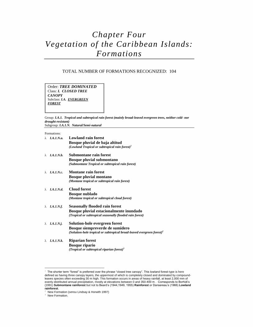
Chapter Four
Vegetation of the Caribbean Islands:
Formations
TOTAL NUMBER OF FORMATIONS RECOGNIZED: 104
Group: I.A.1. Tropical and subtropical rain forest (mainly broad-leaved evergreen trees, neither cold- nor
drought-resistant)
Subgroup: I.A.1.N. Natural/Semi-natural
Formations:
I.A.1.N.a. Lowland rain forest
Bosque pluvial de baja altitud
(Lowland Tropical or subtropical rain forest)1
I.A.1.N.b. Submontane rain forest
Bosque pluvial submontano
(Submontane Tropical or subtropical rain forest)
I.A.1.N.c. Montane rain forest
Bosque pluvial montano (Montane tropical or subtropical rain forest)
I.A.1.N.d. Cloud forest
Bosque nublado (Montane tropical or subtropical cloud forest)
I.A.1.N.f. Seasonally flooded rain forest
Bosque pluvial estacionalmente inundado (Tropical or subtropical seasonally flooded rain forest)
I.A.1.N.j. Solution-hole evergreen forest
Bosque siempreverde de sumidero
(Solution-hole tropical or subtropical broad-leaved evergreen forest)2
I.A.1.N.k. Riparian forest
Bosque ripario
(Tropical or subtropical riparian forest)3
1 The shorter term “forest” is preferred over the phrase “closed tree canopy”. This lowland forest-type is here
defined as having three canopy layers, the uppermost of which is completely closed and dominated by compound-leaves species often exceeding 30 m high. This formation occurs in areas of heavy rainfall, at least 2,000 mm of evenly distributed annual precipitation, mostly at elevations between 0 and 350-400 m . Corresponds to Borhidi’s (1991) Submontane rainforest but not to Beard’s (1944,1949, 1955) Rainforest or Dansereau’s (1966) Lowland rainforest. 2 New Formation (sensu Lindsay & Horwith 1997)
3 New Formation.
Order: TREE DOMINATED
Class: I. CLOSED TREE
CANOPY Subclass: I.A. EVERGREEN
FOREST

Group: I.A.3. Tropical and subtropical seasonal evergreen forest (mainly broad-leaved evergreen trees with
some foliage reduction in dry season) Subgroup: I.A.3.N. Natural/Semi-natural
Formations:
I.A.3.N.a. Lowland seasonal evergreen forest
Bosque estacional siempreverde de baja altitud (Lowland tropical or subtropical seasonal evergreen forest)
I.A.3.N.b. Submontane seasonal evergreen forest
Bosque estacional siempreverde submontano
(Submontane tropical or subtropical seasonal evergreen forest)
I.A.3.N.e. Seasonally/temporarily flooded seasonal evergreen forest
Bosque estacional siempreverde estacionalmente/temporalmente
inundado
(Seasonally or temporarily flooded tropical or subtropical seasonal evergreen forest)
Group: I.A.5. Tropical or subtropical broad-leaved evergreen sclerophyllous closed tree canopy forest
Subgroup: I.A.5.N. Natural/Semi-natural
Formations:
I.A.5.N.a. Lowland/submontane evergreen sclerophyllous forest
Bosque siempreverde esclerófilo de baja altitud/submontano (Lowland or submontane4 tropical or subtropical broad-leaved evergreen sclerophyllous
forest)
I.A.5.N.d. Semi-permanently flooded evergreen sclerophyllous forest
Bosque siempreverde esclerófilo semipermanentemente inundado
(Semipermanently flooded tropical or subtropical broad-leaved evergreen sclerophyllous
forest)
I.A.5.N.e. Mangrove
Manglar (Tidally flooded tropical or subtropical broad-leaved evergreen sclerophyllous forest)
Group: I.A.7. Tropical and subtropical needle-leaved (or needle-stemmed)5 evergreen forest
Subgroup: I.A.7.N. Natural/Semi-natural
Formations:
I.A.7.N.a. Lowland/submontane pine forest
Bosque de pinos de baja altitud/submontano
(Lowland or submontane tropical or subtropical needle-leaved evergreen forest)
Subgroup: I.A.7.C. Planted/Cultivated
Formations:
I.A.7.C.a. Lowland/submontane pine forest plantation
Bosque plantado de pinos de baja altitud/submontano (Lowland or submontane tropical or subtropical needle-leaved evergreen forest plantation)
I.A.7.C.b. Casuarina forest plantation
Bosque plantado de Casuarina (Lowland or submontane tropical or subtropical needle-stemmed6 evergreen forest
plantation)
4 The term “submontane” is added, to include the lowland-submontane sclerophyllous evergreen oak forests
of west Cuba. 5 The phrase “or needle-stemmed” in parenthesis is added, to include the Australian “pine” forest plantations. 6 New Formation, to include the needle-stemmed Australian “pine” forest plantations, under Subgroup C
(Planted/Cultivated).

I.A.7.N.b. Montane pine forest
Bosque montano de pinos
(Montane or subalpine tropical or subtropical needle-leaved evergreen forest)
Group: I.A.10. Mixed tropical and subtropical needle-leaved-broad-leaved evergreen forest7
Subgroup: I.A.10.N. Natural/Semi-Natural
Formations:
I.A.10.N.a. Mixed pine-broad-leaved forest
Bosque mixto de pinos y latifolios (Mixed tropical and subtropical needle-leaved-broad-leaved evergreen forest)8
Group: I.B.1. Drought-deciduous forest
Subgroup: I.B.1.N. Natural/Semi-natural
Formations:
I.B.1.N.a. Lowland/submontane drought-deciduous forest
Bosque seco deciduo de baja altitud/submontano (Lowland or submontane drought-deciduous forest)
Group: I.C.1. Tropical or subtropical semi-deciduous forest
Subgroup: I.C.1.N. Natural/Semi-natural
Formations:
I.C.1.N.a. Lowland semi-deciduous forest
Bosque semi-deciduo de baja altitud (Lowland tropical or subtropical semi-deciduous forest)
I.C.1.N.b. Montane semi-deciduous forest
Bosque semi-deciduo montano (Cloud or montane tropical or subtropical semi-deciduous forest)
I.C.1.N.c. Seasonally flooded/saturated semi-deciduous forest
Bosque semi-deciduo estacionalmente inundado/saturado (Seasonally flooded or saturated tropical or subtropical semi-deciduous forest)
Group: I.C.4. Xeromorphic mixed evergreen-deciduous forest9
Subgroup: I.C.4.N. Natural/Semi-natural
Formations:
I.C.4.N.b. Xeromorphic semi-deciduous forest
Bosque semi-deciduo xeromórfico
(Xeromorphic mixed evergreen-deciduous forest)10
7 New Group. 8 New Formation. 9 The term “extremely” has been removed to distinguish the presence of two different formations (xeromorphic vs.
extremely xeromorphic). 10 New Formation, to include the semi-deciduous xeromorphic forests of central Cuba, which are physiognomically
similar to the Brasilian “Cerrado” forests.
Subclass: I.B. DECIDUOUS FOREST
Subclass: I.C. MIXED EVERGREEN-
DECIDUOUS FOREST

Class: II. OPEN TREE CANOPY (WOODLAND)11
Subclass: II.A. EVERGREEN WOODLAND
Group: II.A.1. Tropical or subtropical broad-leaved woodland
Subgroup: II.A.1.N. Natural/Semi-natural
Formations:
II.A.1.N.a. Evergreen woodland
Arboleda siempreverde (Tropical or subtropical broad-leaved evergreen woodland)
II.A.1.N.b. Seasonally/temporarily flooded evergreen woodland
Arboleda siempreverde estacionalmente/temporalmente inundada (Seasonally or temporarily flooded tropical or subtropical broad-leaved evergreen
woodland)
II.A.1.N.c. Seasonally flooded/saturated evergreen woodland
Arboleda siempreverde estacionalmente inundada/saturada (Seasonally flooded/saturated tropical or subtropical broad-leaved evergreen woodland)
II.A.1.N.d. Semi-permanently flooded evergreen woodland
Arboleda siempreverde semi-permanente inundada (Semi-permanently flooded tropical or subtropical broad-leaved evergreen woodland)
II.A.1.N.e. Tidally flooded evergreen woodland
Arboleda siempreverde mareal (Tidally flooded tropical or subtropical broad-leaved evergreen woodland)
II.A.1.N.f. Hemisclerophyllous evergreen woodland
Arboleda siempreverde hemiesclerófila
(Hemisclerophyllous tropical or subtropical broad-leaved evergreen woodland)12
II.A.1.N.g. Saturated evergreen woodland
Arboleda siempreverde saturada
(Saturated tropical or subtropical broad-leaved evergreen woodland)
II.A.1.N.h. Solution-hole evergreen woodland
Arboleda de sumidero
(Solution-hole tropical or subtropical broad-leaved evergreen woodland)13
Subgroup: II.A.1.C. Planted/Cultivated
Formations:
II.A.1.C.a. Orchards
Frutales (Citrus, coconut and other fruit orchards)
Group: II.A.3. Tropical or subtropical needle-leaved (or needle-stemmed)14 evergreen woodland
Subgroup: II.A.3.N. Natural/Semi-natural
Formations:
II.A.3.N.a. Pine woodland
Arboleda de pinos
(Tropical or subtropical needle-leaved evergreen woodland)
Subgroup: II.A.3.C. Planted/Cultivated
11 The shorter term “woodland” is preferred over the phrase “open tree canopy”
12 New Formation, to include Stoffer’s (1956) “Hippomane Woodlands”.
13 New Formation.
14 The phrase “or needle-stemmed” in parenthesis is added, to include the Australian “pine” woodland plantations.
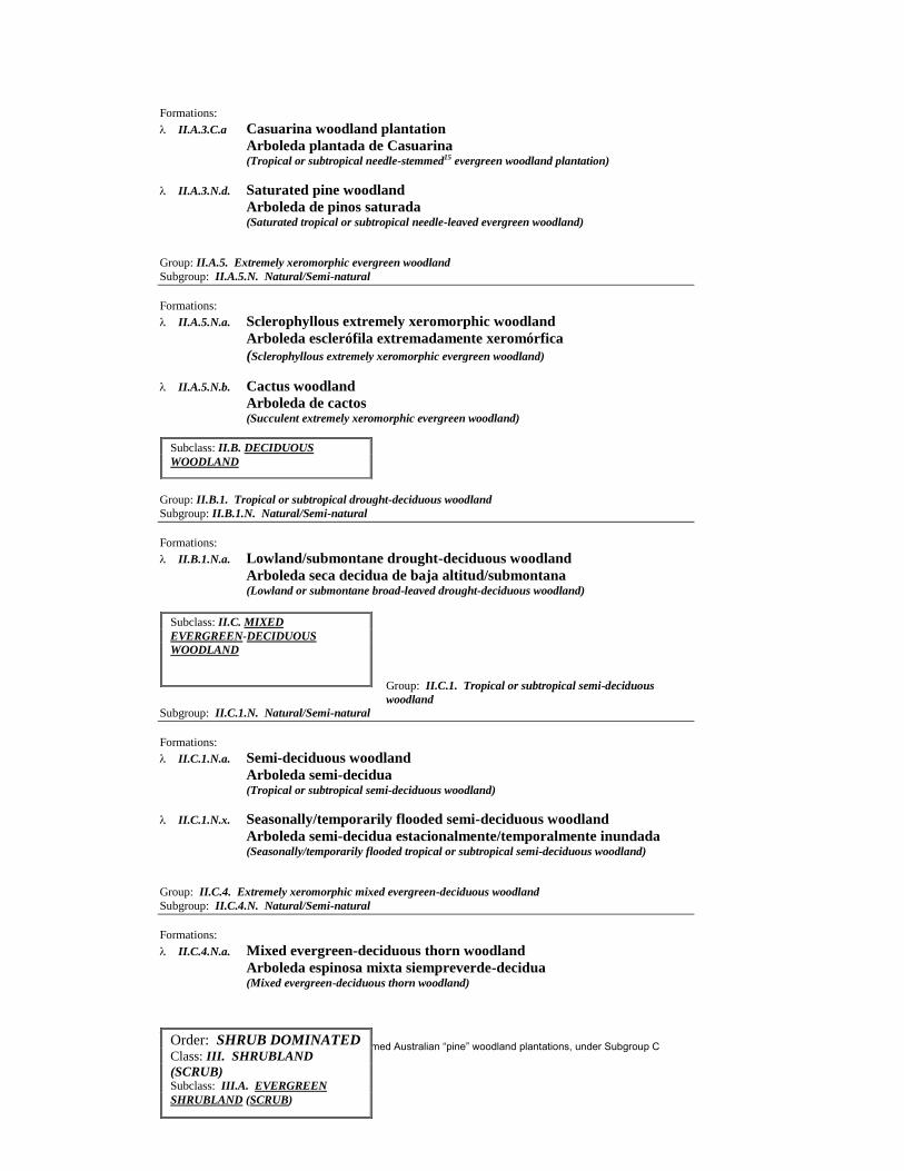
Formations:
II.A.3.C.a Casuarina woodland plantation
Arboleda plantada de Casuarina (Tropical or subtropical needle-stemmed15 evergreen woodland plantation)
II.A.3.N.d. Saturated pine woodland
Arboleda de pinos saturada
(Saturated tropical or subtropical needle-leaved evergreen woodland)
Group: II.A.5. Extremely xeromorphic evergreen woodland
Subgroup: II.A.5.N. Natural/Semi-natural
Formations:
II.A.5.N.a. Sclerophyllous extremely xeromorphic woodland
Arboleda esclerófila extremadamente xeromórfica
(Sclerophyllous extremely xeromorphic evergreen woodland)
II.A.5.N.b. Cactus woodland
Arboleda de cactos
(Succulent extremely xeromorphic evergreen woodland)
Group: II.B.1. Tropical or subtropical drought-deciduous woodland
Subgroup: II.B.1.N. Natural/Semi-natural
Formations:
II.B.1.N.a. Lowland/submontane drought-deciduous woodland
Arboleda seca decidua de baja altitud/submontana (Lowland or submontane broad-leaved drought-deciduous woodland)
Group: II.C.1. Tropical or subtropical semi-deciduous
woodland
Subgroup: II.C.1.N. Natural/Semi-natural
Formations:
II.C.1.N.a. Semi-deciduous woodland
Arboleda semi-decidua (Tropical or subtropical semi-deciduous woodland)
II.C.1.N.x. Seasonally/temporarily flooded semi-deciduous woodland
Arboleda semi-decidua estacionalmente/temporalmente inundada
(Seasonally/temporarily flooded tropical or subtropical semi-deciduous woodland)
Group: II.C.4. Extremely xeromorphic mixed evergreen-deciduous woodland
Subgroup: II.C.4.N. Natural/Semi-natural
Formations:
II.C.4.N.a. Mixed evergreen-deciduous thorn woodland
Arboleda espinosa mixta siempreverde-decidua (Mixed evergreen-deciduous thorn woodland)
15 New Formation, to include the needle-stemmed Australian “pine” woodland plantations, under Subgroup C
(Planted/Cultivated).
Subclass: II.B. DECIDUOUS
WOODLAND
Subclass: II.C. MIXED
EVERGREEN-DECIDUOUS
WOODLAND
Order: SHRUB DOMINATED
Class: III. SHRUBLAND
(SCRUB) Subclass: III.A. EVERGREEN
SHRUBLAND (SCRUB)
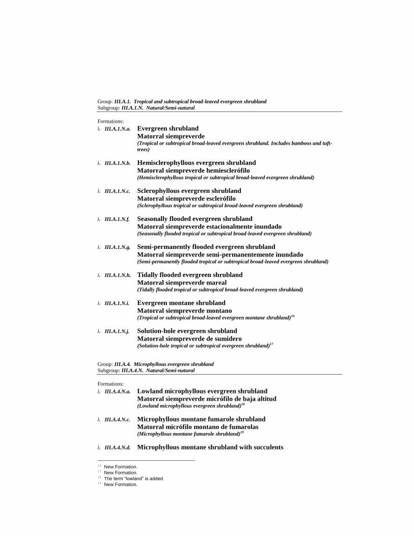
Group: III.A.1. Tropical and subtropical broad-leaved evergreen shrubland
Subgroup: III.A.1.N. Natural/Semi-natural
Formations:
III.A.1.N.a. Evergreen shrubland
Matorral siempreverde
(Tropical or subtropical broad-leaved evergreen shrubland. Includes bamboos and tuft-
trees)
III.A.1.N.b. Hemisclerophyllous evergreen shrubland
Matorral siempreverde hemiesclerófilo
(Hemisclerophyllous tropical or subtropical broad-leaved evergreen shrubland)
III.A.1.N.c. Sclerophyllous evergreen shrubland
Matorral siempreverde esclerófilo
(Sclerophyllous tropical or subtropical broad-leaved evergreen shrubland)
III.A.1.N.f. Seasonally flooded evergreen shrubland
Matorral siempreverde estacionalmente inundado
(Seasonally flooded tropical or subtropical broad-leaved evergreen shrubland)
III.A.1.N.g. Semi-permanently flooded evergreen shrubland
Matorral siempreverde semi-permanentemente inundado (Semi-permanently flooded tropical or subtropical broad-leaved evergreen shrubland)
III.A.1.N.h. Tidally flooded evergreen shrubland
Matorral siempreverde mareal (Tidally flooded tropical or subtropical broad-leaved evergreen shrubland)
III.A.1.N.i. Evergreen montane shrubland
Matorral siempreverde montano
(Tropical or subtropical broad-leaved evergreen montane shrubland)16
III.A.1.N.j. Solution-hole evergreen shrubland
Matorral siempreverde de sumidero
(Solution-hole tropical or subtropical evergreen shrubland)17
Group: III.A.4. Microphyllous evergreen shrubland
Subgroup: III.A.4.N. Natural/Semi-natural
Formations:
III.A.4.N.a. Lowland microphyllous evergreen shrubland
Matorral siempreverde micrófilo de baja altitud (Lowland microphyllous evergreen shrubland)18
III.A.4.N.c. Microphyllous montane fumarole shrubland
Matorral micrófilo montano de fumarolas (Microphyllous montane fumarole shrubland)19
III.A.4.N.d. Microphyllous montane shrubland with succulents
16 New Formation.
17 New Formation.
18 The term “lowland” is added.
19 New Formation.

Matorral micrófilo montano con suculentas
(Microphyllous evergreen montane shrubland with succulents)20
Group: III.A.5. Extremely xeromorphic evergreen shrubland
Subgroup: III.A.5.N. Natural/Semi-natural
Formations:
III.A.5.N.a. Microphyllous evergreen extremely xeromorphic subdesert shrubland
Matorral subdesértico siempreverde micrófilo extremadamente
xeromorfo
(Broad-leaved microphyllous evergreen extremely xeromorphic subdesert shrubland e.g.
creosote bush)
III.A.5.N.b. Facultatively deciduous subdesert shrubland
Matorral subdesértico facultativamente deciduo (Facultatively deciduous extremely xeromorphic subdesert shrubland)
III.A.5.N.c. Succulent evergreen shrubland
Matorral siempreverde suculento (Succulent extremely xeromorphic evergreen shrubland)
III.A.5.N.d. Lowland/submontane serpentine shrubland
Matorral de baja altitud/submontano de serpentinas (Lowland or submontane evergreen extremely xeromorphic serpentine shrubland)21
III.A.5.N.e. Montane serpentine shrubland
Matorral montano de serpentinas
(Montane evergreen extremely xeromorphic serpentine shrubland)22
III.A.5.N.f. Lowland wind-sculpted shrubland
Matorral ventoso-achaparrado de baja altitud
(Wind-sculpted lowland evergreen extremely xeromorphic shrubland)23
Group: III.B.1. Drought-deciduous shrubland
Subgroup: III.B.1.N. Natural/Semi-natural
Formations:
III.B.1.N.a. Lowland drought-deciduous shrubland
Matorral seco deciduo de baja altitud (Lowland drought-deciduous shrubland)
Group: III.C.1. Mixed evergreen - drought-deciduous
20 New Formation.
21 New Formation, to include the Cuban microphyllous/nanophyllous dense thorny shrublands on serpentine-
derived soils. 22 New Formation, to include the Cuban microphyllous dense montane shrublands on serpentine-derived soils,
which correspond to a unique edaphic climax type developed under humid tropical rain forest climate. 23 New Formation, to include the dense wind-sculpted shrublands of the coastal plain of Maisi, eastern end of
Cuba. This Formation is characterized by a matted 1-3 m high shrub carpet with some leafless dwarf shrubs and sparse 8-25 m high emergent individuals of the palm species Coccothrinax alexandri. The occurrence of scattered globular, columnar and tree-shaped cacti is also characteristic.
Subclass: III.B. DECIDUOUS
SHRUBLAND (SCRUB)
Subclass: III.C. MIXED
EVERGREEN-DECIDUOUS
SHRUBLAND (SCRUB)

shrubland
Subgroup: III.C.1.N. Natural/Semi-natural
Formations:
III.C.1.N.a. Mixed evergreen - drought-deciduous shrubland with succulents
Matorral mixto siempreverde-deciduo con suculentas (Mixed evergreen - drought-deciduous shrubland with succulents)24
III.C.1.N.b. Lowland/submontane mixed
evergreen - drought-deciduous shrubland
Matorral mixto siempreverde-
deciduo de baja altitud/submontano
(Lowland or submontane mixed evergreen
- drought-deciduous shrubland)25
III.C.1.N.c. Seasonally flooded mixed
evergreen - drought-deciduous shrubland
Matorral mixto siempreverde-deciduo estacionalmente inundado (Seasonally flooded tropical or subtropical mixed evergreen - drought-deciduous
shrubland)26
Group: IV.A.2. Extremely xeromorphic evergreen dwarf-shrubland
Subgroup: IV.A.2.N. Natural/Semi-natural
Formations:
IV.A.2.N.c. Tidally flooded evergreen dwarf-shrubland
Matorral enano siempreverde mareal (Tidally flooded needle-leaved or microphyllous evergreen dwarf-shrubland)
24 New Formation (FGDC has not defined Formations of Subgroup III.C.1.N.).
25 New Formation, to include the shrub-dominated forests of the Cuban “mogotes” on eroded limestone.
26 New Formation (sensu Lindsay & Horwith 1997).
Class: IV. DWARF-
SHRUBLAND (DWARF SCRUB) Subclass: IV.A. EVERGREEN
DWARF-SHRUBLAND (DWARF-
SCRUB)
Subclass: IV.C. MIXED
EVERGREEN-DECIDUOUS DWARF
SHRUBLAND (DWARF SCRUB)
Order: HERB/NON
VASCULAR DOMINATED
Class: V. HERBACEOUS
Subclass: V.A. PERENNIAL
GRAMINOID VEGETATION
(GRASSLANDS)
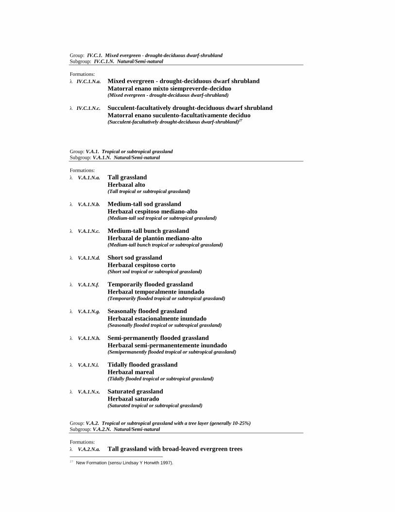
Group: IV.C.1. Mixed evergreen - drought-deciduous dwarf-shrubland
Subgroup: IV.C.1.N. Natural/Semi-natural
Formations:
IV.C.1.N.a. Mixed evergreen - drought-deciduous dwarf shrubland
Matorral enano mixto siempreverde-deciduo (Mixed evergreen - drought-deciduous dwarf-shrubland)
IV.C.1.N.c. Succulent-facultatively drought-deciduous dwarf shrubland
Matorral enano suculento-facultativamente deciduo (Succulent-facultatively drought-deciduous dwarf-shrubland)27
Group: V.A.1. Tropical or subtropical grassland
Subgroup: V.A.1.N. Natural/Semi-natural
Formations:
V.A.1.N.a. Tall grassland
Herbazal alto
(Tall tropical or subtropical grassland)
V.A.1.N.b. Medium-tall sod grassland
Herbazal cespitoso mediano-alto (Medium-tall sod tropical or subtropical grassland)
V.A.1.N.c. Medium-tall bunch grassland
Herbazal de plantón mediano-alto (Medium-tall bunch tropical or subtropical grassland)
V.A.1.N.d. Short sod grassland
Herbazal cespitoso corto (Short sod tropical or subtropical grassland)
V.A.1.N.f. Temporarily flooded grassland
Herbazal temporalmente inundado (Temporarily flooded tropical or subtropical grassland)
V.A.1.N.g. Seasonally flooded grassland
Herbazal estacionalmente inundado (Seasonally flooded tropical or subtropical grassland)
V.A.1.N.h. Semi-permanently flooded grassland
Herbazal semi-permanentemente inundado (Semipermanently flooded tropical or subtropical grassland)
V.A.1.N.i. Tidally flooded grassland
Herbazal mareal (Tidally flooded tropical or subtropical grassland)
V.A.1.N.x. Saturated grassland
Herbazal saturado (Saturated tropical or subtropical grassland)
Group: V.A.2. Tropical or subtropical grassland with a tree layer (generally 10-25%)
Subgroup: V.A.2.N. Natural/Semi-natural
Formations:
V.A.2.N.a. Tall grassland with broad-leaved evergreen trees
27 New Formation (sensu Lindsay Y Horwith 1997).

Herbazal alto con árboles latifolios siempreverdes (Tall tropical or subtropical grassland with mainly broad-leaved evergreen trees)
V.A.2.N.b. Tall grassland with broad-leaved drought-deciduous trees
Herbazal alto con árboles latifolios deciduos (Tall tropical or subtropical grassland with broad-leaved drought-deciduous trees)
V.A.2.N.c. Medium-tall grassland with broad-leaved evergreen trees
Herbazal mediano-alto con árboles latifolios siempreverdes (Medium-tall tropical or subtropical grassland with broad- leaved evergreen trees)
V.A.2.N.d. Medium-tall grassland with broad-leaved drought-deciduous trees
Herbazal mediano-alto con árboles latifolios deciduos (Medium-tall tropical or subtropical grassland with broad-leaved drought-deciduous trees)
V.A.2.N.e. Medium-tall grassland with needle-leaved evergreen or mixed trees
Herbazal mediano-alto con árboles aciculifolios siempreverdes o
mixtos
(Medium-tall tropical or subtropical grassland with needle-leaved evergreen or mixed
trees)
V.A.2.N.f. Medium-tall grassland with xeromorphic trees or succulents
Herbazal mediano-alto con árboles xeromórficos o suculentas
(Medium-tall tropical or subtropical grassland with xeromorphic trees or succulents)
V.A.2.N.g. Seasonally/temporarily flooded grassland with broad-leaved evergreen
trees
Herbazal estacionalmente/temporalmente inundado con árboles
siempreverdes latifolios
(Seasonally/temporarily flooded tropical grassland with broad-leaved evergreen trees)
V.A.2.N.h. Seasonally/temporarily flooded grassland with deciduous trees
Herbazal estacionalmente/temporalmente inundado con árboles
deciduos
(Seasonally/temporarily flooded tropical grassland with broad-leaved deciduous trees)
V.A.2.N.i. Seasonally flooded/ saturated grassland with pine trees
Herbazal estacionalmente inundado/saturado con pinos
(Seasonally flooded/saturated tropical or subtropical grassland with needle-leaved
evergreen trees)
V.A.2.N.j. Short grassland with pine or mixed trees
Herbazal corto con pinos o árboles mixtos
(Short tropical or subtropical grassland with needle-leaved evergreen or mixed trees)28
V.A.2.N.k. Short grassland with broad-leaved evergreen trees
Herbazal corto con árboles latifolios siempreverdes (Short tropical or subtropical grasslands with broad-leaved evergreen trees)29
Group: V.A.3. Tropical or subtropical grassland with a shrub layer (generally 10-25 %)
Subgroup: V.A.3.N. Natural/Semi-natural
Formations:
V.A.3.N.i. Seasonally/temporarily flooded grassland with broad-leaved shrubs
Herbazal estacionalmente/temporalmente inundado con
arbustos latifolios
(Seasonally/temporarily flooded tropical or subtropical grassland with evergreen broad-
leaved shrubs)
28 New Formation.
29 New Formation.

Group: V.A.4. Tropical or subtropical grassland with a
dwarf-shrub layer (generally 10-25%)
Subgroup: V.A.4.N. Natural/Semi-natural
Formations:
V.A.4.N.b. Forb-grassland with dwarf-shrubs
and succulents
Herbazal de dicotiledóneas y gramíneas con arbustos enanos y
suculentas (Tropical or subtropical forb-grassland with
dwarf-shrubs and succulents)30
Group: V.B.1. Tropical or subtropical perennial forb
vegetation
Subgroup: V.B.1.N. Natural/Semi-natural
Formations:
V.B.1.N.b. Low perennial forb vegetation
Vegetacion perenne de herbáceas no graminoides
(Low tropical or subtropical perennial forb
vegetation)
V.B.1.N.d. Saturated perennial forb vegetation
Vegetación saturada perenne de herbáceas no graminoides (Saturated tropical or subtropical perennial forb vegetation)
V.B.1.N.e. Tidally flooded perennial forb vegetation
Vegetación mareal perenne de herbáceas no graminoides
(Tidally flooded tropical or subtropical perennial forb vegetation)
Group: V.C.1. Tropical or subtropical hydromorphic31 vegetation (without seasonal contrasts)
Subgroup: V.C.1.N. Natural/Semi-natural
Formations:
V.C.1.N.a. Aquatic vegetation
Vegetación acuática (Permanently flooded tropical or subtropical hydromorphic32 vegetation)
V.C.1.N.b. Seagrass bed
Pradera submarina
(Tidal permanently flooded tropical or subtropical hydromorphic rooted vegetation)
30 New Formation, to include Lindsay & Horwith’s Lantana camara forb-grassland Alliance, and Beer’s et al.
Aristida-Tephrosia type. 31 The term “rooted” was removed to include free-floating aquatic communities. 32 The term “rooted” was removed to include free-floating aquatic plants/communities of lakes, rivers and ponds.
This complex vegetation unit may consist of : (1) free-floating non rooted plants; (2) Rooted floating-leaf plants; (3) Rooted emergent plants; (4) rooted submerged plants, and/or (5) non-rooted submerged plants.
Subclass: V.B. PERENNIAL FORB
VEGETATION
Subclass: V.C. HYDROMORPHIC
VEGETATION
Subclass: V.D. ANNUAL
GRAMINOID OR FORB
VEGETATION
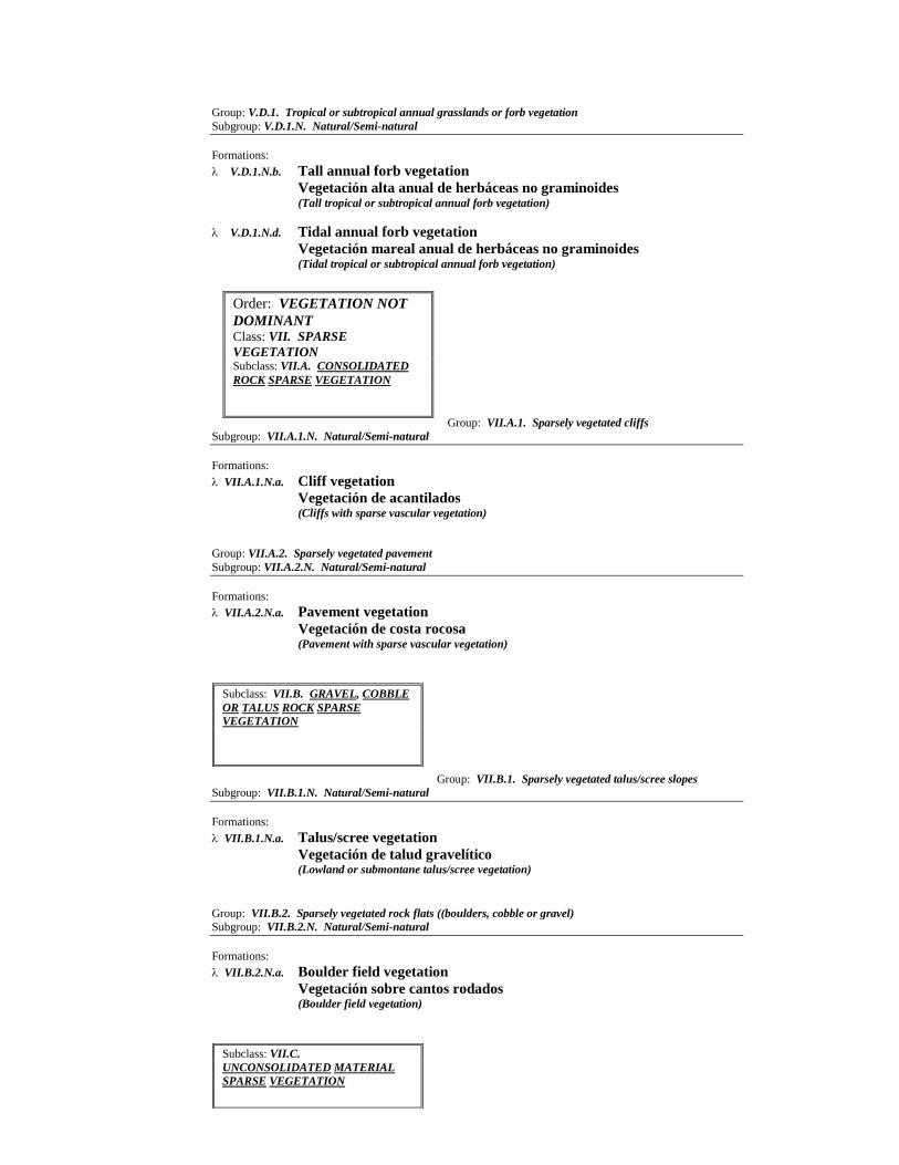
Group: V.D.1. Tropical or subtropical annual grasslands or forb vegetation
Subgroup: V.D.1.N. Natural/Semi-natural
Formations:
V.D.1.N.b. Tall annual forb vegetation
Vegetación alta anual de herbáceas no graminoides
(Tall tropical or subtropical annual forb vegetation)
V.D.1.N.d. Tidal annual forb vegetation
Vegetación mareal anual de herbáceas no graminoides
(Tidal tropical or subtropical annual forb vegetation)
Group: VII.A.1. Sparsely vegetated cliffs
Subgroup: VII.A.1.N. Natural/Semi-natural
Formations:
VII.A.1.N.a. Cliff vegetation
Vegetación de acantilados (Cliffs with sparse vascular vegetation)
Group: VII.A.2. Sparsely vegetated pavement
Subgroup: VII.A.2.N. Natural/Semi-natural
Formations:
VII.A.2.N.a. Pavement vegetation
Vegetación de costa rocosa
(Pavement with sparse vascular vegetation)
Group: VII.B.1. Sparsely vegetated talus/scree slopes
Subgroup: VII.B.1.N. Natural/Semi-natural
Formations:
VII.B.1.N.a. Talus/scree vegetation
Vegetación de talud gravelítico (Lowland or submontane talus/scree vegetation)
Group: VII.B.2. Sparsely vegetated rock flats ((boulders, cobble or gravel)
Subgroup: VII.B.2.N. Natural/Semi-natural
Formations:
VII.B.2.N.a. Boulder field vegetation
Vegetación sobre cantos rodados (Boulder field vegetation)
Order: VEGETATION NOT
DOMINANT
Class: VII. SPARSE
VEGETATION
Subclass: VII.A. CONSOLIDATED
ROCK SPARSE VEGETATION
Subclass: VII.B. GRAVEL, COBBLE
OR TALUS ROCK SPARSE
VEGETATION
Subclass: VII.C.
UNCONSOLIDATED MATERIAL
SPARSE VEGETATION
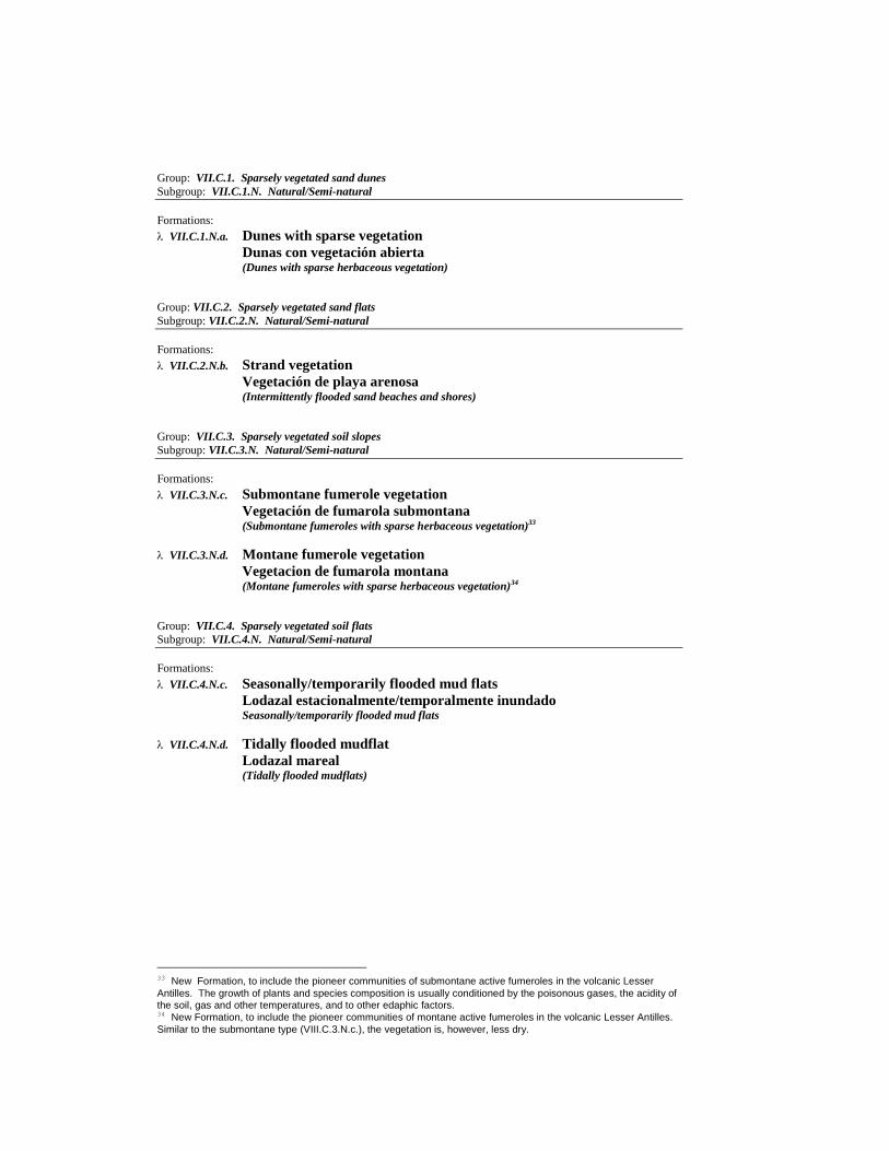
Group: VII.C.1. Sparsely vegetated sand dunes
Subgroup: VII.C.1.N. Natural/Semi-natural
Formations:
VII.C.1.N.a. Dunes with sparse vegetation
Dunas con vegetación abierta (Dunes with sparse herbaceous vegetation)
Group: VII.C.2. Sparsely vegetated sand flats
Subgroup: VII.C.2.N. Natural/Semi-natural
Formations:
VII.C.2.N.b. Strand vegetation
Vegetación de playa arenosa
(Intermittently flooded sand beaches and shores)
Group: VII.C.3. Sparsely vegetated soil slopes
Subgroup: VII.C.3.N. Natural/Semi-natural
Formations:
VII.C.3.N.c. Submontane fumerole vegetation
Vegetación de fumarola submontana (Submontane fumeroles with sparse herbaceous vegetation)33
VII.C.3.N.d. Montane fumerole vegetation
Vegetacion de fumarola montana
(Montane fumeroles with sparse herbaceous vegetation)34
Group: VII.C.4. Sparsely vegetated soil flats
Subgroup: VII.C.4.N. Natural/Semi-natural
Formations:
VII.C.4.N.c. Seasonally/temporarily flooded mud flats
Lodazal estacionalmente/temporalmente inundado Seasonally/temporarily flooded mud flats
VII.C.4.N.d. Tidally flooded mudflat
Lodazal mareal (Tidally flooded mudflats)
33 New Formation, to include the pioneer communities of submontane active fumeroles in the volcanic Lesser
Antilles. The growth of plants and species composition is usually conditioned by the poisonous gases, the acidity of the soil, gas and other temperatures, and to other edaphic factors. 34 New Formation, to include the pioneer communities of montane active fumeroles in the volcanic Lesser Antilles.
Similar to the submontane type (VIII.C.3.N.c.), the vegetation is, however, less dry.
Conclusion
This document and accompanying Atlas contain the preliminary results
of a major undertaking to classify and map Caribbean vegetation types. Both the
classification system and the mapping are works in progress. The classification
system has a number of units which are not currently, or are incompletely,
described. The maps need to be refined with current information obtained from
remotely sensed imagery.
With the help of a wide range of scientists, institutions, and
organizations, we have completed what we see as the first phase of a two-part
project. Phase One gathered a group of vegetation experts from across the region
in an October 1998 workshop to review available data and refine maps as
necessary. This Caribbean Vegetation Ecology Working Group (CVEWG)
identified the International Classification of Ecological Communities (ICEC) as
the standard from which to classify vegetation types of the Caribbean islands.
This standardization allowed the relabeling of vegetation types from existing
maps with standardized vegetation units. These maps were then compiled into
the Caribbean Vegetation Atlas (a separate publication), an island-by-island set
of maps using the best scale available.
In Phase Two, we will fill in our data gaps by acquiring the best and
most current Landsat, Spot, or IRS imagery for the entire insular Caribbean. We
will engage expert scientists to rectify, subset, and cluster the imagery we obtain,
and field verify this imagery. With this new data, we may need to revise our
initial classification. After this revision, we will reconvene the CVEWG to
review our Phase Two maps and classification unit descriptions. A gap analysis
will follow to determine the extent of the protection of vegetation types. These
data will then be disseminated widely for use on the ground. This Phase Two
product can serve as a framework for regional development planners, with utility
in areas such as conservation and development planning, carbon budgeting, and
disaster preparedness.

Appendix One
Vegetation of the Caribbean
Islands: Descriptions of Alliances
and Associations
I.A.1.N.a. Lowland tropical or subtropical rain forest35
(LOWLAND RAIN FOREST)
(BOSQUE PLUVIAL DE BAJA ALTITUD)
I.A.1.N.a. Carapa guianensis Forest Alliance (Carapa guianensis lowland rain forests)
CONCEPT: Rain forest community usually occurring below 400 m altitude, on yellowish-red
mountain soils, with essentially monospecific 30-35 m tall upper canopy layer of Carapa
guianensis, and a second and third species-rich canopy layers.
DISTRIBUTION: North-east Cuba: Sagua-Baracoa ranges.
SYNONYMY: Calophyllo-Dipholion (Borhidi et al. 1979; Borhidi 1991), in part.
Carapa guianensis - Calophyllum utile Forest
DESCRIPTION: Closed upper canopy very strongly dominated by Carapa
guianensis, or rarely mingled with some exceptionally tall individuals of the
20-25 m tall second canopy layer (e.g. Calophyllum utile). As opposed to the
upper one, the second canopy layer is rich in species. Most common associates
are Calophyllum utile, Sloanea curatellifolia, Dipholis jubilla, Guarea
guidonia, Cupania americana, Buchenavia capitata, Ficus wrightii, and the
Cuban royal palm Roystonea regia. Other palms (e.g. Bactris cubensis,
Prestoea montana, and Calyptronoma clementis ssp. orientensis) are
commonly found along creeks, between the second and third canopy layer.
Most characteristic species of the 6-15 m tall third canopy layer are Oxandra
lanceolata, O. laurifolia, Cordia sulcata, Miconia elata, M. dodecandra,
Cyathea araneosa and Hemitelia horrida.
DISTRIBUTION: North-east Cuba: Moa region, and in the Toa, Jaguani and
Duaba river basins.
COMMENTS: Although an essentially lowland community, the Carapa
guianensis rain forest can also occur in a submontane situation, wherever
annual precipitation exceeds 2,500 mm of evenly distributed rain throughout
the year.
SYNONYMY: Manacales (León 1946), in part; Pluvisilva submontana
(Areces-Mallea 1978); Bosque pluvial de llanura (Capote & Berazaín 1984);
Bosque pluvial de baja altitud (Capote et al. 1989); Submontane rainforests
(Borhidi 1991), in part; Calophyllo-Carapetum guianensis (Borhidi 1991).
REFERENCES: Borhidi (1991).
35 The shorter term “forest” is preferred over the phrase “close tree canopy”. This lowland forest-type is here
defined as having three canopy layers, the uppermost of which is completely closed and dominated by compound-leaves species and often exceeds 30 m high. This formation occurs in areas of heavy rainfall, at least 2,000 mm of evenly distributed annual precipitation, mostly at elevations between 0 and 350-400 m . Corresponds to Borhidi’s (1991) Submontane rainforest, in part, but not to Beard’s (1944,1949, 1955) Rainforest or Dansereau’s (1966) Lowland rainforest.
Class: I. FORESTS
Subclass: I.A. EVERGREEN FOREST
Group: I.A.1. Tropical and subtropical rain forest (mainly broad-leaved evergreen trees,
neither cold- nor drought-resistant)
Subgroup: I.A.1.N. Natural/Semi-natural

I.A.1.N.b. Submontane tropical or subtropical rain forest
(SUBMONTANE RAIN FOREST)
(BOSQUE PLUVIAL SUBMONTANO)
I.A.1.N.b. Cecropia peltata-Ochroma pyramidale Forest Alliance
CONCEPT: These are disturbed successional forests, with Cecropia and Ochroma as major
components.
DISTRIBUTION: Puerto Rico, Martinique, widepread in tropics.
REFERENCES: Kimber (1988); Dansereau (1966).
Cecropia peltata - Andira inermis - Didymopanax morototoni Forest
DESCRIPTION: Successional forests. In Puerto Rico other associated species
include Andira inermis, Acrocomia aculeata, Erythrina poeppigiana,
Didymopanax morototoni, Casearia spp., and Ochroma pyramidale.
DISTRIBUTION: Puerto Rico.
COMMENTS: This Alliance covers large portions of remaining forested lands
in the lowland rain forest portions of Puerto Rico, at 0-250m in elevation.
SYNONYMY: Trumpet-wood forest (Dansereau 1966).
REFERENCES: Dansereau (1966).
Cecropia peltata - Ochroma pyramidale - Sterculia caribaea Forest
DESCRIPTION: Forests of landslides, hurricane blowdowns, and other
disturbed areas, dominated by Cecropia peltata, Ochroma pyramidale,
Sterculia caribaea, Sapium caribaeum, Chimarrhis cymosa.
DISTRIBUTION: Martinique.
COMMENTS: Based on Kimber (1988).
SYNONYMY: Silverleaf-balsa Stands (Kimber 1988).
REFERENCES: Kimber (1988).
I.A.1.N.b. Dacryodes excelsa - Sloanea berteriana Forest Alliance (Dacryodes excelsa -
Sloanea berteriana submontane rain forests)
CONCEPT: Tropical forests dominated by Dacryodes excelsa and Sloanea berteriana, in Puerto
Rico.
DISTRIBUTION: Puerto Rico.
COMMENTS: The floristic composition of these communities shows stronger relationships with
the Greater Antilles than with the Lesser Antilles.
SYNONYMY: Rainforest-hygrophytia (Dansereau 1966).
Dacryodes excelsa-Sloanea berteriana-Manilkara bidentata ssp. surinamensis Forest
DESCRIPTION: This forest typically has a dense canopy 20-30m tall. The
forest is dominated by Dacryodes excelsa, Sloanea berteriana, Manilkara
bidentata ssp. surianamensis, and Magnolia splendens, with as many as 150
other tree species present, including Tetrazygia urbanii, Ormosia krugii,
Tabebuia heterophylla, Prestoea montana, Inga fagifolia, Hirtella rugosa, and
many others.
DISTRIBUTION: Puerto Rico.
SYNONYMY: Rain forest (Gleason & Cook 1927), in part; Tabonuco forest
(Dansereau 1966).
REFERENCES: Dansereau (1966); Chinea et al. (1993).
I.A.1.N.b. Dacryodes excelsa - Sloanea massonii Forest Alliance (Dacryodes excelsa - Sloanea
massonii submontane rain forests)
CONCEPT: Tropical submontane forests dominated by Dacryodes excelsa, Sloanea massonii,
Talauma dodecapetala Licania ternatensis and a few other few species, in the Lesser Antilles.
DISTRIBUTION: Martinique, Guadeloupe, Dominica, Montserrat, St. Lucia, St. Vincent,
Grenada, St. Kitts-Nevis and other islands in the Leser Antilles.
COMMENTS: The floristic composition of these communities is dominated by species endemic to
the Lesser Antilles.
SYNONYMY: Lower montane rain forest (Beard 1944); Forêt hygrophytique (Stehlé 1945-1946);
Lower montane forest (Dansereau 1966), in part; Rainforest (Kimber 1988).

Dacryodes excelsa - Sloanea massonii - Talauma dodecapetala - Licania ternatensis
Forest
DESCRIPTION: Lowland but mostly submontane rain forest of the Lesser
Antilles, with Dacryodes excelsa and other tree species in the upper canopy,
and a middle story of trees usually dominated by members of the Lauraceae,
especially species of the genera Nectandra and Ocotea. In Martinique it
formerly occupied large portions of the island, from 300-900 m elevation on
the windward side and from 500-1000 m elevation on the leeward side, with an
average yearly rainfall of 1500-2200mm. Dacroydes excelsa is fairly
widespread in the Lesser Antilles; Sloanea massonii, Talauma dodecapetala
and Licania ternatensis are endemic to the Lesser Antilles. Depending on the
island, the very diverse canopy layers may include other species, e.g. Sterculia
caribaea (Montserrat, Guadeloupe, Dominica, Martinique, St. Lucia, St
Vincent, Trinidad-Tobago), Tovomita plumieri (Dominica, Martinique, St.
Lucia), Endlicheria sericea (Guadeloupe, Marie Galante, Dominica,
Martinique, St. Lucia, St. Vincent, Trinidad-Tobago), Chimarrhis cymosa
(Antigua, Guadeloupe, Dominica, Martinique, St. Lucia, St. Vincent),
Byrsonima trinitensis (Antigua, Guadeloupe, Dominica, Martinique, St. Lucia,
St. Vincent, Grenada).
DISTRIBUTION: Lesser Antilles.
COMMENTS: Of all the above mentioned species, only Dacryodes excelsa,
Endlicheria sericea and Chimarrhis cymosa are not endemic to the Lesser
Antilles.
SYNONYMY: Dacroydes-Sloanea association (Beard 1949); Rainforest
(Kimber 1988).
REFERENCES: Beard (1949); Kimber (1988).
I.A.1.N.b. Hyeronima nipensis Forest Alliance (Hyeronima nipensis submontane rain forests)
CONCEPT: Tropical submontane rain forests dominated by Hyeronima nipensis, on acid ferralitic
soils derived from serpentine bedrocks, in eastern Cuba.
DISTRIBUTION: East Cuba: Sierra de Nipe and Sierra Cristal.
SYNONYMY: Pluvisilva montana de las serpentinitas (Areces-Mallea 1978), in part; Bosque
pluvial submontano (Capote et al. 1989); Podocarpo-Byrsonimion orientensis (Borhidi et al. 1979),
in part; Semi-arid montane serpentine rainforests (Borhidi 1991), in part.
Hyeronima nipensis - Sloanea curatellifolia - Byrsonima coriacea Forest
DESCRIPTION: Serpentine rainforest community with two canopy layers, a
rather dense shrub layer, and a poorly developed herb layer. The 18-25 m high
upper canopy is dominated by Hyeronima nipensis, or co-dominated by this
former species and other associates such as Sloanea curatellifolia, Byrsonima
coriacea, and Chionanthus (Linociera) domingensis This forest association is
poor in tree-ferns, epiphytes, and bryophytes. Other common species may
include, Myrsine coriacea, Terminalia nipensis, Podocarpus ekmanii,
Calophyllum utile, Ocotea cuneata, Coccoloba retusa, Chrysophyllum
argenteum, Miconia serrulata, Dipholis cubensis, etc.
DISTRIBUTION: East Cuba: Sierra de Nipe and Sierra Cristal, between 400
and 800 m elevation.
SYNONYMY: Hyeronimo-Sloanetum curatellifoliae (Borhidi 1991).
REFERENCES: Borhidi (1991).
I.A.1.N.b. Laplacea haematoxylon Forest Alliance (Laplacea haematoxylon submontane rain
forests)
CONCEPT: Submontane forest community co-dominated by Laplacea haematoxylon, occurring
(at present) slightly above 600 m elevation in Jamaica, on dark-brown soils derived from shales or
volcanic bedrocks.
DISTRIBUTION: Jamaica: The Blue Mountains.
SYNONYMY: Lower montane rain forest (Asprey & Robbins 1953; Grossman et al. 1993), in
part.
Laplacea haematoxylon - Solanum punctulatum - Turpinia occidentalis Forest
DESCRIPTION: Forest community with two tree strata, the 12-18 m upper
one essentially co-dominated by three species: Laplacea haematoxylon,

Solanum punctulatum, and Turpinia occidentalis . The 4-10 m second canopy
layer is richer in species: Mecranium purpurascens, Psychotria corymbosa and
Cestrum hirtum are usually well represented, and tree-ferns are very frequent,
particularly Cyathea pubescens. A characteristic diagnostic species of this
association is Boehmeria caudata, which is absent from other forest types in
the area. The shrub layer includes Besleria lutea, Piper arboreum, Piper
fadyenii, Acalypha virgata and Tournefortia glabra, and the thick-stemmed
woody climber Marcgravia brownei is present.
DISTRIBUTION: Jamaica: The Blue Mountains.
COMMENTS: The windward (north-facing) forests of this type differ from
those in the leeward (south-facing) sides most noticeably in the abundance of
pendent bryophytes and filmy ferns (Hymenophyllaceae), as well as a more
hygrophilous ground flora.
SYNONYMY: Gully forest over shale or volcanic substrata (Grubb & Tanner
1976; Shreve 1914).
REFERENCES: Asprey & Robbins (1953); Grossman et al. (1993).
Laplacea haematoxylon - Clethra occidentalis - Calophyllum calaba Forest
DESCRIPTION: Successional association established following disturbance of
the former Laplacea-Solanum-Turpinia Forest, mostly by selective cutting of
larger trees for timber. Small trees and tall weedy shrubs (e.g. Piper spp. and
Goldfusia colorata) replace the original structure of the forest; the original
association’s species composition and coverage change by prevalence, under-
representation, or absence of many of its associates. Clethra occidentalis,
Matayba apetala, Alchornea latifolia, and small individuals of Calophyllum
calaba are usually abundant. Other species may include Laplacea
haematoxylon, Guarea swartzii, Sapium jamaicense, Solanum punctulatum,
Hedyosmum arborescens, Turpinia occidentalis, and others.
DISTRIBUTION: Jamaica: The Blue Mountains range.
SYNONYMY: Disturbed gully forest (Grossman et al. 1993).
REFERENCES: Asprey & Robbins (1993); Grossman et al. (1993);
Muchoney et al. (1994).
I.A.1.N.b. Mora abbottii Forest Alliance (Mora abbottii submontane rain forest)
CONCEPT: Tall evergreen forests of Hispaniola dominated by Mora abbotti, occurring below 800
m altitude in areas with an average yearly rainfall of more than 2,400 mm.
DISTRIBUTION: Dominican Republic: Cordillera Septentrional; Cordillera Central.
SYNONYMY: Bosque de Mora abbottii (Hager & Zanoni 1993).
Mora abbottii - Cyrilla racemiflora - Ocotea leucoxylon Forest
DESCRIPTION: A 25 m tall evergreen forest with emergent trees up to 35 m
tall co-dominated by Mora abbottii, Cyrila racemiflora, and Ocotea
leucoxylon. Mora abbotti is usually the prevalent species, sometimes covering
20% of the canopy strata. Other arboreal species may include Pouteria
domingensis, Calyptronoma dulcis, Carapa guianensis, Sloanea berteroana,
Tabebuia sp., and many others. A very common epiphyte in this association is
Vriesea ringens. Despite the dominance of Mora abbottii, this is a fairly rich
community and about 40 species of trees have been reported in just one hectare
of forest. However, the understory is poor and mostly formed by offspring of
the canopy trees.
DISTRIBUTION: Dominican Republic: northeastern Cordillera Septentrional
(Moca-Nagua); eastern Cordillera Central (Sierra Prieta, Loma Peguera, Bonao,
Casabito, Pancholo-San Cristóbal, Banilejo-Rancho Arriba.
COMMENTS: This association is mostly found at 400-800 m elevation.
However, some stands (i.e. Sierra Prieta and Loma Peguera/Bonao) may occurr
at lower altitude (150 and 200 m, respectively).
SYNONYMY: Bosque de Mora abbottii (Hager & Zanoni 1993).
REFERENCES: Hager & Zanoni (1993).
I.A.1.N.b. Oxandra laurifolia - Tetragrastis balsamifera Forest Alliance (Oxandra laurifolia
lowland rain forests)

CONCEPT: Lowland forest community on red soils, occurring in small protected valleys
alternating with the steep-sided (haystack) limestone mountains of northeastern Hispaniola, in areas
with 2,000-2,200 mm of evenly distributed annual rainfall. Two closed canopy layers are present.
DISTRIBUTION: Hispaniola: Dominican Republic, in Los Haitises; Haiti? (Cape Jackson?).
SYNONYMY: Foresta udica a livello del mare (Ciferri 1936), in part; Bosque de Los Haitises
(Hager & Zanoni 1993), in part.
Oxandra laurifolia - Tetragrastis balsamifera - Dendropanax arboreus Forest
DESCRIPTION: The 25-30m tall upper canopy is mainly composed of
Oxandra laurifolia, Tetragrastis balsamifera, Dendropanax arboreus, Guarea
guidonea, Sloanea berteriana and Ocotea spp. Typical associates of the 5-15
m tall second canopy layer include small individuals of the above mentioned
species, but also Prestoea montana, Turpinia occidentalis, Cordia sulcata,
Ormosia krugii, and Calyptronoma spp.
DISTRIBUTION: North-east Hispaniola (Dominican Republic): Los Haitises
range.
SYNONYMY: Foresta udica a livello del mare (Ciferri 1936), in part;
Vegetación de los Valles, in Bosque de Los Haitises (Hager & Zanoni 1993).
REFERENCES: Hager & Zanoni (1993).
I.A.1.N.b. Sloanea berteriana - Ormosia krugii Forest Alliance (Sloanea berteriana
submontane rain forests)
CONCEPT: Submontane tropical forests of Hispaniola with a dense canopy dominated by Sloanea
berteriana, Ormosia krugii and others, in areas of average yearly rainfall exceeding 2,000 mm.
These rich communities seem to have formerly occupied large areas in the Cordillera Central
(Dominican Republic).
DISTRIBUTION: Hispaniola.
SYNONYMY: Foresta udica su suolo acido (Ciferri 1936).
Sloanea berteriana - Ormosia krugii - Laetia procera Forest
DESCRIPTION: Tall submontane forest with two canopy layers, the upermost
may reach 25 m in hight or slightly more. This association is dominated by
Sloanea berteriana, Ormosia krugii, and Laetia procera. Other tree species of
the upper canopy include Buchenavia tetraphylla, Tetragrastis balsamifera,
Carapa guianensis, Oreopanax reticulatus and many others. The second
canopy layer may include Byrsonima spicata, Ocotea leucoxylon, Guarea
guidonia, Casearia arborea, Eugenia domingensis, Cyathea arborea, Bactris
plumeriana, Prestoea montana, etc. The shrub layer is mostly dominated by
species of Psychotria such as Psychotria uliginosa and Psychotria berteroana.
DISTRIBUTION: Hispaniola: mostly in Cordillera Central.
COMMENTS: This community seems to be close to the submontane primeval
forest association in central Hispaniola, which has been largely altered, or
depleted. Small stands occur in Loma Herradura, south to Miches (Dominican
Republic).
SYNONYMY: Associazione Sloanea-Ormosia (Ciferri 1936), in part; Bosque
de la Cordillera Oriental (Hager & Zanonii 1993), in part.
REFERENCES: Ciferri (1936); Hager & Zanoni (1993).
Didymopanax morototoni - Ormosia krugii - Inga fagifolia - Sloanea berteriana Forest
DESCRIPTION: Submontane forest community with two canopy layers, the
uppermost 15-20 m high, with Didymopanax morototoni, Ormosia krugii, Inga
fagifolia, Sloanea berteriana, Zanthoxylum elephantiasis and Z. marticicense
as prevalent species. Tree-ferns (Cyathea spp.), palms, and lianas such as
Securidaca virgata, Paullinia pinnata, Marcgravia rectiflora, and Entada
gigas, are usually abundant, while in many places Urera baccifera dominates
the shrub layer. Scleria melaleuca is often abundant.
DISTRIBUTION: Hispaniola: mostly in Cordillera Central.
COMMENTS: This is a successional forest established following disturbance
of the Sloanea-Ormosia-Laetia association.
SYNONYMY: Associazione Sloanea-Ormosia (Ciferri 1936), in part; Bosque
de la Cordillera Oriental (Hager & Zanoni 1993), in part.
REFERENCES: Ciferri (1936); Hager & Zanoni 1993).
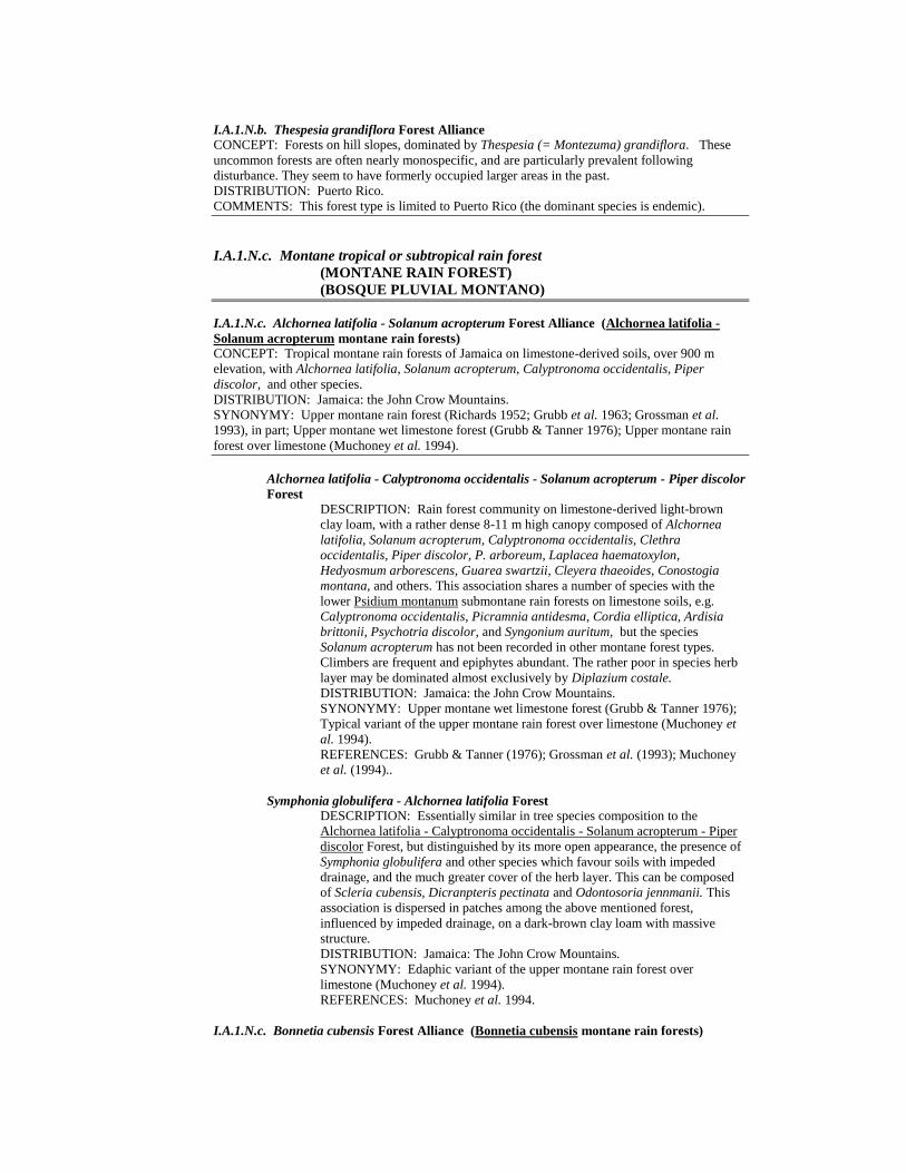
I.A.1.N.b. Thespesia grandiflora Forest Alliance CONCEPT: Forests on hill slopes, dominated by Thespesia (= Montezuma) grandiflora. These
uncommon forests are often nearly monospecific, and are particularly prevalent following
disturbance. They seem to have formerly occupied larger areas in the past.
DISTRIBUTION: Puerto Rico.
COMMENTS: This forest type is limited to Puerto Rico (the dominant species is endemic).
I.A.1.N.c. Montane tropical or subtropical rain forest
(MONTANE RAIN FOREST)
(BOSQUE PLUVIAL MONTANO)
I.A.1.N.c. Alchornea latifolia - Solanum acropterum Forest Alliance (Alchornea latifolia -
Solanum acropterum montane rain forests)
CONCEPT: Tropical montane rain forests of Jamaica on limestone-derived soils, over 900 m
elevation, with Alchornea latifolia, Solanum acropterum, Calyptronoma occidentalis, Piper
discolor, and other species.
DISTRIBUTION: Jamaica: the John Crow Mountains.
SYNONYMY: Upper montane rain forest (Richards 1952; Grubb et al. 1963; Grossman et al.
1993), in part; Upper montane wet limestone forest (Grubb & Tanner 1976); Upper montane rain
forest over limestone (Muchoney et al. 1994).
Alchornea latifolia - Calyptronoma occidentalis - Solanum acropterum - Piper discolor
Forest
DESCRIPTION: Rain forest community on limestone-derived light-brown
clay loam, with a rather dense 8-11 m high canopy composed of Alchornea
latifolia, Solanum acropterum, Calyptronoma occidentalis, Clethra
occidentalis, Piper discolor, P. arboreum, Laplacea haematoxylon,
Hedyosmum arborescens, Guarea swartzii, Cleyera thaeoides, Conostogia
montana, and others. This association shares a number of species with the
lower Psidium montanum submontane rain forests on limestone soils, e.g.
Calyptronoma occidentalis, Picramnia antidesma, Cordia elliptica, Ardisia
brittonii, Psychotria discolor, and Syngonium auritum, but the species
Solanum acropterum has not been recorded in other montane forest types.
Climbers are frequent and epiphytes abundant. The rather poor in species herb
layer may be dominated almost exclusively by Diplazium costale.
DISTRIBUTION: Jamaica: the John Crow Mountains.
SYNONYMY: Upper montane wet limestone forest (Grubb & Tanner 1976);
Typical variant of the upper montane rain forest over limestone (Muchoney et
al. 1994).
REFERENCES: Grubb & Tanner (1976); Grossman et al. (1993); Muchoney
et al. (1994)..
Symphonia globulifera - Alchornea latifolia Forest
DESCRIPTION: Essentially similar in tree species composition to the
Alchornea latifolia - Calyptronoma occidentalis - Solanum acropterum - Piper
discolor Forest, but distinguished by its more open appearance, the presence of
Symphonia globulifera and other species which favour soils with impeded
drainage, and the much greater cover of the herb layer. This can be composed
of Scleria cubensis, Dicranpteris pectinata and Odontosoria jennmanii. This
association is dispersed in patches among the above mentioned forest,
influenced by impeded drainage, on a dark-brown clay loam with massive
structure.
DISTRIBUTION: Jamaica: The John Crow Mountains.
SYNONYMY: Edaphic variant of the upper montane rain forest over
limestone (Muchoney et al. 1994).
REFERENCES: Muchoney et al. 1994.
I.A.1.N.c. Bonnetia cubensis Forest Alliance (Bonnetia cubensis montane rain forests)

CONCEPT: Tropical montane rain forests dominated or co-dominated by Bonnetia cubensis, on
rather poor acid ferralitic soils, in the serpentine plateaus of eastern Cuba between 800 and 900 m
elevation.
DISTRIBUTION: East Cuba: Cuchillas de Moa and Toa.
SYNONYMY: Pluvisilva montana de las serpentinitas (Areces-Mallea 1978), in part; Podocarpo-
Byrsonimion orientensis (Borhidi et al. 1991), in part; Semi-arid montane serpentine rainforests
(Borhidi 1991), in part.
Bonnetia cubensis - Pera ekmanii - Podocarpus ekmanii Forest
DESCRIPTION: Serpentine rainforest community of the high plateaus of the
Cuchillas de Moa and Toa, in eastern Cuba. Characteristic species include
Bonnetia cubensis, Pera ekmanii, Podocarpus ekmanii, Moacroton ekmanii,
Tabebuia dubia, T. clementis, Laplacea moaensis, and Purdiaea moaensis.
Other associates that may be locally abbundant include Hyeronima nipensis,
Jacquiniella globosa, Chionanthus (Linociera) domingensis, Matayba
domingensis, Spathelia pinetorum, Tapura cubensis, Bactris cubensis, and the
tree-fern Alsophila aquilina.
DISTRIBUTION: East Cuba: Cuchillas de Moa and Toa ranges.
COMMENTS: This association shares many east-Cuban serpentine endemics
with the Hyeronima nipensis submontane rain forests of Sierra de Nipe and
Sierra Cristal.
SYNONYMY: Podocarpo-Bonnetietum cubensis (Borhidi 1991).
REFERENCES: Borhidi (1991).
I.A.1.N.c. Cordia elliptica - Chimarrhis cymosa - Tovomita plumieri - Pouteria chrysophylloides
Forest Alliance
CONCEPT: Montane rainforest of Martinique. Forests occupying small areas at elevations of 900-
1000m on the windward side and 1000-1100m on the leeward side of Martinique. Two tree strata
without an emergent layer are present, and the canopy averages 20m in height. Common tree
species include Cordia elliptica, Chimarrhis cymosa, Tovomita plumieri, Pouteria
chrysophylloides, Ocotea dominicana (=Nectandra dominicana), Sterculia caribaea, Cecropia
peltata, Poeteria dussiana, Podocarpus coriaceus, Clusia plukenetii, Prestoea montana, Inga
coruscans, Calyptranthes fasciculata, Myrcia martinicensis, Freziera undulata var. elegans,
Cyathea arborea, Cyathea muricata, Myrcia deflexa, Byrsonima martinicensis, Hedyosmum
arborescens, Genipa americana, Ilex spp., Pouteria hahniana, and Rondeletia spp.
DISTRIBUTION: Martinique.
COMMENTS: Based on Kimber (1988). Nominal species will likely need revision.
SYNONYMY: Montane Forest (Kimber 1988).
I.A.1.N.c. Cyathea arborea Forest Alliance
CONCEPT: Tree-fern forests of Puerto Rico, dominated by the tree ferns Cyathea arborea and
other tree ferns, including Cnemidaria horrida.
DISTRIBUTION: Martinique, Puerto Rico.
COMMENTS: Should this be combined with the next alliance?
SYNONYMY: Fern Scrub -- 77.4 (Dansereau 1966).
REFERENCES: Dansereau (1966); Kimber (1988).
Cyathea arborea - Cnemedaria horrida / Dicranopteris nervosa - Sticherus bifidus
Forest DESCRIPTION: Other species include Odontosoria aculeata, Palhinhaea
cernua.
DISTRIBUTION: Puerto Rico.
SYNONYMY: Fern Savana -- 77.3 (Dansereau 1966).
Cyathea muricata - Cyathea arborea Forest
DESCRIPTION: The 5-10m tall canopy is dominated by combinations of
Cyathea muricata and Cyathea arborea. Other typical species include
Oreopanax capitatum and Didymopanax urbanianum, Guzmania plumieri,
Pitcairnia sp., Blechnum binervatum, and abundant lycopods, mosses, and
grasses.
DISTRIBUTION: Martinique.
COMMENTS: Based on Kimber (1988).

SYNONYMY: Tree Fern Colonies (Kimber 1988).
I.A.1.N.c. Cyrilla racemiflora - Micropholis spp. Forest Alliance
DISTRIBUTION: Puerto Rico.
REFERENCES: Weaver 1994.
Cyrilla racemiflora - Micropholis guyanensis - Micropholis garciniifolia - Ocotea
spathulata Forest
DESCRIPTION: Other typical species include Magnolia splendens (in
Luquillo Mountains), Magnolia portoricensis (in the central mountains),
Didymopanax gleasonii, Micropholis chrysophylloides, Croton poecilanthus,
and Prestoa montana.
DISTRIBUTION: Puerto Rico.
SYNONYMY: Colorado Forest.
I.A.1.N.c. Magnolia cubensis ssp. acunae Forest Alliance (Magnolia cubensis ssp. acunae
montane rain forests)
CONCEPT: Humid montane rain forests of central Cuba forming a vegetation belt between 800
and 1,100 m, on yellow tropical soils. Characteristic trees are Magnolia cubensis ssp. acunae,
Ocotea acunaiana, Torralbasia lenticellata, and others. This central-Cuban rain forest community
is less rich and diverse than its climax equivalent in the ranges of eastern Cuba.
DISTRIBUTION: Central Cuba: Sierra del Escambray.
SYNONYMY: Pluvisilva montana de las rocas cuarcíferas (Areces-Mallea 1978), in part;
Magnolion cubensis (Borhidi et al. 1979), in part; Bosque pluvial montano (Capote & Berazaín
1984; Capote et al. 1989), in part; Wet montane rain forests (Borhidi 1991), in part.
Magnolia cubensis ssp. acunae - Cyrilla racemiflora Forest
DESCRIPTION: Montane rain forest association characterized by Magnolia
cubensis ssp. acunae, Ocotea acunaiana, Ocotea floribunda, Torralbasia
lenticellata, Miconia cubensis, Miconia albescens, Gesneria viridiflora ssp.
colorata, and others. The presence of submontane elements and some endemic
taxa in the herb and shrub layers, such as Pilea clarana, Pilea cellulosa, Pilea
clementis, and Psychotria martii, are also typical.
DISTRIBUTION: Central Cuba: Sierra del Escambray ranges.
COMMENTS: This association often occurs as extrazonal stands in the
mountain ranges of Escambray.
SYNONYMY: Magnolio acunae-Cyrilletum racemiflorae (Borhidi 1991).
REFERENCES: Borhidi (1991).
I.A.1.N.c. Magnolia hamorii Forest Alliance (Magnolia hamorii montane rain forests)
CONCEPT: Montane rain forests dominated or co-dominated by Magnolia hamorii, on the exposed
summits of Sierra de Bahoruco Oriental (Hispaniola), between 950 and 1,500 m elevation.
DISTRIBUTION: Hispaniola (Dominican Republic): Southwest to Barahona, in Sierra de
Bahoruco Oriental.
SYNONYMY: Bosques de Ebano (Hager & Zanoni 1993), in part.
Magnolia hamorii - Oreopanax capitatus - Didymopanax tremulus Forest
DESCRIPTION: Rain forest community with a scattered 15-20 m high upper
canopy co-dominated by Magnolia hamorii, Oreopanax capitatus,
Didymopanax tremulus, Ficus maxima, Ocotea leucoxylon, Ocotea sp., Persea
krugii, Beilschmiedia pendula, Chionanthus ligustrinus, Anthirea oligantha,
Chione sp., and Obolinga Zanonii. The denser 10-12 m high second canopy
layer is formed by the offsprings of the tallest trees, and also by medium-size
and small trees such as Clusia clusioides, Prestoea montana, Miconia
mirabilis, Myrsine coriacea, Ocotea nemodaphne, and others. Shrubs include
Mecranium ovatum, Meriania involucrata, Cestrum daphnoides, Macrocarpea
domingensis, Hedyosmum domingense, Psychotria berterii and Cyathea sp.
DISTRIBUTION: Hispaniola (Dominican Republic): highlands between Loma
Pie de Palo, Loma la Trocha de Rey (Monteada Nueva), Loma Remigio.
SYNONYMY: Bosque de Magnolia hamorii (Hager & Zanoni 1993), in part.
REFERENCES: S.E.A. (1990); Hager & Zanoni (1993).

Magnolia hamorii - Brunellia comocladifolia - Alchornea latifolia Forest
DESCRIPTION: With a first canopy layer of rather dispersed tall trees
(Magnolia hamorii, Didymopanax tremulus, and others), and a second canopy
layer dominated by Brunellia comocladifolia, Alchornea latifolia, Prestoea
montana and Magnolia hamorii. Bamboo-grass climbers (Arthrostylidium
spp.) often become dominant in the understory.
DISTRIBUTION: Hispaniola (Dominican Republic): Highlands between
Loma Pie de Palo, Loma la Trocha de Rey (Monteada Nueva), Loma Remigio.
COMMENTS: This is a successional community established in areas where
the original Magnolia hamorii - Oreopanax capitatus - Didymopanax tremulus
forest is disturbed, mostly because of mining and colonization.
SYNONYMY: Bosque de Magnolia hamorii (Hager & Zanoni 1993), in part.
REFERENCES: S.E.A. (1990); Hager & Zanoni (1993).
I.A.1.N.c. Magnolia pallescens Forest Alliance (Magnolia pallescens montane rain forests)
CONCEPT: Rain forest vegetation dominated or co-dominated by Magnolia pallescens, on the
exposed summits and ridges of the Cordillera Central (Hispaniola), between 1,100 and 1,600 m
elevation, on reddish or yellowish acidic montane soils.
DISTRIBUTION: Hispaniola (Dominican Republic); eastern Cordillera Central.
SYNONYMY: Bosques de Ebano (Hager & Zanoni 1993), in part.
Magnolia pallescens - Didymopanax tremulus - Prestoea montana Forest
DESCRIPTION: With a scattered, rather open 15-20 m high upper canopy
layer dominated by Magnolia pallescens and Didymopanax tremulus, and a 10-
12 m high second tree layer with Prestoea montana, Haenianthus salicifolius,
Myrsine magnolifolia, Clusia clusioides, Ocotea nemodaphne, Miconia
mirabilis, Podocarpus hispaniolanus, Guatteria blainii, Hedyosmum nutans,
etc. Tree-ferns (i.e. Cyathea parvula, C. fulgens) are common. A well
developed shrub layer composed of Psychotria ssp. Palicourea alpina, Cestrum
inclusum, Gomidesia lindeniana, Scolosanthus grandifolius, Lunania ekmanii,
and others, is also present.
DISTRIBUTION: Hispaniola (Dominican Republic): Loma Golondrina; Loma
La Sal, southwards (Casabito).
COMMENTS: This montane association can be readily distinguished from the
Magnolia pallescens-Tabebuia vinosa cloud forest, by the presence of the
conspicuous montane palm Prestoea montana, which is totally absent in the
latter.
SYNONYMY: Bosque de Magnolia pallescens (Hager & Zanoni 1993), in
part.
REFERENCES: Hager & Zanoni (1993).
I.A.1.N.c. Ocotea ekmanii - Magnolia cubensis ssp. cubensis Forest Alliance (Ocotea ekmanii -
Magnolia cubensis ssp. cubensis montane rain forests)
CONCEPT: Humid montane rain forests of eastern Cuba forming a vegetation belt between 800
and 1600 m, on mountain yellow tropical soils. Prevalent trees in these forests are Ocotea ekmanii
and Magnolia cubensis ssp. cubensis.
DISTRIBUTION: East Cuba: Sierra Maesta; Sierra del Purial.
SYNONYMY: Pluvisilva montana de las rocas cuarcíferas (Areces-Mallea 1978), in part;
Magnolion cubensis (Borhidi et al. 1979), in part; Bosque pluvial montano (Capote & Berazaín
1984; Capote et al. 1989), in part; Wet montane rainforests (Borhidi 1991), in part.
Magnolia cubensis ssp. cubensis - Laplacea angustifolia - Ocotea ekmanii Forest
DESCRIPTION: Rich montane forest with two canopy layers, in areas of
1,700-3,000 mm of yearly rainfall. The rather closed 20-25 m high upper
canopy is co-dominated by Magnolia cubensis ssp. cubensis and Laplacea
angustifolia, accompanied by many other tree-species such as Ocotea ekmanii,
Ocotea cuneata, Guatteria blainii, Freziera grisebachii, Laplacea urbanii,
Cleyera nimanimae, and Cyrilla racemiflora. The second canopy layer is
dominated by Melastomataceae and tree-ferns. Epiphytes are abundant and
diverse. Other characteristic species of this association include Torralbasia
cuneifolia, Solonia reflexa, Ditta maestrensis, Lasianthus lanceolatus,

Graffenrieda rufescens, Ilex macfadyenii, Brunellia comocladifolia and
Weinmannia pinnata.
DISTRIBUTION: East Cuba: Sierra Maestra; Sierra del Purial.
COMMENTS: This association represents the climax vegetation between 800
and 1,600 m, in southeastern Cuba.
SYNONYMY: High open forests (Seifritz 1943); Fangales (León 1946);
Magnolio-laplacetum angustifoliae (Borhidi 1991).
REFERENCES: Seifritz (1943); León (1946); Borhidi (1991).
Ocotea ekmani - Cyrilla racemiflora Forest
DESCRIPTION: Somewhat drier and less diverse montane forest community
dominated by Ocotea ekmanii and other microphyllous sclerophyllous trees
such as Cyrilla racemiflora, Persea similis, Tabebuia oligolepis and Myrsine
coriacea, on the steep dry ridges and slopes of the Sierra Maestra range in
eastern Cuba. Another diagnostic character of this community with respect to
the former one, is the total absence of tree-ferns in the second canopy layer.
DISTRIBUTION: East Cuba: Sierra Maestra range.
COMMENTS: This association occurs in the same mountain range (Sierra
Maestra), and at the same altitudinal level as the former one. However its
occurrence is conditioned edaphically to the humid sandtone outcrops, or
mesoclimatically to the dry ridges and steep slopes.
SYNONYMY: Ocoteo ekmanii-Cyrilletum racemiflorae (Borhidi 1991).
REFERENCES: Borhidi (1991).
I.A.1.N.c. Ocotea krugii - Ocotea dominicana - Ocotea coriacea - Ocotea cernua Forest
Alliance
CONCEPT: Laurel forests of montane situations in the Lesser Antilles. The concept and name
may need some modification with additional information from more islands.
DISTRIBUTION: Martinique, others?
Ocotea krugii - Ocotea dominicana - Ocotea coriacea - Ocotea cernua Forest
DESCRIPTION: Occurring in very limited areas on exposed spur ridges.
Canopy 15-20m tall is dominated by evergreen, mesophyll trees of the
Lauraceae. Dominant and characteristic tree species are Ocotea krugii
(=Ocotea globosa), Ocotea dominicana (=Nectandra dominicana), Ocotea
coriacea, Ocotea cernua, Styrax glaber, Cinnamomum elongatum, Persea
urbaniana, Beilschmiedea pendula, and Anida ramageana. The shrub layer is
sparse, and includes Endlicheria sericea, Chrysobabanus cuspidatus,
Dahlbergia monetaria, Hedyosmum arborescens, Clibadium erosum,
Charianthus corymbosus, Cestrum alternifolium, Piper reticulatum, Piper
dussii, Piper glabrescens, Piper aequale. The herb layer is rich and dense, and
includes Eupatorium magdalenae, Heliconia bihai, Heliconia caribaea,
Blechnum ryanii, Pteris biaurita, Pityrogramma chrysophylla.
DISTRIBUTION: Martinique.
COMMENTS: Based on Kimber (1988).
SYNONYMY: Laural Forest (Kimber 1988).
I.A.1.N.c. Prestoea montana Forest Alliance
Sierra Palm Forest Alliance; Palma de sierra Forest Alliance
CONCEPT: Forests on montane slopes dominated by Prestoea montana.
DISTRIBUTION: Cuba, Hispaniola, Puerto Rico, Martinique, [West Indies].
REFERENCES: Weaver 1994.
Prestoea montana / Byrsonima martinicensis - Ilex sideroxyloides Forest
DESCRIPTION: This forest occurs at elevations of 250-800m in Martinique,
on windward and interior, steep, very exposed slopes that are prone to
landslide. The 3-8m tall canopy is dominated by Prestoea montana, with short,
gnarled small trees of Byrsonima martinicensis, Ilex sideroxyloides, and
Hedyosmum arborescens. Large herbs such as Heliconia bihai, Anthurium
spp., and Asplundia rigida are common. Mosses, ferns, and lycopods are
abundant and diverse.
DISTRIBUTION: Martinique.

SYNONYMY: Palm Brake, in part (Kimber 1988).
Prestoea montana / Cordia borinquensis - Miconia sintenisii Forest
DESCRIPTION: This forest occurs at elevations of 500-1100m in Puerto Rico,
on steeper slopes and wetter soils than the associated Cyrilla racemiflora-
Micropholis guyanensis-Micropholis garciniifolia-Ocotea spathulata Forest.
Prestoea montana dominates the 8-15m canopy, with lesser amounts of Croton
poecilanthus, Henriettea squamulosum, Cordia borinquensis, Psychotria
berteriana, Hillia parasitica, Cecropia peltata, Ocotea leucoxylon, Micropholis
garciniifolia, and Miconia sintenisii. Understory trees and shrubs include
Daphnopsis philippiana, Comocladia glabra, Hedyosmum arborescens,
Alsophila bryophila, and Cesneria sintenisii. Woody vines include Schlegelia
brachyantha, Clusia gundlachii, Marcgravia sintenisii, and Ipomoea repanda.
Herbs include Thelypteris deltoidea, Cyathea borinquena, Pilea krugii, Pilea
inequalis, Begonia decandra, Ichnauthus pallens, and Scleria sp. Epiphytes
include Nephrolepis rivularis and Guzmania berteroana.
DISTRIBUTION: Puerto Rico.
COMMENTS: Based on Weaver (1994). Communities dominated by
Prestoea occur on islands of the Lesser Antilles; their similarity to this
community are uncertain.
SYNONYMY: Palm Brake (Beard 1949); Palm Forest (Weaver 1994); Sierra-
palm Forest -- 88.1b (Dansereau 1966).
I.A.1.N.c. Syagrus amara Forest Alliance
CONCEPT: Palm forests of the Lesser Antilles dominated by Syagrus amara.
DISTRIBUTION: Martinique.
COMMENTS: Syagrus amara is sometimes called Rhyticocos amara. This palm occurs on
Montserrat, Guadeloupe, Dominica, St. Lucia, and Martinique; the community might also occur on
other islands than Martinique. This community is restricted to small areas at mid-elevations on
north-facing slopes in northern Martinique.
SYNONYMY: Palm Brake, in part (Kimber 1988); “petit coco”.
I.A.1.N.d. Montane tropical or subtropical cloud forest
(CLOUD FOREST)
(BOSQUE NUBLADO)
I.A.1.N.d. Clusia plukenetii Forest Alliance
CONCEPT: Cloud forests of Martinique.
DISTRIBUTION: Martinique.
Clusia plukenetii - Charianthus nodosus - Rondeletia stereocarpa - Didymopanax
attenuatum Forest -- G1
DESCRIPTION: Occupying very small areas (totalling less than one thosand
acres) near the summits of the highest peaks of Martinique, Mont Pelée, Piton
Géle, and the Carbet Pitons. The canopy is wind-sheared and tight, from 5-
12m tall. Typical species are Clusia plukenetii, Charianthus nodosus,
Rondeletia stereocarpa, Didymopanax attenuatum, Prestoea montana,
Podocarpus coriaceus, Cyathea arborea, Dunalia arborescens.
DISTRIBUTION: Martinique.
COMMENTS: Based on Kimber (1988).
SYNONYMY: Elfin Woodland (Kimber 1988).
I.A.1.N.d. Didymopanax tremulus - Podocarpus aristulatus Forest Alliance (Didymopanax
tremulus - Podocarpus aristulatus cloud forests)
CONCEPT: Montane cloud forests co-dominated by Didymopanax tremulus and Podocarpus
aristulatus, on the highlands of Hispaniola, between 1,600 and 2,200 m elevation.
DISTRIBUTION: Hispaniola (Dominican Republic): Cordillera Central, Sierra de Neiba, Sierra de
Bahoruco.
SYNONYMY: Bosque nublado de la Zona Alta (Hager & Zanoni 1993), in part.

Didymopanax tremulus - Podocarpus aristulatus - Ocotea wrightii Forest
DESCRIPTION: Montane cloud forest with a closed 8-13 m high canopy and
scattered emergent Didymopanax tremulus, Podocarpus aristulatus, and
Ocotea wrightii trees attaining 15, and eventually 20 m high. Most common
species forming the dense 8-13 m tall tree layer are Brunellia comocladifolia,
Trema micrantha, Weinmannia pinnata, Oreopanax capitatus, and the tree-
ferns Cyathea fulgens and Cyathea furfuracea. Among the shrubs, probably
Miconia selleana is most characteristic. All these component plants support an
extensive layer of vascular and non-vascular epiphytes. Arthrostylidium sp.
may become locally abundant, especially in disturbed areas.
DISTRIBUTION: Hispaniola (Dominican Republic): Sierra de Neiba
Occidental; Sierra de Bahoruco; Cordillera Central.
SYNONYMY: Bosque de Didymopanax tremulus (Hager & Zanoni 1993).
REFERENCES: Hager & Zanoni (1993).
Podocarpus aristulatus Forest
DESCRIPTION: Dense montane cloud forest dominated by Podocarpus
aristulatus, or co-dominated by the former species and Didymopanax tremulus,
on the summits of Sierra de Neiba and highlands of Cordillera Central, between
1,800 and 2,200 m elevation. Old trees may attain 25 m high with trunks ca. 1
m diameter at base. Other tree-species present in this association may include
Ocotea wrightii, O. cicatricosa and Persea krugii. Vascular and non-vascular
epiphytes are abundant.
DISTRIBUTION: Hispaniola (Dominican Republic): Sierra de Neiba;
Cordillera Central, in La Nevera (Reserva de Valle Nuevo).
COMMENTS: Small patches of this vegetation type may be present in other
high montane areas of Hispaniola.
SYNONYMY: Bosque de Podocarpus aristulatus (Hager & Zanoni 1993).
REFERENCES: Hager & Zanoni (1993).
I.A.1.N.d. Magnolia pallescens - Tabebuia vinosa Forest Alliance (Magnolia pallescens -
Tabebuia vinosa cloud forests)
CONCEPT: Montane cloud forests of Hispaniola, with Magnolia pallescens and other tree species
dominating the canopy, on the exposed summits and ridges of Cordillera Central, over 1,700 m
elevation.
DISTRIBUTION: Hispaniola (Dominican Republic): eastern Cordillera Central.
COMMENTS: Floristically related with the Magnolia pallescens montane forest alliance, however
Prestoea montana is typically absent in this cloud forest alliance.
SYNONYMY: Bosques de Ebano (Hager & Zanoni 1993), in part.
Magnolia pallescens - Tabebuia vinosa - Didymopanax tremulus Forest
DESCRIPTION: The 8-10 m tall canopy is dominated by Tabebuia vinosa,
Brunellia comocladifolia, Myrsine coriacea, Trema micrantha, and others.
Scattered emergent Magnolia pallescens and Didymopanax tremulus trees up
to 15-18 m high are usually present. This association occurs on the yellowish
acidic montane soils of eastern Cordillera Central, between 1,700 and 2,100 m
elevation.
DISTRIBUTION: Hispaniola (Dominican Republic): South of Constanza, near
Los Mañanguises, Los Montes Llanos, La Siberia, and Pinar Parejo.
COMMENTS: When this cloud forest community is degraded, usually a
succesional mixed Pinus occidentalis forest establishes itself in the disturbed
area.
SYNONYMY: Bosque de Magnolia pallescens (Hager & Zanoni 1993), in
part.
REFERENCES: Hager & Zanoni (1993).
I.A.1.N.d. Tabebuia rigida - Ocotea spathulata Forest Alliance CONCEPT: Cloud forests of eastern Puerto Rico.
DISTRIBUTION: Puerto Rico.
REFERENCES: Weaver 1994.

Tabebuia rigida - Ocotea spathulata - Eugenia borinquensis - Calyptranthes krugii
Forest
DESCRIPTION: Forests dominated by Tabebuia rigida, Ocotea spathulata,
and Eugenia borinquensis, with many other species as well, including Clusia
krugiana, Haenianthus salicifolius, Ilex sideroxyloides, Alsophila bryophila,
Prestoea montana, Psychotria berteriana, Calyptranthes krugii, Marliera
sintenisii, Miconia sintenisii, Henriettea squamulosum, and Weinmannia
pinnata (many of these species are endemic to the higher elevations of Puerto
Rico).
DISTRIBUTION: Puerto Rico.
SYNONYMY: Dwarf Forest; Elfin Woodland; Mossy Forest; Montane
Thicket.
REFERENCES: Weaver 1994.
I.A.1.N.f. Tropical or subtropical seasonally flooded rain forest
(SEASONALLY FLOODED RAIN FOREST)
(BOSQUE PLUVIAL ESTACIONALMENTE INUNDADO)
I.A.1.N.f. Pterocarpus officinalis Forest Alliance
CONCEPT: Freshwater swamps associated with rivers, dominated by Pterocarpus officinalis.
DISTRIBUTION: Puerto Rico, Martinique.
COMMENTS: This forest can be also found in a permanently/semi-permanently flooded
condition. Manilkara bidentata and Calophyllum calaba are often associated with Pterocarpus
officinalis in non riparian basins, in Puerto Rico.
SYNONYMY: Pterocarpus Swamp -- 39.1 (Dansereau 1966); Pterocarpus Swamp Woodland
(Kimber 1988); “mangle medaille”.
Pterocarpus officinalis Forest
DESCRIPTION:
DISTRIBUTION: Puerto Rico.
Pterocarpus officinalis - Manilkara bidentata ssp. surinamensis - Calophyllum
brasiliense Forest
DESCRIPTION: This association occurs in non-riparian basins in northern
Puerto Rico. Other species may include Roystonea sp.
DISTRIBUTION: Puerto Rico.
I.A.1.N.j. Solution-hole tropical or subtropical broad-leaved evergreen forest36
(SOLUTION-HOLE EVERGREEN FOREST)
(BOSQUE SIEMPREVERDE DE SUMIDERO)
(TYPES TO BE DEFINED)
I.A.1.N.k. Tropical or subtropical riparian (gallery) forest37
(RIPARIAN FOREST)
(BOSQUE RIPARIO)
(TYPES TO BE DEFINED)
36 New Formation (sensu Lindsay & Horwith 1997). 37 New Formation.
Group: I.A.3. Tropical and subtropical seasonal evergreen forest (mainly broad-leaved
evergreen trees with some foliage reduction in dry season)
Subgroup: I.A.3.N. Natural/Semi-natural

I.A.3.N.a. Lowland tropical or subtropical seasonal evergreen forest
(LOWLAND SEASONAL EVERGREEN FOREST)
(BOSQUE ESTACIONAL SIEMPREVERDE DE BAJA
ALTITUD)
I.A.3.N.a. Ceiba pentandra - Roystonea spp. Forest Alliance (Ceiba pentandra - Roystonea
spp. forests)
CONCEPT: Lowland meso-macropyllous seasonal evergreen forests with Ceiba pentandra and
Roystonea spp., extending to the lower zone of the middle ranges of the Antilles, conditioned by a
seasonal tropical climate with 1,400-2,000 mm annual precipitation and 2-4 dry months. Two
canopy layers are present, with emergent deciduous trees. In addition to Ceiba pentandra and
Roystonea spp., other characteristic species may include Mastichodendron foetidissimum, Guazuma
ulmifolia, Zanthoxylum flavum, Z. martinicense, Cedrela odorata, Swietenia mahagoni, Bumelia
salicifolia, Lonchocarpus spp., and many others.
DISTRIBUTION: Greater and Lesser Antilles.
SYNONYMY: Guazumo-Cupanion (Borhidi et al. 1979);
Ardisia obovata - Aechmea lingulata Forest (TNC 7572)
DESCRIPTION: Evergreen forest found in sheltered valleys above 200 m, in
the southern hills of Antigua.
DISTRIBUTION: Antigua: northern slope of Sugarloaf Mountain
COMMENTS: Loveless (1960) labels this Seasonal Evergreen Formation
SYNONYMY: Seasonal Evergreen (Loveless, 1960)
REFERENCES: Lindsay & Horwith (1997).
Cordia spp. - Inga laurina Forest (TNC 7573)
DESCRIPTION:
DISTRIBUTION: Antigua: Wallings Hill.
COMMENTS:
SYNONYMY:
REFERENCES: Lindsay & Horwith (1997).
Guazuma ulmifolia - Ceiba pentandra - Roystonea regia Forest
DESCRIPTION: Lowland seasonal forest with two evergreen canopy layers;
the 20-25 m high upper one is somewhat open while the 8-15 m high lower one
is rather closed. The deciduous Ceiba pentandra, which may attain 30-40 m
tall, is a typical emergent tree. Typical species include Guazuma ulmifolia,
Ceiba pentandra, Roystonea regia, Mastichodendron foetidissimum,
Lonchocarpus domingensis, L. latifolius, Luehea speciosa, Spondias mombin,
Ficus membranacea, Andira inermis, Chlorophora tinctoria, Cordia
gerascanthus, C. collococca, Guarea guidonia, Cupania macrophylla, and
many others. Lianas are frequent and abundant, epiphytes occur rather rarely,
and the herb layer is almost completely missing.
DISTRIBUTION: Cuba.
COMMENTS: This probably was the dominant zonal lowland forest
community of Cuba, but it is everywhere destroyed and substituted by second-
growth evergreen or deciduous forests, palm-brakes, savannas and sugarcane
fields. The isolated remnant stands have slightly different species combination
due to various kinds of natural causes and human impacts.
SYNONYMY: Guazumo-Ceibetum (Borhidi 1991).
REFERENCES: Borhidi 1991.
Ocotea leucoxylon - Eugenia spp. Forest (TNC 7574)
DESCRIPTION:
DISTRIBUTION: Antigua: Boggy Peak/Dark Valley/Christian Valley,
Dunning Valley, Blubber Valley.
COMMENTS:
SYNONYMY:
REFERENCES: Lindsay & Horwith (1997).
Sideroxylon foetidissimum - Sideroxylon salicifolium - Roystonea regia Forest

DESCRIPTION: Seasonal evergreen forest community of the Cuban plains
and hilly areas, on limestone-derived soils. The upper canopy layer is usually
co-dominated by Sideroxylon foetidissimum (= Mastichodendron
foetidissimum), Sideroxylon salicifolium (= Bumelia salicifolia), Roystonea
regia, Bursera simaruba and Ficus crassinervis. Other common trees may
include Cordia gerascanthus, Zanthoxylum elephantiasis, Andira inermis,
Cassine xylocarpa, Cecropia shreberiana, Exotea paniculata, Alophylus
cominia, Cedrela odorata, Trichilia hirta, Celtis trinervia, Pseudolmedia
spuria, Petitia domingensis, Citharexylum caudatum, Guazuma ulmifolia,
Pithecellobium arboreum, Casearia hirsuta, Guettarda elliptica, Oxandra
lanceolata, Eugenia maleolens, Savia sessiliflora, Adelia ricinella,
Erythroxulon confusum, Pera bumeliaefolia and Schoepfia chrysophylloides.
Woody climbers such as Cissus sicyoides, Gouania lupuloides, Platygyne
hexandra, and Chiococca alba are often present.
DISTRIBUTION: Cuba: widely distributed from the Guanacahabibes
peninsula, south of Isle of Pines and in the foothills of the limestone middle
ranges of west and central Cuba.
COMMENTS: Several subassociations may be be recognized in this
community, with slighly different species combinations..
SYNONYMY: Mastichodendro-Dipholietum salicifoliae (Borhidi 1991).
REFERENCES: Borhidi (1991).
Spondias mombin - Roystonea hispaniolana - Pithecellobium arboreum Forest
DESCRIPTION: Succesional evergreen seasonal forest with two canopy layers
and Ceiba pentandra as emergent tree, in lowland areas of Hispaniola, on deep,
limestone-derived soils. Common species may include Spondias mombin,
Roystonea hispaniolana, Pithecellobium arboreum, Andira jamaicensis, Bucida
buceras, Sloanea amygdalina, Pseudolmedia spuria, Oxandra laurifolia,
Nectandra coriacea, Calyptranthes suzygium, Myrciaria floribunda,
Allophyllus cominia, Quararibaea turbinata, and many others.
DISTRIBUTION: Hispaniola,Haiti and Dominican Republic.
COMMENTS: This association described by Ciferri as a lowland rainforest
(“foresta udica a suolo neutro”), is obviously a second-growth forest
community on the sites formerly occupied by evergreen seasonal forests.
SYNONYMY: Associazione Spondias-Oreodoxa (Ciferri 1936).
REFERENCES: Ciferri (1936).
Spondias mombin - Roystonea regia - Guazuma ulmifolia Forest
DESCRIPTION: Succesional association established following disturbance of
the former Guazuma ulmifolia - Ceiba pentandra - Roystonea regia seasonal
evergreen forest in Cuba, mostly by selective cutting of trees for timber. The
original association’s species composition and coverage change by prevalence,
under-representation, or absence of many of its associates. Different species
combinations are recognizabe, due to different human interferences. Most
common species usually include Spondias mombin, Roystonea regia, Guazuma
ulmifolia, Ceiba pentandra, Oxandra lanceolata, Crescentia cujete,
Pithecellobium cubense, Samanea saman, Cecropia shreberiana, Cordia
collococca, Nectandra coriacea, Bursera simaruba, Allophyllus cominia,
Drypetes alba, Guettarda combsii, Ficus spp., Eugenia spp., and others.
DISTRIBUTION: Cuba.
COMMENTS: This second-growth forest community represents the Cuban
variant ot the Spondias mombin - Roystonea hispaniolana - Pithecellobium
arboreum seral forest association of Hispaniola.
SYNONYMY: Spondiato-Roystonietum Ciferri (1936) sensu Borhidi (1991).
REFERENCES: Ciferri (1936); Borhidi (1991).
Swietenia mahagoni - Ceiba pentandra - Roystonea hispaniolana Forest
DESCRIPTION: Seasonal evergreen forests of Hispaniola with a 15-20 m
upper canopy and the deciduous Ceiba pentandra as emergent. Common
species include Swietenia mahagoni, Coccoloba diversifolia, Capparis
frondosa, Celtis trinervia, Zanthoxylum elephantiasis, Z. martinicense, Guarea

guidonia, Guazuma ulmifolia, Krugiodendron ferreum, Mastichodendron
foetidissimum, Trichila hirta, T. pallida, and Catalpa longissima.
DISTRIBUTION: Hispaniola: Dominican Republic; Haiti?
COMMENTS: Hager & Zanoni’s (1993) broadly defined “Bosques de
Swietenia-Coccoloba” includes two different forest types which correspond to
two different formations: The dry variant is obviously a lowland/submontane
deciduous forest, while the humid one is the above described Swietenia-Ceiba-
Roystonea seasonal evergreen forest community.
SYNONYMY: Bosques de Swietenia-Coccoloba (Hager & Zanoni 1993), in
part (humid variant).
REFERENCES: Hager & Zanoni (1993).
I.A.3.N.a. Cedrela mexicana - Andira inermis - Hymenaea courbaril Forest Alliance
CONCEPT: Seasonal forests of Martinique, at elevations of 10-500m, formerly occupying large
portions of the island.
DISTRIBUTION: Martinique.
Simarouba amara - Andira inermis - Manilkara bidentata ssp. surinamensis -
Hymenaea courbaril Forest
DESCRIPTION: Seasonal forests of N. Martinique. Typical tree species
include Simarouba amara, Andira inermis, Manilkara bidentata ssp.
surinamensis, Hymenaea courbaril, Calophyllum calaba, Sapium caribaeum,
Ocotea martinicensis, Ocotea leucoxylon, Inga ingoides, Eugenia monticola,
Eugenia lambertiana, Chimarrhis cymosa, Meliosma herbertii.
DISTRIBUTION: Martinique.
COMMENTS: Based on Kimber (1988).
SYNONYMY: Seasonal Forest, in part (Kimber 1988).
Andira inermis - Lonchocarpus pentaphyllus - Zygia latifolia - Cedrela mexicana -
Hymenaea courbaril Forest
DESCRIPTION: Seasonal forests of S. Martinique. Typical tree species
include Andira inermis, Lonchocarpus pentaphyllus, Zygia latifolia, Cedrela
mexicana, Hymenaea courbaril, Byrsonima coriacea, and others.
DISTRIBUTION: Martinique.
COMMENTS: Based on Kimber (1988).
SYNONYMY: Seasonal Forest, in part (Kimber 1988).
I.A.3.N.a. Guapira discolor - Pithecellobium keyense - Reynosia septentrionalis - Metopium
toxiferum Forest Alliance
DISTRIBUTION: FL, Cuba, Bahamas.
Reynosia septentrionalis - Sideroxylon americanum - Pithecellobium keyense -
Jacquinia keyensis Forest
DISTRIBUTION: Bahamas.
SYNONYMY: Whiteland Community (Correll and Correll).
I.A.3.N.a. Manilkara bidentata ssp. surinamensis Forest Alliance (Manilkara bidentata
surinamensis forests)
CONCEPT: Lowland seasonal evergreen forest community dominated or co-dominated by
Manilkara bidentata ssp surinamensis, occurring below 400 m altitude in areas of high rainfall, in
Puerto Rico. Dacryodes excelsa is not present in this vegetation type.
DISTRIBUTION: Puerto Rico.
COMMENTS: Dansereau (1966:20) called this vegetation type a “lowland rainforest” . He used
the term “seasonal evergreen forest” for a drier formation than Beard’s (1944a) community of the
same name. Dansereau’s seasonal evergreen forest should be classified as a semi-deciduous forest.
For further discussion see also Borhidi 1991.
SYNONYMY: Lowland rain forest (Dansereau 1966); Diospyros revoluta Forest Alliance
(Weakley, in checklist of the vegetation of the West Indies, unpubl.).
Manilkara bidentata ssp. surinamensis - Diospyros revoluta Forest
DESCRIPTION: Lowland seasonal evergreen forests with Diospyros revoluta,
Manilkara bidentata ssp. surinamensis, Pouteria multiflora, Mammea

americana, Cassipourea elliptica, Faramea occidentalis, Petitia domingensis,
Quararibaea turbinata, and presumably many other species, occurring at low
elevations in areas of high rainfall.
DISTRIBUTION: Puerto Rico.
COMMENTS: This lowland seasonal evergreen forest association, which
seems to have occupied very little area in Puerto Rico, has been largely
depleted and cannot be observed anywhere in its primeval state. However,
disturbed stands apparently belonging to this community can be seen at the
present time at Dorado, and on the lower slopes of the Luquillo mountains.
SYNONYMY: Lowland rain forest (Dansereau 1966); Dry Rain Forest
(Gleason & Cook); dry lowland rain forest; evergreen coastal forest; lowland
coastal forest.
REFERENCES: Dansereau (1966).
I.A.3.N.b. Submontane tropical or subtropical seasonal evergreen forest
(SUBMONTANE SEASONAL EVERGREEN FOREST)
(BOSQUE ESTACIONAL SIEMPREVERDE SUBMONTANO)
I.A.3.N.b. Alchornea latifolia - Pseudolmedia spuria Forest Alliance (Alchornea latifolia -
Pseudolmedia spuria forests)
CONCEPT: Seasonal evergreen forests with two canopy strata and scattered emergent trees,
occurring between 300 and 800 m in western and central Cuba. Characteristic species of this
community in Cuba are Matayba oppositifolia, M. apetala, Alchornea latifolia, Pseudolmedia
spuria, Trophis racemosa, Margaritaria nobilis, Tabebuia shaferi, Antirhea radiata, Terminalia
intermedia, Sloanea amygdalina, Dendropanax arboreus, Zanthoxylum martinicense, and Z.
ekmanii.
DISTRIBUTION: Central America; west and central Cuba.
SYNONYMY: Alchorneo-Pseudolmedion spuriae (Borhidi et al. 1979).
Matayba oppositifolia - Pseudolmedia spuria Forest
DESCRIPTION: Submontane successional forest co-dominated by Matayba
oppositifolia and Psedolmedia spuria, occurring at 200-600 m elevation in
western Cuba. In the remaining stands of this forest community the tall
emergent trees are usually absent and the most valuable timber-producing
species such as Cedrela odorata, Swietenia mahagoni, Manilkara grisebachii
and Cynometra cubensis are very rarely seen. This selective cutting and logging
has lead to the overwhelming dominance of Matayba and Pseudolmedia, and
the overrepresentation of Roystonea regia as well. Cecropia shreberiana also
may become abundant in places.
DISTRIBUTION: West Cuba: Sierra del Rosario, Pinar del Rio prov.
SYNONYMY: Mataybaeo-Pseudolmedietum spuriae (Capote et al. 1985).
REFERENCES: Capote et al. (1985); Borhidi (1991).
I.A.3.N.b. Calophyllum calaba - Calyptronoma occidentalis Forest Alliance (Calophyllum
calaba - Calyptronoma occidentalis submontane rain forests)
CONCEPT: Submontane forest community with Calophyllum calaba and Calyptronoma
occidentalis, occurring between 500 and 800 m elevation in Jamaica, on yellowish-brown soils
derived from limestone bedrocks.
DISTRIBUTION: Jamaica: John Crow Mountains
SYNONYMY: Lower Montane Rain Forest (Asprey & Robbins 1953; Grossman et al. 1993), in
part.
Calophyllum calaba - Calyptronoma occidentalis - Symphonia globulifera - Drypetes
alba Forest
DESCRIPTION: With two tree strata, the 26-28 m upper one with occasional
huge emergent trees of Psidium montanum reaching up to 40 m high,
sometimes accompanied by Symphonia globulifera. This upper canopy is not
dense. A somewhat ill-defined second canopy layer occurs from 10-13 m, and
include palms (Calyptronoma occidentalis). A diagnostic species combination
for this community is: Calophyllum calaba, Calyptronoma occidentalis,
Drypetes alba, Heliconia caribaea, and Cyathea grevilleana. Other species

may include Alchornea latifolia, Exothea paniculata, Guarea swartzii,
Matayba apetala, Pithecellobium alexandri, Faramea occidentalis, Trophis
racemosa, and others. Pilea spp. are usually abundant in the herb layer.
DISTRIBUTION: Jamaica: western slopes of the John Crow Mountains.
COMMENTS: The John Crow Mountains of Jamaica form the eastern
boundary of the low-lying humid Rio Grande Valley, where, according to
Asprey & Robbins (1953), Tropical Lowland Rain Forest may have flourished
in the past. This vegetation type, however, cannot be recognized in Jamaica
today.
SYNONYMY: Lower wet limestone forest (Grubb & Tanner 1976); Wet
limestone forest (Kelly et al. 1988).
REFERENCES: Adams (1972); Grubb & Tanner (1976); Grossman et al.
(1993); Muchoney et al. (1994).
Cecropia peltata - Calophyllum calaba - Nectandra spp. Forest
DESCRIPTION: A successional community established following disturbance
of the Calophyllum - Calyptronoma - Symphonia - Drypetes Forest, mostly by
selective cutting for timber. This association is charaterized by the strong
presence of the opportunistic species Cecropia peltata. Nectandra antillana
and Nectandra coriacea are usually present. Other characteristics of this
association include a less diverse flora, a structurally diminished form of the
original forest, and a strong presence of climbers. The climbers cover the tops
of the trees, uniting adjacent individuals and forming a web of stems which
droop to the ground.
DISTRIBUTION: Jamaica: the John Crow Mountains.
SYNONYMY: Disturbed wet limestone forest (Grossman et al. 1993), in part;
Modified lower montane rain forest (Muchoney et al. 1994), in part.
REFERENCES: Asprey & Robbins (1953); Grossman et al. (1993);
Muchoney et al. (1994).
Calophyllum calaba - Hibiscus elatus - Cedrela odorata Forest
DESCRIPTION: Essentially a highly disturbed Calophyllum - Calyptronoma -
Symphonia - Drypetes Forest with admixture of a few introduced timber
species, primarily Hibiscus elatus and Cedrela odorata. These species may be
sparsely scattered to dominant within the forest association. May include other
non-native species of economic value such as Cocos nucifera and Musa spp.
DISTRIBUTION: Jamaica: the John Crow Mountains.
COMMENTS: In most cases this association represents old forestry
plantations that have been idle for many years and are now reverting to
secondary forests.
SYNONYMY: Disturbed wet limestone forest (Grossman et al. 1993), in part;
Modified lower montane rain forest (Muchoney et al. 1994), in part.
REFERENCES: Grossman et el. (1993); Muchoney et al. (1994).
I.A.3.N.b. Sideroxylon spp. - Roystonea regia Forest Alliance (Sideroxylon spp. - Roystonea
regia forests)
CONCEPT: Submontane seasonal forest community with two evergreen canopy strata, and
scattered deciduous emergent individuals of Sideroxylon jubillum (= Dipholis jubilla), Sideroxylon
salicifolium (= Dipholis salicifolia) and/or Cedrela mexicana, accurring between 200 and 800 m
elevation in Cuba, in areas with an annual rainfall of 1,400-1,800 mm and seasonal climate (1-3 dry
months).
DISTRIBUTION: Cuba.
SYNONYMY: Calophyllo-Dipholion (Borhidi, in Borhidi et al. 1979), in part.
Sideroxylon jubillum - Roystonea regia Forest
DESCRIPTION: With a 20-25 m high, rather closed upper canopy, and a 8-15
m high lower tree stratum. The buttressed Sideroxylon jubillum (= Dipholis
jubilla) is the most common emergent tree in this forest. Characteristic species
of the upper canopy layer are Roystonea regia, Calophyllum calaba, Zizyphus
rhodoxylon, Ficus berteroi, Zanthoxylum martinicense, Zanthoxylum cubense,
Didymopanax morototoni, Sapium jamaicense, Faramea occidentalis, Guarea
guidonia, Cupania glabra, and Cupania americana. The lower tree stratum
may include Oxandra lanceolata, Oxandra laurifolia, Chrysophyllum
argenteum, Dendropanax arboreus, Lonchocarpus latifolius, Sloanea
amygdalina, Wallenia laurifolia and Ateramnus lucidus.
DISTRIBUTION: East Cuba: Sierra Maestra mountain range.
COMMENTS: This association only occurs on yellow-red mountain soils
derived from andesite and/or granodiorite bedrocks.
SYNONYMY: Yayales (León 1946); Oxandro-Dipholietum jubillae (Borhidi
1991).
REFERENCES: León (1946); Borhidi (1991).
Sideroxylon salicifolium - Cedrela odorata - Roystonea regia Forest
DESCRIPTION: This community is essentially similar in structure to the
Sideroxylon jubillum - Rotstonea regia Forest that as the former association, it
differs slightly in species composition, especially of the upper canopy layer.
While in the Sideroxylon jubillum - Roystonea regia Forest Sideroxylon
jubillum (= Dipholis jubilla) is the dominant emergent, or more often the only
emergent tree, in this association the former species is replaced by Sideroxylon
salicifolium (= Dipholis salicifolia) and Cedrela mexicana.
DISTRIBUTION: East Cuba.
COMMENTS: Because the forest zone to which it belongs is particularily
suitable for tropical agriculture, undisturbed stands of this forest type are not
commonly seen in Cuba, at present.
SYNONYMY: None.
REFERENCES: Borhidi (1991).
I.A.3.N.e. Seasonally/temporarily flooded tropical or subtropical seasonal evergreen
forest
(SEASONALLY/TEMPORARILY FLOODED SEASONAL
EVERGREEN FOREST)
(BOSQUE ESTACIONAL SIEMPREVERDE
ESTACIONALMENTE/TEMPORALMENTE
INUNDADO)
I.A.3.N.e. Hibiscus elatus - Swietenia mahagoni Forest Alliance (Hibiscus elatus - Swietenia
mahagoni forests)
CONCEPT: Seasonal evergreen forests of the regularly flooded alluvial plains and low,
temporarily flooded basins at the edge of swamps in Cuba. This community depends upon the
existence of a seasonal tropical climate with 2-4 dry months.
DISTRIBUTION: Cuba.
SYNONYMY: Hibisco-Swietenion mahagoni (Borhidi et al. 1979).
Hibiscus elatus - Calophyllum calaba Forest
DESCRIPTION: Seasonally flooded evergreen forest community occuring on
the somewhat higher plains of the swamp basins of Cuba, and in the
supralittoral marsh-zone, mostly in the great flat peninsulas of quaternary
limestone (Guanacahabibes, Zapata, south Isle of Pines), and along the low
southern coastal area of the Cuban plain. This forest association is co-
dominated by Hibiscus elatus and Calophyllum calaba and has a high
frequency and abundance of macro- and mesophyllous climbers and xerophytic
epiphytes (Tillandsia spp.).
DISTRIBUTION: Cuba.
SYNONYMY: Hibisco-Calophylletum antillanae (Borhidi 1991).
REFERENCES: Borhidi (1991).
Lysiloma bahamensis - Metopium brownei - Swietenia mahagoni Forest
DESCRIPTION: Alluvial seasonal evergreen forest association on regularly
flooded lowland limestone areas, with two canopy layers and some deciduous
elements. Prevalent trees are Lysiloma bahamensis, Metopium brownei, and
Swietenia mahagoni. Other speciest may include Bucida buceras, Bursera
simaruba, Linociera ligustrina, Nectandra coriacea, Chrysophyllum oliviforme,

Erythroxylon rotundifolium, Ficus citrifolia, Gyminda latifolia, Ateramnus
lucidus, Picrodendron macrocarpum, Pouteris dominguensis, Capparis
cynophallophora, Capparis flexuosa, Eugenia ligustrina, Eugenia maleolens,
Zanthoxylum fagara, Sabal parviflora, Myrica cerifera, and others.
Xerophytic epiphytes (Tillandsia spp.) are particularly abundant.
DISTRIBUTION: Cuba.
SYNONYMY: Lysilomo-Metopietum brownei (Borhidi 1991).
REFERENCES: Borhidi (1991)
Calophyllum calaba - Swietenia mahogani Forest
COMMENTS: This association was not described nor published fide Borhidi
(1991).
SYNONYMY: Calophyllo-Swietenietum mahagoni del Risco (ined.)
REFERENCES: Borhidi (1991)
I.A.5.N.a. Lowland/submontane
38 tropical or subtropical broad-leaved evergreen
sclerophyllous forests
(LOWLAND/SUBMONTANE EVERGREEN
SCLEROPHYLLOUS FOREST)
(BOSQUE SIEMPREVERDE ESCLERÓFILO DE BAJA
ALTITUD/SUBMONTANO)
I.A.5.N.a. Calophyllum calaba ssp. pinetorum Forest Alliance (Calophyllum calaba
pinetorum forests)
CONCEPT: Evergreen tropical forests dominated by Calophyllum calaba ssp. pinetorum, and
other sclerophyllous and microphyllous elements in the canopy and shrub layers. This vegetation
occurs in West Cuba, on lixiviated yellowish-red fersiallitic soils derived from limestone but with
substantial contributions from serpentine rocks.
DISTRIBUTION: West Cuba: Pinar del Rio prov.
SYNONYMY: Calophyllo-Guettardion valenzuelanae (Capote et al. 1985).
Calophyllum calaba-ssp. pinetorum-Coccoloba retusa Forest
DESCRIPTION: Evergreen forest characterized by a great participation of
sclerophyllous and microphyllous trees and shrubs. Prevalent elements in this
association are Calophyllum calaba ssp. pinetorum and Coccoloba retusa.
Other species may include Dipholis neglecta, Zanthoxyllum cubense,
Dendropanax cuneifolius, Pachyanthus tetramerus, Trichilia trachyantha,
Picramnia reticulata, Calyptranthes caroli, Myrcia valenzuelana,
Acunaeanthus tinifolius, Lagetta wrightiana, Malpighia wrightiana, and others.
DISTRIBUTION: West Cuba: Pinar del Rio prov.
SYNONYMY: Calophyllo-Coccolobetum retusae (Capote et al. 1985).
REFERENCES: Borhidi (1991).
I.A.5.N.a. Quercus oleoides ssp. sagraeana Forest Alliance (Cuban oak forests)
CONCEPT: Oak forests of west Cuba on deep, brownish-yellow soils derived from the “San
Cayetano” slatey sandstone, rarely on white-sand areas.
DISTRIBUTION: West Cuba, Pinar del Rio prov.
SYNONYMY: Quercion sagraeanae (Borhidi et al. 1979).
Quercus oleoides ssp. sagraeana - Miconia ibaguensis - Xylopia aromatica Forest
DESCRIPTION: With an essentially monodominant canopy of Quercus
oleoides ssp. sagraeana. The understory consists of a mixture of both pine and
semi-deciduous forest elements. Species commonly include Miconia
38 The term “submontane” is added, to include the lowland-submontane sclerophyllous evergreen oak forests
of west Cuba.
Group: I.A.5. Tropical or subtropical broad-leaved evergreen sclerophyllous forest
Subgroup: I.A.5.N. Natural/Semi-natural

ibaguensis, Miconia splendens, Xylopia aromatica, Amaioua corymbosa,
Byrsonima crassifolia, Clidemia hirta, Clidemia strigillosa, Hirtella
americana, Brya ebenus, etc.
DISTRIBUTION: West Cuba, Pinar del Rio prov.
SYNONYMY: Miconio ibaguensi-Quercetum sagraeanae (Borhidi & Capote
in Borhidi 1991).
REFERENCES: Borhidi (1991).
I.A.5.N.d. Semipermanently flooded tropical or subtropical broad-leaved evergreen
sclerophyllous forest
(SEMIPERMANENTLY FLOODED EVERGREEN
SCLEROPHYLLOUS FOREST)
(BOSQUE SIEMPREVERDE ESCLERÓFILO
SEMIPERMANENTEMENTE INUNDADO)
I.A.5.N.d. Annona glabra Forest Alliance
CONCEPT: Freshwater or very slightly brackish depression or swale wetlands dominated by
Annona glabra. Physiognomy is variable, varying from dense canopies to open canopies,
depending on hydrology and disturbance.
DISTRIBUTION: Puerto Rico, Martinique.
SYNONYMY: Annona Swamp Woodland (Kimber 1988); “mamain swamp”.
Annona glabra Forest
DISTRIBUTION: Puerto Rico.
COMMENTS: Bosque de Aguirre.
Annona glabra - Conocarpus erectus / Acrostichum aureum Forest
DISTRIBUTION: Puerto Rico.
SYNONYMY: Pond-apple Swamp -- 38.2 (Dansereau 1966).
Annona glabra / Cladium mariscus ssp. jamaicense Forest
DISTRIBUTION: Bahamas.
I.A.5.N.f. Tidally flooded tropical or subtropical broad-leaved evergreen
sclerophyllous closed tree canopy
(MANGROVE)
(MANGLAR)
I.A.5.N.f. Avicennia germinans Forest Alliance (Black Mangrove Forest Alliance; Mangle
prieto Forest Alliance)
CONCEPT: Mangrove forests dominated by Avicennia germinans, sometimes with an admixture
of Rhizophora mangle.
DISTRIBUTION: Cuba, Puerto Rico, Bahamas, Martinique, Caribbean.
SYNONYMY: Avicennion occidentalis (Cuatrecasas 1958); Black-mangrove Forest (Dansereau
1966); Mangrove Swamp Woodland (Kimber 1988), in part.
Avicennia germinans Forest (TNC 4827)
DESCRIPTION: Dominated by Avicennia germinans. Batis maritima is
usually a common acompanying species. Others may include Baccharis
halimifolia, Iva cheiranthifolia, Salicornia perennis, Heliotropium
curassavicum, Distichlis spicata.
DISTRIBUTION: Cuba, Puerto Rico, Bahamas, Martinique, Caribbean.
COMMENTS: Based on Borhidi (1991); Dansereau (1966).
SYNONYMY: Batidi-Avicennietum germinantis Borhidi & Del Risco, in
Borhidi (1991); Black-mangrove forest (Dansereau 1966); Mangrove Swamp
Woodland (Kimber 1988), in part.
Avicennia germinans - (Rhizophora mangle) / Batis maritima Forest (TNC 7061)

DESCRIPTION: This is a black mangrove community described from the
Florida Keys, Cuba, and Texas. Mangrove canopy usually four to ten meters
high and irregular in density.
DISTRIBUTION: FL, TX, [Cuba].
COMMENTS: Documented in southeastern Cuba at Guantanamo Bay Naval
Base.
Synonymy: Batidi-Avicennietum germinantis Association (Borhidi 1991); ESU
2--Peaty Mangrove Woodland, in part (Ross et al. 1992).
References: Borhidi 1991; Ross et al. 1992.
I.A.5.N.f. Conocarpus erecta Forest Alliance
CONCEPT: Communities dominated by a 4-5 m tall Conocarpus erecta tree layer, at the inner
side of the mangrove belt, mostly in lagoons with concentrated saltwater.
DISTRIBUTION: Cuba; Caribbean.
SYNONYMY: Conocarpo-Laguncularion (Borhidi et al. 1979).
Conocarpus erecta Forest Vegetation (TNC 7600)
DESCRIPTION: With Conocarpus erecta as the dominant tree species (70-
80% coverage), and the common presence of the fern Acrostichum aureum at
the herb layer. Other species may include Laguncularia racemosa,
Acrostichum danaifolium,Cladium jamaicense, Fimbristylis spadicea,
Schoenoplectus americanus, Eleocharis cellulosa, Baccharis halimifolia.
DISTRIBUTION: Cuba; Caribbean.
COMMENTS: Based on Borhidi (1991).
SYNONYMY: Acrosticho-Conocarpetum erectae (Borhidi & Del Risco, in
Borhidi 1991).
I.A.5.N.f. Laguncularia racemosa Forest Alliance (White Mangrove and Mixed Mangrove
Forests)
CONCEPT: Most inland mangrove forest, least frequently tidally flooded, dominated by
Laguncularia racemosa or mixtures of various mangroves.
DISTRIBUTION: Cuba, Hispaniola, Jamaica, Puerto Rico, Bahamas, Martinique, Caribbean.
SYNONYMY: Mangrove (Ciferri 1936), in part; Mangrove, facies marine (Stehlé 1946);
Mangrove Woodland (Asprey & Robbins 1953); Mixed Mangrove Forest (Dansereau 1966);
Mangrove Swamp Woodland (Kimber 1988), in part.
Laguncularia racemosa - Rhizophora mangle - Avicennia germinans - Conocarpus
erectus Forest
DESCRIPTION: Typically dominated by mixtures of small stands (mosaics)
of the four nominal species of Caribbean mangroves.
DISTRIBUTION: Cuba, Hispaniola, Jamaica, Puerto Rico, Bahamas,
Martinique, Caribbean.
COMMENTS: This association has been relatively well studied in different
localities. Beside floristic surveys, some reports on the growth and
regeneration, ecology, and nutrient cycling are available.
SYNONYMY: Associazione Rhizophora-Avicennia-Laguncularia (Ciferri
1936), in part; Rhizophora mangle-Avicennia nitida assoc. (Stehlé 1946);
Mangrove Woodland (Asprey & Robbins 1953); Mixed Mangrove Forest
(Dansereau 1966); Mangrove Swamp Woodland (Kimber 1988), in part.
I.A.5.N.f. Rhizophora mangle Forest Alliance (Red Mangrove Forests)
CONCEPT: Most oceanwards and frequently tidally flooded mangrove forest, dominated by
Rhizophora mangle.
DISTRIBUTION: Cuba, Bahamas, Puerto Rico, Martinique, Caribbean.
SYNONYMY: Rhizophorion occidentalis (Cuatrecasas 1958), in part; Red-mangrove Forest
(Dansereau 1966); Mangrove Swamp Woodland, in part (Kimber 1988).
Rhizophora mangle - Dalbergia ecastophyllum - Pavonia spicata Forest Vegetation
DESCRIPTION: Dominated by Rhizophora mangle, this association forms a
narrow fringe along the margins of lowland rivers near to their estuaries. A
scarse shrub layer formed by Dalbergia ecastophyllum and Pavonia spicata are
characteristic features of this community, as well as the presence of lianas

(Rhabdadenia biflora, Sarcostemma clausum). Scattered individuals of
Laguncularia racemosa, Conocarpus erecta, Bucida palustris, Tabebuia
angustata, Roystonea regia and Sabal parviflora may also occur.
DISTRIBUTION: Cuba
COMMENTS: Based on Borhidi (1991).
SYNONYMY: Dalbergio-Rhizophoretum manglis (Borhidi 1991); Manglar
(Areces-Mallea 1978), in part; Bosques de Mangle (Capote et al. 1989).
Rhizophora mangle Forest
DESCRIPTION: An essentially monospecific association, with the pioneer
Rhizophora mangle as the sole dominant.
DISTRIBUTION: Cuba: often in keys; Bahamas, Puerto Rico,Caribbean.
COMMENTS: This association represents pure, somewhat extensive stands of
the priserial Rhizophora belt.
SYNONYMY: Red-mangrove forest (Dansereau 1966); Manglar (Areces-
Mallea 1978), in part; Bosques de mangle (Capote et al. 1989).
REFERENCES: Ciferri (1936); Stehlé (1945); Dansereau (1966); Asprey &
Robbins (1953); Borhidi (1991).
I.A.5.N.f. Thespesia populnea Forest Alliance CONCEPT: Wetland short forests (generally 3-8 m tall, dominated by Thespesia populnea,
typically associated with mangroves, often adjoining them on the inland side, and generally not
tidally flooded, except by storm floods.
DISTRIBUTION: Puerto Rico, others.
Group: I.A.7. Tropical and subtropical needle-leaved (or needle-stemmed)39 evergreen forest
Subgroup: I.A.7.N. Natural/Semi-natural
I.A.7.N.a. Lowland or submontane tropical or subtropical needle-leaved evergreen
forest
(LOWLAND/SUBMONTANE PINE FOREST)
(BOSQUE DE PINOS DE BAJA ALTITUD/SUBMONTANO)
I.A.7.N.a. Pinus caribaea var. caribaea Forest Alliance (Pinus caribaea forests, on ferritic
soils)
CONCEPT: Pine forest with canopy dominated by Pinus caribaea var. caribaea, on the ferritic
soils of western Cuba (Cajálbana hills).
DISTRIBUTION: West Cuba: Cajálbana
SYNONYMY: Neomazaeo-Pinion caribaeae (Borhidi et al. 1979; Borhidi 1991), in part.
Pinus caribaea var. caribaea - Neomazaea phialanthoides Forest
DESCRIPTION: The common low-altitude pine forest covering all the ridges
and slopes on the northern part of the Cajálbana range, on ferritic soils, with a
close canopy strongly dominated by Pinus caribaea var. caribaea. Typical
species include Neomazaea phialanthoides, Coccothrinax yuraguana, Phania
cajalbanica. A well developed herb layer dominated by grasses (e.g.
Andropogon gracilis, Aristida refracta) is present.
DISTRIBUTION: West Cuba: Cajálbana.
COMMENTS: Based on Borhidi (1991).
SYNONYMY: Pinetum caribaeae cajalbanensis typicum (Samek 1973), in
part; Neomazaeo-Pinetum caribaeae (Borhidi et al. 1979), in part.
Pinus caribaea var. caribaea - Guettarda valenzuelana Forest
DESCRIPTION: Humid lowland pine forest on ferritic soils, occurring on flat
areas and along creeks, in Cajálbana. The close canopy is dominated by Pinus
caribaea var. caribaea, with relatively strong participation of some broad-
leaved tree species. The shrub layer is richer than the one occurring in the
39 The phrase “or needle-stemmed” in parenthesis is added, to include the Australian “pine” forest plantations.

former association, whereas the herb layer is poorer. Characteristic species of
this community are Guettarda valenzuelana, Guettarda calyptrata, Cyrilla
racemiflora, Calophyllum calaba ssp. pinetorum, Gesneria ferruginea,
Comocladia dentata, Rondeletia odorata, etc.
DISTRIBUTION: West Cuba: Cajálbana
COMMENTS: Based on Borhidi et al. (1979); Borhidi (1991).
SYNONYMY: Pinetum cajalbanensis comocladietosum (Samek 1973), in
part; Guettardo-Pinetum caribaeae (Borhidi et al. 1979).
I.A.7.N.a. Pinus caribaea var. caribaea - Pachyanthus poiretii Forest Alliance (Pinus caribaea
forests, on slately sandstone)
CONCEPT: Submontane pine forests with canopy dominated by Pinus caribaea var. caribaea, on
slately sandstone, in western Cuba.
DISTRIBUTION: West Cuba: Sierra de los Organos and Sierra del Rosario ranges, on typical
“San Cayetano” Jurassic sandstone.
Pinus caribaea var caribaea - Pachyanthus poiretii Forest
DESCRIPTION: With canopy dominated by Pinus caribaea var. caribaea, and
a well developed shrub layer rich in Melastomataceae species such as
Pachyanthus poiretii, P. cubensis, Clidemia strigillosa, C. neglecta, Ossaea
parviflora, Miconia ibaguensis, and M. prasina.
DISTRIBUTION: West Cuba: Submontane sandstone belt of Sierra de los
Organos and Rosario ranges, in Pinar del Rio prov.
COMMENTS: Based on Samek (1969); Borhidi (1991).
SYNONYMY: Pinetum caribaeae (Samek 1969); Pinares de las pizarras (local
name).
I.A.7.N.a. Pinus cubensis Forest Alliance (Pinus cubensis lowland forests, on ferritic soils)
CONCEPT: Lowland pine vegetation very rich in endemics, with a closed canopy strongly
dominated by Pinus cubensis, on deep, acidic ferritic soils.
DISTRIBUTION: East Cuba: Sub-coastal plain between Moa and Baracoa.
SYNONYMY: Guettardo-Pinion cubensis (Borhidi et al. 1979), in part.
Pinus cubensis - Dracaena cubensis Forest (TNC 7624)
DESCRIPTION: Rich pine forest with more than 70% of endemic species.
The rather closed canopy is strongly dominated by Pinus cubensis. Other
typical canopy species may be Dracaena cubensis, Coccothrinax orientalis,
and Guatteria moralesii. Both the shrub and herbaceous layers are well
developed in this community. Characteristic species are: Schmidtottia
sessiliflora, Schidtottia shaferi, Psidium parviflorum, Casearia moaensis,
Casearia bissei, Myrtus ophiticola, Guettarda crassipes, Guettarda ferruginea,
Bumelia cubensis, Cyrilla cubensis, Ossaea pauciflora, Jacquinia roigii,
Rhynchospora lindeniana, Chaetocarpus oblongatus, Eugenia pinetorum,
Phyllanthus myrtilloides ssp. erythrinus, and Callicarpa oblanceolata.
DISTRIBUTION: East Cuba: Lowlands and foothills between Moa and
Baracoa.
COMMENTS: Based on Borhidi (1991).
SYNONYMY: Dracaeno-Pinetum cubensis (Borhidi 1991).
I.A.7.N.a. Pinus tropicalis - Pinus caribaea var. caribaea Forest Alliance (Pinus tropicalis -
Pinus caribaea forests)
CONCEPT: Low-altitude pine forests of the hillsides of Isle of Pines (Cuba), dominated by Pinus
tropicalis with substantial participation of Pinus caribaea.
DISTRIBUTION: Cuba: Isle of Pines.
SYNONYMY: Acoelorrapho-Pinion tropicalis (Samek in Borhidi et al. 1979), in part.
Pinus tropicalis - Pinus caribaea var. caribaea Forest
DESCRIPTION: Pine forest with Pinus tropicalis dominating the canopy.
Pinus caribaea is also present. Other characteristic species include Byrsonima
wrightiana, Tetrazygia delicatula, Clitoria laurifolia, phyllanthus junceus,
Lyonia myrtilloides, and Trachypogon filifolius.
DISTRIBUTION: Cuba: colline belt of Isle of Pines.

COMMENTS: Based on Borhidi (1991).
SYNONYMY: Pinetum tropicalis-caribaeae (Samek 1969).
I.A.7.N.b. Montane or subalpine tropical or subtropical needle-leaved evergreen forest
(MONTANE PINE FOREST)
(BOSQUE MONTANO DE PINOS)
I.A.7.N.b. Pinus occidentalis Forest Alliance (Pinus occidentalis high-altitude forests)
CONCEPT: High-altitude montane pine forests with monospecific canopy of Pinus occidentalis, in
the central range of Hispaniola.
DISTRIBUTION: Hispaniola
SYNONYMY: Belle forêts a pins (Sorre 1928), in part; Pinares (Hager & Zanoni 1993), in part
Pinus occidentalis / Lyonia urbaniana - Lyonia tuerkheimii / Pteridium caudatum
Forest
DESCRIPTION: With monospecific canopy of Pinus occidentalis, and
endemic-rich understory dominated by shrubs and ferns, in humid locations.
Prevalent species include Lyonia urbaniana, Lyonia tuerkheimii, Gaultheria
domingensis, Garrya fadyenii, Senecio fuertesii, Senecio picardae, Satureja
alpestris, Baccharis myrsinites, Hypericum pycnophyllum, Weinmania pinnata,
Miconia krugii, Miconia viscidula, Miconia sphagnicola, Pteridium aquilinum,
Lophosoria quadripinnata, Plagyogyria semicordata.
DISTRIBUTION: Hispaniola: Cordillera Central, over 2,200 m altitude.
COMMENTS: Based on Ciferri (1936); Hager & Zanoni (1993).
SYNONYMY: Pineto Alto (Ciferri 1936), in part; Pinares de la zona alta de la
Cordillera Central (Hager & Zanoni 1993), in part.
Pinus occidentalis / Danthonia domingensis Forest
DESCRIPTION: With monospecific canopy of Pinus occidentalis, and
substantial ground coverage of grasses and other herbaceous plants, in drier and
somewhat exposed areas. Some characteristic grasses include Danthonia
domingensis, Calamagrostis leonardii, Agrostis hyemalis, and Agristis
perennis.
DISTRIBUTION: Hispaniola: Cordillera Central, over 2,200 m altitude.
COMMENTS: Based on Ciferri (1936); Hager & Zanoni (1993).
SYNONYMY: Pineto Alto (Ciferri 1936), in part; Pinares de la zona alta de la
Cordillera Central (Hager & Zanoni 1993), in part.
Group: I.A.10. Mixed tropical and subtropical needle-leaved-broad-leaved evergreen forest40
Subgroup: I.A.10.N. Natural/Semi-Natural
I.A.10.N.a. Mixed tropical and subtropical needle-leaved-broad-leaved evergreen
forest41
(MIXED PINE-BROAD-LEAVED FOREST)
(BOSQUE MIXTO DE PINOS Y LATIFOLIOS)
I.A.10.N.a. Pinus caribaea var caribaea - Quercus oleoides ssp. sagraeana Forest Alliance
(Pinus caribaea caribaea mixed forests)
CONCEPT: Submontane pine-oak mixed forests with canopy co-dominated by Pinus caribaea
var. caribaea and Quercus oleoides ssp. sagraeana, on the slatey sandstones of western Cuba.
DISTRIBUTION: West Cuba: Sierra de los Organos and Sierra del Rosario ranges, on typical
“San Cayetano” Jurassic sandstone.
SYNONYMY: Pachyantho poiretii-Pinion caribaeae (Borhidi et al. 1979), in part.
Pinus caribaea var. caribaea - Quercus oleoides ssp. sagraeana Forest
40 New Group. 41 New Formation.

DESCRIPTION: Pine-oak mixed forest, on slatey sandstone. The canopy
typically shows strong admixture of broad-leaved evergreen Quercus
sagraeana ssp. oleoides. Other arboreal species that may be well represented
in the canopy layer are: Calophyllum calaba ssp. pinetorum, Pinus tropicalis,
Matayba oppositifolia, Xylopia aromatica, and Clusia rosea. As in the former
association, the understory is rich in Melastomataceae species. Other species
present may include Didymopanax morototoni, Guarea guidonia, Rhus
copallina ssp. leucantha, Amaioua corymbosa, Tabebuia lepidophylla,
Alsophila myosuroides, Byrsonima pinetorum, Psychotria revoluta, Eugenia
farameoides, etc.
DISTRIBUTION: West Cuba: Submontane sandstone belt of Sierra de los
Organos and Rosario ranges, in Pinar del Rio prov.
SYNONYMY: Quercum-Pinetum caribaeae Borhidi & Capote in Borhidi
(1991).
REFERENCES: Borhidi (1991).
I.A.10.N.a. Pinus cubensis - Tabebuia dubia Forest Alliance (Pinus cubensis mixed forests)
CONCEPT: Montane mixed forests of Pinus cubensis and broad-leaved evergreen trees, in the
serpentine ranges of eastern Cuba, on ferritic soils. The herb layer in this vegetation type is usually
dense and tall. Characteristic canopy species include Pinus cubensis, Tabebuia dubia, Hyeronima
nipensis, Terminalia orientensis and Guatteria moralesii.
DISTRIBUTION: Eastern Cuba: Sagua-Baracoa.
SYNONYMY: Andropogo-Pinion cubensis (Borhidi et al. 1979; Borhidi 1991).
Pinus cubensis / Rhynchospora tenuis - Baccharis scoparioides - Vernonia urbaniana
Forest (TNC 7626)
DESCRIPTION: Montane mixed pinewoods on relatively fertile, deep humid
ferritic soils, in eastern Cuba. The herb layer is well developed and diverse, and
may include Andropogon gracilis, Andropogon reinoldii, Andropogon
nashianus, Panicum aciculare, Panicum fusiforme, Panicum scoparium,
Paspalum alainii, Aristida refracta, and eight different species of
Rhynchospora. Other prevalent associates are Baccharis scoparioides,
Vernonia urbaniana, Eupatorium polystictum, Dodonaea viscosa, Bactris
cubensis, Casearia crassinervis, and Pteridium caudatum.
DISTRIBUTION: East Cuba: Sierra de Nipe and Sierra Cristal.
SYNONYMY: Pinetum nipense typicum (Samek 1973), in part; Pinetum
panicetusum (Samek 1973), in part; Rhynchosporo-Pinetum cubensis (Samek
1973, sensu Borhidi et al. 1979).
REFERENCES: Samek (1973); Borhidi et al. (1979); Borhidi (1991).
Pinus cubensis / Bactris cubensis - Shafera platyphylla Forest (TNC 7627)
DESCRIPTION: Rich pine forest with a mixed upper canopy of Pinus
cubensis and many evergreen trees, on deep, rather humid and fertile ferritic
soils, in the high plateau of Moa (eastern Cuba). A second canopy layer
composed of small trees such as Bactris cubensis and Alsophila aquilina, is
always present. Other characteristic species include Shafera platyphylla,
Gomidesia lindeniana, Vaccinium alainii, Cordia toaensis, Lyonia glandulosa,
Ficus wrightii, Ossaea navasensis, Ossaea pseudopinetorum, Gundlachia
cubana, Clethra cubensis, Spirotecoma apiculata, Miconia cerasiflora, etc.
DISTRIBUTION: East Cuba: Sierra del Maguey (Cupeyal del Norte).
SYNONYMY: Shafero-Pinetum cubensis (Borhidi & Muñiz in Borhidi 1991).
REFERENCES: Borhidi (1991).
I.A.10.N.a. Pinus maestrensis Forest Alliance (Pinus maestrensis mixed forests)
CONCEPT: Montane mixed pinewoods rich in tree-ferns, on yellow acidic soils derived from
sandstone and andesitic tuffs, in southeastern Cuba. The uppermost of the two canopy layers is
formed by Pinus maestrensis (Pinus cubensis x Pinus occidentalis), accompanied by evergreen
broad-leaved trees. This vegetation type shows affinities to Pinus tropicalis mid-altitude mixed
forests of Hispaniola; both units occur within the montane rainforest zone, and are typically
successional.
DISTRIBUTION: Southeast Cuba: Sierra Maestra range.
SYNONYMY: Pinion maestrensis (Borhidi et al. 1979).

Pinus maestrensis / Clethra cubensis - Cyathea arborea Forest
DESCRIPTION: Montane mixed pinewoods occurring as isolated stands in the
mountain ranges of southeastern Cuba. The upper canopy is dominated by
Pinus xmaestrensis, with strong admixture of broad-leaved trees such as
Myrsine coriacea. Smaller trees, e.g. Weinmania pinnata, Garrya fadyenii, Ilex
macfadyenii, and others, are often common. Very characteristic of this
association is the constant presence of tree-ferns (i.e. Cyathea arborea,
Alsophila aspera) and typical southeastern Cuban montane rain forest species
such as Clethra cubensis, Vaccinium leonis, Lyonia calycosa, and Myrica
punctata.
DISTRIBUTION: Southeast Cuba: Sierra Maestra (northern slopes) and Gran
Piedra ranges.
SYNONYMY: Clethro-Pinetum maestrensis (Borhidi 1991).
REFERENCES: Borhidi et al. (1979); Borhidi (1991).
I.A.10.N.a. Pinus occidentalis - Ilex microwrightioides Forest Alliance (Pinus occidentalis mid-
altitude mixed forests)
CONCEPT: Mid-altitude montane pine forests with canopy of Pinus occidentalis with admixture
of broad-leaved tree species, in humid locations. Species of general distribution within this
vegetation type include Ilex microwrightioides, Ilex tuerckheimii, Eupatorium illitium, Gnaphalium
eggersii, Calamagrostis leonardii, Vernonia stenophylla, Cordia dependens, Lyonia microcarpa,
Satureja domingensis, Chamaecrista glandulosa var. picardae, Galactia rudolphioides var.
haitiensis, Myrcia picardae, Psychotria dolichocalyx, Syderoxylon repens, and Buddleia
domingensis.
DISTRIBUTION: Hispaniola: Cordillera Central; Sierra de Bahoruco.
SYNONYMY: Pineto basso (Ciferri 1936), in part; Pinares de elevación intermedia (Hager &
Zanoni 1993), in part.
Pinus occidentalis / Tabebuia bullata - Eupatorium dictyoneurum Forest
DESCRIPTION: Mixed mid-altitude Pinus occidentalis forests of the central
ranges of Hispaniola, on rather humid locations. A species-rich community
with many associates coming from the neighboring rain forests. Characteristic
species include Tabebuia bullata, Eupatorium dictyoneurum, Mikania
papillosa, Lyonia heptamera, Lyonia rubiginosa, Paepalanthus repens,
Euphorbia tuerckheimii, Hypericum fuertesii, Hypericum constanzae,
Hypericum polycladum, Satureja vimenca, Lepechinia urbanii, Salvia
lavendula, Dendropemon pycnophyllus, Dendropemon constantiae, Alchemilla
domingensis, Galium domingense, Scrophularia eggersii, and Viola
domingensis.
DISTRIBUTION: Hispaniola: Cordillera Central.
SYNONYMY: Pineto basso (Ciferri 1936), in part; Pinares de elevación
intermedia (Hager & Zanoni 1993), in part; Pinares de la Cordillera Central
(Hager & Zanoni 1993).
REFERENCES: S.E.A. (1990); Hager & Zanoni (1993).
Pinus occidentalis / Senecio buchii - Tournefortia selleana Forest
DESCRIPTION: Mixed mid-altitude Pinus occidentalis forests, in Sierra de
Bahoruco. Characteristic differential species include Senecio buchii,
Tournefortia selleana, Corcopsis buchii, Salvia bahorucana, Sophora
albolineata, Polygala crucianclloides, Mitracarpus bahorucana, Scrophularia
bahorucana, Cestrum humile, Symplocos domingensis, and Duranta arida var.
serpentina.
DISTRIBUTION: Hispaniola: Sierra de Bahoruco.
SYNONYMY: Pineto basso (Ciferri 1936), in part; Pinares de elevación
intermedia (Hager & Zanoni 1993), in part; Pinares de la Sierra de Bahoruco
(Hager & Zanoni (1993).
REFERENCES: S.E.A. (1990); Hager & Zanoni (1993).
I.A.10.N.a. Pinus occidentalis - Magnolia pallescens Forest Alliance (Pinus occidentalis high-
altitude mixed forests)

CONCEPT: High-altitude mixed pine forests with canopy co-dominated by Pinus occidentalis,
Magnolia pallescens and other broad-leaved tree species, on the exposed summits and ridges of
Cordillera Central (Hispaniola), over 1,700 m elevation.
DISTRIBUTION: Hispaniola (Dominican Republic): eastern Cordillera Central.
SYNONYMY: Bosque de Magnolia pallescens (Hager & Zanoni 1993), in part.
Pinus occidentalis - Magnolia pallescens - Didymopanax tremulus Forest
DESCRIPTION: Mixed Pinus occidentalis forests, with strong admixture of
broad-leaved trees such as Magnolia pallescens, Didymopanax tremulus,
Tabebuia vinosa, Brunellia comocladifolia, Myrsine coriacea, and Trema
micrantha, on the yellowish acidic montane soils of eastern Cordillera Central
(Hispaniola), between 1,700 and 2,100 m elevation.
DISTRIBUTION: Hispaniola (Dominican Republic): south of Constanza.
COMMENTS: This is a successional community established within the cloud
forest belt, in areas where the original Magnolia pallescens - Tabebuia vinosa -
Didymopanax tremulus cloud forests were disturbed.
SYNONYMY: Bosque de Magnolia pallescens (Hager & Zanoni 1993), in
part.
REFERENCES: Hager & Zanoni (1993).
Subclass: I.B. DECIDUOUS FOREST
Group: I.B.1. Drought-deciduous forest
Subgroup: I.B.1.N. Natural/Semi-natural
I.B.1.N.a. Lowland or submontane drought-deciduous forest
(LOWLAND/SUBMONTANE DROUGHT-DECIDUOUS
FOREST)
(BOSQUE SECO DECIDUO DE BAJA
ALTITUD/SUBMONTANO)
(TYPES TO BE DEFINED)
Subclass: I.C. MIXED EVERGREEN-DECIDUOUS FOREST
Group: I.C.1. Tropical or subtropical semi-deciduous forest
Subgroup: I.C.1.N. Natural/Semi-natural
I.C.1.N.a. Lowland tropical or subtropical semi-deciduous forest
(LOWLAND SEMI-DECIDUOUS FORESTS)
(BOSQUE SEMI-DECIDUO DE BAJA ALTITUD)
(MOST TYPES TO BE DEFINED)
I.C.1.N.a. Coccoloba diversifolia Forest Alliance
CONCEPT: Forests dominated or codominated by Coccoloba diversifolia. In Puerto Rico these
forests occur at low elevations in NW. and NC. Puerto Rico on limestone hills (which make the
vegetation somewhat xerophytic). In Puerto Rico other typical canopy species include Bucida
buceras, Quararibea turbinata, Guapira fragrans, Zanthoxylum martinicense, and Ficus citrifolia.
Terrestrial and epiphytic ferns are frequent and include Blechnum occidentale, Tectaria
heracleifolia, Cyclopeltis semicordata, and Adiantum tenerum.
DISTRIBUTION: Puerto Rico.
SYNONYMY: Gateado forest -- 60.1 (Dansereau 1966); Llume - Gumbo-limbo Savana -- 62.3
(Dansereau 1966); Llume - Gumbo-limbo Scrub -- 62.4 (Dansereau 1966).
REFERENCES: Dansereau (1966).
Coccoloba diversifolia - Bursera simaruba - Bucida buceras - Zanthoxylum
martinicense Forest

DESCRIPTION: This is a characteristic forest of the mogote sides and tops, in
northcentral and northwestern Puerto Rico. Other characteristic species include
Gaussia attenuata, Rondeletia inermis, Guettarda scabra, Eugenia confusa,
Eugenia spp., Coccothrinax alta, Thrinax morrisii, Aiphanes acanthophylla.
DISTRIBUTION: Puerto Rico.
I.C.1.N.a. Lysiloma latisiliqua - Swietenia mahagoni - Peltophorum adnatum Forest Alliance DISTRIBUTION:: Cuba.
COMMENTS: In southeastern Cuba (Guantanamo Bay).
Lysiloma latisiliqua - Swietenia mahagoni - Peltophorum adnatum - Bucida spinosa -
Pseudosamanea cubana / Tillandsia usneoides Forest (TNC 7605)
SYNONYMY: Legume forest.
I.C.I.N.a. Phyllostylon brasiliensis Forest Alliance DISTRIBUTION:: Cuba.
COMMENTS: In southeastern Cuba (Guantanamo Bay).
Phyllostylon brasiliensis - Maytenus buxifolia - Pilososereus brooksianus - Amyris
elemifera Forest (TNC 7606)
SYNONYMY: Phyllostylon forest.
Phyllostylon brasiliensis - Senna insularis - Stenocereus peruvianus - Dendrocereus
nudiflorus Forest (TNC 7607)
SYNONYMY: Phyllostylon-cactus forest.
I.C.1.N.a.085. Tabebuia heterophylla - Pisonia subcordata Forest Alliance CONCEPT:
DISTRIBUTION: Antigua and Barbuda.
REFERENCES: Lindsay and Horwith (1997).
Tabebuia heterophylla - Pisonia subcordata Forest (TNC 7609)
DISTRIBUTION: Antigua and Barbuda.
REFERENCES: Lindsay and Horwith (1997).
I.C.1.N.a. Tabebuia pallida - Coccoloba swartzii - Bursera simaruba Forest Alliance
CONCEPT: Semi-deciduous forests of Martinique (and possibly of wider occurrence in the Lesser
Antilles), with a mixture of drought-deciduous and evergreen species in the canopy.
DISTRIBUTION: Martinique.
Tabebuia pallida - Coccoloba swartzii - Bucida buceras - Bursera simaruba /
Guettarda scabra - Zanthoxylum martinicense Forest
DESCRIPTION: Semi-deciduous forest of the s. coast of Martinique, restricted
to small areas on gently sloping land over vertisols high in montmorillonitic
clays. The average annual temperature is 26 degrees C, the average annual
rainfall 1300-1700mm, with a dry season of 1-2 months with less than 50mm of
precipitation. Common canopy species include the deciduous trees, Tabebuia
pallida and Bursera simaruba, and evergreens Coccoloba swartzii, Bucida
buceras, Inga laurina, Simarouba amara, Pimenta racemosa, Citharexylum
fruticosum, and Lonchocarpus benthamianus. The evergreen understory
typically has Guettarda scabra, Picramnia pentandra, Zanthoxylum
martinicense, and Myrcia citrifolia. Shrubs include Randia aculeata,
Zanthoxylum spinifex, Croton bixoides, Croton hircinus, Ardisia obovata, and
Coccoloba pubescens. Herbs include Sporobolus indicus, Chloris barbata,
Scleria lithosperma, Dichromena nervosa, and Kalanchoe pinnata.
DISTRIBUTION: Martinique.
COMMENTS: Based on Kimber (1988).
SYNONYMY: Semideciduous Forest (Kimber 1988).
Tabebuia pallida - Calophyllum calaba - Coccoloba swartzii - Bursera simaruba -
Hippomane mancinella - Coccoloba uvifera Forest

DESCRIPTION: Semi-deciduous forest originally occurring fairly extensively
in a usually narrow band around the southern coast of Martinique. The average
annual temperature is 26-27 debrees C, the average annual rainfall 900-
1300mm, with occasional drought years with as little as 300-500 mm, and with
a dry season in most years of 2-6 months with less than 50mm of precipitation.
Canopy height ranges from 10-20m, with typical species including Tabebuia
pallida, Calophyllum calaba, Coccoloba swartzii, Bursera simaruba,
Hippomane mancinella, Coccoloba uvifera, Lonchocarpus benthamianus,
Pisonia fragrans, Erythrina berteroana, Capparis indica, and Thespesia
populnea. Understory vegetation is sparse.
DISTRIBUTION: Martinique.
COMMENTS: Based on Kimber (1988).
SYNONYMY: Littoral Woodland (Kimber 1988).
Pisonia fragrans - Bursera simaruba - Tabebuia pallida - Ceiba pentandra / Pimenta
racemosa - Cordia alliodora Forest
DESCRIPTION: Semi-deciduous forest originally occurring fairly extensively
in a broad band around the southern coast of Martinique, inland from the
Tabebuia pallida - Calophyllum calaba - Coccoloba swartzii - Bursera
simaruba - Hippomane mancinella - Coccoloba uvifera Forest. The average
annual temperature is 26-27 degrees C, the average annual rainfall 900-
1300mm, with occasional drought years with as little as 300-500 mm, and with
a dry season in most years of 2-6 months with less than 50mm of precipitation.
Canopy height ranges from 20-25m, with typical species including Pisonia
fragrans, Bursera simaruba, Tabebuia pallida, Ceiba pentandra. Shorter trees
include Pimenta racemosa, Cordia alliodora, Myrcia citrifolia, and Myrcia
splendens. A well-developed shrub layer includes species such as
Pithecellobium unguis-cati, Parkinsonia aculeata, Randia aculeata, Coccoloba
swartzii, Rauvolfia viridis, Daphnopsis caribaea, Psychotria nervosa,
Zanthoxylum punctatum, Capparis flexuosa, Croton spp., Acacia spp.,
Pilosocereus royenii.
DISTRIBUTION: Martinique.
COMMENTS: Based on Kimber (1988).
SYNONYMY: Dry Woodland (Kimber 1988).
I.C.1.N.c. Seasonally flooded/saturated tropical or subtropical semi-deciduous closed
tree canopy
(SEASONALLY FLOODED/SATURATED SEMI-DECIDUOUS
FOREST)
(BOSQUE SEMI-DECIDUO ESTACIONALMENTE
INUNDADO/SATURADO)
I.C.1.N.c.002. Annona glabra - Bucida buceras Seasonally Flooded Forest Alliance CONCEPT:
DISTRIBUTION: Antigua and Barbuda.
REFERENCES: Lindsay and Horwith (1997).
Class: II. WOODLAND42
Subclass: II.A. EVERGREEN WOODLAND
Group: II.A.1. Tropical or subtropical broad-leaved woodland
Subgroup: II.A.1.N. Natural/Semi-natural
II.A.1.N.a. Tropical or subtropical broad-leaved evergreen woodland
(EVERGREEN WOODLAND)
(ARBOLEDA SIEMPREVERDE)
42 The shorter term “woodland” is preferred over the phrase “open tree canopy”

II.A.1.N.a. Acoelorraphe wrightii Woodland Alliance (Silver Saw Palmetto Woodlands, on
white sands)
CONCEPT: Palm-dominated community with Acoelorraphe wrightii, in the white-sand areas of
Cuba.
DISTRIBUTION: West Cuba: Pinar del Rio prov., in white-sand areas.
SYNONYMY: Blechno-Acoelorraphion wrightii (Hadac in Hadac & Hadacova 1971), in part.
Acoelorraphe wrightii - Blechnum serrulatum Woodland
DESCRIPTION: Community with an open canopy dominated by the clumping
palm species Acaoelorraphe wrightii, in the humid sites of white-sand areas,
usually along or near the drainage network surrounding shallow oligotrophic
lakes. The fern Blechnum serrulatum often gives substantial coverage to the
ground.
DISTRIBUTION: West Cuba: Pinar del Rio prov.
COMMENTS: Based on Hadac in Hadac & Hadacova (1971); Borhidi (1991).
SYNONYMY: Blechnum-Acoelorraphetum wrightii (Hadac in Hadac &
Hadacova 1971).
II.A.1.N.a. Coccothrinax barbadensis Woodland Alliance CONCEPT:
DISTRIBUTION: Antigua and Barbuda.
REFERENCES: Lindsay and Horwith (1997).
Coccothrinax barbadensis Woodland (TNC 7614)
DISTRIBUTION: Antigua and Barbuda.
REFERENCES: Lindsay and Horwith (1997).
II.A.1.N.a. Colpothrinax wrightii Woodland Alliance (Colpothrinax wrightii woodlands, on
white sand)
CONCEPT: Palm-dominated community with Colpothrinax wrightii, in the white-sand areas of
Cuba.
DISTRIBUTION: West Cuba: Pinar del Rio prov., in white-sand areas.
SYNONYMY: Blechno-Acoelorraphion wrightii (Hadac in Hadac & Hadacova 1971, sensu
Borhidi 1991), in part.
Colpothrinax wrightii - Chrysobalanus icaco Woodland
DESCRIPTION: Open canopy dominated by the endemic palm species
Colpothrinax wrightii, sometimes with scattered individuals of Pinus tropicalis,
in white sand areas. Crysobalanus icaco is a major component of the tall shrub
layer.
DISTRIBUTION: West Cuba: Pinar del Rio prov.
COMMENTS: Some of the extant stands of this rather broad-leaf association
can be interpreted as being natural, but the majority of them are second-growth
communities developed as a result of cutting and logging original pine
woodlands.
SYNONYMY: Chrysobalano-Colpotrinacetum wrightii (Borhidi & Capote, as
mentioned in Borhidi 1991).
II.A.1.N.a. Hippomane mancinella - Coccoloba uvifera Woodland Alliance CONCEPT: This alliance occurs in coastal areas, with trees often stunted from wind. Other
species may include Thespesia populnea, Hippomane mancinella, Conocarpa erecta, Cocos
nucifera (alien), Coccoloba uvifera, Terminalia catappa (alien), and Cordia sebestena.
DISTRIBUTION: Antigua and Barbuda.
REFERENCES: Lindsay and Horwith (1997).
II.A.1.N.a. Randia aculeata - Didymopanax morototoni Woodland Alliance
DISTRIBUTION: Puerto Rico.
SYNONYMY: Second-growth Woodland -- 48.2 (Dansereau 1966); Second-growth Savana --
48.3 (Dansereau 1966).

II.A.1.N.b. Seasonally/temporarily flooded tropical or subtropical broad-leaved
evergreen woodland
(SEASONALLY/TEMPORARILY FLOODED EVERGREEN
WOODLAND)
(ARBOLEDA SIEMPREVERDE
ESTACIONALMENTE/TEMPORALMENTE INUNDADA)
(TYPES TO BE DEFINED)
II.A.1.N.c. Seasonally flooded/saturated tropical or subtropical broad-leaved
evergreen woodland
(SEASONALLY FLOODED/SATURATED EVERGREEN
WOODLAND)
(ARBOLEDA SIEMPREVERDE ESTACIONALMENTE
INUNDADA/SATURADA)
II.A.1.N.c. Sabal palmetto Woodland Alliance
DISTRIBUTION: Bahamas.
Sabal palmetto Bahamian Grove Woodland DESCRIPTION: Sabal palmetto groves occurring in isolated drainage basins with
freshwater accumulation. A sparse herbaceous stratum is seasonally present.
DISTRIBUTION: Bahamas (except Andros).
SYNONYMY: 4.b. Sabal palmetto grove, in part (Freid 1998).
Sabal palmetto - Conocarpus erecta Woodland DESCRIPTION: Occurs in sandy soil, isolated drainage basins in the Exumas.
DISTRIBUTION: Bahamas (Exumas).
SYNONYMY: 4.b. Sabal palmetto grove, in part (Freid 1998).
II.A.1.N.d. Semi-permanently flooded tropical or subtropical broad-leaved evergreen
woodland
(SEMI-PERMANENTLY FLOODED EVERGREEN
WOODLAND)
(ARBOLEDA SIEMPREVERDE SEMI-PERMANENTEMENTE
INUNDADA)
(TYPES TO BE DEFINED)
II.A.1.N.e. Tidally flooded tropical or subtropical broad-leaved evergreen woodland
(TIDALLY FLOODED EVERGREEN WOODLAND)
(ARBOLEDA SIEMPREVERDE MAREAL)
(TYPES TO BE DEFINED)
II.A.1.N.f. Hemisclerophyllous tropical or subtropical broad-leaved evergreen
woodland43
(HEMISCLEROPHYLLOUS EVERGREEN WOODLAND)
(ARBOLEDA SIEMPREVERDE HEMIESCLERÓFILA)
(TYPES TO BE DEFINED)
43 New Formation, to include Stoffer’s (1956) “Hippomane Woodlands”

II.A.1.N.x. Saturated tropical or subtropical broad-leaved evergreen woodland
(SATURATED EVERGREEN WOODLAND)
(ARBOLEDA SIEMPREVERDE SATURADA)
II.A.1.N.x. Bucida spinosa Woodland Alliance
DISTRIBUTION: Bahamas.
Bucida spinosa / Rhynchospora tenuis - Cladium mariscus ssp. jamaicense Woodland
DISTRIBUTION: Bahamas.
Group: II.A.3. Tropical or subtropical needle-leaved (or needle-stemmed)44 evergreen woodland
Subgroup: II.A.3.N. Natural/Semi-natural
II.A.3.N.a. Tropical or subtropical needle-leaved evergreen woodland
(PINE WOODLAND)
(ARBOLEDA DE PINOS)
II.A.3.N.a. Pinus tropicalis Woodland Alliance (Pinus tropicalis woodlands, on white-sand or
slates)
CONCEPT: Open pine woodlands of western Cuba, on white-sand soils and hard slate rocks, with
a canopy dominated by Pinus tropicalis.
DISTRIBUTION: Cuba: Pinar del Rio prov., and western Isle of Pines.
SYNONYMY: Acoelorrhapho-Pinion tropicalis (Samek in Borhidi et al. 1979), in part.
Pinus tropicalis / -Byrsonima crassifolia - Tabebuia lepidophylla Woodland
DESCRIPTION: Open pine association on crystalline slates and white sand
soils, with canopy dominated by Pinus tropicalis. Other species include
Colpothrinax wrightii, Byrsonima crassifolia, B. pinetorum, Tabebuia
lepidophylla, Pachyanthus wrightii, Pachyanythus poiretii, Befaria cubensis,
Brya depressa, Hyptis pedalipes, Aster grisebachii, Heptanthus cochlearifolius,
Stenandrium ovatum, etc.
DISTRIBUTION: Cuba: slate range of Sierra del Rosario, and white-sand area
of south Pinar del Rio prov.
COMMENTS: Based on Borhidi & Capote in Borhidi (1991).
SYNONYMY: Byrsonimo-Pinetum tropicalis-caribaeae (Borhidi & Capote in
Borhidi 1991).
Pinus tropicalis / Eragrostis cubensis Woodland
DESCRIPTION: Open canopy dominated by Pinus tropicalis, on white-sand
areas, with substantial coverage of the ground by Eragrostis cubensis and other
grasses.
DISTRIBUTION: West Cuba: Remates de Guane.
COMMENTS: Based on Samek in Hadac & Hadacova (1971).
SYNONYMY: Eragrosti cubensi-Pinetum tropicalis (Samek in Hadac &
Hadacova 1971).
Pinus tropicalis / Paepalanthus seslerioides - Syngonanthus insularis Woodland
DESCRIPTION: Open pine association on white-sands, with the canopy
dominated by Pinus tropicalis. Characteristic species are: Paepalanthus
seslerioides, Paepalabthus alsinoides, Syngonanthus insularis, Pachyanthus
longifolius, Kalmiella aggregata, Kalmiella simulata.
DISTRIBUTION: Cuba: western Isle of Pines.
COMMENTS: Based on Samek (1969); Borhidi (1991).
SYNONYMY: Paepalantho-Pinetum tropicalis (Samek 1969).
44 The phrase “or needle-stemmed” in parenthesis is added, to include the Australian “pine” woodland plantations.

II.A.3.N.a. Pinus caribaea var. bahamensis Woodland Alliance (Pinus caribaea bahamensis
woodlands, on limestone)
CONCEPT: "Pineyards" of the Bahamas, on limestone, with essentially monospecific canopy of
Pinus caribaea var. bahamensis. These communities occur near the conceptual boundary between
wetland (saturated or seasonallt saturate) and upland situations.
DISTRIBUTION: Bahamas.
SYNONYMY: Pineyard, in part; Pineland, in part; Dry Pine Barren (Correll & Correll 1982).
Pinus caribaea var. bahamensis / Coccothrinax argentea - Vernonia bahamense -
Tabebuia bahamensis Woodland (7620)
DESCRIPTION: Pine woodlands of Pinus caribaea var. bahamensis , often
with Schizachyrium gracile. Species that are more prevalent in this association
are: Coccothrinax argentea, Vernonia bahamense, Petitia domingensis,
Duranta repens, Acacia choriophylla, Tetrazygia bicolor, Zanthoxylum fagara,
Cordia bahamensis, Ernodea littoralis, Hypericum hypericoides, Turnera
ulmifolia and Bletia purpurea.
DISTRIBUTION: Bahamas: Grand Bahama, Abaco, New Providence, Andros,
and Caicos Islands.
COMMENTS: Based on Correll & Correll (1982).
SYNONYMY: Dry Pine Barren (Correll & Correll 1982).
Pinus caribaea var. bahamensis / Metopium toxiferum - Byrsonima lucida Woodland
(7628)
DESCRIPTION: Prevalently associated to Pinus caribaea var. bahamensis in
this woodland type are Metopium toxiferum, and Byrsonima lucida. Fewer
palms than in Pinus caribaea var. bahamensis / Coccothrinax argentea -
Vernonia bahamense - Tabebuia bahamensis Woodland (7620).
DISTRIBUTION: Bahamas: Grand Bahama, Abaco, New Providence, Andros.
COMMENTS: Many species occurring in this community are also found in the
above described association. However, most of them are more prevalent in only
but one of the two communities within the Alliance.
SYNONYMY: Wet Pine Barren (Correll & Correll 1882).
II.A.3.N.a. Pinus occidentalis Woodland Alliance (Pinus occidentalis woodlands)
CONCEPT: Mid-altitude pine woodland with essentially monospecific canopy of Pinus
occidentalis.
DISTRIBUTION: Hispaniola (Dominican Republic).
SYNONYMY: Pineto Basso (Ciferri 1936), in part; Pinares de Elevación intermedia (Hager &
Zanoni 1993), in part.
Pinus occidentalis Woodland
DESCRIPTION: Pine woodland with essentially monospecific canopy of
Pinus occidentalis, at mid elevations, in slopes usually facing south. This
community occurs in relatively dry, rocky substrate. The understory is poor in
species, and a herbaceous layer of Andropogon spp. and other grasses is often
present. Other species may include Agave antillana, Salvia spp. and the exotic
Melinis minutiflora.
DISTRIBUTION: Dominican Republic (Cordillera Central; Sierra de Bahoruco).
COMMENTS: Based on Hager & Zanoni (1993).
SYNONYMY: Pinares Secos (Hager & Zanoni 1993).
II.A.3.N.a. Pinus caribaea var. caribaea Woodland Alliance (Pinus caribaea caribaea
woodlands, on serpentines and ferritic soils)
CONCEPT: Pine woodland with canopy dominated by Pinus caribaea var. caribaea on the ferritic
soils and serpentine outcrops of western Cuba (Cajálbana hills).
DISTRIBUTION: West Cuba (Cajálbana).
SYNONYMY: Neomazaeo-Pinion caribaeae (Borhidi et al. 1979; Borhidi 1991), in part.
Pinus caribaea var. caribaea / Aristida refracta - Andropogon gracilis Woodland
DESCRIPTION: Low-altitude pine woodland covering small areas of ridges
and/or slopes on the northern part of the Cajálbana range, with an open canopy

dominated by Pinus caribaea var. caribaea, and substantial coverage by a
grass-dominated herb layer.
DISTRIBUTION: West Cuba (Cajálbana).
COMMENTS: This community is basically a degraded Pinus caribaea var.
caribaea forest on ferritic soils, with open canopy and well developed herb
layer dominated by grasses.
SYNONYMY: Pinetum caribaeae cajalbanensis typicum (Samek 1973);
Neomazaeo-Pinetum caribaeae (Borhidi et al. 1979), in part.
Pinus caribaea var. caribaea / Agave cajalbanensis Woodland
DESCRIPTION: Pine community with open canopy dominated by Pinus
caribaea var. caribaea, on the steep, rocky serpentine slopes of the Cajálbana
range. This woodland is characterized by a number of heliophilous scrub
elements rich in spiny species. Common associates include: Agave
cajalbanensis, Eugenia rigidifolia, Brya ebenus, Jacquinia brunnescens,
Erythroxylon minutifolium, Malpighia horrida, Rheedia fruticosa, Lescaillea
equisetiformis, Plumeria sericifolia, Garcinia serpentini, Buxus wrightii,
Zanthoxylum dumosum, Machaonia dumosa, Plinia dermatodes, Scolosanthus
acunae.
DISTRIBUTION: West Cuba (Cajálbana).
COMMENTS: Based on Samek (1973); Borhidi (1991).
SYNONYMY: Agavo cajalbanensi-Pinetum caribaeae (Samek 1973).
II.A.3.N.a. Pinus cubensis Woodland Alliance (Pinus cubensis woodlands, on serpentine
rocks)
CONCEPT: Open woodlands with canopy dominated by Pinus cubensis, on bare serpentine rocks.
Coccothrinax orientalis is usually present in the canopy. The species-rich, well developed
microphyllous evergreen shrub layer is made up by the same endemic species found in the
serpentine scrubs of eastern Cuba.
DISTRIBUTION: East Cuba (serpentine ranges of Sagua-Baracoa).
SYNONYMY: Guettardo-Pinion cubensis (Borhidi et al. 1979), in part.
Pinus cubensis / Anemia coriacea - Anemia nipensis - Clerodendron nipense
Woodland (TNC 7622)
DESCRIPTION: Xerophytic pine woodland community with canopy
dominated by Pinus cubensis, on shallow ferritic soils often rich in hardpan on
iron-oxide concretions, in the foothills and submontane serpentine belts of east
Cuba. Characteristic species include Pinus cubensis, Anemia coriacea, Anemia
nipensis, Clerodendron nipense, Plumeria clusioides, Lyonia nipensis, L.
macrophylla, Pachyanthus reticulatus, Tabebuia shaferi, Ouratea striata,
Guettarda monocarpa, G. calyptrata, Casearia crassinervis, Vernonia
urbaniana, Rondeletia myrtacea and Bletia floribunda.
DISTRIBUTION: East Cuba (mainly in Sierra de Nipe, but also in the Sierra
Cristal range).
REFERENCES: Samek (1973); Borhidi (1991).
SYNONYMY: Pinetum anemietosum Rhynchosia (Samek 1973); Anemio
coriaceae-Pinetum cubensis (Borhidi et al. 1979).
Pinus cubensis / Euphorbia helenae Woodland (TNC 7625)
DESCRIPTION: Pine woodland association with a 6-10 m tall canopy
dominated by Pinus cubensis, on shallow, rather rocky ferritic soils, in the
Sagua-Baracoa serpentine range of eastern Cuba. Dwarf palms are usually
present in the well-developed shrub layer. Most characteristic species are:
Pinus cubensis, Coccothrinax yuraguana ssp. moaensis, Euphorbia helenae,
Scaevola wrightii, Coccoloba oligantha, Croton monogynus, Eupatorium
lantanifolium, Guettarda ferruginea, Gochnatia recurva, Hypericum
styphelioides ssp. moaensis, Linodendron aronifolium, , Malpighia cnide,
Tabebuia pinetorum, Byrsonima minutifolia, Vaccinium alainii and Vernonia
wrightii.
DISTRIBUTION: East Cuba (in all the range of the Sagua-Baracoa massif, but
especially on the eroded rocky ridges of Moa).
REFERENCES: Borhidi (1991).

SYNONYMY: Euphorbio helenae-Pinetum cubensis (Samek 1973) sensu
Borhidi et al. (1979).
Pinus cubensis / Agave shaferi - Ariadne shaferi Woodland (TNC 7621)
DESCRIPTION: Open Pinus cubensis woodland on the rocky peaks and steep
rocky slopes of the serpentine ranges of eastern Cuba (Nipe-Cristal).
Characteristic species of this association include Pinus cubensis, Agave shaferi,
Ariadne shaferi, Coccothrinax orientalis, Aristida laevigata, Oplonia cubensis,
Psychotria graminifolia, Callicarpa nipensis, Callicarpa lancifolia, Callicarpa
cuneifolia, Clusia nipensis, Euphorbia podocarpifolia, Ossaea acunae,
Phyllanthus shaferi, Xylosma buxifolium, Gesneria nipensis, Vaccinium
cubense, Platygyne triandra, and others.
DISTRIBUTION: East Cuba: Nipe and Cristal serpentine ranges.
REFERENCES: Borhidi (1991).
SYNONYMY: Agavo shaferi-Pinetum cubensis (Samek 1973) sensu Borhidi
et al. (1979).
II.A.3.N.d. Saturated tropical or subtropical needle-leaved evergreen woodland
(SATURATED PINE WOODLAND)
(ARBOLEDA DE PINOS SATURADA)
II.A.3.N.d. Pinus caribaea var. bahamensis Woodland Alliance (Pinus caribaea bahamensis
saturated woodlands)
CONCEPT: Seasonally saturated “pineyards” of the Bahamas, limestone rocks, with essentially
monospecific canopy of Pinus caribaea var. bahamensis.
DISTRIBUTION: Bahamas.
SYNONYMY: Pineyard, in part; Pineland, in part; Wet Pine Barren (Correll & Correll 1982).
REFERENCES: Correll & Correll 1982.
Pinus caribaea var. bahamensis / Sabal palmetto Woodland
DESCRIPTION: Pine woodlands of Pinus caribaea var. bahamensis,
associated to Sabal palmetto on typically honeycombed limestone strata.
DISTRIBUTION: Bahamas: Grand Bahama, Abaco, New Providence, Andros.
COMMENTS: Many species occurring in this community are also found in the
association described below. However most of them are more prevalent in only
but one of the two communities within the Alliance.
SYNONYMY: Wet Pine Barren (Correll & Correll 1982), in part.
REFERENCES: Correll & Correll 1982.
II.A.5. Extremely xeromorphic evergreen woodland
II.A.5.N. Natural/Semi-natural
II.A.5.N.b. Succulent extremely xeromorphic evergreen woodland
(CACTUS WOODLAND)
(ARBOLEDA DE CACTOS)
(MOST TYPES TO BE DEFINED)
II.A.5.N.b. Stenocereus peruvianus Woodland Alliance DISTRIBUTION: Cuba.
COMMENTS: Present in southeastern Cuba (Guantanamo Bay).
Stenocereus peruvianus / Plumeria tuberculata - Neea shaferi - Capparis ferruginea
Woodland (TNC 7631)
SYNONOMY: Cactus scrub.
REFERENCES: {Guant. Bay}
Subclass: II.B. DECIDUOUS WOODLAND

Group: II.B.1. Tropical or subtropical drought-deciduous woodland
Subgroup: II.B.1.N. Natural/Semi-natural
II.B.1.N.a. Lowland or submontane broad-leaved drought-
deciduous woodland LOWLAND/SUBMONTANE DROUGHT-DECIDUOUS
WOODLAND) (ARBOLEDA SECA DECIDUA DE BAJA
ALTITUD/SUBMONTANA)
II.B.1.N.a. Bursera simaruba Woodland Alliance
CONCEPT: Common shrubs include Pilosocereus royenii, Thouinia striata var. portoricensis,
Plumeria alba, Croton lucidus, Pictetia aculeata, Comocladia dodonaea.
DISTRIBUTION: Puerto Rico.
SYNONYMY: Gumbolimbo Savana -- 64.3 (Dansereau 1966).
Subclass: II.C. MIXED EVERGREEN-DECIDUOUS WOODLAND
Group: II.C.1. Tropical or subtropical semi-deciduous woodland
Subgroup: II.C.1.N. Natural/Semi-natural
II.C.1.N.a. Tropical or subtropical semi-deciduous woodland (SEMI-DECIDUOUS WOODLAND)
(ARBOLEDA SEMI-DECIDUA)
II.C.1.N.a. Bucida buceras Woodland Alliance
CONCEPT: Bucida buceras, with Savia sessiliflora, Krugiodendron ferreum.
DISTRIBUTION: Puerto Rico.
SYNONYMY: Bucaro Forest -- 64.1 (Dansereau 1966); Bucaro Woodland -- 64.2 (Dansereau
1966).
II.C.1.N.b. Seasonally flooded tropical or subtropical semi-
deciduous woodland (SEASONALLY FLOODED SEMI-DECIDUOUS WOODLAND)
(ARBOLEDA SEMI-DECIDUA ESTACIONALMENTE
INUNDADA)
II.C.I.N.b. Bucida spinosa Seasonally Flooded Woodland Alliance DISTRIBUTION: Cuba.
COMMENTS: Present in southeastern Cuba (Guantanamo Bay).
Bucida spinosa - Harrisia taylori / Cordia globosa - Lycium americanum Woodland (TNC 7634)
DISTRIBUTION: Cuba.
COMMENTS: Present in southeastern Cuba (Guantanamo Bay).
SYNONYMY: Bucida woodland.
Cordia dentata - Citharexylum fruticosum - Capparis ferruginea / Cordia globosa -
Lycium americanum Woodland (TNC 7635
DISTRIBUTION: Cuba.
COMMENTS: Present in southeastern Cuba (Guantanamo Bay).
SYNONYMY: Bucida woodland.

II.C.1.N.x. Seasonally/temporarily flooded tropical or
subtropical semi-deciduous woodland (SEASONALLY/TEMPORARILY FLOODED SEMI-
DECIDUOUS WOODLAND)
(ARBOLEDA SEMI-DECIDUA
ESTACIONALMENTE/TEMPORALMENTE INUNDADA)
(TYPES TO BE DEFINED)
Class: III. SHRUBLAND (SCRUB)
Subclass: III.A. EVERGREEN SHRUBLAND (SCRUB)
Group: III.A.1. Tropical and subtropical broad-leaved evergreen shrubland
Subgroup: III.A.1.N. Natural/Semi-natural
III.A.1.N.a. Tropical or subtropical broad-leaved evergreen shrubland (includes
bamboos and tuft-trees)
(EVERGREEN SHRUBLAND)
(MATORRAL SIEMPREVERDE)
III.A.1.N.a. Cassia lineata Shrubland Alliance
DISTRIBUTION: Bahamas.
Cassia lineata - Gundlachia corymbosa Shrubland (TNC XXXX)
DESCRIPTION: This community occurs on ocean shorelines. Typical species are
Suriana maritima, Strumpfia maritima, Antirhea myrtifolia, Cassia lineata, Salmia petrobioides,
Gundlachia corymbosa, and sometimes Scaevola plumieri.
DISTRIBUTION: Bahamas.
SYNONYMY: 1.a. Beach strand, in part (Freid 1998).
III.A.1.N.a. Clusia minor - Clusia clusioides Shrubland Alliance
DISTRIBUTION: Puerto Rico.
SYNONYMY: Montane Broadleaf Scrub -- 87.4a (Dansereau 1966).
III.A.1.N.a. Colubrina spp. Shrubland Alliance
CONCEPT: Oplonia spinosa, Comocladia dodonaea, Reynosia uncinata, Bromelia pinguin.
DISTRIBUTION: Puerto Rico.
SYNONYMY: Snake-bark Scrub -- 22.4 (Dansereau 1966).
III.A.1.N.a. Croton lucidus Shrubland Alliance DISTRIBUTION: Puerto Rico, Bahamas?
SYNONYMY: Firebrush Scrub -- 47.4 (Dansereau 1966).
III.A.1.N.a. Dalbergia ecastaphyllum Shrubland Alliance
DISTRIBUTION: Puerto Rico.
SYNONYMY: Maray-maray Scrub -- 21.4 (Dansereau 1966)
III.A.1.N.a. Eugenia borinquensis-Tabebuia rigida Shrubland Alliance
CONCEPT: Wind-sculpted scrub on summits of higher peaks in Puerto Rico, dominated by
Eugenia borinquensis, Tabebuia rigida, and others.
DISTRIBUTION: Puerto Rico.
Eugenia borinquensis-Tabebuia rigida-Marcgravia sintenisii Shrubland
DESCRIPTION: This 1-3m tall shrubland occurs on the highest peaks (at elevations of
900-1050m) in the Luquillo Mountains in eastern Puerto Rico, associated with Tabebuia rigida-
Ocotea spathulata-Eugenia borinquensis-Henriettea squamulosum Forest. Dominant shrubs are
Eugenia borinquensis, Tabebuia rigida, Ocotea spathulata, Micropholis garciniifolia, Daphnopsis
philippiana, Symphysia racemosa, and Ardisia luquillensis. A dominant woody vine, often densely

draped over shrub species, is Marcgravia sintenisii. Other shrub and vine species include Ilex
sintenisii, Psychotria guadelupensis ssp. grosourdyana, Henriettea squamulosum, Miconia
sintenisii, Miconia pachyphylla, Vriesea sintenisii, Sloanea berteriana, Cyathea borinquena,
Alsophila bryophila, Ardisia luquillensis, Calyptranthes krugii, Ocotea leucoxylon, Mikania
pachyphylla, Psychotria maleolens, Gesneria viridiflora ssp. sintenisii, Podocarpus coriaceus, and
Prestoea montana. Herbaceous species include Guzmania berteroana, Olfersia cervina,
Peperomia emarginella, Jacquemontia solanifolia, Pilea leptophylla, Diplazium lherminieri,
Anthurium dominicense, Blechnum fragile, Thelypteris deltoidea, Isachne angustifolia, and
Selaginella krugii. Most of the dominant shrubs are endemic either to the Luquillo Mountains of
eastern Puerto Rico, or somewhat more widespread endemics of montane Puerto Rico.
DISTRIBUTION: Puerto Rico.
SYNONYMY: High montane scrub -- 88.4b (Dansereau 1966).
III.A.1.N.a. Gymnanthes lucida Shrubland Alliance CONCEPT: Shrublands dominated by Gymnanthes lucida, 2-5m in height. In Puerto Rico these
are developed in thin soils over limestone, in hills in NC. and NW. Puerto Rico. Eugenia
monticola is often co-dominant.
DISTRIBUTION: Puerto Rico, Bahamas, [West Indies].
COMMENTS: Gymnanthes lucida is called Ateramnus lucidus in some literature.
SYNONYMY: Crabwood scrub -- 60.4 (Dansereau 1966).
Gymnanthes lucida - Eugenia monticola Shrubland DESCRIPTION: Shrublands dominated by Gymnanthes lucida, 2-5m in height. In
Puerto Rico these are developed in thin soils over limestone, in hills in nc. and nw. Puerto Rico.
Eugenia monticola is often co-dominant.
DISTRIBUTION: Puerto Rico.
SYNONYMY: Crabwood scrub -- 60.4 (Dansereau 1966).
III.A.1.N.a. Pithecellobium unguis-cati Shrubland Alliance
CONCEPT: Dry shrublands in near-coastal areas of Martinique.
DISTRIBUTION: Martinique.
Pithecellobium unguis-cati-Cordia spp.-Croton spp.-Lantana spp. Shrubland DESCRIPTION: Typical species of this dry shrubland include Pithecellobium unguis-
cati, Cordia spp., Croton spp., Lantana spp., Crossopetalum rhacoma, Pimenta racemosa,
Erythroxylum brevipes, Erythroxylum ovatum, Capparis spp.
DISTRIBUTION: Martinique.
COMMENTS: Based on Kimber 1988).
SYNONYMY: Dry Bushland (Kimber 1988).
III.A.1.N.a. Rondeletia martinicensis - Miconia martinicensis Shrubland Alliance
CONCEPT: Wind-sculpted scrub on summits of higher peaks in Martinique, dominated by the
Martinique endemics Rondeletia martinicensis, Miconia martinicensis, and others. These
shrublands are associated with cloud forests.
DISTRIBUTION: Martinique.
Rondeletia martinicensis - Miconia martinicensis - Ilex macfadyenii Shrubland
DESCRIPTION: Cloud shrublands on the summits of the higher peaks of Martinique,
the Carbet Pitons, Morne Jacob, and Mont Pelée. The 2-4m tall shrubland is dominated by
Rondeletia martinicensis, Miconia martinicensis, Ilex macfadyenii, Didymopanax attenuatum,
Charianthus spp., melastomes, and ericads. Branches are densely covered with bryophytes,
bromeliads, and orchids.
DISTRIBUTION: Martinique.
COMMENTS: Based on Kimber (1988).
SYNONYMY: Montane Bushland (Kimber 1988).
III.A.1.N.a. Schefflera gleasonii Shrubland Alliance
DISTRIBUTION: Puerto Rico.
SYNONYMY: Montane Maquis -- 87.4 (Dansereau 1966).
III.A.1.N.a. Tabebuia heterophylla Shrubland Alliance
DISTRIBUTION: Puerto Rico.

SYNONYMY: Roble Prieto Scrub -- 63.4 (Dansereau 1966).
III.A.1.N.a. Thrinax morrisii - Coccothrinax argentata Shrubland Alliance
CONCEPT:
DISTRIBUTION: Bahamas (Exumas, San Salvador, East Caicos).
REFERENCES: Freid (unpublished).
Thrinax morrisii - Coccothrinax argentata Shrubland (XXXX)
Description: This shore-associated community occurs on sand substrate, on old
(stabilized) sand beaches. The community is dominated by 2-3 meter high thickets of Thrinax
morrisii and Coccothrinax argentata, sometimes also with Pseudophoenix sargentii. Occurs on old
(stabilized) sand beaches. Herb stratum is sparse, occasionally with Heliotropium nanum,
Fimbristylis sp., and occasionally with scattered shrubs Reynosia septentrionalis and Bourreria
ovata.
Distribution: Bahamas (Exumas, San Salvador, East Caicos).
Synonymy: 4.a. Thrinax/Coccothrinax groves, in part (Freid 1998).
III.A.1.N.b. Hemisclerophyllous tropical or subtropical broad-leaved evergreen
shrubland
(HEMISCLEROPHYLLOUS EVERGREEN SHRUBLAND)
(MATORRAL SIEMPREVERDE HEMIESCLERÓFILO)
III.A.1.N.b. Coccoloba uvifera Shrubland Alliance
CONCEPT: Coastal strand or berm communities dominated by dwarfed Coccoloba uvifera and
other salt aerosol sculpted shrubs.
DISTRIBUTION: Florida, Puerto Rico, Bahamas, Martinique.
SYNONYMY: Sea-grape Scrub -- 20.4 (Dansereau 1966)
Coccoloba uvifera - Hura crepitans - Zanthoxylum spinifex Shrubland
DESCRIPTION: This community is a dense salt-pruned thicket oceanwards of
the Tabebuia pallida - Calophyllum calaba - Coccoloba swartzii - Bursera
simaruba - Hippomane mancinella - Coccoloba uvifera Forest. The primary
species is Coccoloba uvifera, intermixed variously with Hura crepitans,
Zanthoxylum spinifex, Capparis baducca, Tabebuia pallida, Eugenia axillaris,
Erithalis fruticosa, Maytenus laevigata, and Mancinella hippomane.
DISTRIBUTION: Martinique.
COMMENTS: Based on Kimber (1988).
SYNONYMY: Littoral Hedge (Kimber 1988).
Coccoloba uvifera - Thespesia populnea Shrubland
DISTRIBUTION: Puerto Rico.
III.A.1.N.c. Sclerophyllous tropical or subtropical broad-leaved
evergreen shrubland (SCLEROPHYLLOUS EVERGREEN SHRUBLAND)
(MATORRAL SIEMPREVERDE ESCLERÓFILO)
III.A.1.N.c. Strumpfia maritima Shrubland Alliance
CONCEPT: Matted dwarf-shrubland, 1-5 dm tall, on flat to sloping limestome pavement on the
coast of sw. Puerto Rico, dominated by old, salt-pruned Conocarpus erectus. Other species present
include Suriana maritima, Strumpfia maritima, Coccoloba uvifera, and Chamaesyce
mesembrianthemifolia.
DISTRIBUTION: Puerto Rico.
COMMENTS: Though stature indicates that this should be placed in dwarf-shrubland, it is not
microphyllous, and is therefore placed (for now) in shrubland.
SYNONYMY: Button-mangrove Matted Scrub -- 15.9 (Dansereau 1966).

Conocarpus erectus - Strumpfia maritima - Suriana maritima Shrubland
DISTRIBUTION: Puerto Rico.
III.A.1.N.f. Seasonally flooded tropical or subtropical broad-leaved evergreen
shrubland
(SEASONALLY FLOODED EVERGREEN SHRUBLAND)
(MATORRAL SIEMPREVERDE ESTACIONALMENTE
INUNDADO)
III.A.1.N.f. Chrysobalanus icaco Seasonally Flooded Shrubland Alliance
Distribution: Puerto Rico.
Chrysobalanus icaco / Blechnum serrulatum Shrubland -- G?
DISTRIBUTION: Puerto Rico.
SYNONYMY: Icaco Scrub -- 37.4 (Dansereau 1966).
III.A.1.N.f. Thrinax morrisii - Coccothrinax argentata Seasonally Flooded Shrubland Alliance
Thrinax morrisii - Coccothrinax argentata / Cladium mariscus ssp. jamaicense
Shrubland (XXXX) DESCRIPTION: Dominated by mixtures of Thrinax morrisii and Coccothrinax
argentata. This community occurs in seasonally flooded and semipermanently saturated situations,
associated with Cladium marsh. The herbaceous stratum is well-developed, and consists of
Eleocharis spp. and Cladium mariscus ssp. jamaicense.
DISTRIBUTION: Bahamas (North Andros, possibly Abaco, possibly
Freeport).
SYNONYMY: 4.a. Thrinax/Coccothrinax groves, in part (Freid 1998).
III.A.1.N.g. Semi-permanently flooded tropical or subtropical broad-leaved evergreen
shrubland
(SEMI-PERMANENTLY FLOODED EVERGREEN
SHRUBLAND)
(MATORRAL SIEMPREVERDE SEMI-PERMANENTEMENTE
INUNDADO)
III.A.1.N.g. Rhizophora mangle Semipermanently Flooded Shrubland Alliance CONCEPT: Nontidal shrublands dominated by Rhizophora. Occurs in more stressed sites than
Rhizophora mangle Forests and has shorter individuals (less than five meters, and usually only one-
half to two meters tall) and often sparser as well.
DISTRIBUTION: FL, West Indies.
SYNONYMY: Scrub Mangrove Thicket (Hilsenbeck et al. 1979).
Rhizophora mangle / Eleocharis cellulosa Shrubland
DESCRIPTION: Stunted Rhizophora mangle Shrubland, the mangroves typically 0.5 to
2.5 meters in height, and more likely to be intertwined by prop roots than by branches. This
community occurs in seasonally to semipermanently flooded situations, in “gumbo marls” over
oolite. Shrub cover is generally from 20-60 percent, and areas between the shrubs are dominated
by Eleocharis cellulosa, with Utricularia purpurea, Utricularia spp., Rhynchospora tracyi, Crinum
americanum, Chara sp., and with a dense marl periphyton. Bromeliads (Tillandsia paucifolia,
Tillandsia flexuosa) may be common on the mangroves.
DISTRIBUTION: FL, Bahamas, West Indies.
SYNONYMY: Scrub Mangrove Thicket (Hilsenbeck et al. 1979).
III.A.1.N.h. Tidally flooded tropical or subtropical broad-
leaved evergreen shrubland (TIDALLY FLOODED EVERGREEN SHRUBLAND)

(MATORRAL SIEMPREVERDE MAREAL)
III.A.1.N.h. Avicennia germinans Tidal Shrubland Alliance
DISTRIBUTION: Florida, West Indies.
SYNONYMY: Black-mangrove Scrub -- 6.4 (Dansereau 1966).
Avicennia germinans / Sarcocornia perennis Shrubland
DESCRIPTION: Mangrove communities growing on exposures of Miami Formation
oolite in the lower Florida Keys. Dominated by a rather sparse stratum of Avicennia germinans
(20-60 percent cover), mostly rooting in solution cavities, stunted by lack of soil and hypersaline
conditions. Rarely Laguncularia racemosa may be present. Sarcocornia perennis (=Salicornia
virginica) is scattered. No herbs are normally present. Oceanwards this community normally
adjoins a deeper water Rhizophora mangle community. Landwards this community grades into a
shrubless Monanthochloe littoralis community, which then grades into a Conocarpus erectus
community.
DISTRIBUTION: Florida, West Indies.
III.A.1.N.h. Conocarpus erectus Tidal Shrubland Alliance
CONCEPT: Natural salinas on the southwest (dry) coast of Puerto Rico, with high salt
concentrations, dominated by shrubby Conocarpus erectus.
DISTRIBUTION: Puerto Rico.
COMMENTS: Known from the Bosque Estatal de Guánica.
III.A.1.N.h. Rhizophora mangle Tidal Shrubland Alliance CONCEPT: Shrublands dominated by Rhizophora. Occurs in more stressed sites than Rhizophora
mangle Forests and has shorter individuals (less than 5 m, and usually only 0.5-2 m tall) and often
sparser as well.
DISTRIBUTION: Florida, Puerto Rico, West Indies.
SYNONYMY: Tidal Swamp (FL 1990); ESU 3--Dwarf Mangrove Mudflats (Ross, O'Brien, and
Flynn 1992).
Rhizophora mangle Shrubland
DESCRIPTION: Generally monospecific shrublands in highly stressed situations (such
as full saline, shallowly underlain by oolite). Sometimes grades landward to Rhizophora mangle
Forest. Submerged for long periods, not on peats but on calcareous muds 2-30 cm deep over
limestone. Structure varies from nearly closed to open (canopy closure 25-90 percent). Described
from Florida Keys (Ross, O'Brien, & Flynn 1992). Other characteristic species include Cladium
mariscus ssp. jamaicense, Avicennia germinans, Salicornia virginica.
DISTRIBUTION: Florida, Bahamas, West Indies, southwards.
SYNONYMY: Tidal Swamp (FL 1990); ESU 3--Dwarf Mangrove Mudflats (Ross,
O'Brien, and Flynn 1992).
Rhizophora mangle - Avicennia germinans Shrubland
DISTRIBUTION: Puerto Rico.
SYNONYMY: Red-mangrove Scrub -- 5.4 (Dansereau 1966).
Rhizophora mangle - Avicennia germinans - Laguncularia racemosa / Batis maritima
Shrubland
DISTRIBUTION: Puerto Rico.
SYNONYMY: Mixed Mangrove Scrub -- 7.4 (Dansereau 1966).
III.A.1.N.h. Suriana maritima Shrubland Alliance
CONCEPT:
DISTRIBUTION: Puerto Rico.
SYNONYMY: Bay-cedar - Horse-bush Scrub -- 13.4 (Dansereau 1966); Bay-cedar Scrub -- 13.7
(Dansereau 1966).
Suriana maritima - Gundlachia corymbosa - Borrichia arborescens - Conocarpus
erectus Shrubland
DISTRIBUTION: Puerto Rico.
SYNONYMY: Bay-cedar - Horse-bush Scrub -- 13.4 (Dansereau 1966).

III.A.1.N.i. Tropical or subtropical broad-leaved evergreen montane shrubland45
(EVERGREEN MONTANE SHRUBLAND)
(MATORRAL SIEMPREVERDE MONTANO)
Group: III.A.4. Microphyllous evergreen shrubland
Subgroup: III.A.4.N. Natural/Semi-natural
III.A.4.N.a. Lowland microphyllous evergreen shrubland
46
(LOWLAND MICROPHYLLOUS EVERGREEN SHRUBLAND)
(MATORRAL SIEMPREVERDE MICRÓFILO DE BAJA
ALTITUD)
III.A.4.N.a. Rhachicallis americana Shrubland Alliance
Rhachicallis americana - Strumpfia maritima - Suriana maritima Shrubland (TNC
XXXX)
DESCRIPTION: This community occurs on rocky (consolidated) limestone shores. The
vegetation is dominated by Rhachicallis americana, Strumpfia maritima, and Suriana maritima. It
is variable in height and density.
DISTRIBUTION: Bahamas, Greater Antilles (but not PR), US Virgin Islands.
SYNONYMY: Rocky shore (Freid 1998).
III.A.4.N.c. Microphyllous montane fumarole shrubland47
(MICROPHYLLOUS MONTANE FUMAROLE SHRUBLAND)
(MATORRAL MICRÓFILO MONTANO DE FUMAROLAS)
III.A.4.N.c. (Alliance name has not been defined yet)
CONCEPT: Montane microphyllous shrubland of the active volcanic Lesser Antilles.
DISTRIBUTION: St. Kitts, Montserrat, Guadeloupe, Dominica, Martinique, St.
Lucia, St. Vincent and Grenada(?).
COMMENTS: Occurring in proximity to fumeroles. Beard considers this a subclimax
community due to a lack of soil development or as he calls it "pioneer
communities of volcanic ejecta".
SYNONYMY: Pioneer communities of volcanic ejecta (Beard, 1949).
III.A.4.N.d. Microphyllous evergreen montane shrubland with succulents48
(MICROPHYLLOUS MONTANE SHRUBLAND WITH
SUCCULENTS)
(MATORRAL MICRÓFILO MONTANO CON SUCULENTAS)
III.A.4.N.c. Ilex turquinensis - Myrica cacuminis Shrubland Alliance (after Borhidi & Muñiz in
Borhidi et al. 1979).
CONCEPT: Subalpine microphyllous shrublands of Cuba.
DISTRIBUTION: Cuba (1800-2000m altitude).
COMMENTS: Occurring at the summit of the highest mountains of Cuba slightly above the
condensation belt, this vegetation type rich in herbaceous leaf-succulents and spiny plants is much
drier than other West Indian non-microphyllous “elfin thickets” of the cloud zone, and thus treated
separately.
45 New Formation. 46 The term “lowland” is added. 47 New Formation. 48 New Formation.
SYNONYMY: Alpine thicket (Seifritz 1943); Monte fresco in part (León 1946); Matorral fresco
subalpino (Areces-Mallea 1978); Matorral sub-alpino (Capote & Berazaín 1984); Subpáramo
(Capote et al. 1989); Elfin thicket (Borhidi 1991).
REFERENCES: Borhidi & Muñiz in Borhidi et al. 1979.
Ilex turquinensis - Myrica cacuminis - Lyonia calycosa - Persea similis Shrubland DESCRIPTION: Dense thicket composed of 1.5-3 m tall shrubs occupying the summits
of the Pico Turquino massif. Typical species are Ilex turquinensis, Myrica cacuminis, Persea
similis, Lyonia calycosa, Peratanthe cubensis, Lobelia cacuminis, Torralbasia cuneifolia,
Ageratina paucibracteata (= Eupatorium), Vernonia parvuliceps and Vernonia praestans ssp.
cacuminis.
DISTRIBUTION: Southeastern Cuba.
Agave pendentata - Mitracarpus acunae - Peratanthe cubensis Shrubland
DESCRIPTION: Low 0.5-1m tall thicket on the rather exposed upper rocky slopes of the
Turquino group, with an endemic Agave species and many shrubs and dwarf shrubs (e.g. Ilex
nanophylla, Ilex turquinensis, Mitracarpus acunae, Cassia turquinae, Micromeria bucheri,
Shoepfia stenophylla, Vernonia praestans ssp. cacuminis). The shrubs are often interwined by the
lianes Chusquea abietifolia and Arthrostylidium multispicatum.
DISTRIBUTION: Southeastern Cuba.
Group: III.A.5. Extremely xeromorphic evergreen shrubland
Subgroup: III.A.5.N. Natural/Semi-natural
III.A.5.N.a. Broad-leaved microphyllous evergreen extremely xeromorphic subdesert
shrubland (e.g. creosote bush)
(MICROPHYLLOUS EVERGREEN EXTREMELY
XEROMORPHIC SUBDESERT SHRUBLAND)
(MATORRAL SUBDESÉRTICO SIEMPREVERDE
MICRÓFILO EXTREMADAMENTE XEROMÓRFICO)
III.A.5.N.a. Capparis ferruginea - Citharexylum fruticosum Shrubland Alliance DISTRIBUTION: Cuba.
COMMENTS: Present in southeastern Cuba (Guantanamo Bay).
Capparis ferruginea - Henoonia brittonii - Colubrina elliptica - Erythroxylum
havanense - Randia aculeata Shrubland (TNC 7644)
DISTRIBUTION: Cuba.
SYNONYMY: Thorn scrub.
III.A.5.N.a. Coccothrinax fragrans - Croton (rosmarinioides, stenophyllus) Shrubland Alliance DISTRIBUTION: Cuba.
COMMENTS: Present in southeastern Cuba (Guantanamo Bay).
Coccothrinax fragrans - Croton stenophyllus - Ateleia gummifera / Agave underwoodii
Shrubland (TNC 7645)
DISTRIBUTION: Cuba.
SYNONYMY: Coccothrinax scrub.
Croton stenophyllus - Exostema caribaeum - Coccothrinax fragrans - Pithecellobium
circinale Shrubland (TNC 7646)
DISTRIBUTION: Cuba.
SYNONYMY: Croton - Coccothrinax scrub.
III.A.5.N.b. Facultatively deciduous extremely xeromorphic subdesert shrubland
(FACULTATIVELY DECIDUOUS SUBDESERT SHRUBLAND)
(MATORRAL SUBDESÉRTICO FACULTATIVAMENTE
DECIDUO)

(TYPES TO BE DEFINED)
III.A.5.N.c. Succulent extremely xeromorphic evergreen
shrubland (SUCCULENT EVERGREEN SHRUBLAND)
(MATORRAL SIEMPREVERDE SUCULENTO)
III.A.5.N.c. Melocactus intortus Shrubland Alliance DISTRIBUTION: Puerto Rico.
Melocactus intortus - Opuntia rubescens - Pilosocereus royenii - Stenocereus hystrix -
Oplonia spinosa - Conocarpus erectus Shrubland (TNC 7647)
DISTRIBUTION: Puerto Rico.
SYNONYMY: High Button-mangrove - Cactus Scrub -- 15.4 (Dansereau
1966); Sebucan - Tachuelo Thornscrub -- 16.4 (Dansereau 1966).
Melocactus intortus - Conocarpus erectus - Krameria ixine - Comocladia dodonaea -
Croton discolor Shrubland (TNC 7648)
DESCRIPTION: Sparse shrubland on limestone pavement, in sw. Puerto Rico.
DISTRIBUTION: Puerto Rico.
SYNONYM: Low Button-mangrove - Cactus Scrub -- 15.4a (Dansereau
1966).
III.A.5.N.c. Pilosocereus royenii Shrubland Alliance
CONCEPT: Mixed cactus scrub on limestone pavement and receiving salt aerosol. Dominated by
Pilosocereus royenii (=Cephalocereus nobilis), with thorny legumes, Randia aculeata, and Croton
spp. Lower shrubs include Opuntia spp. and Furcraea tuberosa. Native grasses include
Dactyloctenium aegyptiacum, Cenchrus echinatus, and Sporobolus indicus.
COMMENTS: Based on Kimber (1988). Needs to be assessed against other cactus scrub in the
Greater and Lesser Antilles.
DISTRIBUTION: Martinique, Antigua and Barbuda.
SYNONYMY: Mixed Cactus Scrub (Kimber 1988).
Pilosocereus royenii - Agave karatto Shrubland (TNC XXXX)
DESCRIPTION: Typical species include Pilosocereus royenii, Agave karatto,
Pisonia subcordata, Pisonia aculeata, Capparis indica, Capparis
cynophallophora, Leucaena leucocephala, Pithecellobium unguis-cati,
Haematoxylon campechianum, and Clerodendrum aculeatum.
DISTRIBUTION: Antigua, Barbuda.
SYNONYMY: Pilosocereus royenii - Agave karatto (Lindsay & Horwith
1997)
REFERENCES: Lindsay & Horwith (1997).
Subclass: III.B. DECIDUOUS SHRUBLAND (SCRUB)
Group: III.B.1. Drought-deciduous shrubland
Subgroup: III.B.1.N. Natural/Semi-natural
III.B.1.N.a. Lowland drought-deciduous shrubland
(LOWLAND DROUGHT-DECIDUOUS SHRUBLAND)
(MATORRAL SECO DECIDUO DE BAJA ALTITUD)
III.B.1.N.a. Acacia macracantha - Acacia farnesiana Shrubland Alliance
CONCEPT: Thorn-scrub on rocky hillsides, following disturbance. May vary structurally towards
woodland or savanna structure.
DISTRIBUTION: Martinique.
COMMENTS: Based on Beard (1949).

III.B.1.N.a. Leucaena leucocephala Shrubland Alliance
CONCEPT:
DISTRIBUTION: Puerto Rico, Bahamas.
SYNONYMY: Leucaena Woodland -- 23.2 (Dansereau 1966); Leucaena Thicket -- 23.4
(Dansereau 1966).
Subclass: III.C. MIXED EVERGREEN-DECIDUOUS SHRUBLAND (SCRUB)
Group: III.C.1. Mixed evergreen - drought-deciduous shrubland
Subgroup: III.C.1.N. Natural/Semi-natural
III.C.1.N.a. Mixed evergreen - drought-deciduous shrubland with succulents
49
(MIXED EVERGREEN - DROUGHT-DECIDUOUS
SHRUBLAND WITH SUCCULENTS)
(MATORRAL MIXTO SIEMPREVERDE-DECIDUO CON
SUCULENTAS)
III.C.1.N.a. Tabebuia bahamensis - Psidium longipes - Stigmaphyllon sagraeanum Shrubland
Alliance
Tabebuia bahamensis - Psidium longipes - Stigmaphyllon sagraeanum - Manilkara
bahamensis - Coccoloba
northropiae - Coccoloba tenuifolia Shrubland (TNC XXXX)
DESCRIPTION: This community occurs on limestone pavement with sinkhole and
dogtooth development, just above watertable. Characteristic species include Pithecellobium
bahamense, Guettarda scabra, Tabebuia bahamensis, Bursera simaruba, Psidium longipes,
Coccoloba northropiae, Coccoloba tenuifolia, Bumelia americana, Stigmaphyllum sagraeanum,
Manilkara bahamensis, Cephalocereus, Randia aculeata, and Cladium mariscus ssp. jamaicense.
Physiognomy is very variable, with some areas severely dwarfed (less than 2 decimeters), and other
areas over 2 meters tall.
DISTRIBUTION: Bahamas (Andros, Exumas).
SYNONYMY: Open Scrub (Freid 1998).
III.C.3.N.a. Colubrina elliptica Shrubland Alliance DISTRIBUTION: Cuba.
COMMENTS: Present in southeastern Cuba (Guantanamo Bay).
Colubrina elliptica - Stenocereus peruvianus - Plumeria tuberculata - Neea shaferi -
Capparis ferruginea Shrubland (TNC 7649)
DISTRIBUTION: Cuba.
COMMENTS: Present in southeastern Cuba (Guantanamo Bay).
SYNONYMY: Colubrina scrub.
III. C. 1.N.b. Lowland or submontane mixed evergreen -
drought deciduous shrubland (LOWLAND/SUBMONTANE MIXED EVERGREEN-
DROUGHT-DECIDUOUS SHRUBLAND) (MATORRAL MIXTO SIEMPREVERDE-DECIDUO DE BAJA
ALTITUD/SUBMONTANO)
(TYPES TO BE DEFINED)
49 New Formation (FGDC has not defined Formations of Subgroup III.C.1.N.).

III.C.1.N.c. Seasonally flooded tropical or subtropical mixed evergreen - drought-
deciduous shrubland50
(SEASONALLY FLOODED MIXED EVERGREEN -
DROUGHT-DECIDUOUS SHRUBLAND)
(MATORRAL MIXTO SIEMPREVERDE-DECIDUO
ESTACIONALMENTE INUNDADO)
(TYPES TO BE DEFINED)
Class: IV. DWARF-SHRUBLAND (DWARF SCRUB)
Subclass: IV.A. EVERGREEN DWARF-SHRUBLAND (DWARF-SCRUB)
Group: IV.A.2. Extremely xeromorphic evergreen dwarf-shrubland
Subgroup: IV.A.2.N. Natural/Semi-natural
IV.A.2.N.c. Tidally flooded needle-leaved or microphyllous evergreen dwarf-shrubland
(TIDALLY FLOODED EVERGREEN DWARF-SHRUBLAND)
(MATORRAL ENANO SIEMPREVERDE MAREAL)
IV.A.2.N.c. Batis maritima Dwarf-shrubland Alliance
CONCEPT: Salt flats dominated (usually essentially monospecific) dominated by Batis maritima.
DISTRIBUTION: Cuba, Puerto Rico, Bahamas, Jamaica, Martinique.
SYNONYMY: Saltwort Scrub -- 11.4 (Dansereau 1966).
Batis maritima Dwarf-shrubland CONCEPT: Salt flats (usually essentially monospecific) dominated by Batis maritima.
DISTRIBUTION: Cuba, Puerto Rico, Bahamas, Jamaica, Martinique.
IV.A.2.N.c. Rhachicallis americana Dwarf-shrubland Alliance
CONCEPT: Monotypic stands dominated by Rhachicallis americana. Occurs in extensive tidal
flat areas.
DISTRIBUTION: Bahamas (Andros, East Caicos).
SYNONYMY: Rhachicallis americana flats (Freid 1998).
Rhachicallis americana Tidal Dwarf-shrubland (TNC XXXX)
DESCRIPTION: Monotypic stands dominated by Rhachicallis americana. Occurs in
extensive tidal flat areas.
DISTRIBUTION: Bahamas (Andros, East Caicos).
SYNONYMY: Rhachicallis americana flats (Freid 1998).
Subclass: IV.C. MIXED EVERGREEN-DECIDUOUS DWARF SHRUBLAND (DWARF
SCRUB)
Group:: IV.C.1. Mixed evergreen - drought-deciduous dwarf-shrubland
Subgroup: IV.C.1.N. Natural/Semi-natural
IV.C.1.N.a. Mixed evergreen - drought-deciduous dwarf-shrubland
(MIXED EVERGREEN - DROUGHT-DECIDUOUS DWARF-
SHRUBLAND)
(MATORRAL ENANO MIXTO SIEMPREVERDE-DECIDUO)
(TYPES TO BE DEFINED)
IV.C.1.N.c. Succulent-facultatively drought-deciduous dwarf-shrubland51
50 New Formation (sensu Lindsay & Horwith 1997). 51 New Formation (sensu Lindsay Y Horwith 1997).

(SUCCULENT-FACULTATIVELY DROUGHT-DECIDUOUS
DWARF-SHRUBLAND)
(MATORRAL ENANO SUCULENTO FACULTATIVAMENTE
DECIDUO)
(TYPES TO BE DEFINED)
Class: V. HERBACEOUS
Subclass: V.A. PERENNIAL GRAMINOID VEGETATION (GRASSLANDS)
Group: V.A.1. Tropical or subtropical grassland
Subgroup: V.A.1.N. Natural/Semi-natural
V.A.1.N.a. Tall tropical or subtropical grassland (TALL GRASSLAND)
(HERBAZAL ALTO)
(TYPES TO BE DEFINED)
V.A.1.N.b. Medium-tall sod tropical or subtropical grassland
(MEDIUM-TALL SOD GRASSLAND)
(HERBAZAL CESPITOSO MEDIANO-ALTO)
V.A.1.N.b. Andropogon bicornis Herbaceous Alliance
CONCEPT:
DISTRIBUTION: Puerto Rico.
SYNONYMY: Bluestem Prairie -- 79.5 (Dansereau 1966).
V.A.1.N.b. Arundinella confinis - Schizachyrium sanguineum var. sanguineum Herbaceous
Alliance
CONCEPT:
DISTRIBUTION: Puerto Rico.
SYNONYMY: Rabo-de-gato Pasture -- 68.5 (Dansereau 1966).
V.A.1.N.b. Axonopus compressus Herbaceous Alliance
CONCEPT:
DISTRIBUTION: Puerto Rico, Bahamas, Martinique?
SYNONYMY: Carpet-grass Sward -- 50.6 (Dansereau 1966).
V.a.1.N.b. Bouteloua repens Herbaceous Alliance
CONCEPT:
DISTRIBUTION: Puerto Rico.
SYNONYMY: Grama-grass Steppe -- 66.7 (Dansereau 1966); Lamilla.
V.A.1.N.b. Cenchrus myosuroides Herbaceous Alliance CONCEPT: Maritime grasslands dominated by Cenchrus myosuroides, occurring in southwestern
Puerto Rico.
DISTRIBUTION: Puerto Rico, Bahamas?, Cuba.
Cenchrus myosuroides Herbaceous Vegetation (TNC 7651)
SYNONYMY: Sandspur Ruderal Grassland.
V.A.1.N.b. Dichanthium annulatum Herbaceous Alliance
CONCEPT:
DISTRIBUTION: Puerto Rico.
SYNONYMY: Angleton-grass Sward -- 70.7 (Dansereau 1966).

V.A.1.N.b. Spartina patens Herbaceous Alliance
CONCEPT:
DISTRIBUTION: Puerto Rico, Bahamas.
SYNONYMY: Salt-grass Prairie -- 18.5 Dansereau 1966); Salt-grass Steppe -- 18.7 (Dansereau
1966)
V.A.1.N.b. Stenotaphrum secundatum Herbaceous Alliance
CONCEPT:
DISTRIBUTION: Puerto Rico, Bahamas.
SYNONYMY: St. Augustine Grass Sward -- 49.6 (Dansereau 1966).
V.A.1.N.c. Medium-tall bunch tropical or subtropical grassland (MEDIUM-TALL BUNCH GRASSLAND)
(HERBAZAL DE PLANTÓN MEDIANO-ALTO)
V.A.1.N.c. Leptochloopsis virgata Herbaceous Alliance CONCEPT: Tall bunch grasslands dominated by Leptochloopsis virgata.
DISTRIBUTION: PR, Bahamas, Cuba.
SYNONYMY: Wire-grass Steppe -- 65.7 (Dansereau 1966).
Leptochloopsis virgata Herbaceous Vegetation (TNC 7652)
V.A.1.N.c. Leptocoryphium lanatum - Aristida portoricensis Herbaceous Alliance
CONCEPT:
DISTRIBUTION: Puerto Rico.
SYNONYMY: Lanilla Pasture -- 69.6 (Dansereau 1966).
V.A.1.N.c. Schizachyrium gracile Herbaceous Alliance
DISTRIBUTION: Puerto Rico.
SYNONYMY: Wiry-beardgrass Sward -- 52.6 (Dansereau 1966).
V.A.1.N.c. Sporobolus indicus Herbaceous Alliance
DISTRIBUTION: Puerto Rico, Bahamas.
SYNONYMY: Cerrillo-grass Sward -- 51.6 (Dansereau 1966).
V.A.1.N.d. Short sod tropical or subtropical grassland
(SHORT SOD GRASSLAND)
(HERBAZAL CESPITOSO CORTO)
V.A.1.N.d. Isachne angustifolia - Scleria scandens Herbaceous Alliance CONCEPT: Montane meadows and landslide scars at upper elevations of the Luquillo Mountains
of eastern Puerto Rico. Dominant graminoids are Isachne angustifolia and Scleria scandens (=
Scleria canescens). Other species include Clibadium erosum and Phytolacca rivinoides.
DISTRIBUTION: Puerto Rico.
REFERENCES: Guariguata 1990.
Isachne angustifolia - Scleria scandens - Clibadium erosum - Phytolacca rivinoides
Herbaceous Vegetation (TNC 7655)
DESCRIPTION: Montane meadows and landslide scars at upper elevations of
the Luquillo Mountains of eastern Puerto Rico. Dominant graminoids are
Isachne angustifolia and Scleria scandens (= Scleria canescens). Other species
include Clibadium erosum and Phytolacca rivinoides.
DISTRIBUTION: PR.
REFERENCES: Guariguata (1990).

V.A.1.N.f. Temporarily flooded tropical or subtropical
grassland (TEMPORARILY FLOODED GRASSLAND)
(HERBAZAL TEMPORALMENTE INUNDADO)
V.A.1.N.f. Cyperus heterophyllus Temporarily Flooded Herbaceous Alliance CONCEPT: Human-altered grasslands dominated by Cyperus heterophyllus, along gravelly
montane and submontane creeks and rivers in Cuba.
DISTRIBUTION: Cuba.
Cyperus heterophyllus Herbaceous Vegetation (TNC 7657)
DESCRIPTION: Human-altered grasslands dominated by Cyperus
heterophyllus, along gravelly montane and submontane creeks and rivers in
Cuba.
DISTRIBUTION: Cuba.
COMMENTS: Based on Borhidi (1991).
SYNONYMY: Cyperion heterophylli (Borhidi 1991).
REFERENCES: Borhidi (1991).
V.A.1.N.g. Seasonally flooded tropical or subtropical grassland (SEASONALLY FLOODED GRASSLAND)
(HERBAZAL ESTACIONALMENTE INUNDADO)
V.A.1.N.g. Cladium mariscus ssp. jamaicense Seasonally Flooded Herbaceous Alliance CONCEPT: Marshes (sometimes very extensive, such as the Everglades, though often much
smaller) dominated by Cladium mariscus ssp. jamaicense, the alkaline chemistry provided by
underlying calcareous rock (oolite) rather than by brackish tidal influence (contrast V.A.5.N.n.010).
DISTRIBUTION: Bahamas, Florida.
SYNONYMY: Sawgrass Marsh; Wet Prairie; Sawgrass Glade (Hilsenbeck et al. 1979).
Cladium mariscus ssp. jamaicense - Bacopa caroliniana Herbaceous Vegetation
DESCRIPTION: Dense, tall (1-3 m) Cladium mariscus ssp. jamaicense, with some
Pontederia cordata (var. lancifolia), Sagittaria lancifolia, Eleocharis cellulosa, Proserpinaca
palustris, Bacopa caroliniana, Bacopa monnieri, Ludwigia repens, Leptochloa fascicularis var.
fascicularis, and Utricularia gibba (Utricularia biflora). This community has a 5-10 month
hydroperiod and occupies relatively deep organic soils.
DISTRIBUTION: Florida, Bahamas.
SYNONYMY: Sawgrass Marsh; Sawgrass Glade, in part (Hilsenbeck et al. 1979).
Cladium mariscus ssp. jamaicense / algal periphyton Herbaceous Vegetation DESCRIPTION: Sparse, fairly tall (0.7-1.5 m) Cladium mariscus ssp. jamaicense, much
less productive than denser Cladium because of harsh site conditions, and with fewer other vascular
plant species present. Algal periphyton is nearly continuous, and is beeter developed than in the
Cladium mariscus ssp. jamaicense - Bacopa caroliniana Herbaceous Vegetation.
DISTRIBUTION: Florida, Bahamas.
SYNONYMY: Wet Prairie; Sawgrass Glade, in part (Hilsenbeck et al. 1979).
V.A.1.N.g. Eleocharis interstincta - Sagittaria lancifolia Herbaceous Alliance
CONCEPT: Freshwater wetlands dominated by Eleocharis interstincta and Sagittaria lancifolia, in
shallow waters of lakes, ponds, and boggy areas, on muddy and peaty substrates.
DISTRIBUTION: Puerto Rico, Bahamas, Cuba.
SYNONYMY: Sagittario-Eleocharetum interstinctae (Borhidi 1991); Spike-rush Marsh -- 34.5
(Dansereau 1966).
Eleocharis interstincta - Sagittaria lancifolia Herbaceous Vegetation DESCRIPTION: Freshwater wetlands dominated by Eleocharis interstincta and
Sagittaria lancifolia, in shallow waters of lakes, ponds, and boggy areas, on muddy and peaty

substrates. Other species include Pontederia lanceolata, Nuphar lutea ssp. macrophylla, and
Nymphaea ampla.
DISTRIBUTION: Bahamas, Cuba.
COMMENTS: Based on Borhidi (1991).
SYNONYMY: Sagittario-Eleocharetum interstinctae (Borhidi 1991).
V.A.1.N.g. Gynerium sagittatum Herbaceous Alliance
CONCEPT: Riverside thickets dominated by Gynerium sagittatum.
DISTRIBUTION: Puerto Rico, Cuba.
Gynerium sagittatum Herbaceous Vegetation
DESCRIPTION: Community dominated by the giant cane Gynerium sagittatum, in
dense stands.
DISTRIBUTION: Puerto Rico, Cuba.
SYNONYMY: Rivercane Brake -- 36.5 (Dansereau 1966); Gynerietum sagittati (Borhidi
1991).
V.A.1.N.g. Panicum hemitomon Seasonally Flooded Tropical Herbaceous Alliance CONCEPT: Tropical wet prairies (marshes) dominated by Panicum hemitomon.
DISTRIBUTION: FL, [Bahamas].
Panicum hemitomon Herbaceous Vegetation
DESCRIPTION: This tropical wet prairie community of southern Florida occurs on peat
and marl-peat soils, with 6-11 month hydroperiod (generally greater than that of associated
Cladium mariscus ssp. jamaicense and Eleocharis cellulosa - Rhynchospora tracyi communities).
Panicum hemitomon dominates; other species present in small amounts are Cladium mariscus ssp.
jamaicense, Sagittaria lancifolia, Salix caroliniana, Nuphar lutea ssp. advena, Nymphaea odorata,
Paspalidium geminatum var. paludivagum, and Typha domingensis.
DISTRIBUTION: Bahamas, Florida.
COMMENTS: Needs additional data and assessment.
SYNONYMY: Wet Prairie; Maidencane Flat (Hilsenbeck et al. 1979).
V.A.1.N.g. Phragmites australis Herbaceous Alliance
CONCEPT: Marshes dominated by Phragmites australis.
DISTRIBUTION: PR, Bahamas.
SYNONYMY: Reed-grass Marsh -- 33.5 (Dansereau 1966).
V.A.1.N.h. Semi-permanently flooded tropical or subtropical
grassland (SEMI-PERMANENTLY FLOODED GRASSLAND)
(HERBAZAL SEMI-PERMANENTEMENTE INUNDADO)
V.A.1.N.h. Brachiaria mutica - Eriochloa polystachya Herbaceous Alliance
DISTRIBUTION: Puerto Rico.
SYNONYMY: Para-carib-grass Marsh -- 30.5 (Dansereau 1966).
V.a.1.N.h. Hymenachne amplexicaulis - Panicum aquaticum Herbaceous Alliance
DISTRIBUTION: Puerto Rico.
SYNONYMY: Trompetilla-grass Marsh -- 31.5 (Dansereau 1966).
V.A.1.N.h. Paspalidium geminatum var. paludivagum Herbaceous Alliance
CONCEPT: Monodominant community dominated by Paspalidium geminatum var. paludivagum,
of semi-permanently flooded zones of freshwater lakes.
DISTRIBUTION: Bahamas?, Cuba.
COMMENTS: Paspalidium geminatum var. paludivagum has often been called Panicum
geminatum; recently it has been proposed as Setaria geminata var. paludivaga.
REFERENCES: Borhidi (1991).

Paspalidium geminatum var. paludivagum - Hydrocotyle umbellata Herbaceous
Vegetation DESCRIPTION: In shallower water than Paspalidium geminatum var. paludivagum-
Vallisneria americana Herbaceous Vegetation.
DISTRIBUTION: Cuba.
SYNONYMY: Paspalidietum paludivagi subass. typicum (Borhidi 1991).
REFERENCES: Borhidi (1991).
Paspalidium geminatum var. paludivagum - Vallisneria americana Herbaceous
Vegetation
DESCRIPTION: In deeper water than Paspalidium geminatum var. paludivagum-
Hydrocotyle umbellata Herbaceous Vegetation.
DISTRIBUTION: Cuba.
SYNONYMY: Paspalidietum paludivagi subass. vallisnerietosum (Borhidi 1991).
REFERENCES: Borhidi (1991).
V.A.1.N.h. Typha domingensis Herbaceous Alliance
CONCEPT: Marshes dominated (usually in nearly pure stands) by Typha domingensis.
DISTRIBUTION: Puerto Rico, Bahamas.
SYNONYMY: Cattail Marsh -- 32.5 (Dansereau 1966).
V.A.1.N.i. Tidally flooded tropical or subtropical grassland (TIDALLY FLOODED GRASSLAND)
(HERBAZAL MAREAL)
V.A.1.N.i. Bothriochloa pertusa Herbaceous Alliance
CONCEPT: Littoral grasslands dominated by Bothriochloa pertusa, with scattered shrubs of
Capparis flexuosa, Lantana involucrata, Rauvolfia nitida, Coccoloba uvifera, and Sesuvium
portulacastrum.
DISTRIBUTION: Puerto Rico.
COMMENTS: Known from Reserva Natural Cabezas de San Juan.
V.A.1.N.i. Cladium mariscus ssp. jamaicensis Herbaceous Alliance
DISTRIBUTION: Bahamas.
V.A.1.N.i. Fimbristylis spadicea Herbaceous Alliance
CONCEPT:
DISTRIBUTION: Puerto Rico.
SYNONYMY: Salt-sedge Meadow -- 14.6 (Dansereau 1966).
V.A.1.N.i. Sporobolus virginicus Tidal Herbaceous Alliance DISTRIBUTION: Florida, Puerto Rico, Bahamas, Cuba, Martinique?, St. Kitts and Nevis.
SYNONYMY: Beach-grass Sward -- 19.6 (Dansereau 1966).
REFERENCES: Dansereau 1966.
Sporobolus virginicus - Paspalum vaginatum Herbaceous Vegetation (TNC 7662)
DISTRIBUTION: Puerto Rico, Martinique?.
SYNONYNY: Beach-grass Sward -- 19.6 (Dansereau 1966).
Sporobolus virginicus - Distichlis spicata Herbaceous Vegetation (TNC 7663)
DISTRIBUTION: Florida, Cuba.
V.A.1.N.x. Saturated tropical or subtropical grassland (SATURATED GRASSLAND)
(HERBAZAL SATURADO)
V.A.1.N.x. Kyllinga squamata-Isachne rigidifolia-Eleocharis spp. Herbaceous Alliance

CONCEPT: Montane wet meadows in Martinique.
DISTRIBUTION: Martinique.
Kyllinga squamata-Isachne rigidifolia-Eleocharis spp. Herbaceous Vegetation (TNC
7656)
DESCRIPTION: Small areas at high elevations in the mountains of Martinique,
dominated by Kyllinga squamata, Isachne rigidifolia, Eleocharis spp., and Dicranopteris bifida.
DISTRIBUTION: Martinique.
COMMENTS: Based on Kimber (1988).
SYNONYMY: Montane Meadow (Kimber 1988).
REFERENCES: Kimber 1988.
V.A.1.N.x. (Alliance name has not been defined yet)
CONCEPT: Permanently saturated herbaceous vegetation occurring in the splash or spray zone of
waterfalls, streams and rivers.
DISTRIBUTION: St. Kitts, Montserrat, Guadeloupe, Dominica, Martinique, St. Lucia, St. Vincent
and Grenada.
COMMENTS: This plant community is adapted to the wet, saturated conditions of waterfalls,
rapids and streams. Plants can be found growing on the vertical rock faces of waterfalls or on large
boulders in streams. However, the flora of this community differs from the true aquatic flora in the
species composition and growth form. There is an abundance of ferns, mosses, lichens, bromeliads,
short low shrubs and other herbaceous growth, and Lycopodium and Selaginella.
SYNONYMY: None.
REFERENCES: Lindsay (ined.).
Group: V.A.2. Tropical or subtropical grassland with a tree layer (generally 10-25%)
Subgroup: V.A.2.N. Natural/Semi-natural
V.A.2.N.a. Tall tropical or subtropical grassland with mainly broad-leaved evergreen
trees (includes tuft plants and broad-leaved semi-evergreen trees)
(TALL GRASSLAND WITH BROAD-LEAVED EVERGREEN
TREES)
(HERBAZAL ALTO CON ÁRBOLES LATIFOLIOS
SIEMPREVERDES)
(TYPES TO BE DEFINED)
V.A.2.N.b. Tall tropical or subtropical grassland with broad-leaved evergreen drought-
deciduous trees
(TALL GRASSLAND WITH BROAD-LEAVED DROUGHT-
DECIDUOUS TREES)
(HERBAZAL ALTO CON ÁRBOLES LATIFOLIOS
DECIDUOS)
(TYPES TO BE DEFINED)
V.A.2.N.c. Medium-tall tropical or subtropical grassland with broad-leaved evergreen
trees (includes tuft plants and semi-evergreen trees)
(MEDIUM-TALL GRASSLAND WITH BROAD-LEAVED
EVERGREEN TREES)
(HERBAZAL MEDIANO-ALTO CON ÁRBOLES LATIFOLIOS
SIEMPREVERDES)
(TYPES TO BE DEFINED)

V.A.2.N.d. Medium-tall tropical or subtropical grassland with broad-leaved drought-
deciduous trees
(MEDIUM-TALL GRASSLAND WITH BROAD-LEAVED
DROUGHT-DECIDUOUS TREES)
(HERBAZAL MEDIANO-ALTO CON ÁRBOLES LATIFOLIOS
DECIDUOS)
(TYPES TO BE DEFINED)
V.A.2.N.e. Medium-tall tropical or subtropical grassland with needle-leaved evergreen
or mixed trees
(MEDIUM-TALL GRASSLAND WITH NEEDLE-LEAVED
EVERGREEN OR MIXED TREES)
(HERBAZAL MEDIANO-ALTO CON ÁRBOLES
ACICULIFOLIOS SIEMPREVERDES O MIXTOS)
(TYPES TO BE DEFINED)
V.A.2.N.f. Medium-tall tropical or subtropical grassland with xeromorphic trees or
succulents
(MEDIUM-TALL GRASSLANDS WITH XEROMORPHIC
TREES OR SUCCULENTS)
(HERBAZAL MEDIANO-ALTO CON ÁRBOLES
XEROMÓRFICOS O SUCULENTAS)
(TYPES TO BE DEFINED)
V.A.2.N.g. Seasonally/temporarily flooded tropical grassland with broad-leaved
evergreen trees (includes tuft plants)
(SEASONALLY/TEMPORARILY FLOODED GRASSLAND
WITH BROAD-LEAVED EVERGREEN TREES)
(HERBAZAL ESTACIONALMENTE/TEMPORALMENTE
INUNDADO CON ÁRBOLES SIEMPREVERDES LATIFOLIOS)
(TYPES TO BE DEFINED)
V.A.2.N.h. Seasonally/temporarily flooded tropical grassland with broad-leaved
deciduous trees
(SEASONALLY/TEMPORARILY FLOODED GRASSLAND
WITH DECIDUOUS TREES)
(HERBAZAL ESTACIONALMENTE/TEMPORALMENTE
INUNDADO CON ÁRBOLES DECIDUOS)
(TYPES TO BE DEFINED)
V.A.2.N.i. Seasonally flooded/saturated tropical or subtropical grassland with needle-
leaved evergreen trees
(SEASONALLY FLOODED/SATURATED GRASSLAND WITH
PINE TREES)

(HERBAZAL ESTACIONALMENTE INUNDADO/SATURADO
CON PINOS)
(TYPES TO BE DEFINED)
V.A.2.N.j. Short tropical or subtropical grassland with neadle-leaved evergreen or
mixed trees52
(SHORT GRASSLAND WITH PINE OR MIXED TREES)
(HERBAZAL CORTO CON PINOS O ÁRBOLES MIXTOS)
(TYPES TO BE DEFINED)
V.A.2.N.k. Short tropical or subtropical grasslands with broad-leaved evergreen trees53
(SHORT GRASSLAND WITH BROAD-LEAVED EVERGREEN
TREES)
(HERBAZAL CORTO CON ÁRBOLES LATIFOLIOS
SIEMPREVERDES)
(TYPES TO BE DEFINED)
Group: V.A.3. Tropical or subtropical grassland with a shrub layer (generally 10-25 %)
Subgroup: V.A.3.N. Natural/Semi-natural
V.A.3.N.i. Seasonally/temporarily flooded tropical or subtropical grassland with
evergreen broad-leaved shrubs
(SEASONALLY/TEMPORARILY FLOODED GRASSLAND
WITH BROAD-LEAVED SHRUBS)
(HERBAZAL ESTACIONALMENTE/TEMPORALMENTE
INUNDADO CON ARBUSTOS LATIFOLIOS)
(TYPES TO BE DEFINED)
Group: V.A.4. Tropical or subtropical grassland with a dwarf-shrub layer (generally 10-25%)
Subgroup: V.A.4.N. Natural/Semi-natural
V.A.4.N.b. Tropical or subtropical forb-grassland with dwarf-shrubs and succulents
54
(FORB-GRASSLAND WITH DWARF-SHRUBS AND
SUCCULENTS)
(HERBAZAL DE DICOTILEDÓNEAS Y GRAMÍNEAS CON
ARBUSTOS ENANOS Y SUCULENTAS)
(TYPES TO BE DEFINED)
Subclass: V.B. PERENNIAL FORB VEGETATION
Group: V.B.1. Tropical or subtropical perennial forb vegetation
Subgroup: V.B.1.N. Natural/Semi-natural
52 New Formation. 53 New Formation. 54 New Formation, to include Lindsay & Horwith’s Lantana camara forb-grassland Alliance and Beers et al. Aristida-Tephrosia
type.

V.B.1.N.b. Low tropical or subtropical perennial forb vegetation
(LOW PERENNIAL FORB VEGETATION)
(VEGETACIÓN PERENNE DE HERBÁCEAS NO
GRAMINOIDES)
V.B.1.N.b. Chamaesyce mesembrianthemifolia Dwarf-shrubland Alliance
CONCEPT: Rocky shores of limestone or sandstone, with moderately dense to very sparse pockets
of shrubby and herbaceous plants.
DISTRIBUTION: Puerto Rico.
SYNONYMY: Spurge-sedge Mat -- 14.7 (Dansereau 1966); Spurge Desert -- 14.8 (Dansereau
1966).
Chamaesyce mesembrianthemifolia - Fimbristylis spadicea Dwarf-shrubland
DESCRIPTION: Rocky shores of limestone or sandstone, with moderately dense to very
sparse pockets of shrubby and herbaceous plants.
DISTRIBUTION: Puerto Rico.
SYNONYMY: Spurge-sedge Mat -- 14.7 (Dansereau 1966); Spurge Desert -- 14.8
(Dansereau 1966).
V.B.1.N.b. Euphorbia blodgettii Herbaceous Alliance
CONCEPT: This community occurs in hard-packed sand areas behind dunes. Characteristic
species are Euphorbia blodgettii, Cassia lineata, Ambrosia hispida, Heliotropium nanum, Erithalis,
and Ipomoea imperati.
DISTRIBUTION: Bahamas.
Euphorbia blodgettii Sand Plain Herbaceous Vegetation (TNC XXXX)
DESCRIPTION: This community occurs in hard-packed sand areas behind dunes.
Characteristic species are Euphorbia blodgettii, Cassia lineata, Ambrosia hispida, Heliotropium
nanum, Erithalis, and Ipomoea imperati.
DISTRIBUTION: Bahamas.
SYNONYMY: 1.c. Coastal herb/shrub plain (Freid 1998).
V.B.1.N.b. Ipomoea pes-caprae Vine-shrubland Alliance
DISTRIBUTION: Puerto Tico, Hawaii, Bahamas, Martinique.
SYNONYMY: Morning-glory Festoon -- 17.6 (Dansereau 1966)
Ipomoea pes-caprae - Canavalia rosea Vine-shrubland Vegetation DISTRIBUTION: Puerto Rico, Bahamas.
Ipomoea pes-caprae - Scaevola plumieri - Ambrosia hispida Herbaceous Vegetation
(TNC XXXX)
DESCRIPTION: This community occurs on unconsolidated substrates on ocean shores.
Characteristic species include Ipomoea pes-caprae, Ambrosia hispida, Sporobolus virginicus,
Scaevola plumieri, and Hymenocallis arenicola.
Distribution: Bahamas.
Synonymy: 1.a. Beach strand, in part (Freid 1998).
V.B.1.N.b. Sesuvium portulacastrum Herbaceous Alliance
CONCEPT:
DISTRIBUTION: Puerto Rico, Hawaii, Bahamas, Martinique.
SYNONYMY: Sea-purslane Mat -- 10.6 (Dansereau 1966); Littoral Meadow, in part (Kimber
1988).
V.B.1.N.d. Saturated tropical or subtropical perennial forb
vegetation (SATURATED PERENNIAL FORB VEGETATION)

(VEGETACIÓN SATURADA PERENNE DE HERBÁCEAS NO
GRAMINOIDES)
V.B.1.N.d. Diffenbachia seguine Herbaceous Alliance CONCEPT: Permanently or semi-permanently saturated herbaceous community, usually
in standing or slow moving water.
DISTRIBUTION: Antigua, Nevis(?), Guadeloupe, Martinique, St. Lucia, Grenada and
St. Vincent.
COMMENTS: Diffenbachia may form pure stands, sometimes covering fairly extensive
areas of the stream. Only the roots and lower stem are inundated. It may also
grow in association with herbaceous Commelina spp.
V.B.1.N.e. Tidally flooded tropical or subtropical perennial
forb vegetation (TIDALLY FLOODED PERENNIAL FORB VEGETATION)
(VEGETACIÓN MAREAL PERENNE DE HERBÁCEAS NO
GRAMINOIDES)
V.B.1.N.e. Acrostichum aureum - Acrostichum danaeifolium Herbaceous Alliance
CONCEPTt: Marshes dominated by giant ferns, usually in association with mangrove shrublands
or mangrove forests.
DISTRIBUTION: Puerto Rico, Bahamas, Martinique.
SYNONYMY: Salt-fern Prairie -- 12.5 (Dansereau 1966); Littoral Meadow, in part (Kimber
1988).
Subclass: V.C. HYDROMORPHIC VEGETATION
Group: V.C.1. Tropical or subtropical hydromorphic55 vegetation (without seasonal contrasts)
Subgroup: V.C.1.N. Natural/Semi-natural
V.C.1.N.a. Permanently flooded tropical or subtropical hydromorphic
56 vegetation
(AQUATIC VEGETATION)
(VEGETACIÓN ACUÁTICA)
V.C.1.N.a. Cabomba piauhyensis Herbaceous Alliance (Cabomba piauhyensis freshwater
vegetation)
CONCEPT: Vegetation dominated by the submerged Cabomba piauhyensis in lakes and ponds.
DISTRIBUTION: Western Cuba (Borhidi 1991); Jamaica (Grossman et al. 1993).
SYNONYMY: Ceratophyllo-Cabombion piauhyensis (Samek & Moncada 1971).
Cabomba piauhyensis Herbaceous Vegetation
DESCRIPTION: Essentially monodominant with Cabomba piauhyensis.
DISTRIBUTION: Western Cuba.
SYNONYMY: Cabombetum piauhyensis (Borhidi et al. 1983).
REFERENCES: Borhidi et al. (1983).
Cabomba piauhyensis - Nymphaea odorata Herbaceous Vegetation
DESCRIPTION: Submerged and rooted aquatic vegetation of white sand wetlands of
West Cuba. This community is strongly dominated by Cabomba piauhyensis in the first place, and
Nymphaea odorata in the second place. Other species include: Nymphoides aureum, Salvinia
auriculata, Ludwigia inclinata and Hymenachne amplexicaulis.
DISTRIBUTION: Western Cuba (Pinar del Rio prov.).
SYNONYMY: Nymphaeo-Cabombetum piauhyensis (Samek & Moncada 1971).
55 The term “rooted” was removed to include free-floating aquatic communities. 56 The term “rooted” was removed to include free-floating aquatic communities. This complex vegetation unit consists of : (1)
free-floating non rooted communities; (2) Rooted floating-leaf communities; (3) Rooted underwater communities, and (4) non-
rooted underwater communities.

REFERENCES: Samek & Moncada (1971); Borhidi (1991).
V.C.1.N.a. Vallisneria americana Herbaceous Alliance (Vallisneria americana freshwater
vegetation)
CONCEPT: Submerged aquatic freshwater communities dominated by Vallisneria americana
(including V. neotropicalis).
DISTRIBUTION: West and central Cuba; Hispaniola (Ciferri 1936); south east U.S. and Florida
(Borhidi 1991).
SYNONYMY: Vallisnerion americanae (Borhidi et al. 1983).
Vallisneria americana Herbaceous Vegetation
DESCRIPTION: The aquatic community is strongly dominated by Vallisneria
americana. Other species may include Hydrocotyle umbellata, Potamogeton nodosus, Utricularia
foliosa, Panicum geminatum.
DISTRIBUTION: Cuba: Laguna del Tesoro, Rio Zaza; Hispaniola.
SYNONYMY: Vallisnerietum americanae (Borhidi et al. 1983); Vallisnerietum
neotropicalis (Borhidi et al. 1983); Vegetazione delle lagune a caratteri intermediari (Ciferri 1936),
in part.
REFERENCES: Ciferri (1936); Borhidi et al. (1983).
V.C.1.N.a. Mayaca fluviatilis Herbaceous Alliance (Mayaca fluviatilis freshwater vegetation)
CONCEPT: Submerged or partially submerged communities along margins of montane creeks and
oligotrophic lowland lakes. These communities are strongly dominated by two different ecotypes of
Mayaca fluviatilis: M. fluviatilis var. fluviatilis and M. fluviatilis var. wrightii.
DISTRIBUTION: East and west Cuba.
SYNONYMY: Mayacion fluviatilis (Borhidi et al. 1983).
Mayaca fluviatilis var. fluviatilis Herbaceous Vegetation
DESCRIPTION: Submerged rock pavement along margins of montane streams and
rivers, in the mountains of eastern Cuba, especially over serpentine. Mayaca fluviatilis var.
fluviatilis strongly dominates this community. Other species include: Fimbristylis annua,
Eleocharis elegans, Anemia nipensis, Utricularia pusilla, Heptanthus lobatus, Koehneola repens (a
number of which are Cuban endemics).
DISTRIBUTION: Mountain ranges of eastern Cuba.
SYNONYMY: Mayacetum fluviatilis (Borhidi et al. 1983).
REFERENCES: Borhidi (1991).
Mayaca fluviatilis var. wrightii Herbaceous Vegetation
DESCRIPTION: Sandy littoral margins of white sand wetlands in western Cuba and the
Isle of Pines, with Mayaca fluviatilis var. wrightii as the strong dominant. Other species include
Eleocharis interstincta, Eleocharis capillacea, Eleocharis minima, Eriocaulon lacustre, Pinguicula
filifolia, Rhynchospora cyperoides, Websteria confervoides, Rhynchospora tracyi, Utricularia
juncea, Andropogon sp. This community shows strong affinities to Coastal Plain ponds of the se.
United States.
DISTRIBUTION: Western Cuba: Pinar del Rio prov. and Isle of Pines.
SYNONYMY: Mayacetum wrightii (Borhidi et al. 1983).
REFERENCES: Borhidi (1991).
V.C.1.N.a. Myriophyllum sparsiflorum Herbaceous Alliance (Myriophyllum sparsiflorum
freshwater vegetation)
CONCEPT: Characteristic communities of the centers of shallow white sand lakes in western
Cuba, dominated by Myriophyllum sparsiflorum.
DISTRIBUTION: Cuba: White sand wetlands of western Cuba.
SYNONYMY: Potamion illinoensis (Borhidi et al. 1983), in part.
Myriophyllum sparsiflorum Herbaceous Vegetation
DESCRIPTION: Shallow water community dominated by Myriophyllum sparsiflorum,
also with Proserpinaca palustris, Cabomba piauhyensis, Utricularia foliosa, Utricularia mixta,
Mayaca fluviatilis var. wrightii.
DISTRIBUTION: Western Cuba: Pinar del Rio prov.
SYNONYMY: Myriophylletum sparsiflori (Borhidi et al. 1983).
REFERENCES: Borhidi (1991).

V.C.1.N.a. Utricularia foliosa Herbaceous Alliance (Utricularia foliosa freshwater vegetation)
CONCEPT: Submerged or partially submerged plant community in deep water of dystrophic or
eutrophic lakes with neutral to alkaline fresh water, with Utricularia foliosa as the dominant.
DISTRIBUTION: Western and central Cuba.
SYNONYMY: Aldrovando-Utricularion (Borhidi et al. 1983), in part.
Utricularia foliosa - Utricularia mixta Herbaceous Vegetation
DESCRIPTION: Basically co-dominated by Utricularia foliosa and Utricularia mixta.
Other species may include Ludwigia erecta, Spirodela polyrrhiza, Salvinia auriculata.
DISTRIBUTION: Cuba: Lake Ariguanabo and Zapata swamp.
SYNONYMY: Utricularietum foliosae (Borhidi et al. 1983).
REFERENCES: Borhidi et al. (1983); Borhidi (1991).
V.C.1.N.a. Utricularia pumila Herbaceous Alliance (Utricularia pumila freshwater vegetation)
CONCEPT: Communities dominated by species of Utricularia, free-floating or partly rooted in
shallow water of dystrophic or oligotrophic white-sand lakes with neutral to acidic fresh water.
DISTRIBUTION: West Cuba.
SYNONYMY: Aldrovando-Utricularion (Borhidi et al. 1983), in part.
Utricularia juncea - Utricularia pumila - Utricularia pusilla - Utricularia virgulata
Herbaceous Vegetation
DESCRIPTION: In shallow white-sand lakes of neutral or slightly acidic fresh water,
with Utricularia juncea as a dominant to moderate component. Other species include Utricularia
pumila, Utricularia virgulata, Utricularia pusilla, Bulbostylis tenuifolia.
DISTRIBUTION: West Cuba, in white-sand wetland areas.
SYNONYMY: Utricularietum junceae (Borhidi et al. 1983).
REFERENCES: Borhidi (1991).
Utricularia resupinata - Utricularia pumila - Utricularia sclerocarpa Herbaceous
Vegetation
CONCEPT: In shallow sublittoral sandy lakes of oligotrophic, acidic fresh water,
dominated by Utricularia resupinata. Other species include Utricularia pumila, Utricularia
sclerocarpa, Bulbostylis tenuifolia, Bulbostylis areanaria, Caperonia cubana.
DISTRIBUTION: West Cuba, in white-sand wetland areas.
SYNONYMY: Utricularietum resupinatae (Borhidi 1991).
REFERENCES: Borhidi (1991).
V.C.1.N.a. Lemna perpusilla Herbaceous Alliance (Lemna perpusilla freshwater vegetation)
CONCEPT: Free-floating freshwater vegetation formed by Lemnaceae and small water ferns,
covering the surface of lakes, ponds, and slow streams.
DISTRIBUTION: Cuba: Batabanó, Ariguanabo, Zapata swamp (Borhidi & Muñiz 1983); Jamaica
(Asprey & Robbins 1953; Grossman et al. 1993); Puerto Rico (Dansereau 1966); Lesser Antilles
(Lindsay & Harwith 1997).
SYNONYMY: Azollaeo-Salvinion (Borhidi & Muñiz 1979); Nymphaea-Nelumbo-Pistia Alliance
(Lindsay & Harwith 1997), in part.
Lemna perpusilla - Azolla caroliniana Herbaceous Vegetation (Duckweed Herbaceous
Vegetation)
DESCRIPTION: Association dominated by the free-floating Lemna perpusilla and
Azolla caroliniana, in the ponds and streams of the Batabanó swamp, and in lake Ariguanabo (west
Cuba).
DISTRIBUTION: West Cuba (Habana prov.); Jamaica (Ferry River); Puerto Rico.
SYNONYMY: Lemno-Azolletum carolinianae (Borhidi & Muñiz 1983); Duckweed
crust (Dansereau 1966).
REFERENCES: Borhidi & Muñiz (1983); Asprey & Robbins (1953); Dansereau (1966).
Salvinia auriculata - Spirodela polyrrhiza - Lemna perpusilla Herbaceous Vegetation (Water-fern Herbaceous Vegetation)
DESCRIPTION: Floating vegetation composed of Salvinia auriculata, S. rotundifolia,
Lemna perpusilla, Spirodela polyrrhiza and Pistia stratiotes.
DISTRIBUTION: Cuba: Zapata and Batabanó swamps, lake Ariguanabo.
SYNONYMY: Spirodelo-Salvinietum auriculatae (Borhidi & Muñiz 1983).
REFERENCES: Borhidi & Muñiz (1983).
V.C.1.N.a. Pistia stratiotes Herbaceous Alliance (Pistia stratiotes freshwater vegetation)
CONCEPT: Floating or rooted (by stranding) aquatic vegetation occurring in slow-moving or
stagnant tropical waters, dominated by Pistia stratiotes.
DISTRIBUTION: Florida, Cuba, Hispaniola, Jamaica, Puerto Rico, Lesser Antilles.
SYNONYMY: Eichhornion azureae (Borhidi et al. 1983), in part; Nymphaea-Nelumbo-Pistia
Alliance (Lindsay & Harwith 1997), in part.
Pistia stratiotes Herbaceous Vegetation (Water-lettuce Herbaceous Vegetation).
DESCRIPTION: Dominated (and often nearly monospecifically so) by Pistia stratiotes,
sometimes also with Salvinia auriculata, Spirodela polyrrhiza, Azolla caroliniana, and other
aquatics.
DISTRIBUTION: Cuba, Hispaniola, Jamaica, Puerto Rico.
SYNONYMY: Zona a Pistia (Ciferri 1936); Water-lettuce Mat (Dansereau 1966);
Pistietum stratiotidis (Borhidi 1991).
REFERENCES: Ciferri (1936); Asprey & Robbins (1953); Dansereau (1966); Borhidi et
al. (1983), Borhidi (1991); Hager & Zanoni (1993); Grossman et al. (1993).
V.C.1.N.a. Eichhornia crassipes Herbaceous Alliance (Eichhornia crassipes freshwater
vegetation)
CONCEPT: Floating or rooted (by stranding) aquatic vegetation in slow-moving or stagnant,
usually eutrophic water of lakes, ponds and rivers, dominated by Eichhornia crassipes, and often
essentially monospecific.
DISTRIBUTION: Florida, Cuba, Jamaica, Hispaniola, Puerto Rico, Bahamas, Lesser Antilles,
Neotropics.
SYNONYMY: Eichhornion azureae (Borhidi et al. 1983), in part; Nymphaea-Nelumbo-Pistia
Alliance (Lindsay & Harwith 1997), in part.
Eichhornia crassipes Herbaceous Vegetation (Water-hyacinth Herbaceous Vegetation)
DESCRIPTION: Floating or rooted aquatic vegetation dominated by Eichhornia
crassipes, and often essentially monospecific. Other species may include Paspalidium geminatum,
Lemna spp., Azolla caroliniana, Pistia stratiotes, Spirodela polyrrhiza, Salvinia auriculata.
DISTRIBUTION: Florida, Cuba, Jamaica, Puerto Rico, Bahamas.
SYNONYMY: Eichhornietum crassipedis (Samek & Moncada 1971); Water-hyacinth
Mat (Dansereau 1966); Vegetazione dei fiumi a lento corso (Ciferri 1936), in part; Vegetazione
delle Isole galleggianti (Ciferri 1936), in part.
REFERENCES: Samek & Moncada (1971); Asprey & Robbins (1953); Borhidi (1991);
Grossman et al. (1993).
V.C.1.N.a. Eichhornia azurea Herbaceous Alliance (Eichhornia azurea freshwater vegetation)
CONCEPT: Floating or rooted (by stranding) aquatic vegetation of tropical areas, occurring in
more oligotrophic situations than Eichhornia crassipes Herbaceous Vegetation.
DISTRIBUTION: Cuba, Hispaniola.
SYNONYMY: Eichhornion azureae (Borhidi et al. 1983), in part.
Eichhornia azurea Herbaceous Vegetation
DESCRIPTION: Floating or rooted aquatic vegetation dominated by Eichhornia azurea,
and often essentially monospecific. Other species may include Pistia stratiotes, Azolla caroliniana,
Salvinia auriculata, Panicum aquaticum, Polygonum spp.
DISTRIBUTION: Cuba, Hispaniola.
SYNONYMY: Eichhornietum azureae (Borhidi et al. 1983); Vegetazione dei fiume a
lento corso (Ciferri 1936), in part; Vegetazione delle isole galleggianti (Ciferri 1936), in part.
REFERENCES: Borhidi (1991); Ciferri (1936); Hager & Zanoni (1993).
V.C.1.N.a. Potamogeton nodosus Herbaceous Alliance (Potamogeton nodosus freshwater
vegetation)
CONCEPT: Submerged or slightly emerged rooted vegetation dominated by Potamogeton spp.,
often forming dense communities in slow-moving eutrophic freshwaters.
DISTRIBUTION: Cuba, Hispaniola, Jamaica.

SYNONYMY: Potamion illinoensis (Borhidi et al. 1983), in part; Zona a Nymphaea (Ciferri
1936), in part.
Potamogeton nodosus - Potamogeton illinoensis Herbaceous Vegetation
DESCRIPTION: Rather dense aquatic community essentially formed by two co-
dominant Potamogeton species. May include also Utricularia foliosa, Hydrocotyle umbellata,
Vallisneria neotropicalis, Paspalidium paludivagum.
DISTRIBUTION: Cuba, Hispaniola, Jamaica, Puerto Rico?
SYNONYMY: Potametum illinoensi-nodosi (Borhidi et al. 1983); Zona a Nymphaea
(Ciferri 1936), in part; Pondweed tangle? (Dansereau 1966).
REFERENCES: Ciferri (1936); Asprey & Robbins (1953); Dansereau (1966); Borhidi
(1991); Grossman et al. (1993).
Potamogeton nodosus - Nymphaea ampla - Utricularia foliosa Herbaceous Vegetation
DESCRIPTION: Occurring in shallower waters, this community prefers a muddier
habitat. Other species may include Sagittaria lancifolia, Utricularia mixta, Proserpinaca palustris.
DISTRIBUTION: Cuba, Hispaniola.
SYNONYMY: Nymphaeo-Potametum nodosi (Borhidi et al. 1983); Zona a Nymphaea
(Ciferri 1936), in part.
REFERENCES: Ciferri (1936); Borhidi et al. (1983); Borhidi (1991).
V.C.1.N.a. Nymphaea ampla Herbaceous Alliance (Nymphaea ampla freshwater vegetation)
CONCEPT: This is a common alliance of waterlily mats and other rooted aquatic plants with
floating or emerged leaves, characterized by dominance or strong presence of Nymphaea ampla,
widespread in the Greater Antilles, Lesser Antilles, and Central and South America.
DISTRIBUTION: Cuba, Hispaniola, Jamaica, Puerto Rico.
SYNONYMY: Nelumbio-Nymphaeion amplae (Samek & Moncada 1971), in part.
Nymphaea ampla Herbaceous Vegetation
DESCRIPTION: This community occurs in eutrophic and dystrophic lakes, ponds, and
oxbows, in the lowlands of the Greater Antilles (and very likely more widespread). Nymphaea
ampla usually dominates strongly, with other species including Brasenia schreberi, Nuphar luteum
ssp. macrophyllum, Potamogeton nodosus, Utricularia foliosa, Eleocharis interstincta, Ludwigia
erecta.
DISTRIBUTION: Cuba, Hispaniola, Jamaica? Puerto Rico.
SYNONYMY: Nymphaeetum amplae (Borhidi et al. 1983); Waterlily Mat (Dansereau
1966); Zona a Nymphaea (Ciferri 1936); Zona 3, Laguna Don Gregorio (Hager & Zanoni 1993).
REFERENCES: Ciferri (1936); Dansereau (1966); Borhidi (1991); Grossman et al.
(1993); Hager & Zanoni (1993).
Brasenia schreberi - Nymphaea ampla Herbaceous Vegetation
DESCRIPTION: With about the same species composition as the former neighboring
unit, in this association, however, Brasenia schreberi tends to dominate over Nymphaea ampla.
Often occurs in the inner side of the waterlily mats, in somewhat deeper waters. Besides Brasenia
and Nymphaea other common associates are Nuphar luteum ssp. macrophyllum, Potamogetum
nodosus, Utricularia foliosa, Eleocharis interstincta, Scirpus confervoides.
DISTRIBUTION: Cuba.
SYNONYMY: Brasenietum schreberi (Borhidi et al. 1983).
REFERENCES: Borhidi et al. (1983); Borhidi (1991).
Nuphar luteum - Nymphaea ampla Herbaceous Vegetation
DESCRIPTION: Co-dominated by Nuphar luteum ssp. macrophyllum and Nymphaea
ampla, with other common associates of the typical waterlily mat (i.e. Potamogetum nodosum,
Utricularia foliosa, Eleocharis interstincta). In somewhat muddier sites and shallower, more
dystrophic waters than the Nymphaea ampla Herbaceous Vegetation community, to which it is
often in contact. Other species may include Sagittaria lancifolia, Polygonum punctatum.
DISTRIBUTION: Cuba.
SYNONYMY: Nupharetum macrophylli (Borhidi et al. 1983).
REFERENCES: Borhidi (1991).
V.C.1.N.a. Nelumbo lutea Herbaceous Alliance (Nelumbo lutea freshwater vegetation)

CONCEPT: American lotus mat, characterized by the dominance of the emergent, large-leaved
Nelumbo lutea, and the presence of other emerged and submersed aquatic plants in both eutrophic
and oligotrophic freshwater lakes.
DISTRIBUTION: Cuba, Hispaniola, Lesser Antilles.
SYNONYMY: Nelumbio-Nymphaeion amplae (Samek & Moncada 1971), in part; Nymphaea-
Nelumbo-Pistia Alliance (Lindsay & Horwith (1997), in part.
Nelumbo lutea - Eleocharis interstincta - Nymphoides aureum Herbaceous Vegetation
DESCRIPTION: In oligotrophic lakes of Cuba, dominated by emergent Nelumbo lutea,
with substantial coverage of other floating, emergent, and submersed species, such as Eleocharis
interstincta, Nymphoides aureum, Utricularia foliosa, Paspalidium geminatum, Rhynchospora
cyperoides, and Panicum parvifolium.
DISTRIBUTION: Cuba.
SYNONYMY: Nelumbonetum luteae (Samek & Moncada 1971) subass.
eleochareotosum interstinctae (Borhidi 1991).
REFERENCES: Samek & Moncada (1971), Borhidi (1991).
Nelumbo lutea - Nymphaea ampla - Utricularia foliosa Herbaceous Vegetation
DESCRIPTION: In eutrophic lakes of Cuba, dominate by emergent Nelumbo lutea, with
substantial coverage of other floating, emergent, and submersed species, such as Nymphaea ampla,
Schoenoplectus tabernaemontani, Utricularia foliosa, and U. mixta.
DISTRIBUTION: Cuba, Hispaniola?
COMMENTS: This association seems to occur also in The Dominican Republic (Laguna
Saladillo).
SYNONYMY: Nelumbonetum luteae (Samek & Moncada 1971) subass.
nymphaeetosum amplae (Borhidi 1991).
REFERENCES: Borhidi (1991); Hager & Zanoni (1993).
V.C.1.N.a. Nymphoides aurea Herbaceous Alliance (Nymphoides aurea freshwater vegetation)
CONCEPT: With Nymphoides aurea as a dominant or strong component, and presence of other
rooted aquatic plants with floating leaves. Free-floating and/or submersed species can also occur.
Typical in lakes of the white-sand area of west Cuba, in slightly oligotrophic or eutrophic waters.
DISTRIBUTION: West Cuba: Pinar del Rio prov.
SYNONYMY: Nelumbio-Nymphaeion amplae (Samek & Moncada 1971), in part.
Nymphoides aurea Herbaceous Vegetation
DESCRIPTION: In shallow, slightly oligotrophic water, strongly dominated by
Nymphoides aurea, with little coverage of other associates such as Nymphaea odorata, Ludwigia
inclinata, L. erecta, Hymenachne amplexicaulis, Cabomba piauhyensis and Caperonia palustris.
DISTRIBUTION: West Cuba.
SYNONYMY: Nymphoidetum aureae (Borhidi et al. 1991).
REFERENCES: Borhidi (1991).
Nymphoides aurea - Salvinia auriculata - Eichhornia heterosperma Herbaceous
Vegetation
DESCRIPTION: In slightly oligotrophic to eutrophic water, dominated by Nymphoides
aurea. Other species include the diagnostic water fern Salvinia auriculata, Eichhornia
heterosperma, and occasionally Ludwigia inclinata.
DISTRIBUTION: West Cuba.
SYNONYMY: Eichhornio heterospermae-Nymphoidetum aureae (Samek & Moncada
1971) subass. typicum (Borhidi 1991).
REFERENCES: Samek & Moncada (1971), Borhidi (1991).
Nymphoides aurea - Marsilea polycarpa Herbaceous Vegetation
DESCRIPTION: Co-dominated by Nymphoides aurea and the aquatic fern Marsilea
polycarpa. Other species include Polygonum punctatum, Eichhornia heterosperma, Salvinia
auriculata, Cabomba piauhyensis, Hymenachne amplexicaulis, Ludwigia inclinata.
DISTRIBUTION: West Cuba.
SYNONYMY: Eichhornio heterospermae-Nymphoidetum aureae (Samek & Moncada
1971) subass. marsilietosum (Borhidi 1991).
REFERENCES: Samek & Moncada (1971); Borhidi (1991).

Nymphoides aurea - Cabomba piauhyensis - Eichhornia heterosperma - Nymphaea
odorata Herbaceous Vegetation
DESCRIPTION: Characteristic community of three major associates (Nymphoides
aurea, Cabomba piauhyensis, and Eichhornia heterosperma), usually with the strong presence of
Nymphaea odorata.
DISTRIBUTION: West Cuba.
SYNONYMY: Eichhornio heterospermae-Nymphoidetum aureae (Samek & Moncada
1971) subass. cabombetosum (Borhidi 1991).
REFERENCES: Samek & Moncada (1971); Borhidi (1991).
V.C.1.N.a. Nymphoides grayana Herbaceous Alliance (Nymphoides grayana freshwater
vegetation)
CONCEPT: A vicariant unit of the Nymphoides aurea Herbaceous Alliance, in the eutrophic water
of the limestone pits of western Cuba. The differential dominant species is Nymphoides grayana.
DISTRIBUTION: West Cuba.
SYNONYMY: Nelumbio-Nymphaeion amplae (Samek & Moncada 1971), in part.
Nymphoides grayana Herbaceous Vegetation
DESCRIPTION: Nymphoides grayana dominates strongly. Also with other species
including Cabomba piauhyensis, Nymphaea ampla, Hydrocotyle umbellata, Marsilea polycarpa,
Salvinia natans.
DISTRIBUTION: West Cuba: Guanacahabibes peninsula; southern Isle of Pines.
SYNONYMY: Nymphoidetum grayanae (Borhidi et al. 1983).
REFERENCES: Borhidi et al. (1983); Borhidi (1991).
V.C.1.N.a. Hydrocotyle umbellata Herbaceous Alliance (Hydrocotyle umbellata freshwater
vegetation)
CONCEPT: Aquatic vegetation composed of two dominant components, an emerged and a
submerged one. The emerged dominant is Hydrocotyle umbellata. Usually occurs in the transitional
zone between the water-lily or water-lettuce mats and the sedge marsh, in shallow, eutrophic
waters.
DISTRIBUTION: Cuba, Hispaniola?, Jamaica?
SYNONYMY: Potamion illinoensis (Borhidi et al. 1983), in part.
Hydrocotyle umbellata - Vallisneria neotropicallis Herbaceous Vegetation
DESCRIPTION: Co-dominated by the emerged Hydrocotyle umbellata and the
submerged Vallisneria neotropicalis. Usually also with Utricularia foliosa, Scirpus validus,
Paspalidium paludivagum, Polygonum punctatum.
DISTRIBUTION: Cuba.
COMMENTS: A different association within the same Alliance seems to occur in the
Dominican Republic, in Zone 4 (in part.) of Laguna Don Gregorio.
SYNONYMY: Hydrocotyletum umbellati (Borhidi et al. 1983).
REFERENCES: Asprey & Robbins (1953); Borhidi (1991); Hager & Zanoni (1993).
V.C.1.N.a. Limnocharis flava Herbaceous Alliance (Limnocharis flava freshwater vegetation)
CONCEPT: Emergent aquatic vegetation dominated by the yellow swamp lily Limnocharis flava,
in the shallow eutrophic waters of slow-running rivers.
DISTRIBUTION: Cuba, Hispaniola.
SYNONYMY: Vegetazione dei fiumi a lento corso (Ciferri 1936), in part; Crino-Limnocharion
flavae (Borhidi et al. 1979 emend. Borhidi 1983).
Limnocharis flava - Fuirena umbellata - Crinum americanum - Rhynchospora
cyperioides Herbaceous Vegetation
DESCRIPTION: Dense aquatic sward dominated by Limnocharis flava, on shallow
waters, usually with strong participation of Crinum spp. and a number of species of Cyperaceae of
relatively small size. Common associates may include Crinum americanum, C. oliganthum,
Fuirena umbellata, Rhynchospora cyperoides, R. stellata, Fimbristylis ovata, Eleocharis cellulosa,
and others.
DISTRIBUTION: Cuba, Hispaniola?
SYNONYMY: Limnocharietum flavae (Borhidi et al. 1983).
REFERENCES: Ciferri (1936); Borhidi (1991).

V.C.1.N.b. Tidal permanently flooded tropical or subtropical hydromorphic rooted
vegetation
(SEAGRASS BEDS)
(PRADERA SUBMARINA)
V.C.1.N.b. Ruppia maritima Herbaceous Alliance (Ruppia maritima seagrass beds)
CONCEPT: Estuarine and marine seagrass beds dominated by Ruppia maritima.
DISTRIBUTION: Cuba, Bahamas, Puerto Rico, Martinique, Barbuda, Antigua, Caribbean region.
SYNONYMY: Ruppion maritimae; Ruppia-Najas Alliance (Lindsay & Harwith 1997), in part.
Ruppia maritima Herbaceous Vegetation
DESCRIPTION: Estuarine and marine seagrass beds dominated by Ruppia maritima,
often nearly monospecific but sometimes with other species, including Najas guadelupensis,
Halodule beaudettii, and Cymodocea filiformis.
DISTRIBUTION: Cuba, Bahamas, Puerto Rico, Lesser Antilles, Caribbean region.
COMMENTS: This vegetation type tolerates well the highly saline waters of shallow
muddy lagoons not colonized by mangroves.
SYNONYMY: Halodulo-Ruppietum maritimae (Borhidi et al. 1983).
REFERENCES: Kimber (1988); Borhidi (1991).
V.C.1.N.b. Thalassia testudinum Herbaceous Alliance (Thalassia testudinum seagrass beds)
CONCEPT: Estuarine and marine seagrass beds dominated or co-dominated by Thalassia
testudinum, on seaward muddy bottoms.
DISTRIBUTION: Cuba, Hispaniola, Puerto Rico, Bahamas, Jamaica, Caribbean region.
SYNONYMY: Syringodio-Thalassion (Borhidi et al. 1983), in part.
Thalassia testudinum Herbaceous Vegetation
DESCRIPTION: Estuarine and marine seagrass beds essentially monodominant with
Thalassia testudinum, on muddy or sandy substrate.
DISTRIBUTION: Cuba, Puerto Rico; Caribbean region.
SYNONYMY: Turtle-grass bed (Dansereau 1966).
REFERENCES: Dansereau (1966); Areces-Mallea (1986).
Thalassia testudinum - Cymodocea filiformis Herbaceous Vegetation DESCRIPTION: Estuarine and marine seagrass beds co-dominated by Thalassia
testudinum and Cymodocea filiformis. Occasionally may include Halodule beaudettii.
DISTRIBUTION: Cuba, Hispaniola, Jamaica, Caribbean region.
COMMENTS: This vegetation type, and the former one as well, often occur in dense,
extensive stands along sandy beaches. As sea grasses are periodically uprooted by sea currents,
turbulent waters, and exceptionally high tides, they are usually deposited in great masses on the
beaches.
SYNONYMY: Associazione Thalassia-Cymodocea (Ciferri 1936), in part; Syringodio-
Thalassietum (Borhidi et al. 1983), in part; Thalassia testudinum-Cymodocea filiformis colonies
(Kimber 1988), in part.
REFERENCES: Ciferri (1936); Asprey & Robbins (1953); Areces-Mallea (1986);
Kimber (1988); Borhidi (1991).
V.C.1.N.b. Cymodocea filiformis Herbaceous Alliance (Cymodocea filiformis seagrass beds)
CONCEPT: Estuarine and marine seagrass beds dominated by Cymodocea filiformis.
DISTRIBUTION: Cuba, Bahamas, Caribbean region?.
SYNONYMY: Syringodio-Thalassietum (Borhidi et al. 1983), in part.
Cymodocea filiformis Herbaceus Vegetation
DESCRIPTION: Essentially monodominant with Cymodocea filiformis, on seaward
muddy bottoms.
DISTRIBUTION: Florida, Cuba, Hispaniola, Puerto Rico, Bahamas, Jamaica,
Martinique, Caribbean region?.
COMMENTS: Often occurring in patches throughout the Thalassia testudinum-
Cymodocea filiformis vegetation.
SYNONYMY: Associazione Thalassia-Cymodocea (Ciferri 1936), in part; Syringodio-
Thalassietum (Borhidi et al. 1983), in part; Thalassia testudinum-Cymodocea filiformis colonies
(Kimber 1988), in part.
REFERENCES: Ciferri (1936); Asprey & Robbins (1953); Areces-Mallea (1986);
Kimber (1988); Borhidi (1991).
V.C.1.N.b. Halodule beaudettii Herbaceous Alliance (Halodule beaudettii seagrass beds)
CONCEPT: Estuarine and marine seagrass beds dominated by Halodule beaudettei.
DISTRIBUTION: Florida, Bahamas, Caribbean?
SYNONYMY: None.
Halodule beaudettii Herbaceous Vegetation
DESCRIPTION: Seagrass community with Halodule beaudettii as a major
monodominant species.
DISTRIBUTION: Florida, Bahamas, Caribbean?
SYNONYMY: None.
REFERENCES: Borhidi (1991); Weakley’s checklist of the vegetation of the West
Indies (unpubl.).
V.C.1.N.b. Limnobium laevigatum Herbaceous Alliance (Limnobium laevigatum seagrass beds)
CONCEPT: Marine seagrass beds dominated by Limnobium laevigatum, in shallow sublittoral
zone of sandy beaches.
DISTRIBUTION: Cuba, Caribbean?
SYNONYMY: Syringodio-Thalassion (Borhidi et al. 1983).
Limnobium laevigatum Herbaceous Vegetation
DESCRIPTION: Dominated by Limnobium laevigatum. Other species may include
Halodule wrightii, Cymodocea filiformis, Ruppia maritima, Halophila baillonis.
DISTRIBUTION: Cuba, Caribbean?
SYNONYMY: Limnobietum laevigati (Borhidi et al. 1983).
REFERENCES: Borhidi (1991).
Subclass: V.D. ANNUAL GRAMINOID OR FORB VEGETATION
Group: V.D.1. Tropical or subtropical annual grasslands or forb vegetation
Subgroup: V.D.1.N. Natural/Semi-natural
V.D.1.N.b. Tall tropical or subtropical annual forb vegetation
(TALL ANNUAL FORB VEGETATION)
(VEGETACIÓN ALTA ANUAL DE HERBÁCEAS NO
GRAMINOIDES)
(TYPES TO BE DEFINED)
V.D.1.N.d. Tidal tropical or subtropical annual forb vegetation (TIDAL ANNUAL FORB VEGETATION)
(VEGETACIÓN MAREAL ANUAL DE HERBÁCEAS NO
GRAMINOIDES)
(TYPES TO BE DEFINED)
Class: VII. SPARSE VEGETATION
Subclass: VII.A. CONSOLIDATED ROCK SPARSE VEGETATION
Group: VII.A.1. Sparsely vegetated cliffs
Subgroup: VII.A.1.N. Natural/Semi-natural

VII.A.1.N.a. Cliffs with sparse vascular vegetation (CLIFF VEGETATION)
(VEGETACIÓN DE ACANTILADOS)
(TYPES TO BE DEFINED)
Group: VII.A.2. Sparsely vegetated pavement
Subgroup: VII.A.2.N. Natural/Semi-natural
VII.A.2.N.a. Pavement with sparse vascular vegetation
(PAVEMENT VEGETATION)
(VEGETACIÓN DE COSTA ROCOSA)
VII.A.2.N.a. Portulaca halimoides Herbaceous Alliance
CONCEPT: Rocky shores.
DISTRIBUTION: Martinique.
SYNONYMY: Portulaca Zone (Kimber 1988).
Subclass: VII.B. GRAVEL, COBBLE OR TALUS ROCK SPARSE VEGETATION
Group: VII.B.1. Sparsely vegetated talus/scree slopes
Subgroup: VII.B.1.N. Natural/Semi-natural
VII.B.1.N.a Lowland or submontane talus/scree vegetation
(TALUS/SCREE VEGETATION)
(VEGETACIÓN DE TALUD GRAVELÍTICO)
(TYPES TO BE DEFINED)
Group: VII.B.2. Sparsely vegetated rock flats ((boulders, cobbel or gravel)
Subgroup: VII.B.2.N. Natural/Semi-natural
VII.B.2.N.a. Boulder field vegetation
(BOULDER FIELD VEGETATION)
(VEGETACIÓN SOBRE CANTOS RODADOS)
(TYPES TO BE DEFINED)
Subclass: VII.C. UNCONSOLIDATED MATERIAL SPARSE VEGETATION
Group: VII.C.1. Sparsely vegetated sand dunes
Subgroup: VII.C.1.N. Natural/Semi-natural
VII.C.1.N.a. Dunes with sparse herbaceous vegetation
(DUNES WITH SPARSE VEGETATION)
(DUNAS CON VEGETACIÓN ABIERTA)
(TYPES TO BE DEFINED)
Group: VII.C.2. Sparsely vegetated sand flats
Subgroup: VII.C.2.N. Natural/Semi-natural
VII.C.2.N.b. Intermittently flooded sand beaches and shores

(STRAND VEGETATION)
(VEGETACIÓN DE PLAYA ARENOSA)
VII.C.2.N.b. Cakile lanceolata Herbaceous Alliance
CONCEPT: Beach vegetation, with scattered Cakile lanceolata.
DISTRIBUTION: Puerto Rico, Bahamas.
SYNONYMY: Sea-rocket Strip -- 17.8 (Dansereau 1966)
Group: VII.C.3. Sparsely vegetated soil slopes
Subgroup: VII.C.3.N. Natural/Semi-natural
VII.C.3.N.c. Submontane fumeroles with sparse herbaceous vegetation
57
(SUBMONTANE FUMEROLE VEGETATION)
(VEGETACIÓN DE FUMAROLA SUBMONTANA)
VII.C.3.N.c. (Alliance name has not been defined yet)
CONCEPT: Submontane microphyllous herbaceous community of the active, volcanic Lesser
Antilles. Found around active fumeroles. The conditions may be somewhat drier than VII.C.3.N.d.,
but overall the vegetation is somewhat similar.
DISTRIBUTION: St. Kitts, Montserrat, Guadeloupe, Dominica, Martinique, St. Lucia, Grenada(?)
and St. Vincent.
COMMENTS: Occurring in proximity to fumeroles. Beard considers this a subclimax community.
Both this and VII.C.3.N.c. are quite similar but differ somewhat due to elevation and to a lesser
extent, the species composition. This alliance is found at lower elevations where conditions may be
somewhat drier. They are both pioneer communities, and the growth of plants and species
composition may be limited by the poisonous gases, the acidity of the soil, gas and other
temperatures, and to other edaphic factors.
SYNONYMY: Sub-climax community, fumerole vegetation (Beard, 1949).
VII.C.3.N.d. Montane fumeroles with sparse herbaceous vegetation58
(MONTANE FUMEROLE VEGETATION)
(VEGETACIÓN DE FUMAROLA MONTANA)
VII.C.3.N.d. (Alliance name has not been defined yet) CONCEPT: Montane Microphyllous herbaceous community of active, volcanic Lesser Antilles.
Found around active fumeroles.
DISTRIBUTION: St. Kitts, Montserrat, Guadeloupe, Dominica, Martinique, St. Lucia, Grenada(?)
and St. Vincent.
COMMENTS: Both this and VII.C.3.N.c. are quite similar but differ somewhat due to elevation
and to a lesser extent, the species composition. They are both pioneer communities, and the growth
of plants and the species composition may be
limited by the poisonous gases, the acidity of the soil, gas and other temperatures, and to other
edaphic factors.
SYNONYMY: Beard (1949) called this a "Sub-climax community, Fumerole Vegetation".
Group: VII.C.4. Sparsely vegetated soil flats
Subgroup: VII.C.4.N. Natural/Semi-natural
VII.C.4.N.c. Seasonally/temporally flooded mud flats
(SEASONALLY/TEMPORARILY FLOODED MUD FLAT)
(LODAZAL ESTACIONALMENTE/TEMPORALMENTE
INUNDADO)
57 New Formation. 58 New formation.

(TYPES TO BE DEFINED)
VII.C.4.N.d. Tidally flooded mudflats
(TIDALLY FLOODED MUDFLAT)
(LODAZAL MAREAL)
(TYPES TO BE DEFINED)

EXOTIC AND ALTERED VEGETATION
I.A.1.N.b. Bambusa vulgaris Forest Alliance
CONCEPT: Bamboo thickets dominated by the naturalized Bambusa vulgaris, generally very
dense and nearly monospecific in the 10-25 m tall canopy.
DISTRIBUTION: Puerto Rico, Martinique.
I.A.1.N.b. Mangifera indica Forest Alliance
CONCEPT: Forests dominated or codominated by the exotic Mangifera indica.
DISTRIBUTION: Puerto Rico.
Mangifera indica - Artocarpus altilis / Musa spp. Forest
DESCRIPTION: Ruinate forests following disturbance and abandoned cultivation,
dominated by exotic species.
DISTRIBUTION: Puerto Rico.
I.A.1.N.b. Syzygium jambos Forest Alliance
CONCEPT: Short forests and thickets of the exotic Syzygium jambos.
DISTRIBUTION: Puerto Rico, Martinique.
SYNONYMY: Rose-apple Thicket -- 76.4 (Dansereau 1966).
COMMENTS: Based on Dansereau (1966), Beard (1949). Syzygium jambos is called Eugenia
jambos in some older literature.
I.A.1.N.b. Terminalia catappa Forest Alliance
CONCEPT: Disturbed areas, especially in lowland coastal areas, dominated by the exotic
Terminalia catappa.
DISTRIBUTION: Puerto Rico, Bahamas.
SYNONYMY: Malabar-almond Scrub -- 26.4 (Dansereau 1966).
I.A.1.N.c. Eucalyptus robusta Forest Alliance
CONCEPT: Forests in montane portions of Puerto Rico, dominated by the exotic (planted and
naturalized) Eucalyptus robusta.
DISTRIBUTION: Puerto Rico.
I.A.7.C.a. Pinus caribaea var. hondurensis Forest Plantation Alliance (Pinus caribaea
hondurensis forest plantations)
CONCEPT: Pine forest plantations with Pinus caribaea var. hondurensis dominating the canopy.
DISTRIBUTION: Jamaica.
SYNONYMY: Commercial forest (pine) plantation (Grossman et al. 1993).
ONE ASSOCIATION:
I.A.7.C.a. Pinus caribaea var hondurensis Forest Plantation
DESCRIPTION: Pine forest plantation with an essentially monodominant
canopy of Pinus caribaea var. hondurensis. There is no understory, and the
condition of the shrub and ground layers depend upon the prevailing forestry
practices.
DISTRIBUTION: Jamaica: frequent in the Blue Mountains, and in central
Jamaica.
COMMENTS: Pinus caribaea var. hondurensis is non-native to Jamaica.
SYNONYMY: Pine plantation (Grossman et al. 1993).
REFERENCES: (Grossman et al. 1993).
I.A.7.C.b. Casuarina equisetifolia Forest Plantation Alliance (Australian pine forest plantations)
CONCEPT: Forests (varying to woodland structure) of the exotic Casuarina equisetifolia,
generally in maritime situations, on beach sands.
DISTRIBUTION: Cuba, Bahamas, Puerto Rico.
SYNONYMY: Australian-pine Screen (Dansereau 1966), in part.
ONE ASSOCIATION:
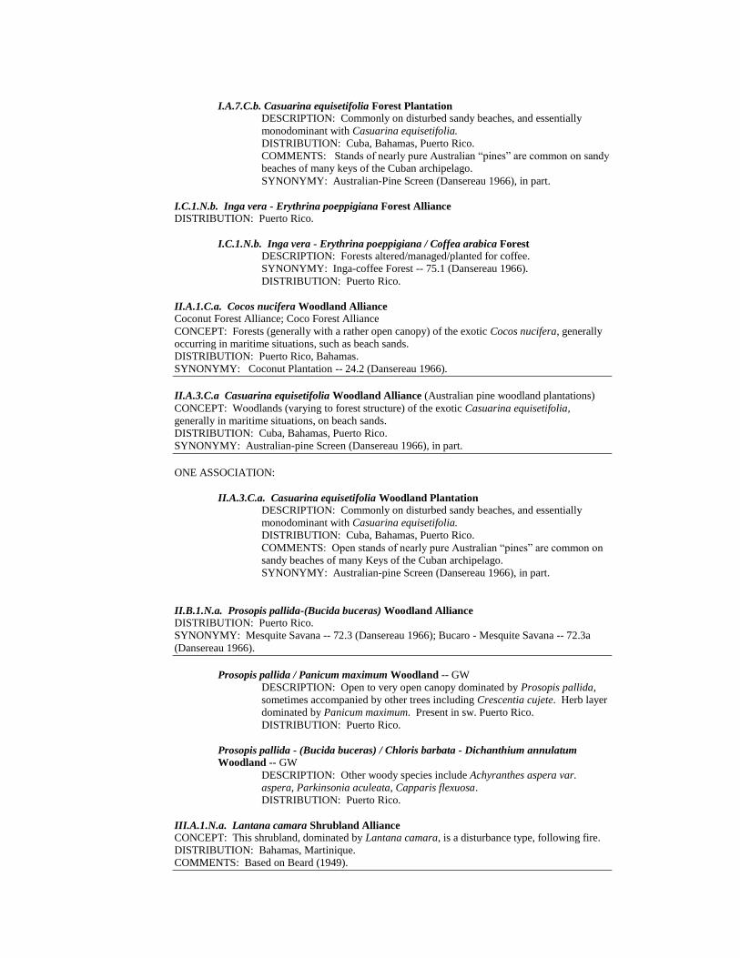
I.A.7.C.b. Casuarina equisetifolia Forest Plantation
DESCRIPTION: Commonly on disturbed sandy beaches, and essentially
monodominant with Casuarina equisetifolia.
DISTRIBUTION: Cuba, Bahamas, Puerto Rico.
COMMENTS: Stands of nearly pure Australian “pines” are common on sandy
beaches of many keys of the Cuban archipelago.
SYNONYMY: Australian-Pine Screen (Dansereau 1966), in part.
I.C.1.N.b. Inga vera - Erythrina poeppigiana Forest Alliance DISTRIBUTION: Puerto Rico.
I.C.1.N.b. Inga vera - Erythrina poeppigiana / Coffea arabica Forest
DESCRIPTION: Forests altered/managed/planted for coffee.
SYNONYMY: Inga-coffee Forest -- 75.1 (Dansereau 1966).
DISTRIBUTION: Puerto Rico.
II.A.1.C.a. Cocos nucifera Woodland Alliance Coconut Forest Alliance; Coco Forest Alliance
CONCEPT: Forests (generally with a rather open canopy) of the exotic Cocos nucifera, generally
occurring in maritime situations, such as beach sands.
DISTRIBUTION: Puerto Rico, Bahamas.
SYNONYMY: Coconut Plantation -- 24.2 (Dansereau 1966).
II.A.3.C.a Casuarina equisetifolia Woodland Alliance (Australian pine woodland plantations)
CONCEPT: Woodlands (varying to forest structure) of the exotic Casuarina equisetifolia,
generally in maritime situations, on beach sands.
DISTRIBUTION: Cuba, Bahamas, Puerto Rico.
SYNONYMY: Australian-pine Screen (Dansereau 1966), in part.
ONE ASSOCIATION:
II.A.3.C.a. Casuarina equisetifolia Woodland Plantation DESCRIPTION: Commonly on disturbed sandy beaches, and essentially
monodominant with Casuarina equisetifolia.
DISTRIBUTION: Cuba, Bahamas, Puerto Rico.
COMMENTS: Open stands of nearly pure Australian “pines” are common on
sandy beaches of many Keys of the Cuban archipelago.
SYNONYMY: Australian-pine Screen (Dansereau 1966), in part.
II.B.1.N.a. Prosopis pallida-(Bucida buceras) Woodland Alliance
DISTRIBUTION: Puerto Rico.
SYNONYMY: Mesquite Savana -- 72.3 (Dansereau 1966); Bucaro - Mesquite Savana -- 72.3a
(Dansereau 1966).
Prosopis pallida / Panicum maximum Woodland -- GW
DESCRIPTION: Open to very open canopy dominated by Prosopis pallida,
sometimes accompanied by other trees including Crescentia cujete. Herb layer
dominated by Panicum maximum. Present in sw. Puerto Rico.
DISTRIBUTION: Puerto Rico.
Prosopis pallida - (Bucida buceras) / Chloris barbata - Dichanthium annulatum
Woodland -- GW
DESCRIPTION: Other woody species include Achyranthes aspera var.
aspera, Parkinsonia aculeata, Capparis flexuosa.
DISTRIBUTION: Puerto Rico.
III.A.1.N.a. Lantana camara Shrubland Alliance
CONCEPT: This shrubland, dominated by Lantana camara, is a disturbance type, following fire.
DISTRIBUTION: Bahamas, Martinique.
COMMENTS: Based on Beard (1949).

III.A.1.N.a. Piper aduncum Shrubland Alliance
CONCEPT: Abandoned pastures and fields dominated by the shrub Piper aduncum.
DISTRIBUTION: Puerto Rico.
SYNONYMY: Pepper Scrub -- 46.4 (Dansereau 1966).
III.A.1.N.a. Psidium guajava Shrubland Alliance
CONCEPT:
DISTRIBUTION: Puerto Rico.
SYNONYMY: Guava Scrub -- 45.4 (Dansereau 1966).
V.A.1.N.c.003. Panicum maximum Herbaceous Alliance CONCEPT: Herbaceous vegetation dominated by the exotic grass Panicum maximum. This
vegetation now covers large parts of Puerto Rico, particularly in southwestern Puerto Rico.
DISTRIBUTION: Puerto Rico, Cuba.
COMMENTS: This is typically 1-2 m tall. If the criteria for tropical/subtropical tall vs. medium-
tall grasslands are brought into agreement with the criteria for temperate/subpolar, this would be
transferred to "tall."
SYNONYMY: Guinea-grass Prairie -- 67.5 (Dansereau 1966); Guinea-grass ruderal grassland.
Panicum maximum Herbaceous Vegetation (TNC 7653)
DESCRIPTION: Vegetation usually strongly dominated by Panicum
maximum. This community results from disturbance, and now covers large
parts of Puerto Rico, particularly in southwestern Puerto Rico.
DISTRIBUTION: Puerto Rico.
SYNONYMY: Guinea-grass ruderal grassland.
V.A.1.N.c.005. Rhynchelytrum repens Herbaceous Alliance CONCEPT: Disturbed areas, such as old fields, vacant lots, roadsides, dominated by the exotic
Rhynchelytrum repens.
DISTRIBUTION: Florida, Puerto Rico, Bahamas.
Rhynchelytrum repens Herbaceous Vegetation (TNC 7654)
DESCRIPTION: Disturbed areas, such as old fields, vacant lots, roadsides,
dominated by the exotic Rhynchelytrum repens.
DISTRIBUTION: Florida, Puerto Rico, Bahamas.
V.B.1.N.d. Colocasia esculenta-Cyperus spp. Herbaceous Alliance
CONCEPT: This vegetation occurs in disturbed wetland areas.
DISTRIBUTION: Puerto Rico.
SYNONYMY: Aroid - sedge Belt -- 73.5 (Dansereau 1966).
V.D.1.N.b. Cleome spinosa Herbaceous Alliance
CONCEPT: Disturbed areas.
DISTRIBUTION: Puerto Rico.
SYNONYMY: Spider-flower Flat -- 41.7 (Dansereau 1966).

Appendix Two
Caribbean Vegetation Classification
References
Reference list organized by country/island
GENERAL Adams, R. P. 1989. Biogeography and evolution of the junipers of the West Indies, pp. 167-190 in
C. A. Woods (ed.). Biogeography of the West Indies: past, present and future. Sandhill Crane
Press, Inc.: Gainesville, Florida xviii, pp. 1-878.
Anderson, J. R., E. E. Hardy, J. T. Roach and R. E. Witmer. 1976. A Land use and land cover
classification system for use with remote sensor data. U.S. Geological Survey Professional
Paper 964, 28 pp.
Asprey, G. F. 1959. Vegetation in the Caribbean area. Carib. Quart. 5(4):245-263.
Aubréville, A. M. 1965a. Principles d’une systématique des formations végétales tropicales.
Adansonia 5:153-196.
. 1965b. Conceptions modernes en bioclimatologie et classification des formation végétales.
Adansonia 5:297-306.
. 1966. Les lisiéres forêt-savane des régions tropicales. Adansonia 6:177-187.
Austin, M. P. and P. Greig-Smith. 1968. The application of quantitatve methods to vegetation
survey II. Some methodological problems of data from rainforests. J. Ecol. 56:827-844.
Bannister, B. A. 1970. Ecological life cycle of Euterpe globosa Gaertn. In: H. T. Odum (ed.), A
Tropical Rain Forest. U.S. Atomic Energy Comm., Oak Ridge, Tenn., pp. 299-314.
Barbour, W. R. 1942. Forest types of tropical America. Carib. For. 3:137-150.
Beard, J. S. 1942. Montane vegetation in the Antilles. Carib. Forest. 3: 61-74.
. 1944. Climax vegetation in tropical America. Ecol. 25:127-158.
. 1945. Some ecological work in the Caribbean. Empire For. J. 24:40-46.
. 1949. Montane vegetation in the Antilles. Carib. For. 3:61-74.
. 1955. The classification of tropical American vegetation types. Ecol. 36:89-100.
Bossi, R. and G. Cintrón. 1990. Mangroves of the wider Caribbean: toward sustainable
management. Caribbean Conservation Association and United Nations Environment
Programme and Panos Institute. 32 pp.
Boyce, S. G. 1954. The salt spray community. Ecol. Monogr. 24:29-67.
Budowski, G. 1956. Tropical savannas, a sequence of forest felling and repeated burnings.
Turrialba 6:23-33.
. 1965. Distribution of tropical American rainforest species in the light of successional
processes. Turrialba 15:40-42.
Campbell, D. G. and H. D. Hammond (eds.). 1989. Floristic inventory of tropical countries. New
York Botanical Garden, Bronx, NY. pp 317-349.
Chrysler, M. A. 1948. Origin of the West Indian fern flora. Am. Fern Journ. 38:135-142.
Cintrón-Molero, G. and Y. Schaeffer-Novelli. 1992. Ecology and management of New World
mangroves, pp. 233-251 in U. Seeliger (ed.), Coastal plant communities of Latin America.
Academic Press, Inc., San Diego, California.
Dansereau, P. 1951. Description and recording of vegetation upon a structural basis. Ecol. 32:172-
229.
. 1958. An universal system for recording vegetation. Contr. Inst. Bot. Univ. Montreal,
72:1-52.
and K. Lems. 1957. The grading of dispersal types in plant communities and their
ecological significance. Contr. Inst. Bot. Univ. Montreal 71:52 pp.
Dinerstein, E., et al. 1995. A conversation assessment of the terrestrial ecoregions of Latin America
and the Caribbean. Published in association with The World Wildlife Fund & The World
Bank: Washington, D. C. xviii, 129 pp., Maps 1-9, and one unnumbered map inserted in back
cover.
Ellenberg, H. and D. Müeller-Dombois. 1966. Tentative physiognomic ecological classification of
plant formations of Earth. Ber. Geobot. Isnt. Rübel, 37:21-56.
Ellison, A. M. and E. J. Farnsworth. 1996. Anthropogenic disturbance of Caribbean mangrove
systems: Past impacts, present trends, and future predictions. Biotropica 28: 549-565.
Emberger, L. 1930. Sur une formule climatique applicable en géographie botanique. C. R. Acad.
Sci. 191:389-391.
. 1955. Une classification biogéographique des climats. Rec. Trav. L’Univ. Montpellier, Sér.
Bot. 7:3-43.
Fedorov, A. A. 1966. The structure of the tropical rainforest and speciation in the humid tropics. J.
Ecol. 54:1-11.
FGDC. 1996. Federal Geographic Data Committee Vegetation Classification and Information
Standards. FGDC Secretariat, Reston, VA. Draft. 35 pp.
Fino, U. H. 1971. Nuevos parametros a considerarse en el analisis estructural de las selvas virgenes
tropicales. Rev. For. Venez. 21:29-42.
Fosberg, F. R. 1963. The island ecosystem. In: Fosberg, F. R. (ed.) Man’s place in the island
ecosystem. 1-6. Honolulu; Bishop Museum Press.
Gaussen, H. 1954. Expression du milieu par des formules écologiques. Leur représentation
cartographique. Les division écologiques du monde. Coll. Intern. CNRS. (Paris) Ann. Biol.
31(5-6):257-267.
. 1963. Les cartes bioclimatiques et de la végétation. Principes directeurs et emploi de la
couleur. Science du Sol. 1963. Mai. no. 1:1-14.
Gill, T. 1931. Tropical Forests of the Caribbean. Washington, 318 pp.
Goldstein, R. A. and D. F. Grigal. 1972. Definition of vegetation structure by canonical analysis. J.
Ecol. 60:277-284.
Graham, A. 1995. Diversification of Gulf/Caribbean mangrove communities through Cenozoic
time. Biotropica 27:20-27.
Grebert, R. 1971. Application of numerical methods to tropical forests. In: Patil, G. P., E. C. Pielou,
and W. E. Waters (eds): Statistical Ecology. Vol. 3. Many species populations, ecosystems and
system analysis. The Pennsylvania State Univ. Press, University Park. pp. 195-204.
Hallé, F., R. A. A. Oldeman and P. B. Tomlinson. 1978. Tropical trees and forest. An architectural
analysis. Springer Verlag, Berlin, Heidelberg, New York.
Hatheway, W. G. 1971. Contingency-table analysis of rainforest vegetation. In: G. P. Patil, E. C.
Pilou and W. E. Waters (eds): Statistical Ecology., vol 3. Many species population, ecosystems
and systems analysis. The Pennsylvania State Univ. Press, University Park, pp. 207-307.
Herndon, A., L. Gunderson and J. Stenberg. 1991. Sawgrass (Cladium jamaicense) survival in a
regime of fire and flooding. Wetlands 11(1):17-28.
Hewetson, C. E. 1956. A discussion on the climax concept in relation to the tropical rain and
deciduous forest. Emp. For. Rev. 35:274-291.
Hills, T. L. 1965. Savannas: a review of a major research problem in tropical geography. Canad.
Geographer 9:216-228.
Hitchcock, A. S. 1936. Manual of the grasses of the West Indies. U.S. Department of Agriculture
Miscellaneous Publication No. 243. Washington, D. C.
Holdridge, L. R. 1947. Determination of world plant formations from simple climatic data. Science
105:367-368.
. 1967. Life zone ecology. Tropical Science Center, San José, Costa Rica. 206 pp.
. 1971. Forest environments in tropical life zones. Pergamon Press. Oxford, New York. 747
pp.
, et al. 1971. Forest environments in tropical life zones. A pilot study. Wiley and Son, New
York, 747 pp.
Howard, R. A. 1973. The vegetation of the Antilles. In: A. Graham (ed.): Vegetation and vegetation
history of northern Latin America. Elsevier, New York, 1-38 pp.
. 1979. Flora of the West Indies. In: Larsen, K. (Ed.): Tropical Botany. Academic Press,
London. pp. 239-250.
Institute of Tropical Forestry. 1985. Development, forestry, and environment in the Eastern
Caribbean. U.S.D.A., Forest Service, Institute of Tropical Forestry: Río Piedras, Puerto Rico.
165 pp.
Julius, C. and J.-C. Pons. 1972. Contribution à l’étude d’une mangrove et de la région des Vauclin.
Bull. Inst. Géol. Bassin d’Aquitaine 12:181-182.
Kruckeberg, A. R. 1954. The ecology of serpentine soils. III. Plant species in relation to serpentine
soils. Ecol. 35:251-258.
Küchler, A. W. 1947. A geographical system of vegetation. Geogr. Rev. 37:233-240.
. 1949. A physiognomic classification of vegetation. Ann. Assoc. Amer. Geogr. 39:20-210.
. 1953. Some uses of vegetation maps. Ecol. 34:629-636.

(compiler). 1980. Vegetation maps of South America. I. Lawrence: University of Kansas
Libraries, pp. 230-232; 273-291.
Lamotte, M. 1975. The structure and function of a tropical savanna ecosystem. In: F. B. Golley and
E. Medina (eds): Tropical Ecological Systems. Ecological Studies 11:179-223.
Lamprecht, H. 1962. Ensayo sobre unos métodos para el análisis estructural de los bosques
tropicales. Acta Cient. Venez. 13:57-65.
Lang, G. E., D. H. Knight and D. A. Anderson. 1971. Sampling the density of tree species with
quadrats in a species-rich tropical forest. For. Sci. 17:395-400.
Lemée, G. 1959. Effects des caractéres du sol sur la localisation de la végétation en zones
equatoriales et tropicales humides. In: Tropic Soils and Vegetation. Proc. Abidjan Symp.
Paris: UNESCO 1961.
Longman, K. A. and J. Jenik. 1974. Tropical Forest and its environment. Longman Group, London,
196 pp.
Lowden, R. M. 1976. Caribbean aquatic botany. Taxon 25:256.
Lugo, A. E. and S. Brown. 1988. The wetlands of Caribbean Islands. Acta Ci. [Asoc. Maestros Ci.
Puerto Rico] 2:48-61.
Moran, R. C. 1995. The importance of mountains to pteridophytes, with emphasis on neotropical
montane forests, pp. 359-363 in S. P. Churchill, H. Balslev, E. Forero, and J. L. Luteyn (eds.)
1995, Biodiversity and conservation of neotropical montane forests. New York Botanical
Garden: Bronx, N.Y. xiv, 702 pp.
Mueller-Dombois, D. 1975. Some aspects of island ecosystem analysis. In: F. B. Golley and E.
Medina (eds): Tropical Ecological Systems. Ecological Studies. 11:353-366.
Odum, H. T, ed. 1970. A tropical rain forest. Division of Technical Information, USAEC, Oak
Ridge, Tennessee.
Orlóci, L. 1967. An agglomerative method for classification of plant communities. J. Ecol. 55:193-
206.
Richards, P. W. 1952. The tropical rainforest, Cambridge, Univ. Press 450 pp.
. 1955. The secondary succession in the tropical rainforest. Sci. Prog. 43:45-57.
. 1959, 1961. The types of vegetation of the humid tropics in relation to soil. In: Tropical
Soils and Vegetation. Proc. Abidjan Symps. 1959. Paris, UNESCO 1961.
. 1969. Speciation in the tropical rainforest and the concept of niche. Biol. J. Linn. Soc.
1:149-153.
, A. G. Tansley and A. S. Watt. 1940. The recording of structure, life form, and flora of
tropical forest communities as a basis for their classification. J. Ecol. 28:224-229.
Ross, M. S., J. J. O’Brien and L. J. Flynn. 1992. Ecological site classification of Florida Keys
terrestrial habitats. Biotropica 24: 488-502.
Rutishauser, R. 1997. Structural and developmental diversity on Podostemaceae (river-weeds).
Aquat. Bot. 57:29-70.
Rutzler, K. and I. C. Feller. 1996. Caribbean mangrove swamps. Sci. Amer. 274(3):70-75.
Sauer, J. D. 1959. Coastal pioneer plants of the Caribbean and Gulf of Mexico. Madison, Wis.:
Departments of Botany and Geography, University of Wisconsin.
Sarmiento, G. and M. Monasterio. 1975. A critical consideration of the environmental conditions
associated with the occurrence of savanna ecosystems in tropical America. In: F. B. Golley
and E. Medina (eds) Tropical Ecological Systems. Ecological Studies 11:223-250.
Schnell, R. 1970-1971. Introduction á la Phytogéographie des pays tropicaux. I-II. Ed. Gauthier-
Villars, Paris, 951 pp.
Silver, W. L. 1997. Montane vegetation in the tropics: Controls on the development, structure, and
function of cloud forest ecosystems, pp. 28-29/Vegetación montana en los trópicos: Control
del desarrollo, la estructura y función de los ecosistemas de los bosques nublados, pp. 96-97,
in annual letter, 1993-1994, International Institute of Tropical Forestry, Forest Service, U.S.
Dept. Agriculture, Río Piedras, Puerto Rico.
Stearns, W. T. 1958. A key to the West Indian mangroves. Kew. Bull. pp. 33-37.
Steenis, C. G. J. van. 1958a. Rejuvenation as a factor for judging the status of vegetation types: the
biological nomad theory. Studies of Tropical Vegetation, UNESCO, pp. 212-218.
. 1958b. Basic principles of rain forest sociology. Studies of Tropical Vegetation, UNESCO.
pp. 159-165.
Sugden, A. M. 1983. Determinants of species composition in some isolated neotropical cloud
forests. Trop. Rain For. 2:43-56.
Tanner, E. V. J., V. Kapos and J. R. Healey. 1991. Hurricane effects on forest ecosystems in the
Caribbean. Biotropica 23:513-519.
Thom, B. G. 1967. Mangrove ecology and deltaic geomorphology: Tabasco, Mexico. J. Ecol.
55:301-343.

Thompson, P. T. 1966. A test of the Holdridge model in midlatitude mountains. Profess.
Geographer 15:286-292.
Tosi, J. A., Jr. 1964. Climatic control of terrestrial ecosystems: a report of the Holdridge model.
Economic Geogr. 4:173-181.
UNESCO. 1973. International classification and mapping of vegetation. Paris.
Van Steenis, C. G. G. J. 1958a. Basic principles of rain forest sociology, In: Study of Tropical
Vegetation. Kandy Symp. UNESCO, Paris, 159-163 pp.
. 1958b. Rejuvenation as a factor for judging the status of vegetation types: The biological
nomad theory. In: Study of Tropical Vegetation. Proc. Kandy Symp. 212-215. UNESCO,
Paris.
. 1962. The land-bridge theory in botany. Blumea 11:235-372.
Verdoorn, F. (ed.) 1945. Plants and plant science in Latin America. Chronica Botanica Co.
Waltham, Mass. 383 pp.
Wadsworth, F. H. 1997. Forest production in tropical America. U.S.D.A. Forest Service,
Agriculture Handbook 710, 563 pp.
Walker, L. R., W. L. Silver, M. R. Willig and J. K. Zimmerman. 1997. Biotropica special issue:
Long term responses of Caribbean ecosystems to disturbance. Biotropica 28(4a):414-614.
, et al. 1996. Ecosystem development and plant succession on landslides in the Caribbean.
Biotropica 28:566-576.
Walter, H. 1962. Die Vegetation der Erde in ökophysiologischer Betrachtung. I. Die tropischen und
subtropischen Zonen. Fischer, Stuttgart-Jena, 538 pp.
. 1970. Vegetationszonen und Klima. Fischer Jena, 244 pp.
Watt, A. S. 1947. Pattern and process in the plant community. J. Ecol. 35:1-22.
Watts, D. 1970. Persistence and change in the vegetation of oceanic islands. Can. Geogr. 14:91-
109.
Weakley, A. S. 1996. Vegetation of the West Indies (Cuba, the Greater Antilles, the Lesser
Antilles, and the Bahamas). Draft. (Unpublished).
Webb, L. J., J. G. Tracey and W. T. Williams. 1972. Regeneration and pattern in the subtropical
rainforest. J. Ecol. 60:675-695.
, , and G. N. Lance. 1967. Studies in the numerical analysis of complex rain-
forest communities. I. A comparison of methods applicable to site/species data. J. Ecol.
55:171-191.
Webster, G. L. 1995. The panorama of neotropical cloud forests, pp. 53-77 in S. P. Churchill, H.
Balslev, E. Forero and J. L. Luteyn (eds.) 1995, Biodiversity and conservation of neotropical
montane forests. New York Botanical Garden: Bronx, NY xiv, 702 pp.
Whittaker, R. H. 1953. A consideration of climax theory: the climax as a population and pattern.
Ecol. Monogr. 23:41-78.
. 1965. Dominance and diversity in land plant communities. Science 147:250-260.
Williams, S. L. 1990. Experimental studies of Caribbean seagrass bed development. Ecol. Monogr.
60:449-469.
Woods, C. A. (ed.) 1989. Biogeography of the West Indies: past, present and future. Sandhill Crane
Press, Inc.: Gainesville, Florida xviii, pp. 1-878.
ARUBA-BONAIRE-CURAÇAO Amshoff, G. J. 1942. The grasses of the Dutch West Indies. Kolonial Instituit Amsterdam, Afduling
Handelsmuseum 225.
Beers, C. E., Freitas, J. de and P. Ketner. 1997. Landscape ecological vegetation map of the island
of Curaçao, Netherlands Antilles. Publications Foundation for Scientific Research in the
Caribbean Region:138, Amsterdam. 43 pp.
E.C.N.A.M.P. 1980. Eastern Caribbean Natural Area Management Program. Aruba; Bonaire;
Curaçao. Preliminary data atlas. Caribbean Conservation Association, University of Michigan,
and The United Nations Environment Programme.
Kuenen, M. M. C. E. and A. O. Debrot. 1995. A quantitative study of the seagrass and algal
meadows of the Spaanse Water, Curaçao, The Netherlands Antilles. Aquat. Bot. 51:291-310.
Stoffers, A. L. 1956. Studies on the flora of Curacao and other Caribbean islands. I. The
vegetation of the Netherlands Antilles. Natuurwetenschappelijke studiekring voor Suriname
en de Nederlandse Antillen. No 15. Utrecht.
. Flora of the Netherlands Antilles. Vol. 1: 1-84. 1962; Vol. 2: 1-96. 1966, 97-209. 1980,
211-315. 1982; Vol. 3: 61-142. 1979. With collaborators and published out of order. Utrecht.
et al. 1963. Flora of the Netherlands Antilles-Spermatophyta, Monocotyledoneae. Utrecht.

. 1966. Flora of the Netherlands Antilles-Spermatophyta, Dicotyledoneae.
BAHAMAS (INCLUDING TURKS AND CAICOS) Britton, N. L. and Millspaugh, C. F. 1920. The Bahama Flora. New York Botanical Garden, Bronx,
NY, 694 pp.
Clark, C. A. 1992. Gramineae on the Island of San Salvador: survey in progress. pp. 13-14 in W. H.
Eshbaugh (ed.), Proceedings of the Fourth Symposium on the Natural History of the Bahamas.
Bahamian Field Station, Ltd.: San Salvador, Bahamas.
Coker, W. C. 1905. The vegetation of the Bahama Islands in G. B. Shattuck (ed.), The Bahama
Islands, pp. 185-270.
Correll, D. S. and H. B. Correll. 1982. Flora of the Bahama Archipelago. Strauss and Cramer,
Germany.
Eshbaugh, W. H., D. L. Nickrent and T. K. Wilson. 1988. Vascular flora of Andros Island,
Bahamas. Kendall/Hunt Publishing Co.: Dubuque, Iowa. 185 pp.
and T. K. Wilson. 1990. The tropical tree flora of Andros Island Bahamas: observations
and notes. pp. 17-23 in R. R. Smith (ed.), Proceedings of the Third Symposium on the Botany
of the Bahamas. Bahamian Field Station, Ltd.: San Salvador, Bahamas.
and . 1996. On the need to conserve Bahamian floral diversity, pp. 77-82, in N. B.
Elliott, D. C. Edwards and P. J. Godfrey (eds.) 1996. Proceedings of the Sixth Symposium on
the Natural Hisotry of the Bahamas. Bahamian Field Station, Ltd.: San Salvador, Bahamas.
Frazer, A. M. and W. H. Eshbaugh. 1993. Ecology and floristic composition of the herbaceous vine
and liana assemblages of pineland and coppice communities of North Andros Island,
Bahamas. Amer. J. Bot. 80(6, suppl.): 67[Abstract].
and . 1997. The vines of pineland and dry evergreen forest (coppice) communities
on North Andros Island, Bahamas: Abundance and floristic composition, pp. 22-38, in N. B.
Elliott, D. C. Edwards and P. J. Godfrey (eds.). 1996. Proceedings of the Sixth Symposium on
the Natural History of the Bahamas. Bahamian Field Station, Ltd.: San Salvador, Bahamas.
Godfrey, P. J., A. M. Fowler and D. C. Edwards. 1993. Effects of recent sea level rise on plant
succession around saline ponds of San Salvador Island, The Bahamas. Amer. J. Bot. 80(6,
Suppl.): 55. [Abstract].
and K. Herchenreder. 1986. Vegetation transects and profiles across an overwash site and
stable dunes on Sand Cay (21º12'N, 71º15'W) in the southern Bahamas, pp. 139-158 in R. R.
Smith (ed.) 1986. Proceedings of the Third Symposium on the Botany of the Bahamas.
Bahamian Field Station, Ltd.: San Salvador, Bahamas
Green, E. P., et al. 1997. Estimating leaf area index of mangroves from satellite data. Aquat. Bot.
58:11-19. [Turk & Caicos Islands].
Kass, L. B. and L. J. Stephens. 1990. The trees of the mangrove swamp community of San
Salvador Island, The Bahamas, and their “succession” patterns. pp. 53-65 in R. R. Smith (ed.),
Proceedings of the Third Symposium on the Botany of the Bahamas. Bahamian Field Station,
Ltd.: San Salvador, Bahamas.
, , M. Kozacko and J. D. Carter. 1994. Continued studies of mangrove ecosystems
on San Salvador Island, Bahamas. pp. 50-56 in L. B. Kass (ed.), Proceedings of the Fifth
Symposium on the Natural History of the Bahamas. Bahamian Field Station, Ltd.: San
Salvador, Bahamas.
McCartney, D. J., J. A. Lundgren and P. J. Godfrey. 1986. The flora and vegetation of Sand Cay
(21º12’N, 71º15’W) in the Turks and Caicos Islands, Southern Bahamas, pp. 117-127 in R. R.
Smith (ed.) Proceedings of the Third Symposium on the Botany of the Bahamas. Bahamian
Field Station, Ltd.: San Salvador, Bahamas.
Morrison, L. W. 1997. The insular biogeography of small Bahamian cays. J. Ecol. 85:441-454.
Nickrent, D. L., W. H. Eshbaugh, and T. K. Wilson. 1991. The vascular flora of Andros Island,
Bahamas. Willard Sherman Turrell Herbarium, Department of Botany, Miami University:
Oxford, Ohio. iv. 186 pp.
Rathcke, B., L. B. Kass, and R. E. Hunt. 1996. Preliminary observations on the reproductive
biology of a San Salvador mangrove community, pp. 87-96, in N. B. Elliott, D. C. Edwards
and P. J. Godfrey (eds.). 1996. Proceedings of the Sixth Symposium on the Natural History of
the Bahamas. Bahamian Field Station, Ltd.: San Salvador, Bahamas.
Rivers, W. G. 1986. Halophytes of the hypersaline lakes of San Salvador, Bahamas, pp. 87-99 in R.
R. Smith (ed.) Proceedings of the Third Symposium on the Botany of the Bahamas. Bahamian
Field Station, Ltd.: San Salvador, Bahamas.
Smith, G. W., F. T. Short and D. I. Kaplan. 1990. Distribution and biomass of seagrasses in San
Salvador, Bahamas. pp. 67-77 in R. R. Smith (ed.) Proceedings of the Third Symposium on
the Botany of the Bahamas. Bahamian Field Station, Ltd.: San Salvador, Bahamas.
Smith, I. K., W. H. Eshbaugh, J. L. Vankat and T. K. Wilson.
1992. On the nature of the dry evergreen forest (coppice)
communities of North Andros Island, Bahams. Pp. 109-123
in W. H. Eshbaugh (ed.), Proceedings of the Fourth
Symposium on the Natural History of the Bahamas.
Bahamian Field Station, Ltd.: San Salvador, Bahamas. and J. L. Vankat. 1992. Dry evergreen forest (coppice) communities of North Andros
Island, Bahamas. Bull. Torrey Bot. Club 119:181-191.
BERMUDA Britton, N. L. 1918. Flora of Bermuda. Charles Scribner’s Sons. New York. 585 pp.
Herwitz, S. R. 1992. Quaternary vegetation change and dune formation on Bermuda: a discussion.
Global Ecol. Biogeogr. Lett. 2:65-70.
CAYMAN ISLANDS Brunt, M. A. and J. E. Davies (eds.) 1994. The Cayman Islands. Natural History and Biogeography.
Monogr. Biol. 71: i-xx, 1-604, 3 maps.
Proctor, G. R. 1984. Flora of the Cayman Islands. Kew Bull. Additional Ser. XI, London.
Sauer, J. D. 1982. Cayman Islands seashore vegetation: A study in comparative biogeography.
University of California Publications in Geography No. 25. Berkeley: University of California.
CUBA Acuña, J. G. 1964. Flora de las ciénagas de Cuba. Poeyana, Ser. A. (3): 1-10.
, C. S. Pinal and O. G. Acuña. 1967. Catálogo florístico de Isla de Pinos. Acad. Sci. Cuba
Ser. Isla de Pinos 22: 1-54.
Aguila, N. et al. 1995. Vegetación de los dunas Lomas del Puerto (Cayo Coco, Ciego de Avila,
Cuba). Fontqueria 47:243-256.
Alain, Hno. 1950. Notas sobre la vegetación de la loma de Cajálbana, Pinar del Rio. Rev. Soc. Bot.
Cubana 7(1-3):8-18.
. 1958. La flora de Cuba: sus principales características, su origen probable. Rev. Soc. Bot.
Cubana 15(2-3):36-59.
. 1960. Flora de Baracoa. Rev. Soc. Geogr. Cubana 30(4):13-22.
. 1962. Flora de Cuba. Sucre, Caracas, vol. 5, 362 pp.
. 1969. Suplemento de la Flora de Cuba. Sucre, Caracas. 150 pp.
Albert, D. and A. López. 1986. Distribución de las fanerógamas endémicas de Sierra Maestra. Rep.
Invest. Inst. Bot. (La Habana, Cuba) 11:1-27.
Anon. 1989. Ecología de los bosque siempre verdes de la Sierra del Rosario, Cuba. InfoMAB
11:14-16.
Areces-Mallea, A. E. 1978. Mapa de vegetación, in Atlas de Cuba XX Aniversario del Triunfo de la
Revolución. Inst. Cub. Geodesia y Cartografía. Havana.
. 1986. Ecología de la vegetación de las aguas y fondos marinos de Cuba, y su signicación
en las facies sedimentarias de la plataforma 1. Los pisos supra- y mesolitoral. Rev. Invest.
Mar. (Cuba) 7(2):81-92.
Avila, J., N. Enríquez and E. Méndez. 1988. Cuatro nuevas familias para el distrito fitogeográfico
serpentinas de Camagüey. Rev. Jard. Bot. Nac. (La Habana, Cuba) 9(3):85-88.
Balátová-Tulácková, E. 1984. Phytosociological characteristics of the Sclerio interruptae-
Rhynchosporetum subimberbis Yaguaramas savanna (Cuba). Folia Geobot. Phytotax.
19:317-
321.
. 1986. Sinopsis preliminar de las comunidades sabanosas de las regiones occidental y
central de Cuba e Isla de la Juventud, incluyendo algunas comunidades de contacto. DOC.
Phytosoc. 10: 215-222.

and R. Capote. 1982. A new savanna-like community of the Sierra del Rosario mountains,
Cuba. Folia Geobot. Phytotax. 17:137-148.
and . 1985. Contribution to the knowledge of some savanna and forb-rich
communities on the Isla de la Juventud (Cuba). Folia Geobot. Phytotax. 20: 17-39.
and . 1985b. The Cassio lineatae-Aristidetum neglectae, a new association of the
serpentine in Cuba. Folia Geobot. Phytotax. 20: 177-183.
and . 1992. Contribution to the knowledge of the savanna and forb-rich
communities of Pinar del Río Province, Cuba. Folio Geobot. Phytotax. 27:337-356.
and E. E. García. 1987. Contribución acerca de las comunidades secundarias de gramíneas
en Cuba. Phytocoenologia 15:39-49.
and M. Surlí. 1983. Contribution to the phytosociological characteristics of the
Yaguaramas savannas (Cienfuegos province, Cuba). Folia Geobot. Phytotax. 18:1-12.
Barreto, A., et al. 1992. Inventario florístico de las áreas del plan ovino del norte de Camagüey.
Rep. Invest. Inst. Ecol. Sist. [La Havana, Cuba] [not numbered]:1-36.
, P. Herrera, N. Rodríguez and G. Espín. 1992. Lista florística de Monte Quemado, sureste
de la Reserva Natural de la Sierra del Chorrillo, municipio Najasa, Provincia de Camagüey,
Cuba. Rep. Invest. Inst. Ecol. Sist. [La Habana, Cuba] ser. Bot. 9:1-16.
Bastart, J. A. and N. Ricardo. 1988. Paspalo fimbriati-Bidentetum pilosae, nueva asociación ruderal
de Cuba. Acta Bot. Cubana 66:1-7.
Berazaín, R., R. Rankin, I. Arias and J. Gutiérrez. 1985. Notas sobre la vegetación de serpentina en
Camagüey. Rev. Jard. Bot. Nac. (La Habana, Cuba) 6(2):63-78.
Berazaín, R. 1987. [1988]. Notas sobre la vegetación y flora de la Sierra de Cajálbana y Sierra
Peluda (Pinar del Río). Rev. Jard. Bot. Nac. (La Habana, Cuba). 8(3):39-68.
. 1992. A note on plant/soil relationships in the Cuban serpentine flora, pp. 97-99 in A. J. M.
Baker, J. Proctor and R. D. Reeves (eds.), The vegetation of ultramafic (serpentine) soils.
Proceedings of the First International Conference on Serpentine Ecology, University of
California, Davis, 19-22 June 1991. Andover, Hampshire, England.
. 1997. The serpentine flora of Cuba: Its diversity, pp. 139-14 in T. Jaffré, R. D. Reeves and
T. Becquer (eds.), Écologie des milieux sur roches ultramafiques et sur sols métalliféres.
, C. Sánchez and R. Rankin. 1985. Breve reseña de los pinares en Sumidero, Pinar del Río.
Rev. Jard. Bot. Nac. (La Habana, Cuba) 6(1):99-107.
Biochino, A. A. and J. Ortega. 1984. Características de la vegetación en algunos embalses de Cuba.
Ci. Biol. (Cuba) 12:61-80.
Bisse, J. 1973. Guía para clasificar los diferentes tipos de montes y vegetación con especies
forestales existentes en el país. Havana (unpubl.).
. 1975. Die floristische Stellung und Gliederung Kubas. Wiss. Z. Friedrich Schiller Univ.
Jena 24:365-371.
. 1980. La subdivisión florística de la región nororiental de Cuba. Rev. Jard. Bot. Nac. Cuba
1 (1): 11-18.
, C. Sánchez and R. Rankin. 1984. Breve caracterización de la flora y vegetación de los
mogotes de Sumidero (Pinar del Río). Rev. Jard. Bot. Nac. (La Habana, Cuba) 5:77-97.
Borhidi, A. 1973. Fundamentals of Geobotany of Cuba.. Thesis for D. Sc. (in Hungarian).
Budapest, 292 pp.
. 1974a. Kubában térképeztünk. (Mapping in Cuba) In Hungarian. Budapest, Gondolat pp.
245 + 116 tables.
. 1974b. Mapping in Cuba (in Hungarian). Gondolat, Budapest.
. 1975. The effects of serpentine soils on tropical flora and vegetation in Cuba. XII Intern.
Bot. Congr. Leningrad. Abstracts 1:110.
. 1976. Fundamentals of Geobotany of Cuba (in Hungarian). Summary of D. Sc. thesis.
Budapest. 16 pp.
. 1985. Phytogeographic survey of Cuba I. The phytogeographic characteristics and
evolution of the Flora of Cuba. Acta Bot. Acad. Sci. Hung. 31:3-34.
. 1988a. Vegetation dynamics of savannization processes in Cuba. Vegetatio 75:177-183.
. 1988b. The main vegetation units of Cuba. Acta Bot. 33:151-185.
. 1988c. Efectos de la roca serpentina en la adaptación y evolución de la flora y vegetación
tropical en Cuba. Acta Bot. Hung. 34:123-174.
. 1988d. El efecto ecológico de la roca serpentina en la flora y la vegetación de Cuba. Acta
Bot. Hungar. 34:123-174.
. 1991. Phytogeography and vegetation ecology of Cuba. Akadémiai Kiadó, Budapest.
. 1992. The serpentine flora and vegetation of Cuba, pp. 83-95 in A. J. M. Baker, J. Proctor
and R. D. Reeves. (eds.), The vegetation of ultramafic (serpentine) soils. Proceedings of the

First International Conference on Serpentine Ecology, University of California, Davis, 19-22
June 1991. Andover, Hampshire, England.
. 1993a. Phytogeography and vegetation ecology in Cuba. Feddes Repert. 104:307-308.
. 1993b. Dry coastal ecosystems of Cuba. In E. Van der Maarel (ed.), Dry coastal
ecosystems: Africa, America, Asia, and Oceania. Ecosystems of the World 2B: 423-452.
Elsevier: Amsterdam.
. 1996. Phytogeography and vegetation ecology of Cuba. 2nd revised edition Akadémiai
Kiadó, Budapest, Hungary. 940 pp.
and R. Capote. 1984. Plant communities of Cuba. II. The riverside scrub vegetation. Acta
Bot. Acad. Sci. Hung. 30:119-127.
and R. Herrera. 1977. Génesis, características y clasificación de los ecosistemas de sabana
de Cuba. Cienc. Biol. 1:115-130.
and O. Muñiz. 1980. Die Vegetationskarte von Kuba. Acta Bot. Acad. Sci. Hung. 26:25-53.
and . 1984. Mapa de la vegetación potencial de Cuba. Imp. Juceplan, Havana pp. 1-
45.
and . 1986. Phytogeographic survey of Cuba II. Floristic relationships and
phytogeographic subdivision. Acta. Bot. Acad. Sci. Hung. 32 (1-4): 3-48.
, and E. del Risco. 1979. Clasificación fitocenológica de la vegetación de Cuba.
Acta Bot. Acad. Sci. Hung. 25:263-301.
, and . 1983. Plant communities of Cuba I. Fresh- and salt water, swamp,
and coastal vegetation. Acta Bot. Acad. Sci. Hung. 29:337-376.
and Pócs, T. 1985. Effects of serpentine on the distribution of cryptogams in Cuba. Abstr.
IAB Conf. of bryoecology Budapest-Vácrátót. Abstr. Bot. 9:Suppl. 3:14.
Britton, N. L. 1921. The natural vegetation of the Isle of Pines. J. New York Bot. Gard. 17:64-71.
Capote, R. and R. Berazaín. 1984. Clasificación de las formaciones vegetales de Cuba. Rev. Jard.
Bot. Nac. 5 (2): 27-75.
, and A. Leiva. 1992. Flora and vegetation, pp. 26-36 in K. Hammer, M. Esquivel,
and H. Knüpffer (eds.). “...y tienen faxones y fabas muy diversos de los nuestros...” Origin,
evolution and diversity of Cuban plant genetic resources. Institut für Pflanzengenetik und
Kulturpflanzenforschung: Gatersleben, Germany. vol. 1: vii, 1-212; vol. 2: 213-454.
et al. 1985. Nuevas associaciones de bosque tropical en la Reserva de la biosfera, Sierra del
Rosario, Pinar del rio, Cuba. Mem. Primer Simp. Bot. Cuba. 3:190-211.
, E. Garcia, J. Urbino and M. Surli. 1988. Mapa de la vegetación actual de Pinar del Rio,
Cuba, a escala 1:2250,000. Acta Bot. Cub. 68:1-11, mapa.
, , R. Vandama and J. Oro. 1988. Aplicación del análisis cósmico multizonal al
estudio de la vegetación de Parque Baconao, Santiago de Cuba, Acta Bot. Cub. 65:1-11.
, L. Menéndez, E. E. García and R. A. Herrera. 1986. Sucesión vegetal, In R. A. Herrera-P.,
L. Menéndez and M. E. Rodríguez, eds. 1986. Ecología de los Bosques Tropicales de la Sierra
del Rosario, Cuba (1974-1986) Proyecto MAB 1. Resumenes.
Capote, R. P., et al. 1987. Flora y vegetación de la zona costera entre Daiquirí y Verraco, Parque
Baconao, Santiago de Cuba. Acta Bot. Cub. 48:1-28.
et al. 1989. Mapa de vegetación actual, in Nuevo Atlas Nacional de Cuba. Academia de
Ciencias de Cuba.
Carabia, J. P. 1945. Vegetation of Sierra de Nipe, Cuba. Ecol. Monogr. 15:324-341.
Cejas, F. and P. Herrera. 1995. El endemismo vegetal en las sabanas de arenas blancas (Cuba
oriental). Fontqueria 47:229-242.
Chiappy, C., L. Montes, P. Herrera and R. Capote. 1986. Estudio y valoración de la propuesta
reserva natural “La Cañada” en la Isla de la Juventud. Rep. Invest. Inst. Bot. (Cuba) 9:1-24.
Chiappy, C., P. Herrera and L. Iñiguez. 1988. Aspectos botánicos y valores para la conservación de
la naturaleza de la llanura costera del norte de la Provincia de Las Tunas, Cuba. Acta Bot. Cub.
61:1-26.
del Risco, E. and A. Borhidi. 1975. Estructura del manto vegetal. In: Informe sobre el estado de los
conocimientos relativos a los ecosistemas forestales tropicales de Cuba; bosques
perennifolios, semicaducifolios. Informe al UNESCO, 23-43.
and . 1977. El area de Zapata, Cuba I. Clasificación fitocenológica y descripción de
la vegetación. Mscr. 48 pp.
and V. Samek. 1984. Estudio fitocenológica de los pinares de Pinar del Río y su
importancia práctica para la silvicultura. Acta Bot. Cub. 20:17-28.
Dénes, B. 1989. Kuba erdei. Az Erdö 38:178-181.
Díaz, M. A. and C. Sánchez. 1986. [1987]. Un recorrido por los Pinares de Mícara (Sierra de
Cristal) [Cuba]. Rev. Jard. Bot. Nac. (La Habana, Cuba) 7(3):33-34.

Fraga, J. M. P. and J. Kvet. 1993. Production dynamics of Typha domingensis (Pers.) Kunth
populations in Cuba. J. Aquat. Pl. Managem. 31:240-243.
García, E. E., R. P. Capote, P. Herrera and M. Surlí. 1985. La vegetación del Sur de Isla de la
Juventud. Rev. Jard. Bot. Nac. (La Habana, Cuba) 6(2):79-94.
, and J. Urbino. 1988. Mapa de la vegetación actual de Isla de La Juventud, Cuba, a
escala 1:250,000. Acta Bot. Cub. 70:1-6, mapa.
Gutiérrez, J., J. Bisse, and R. Rankin. 1984. Sobre la vegetación de mogotes en tres localidades al
sur de la Sierra de Nipe. Rev. Jard. Bot. Nac. (La Habana, Cuba) 5:133-155.
Gutte, P. 1989. Ein Beitrag zur Kenntnis von Flora and Vegetation der Stadt Santa Clara in Cuba.
Wissenschaft. Zeitschrift. Friedrich-Schiller-Univ. Beitr. Phytotaxon. 14:297-314.
Hadac, E. and V. Hadacová. 1971. The association Blechno serrulati-Aceoloraphetum wrightii in
the Remates de Guane, West-Cuba, and its ecology. Folia Geobot. Phytotax. 6:369-388.
Helmecke, K. and L. Menéndez. 1986. Oekologische und physiologische Aspekte des
Serpentinbodens und seiner Pflanzengesellschaften. Feddes Repert. 97:43-47.
Hernández, J. A., J. A. Bastart, E. Medero and P. Herrera. 1995. Flora y vegetación de las sabanas
de arenas blancas, Isla de la Juventud (Cuba). Estado de conservación. Fontqueria 47:219-
228.
Herrera, P., L. Montes and C. Chiappy. 1987. Valoración botánica de la propuesta de reserva
natural “Loma de la Coca”, ciudad de La Habana, Cuba. Acta Bot. Cub. 52:1-23.
Herrera, R. 1984. El origen de las sabanas cubanas. pp 49-97 in L. Waibe and R. Herrera, La
Toponimia en el paisaje cubano. Demografia. Ed. Cienc. Soc. La Habana.
Herrera, R. A., L. Menéndez, M. E. Rodríguez and E. E. García (eds.) 1988. Ecología de los
bosques siempre verdes de la Sierra del Rosario, Cuba. Proyecto MAB no. 1, 1974-1987.
Instituto de Ecología y Sistemática, Academia de Ciencias de Cuba. Oficina Regional de
Ciencia y Tecnología de la UNESCO para América Latina y el Caribe: Montevideo, Uruguay.
x, 1-760.
Howard, R. A. and W. Briggs. 1953. The vegetation on coastal dogtooth limestone in southern
Cuba. J. Arn. Arb., 34:88-94.
Jennings, O. E. 1917. A contribution to the botany of the Isle of Pines. Ann. Carnegie Mus. 11:19-
290.
Jiménez, C. and P. Alcolado. 1989. Comportamiento estacional de la biomasa vegetal en un
seibadal de Cuba. Acta. Bot. Cubana 71:1-10.
Köhler, E. and B. Mory. 1989. Die Flora-Cuba-Forschungen und - Sammlungen des Bereichs
Botanik und Arboretum. Wissenschaft. Zeitshr. Humboldt-Universität Berlin, Reihe Math.
Natur. Wissen Schaft. 38(4):374-381.
León, H. Sauget. 1926. Cuba: Natural areas and regions. In: Naturalist’s Guide to the Americas.
Shelford Baltimore 761 pp.
. 1942. Vegetación de las terazas de Maisi. Rev. Soc. Geogr. Cuba. 15(2):33-49.
. 1946. Flora de Cuba 1. Contrib. Ocas. Mus. Hist. Nat. Colegio “De la Salle”, Havana,
8:1-441.
and A. H. Liogier. 1951-1957. Flora de Cuba, vols. 2, 3, 4. Contrib. Occas. Col. De la
Salle, 10:1-456; 13:1-502; 16:1-556.
Liogier, A. 1962. Flora de Cuba, V. Río Piedras, P. R. pp. 1-363.
. 1969. Flora de Cuba, Suplemento. Caracas, Venezuela, pp. 1-150.
Lötschert, W. 1958. Die Übereinstimmung von geologischer Unterlages und vegettion in der Sierra
de los Organos (West-Cuba). Ber. Deutsch. Bot. Ges. 71:55-70.
Marie-Victorin, F. and F. Leon. 1942, 1944, 1956. Itinéraires botanique dans l’Île de Cuba.
Contrib. Inst. Bot. Univ. Montreal, 41:496 pp; 50:410 pp; 68-227 pp.
Méndez, I. E., P. Esperón and R. Risco. 1990. Notas sobre la flora y vegetación de la Provincia de
Camagüey-II. Orchidaceae. Rev. Jard. Bot. Nac. (La Habana, Cuba) 11:41-51.
, M. E Gómez and L. Catasús. 1992. Notas sobre la flora y la vegetación de la Provincia de
Camagüey-III: Poaceae. Rev. Jard. Bot. Nac. (La Habana, Cuba) 13:63-71.
and Y. Ramos Rodríguez. 1993. Fitogeografía de las Verbenaceae de Cuba. Fontqueria
36:439-450.
Méndez, I. E., R. Trujillo and V. Martínez. 1986. Inventario florístico del Cerro de Tuabaquey
(Sierra de Cubitas, Camagüey [Cuba]). Rev. Jard. Bot. Nac. (La Habana, Cuba) 7(2):67-78.
Menéndez, L. and P. Smid. 1987. Distribución del número de árboles por clases de diámetros en un
bosque tropical (Sierra del Rosario, Cuba.) Ci. Biol. (La Habana, Cuba) 17:108-110.
, D. Vilamajó and L. Castiñeiras. 1985. Algunos aspectos de la regeneración de un bosque
tropical siempreverde, Sierra de Rosario, Cuba. Ci. Biol. (Ciba) 13:39-49.
, et al. 1995. Biodiversidad del área costera natural, en la península de Ancón (Cuba).
Fontqueria 43:91-102.

Menéndez, R., et al. 1986. Introducción al estudio de la vegetación y la flora de la parte costera de
la región de Baconao [Cuba]. Rev. Jard. Bot. Nac. (La Habana, Cuba) 7(1):37-47.
, et al. 1987. Flora y vegetación de la cayeria al norte de Matanzas, Cuba. Acta Bot. Cub.
39:1-20.
, and N. Ricardo. 1987. Principales características fisionómicas de la vegetación
boscosa de Las Peladas, Sierra del Rosario, Cuba. Acta Bot. Cub. 40:1-25.
Montes, L. A., et al. 1986. Estudios y valoración de la propuesta reserva natural “La Ceiba” en la
Isla de la Juventud. Rep. Inst. Bot. (Cuba) 8:1-22.
, et al. 1989. Flora de la Sierra de Anafe, Provincia de La Habana, Acta Bot. Cub. 74:1-26.
Oviedo, R., M. Fernández, and M. A. Vales. 1988. Estudio florístico de Cayo Alfiler, Finca
Toscano, Pinar del Río. Rev. Jard. Bot. Nac. (La Habana, Cuba) 9(3):75-84.
, L. Montes and R. Vendama. 1989. Flora del Valle del Río Cojimar, Provincia Ciudad de la
Habana. Acta Bot. Cubana 73:1-17.
, et al. 1988. Flora de Santa María del Loreto, Parque Baconao, Santiago de Cuba. Acta Bot.
Cub. 60:1-20.
Panfet, C., R. Rankin, R. Berazain and R. Oviedo. 1986. Notas sobre la flora y vegetación de la
zona de Yamanigüey, Moa, Provincia de Holguí [Cuba]. Rev. Jard. Bot. Nac. (La Habana,
Cuba 7(2):79-96.
Pérez, E., et al. 1992. Flora y vegetación de la zona costera de los municipios Sierra de Cubitas y
Minas, Camagüey, Cuba. Acta Bot. Cubana 87:1-10, apéndice, figs. 1-4.
Plasencia, J. M. 1985 Invasión de Typha domingensis (Pers.) Kunth en un embalse de Sierra del
Rosario. Rep. Invest. Inst. Bot. (La Habana, Cuba) 7:1-8.
. 1986. El papel ecológico de la vegetación acuática superior en la Laguna del Tesoro,
Cuba. Rep. Invest. Inst. Bot. (Cuba) 12:1-17.
Ponce-León, P. de. 1952, 1953, 1954. Evolución de las formaciones vegetales transitorias en Cuba.
Rev. Soc. Cub. Bot. 9:91-93; 10:20-23; 11:69-72.
. 1955. La vegetación de la Laguna de Ariguanabo. Rev. Soc. Cub. Bot. 12:48-53.
Puentes, D. A. and A. López. 1986. Distribución de las fanerógamas endémicas de Sierra Maestra.
Rep. Invest. Inst. Bot. (Cuba) 11:1-27.
Rankin, R., C. Panfet, R. Berazaín and R. Oviedo. 1987. Notas sobre la vegetación de la laguna del
Altiplano de la Mina Iberia (Alturas de Baracoa, Guantánamo) [Cuba]. Rev. Bot. Nac. (La
Habana, Cuba) 8(3):69-75.
Ricardo, N., J. A. Bastart, M. Lescaille and Y. Jiménez. 1988. New ruderal plant communities from
Cuba. Acta Bot. Cub. 64:1-9.
, E. E. García, R. P. Capote, D. Vilamajo and R. Vandama. 1987 [1988]. Flora y vegetación
de las alturas mogotiformes de La Habana [Cuba]. Rev. Jard. Bot. Nac. (La Habana, Cuba)
8(1):33-52.
, R. García and M. Lauzán. 1990. Comunidades sinantrópicas en la Reserva de la Biosfera
de Sierra del Rosario, Cuba. II. Sabana sobre serpentinita. Rev. Jard. Bot. Nac. (La Habana,
Cuba) 11:75-90.
, et al. 1988. Asociaciones herbáceas secundarias presentes en terrenos abandonados en
Cuba. Acta Bot. Cub. 67:1-14.
Samek, V. 1967. Regiones naturales de Isla de Pinos. Acad. Cien. Cuba, Serie Isle de Pinos 3:1-36.
. 1968. Regiones naturales de la provincia Pinar del Rio bajo el aspecto de la planificación
física. Acad. Cien. Cuba, Ser. Pinar del Rio 15:1-23.
. 1969. La vegetación de la Isla de Pinos. Acad. Cien, Cuba, Ser. Isla de Pinos no. 28:1-28.
. 1973a. Vegetación litoral de la costa norte de la provincia de la Habana. Acad. Cien. Cuba,
Ser. Forestal, 18:1-85.
. 1973b. Pinares de Cajalbana. Acad. Cien. Cuba, Ser. Forestal 13:1-56.
. 1973c. Pinares de la Sierra de Nipe. Acad. Cien. Cuba, Ser. Forestal 14:1-58.
. 1973d. Regiones fitogeográficas de Cuba, Acad. Cien. Cuba, Ser. Forestal 15:1-60.
, E. del Risco and R. Vandama. 1988. Fitoregionalización del Caribe. Rev. Jard. Bot. Nac.
(La Habana, Cuba) 9(2):25-38.
and M. Moncada. 1971. Comunidades vegetales de las lagunas blancas de Pinar del Rio,
Cuba. Acad. Cien. Cuba, Ser. Pinar del Rio, 27:1-48.
Sánchez, C. and M. A. Díaz. 1986. Notas sobre la vegetación del Pico Cristal [Cuba]. Rev. Jard.
Bot. Nac. (La Habana, Cuba) 7(3):29-31.
Schubert, R. and S. Danert. 1969. Über die Vegetationsverhältnisse in zwei Naturschutzgebieten
Kubas. I. Das Naturschutzgebiet von El Beral. Arch. Naturschutz Landschaftsforsch. 9:271-
299.

and . 1971. Über die Vegetationsverhältnisse in zwei Naturschutzgebieten Kubas.
II. Das Naturschutzgebiet von El Beral. Arch. Naturschutz Landschaftsforsch. 11:17-41.
Seifriz, W. 1940. Die Pflanzengeographie von Kuba. Bot. Jahrb. 70:441-462.
. 1943. The Plant life of Cuba. Ecol. Monogr. 13:375-426.
Smith, E. E. 1954. The forests of Cuba. Maria Moors Cabot. Found Bot. Res. Publ. 2:1-98.
Surli, M. and E. E. García. 1988. Vegetación actual del sur de la Provincia de Pinar del Río, Cuba.
Acta. Bot. Cub. 69:1-8, mapa.
Vilamajó, D., et al. 1987. La vegetación entre Herradura y Bacunayagua, costa norte de la
Provincia de La Habana, Cuba. Acta Bot. Cub. 49:1-15.
and L. Menéndez. 1987. Flora y vegetación del grupo insular Los Colorados, Cuba. Acta
Bot. Cub. 38:1-14.
Voronov, A. G. 1970. Mapa de vegetación. Atlas Nacional de Cuba. Havana. pp. 56-59.
Waibel, L. 1943. Place names as an aid in the reconstruction of the original vegetation of Cuba.
Geogr. Rev. 33:376-396.
HISPANIOLA (HAITI AND DOMINICAN REPUBLIC) Alain, Hno. 1978. La flora de Española: análisis, origen probable. Colecc. Conf. Botánica. Acad.
Cien. Rep. Domin. 3:3-32.
. 1982. La Flora de la Española. I. Univ. Centr. del Este v. 6, Ser. Cient. 12. San Pedro de
Macorís, Dominican Republic.
. 1983. Flora de la Española, II. Univ. Centr. del Este vol. 44. Ser. Cien 15. San Pedro de
Macoris, Dominican Republic.
. 1985. Flora de la Espanola III. Univ. Centr. del Este vol. 56 Ser. Cien 22. San Pedro de
Macoris, Dominican Republic.
. 1986. Flora de la Espanola IV. Univ. Centr. del Este vol. 64 Ser. Cien. 24. San Pedro de
Macoris, Dominican Republic.
. 1989. Flora de la Espanola V. Univ. Centr. del Este vol. 69. Ser. Cien. 26. San Pedro de
Macoris, Dominican Republic.
. 1994. Flora de la Espanola VI. Univ. Centr. del Este vol. 70. Ser. Cien. 27. San Pedro de
Macoris, Dominican Republic.
. 1995. Flora de la Espanola VII. Univ. Centr. del Este vol. 71. Ser. Cien. 28. San Pedro de
Macoris, Dominican Republic.
Alvarez, V. 1983. Características de los manglares ribereños del este y sur de la República
Dominicana. Contrib. CIBIMA 47: 1-15, figs. 1-6.
. 1984. La flora de la Laguna de Oviedo. Contr. Centro Invest. Biol. Marina, Univ.
Autónoma Santo Domingo 55:1-7.
. 1985. La flora de la Laguna de Oviedo, pp. 196-208, in Academia de Ciencias de la
República Dominicana (ed.) Santo Domingo, Dominican Republic.
and G. Cintrón. 1983a. Características de los manglares ribereños del este y sur de la
República Dominicana. Contib. Centro Invest. Biol. Marina, Univ. Autónoma Santo Domingo
45:1-22.
and . 1983b. Características de los manglares del Parque Nacional del Este de la
República Dominicana, pp. 25-46, in Academia de Ciencias de la República Dominicana
(1983).
— and . 1984. Los manglares de la República Dominicana: caracterización de su
estructura y factores que determinan su desarrollo. Contrib. Centro Invest. Biol. Marina (Univ.
Autónoma Santo Domingo) 53:1-13.
and ––——. 1983. Características de los manglares del Parque Nacional del Este de la
República Dominicana, pp. 25-46 in Academia de Ciencia de la República Dominicana
(1983).
and . 1984. Los manglares de la República Dominicana: caracterización de su
estructura y factores que determinan su desarrollo. Contrib. CIBIMA 53:1-13. Figs. 1-10.
Ballista, A. 1982. La flora terrestre del litoral sur de la ciudad de Santo Domingo. Ciencia (Univ.
Autónoma Santo Domingo) 6(1-4):69-77.
Barker, H. D. and W. S. Dardeau. 1930. Flore d’Haiti. Port-au-Prince, pp. 1-456.
Bolay, E. 1997. The Dominican Republic: a country between rain forest and desert. Contributions
to the ecology of a Caribbean island. Margraf Verlag: Weikersheim, Germany.
Brothers, T. S. 1997. Rapid destruction of a lowland tropical forest, Los Haitises, Dominican
Republic. Ambio 26:551-552.

Ciferri, R. 1934. Studi sull’ecologia del Mogano (Swietenia Mahagoni Jacq.) in San Domingo. Atti
Ist. Bot. Univ. Pavia, 4:87-166.
. 1936. Studio geobotanico dell’Isola Hispaniola (Antille), R. Universita di Pavia. Atti Ist.
Bot. Univ. Pavia 8:3-336.
Curtis, J. T. 1947. The palo verde forest type near Gonaives, Haiti, and its relation to the
surrounding vegetation. Carib. For., 8:1-26.
Darrow, W. K. and T. Zanoni. 1990. Hispaniolan pine (Pinus occidentalis Swartz): a little known
sub-tropical pine of economic potential. Commonw. Forestry Rev. 69:133-146; 259-271.
Dobler, G., L. E. Peralto, L. Tejada Debord and J. G. Torres. 1995. Investigación y manejo de
especies maderables de uso común en la Sierra: una guia técnica. Plan Sierra. Servicio Alemán
de Cooperación Social-Técnica (Deutsche Gesellschaft für Technische Zusammenarbeit):
Santiago [República Dominicana].
Durland, W. D. 1922. The forests of the Dominican Republic. Geogr. Rev. 12:206-222.
Ekmann, E. L. 1926. Botanizing in Haiti. U. S. Med. Bull., 24(3):1-15.
. 1928. A botanical excursion in La Hotte. Svensk Bot. Tidskr., 22(1-2):200-219, 9 figures.
. 1929a. En busca del Monte Tina. Est. Nac. Agr. Moca, Serie B, Bot., Bull. 15:1-17, 1
carta.
. 1929b. Plants observed in Tortue Island. Haiti, Ark. F. Bot. 22a(9):1-61.
. 1929c. Plants of Navassa Island, West Indies. Haiti, Ark. F. Bot., 22a(16):1-12, 2 pl. (4
fig.).
. 1930a. A list of plants from the island of Gonaïve, Haiti. Haiti, Ark. F. Bot., 23a(6):1-73.
. 1930b. Excursión botanica al Nord-Oeste de la Republica Dominicana. Est. Nac. Agr.
Moca, Serie B, bot., 17:1-16.
Fisher-Meerow, L. L. 1983. Floristics, ecology, phytogeography, and history of botanical
exploration of the Sierra de Bahoruco, Dominican Republic. Tesis, M.S. University of
Florida: Gainesville, Florida. (Not published).
, L. L. and W. S. Judd. 1989. A floristic study of five sites along an elevational transect in
the Sierra de Bahoruco, Prov. Pedernales, Domincan Republic. Moscosoa 5:159-185.
Fournet, J. 1983. Approche phytoécologique l’amélioration fourragére des jacheres dans un transect
de la peninsule sud d’Haiti. Acta Oecol. 4:273-296.
Gabb, W. M. 1965. Notas sobre la distribución de la vegetación de Santo Domingo, pp. 218-222 in
E. Rodríguez, Riqueza mineral y agrícola de Santo Domingo. Publ. Acad. Dominicana Hist.
20:1-438.
. 1971. Notes on distribution of the vegetation of Santo Domingo, Am. Journ. Sc. And Arts,
New Haven, III ser., II:127.
García, R. R. and N. Alba. 1989. Estudio ecoflorístico comparativo del bosque seco subtropical de
Azua y Monte Cristi, República Dominicana. Moscosoa 5:55-84.
García, R. G. and J. Pimentel B. 1986. Florula de la Reserva Científica “Dr. Orlando Cruz Franco,”
Provincia Monte Cristi, República Dominicana. Moscosoa 4:206-214.
García, R., M. Mejía and T. Zanoni. 1995. Composición florística y principales asociaciones
vegetales en la Reserva Científica Ebano Verde, Cordillera Central, República Dominicana.
Moscosoa 8: 86-130.
Geraldes, F. X. 1983. Reporte preliminar de la expedición a los manglares del Parque Nacional del
Este. Bayahibe-Bahía de las Calderas-Islas Saona. 20-21 Marzo 1983. Contrib. CIBIMA 38:1-
6, fig. 1.
Gonzáles, R. and L. Perdomo. 1990. Estructura y composición del bosque pluvial de la Loma La
Canela en un hectárea. Tesis, Instituto Superior de Agricultura (ISA): Santiago de Los
Caballeros, República Dominicana.
Gross, G., et al. 1990. Evaluación de los recursos naturales en la Sierra Martín García y Bahía de
Neiba. Secretaróa de Estado de Agricultura, Depto. De Vida Silvestre and Servicio Alemán de
Cooperación Social-Técnica (DED): Santo Domingo, D.N., [Dominican Republic]. [xii], 1-88,
3 maps.
Guerrero, A. E. 1993. Magnolia hamori, la flora y la vegetación asociadas, en la parte oriental de la
Sierra de Bahoruco, República Dominicana. Moscosoa 7:127-152.
, F. Jiménez, D. Höner and T. Zanoni. 1997. La flora y la vegetación de la Loma Barbacoa,
Cordillera Central, República Dominicana. Moscosoa 9:84-116.
Hager, J. 1990. Flora y vegetación de Loma Quita Espuela: restos de la vegetación natural en la
parte oriental de la Cordillera Septendrional, República Dominicana. Moscosoa 6:99-123.
and T. A. Zanoni. 1993. La vegetacion natural de la Republica Dominicana: Una nueva
clasificacion. Muscosoa, 7:39-81.

Hare, M. A., D. O. Lantagne, P. G. Murphy and H. Checo. 1997. Structure and tree species
composition in a subtropical dry forest in the Dominican Republic: Comparison with a dry
forest in Puerto Rico. Trop. Ecol. 38:1-17. [Mao, Dominican Republic vs. Guánica, Puerto
Rico].
Harshberger, J. W. 1901. An ecological sketch of the flora of Santo Domingo. Proc. Acad. Nat. Sc.
Philadelphia, pp. 554-561.
Holdridge, L. R. 1947. The pine forest and adjacent mountain vegetation of Haiti, considered from
the standpoint of new climatic classification of plant formations. Dissertation, Ph.D.:
University of Michigan, Ann Arbor. (Unpublished).
Höner, D. and F. Jiménez. 1995. Flora vascular y vegetación de la Loma La Herradura (Cordillera
Oriental, República Dominicana). Moscosoa 8:65-85.
Hubbuch, C. and S. Michal. 1996. Can we conserve the palms of Haiti? - a search for Copernicia
ekmanii and Attalea crassispatha. Bot. Gard. Conserv. News 2(7):39-40.
Hudson, W. D. 1991. Photo interpretation of montane forests in the Dominican Republic.
Photogramm. Eng. Remote Sensing 57:79-84.
Hungría, J. J. 1983. Actualización del mapa ecológico y ampliación del levantamiento de las zonas
costeras de República Dominicana, pp.59-66 in Academia de Ciencia de la República
Dominicana.
Jennings, O. E. 1979. Recursos energéticos de bosques secos en la República Dominicana. Centro
de Investigaciones Económicas y Alimenticias, Instituto Superior de Agricultura (ISA):
Santiago, República Dominicana, 119 p. (Unpublished).
Incháustegui, S., et al. 1978. Notas sobre la ecología del Lago Enriquillo, República Dominicana en
1977, pp. 305-347 in I. Bonnelly de Calventi (ed.), Conservación y ecodesarrollo. Publ. Univ.
Autónoma Santo Domingo, Col. Cien. & Tecn. 8.
Judd, W. S. 1987. Floristic study of Morne La Visite and Pic Macaya National Parks, Haití. Bull.
Florida St. Mus. Biol. Sci. 32(1):1-136.
and J. D. Skean Jr. 1990. Flora of Parc National Pic Macaya, Haiti. Additions, I. Moscosoa
6:124-133.
Klotz, U. and J. G. Torres. 1991. Comportamiento de Pinnus occidentalis Sw. En la zona de
Monción, La Celestina y San José de las Matas. Plan Sierra y Servicio Alemán de
Cooperación Social-Técnico: San José de las Matas, República Dominicana.
Lasserre, G., P. Moral and P. Usselmann. 1985. Atlas d’Haiti. Centre d’Etudes Geographie
Tropicale (CNRS). Bordeaux (France). No page numbers.
Liogier, A. 1978. La flórula de la Loma Isabel de Torres. Moscosoa I(3):10-48.
. 1981. Ecosistemas de montañas en la República Dominicana. Acad. Ci. República
Dominicana, Anuario 5:87-102.
. 1981-1995. Flora de Española. 7 vols. Universidad Central del Este, San Pedro de
Macoris, Dominican Republic.
. 1985. La flora de la Española: sus principales características, pp. 184-195 in Academia de
Ciencias de la República Dominicana (ed.).
Marcano, E. J. 1989. Flórula de la Isla Carbritos. Publ. Univ. Autón. Santo Domingo 632 (Col. Ci.
Soc. No. 6): 1-41.
Marie-Victorin, F. 1943. Les haut pinèdes d’Haiti. Contr. Inst. Bot. Univ. Montreal no. 48:47-60.
Martínez, E. 1983. Ecología de los bosques secos, pp. 187-194 in Academia de Ciencias de la
República Dominicana.
. 1990a. Los bosques dominicanos. Editora Horizontes de América, C. Por A.: Santo
Domingo, República Dominicana. [Publicación auspiciada por la Superintendencia de
Seguros, República Dominicana.]
. 1990b. Los bosques nublados de la República Dominicana. Ci. Soc. 15(2):192-218.
May, T. 1995. Regeneración de la vegetación arbórea y arbustiva en un terreno de cultivos
abandanado durante 12 años en la zona de bosques húmedos montanos (Reserva Científica
Ebano Verde, Cordillera Central, República Dominicana). Moscosoa 8: 131-149.
. 1997. Fases tempranas de la sucesión en un bosque nublado de Magnolia pallescens
después de un incendio (Loma de Casabito, Reserva Científica Ebano Verde, Cordillera
Central, República Dominicana). Moscosoa 9:117-144.
Mejía, M. M. 1984. La vegetación y la flora de la cuenca del Arroyo Parra, Provincia Peravia,
República Dominicana. Moscosoa 3:127-148.
Moscoso, R. M. 1943. Catalogus Florae Domingensis. Univ. Santo Domingo, Santo Domingo, pp
1-732.
OAS. (Organization of American States). 1972. Ecologie, Repúblique D’Haiti. Washington, D.C.
. 1987. Saint Lucia Development Atlas. OAS, Executive Secretariat for Economic and
Social Affairs, Washington D.C.

Ostenfeld, C. H. 1924. Plants from Beata Island, St. Domingo. I. General Remarks on the
vegetation. Dansk. Bot. Ark, vol 4(7):1-5 (gen. Pp. 1-36; 3 p., 19 figs.).
Potter, K. L., C. W. Ramm and R. A. Rodriguez. 1989. An initial analysis of the potential of the
pine forests of the Domincan Republic. Commonwealth For. Rev. 68:109-116.
Robart, G. 1975. Végétation d’une barriére rocheuse d’un cordon de sable corallien sur la côte
atlantique d’Haïti (Nan Coco). Rev. Conjonction 128:103-109.
. 1975. Etude statique, dynamique, écologique de la végétation sur trois îlets coralliens du
golfe de La Gonave: les Arcadins, Haïti, Antilles. Rev. Fac. Ethn. Haïti. 25:39-53, 5 cartes.
. 1984a. Vegetation de la Republique de Haiti. Premier mémoire. Etude écologique de I’Ile
de la Gonave: Processus d’anthropisation d’un ensamble insulaire tropical. Université
Scientifiqe et Médicale de Grenoble: Grenoble, France. Tesis. 149 pp.
. 1984b. Vegetation de la Republique de Haiti. 2e memoire. Haiti: Région tropicale
dégradée en voie d’aménagement, Université Scientifique et Médicale de Grenoble: Grenoble,
France. Tesis. 149 pp.
. 1987. Etude ecologique de I’île de La Gonave (Haiti-Antilles): processus d’anthropisation
d’un ensemble insulaire tropical. Doc. Cartogr. Ecol. (Grenoble, France) 30:81-112.
Santana, B. 1993. Zonación de la vegetación en un transecto altitudinal (La descubierta - Hondo
Valle), in Sierra de Neiba, República Dominicana. Moscosoa, 7:83-125.
S.E.A. 1990. Secretaria de Estado de Agricultura. Departamento de Vida Silvestre. La diversidad
biologica en la Republica Dominicana. Santo Domingo, D. N. Republica Dominicana. pp.
200-263.
Tasaico, H. 1967a. Ecología (zonas de vida de la República Dominicana). In: Organización de los
Estados Americanos (OEA) 1967: Reconocimiento y evaluación de los recursos naturales de
la República Dominicana, Tomo I. Washington, D.C. (mapa).
. 1967b. Reconocimiento y evaluación de los recursos naturales de la República
Dominicana: estudio para su desarrollo y planificación (con Mapa Ecológico de la República
Dominicana, 1:250,000). Pan American Union, Washington, D. C.
Tirado, G. and M. A. Lugo-López. 1984. Erosion on the hillsides of the Dominican Republic. J.
Agric. Univ. Puerto Rico 68:117-119.
Urban, I. 1909. Zur Hochgebirgsflora von Santo Domingo. Symb. Ant., 6:280-292.
. 1920-1921. Flora Domingensis. Symb. Ant. Vol. 8:1-86.
. 1923. Zur Pflanzengeographie von Hispaniola. Symb. Ant. 9(1):1-54.
Weaver, P. L. 1990a. La flora y vegetación de la Loma Diego de Ocampo, cordillera Septentrional,
República Dominicana. Moscosoa 6:19-45.
. 1990b. The flora and vegetation of Pico Duarte and Loma La Pelona, Dominican Republic
the “Top of the Caribbean”. Mem. New York Bot. Gard. 64:279-289.
Woods, C. A. and J. A. Ottenwalder. 1992. The Natural History of southern Haiti. Florida Museum
of Natural History, University of Florida, Gainseville, FL. pp. 53-55.
Zanoni, T. 1986. Regiones geográficas de la isla de la Española. Moscosoa 4:1-5.
. 1989. Parque Nacional Histórico Sans-Souci, Haiti. La vegetación, la flora, 2da. Parte.
Bol. Soc. Dominicana Orquid. 4(1):8-17.
. 1990a. La flora y la vegetación de Los Haitises, República Dominicana. Moscosoa 6:46-
98.
. 1993. La flora y la vegetación del Pico Duarte y la Loma La Pelona, Republica
Dominicana. Moscosoa, 7:1-14.
and R. G. García. 1995. Notes on the flora of Hispaniola. Annals Carnegie Mus. 64:255-
265.
, M. Mejía, J. D. Pimentel and R. G. García. 1989. La flora y la vegetación de la Isla
Catalina, República Dominicana. Moscosoa 5:28-54.
. 1989. La flora y vegetación de la isla Catalina. Moscosoa 5:28-54.
. 1990a. La flora y la vegetación de las islas La Matica y La Piedra, Distrito Nacional,
República Dominicana. Moscosoa 6:1-18.
. 1990b. La flora y la vegetación de Los Haitises, República Dominicana. Moscosoa 6:46-
98.
JAMAICA Adams, C. D. 1971. The Blue Mahoe and other bush. An Introduction to Plant Life in Jamaica.
Sangster Bookstore, Jamaica. 159 pp.

. 1972. Flowering Plants of Jamaica. University of the West Indies, Mona, Jamaica, pp.1-
848.
. 1991. Phytogeography of Jamaica. In: Biogeographical Aspects of Insularity.
Symposium of Accademia Nazionale dei Lincei, Rome, 1987.
and M. C. Du Quesney. 1970. Vegetation. In: Woodley, J. (ed.) Hellshire Hills Scientific
Survey. University of the West Indies, Kingston, Jamaica.
Asprey, G. F. and R. G. Robbins. 1953. The vegetation of Jamaica. Ecol. Mon.. 23:359-412.
and A. R. Loveless. 1958. The dry evergreen formations of Jamaica. II. The raised coral
beaches of the north coast. J. of Ecol.. 46:547-570.
Bellingham, P. J. 1991. Landforms influence patterns of hurricane damage-evidence from Jamaican
montane forests. Biotropica 23:427-433.
, et al. 1992. Hurricanes need not cause high mortality: the effects of Hurricane Gilbert on
forest in Jamaica. J. Trop. Ecol. 8:217-223.
, E. V. J. Tanner and J. R. Healey. 1995. Damage and responsiveness of Jamaican montane
tree species after disturbance by a hurricane. Ecol. 76:2562-2580.
, , P. M. Rich and T. C. R. Goodland. 1996. Changes in light below the canopy of a
Jamaican montane rainforest after a hurricane. J. Trop. Ecol. 12:699-722.
Björk, S. and G. Digerfeldt. 1991. Development and degradation, redevelopment and preservation
of Jamaican wetlands. Ambio 20:276-284.
Bunce, H. W. F. and J. A. McLean. 1990. Hurricane Gilbert’s impact on the natural forests and
Pinus caribaea plantations of Jamaica. Commonw. Forestry Rev. 69:147-155.
Dalling, J. 1993. The flora of Blue Mountain Peak, pp. 29-39 in M. Hodges (ed.), Blue Mountain
guide. Natural History Society of Jamaica: Kingston, Jamaica.
. 1994. Vegetation colonization of landslides in the Blue Mountains, Jamaica. Biotropica
26:392-399.
and S. Iremonger. 1994. Preliminary estimate of landslide disturbance in the Blue
Mountains, Jamaica. Carib. J. Sci. 30:290-292.
and V. J. Tanner. 1995. An experimental study of regeneration on landslides in montane
rain forest in Jamaica. J. Ecol. 83:55-64.
Fawcett, W. and A. B. Rendle. 1914-1936. Flora of Jamaica. vols. 3-5, 7. British Museum,
London.
Grossman, D. H., S. Iremonger and D. M. Muchoney. 1993. Jamaica: a Rapid Ecological
Assessment. I. The Nature Conservancy, Arlington, VA. 41 pp.
Grubb, P. J. and V. J. Tanner. 1976. The montane forests and soils of Jamaica: a reassessment. J.
Arn. Arb. 57(3):313-368.
Hodges, M. 1993. Blue Mountain guide. Natural History Society of Jamaica: Kingston, Jamaica. 56
pp.
Howard, R. A. and G. R. Proctor. 1957. The vegetation on bauxitic soils in Jamaica. Part I. J.
Arn. Arb. 38:1-50.
and . 1975. The vegetation on bauxitic soils in Jamaica. Part II. J. Arn. Arb..
38:151-169.
Kapos, V. 1986. Dry limestone forests. In: D. A. Thompson, P. K. Bretting and M. Humphreys
(eds.) Forests of Jamaica. Jamaican Society of Scientists and Technologists, Kingston. pp.
49-58.
and E. V. J. Tanner. 1985. Water relations of Jamaican upper montane rainforest trees.
Ecol. 66:241-250.
Kelly, D. L. 1985. Epiphytes and climbers of a Jamaican rain forest: vertical distribution, life
forms and life histories. J. Biogeography. 12:223-241.
. 1986. Native forests on wet limestone in north-eastern Jamaica. In: D. A. Thompson, P.
K. Bretting and M. Humphreys (eds.) Forests of Jamaica. Jamaican Society of Scientists and
Technologists, Kingston, pp. 31-42.
et al. 1988. Jamaican limestone forests: floristics, structure and environment of three
examples along a rainfall gradient. J. Tropical Ecology. 4:121-156.
Loveless, A. R. and G. F. Asprey. 1957. The dry evergreen formations of Jamaica. I. The
limestone hills of the south coast. J. Ecol. 45(3):799-822.
Muchoney, D. M., S. Iremonger and R. Wright. 1994. A Rapid Ecological Assessment of the Blue
and John Crow Mountains National Park, Jamaica. The Nature Conservancy, Arlington, VA.
90 pp.
Proctor, G. R. 1964. The vegetation of the Black River morass. In: Black River Morasses
Reclamation Project. Grontmij, the Netherlands. Appendix H.
. 1970. Mason River field station. Jamaica Journal. 42:29-33.

. 1982. More additions to the flora of Jamaica. J. Arn. Arb. 63:199-315.
. 1985. Ferns of Jamaica. British Museum (Natural History). London.
. 1986a. Cockpit Country forests. In: D. A. Thompson, P. K. Bretting and M. Humphreys
(eds) The Forests of Jamaica. The Jamaican Society of Scientists and Technologists,
Kingston, Jamaica, pp 43-48.
. 1986b. Vegetation of the Black River Morass. In: D. A. Thompson, P. K. Bretting and
M. Humphreys (eds). The Forests of Jamaica. The Jamaican Society of Scientists and
Technologists, Kingston, Jamaica, pp. 59-65.
Shreve, F. 1910. The coastal deserts of Jamaica. Plant world. 13:129-134.
. 1914. A montane rain forest: A contribution to the physiological plant geography of
Jamaica. Carnegie Institute of Washington Publication. No. 199. 11 pp.
Stoddart, D. R. and F. R. Fosberg. 1991. Plants of the Jamaican cays. Atoll Res. Bull. 352: 1-24.
Sugden, A. M., E. V. J. Tanner and V. Kapos. 1985. Regeneration following clearing in a Jamaican
montane forest: results of a ten-year study. J. Trop. Ecol. 1:329-351.
Tanner, E. V. J. 1977. Four montane rain forests of Jamaica: A quantitative characterization of
the floristics, the soils and the foliar mineral levels, and a discussion of their interrelations.
J.Ecol. 65(3):883-918.
. 1982. Species diversity and reproductive mechanisms in Jamaican trees. Biol. J. Linm. Soc.
18:263-278.
. 1986. Forests of the Blue Moutains and the Port Royal Mountains. In D. A. Thompson,
P. K. Bretting and M. Humphreys (eds.) Forests of Jamaica. pp. 15-30. The Jamaican
Society of Scientists and Technologists, Kingston.
Thompson, D. A., P. K. Bretting, and M. Humphreys (eds). 1986. The Forests of Jamaica. Papers
from the Caribbean Regional Seminar on forests of Jamaica held in Kingston, Jamaica 1983.
Jamaican Society of Scientists and Technologists. Publicado por Institute of Jamaica
Publications Limited: Kingston, Jamaica. Vii. 1-162.
LESSER ANTILLES (LEEWARD AND WINDWARD ISLANDS) Allan, J. A. 1957. Grasses of Barbados. Colonial Research Publication No. 23. London: Her
Majesty’s Stationary Office.
Bacon, P. R. 1991. The status of mangrove conservation in the CARICOM islands of the Eastern
Caribbean. Report to the Commission of the European Communities as part of the Tropical
Forestry Action Plan for the Caribbean Region. 211 pp.
Barker, G. H. 1981a. Agricultural Profile Series, 2. St. Vincent. Caribbean Agricultural Research
and Development Institute, University Campus, St. Augustine, Trinidad, W.I.
. 1981b. Agricultural Profile Series, 4. Dominica. Caribbean Agricultural Research and
Development Institute, University Campus, St. Augustine, Trinidad, W.I.
. 1981c. Agricultural Profile Series, 5. St. Lucia. Caribbean Agricultural Research and
Development Institute, University Campus, St. Augustine, Trinidad, W.I.
. 1981d. Agricultural Profile Series, 6. Grenada. Caribbean Agricultural Research and
Development Institute, University Campus, St. Augustine, Trinidad, W.I.
. 1981e. Agricultural Profile Series, 7. Antigua & Barbuda. Caribbean Agricultural
Research and Development Institute, University Campus, St. Augustine, Trinidad, W.I.
Beard, J. S. 1944a. Forestry in the Windward Islands. Development and Welfare W. Indies Bull.
11., Trinidad, 183 pp.
. 1944b. Provisional list of trees and shrubs of the Lesser Antilles. Carib. For. 5(2):48-66.
. 1945a. The progress of plant succession on the Soufriere of St. Vincent. J. Ecol. 33:1-9.
. 1945b. A forest lover in the Caribbee Islands-IV. The cloud-capped wilderness of
Dominica. J. N.Y. Bot. Gard. 46:237-248.
. 1946. The progress of plant succession on the Soufriere of St. Vincent. J. Ecol. 33:1-9.
. 1949a. The natural vegetaton of the Windward and Leeward Islands. Oxford Forestry
Mem. 21. Clarendon Press, Oxford, 192 pp.
. 1949b. Trees of the Windward and Leeward Islands. Carib. For. 12(1):38-50.
Beaulieu, A. 1965. The changing plant associations of Martinique from pre-Columbian times to the
present day. M.S. thesis, McGill University.
Bénito-Espinal, F. P. and E. Bénito-Espinal. 1991. L’Ouragan Hugo: génèse, incidences
géographiques et écologiques sur la Guadeloupe. Parc National de la Guadeloupe, Délégation
Régionale à l’Action Culturelle & Agence Guadeloupéene de l’Environnement du Tourisme et
des Loisirs. Imprimerie Désmoreaux: Fort-de France, Martinique.

Birdsey, R. A., P. L. Weaver and C. Nicholls. 1985. The forest resources of St. Vincent, pp. 31-102
in A. E. Lugo (ed.), Development, forestry, and environmental quality in the eastern
Caribbean. Institute of Tropical Forestry, Río Piedras, Puerto Rico.
, and . 1986. The forest resources of St. Vincent, West Indies. U.S.D.A.,
For. Serv. Res. Pap. SO-229:1-25.
Boldingh, J. 1909. The flora of St. Eustachius, Saba and St. Martin. Leiden.
Box, H. E. and A. H. G. Alston. 1937. The Pteridophyta of St. Kitts. J. Botany, September, pp.241-
258.
Carrington, S. 1993. Wild plants of Barbados. MacMillan Caribbean. MacMillan Press Ltd.:
London. viii, 1-128.
CCA. 1991a. Caribbean Conservation Assn. Country Environmental Profile. Grenada. U.S. Agency
for International Development, Bridgetown, Barbados.
. 1991b. Caribbean Conservation Assn. Country Environmental Profile. Antigua and
Barbuda. U.S. Agency for International Development, Bridgetown, Barbados.
. 1991c. Caribbean Conservation Assn. Country Environmental Profile. Dominica. U.S.
Agency for International Development, Bridgetown, Barbados.
. 1991d. Caribbean Conservation Assn. Country Environmental Profile. St. Lucia. U.S.
Agency for International Development, Bridgetown, Barbados.
. 1991e. Caribbean Conservation Assn. Country Environmental Profile. St. Kitts and Nevis.
U.S. Agency for International Development, Bridgetown, Barbados.
. 1991f. Caribbean Conservation Assn. Country Environmental Profile. St. Vincent and the
Grenadines. U.S. Agency for International Development, Bridgetown, Barbados.
Chevalier, A. 1938. La végétation de la Guadeloupe d’apreés H. Stehlé, in Annales de Géographie,
Paris, 47:297-306.
D’Arcy, W. G. 1971. The island of Angeada and its flora. Atoll Res. Bull. 139:1-21.
DeFoucault, B. 1991. Nouvelles considerations sur la végétation de la Guadeloupe (Antilles
Françaises). Phytocoenologia 19:445-478.
Domin, K. 1929a. Vegetation of Dominica, Totius Orbis Flora Photographica Arte Depicta, I:37-
42.
. 1929b. The Pteridophyta of the island of Dominica. Mem. Czech. Soc. Sci. Nat. Hist. n.s.,
Praha. 2:1-259.
Dom-Tom, F. B. D. 1993. Antilles Françaises. Bois Forêts Trop. 238:66-73.
Ducamp, R. 1909. Choses forestières Coloniales françaises, Bull. Soc. Forest. Franche-Comté, no.
2.
Ducrey, M. 1992. Variations de la morphologie foliare et branchaison de quelques espéces de la
foret tropicale humide de Guadeloupe en conditions semi-controlées d’éclairement. Ann. Sci.
Forest. 49:553-570.
Duss, A. 1897. Flore phanèrogamique des Antilles francaises (Guadeloupe et Martinique). Ann.
Mus. Colon. Marseille 3:1-656.
E.C.N.A.M.P. 1980. Eastern Caribbean Natural Area Management Program. Anegada, B.V.I.;
Anguilla; Antigua; Barbados; Barbuda; Dominica; Grenada; Grenada; Grenadines;
Guadeloupe; Martinique; Montserrat; Nevis; Saba; St. Barthélemy; St. Eustasius; St. Kitts; St.
Lucia; St. Vincent; St. Vincent Grenadines; Preliminary data atlas. Caribbean Conservation
Association, University of Michigan, and the United Nations Environment Programme.
Edwards, M. J. and D. Dunn. 1978. Forests of Dominica. National Park Service. Dominica.
and . 1991. The forest of Dominica. Revised ed. Dominican Ministry of Agriculture,
Forestry, and Wildlife Division, Environmental Education Unit: Dominica. 14 pp.
Feldmann, J. and R. Lami. 1936. Sur la végétation de la mangrove à la Guadeloupe, in Comptes-
Rendus de l Acad. Des Sci. Tome 203, no. 17, pp. 883-884.
Fiard, J-P, et al. 1979. La Forêt Martiniquaise, Présentation et Propositions de Mesures de
Protection. Parc Naturel Régional de la Martinique.
Foucalt, B. de. 1987. Contribution à l’étude phytosociologique des paysages de Guadeloupe
(Antilles francaises): La végé des plages et des falaises littorales. Phytocoenologia 15:397-
418.
Fournet, J. 1978. Flore illustrée des Phanérogames de Guadeloupe et de Martinique. Paris: Institut
National de la Recherche Agronomique. pp. 1-1654.
and P. Monestiez. 1987. Essai de caracterisation phytoécologique des formations herbacées
paturées de Grande-Terre (Guadeloupe). Agronomie 7:833-851.
Francis, J., C. Rivera, and J. Figueroa. 1994. Toward a woody plant list for Antigua and Barbuda:
past and present. U.S.D.A., Forest Serv. Gen. Techn. Rep. SO-102:1-28.
Fraser, H. 1956. Forest preservation in the Windward Islands. Carib. For. 17:25-27.
Gooding, E. G. B. 1944. Turner’s Hall Wood, Barbados. Carib. For., 5:153-170.

Gooding, E. R., A. R. Loveless and G. R. Proctor. 1965. Flora of Barbados. 486 pp. Ministry of
Overseas Development, Publication 7. London.
, A. R. Loveless and G. R. Proctor. 1965. Flora of Barbados. London. pp. 1-486.
González, O. J. and D. R. Zak. 1997. Tropical dry forest of St. Lucia, West Indies: Vegetation and
soil properties. Biotropica 28: 618-626.
Grebert, R. 1934. Les forêts de la Guadeloupe, Bulletin de l’Agence générale des Colonies, Paris.
Grisebach, A. G. R. 1857a. Systematische untersuchung über die vegetation der karaiben,
insbesondere der Insel Guadaloupe. VII Bande, d. Abhandl. D. Königl. Gesell. D. Wiss. Zu
Göttingen, pp. 1-138.
. 1857b. Über die Vegetation der Kariben. Abh. Königl. Ges. Wiss. Göttingen 7:151-286.
. 1859-64. Flora of the British West Indian Islands, London. Lovell, Reeve.
Groome, J. R. 1970. A natural history of the Island of Grenada, W.I.. Caribbean Printers, Trinidad,
115 pp.
Guilding, L. 1825. An account of the botanic garden in the Island of St. Vincent, Glasgow, 47 pp.
(Now from Arnold Arboretum, Jamaica Plain, Mass.).
Hardy, F. 1932. Some aspects of the flora of Barbados. Agric. J. (Barbados) 1(1).
Harris, D. R. 1965. Plants, animals, and man in the Outer Leeward Islands, West Indies. An
ecological study of Antigua, Barbuda, and Anguilla. Univ. Calif. Press. Berkeley and Los
Angeles. 184 pp.
Hodge, W. H. 1941. The vegetation of the Lesser Antilles, a brief review. Chron. Botan. 6:1-402.
. 1943. The vegetation of Dominica. Geogr. Rev. 33:349-375.
. 1954. Flora of Dominica, B.W.I., 1. Lloydia, 17:1-238.
Howard, R. A. 1952. The vegetation of the Grenadines, Windward Islands, British West Indies.
Contrib. Gray Herb. Harvard Univ., 174:1-129.
. 1962. Volcanism and vegetation in the Lesser Antilles. J. Arn. Arb., 43:279-311.
. 1974-1989. Flora of the Lesser Antilles. (Leeward and Windward Islands) vols. 1-6.
Howard and collaborators. Arnold Arb., Harvard University, Cambridge, MA.
James, A. 1979. Report on the occurrence of freshwater swamp, forest and maritime mangrove
species in Dominica. Forestry and wildlife division. Dominica.
. 1988. An overview of wetlands in Dominica. Acta Ci. [Asoc. Maestros Ci. Puerto Rico]
2:62-64.
Jérémie, J. and B. Jeune. 1993. Végétation des milieux aquatiques stagnants des Petites Antilles et
relation entre la mineralisation des eaux et la distribution des macrophytes. Bull. Mus. Natl.
Hist. Nat. Ser. 4, 14, sect. B, Adansonia 2:297-330.
Imbert, D. and S. Ménard. 1997. Structure de la végétation et production primaire dans la mangrove
de la Baie de la Fort-de-France, Martinique (F.W.I.). Biotropica 29:413-426.
Johnson, M. S. 1985. Forest inventory in Granada. Land Resources Development Centre (Overseas
Development Administration, Surrey, England) P-169:viii, 1-68.
Kimber, C. T. 1988. Martiniue revisited. The changing plant geographies of a West Indian island.
Texas A & M University Press: College Station, Texas. xx, 1-458 pp
Labbe, P. 1994. Regénération aprés passage de cyclone Hugo en fôret dense humide de
Guadeloupe. Acta Oecol. 15:301-306.
Lack, A. J. 1991. Dead logs as a substrate for rain forest trees in Dominica. J. Trop. Ecol. 7:400-
406.
Lazare, J., J. Vivant and C. Sastre. 1991. Les ptéridophytes de Guadeloupe: biodiversité, écologie,
protection. Bull. Soc. Bot. France, Actual. Bot. 138:197-214.
Lindsay, K. and B. Horwith. 1997. A Vegetation Classification of Antigua-Barbuda-Redonda:
Implications for Conservation. Eastern Caribbean Biodiversity Programme, Biodiversity
Publication 2. 61 pp.
Loveless, A. R. 1960. The vegetation of Antigua, W. Indies. J. Ecol. 48:495-527.
Lugo, A. E., M. Applefield, D. J. Pool and R. B. McDonald. 1983. The impact of Hurricane David
on the forests of Dominica. Can. J. For. Research 13(2):201-211.
Marshall, R. C. 1932. Report on Forestry in Grenada. Govt. Printing Office, Grenada.
Maycock, J. D. 1830. Flora Barbadensis. London: J. Ridgeway.
Mazé, H. 1892. Contribution à la flore de la Guadeloupe. Basse-Terre, Guadeloupe: Imprimerie du
Gouvernement.
Meagher, W. L. 1996a. Vegetation and habitat on a Caribbean island, the Friar’s Bay Salt Pond and
adjoining habitats on the southeast peninsula of St. Kitts. Phytologia 81:282-321.
. 1996b. Caribbean coastal and hillside vegetation, St. Kitts, West Indies. Published by
author: Oxon, England. Pages not numbered, 44 pages plus a fold-out map.
Morello, J. 1983. Ecological diagnosis of Antigua and Barbuda. Organization of American States,
Dept., Reg. Dev., Washington, D.C.

Portecop, J. 1979. Phytogéographie, cartographie écologique et aménagement dans une ile
tropicale: le cas de la Martinique. In: Documents de Cartographie Ecologique, laboratoire de
Biologie Végétale de l’Université de Grenoble (France), No. 21.
Questel, A. 1941. La Flore de L’ile de Saint Barthélemy et son Origine. Basse-Terre, Guadeloupe:
Imprimerie Catholique.
. 1951. La flore de la Guadeloupe et dépendances. Paris: L. LeCharles.
Randall, E. R. 1970. Vegetation and environment on the Barbados coast. J. Ecol. 58:155-172.
Rollet, B. 1993. Comments on and additions to the “Flora of the Lesser Antilles” by R. A. Howard
and the “Flora of Dominica” by D. H. Nicolson. Bull. Mus. Natl. Hist. Nat. Sér. 4, 14, sect. B,
Adansonia 2:279-296.
Rousteau, A. 1986. Les types plantulaires des arbres de Guadeloupe. Rev. Cytol. Biol. Veget. Bot.
9:263-270.
Sands, W. N. 1912. An account of the return of vegetation and the revival of agriculture in the area
devastated by the Soufriere of St. Vincent in 1902-1903. W.I. Bulletin, 12:22-33.
Sastre, C. 1985. Evolution de la flore terrestre, en Evolution des biotopes de la Soufriere de
Guadeloupe apres les éruptions de 1976-77. Comp. Rend. Séanc. Soc. Biogéogr. 61:9-21.
. 1990. Speciation de taxons specifiques et intraspecifiques “volcaniques” en Guadeloupe et
Martinique, incidences sur les listes regionales d’especes a proteger Compt.-Rend. Soc.
Biogeogr. 66:85-97.
Stehlé, H. 1935. Flora de la Guadeloupe, Tome 1er, Essai d’écologie et de géographie botanique.
Basseterre, Guadeloupe. (In French.)
. 1936a. Aperçu sur végétation de la Guadeloupe, Revue de Bot. Appl. et d’Agric. Trop.,
Paris, 184:969-973.
. 1936b. Essai d’écologie et de géographie botanique. Vol. 1 of Flore de la Guadeloupe et
dépendances. Basse-Terre, Guadeloupe: Imprimerie Catholique.
. 1937a. Les associations végétales de la Guadeloupe et leur intérêt dans la valorisation
rationnelle. Revue Bot. Appl. Agr. Trop. 187, pp. 188-195.
. 1937b. Esquisse des associations végétales de la Martinique, Bulletin Agricole de la
Martinique, Paris, 6(3-4):194-264.
. 1938. Flore de la Guadeloupe et dépendances. I. Catalogue des phanérogames et
fougères, avec contribution á la flore de la Martinique. Basse-Terre, Guadeloupe:
Gouvernement de la Guadeloupe et Dépendances. Imprimerie Catholique.
. 1939. Flore descriptive des Antilles françaises. I. Orchidales. Fort-de-France: Imprimerie
Officielle de la Martinique.
. 1940a. La végétation des Antilles Françaises, Bull. Agri. Mart., Fort-de-France, 9(1):19-
28.
. 1940b. Flore descriptive des Antilles françaises. II. Piperales. Fort-de-France, Martinique:
Imprimerie du Government.
. 1941a. Esquisse des associations végétales de la Martinique. Bull. Agric. De Martinique,
6:194-264. (In French.)
. 1941b. Conditions éco-sociologiques et évolution des forêts des Antilles françaises, Carib.
For., Rio Piedras, 2(4):154-159.
. 1941c. The Flora of Martinique, J. NY Bot. Garden, Bronx, NY. 42(502):235-244.
. 1943. La végétation muscinale des Antilles françaises et son intérêt dans la valorisation
sylvicole, Carib. For., 4(4):164-182 and 5(1):20-43.
. 1944a. Les petites associacions epiphilles en forêt hygro-sciaphile aux Antilles Francaises.
Carib. For. 5:136-137.
. 1944b. Le sens de l’évolution du tapis végétal de la Madinina caraïbe à la Martinique
actuelle. Martinique: Revue Tremestrielle 3:110-114.
. 1945. Forest types of the Caribbean Islands. Carib. For., 6(suppl.): 273-422.
. 1946. Les types forestiers des Iles Caraibes. Carib. For., 7(suppl.):337-709.
. 1947. La végétation sylvatique de l’Archipel caraíbe. Etude d’éco-phytosociologie. Thèse,
Université de Montpellier, 548 pp.
. 1955a. Les principaux types de pâtures et savanes paturelles et les mélanges fourragers
dans l’archipel caraïbe. Etude no. 36. Basse-Terre, Guadeloupe: Centre des Recherches
Agronomiques des Antilles et de la Guyane Française (CRAAG).
. 1955b. Les principales plantes ruderales de l’Archipel Antillais. VIII Congrès
International de Botanique de Paris 2-14 juillet 1954. Etude No. 46.
. 1959. Flore de la Guadeloupe et Dépendances. X. Flore ornementale. Basse-Terre,
Guadeloupe, pp. 1-183.

. 1960. Flore agronomique des Antilles. III. Flore des légumineuses et anti-érosion. Basse-
Terre, Guadeloupe, pp. 1-190.
. 1962. Flore agronomique des Antilles. IX. Flore médicinale illustrée. Point-à-Pitre,
Guadeloupe, pp. 1-134.
. 1976. Les monocotylédones des Antilles françaises. Bulletin de la Société Botanique de
France 123:441-454.
and M. Stehlé. 1947. Supplementary list of the trees and shrubs of the Lesser Antilles.
Carib. For. 8:91-111.
and . 1957. Flore agronomique des Antilles. I. Flore des champs de canne a sùcre.
Point-a-Pitre, Guadeloupe, pp. 1-128.
and . 1958. Flore agronomique des Antilles françaises. X. Flore ornementale.
Basse-Terre, Guadeloupe: Imprimerie Officielle.
, and L. Quentin. 1937-1949. Flore de la Guadeloupe et dépendances. II. Catalogue
des phanerogames et des fougères pt. 1, (Basse-Terre, 1937); pt. 2 (Montpellier, 1948); pt. 3
(Montpellier, 1949).
Trevin, J. O., K. P. Rodney, A. Glaskow and N. Weekes. 1993. Forest change in a subtropical moist
forest of St. Vincent. Commonwealth Forestry Rev. 72:187-192.
Velez, I. 1957. Herbaceous angiosperms of the Lesser Antilles. Rio Piedras: Biology Department of
the Interamerican University of Puerto Rico.
Wald, E. Y. 1939. Forestry in St. Lucia, Carib. For., 1(1):12-13.
Watts, D. 1966. Man’s influence on the Vegetation of Barbados 1627 to 1800. Univ. Hull Occas.
papers in Geography no. 4. Yorkshire, U.K. 96 pp.
Weaver, P. L., R. A. Birdsey and C. F. Nicholls. 1988. Los recursos naturales de San Vicente,
Indias Occidentales. U. S. Dep. Agric., Forest Serv. Re. Pap. SO-244:1-27.
Wiersma, P. 1984. Moss flora and vegetation of Saba and St. Eustatius (West Indies). Proc.
Konink. Nederl. Akad. Wetenschap. C, 87:337-364.
PUERTO RICO AND THE VIRGIN ISLANDS Acevedo-Rodríguez, P. 1993. Additions to the flora of Saint John, United States Virgin Islands.
Brittonia 45:130-137.
et al. 1996. Flora of St. John, U.S. Virgin Islands. Mem. New York Bot. Gard. 78:1-581.
Aide, T. M., J. K. Zimmerman, N. Rosario and H. Marcano. 1997. Forest recovery in abandoned
cattle pastures along an elevational gradient in northeastern Puerto Rico. Biotropica 28:537-
548.
, , L. Herrera, M. Rosario and M. Serrano. 1995. Forest recovery in abandoned
tropical pastures in Puerto Rico. Forest Ecol. Managem. 77:77-86.
Alain, Hno. 1985-1997. Descriptive flora of Puerto Rico and adjacent islands. Spermatophyta vols.
1-5 Univ. Puerto Rico, Rio Piedras, Puerto Rico.
and L. F. Martorell. 1982. Flora of Puerto Rico and adjacent Islands: a systematic synopsis
Univ. Puerto Rico, Corripio Santo Domingo, Dominican Republic, 342 pp.
Alvarez, M. 1982. A comparison of the structure and ecology of Pterocarpus officinalis Jacq.
Forested wetlands in Puerto Rico. Tesis M.S., University of Puerto Rico: Río Piedras, Puerto
Rico.
Ashton, P. M. 1985. Forester’s field guide to the trees and shrubs of Puerto Rico. Yale School of
Forestry and Environmental Studies.
Basnet, K. 1992. Effect of topography on the pattern of trees in tabounuco (Dacryodes excelsa)
dominated rain forest of Puerto Rico. Biotropica 24:31-42.
. 1992 [1993]. An experimental study of the slope stability of the rain forest in Puerto Rico.
Trop. Ecol. 33:181-185.
, G. E. Likens, F. N. Scatena and A. E. Lugo. 1992. Hurricane Hugo: damage to a tropical
rain forest in Puerto Rico. J. Trop. Ecol. 8:47-55.
Baynton, H. W. 1968. The ecology of an elfin forest in Puerto Rico, 2. The microclimate of Pico de
Oeste. J. Arn. Arb. 49:419-430.
Bello y Espinosa, D. 1881-1883. Apuntes para la flora de Puerto Rico. Anales Soc. Esp. Hist. Nat.
10:231-304, 1881; 12:103-130, 1883.
Birdsey, R. A. and D. Jiménez. 1985. The forests of Toro Negro. U.S.D.A. Forest Serv. Res. Pap.
SO-222. ii, 1-29.
and P. L. Weaver. 1987. Forest area trends in Puerto Rico. U.S.D.A., Forest Service Res.
Note SO-331:1-5.

Boergesen, F. 1909. Notes on the shore vegetation of the Danish West Indian Islands. Bot. Tidsskr.,
Vol. xxix, pp. 201-259.
Boldingh, J. and O. Paulsen. 1909. La Végétations des Antilles Dannoises. Rev. Gén. De Bot., vol.
XII.
Britton, N. L. and Millspaugh, C. F. 1923-1930. Botany of Porto Rico and the Virgin Islands. Sci.
Surv. of Porto Rico and the Virgin Islands, vol. 5 & 6. New York Academy of Sciences.
Buell, P. F. and P. Dansereau. 1966. Studies on the vegetation of Puerto Rico. 2. Analysis and
mapping of the Roosevelt Roads area. Special Pub. No. 1., Univ. of Puerto Rico, Institute of
Caribbean Science, Mayaguez. 287 + maps.
Cedeño-Maldonado, J. A. and G. J. Breckon. 1996. Serpentine endemism in the flora of Puerto
Rico. Carib. J. Sci. 32:348-356.
Chengxia, Y. and W. H. Petty. 1991. Effects of Hurricane Hugo on Manilkara bidenta, a primary
tree species in the Luquillo Experimental Forest of Puerto Rico. Biotropica 23:400-406.
Chinea, J. D. 1980. The forest vegetation of limestone hills of northern Puerto Rico. Cornell
University Masters thesis, Ithaca, NY.
, et al. 1993. An annotated list of the flora of the Bisley area, Luquillo Experimental Forest,
Puerto Rico, 1987-1992. U.S.D.A. Forest Serv. Gen. Techn. Rep. SO-94:1-12.
Cintrón, B.B. 1983. Coastal freshwater swamp forest: Puerto Rico’s most endangered ecosystem?
pp. 249-282, in Lugo, A. E. (ed.). Development, forestry, and environmental quality in the
eastern Caribbean. Institute of Tropical Forestry, Río Piedras, Puerto Rico.
Cook, M. T. and H. A. Gleason. 1928. Ecological Survey of the flora of Porto Rico. J. Dept.
Agricult. Porto Rico. 12:3-137.
Dansereau, P. 1966. Studies on the vegetation of Puerto Rico. 1. Description and integration of the
plant-communities. Inst. Carib. Sci. Spec. Pbl. 1, Mayagüez, special pub. no. 1:1-45.
and F. P. Buell. 1966. Studies on the vegetation of Puerto Rico II. Univ. Of Puerto Rico
Spec. Publ. no. 1:46-287.
D’Arcy, W. G. 1967. Annotated checklist of the Dicotyledons of Tortola, V. I. Rhodora 69:385-
450.
E.C.N.A.M.P. 1980. Eastern Caribbean Natural Area Management Program. Tortola, B.V.I.; Virgin
Gorda, B.V.I. Preliminary data atlas. Caribbean Conservation Association, University of
Michigan, and The United Nations Environment Programme.
Eggers, B. H. F. A. 1879. Flora of St. Croix and the Virgin Islands, West Inides. Bull. U. S. Nat.
Mus. No. 13:1-133.
Ewel, J. J. and J. L. Whitmore. 1973. The ecological life zones of Puerto Rico and the Virgin
Islands. U.S.D.A. Forest Service Research Paper no ITF-18, 72 pp.
Farnsworth, E. J. 1993. Ecology of semi-evergreen plant assemblages in Guánica dry forest, Puerto
Rico. Carib. J. Sci. 29:106-123.
Fernández, D. S. and N. Fetcher. 1991. Changes in light availability following Hurricane Hugo in a
subtropical montane forest in Puerto Rico. Biotropica 23:393-399.
Figueroa, J. C. 1996. Phytogeographical trends. Centers of high species richness and endemism,
and the question of extinctions in the native flora of Puerto Rico, pp. 89-102 in J. C. Figueroa
Colón (ed.), The Scientific Survey of Puerto Rico and the Virgin Islands: an eighty-year
reassessment of the islands’ natural history. Ann. New York. Acad. Sci. 776.
, L. Totti, A. E. Lugo and R. O. Woodbury. 1984. Structure and composition of moist
coastal forests in Dorado, Puerto Rico. U.S. For. Ser. Res.Pap. SO-202:1-11.
Forman, R. T. 1981. An introduction to the ecosystems and plants on St. Croix, U.S. Virgin Islands.
Special Publications no. 7, West Indies Laboratory, Fairleigh Dickinson University, St. Croix,
U.S.V.I. 33 pp.
. 1990. An introduction to the ecosystems and plants on St. Croix, U.S. Virgin Islands.
Fairleigh Dickinson Univ., W. Indies Lab. Spec. Publ. 7:1-37.
Francis, J. K. 1995. Forest plantations in Puerto Rico. In A. E. Lugo and C. Lowe (eds.,), Tropical
forests: management and ecology. Ecol. Stud. 112:210-223. Springer-Verlag: New York, New
York.
Frangi, J. L. and A. E. Lugo. 1991. Hurricane damage to a flood plain forest in the Luquillo
Mountains of Puerto Rico. Biotropica 23: 324-335.
Fulford, M., B. Crandall, and R. Stotler. 1970. The ecology of an elfin forest in Puerto Rico, 11.
The leafy hepaticae of Pico del Oeste. J. Arn. Arb. 51:56-69.
Garcia-Molinari, O. 1952. Grasslands and grasses of Puerto Rico. Univ. Puerto Rico, Agric. Exp.
Sta., Bull. 102:167 pp.
García-Montiel, D. C. and F. N. Scatena. 1994. The effect of human activity on the structure and
composition of a tropical forest in Puerto Rico. For. Ecol. Management. 63:57-78.

Gill, A. M. 1969. The ecology of an elfin forest in Puerto Rico, 6. Aërial roots. J. Arn. Arb. 50:197-
209.
Gleason, H. A. and T. M. Cook. 1926. Plant ecology of Puerto Rico. In:Scientific Survey of Puerto
Rico and the Virgin Islands. N. Y. Acad. of Sciences, New York, 7:1-178, parts 1 and 2 +
plates.
Golley, F., H. T. Odum and R. F. Wilson. 1962. The structure and metabolism of a Puerto Rican
red mangrove forest in May. Ecol. 43:(1):9-19.
Heaton, K. and A. Letourneau. 1989. Analysis of vegetation along a gradient from ridgetop to
stream channel in Bisley Experimental Watershed, Puerto Rico. Trop. Resources Inst.
Working Pap. 32:1-26.
Holdridge, L. R. 1940. Some notes on the mangrove swamps of Puerto Rico. Carib. For., 1(4):19-
29.
Howard, R. A. 1968. The ecology of an elfin forest in Puerto Rico, 1. Introduction and composition
studies. J. Arn. Arb., 49:381-418.
. 1969. The ecology of an elfin forest in Puerto Rico, 8. Studies of stem growth and form of
leaf structure. J. Arn. Arb., 50:225-267.
Kumme, D. W. O. and C. B. Briscoe. 1963. Forest formations of Puerto Rico. Carib. Forester,
24(2):57-66.
Liogier, A. 1985-1997. Descriptive flora of Puerto Rico and adjacent islands. Vols. I-V. Editorial
de la Universidad de Puerto Rico: San Juan, Puerto Rico. [Includes supplement to vols. 1-4 of
the Descriptive Flora].
and L. F. Martorell. 1982. Flora of Puerto Rico and adjacent islands: A systematic
synopsis. Editorial de la Universidad de Puerto Rico, 342 pp.
Little, E. L. Jr. 1969. Trees of Jost Van Dyke (British Virgin Islands). U.S.D.A. Forest Service
Research Paper ITF 9:1-12.
and F. H. Wadsworth. 1964. Common trees of Puerto Rico and the Virgin Islands.
U.S.D.A. Forest Service Handbook, Washington D. C., no. 249, 548 pp.
. 1989. Common trees of Puerto Rico and the Virgin Islands. Revised edition. Published by
the authors: Washington, D. C. x, 556 pp.
and R. O. Woodbury. 1976. Trees of the Caribbean National Forest, Puerto Rico. U.S.D.A.
Forest Service Research Paper ITF-20.
, and F. H. Wadsworth. 1974. Trees of Puerto Rico and the Virgin Islands. U.S.D.A.
Forest Service Handbook 449.
, and . 1976. Flora of Virgen Gorda (British Virgin Islands). U.S.D.A. Forest
Service Research paper ITF-21.
Lugo, A. E. (ed.) 1983. Los bosques de Puerto Rico. U.S. Forest Service & Universidad de Puerto
Rico: Río Piedras, Puerto Rico.
. 1994. Preservation of primary forests in the Luquillo Mountains, Puerto Rico. Conserv.
Biol. 8:1122-1131.
. 1995. Preservation of primary forest in the Luquillo Mountains, Puerto Rico. Conserv.
Biol. 8:1122-1131.
, A. Bokkestijn and F. N. Scatena. 1995. Structure, succession, and soil chemistry of palm
forest in the Luquillo Experimental Forest. In Lugo, A. E. And C. Lowe (eds.), Tropical
forests: management and ecology. Ecol. Stud. 112: 142-177. Springer-Verlag: New York,
New York.
and C. T. Rivera Batlle. 1987. Leaf production, growth rate, and age of the palm Prestoea
montana in the Luquillo Experimental Forest, Puerto Rico. J. Trop. Ecol. 3:151-161.
Mohlenbrock, R. H. 1987. El Yunque Rain Forest, Puerto Rico. Nat. Hist. 96(2):77-79.
Murphy, L. S. 1916. Forests of Porto Rico; past, present, and future, and their physical and
economic environment. U.S.D.A. Forest Service Bull. 354:1-99.
Murphy, P. G., A. E. Lugo, A. J. Murphy and D. C. Nepstad. 1995. The dry forests of Puerto Rico’s
south coast. In A. E. Lugo and C. Lowe (eds.), Tropical forests: management and ecology.
Ecol. Stud. 112: 178-209. Springer-Verlag: New York, NY.
Odum, H. T. 1970. The El Verde study area and the rain forest systems of Puerto Rico. Chapt. B-
1:1-32 In: H.T. Odum, ed. A tropical rain forest, USAEC, Oak Ridge, Tennessee.
Odum, H. T. and R. F. Pigeon. 1970. A tropical rain forest. A study of irradiation and ecology at El
Verde, Puerto Rico. Nat. Tech. Info. Serv. Springfield, Va. 1644 p.
Ramos, O. M. and A. E. Lugo. 1994. Mapa de la Vegetación de Puerto Rico. Acta Cientifica, 8(1-
2):63-66.
Ray, G. J. and B. Brown. 1995. The structure of five successional stands in a subtropical dry forest,
St. John, U.S. Virgin Islands. Carib. J. Sci. 31: 212-222.

Reagan, D. P. and R. B. Wade. 1996. The food web of a tropical rain forest. University of Chicago
Press: Chicago, Illinois. xii, 616 pp. [El Verde, Luquillo Experimental Forest, Puerto Rico.]
Reilly, A. E. 1991. The effects of Hurricane Hugo in three tropical forest in the U.S. Virgin Islands.
Biotropica 23:414-419.
, J. A. Earhart and G. T. Prance. 1990. Three subtropical secondary forests in the U.S.
Virgin Islands a comparative ecological inventory. Adv. Econ. Bot. 8:189-198.
Scatena, F. N. 1997. Watershed research, pp. 20-23/Investigación de cuencas, pp. 88-90, in Annual
letter, 1993-1994, International Institute of Tropical Forestry, Forest Service, U.S.D.A., Rio
Piedras, Puerto Rico.
Smith, R. F. 1970. List of common plant species at El Verde. Chapt. B-4:59-61. In: H. T. Odum,
ed. A tropical rain forest. USAEC, Oak Ridge, Tennessee.
Thomlinson, J. R., et al. 1997. Land-use dynamics in a post-agricultural Puerto Rican landscape
(1936-1988). Biotropica 28:525-536.
Tosi, J. A., Jr. 1959. Forest land utilization in western Puerto Rico. Ph.D. dissertation, Clark
University, University Microfilms, Inc. Ann Arbor, Michigan. 511 pp.
Urban, I. 1903-1911. Flora Portoricensis. Symb. Ant. vol. 4, 771 pp.
Vélez, I. 1939. Vegetation of the Southwestern part of Puerto Rico. Ph.D. thesis, Louisiana State
University.
Vicente, V. P. 1992. A summary of ecological information on the seagrass beds of Puerto Rico, pp.
123-133 in E. Seeliger (ed.), Coastal plant communities of Latin America. Academic Press,
Inc.: San Diego, California
Wadsworth, F. H. 1943. Pomarrosa, Jambosa Jambos (L.) Millsp. and its place in Puerto Rico.
Carib. For., 4(4):183-194.
. 1945. Forestry in the coffee region of Puerto Rico. Carib. For., 6(2):71-75.
. 1947. Growth in the lower mountain rain forest of Puerto Rico. Carib. For. 8:27-44.
. 1950. Notes on the climax forests of Puerto Rico and their destruction and conservation
prior to 1900. Carib. For. 11:38-47.
. 1951. Forest management in the Luquillo Mountains, I. The setting. Carib. For.. 12:93-
114.
. 1952a. Forest management in the Luquillo Mountains, II. Carib. For., 13(2):49-61.
. 1952b. Forest management in the Luquillo Mountains, III. Carib. For., 13(3):93-119.
. 1954. Tropical rain forest. The Dacryodes-Sloanea association of West-Indies. Act. Du IV
Congr. Forest. Mond. 3. Dehra Dun.
. 1959. Growth and regeneration of white mangrove in Puerto Rico. Carib. Forester, 20(3-
4):59-72.
and R. A. Birdsey. 1985. A new look at the forests of Puerto Rico. Turrialba 35(1):11;17.
and J. A. Bonnet. 1951. Soil as a factor in the occurrence of two types of montane forest in
Puerto Rico. Carib. For., 12(2):67-70.
Walker, L. R. 1991. Tree damage and recovery from Hurricane Hugo in Luquillo Experimental
Forest, Puerto Rico. Biotropica 23:379-385.
, et al. 1992. Immediate impact of Hurricane Hugo on a Puerto Rican rain forest. Ecol.
73:691-693.
Weaver, P. L. 1972. Cloud moisture interception in the Luquillo Mountains of Puerto Rico. Carib.
J. of Sci. 12:129-144.
. 1983. Growth and age of Cyrilla racemiflora L. in montane forests of Puerto Rico.
Interciencia 11:221-228.
. 1986. Hurricane damage and recovery in the montane forests of the Luquillo Mountains
of Puerto Rico. Carib. J. Sci. 22:53-70.
. 1987a. Ecological observations on Magnolia splendens Urban in the Luquillo Mountains
of Puerto Rico. Carib. J. Sci. 23:340-351.
. 1987b. Structure and dynamics in the Colorado forest
of the Luquillo Mountains of Puerto Rico. Ph.D.
dissertation. Department of Botany and Plant Pathology,
Michigan State University, East Lansing, MI. . 1989a. Forest changes after hurricanes in Puerto Rico’s Luquillo Mountains. Interciencia
14:181-192.
. 1989b. Rare trees in the colorado forest of Puerto Rico’s Luquillo Mountains. Natural
Areas J. 9:169-173.
. 1990. Succession in the elfin woodland of the Luquillo Mountains of Puerto Rico.
Biotropica 22:83-89.

. 1991. Environmental gradients affect forest composition in the Luquillo Mountains of
Puerto Rico. Interciencia 16:142-151.
. 1992. An ecological comparison of canopy trees in the montane rain forest of Puerto
Rico’s Luquillo Mountains. Carib. J. Sci. 28:62-68.
. 1994. Effects of Hurricane Hugo on trees in the Cinnamon Bay Watershed, St. John, U. S.
Virgin Islands. Carib. J. Sci. 30:255-261.
, M. D. Byer and D. L. Bruck. 1973. Transpiration rates in the Luquillo Mountains of Puerto
Rico. Biotropica 5:123-133.
and R. A. Birdsey. 1990. Growth of secondary forest in Puerto Rico between 1980 and
1985. Turrialba 40:12-22.
and P. G. Murphy. 1990. Forest structure and productivity in Puerto Rico’s Luquillo
Mountains. Biotropica 22:69-82.
, et al. 1986. Ecological observations in the dwarf cloud forest of the Luquillo Mountains of
Puerto Rico. Biotropica 18:79-85.
and J. D. Chinea Rivera. 1987. A phytosociological study of Cinnamon Bay Watershed, St.
John, U. S. Virgin Islands. Carib. J. Sci. 23:318-336.
White, H. H. Jr. 1963. Variation of stand structure correlated with altitude in the Luquillo
Mountains. Carib. For., 24(1):46-52.
Williams, L. 1967. Forests of southeast Asia, Puerto Rico, and Texas. CR 12-67. U.S.D.A,
Agricultural Research Service, Washington, D. C. 410 pp.
Woodbury, R. O. and E. L. Little, Jr. 1976. Flora of Buck Island Reef National Monument (U.S.
Virgin Islands). U.S.D.A. Forest Service Research Paper ITF-19.
and B. M. Marriott. 1994. Catalog of the vascular plants of Cayo Santiago, Puerto Rico.
Carib. J. Sci. 36:130-142.
, L. F. Martorell and J. C. García-Tudurí. 1971. The flora of Desecheo Island, Puerto Rico.
Journ. Agric. Univ. P. R. 55(4):478-505.
, and . 1977. The flora of Mona and Monito Islands, Puerto Rico (West
Indies), Bull. 252, Agr. Exp. Sta., Univ. P. R., pp 1-60.
and P. L. Weaver. 1987. The vegetation of St. John and Hassel Island, U. S. Virgin Islands.
Research/Resources Management Report SER-83. United States Department of the Interior,
National Park Service, Southeast Regions, Atlanta, Georgia. 101 pp.
Zimmerman, J. K., et al. 1996. Past land use as an important determinant of species composition in
secondary forests in Puerto Rico. Bull. Ecol. Soc. Amer. 77(3, Suppl.): 502. [Abstract.]
TRINIDAD-TOBAGO Beard, J. S. 1942. The use of the term “deciduous” as applied to forest types in Trinidad.” Emp.
For.
Journ. 21:12-17.
. 1944. The natural vegetation of Tobago. Ecol. Monog. 14:135-163.
. 1946a. The natural vegetation of Trinidad. Oxford Forestry Memoir, no. 20, Clarendon
Press, Oxford. 152 pp. + map.
. 1946b. The Mora forests of Trinidad, British West Indies. J. Ecol., 33(2):173-192.
Britton, N. L. 1920. A botanical expedition to Trinidad, J. New York Bot. Gard.. 21:101-118.
Brooks, R. L. 1941a. The regeneration of mixed rain forest in Trinidad, Carib. For., 2(4):164-173.
. 1941b. Notes on pure teak plantations in Trinidad. Carib. For. 3:25-28.
Brown, C. B., et al. 1965. Land capability survey of Trinidad and Tobago, no. 1, Tobago, pp. 3-
130.
Greig-Smith, P. 1952. Ecological observations on degraded and secondary forest in Trinidad,
British West Indies. II. Structure of the communities. J. Ecol. 40:316-330.
Marshall, R. C. 1934. Physiography and vegetation of Trinidad and Tobago. Oxford, pp. 1-56.
. 1939. Silviculture of the Trees of Trinidad and Tobago, B.W.I. Oxford Univ. Press,
London.
Richardson, W. D. 1963. Observations on the vegettion and ecology of the Aripo Savannas,
Trinidad, J. Ecol. 51:295-313.
Ross, P. 1959. Teak in Trinidad. Econ. Bot. 13:30-40.
. 1961. The plant ecology of the teak plantations in Trinidad. Ecol. 42(2):387-398.
Williams, R. O. and E. E. Cheesman. 1928. Flora of Trinidad and Tobago. Port-of-Spain, Trinidad:
Government Printing Office.

Appendix Three Members of the Car ibbean
Vegetat ion Ecology Working Group
Alberto Areces-Mallea
Institute of Systematic Botany
The New York Botanical Garden
Bronx, NY 10458-5126
(718) 817-8677
(718) 562-6780 fax
Dayle Barry
Coordinator
Virgin Islands Conservation Data Center
Eastern Caribbean Center
University of the Virgin Islands
No. 2 John Brewers Bay
St. Thomas, USVI 00802
(340) 693-1030
(340) 693-1025 fax
Luis D. Beltrán Burgos
Environmental Planner
Puerto Rico Natural Heritage Division
Department of Natural and Environmental
Resources
P.O. Box 9066600
Puerta de Tierra Station
San Juan, PR 00906-6600
(787) 724-8774 x2231
(787) 725-9526 fax
Tim Boucher
Landscape Ecology Assistant
Conservation Science/LACR
The Nature Conservancy
4245 N. Fairfax Dr., Suite 100
Arlington, VA 22203-1606
(703) 841-4117
(703) 841-2722 fax
Gary Breckon
Biology Department
University of Puerto Rico-Mayaguez
MAPR Herbarium
Biology Dept.
P.O. Box 9012
RUM-UPR
Mayaguez, PR 00681
(787) 832-4040 x3646
Olasee Davis
University of the Virgin Islands
Cooperative Extension Service
P.O. Box 10000
Kingshill, St. Croix 00851
U.S. Virgin Islands
(340) 778-5335
(340) 692-4085 fax

William Edwards
Assistant Director
International Institute of Tropical Forestry
USDA Forest Service
UPR Experimental Station Grounds
Botanical Gardens
Rio Piedras, PR 00927
(787) 766-5335
(787) 766-6302 fax
Julio C. Figueroa Colón
International Institute of Tropical Forestry
USDA Forest Service
UPR Experimental Station Grounds
Botanical Gardens
Rio Piedras, PR 00927
(787) 766-5335
(787) 766-6302 fax
/S=J.FIGUEROA/OU1=R12@mhs-
fswa.attmail.com
Ethan Freid
Miami University
Department of Botany
Oxford, OH 45056
(513) 529-4200
(513) 529-4243 fax
Elanor Gibney
3759 Round Top Dr.
Honolulu, HI 96822
(340) 776-6748
Stevie Henry
Virgin Islands Conservation Data Center
Eastern Caribbean Center
University of the Virgin Islands
No. 2 John Brewers Bay
St. Thomas, USVI 00802
(340) 693-1030
(340) 693-1025 fax
Richard A. Howard
Harvard University Herbaria
22 Divinity Avenue
Cambridge, MA 02138
(617) 496-8923
Duane Kolterman
Biology Department
University of Puerto Rico-Mayaguez
MAPR Herbarium
Biology Dept.
P.O. Box 9012
RUM-UPR
Mayaguez, PR 00681
(787) 832-4040 x3646
Xiaojun Li
Chief Landscape Ecologist
Conservation Science/LACR
The Nature Conservancy
4245 N. Fairfax Dr., Suite 100
Arlington, VA 22203-1606
(703) 247-3745
(703) 841-2722 fax
Eric Lindsay
Department of Planning and Natural
Resources
6003 Anna’s Hope
Christiansed, St. Croix 00820
(340) 773-3450
Kevel Lindsay
Coordinator, Eastern Caribbean
Biodiversity Program Island Resources Foundation
P.O. Box 2103
St. John’s, Antigua-Barbuda
West Indies
(268) 460-1740
(268) 463-7740 fax

Carol H. Mayes
Director, U.S. Virgin Islands Program
Caribbean Region
The Nature Conservancy
14B Norre Gade, 2nd
floor
Charlotte Amalie St.
St. Thomas, USVI 00802
(340) 774-7633
(340) 774-7736 fax
Rudy O’Reilly
Soil Conservationist
USDA/Natural Resources
Conservation Science
5030 Anchor Way, Suite #2
Gallows Bay
Christiansed, VI 00824
(340) 692-9662
(340) 692-9607 fax
Jeff Parrish
Director, Site Conservation Program
Conservation Science, LACR
The Nature Conservancy
4245 N. Fairfax Dr., Suite 100
Arlington, VA 22203-1606
(703) 841-5248
(703) 841-2722 fax
George Proctor
Smithsonian Institution
1311 Delaware Ave. SW
Apt. S126
Washington, DC 20024
(202) 357-4808
(202) 786-2563 fax
Vicente Quevedo Bonilla
Acting Chief, Studies and Data Analysis
Secion
Puerto Rico Natural Heritage Division
Department of Natural and Environmental
Resources
P.O. Box 9066600
Puerta de Tierra Station
San Juan, PR 00906-6600
(787) 724-8774 x2229
(787) 725-9526 fax
Olga Ramos
GIS Specialist
International Institute of Tropical Forestry
USDA Forest Service
UPR Experimental Station Grounds
Botanical Gardens
Rio Piedras, PR 00927
(787) 766-5335
(787) 766-6302 fax
Gary Ray
3759 Round Top Dr.
Honolulu, HI 96822
(340) 776-6748
Enrique del Risco
Instituto de Investigaciones Forestales
Calle d 174 No. 1723 e/17b y 17c
Siboney
Playa C. Habana
Cuba
(537) 21-0068

Carlos Rodriguez
International Institute of Tropical Forestry
USDA Forest Service
UPR Experimental Station Grounds
Botanical Gardens
Rio Piedras, PR 00927
(787) 766-5335
(787) 766-6302 fax
Roger Sayre
Director
Conservation Science, LACR
The Nature Conservancy
4245 N. Fairfax Dr., Suite 100
Arlington, VA 22203-1606
(703) 841-4211
(703) 841-2722 fax
Susan Solander
U.S. Fish & Wildlife Service
Carr. 301, Km. 5.1
Bo Crozo
Boquerón, PR 00622
(787) 851-7297
Larry Tieszen
Deputy Manager, International Program
USGS/EROS Data Center
Mundt Federal Building
47914 252nd
St.
Sioux Falls, SD 57198
(605) 594-6056
(605) 594-6529 fax
Alan S. Weakley
Regional Ecologist
The Nature Conservancy
Southeast Regional Office
101 Conner Drive, Suite 302
Chapel Hill, NC 27514
(919) 967-5493 x128
(919) 967-1575 fax
