a gis-based integrative approach for land use … · a gis-based integrative approach for land use...
TRANSCRIPT

A GIS-based integrative approach for land use optimization in a semi-arid watershed
S.M. Tajbakhsh, H. Memarian*, A. Kheyrkhah
Department of Watershed Management, Faculty of Natural Resources and Environment, University of Birjand, Birjand, Iran
Global J. Environ. Sci. Manage.,4(1): 31-46, Winter 2018DOI: 10.22034/gjesm.2018.04.01.004
ORIGINAL RESEARCH PAPER
Received 22 June 2017; revised 17 September 2017; accepted 1 November 2017; available online 1 January 2018
*Corresponding Author Email: [email protected] Tel.: +98 915 532 0032 Fax: +98 56 3225 4066Note: Discussion period for this manuscript open until April 1, 2018 on GJESM website at the “Show Article”.
ABSTRACT: The proper use of natural resources can preserve these valuable assets. In line with the management of natural resources, land use optimization can be highly useful. The aim of the present study is to propose an appropriate integrative model for optimized allocation of lands for surface runoff and sediment load minimization and net income maximization in Bayg watershed, Iran. In this study, five categories of land uses, i.e. irrigated orchard, rangeland, irrigated farming, rainfed farming and almond orchard were spatially optimized to minimize surface runoff and sediment yield and to increase net income by integrating three approaches: weighted goal programming, analytic hierarchy process and multi-objective land allocation algorithm. To achieve the target levels in this work, the acreages of almond orchard and rainfed farming should be reduced by 100% and 37.32% respectively, and irrigated farming acreage should be increased by 138.53%. Through these alterations in the land use acreage, the sediment load will be reduced by 16.78% and net income will be improved by 72.52%. However, runoff volume will be increased by 0.22%. Results indicated that weighted goal programming satisfied 96% and 46% of the target levels of sediment load and net income respectively, but failed to reduce runoff volume. Therefore, it is necessary for managers to control runoff using the strategies related to runoff harvesting, especially on steep slopes. Generally, it can be concluded that a combination of the techniques weighted goal programming, analytic hierarchy process and multi-objective land allocation is highly capable to optimize land use and land covers based on the conflicting objectives.
KEYWORDS: Analytic hierarchy process (AHP); Goal programming; Land use optimization; Multi-objective land allocation (MOLA); Net income; Runoff volume; Sediment load; Weighted goal programming (WGP).
INTRODUCTIONOne of the main issues of human community in the
21st century is environmental degradation and the depletion of natural resources. Due to the limitation of available resources, the human has been forced to combat this degrading trend. Thus, for cost-effective and sustainable land exploitation, the management of resources is essential (Lele, 1991). Currently, the impact of human activities, for example land use change, on the main environmental function and biological species has been well known (De Lara,
2008). Watershed degradation is one of the most complex environmental problems that threatens the livelihood of millions of people, especially in developing countries (Evelyn, 2009). The growing population, increases the pressure on natural resources. The indiscriminate and unprincipled exploitation of land and land use change have led to the different responses of ecosystems (Lu and Weng, 2007). Therefore, under the conditions of increasing growth of the human population, there may be no way for dynamical planning of natural resources unless by integrating programming into the management of natural resources with the aim of control, restoration and conservation (Memarian et al., 2015). Although

32
S.M. Tajbakhsh et al.
the extent of land degradation in developing countries is higher than in developed countries, degradation even in a country like the United States of America is also taking place (Holdren and Ehrlich, 1971). Since some renewable resources may be converted to non-renewable ones due to poor management and/or natural disasters, the management of resources is necessary for cost-effective and sustainable land exploitation (Lele, 1991). Sustainable development is defined as the efficient use of available resources without damaging the assets and resources belonging to future generations (Clark, 2003). To achieve sustainable development in agriculture and natural resources, optimum land use programming is necessary (Bowler, 2010). When the natural balance is disturbed by human activities such as extensive deforesting, land leveling and farming, soil erosion accelerates (Singh and Singh, 1999; Tripathi and Singh, 1993). Nowadays, in many fragile ecosystems, the rate of soil erosion exceeds the rate of soil formation, resulting in destruction of soil resources and reduction of potential production. The difference between the rate of erosion and soil formation usually originates from human activities (Sadeghi et al., 2009). Inappropriate land use change increases soil destruction and erosion. Thus, the exploitation of land resources in a correct managerial programming framework can reduce the intensity of destruction and loss of resources. In this regard, the concept of optimization that in fact is achieving the most appropriate output value of a system with regard to the available constraints, can be employed for land use optimization. Land use optimization is one of the proper solutions for soil conservation that allows watershed managers and decision makers to take the best option of various land use alternatives (Riedel, 2003). Land use arrangement in a watershed can be optimized using a programming model to increase land use earnings and reduce environmental impacts (Riedel, 2003). Today, the essence of management science is manifested in the modeling method and programming techniques which are considered as the most important tools applied in management science to allocate rare resources optimally to gain the most benefits (Nikkami et al., 2002). In recent decades, new programming methods which have been developed can be employed under conflicting conditions of the goals of managers and limited resources (Aouni et al., 1997). In natural resources
management, there are many optimization techniques; however, some approaches like linear programming, goal programming, weighted goal programming and fuzzy goal programming are widely employed in the land use optimization of watersheds. For instance, Sadeghi et al., (2009) used a linear multi-objective model of land use optimization in Brimvand watershed to reduce erosion and improve economic efficiency of land units. They concluded that in an optimized situation, the level of erosion and economic efficiency respectively will be reduced and increased by 7.9% and 18.6%. Increasing the productivity of agricultural lands and forests in Tran Yen, Japan through the appropriate allocation of land to various uses was confirmed by Tra and Egashira (2004). The linear programming was employed by Yeo et al., (2004) in order to optimize land uses with the aim of peak discharge minimization. Results showed that by utilizing land use optimization, the level of peak discharge is reduced by 15-20%. Barnett et al., (1982) applied a Weighted Goal Programming (WGP) approach with multi-dimensional scaling for land allocation in Senegalese subsistence farms. Njiti and Sharp (1994) used a WGP approach for managing the various land uses in Cameron. In their study, a model was developed for land allocation among agriculture, forest, and livestock uses. Owji et al., (2012) applied linear programming for land use optimization to minimize runoff and sediment yield in Jajrood watershed, Iran. Results showed that, by using optimization, the acreages of irrigated farming and pasture were reduced, while the acreage of orchard was increased. Furthermore, after optimization, the watershed surface runoff and sediment yield will be reduced by 73.03% and 36.93%, respectively. Memarian et al., (2015) utilized WGP integrated with the analytic hierarchy process (AHP) to optimize the control of land use scenario with an emphasis on water conservation viewpoint and future development processes in Langat Basin, Malaysia. Three types of goals were concerned, i.e. social, economic, and environmental. The values of environmental goals were projected using the calibrated Soil and Water Assessment Tool (SWAT). Four management scenarios were formulated, i.e. A1, A2, B1, and B2. Considering the water conservation objective, the alternatives A1 and B1 were more suitable than the alternatives A2 and B2, respectively. However, due to the present socioeconomic-environmental situations

33
Global J. Environ. Sci. Manage., 4(1): 31-46, Winter 2018
within the Hulu Langat Basin, the alternatives B1 and B2 were more proper. Mwasi (2001) used a spatial decision support system (SDSS) that benefited from multi-objective land use allocation (MOLA) method to decide on the allocation of land uses in a watershed (with conflicting objectives) in Nairobi, Kenya. Shaygan et al., (2013) used a multi-objective optimization model in a watershed of Iran to allocate the land uses. They combined two methods of goal attainment algorithm and MOLA to reduce erosion and improve economic efficiency. The modeling results showed that by changing the current pattern of land use to the optimized pattern, soil erosion will be reduced by 3.6% and net income will be increased by 13.5%. Some recent works establish the capability of MOLA for managing the competing objectives for land use allocation in urban or natural watersheds as well (Hajehforooshnia et al., 2011; Huang et al., 2013; Pearsall et al., 2014). In the current study, Bayg Watershed in Khorasan Razavi province was selected as a case study. The evidence suggests that the major agricultural problem of the area is the climatic risk resulted from uncertain weather conditions. The problems of hail, flood and frost have largely imposed some limitations on agricultural activities. Precipitation shortage in rainfed farming is another constraint in this watershed. Cattle overgrazing and free pastures for grazing are important factors in watershed erosion. The hydrological imbalance of the watershed due to anthropogenic manipulations during the last 20 years has led to the intensified flood and
soil erosion. The presence of erodible geological formations composed of Shale and Marl layers in the watershed has accelerated soil erosion as well. There are no conservation and improvement operations in the study area. Therefore, poor vegetation mainly resulted from overgrazing and rainfed farming, reduced permeability and storm events caused a high-frequency occurrence of floods in Bayg watershed. According to the literature review, high volume of runoff and sediment yield in Iran suggests that the application of optimization approaches is necessary for land use planning in the watersheds of Iran, including Bayg watershed. This area, due to its importance to Bayg city, was considered in this work to provide a model for land use optimization to reduce runoff and sediment yield, and to increase net income of the watershed stakeholders. This study has been carried out in Bayg watershed, Khorasan province of Iran in 2016.
MATERIALS AND METHODSStudy area
Bayg watershed, with an area of 37.75 Km2, is located between 58◦ 57’ 48’’ E to 59◦ 07’ 09’’ E and 35◦ 21’ 55’’ N to 35◦ 29’ 45’’ N (Fig. 1). The watershed average annual precipitation is 285.09 mm and its climate is categorized in cold and semi-arid category according to the Emberger classification method. The major activities in the study area are agriculture (rain-fed and irrigated farming), horticulture, animal husbandry, production of silk, silk lining, beekeeping,
Fig. 1: Geographic location of study area, overlaid on land use map
Fig. 1: Geographic location of study area, overlaid on land use map

34
Land use optimization in a semi-arid watershed
aquaculture and collection of medicinal herbs.
Optimization approachWeighted goal programming (WGP)
The goal programing (GP) is a subdivision of multi-objective optimization that can be supposed of as an extension of linear programming to deal with multiple and usually conflicting objectives. WGP, as a distance metric-based type of GP, solves multi-objective optimization problems. This variant of problems can be formulated as Eq. 1.
Minimize Z(x) = [Z1(x), Z2(x), Z3(x) …Zp(X)], xϵX (1)
Where, Z(x) is an objective function with p dimensions, x is a vector of decision variables with n dimensions, and X is the feasible region (Memarian et al., 2015).
The GP searches for “satisfaction” sooner than “optimization” and tries to achieve prospected objectives. The GP represents all objectives through a single objective function to answer multi-objective problems. Different weights according to the importance of each objective function will belong to them. In WGP, a single objective function as a weighted sum of different objective functions is formed as Eqs. 2, 3 and 4.
Minimize �(𝑤𝑤𝑖𝑖+𝑑𝑑𝑖𝑖+ + 𝑤𝑤𝑖𝑖−𝑑𝑑𝑖𝑖−),𝑝𝑝
𝑖𝑖=1
(2)
𝑍𝑍𝑖𝑖(𝑥𝑥) + 𝑑𝑑𝑖𝑖− − 𝑑𝑑𝑖𝑖+ = 𝐺𝐺𝑖𝑖 𝑓𝑓𝑓𝑓𝑓𝑓 𝑖𝑖 = 1,2, … ,𝑝𝑝, (3)
xϵX, x, 𝑑𝑑𝑖𝑖+,𝑑𝑑𝑖𝑖− ≥ 0, (4)
Where, 𝑤𝑤𝑖𝑖+ and 𝑤𝑤𝑖𝑖− are positive numerical weights corresponding to positive and negative deviations to the ith objective, 𝑑𝑑𝑖𝑖+ and 𝑑𝑑𝑖𝑖− are deviations of the ith objective (Zi) from the target value (Gi), and 𝑤𝑤𝑖𝑖+ and 𝑤𝑤𝑖𝑖− are non-negative (Memarian et al., 2015). In GP, unwanted deviations are penalized in an objective function. In this work, weighted goal programming was used to minimize runoff and sediment yield and maximize the earnings of residents in the studied watershed. Different studied objectives have different
units. Therefore, the percentage normalization approach was employed to normalize objective function. In this technique, each deviation becomes a percentage value away from its intention point. Therefore, all deviations are quantified in the similar units (Jones and Tamiz, 2010). Eq. 5 indicates a general form of a normalized objective function.
Minimize ��𝑤𝑤𝑝𝑝𝑖𝑖𝑇𝑇𝑇𝑇𝑖𝑖
� (𝑑𝑑𝑖𝑖+ + 𝑑𝑑𝑖𝑖−),𝑝𝑝
𝑖𝑖=1
(5)
Where, wpi is the predetermined weight of the ith objective and TLi is target level of the ith objective (Memarian et al., 2015). One of the cases that should be considered in the model is how to prioritize constraints, goals or the rate of penalty considered for the deviation. This work needs a decision-making model to measure a relative priority of each goal and considers a weight according to its importance. Thus, GP integration with AHP can provide a fine model for organizational decision-making, including land use optimization (Leung and Lai, 2002). In this work, the rational approach (McCuen, 1989) based on the adjusted runoff coefficients was used to calculate runoff volume. The Modified Pacific Southwest Inter-Agency Committee (MPSIAC) approach (Johnson and Gebhardt, 1982) was also used to estimate the sediment yield potential (Qs) in Bayg watershed. In the rational approach, runoff volume is a function of runoff coefficient (c), which can be obtained using Table 1. Runoff coefficient is obtained only based on the land use type in Table 1. However, the coefficient can be adjusted according to watershed slope and mean annual rainfall (Table 2). Runoff height is obtained via multiplying runoff coefficient by rainfall amount (Fig. 2). Since in arid regions, rainfall mostly
Table 1: Runoff coefficient (c) in the rational approach for natural watershedsTable 1: Runoff coefficient (c) in the rational approach for natural watersheds
Land use Runoff coefficient (c) Barren land 0.4 Grassland and pasture 0.35 Agriculture 0.3 Forest 0.18
Table 2: Adjustment of runoff coefficient (c) in the rational approach for natural watersheds
Watershed status Add/deduct from runoff coefficient Slope < 5% -0.05 Slope > 10% +0.05 Mean annual rainfall < 600 mm -0.03 Mean annual rainfall > 900 mm +0.03
Table 2: Adjustment of runoff coefficient (c) in the rational approach for natural watersheds

35
Global J. Environ. Sci. Manage., 4(1): 31-46, Winter 2018
occurs in winter and only for a short period, the rational approach can be used to calculate the annual runoff volume (Te Chow, 1988).
The PSIAC model (Pacific Southwest Inter-Agency Committee, 1968) was developed to estimate Qs for a large variety of factors within a watershed. The nine factors supporting the PSIAC model were endorsed for erodibility and Qs as follows: surface geology (X1), soil (X2), climate (X3), runoff (X4), topography (X5), land cover (X6), land use (X7), upland erosion (X8) and channel erosion (X9). In this model, the values of nine factors ordered based on corresponding Tables or Equations in MPSIAC (Daneshavar and Bagherzadeh, 2012). All these factors are to be rated based on a field
evaluation of the watershed. The total rating values (R) ranged from 0 to 150 and categorized into five Qs classes. In modified version (MPSIAC), the Qs can be estimated via Eq. 6.
𝑄𝑄𝑄𝑄 = 0.253𝑒𝑒0.036𝑅𝑅 (6)
Where, Qs is sediment yield (ton/ha/yr) and R is the total rating value. Fig. 3 shows the sediment yield map of Bayg watershed estimated through the MPSIAC model.
The detailed studies of watershed management operations were considered as a base to extract the net income of multiple agricultural activities and also the values for various constraints, i.e. B1 to
Fig. 2: (a) Isohyetal map overlaid on runoff coefficient map; (b) Runoff height extracted using the rational approach
Fig. 2: (a) Isohyetal map overlaid on runoff coefficient map; (b) Runoff height extracted using the rational approach
Fig. 3: Sediment yield map, extracted via the MPSIAC model
Fig. 3: Sediment yield map, extracted via the MPSIAC model

36
S.M. Tajbakhsh et al.
B9 in GP. According to the average discount rate, all economic records were updated and rechecked through watershed appraisal. In the detailed studies of watershed management operations, the soil map was prepared using the geopedological method. Following the preparation of the soil map as a base map, land suitability classification for different land covers was conducted using the simple constraint technique, based on the principles set forth in FAO, (1977) and the Table of climate and soil requirements provided by Sys et al. (1993). The land suitability map obtained in this stage does not consider all effective factors involved in suitability, e.g. proximity maps; however, it can be entered as a valuable and effective factor into the multi criteria evaluation (MCE) (Table 3).
Problem formulation In the current study, the first goal is the minimization
of surface runoff, which is formulated in Eqs. 7 and 8 as below:
Min (Z1) = �𝐶𝐶𝑓𝑓𝑖𝑖𝑋𝑋𝑖𝑖
𝑛𝑛
𝑖𝑖=1
(7)
Min (Z1) = 261.82X1+ 629.37X2 (8)+ 396.80X3 + 462.45 X4 + 277.51X5
Where, Z1 is the annual surface runoff of the watershed (m3/yr), Cri is the annual surface runoff in each land use (m3/ha/yr), Xi is land use acreage (ha), i denotes land use number and n is the total number of land uses. The second goal is the minimization of sediment yield, as presented by Eqs. 9 and 10.
𝑀𝑀𝑖𝑖𝑛𝑛 (𝑍𝑍2) = �𝐶𝐶𝑒𝑒𝑖𝑖𝑋𝑋𝑖𝑖
𝑛𝑛
𝑖𝑖=1
(9)
Min (Z2) = 0.91X1+ 1.96X2 + 0.89X3 +3.70 X4+ 2.17X5
(10)
Where, Z2 is the watershed sediment yield (ton/yr), Cei is annual sediment yield in each land use (ton/ha/yr), Xi is land use acreage (ha), i is land use number and n is the total number of land uses.
The third goal is to maximize the net income of the watershed stakeholders, which can be formulated by Eqs. 11 and 12.
Max (Z3) = � 𝐶𝐶𝑛𝑛𝑖𝑖𝑋𝑋𝑖𝑖𝑛𝑛
𝑖𝑖=1 (11)
Max (Z3) = 115.61 X1+ 7.89 X2 + 353.38 X3 + 20.12 X4 + 68.65 X5
(12)
Where, Z3 is net income (USD/yr), Cni is annual net income per land use (USD/ha/yr), Xi is land use acreage (ha), i denotes land use number and n is the total number of land uses. The model constraints were considered as explained by Eqs. 13 to 21.
X1+X2+X3+X4+X5=B9 (13)
X1≤B2 (14)
X1≥B1 (15)
X2≥B3 (16)
X2≤B4 (17)
X3≥B5 (18)
X3≤B6 (19)
X4≤B7 (20)
X5≤B8 (21)
Where, X1, X2, X3, X4, and X5, respectively, are the acreages of irrigated orchard, rangeland, irrigated farming, rainfed farming, and almond orchard while B1 to B9 are the maximum land use area of irrigated orchard, the minimum land use area of irrigated orchard, the minimum land use area of rangeland, the maximum land use area of rangeland, the minimum land use area of irrigated farming, the maximum land use area of irrigated farming, the maximum land use area of rainfed farming, the maximum land use area of almond orchard and the total area of all land uses, respectively. The GP objective function for Bayg watershed is written as Eq. 22.
Min Z = 0.0000266726 𝑑𝑑1+
+ 0.0113153529𝑑𝑑2+ +0.0000009025𝑑𝑑3
− (22)
Based on Eqs. 13-21, different constraints have been formulated as Eqs. 23-31 as follows. Firstly, the total acreage of all land uses must be 2614.33 ha.
X1+X2+X3+X4+X5 = 2614.33 (23)
The second constraint is related to the maximum land use acreage of irrigated orchard. According to the studies on land capability, the maximum area that can be remained or transited to orchard is 211.05 ha as Eq. 24.
X1 ≤ 211.05 (24)
The third constraint is related to the minimum land use acreage of irrigated orchard that should be more than 191.74 ha based on Eq. 25.

37
Global J. Environ. Sci. Manage., 4(1): 31-46, Winter 2018
X1 ≥ 191.74 (25)
The fourth constraint is related to the minimum acreage of rangeland that according to the studies on assessment of resources and land capability it should not be less than 1478.25 ha based on Eq. 26.
X2 ≥ 1478.25 (26)
The fifth constraint is related to the maximum acreage of rangeland that is expandable up to 1747.15 ha based on Eq. 27.
X2 ≤ 1747.15 (27)
The sixth constraint is related to the minimum acreage of irrigated farming that according to the land capability studies it should not be less than 279.85 ha as Eq. 28.
X3 ≥ 279.85 (28)
The seventh constraint is related to the maximum acreage of irrigated farming which is expandable up to 667.54 ha based on Eq. 29.
X3 ≤ 667.54 (29)
The eighth constraint is related to the maximum acreage of rainfed farming and according to the land capability studies it cannot exceed 234.36 ha as Eq. 30.
X4 ≤ 234.36 (30)
The ninth constraint is related to the maximum acreage of almond orchard that cannot exceed 410.82 ha based on Eq. 31.
X5 ≤ 410.82 (31)
Fuzzy-AHP approach for suitability mappingMulti criteria evaluation prepares easy and natural
tools to settle on the alternatives of the issues that contain uncertain and subjective data (Tajbakhsh et al., 2016). To find a solution to the continuous decision problems, fuzzy set theory is employed herein to standardize all layers (Cheng, 2001; Li et al., 2010). Fuzzy theory, as a supplement to the classical Boolean theory, was presented by Zadeh (Zadeh, 1965). In light of the fuzzy basis, the factor maps were standardized into a suitability continuous range from 0 (the lowest suitability) to 255 (the highest suitability) (Memarian et al., 2015). The linear fuzzy membership function was employed to rescale parameter layers into the range of 0-255. AHP was
used to extract the weights of significant factors. AHP is a computational theory stemmed from the specialist judgment to extract importance scales using pair-wise comparisons (Saaty, 1988). In this procedure, contrasts are made based on a scale of absolute judgment that shows the amount one component overcomes the other for a specific property (Saaty, 1988). However, the judgment may be inconsistent (Saaty, 2008). The consistency ratio (CR) is computed to measure the judgment inconsistency (Memarian et al., 2012). If the CR overpasses 0.1, the judgments may be too inconsistent to be valid and the CR of zero indicates that the judgments are completely consistent (Coyle, 2004; Memarian et al., 2012).
Weighted linear combinationThe parameters shown in Table 3 were merged
through the Weighted Linear Combination (WLC) method to map transition suitability (Fig. 4). The WLC is the most familiar approach in MCE, which is based on the rule of weighted average according to Eq. 32.
𝐴𝐴𝑖𝑖 = �𝑊𝑊𝑗𝑗 ∗ 𝑋𝑋𝑖𝑖𝑗𝑗
𝑛𝑛
𝑗𝑗=1
(32)
Where, Wj is the weight of the criterion j; Xij is a value in the location i in connection to the criterion j, n is the total number of criteria and Ai is a suitability value which finally will join the location i (Alizadeh et al., 2013; Tajbakhsh et al., 2016).
Mola approachIn the early 1990s, the GIS as an analytical tool
provided a proper ground for more reasoned and rational decision-making, especially on multi-objective problems in the field of environmental management. Although most of the decisions were made outside the GIS environment based on mathematical programming, but practices of decision support were slowly integrated with GIS. Clark Lab at Clark University, who was a pioneer in the development of GIS collaborative decision-making procedures, provided MOLA method with hierarchical format where the goals were contradictory to each other. In addition, this method is able to quickly process large data sets. If only two contradictory goals are examined, there is a 2-dimension space and this can be extended to a multi-dimensional space on behalf of several contradictory goals. However, with more

38
S.M. Tajbakhsh et al.
than three goals, the method is out of a simple form and gets more difficult conditions (Mwasi, 2001). MOLA underlying logic in the face of conflicting goals, such as a single objective problem, is using sorting and re-classification procedure. The problem is particularly in areas where there is a conflict. MOLA needs the names of the goals and their relative weights, the suitability maps for each, and the areas that should be allocated to each. It then iteratively executes a first stage allocation for each objective individually, controls the conflicts in the allocations, and then solves conflicts according to a minimum-distance-to-ideal-point rule using the weighted ranks. At the end of each cycle towards the area, goals are surveyed and new parameters are set. The process proceeds until all objectives are met. As with single-objective solutions, MOLA also enables user to specify whether the allocations ought to be adjoining and to check their compactness by determining a minimum distance (Sharma and Lees, 2004).
RESULTS AND DISCUSSION The factors affecting land suitability for each type of
land use have been pair-wise compared and scored based on AHP rating scale. Factor weights and inconsistency ratio of the decision matrix are given in Table 3.
According to the pairwise comparison between different criteria in AHP, land suitability criterion with the weights of 0.3218, 0.5129, 0.3181, 0.3994, and 0.471 showed the highest importance for the irrigated orchard, rangeland, irrigated farming, rainfed farming and almond orchard land uses, respectively. However, the criterion of proximity to road with the weights of 0.0328, 0.0398, and 0.0351 for the irrigated orchard, irrigated farming, and rainfed farming land uses, respectively, had the lowest effect on suitability mapping. Furthermore, slope criterion with the weights of 0.0333 and 0.0437 for the rangeland and almond orchard land uses, respectively, showed the lowest impact on suitability mapping. In this work, pairwise comparisons were supported and achieved through the questionnaire filled by experienced experts in both academic and executive environments. The results of pairwise comparisons revealed that the soil is a key component of the earth system, as controls the biological, hydrological, erosional, and geochemical cycles. Soils also controls the resources, goods and services offered to the human societies to achieve the sustainability (Mol and Keesstra, 2012; Keesstra et al., 2016). Results showed that the consistency ratios of pairwise judgments in AHP for suitability
Table 3: Type of fuzzy membership function, eigenvectors of weight (values in italic) and AHP consistency ratio for each land use typeTable 3: Type of fuzzy membership function, eigenvectors of weight (values in italic) and AHP consistency ratio for each land use type
Land use Parameter
Irrigated orchard Rangeland Irrigated
farming Rainfed farming
Almond orchard
Proximity to residential LMD – 0.0557 LMD – 0.0521 slope LMD – 0.1161 LMI – 0.0333 LMD – 0.0784 LMD – 0.0597 LMD – 0.0437 Proximity to water resources LMD – 0.1639 LMD – 0.1682 Proximity to road LMD – 0.0328 LMD – 0.0398 LMD – 0.0351 Proximity to existing land use LMD – 0.2269 LMD – 0.129 LMD – 0.2239 LMD – 0.2343 LMD – 0.2677 Soil depth LMI – 0.0827 LMI – 0.0634 LMI – 0.1195 LMI – 0.1096 LMI – 0.0751 Land suitability LMI – 0.3218 LMI – 0.5129 LMI – 0.3181 LMI – 0.3994 LMI – 0.471 Rainfall LMI – 0.1619 LMI – 0.1425 Range condition LMI – 0.2614 Consistency ratio 0.0152 0.0531 0.0188 0.0144 0.0103
Note: LMI: Linear membership function-monotonically increasing, LMD: Linear membership function-monotonically decreasing
Fig. 4: Suitability maps for different land uses produced by WLC
Fig. 4: Suitability maps for different land uses produced by WLC
39
Global J. Environ. Sci. Manage., 4(1): 31-46, Winter 2018
mapping of the irrigated orchard, rangeland, irrigated farming, rainfed farming and almond orchard land uses equal to 0.0152, 0.0531, 0.0188, 0.0144, and 0.0103, respectively, indicating the consistency in the judgments (Saaty, 1988; Memarian et al., 2015). Using AHP, the preferred weights of 0.2, 0.3, and 0.5 were respectively allocated to the goals net income, runoff yield, and sediment load. Based on the detailed studies of Bayg watershed management, the outcomes of the questionnaires, and the concept that introduces rainfall-induced soil erosion as a major threat to agricultural soils (Cerda et al., 2017), the sediment load objective received the highest priority in this study. After extracting the weights of criterion layers in all five land uses, the final suitability layers were produced via WLC approach. Fig. 4 shows the final suitability layers for different land uses.
Among the five land use classes, rangeland with a proportion of 56.54% has the largest acreage. The almond orchard, irrigated farming, rainfed farming and irrigated orchard land uses, respectively occupying 15.71, 10.70, 8.96, and 8.07% of the total area are in the next orders. Comparison of the acreages allocated to each land use before and after optimization (Tables 4 and 5) revealed that the areas of rainfed farming and almond orchard land uses have been reduced, while the area of irrigated farming land use has been increased, and the rest have not been changed. The areas covered by rainfed farming and almond orchard were faced with 100% and 37.32% reduction
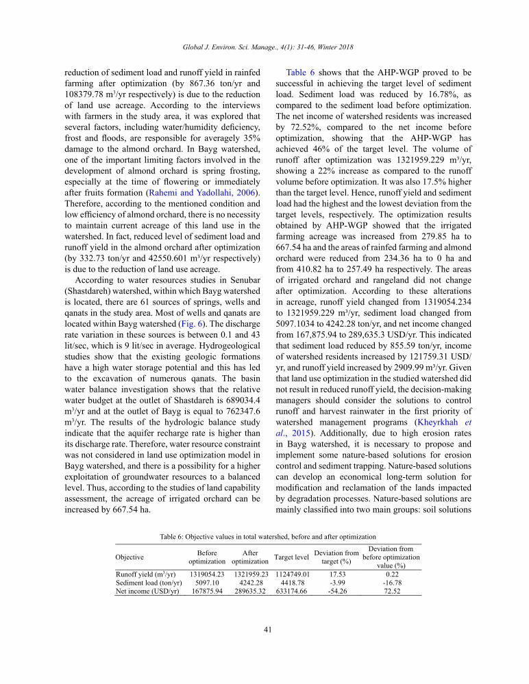
respectively; however, the irrigated farming acreage was increased by 138.53%. After optimization, runoff yield, sediment load and net income of the rainfed farming were reduced by 108379.78 (m3/yr), 867.13 (ton/yr), and 4715.86 (USD/yr) respectively. In almond orchards, runoff yield, sediment load and net income were respectively reduced by 42550.61 (m3/yr), 332.73 (ton/yr), and 10526.32 (USD/yr), as well. This reduction was as a result of the reduced almond orchard acreage. Increased levels of runoff yield, sediment load and net income in the irrigated farming were also equal to 153835.39 (m3/yr), 345.04 (ton/yr), and 137001.56 (USD/yr) respectively, which were due to the increased land use acreage. Total surface runoff and net income of the studied watershed, were increased by 0.22% and 72.52% respectively, while sediment load was reduced by 16.78%, as compared with the load before optimization. In fact, by changing the current land use pattern to an optimized pattern, the net income will be increased in irrigated farming and reduced in rainfed farming and almond orchard (Fig. 7).
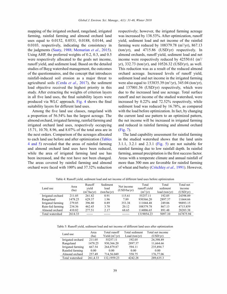
The land capability assessment for rainfed farming in the studied watershed shows that the land units 3.1.1, 3.2.1 and 2.3.1 (Fig. 5) are not suitable for rainfed farming due to low rainfall depth. In rainfed farming, annual precipitation is the first success factor. Areas with a temperate climate and annual rainfall of more than 300 mm are favorable for rainfed farming of wheat and barley (Critchley et al., 1991). However,
Table 4: Runoff yield, sediment load and net income of different land uses before optimization
Total net income
(USD/yr)
Total sediment
load (ton/yr)
Total runoff yield
(m3/yr)
Net income (USD/ha/yr)
Sediment load
(ton/ha/yr)
Runoff yield
(m3/ha/yr)
Area (ha) Land use
24398.89 192.05 55257.11 115.61 0.91 261.82 211.05 Irrigated orchard 11664.66 2897.37 930366.20 7.89 1.96 629.37 1478.25 Rangeland 98893.15 249.06 111044.48 353.38 0.89 396.80 279.85 Irrigated farming 4715.859 867.13 108379.78 20.12 3.70 462.45 234.36 Rain-fed farming 28203.38 891.48 114006.65 68.65 2.17 277.51 410.82 Almond orchard 167875.94 5097.10 1319054.23 ------- ------ ------ 2614.33 Total watershed
Table 4: Runoff yield, sediment load and net income of different land uses before optimization
Table 5: Runoff yield, sediment load and net income of different land uses after optimization
Table 5: Runoff yield, sediment load and net income of different land uses after optimization
Total net income (USD/yr)
Total sediment Load (ton/yr)
Total runoff Yield (m3/yr)
Area (ha) Land use
24,398.89 192.05 55257.11 211.05 Irrigated orchard 11,664.66 2897.37 930,366.20 1478.25 Rangeland 235,894.7 594.11 264,879.87 667.54 Irrigated farming
0.00 0.00 0.00 0.00 Rainfed farming 176,77.06 558.75 714,56.049 257.49 Almond orchard 289,635.3 4242.28 132,1959.23 261,4.33 Total watershed
40
S.M. Tajbakhsh et al.
in Bayg watershed, the land units 3.1.1, 3.2.1 and 2.3.1 are mostly located in the areas with an average rainfall of less than 300 mm (Fig. 2). In addition to the adverse climatic conditions, constraints of low soil depth, high slope, high erosion rate, high amount of stone/pebble fraction in the soil surface, and rock outcrops make other land units unsuitable for permanent rainfed farming (Hobbs and Osmanzai, 2011). In fact, the
Fig. 5: Land units map of Bayg watershed
Fig. 6: Available water resources in the study area
Fig. 5: Land units map of Bayg watershed
Fig. 6: Available water resources in the study area
Fig. 7: (a) Runoff yield, (b) sediment load, and (c) net income, in each land use before and after optimization
Fig. 7: (a) Runoff yield, (b) sediment load, and (c) net income, in each land use before and after optimization
41
Global J. Environ. Sci. Manage., 4(1): 31-46, Winter 2018
reduction of sediment load and runoff yield in rainfed farming after optimization (by 867.36 ton/yr and 108379.78 m3/yr respectively) is due to the reduction of land use acreage. According to the interviews with farmers in the study area, it was explored that several factors, including water/humidity deficiency, frost and floods, are responsible for averagely 35% damage to the almond orchard. In Bayg watershed, one of the important limiting factors involved in the development of almond orchard is spring frosting, especially at the time of flowering or immediately after fruits formation (Rahemi and Yadollahi, 2006). Therefore, according to the mentioned condition and low efficiency of almond orchard, there is no necessity to maintain current acreage of this land use in the watershed. In fact, reduced level of sediment load and runoff yield in the almond orchard after optimization (by 332.73 ton/yr and 42550.601 m³/yr respectively) is due to the reduction of land use acreage.
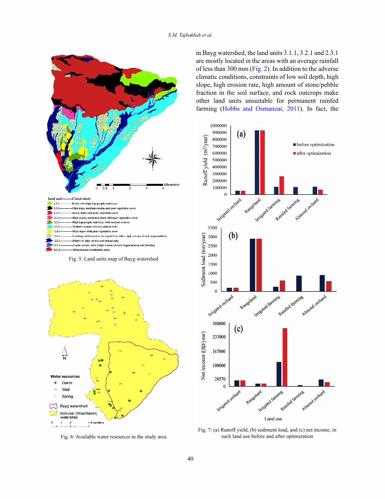
According to water resources studies in Senubar (Shastdareh) watershed, within which Bayg watershed is located, there are 61 sources of springs, wells and qanats in the study area. Most of wells and qanats are located within Bayg watershed (Fig. 6). The discharge rate variation in these sources is between 0.1 and 43 lit/sec, which is 9 lit/sec in average. Hydrogeological studies show that the existing geologic formations have a high water storage potential and this has led to the excavation of numerous qanats. The basin water balance investigation shows that the relative water budget at the outlet of Shastdareh is 689034.4 m3/yr and at the outlet of Bayg is equal to 762347.6 m3/yr. The results of the hydrologic balance study indicate that the aquifer recharge rate is higher than its discharge rate. Therefore, water resource constraint was not considered in land use optimization model in Bayg watershed, and there is a possibility for a higher exploitation of groundwater resources to a balanced level. Thus, according to the studies of land capability assessment, the acreage of irrigated orchard can be increased by 667.54 ha.
Table 6 shows that the AHP-WGP proved to be successful in achieving the target level of sediment load. Sediment load was reduced by 16.78%, as compared to the sediment load before optimization. The net income of watershed residents was increased by 72.52%, compared to the net income before optimization, showing that the AHP-WGP has achieved 46% of the target level. The volume of runoff after optimization was 1321959.229 m³/yr, showing a 22% increase as compared to the runoff volume before optimization. It was also 17.5% higher than the target level. Hence, runoff yield and sediment load had the highest and the lowest deviation from the target levels, respectively. The optimization results obtained by AHP-WGP showed that the irrigated farming acreage was increased from 279.85 ha to 667.54 ha and the areas of rainfed farming and almond orchard were reduced from 234.36 ha to 0 ha and from 410.82 ha to 257.49 ha respectively. The areas of irrigated orchard and rangeland did not change after optimization. According to these alterations in acreage, runoff yield changed from 1319054.234 to 1321959.229 m³/yr, sediment load changed from 5097.1034 to 4242.28 ton/yr, and net income changed from 167,875.94 to 289,635.3 USD/yr. This indicated that sediment load reduced by 855.59 ton/yr, income of watershed residents increased by 121759.31 USD/yr, and runoff yield increased by 2909.99 m³/yr. Given that land use optimization in the studied watershed did not result in reduced runoff yield, the decision-making managers should consider the solutions to control runoff and harvest rainwater in the first priority of watershed management programs (Kheyrkhah et al., 2015). Additionally, due to high erosion rates in Bayg watershed, it is necessary to propose and implement some nature-based solutions for erosion control and sediment trapping. Nature-based solutions can develop an economical long-term solution for modification and reclamation of the lands impacted by degradation processes. Nature-based solutions are mainly classified into two main groups: soil solutions
Table 6: Objective values in total watershed, before and after optimization
Objective Before optimization
After optimization Target level Deviation from
target (%)
Deviation from before optimization
value (%) Runoff yield (m3/yr) 1319054.23 1321959.23 1124749.01 17.53 0.22 Sediment load (ton/yr) 5097.10 4242.28 4418.78 -3.99 -16.78 Net income (USD/yr) 167875.94 289635.32 633174.66 -54.26 72.52
Table 6: Objective values in total watershed, before and after optimization

42
S.M. Tajbakhsh et al.
and landscape solutions. Soil solutions improve the soil vigor and soil functions, while landscape solutions mainly emphasize on the connectivity concept, making the landscape less connected, assisting in less rainfall transform into runoff and hence leading to reduced flood risk and erosion problems (Keesstra et
al., 2018). Runoff yield, sediment load and net income per land use class before and after the optimization in Bayg watershed are shown in Fig. 7.
After determining the optimized areas of different land uses, the spatial pattern was optimized based on the MOLA approach. Fig. 8 shows that the dominant
Fig. 8: Land use map (a) before and (b) after optimization
Fig. 8: Land use map (a) before and (b) after optimization
Fig. 9: The cross map, intersected by the land use maps before and after optimization Fig. 9: The cross map, intersected by the land use maps before and after optimization

43
Global J. Environ. Sci. Manage., 4(1): 31-46, Winter 2018
land use class is the rangeland that covers the northern and southern areas. Optimized allocation of irrigated farming and irrigated orchard is around the thalweg and western parts of the watershed. The optimized areas for almond orchard is sporadically in the center and east of the watershed. In the AHP-WGP model, the first objective was to minimize the sediment load, hence rainfed farming has been removed and become irrigated farming.
Fig. 9 shows that the highest rate of change (8.5%) was related to the change of rangeland (class #2) to irrigated farming (class #3). Then the changes of classes 5 to 2, 5 to 3 and 4 to 3 with the rates of 5.69%, 5.53% and 5.16%, respectively, were the highest rates of transition obtained through the MOLA approach. The land use change of irrigated orchard (class #5) to irrigated farming (class #3) with a rate of 0.027% had the lowest transition rate during the MOLA optimization process. The AHP-WGP has been employed successfully by Memarian et al., (2015) in order to optimize the land use maps of Langat basin, Malaysia under the strategies of water protection and future development process. The strength of this approach in land use optimization has been also confirmed by Barnett et al., (1982), Sharp et al., (1994) and Shaygan et al., (2013). Furthermore, minimization of sediment yield and maximization of net income were the main objectives in multi-objective land use optimization in the works by Sadeghi et al., (2009), and Mohseni Saravi et al., (2003), which were achieved successfully.
CONCLUSIONResults showed that AHP-WGP acted successfully
in achieving the target level of sediment load and net income. Sediment load was reduced by 16.78% compared to the sediment load rate before optimization and highly contributed to achieving the target level. Furthermore, net income was increased by 72.52% compared to the net income rate before optimization and could reach the target level by 46%. After optimization, runoff volume was estimated to be 1321959.23 m³/yr. This volume showed an increase of by 22% and also it was 17.5% higher than the target level as compared to the runoff volume before optimization. Thus, runoff yield and sediment load had the highest and lowest deviations from the target level, respectively. As a result, the model proved to be successful in reaching the goal
of sediment load minimization. By changing the land use pattern to optimum outline, net income in irrigated farming was increased by 137001.56 USD/yr. Net incomes in rainfed farming and almond orchard were respectively reduced by 4715.86 and 10526.32 USD/yr as well. To achieve an optimized land use map, the area covered with rainfed farming and almond orchard was subjected to 100% and 37.32% reduction respectively, while the irrigated farming acreage was increased by 138.53%. In an optimized state, the area ratios of irrigated farming, rainfed farming and almond orchard land uses were 25.53%, 0.00% and 9.85%, respectively. Thus, sediment load was reduced by 16.78% and net income and runoff yield were increased by 72.52% and 0.22%, respectively. The integration of MOLA and WGP had two advantages. First, by utilizing WGP, the optimized acreage of different land uses was determined with regard to the conflicting objective functions and different constraints. Next, the optimized area obtained by AHP-WGP was optimally distributed using the MOLA approach. The results demonstrated the usefulness and efficiency of the proposed integrative model thanks to its flexibility and capability in simultaneously providing both optimum values and location of land resources in semi-arid watersheds.
ACKNOWLEDGMENTSThe authors would like to acknowledge the
Department of Natural Resources and Watershed Management of Khorasan Razavi Province for providing the necessary data.
CONFLICT OF INTERESTThe authors declare that there are no conflicting
conditions with respect to the distribution of this original copy.
ABBREVIATIONS
A1 Alternative_A1 in land use planning of Hulu Langat basin
A2 Alternative_A2 in land use planning of Hulu Langat basin
B1 Alternative_B1 in land use planning of Hulu Langat basin
B2 Alternative_B2 in land use planning of Hulu Langat basin
AHP Analytic hierarchy process

44
Land use optimization in a semi-arid watershed
CR Consistency ratioGIS Geographic information systemGP Goal programmingha Hectare
LMD Linear membership function-monotoni-cally Decreasing
LMI Linear membership function-Mono-tonically Increasing
m3/ha/yr Cubic meter per hectare per yearMCE Multi criteria evaluationMOLA Multi-objective land allocation
MPSIAC Modified Pacific Southwest In-ter-Agency Committee
PSIAC Pacific Southwest Inter-Agency Committee
SDSS Spatial decision support systemSWAT Soil and water assessment toolton/ha/yr Tons per hectare per year
USD/ha/yr United States Dollar per hectare per year
WGP Weighted goal programmingWLC Weighted linear combinationX1 Area of irrigated orchardX2 Area of rangelandX3 Area of irrigated farmingX4 Area of rainfed farmingX5 Area of almond orchard
REFERENCESAlizadeh, M.; Ngah, I.; Shahabi, H.; Alizade, E., (2013).
Evaluating AHP and WLC methods in site selection of waste landfill (Case study: Amol, North of Iran). J. Basic Appl. Sci. Res. 3(5): 83-88 (6 pages).
Aouni, B.; Kettani, O.; Martel, J. M., (1997). Estimation through the imprecise goal programming model. Adv. Multiple Object. Goal Prog., 455: 120-128 (9 pages).
Barnett, D.; Blake, B.; McCarl, B. A., (1982). Goal programming via multidimensional scaling applied to Senegalese subsistence farms. Am. J. Agr. Econ. 64(4): 720-727 (8 pages).
Bowler, I. R., (2010). Promoting sustainable agriculture and rural development. 1st Ed. University of Leicester (25 pages).
Cerdà, A.; Keesstra, S.D.; Rodrigo-Comino, J.; Novara, A.; Pereira, P.; Brevik, E.; Giménez-Morera, A.; Fernández-Raga, M.; Pulido, M.; di Prima, S.; Jordán, A., (2017). Runoff initiation, soil detachment and connectivity are enhanced as a consequence of vineyards plantations. J. Environ. Manage. 202, 268-275 (8 pages).
Cheng, S., (2001). Development of a Fuzzy Multi-criteria Decision Support System for Municipal Solid Waste Management. MSc dissertation, University of Regina. Saskatchewan, Canada (181 pages).
Clark, D., (2003). Urban world/global city, 2nd Ed. Routledge. London and New York (227 pages).
Coyle, G., (2004). The analytic hierarchy process. Upper Saddle River. NJ. USA: Pearson Education Open Access. Material (20 pages).
Critchley, W.; Siegert, K.; Chapman, C.; Finkel, M., (1991). Water harvesting. A manual for the design and construction of water harvesting schemes for plant production. FAO Corporate Document Repository.
Daneshvar, M.R. M.; Bagherzadeh, A., (2012). Evaluation of sediment yield in PSIAC and MPSIAC models by using GIS at Toroq Watershed, Northeast of Iran. Front. Earth Sci., 6(1): 83-94 (12 pages).
De Lara, M.; Doyen, L., (2008). Sustainable management of natural resources: mathematical models and methods, 1st Ed. Springer. Sci. Business Media (236 pages).
Evelyn, O.B., (2009). Utilizing geographic information system to determine optimum forest cover for minimizing runoff in a degraded watershed in Jamaica. Int. Forest Rev., 11(3): 375-393 (18 pages).
FAO, (1977). Soil resources and conservation service. (1977). Soil resources and conservation service Food and Agriculture Organization of the United Nations, No. 32.
Hajehforooshnia, S.; Soffianian, A.; Mahiny, A.S.; Fakheran, S., (2011). Multi objective land allocation (MOLA) for zoning Ghamishloo Wildlife Sanctuary in Iran. J. Nat. Conserv. 19(4): 254-262 (9 pages).
Hobbs, P.R.; Osmanzai, M., (2011). Important rainfed farming systems of South Asia. In Rainfed Farming Systems. Springer Netherlands, 603-641 (39 pages).
Holdren, J.; Ehrlich, P., (1971). Overpopulation and the Potential for Ecocide. Jovanovich, New York (15 pages).
Huang, K.; Liu, X.; Li, X.; Liang, J.; He, S., (2013). An improved artificial immune system for seeking the Pareto front of land-use allocation problem in large areas. Int. J. Geogr. Inf. Sci. 27(5): 922-946 (25 pages).
Johnson, C.W.; Gebhardt, K.A., (1982). Predicting sediment yields from sagebrush rangelands [Pacific Southwest Inter-Agency Committee prediction procedure, southwest Idaho]. Agric. Rev. Manuals. 26:145-156 (12 pages).
Jones, D.; Tamiz, M., (2010). Practical goal programming. 141 Ed. New York: Springer (160 pages).
Keesstra, S.D.; Quinton, J.N.; van der Putten, W.H.; Bardgett, R.D.; Fresco, L.O., (2016). The significance of soils and soil science towards realization of the United Nations Sustainable Development Goals. Soil, 2(2): 111-126 (16 pages).
Keesstra, S.; Nunes, J.; Novara, A.; Finger, D.; Avelar, D.; Kalantari, Z.; Cerdà, A., (2018). The superior effect of nature based solutions in land management for enhancing ecosystem services. Sci. Total Environ. 610, 997-1009 (13 pages).

45
Global J. Environ. Sci. Manage., 4(1): 31-46, Winter 2018
Kheyrkhah, A.; Mohamadi, F.; Memarian, H., (2015) Determination of suitable locations for rainwater harvesting using analytic hierarchy process in GIS framework (Case study: Roodsarab watershed, Khooshab, Khorasan Razavi, Iran). Iran J. Rainwater Catch. Syst., 8 (3): 59-72 (14 pages) (in Persian).
Lélé, S.M. (1991). Sustainable development: A critical review. World Dev., 19(6): 607-621 (15 pages).
Leung, S.C.; Lai, K.K., (2002). Multiple objective decision-making in the mode choice problem: a goal-programming approach. Int. J. Syst. Sci. 33(1): 35-43 (9 pages).
Li, J.; Rahman, M. H.; Thring, R.W., (2010). A fuzzy multi-criteria decision analysis approach for the management of petroleum-contaminated sites. Int. J. Environ. Pollut., 42(1-3): 220-239 (20 pages).
Lu, D.; Weng, Q., (2007). A survey of image classification methods and techniques for improving classification performance. Int. J. Remote Sens. 28(5): 823-870 (48 pages).
McCuen, R.H., (1989). Hydrologic analysis and design. 2nd Ed. Englewood Cliffs, NJ.; Prentice-Hall.
Memarian, H.; Balasundram, S.K.; Abbaspour, K.C.; Talib, J.B.; Sung, C.T.B.; Sood, A.M., (2015). Integration of analytic hierarchy process and weighted goal programming for land use optimization at the watershed scale. Turkish J. Eng. Environ. Sci. 38(2): 139-158 (20 pages).
Memarian, H.; Balasundram, S.K.; Talib, J.B.; Sung, C.T.B.; Sood, A.M.; Abbaspour, K., (2012). Validation of CA-Markov for simulation of land use and cover change in the Langat Basin, Malaysia. J. Geog. Inf. Syst. 4(6): 542-554 (13 pages).
Mohseni Saravi, M.; Farzanegan, M.; Koopaee, M.; Kholghi, M., (2003). The determination of optimal land use pattern in watershed resources using goal programming. Iran J. Nat. Res., 56(1, 2): 3-15 (13 pages) (in Persian).
Mol, G.; Keesstra, S.D., (2012). Soil sciences in a changing world. Curr. Opin. Environ. Sustainable. 4(5), 473-477 (5 pages).
Mwasi, B., (2001). Land use conflicts resolution in a fragile ecosystem using Multi-Criteria Evaluation (MCE) and a GIS-based Decision Support System (DSS). International Conference on Spatial Information for Sustainable Development, Nairobi, Kenya (2–5 October 2001).
Nikkami, D.; Elektorowicz, M.; Mehuys, G.R., (2002). Optimizing the management of soil erosion. Water Qual. Res. J. Canada. 37(3): 577-586 (10 pages)
Njiti, C.F.; Sharpe, D.M., (1994). A goal-programming approach to the management of competition and conflict among land uses in the tropics; the Cameroon example. Ambio. 23(2): 112-119 (8 pages).
Owji, M.R.; Nikkami, D.; Mahdian, M.H.; Mahmudi, Sh., (2012). Minimizing runoff and sedimentation by optimizing land use (Case study: Jajrood watershed). J. Water Soil Conserv. 20(4): 183-199 (17 pages) (in Persian).
Pearsall, H.; Lucas, S.; Lenhardt, J., (2014). The contested nature of vacant land in Philadelphia and approaches for resolving
competing objectives for redevelopment. Cities 40: 163-174 (12 pages).
Rahemi, A.; Yadollahi, A., (2006). Rainfed almond orchards in Iran, ancient and new methods and the value of water harvesting techniques. Acta Horticulturae 726: 449-453 (5 pages).
Riedel, C., (2003). Optimizing land use planning for mountainous regions using LP and GIS towards sustainability. J. Soil. Conserv. 34(1): 121-124 (4 pages).
Saaty, T.L., (1988). What is the analytic hierarchy process? In Mathematical models for decision support. 109-121. Springer, Berlin, Heidelberg (13 pages).
Saaty, T. L. (2008). Decision making with the analytic hierarchy process. Int. J. Serv. sci. 1(1): 83-98 (16 pages).
Sadeghi, S.H.R.; Jalili, K.; Nikkami, D., (2009). Land use optimization in watershed scale. Land Use Policy 26(2): 186-193 (8 pages).
Sharma, S.K.; Lees, B.G., (2004). A comparison of simulated annealing and GIS based MOLA for solving the problem of multi-objective Land use assessment and allocation. In: Proceedings of the 17th International Conference on Multiple Criteria Decision Analysis, Whistler, Canada, Open-File Report Ap58 (10 pages).
Shaygan, M.; Alimohammadi, A.; Mansourian, A., (2013). Multi-objective optimization approach for land use allocation using goal attainment algorithm and MOLA. Iran J. Remote Sens. GIS, 5(1): 1-12 (13 pages) (in Persian).
Singh, A.K.; Singh, J.P., (1999). Production and benefit maximization through optimal crop planning-a case study of Mahi Command. India J. Soil Conserv. 27(2): 152-157 (6 pages).
Sys, I.C.; Van Ranst, E.; Debaveye, I.J.; Beenaert, F., (1993). Land evaluation (Part I-III). Crop Requirements. General Administration for Development Cooperation, Brussels. Belgium (191 pages).
Tajbakhsh, M.; Memarian, H.; Shahrokhi, Y., (2016). Analyzing and modeling urban sprawl and land use changes in a developing city using a CA-Markovian approach. Global J. Environ. Sci. Manage. 2(4): 397-410 (14 pages).
Te Chow, V.; Maidment, D.R.; Mays, L.W., (1988). Applied hydrology. Tata McGraw-Hill Education (294 pages).
Tra, N.T.; Egashira, K., (2004). Land use effectiveness by farm households after land and forest allocation at Tran Yen district, Yen Bai province. J. Faculty Agric., Kyushu University. 49(2): 461-466 (6 pages).
Tripathi, R.P.; Singh, H.P., (1993). Soil erosion and conservation. 2nd Ed. New Age International Limited. (P)Ltd. New Delhi.
Yeo, I.Y.; Gordon, S.I.; Guldmann, J.M., (2004). Optimizing patterns of land use to reduce peak runoff flow and nonpoint source pollution with an integrated hydrological and land-use model. Earth Interact. 8(6): 1-20 (20 pages).
Zadeh, L.A., (1965). Fuzzy Sets. Inf. Control 8(3): 338-353 (16 pages).

46
S.M. Tajbakhsh et al.
AUTHOR (S) BIOSKETCHESTajbakhsh, S.M., Ph.D., Assistant Professor, Department of Watershed Management, Faculty of Natural Resources and Environment, University of Birjand, Birjand, Iran. Email: [email protected]
Memarian, H., Ph.D., Assistant Professor, Department of Watershed Management, Faculty of Natural Resources and Environment, University of Birjand, Birjand, Iran. Email: [email protected]
Kheyrkhah, A., M.Sc., Department of Watershed Management, Faculty of Natural Resources and Environment, University of Birjand, Birjand, Iran. Email: [email protected]
COPYRIGHTSCopyright for this article is retained by the author(s), with publication rights granted to the GJESM Journal.This is an open-access article distributed under the terms and conditions of the Creative Commons AttributionLicense (http://creativecommons.org/licenses/by/4.0/).
HOW TO CITE THIS ARTICLETajbakhsh, S.M.; Memarian, H.; Kheyrkhah, A., (2018). A GIS-based integrative approach for land use optimization in a semi-arid watershed. Global. J. Environ. Sci. Manage., 4(1): 31-46.
DOI: 10.22034/gjesm.2018.04.01.004
url: http://gjesm.net/article_28202.html