a geophysical transect of the adélie margin, east antarctica
TRANSCRIPT
A geophysical transect of the Ad lie Margin, East Antarctica
Jacques Wannesson Inst i tut Fran~}ais du P6trole, BP 311, 9 2 5 0 6 RueiI-Malmaison Cedex, France Monique Pelras and Bernard Petitperrin Soci6t~ Nationale Elf-Aquitaine (Production) - T o u r G~n~rale, La D6fense 9, Cedex 22, 9 2 0 8 8 Paris La D6fense, France Martine Perret Compagnie Fran~aise des P~troles - Tour Mirabeau, 39-43 quai A. Citroen, 7 5 7 3 9 Paris Cedex 05, France Jacques Segoufin Inst i tut de Physique du G l o b e - Universit6 P. et M. Curie, 4 place Jussieu 7 5 2 3 0 Paris Cedex 05, France Received 23 December 1984
In 1982, a geophysical survey of the Antarctic margin, including multichannel seismic, gravity, magnetic and bathymetric surveying, was carried out off Ad~lie Coast-Wilkes Land and in the eastern Ross Sea. Of the 5000 km of lines recorded, 3000 km were in the Ad61ie Coast area. Lines ATC 101-102, approximately following meridian 1380E, show the first complete transect of the Ad~lie Coast margin from the Southeast Indian abyssal plain at DSDP Site 269 to the continental shelf. These lines reveal a thick sedimentary series divided into three main acoustic units by two major unconformities considered to be Upper Eocene (42 Ma) and late Oligocene (25 Ma). Oceanic or continental basement can be traced under the whole area, and the ocean-continent boun- dary clearly lies beneath the lower continental slope. A deep, high-amplitude, low- frequency horizon, extending under the oceanic basement for over 300 km of line, is considered to be the Moho. Our interpretation supports a recent revision be Cande and Mutter proposing an early Upper Cretaceous opening between Australia and East Antarctica.
Keywords: Antarctic margin; Magnetic anomolies; Breakup; Acoustic sequences
Introduction
In January and February 1982, a reconnaissance geophysical survey was carried out on the East Antarctic margin offAd~lie Coast/Wilkes Land, and in the eastern Ross Sea. 5000 km of multichannel seismic lines were recorded with a 2000 in 3 airgun array source and a 2400 m, 48-trace streamer from S/V Explora (Prakla-Seismos). Gravity, magnetic and bathymetric profiles were also recorded.
The 3000 km programme conducted on the Ad~lie Coast/Wilkes Land margin consisted of 18 lines extending from 136 ° to 154°E from the abyssal plain to the continental shelf. In the western part of the survey area, lines ATC 101 and 102 extend over 500 km from DSDP site 269 in the 4200 m deep Wilkes Abyssal Plain to the antarctic continental shelf west of the Dumont d'Urville polar station, showing the first complete multichannel (MCS) transect of the margin ever recorded.
Regional setting
The margins of the southeast Indian Ocean between Australia and Antarctica have been described by Hayes (1972), Talwani et al. (1979), Weissel and Hayes
(1972), K6nig (1980), and Falvey and Mutter (1981) who identified symmetric magnetic anomaly sequences as far back as anomaly 22 (early Eocene) on each side of the east-west trending southeast Indian Ridge, boun- ded by magnetic quiet zones in the direction of the continents.
Based on these data and on the structure of the south Australian margin (Talwani et al., 1979; Griffiths, 1971; Boeuf and Doust, 1975; Deighton et al., 1976), it was supposed that the Antarctic margin of Wilkes Land/ Ad61ie Coast was a passive margin resulting from the breakup of Australia and Antarctica in early Eocene times. This assumption is in accordance with the reconstructions ofWeissel eta l . (1977) for the Antarctic, Pacific and Australian plates, in which the opening of the Tasman Sea stopped at about the time of anomaly 24, before the opening of the southeast Indian Ocean between Australia and Antarctica. This evolution resulted in a major change in the shear motion of the Macquarie Ridge and the creation of the Pacific- Antarctic Ridge.
More recently, Cande and Mutter (1982) revised the magnetic anomaly identification between Australia and Antarctica, with anomaly 22 becoming anomaly 34 and the quiet zone corresponding to the long normal-
0264-8172/85/030192-09 $03.00 ©1985 Butterworth E~ Co. (Publishers) Ltd
192 Marine and Petroleum Geology, 1985, Vol 2, August

Geophysical transect o f Addl ie Margin: J. Wannesson et al.
N SW NE
® i
ATC 101 ATC 102
~= 0 2
6
8
10
ANOMALY t9 S h o t _ P o i n t ~ D S Q P
2500 2000 1000 Ze9
.2
ANOMALY 34 ANOMALY 30-31 5500 ~ 5000 4000 F~
4~
6- 8_-
lO_-
2200 0 21
4~
6~
8;
10~
3000
0
2
4
8
10
Fig, 3
I I
- ~ O S _
~ - ~ - - ~ ~ - . . . . .--MO-- ~ - ~
MAGNETIC QUIET ZONE
2000 ~000 ¢ 6297 6000 5500 I I i i l I
Fig.4
~ ~ _ _ ~ . . . . : - __ - - _ ~ _ _ ~ - ~ ' _
. . . . . . . . . . _ . . . . . . o , . . . . . . . . . . . . F- /
2500 0
;z
4 ~6
;8
110
®
4
8
10
486O 6866 Fig. 6 6000 5000
0 , ' [ ' ' - - '
3735 5000 2200
J i i 0
Fig. 5
- 6
8
ll!ll il!lilllllllhll'lil ~llll C.O.B
40* 150 o L ~ 6 0 o
6 ~ 6 0 0 ' AI)ELIE COAST
WILKES LAND
,65"
I I I I
o n e n l a r g e d sections
180"
O •
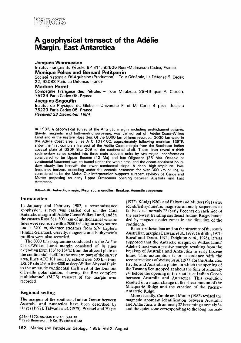
Figure 1 Interpretation of seismic profiles ATC 101/ATC 102, with overall view on top and enlargments of successive parts below. Circled numbers refer to abyssal plain (1), anomalous oceanic zone (2), continental rise (3), continental slope (4) and continental shelf (5). Acoustic unit numbers refer to pre-upper Eocene (1), Upper Eocene to late Oligocene (2) and post-late Oligocene series (3). OB, oceanic basement; CB, continental basement; Mo, Moho; COB, continent-ocean boundary. Magnetic anomalies interpretation is from this paper
Mar ine and Pet ro leum Geology, 1 9 8 5 , Vol 2, Augus t 1 9 3

Geophysical transect of Ad~lie Margin: J. Wannesson et al.
polarity period of the Upper Cretaceous. In this interpretation, the breakup between Australia and Antarctica occurred during the Cenomanian (95 Ma), and the southeast Indian Ocean was nearly 800 km wide in the late Eocene. This new identification is valid for the oceanic area extending west to the Kerguelen plateau (Mutter and Cande, 1983). To the east, however, this revision implies a simultaneous opening of the Tasman Sea and the southeast Indian Ocean lasting for over 30 million years between the times of anomaly 34 and anomaly 24 (Hayes and Ringis, 1973).
T r a n s e c t o f the A d t l i e Coas t M a r g i n
Lines ATC 101 and 102 of the 1982 Antarctic survey show a normal morphological sequence: abyssal plain, continental rise, slope and shelf approximately follow- ing the 138°E meridian, with the exception of an anomalous oceanic feature between the abyssal plain and the continental rise (Figure 1).
Abyssal plain The abyssal plain (ATC 101 SP 1-2500,Figures 1 and2) is characterized by a uniform sedimentary series, 1000 to 1500 m thicL resting on an oceanic basement that occasionally pierces the sea-floor in the form of abyssal hills. The thickness of the sedimentary cover was computed by velocity analyses of the MCS. On the basis of its acoustic facies, this series may be divided into three main units: (1) a lower chaotic unit of variable thickness, suggesting coarse sediments inter- bedded with volcanic rocks; (2) a more acoustically- transparent intermediate unit, probably consisting of pelagic sediments; and (3) an upper laminated unit, approximately two-thirds of the total thickness, suggesting fine-grained turbidites.
A limited stratigraphic check was obtained from DSDP site 269, located near SP 805 (Figure2). This well was drilled through 958 m of distal turbidites of Neogene age (corresponding to acoustic unit 3) down to a series tentatively defined as Upper Oligocene to Lower Miocene. Acoustic units 2 and 1, corresponding to layers that were not reached during drilling have a total thickness of about 550 m at DSDP site 269. Their age is assumed to be pre-Neogene, and possibly as old as Middle Eocene at the bottom of unit 1, where an oceanic-like basement is identified on the seismic line 1500 m below the sea-floor. This interpretation is in accordance with the new magnetic anomalies iden- tified by Cande and Mutter, in which anomalies 27-31 (Palaeocene 59-65 Ma, Patriat, 1983) are placed some 50 km south of DSDP site 269.
A deep, low-frequency, high-amplitude seismic horizon, gently dipping southwards, can be traced under most of this area at the depth of about 11 to 15 km below the sea surface. The depth of this horizon was calculated from standard average velocities of 5.8 and 6.8 kin-is for layer 2 and layer 3, respectively, rather than from MCS velocity values which are insufficient at such great depths. This deep horizon is tentatively considered as the Moho, although other authors such as Musgrove and Austin (1983), believe similar features may lie within layer 3. If we consider it to be the Moho, then the thickness of the oceanic crust is 5-9 km, which is acceptable (Le Douaran et al., 1984).
Anomalous oceanic zone This zone (Figures I and 3) extends over 150 km from SP 2500 to 5500, line ATC 101. It has a topographic expression of 300 to 400 m, clearly visible on the bathymetric map (Vanney and Johnson, 1979). It is characterized by the extreme thinning of laminated acoustic unit 3 and probably of unit 2 by onlap with angular unconformity and probable significant hiatus on a strong local development of unit 1 seismic facies, which displays a series of sub-parallel, low-continuity, apparently faulted reflectors over a thickness of 3000 to 4000 m. Similar facies in other areas have been inter- preted as volcano-clastic sediments (Ravenne et al., 1977). On the single-channel monitor record of line ATC 101, as on all previously-available single-channel lines, this vertical development of unit 1 acoustic facies can hardly be distinguished from a basement high. The oceanic character of this area is underlined by the presence of magnetic anomalies (anomalies 32-33 of Cande and Mutter lie approximately at SP 3500, line ATC 101) and by the lack of any significant change in the depth of the Moho compared to surrounding oceanic areas.
The continental rise The rise (ATC 101 SP 5500 to ATC 102 SP 2200,Figures 1 and 4) is underlain by oceanic basement of the magnetic quiet zone, with its typical acoustic facies and a sizeable relief of about 1 s two way time (TWT), generally related to a period of slow spreading (Tapponnier and Francheteau, 1978). Toward the continent, the sedimentary series increases in thickness from 2.5 to 4 s TWT. As in the abyssal plain, this series has been divided into three acoustic units separated by two major unconformities, which we cannot date directly due to the lack of drilling data on the margin. However, based on the geologic history of Antarctica as well as that of Australia and the Indian Ocean, we consider the lower unconformity to be Upper Eocene (42 Ma = Anomaly 18) because of two possible events. (a) A speed-up of sea-floor spreading of the southeast Indian Ridge at about the time of anomaly 18 (Patriat, 1983), resulting in a change in the margin's subsidence rate. This event is probably related to the first collision of India against Asia and to the major plate readjust- ment this induced. (b) The opening of the Tasman Seaway, probably in the Eocene, when the Tasman plateau cleared Antarctica, allowing deep oceanic circulations to develop between the Pacific and the Indian Oceans.
If caused by the regression that followed the build- up of the Antarctic ice sheet, the upper unconformity would be late Oligocene, about 25 Ma old (Hayes and Frakes, 1975).
Thickening of the sedimentary series southwards is essentially due to seismic units 1 and 2. Basal pre- Upper Eocene unit 1 corresponds to the progressive burial of the oceanic basement by coarse sediments with possible volcanic layers. Another transect of this margin (ATC 103) also reveals a seaward dipping configuration within unit 1. The intermediate sequence between the Upper Eocene and late Oligocene uncon- formities has sub-parallel, low-amplitude reflectors suggesting fine-grained pelagic sediments. The upper sequence is more laminated and consists mainly of
194 Marine and Petroleum Geology, 1985, Vol 2, August

900 850 I I I I I I I I
3
800 750 700 I i ~ i 1 I I I 1 I I
DSDP 269
2 I
f { l l l l l l l l l l l ~ l l l l l l ( ~ l . . . . . . . . . I I ~ , , . ~ . . , . . , , , I d l l l l b l
" " . . . . . . . . I ' I , . . . . . . . . . . . . . . . . . . . . . . . . I . . . . . . . . . . . . . . . . . . . . . . . . I I " I " F
- ; ; T - - - - - : :- - I . . . . . . . . . . . . . . . . ~,111,111, I . . I I I I l l l I I $1 IP I l I I I " I ~ "
i i II I il iiiiiii
rP , , . . . . . . . . . . . . . . . . . . . . . . . .
From velocity onolysis of MC5
( - 4 2 8 5 m )
~ . ~ w . . . . . " " " ' " " JATI:" u l ~ - - 4 " u " " ' " ~ " " : ::~;I;Z;!!!I'!!ZI::::z:~:=:~L'::ITIJ!!N u" 6 . . . . . . . . . . . . . . . . . . . . . . . . ~ I - - '1 I - - , I I I V - 9 "~ ' ~ - - ' [ I . _ . . . . . . ~ v
..... :::::::::::::::::: ................. , , EARLY TO .... , l===r ......... : ~ ° = : ; ......................... I . . . . . . . . . . . . . . . . . . . . . . . . . . . . . . . . . . . . . . . . . . . . . . L A T E M I O ? 4 5 0
' L-' .......... .......... II~ . . . . . ~ ~ ~ n K m l l = ~ ~ : ~ . " ' ' : :
Geophysical transect of Addlie Margin: J Wannesson et a l
OB
MO
ATC 101 Figure 2 Interpretation of seismic line ATC 101 and correlation with DSDP hole 2 6 9 . Same legend as on Figure I
I
M a r i n e a n d P e t r o l e u m G e o l o g y , 1 9 8 5 , V o l 2 , A u g u s t 1 9 5

Geophysical transect of Ad#lie Margin: J. Wannesson et al.
SkX/ 3400 &300
_ I I
32OO 3100 I I
NE
S w w_
Figure 3 Detailed interpretation of seismic line ATe 101, SP 3000-3500. Same legend as on Figure I
turbidites. It is divided into several sub-units by uncon- formities, with the upper one marking a sharp increase in sedimentation rates. This upper unconformity is believed to be Lower Pliocene, (about 4 Ma old), and to result from a significant growth of the Antarctic ice sheet (KennetL 1978).
The continental slope The slope (ATC 102, SP 2200-5000,Figures I and5), has a steep upper part (6 °) corresponding to the frontset of oblique progradations of the shelf. The lower part has a very irregular morphology with many indications of erosion, channelling and possible contour currents. Erosion may bring the late Oligocene unconformity close to the sea-floor, and the total sedimentary thick- ness in this area may be locally as small as 2.5 s TWT.
At about SP 3000, the underlying basement marks an abrupt change from its diffractant and hilly oceanic character to sub-parallel horizons, interpreted as faulted continental blocks of the east Antarctic shield and its Palaeozoic and Mesozoic sedimentary cover, including syn-rift sediments. We believe this change marks the boundary between continental and oceanic crusts. A low-relief volcanic high between SP 2500 and 3000 near the continent-ocean boundary is interpreted here, as on other passive margins (Masson et al., in
ATC 101 press), as the result of high volcanic activity at the moment of continental breakup.
The continental shelf qqae shelf(Figures I and 6), is 120 km wide along this transect from shelf-edge to coast, which is 35 km south of the end of the seismic line. It is characterized by water depths ranging from 450 to 700 m, with the shallowest part being near the shelf edge. This configuration and the abnormal depths are specific to the Antarctic continent environment and are pre- sumably due to loading of the Antarctic ice sheet and glacial erosion. A thick sedimentary series is present, especially under the outer shelf, where it may exceed 4 s TWT (6000 to 7000 m). The continental basement, traced on the processed seismic sections and confirmed by refraction data with velocities higher than 4--4.5 km s -1, plunges northwards. The seismic configuration of horizons within the basement suggests the presence of numerous normal faults, especially from the present shelf edge to the continent-ocean boundary.
The sedimentary series thins southwards by conjunction of two phenomena: (a) erosion of the upper sequences, probably down to the Lower Miocene, and (b) progressive onlap of the pre-upper Eocene sequence on the continental basement. Base-
196 Marine and Petroleum Geology, 1985, Vol 2, August

SV,/ 62130 6100
4 - I I
Geophysical transect of Ad~lie Margin: J. Wannesson et al.
NE 6000 5900 58133 57133
I I I I
SI
/-k I (.. qU1 Figure 4 Detailed interpretation of seismic line ATC 101, SP 5700-6200. Same legend as on Figure 1
ment outcrops have been found along the Ad~lie Coast, south of the end of line ATC 102. Plio-Pleistocene sediments form a thick oblique prograding sequence indicating high sedimentary influx at low sea-level stages (Vail et al., 1977).
Interpretation of magnetic profiles Seismic data have shown that lines ATC 101/102 extend for nearly 400 km over an oceanic crust. An attempt can thus be made to date this crust through the identification of associated magnetic anomalies. Using additional magnetic profiles to date the crust is of particular interest in this area where previous inter- pretations have given an initial drift age ranging from 50 Ma (anomaly 22) to 95 Ma (older than anomaly 34). A reliable identification of magnetic anomalies can be carded out only on a long transect characterized by numerous anomalies. This is not the case for line ATC 101/102, which is relatively short and extends mainly over the magnetic quiet zone defined by Weissel and Hayes (Figure 7). Our interpretation has therefore been based on two older magnetic profiles (TAA 01 and 02) recorded in 1965 from Hobart to Dumont D'Urville by the French-chartered polar ship Thala-Dan. In 1967 these lines were difficult to interpret (Schlich and Patriat, 1967), due to the fact that trends and locations of major fracture zones in the southeast Indian Ocean were not known until the synthesis of the Eltanin data by Weissel and Hayes in 1972.
Magnetic lines TAA 01 and 02 were projected along the suspected direction of spreading in this area (360 ° ) and compared to a model using the same uniform 2 cm yr -l spreading rate as used by Weissel and Hayes in 1972 (Figure 8a). With this model, a good correlation appears for anomaly sequence 3 to 15-18, especially on line TAA 02. The more easterly line TAA 01 probably cuts across several fracture zones and is more difficult to interpret. Identification of anomalies 19 to 23-24 is still possible on line TAA 02, although not so easy. From anomaly 23-24 onward, no correlation exists bet- ween the many magnetic reversals of the model and the quiet zone observed on both lines TAA 01 and 02. A second model was computed with a 0.45 cm yr -l spreading rate, as proposed by Cande and Mutter in 1982 (Figure 8b). With this model, a good correlation appears on lines TAA 01 and 02 for anomalies older than anomaly 19, back to anomaly 34 (83 Ma) and the earlier quiet zone. No correlation is possible for the anomaly sequence younger than anomaly 19. From these two models, we believe that an important change in spreading rates occurred at about the time of anomaly 19. If we compare lines ATC 101/102 projec- ted along the same 360 ° direction (Figure 9) with the second model and line TAA 02, we observe a good correlation from anomaly 19 to anomaly 34 and the quiet zone. The presence of anomaly 34 (83 Ma) on the Antarctic margin of Ad~lie Coast which we propose here bears out the hypothesis of an Upper Cretaceous
Marine and Petroleum Geology, 1985, Vol 2, August 197

Geophysical transect of Ad#lie Margin: J. Wannesson et al.
S 3200 3100 3000
I I I
2-
2900 I
28OO I
N 2700
I
s e
Figure 5 Detailed interpretation of seismic line ATC 102, SP 2700-3250. Same legend as on Figure 1 ATC 102
SE 6400 6300 6200 6100
O I I I I 6000
I
NW
Figure 6 Detailed interpretation of seismic line ATC 102, SP 5950-6400. Same legend as on Figure 1
198 Marine and Petroleum Geology, 1985, Vol 2, August
ATC 102

Geophysical transect of Ad~lie Margin: J. Wannesson et al.
3 4
7 _4._4 _
604
i ' ~ ' / ~ / Limil of Magnetic ~ 1 [ / / / & Ouiet Zone
Figure 7 Location of magnetic profiles discussed in this paper: ATC 101/ATC 102 (Explora, 1982); TAA01/TAA02 (Thala Dan, 1965). Magnetic lineations, fracture zones and limit of magnetic quiet zone are from Weissel and Hayes (1972)
S
®
2cm/yr w
initiation of drifting between Australia and Antarctica. If we assume that separation occurred at about the time of anomaly 22, it is difficult to explain the presence of a magnetic quiet zone between this anomaly and the ocean-continent boundary, some 150 km to the south. If, on the contrary, we assume a separation initiated before the time of anomaly 34, then the quiet zone observed corresponds to the normal polarity period which extends from 83 to 1 l0 Ma, approximately. The quiet zone on line ATC 101/102 ends with a magnetic trough of 200 nT associated with a free-air anomaly of 50 mgal (Figure 10), which clearly indicates the continent-ocean boundary (Talwani and Eldholm) 1972) already proposed in the seismic interpretation. On the other hand. the rough topography of the oceanic basement on line ATC 101/102 may be related to a slow spreading rate (Tapponnier and Francheteau, 1978) which favours our two-velocity magnetic model including anomaly 34 and the Upper Cretaceous quiet zone. Faster spreading rates along the western part of the southeast Indian Ridge for the pre-anomaly 19 period (Patriat, 1983) are not inconsistent with slow spreading rates between Australia and Antarctica. Liu et al. (1983) have shown the presence of an extinct ridge in the Wharton basin which was active until the time of anomaly 19-20 when fast spreading shifted to the Australia-Antarctica sector.
TAA 02 . . . . . . -q:' % ,,~ ', '' ,', ,
IF'I" /'~/ / '1 / !,
/, d , ; ~,~," ',v ~ 'x/
Conclusion This transect of the east Antarctic margin facing southeast Australia is typical of a relatively old passive
F.Z. N
r,' IVi !
~ ...... ~"1 ' I~' ,i I n i
/ i L ~ : ! \, i/'11 i ~
" :~ ~/I !1 ~ J
13 12 11~ 9 8
34 35 32
L ]~ ] UllO 2 0 0 []10 ]~ ,[I K] []]IJ]KIIOT]I1 0[ 3 ~I ~ :[ -I~i 18 !IL]0iI[I~EEIi/
31 30 292B27 26 25 24 23 2_2 21 20 19 17 t6 t413 12 11 t0 9 8 7 6a 6
® TAA 02
MODEL 0.45cm/yr
[ J ', i
33 32 51/30 ~9 V 34
, " !,~,' J J,:! , , , !,;r~'~;l"~ '~ ' i ' ' 5~ '
s2 24 19 3O 2O
N /Q,
r'd' I i '
V RIDGE AXIS
Figure 8 Magnetic models used for interpretation of magnetic profiles off Ad~lie Coast. Model parameters: top of layer, 2.5 to 6.5 km from ridge axis to anomaly 24 ('normal' Parson and Sclater law, Parson and Sclater, 1977), 6.5 km from anomaly 25 to anomaly 34; latitude of formation, -55°; longitude of formation, 240°; direction of spreading, 1800; coefficient of contamination, 0.6 (Tisseau and Patriat, 1981); spreading rates, 2 (a) and 0.45 cm yr -1 (b)
Marine and Petroleum Geology, 1 985, Vol 2, August 199

Geophysical t ransect o f Ad~/ie Margin: J. Wannesson et el.
RIDGE ? AXIS
TAAO~
ATC 101 + ATC 102
TAA 02
MODEL
FZ 20 30 I A
f I f I I r I I
, I I ' '
/ 6
Figure 9 Interpretation of magnetic profiles off Ad~lie Coast from a two-spreading rates model of 2 cm yr -1 back to anomaly 19 and 0.45 cm yr -1 from anomaly 19 to anomaly 34
S N
Free Air 50 m got 1 ~ - ~ ~ ~ - ~ - Anomaly
~ ~ Residual 200 nT ] ~ ~'-/~--~\ Magnetic
An0m01y
5krn
t00 km ~ B thy , , o merry Figure 10 Composite profile ATC 101/102 with free air anomaly, residual magnetic anomaly and bathymetry
margin. It reveals, especially under the outer shelf, a thick sedimentary series made of three main units which recorded the major structural and climatic phases of evolution of the southeast Indian Ocean. In our opinion, the presence of an oceanic basement for some 150 km south of anomaly 34, in addition to com- parisons with published stratigraphic data of the south Australian margin, support the theory that the breakup between Australia and Antarctica occurred in Early Upper Cretaceous times (100-95 Ma), and not in Eocene times (51-53 Ma) as considered by previous authors. This conclusion is in accordance with recent revisions of magnetic anomaly identification in this area by Cande and Mutter (1982), and with the more recent interpretation of the evolution of the southeast Indian Ocean. On the other hand, it calls for some revision of previous concepts of the relationships between the Tasman Sea and the southeast Indian Ocean during the Upper Cretaceous, at which time a simultaneous opening probably occurred in these two oceanic areas.
References Boeuf, M.G. and Doust, H. (1975) Structure and development of
the southern margin of Australia, APEA J. 15, 33-43 Cande, S.C. and Mutter, J.C. (1982) A revised identification of
the oldest sea-floor spreading anomalies between Australia and Antarctica, Earth Planet. ScL Lett 58, 151-160
Deighton, J., Falvey, D.#~ and Taylor, D.J. (1976) Depositional environments and geotectonic framework: southern Australia continental margin, APEA J. 16, 25-36
Falvey, D.A. and Mutter, J.C. (1981) Regional plate tectonics and the evolution of Australia's passive continental margins, BMR J. Austr. Geol. Geophys. 6, 1-29
Griffiths, J.R. (1971) Continental margin tectonics and evolution of southeast Australia, APEA J. 11, 75-79
Hayes, D.E. (1972) Introduction: Marine geophysics of the southeast Indian Ocean, in: Antarctic Oceanology I1: The Australian-New Zealand sector, (Ed Hayes, D.E.) Am. Geophys. Union, Antarctic Research series vol 19, pp. 119-124 119-124
Hayes, D.E. and Ringis, J. (1973) Seafloor spreading in the Tasman Sea, Nature 243, 454-458
Hayes, D.E. and Frakes, L.A. (1975) General synthesis, deep sea drilling project leg 28, in: Initial reports of the Deep Sea Drilling Projec¢ vol 28, pp. 919-942
Kennett, J.P. (1978) The development of planctonic biogeography in the Southern Ocean during the Cenozoic, Marine Micropaleontol. 3, 301-345
KSnig, M. (1980) Geophysical investigations of the southern continental margin of Australia and the conjugate sector of east Antarctica, Ph. D. Thesis Columbia University, 337 p.
Le Douaran, S., Burrus, J. and Avedik, F. (1984) Deep structure of the northwestern mediterranean basin: results of a two- ship seismic survey, Marine Geology 55, 325-345
Liu, C.S., Curray, J.R. and McDonald, J.M. (1983) New constraints on the tectonic evolution of the eastern Indian Ocean, Earth Planet ScL Lett. 65, 331-342
Masson, D.G., Montadert, L., Scrutton, R.A. and Gruvel, J.P. (in press) Evolution of the Goban spur: history of a starved passive margin, in: Initial reports of the Deep Sea Drilling project (Eds de Graciansky, P.C., Poag, W. et el.,) vol. 80
2 0 0 Ma r i ne and Pe t ro leum Geology, 1 9 8 5 , Vo l 2, A u g u s t