a g e n d a - oklahoma county, ok g e n d a oklahoma county planning commission room 204 1:30 p.m....
TRANSCRIPT
A G E N D A
OKLAHOMA COUNTY PLANNING COMMISSION
ROOM 204 1:30 p.m.
September 15, 2016
1. Notice of meeting posted September 9, 2016. 2. Call to Order. 3. Roll Call. 4. Approval of Minutes of the Previous Meeting: (August 18, 2016) 5. Discussion and possible action to approve/deny a zoning change from AA-
Agricultural and Rural Residential District to CR-Rural Commercial District (Z-2016-02). (Received written request from applicant to withdraw)
Application of: GREEN SHOE FOUNDATION
C/O RANDEL SHADID
The applicant proposes developing a tract of land using an existing structure for professional and administrative offices (Green Shoe Foundation) on a five (5) acre parcel. The following is the legal description of the property to be considered:
A tract of land being a part of the South-Half of the Southwest Quarter (S/2, SW/4) of Section Twenty-two (22), Township Fourteen (14) North, Range One (1) West of the Indian Meridian, Oklahoma County, Oklahoma, being more particularly described as follows: Commencing at the Northwest Corner of the South-Half of the Southwest Quarter (S/2, SW/4), at a set mag nail and shiner; Thence S89°54’24”E along the North line of the South-Half of the Southwest Quarter (S/2, SW/4), a distance of 1475.00 feet, more or less, to a point, said point is the Point of Beginning; Thence S11°41’29”E, a distance of 453.75 feet, more or less, to a point; Thence S78°18’31”W, a distance of 480.00 feet, more or less, to a point; Thence N11°41’29”W a distance of 453.75 feet, more or less, to a point; N78°18’31”E, a distance of 480.00 feet, more or less, to the Point of Beginning. Said tract contains 5.00 acres, more or less.
Location: NE 192nd & Hiwassee Rd. (County Highway District #3)
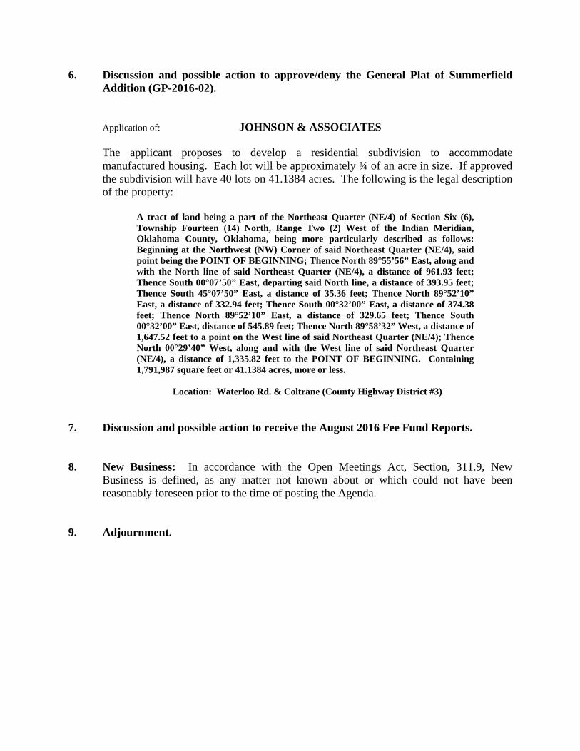
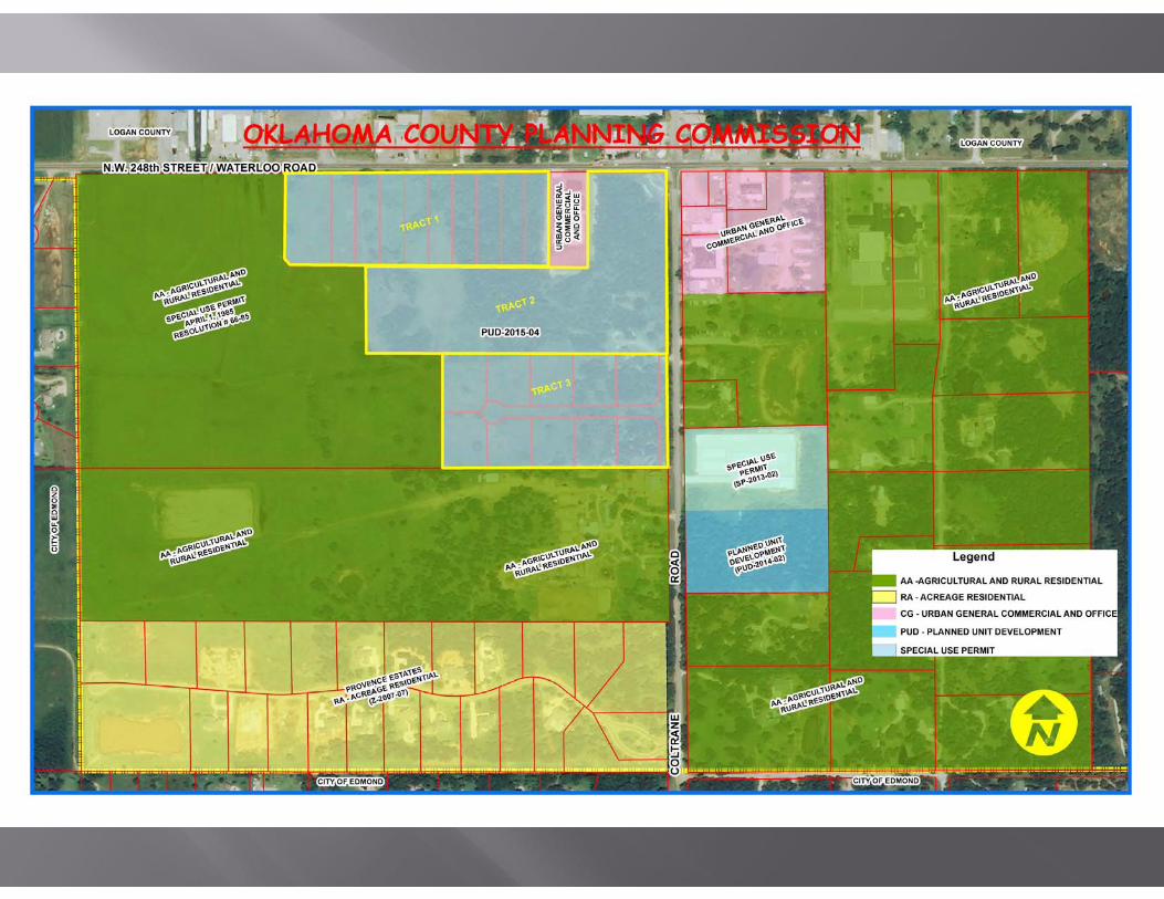
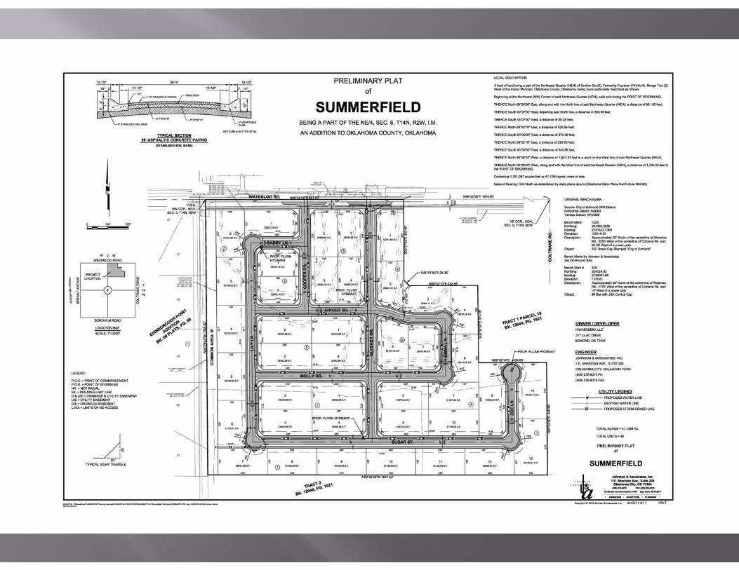
6. Discussion and possible action to approve/deny the General Plat of Summerfield Addition (GP-2016-02).
Application of: JOHNSON & ASSOCIATES
The applicant proposes to develop a residential subdivision to accommodate manufactured housing. Each lot will be approximately ¾ of an acre in size. If approved the subdivision will have 40 lots on 41.1384 acres. The following is the legal description of the property:
A tract of land being a part of the Northeast Quarter (NE/4) of Section Six (6), Township Fourteen (14) North, Range Two (2) West of the Indian Meridian, Oklahoma County, Oklahoma, being more particularly described as follows: Beginning at the Northwest (NW) Corner of said Northeast Quarter (NE/4), said point being the POINT OF BEGINNING; Thence North 89°55’56” East, along and with the North line of said Northeast Quarter (NE/4), a distance of 961.93 feet; Thence South 00°07’50” East, departing said North line, a distance of 393.95 feet; Thence South 45°07’50” East, a distance of 35.36 feet; Thence North 89°52’10” East, a distance of 332.94 feet; Thence South 00°32’00” East, a distance of 374.38 feet; Thence North 89°52’10” East, a distance of 329.65 feet; Thence South 00°32’00” East, distance of 545.89 feet; Thence North 89°58’32” West, a distance of 1,647.52 feet to a point on the West line of said Northeast Quarter (NE/4); Thence North 00°29’40” West, along and with the West line of said Northeast Quarter (NE/4), a distance of 1,335.82 feet to the POINT OF BEGINNING. Containing 1,791,987 square feet or 41.1384 acres, more or less.
Location: Waterloo Rd. & Coltrane (County Highway District #3)
7. Discussion and possible action to receive the August 2016 Fee Fund Reports. 8. New Business: In accordance with the Open Meetings Act, Section, 311.9, New
Business is defined, as any matter not known about or which could not have been reasonably foreseen prior to the time of posting the Agenda.
9. Adjournment.
Oklahoma County Planning Commission Planning Commission Staff Report — (GP‐2016‐02) Planning Commission Mee ng Date — September 15, 2016
1
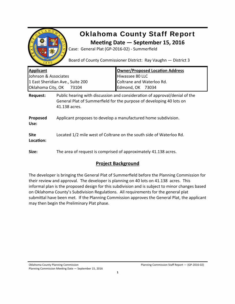
Oklahoma County Staff Report Mee ng Date — September 15, 2016
Case: General Plat (GP‐2016‐02) ‐ Summerfield Board of County Commissioner District: Ray Vaughn — District 3
Applicant Johnson & Associates 1 East Sheridian Ave., Suite 200 Oklahoma City, OK 73104
Owner/Proposed Loca on Address Hiwassee 80 LLC Coltrane and Waterloo Rd. Edmond, OK 73034
Request: Public hearing with discussion and considera on of approval/denial of the General Plat of Summerfield for the purpose of developing 40 lots on 41.138 acres. Proposed Applicant proposes to develop a manufactured home subdivision. Use: Site Located 1/2 mile west of Coltrane on the south side of Waterloo Rd. Loca on: Size: The area of request is comprised of approximately 41.138 acres.
Project Background The developer is bringing the General Plat of Summerfield before the Planning Commission for their review and approval. The developer is planning on 40 lots on 41.138 acres. This informal plan is the proposed design for this subdivision and is subject to minor changes based on Oklahoma County’s Subdivision Regula ons. All requirements for the general plat submi al have been met. If the Planning Commission approves the General Plat, the applicant may then begin the Preliminary Plat phase.
Oklahoma County Planning Commission Planning Commission Staff Report — (GP‐2016‐02) Planning Commission Mee ng Date — September 15, 2016
2
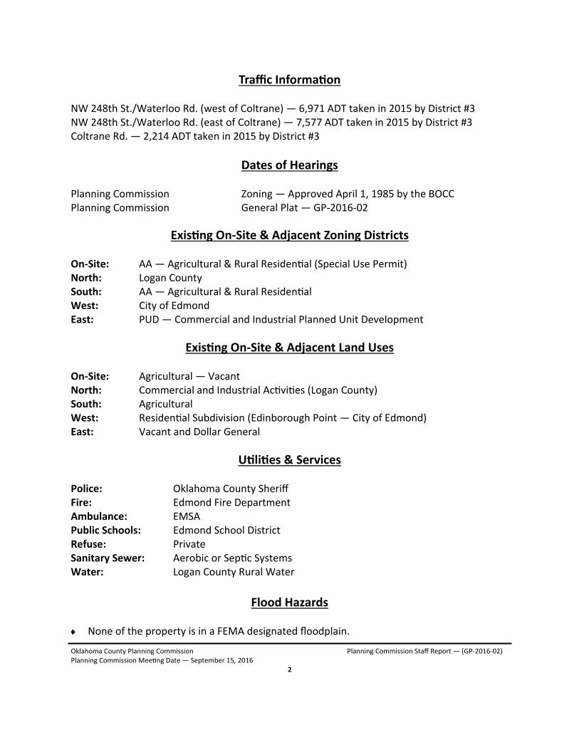
Flood Hazards None of the property is in a FEMA designated floodplain.
Traffic Informa on NW 248th St./Waterloo Rd. (west of Coltrane) — 6,971 ADT taken in 2015 by District #3 NW 248th St./Waterloo Rd. (east of Coltrane) — 7,577 ADT taken in 2015 by District #3 Coltrane Rd. — 2,214 ADT taken in 2015 by District #3
Dates of Hearings Planning Commission Zoning — Approved April 1, 1985 by the BOCC Planning Commission General Plat — GP‐2016‐02
Exis ng On‐Site & Adjacent Zoning Districts On‐Site: AA — Agricultural & Rural Residen al (Special Use Permit) North: Logan County South: AA — Agricultural & Rural Residen al West: City of Edmond East: PUD — Commercial and Industrial Planned Unit Development
Exis ng On‐Site & Adjacent Land Uses On‐Site: Agricultural — Vacant North: Commercial and Industrial Ac vi es (Logan County) South: Agricultural West: Residen al Subdivision (Edinborough Point — City of Edmond) East: Vacant and Dollar General
U li es & Services Police: Oklahoma County Sheriff Fire: Edmond Fire Department Ambulance: EMSA Public Schools: Edmond School District Refuse: Private Sanitary Sewer: Aerobic or Sep c Systems Water: Logan County Rural Water
Oklahoma County Planning Commission Planning Commission Staff Report — (GP‐2016‐02) Planning Commission Mee ng Date — September 15, 2016
3
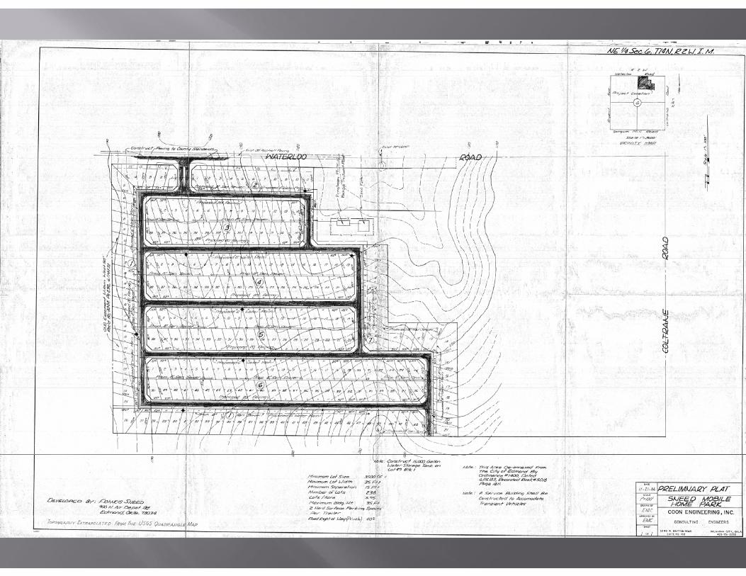
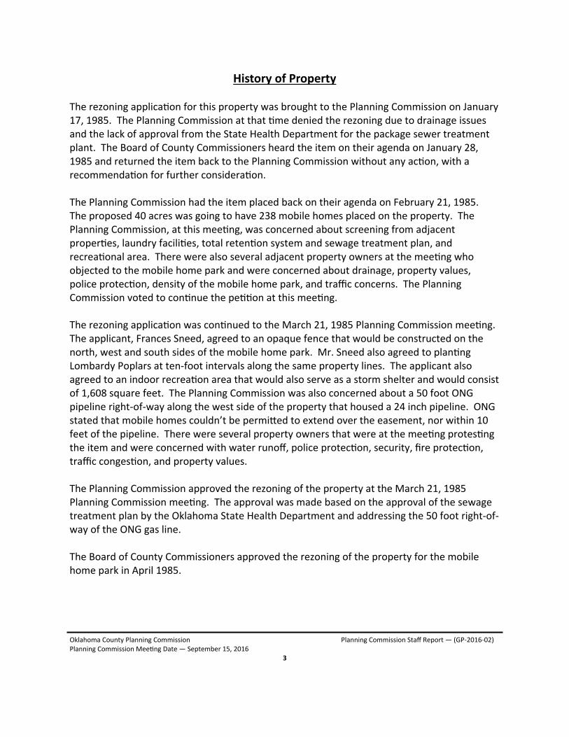
History of Property The rezoning applica on for this property was brought to the Planning Commission on January 17, 1985. The Planning Commission at that me denied the rezoning due to drainage issues and the lack of approval from the State Health Department for the package sewer treatment plant. The Board of County Commissioners heard the item on their agenda on January 28, 1985 and returned the item back to the Planning Commission without any ac on, with a recommenda on for further considera on. The Planning Commission had the item placed back on their agenda on February 21, 1985. The proposed 40 acres was going to have 238 mobile homes placed on the property. The Planning Commission, at this mee ng, was concerned about screening from adjacent proper es, laundry facili es, total reten on system and sewage treatment plan, and recrea onal area. There were also several adjacent property owners at the mee ng who objected to the mobile home park and were concerned about drainage, property values, police protec on, density of the mobile home park, and traffic concerns. The Planning Commission voted to con nue the pe on at this mee ng. The rezoning applica on was con nued to the March 21, 1985 Planning Commission mee ng. The applicant, Frances Sneed, agreed to an opaque fence that would be constructed on the north, west and south sides of the mobile home park. Mr. Sneed also agreed to plan ng Lombardy Poplars at ten‐foot intervals along the same property lines. The applicant also agreed to an indoor recrea on area that would also serve as a storm shelter and would consist of 1,608 square feet. The Planning Commission was also concerned about a 50 foot ONG pipeline right‐of‐way along the west side of the property that housed a 24 inch pipeline. ONG stated that mobile homes couldn’t be permi ed to extend over the easement, nor within 10 feet of the pipeline. There were several property owners that were at the mee ng protes ng the item and were concerned with water runoff, police protec on, security, fire protec on, traffic conges on, and property values. The Planning Commission approved the rezoning of the property at the March 21, 1985 Planning Commission mee ng. The approval was made based on the approval of the sewage treatment plan by the Oklahoma State Health Department and addressing the 50 foot right‐of‐way of the ONG gas line. The Board of County Commissioners approved the rezoning of the property for the mobile home park in April 1985.
Oklahoma County Planning Commission Planning Commission Staff Report — (GP‐2016‐02) Planning Commission Mee ng Date — September 15, 2016
4
Ac on Required Approve or Deny applica on — GP‐2016‐02
O
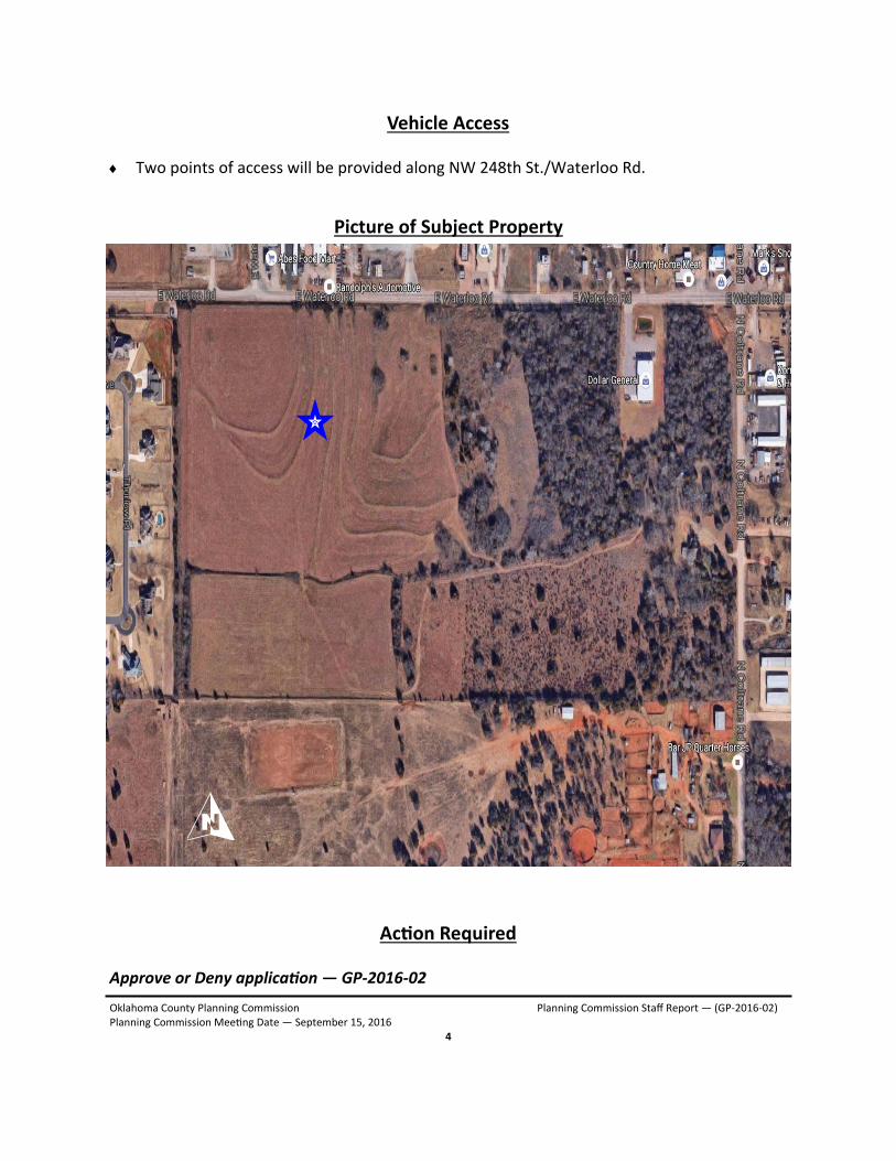
Vehicle Access Two points of access will be provided along NW 248th St./Waterloo Rd.
Picture of Subject Property

Planning Commission MeetingSeptember 15, 2016