a data model for route planning in case of forest res · a data model for route planning in case of...
TRANSCRIPT

A data model for route planning in case of forest fires
Zhiyong Wanga,∗, Sisi Zlatanovaa, Aitor Morenob, Peter van Oosteroma, Carlos Torob
aDelft University of Technology, Jaffalaan 9, 2628BX Delft, The NetherlandsbVicomtech, Mikeletegi Pasealekua 57, 20009 San Sebastian, Spain
Abstract
The ability to guide relief vehicles to safety and quickly pass through environments affected by fires iscritical in fighting forest fires. In this paper, we focus on route determination in the case of forest fires, andpropose a data model that supports finding paths among moving obstacles. This data model captures bothstatic information, such as the type of the response team, the topology of the road network, and dynamicinformation, such as sensor information, changing availabilities of roads during disasters, and the positionof the vehicle. We used a fire simulation model to calculate the fire evolution. The spread of the fire isrepresented as movements of obstacles that block the responders’ path in the road network. To calculate safeand optimal routes avoiding obstacles, the A* algorithm is extended to consider the predicted availabilitiesof roads. We prove the optimality of the path calculated by our algorithm and then evaluate it in simulatedscenarios. The results show that our model and algorithm are effective in planning routes that avoid one ormore fire-affected areas and that the outlook for further investigation is promising.
Keywords: Emergency navigation, Fire simulation, Data model, Algorithm
1. Introduction1
Natural fires have caused enormous socioeco-2
nomic losses and created many victims in the past3
few years. Recently, there has been growing in-4
terest in understanding and mitigating the effects5
of these disastrous events. In fighting forest fires,6
a wide range of response activities and emergency7
operations are involved, such as transporting in-8
jured persons, distributing supplies, and evacuat-9
ing citizens, all of which require navigation aids.10
Because the radiant heat released during burning11
can be considered obstacles that might make some12
roads unsafe and temporarily inaccessible (Taylor13
and Freeman, 2010), emergency managers need a14
path planner that is capable of finding a safe and15
optimal route that avoids fire-affected areas.16
Navigation has been thoroughly studied from17
varied theoretical perspectives and across multi-18
ple disciplines, such as robotics, geomatics and ap-19
plied mathematics (Chabini and Lan, 2002; Ge and20
Cui, 2002; Huang et al., 2007; Delling et al., 2009).21
∗Corresponding author. Tel.: +31 (0)152787934; fax:+31 (0)152784422. E-mail addresses: [email protected]
Nevertheless, very few research efforts have been22
devoted specifically to emergency navigation prob-23
lems in the context of moving obstacles that dynam-24
ically affect the road network (Wang and Zlatanova,25
2013b). Although some studies have some relevance26
for route planning in case of disaster events (Mioc27
et al., 2008; Liu et al., 2006), the issues that arise28
in the path planning during disasters have not yet29
been fully addressed. On one hand, the existing30
emergency support systems (Parker et al., 2008;31
Johnson, 2008) are capable of finding the short-32
est route to a certain location, taking the dam-33
ages to the infrastructure into account, but do not34
consider the dynamics of disasters, particularly the35
predicted information on their developments, which36
limits their practical applications in disaster re-37
sponse. Some studies of emergency navigation used38
crowdsourced data regarding the state of the road39
to calculate the shortest path (Nedkov and Zla-40
tanova, 2011; Neis et al., 2010). However, they can41
only cope with static obstacles, and do not offer42
the routing functionality required to avoid moving43
obstacles. On the other hand, most research on dy-44
namic obstacles has been centered on robotics (Li45
Preprint submitted to Computers and Geosciences November 19, 2013
et al., 2009; Masehian and Katebi, 2007; Gonzalez46
et al., 2012). The results from these studies could47
benefit the navigation of first responders in certain48
aspects. Nevertheless, the focus of their research49
is mainly on planning obstacle-avoiding paths in a50
given free space, without the constraints of a trans-51
portation network.52
One of the most critical aspects in emergency53
navigation is information, most of which falls into54
two categories, static and dynamic. Static informa-55
tion is relevant to topographic and territorial data56
(e.g., land use, road network, buildings, and loca-57
tions of fire hydrants). Most of the static data can58
be obtained through municipality offices and the59
emergency reponse (ER) sectors, as well as pub-60
lic resources, such as the location of fire hydrants61
on www.openfiremap.org and general maps from62
OpenStreetMap (www.openstreetmap.org). Dy-63
namic information is more related to the incident64
description and its impacts, damages, and sensor65
measurements, etc., and has a highly temporal as-66
pect, i.e., it changes rapidly with time. This infor-67
mation consists of historic information, about what68
has happened since the disaster occurred, and pre-69
dicted information, about what may happen. Ex-70
amples of historical information are the type, scale,71
and affected area of an incident, the number of in-72
jured and missing people, etc. This information is73
needed to help emergency managers identify dan-74
gerous areas that should be avoided. Examples of75
predicted information are the likelihood of floods76
in a given 2.5-dimensional terrain, areas threatened77
by gas plumes, and the forecasted wildfire front,78
etc. Such information is also needed to assist plan-79
ners in adjusting original route plans in advance of80
developing disasters.81
For the above reasons, a hazard simulation model82
that is capable of providing reliable predicted infor-83
mation about disaster changes, is a valuable frame-84
work that underlies the solutions for many prob-85
lems that arise in the context of advance rescue86
planning. Many disaster models have emerged to87
encourage and facilitate emergency operations in88
the past few years (Hu, 2011; Moreno et al., 2012,89
2011; Zelle et al., 2013; Lu et al., 2008). For exam-90
ple, Zelle et al. (2013) present an integrated system91
for smoke plume and gas cloud forecasts, combining92
a weather model, a smoke plume model and a crisis93
management system. Moreno et al. (2011) present94
a real-time fire simulation algorithm that can be in-95
tegrated into interactive virtual simulations where96
fire fighters and managers can train their skills.97
These models make it possible for emergency work-98
ers to assess the potential impact of a hazard, iden-99
tify dangerous areas that should be evacuated, and100
make effective plans to curb damages and protect101
lives.102
In our research, a geo-Database Management103
System (geo-DBMS) is selected to manage hazard104
simulation results and dynamic information of geo-105
graphic objects. The Geo-DBMS provides efficient106
management of large spatial data sets (often en-107
countered in large scale events). In addition, it has108
mechanisms that enable fast update and access to109
geographic information, and functionality for data110
analysis. The geometric model, which has been111
used and implemented in major geo-DBMSs (e.g.,112
Oracle Spatial, PostGIS) (Meijers et al., 2005),113
makes the systems capable of handling all types of114
spatial data related to disaster management. Some115
data models haven been developed in geo-DBMSs116
for emergency response (Dilo and Zlatanova, 2011;117
Kwan and Lee, 2005; Zlatanova and Baharin, 2008).118
However, they are not capable of dealing with pre-119
dicted information from hazard simulation models120
and can not support routing among moving obsta-121
cles. Many researchers have been working on man-122
aging moving objects and numerous data manage-123
ment techniques have been developed to facilitate124
the collection, organization, and storage of dynamic125
data of moving objects (Wolfson et al., 1998; Merat-126
nia, 2005; Guting et al., 2006). These studies pro-127
vide a rich set of solutions for managing the dy-128
namic information produced during disasters, such129
as the locations of the rescue unit, plume move-130
ment, and changes in the water level.131
In this paper, we focus on the routing process132
in a real road network in the case of forest fires.133
We use a fire simulation model to generate datasets134
about the spread of the fire, and obtain information135
about its damage to the infrastructure through spa-136
tial data analysis. A spatio-temporal data model137
is proposed to structure dynamic information of138
transportation conditions affected by fires in the139
database. Using this information, we apply a mod-140
ified shortest path algorithm to calculate optimal141
paths avoiding fire-affected areas for first respon-142
ders. Such an approach is not limited to route plan-143
ning during forest fires, but also can be extended to144
assist navigation among moving obstacles brought145
about by other types of disasters.146
The organization of the paper is as follows. In147
section 2, we describe our system architecture for148
emergency navigation. Section 3 presents both con-149
2
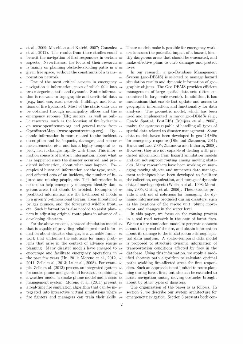
Figure 1: The overview of the proposed system architecture
ceptual and logical spatio-temporal data models of150
the dynamic information for routing to avoid ob-151
stacles. Section 4 illustrates the network analysis152
application, including the extended A* algorithm.153
Section 6 describes the detailed implementation of154
our navigation system. In section 7, we test the155
model and the algorithm in different scenarios, and156
detail our results. We draw some conclusions in157
section 8 and end this paper with proposed future158
work in section 9.159
2. System architecture160
To assist fire fighting in forest areas, a system161
architecture for routing avoiding fire-affected areas162
is designed. The framework of the proposed sys-163
tem is depicted in figure 1 and is composed of the164
following components: data collection, data man-165
agement, fire simulation model, agent-based simu-166
lation model and visualization of simulation results.167
When a fire incident occurs, several measurement168
teams are formed and sent into the field to per-169
form measurements. Real-time sensor information170
(e.g., wind speed and wind direction) is collected171
from the field via a communication network and in-172
corporated into the fire simulation model (Moreno173
et al., 2012). The fire model produces dynamic data174
of spatial units about the fire state, from which the175
shape and direction of movement of fires are de-176
rived. This dynamic information, together with the177
geo-information of the network and the information178
regarding response units (routes, starting point,179
end point, status, etc.) is consistently recorded180
and structured in a geo-DBMS based on the data181
model designed for emergency response (Dilo and182
Zlatanova, 2011). We use an agent-based simulator183
with GIS functionalities to predict the availabilities184
of roads in a certain area at a certain time, and to185
display the movement of both the fire and respon-186
ders. The fire simulation results are represented187
as one or more moving polygons crossing a certain188
road network. The first responder is modeled as189
an agent characterized by a set of attributes (e.g.,190
speed, type of vehicle) and performs certain actions191
(e.g., moving, waiting). Using predicted informa-192
tion about the status of roads, the path planner,193
within the agent, applies the shortest path algo-194
rithm to calculate the safest and fastest route for195
responders. The calculated results are visualized196
to users through a 2D view as well as a navigable197
3D view to enhance human situational awareness198
(Schurr et al., 2005).199
3. Data model design200
A spatial temporal data model is needed to effec-201
tively organize all required information and knowl-202
edge in the geo-DBMS. This data model should ful-203
fill the following requirements: (1) support repre-204
sentation of the environment, particularly the net-205
work elements and the network topology; (2) sup-206
port dynamic simulation, such as the representa-207
tions of disaster developments in time, changes in208
the availability of roads, and the movements of re-209
lief vehicles; (3) support various analyses, includ-210
ing identifying the areas that are most threatened,211
planning paths in the context of moving obstacles,212
etc.; (4) support representation of the calculated re-213
sults, e.g., the navigation route, estimated traveling214
and arrival time; and (5) should be compatible with215
the relevant data models for emergency response216
and existing standards defined by the Open Geospa-217
tial Consortium (OGC) or International Standard218
Organization (ISO), e.g., ISO 19107:2003 that pro-219
vides a formal structure for representation of spatial220
objects.221
Using the requirements listed above, we define222
a data model to capture dynamics of the envi-223
ronment, using Unified Modeling Language (UML)224
profiles for database design. The proposed model225
is designed adhering to the data model presented226
by Dilo and Zlatanova (2011) as much as possible,227
and is built for the following 3 groups of data: (1)228
data related to the road network; (2) data relevant229
to disasters; and (3) data on response units. We230
define the topology of the network by ourselves,231
and use the geometric data types specified by ISO232
3
19107, e.g., GM Point, GM LineString, GM Polygon,233
and GM MultiSurface, to describe the spatial char-234
acteristics of geographic features. Because the data235
we are handling are constantly changing, new data236
types are created to capture this spatio-temporal237
nature.238
3.1. Conceptual data model239
Figure 2 is a UML class diagram presenting a240
conceptual model of the data required for naviga-241
tion among moving obstacles. The yellow classes242
are created for handling the data related to dis-243
asters. The green classes are used to support the244
representation of the road network. The classes in245
light-gray are defined for modeling the data of re-246
sponse units. New datatypes are colored in purple.247
The class RoadNetwork is an extended graph, con-248
sisting of instances of RoadSegment that contain249
dynamic information produced by disaster events.250
To maintain the topology of the road network, an251
association between RoadSegment and RoadJunc-252
tion is established. Both RoadSegment and Road-253
Junction have an attribute affected time list used to254
store temporal information regarding the availabil-255
ities of the corresponding spatial objects. A new256
data type called AffectedTimePeriod is created for257
these two classes containing the attribute of a dy-258
namic nature. A RealIncident is used to record the259
information of the disaster incident. It inherits all260
properties of the abstract class Incident which con-261
tains static information of the incident including262
incidentID identifying the incident, the location of263
the incident, the start time, and a text descrip-264
tion of the incident. Some additional attributes265
are added to store the dynamic information gener-266
ated during the incident, such as the disaster type267
which may change in time, GRIPlevel describing the268
changing severity of the incident, and affected area269
which stores the historic information of affected ar-270
eas during the incident. The class SimulatedEvent is271
linked with RealIncident to describe disaster simula-272
tions that predict the effect of real incidents within273
a certain period of time. The class Obstacle con-274
tains predicted information about the obstacles in275
the form of moving polygons affecting the road net-276
work. As soon as a real incident occurs, different277
types of Processes are started. Several teams that278
are sent to address the incident are responsible for279
managing these processes. A team may be com-280
posed of one or more vehicles. The class Vehicle281
contains information related to vehicles. The as-282
sociation Follow is used to record the routes that283
drivers want to follow. These Routes are calculated284
based on spatio-temporal information in the geo-285
DBMS and proposed to the drivers. The stored286
route information will also be used for monitoring287
movement of vehicles during disasters and analysed288
after disaster response.289
3.2. Logical data model290
The proposed data model has been realized in291
the relational database PostGIS (www.postgis.org).292
PostGIS spatial data types and functions are com-293
pliant with OGC specifications and ISO 19107. Fig-294
ure 3 shows the logical data model for PostGIS.295
Following classical approaches (Guting et al., 2000;296
Guting and Schneider, 2005), we create some new297
data types to store the spatio-temporal data, i.e.,298
MovingPointInst to store dynamic positions of both299
vehicles and teams; MovingPolygonInst to record300
historic affected regions and identify dangerous ar-301
eas in the near future. These data types are de-302
fined by adding timestamps as one of attributes to303
capture the temporal aspect. We use the ARRAY304
type, in which the new data types are used as a base305
type of the array elements, to record facts associ-306
ated with time. For example, MovingPolygonInst[307
] is composed of a sequence of pairs of polygons308
and time instances. To represent many-to-many309
associations, an intersection table is created. For310
instance, a table, RoadSegment to Route, is intro-311
duced to hold the many-to-many relationship be-312
tween RoadSegment and Route, combining the pri-313
mary keys from the original tables. The logical314
schema is automatically transformed by a modelling315
tool Enterprise Architect (www.sparxsystems.com)316
to a collection of Structured Query Language (SQL)317
scripts for creating and dropping tables. These cre-318
ated tables are populated with spatial and spatio-319
temporal data that are used for analysis and visu-320
alization by our navigation application as well as321
traditional GIS tools.322
4. Network analysis application considering323
the spread of the fire324
In this study, we design and develop a prototype325
network analysis application for forest fire rescue326
planning. The application supports both data pro-327
cessing and data analysis, including fetching the fire328
simulation results, formatting them into a general329
representation, calculating the availability of road330
segments, and computing the shortest path while331
4

Figure 2: Conceptual data model (UML class diagram with ISO 19107 geometric data types)
avoiding predicted inaccessible roads in fire-affected332
areas. The shortest path algorithm is extended to333
consider both static information, i.e., the topologi-334
cal and spatial constraints of the network, and dy-335
namic information, i.e., the predicted accessibility336
of roads.337
4.1. Intersection of the fire-affected area with the338
road network339
For the network analysis application, a cell-based340
fire simulation model developed by Moreno et al.341
(2011) is used to generate datasets of fire-affected342
areas. The fire simulation method divides the to-343
pography into a grid of square cells. Each cell con-344
tains both static information, such as position, size345
(i.e., 3 meters), type, and the burning rate depend-346
ing on its type, and the runtime information, such347
5

Figure 3: Logical data model (UML class diagram with PostGIS geometric data types, note thatthe ARRAY is used and indicated by square brackets [ ] after the datatype of the attribute)
6

as the quantity of combustible, the power intensity348
of the fire, and the state of the fire. The fire simula-349
tion system, integrated with passive data from dif-350
ferent sources and dynamic events, including real-351
time changes in the weather conditions, calculates352
the spread of the forest fire and updates the run-353
time information of forest cells calculated during354
each simulation step. By grouping the cells accord-355
ing to the cell state and time step, we create a set356
of moving polygons that overlap a certain road net-357
work. Considering that each cell in the simulation358
has a certain width, we introduce a new buffer for359
each road-center line to represent the road network,360
extract all the road segments and junctions inside361
affected areas, and store them with their affected362
time periods in the database according the data363
model described in section 3.364
4.2. Routing algorithm365
Once the state of roads has been updated, the366
application fetches spatio-temporal data of the road367
network from the database and generates a graph368
with affected time of roads. Consider a graph369
G = (N,E) consisting of a finite set of edges E and370
nodes N . Each edge e ∈ E corresponds to an object371
of class RoadSegment, and each node n ∈ N corre-372
sponds to an object of class RoadSegment. We use w373
to represent the length of each RoadSegment and use374
an interval [tclosed, topen] to denote an element of af-375
fected time list attached to the corresponding road376
segment and junction. [tclosed, topen] is an instance377
of data type AffectedTimeperiod, where tclosed is the378
start time of closing, and topen is the end time of379
closing. Here we assume that once the nodes and380
edges are affected by the fire, they will not be avail-381
able anymore. Following the above assumption, ev-382
ery affected edge and node has only one affected383
time interval, and the opening time, topen, is set384
to inf by default. To calculate routes avoiding ob-385
stacles, a special algorithm is needed to handle the386
affected time of roads.387
In our application, we have extended the A*388
methodology for shortest path planning among389
moving obstacles. Related research on navigation390
among moving obstacles have been greatly studied391
in the robotic field. Phillips and Likhachev (2011)392
introduce the concept of safe intervals to compress393
search space and extends the A* algorithm to gen-394
erate time-minimal paths in dynamic environments395
with moving obstacles. Similarly, Narayanan et al.396
(2012) use time intervals instead of timesteps and397
develops a variant of A* for anytime path planning398
The modified A* algorithm
1: Initialize startNode s, goalNode d , moveRate, departureTime2: Initialize openSet, closedSet3: g(s) := departureTime4: Insert s in openSet5: while openSet is not empty do6: n := the node in openSet having the lowest f value7: if n = g then8: return the path from s9: to d
10: end if11: Remove n from openSet12: Insert n to closedSet13: for each neighbor n′ of n do14: if n′ in closedSet then15: continue16: end if17: tentative cost := g(n) + wnn′/moveRate18: flag := false19: if n′ not in openSet then20: if tentative cost < tclosednn′ then21: Insert n′ to openSet22: flag := true23: end if24: else if (tentative cost < g(n′)) and (tentative cost < tclosednn′ )
then25: flag := true26: else27: flag := false28: end if29: if flag = true then30: the backpointer of n′ := n31: g(n′) := tentative cost /* the actual path cost from s
to node y */
32: h(n′) := heuristic estimate of cost(n′, d)33: f (n′) := g(n′) + h(n′)34: end if35: end for36: end while37: return no-path
Figure 4: The modified A* algorithm
in the presence of dynamic obstacles. However,399
their planners do not take constrains of the real400
road network into consideration and can be only ap-401
plied to free space. Our path planner has some sim-402
ilarities to the algorithms presented in Visser (2009)403
and Wang and Zlatanova (2013a) which also con-404
sider predicted information of the road network and405
introduce waiting options to avoid moving obsta-406
cles. Under the above assumptions, waiting would407
not be safe during fires and the vehicles need to408
move as fast as possible. Therefore, we remove the409
waiting option in the algorithm and do not consider410
the information on the state of nodes.411
A* is a well-known algorithm developed to solve412
the one-to-one shortest path problem (Hart et al.,413
1968). The A* algorithm uses a heuristic func-414
tion to estimate cost from each node to the des-415
tination to guide path search. The cost associated416
with a node n is f(n) = g(n) + h(n), where g(n) is417
the actual cost of the path from the start to node418
7

n, and h(n) is an estimated coast from node n to419
the destination. The algorithm maintains two sets:420
openSet that stores nodes who are not expanded421
, and closedSet that stores nodes who have been422
expanded. At each iteration, the algorithm selects423
node m with the minimal cost from the openSet424
for expansion. All successors of node m that are425
unexplored will be put in the openSet for further426
expansion.427
In our extension of the A*, we take into account428
the affected time of roads and introduce an addi-429
tional parameter for the algorithm, the speed of430
vehicles moveRate, to select nodes for expansions.431
The value of moveRate can be obtained in two432
ways: (1) user configuration; (2) real-time calcu-433
lation based on the location of vehicles recorded434
in the database. A new parameter departureT ime435
is added to help estimation of arrival time of each436
node. Figure 4 shows the main structure of the437
modified A*. When a node n is expanded, we com-438
pute the estimated arrival time considering the cost439
of the edge wnn′ and the given speed, moveRate440
(see line 15). At line 18, we use a condition to de-441
cide if the successor n′ of n should be added to the442
openSet. If the object can safely pass through the443
edge between the expanded node n and the succes-444
sor n′, i.e., the estimated arrival time is earlier than445
the closed time of the edge tclosednn′ , the successor n′446
will be added into the openSet for further expan-447
sions. If not, it remains un-explored. The same448
condition is also applied on line 22, which guaran-449
tees that the evaluated node n′ should be updated450
not only with the faster arrival time but also with451
the safety of passing through the edge nn′.452
4.3. Theoretical analysis453
Here we sketch the proof of the optimality of the454
path calculated by our algorithm.455
Theorem 1 When the modified A* selects the goal456
for expansion, it has found a time-minimal and safe457
path to the goal node d.458
Proof Were this not the case, the optimal path,459
P , must have a node n that is not yet expanded460
(If the optimal path has been completely expanded,461
the goal would have been reached along the optimal462
path.). There are then the following two possibil-463
ities resulting in the fact that n is not expanded464
to generate successors: (1) f(n) > f(d); (2) all465
successors of n cannot be safely reached, i.e. the466
estimated arrival time is after the closing time of467
the edge between n and its successor. Because f468
is non-decreasing along any path, n would have a469
lower f -cost than d and would have been selected470
first for expansion before the goal node, which con-471
tradicts the first possibility. We assume n′ is the472
successor of n along the optimal path, implying that473
g(n) + wnn′ < tclosednn′ , which eliminates the second474
possibility. In the algorithm, the cost on an edge is475
equal to the time it takes to execute that edge, and476
whenever a g-value is updated (a shorter path is477
found), the time value is also updated to the earlier478
time. Therefore, when the node d is expanded, it479
is the earliest time we can arrive at the goal node.480
This is optimal in terms of time cost. We also know481
that all explored nodes are safely reached, which482
makes the entire path safe, from the start node to483
the goal node.484
5. Route safety485
To evaluate the safety of the route, we provide a486
method to quantify the safety value of edges and487
routes. Our method is similar to the one pro-488
posed by Shastri (2006) that introduces the mar-489
gin of safety of nodes, but uses the affected time of490
edges to evaluate the safety of routes. The safety491
of each edge is expressed as difference between the492
time when fires block the edge and the estimated493
time when the responder arrive at the target node494
of the edge. Mathematically, the safety of an edge495
nini+1, Snini+1, is496
Snini+1= tclosednini+1
− tni+1(1)
Here tclosednini+1is the closed time of edge nini+1; tni+1
497
is the estimated time of reaching node ni+1 though498
edge nini+1.499
Because the safety of a route mainly depends onthe most unsafe edge along the route, the minimumof safety values of edges is selected as the routesafety. Let R = {n0, n1, . . . , nk} be one of routesfrom s to t, where n0, n1, . . . , nk are the nodes alongthe route, n0 = s, nk = d. The safety of the en-tire route can be computed by using the followingformula (Shastri, 2006):
SR = min(Sn0n1 , Sn1n2 , . . . , Snk−1nk) (2)
If SR > 0, the route is considered safe; If SR <= 0,500
the route is considered not safe. The higher the501
safety value, the more safe the route is. +∞ means502
the route is completely safe.503
8

Using the above formulas, we can compare the504
routes calculated by the algorithms to evaluate the505
proposed algorithm.506
6. Implementation507
The proposed model and algorithm are realized508
in a multi-agent simulator, called Mason (Luke509
et al., 2004, 2005), and are evaluated with a real510
road network. The data set of the road network511
is extracted from OpenStreetMap and loaded into512
the database according to our defined schema in513
section 3. The fire simulation model (Moreno514
et al., 2011) calculates the fire spread and the re-515
sults are also updated into the database and used516
to create the moving polygons crossing the net-517
work. GeoTools (www.geotools.org) is used to518
fetch the required data from the database to per-519
form the intersection operation and route calcu-520
lation. The agent simulator displays both the521
spread of the fire and the movements of relief522
vehicles. The calculated results are shown to523
users through both a 2D viewer, which provides524
an overview of the fire spread and the navigation525
routes, and a 3D viewer, enabling users to gain526
accurate impressions of the actual situation. The527
3D viewer is built on top of an open source visu-528
alization tool, OSM2World (www.osm2world.org)529
that builds three-dimensional models of the envi-530
ronment from OpenStreetMap data (a snapshot can531
be found in figure 5). Through the construction of532
the 3D visualization, situational awareness is en-533
hanced by providing information on the surround-534
ings, such as houses, gardens, etc., that might not535
initially be included in the street network model.536
7. Case study537
The model and algorithm have been tested with538
the road network dataset in San Sebastian, Spain.539
The network is composed of 1717 edges and 1661540
nodes. We simulate several scenarios in which one541
or more fires take place in a forest located in the542
eastern part of the city. The fire simulator gener-543
ates the fire spread dataset within the given area in544
seconds, starting from time t=0 min to time t=20545
min. The information regarding the status of the546
road network is collected and used for instantiating547
the model. Paths between locations are calculated548
by using both the modified algorithm and the clas-549
sical A* algorithm.550
Table 1: Calculated resultsRouteID
Distance(km)
Total traveltime (mins)
Route safety(mins)
Speed=20 km/h
R0R1
2.563.00
7.79.0
-1.8+∞
Speed=30 km/h
R0R2
2.562.56
5.15.1
0.70.7
Speed=50 km/h
R0R3
2.562.56
3.13.1
2.72.7
Notes:1 The vehicles considered in this scenario departure at
time t=0 min2 R0: The shortest route calculated by the standard
A* algorithm3 R1: The route calculated by the modified A* algo-
rithm at a speed of 20 km/h4 R2: The route calculated by the modified A* algo-
rithm at a speed of 30 km/h (the distance of R2equals the distance of R0)
5 R3: The route calculated by the modified A* algo-rithm at a speed of 50 km/h (the distance of R3equals the distance of R0)
6 +∞: This route is completely safe from t=0 min tot=20 min
7.1. Scenario 1: navigation for one responder551
avoiding one fire-affected area552
Considering that different vehicle types have dif-553
ferent maximum moving speeds, we compare relief554
routes for different speeds to evaluate the practi-555
cal application of our route planner. Table 1 shows556
the results of our experiments. In the first situa-557
tion, where the relief vehicle is moving at a speed558
of 20 km/h, our algorithm and the standard A* al-559
gorithm produce different routes, depicted in figure560
5. The light blue line is the route calculated by561
our algorithm, and the brown line represents the562
shortest path without considering the fire spread.563
The results indicate that when fires are moving fast564
and affect the environment rapidly, the vehicle at565
a speed of 20 km/h can not safely arrive at the566
destination along the shortest route, because the567
route could be blocked by fires before the vehicle568
can pass through. Our algorithm finds a new route569
that makes the responding unit detour to avoid fires570
and is safer than the shortest one.571
Continuing our analysis, figure 6 depicts another572
situation in which the shortest path and the cal-573
culated route are the same at given speeds of 30574
km/h and 50 km/h. As shown in table 1, the vehi-575
cle in this situation is moving faster, which leads to576
a shorter path and less travelling time. The table577
9

Figure 5: The calculated paths (speed=20 km/h) from theblue point to the yellow point through the environment withone fire-affected area (in red)
Figure 6: The calculated paths (speed=30, 50 km/h) fromthe blue point to the yellow point through the environmentwith one fire-affected area (in red)
1 also indicates the vehicle moving at a speed of 50578
km/h has a higher safety value than the vehicle at a579
speed of 30 km/h. By testing different speeds in the580
application, the emergency manager can determine581
the minimum speed required to safely pass through582
the affected region or to follow a specific route.583
7.2. Scenario 2: navigation for multiple responders584
avoiding multiple-affected areas585
In this scenario, we study the navigation case586
that multiple rescue vehicles have to be routed to587
one destination avoiding multiple fire-affected ar-588
eas. The considered vehicles have different maxi-589
mal speeds, and start moving from different loca-590
tions at different time instants. Our algorithm cal-591
culates routes avoiding fires, considering both the592
speed of vehicles and their departure times. The593
Table 2: Calculated resultsRouteID
Departuretime (min)
Total traveltime (mins)
Arrival time(min)
Vehicle 1(30 km/h)
R0R1
2.02.0
6.06.0
8.08.0
Vehicle 2(20 km/h)
R2R3
5.05.0
5.38.8
10.313.8
Vehicle 3(20 km/h)
R4R5
8.08.0
6.511.0
14.519.0
Notes:1 R0, R2, R4: The shortest routes from different
sources to the same destination2 R1: The route calculated by the modified A* al-
gorithm given a speed of 30 km/h and a depar-ture time t=2.0 min (the route R1 and the shortestroute R0 are the same)
3 R3: The route calculated by the modified A* al-gorithm given a speed of 20 km/h and a departuretime t=5.0 min
4 R5: The route calculated by the modified A* al-gorithm given a speed of 20 km/h and a departuretime t=8.0 min
calculated results are shown in table 2. Because of594
the fact that the shortest routes could be blocked595
by the fires, emergency plans made based on es-596
timation of arrival time of the shortest route will597
not be feasible due to possible delays. As we can598
see from the table that, although vehicle 1 can ar-599
rive at the destination on time, the time difference600
between arrival time of the shortest route and ar-601
rival time of obstacle avoiding route for vehicle 2602
is about 3.5 min, and vehicle 3 has a time differ-603
ence of 4.5 min. Because responders often work in604
groups, a reliable estimation of their arrival time at605
the field site is very important for rapid emergency606
operations. A lack of consideration of possible de-607
lays caused by fires could slow the response process.608
Figure 7 shows a snapshot of routes calculated by609
our algorithm. The results indicate that our algo-610
rithm can not only deal with multiple fire-affected611
areas, but also give a more reliable estimation of612
arrival time for different types of vehicles starting613
from different places and different time instances,614
which would make emergency plans more effective615
and contributes to an improvement of performance616
of the response units.617
8. Conclusions618
During forest fires, transportation networks could619
be damaged by fires spreading and blocking roads620
10
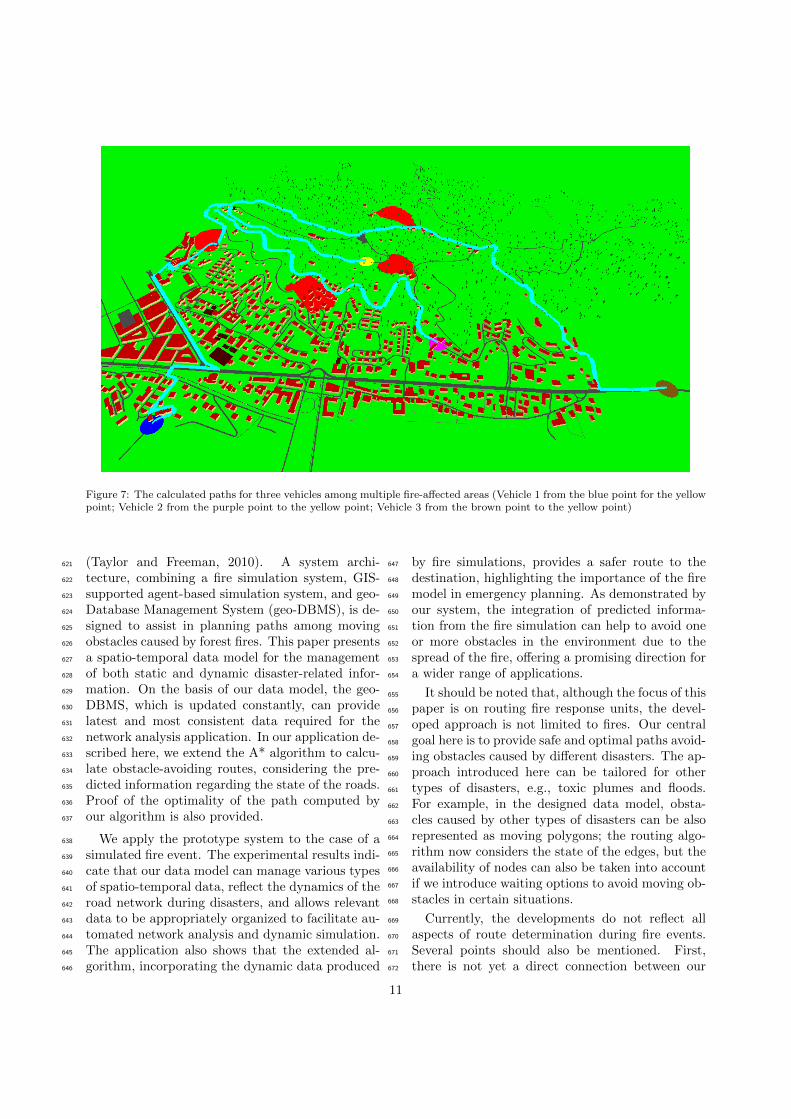
Figure 7: The calculated paths for three vehicles among multiple fire-affected areas (Vehicle 1 from the blue point for the yellowpoint; Vehicle 2 from the purple point to the yellow point; Vehicle 3 from the brown point to the yellow point)
(Taylor and Freeman, 2010). A system archi-621
tecture, combining a fire simulation system, GIS-622
supported agent-based simulation system, and geo-623
Database Management System (geo-DBMS), is de-624
signed to assist in planning paths among moving625
obstacles caused by forest fires. This paper presents626
a spatio-temporal data model for the management627
of both static and dynamic disaster-related infor-628
mation. On the basis of our data model, the geo-629
DBMS, which is updated constantly, can provide630
latest and most consistent data required for the631
network analysis application. In our application de-632
scribed here, we extend the A* algorithm to calcu-633
late obstacle-avoiding routes, considering the pre-634
dicted information regarding the state of the roads.635
Proof of the optimality of the path computed by636
our algorithm is also provided.637
We apply the prototype system to the case of a638
simulated fire event. The experimental results indi-639
cate that our data model can manage various types640
of spatio-temporal data, reflect the dynamics of the641
road network during disasters, and allows relevant642
data to be appropriately organized to facilitate au-643
tomated network analysis and dynamic simulation.644
The application also shows that the extended al-645
gorithm, incorporating the dynamic data produced646
by fire simulations, provides a safer route to the647
destination, highlighting the importance of the fire648
model in emergency planning. As demonstrated by649
our system, the integration of predicted informa-650
tion from the fire simulation can help to avoid one651
or more obstacles in the environment due to the652
spread of the fire, offering a promising direction for653
a wider range of applications.654
It should be noted that, although the focus of this655
paper is on routing fire response units, the devel-656
oped approach is not limited to fires. Our central657
goal here is to provide safe and optimal paths avoid-658
ing obstacles caused by different disasters. The ap-659
proach introduced here can be tailored for other660
types of disasters, e.g., toxic plumes and floods.661
For example, in the designed data model, obsta-662
cles caused by other types of disasters can be also663
represented as moving polygons; the routing algo-664
rithm now considers the state of the edges, but the665
availability of nodes can also be taken into account666
if we introduce waiting options to avoid moving ob-667
stacles in certain situations.668
Currently, the developments do not reflect all669
aspects of route determination during fire events.670
Several points should also be mentioned. First,671
there is not yet a direct connection between our672
11

application and the fire model. Because we need673
only the output data from the fire simulation, we674
assume that these data have been provided by ex-675
ternal software or a simulation system and stored676
in the database. The integration of the fire model677
into the application could facilitate the computa-678
tion and can be performed in later work. Second,679
our data model only handles data that are essential680
for emergency navigation. The structuring of the681
OSM data and the fire simulation output data used682
by our application is not considered in our data683
model and is beyond the scope of this paper. Fi-684
nally, due to a lack of data on the width of roads in685
our test dataset, we assume all roads have the same686
width and use it to create road buffers. Because the687
affected time of roads for routing is obtained based688
on intersection operations between road buffers and689
fire affected areas, a data source that contains data690
on real road width is needed to make calculated691
route results more reliable.692
9. Future work693
Despite these promising results, many challenges694
must still be addressed. One of the most challeng-695
ing problems is that the behaviors of fires are diffi-696
cult to capture with the fire simulation model. The697
predictions, provided by the fire model, have inher-698
ent uncertainty, which decreases the effectiveness of699
our route planning for fire response. The next very700
important step will be to improve the routing algo-701
rithm to consider the accuracy of the fire model.702
Because the environment could be simultane-703
ously affected by multiple disasters and is con-704
stantly changing, we need a path planner that is705
capable of processing large volumes of updated data706
from different hazard models and able to regener-707
ate routes as quickly as possible. Currently, we708
are building a multi-agent system, exploiting JADE709
(Java Agent DEvelopment Framework) to support710
automated data processing and analysis. Based on711
the technology of the software agents, a collabora-712
tion platform for emergency navigation is designed,713
enabling interoperability between the hazard sim-714
ulation systems and our network analysis applica-715
tion.716
In future work, we will also explore a variety717
of navigation cases involving multiple responders718
as well as multiple destinations. Furthermore, we719
will consider connecting to the simulation model720
to other types of disasters, e.g., the plume model,721
the flood model. In the case of toxic plumes, in-722
stead of being blocked or non-blocked, the affected723
road can have a degree of accessibility that depends724
on the amount of dangerous smoke along the road725
and also changes over time. In some situations, the726
responders can wait at certain places for dynamic727
obstacles to pass to arrive at the destination faster.728
Therefore, waiting could be an advantageous option729
for certain types of disasters and should also be con-730
sidered in the routing process. Another extension731
of the data model is needed to meet a wider range732
of informational needs when multiple disasters oc-733
cur simultaneously. The data model is generic and734
can be easily adjusted to merge and organize in-735
formation from models of different types of disas-736
ter. Based on using standard Web services, we can737
further develop an Android navigation application738
that supports interoperable collaborations between739
the user and the machine, and apply it to real disas-740
ter situations. In this application, a user interface741
with various styling options will also be designed742
for different situations, e.g., waiting and moving,743
day and night, and urgent and non-urgent.744
Acknowledgement745
This work was supported by COST Action746
TU0801 “Semantic Enrichment of 3D City Models747
for Sustainable Urban Development”748
References749
Chabini, I., Lan, S., 2002. Adaptations of the A* algo-750
rithm for the computation of fastest paths in deterministic751
discrete-time dynamic networks. Intelligent Transporta-752
tion Systems, IEEE Transactions on 3, 60–74.753
Delling, D., Sanders, P., Schultes, D., Wagner, D., 2009.754
Engineering route planning algorithms, in: Algorithmics755
of large and complex networks. Springer, pp. 117–139.756
Dilo, A., Zlatanova, S., 2011. A data model for operational757
and situational information in emergency response. Ap-758
plied Geomatics 3, 207–218.759
Ge, S.S., Cui, Y., 2002. Dynamic motion planning for mobile760
robots using potential field method. Autonomous Robots761
13, 207–222.762
Gonzalez, J.P., Dornbush, A., Likhachev, M., 2012. Us-763
ing state dominance for path planning in dynamic envi-764
ronments with moving obstacles, in: Robotics and Au-765
tomation (ICRA), 2012 IEEE International Conference766
on, IEEE. pp. 4009–4015.767
Guting, R., De Almeida, V., Ding, Z., 2006. Modeling and768
querying moving objects in networks. The VLDB Journal769
15, 165–190.770
Guting, R.H., Bohlen, M.H., Erwig, M., Jensen, C.S.,771
Lorentzos, N.A., Schneider, M., Vazirgiannis, M., 2000.772
12

A foundation for representing and querying moving ob-773
jects. ACM Transactions on Database Systems (TODS)774
25, 1–42.775
Guting, R.H., Schneider, M., 2005. Moving objects776
databases. Morgan Kaufmann.777
Hart, P.E., Nilsson, N.J., Raphael, B., 1968. A formal basis778
for the heuristic determination of minimum cost paths.779
IEEE Transactions on Systems Science and Cybernetics780
4, 100–107.781
Hu, X., 2011. Dynamic Data Driven Simulation. SCS M&S782
Magazine , 662–669.783
Huang, B., Wu, Q., Zhan, F., 2007. A shortest path al-784
gorithm with novel heuristics for dynamic transportation785
networks. International Journal of Geographical Informa-786
tion Science 21, 625–644.787
Johnson, R., 2008. Gis technology and applications for the788
fire services, in: Zlatanova, S., Li, J. (Eds.), Geospatial789
Information Technology for Emergency Response. Taylor790
& Francis Ltd, London. Geospatial Information Technol-791
ogy for Emergency Response, pp. 351–372.792
Kwan, M.P., Lee, J., 2005. Emergency response after 9/11:793
the potential of real-time 3D GIS for quick emergency794
response in micro-spatial environments. Computers, En-795
vironment and Urban Systems 29, 93–113.796
Li, H., Yang, S.X., Seto, M.L., 2009. Neural-network-based797
path planning for a multirobot system with moving ob-798
stacles. Systems, Man, and Cybernetics, Part C: Appli-799
cations and Reviews, IEEE Transactions on 39, 410–419.800
Liu, Y., Hatayama, M., Okada, N., 2006. Development of an801
adaptive evacuation route algorithm under flood disaster.802
Annuals of Disaster Prevention Research Institute, Kyoto803
University 49, 189–195.804
Lu, G., Wu, Z., Wen, L., Lin, C.A., Zhang, J., Yang, Y.,805
2008. Real-time flood forecast and flood alert map over806
the huaihe river basin in china using a coupled hydro-807
meteorological modeling system. Science in China Series808
E: Technological Sciences 51, 1049–1063.809
Luke, S., Cioffi-Revilla, C., Panait, L., Sullivan, K., 2004.810
Mason: A new multi-agent simulation toolkit, in: Pro-811
ceedings of the 2004 SwarmFest Workshop.812
Luke, S., Cioffi-Revilla, C., Panait, L., Sullivan, K., Balan,813
G., 2005. Mason: A multiagent simulation environment.814
Simulation 81, 517–527.815
Masehian, E., Katebi, Y., 2007. Robot motion planning in816
dynamic environments with moving obstacles and target.817
International Journal of Mechanical Systems Science and818
Engineering 1, 20–25.819
Meijers, M., Zlatanova, S., Pfeifer, N., 2005. 3D geoinforma-820
tion indoors: structuring for evacuation, in: Proceedings821
of Next generation 3D city models, pp. 21–22.822
Meratnia, N., 2005. Towards database support for moving823
object data. Ph.D. thesis. University of Twente.824
Mioc, D., Anton, F., Liang, G., 2008. On-line street network825
analysis for flood evacuation planning, in: Remote Sens-826
ing and GIS Technologies for Monitoring and Prediction827
of Disasters. Springer, pp. 219–242.828
Moreno, A., Segura, A., Korchi, A., Posada, J., Otaegui,829
O., 2011. Interactive urban and forest fire simulation830
with extinguishment support, in: Advances in 3D Geo-831
Information Sciences. Springer, pp. 131–148.832
Moreno, A., Segura, A., Zlatanova, S., Posada, J., Garcıa-833
Alonso, A., 2012. Benefit of the integration of semantic 3D834
models in a fire-fighting vr simulator. Applied Geomatics835
4, 143–153.836
Narayanan, V., Phillips, M., Likhachev, M., 2012. Anytime837
safe interval path planning for dynamic environments, in:838
2012 IEEE/RSJ International Conference on Intelligent839
Robots and Systems (IROS), pp. 4708–4715.840
Nedkov, S., Zlatanova, S., 2011. Enabling obstacle avoid-841
ance for Google maps’ navigation service, in: Altan,842
Backhause, Boccardo & Zlatanova (Eds.), International843
Archives ISPRS XXXVIII, 7th, Gi4DM, Anltalya, Turkey.844
Neis, P., Singler, P., Zipf, A., 2010. Collaborative mapping845
and emergency routing for disaster logistics-case studies846
from the haiti earthquake and the un portal for afrika.847
Geospatial Crossroads@ GI Forum 10.848
Parker, C.J., MacFarlane, R., Phillips, C., 2008. Integrated849
emergency management: Experiences and challenges of850
a national geospatial information provider, ordnance sur-851
vey, in: Zlatanova, S., Li, J. (Eds.), Geospatial Informa-852
tion Technology for Emergency Response. Taylor & Fran-853
cis, London. volume 6 of Geospatial Information Technol-854
ogy for Emergency Response, pp. 275–310.855
Phillips, M., Likhachev, M., 2011. SIPP: Safe interval856
path planning for dynamic environments, in: 2011 IEEE857
International Conference on Robotics and Automation858
(ICRA), pp. 5628–5635.859
Schurr, N., Marecki, J., Lewis, J., Tambe, M., Scerri, P.,860
2005. The defacto system: Coordinating human-agent861
teams for the future of disaster response, in: Multi-Agent862
Programming. Springer US. volume 15, pp. 197–215.863
Shastri, J., 2006. Safe navigation during fire hazards using864
Specknets. Master’s thesis. The University of Edinburgh,865
Edinburgh, UK.866
Taylor, M.A., Freeman, S.K., 2010. A review of planning and867
operational models used for emergency evacuation situa-868
tions in australia. Procedia Engineering 3, 3 – 14.869
Visser, I., 2009. Route determination in disaster areas. Mas-870
ter’s thesis. Utrecht University, Netherlands.871
Wang, Z., Zlatanova, S., 2013a. An A*-based search ap-872
proach for navigation among moving obstacles, in: In-873
telligent Systems for Crisis Management. Springer, pp.874
17–30.875
Wang, Z., Zlatanova, S., 2013b. Taxonomy of navigation for876
first responders, in: Progress in Location-Based Services.877
Springer, pp. 297–315.878
Wolfson, O., Xu, B., Chamberlain, S., Jiang, L., 1998. Mov-879
ing objects databases: Issues and solutions, in: Proceed-880
ings of the 10th International Conference on Scientific and881
Statistical Database Management, IEEE Computer Soci-882
ety. pp. 111–122.883
Zelle, H., Wisse, E., Mika, A., van Tilburg, T., 2013. Smoke884
plume modeling in crisis management, in: Intelligent Sys-885
tems for Crisis Management. Springer, pp. 51–66.886
Zlatanova, S., Baharin, S.S.K., 2008. Optimal navigation of887
first responders using dbms, in: Joint conference of the888
3rd international conference on information systems for889
crisis response and management/4th international sym-890
posium on geo-information for disaster management, pp.891
541–554.892
13