a cultural value management aspect formanoa.hawaii.edu/durp/wp-content/uploads/2016/10/plan751...the...
TRANSCRIPT


Kohala ‘āina ha‘aheo. Kohala, land of the proud
Kohala ihu hakahaka.
Kohala of the gaping nose.
Kohala i ka unupa‘a. Kohala of the solid stone.
Kohala, mai Honoke‘ā a Keauhualono. Kohala, from Honoke‘ā to Keahualono.
(Mary Kawena Pukui: (1813-1816) 1983)
The youths, lei-bedecked, were proud of their handsome appearance and of their home district.
It is full of hills, and the people there are said to breathe hard from so much climbing. However, the people of Kohala were known for their attitudes.
This is the extent of Kohala.
2

MANAGING TRADITIONAL AHPUA‘A TRAIL SYSTEM
IN A MULTI-CULTURE MODERN SOCIETY
Hō‘ili‘ili Ka ‘Ike O ka Ikaika “Gathering the Strength of Knowledge”
PLAN 751: Fall 2007 Practicum Department of Urban and Regional Planning
University of Hawai‘i Manoa Honolulu, Hawai‘i
Students: Raymond Chung Tao Feng Fusae Kikuchi Francine Palama Faculty Participant: Professor Luciano Minerbi
3

DISCLAIMER
The opinions expressed in this study are those of the authors and do not necessarily reflect the views of the University of Hawai‘i, the Department of Urban and Regional Planning, the National Park Service (NPS): Ala Kahakai Historical Trail System or any other agency, organization, or individuals mentioned in this report. Errors and omissions are the sole responsibility of the authors and editors.
4

ACKOWLEDGMENTS
Numerous persons and groups assisted in this project. All deserve our sincere thanks and
appreciation. We especially thank the following for their cooperation, support, and
knowledge, without which completion of this report would not have been possible.
Aric Arakaki, Superintendent, National Park Service – Ala Kahakai Historical Trail System, for the opportunity of attending, participating, and interacting at the community meetings for the draft EIS of the Ala Kahakai Historical Trail System throughout the Island of Hawai‘i, Raynette Kahaiali‘i of the Kohanaiki Urban Development Ahupua‘a, for sharing their insights, for their hospitality, for coordinating our visit to the site, and their ongoing efforts to malama the ‘āina of Kohanaiki. The staff of the Kona Historical Society for taking the time to retrieve vital reports and maps that assisted us with our reports. Flo Frank, Specialist in Community Development, for sharing her mana`o on community based economic development, cultural stewardship, and capacity building.
5

TABLE OF CONTENTS EXECUTIVE SUMMARY ……………………………………………………………...7 CHAPTER ONE: INTRODUCTION …………………………………………………9
1.1 Goals and Objectives.…………………………………………………….9 1.2 Methodology……….....................................………………………….....9 1.3 Project Site – Natural, Historical, Cultural.……………………………..10 1.4 Evaluating the Ala Kahakai Historical Trail Comprehensive
Management Plan………………………………………………………..10 1.5 A Working Model for Historical Trails…………………. …………..… 15
CHAPTER TWO: A TRADITIONAL MANAGEMENT AHUPUA`A SYSTEM……18
2.1 Introduction: Ahupua`a and Moku Ancient Land Use System…………..18 2.2 Literature Review of Ahupua`a In Modern Land Use...………………....20
CHAPTER THREE: ORAL HISTORY………………………………………………..22
3.1 Introduction ……………………………………………………………..22 3.2 Methodology and Oral History Diagram…...……………………............23 3.3 Kohala’s Legendary Past………………………...………………………24 3.4 Their Legends, Mo‘olelo Passed Down…………………………………26 3.5 Cultural Sites & Practices………………………………………………..29 3.6 Timeline & Special Events At Kohala…………………………………...32
CHAPTER FOUR: ECOTOURISM AND TRAIL VOLUNTEER PROGRAMS…......40
4.1 Develop Ecotourism in a Proper Manner for Ala Kahakai National Historical Trail …………………………………………………………..40
4.2 Case Study on Successful Trail Volunteer Program……………………..49
CHAPTER FIVE: COMMUNITY BASED ECONOMIC DEVELOPMENT…………55 5.1 Introduction: The concept of CBED and how it applies to the case of
Hawai`i…………………………………………………………………...55 5.2 The State of Hawai`i CBED Program …………………………………...56 5.3 Building Community Capacity…………………………………………..57 5.4 Effects of NPS Ala Kahahai NHT on Socioeconomic Environment…….58 5.5 Issues of Concern to the Community in addition to the
Ala Kahakai NHT………………………………………………………..62 5.6 Business Directory for North Kohala……………………………………65 5.7 Successful CBED Models………………………………………………..66
REFERENCES …………………………………………………………….....................70 APPENDIX ……………………………………………………………...........................74
6

ACRONYMS BCN Biodiversity Conservation Network
CBED Community Based Economic Develop
CBO Community Based Organizations
CMP Comprehensive Management Plan
DBET Department of Business Economic Tourism
EIS Environmental Impact Statement
GIS Geographic Information System
HEA Hawaiian Ecotourism Association
NGO Non-government Organization
NHT National Historic Trails
NPS National Park Services
NRM Natural Resource Management
STEP Sustainable Tourism Eco-Certification Program
SWOT Strengths, Weaknesses, Opportunities, Threats
TIES The International Ecotourism Society
UNEP United Nations Environment Programme
UNESCO United Nations Education, Scientific and Cultural Organization
WTA Washington Trails Association
7

HAWAIIAN GLOSSARY ahupua‘a land division usually extending from the land to the sea ‘āina land and earth aku god, goddesss ala loa long trail ali‘i king, queen, chief, chiefess ali‘i nui high chief a‘ole no, not, to have none aumakua family or personal god hānai to foster a child, adopted child heiau sacred temple; Pre-Christian place of worship honu turtle ‘ike to see, know, feel, greet, recognize `ili land section kahuna nui high priest kala ‘āina land caring, political kalo taro kanaka maoli Hawaiian people kaona hidden meaning in Hawaiian poetry kapu taboo, prohibition, special privilege or exemption ki ti, woody plant kino lau many forms taken by a supernatural being konohiki headman of an ahupua‘a kula uplands, plain, open country kuleana right, title, property, responsibility kupuna grandparent, ancestor, relative or close friend limu name for all kinds of plants living under water, both fresh and salt lōkahi unity, agreement makai at the ocean makahiki year, age, annual maka‘ainana commoner, population mālama to care of, care for manō shark mana‘o thought, idea, opinion mana‘o‘io faith, confidence mauka inland moku district, island, section moku puni island mo‘o lizard, reptile mo‘oleo story, tale, tradition, legend nou to throw, pitch, hurl ohana family pae moku group of islands, archipelago po‘e kahiko people of old pono goodness, correct, excellence
8

pueo owl tapa made from wauke or mamaki bark; quilt or clothes ‘uala sweet potato wahipana sacred sites wauke paper mulberry
9

EXECUTIVE SUMMARY The 2007 Fall Practicum, the Planning Practicum team conducted a research related to the Ala Kahakai National Historic Trail System, a program of the United States National Park Service (NPS). Professor Luciano Minerbi expeditiously volunteered the services of the practicum team with a unique opportunity for University of Hawai‘i students to engage in community-building and planning efforts in an area of Hawai‘i so rich in history, culture, and traditions that few people have a chance to visit, let alone know intimately. After reviewing the comprehensive management plan of the Ala Kahakai National Historic Trail (NHT), our team decided to focus on four areas related to the plan. In the first chapter, our team introduces several components related to this study: goals and objectives, methodologies, and introducing the project site. One of the focuses is on evaluating the Ala Kahakai Historic Trail Comprehensive Management Plan (CMP). After applying the SWOT analysis, we propose a working model for historical trail management. In chapter two, we studied the traditional ahupua‘a land use system of the in Hawai‘i and review different literature about applying this system in a modern society. Different from today’s land use system that divides land into parcels, the ancient Hawaiian land use system considers the entire ahupua‘a as an integrated ecosystem and manages all subdivisions and their resources holistically. This unique idea could be helpful for today’s land use. In chapter three, we analyzed the oral history interviews of several Big Island residents to get an inside perspective into what it was like to live in a particular time and a particular group within a society. To trace the course of traditional land use and land tenure in north and south Kohala, Hawai‘i Island, this section is intended to show how oral interviews from Kohala residents view the historical landscape, wahi pana (sacred places), traditions that are changing steadily, and their experiences. Eventually, their stories and Hawaiian sense of place will be protected for future generations and shared through modern technology. This process will assist the Ala Kahakai National Historic Trail System with building an authentic Hawaiian trail experience that could be embraced by both residents and visitors alike. In chapter four, we first discussed developing ecotourism in a proper manner for the Ala Kahakai NHT. We reviewed the ecotourism principles and a possible solution to ecotourism trap. Also discussed are indigenous rights in tourism development, local ownership, marketing strategies, native trademarks, visitor protocol and codes, and using technology to enhance preservation and visitor experience as well. These discussions will be helpful to understand tourism development issues at a micro level from local perspective. In the second part, we studied three successful trail volunteer programs which are Washington Trail Association, Terrace Park Walking Trail and Adopt-A-Trail Program and suggested how they can be applied or adapted in Ala Kahakai NHT trail management.
10

Finally, chapter five will look at the concept of community based economic development (CBED). Once the Ala Kahakai NHT is established, it would provide local community’s opportunities to practice their culture and develop culturally-linked economic prospects and gain training that could improve job seeking career options. The new infrastructure will allow for access within cultural sites and nearby towns. This will allow for the existing social network to expand, and the sharing of resources will allow the communities to grow stronger while uniting individuals with mutual goals. In conclusion, we hope that learning experiences from Hawai‘i and other places will help find the appropriate ways for communities to develop their own community and protect their resources. It is by building upon this “sense of place and belonging”, the community and National Park Services-Ala Kahakai NHT hope to solve some of the challenges of modern day access trail activities and respect the traditions and culture of the communities along the shoreline and mauka-makai trails.
11

CHAPTER ONE: INTRODUCTION 1.1 Goals and Objectives
Given the complexities and dynamic nature of community building, the overarching objectives of strengthening the communities in planning for traditional trail ahupua‘a system must be viewed as an objective for many agencies and individuals. Native Hawaiians have a deep concern for protection of natural and cultural resources, which are one and the same to them. For many, the trails are a part of a way of their life. This notion, and the philosophy of “bottom-up planning” led the practicum to interact with the Island of Hawai‘i residences during a week long attendance of community meetings. Thus, the Practicum objectives were determined to include the following:
Objective One: Address issues associated with trail management that can assist
both the local communities and visitors;
Objective Two: Interact with the appropriate institutions and social organizations
on the Island of Hawai‘i;
Objective Three: Identify appropriate specific geographic areas for research to
facilitate community-building and planning between the Native
Hawaiian communities and NPS;
Objective Four: Engage with primary source research of appropriate topics in
specific study areas along the NHT with the intent of producing a
template for community-building and planning elsewhere in other
districts or moku.
Objective Five: Produce a report describing: the Practicum’s rationale and
methods; research findings and results of interactions; approaches
to integrating responsible and culturally sensitive trail management
practices, including a proposed eco-cultural tourism management
plan and associated maps, and summary planning options.
1.2 Methodology
A series of interactive processes were undertaken in which the Practicum team assisted the community and NPS in their efforts to take care of the resources along the NHT. This was facilitated by direct interaction with the community and government agencies, and through a multi-method research approach in which the Practicum developed a basic understanding of local and regional history, contemporary issues, and social, cultural, and governmental processes. The Practicum Team wrote detailed notes of the NPS meeting minutes, viewed a power point presentation and posted posters, and notable cultural aspects of life along the NHT.
12

1.3 Project Site: Natural, Historical and Cultural
Ala Kahakai NHT stretches approximately 175 miles from Upolu Point to Hawaii National Volcano Park, composite of prehistoric ala loa (long trail) and other trails on or parallel to the seacoast. Federal ownership of the Ala Kahakai NHT is limited within the four national park links: Pu`u-koholā Heiau National Historic Site; Kaloko-Honokōhau NHP; and Hawai‘i Volcanoes National Park. Approximately, 17% of the NHT is within the boundaries of these trails segments The CMP is intended to provide relatively long-term (approximately 15-year) direction for natural and cultural resource preservation, education, and trail user experience of the Ala Kahakai NHT. It identifies the necessity of community partnerships to protect trail resources and provide appropriate trail user services.
The Ala Kahakai NHT connects hundreds of cultural sites and traditional use areas. Desecration of cultural sites on public and adjacent private lands by persons accessing these sites via coastal trails is an on going problem. The plan addresses how trail management can protect these sites with emphasis on community-based management that protects and preserves the cultural sites and landscapes thereby providing the setting for cultural conservation and livelihood opportunities on-site practice and preservation of Hawaiian values and customs.
For this report, our focus is on North and South Kohala communities which are on the west coast of Big Island.
1.4 SWOT Analysis of Ala Kahakai National Historical Trail Comprehensive Management Plan: Alternative C
We studied the comprehensive management plan of Ala Kahakai NHT and decided to focus on Alternative C: Ahupua‘a Trail System. This alternative validates the existence and importance of multiple trail alignments in traditional land use. Below, in order to have a good understanding of the draft CMP, we will examine Alternative C by using SWOT analysis which includes two internal (Strengths and Weaknesses) and two external factors (Opportunities and Threats). Strengths represent organization’s resources and capabilities that can be used as a basis for developing a competitive advantage. Weaknesses indicate absence of certain strengths. Opportunities scan the trend and change in the environment and look for opportunities for growth. Threats are external factors which might affect the successful function of the organization. (Quick MBA, 1999) Strengths: As the National Park Service (NPS) indicates “all ancient and historic trails lateral to the shoreline in the Ala Kahakai NHT corridor would be considered as significant rather than recognizing only a single trail”(NPS CMP, page 86), Alternative C concerns broader areas than the other alternatives thus more trails, cultural and historical sites, and natural
13
resources could be protected. Alternative C would extend protection approach not only to the single trail but also multiple trails alignments and mauka-makai trails. According to the NPS, “protection of a system of trails on public lands within ahupua‘a context would provide the opportunity for Native Hawaiians to pursue traditional cultural, religious, and natural resource stewardship activities with may include sustainable gathering. The ahupua‘a trail system approach would allow on public lands an inventory process based on landscapes or ecosystems rather than on the specific trail right-of –way and immediately adjacent resources” (NPS CMP, page 90).
Alternative C provides the opportunity for loop trail experiences on the Ala Kahakai NHT. It might be convenient for resident and visitors to have more options to enjoy shorter hiking especially for families with small children. Also, it would be easier to arrange logistics including transportation, thus encourage more people to come out and enjoy the trails.
Alternative C provides high degree of protection to the trails as NPS states that “ full federal protections would apply to the trail right-of-way for these trail segments that the NPS receives for management, in less than fee, from the state”( NPS CMP, page 89). Along with the trails, several resources which are caves, heiau, habitation sites, shelters, petroglyphs, quarries, many traditional properties, and wahi pana would be protected (NPS CMP, page 89).
Alternative C heavily stresses on conserving Hawaiian cultural and historical sites, and natural resources. Moreover, Alternative C tries to manage the trails referencing Hawai‘i’s traditional trail management system as NPS states that “Alternative C reflects a Hawaiian concept of trails as a network of trails connecting places of importance to Native Hawaiian people” (NPS CMP, page 86). NPS is activity involved in pursuing the NHT management in Alternative C and provides various services for the trail management and the local community.
To conduct Alternative C, NPS collaboratively work with many entities such as other government agencies, non-government organizations, non-profit organizations, local community including Native Hawaiian families, groups; trail support groups private land owners, and local schools. This collaborative effort would enable us to gather many ideas and efforts contributed from people with various perspectives and view points. Alternative C requires hiring some staff for the management of the trail. It could also be another job opportunities for local residents. Moreover, the constructions establishing facilities for the NHT would provide local community job opportunities as well. Alternative C concerns geo-tourism. This activity will be opportunity for the local community to pursue community based economic development and keep their community vital as the NPS says that “the Ala Kahakai NHT and its partners will work on initiatives to build local capacity for community-based economic development and revenue generating activities that incorporate geo-tourism principles” (NPS CMP, page 94).
14
Alternative C especially emphasizes the participation of local community in its management of the trails. NPS establishes organization Ala Kahakai Trail Association, which involves local community. According to the NPS, “Ala Kahakai Trail Association would work in close relationship with Ala Kahakai NHT administration in the management of the trail with the goal of preserving a trail network and associated sites as places of cultural conservation” and “the association would develop and implement a strategic approach to communications, membership, product development, marketing, and fund raising strategies for projects, project management, and staffing” (NPS CMP, page 88). Moreover, Alternative C concerns cooperative work with Ala Kahakai NHT office and the non-profit association.
Other than setting Ala Kahakai Trail Association, alternative C encourage landowners, lessees, managers to play roles of community trail segment managers and also encourages several groups such as hiking, sports, educational, residential community, and cultural organizations to be partner with trail segment management organization and Ala Kahakai Trail Association. This active local community involvement to the management work would be one of the strengths of this alternative plan.
Alternative C provides interpretation and educational programs. For interpretation, Alternative C actively uses media such as website, publications, and wayside exhibits. These attempts of interpretation using media would be effective to inform people about the trails, culture and history, and natural resources relating to the trails. From the educational service, people can learn natural and cultural resources from kūpuna or other traditional practitioners. It could also be a great opportunity to preserve valuable data of oral history and traditional skills and knowledge.
Overall, Alternative C does not have major negative affect to any natural resources of the trails and provide beneficial impact on several resources around NHT including cultural resources, pools and fishponds, traditional coastal harvesting, native ecosystems, special species (if protocol is followed), user experience, socioeconomic environment, and trail operations. Weaknesses: The weaknesses of Alternative C are mainly financial needs. Alternative C requires hiring five full-time staff to carry out the operational responsibility of the trail, the position of interpretive specialist and volunteer coordinator/trainer. Other than these operations law enforcement/interpretive ranger are needed in the event that the NPS takes over management of a significant number of states owned trail segments. Alternative C requires eight disciplines which are: administrative assistant, GIS specialist, trail management coordinator, archeologist, anthropologist/ethnographer, cultural landscape specialist, ecologist, and trail maintenance crew (2) (NPS CMP, page 96). These disciplines require high skills and it would be hard to find volunteers who have such high skills.
15

Alternative C cost much more than other alternatives. For the total one-time costs, Alternative A costs $67,500 and Alternative B costs $ 2588, 000-$4235, 000. However, the total one-time costs of Alternative C could be estimated $3,258,000-$5,015, 000. Talking about the total annual operation costs, Alternative B will be $493, 000-$$633, 000 and Alternative C is estimated $702, 000-$887, 000. Although the amount of the cost, the estimated federal share for Alternative C is only $1, 263, 200-$2, 507, 500. Alternative C has to cover the shortage with NPS funding, partnership fund, sponsorship. However, as NPS says, “the approval of alternative C would not guarantee that funding and staffing needed to implement the plan would be forthcoming” (NPS CMP, page 95) Therefore, Alternative C might need to obtain additional funds, grants or sponsorship.
The NPS says that “funding for the annual staff costs and some other operations costs would be provided by the base operating budget of the NPS” however, the NPS expects partnerships, civic engagement, and ahupua‘a management opportunities to fulfill the needs of administrative and management. The NPS also argues that development of facilities, supplementing existing data about high potential sites and to stabilize or conduct physical activities to conserve resources would need to be funded from state or local governments or private groups or individuals, or federal or state highway links or partnerships, and donations.
We are not sure if we can acquire enough money to manage Alternative C. In the case we could not have enough fund, we have to give up this plan and think about shifting another alternatives. As the solution to the threat, community based economic development (CBED) including ecotourism and geo-tourism would be effective. We will discuss CBED and ecotourism in another section.
Because this management plan heavily relies on funds, partnership, and sponsorships, some group of people could significantly contribute to the NHT financially. As a result, they could obtain power to influence the management of NHT; therefore an imbalance of power could occur. This situation could make some people who are knowledgeable about cultural and traditional use of the trails less influential to the management of NHT because of their limited financial contribution.
Some mauka-makai trails are privately owned and the NPS needs to ask private land owners for easement and consult “regarding areas adjacent to the trail right –of –way that require protection of associated resources and other potential concerns.”(NPS CMP, page 90) It could happen that landowners refuse easement and protection of cultural and historical sites in the trails. Because this trail management plan takes fifteen years to be completed, we could lose some kūpuna or other traditional practitioners who are informants of Hawaiian oral history, traditional skills and knowledge, and culture by the time the management plan is launched. Therefore, we could lose chances to preserve valuable data about Hawaiian culture and history. Opportunities:
16

The CMP embodies Native culture and especially the Ahupua‘a concept, which will enjoy the support from Native residents and would also be more attractive to visitors as it stands out for its uniqueness. In UNESCO’s world heritage list, only 26 out of 851 properties have mixed features combining cultural and natural heritage resources. Thus, such properties are rare and will attract people’s attention (UNESCO, 2007).
According to UNEP, tourism can generate positive impacts as it can work as a helpful force for peace, foster pride in cultural traditions and create local jobs for local community and avoid urban relocation. Moreover, tourism contributed to the government revenues, local community, and stimulated the infrastructure investment (UNEP, 2001).
The trail management expects the use of trails by visitors. Recently, tourism industry is performing well. According to the Honolulu Advertiser, there is a strong growth in arrivals from the Pacific Northwest. Other than the number of visitors from the US mainland, the number of visitors from Europe, Japan, Australia and Canada are growing. The growth of European visitors is caused by the value of euro rising against the dollar (The Honolulu Advertiser, 2007).
The activity such as hiking, trekking, and tramping is becoming very popular. For example, in Japan, according to the public opinion polls about physical health and sports done by the Cabinet Office of Japan, walking (including trekking, and tramping) is the most commonly enjoyed exercise and the numbers of people who are involved in walking activities are growing rapidly (Japan Cabinet Office, 2006). People enjoy walking on several trails in Japan and also visit trails in other countries including Hawai‘i and there is a book about information of several trekking routes in Hawai‘i. Therefore, we can predict that a large number of Japanese would visit the Ala Kahakai NHT if it is set.
Threats: The complicatedness of the plan increases the challenges on organization’s capacity in terms of administration, management, fund-raising and communication. The trail / resources might be poorly managed if some dysfunction happens in bureaucratic entities. The tourism industry tends to be influenced by economic conditions of which visitors are from, foreign exchange fluctuation, wars, terrorism, and weather, therefore tourism could be an unstable business. If the trail management heavily relies on tourism, it would be risky when the number of visitors decreases.
Even though Alternative C would pursue geo-tourism that sustains or enhances the geographical character of a place, tourism could negatively impact on local community socio-culturally, environmentally, and economically. According to UNEP, the socio-cultural impact would change community structure, family relationships, collective traditional life styles, ceremonies and morality. Economic impact are extra cost for infrastructure, increase in prices for basic goods and services, and dependency of the local community on tourism. On the other hand, there are several negative impacts on the environment. First, depletion of natural resources including water resources, local resources(energy, food, and other raw materials that are already in short), land resources
17

(minerals, fossil fuels, fertile soils, forests, wetland and wildlife). Second, pollution air pollution and noise, solid waste and littering, sewage, and aesthetic pollution (UNEP).
Besides the several impact mentioned above, we should be concerned about physical impact on environment as well. The physical impact would be damaging ecosystems, deforestation, change in current and coastlines, tramping impacts on vegetation and soil, alteration of ecosystems and introducing alien species (UNEP). 1.5 Working Model When a trail is built in a community, people have different response to it. While new trails create more recreation options and bring in tourism dollars, residents may consider it a disturbance into their daily life. Therefore, trail management goes way beyond just trail design and maintenance. There are many factors that should be included for consideration: historical and cultural preservation, environment impact, carrying capacity, education opportunity, local business boost, Native rights, land ownership, watershed management, impacts on transportation and infrastructure…the list can go on. In addition, special attention should be given to interaction with all different stakeholders: local communities, business associations, private landowners, other government agencies and concerned residents. The relationship should be handled with caution and the key is to gain support and cooperation from them. A trail like Ala Kahakai, which enjoys the prominent status as National Historical Trail, should be anything but ordinary. A National Historical Trail is a monument to important history in the U.S.A., and Ala Kahakai Trail is recognition of the importance of Native Hawaiian History associated with the trail. This idea is generally welcomed by most local residents including Native Hawaiians. But concerns, conflicts, doubts, questions and strong emotions also surfaced at the public meetings. For example, for Native Hawaiians, there is a purpose to use the trail other than leisure such as collecting subsistence or go fishing; however, other ethnic groups want to open the trail as early as possible for recreations. Additionally, some strongly oppose visitor presence in their community while others welcome the economic benefits of tourism development. Nevertheless, the question is not really about pro or against trail/ tourism/ economic development, the true question is about developing in an appropriate manner so that public good is protected and enhanced. A working model is designed to guide the Practicum’s research work for Ala Kahakai National Historical Trail. Five major components are identified for successful trail management. They are: Moku & Ahupua‘a Traditonal Knowledge, Cultural Preservation, Community Based Economic Development (CBED) & Tourism, Natural Resource Management (NRS) and Protocols among Stakeholders.
18

Moku & Ahupua‘a Traditional Knowledge: Moku and Ahupua‘a are traditional land use system in Hawaii. They have sustained Native Hawaiian People for thousands of years. It provides life necessities for every single person living in the area. It is important to study traditional knowledge of land use. By this, we can better understand the Ahupua‘a system and manage ancient and historical trails in a sustainable way. Chapter Two is dedicated to Ahupua‘a traditional system and its application in modern context. Cultural Preservation: Ala Kahakai Trail is National Historical Trail. It is an essential part of trail management to preserve historical resources on and by the trail, share the fascinating history with visitors, and most importantly, pass on the knowledge and tradition to the children. Native Hawaii history is oral history most of the time. Written language was created after western contact. Therefore lots of historic events and stories are told or performed out by Hula dancer from generation to generation. Within a same ohana/ family, same story is shared among family members. Even if they are apart because of different reasons, they can still identify each other generations later by telling the same stories. Hawaiian oral history is by any standard fascinating. By studying oral history of the trail and ahupua‘a, it will help develop more meaningful interpretation, identify important sites which might be forgotten after all these years, and perpetuate Native cultures. In Chapter Three, we will discuss how to research oral history, share some stories about the trail and the region, and also discuss how to apply the research. Community Based Economic Development (CBED) & Tourism:
19

A trail can benefit a community in many ways. Besides social and cultural benefits, Ala Kahakai Trail can also benefit the host community economically. Tourism development will be one of the first direct results. A trail of national historical importance will bring in visitors who are interested in nature and culture from home and abroad. And this will provide the community various opportunity to launch related business to support visitor industry. Not just that, CBED will help build livable and sustainable communities for residents themselves. But “how” is the question we plan to drill down to maximum the benefits while minimizing the negative impacts. In Chapter Four, how to develop eco-tourism in a proper manner is discussed and in Chapter Five, we will discuss how CBED can work out along the trail and also learn form some successful examples. Nature Resource Management (NRM) Ancient and historical trails in Hawaii connect people with their natural environment. It leads to ocean, goes to forest and winds around taro fields where people catch fish, gather fruits and farm and harvest. Native Hawaiians take care of their lands and nature. And their NRM philosophy is that you never take more than what you need from the nature. The same philosophy should guide the modern people in achieving a harmony relationship between nature resource and development. We should respect the nature in terms of how much it can provide, handle and sustain. Protocol among Stakeholders Ala Kahakai Trail is 175 miles long, and it goes through not just Federal lands, but also state, county and private lands. If there is no collaboration and communication between various stakeholders, a successful trail management will be at risk. A protocol is not only necessary between different level of agencies and business communities; it is also a must to include local communities, different civil associations and concerned citizens.
20

CHAPTER TWO: TRADITIONAL LAND USE SYSTEM 2.1 Introduction: Ahupua‘a and Moku Ancient Land Use System Besides the single trail, Alternative C includes mauka-makai trails which would have been part of the ahupua‘a system besides a single trail. To understand alternative C, we should acknowledge the preferred ancient Hawaiian land use system including the ahupua‘a. The island is called a mokupuni in Hawaiian. Each mokupuni was divided into several moku (districts) which are a larger piece in each mokupuni. The moku usually ran from the mountain ridge to the ocean. The island of Hawai‘i consisted of six moku: Kohala, Kona, Ka‘ū, Puna, Hilo, and Hāmākua. Each moku was divided into smaller sections which were called ahupua‘a. They were shaped following the natural boundaries of the watershed, from mountainous part to the coast. The size of each ahupua‘a was dependent upon the resources of the area. If the area was poor in agricultural resources, it was divided into a larger portion to be compensated for the lack of natural resources. Each ahupua‘a consisted of the resources that were needed for the human community for subsistence such as, fish, salt, and limu (sea weed) from the ocean, fertile land for cultivating taro and sweet potato, and trees grown in the upland. The ahupua‘a was then sub-divided into smaller segments that were called ‘ili. This could also be a form of a nonadjacent part of the lele, to jump or leap. Mo ‘o was another land division of the ‘ili. Mo‘o was usually used for farming and usually did not extend to
21
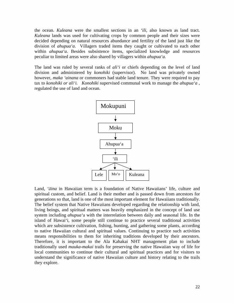
the ocean. Kuleana were the smallest sections in an ‘ili, also known as land tract. Kuleana lands was used for cultivating crops by common people and their sizes were decided depending on natural resources abundance and fertility of the land just like the division of ahupua‘a. Villagers traded items they caught or cultivated to each other within ahupua‘a. Besides subsistence items, specialized knowledge and resources peculiar to limited areas were also shared by villagers within ahupua‘a. The land was ruled by several ranks of ali‘i or chiefs depending on the level of land division and administered by konohiki (supervisor). No land was privately owned however, maka ‘ainana or commoners had stable land tenure. They were required to pay tax to konohiki or ali‘i. Konohiki supervised communal work to manage the ahupua‘a , regulated the use of land and ocean.
Mokupuni Moku
Ahupua‘a ‘ili
Lele
Kuleana Mo’o
Land, ‘āina in Hawaiian term is a foundation of Native Hawaiians’ life, culture and spiritual custom, and belief. Land is their mother and is passed down from ancestors for generations so that, land is one of the most important element for Hawaiians traditionally. The belief system that Native Hawaiians developed regarding the relationship with land, living beings, and spiritual matters was heavily emphasized in the concept of land use system including ahupua‘a with the interrelation between daily and seasonal life. In the island of Hawai‘i, some people still continue to practice several traditional activities which are subsistence cultivation, fishing, hunting, and gathering some plants, according to native Hawaiian cultural and spiritual values. Continuing to practice such activities means responsibilities to them for inheriting traditions developed by their ancestors. Therefore, it is important to the Ala Kahakai NHT management plan to include traditionally used mauka-makai trails for preserving the native Hawaiian way of life for local communities to continue their cultural and spiritual practices and for visitors to understand the significance of native Hawaiian culture and history relating to the trails they explore.
22

Different from today’s land use what divide land into parcels, the ancient Hawaiian land use system views the entire ahupua‘a as a whole and manage all subdivisions of ahupua‘a and their resources (forests, streams, plantations, fishponds, and ocean) relate and rely on each other. This unique idea could be helpful for considering today’s land use. To adopt the idea of managing the large area from the mountainous area to the ocean as a whole, we could find different solutions for environmental management which we could not have been found out in western and modern way of land management. Furthermore, for the economic development, we can find multiple resources by exploring ahupua‘a easier than looking at small parcels. Because ahupua‘a system is ancient Hawaiian way of land use, this idea was based on Hawaiian culture and indigenous religion and was kept up dated by generations. Moreover, according to Burrows edited by Minerbi, McGregor and Matsuoka, Hawaiian people managed land practicing several conservation values which are Mana‘o‘i‘o (faith, respect for nature), Kapu and noa (sacred and profane), Ike (knowledge), ‘Aina (that which feeds), Lōkāhi (unity, balance, harmony), Mālama ‘Aina (caring for the land) (in Minerbi, McGregor and Matsuoka (eds.) 1993:93-94). Therefore the ancient Hawaiian way of land management should be suitable for Hawai‘i’s land even today. Some Native Hawaiians still practice their tradition and culture so that adopting ahupua‘a system to today’s land management would be reasonable for them and even though some Native Hawaiians who live in modern way, the Hawaiian way of managing land might be still sound familiar. For non Hawaiians, even though they do not believe in Hawaiian indigenous religion, Hawaiian way of managing land should be worth to follow. For Ahupua‘a system, the elders’ knowledge is important. Hawaiian people respect the elders for their wisdom. It is also important to pass their knowledge, tradition, and culture onto children. Therefore, adopting ahupua‘a system could activate the bond between generations, and the community. 2.2 Literature Review of Ahupua`a In Modern Land Use There are several literatures which study ahupua‘a system for land use in modern society. We will review “Ahupua’‘a Planning Guidelines” by Michael L. Donoho, Indigenous Management Models and Protection of the Ahupua‘a” by Minerbi. Donoho’s work studies ahupua‘a planning as the solution to address environmental problems which are water quality and availability preservation, effects of non-native species, and responsibility of environmental maintenance; to address social problems which are lack of involvement, generational disconnection, and poverty; to create a –range community-based vision; and to create plans and visions for culturally-appropriate, multi ethnic communities. These problems, trends of communities are serious in today’s Hawai‘i. Donoho evaluates the concept of ahupua’a that “holistic, meaning all encompassing; it is about sustainability, about economics, politics, the natural and social environment, and yes, it still must address spirituality” (Donoho, 2001, p.10). Donoho also argues that ahupua‘a planning approach is applicable not only to Hawai‘i that are facing similar environmental and social aspects to Hawai‘i (Donoho, 2001, p.10).
23

Donoho pursues ahupua‘a planning by using three planning principles which are spiritual, physical, and social (Donoho, 2001, p.33). This approach might be applicable to Ala Kahakai NHT management. For the guideline of ahupua‘a planning, Donoho concerns several significant aspects which are sacred site preservation, cultural awareness and perpetuation, mālama kupuna (taking care of the elderly), sense of place, mālama ‘āina (taking care of land) sense of ‘ohana, and sense of makahiki (time). These aspects are not focused in modern society but are quite important to Hawaiian culture so that we should also be sensitive to these aspects when we plan the Ala Kahakai NHT management. Minerbi’s work addresses Hawaiian modern management models which based on the ahupua‘a concept. Minerbi introduces the ahupua‘a -based plan for ‘Ualapu‘e on Moloka‘i what pursues community based economic development with subsistence fishing and aquaculture by utilizing fishponds. Moloka‘i was known by its rich subsistence resources but because of wrong use of land such as mono-crop agriculture, inappropriate development, and ranching introduced by off-shore people. Minerbi argues that “community-wide acceptance of traditional Hawaiian subsistence values and practices key to restoring balance” (Minerbi, 1998, p.215). Therefore, the Ala Kahakai NHT management should concern subsistence values for keeping the balance of the environment. Finally in the conclusion, Minerbi comments on adopting ahupua‘a concept for environmental protection that “more protection can be achieved with Hawaiian conservation values and planning ideas based on the integration of traditional ahupua‘a district planning with modern watershed and ecological planning” (Minerbi, 1998, p. 222) as Minerbi argues, collaboration of traditional and modern ideas will be effective to the Ala Kahakai NHT management.
24

CHAPTER THREE: ORAL HISTORY 3.1 Introduction Oral history involves interviewing a person or group to get an inside perspective into what it was like to live in a particular time or is like to live as the member of a particular group within a society. To trace the course of traditional land use and land tenure in north and south Kohala, Hawai‘i Island, this section is intended to show how oral interviews from Kohala residents view the historical landscape, wahi pana (sacred places), traditions changing steadily, and their experiences. This report will also examine three levels of interpreting their oral stories. First, the literal stories that is most common or known to the average person. Second, the figurative story whereby Native Hawaiian people used metaphors associated with the Hawaiian language. Third, the kaona, the inner meaning or sacred meaning that may be family genealogies. (Pukui, 1949) The following will be explored throughout this report to provide a linkage between the oral stories and the historic trails of Kohala:
Review interview data collected Provide illustrations relating to the interview process Use the raw material of the interview to address the areas
affected Determine story places most helpful to the Ala Kahakai
Historic Trail Present cultural and traditional values Recommend creating a data base and web page
The history of the Native Hawaiian culture was shared orally. It was passed down from one generation to the next, an unwritten language or oral literature. For instance, they recited their genealogies committed to memory and lengthy chants that related to the beginning of the Hawaiian people known as the Kumulipo. Missionaries told of local history with no particular finish---but with great attention to details as they told the history of surrounding communities, landscapes, and daily activities. They demonstrated the way in which this history has been kept alive. Ancient charts, legends, chants, hula, mythological stories, songs, and genealogies have been kept alive to this day.
It is through sacred stories or mo‘olelo, that the values of the po‘e kahiko (people who dwelt in the past, pre-Western contact) are revealed. These tales often incorporate historical accounts and imbue the protagonists (and antagonists) with supernatural abilities. Embedded within these mo‘olelo are the epistemological (relating to knowing) and ontological (relating to being) values of the kānaka maoli. These values serve to reinforce forbidden and correct behaviors. Their importance to modern society is that they often act as windows into time, and if understood, can provide valuable information in recreating a true “sense of place.” (PDPP, 2005) The district or moku, of Kohala, is the northernmost and one of the most geographically isolated districts on Hawai‘i Island. It clearly illustrated the natural resource
25

management system of the Native Hawaiian people that took place throughout the Hawaiian Islands following the first major contact with Westerners in 1775. Both historically and culturally, Kohala was the most important district in Hawai‘i, due to its central role as a seat of power for Hawaiian ali‘i nui (high chief) and a significant population center for over a thousand year period. (http://www.hawaii.gov/dbedt/czm/todays_challenges/challenges.html)
The oral landscape history is one of the ways to interpret the historic land use that have cultural significances in Kohala. It was a center of religious and political power. The first heiau (temple) was built in 900 AD and by 500 AD every island was occupied. These heiau were used to worship Ku and Lono, their principal gods. By 1200 AD, the Tahitian explorers arrived where the Tahitian Priest, Pa‘ao started the “kahuna nui or high priest line that initiated a ruling King for each island. (Malo, 1951) From Tahiti, he brought Pili, the father of the royal line leading to King Kamehameha the Great who eventually unified the Hawaiian Islands. (http://deephawaii.com) 3.2 Methodology and Oral History Diagram
During the week of October 28 through November 1, some taped interviews were made available and some interviews of Kohala residents were conducted. The following diagram illustrates the methods used for interviewing the residents with tape recorders, transcribing their stories and mana‘o (thoughts) to collecting the data. These few simple steps were vital to analyzing their stories relating to the historical landscape and the changes in Kohala. These stories can then lead to mapping the places that reflected the stories that were told by the interviewees, activities, special events and land uses before and after the Kohala sugar plantation. Eventually, many of their stories could be tabled, categorized as remembrances of this region, and organized by themes, specific geographic areas, historic significance and trails related along the shoreline and mauka. (mountain) Downloading this new data to various websites such as http://www.pacificworld.com or http://www.hawaii.ed/environment/ainakumuwai/html could also expand on new websites with the information for north and south Kohala as displayed later in this report. ORAL HISTORY DIAGRAM
Personal Interviews
Tape Recording
Place Names
Transcribe
North Kohala
South Kohala
Collected Data
Analyze Synthesis
Mapping Data
Activities Land Uses
Figure 1: Oral History Diagram Illustration (Palama, 2007)
26

The following residents contributed to the oral interviews and shared their mo‘olelo as it was passed down from prior generations. It helped reveal their roles in the community and as individuals that helped shaped their past and how they felt about major life changing events affecting their community, cultural traditions, and what is revealed today.
• William Akau, former Kawaihae Harbor Master and cultural practitioner
• Michael Isaacs, resident and advocate for restoring and preserving Kohala’s cultural traditions, natural resources, and land use
• Clyde Kindy Sproat, resident, musician, and falsetto legend • Armstrong Yamamoto, resident and taro farmer of Kohala • Fred Cachola, resident and cultural practitioner • Grace Kupuka‘a, resident and cultural practitioner • Nani Svendsen, resident and cultural practitioner • Pete Okino, resident and fisherman
A secondary research was conducted at the Bishop Museum and several documents revealed additional historical events, mo‘olelo of the people from Kohala, myths and legends. They were interviewed by Mary Kawena Pukui and Rubellite Kinney. (Pukui, 1955) These stories were told by the following residents of Kohala and Kawaihae:
• Mahealani Lono, Kawaihae resident who was interviewed a week after his 100th birthday
• Albert Nahale‘ā, Kohala resident • Eleanor Williamson, Kohala resident
The need to know who we are reflects the ancient traditions of memorizing genealogical chants, who we are, changes to the landscape and uses is obviously a strong desire to what happened before we got there. In a radio interview, author of Roots, Alex Haley addressed this subject: “We do not exist alone, we all need to know who we are. . . where we come from is part of who we are both genetically and culturally. . None of us is as physically strong without a sense of the past. . .hand in hand with a sense of identity goes a sense of self-worth. Lack of worth is a prime reason for not living up to potential. . . .An orphan is often haunted by a sense of who am I—where did I come from? Africans believed in a spiritual village where ancestors go. We are all part of a line—those who have died, those who live, and those yet to be born.” (Morgan, 1981)
3.3 Kohala’s Legendary Past
North and south Kohala were extremely important in Hawaiian history and culture, an importance that cannot be overemphasized. The Kohala Mountains, the volcanic system that produced Kohala, are geologically the oldest on the Big Island. It is a very sacred place because in one of the mo‘olelo (historical accounts passed down via oral tradition), it is here that Papahanauoku, Mother Earth and Wakea, Father Sky, progenitors of the Hawaiian people lived. It is said that “…it (Pololu) was originally the residence of Oakea
27

and Opapa, Wakea and Papahanaumoku...the god and goddess who made Hawai‘i and all others of this group of islands (Damon, 1927). They mated, and the birthing order of their children is as follows: Hawai‘i Island, Maui Island, and then a daughter called Ho‘ohokulani (translated as “to place the stars in the heavens). At this point, Papa leaves for a trip to Tahiti and in her absence, Wākea has Lāna‘i with a woman named Ka‘ula, and fathers Moloka‘i with the powerful female deity Hina. Papa returns from Tahiti and, after learning of Wākea’s adventures, has a child with a man named Lua, and thus O‘ahu is born. The two lovers then reunite and have Kaua‘i. (Kame`eleihiwa, 1992) It is Hāloa who begins the great chiefly lineage that was to rule the pae moku o Hawai‘I (the Hawaiian archipelago) until the fall of the Hawaiian Monarchy in 1893. During the leadership in Kohala, it was an inherited right like a birth right within the ali‘i class and competition between districts was largely a matter of consolidating or asserting the power of a particular lineage. Many of Hawaii’s greatest ali‘i came from the Kohala region including Alapa‘inui, Kalaniopu‘u, and notably, the Lonely One, King Kamehameha, the Great who was born in Koko‘iki.
When Kamehameha launched his historic assault on the island chain in 1790, he did so from the shores of Kawaihae with thousands of Kohala warriors in his ranks. Kohala was Kamehameha’s homeland and his legacy is a significant part of this district’s history. The land of I‘ole was Kamehameha’s favorite taro patches. As the king, it was customary to keep part of the land for his own personal use and enjoyment and give part to the principal chiefs under him. The chiefs in turn gave the land to their retainers and a
regular hierarchy was thereby established. Possession of the land carried with it the right to fish, riparian (water) rights, use of forest products, farming, and animal husbandry. All the land, save that of the king was held be revocable tenure and dispossession was in fact not uncommon. (Stephenson, 1977) The waters of I‘ole was abundance and the principal factor in the richness of the taro lands. The water source is known as the Kamehameha Spring. (Stephenson, 1977)
In north Kohala, the prevailing winds keeps the windward side very cool. Occasionally, this district is subject to heavy rainfall and high-speed winds that have been damaging to agriculture. There are also many historical landmarks. The most significant is the birth of Kamehameha I who was born near Kokoiki near the Mo‘okini Heiau about 1750. Following his death, Kohala and the entire Hawaiian kingdom changed. It was in 1823 that the arrival of the first Protestant Missionaries appeared on Hawai‘i Island under the leadership of Reverend William Ellis who was to assess the prospects for establishing missions posts in various areas of the island. (Morgan, 1981) On June 26, 1841, the young Reverend Elias Bond and his wife Ellen Howell Bond were assigned to the Kohala station on Hawai‘i Island. This new western culture would have a drastic impact on the native population, the natural resources, traditions, and their culture.
28

Since 1847, the upper or mauka portions of south Kohala have been a major ranching operation when John Parker received one of the first land grants from the Hawaiian monarchy. From the modest start of two acres granted under Royal Grant No. 7 from Kamehameha III, the present-day Parker Ranch encompasses over 250,000 acres operated in both fee and leased lands throughout the Hawai‘i Island. The climate varies from the dry, arid Kawaihae area to the rain forests of the Kohala mountains. The nearby community of Waimea has long been a summer vacation for local residents and visitors who are attracted to the cool weather but also by the rustic ranching lifestyle. (KCD, 1976) 3.4 Their Legends & Mo‘olelo Passed Down
There are numerous mythological associations, legends, and mo‘olelo indicative of Kohala’s importance in Hawaiian history and culture. How did the Hawaiians manage to continue to tell their stories and many? Why was it so important to pass these stories down to the next generation? What were these stories like in real life to the chiefs, kahuna, the kings, and the people? Through traditional oral history are we able to piece together a brief glimpse of what life may have been like in Kohala. There still remains a wealth of traditions that have been passed down through oral history to some of the island’s existing ohana.
These stories and legends were shared with families and friends. One of these stories by Clyde “Kindy” Sproat was Makapala, eyes the color of ripened fruit, reddish-yellow. It is said that when the infant, Kamehameha I was born, Alapai sent his warriors in search of the infant. Their eyes were so swollen and blood shot while they were searching for days and days without sleep that they still couldn’t find the infant Kamehameha and his guardian, Nae‘ole. (Sproat, 2004) For the “eyes the color of ripened fruit, reddish yellow” is the kaona for ridiculing the appearance of the eyes of Alapai’s warriors. (Sproat, Oral interview 2004)
Auwai in the upland
The traditional management system was distinguished by feedback, interconnection, natural balance, and “a spiritual system”. In Marion Kelly’s report, she characterizes functional pattern of land division of the ahupua‘a: 1. Various resources of the land and sea within the boundaries; 2. Food surplus for ali‘i’s by cultivation plot and labor; 3. Planters not tied to a particular ahupua‘a or ali‘i.
29

These resources were considered gifts from the gods, and neglect or unsustainable use could exact retribution from those gods (Kelly 1997). It was a system of spiritual environment, where akua or gods and familial aumakua or deities manifested in nature as physical forms, or kinolau. Because gods manifest in nature, and humans can manifest into gods, a circle is complete between nature, humanity, and divinity. (Herman: 1995).
Photo of Kawaihae Mahelani Lono, a long time resident of Kawaihae shared his story about paying respect and homage
to the familial deity (aumakua), the manō (shark) at Hale O Kapuni heiau at Pelekane Bay, Kawaihae. In the days of old, there were many sharks in Pelekane Bay who were fed decomposed human flesh left-over from a sacrificial ceremony at the heiau. The corpse was soaked in the sea and the sharks would gather. This was to pay homage to manō, the aumakua of the sea. He tells of another story about the mischievous shark man of Waipi‘o Valley where the people could not see the shark mouth on his back because it was hidden by tapa cloth. One day as the people came down from the upland to go swimming and the shark man called out, “where are you folks going?” We are going swimming said the chief. The shark answered, “This is a bad day to go swimming lest you go, head and tail into the shark.” For when the shark bit, he bit off the feet and the head and left the body. This is how they were eaten. This angered the chief. He prepared a net made of natural fibers with wauke where he caught the shark. Source: http://www.deephawaii.com
The chief and his people cut the shark into pieces. Later, a piece of the shark gained life again because it was picked up a dog and carried out to sea. The shark dwells in Kohala at a gulch called Pau‘ewalu.”
Here, fishermen fished at night with torches. One night, one of the men jumped along the shoreline with his torch, when he turned, he fell down into the water. A shark had kicked him with his tail. Another man fell and he was eaten by this shark. Eight men were consumed by this shark and this is why this place is called Pau‘ewalu (pau: finish/ended/complete ‘ewalu: eight). (Lono, 1955) Source: Voyaging Society
30

Perspectives on the Landscape During the 110 years of the Kohala Sugar Plantation, many workers lost their jobs and relocated from plantation camps near the mills to more accessible areas. There were many changes affecting people’s lifestyle in Kohala: before the plantation, during the plantation, and after the closing of the Kohala Sugar Plantation in 1975. Stories about the changes to the landscape, diversion of water, dried up streams, and ocean access told of a disconnection from the place. Where and what happened to our sense of place?
• Pete Okino, a long time resident of Kohala and fishermen would lay his fish net 300 feet x 20 feet in Puakō to feed his family. After the closing of the plantation, hotels were built along the shoreline and no longer accessible. The plantation mentality affected many families in Kohala especially the men. Many of the women were hired at the hotel resorts while men who were jobless, stayed at home with the children. The roles were reversed. (Okino, Oral interview 2004)
• Fred Cachola, cultural practitioner and long time resident of Kohala talks about the sacred sites or wahipana in Kohala that were destroyed by the plantation workers and have not been paid attention to. Preparing an inventory, the types of sacred sites, archeological sites, a management plan and pass laws to protect these sacred sites throughout Hawai‘i. These sacred sits on the land should not be for sale and put into a community trust and develop criteria for land owners in Kohala. Preserve the culture, its history, and landscape. (Cachola, Oral interview 2004)
• Mike Isaacs, resident and advocate for restoring and preserving Kohala’s
about the desecration of a sacred site: Heiau of Kukuipahu that was built out of quarried red stone. Later, the plantation workers took the cinders from the heiau to patch the potholes. Paniolos took some these stones from the heiau for stables at Puakea Ranch. Parker Ranch was a gated community. Some of these stones were quarried at Puu‘ula. There were images of the manō, pue‘o and a structure that looked like a Marquesan or Tahitian style (marae) with a raised platform. There was a petroglyph of a honu and possibly a mo‘o. It was very special but now it’s all gone. The Hawaiians were the first real and only true naturalist and conservationists because they knew to not over tax the systems and that nature allowed them to stay within the parameters and they were successful. (Isaacs, Oral interview 2004)
• William Akau, former Kawaihae Harbor Master and cultural practitioner and in his late 80’s Papa Akau begin to talk about the five ahupua‘a of south Kohala. He spoke of Kawaihae 1, Kawaihae 2, Hou‘uli, Lalamilo, and Waikaloa. These were big ahupua‘a that ran from 8,000 acres to about 90,000 acres. Each ahupua‘a had a konohiki or chief in charge of those who live within that area. Looking at the old map of 1885 by Lyons
31

that illustrates the ahupua‘a. In ancient times, like Honakoa Gulch, this ahupua‘a is not ancient ahupua‘a but they became ahupua‘a when Kamehameha III and the Great Mahele period started. The leaders decided to kalai‘aina (politics, political, lit. land carving) these lands and started these really small divisions of ‘ili. The trails ran from mauka-makai from Kawaihae up to Huhui and Makuhuna and then it gets cut off. These gulches were deep and the people couldn’t cross this portion of the gulch. Instead, they is the way to go and trail started from Kohala to Pu‘u Hui and connected to where this was a main trail. The people of the North Kohala ahupua‘a would live along shoreline and then go up mauka for farming. This is why you see a mauka-makai trail in every other ahupua‘a. The people followed the contour of the land on a slant angle and straight up and down. The bottom trail was called Ala Loa, the road that go right around and Ala Hele was called mauka-makai. When traveling on the Ala Hele and need to go mauka, you would use the Ala Loa. (Akau, Oral interview 2004)
3.5 Cultural Sites and Practices According to several interviewees, many of them used a moon or seasonal calendar to help with their fishing season, planting season, and getting to know the blessings of akua. During the fishing season, they would not go outside of an area or else it was considered a‘ole, meaing you won’t catch anything, zero. The clouds, sky, moon, star position, and winds had its purpose with the people and the land. The Hawaiians knew the seasons, respect and followed its rhythm. (Oral interviews, 2004) There was intensive kalo cultivation that occurred on the wet windward side of Kohala, also called Kohala Iloko, or Inner Kohala, where the reliably well watered deep valleys and gulches provided ideal conditions for year-round wet taro cultivations. The kula or upland regions, with dependable rains and mists, offer themselves to dry land kalo and mixed Hawaiian Garden cultivation. Areas such as Kohala Iwaho or outer Kohala did not have these desirable conditions, so the basic agricultural plants were dry land kalo and ‘uala or sweet potatoes, sugar cane, yams, gourds, bananas ki and wauke or paper mulberry, the source of kapa. (Kelly, 1956; Kirch, 1985, Schweitzer, 2003) Despite the western pressures, the traditional system persisted until plantations took over, and in some remote areas well into the 20th century at Pololū and Waia‘a Puka. However, the sugarcane plantation had changed the cultural integrity of the landscape in Kohala by dragging anchor chains across the landscape and removing the markers that defined those boundaries prior to modern surveying devices. The North Kohala Coastal Cultural Resource & Heritage Landscape Study (DURP 2005) reported that can trash was showed into the gulches near the coast, and when it got high enough, the plantation set off dynamites in the pile and blasted it out to sea. This abusive practice had significant impacts on marine resources and the coastal ecosystem. During the interviews, several residents mentioned that at one time stream life had been much more abundant and streams healthier, before the Kohala ditch started diverting the stream flows from the
32

upper watershed. Attempts to restore the minimum stream flow through a lawsuit in the 1990’s by the Nature Conservancy did not get much support from the stakeholders in the district. Preservation and Restoration of Kohala
Hawai‘i have strong historic preservation laws as well as commitment to a meaningful involvement of the Native Hawaiian community in the management of cultural resources. Community planning for the protection and interpretation of the Ala Kahakai Historic Trail Systems present a partnership of opportunities throughout the governmental agencies and private land owners. Their historic properties and features are associated with the historic trails and contribute to its significance. It also offers archeological potential as well as scenic beauty. Kohala have preserved many of its cultural sites, buildings, residences, as well as sacred sites leaving a
Source: http://www.deephawaii.com legacy for the future generations. In addition to preservation and restoration, education and information are equally important for newcomers to Hawai‘i Island. Many cultural sites are being visited daily by both tourists and residents throughout the state of Hawai‘i. Currently, there are no buffer zones with vegetation, rock walls, or signage that informs the visitors these sacred sites are to be treated with reverence and respect. Due to the lack of protection by government agencies, many sites are overlooked by the visiting community. Some of these sites are under the jurisdiction of the National Park Services, Honaunau National Park. As our practicum team visited this area and noticed there were many tourists lying on the beach with their towels and personal items on the heiau wall. Others were mounting the wall and climbing over rocks to take photographs. These behaviors are inappropriate and not pono (right). There should be secured barriers similar to Pu‘u Kohola Heiau in Kawaihae. While these tables list those sites in north and south Kohala that have been preserved and restored, other sites equally deserve the same listing.
33

Site Tax Map Key Ahupua‘a or Region HI Register NAT’L.Register Kohala District Court 5-4-05:1 Honopueo X X Tong Wo Society Bldg 5-3-08:20 Halawa X X Bond District 5-30-05:4,5,17,
19,20, 26, 27 Iole X X
Nanbu Hotel/Holy Bakery
5-4-05:22 Honopueo X
Union Mill Mgr. Residence
5-4-10:58, 59 Puehuehu-Laaumama X
Mo‘okini Heiau 5-5-05:20 Puuepa X X Kohala Pilgrim Church 5-5-15:25 Pahoa X
James Hind Residence 5-5-15:35 Hawi X X Hashimoto House 5-5-15:38 Hawi X Hawi Plantation Mgr. Res.
5-5-15:41 Hawi X
Heiau in Kukuipau 5-6-01:75 Kukuipahu X X Habitation Complex 5-7-01:21 Paoo X Vauyit Complex 5-7-01:21 Paoo X Makeanehu complex 5-8-01:12 Makeanehu X Habitation and Burial 5-8-01:12 Makeanehu X Possible Heiau 5-8-01:13 Kehena X Lapakahi Complex (District complex with Multiple sites)
Various Lapakahi X X
Source: Historic Sites: District of North Kohala, Hawaii County General Planning Site Tax Map Key Ahupua‘a or Region HI Register NAT’L.Register Pu‘ukohola Heiau Nat’l. Historic Park w/multiple sites
6-2-20:9,10,16 Kawaihae X
‘Imiola 6-5-04:4 Waikoloa X X Old Lindsey House 6-5-06:42 Lalamilo X Ala Loa Foot Trail (southern Kohala northern Kona District)
Portions of 6-8-1:32-35;6-8-22:32; 6-9-01:15, 6-9-07;7-1-03:22
Kiholo-Puako Trail Various Various X X Puako Petroglyph Archeo-logical District
6-9-01:15 Lalamilo X X
Source: Historic Sites: District of south Kohala: Hawaii County General Planning
34

Source: Photo courtesy of F. Palama (Sacred Site (hale) at Honaunau National Historic Park
Source: Photo courtesy of F. Palama (Sacred Site (heiau) at Honaunau National Historic Park 3.6 Timeline and Special Events at Kohala The history of Kohala has several characteristics and stages that are reflective of the following.
35

1 Ahupua‘a Traditional & Cultural based Pre-contact
2 Post-Mahele Transitional, adapt to western concept of property of land division
1845-50
3 Monarchy Decline
Kamehameha III dies; 1850-55 Alexander Liholiho is Kamehameha IV
4 Plantation Formed Kohala Sugar Company 1860-80 KSC begins to profit Niuli‘i Mill and Star Mill Plantation opens
5 Monarch of Hawaii dies
Kalakaua dies 1880-85 4 plantation buy out Samuel Wilder & Hawaii Railroad Co.
6 New Hawaii Queen Liliuokalani ousted by revolution.
1890-95 Provisional government formed
7 US Involvement Hawaiian Islands Annexed 8 Plantation
Continues Opening of Union Mill; Kohala Sugar Mill sole plantation in Kohala
1900-30 Halawa Mill closes
9 Pearl Harbor bombed
WWII ends; Kawaihae port opens
1930-60 Bulk sugar trucked to Hilo Terminal
10 Plantation Closed Kohala Sugar Co. closes 1960-80 Real estate boom 11 Cultural Sites Historical landscapes, sacred
site and historic trails threatened
1980-2000
E Mau Na Ala Hele preservation of Hawn. Historical trail system
12 National Park Service
Ala Kahakai National Historic Trail PL: 106-509
Draft EIS for historic trails
Source: Schweitzer, 2003, Morgan, 1981. Since 1912, a statue of King Kamehameha I has honored and protected North Kohala from his position above Akoni Pule Highway above Kapa‘au. On June 11, organizations and individuals pay homage to the king by creating floral or ti lei that are draped over the statue in a traditional ceremony. A celebration of Hawaiian culture will display arts, crafts, exhibits, entertainment and local foods. All events are free, all are invited and it is always on June 11 celebrating Kamehameha Day in North Kohala. (Source: http://www.kamehamehacelebrationday.org) In August of each year, Pu‘u Kohola Heiau hosts the Hawaiian Cultural Festival where visitors and locals experience native customs and traditions. It was built in 1790-1791 by King Kamehameha I and displayed the skills of men, women, and children under his astute leadership. In the 1960’s, Queen Emma Foundation and Queen’s Medical Hospital, civic clubs and organizations were instrumental in getting Pu‘u Kohola Heiau
36

designated as a National Historic Landmark. Through an act of congress on August 17, 1972 and the lands surrounding Pu‘u Kohola Heiau including John Young Homestead, became Pu‘u Kohola Heiau National Historic Site. (Source: http://www.nps.gov/puhe) As the interviewees shared their stories about North Kohala, the following maps described the activities, population, jobs, weather, and landscape of north Kohala. Source: Morgan, 1981
37

Source: Morgan, 1981 Kohala’s Historic Trails Today, Kohala faces a new battle and challenge that has encroached onto its historical landscape: the rapid growth of new comers, new ideas, and buying large parcels of lands. The community has expressed their concerns at government meeting, community and
38

organization gatherings. One of the latest issues is the Ala Kahakai historic Trail Systems headed by the National Park Services. Throughout the public meetings during November 5-10, 2007, the community expressed their concerns whether to access or not to access these historical trails, work towards developing an acceptable management plan, and comment on the draft Environmental Impact Statement. These comments concerned the native Hawaiian population because of the possible impact intensity that could affect the native ecosystems, have measurable effects on species, suitable, potential, or critical habitat resulting in a threatened or endangered situation. The following table reflects the actions that are common to all:
• Trail access: mauka-makai vertical and lateral trails on public and private lands along the shoreline, activities along the trails, manage- ment and monitor activities.
• Cultural impacts to the heritage landscape: trail management, cultural, and natural resource areas still used for subsistence by families in Kohala, traditional gathering, coastal harvesting, water and stream diversions.
• Commercialization: public services along the trails, intrusion from outsiders, no gated communities affecting sacred sites and cultural kipuka or connectors that should not be for sale but protected.
• Deforestation: bulldozing in the uplands destroying sacred sites and walls, road access and cutting up trails…eco-tourism could be destroying the trails rather than saving and preserving it.
• Coastal views: 200 feet buffer inland zone from coastline, protect sacred sites along the Kohala coastline, mark ahupua‘a boundaries, learn Hawaiian ways of management.
• Cultural preservation: preserve Pa‘ao fishing complex and heiau, develop a living cultural park (maintained by the community), protect coast lines and archeological sites. (Kohala, 2004)
Kohala Website Based on earlier stories told by the residents of Kohala, the following tables were developed to produce and end product that is similar to the aforementioned websites: http://www.pacificworlds.com http://www.hawaii.ed/environment/ainakumuwai/html Their stories could provide a connector to what happened to Kohala and how those stories have been passed down from generation to generation. This included: place names, story teller, activities, historic significance, trail related, and location on the map. The importance of this table is to provide quick access to additional stories as told by the story teller but also have the capability to create a webpage designed for these stories of Kohala like that of ‘Āinakumuwai.
39

Place Names Story Teller Activities Historic Significance Trail Map Anaeho‘omalu Fred Cachola People fished for ‘opae Important fish to streams yes yes Haleako Papa Akau Grow taro in gulches Last taro patches grown in
gulch
Hhiwai Mike Issacs Small brackish water fish in streams
Important fish to the streams
Hou‘uli Ahupua‘a
Papa Akau 1 of 5 ahupua‘a in south Kohala
Important ahupua‘a (1 of 5) yes yes
Iholena Gulch Armstrong Yamamoto
Grew red and green striped bananas; sweet
No longer exist
Kalahuipua‘a Fred Cachola Gathering of the pigs; original name of place
Changed to Maunalani for the hotel
yes yes
Kiholo Papa Akau Mauka trail Used by chief to carry Kamehameha to his mother
yes yes
Luahinewai Fred Cachola Name for a mermaid Next to Kiholo where a fresh water pond existed
yes yes
Malaekini Heiau Fred Cachola Women heiau below Pu‘ukohola Heiau
Chant written for the women heiau
yes yes
Mo‘okini Heiau Grace Kupuka‘a Built by Tahitian Priest Pa‘ao 12th century
Luakini temple yes yes
Lapakahi Park Grace Kupuka‘a Harbor landing for the 7 sugar plantations
Harbor built for plantations; state park
yes yes
Mahukona Mike Issacs Kamehameha I naviga-tional heiau;
Kamehameha I birthing stone
yes yes
Punawai Papa Akau Kamehameha I child-hood area
Names of places/events with Kamehameha I
Pu‘ukohola Heiau Fred Cachola Built by Kamehameha I United all the island yes yes Oe‘oe Stream Armstrong
Yamamoto Stream diverted for sugar cane
Small fishes died off
Pu‘uanahulu Fred Cachola Kula lands, dry and very hot area
Good fishing grounds; farmers exchange taro, yams
yes yes
Umiwai Bay Grace Kupuka‘a Waters where the shark god, Kapa‘akeo swam
Water of the shark god yes yes
Kaiholena Papa Akau Water reservoir destroy by sugar plantation
Natural resources for fishes; a pond
yes yes
Figure 2: Oral History Table Illustration (Palama, 2007) As noted with the web pages, each category or theme leads to a story, place of interest, and history. This table is an example of how an additional web page could reflect the stories of our kupuna, preserve our culture and perpetuate our indigenous traditions in Hawai‘i and the Pacific. This website is a rough historical trajectory that stem from the most ancient to the recent contemporary. These guides or themes could introduce the section and familiarize the reader with its content. The home web page layout for Kawaihae and ‘Āinakumuwai is designed for users to access information from the website. However, the difference with the information that these websites provide focuses on indigenous communities in the Pacific, indigenous cultural preservation as well as education. ‘Āinakumuwai website is informative to the Ahupua‘a of Nāwiliwili Bay in Kauai. This website could serve as a template for Kohala whereby it is site specific for that ahupua‘a and their stories could be included to reflect the days of old.
40

Kawaihae Home | Our Guides | Location | Orientation | Getting Here | Credits | Site Map
Hawai‘i-Kawaihae Site Map Choose Location
Source: http://www.pacificworlds.com
41

Home
Site Map Tour Nawiliwili Bay Natural History Ahupua'a Plantation Today Tomorrow
Student Objectives
and Standards
It's time to think about our home.
Teacher's Guide
Credits
Contact the author
• What is special about Nawiliwili Bay? • What was Nawiliwili Bay like before people arrived? • How did Hawaiian settlers use their new home? • What happened when sugar plantations began?
• Why is Nawiliwili Bay one of the most polluted bays in
the state? • What can we do to restore the health of Nawiliwili Bay?
Explore these questions as we tour the ahupua'a of Nawiliwili
Bay.
E Komo Mai!
Tour Nawiliwili Bay / Natural History / Ahupua'a / Plantation / Today / Tomorrow
Created June 2001 Source: http://www.hawaii.ed/environment/ainakumuwai/html
42

CHAPTER FOUR: ECOTOURISM AND TRAIL VOLUNTEER PROGRAMS 4.1 Develop Ecotourism in a Proper Manner for Ala Kahakai National Historical Trail Ecotourism Principles In the past two decades, ecotourism developed fast and becomes an important segment of the travel industry. It is largely different from the conventional resort tourism, especially the popular 3S (sun, sand & sea) tour in the light that it greatly relies on unique natural and cultural resources and more directly benefits local community and small business. According to The International Ecotourism Society (TIES, 2007), ecotourism is “Responsible travel to natural areas that conserves the environment and improves the well-being of local people. Ecotourism is about connecting conservation, communities, and sustainable travel”. The following are the main ecotourism principles advocated by TIES:
• minimize impact • build environmental and cultural awareness and respect • provide positive experiences for both visitors and hosts • provide direct financial benefits for conservation • provide financial benefits and empowerment for local people • raise sensitivity to host countries' political, environmental, and social climate
(Source:http://www.ecotourism.org/webmodules/webarticlesnet/templates/eco_template.aspx?articleid=95&zoneid=2)
Ecotourism also advocates for education and interpretation opportunities. Serious eco-tourists will look for opportunities to learn from nature and get involved in taking care of endangered species and ecological activities (Fotiou, Buhalis & Vereczi, 2002). There are other similar terms such as sustainable tourism, alternative tourism, nature tour, ethnic tour, cultural tourism, geo-tourism, and responsible tourism. They are not quite the same however they do share similar components and they are all reaction to mass tourism and dominating multinational tourism enterprises. Ecotourism Trap However, there exists strong controversy about ecotourism. And in reality, damages to host environment, cultural and social fabrics were observed. Special caution should be taken against “ecotourism trap”. Many tour operators brand themselves as “ecotourism”, but indeed it might be just a marketing strategy. They provide nature tours from hiking, bird/animal watching, kayak, mountain biking to river drifting, but these tours have nothing in common with real ecotourism except that the destination is in natural areas. There is no consultation with local community or environment assessment before launching the tour. There is no
43

connection or interaction with local people. There is little maintenance of trails they use or restoration effort of native ecosystem they enjoy. Some tour operators volunteered to participate in the ecotourism certification program which allows them to use eco logo if they qualify. This gives travelers certain assurance of the tour content. Currently there are international, regional and sub-regional ecotourism certification programs such as STEP, Green Globe 2000, Green Hotel Initiative, Blue Flag, Kiskeya Alternativa, Alianza Verde’s Green Deal, and Smart Voyager. In Hawaii, the Hawaii Ecotourism Association (HEA) has its own certification program too. However it caused consumer confusion as there are over 100 different instruments worldwide offering ecotourism logos and labels. This confusion has led to a lack of consumer demand for certified holidays. Furthermore, less than one per cent of businesses have joined up to these schemes (Synergy, 2000). Efforts were taken to establish clear brand recognition amongst these different programs. In 2000, the Mohonk Agreement was reached among leading tourism certification programs to lay the foundations for creating ecotourism and sustainable tourism certification principles and standards as well as for an international accreditation system to certify certifiers (Maclaren, 2002). For Ala Kahakai National Historical Trail, NPS, community and tour operators could work together and set up certain standards of tour operation to ensure a genuine experience for visitors who care about ecological and cultural environment. Or NPS could encourage tour operators to apply worldly recognized certification, for example, STEP, Green Globe 2000 or HEA Certification. Only those who comply could be endorsed by NPS to offer eco-tours, especially auto tours associated with the trail. NPS, the Trail Association and community should act as watch-dog for tour operation and review tour companies performance periodically. Another ecotourism pitfall is with government agencies. In some places, ecotourism was developed with good intention to fund restoration and preservation. But because of lack of proper management and monitor from agencies, especially lack of carrying capacity control, natural resources suffered from overuses and conflict use, and cultural resources struggle with disrespectful use. Ala Kahakai National Historical Trail will for sure attract increasing number of visitors once segments are open to public. This is because first, NPS is a brand name to travelers as they can expect certain standards of products and services. Second, Hawaii is a world famous destination that receives millions of visitors each year. According to DBEDT’s 2006 Visitor Satisfaction and Activity Report, Kona is famous for historic sites while Hilo visitors were more likely to be on tour bus excursions and enjoy some backpacking, hiking and camping. Rich in beautiful landscapes, native species, significant sites and fascinating stories, Ala Kahakai will appeal to both historical and natural visitors. As visitor number increases, NPS should try to minimize impacts on trails and adjacent areas. Except carrying capacity control to cap visitor numbers and use frequency, certain
44

trail design and maintenance techniques are helpful too. For example: 1. Pay attention to trail slope, surface and alignment and analyze what design can
meet the needs of both visitor and environment conservation; 2. Laying duckboard to protect fragile surface; 3. Provide enough buffer zone along the trail and significant sites 4. Set up trail sings to promote proper visitor behavior. (Source: Obua, 1997. Environmental Impacts of Ecotourism in Kibale National Park, Uganda.)
Indigenous Rights In 2000, at the 8th session of the United Nations Commission on Sustainable Development, guidelines for ecotourism were proposed by a group of Indigenous Peoples Organizations, NGOs and other members of Civil Society. It emphasizes indigenous rights in tourism development.
“Ecotourism is sustainable tourism, which follows clear processes that:
Ensures prior informed participation of all stakeholders;
Ensures equal, effective and active participation of all stakeholders;
Acknowledges Indigenous Peoples communities' rights to say "no" to tourism development - and to be fully informed, effective and active participants in the development of tourism activities within the communities, lands, and territories; and
Promotes processes for Indigenous Peoples and local communities to control and maintain their resources.”
(Source: UNEP. http://www.uneptie.org/pc/tourism/ecotourism/home.htm) This is of special meaning to Native Hawaiian communities. The ancient trails have been used by Native Hawaiians for generations. They used the trail for gathering, to go to their taro fields, to go to the shores, to share and exchange foods, and to travel around the island. And they are still using it now. For Native Hawaiian, the trail is alive and still important for their subsistence living. Lots of historic events happened along the trail and stories still talk about them. Native Hawaiians in the community want to protect historical, cultural, spiritual resources as well as natural resources along the trail. However, they do not necessarily support tourism or recreation development on the trail. Many concern about whether there will be conflicts between native traditional use and recreational use, and also disturbance of sacred sites. Their concerns should be highly respected in any trail and tourism development. And the principles mentioned above should be followed, especially the “no development” rights. When it comes to historical and cultural preservation and perpetuation, a line has to be drawn to restrain tourism development and tourist presence from Native Hawaiian cultural sites, especially the sacred places. Some measures can be put into quick practice
45

and they are adopted commonly around the world. However, if Native Hawaiians are missing from the decision making process, their historical and cultural sites will not be protected properly. For example, a buffer zone could be easily set up around historical and cultural sites so visitors do not climb onto the heiau by accident or out of curiosity, which unfortunately happens all the time (see picture below).
Visitors Climbing Heiau. Source: http://www.sweetmarias.com
When the practicum team went down to the Honaunau Park Beach (NPS), visitors were found sun-bathing and doing picnic right beside a Native heiau and swimming in an ancient fish pond. The inappropriate behaviors show no respect to Native Hawaiian people and their culture. NPS did set up a stone signage in front of the heiau with brief introduction about the importance of it, but it is almost invisible and very hard to read. Therefore it fails to deliver the information to visitors.
This made the team wonder whether National Park Service invites every stakeholder to be involved in the tourism development,
especially whether Native Hawaiians have a say in the process. For Ala Kahakai National Historical Trail, two rounds of public meetings have been conducted and many concerned residents have spoken out at the meetings. This is a good start and set a right tone for any future actions. It is our hope that this momentum will carry on into every step that follows including the detailed site planning stage. Community Concerns Whether ecotourism should be developed or how to develop ecotourism are of great concern to the residents of Kohala. These issues were discussed at the Ala Kahakai Public Meetings. There are several reasons behind that and they reflect current controversy about ecotourism discussed above. The reasons particularly for Kohala area are:
1) Comparing to conventional mass tourism in resort areas, ecotourism attracts more visitors to relatively remote areas where people would like to enjoy their exclusive tranquil life and keep the cultural and natural resources intact. The increasing exposure of fragile cultural and natural resources to visitors could lead to soil erosion, environmental degradation, threats to native species, use conflicts and disturbance to sacred sits;
2) The ownership of ecotourism enterprises might fall in hand of outsiders, who may not necessarily be environment conscious and only use ecotourism as a marketing
46

strategy. Besides, outsiders may not care enough about community and local welfare;
3) There is no urgent incentive to use ecotourism to alleviate poverty or as a source to generate funds for environment conservation. The community is pretty well-off and community activists feel they can preserve the ancient and historical trails even without the National Park Services.
Other Issues in Ecotourism Development Local Ownership One of the most important issues in ecotourism development is how to increase local ownership of tourism enterprises. On one hand, visitors need to be guided to use local products and facilities as possible as they can; on the other hand, entrepreneurship should be nurtured among local communities. The proposed trail association and other non-profit organizations can play a critical role in this. Training course, workshop, guideline in management, marketing, service quality and accounting could be developed and help local community grown business savvy. There is a possibility that some native families are reluctant to start a business as money and profit are not part of their traditional values. But still, there are many other ways they can participate in the ecotourism process. They can be tour guides, exhibition interpreter, site caretaker, cultural instructor, surf coach, or just a short conversation with visitors on their way fishing would add to visitor’s genuine experience of real HAWAII. Creative Marketing Small scale is the key of ecotourism. However this might put small business into disadvantage in terms of marketing leverage. They do not have the financial power as big companies that can afford time and space in conventional media. They will have to promote themselves creatively. One possibility is to join a marketing corporation. In Hawaii, the Hawaii Visitor and Convention Bureau and Big Island Visitor Bureau offer marketing opportunities to their members through their website and other prints. Although they do not specifically differentiate eco-tours from nature tours, they can be a starting point for small ecotourism business. There are other marketing channels in Hawaii, such as visitor magazine, in-room TV and visitor newspaper. One way to utilize these media is to form a marketing entity for ecotourism enterprises associated with the Ala Kahakai, and buy advertisement space collectively and direct viewers to the organization’s website where they can find detailed information about each member so that benefit everybody. To list on the website of Hawaii Ecotourism Association and other ecotourism organization is a good idea too. Website is always an efficient and effective way to promote business nowadays. Most U.S. Visitors (88.6%) used the Internet to help plan their trip. Although lower than U.S. Visitors, there are still about two-thirds of Japanese visitors (62.1%) used the Internet to plan and seek out information. And believe it or not, word of mouth is still important in today’s society, especially for first time visitors. U.S. First-timers relied heavily on the advice of friends and relatives (DBEDT, 2007). Even though it requires more coordination and collaboration between members, a
47

marketing entity will overcome the disadvantage of individual small business, and spread the words out more effectively. More importantly it will help build a brand name for ecotours of the Ala Kahakai, which will become a very valuable asset to each member. Native Trademark A related issue is Native cultural and intellective property rights. And this could be a big deal to the benefits of Native Hawaiians. For American Indian, the Indian Arts and Crafts Act of 1990 prohibits the misleading of marketing to falsely claim an art piece is Indian Made if it is not made by someone who is a member, or certified Indian artisan, of an Indian tribe. It is “illegal to offer or display for sale, or sell any art or craft product in a manner that falsely suggests it is Indian produced, an Indian product, or the product of a particular Indian or Indian Tribe or Indian arts and crafts organization, resident within the United States” (U.S. Department of Interior, 2007). If there is such a law to protect Native Hawaiian cultural and intellective property rights, it could uphold high value of Native Hawaiian arts and crafts and bring in great revenues to Native communities. It will be easier for visitors to understand the differences between a twenty bucks shell necklace using imported shells from other countries and a one made by Native Hawaiian artist using shells from Nihao Island which could worth thousands of dollars. In Hawaii, there are organizations and individuals that are trying to help Native families and communities to establish their own trademark. If this movement gets its momentums, it will get increasing supports from Native Hawaiians, other ethnic groups and purchasers of Hawaiian arts and crafts and eventually lead to a successful establishment of legal protection of Native Hawaiian cultural and intellective property. Visitor Protocol & Codes Another way to address community’s concern is to promote visitor protocol and codes, or responsible tourism. Just like visiting friends’ home, visitors should show respect to the host community, and know what behavior is welcome and what is kapu. Even though most visitors have good heart and intention, but sometimes because of lack of knowledge of host culture and custom, their behaviors are perceived as unacceptable by local communities. As host community, it is important to educate visitors even before they come. And there are lots of opportunities for host communities to do so. Good examples include showing instructional movie on site or on tour buses, sending visitor guide together with tour package from tour companies, setting up signs at the site, or distributing educational brochure at local airports. Lots of organizations are involved in developing and promoting responsible visitor behavior and responsible business operation. The graph below is the Responsible Tourism Code for the Pacific supported and endorsed by the South Pacific Tourism Organization and the Pacific Island Association of NGOs. (Source: http://www.responsibletourism.org.nz/)
48
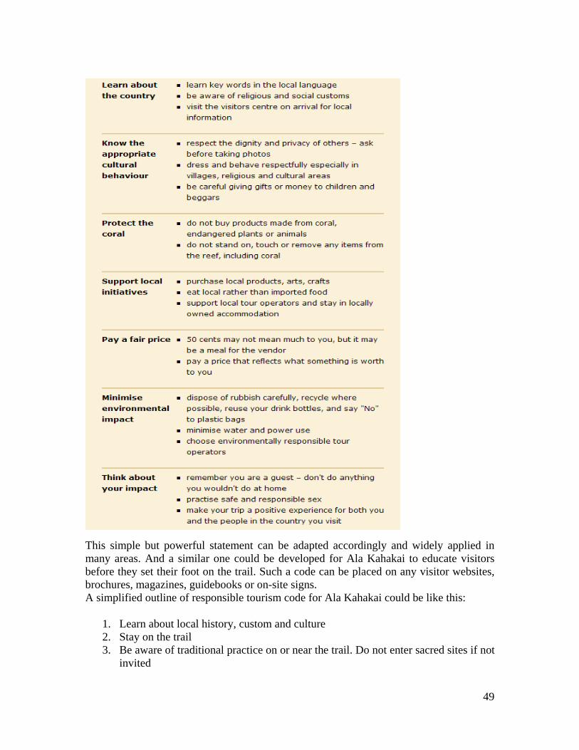
This simple but powerful statement can be adapted accordingly and widely applied in many areas. And a similar one could be developed for Ala Kahakai to educate visitors before they set their foot on the trail. Such a code can be placed on any visitor websites, brochures, magazines, guidebooks or on-site signs. A simplified outline of responsible tourism code for Ala Kahakai could be like this:
1. Learn about local history, custom and culture 2. Stay on the trail 3. Be aware of traditional practice on or near the trail. Do not enter sacred sites if not
invited
49

4. Show respect to historical and cultural sites 5. Do not disturb animals or birds 6. Show Aloha to environment, take away nothing except garbage 7. Support local business 8. Ensure your travel needs provider is environmentally responsible.
Some people may have concerns that a tourism code will scare some visitors away. This is not necessarily true, or Hawaiian residents do no have to necessarily worry about. The state is trying to switch tourism marketing strategies from focusing on quantity to quality. Here “quality” should not be interpreted only as visitors with big money to spend; it should also include visitors who highly respect local and Native history and culture, buy local products, support local communities, and interact well with local and Native people. That is the quality Hawaii tourism industry should seek for. Technology, New technology can help minimize impacts on natural and cultural resources, and at the same time, enhance visitor experience. For example, mobile GPS powered interpretation system will allow self-guided tourists to learn more about the place they visit from point to point. Meanwhile, this new technology can help control numbers of sign necessary that could be intrusive to natural environment. Another example, underwater camcorder video can be broadcast live to visitors near protected marine areas for endangered species. It can satisfy visitor’s curiosity while minimize direct contact, illegal feeding, or other disturbance of marine species. Ecotourism Activities on the Trail Activities that may be appeal to eco-tourists include hiking, camping, mountain biking, horseback riding, sport fishing, whale watching, bird watching, stargazing, full moon walks, school excursion and volunteer tours. All these activities should be carried out abiding ecotourism principles.
Hiking and camping are a very popular activity for eco-tourists. Guide assisted tours can illustrate historical perspectives and offer education about native species. The purpose of the tours being guide assisted is to aid in creating an environment for tourists that is enlightening, safe, and rewarding. The guide can help to minimize the impact on the land, as well as, insure the customers have an enjoyable experience.
The popularity of mountain biking, especially in natural setting, has increased
steadily since its inception in the 1970’s. Canada, New Zealand, U.S. and Australia are among the several international tourist destinations offering mountain biking as a nature-based activity through guided or unguided tours (Goeft & Alder, 2001). Caution should be taken as mountain biking is likely to cause environment degradation. The common cited impacts are soil compaction, erosion, trail widening and vegetation disturbance (Goeft & Alder, 2001). Therefore not very segment of Ala Kahakai is suitable for mountain
50
biking, and special attention should be given to appropriate trail siting, design and management.
Horseback riding is another popular activity among tourists. To minimize
environmental impact and soil erosion, it is important not to use one single trail too much and to have the ability to vary routes. In addition, knowledgeable local guides who can interpret the history, ecology and geology of Ala Kahakai are essential to the success of the activity.
Ala Kahakai is an open classroom for Hawaiian nature, culture, history,
ecology and geology. There are lots of opportunities for school trips. NPS and the trail association could work with schools from Hawaii and even abroad to set up interesting and educational programs for kids. The closer they are to nature, the more likely they will practice good stewardship of the land and culture in life later.
Every year, many Americans spend their vacation time on some volunteer
activities. This form of travel is getting popular and popular. It covers from teaching, nursing, restoration to park services. Even though most of volunteer travelers go to the developing countries, there is an opportunity to attract them to travel to Hawaii and to do volunteer work in national parks, including restore tails, clean beaches and plant native plants. This type of tour will be especially appealing to people who have come to Hawaii before and love the land and culture here. This will give them a good opportunity to give back to the place they really enjoy. It is a win-win game.
51

4.2 Case Study on Successful Trail Volunteer Program
"Build the Trail in the community and then build the community into the Trail." -- Baltimore & Annapolis Trails Maintenance Philosophy
In the Ala Kahakai National Historical Trail Comprehensive Management Plan, a trail association is proposed to play an important role in trail management, such as fund raising, community outreach, networking and capacity building. In U.S., hiking trail associations are essential to the success of trail management. The association comes into being because there is need from the hiker community. The hikers want to give something back to the community and the environment. They want to exchange trail information, hiking stories or hiking photos. They want to know more about the trail and the place they visit. A trail association is an organization that works for the hiker community and many other people who have connection with the trail. When the association grows to its full function, it can help the trail authority with varied aspects of the trail management. The key members of trail association usually start volunteering their time without any compensation until the membership is strong enough to afford paid employees. That will enable the staff focus on their work and help the association grow stronger. The donated hours and work from volunteers are just great resources that can be utilized to do something great. The belonging to a community and the sense of accomplishment keep volunteers’ spirit high. As mentioned by Aric Arakaki, the superintendent of Ala Kahakai NHT, the key is to connect communities and families to the trail. Below we will present a case study of a successful trail association and a couple of successful volunteer projects in U.S. Washington Trail Association Washington Trail Association (WTA) is a very active trail organization in the State of Washington. It promotes hiking as a way to connect with nature and wildness and a way to live healthy and fun life. They lead the volunteer programs in the nation with over 77,000 hours of volunteer service. They lobby for trail funds, develop membership, share information, educate public, create new trails and nature young hikers. There are many things on their accomplishment list. WTA first started with a grassroots trail magazine-Signpost in 1966 for hikers to share their backcountry adventures and trail conditions. It evolved into Washington Trails Association, a community of hikers speaking out for trails and wildlands. In 1993, WTA launched its volunteer trail maintenance program to help out fund-shorted parks. Even though the first year volunteers only contributed 250 hours of trail work on National Parks and Forest trails, the program grew fast, and attracted 1,700 volunteers contributing 77,000 hours of service in 2006. In 1995, WTA set up a dynamic website with viewers contributing content including trip report, trail guides and photographs.
52

In WTA, they call the volunteer work “Trail Work Party”. Efforts are taken to make it a fun and rewarding experience for volunteers and the arrangement is very encouraging for people with no trail maintenance experience. “Trail Work Party” provides incentives for volunteers. Below shows how WTA’s Perk System works: Work Party Perks: First work party: Get your free One-day Northwest Forest Pass Second work party: Earn your free Annual Northwest Park Pass Fifth work party: Get your own personalized WTA hard hat Twenty-fifth work party: REI fleece vest embroidered with WTA logo & "Trail Crew" However, it seems what works is not just the incentive system, but the sense of a community that connecting people with similar interests and are committed to maintain high quality hiking experience for all. Over the past decade, WTA has added to its program week-long Volunteer Vacations, youth trail maintenance for high school students, and expanded regionally to host trail maintenance work parties throughout the Cascades and Olympics. Every summer WTA hosts several week-long work parties called Volunteer Vacations. Volunteers join WTA for a week of volunteer trail maintenance with enough extra time enjoying the site they are helping. Volunteer Vacations is programmed to encourage longer stay in the season. Volunteers pay $125 for the first week for camping lodging facility and food, but only have to pay $50 for the second and any subsequent trips after that. During the one week vacation time, volunteers help rebuilding tread, installing drainage structures and other tasks. The association tries to match different ability with different level of work. And they have a difficulty rating system that helps volunteers to choose from.
WTA Work Party
WTA Volunteer Vacation Difficulty Rating System: Car camp – We will stay at a campsite close to the trail head. Easy – A 1-3 mile hike to camp with little elevation gain. Moderate – A 3-5 mile hike to camp with 500-1,000 feet elevation gain. Difficult – A 5-8 mile hike to camp with 1,000-2,000 feet elevation gain. Strenuous – A 4+ mile hike to camp with 2,000+ elevation gain.
53

A similar but more education oriented program is host for high school students. Young people come and learn everything about trail maintenance, experience teamwork building and exercise their leadership skills. With the youth program, a brand new trail was added to the area. Although it took the youth program four years to complete the trail, it is really something for all the young volunteers to be proud of. WTA maintains a comprehensive donor system with options to meet different donor’s needs. Combined with membership dues, it enables WTA to accomplish many creative programs and develop itself. WTA Youth Program
WTA offers a successful model of how trail association can connect people to trails through member services and programs. Behind the scene are dedicated staff members who should get credits for the success of the association. Application to Ala Kahakai: WTA channels its energy on physical trail maintenance, and its volunteer programs and lobby activities are centered on that. For the Ala Kahakai National Historical Trail, it has so much more to offer, from fascinating Hawaiian history to unique geological features, from culture practice to spiritual connection, from magnificent view to fish in the ponds to feed families. It is not just a trail to experience nature wonders, it is a trail of history, a trail of stories, a trail for people’s everyday living, and a trail connecting past, present and future. For this reason, Ala Kahakai Trail Association is endowed with rich resources to design more creative programs that can connect people and visiting friends with the trail. Below is a case study of a high school trail project in Hancock City, Michigan. Students in this case took full responsibilities to create a new trail and were able to include the trail project as part of their curricular. Terrace Park Walking Trail
Students working on the trail
Under the supervision of their geography teacher Cathy Hill, high school students from B.R.I.D.G.E. Alternative High School got a Service Learning grant and designed and built a walking trail in the Terrace Park for their city. Students put lots of enthusiasm, efforts and many hours on the trail. They first went to the park and marked the trail on a map using GPS. Then they began to clear the trail. Students did all the lay out and design while the city provides all the materials and utensils. Students came up with some very nice design. The trail starts with a few steps up a small steep hill; it crosses a creek, where the students have built two bridges; it then circles around and returns to the far end of the park. When people in the community come and use the trail, they all enjoy it and are amazed how much volunteer work can accomplish.
54

People hiking on the trail
Entrance sign designed by students
Students themselves also enjoyed the pleasure of putting what they have learnt at school into practice. The project has involved math, geography, history, finance, science and a lot more. Students need to calculate the cubic yardage on their wood chips and gravel. They need to make budget and watch the spending. They need to draw the trail on a map. They need to study the location in terms of geographic feature and environment. They got to learn what makes a safe and fun trail, and also provide
educational experience. The students and the teacher were planning to continue their volunteer work at the time when
the trail was open to the public. They decided to study the history of the park as well as plants and trees so that they can set up interpretive signs along the trail in the second phase. This case shows how great a school trail project can benefit both community and the students. Given trust and responsibilities, high school students can accomplish a lot in the fields. National Parks can harness this kind of energy of young people and create more opportunities for students, which will help build closer relationships with the community.
Application to Ala Kahakai: Imagine if students on the Big Island get supports from NPS and get assigned a segment of trail for them to work on, it will intriguer their interests in learning everything about the historic trail – Hawaiian history, native culture, geography and geology, environment and ecosystem, trail design and construction, just name a few. Even though for a long trail, unification in signs and facilities is
important to avoid confusing, some flexibility could be allowed for this experimental segment. This type of
project will really connect students and the community with the trail. Adopt-A-Trail / Hanai a Trail Program Trail maintenance will be very onus work for trail authorities if there is no help from volunteers. When a trail is adopted, the adopter will perform basic maintenance tasks which include cleaning out existing drainage and trail clearing. Adopters are basically on their own when it comes to when and how to work as long as they meet certain standards. However, trail adoption does not involve ownership transfer from trail authority to volunteers nor does it mean that trail authority will totally shoulder off their monitor, support and supervise responsibility. The beauty of Adopt-A-Trail (AAT) is its flexibility for adopters and hands-off for trail authority in terms of routine maintenance. Usually within the trail authority’s jurisdiction, the adopter has the freedom to choose any segment that they either enjoy very much or have easier access, of course, if it is still available. An adopter could be one person, or could be a representative of a family, a
55

church group, a company or among a few friends. The segment they choose could be short or long, depending on how many people there are in the adopter’s group or how much work the volunteers feel comfortable dealing with. It’s totally up to the adopters. The flexibility will make it easier for people to be committed to their responsibility. While for the trail authority or trail association, they could be hands-off most of the time, however, a coordinator or manager is still needed to be in touch and respond to adopters’ request and report. Once volunteers choose a segment, an agreement will be signed between the trail authority/ association and the adopter. The agreement will make sure everybody understands their responsibilities. Before volunteers start working, usually some training will be provided regarding basic maintenance skills. Also a handbook with all the important information will be handed out as volunteer’s quick reference. To improve volunteers’ skills, workshop will be provided each year for interested adopters. To appreciate volunteers’ work, certain awards/ incentives are in place, such as free use of camping facilities on the trail.
Missouri Department of Conservation Adopt-A-Trail Program Application to Ala Kahakai: However, “adoption” is a western concept and may not sound appealing in Native Hawaiian context. “Adopt a Trail” might hint that “the trail is an orphan”, which is not true to Native Hawaiians as they have used and taken care of the trail for centuries, and they are still using the trail, maintaining the trail to their best. Or it hints the child (trail) has to cut off all connections with the biological parents (trail authority/ NPS), which sounds daunting in many senses. In Hawaiian tradition, “Hanai” is the practice of raising and loving a child from another family but encouraging the child to keep in touch with the biological parents (Marsh, 2004). Therefore, if the program is renamed as “Hanai a Trail”, it will immediately deliver the right message – trail authority and volunteers work hand in hand, and love and take care of trails -- to local communities, especially the Native Hawaiian community.
56

“Hanai a Trail” will be of great help to Ala Kahakai, especially for those trails on the federal lands. For trails on state and county lands, Hanai a Trail could still be implemented through coordination between the three levels of government. If the trails are on private lands, the private owners could be encouraged to participate, or try to reach certain agreement with the owner to work with NPS, trail association and volunteers. Cautions should be taken when Native Hawaiian rights are involved if Ala Kahakai Trail is going to implement the Hanai a Trail Program. Trail is an integrated part of Native Hawaiian history and culture, and Native Hawaiians still use the trail for subsistence living and cultural practice. Their roots are deep in the land, closely knotted with the trail. Many Native Hawaiian families are still taking care of the ‘ili and ahupua’a where their families are from, and also the trails that are in the area. Whenever Native Hawaiian descendents can be identified for an ahupua’a where the trails pass, NPS should try to work with the families and respect their rights of using and caring of the trail, and try not to arrange other volunteers without consent from the families.
57

CHAPTER FIVE: COMMUNITY BASED ECONOMIC DEVELOPMENT
5.1 Introduction: The concept of CBED and how it applies to the case of Hawai‘i Community based economic development (CBED) is based on a concept that is shared by various stakeholders. These individuals, who live and work in the community, combine their objectives and goals to focus on local self-suffiency. The backbone of CBED is community businesses, which include community development corporations, cooperatives, food conspiracies, and buying clubs. CBED is also reliant on the thoughts of economic decentralization and diversification, to increase the chance of sustainable growth and development. It is an idea of allocating and maximizing local resources to help each other, while growing as a community. In addition to financial resources, successful community development must also include building and managing natural, human, and infrastructure resources. The concept of natural resources and environmental management is already embedded in the traditional Hawaiian belief system. This includes the concept of being responsible stewards of the land, maintaining a healthy balance between the environmental, economic, and social commissions in the community. Human resource development involves placing people into the appropriate roles and building skills; this is known as developing human capacity. CBED is dependent on local businesses that employ local residents and serve the local community. Thus, the first step is to look at existing businesses and the available labor force. If the labor force is plentiful, but unskilled or unproductive, it is the role for the community under the idea of CBED to increase the level of skills and productivity of the existing workers. This can be done through training in community colleges or volunteer workshops. The idea of attracting a large corporation to set up shop in the community or to engage in an activity which requires outside technology and/or a cheaper outside workforce would be detrimental to the idea of CBED in the long run. Community economic developers should encourage development within the local setting as a normal expansion of existing efforts. Julie-Ann Cachola describes the typical activities of CBED as: 1. Assist existing businesses in the community; 2. Create new businesses that build on skills, interests, and values of current residents; 3. Look for opportunities for vertical integration; 4. Look for opportunities for import substitution; 5. Capture the market for goods and services purchased by government funds; 6. Produce goods and delivery services which can be paid for with per capita reimbursements and 7. Develop businesses which are ancillary to primary service activities in the community (Cachola 1985).
58

The geography of Hawai‘i emphasizes the need for self-sufficient communities. The idea of a subsistence economy involves small businesses harvesting, manufacturing, and trading their goods and services for equivalent goods and services, ‘recycling’ resources and production within the community. However, in today’s economy, these grassroots businesses are finding it tougher and tougher to survive, and would be greatly benefited by financial support from the government. 5.2 The State of Hawai‘i CBED Program The ultimate goal of community based economic development is for the community to have increased control over its economic resources. The program of CBED in Hawai`i assists in the creation and development of non-profit, community-controlled organizations. It indirectly helps to build the skill level and carrying capacity of the community by strengthening non-profits who may be situated better than the State in terms of assisting the community to become more economically self-sufficient. The municipal government hopes that by doing this, it will create more jobs and in turn reduce the overall dependence on social welfare programs, eventually resulting in larger tax revenue. From a social benefit perspective, CBED programs empower the entire economy by using economically-viable projects to promote stability and human resource management. The Hawai‘i State Plan of 1986 implemented several principles of traditional principles and values: 1. “Individual and family self-sufficiency”: refers to the rights of people to maintain as much self-reliance and independence as possible. 2. “Social and economic mobility”: refers to opportunities and incentives that should be available for people to seek out their own levels of social and economic fulfillment.
3. “Community or social well-being” refers to healthy social, economic, and physical environments that benefit the community as a whole. A sense of social responsibility, of caring for others, and for the well-being of our community and of participating in social and political life, are important aspects of this concept. It further implies attitudes of tolerance, respect, cooperation, and unselfish giving (226-3 Hawai’i State Planning Act, last revised 1988).
The state of Hawai`i CBED program and Revolving Fund was created in 1990, as a subdivision of the Department of Business, Economic Development, and Tourism (DBEDT) to recognize the value of “grassroots” planning, support, and decision-making. Project-specific grants and loans are eligible for allocation amongst applicants through a competitive process. The eligible parties include non-profit organizations; and geographic, cultural, or economic development-based community groups. These groups use the funds to develop viable, sustainable business ventures that serve local needs and are compatible with the vision, character, and cultural values of their communities. The concept of community based economic development is believed to be prevalent in Hawai`i for over a thousand years. It began with the use and employment of resources for the social and spiritual good; improvements or constructions of roads and heiau
59

ultimately benefited all the members of the community, and the task of assembly or rehabilitation were communal. The traditional Hawaiian economy was diversified in terms of skills and production, where the native people used and consumed things that were produced locally and readily available. The community fostered diversity by using community networks to train the future labor force, ensuring that a variety of skills would be sustained, while instilling community values and traditions into the next generation of workers. Some have suggested that this tradition method of job creation, training, and development of a range of small-scale businesses would likely stimulate modern economic development in Hawaii primarily because its utilization of conventional thinking (Balassiano 2006). The CBED Revolving Fund is the main source from which the CBED program distributes funds to qualified CBOs. It involves two main sources of funding— the State Legislature, who can allocate funds through legislation; and DBEDT, who apportions funds from within the agency. The initial legislation appropriation in 1990 was $900,000. That year, the Legislature dedicated $470,000 to the Waianae Coast Community Alternative Development Corporation, resulting in less than the original funds to the Revolving Fund. The condition of the current CBED Revolving Fund is quite bleak. No loans have been issued in the last seven years. Currently, there is only $2,155 remaining in the source (Rock 2007). Hawaii’s CBED program also provides training and capacity building opportunities to promote, support, and invest in community-based development projects that hopefully result in measurable economic impact. Between the years of 1999-2007, a total of 70 community-based organizations (CBOs); broken down to issues in coordination with the Ala Kalahai Trail, 8 were funded for job training and job creation; 13 for agriculture, farming, and forestry; 13 for cultural education 3 for land conservation; and 9 for community improvement and economic development. The island of Hawai`i received 37% of the total allotted funds from the inception of CBED to 2006, the highest of any single island (Rock 2007). 5.3 Building Community Capacity
Capacity building is the key component in community based economic development. The concept often refers to assistance which is provided to entities which have a need to develop a certain skill or competence, or for general upgrading of performance ability. Most capacity is built by societies themselves, sometimes in the public, sometimes in the non-governmental and sometimes in the private sector. Many international organizations, often of the UN-family, have provided capacity building as a part of their programs of technical cooperation with their member countries. Bilaterally funded entities and private sector consulting firms or non-governmental organizations have also offered capacity building services.
Community development works most efficiently when driven by community members, building community capacity. Healthy communities are made up of healthy people and families; the creation and protection of healthy environments will encourage healthy
60

communities and sustainable development. There needs to be good leadership, a sensible plan, motivation, and support of the community. Capacity is often referred to as including the following components: people who are willing to be involved; skills, knowledge and abilities; wellness and community health; ability to identify and access opportunities; motivation and the means to carry out initiatives; infrastructure, supportive institutions and physical resources; leadership and the structures needed for participation; economic and financial resources; and enabling policies and systems. A community’s assets and capacity include: human assets and liabilities; environmental resources; economic opportunities and limitations; cultural and recreational facilities, programs, and services; financial, political and security systems; infrastructure in existence and needed; and communication processes (Frank and Smith 1999). Before planning to build capacity, a community must access its existing strengths and abilities, so that they can decide where to focus their limited resources. Assets in a community which should be appraised include human qualities and liabilities; environmental resources; economic opportunities and limitations; cultural and recreational facilities, programs, and services; financial, political, and security systems; infrastructure in existence and needed; and communication processes (Frank and Smith 1999). A healthy relationship can be fostered between community development and capacity building, increasing the community’s ability to manage itself, make decisions, sustain long-term well-being and prepare for the future. Principles and values involved in community capacity building should involve respecting people, improving the quality of living, appreciating and supporting cultural differences and being good stewards of the land, water, and wildlife. The most vital resource in the community is the community members, who are renewable—but need the ability to keep healthy family and lifestyles; the acquisition of new skills through education and training; and career planning and most importantly, employment (Frank and Smith 1999). The Hawaiian concept of ahapua`a management takes on a communal perspective and has traditionally built capacity. The water is fairly apportioned so that all families sharing a common water source get a sufficient amount; this distribution required the careful construction of dams and ditches, which were jointly built by community members. In this way, the value of human relationships, maintenance of traditional customs, self-sufficiency, and the sustainable use of resources meshed to result in long term benefits for the entire community. 5.4 Effects of NPS Ala Kahahai NHT on socioeconomic environment Under the National Park Service’s Draft Comprehensive Management & Environmental Impact Statement, methodology and assumptions were developed for the effects on the socioeconomic environment of land on or surrounding the trail. Socioeconomic factors are defined as “effects on the economy and nearby communities and land ownership” (National Park Service 2007). The National Park Service (NPS) considered economic and tourist data developed by the state of Hawai‘i, under the Department of Tourism, when preparing their management plan. To identify and discuss potential impacts to
61

landowners, community meetings allowed an open forum for landowners to express their concerns. In development of the trail, applications of the state law as it affects properties with cultural resources and ancient trail were considered, along with the concerns of landowners. On state-owned segments of trail crossing private property, landowners have expressed concerns with the trail alignment across their property. Among such concerns are potentially negative actions of recreational trail users to trespass to camp, picnic, litter, or vandalize the property if trail rules were not properly enforced. They also have concerns that the Ala Kahakai National Historic Trail (NHT) could influence public opinion to affect their ability to use their lands for public use. There are worries about loss of privacy, that access to the trail would put their property into public view. Another potential unease is the landowners’ liability if the public uses a trail across their land. Public agencies could be impacted by having to manage more land or to manage it in a new way; available resources and personnel may not be adequate. To reduce this problem, a solution could be financial assistance through National Parks Service and/or the Ala Kahakai Nonprofit Organization. As the trail gains popularity, it will become easier for nonprofit organizations to apply for federal funding. More community members will also be more likely to attend meetings. Alternative C, the Ahapua‘a Trail System, was designated as the Preferred Alternative by the National Parks Service, and community members have enthusiastically supported this at community meetings. It includes a linear trail alignment and a traditional system of trails (mauka-makai) on public lands. An immediate impact on landowners is the enhancement on cultural conservation through traditional protection and interpretation of cultural sites and landscapes. These situations would offer opportunities for local Hawaiians to be responsible for their culture by taking care of the land in traditional and semi-traditional ways. The ahapua‘a trail system provides for increased learning, skill building, employment, and career track development for local people and offers a platform from which to launch culturally appropriate non-profit entrepreneurial or concession opportunities for revenue production. These activities would fund trail resource management activities aimed at cultural and natural resource conservation and could bring some limited income to local communities resulting in negligible to moderate beneficial effects. The National Parks Service defines negligible impact intensity as “no effects occur or the effects on socioeconomic conditions and on landowners are below or at the level of detection” (National Park Service 2007). It defines minor impact intensity as “the effects on socioeconomic conditions and on landowners are small but detectable, and only affect a small number of firms, a small portion of the population, or a few landowners. The impact is slight and not detectable outside the affected area”. Finally, the NPS defines moderate impact intensity as “the effects on socioeconomic conditions and landowners are readily apparent. Any effects result in changes for socioeconomic conditions on a local scale or on a large number of landowners”. From these definitions, one can see the potential for socioeconomic benefits in the local and surrounding communities (National Park Service 2007).
62

Land ownership records are being reviewed for ancient and historical trail segments along the trail route. For state-owned segments, even if crossing private land, the trail would be made available to the public after management plans are completed and a trail segment manager in place. More trail users would be attracted to use the public trails as it passes through private land on state-owned trail, increasing the potential for trespassing. Trail designation would not impact private landowners regarding federal acquisition because land would be acquired only from willing sellers or donors. The National Park Service will not seek to manage the state-owned segments of the trail, but would provide technical assistance and limited financial assistance to State Parks and Na Ala Hele for their management of the trail resulting in minor to moderate beneficial effects on these agencies. Federal laws would apply only to the trail and agreed upon adjacent areas and not to the rest of the landowners’ property. Under current state laws, any action regarding any segment of the Ala Kahakai NHT would require joint state and federal environmental assessments or statements to be prepared. Adding NPS technical and limited financial assistance could result in benefits to landowners. Participation by landowners in the Ala Kahakai NHT would require an agreement with the National Parks Service. Interested landowners could be encouraged to incorporate their resources into the Ala Kahakai NHT so that they would receive the benefits of NPS technical and possible financial assistance in protecting those resources. Easements and partial interests in land can sometimes provide significant tax relief under the National Trails System Act, as amended (National Park Service 2007). The National Park Service would consider less-than-fee interest and management responsibilities for those trail segments along the Ala Kahakai NHT in the Na Ala Hele register. State Parks would also be affected as this alternative includes public lands adjacent to the linear alignment of the Ala Kahakai NHT contain other lateral and mauka-makai segments of ancient and historical trails. With NPS assistance, State Parks could experience minor to moderate beneficial impacts. The NPS and the state would work out their relationship through an agreement. Without NPS assistance, State Parks could experience moderate to major adverse impacts, which are defined as “the effects on socioeconomic conditions are readily apparent. Measurable changes in social or economic conditions at the distinct level. The impact is severely adverse or exceptionally beneficial within the area of the trail” (National Park Service 2007). Possible difficulties include public pressure for landowners not wishing to participate, especially if the land represents a linking segment that could help create a continuous trail. The Ala Kahakai NHT, once established, would provide the setting for members of local communities to practice their culture and thereby develop culturally-linked economic opportunities and gain training that could improve their job and career options. The auto tour along the trail could add an undermined number of visitors to trail sites and experience the trail. It can also allow for basic-skill training and provide job opportunities for local community members. Over time, the trail will become a continuous 175-200 mile trail. Approximately 35 miles of state-owned trail across
63

private property would be affected, as well as state and county parks and trails in Na Ala Hele jurisdiction. With NPS technical and financial assistance, these impacts could be positive for the private landowner and the public agencies. According to public financial data, tourists spend an estimated $1.31 billion on visits to Hawai`i. Even if tourists extend their stays to experience the trail, the effects on the local economy would be minor, with possible beneficial effects mainly due to cultural conservation. Effects to private landowners from federal actions as a result of development of the Ala Kahakai NHT would generally be negligible to minor as the state already requires protection of ancient and historic trails. If a landowner chooses to include resources associated with the trail in terms of management, effects could be beneficial to the landowner and the public. Relieving Na Ala Hele responsibility got trails in its jurisdiction along the trail could be a moderate beneficial effect on the agency. State Parks would receive moderate to major beneficial effects if the NPS assists it with parklands adjacent to the linear alignment of the trail that contain other lateral and mauka-makai segments of ancient and historic trails. If NPS assistance were unavailable, State Parks could experience moderate to major adverse effects. In 2005, the projected resident population of the Big Island was 163,000. The projected de facto population was 180,000, which includes 20,800 visitors. According to the Ala Kahakai National Historic Trail Draft Comprehensive Management Plan & Environmental Impact Statement, resident population is defined as the number of persons whose usual place of residence is in an area regardless of physical location on the estimate or census date. It includes military personnel stationed or home reported in the area, but excludes persons of local origin attending school or in military service outside the area. The reason for this estimate is to roughly project the potential number of visitors to the Ala Kahakai NHT. Assuming that the trail opens in 2008, and up to the year 2025 (within the boundaries of 15-year plan), the Big Island is projected to have 241,800 persons de facto. According to the management plan, “the visitor industry is an economic mainstay of the island of Hawai‘i. Visits to the island have fluctuated between 232,850 and 323,662 in 2004, averaging 288,497 for the period” (National Park Service 2007). Generally, most of the visits to the island occur in the summer months (June through August) and the winter months (December, January, and February). The portion of these visitors who would use the Ala Kahakai cannot be predicted. However, trail visitor numbers could be substantial based on the number of visitors The next step would be to estimate the number of potential visitors to the Ala Kahakai NHT. Unfortunately this cannot be predicted. However, trail visitor numbers could be substantial based on the number of visitors to existing sites along the trail route and those interested in shoreline use of hiking (National Park Service 2007). Table 15 of the Ala Kahakai NHT Draft Comprehensive Management Plan & EIS identifies the following cultural sites along the trail route as attractive to tourists—Hawai‘i Volcanoes National Park; Huihe’e Palace, Laloko-Honokonau National Historic Park; Pu’uhonua o Honaunau National Historic Park; and Pu`ukohoa Heiau National Historic Site. Also, while playing
64

golf on the courses or using the beaches at Kohala resorts such as the Mauna Lani, Mauna Kea, and Waikoloa and at the Kailua-Kona and Keauhou hotels, guests will encounter the Ala Kahakai NHT. Mauni Lani Resort has preserved portions of the prehistoric and historic trail as a marked and interpreted shoreline trail (National Park Service 2007). In 2004, visitor spending in the island of Hawai’i was the third highest among the islands at $1.31 billion, representing a 5.1% increase from 2003 when the total for Hawai’i Island spending was $1.25 billion. The length of visitor stays in 2004 was 6.68 days, up from 6.63 days in 2003. Whether this upward trend will continue in the next fifteen years cannot be determined (National Park Service 137). A boon to the potential of the Ala Kahakai NHT is the unanimous agreement of all communities surveyed to accept Alternative C. This agreement represents, more than anything, the tool which fuels not only economic development, but social development. It will hopefully continue to meet the desires of the communities, as well as giving individuals a voice, a subject to be passionate about. Tax records and tax key maps indicate that approximately 47% of the Ala Kahakai NHT is government-owned land, representing 89 miles. The remainder, or 53%, of the land through which the trail runs is privately owned. Although the Feasibility Study defines the trail length as 175 miles, the maps of the 1979 county Inventory of Public Shoreline Access shows the trail along 210 miles of shoreline (National Park Service 137). Also, residents of Kohala may be petitioning for more land along the shoreline to be included in the Ala Kahakai NHT. In conclusion, the actual number of miles along the trail is to be determined at a later time. Also, not the entire trail is ready for public use, as management plans must be in place before sites are open for access. The Ala Kahakai NHT is administered by the NPS superintendent, Arik Arakaki, using office space at the headquarters building of Kaloko-Honokohau NHP. Funds were available to hire a second staff person, community planner Flo Frank from Canada. Arakaki relies on the four national park units to manage the trail within their boundaries. Beyond responding to the basic administrative duties a required by the NPS, Arakaki is engaged in developing the framework for community-based management of the trail. This is through the set-up of the Ala Kahakai Trail Management Group (non-profit organization), as well as community meetings at towns along the trail to allow for input from community members. Using its base budget augmented by NPS Challenge Cost Share Program funds, the trail superintendent has been able to contract for community engagement consultation, a cultural landscape study for North Kohala, and ethnographic and historic studies (National Park Service 138). 5.5 Issues of concern to the community in addition to the Ala Kahakai NHT In addition to the opening of the Ala Kahakai NHT, the community of Hawai‘i Island will also be dealing with a variety of issues directly impacting their daily lifestyle.
65

Consistent with the current Commercial Harbors Masters Plan 2020, Hawai‘i SuperFerry Inc. proposes to start operating a ferry from Oahu beginning in 2009. It would operate seven days a week, with a 11:45 a.m. arrival at Kawaihae and a 12:45 p.m. departure each day. Concerns have been raised for impacts to traffic on roads and at parks and other public facilities, and on the potential introduction of plant diseases and alien plant species. No environmental impact statement has been completed yet, but at least one member of the county Council has asked for one to be completed prior to the Superferry starting business on Hawai’i Island (National Park Service 2007). Conclusion: Although the SuperFerry will bring more visitors to the island of Hawai‘i, resulting in more revenue, the majority of landowners and residents are opposed to the ferry services. It is also damaging to the environment and natural habitat, negatively impacting the community’s carrying capacity. Waikaloa, Hualalai, and Mauna Lani resorts are continuing to complete phased developments for which they have existing permits (National Park Service 2007). Conclusion: There will be a larger capacity for visitors to the areas around the trail. A number of large private developments are worthy of note, due to its potential influence on the Ala Kahakai NHT. Mahukona has been designated for private development, but permits have not yet been used. Kohala Waterfront, described by the owners, C&H Properties, will blossom as “elite Big Island properties on the Kona/Kohala coast at the Kohala Waterfront to form a beautiful oceanfront/ocean view community on the island of Hawaii” (National Park Service 2007). The owners go on to add that on the new “luxury real estate”, one can create their own “private haven with a spacious lot, with dynamic ocean and mountain views destined to be enjoyed for a lifetime”. No mention of trails is mentioned in the sales information. However, the SMA permit and approved subdivision does allow for a 10-foot wide pedestrian trail along the top of the sea cliff. Public parking and mauka-makai pedestrian access to the trail is also required. Although the easement is recorded, the lateral trail is not discernable on the ground (National Park Service 2007). Conclusion: The existing view of the waterfront is being sacrificed for developmental housing. Although public housing and a pedestrian trail will be built, this has a negative impact on the socioeconomic impact of the community, as new landowners will likely conflict with the local lifestyle. The O‘oma development project is adjacent and north of the Kohanaiki development, and has approved zoning change and SMA permits, but building approval may be postponed until the Queen Ka‘ahumanu Highway widening to the airport is completed. The development plan includes residential uses, an 18-hole golf course, a public shoreline park with facilities and camping, and an alignment of the Ala Kahakai NHT as the existing shoreline trail (NPS 144). Conclusion: More of the Big Island is being changed from agricultural zone to residential zone; perhaps the new park will be adequate compensation for the community to counteract the overall negative effects of new residential development and the fold course.
66

Construction is underway at Shores at Kohanaiki, a 4448-acre luxury home (500 single-family) and golf course development in the ahupua`a of Kohanaiki makai of Queen Ka`ahumanu Highway and adjacent to the north boundary of Kaloko-Honokohau NP. Plans include a 129-acre public shoreline park with facilities and camping and an alignment of the Ala Kahakai NHT as the existing shoreline trail. Extensive land modifications have created high platforms adjacent to the Kaloko-Honokohau NP boundary on which houses are to be built (National Park Service 2007). Conclusion: The planned public park can be a benefit to the community as it is a new public space. Hokuli‘a, the 1,540-acre development located in Kona near Kealakekua Bay includes plans for 665 luxury homes, a golf course, and related amenities. The developers are required to protect previously unidentified cultural sites, build a new public highway to ease traffic congestion in Kona, build 100 or more units of affordable housing in Kona, complete a 140-acre public shoreline park spanning about three miles of coastline, add additional parking and recreational facilities to this Kona Scenic Park, and conduct a baseline water quality study along an approximately 11-mile stretch of the Kona coast. The Hawaii Supreme Court determined that the property contains 3 government-owned trails parallel to the coastline: an old government road, a stepping stone trail, and an old cart road. These trails will most likely come under the purview of Na Ala Hele. The court required that an advisory council for the trails be established, and that easements be negotiated. Hokuli‘a will be required to maintain the trails according to direction developed by the advisory council. Conclusion: The planned public park can be a benefit to the community as it is a new public space. The site of the demolished Ola Kona Lagoon Hotel just south and adjacent to the Outrigger Keauhou Beach Resort and north of the Keauhou Surf and Racquet Club Condominiums is planned for development by the owners, Kamehameha Schools (National Park Service 2007). Conclusion: The new development is similar to its previous land use; therefore, it should not have any significant impact on the local socioeconomic environment. On the South Kona coast, the Magoon family sold several ahapua‘a parcels on their property south of Ho‘okena. One owner subdivided his parcel, and is therefore required by law to work with Na Ala Hele to provide lateral shoreline access across his property. It is possible that future subdivisions in this area may require public access to the shoreline trail as a condition of use. Conclusion: More public shoreline access, which has possible connections with the Ala Kahakai NHT. The Punalu‘u Sea Mountain resort recently completed its draft environmental impact statement on its proposed project, which calls for 434-acre resort complex including two resorts with over three hundred rooms, two retail areas, and about 1,500 housing units, including three-bedroom homes, duplexes, triplexes, and cluster townhouses. Environmental organizations have expressed concerns about the resort’s effects on the area, including effects on endangered species. Ka‘u Preservation has been fighting resort development in the area for years. It recently revealed its own plans to convert the area into a “living classroom” with educational facilities and two restaurants (National Park
67

Service 2007). Conclusion: This is one of the largest potential impacts on the community of Ka‘u, and we will have to wait to see what becomes of the proposed development. Obviously, the ‘living classroom’ will be a positive impact on the community, as it is grassroots community based economic development, while the proposed development could prove significantly negative. In March 2006, 225 acres of historical coastal land in the Honu‘apo area of Ka‘u became permanent public land through combined efforts of the Trust for Public Land, the state of Hawaii, the county of Hawaii “2% fund,” the National Oceanic and Atmospheric Administration coastal preservation fund, the original landowners (LandCo), and private funds. The county is responsible for these lands aided by a new non-profit group, Ka ‘Ohana o Honu‘apo, formed to guide a stewardship process (Trust for Public Land). The Ala Kahakai Trail traverses this area. Conclusion: This is a great example of how nonprofit organizations can preserve public land and local culture through grants and loans. As we can see, the future’s private developments will expand the community capacity for economic development in sites along the Ala Kahakai NHT. While some cases are negative, some will have positive use for the community and help with the concept of CBED. The Ala Kahakai NHT, because there will be new infrastructure built in the vicinity, will allow for better access within cultural sites and nearby towns. This will allow for the existing social network to expand, and the sharing of resources will allow the communities to grow even stronger while uniting individuals with mutual goals. The relationship between communities on the trail will gradually change from indirect and infrequent, to physical and frequent. With existing social groups such as Tutu's House, and neighborhood organizations such as farmer's markets scattered along the trail, the seeds are already in place for a larger social network to form. Nearby restaurants, businesses, and social groups can advertise by sponsoring sections of the trail. This would benefit both the local business, drawing more potential customers, while benefiting the trail users by giving them an opportunity to engage with the local communities, a rare experience which few people regret. 5.6 Business Directory for North Kohala The following is a business directory for North Kohala. I designated the reference point as 55-510 Hawi Road (The Kohala Inn and Luke’s Place in Hawi) and searched for business listings around the area. All listings should be within ten miles of one another. Grocery stores Arakaki A Store, 53-4142 Akoni Pule Highway, Kapaau M Nakahara Stores, 55-515 Hawi Road, Hawi Naito H Store, 54-3695 Akona Pule Highway, Kapaau
68

Takata K Store, 54-3627 Akona Pule Highway, Kapaau Restaurants Aunty’s Place, 55-3642 Akoni Pule Highway Bamboo Restaurant & Gallery, 55-3415 Akoni Pule Highway, Hawi Hula La’s Mexican Kitchen, 55-3419 Akoni Pule Highway, Hawi Kohala Rainbow Café, 54-3897 Akoni Highway, Kapaau Kohala Diner, 54-3615 Akoni Pule Highway, Kapaau J & R’s Place, 54-3886 Akoni Pule Highway, Kapaau Luke’s Place, 55510 Hawi Road, Hawi Sammy D’s, 54-3854 Akoni Pule Highway, Kapaau T&T Parel Mini Mart & Snack Shoppe, 42-1027 Hawai‘i Belt Road, Kapaau Coffee Shops Café Karen, 53-4140 Kolonahe Place, Kapaau Kohala Coffee Mill, 1 Akoni Pule Highway, Hawi Kohala Winds of Change, 55 Akoni Pule Highway #10, Hawi Nanbu Courtyard, 54-3885 Akoni Pule Highway #A, Kapaau Bookstores Kohala Book Shop, 54-3885 Akoni Pule Highway, Kapaau Gyms County of Hawai‘i: Kohala Gym, Hisaoka, Kapaau County of Hawai‘i: Paauilo Gym, Kapaau Drug Stores Kamehameha Pharmacy, 54-3877 Akoni Pule Highway, Kapaau Hardware Stores Sunshine True Value Hardware, 54-3842 Akoni Pule Highway, Kapaau Clothing Persimmon, 55-3435 Akoni Pule Highway Suite 9, Hawi 5.7 Successful CBED Models The Biodiversity Support Program was established to test a specific hypothesis about the conditions under which an enterprise-based strategy might help local communities
69

conserve their biodiversity. The key hypothesis behind this enterprise-based conservation strategy is that if local people directly benefit from a business that depends on the biodiversity at a given site, then they should have the incentive to act to protect it against both internal and external threats to its destruction. The Biodiversity Conservation Network (BCN) found key factors that influenced enterprise success included having individuals with good bookkeeping skills, businesses working in markets that are established but not too competitive, doing good market research, and focusing on simple enterprises that used skills local community members already possess. The second condition of the BCN Core Hypothesis is that the enterprise must generate benefits for the stakeholders in the biodiversity. The following describes a general framework for a model community group, and a strategy guide with possible conclusions. The conditions listed under the fourth column, resulting in ‘Go For It!’, are the optimal circumstances where a new enterprise can thrive. Start: Clarify group’s mission 1. Design a conceptual model based on local site conditions 2. Develop management plan: Goals, Objectives, and Activities 3. Develop monitoring plan 4. Implement management and monitoring pans 5. Analyze data and communicate results. 6. Use results to analyze and learn.
As pertinent to the concept of our study of the Ala Kahakai NHT, the following advice from the Biodiversity Conservation Network can prove helpful in terms of community based economic development.
70

• Try not to claim the entire NPS trail as a market area. Focus on a small area and
test the market before expanding.
• Are some types of businesses more profitable than others? The BCN defined two categories of businesses— product harvesting businesses (harvesting crops, farming, or making handicrafts) and service oriented businesses (ecotourism, scientific research, hotels, etc). Service oriented businesses are generally more profitable, but production costs are higher.
• Enterprises will be more viable if they are set up with a mixture of grants and
loans.
• Promote local stakeholder involvement in the ownership and the management of the enterprise. Local management would lead to a less successful enterprise because local people might not have the necessary skills.
• Focus on simple enterprises that use skills local people already have instead of
complex enterprises that require new skills.
• Which market are the businesses attracting? Is it better to produce products for which there is an existing market and substantial competition? Or is it better to enter new markets for which there is little competition? It is better to develop enterprises in markets that are established, but not too competitive.
• Do not start a business without first being certain there will be sufficient demand
for your product or service.
• Enterprises are better off selling non-perishable commodities unless they have access to nearby markets and/or excellent transportation infrastructure and good logical development.
• Enterprises should only target international markets if they have a world-class
resource in demand and available in few other places.
• How should the enterprises distribute the money? Should you encourage the village to pool their earnings in a trust fund, or to build a new school and health clinic?
• In addition to cash benefits directly paid to individuals, enterprises can generate
non-cash benefits. Cash from an enterprise could be pooled by the community to build a health care center or a road. Other benefits might be an increased sense of empowerment among local people or improved environmental conditions. Non-cash benefits are important and perhaps even necessary conditions for conservation.
71

• Almost every project team reported that local community members get impatient unless they see benefits in the short term (less than three years).
• There must be a community of stakeholders who have the capacity to counter the
internal and external threats to the community. The stakeholders must be organized to take action. Strong stakeholder group leadership is an important and perhaps necessary condition for conservation.
• Resource management—who has the right to access resources? Who owns the
land/trail? Who manages the land? How? These are questions that the community is still seeking answers to, as opinions differ considerably, judging from the community meetings our practicum group attended.
• Stakeholders need some incentives to take action. Non-cash benefits seem to be
effective in promoting trust and cooperation between stakeholders and project staff.
• Community participation in the enterprise was significantly associated with
conservation, non-cash benefits, such as enhanced community confidence; communities took action in support on conservation in sites where they had good working relationships with project staff members.
In conclusion, the development of the NPS Ala Kahakai NHT is aided by the concept of community based economic development. The community of the Island of Hawai`i is building carrying capacity through the involvement of NPS, public agencies, local communities, and individuals, creating a strong network that is finding the best way to manage their land and township. The adoption of Alternative C for the Ala Kahakai NHT should guide the management, leading to eventual cultural and natural resource protection and proper use of the trail by local residents, Native Hawaiians, and the visiting public. Community partnerships are necessary to protect trail resources and to build rapport between residents of the Island of Hawai‘i. It will take continued persistence by the NPS, local government agencies, organizations, neighborhood associations, and individuals to make the Ala Kahakai NHT, a sustainable resource for many generations to come.
72

REFERENCE: Anderson M., (2006) B.R.I.D.G.E. Alternative High School students build Hancock trail. Keweenaw Now. http://www.keweenawnow.com/news/bridge_schl_trail_05_06/bridge_schl_05_06.htm Balassiano, Katia. Community-Based Economic Development Administered Within the Context of Pacific Islands (2006). Working paper for PLAN 632, University of Hawaii at Manoa. Cachola, Julie-Ann. The Development of a Community-Based Economy (1985). Working paper for PLAN 645 class, University of Hawaii at Manoa. Damon, Ethel M. (1927) Father Bond of Kohala. Honolulu: The Friend.
DBEDT’s 2006 Visitor Satisfaction and Activity Report
Donoho. Michael L, 2001, Ahupua’a Planning Guidelines. Japan Cabinet Office, 2006, The Public Opinion Polls about Physical Health and Sports, http://www8.cao.go.jp/survey/h18/h18-tairyoku/2-2.html, available on line on November 20, 2007. Elbert, Samuel H. and Noelani Mahoe. (1970) Nā Mele O Hawai‘i Nei. Honolulu: University of Hawai‘i Press. Ellis, William, (2004) Journal of William Ellis: A Narrative of an 1823 Tour Through Hawai‘i. Honolulu: Mutual Publishing.
Fergus Tyler Maclaren, A Strategic Overview of Ecotourism Accreditation and Certification: The Road Forward http://www.world-tourism.org/sustainable/IYE/Regional_Activites/Brazil/cases/TIES.htm
Fornander, Abraham.(1996) Ancient History of the Hawaiian People to the Times of Kamehameha I. Honolulu: Mutual Publishing. Frank, Flo and Anne Smith. The Community Development Handbook: A Tool to Build Community Capacity (1999). Hull, Quebec: Minister of Public Works and Government Services Canada. Handy, E.S. Craighill and Mary Kawena Pukui. (1998) The Polynesian Family System in Ka‘u, Hawai‘i. Honolulu: Mutual Publishing. HawaiiHistory.Org, Ahupua‘a, http://www.hawaiihistory.com/index.cfm?fuseaction=ig.page&CategoryID=299, available on line on November 20, 2007.
73

Herman, R.D.K. (1995, December) Kalai‘aina: Carving the Land: Geography, Desire, and Possessions in the Hawaiian Islands. Dissertation for Degree of Doctor of Philosophy in Geography. Honolulu: University of Hawaii Manoa. I‘i, John Papa, (1995) Fragments of Hawaiian History. Honolulu: Bishop Museum Press. Kame‘eleihiwa, Lilikala. (1992) Native Land and Foreign Desires: Pehea Lā E Pono Ai?.” Honolulu: Bishop Museum Press. Kelly, Marion. (1956) Changes in Land tenure in Hawaii, 1778-1850. Theses for the degree of Master of Arts. Honolulu: University of Hawaii, Pacific Islands Studies. Kelly, Marion. (1997) Ahupua‘a: A Kanaka Maoli System of Natural Resource Enhancement, Utilization, and Preservation. Honolulu: University of Hawaii Manoa, Ethnic Studies Dept. Kirch, Patrick (1985) Feathered Gods and Fishhooks: an Introduction to Hawaiian Archeology and Prehistory. Honolulu: University of Hawaii Press Kohala Community Development. (1976) Kohala, Hawaii Island. Malo, David. (1949) Hawaiian Antiquities: Mo‘olelo Hawai‘i. Honolulu: Bishop Museum Press. Marsh, R., (2004). Shortcomings in American Adoption Policies. http://www.uhh.hawaii.edu/academics/hohonu/writing.php?id=28 Minerbi. Luciano, 1998, Indigenous Management Models and Protection of the Ahupua’a. Missouri Department of Conservation Adopt-A-Trail Program. http://mdc.mo.gov/trails/adopt.htm Morgan, Paul F. (1981). The Bond Historic District: Kohala, Hawaii…Documentation, Evaluation and Proposal for Preservation and Reuse. Washington: University of Washington. Pāpōhaku Dunes Preservation Plan, DURP, Spring 2005, Planning Practicum National Park Service, U.S. Department of the Interior. Ala Kahakai National Historic Trail: Draft Comprehensive Management Plan & Environmental Impact Statement (2007). Obua, (1997). Environmental Impacts of Ecotourism in Kibale National Park, Uganda Pukui, Mary Kawena. (1955) Oral Interviews in Kawaihae, South Kohala, Hawai‘i Island.
74

Pukui, Mary Kawena. (1995) Folktales of Hawai‘i: He Mau Ka‘ao Hawai‘i. Honolulu: Bishop Museum Press. Pukui, Mary Kawena. (1949) Songs (Meles) of Old Ka‘u, Hawai‘i. Journal of American Folklore, July-September (247-258). Pukui, Mary Kawena. (1983) ‘Ōlelo No‘eau: Hawaiian Proverbs & Poetical Sayings. Honolulu: Bishop Museum Press. Pukui, Mary Kawena and Samuel H. Elbert. (1992). Hawaiian Dictionary: Hawaiian-English. Revised and Enlarged Edition. Honolulu: University of Hawai‘i Press. Pukui, Mary Kawena and Samuel H. Elbert. (1992). New Pocket Hawaiian Dictionary. Honolulu: University of Hawai‘i Press. Quick MBA. (1999) Strategic Management: SWOT Analysis. http://www.quickmba.com/strategy/swot/ Remy, Jules M. (1859). Contributions of a Venerable Savage to the Ancient History of the Hawaiian Islands. Honolulu: The Friend, translated from French text published. Rock, Taylor. Accessing an Alternative: CBED, The State of Hawai`i Community Based Development Program (2007). Area of Concentration Paper for the Department of Urban and Regional Planning, University of Hawai`i at Manoa. Salafsky, Nick, Bernd Cordes, John Parks, and Cheryl Hochman. Evaluating Linkages Between Business, the Environment, and Local Communities: Final Analytical Results from the Biodiversity Conservation Network (1999). Biodiversity Support Program: Washington, DC. Schweitzer, Sophia V. (2003) Kohala ‘Āina: A History of North Kohala. Honolulu: The Mutual Publishing. State of Hawai’i State Plan Policy Council (1986). Hawai’i State Plan: revised. Honolulu: Hawai’i. Department of Planning and Economic Development. Synergy. Tourism Certification: An Analysis of Green Globe 21 and other Tourism Certification Programmes. A report prepared for WWF-UK, August 2000. The Honolulu Advertiser, 2007, January tourism up: 4.1% more visitors, http://www.honoluluadvertiser.com/apps/pbcs.dll/frontpage, available on line on November 20, 2007. The North Kohala Coastal Cultural Resource & Heritage Landscape Study, Dept. of Urban Regional & Planning. (2005), Honolulu: University of Hawaii Manoa
75

U.S. Department of Interior, 2007. he Indian Arts and Crafts Act of 1990 http://www.doi.gov/iacb/act.html
Ute Goeft, Jackie Alder. (2001)Sustainable Mountain Biking: A Case Study from the Southwest of Western Australia. Journal of Sustainable Tourism, Volume 9, Number 3, pp. 193-211.
UNESCO, 1992, World Heritage List, http://whc.unesco.org/en/list, available on line on November 20, 2007. UNEP (United Nations Environment Programme), 2002, Economic Impacts of Tourism, http://www.uneptie.org/pc/tourism/sust-tourism/economic.htm, available on line on November 20, 2007. Washington Trail Association. http://www.wta.org/ Other Websites: http://www.hawaii.gov/dbedt/czm/todays_challenges/challenges.htmlhttp://deephawaii.comhttp://www.pacificworlds.comhttp://www.hawaii.ed/environment/ainakumuwai/htmlhttp://www.nps.gov/puhehttp://www.kamehamehacelebrationday.org
76

APPENDIX Ala Kahakai National Historical Trails Public Meeting Minutes 11-04-07: 6:30 -8:30pm Monday. NPS Meeting @ the Kona Outdoor Circle Community Comments/Questions Ala Kahakai National Historic Trail: Draft Comprehensive Management Plan and Environmental Impact Statement NPS: Aric Arakaki (AA)/ Flo Frank (FF)/ Meredith Kaplan (MK)/Kalani Souza (KS) Comments (C) & Questions (Q)
1. C: Community seem to prefer Alternative C: The Ahupua`a Trail System from mauka to makai.
2. Q: A management plan may be interpreted and applied different from what one
may perceive at this meeting. Please define the management plan and points of clarification.
A: (MK) author of the EIS & Management Plan: NPHT has 2 sections: a) administration b) management NPS only manages daily operations of the trails ALT. B: the State manages the trails and over sees it. ALT. C: NPS manage the trail as an option by the park rangers 3. Q: ALT. C seems much more experienced than ALT. B. What are the
possibilities for monies on ALT C? A: (MK) There really isn’t any money. However, ALT A: “No Action” has a
minimum budget. As more people use the trails, the application for funding becomes available and the responsibilities are greater.
4. Q: The EIS document is currently a draft only. However, there are problems to
this EIS. Is there an alternative plan to the EIS as the more trails are opened up? A: (MK) Yes. There will be further compliances as the trails are opened up and
the resources are placed in a protection plan. Each new trail will be reviewed through the EIS process again.
5. Q: All 3 alternatives are significant concepts with the ohana and volunteers. How
will different segments of the trail be affected if there is no one who is interested in these trails?
A: (MK) NPS will participate to manage it with volunteer groups, trail groups or clubs.
A: (AA) Trails will be handled in segments and some may not have a full trail. “No trail will be opened until there is a management plan in place.”
77

6. Q: If there is no discussions of identification, nurturing and building capacity in education at the community and ohana level, are the trails going to be reviewed by segments?
A: (MK) All the segments of the trails will be reviewed as interest grow or developed within the community.
7. Q: Some trails are resource trails and increasing access is a concern about what
information will be provided and how heavily will it be used. What informative value will be put back into action and the impact is great?
Q: The impact around the trails that have no (current) access will be great. How do you manage these sites around the trails? The spiritual entity and mass impact on cultural sites and controlling human behavior on these trails especially in Miloli`i and Ka`u will be greatly affected. A: (AA) All shoreline potential for access is in great danger. NPS can promote management plan for the area.
8. Kalani: If a trail is blocked off because of its cultural significance, what or will
NPS react to this? A: (AA) NPS will honor it if the community doesn’t want it. A: (MK) guided tours is possible with park rangers. 9. MK: comments written down from participants
There are concerns that information value of the trail will be first with public use, how will trail use impact cultural sites next to the trails and who will guarantee behavior of the people visiting?
10. C: (Namaka from Kamehameha Schools/Bishop Estate) Keep Miloli`i and
other sites culturally sensitive to not having access. Who is going to maintain the bathrooms? Who cleans up after the visitors? Who monitors the activities, i.e. camping?
78

11-08-07: 6:30 – 8:30 pm Thursday NPS Meeting. @ Tutu’s House in Waimea Comments/Questions Ala Kahakai National Historic Trail: Draft Comprehensive Management Plan and Environmental Impact Statement NPS: Aric Arakaki (AA)/ Flo Frank (FF)/ Meredith Kaplan (MK)/Kalani Souza (KS) This process began about 10 years ago about historic trails along the shoreline for public access. Many community organizations, volunteers, individuals, families, and government met throughout the years to where it is now: A draft EIS/Management Plan Aric Arakaki shared about other families across the state have developed some form of a management plan for these areas:
1. Waipa Ohana - Kauai 2. He‘eia Fish Pond – Oahu 3. Lind Ohana – Kipahulu-Haleakala – Maui 4. Kahikinui – NPS licensing 7,000 acres to the community to manage 5. Keanae – Waianuenue (a cultural kipuka) – Maui 6. Hind-Keakealni Family – Kiholo Beach Area – Honokohau National Park
- Hawai‘i Island 7. Kanuha Ohana – Kamoa Pt. – Keolonahihi & Keakealani Heiau – Hawaii
Island 8. Dennis Hart (1871 trail) to Ho‘okena Beach - Pu‘uhonua
All the families listed above have management agreements with landowners for non-profit organizations to manage. Families are being allowed to practice and perpetuate the culture. Aric mentioned focusing on areas for opening the trail to the public maybe 50 years later with a possible auto tour route on Ali‘i Drive. One of the non-profit organizations to be formed is: Ala Kahakai Trail Association that may over-see or work with families at a later time. Questions/Comments/Considerations from the attendees of tonight’s meeting
1. C: (male) (Keawiki landowner): He spoke on the remote areas and the different kinds of people accessing the land; if no one takes the lead on preserving it, it will disappear; most of the damages by local people; help find an organization that will foster and watch the area. DLNR offers not available all the time. ALT C is the best that works. NPS need more employees and monies to manage these trails. He supports the efforts for managing and a management plan. It is much closer to what it used to be.
2. C: (female) Love the trail. Kawaihae to Maunakea and Maunalani Hotels where
their group is willing to foster education programs --- PATH Org. (People Access Trail in Hawaii).
79

3. Q: (female) ALT C is the best way but the concern depends heavily on the non-profit organization. Can you give an idea where we are in the process of the non-profit association of the Ala Kahakai Trail Association? A: (AA) We are creating the non-profit bylaws, etc and trying to get established. E Mauna Ala Hele Group (President Laura) is a 501c3 and is interested in helping.
4. Q: (female) ALT C is ok but there is a problem. NPS has worked on it for 10 yrs. and need spots to open now and to create activities to walk 2-3 miles or a shorter trail. These are small victories and ok but some trails need management and coordination beyond the NPS services. A: (AA) we are looking at the priority area of South Kohala and North Kona. Work with resorts and landowners to identify opportunities. After the plan is adopted and archeological study is done, we will be able to open some parts of the trail.
5. C: (male) It is important to preserve and limit use in the priority section like the King Trails with educational signage. Make sure the trail is properly marked, maintained, and provides opportunity to learn culture and habitat. It is encouraging to see what has been done. Some are pretty rough trail, but it is quite fun experience it.
6. C: (male) support ALT C. Makai-Mauka trail is important. It is essential to work
with communities and landowners. It is helpful to create sort of standard of codes of management for trails, resources and coastal. A: (AA) Model areas like the old airport to the new airport where land owners connectivity for uniform land management is vital. NPS land, county, QLCC land owners, State and then bring in the community to assist with managing the daily use of the trails. Work with the county planning department, south and north Kohala community planning. NPS is developing a memorandum of understanding with the county and state and the urgency of the timeline is important.
7. Q: (male) Once the draft is final, what is your educational plan for K-12, 20+ yr. old, new people (visitors), locals, kupuna, up-reach and outreach? A: (AA) NPS would work with parents and educational agencies for creating and distributing the information.
8. Q: (female) With our Mayor leaving office Nov. ’08, what can we do in our community with our steering committee in Waimea to assist with the AKHT? A: (AA) Attend meetings and sanction the plan.
9. C: (male): Make short loops for the trails. 10. Q: (female) Where is the timeline for the plan regarding where the trails are at
and when will it be completed?
80

A: (AA) That is a very good question and we’re looking at the whole timeline of 15 years. The time begins when the plan is adopted but it has started already. The life of the plan and trails could start earlier, maybe 2, 4 or 6 yrs. as long as all systems and management plans are in place.
11. C: (male) The distance out in the ocean is great and it is difficult to reach out there (Tahiti-Samoa, etc). West HI Fishing Management Area has a good start with the management plan and coastal land issues may have an overlap with the state and West Hawaii Family Management. Encourage NPS to look at the institutional framework how to coordinate/ corporate with other agencies.
12. Q: (male) How or who decided the limits from Upolu Pt. to National Park? How
was it established? A: (AA&MK) NPS looked at state parks as an anchor point.
13. C: (male) Comment on standard protocols and recommend ways to build new trails in certain places. A: (MK) NPS is reviewing the overall vision for the trail.
14. Q: (male) How do you realign Ali‘i Drive? A: (AA) Encourage bike lanes along the trail
15. C: (female) There is a 10 foot wide easement that goes from the Old Airport to Hunnels and go along the shoreline and up to other areas. It has to be seen from that area and looking back to view the easement. There was no easement and Kona Village or Inn was deeded land by Uncle Billy.
16. C: (female) NPS should create a model of short trail so that the community can embrace the bigger area. A: (AA) The priority areas are from Pu‘uhonua to Ho‘okena. Kaloko Park is now opened. Holoholokai Beach Park where the Four Seasons is at has a public right of way to the ocean and trails.
17. C: Most areas have the old trails and they still exist but we want NPS to open it up and have public access.
18. C: (Kawaihae cultural expert and kupuna) “In the old days, the trails in the past
were for certain things that were needed---seasonal and not recreational.” We went to the ocean for food and we took care of the ocean ourselves and what is there. The natural resource was our food to exchange with those from the mountain and is there we took care of it. We focused on the ocean as our refrigerator because if we didn’t take care of it, we starved, our family starved, and so did the village. The shoreline trails was not to look how pretty the water or play around, we malama the area. The trails were for specific purpose and the task was assigned to you to take care by the family.
81

19. C: (Francine) suggest setting up buffer zone around sacred sites. It is not appropriate for visitors to sunbath right beside Heiau. It is not enough just set up a sign saying keep out of historical site. To protect important historical and cultural resources, it is critical to have buffer zone.
20. C: (Luciano) It would be good to compare side by side using pictures what is
good practice and what is not in the trail management plan.
82

11-08-07 6:30 – 8:30 pm Friday NPS Meeting @ Hilo Comments/Questions Ala Kahakai National Historic Trail: Draft Comprehensive Management Plan and Environmental Impact Statement
1. Q: Is this is a trail that people like backpackers can spend a few days with access to drinking water and camping site? A: It is in the plan, budget included. Camping site and water facilities will be set up about every five miles.
2. Q: Is Waikoloa trail which is well developed trail what you’ve done already? A: The trail is called Mauna Loa trail trail. It is managed by Na Ala Hele
program. 3. Q: Where does the money come from? A: Primary source is from NPS, federal government, and others include revenue
generated from non -profit organizations. NPS will provide operation fund for staff salary, signs and brochures. But for project, NPS is looking for matching fund from other entities which could be federal, county or organizations.
4. Q: Are you working with state? What is the guideline? A: NPS is developing MOU with state and county. We are all on the same page.
We try to get support from state and county for the implementation of the plan. The draft agreement is in the plan. Volunteer work is also important and it is a large component of the plan.
5. Q: Are you working with Na Ala Hele, or any specific volunteer organizations? A: Yes, we work with Na Ala Hele, but not so much with Kona Hiking Club. We
are in touch with different community groups. 6. Q: small property sold by the county to adjacent landowners for little money
while they should be kept and held off until the detailed study is done to see if they can be utilized directly or for exchanges and make landowners happy
7. Q: Do you have Puna trail report? I have a copy of it I can give it to you. I would
like to see it cooperate with Ala Kahakai trail because it is part of it. I think Makai-Mauka trail is just as important as the shoreline trail.
8. Q: One participant pointed out that there are no young people in the meeting.
How can we get kids hiking?
83

9. Q: During the planning process, many developments are going on particularly between Kohanaiki and Kailua Kona, what kind of instruments are in place that could put these things on hold to make sure the preservation of trails?
A: The county requires the developers to provide access and along the shoreline trails and there are set back requirements too. Mauka-Makai will be preserved if we find it. We are working with all the landowners and have organized landowners and community people to get together and so we can figure out activities and uniform experience. We also have the youth strategy. We try to strategize how we can involve the youth and get them active on the trail as they are our future land managers, future decision makers, we want to work with them, recognize the value that we can do so many on the shoreline. One example is we work with University of Redlands, California. They are next door to the software developer of GIS. They provided free soft ware to schools. They cooperate with West Hawai‘i county and establish a curriculum to teach students how to use GPS and GPS units. We have gone on a trail with GPS and research various things-natural resources. We have built the capacity of teachers who can teach GIS.
10. Q: I concern that we potentially lose stuff while developments going
concurrently. A: Professor Minerbi is working with us researching old maps and digitizing
these maps to show where the trails are so that we can inform landowners and realtors and they can dispose these to potential land buyers.
11. Q: Have you been to the Hilo library for the maps? A: Yes. 12. Q: How westernize the trail and the management will be? A: The mission of Ala Kahakai trail management is to preserve ancient historic
trails and see how we can work with family so we have Kuliana-ties with the areas to manage them, so we want keep it as Hawaiian as possible. And the same time, we make safe trail and everyone can enjoy. This is about preserving these cultural trails and connecting and reconnecting or enhancing connection with families who have been lived there, and increase their capacity to manage the trail. This is really about preserve culture.
84

11-10-07: 6:30 – 8:30 pm Saturday NPS Meeting @ Kapaau-Kohala Intergenerational Center, Kamehameha Park Comments/Questions Ala Kahakai National Historic Trail: Draft Comprehensive Management Plan and Environmental Impact Statement NPS: Aric Arakaki (AA)/ Flo Frank (FF)/ Meredith Kaplan (MK)/Kalani Souza (KS) Aric Arakaki introduced the NPS mission of the three alternatives: A, B, and C. Aric’s family will be celebrating their 100th anniversary of the Arakaki Ohana in Kohala. After introducing the draft management plan and the environmental impact statement, the audience made their comments known to those who were present at the meeting.
1. Q: (female) If swimming is allowed while on the trails, could the trails or beach be closed during the spawning season like a rotation?
2. Comment: Kuhi means what direction you come from and Kaula means where
you are going now. A Hawaiian cultural expert asked that NPS reconsider the start of the trail from Pololu rather than Upolu. There are many significant sights and need assistance on the trail. For instance, historically, Kamehameha I came to Kohala which was his residence. He contemplated at Pu‘u Kohola that was very significant, environmentally. His birth place, death, and life are in Kohala. A: (AA) Congress decide where to start and end, but the law might have some flexibility to local decision, need to research
3. Comments: (female) Toni Wittington-Kako‘o representative engaged with a visual map of the areas that should not have public access because these areas are still be used for subsistence by many families in Kohala. It could be managed for controlling access, managing traditional gathers and other visitors or educational users for appropriate activities. Kohala is different for several reasons – • Most remaining intact archaeological historical sites • Unrestricted access to historical sites • Choice of management, EIS (object to the fact that it’s getting lost, should be more
significant) • Archaeological recognition of what is happening on the shoreline, shouldn’t let it be
a treasure map, but the community should know about the historic sites (the control and access should not be withheld from the community by the EIS)
• Coastal harvesting (let’s not have people come here to fish on our land) • Doesn’t want people from Oahu coming in and fishing on the land, only wants to
include THIS community. Doesn’t want to open up shoreline to share the community’s resources.
• Will not stop native gatherers going down. This concern has come up in every meeting.
85

• Key concern is commercialization…Arik says THE COMMUNITY has the say…will this hold up…? Only time will tell!
• Super Ferry, the beginning of commercialization, intrusion from outsiders!? Need some way to mitigate this, community can only do so much…need some kind of legal authority to control this issue, people will be very upset when they see tourists on their land. Kohala extremely sensitive about access and challenges.
4. Comment: (A Hawaiian cultural expert) These areas are cultural kipuka and connectors. Even though the developer may own the land but now they are part of the cultural legacy. The community needs to change the attitude. The more the Hawaiians lose, the less Hawaiian we become.
5. Comments: NPS should try securing funding to manage the system and public
access. A: (AA) The Ala Kahakai Trail Association will be securing funding and matching funds. The percentage of the $1.3 million is not clear. However, in the first 3-5 years, the monies decrease.
6. Comment: (A Hawaiian cultural expert) The federal government should fund the 1st three years and acquisition of private properties. During the Waihee administration, a decree of exchange with monies and properties got the NPS Kaloko Honokohau.
7. Comment: Accessing these trails was done early in the morning and not at “day
light” even though it is safe to walk on the trail. To experience what the Hawaiian felt and knew is to approach the trail early in the morning because walking from 10 to 5 pm, liability will prevail. Uncle Fred suggests to use our cultural mentality (Hawaiian). “what is pono to the culture may not be convenient for the federal government.”
8. Comment: (A Hawaiian cultural expert) It would be useful to use signage with
a thematic color scheme like red representing the 1778 – 1882 trails. The users will feel and see the different era that they are crossing on and this will be historical age significance. The fishing koa, burial sites, etc. needs protection from a historical perspective. Although the EIS starts off with ecological of the upland forest, what about the restoration of the dry land forest, milo, hau trees, etc.
9. Q: (a Kohala resident) What is the process of the lineal descendants to manage
their ahupua‘a? A: (AA) It was completed about a year ago.
10. Comment: Thomas “Dutch” ??? spoke about his walk 37 years ago on the
fisherman’s trail from Honokohau to Kawaihae. Today, my walk feels different with all the development along the shoreline.
86