a conceptual plan - oregon document is a conceptual plan for the development of a water trail that...
TRANSCRIPT

A Conceptual Plan:
Coordinated by
Rivers & Trails


Willamette River Water Trail Concept Plan
Acknowledgements American Heritage Rivers Initiative Metro Parks and Greenspaces
Benton County Parks Mid Willamette Council of Governments
Bill Young Middle Fork Willamette Watershed Council
Bridges Foundation National Park Service – Rivers & Trails Program
Bureau of Land Management (through a grant of technical assistance)
Chehalem Parks District Oregon Department of Fish and Wildlife
City of Albany Oregon Parks & Recreation Department
City of Canby Oregon State Marine Board
City of Eugene Oregon State Parks Trust
City of Harrisburg Oregon State Police
City of Independence Oregon Tourism Commission
City of Keizer Oregon Youth Conservation Corps
City of Lake Oswego Port of Portland
City of Milwaukie Portland Oregon Visitors Association
City of Salem Portland Parks & Recreation
City of West Linn Pudding River Watershed Council
City of Wilsonville REI
Clackamas County Tourism Salem Convention & Visitors Bureau
Development Council Salem Parks Department
Columbia Sportswear Tom's of Maine
Corvallis Parks & Recreation US Army Corps of Engineers
Department US Fish and Wildlife Service
Department of State Lands Willamalane Parks
Friends of Champoeg State Park Willamette Conservation Network (former known as
Joes (formerly G.I. Joes) Willamette Restoration Initiative)
Lane Council of Governments Willamette Riverkeeper
Lane County Wilsonville Chamber of Commerce
Linn County Parks Yamhill County Parks
Marion County Parks
Created June 2007

Willamette River Water Trail Concept Plan
Created June 2007

Willamette River Water Trail Concept Plan
Executive Summary
Project Area The Willamette River is an ideal opportunity for novice to experienced paddlers looking for a natural experience filled with peace and tranquility mere miles from some of Oregon’s more populated areas. This document is a conceptual plan for the development of a water trail that will link together the existing publicly owned sites along the River’s bank through uniform signage, comprehensive maps, recommended trips and designation of camping sites. The plan covers the stretch of river from The Coast and Middle Forks to its confluence with the Columbia River, including the Multnomah Channel.
Coordinated Partnership This plan was developed through a collaborative effort between the numerous public and not for profit entities who hope to develop this opportunity as a means of recreation and as a vehicle to raise public awareness about the river and the numerous restorations efforts aimed at making it an even more special place to enjoy.
Support For The Water Trail In response to Governor Ted Kulongoski’s Willamette River Legacy, this plan was developed to meet the demands of the public. In a series of open houses and responses to questionnaires, creating this water trail had overwhelming support. The Oregon Parks and Recreation Department has designated the Willamette River as a state water trail. In Oregon’s latest Trails Plan, the Willamette River is listed as an important opportunity.
Development Of The Plan Prior to coming up with recommendations, a comprehensive site inventory was conducted that recorded 200 pages of information on the publicly owned sites along the river. Three planning groups for the north, central and southern reaches of this stretch of river were formed consisting of non-profits, municipalities, paddlers and park managers. Each planning group analyzed the inventory and conducted their own site visits and then finally made recommendations for the creation of the water trail. The Partners synthesized the recommendations and collectively addressed issues such as signage, management and maintenance of the water trail and finally drafted this plan.
Management & Maintenance Each land manager will be responsible for their respective sites along the Willamette River Water Trail. Islands and other public parcels incorporated into the water trail that are not currently receiving maintenance will be cared for by the volunteer oriented organizations. This plan envisions that the Willamette Riverkeeper, and the Oregon Parks and Recreation Department will take the lead on the overall coordination of the water trail.
Created June 2007

Willamette River Water Trail Concept Plan
Created June 2007

Willamette River Water Trail Concept Plan
Table of Contents
Introduction......................................................................................................................................1Project Background & Methodology ...............................................................................................3Water Trail Related Tourism ...........................................................................................................4Private Property & The Water Trail.................................................................................................5Outreach & Education......................................................................................................................6Maintenance & Operations ..............................................................................................................7 Design Standards .............................................................................................................................9 Public Parcel Inventory & Recommendations...............................................................................10 Recommendations by Agency .......................................................................................................15 Appendix A – Leave No Trace Guidelines.................................................................................25 Appendix B – Memorandum of Understanding........................................................................29 Water Trails Maps.......................................................................................................................33 Appendix C – Willamette River Public Parcel Inventory
Cloverdale Access ..................................................................................................................38Bristow Landing .....................................................................................................................39 Camas Swale Landing ............................................................................................................40 Dilley Landing ........................................................................................................................41 Mt. Pisgah ...............................................................................................................................42Glassbar Landing ....................................................................................................................43 Dexter Launch ........................................................................................................................44 Elijah Bristow .........................................................................................................................45Pengra Access.........................................................................................................................46 Green Island Landing .............................................................................................................47 OPRD Island (RM 196.5) .......................................................................................................48 Jasper Recreation Area ...........................................................................................................49 Jasper Bridge Ramp................................................................................................................50 Log Jam Access ......................................................................................................................51Log Jam Landing ....................................................................................................................52 Pisgah Landing .......................................................................................................................53 Clearwater Boat Ramp............................................................................................................54Island Park ..............................................................................................................................55 D Street Greenway..................................................................................................................56 Alton Baker Park ....................................................................................................................57 Skinner Butte Park..................................................................................................................58Maurie Jacobs/Eugene Outdoor Program...............................................................................59 Beltline West Boat Ramp .......................................................................................................60 Whitely Landing/Ramp ..........................................................................................................61 Rogers Bend Landing .............................................................................................................62 Beacon Landing ......................................................................................................................63 Christensen’s Boat Ramp .......................................................................................................64 Marshall Island Access ...........................................................................................................65 Marshall Island .......................................................................................................................66 Blue Ruin Island .....................................................................................................................67
i Created June 2007

Willamette River Water Trail Concept Plan
Harrisburg Park.......................................................................................................................68DSL Island (RM 160.5) ..........................................................................................................69 McCartney Park ......................................................................................................................70DSL Island (RM 153.5 above Harkens Lake) ........................................................................71 Harkens Lake Landing............................................................................................................72 Irish Bend Island.....................................................................................................................73Irish Bend................................................................................................................................74 Norwood Island ......................................................................................................................75 Buckskin Mary/ Sam Daws Landing......................................................................................76 Snag Boat................................................................................................................................77 Peoria Park..............................................................................................................................78Kiger Island Landing ..............................................................................................................79 River Jetty Landing.................................................................................................................80Willamette Park & Crystal Lake Boat Ramp .........................................................................81 Pioneer Boat Basin .................................................................................................................82 Martin Luther King & Alan Berg Parks .................................................................................83 Downtown Waterfront Park....................................................................................................84 Michael’s Landing ..................................................................................................................85Traux Island Access................................................................................................................86 Half Moon Landing ................................................................................................................87 Riverside Landing...................................................................................................................88State Park Island (RM124.75) ................................................................................................89 Bowers Rock State Park .........................................................................................................90 Hyak Park ...............................................................................................................................91 Bowman Park..........................................................................................................................92DSL Island (RM113.5) ...........................................................................................................93 Black Dog Landing.................................................................................................................94 Luckiamute Landing...............................................................................................................95Buena Vista.............................................................................................................................96 Wells Island Park....................................................................................................................97 American Bottom Landing .....................................................................................................98 Sidney Access.........................................................................................................................99 Judson Rocks ........................................................................................................................100 Independence Bar Landing ...................................................................................................101 Independence Park................................................................................................................102Emil Mark/Lloyd Strange .....................................................................................................103DSL Island (RM 91.25) ........................................................................................................104 DSL Island (RM 91.2) ..........................................................................................................105 Hall’s Ferry...........................................................................................................................106DSL Island (RM 89.5) ..........................................................................................................107 DSL Island (RM 87.25) ........................................................................................................108 Eola Bend..............................................................................................................................109Minto Brown Park ................................................................................................................110Salem Riverfront Park ..........................................................................................................111Wallace Marine Park ............................................................................................................112McLane Island ......................................................................................................................113
ii Created June 2007

Willamette River Water Trail Concept Plan
River’s Edge Park .................................................................................................................114 Sunset Park ...........................................................................................................................115Palma Ciea Park....................................................................................................................116Beardsley’s Bar Access – Keizer Rapids Park .....................................................................117 Darrow Rocks Landing.........................................................................................................118 Darrow Bar ...........................................................................................................................119 Spong’s Landing Park...........................................................................................................120Lincoln Access......................................................................................................................121 Spring Valley Access............................................................................................................122 Willamette Mission State Park .............................................................................................123 Champoeg State Heritage Area ............................................................................................124 Ediger Landing .....................................................................................................................125 Wheatland Bar ......................................................................................................................126Grand Island Access .............................................................................................................127Eldridge Bar Landing ...........................................................................................................128Lambert Bar ..........................................................................................................................129Jackson Bend Landing..........................................................................................................130 Five Island ............................................................................................................................131 Coffee Island.........................................................................................................................132 Candiani Bar .........................................................................................................................133 Yamhill Landing...................................................................................................................134San Salvador Park.................................................................................................................135 Hess Creek Landing..............................................................................................................136Roger’s Landing ...................................................................................................................137 Parrett Mountain Access.......................................................................................................138 French Prairie Access ...........................................................................................................139 Boones Ferry Public Boat Ramp ..........................................................................................140 Boones Ferry Park ................................................................................................................141 Wilsonville Memorial Park...................................................................................................142Willamette Meridian Landing...............................................................................................143 Molalla River State Park.......................................................................................................144Rock Island Landing.............................................................................................................145Coalca Landing.....................................................................................................................146 Willamette Park ....................................................................................................................147Bernert Landing Boat Ramp.................................................................................................148 West Bridge Park & McLean House ....................................................................................149 Maddax Woods.....................................................................................................................150 Mary S. Young Park .............................................................................................................151 Cedar Island ..........................................................................................................................152 Cedaroak Boat Ramp............................................................................................................153 Peter Kerr Natural Area ........................................................................................................154Elk Rock Island Natural Area...............................................................................................155 Jefferson Street Boat Ramp at Milwaukie Riverfront Park ..................................................156 Powers Marine Park..............................................................................................................157Oaks Crossing.......................................................................................................................158 Sellwood Riverfront Park .....................................................................................................159
iii Created June 2007

Willamette River Water Trail Concept Plan
Butterfly Park........................................................................................................................160Willamette Moorage .............................................................................................................161 Willamette Park ....................................................................................................................162Toe Island .............................................................................................................................163River Place Marina Breakwater............................................................................................164 South Waterfront Park ..........................................................................................................165Tom McCall Waterfront Park...............................................................................................166 Vera Katz Eastbank Esplanade.............................................................................................167 Cathedral Park ......................................................................................................................168Kelley Point Park..................................................................................................................169
Appendix D – Multnomah Channel Wapato Access / Hadley’s Landing......................................................................................172 Gilbert River Boat Ramp, Sauvie Island ..............................................................................173 Scappoose Bay Landing .......................................................................................................174
iv Created June 2007

Willamette River Water Trail Concept Plan
Introduction
Project Scope This plan analyzes and recommends actions for the creation of a water trail on the Willamette River from its mouth in Portland, OR upstream to the confluence of the Middle Fork Willamette and Coast Fork Willamette, and along these tributaries to their respective dams at Elijah Bristow and Cloverdale Access.
Defining A Water Trail Water trails are stretches of river, shorelines, or lakes that have been mapped out with the intent to create an educational, scenic, and rewarding experience for recreational canoeists and kayakers. Oregon Parks and Recreation Department (OPRD) defines water trails as “corridors between specific locations on a lake, river or ocean. Water trails are primarily designed for small watercraft such as canoes, kayaks, rafts and drift boats. Necessary water trail facilities include a safe place for the public to put in, parking, restrooms, a safe place to take out, and in some cases day-use sites and overnight campsites. Water trails offer a variety of challenge levels on white water, moving water, flat water and tidewater and emphasize low-impact use and provide stewardship of the resource.” (OPRD, 2004)
A Prime Opportunity The Willamette River is a ready-made opportunity for a water trail. Over 100 publicly owned properties are already well distributed along the river’s length—many with easy public access. About 70 percent of Oregonians live within 20 miles of the Willamette, so a large number of potential users are within a few minutes travel time. Governor Kulongoski recognized the importance of the Willamette River to those communities that developed along its shorelines. In his 2004 Willamette River Legacy he emphasized the need for communities to reconnect with the river. Specifically he identified the development of the Willamette River Water Trail for paddlers.
In its 1995 State Trails Plan, the OPRD identified the Willamette River as a prime water trail opportunity. During the most recent State Comprehensive Outdoor Recreation Plan process, recreation providers reported a need for the trails plan to address a growing interest in canoe, rafting, and kayak routes (water trails) throughout the state. The resulting 2005 State Trails Plan proposes a state-administered water trail program.
Although the state enjoys a variety of high-quality paddling opportunities, additional recreational infrastructure is needed to satisfy a growing demand for paddling sports. Additionally, whether people actually paddle the trail, other popular resource-based recreation opportunities abound in the river corridor. As an example, participation in nature viewing as an activity grew by over 250% in the Willamette Valley in the last 15 years, (OPRD 2003), and what better place to observe nature than along the River?
1 Created June 2007

Willamette River Water Trail Concept Plan
Benefits Of The Trail There are many valuable benefits to be gained from the water trail, including health and wellness from exercise, social benefits from group activities and interaction, educational, recreational, and environmental benefits, and increased opportunities for cultural and historical preservation. Additionally, water trails can be significant to local and regional economies. For example, in eastern North Carolina, the coastal plains water trail system produces 2.4 percent ($55.14 million) of tourism economic impact. When combining local and non-local expenditures, North Carolina’s coastal paddling experiences produced $103.9 million. Canoeists on the Kickapoo spend over $1.2 million in rural southwest Wisconsin. (Lindsy Johnson, Case Studies of Water Trail Impacts on Rural Communities, University of Oregon, Eugene, OR, September 2002)
It is hoped that the Willamette Water Trail will become a stimulus benefiting local community’s economies and the environment; that water trail users will gain a greater appreciation for the river, the ecosystem and the on-going efforts to protect it. The trail can become a signature Oregon recreation experience, and offers promising opportunities for adventurous partnerships. The Willamette River Water Trail can create new opportunities for experiencing Oregon—for example, the chance for a paddler to travel from Lane County to the confluence with the Columbia and on to the Pacific Ocean via the Lower Columbia Water Trail.
Purpose of the Plan The plan is intended to establish a process by which the Willamette River can serve as a major recreational resource, community connection and economic resource within the framework set by Oregon’s State Trails Plan. It is hoped that the Willamette River Water Trail will serve as a template for the planning, design, and implementation of other segments of the state system. The authors of this plan have designed it to be a ‘living, breathing’ document that will continue to change and develop over time and as the water trail increases in use.
2 Created June 2007

Willamette River Water Trail Concept Plan
Project Background & Methodology
Planning Partnership The 1st section, the mid-Willamette, was planned and developed by the Mid-Willamette River Connections (MWRC) workgroup, a grassroots effort of local non-profits, municipalities, and regional government entities. The second (upper) and third effort (lower) were planned through a partnership of entities led by OPRD with support from the National Park Service’s Rivers, Trails and Conservation Assistance Program (RTCA), Willamette Riverkeeper, the Willamette River Navigator and the Bureau of Land Management.
Inventory Of The River A detailed inventory of publicly owned sites along the Willamette was completed by the Willamette Riverkeeper, the RTCA OPRD and other riverside site public lands management agencies. The inventory resulted in a comprehensive look at public parcels.
Planning Team The Willamette River Trail Plan was completed through a group stakeholder process including OPRD, The Willamette Riverkeeper, The Willamette River Navigator with BLM, and other state, federal, city and county agencies and park providers with jurisdiction along the Willamette River. RTCA provided technical planning assistance to this effort. The plan represents the shared vision of all the partners and mutual support toward implementation over time.
The team comprised the region’s land managers as well as key stakeholders such as paddling representatives and non-profits. The team was charged with analyzing the Public Parcel Inventory for their particular reach and making recommendations for needed improvements.
3 Created June 2007

Willamette River Water Trail Concept Plan
Water Trail Related Tourism
The water trail will bring paddlers from within the state of Oregon and beyond. The potential exists for tourism related expenditures from these visitors. The challenge for communities along the Willamette River is in getting these paddlers off the river and into the communities where businesses can benefit from their visitation. Here are the recommendations that were developed out of numerous discussions during the planning process.
Support Existing & Start-up Water Trail Entrepreneurs There currently is a lack of canoe and sea kayak businesses in the Willamette Valley. Boat rentals, guide/outfitters, and shuttle services are needed along the river to accommodate paddlers.Water trail managers should encourage and support these related businesses. Managers should consider partnering with outfitters to provide canoe and sea kayak rentals on their park site(s). Contact information for these businesses should be easy to find on the water trail’s website.
Partner With Chambers of Commerce and Similar Economic Development Entities The Chambers of Commerce and tourism entities around the Willamette Valley are key stakeholders in the water trail and should be brought into the fold of water trail management meetings and planning sessions. These entities have a far greater knowledge of the businesses near the river and have the relationships and skill sets to effectively work with the private sector.In addition, they can assist in helping develop tourism and marketing strategies and materials.
Create Overnight Parking Areas Most of the access points do not currently allow for overnight parking. Multi-day paddlers will need to have the ability to park a vehicle at their take-out and/or put-in. Park site managers should consider providing an overnight parking area or have information about where they can safely park near the site. Shuttle services and relieve some of the pressure of having to provide overnight parking.
Develop Paddler Friendly Businesses Along The Willamette Hotels, bed & breakfasts, restaurants and other businesses that are happy to accommodate paddlers by picking them up at an access point and/or storing their gear while they stay, eat or shop. A contact list of businesses happy to cater to river runners should be generated and housed on the website and with Chambers of Commerce.
Install Storage Lockers At Key Sites Sites along the water trail that are in close proximity to downtown businesses should consider developing storage lockers where water trail users can safely stow their gear and boats while they eat some lunch or stay at a local hotel.
4 Created June 2007

Willamette River Water Trail Concept Plan
Private Property & The Water Trail
Designating The Water Trail To Reduce Private Property Conflicts Currently the Willamette River is a navigable public river and people regularly float down the river today without any clear understanding of which property along the river is public and which lands are private. Paddlers often do not know where to properly dispose of garbage and human waste. One of the stated goals of the water trail proposal is to protect private property by providing clear delineations between public and private lands along the Willamette in literature, maps, signage, and boundary markers. The project will also provide directions to public garbage and restroom facilities en route, so that people will be directed to the public lands and facilities and away from private lands. These efforts are aimed at reducing trespass, litter, and improper use of private lands along the river corridor.
The Water Trail Will Reduce Crime & Other Unwanted Activities While no public place is crime-free, first hand experiences and studies show that crime and vandalism along trails are minimal and occur at a lower rate than most other public places. For example, a study of the Burke-Gilman Trail in Seattle found incidents of vandalism and burglary did not increase due to the creation of the trail system. Rather, the rate of vandalism and break-ins to adjacent property was well below the neighborhood average. The idea of fighting crime by bringing in more recreational users to an area has been successful throughout the country.Many attribute the lowering crime rates to the many “eyes” that recreational users bring to a well used area which tends to discourage criminal activity. Such recreational users also tend to form care-taking groups and share in the stewardship of the trail system and neighboring properties by promptly reporting any inappropriate activities. For this reason it is rare to find homeless camps and other such activities directly adjacent to well used trail systems.
Locally we have seen this process of “chasing out crime” by creating a well used facility along the Salem riverfront. Creating a Salem Riverfront Park which attracted crowds of recreational users transformed their riverfront property from a high crime, high litter area, with heavy drug use and homeless encampments into the jewel of the City of Salem. Like the Salem Riverfront project and many trail systems throughout the country, one of the benefits of facilitating more recreational users on the Willamette through an established Water Trail is that it will tend to discourage homeless camps and other criminal activities from becoming established in the Willamette greenway.
5 Created June 2007

Willamette River Water Trail Concept Plan
Outreach & Education
The success of this water trail will be due in part to how effectively information is distributed to the public. Because many of the users of this water trail will be newer paddlers, the dissemination of information and educational materials will be necessary to lessen the impacts of the increased river use.
Leave No Trace Principles Leave No Trace principles including low impact paddling and camping guidelines will be made available to the public through signage at put-ins, in the river guidebooks, at outdoor related shops, agency offices, and on the website. See Appendix A for an example of the Leave No Trace guidelines.
River Guidebooks Guidebooks will be developed for the entire stretch of river. Due to the cost of production and length of this section of river, two to three separate guidebooks will be produced. Information contained in the guidebooks will include such information as paddler safety, maps with river access points and public parcels denoted, river etiquette and Leave No Trace principles, suggested day and overnight trips and agency contacts.
WebsiteA website is a cheap and easy way to distribute information for paddlers. The river trail website (www.willamettewatertrail.org) will be developed to include the latest information regarding current water levels and weather forecasts, site closures and/or changes, all of the information in the river guidebooks, and detailed information about each river access site.
6 Created June 2007

Willamette River Water Trail Concept Plan
Maintenance & Operations
Maintenance costs for water trail are anticipated to be relatively low. Since there is no trail or tread to maintain in a paddling route, the majority of the annual maintenance costs are projected to be upkeep of signs and clean-up and minimal maintenance of water trail related amenities such as paddle-in campsites and access points. In addition, most of the key sites along the water trail are already receiving active management and maintenance and the water trail will be one amenity added to the particular site. The sites that are not being actively managed such as undeveloped islands and boat-in only sites will require the majority of management and maintenance issues for the water trail.
Role of Public Land Managers The individual sites along the trail route are managed by the agency that owns the site. Most sites outside urban areas are administered by Oregon State Parks and Recreation, though the Department of State Lands owns some islands. Cities, Park and Recreation Districts, counties, and the Army Corp of Engineers, will manage the waterfront parks in their jurisdiction. In addition to the managing agencies, the Oregon State Marine Board, Oregon Department of Fish and Wildlife, and Sheriff Marine Patrols provide assistance.
It is assumed that whenever possible, the public land management agencies responsible for given sites will be the ones who will be ultimately responsible for the maintenance and upkeep of their particular parcels as they relate to the water trail. However, where gaps exist, volunteers and grant funds will be used to address those maintenance issues.
Coordination of the Water Trail Coordination of the Water Trail is an important role that will need to be addressed. The coordinating entity should be someone whose jurisdiction would allow them to work over the entire water trail. This entity could be a public or non-profit agency. Entities that make the most sense include Oregon Parks and Recreation Department and the Willamette Riverkeeper. Regardless of which entity is the coordinating body, there should be one single person who is the contact for the water trail. This person would serve to organize and coordinate volunteer efforts, proactively work with and be available to private landowners along the water trail, and work with public landowners to ensure the proper management and maintenance of the water trail. The water trail coordinator could work with the various site managers to develop a list of annual maintenance needs (work plan) that could be distributed to the volunteers for completion. A cooperative agreement should be developed amongst the various land managers and the water trail coordinator.
Volunteer Labor There exist a number of organizations that are already doing or have expressed a desire to do volunteer service projects on the Willamette River. Some of these include Boy Scouts of America, Willamette Riverkeeper, and Oregon Youth Conservation Corps. Volunteer efforts can support the water trail by either adopting a particular site along the route or providing labor hours for annual maintenance and/or special projects. Coordination of the various volunteer efforts along the trail will be essential to the long-term sustainability of route. Volunteer groups and/or
7 Created June 2007

Willamette River Water Trail Concept Plan
individuals will need to have one person whom they can contact if they have questions, need assistance, or want to report a maintenance and management issues.
Memorandums of Understanding (MOUs) It is recommended that MOUs be developed and signed between cooperating land management agencies and other involved parties. MOUs are not legally binding but act as a sort of formal handshake amongst the parties. MOUs can clearly spell out the roles and responsibilities of all participants and should be drafted for adoptees of specific sites as well those wishing to provide general maintenance labor. See Appendix B for an example of water trail maintenance.
MonitoringThere will be a need to monitor use and impacts related to the use of the Willamette River Water Trail. Over time, it may be necessary to implement a solid waste policy or perform restoration to sites receiving heavy use. In order to have the most useful monitoring data, it is recommended that a baseline inventory be conducted in the near future. This will be the ‘standard’ that subsequent monitoring will be ‘measured’ against. Oregon State University or similar academic institutions are a good source for creating the monitoring methodology as well as implementing the monitoring program.
Continuing the Discussion Annual or biennial meetings of the Partners will be necessary to discuss emerging needs, trends, opportunities, etc. This Water Trail Summit will keep the Partners connected so there is always a name attached to an entity.
8 Created June 2007

Willamette River Water Trail Concept Plan
Design Standards
A Seamless Trail Though the management agencies are varied, the water trail is intended to be a seamless unit, rather than a collection of different parts. Common design guidelines will be developed to establish the Willamette River Water Trail as its own feature. Whether a paddler intends a week long experience on the main stem of the river or a quick excursion on a summer evening, a safe and trouble-free experience on the river is the primary concern of the trail providers.
Uniform Signage The main amenity of the trail will be the establishment of common signage along the trail. Currently, there are design guidelines for signage along the parcels incorporated into the Willamette Greenway system. These signs provide good information about some of the amenities that can be found on those parcels. However, there is a need for additional signage to better serve the public as they paddle along the water trail. The following are signs that will be installed along the water trail: � Water Trail Logo – the Willamette River Water Trail logo will be attached to the Willamette
Greenway system of signage to denote which sites are included in the trail system. � Carsonite Posts – Parcels which do not have existing sign posts to attach the water trail logo
will have a Carsonite (or similar) post installed. These posts are between 4 feet and 6 feet tall and less than 6 inches wide and are easy to install, relatively cheap to replace after flooding, and resilient to damage. In addition to the water trail logo, the post will have the following stickers placed on it: o Land manager/owner of the site.o River mile of site.o A camping symbol if appropriate.
� Boundary Markers – Some property boundaries will need to be denoted so that accidental trespass is reduced. These should be standard Carsonite posts or similar.
� Interpretive Information – Certain sites with interesting natural or cultural stories are excellent places for interpretive signs or markers.
� Put-In Bulletin Boards - Just as land-based trails have a need for trailhead information, the water trail will benefit from having maps, river etiquette, safety guidelines and other important information posted near the put-ins.
9 Created June 2007

Willamette River Water Trail Concept Plan
Public Parcel Inventory & Recommendations
Conducting the Public Parcel Inventory This plan was designed to be read in conjunction with the Willamette River Public Parcel Inventory (Appendix C & D). These inventories will be updated as facilities are added, improved, removed or other reasons not anticipated today.
The site inventory was pulled together from each of the land managing agencies. Willamette Riverkeeper conducted the research and site visit portion of the inventory. Oregon Parks and Recreation Department compiled the raw inventory data and created the individual site sheets.The Rivers, Trails and Conservation Assistance Program of the National Park Service designed and coordinated the creation of the inventory in conjunction with the Bureau of Land Management’s American Heritage Rivers Initiative.
Recommendations The recommendations in this section were made by the three river section planning groups.Recommendations have been made with the intent of meeting existing and anticipated future needs. The land managers realize that implementing a plan takes time, patience, and a flexible approach to meet the opportunities in volunteerism and funding. Recommendations in this plan were made with the intention that things often change and recommendations may need to added or tweaked to address the current situation.
Restroom & Camping – Tables 1&2Because camping and restrooms are essential to a long distance water trail, each amenity has a table (1 & 2) that displays the sites that currently have that amenity as well as those sites that are recommended to receive restrooms or campsites.
Recommendations by Agency Each agency has a compilation of the recommendations for their particular sites that they manage.
10 Created June 2007

Willamette River Water Trail Concept Plan
Table 1 – Restrooms Site - Coast Fork River Mile Type Existing Proposed
Cloverdale Access 13 Portable ��
Mr. Pisgah 10-Sep Vault ��
Site - Willamette River River Mile Type Existing ProposedDexter Launch 205.5 Pit ��
Elijah Bristow 200 Flush ��
Pengra Access 201 Pit ��
Jasper Rec. Area 196 Seasonal ��
Clearwater Ramp 191 Pit ��
Island Park 184.5 Flush ��
Eastgate Woodlands 184 Vault ��
Alton Baker Park 182.5 Flush ��
Skinner Butte Park 181-182 Vault ��
Maurie Jacobs 181 Vault ��
Beltline West Ramp 178 Vault ��
Whitely Landing 175 Pit ��
Marshall Island Access 169 Vault ��
Harrisburg Park 160.5 Flush ��
McCartney Park 156.5 Pit ��
Irish Bend 151 Seasonal ��
River Jetty Landing 136 Portable ��
Willamette Park – Crystal Lake 132.5 Portable (seasonal) ��
Michael’s Landing 131 Portable ��
Half Moon Landing 126-127 Portable (seasonal) or Pit Vault ��
Hyak 123 Flush ��
Bowman Park 118.5 Pit Vault ��
Bryant Park 118 Pit Vault ��
Takena Landing 118 Pit Vault ��
Lukiamute Landing 108-110 Portable (seasonal) ��
Buena Vista 106.5 Pit Vault ��
Emil Mark/Loyd Strange 91.25 Pit Vault ��
Minto Brown 85-87 Portable ��
Salem Riverfront 85 Portable ��
Wallace Marine 83-84 Flush ��
Beardsley Bar/Keizer Rapids 79.5 Portable (seasonal) ��
Spong’s Landing 78 Flush (seasonal) ��
Wheatland Ferry 72 Portable (seasonal) �� üWillamette Mission 72-74 Pit Vault & Flush ��
11 Created June 2007

Willamette River Water Trail Concept Plan
Table 1 – Restrooms (cont.) Site - Willamette River River Mile Type Existing Proposed
Ediger Landing 72 ��
Grand Island 71 Portable ��
Chehalem P&R Purchase 69 Flush � ��
San Salvador 57 Portable ��
Roger’s Landing 50.5 Flush ��
Champoeg State Park 47 All types ��
Parrett Mountain 46 Pit Vault ��
Boones Ferry 39.5 Flush ��
Wilsonville Memorial Park 38 Flush ��
Molalla River State Park 34 Flush ��
Willamette Park (West Linn) 28.2 Flush ��
Bernert Landing - Boat Ramp 28.2 Flush ��
Maddax Woods 24.8 Pit/Portable ��
George Rogers Park 21 Flush ��
Foothills Park 20.25 Flush ��
Jefferson Street Boat Ramp 18.5 Flush ��
Powers Marine Park 17 Flush ��
Sellwood Riverfront Park 16.3 Flush ��
Willamette Park (Portland) 15.8 Flush ��
South Waterfront Park 13 Flush ��
Tom McCall Waterfront Park 12.5 Flush ��
Vera Katz Eastbank Esplanade 11.5 Flush ��
Cathedral Park 5.9 Flush ��
Kelley Point Park 0 Flush ��
Site - Multnomah Channel River Mile Type Existing ProposedWapato Access/Hadley's
Landing 17-18Portable (Seasonal) ��
Gilbert River Boat Ramp SauvieIsland
Vault ��
Sauvie Island Island Portable along Reeder Road ��
12 Created June 2007

Willamette River Water Trail Concept Plan
Table 2 – CampingSite - Coast Fork River
MileType # of Camp
SitesExisting Proposed
Bristow Landing 11-Oct Primitive Single ��
Site - Willamette River RiverMile
Type # of Camp Sites
Existing Proposed
Log Jam Access 195 Primitive Single ��
Beacon Landing 173.5 Primitive Single ��
Marshall Island 168.5 Primitive Single ��
Blue Ruin Island 165 Primitive Single ��
DSL Island 160.5 Primitive Single ��
DSL Island 153.5 Primitive Single ��
Harken's Lake Land 153 Primitive Single ��
Irish Bend 151.25 Primitive Multi ��
Irish Bend 151 Primitive Multi ��
Buckskin Mary 145-146 Primitive Multi ��
Kiger Island Landing 137 Primitive Multi ��
River Jetty Landing 136 Primitive Single/Multi ��
Berg Park 132 Primitive Multi ��
Half Moon Landing 126-127 Primitive Multi ��
Riverside Landing 125 Primitive Single/Multi ��
State Park Island RM124.75
124.75 Primitive Single ��
Bowers Rock State Park 122-123 Primitive Single ��
DSL Island RM113.5 113.5 Primitive Single ��
Black Dog Landing 111-112 Primitive Single ��
Luckiamute Landing 108-110 Primitive Multi ��
Wells Island 106 Primitive Multi ��
American Bottom 104 Primitive Single ��
Sidney Landing 101-102 Primitive Multi ��
Independence Park* 97 Primitive Single/Multi ��
DSL Island RM91.25* 91.25 Primitive Single/Multi ��
McLane Island 83 Primitive Single/Multi ��
��Beardsley Bar/Keizer Rapids
79.5 Primitive Single/Multi(single/multi)
Spong’s Landing 78 Developed Multi ��
Spring Valley 74 Developed Multi ��
Willamette Mission 72-74 Primitive Single ��
Grand Island Access 71 Primitive Single � ��
Wheatland Bar (island) 70-72 Primitive Single ��
Eldrige Bar Landing 70-69 Primitive Multi � ��
Lambert Bar 65 Primitive Single/Multi ��
13 Created June 2007

Willamette River Water Trail Concept Plan
Table 2 – Camping (cont.)Site - Willamette River River
MileType # of Camp
SitesExisting Proposed
DSL Island 64 Primitive Multi ��
Five Island 62 Primitive Single ��
Coffee Island* 61 Primitive Single ��
DSL Island 60 Primitive Multi � ��
Candiani Bar* 58-59 Primitive Single/Multi ��
Yamhill Landing** 58 Primitive Single/Multi ��
�� ��Champoeg State Park 47 Both Single/Multi (Developed) (Primitive)
Mollala River State Park 34 Primitive Single/Multi ��
Rock Island Landing 30.8 Boat-inPrimitive
Single/Multi ��
Coalca Landing 30.7 Primitive Multi ��
Old Sewer Plant 19.8 Primitive Single ��
Toe Island 15 Primitive Multi ��
Catherdral Park 6 Primitive P ��
Site - Multnomah Channel
RiverMile
Type # of Camp Sites
Existing Proposed
Wapato Access/Hadley's Landing 17-18
Primitive Boat In ��
* These sites could be developed if water trail use necessitates.
** Yamhill Landing has been closed due to poor access, trash, vandalism and trespass. If these issues can be resolved, boat-in camping could be developed.
14 Created June 2007

Willamette River Water Trail Concept Plan
Recommendations by Agency
Site improvement recommendations have been organized by the agency having management responsibilities for the particular site. It does not necessarily mean that the particular agency should be the entity to undertake the recommended action.
Albany Parks Department Takena Landing – RM 118� Improvements to river access
� 1 pit vault toilet
Benton County Parks Department Irish Bend – RM 151� Provide upland parking � Separate walk-in boat access Hyak – RM 123� Improvements to river access
� 1 flush toilet
Chehalem Parks and Recreation District RM 59.25 River Right� Purchase Property � Park development
� Restrooms � Parking� Potable Water � Picnic Tables
RM 54 River Right� Purchase Property
City of Canby Fish Eddy Landing – RM 33� Revitalize the development plan created by OPRD
City of Corvallis Willamette Park – RM 134.6� Provide overnight parking � Enhance access between here and Crystal Lake Boat Ramp Crystal Lake Boat Ramp – RM 134� Provide overnight parking � Enhance access between hear and Willamette Park
15 Created June 2007

Willamette River Water Trail Concept Plan
Corvallis Waterfront� Provide better walkup access from boat docks
City of Harrisburg Harrisburg Park – RM 160.5� Provide overnight parking
City of Independence Independence Park – RM 95.5� Install Interpretive Displays
� develop and install interpretive signage � Improvements to river access
� 1 secure boat storage/lock-up device � Develop Primitive Camping Site
� 1 group or single camping site
City of Keizer River’s Edge Park – RM 82� Install Interpretive Information
� develop & install interpretive signage for Wallace House � Improvements to river access
� trail to/from river � install larger greenway sign
� Creation of a picnic area � 2 picnic tables � 1 fire ring/bbq grill � 2 garbage cans
Palma Ciea Park – RM 80.5 � Improvements to river access
� stairs to river � Creation of a picnic area
� 2 picnic tables
Beardsley Bar (Keizer Rapids) – RM 79.5 � Note: Master park planning process currently underway. � Develop Camping Area
� 1 group or multiple single camping sites � picnic tables � fire rings � tent platforms
� Improvements to river access � formalize trail system on parcel � install larger greenway sign
16 Created June 2007
Willamette River Water Trail Concept Plan
City of Lake Oswego George Rogers Park – RM 20.9� Interpretive potential for the Historic Iron Smelter Tryon Cove Park – RM 20.25� Boat launch � Parking
City of Oregon City Clackamette Park – RM 25� Create a canoe camp
City of West Linn Maddax Woods� Develop Restroom facilities
City of Wilsonville Wilsonville Memorial Park – RM 38� Improve water access
Clackamas County Boones Ferry – RM 38.5� Improve access/boat storage � Create a bike/pedestrian river crossing Hogg Island – RM 22� Coordinate management with Willamette Riverkeeper
Corvallis Parks Department Willamette Park (Crystal Lake Boat Ramp) – RM 136� Improvements to river access
� 1 seasonal portable toilet
Berg Park – RM 132� Creation of a primitive camping site(s)
� 1 small group or a couple of individual tent sites � Improvement to river access
� 1 hiking trail � 1 beach access only area
Michael’s Landing – RM 131� Improvement to river access
� parking improvements � launch improvements
17 Created June 2007

Willamette River Water Trail Concept Plan
Linn County McCartney Park – RM 156.5� Provide potable water � Provide camping Anderson Park – RM 153.5� Turn over to OPRD � Upgrade with water, restrooms, parking and camping Peoria Park – RM 141.5� Interpretative display
� Develop & install interpretive informational signs for Peoria history � Improvement to river access
� 1 garbage can � 1 seasonal portable toilet � Potable water � Overnight Parking
Marion County Parks Spongs Landing – RM 78� Develop Primitive Camping Site
� 1 primitive camping site � Improvements to river access
� develop trail to Willamette Mission � install boat lock-up/storage
� Install Interpretive Information � develop install interpretive signage
Salem Parks Department Minto-Brown – RM 85-87� Improvements to river access
� directional signage to slough � create canoe access
Salem Riverfront Park – RM 85� Improvements to river access
� add lock-up/canoe storage � create overnight parking
Wallace Marine Park – RM 83-84� Improvements to river access
� install portable or pit vault toilet � create overnight parking � add lock-up/canoe storage
18 Created June 2007

Willamette River Water Trail Concept Plan
Yamhill County Ediger Landing – RM 72� Improvement to river access
� 1 garbage can � 1 seasonal portable toilet
Rogers Landing – RM 50.5� Improvement to river access
� 1 hand launch� Creation of a picnic area
� 10 picnic tables � 4 fire rings/bbq grills
Department of State Lands (DSL) DSL Island – RM 160.5� Verify ownership DSL Island – RM 113.5� Creation of a primitive boat-in only camping site
� 1 primitive tent site
DSL Island – RM 91.25� Creation of a primitive boat-in only camping site
� 1 primitive tent site
Wheatland Ferry – RM 72 (River Left)� Seasonal Restrooms � Overnight Parking Lambert Bar – RM 65� Creation of a picnic area
� 2 picnic tables � 1 fire ring/bbq grill � 2 garbage cans
� Overnight camp DSL Island – RM 64� Overnight camp Five Island – RM 62� Overnight Camp Coffee Island – RM 61� Overnight Camp DSL Island – RM 60� Overnight Camp Candiani Bar – RM 58-59� Creation of a primitive boat-in only camping area
� 2 hardened tent sites
19 Created June 2007

Willamette River Water Trail Concept Plan
Rock Island Landing� Create a boat-in camp
Private Properties Norwood Island – RM 18.5� OPRD acquisition � Provide water, restrooms and parking
Oregon Department of Fish and Wildlife San Salvador – RM 57� Deed ownership to OPRD � Close to vehicle access � Overnight Camp � Seasonal Restroom
Oregon Parks & Recreation Department Buckskin Mary Landing – RM 145-146� Add restrooms to camping area � Provide trash receptacles, potable water and picnic tables. Kiger Isalnd Landing – RM 137� Creation of a primitive camping area
� 1 delineated small group or single campsite
River Jetty Landing – RM 136� Creation of a primitive camping area
� 1 portable toilet � 1 delineated large group or single campsite
Truax Island – RM 128� Improvement to river access
� Brush and sign southern end of parcel to create more inviting access point
Half Moon Landing – RM 126-127� Creation of a primitive camping area
� 1 single-stall ADA pit vault toilet or portable toilet � 1 large group site or multiple single tent sites
Riverside Landing – RM 125-126� Creation of a primitive camping area
� 1 group site or single tent site
State Park Island – RM 124.75� Creation of a primitive boat-in only camping site
� 1 single tent site
Bowers Rock – RM 122-123� Creation of a primitive camping site
� 1 individual tent site
20 Created June 2007

Willamette River Water Trail Concept Plan
� Improvement to river access � 1-2 hiking trails (rookeries, wildlife viewing)
Black Dog Landing – RM 111-112� Creation of a primitive camping site
� 1 delineated single campsite
Luckiamute Landing – RM 108-110� Creation of a primitive camping area
� 1 seasonal portable toilet � 1 group site or multiple single tent sites
Wells Island Park– RM 106� Creation of a primitive camping area
� 1 delineated group or single campsite
Sidney Landing – RM 101-102� Reconstruction of a primitive camping site
� 1 group site or multiple single sites � Install 1 pit vault toilet
� Creation of a picnic area � 2 picnic tables � 2 fire rings/bbq grills
� Creation of river access � Install stairs � Install small floating boat dock
McLane Island – RM 83� Creation of a primitive boat-in only camping site
� 1 primitive group or single tent site
Hall’s Ferry – RM 91� Improvement to river access
� improve automobile access and parking � add a canoe drag or similar
Darrow Rocks Landing – RM 79� Creation of a picnic area
� 1 picnic table
Darrow Bar Access – RM 78.5� Creation of a picnic area
� 1 picnic table
Lincoln Access – RM 77� Improvement to river access
� improve automobile access and parking � improve bank access
� Install Interpretive Information � develop install interpretive signage
21 Created June 2007

Willamette River Water Trail Concept Plan
Spring Valley Access – RM 74� Close to vehicles Willamette Mission (Boat Ramp) – RM 72-74� Creation of a primitive boat-in only camping area
� Boat-in only primitive campsite near south end � Develop potable water source
� 1 spigot and potable water line
Eldrige Bar – RM 70-69� Boat- in Camping Wheatland Bar – RM 70-72� Creation of a primitive boat-in only camping area
� 2 hardened tent sites
Yamhill Landing – RM 58� Overnight Camp French Prairie Access� Sell/swap for Champoeg acquisition Champoeg (Boat Dock) – RM 47� Creation of a primitive boat-in only camping area
� 4 hardened tent sites � 4 fire rings/bbq grills � 4 picnic tables � 2 garbage cans � 1 spigot and potable water line
� Improve boat dock for paddle craft � Create a non-motorized boat launch � Acquire additional land for camping RM 43� Dock� Vehicle Parking � ShadeMolalla River State Park – RM 35-36� Create safe, overnight vehicle parking � Create a boat-in camp � Primitive camping Coalca Landing – RM 30.7� Primitive canoe camp
Yamhill County Rogers Landing – RM 50� Safe, overnight parking
22 Created June 2007

Willamette River Water Trail Concept Plan
US Army Corps of Engineers Willamette Falls Locks – RM 26.6� Interpretive Plan for the Sullivan Hydro Electric Plant
US Fish and Wildlife Service Snag Boat – RM 143� Provide restrooms and picnic tables
General Recommendations Throughout length of trail� Safe, overnight vehicle parking � Add Metro owned properties � Within Metro area, look for public transportation that can provide shuttle services � Look at proposed boat locking/storage facilities. � OMSI – interested in being involved � Headwaters of Multnomah Channel – potential acquisition RM 50.5, River Left� AcquisitionRM 49, River Left� AcquisitionRM 48 – River Left� AcquisitionRM 19.8, River Right (Old sewer Plant)� Purchase for public use � Develop boat-in camping
23 Created June 2007

Willamette River Water Trail Concept Plan
24 Created June 2007

Willamette River Water Trail Concept Plan
Appendix A – LEAVE NO TRACE GUIDELINES
PADDLING SAFETY
Basic Safe Paddling Practice
� Always wear a properly fitted PFD (lifejacket) while on the water. � Never go boating while under the influence of alcohol.� Do not stand up in a canoe or kayak, and avoid weight shifts that may cause capsize. � Avoid weather or water conditions beyond your skill level. � Be able to effectively steer and propel your boat.� Never float or paddle over a low-head (submerged) dam, fallen tree or other in-stream
obstruction.� Dress appropriate to weather conditions (including air and water temperature). � Do not paddle alone.� Inform others (friends, family, resource manager) of your trip plan. � Carry a supply of food and water adequate for your trip length.� Learn about your route in advance, especially potential hazards.� Never overload the boat with more weight or persons than it is designed to safely
accommodate. � Plan for emergencies.
Additional Safety Skills
1. Learn how to self-rescue in the event of capsize. 2. Be proficient in proper paddling technique and learn to read the water.3. Only take on challenges for which you are physically and mentally prepared. 4. Learn rescue skills necessary to assist others in your group. Responsibility
RESPONSIBILITY
Environmental Ethics
1. Never litter. Always pack out trash.2. Conduct all toilet activity at least 200 feet from any water body. * 3. Pack out human waste in sensitive or heavily used environments. 4. Do not disturb wildlife.5. Minimize impacts to shore when launching, portaging, scouting or taking out.6. Avoid building campfires, except in established fire rings, or in emergencies. 7. Consult the Leave No Trace website (www.lnt.org) and local resource managers for
additional guidance.
25 Created June 2007

Willamette River Water Trail Concept Plan
General Outdoor Principles
The Leave No Trace Principles of outdoor ethics form the framework of Leave No Trace's message: 1. Plan Ahead and Prepare2. Travel and Camp on Durable Surfaces 3. Dispose of Waste Properly4. Leave What You Find 5. Minimize Campfire Impacts 6. Respect Wildlife 7. Be Considerate of Other Visitors
Plan Ahead and Prepare (more details and information) � Know the regulations and special concerns for the area you'll visit. � Prepare for extreme weather, hazards, and emergencies. � Schedule your trip to avoid times of high use. � Visit in small groups. Split larger parties into groups of 4-6.� Repackage food to minimize waste. � Use a map and compass to eliminate the use of marking paint, rock cairns or flagging.
Travel and Camp on Durable Surfaces (more details and information) � Durable surfaces include established trails and campsites, rock, gravel, dry grasses or snow. � Protect riparian areas by camping at least 200 feet from lakes and streams. � Good campsites are found, not made. Altering a site is not necessary.� In popular areas:
o Concentrate use on existing trails and campsites. o Walk single file in the middle of the trail, even when wet or muddy. o Keep campsites small. Focus activity in areas where vegetation is absent.
� In pristine areas: o Disperse use to prevent the creation of campsites and trails. o Avoid places where impacts are just beginning.
Dispose of Waste Properly (more details and information) � Pack it in, pack it out. Inspect your campsite and rest areas for trash or spilled foods. Pack
out all trash, leftover food, and litter.� Deposit solid human waste in catholes dug 6 to 8 inches deep at least 200 feet from water,
camp, and trails. Cover and disguise the cathole when finished. � Pack out toilet paper and hygiene products.� To wash yourself or your dishes, carry water 200 feet away from streams or lakes and use
small amounts of biodegradable soap. Scatter strained dishwater.
Leave What You Find (more details and information) � Preserve the past: examine, but do not touch, cultural or historic structures and artifacts.� Leave rocks, plants and other natural objects as you find them.� Avoid introducing or transporting non-native species.� Do not build structures, furniture, or dig trenches.
26 Created June 2007

Willamette River Water Trail Concept Plan
Minimize Campfire Impacts � Campfires can cause lasting impacts to the backcountry. Use a lightweight stove for cooking
and enjoy a candle lantern for light.� Where fires are permitted, use established fire rings, fire pans, or mound fires. � Keep fires small. Only use sticks from the ground that can be broken by hand.� Burn all wood and coals to ash, put out campfires completely, then scatter cool ashes.
Respect Wildlife (more details and information) � Observe wildlife from a distance. Do not follow or approach them. � Never feed animals. Feeding wildlife damages their health, alters natural behaviors, and
exposes them to predators and other dangers.� Protect wildlife and your food by storing rations and trash securely. � Control pets at all times, or leave them at home. � Avoid wildlife during sensitive times: mating, nesting, raising young, or winter.
Be Considerate of Other Visitors (more details and information) � Respect other visitors and protect the quality of their experience. � Be courteous. Yield to other users on the trail.� Step to the downhill side of the trail when encountering pack stock. � Take breaks and camp away from trails and other visitors. � Let nature's sounds prevail. Avoid loud voices and noises
27 Created June 2007

Willamette River Water Trail Concept Plan
28 Created June 2007

Willamette River Water Trail Concept Plan
APPENDIX B
Willamette River Water Trail Site Maintenance MOU:
Memorandum of Understanding for Maintenance of ____________(site to be maintained)
29 Created June 2007

Willamette River Water Trail Concept Plan
DATE________Introduction This Memorandum of Understanding (MOU) is executed to coordinate the maintenance activities of the______________, a site along the Willamette River Water Trail. This MOU defines the working relationship needed to ensure the upkeep of the site and its related infrastructure. An MOU member of record is defined as an individual signer of this MOU, or the official representative, or delegate, of an agency or organization that is a signatory to this MOU.
For each member or member organization: This MOU will become effective upon the signing of this document. This agreement will remain valid until such time as the member or member organization provides written notification to the other signing party that it wishes to no longer be a participating member of this MOU.
Objectives of _________ Site Maintenance MOU The objectives of the ________ Site Maintenance MOU are to:
� Coordinate the most effective use of volunteer labor; � Provide for a well maintained and functioning recreation site opportunity; � Demonstrate the collective desire of local and regional clubs and organizations to provide
significant volunteer resources to the upkeep of the Willamette River Water Trail.
Role of the _____________________(Land Manager/Entity Responsible For Site) The ___________ (land manager) will serve as the primary lead for coordinating all maintenance activities along the C2C Trail. The ___________(land manager) will provide a primary contact to coordinate with _______________ (entity signing on to maintain the site) questions, and reporting. The ___________(land manager) will provide tools and expertise to assist volunteers whenever and wherever feasible.
Role of _____________ (Entity Signing On To Maintain Site) ______________ (entity signing on to maintain the site) will be responsible for coordinating the work of their individual members. In addition, said organization will provide a primary contact to ____________ (land manager). All volunteer work will be cleared with the ____________ (land manager) prior to the start of the work. ____________(entity signing on to maintain the site) will record and report to _____________ (land manager) all hours worked on the site.
Modification and Termination Any party may terminate this MOU by providing thirty (30) days written notice to the to the other party. Upon receipt of such notices, the party will no longer be bound by the terms within the MOU.
This MOU may be altered at anytime providing that each entity who signed on to the MOU formally approves the changes being made. A formal approval will include a written letter with signature detailing the acceptance of the changes to the MOU.
30 Created June 2007

Willamette River Water Trail Concept Plan
Signatures
This MOU is approved and executed by:
____________________________ ____________________________ Print Name Print Name
____________________________ ____________________________ Signature Date Signature Date
____________________________ ____________________________ Position Position
____________________________ ____________________________ Entity Entity
31 Created June 2007

Willamette River Water Trail Concept Plan
32 Created June 2007

Willamette River Water Trail Concept Plan
33 Created June 2007

Willamette River Water Trail Concept Plan
34 Created June 2007

Willamette River Water Trail Concept Plan
35 Created June 2007

Willamette River Water Trail Concept Plan
36 Created June 2007

Willamette River Water Trail Concept Plan
37 Created June 2007
Appendix C –Willamette River Public Parcel Inventory

Willamette River Water Trail Concept Plan
38 Created June 2007
Cloverdale Access
LOCATIONThe property is on both sides.River Mile ..................................................13 GPS @ ........................................................... County....................................................Lane Nearest town ................................... Creswell
ACCESSBoat In..................................................... Yes Drive In .................................................. Yes Walk In.................................................... Yes Fees ..........................................................No Vehicle parking....................................... Yes Hazards: Swift current, small rapid below put in.
PUT-IN/TAKE-OUTShore Launch .......................................... Yes Boat ramp..................................................No Dock..........................................................No
DESCRIPTION This is a small parcel just upriver of this bridge. The purpose of the photos is to show the small rapid just below the put in. Cloverdale is a little out of the way, so regular caution regarding parking and people should be taken. There is a short path from the parking lot to the river’s edge.
AMENITIES Restroom.......................................... Portable Potable Water............................................No Picnic Tables.............................................No Trash Receptacle.......................................No Fire Rings..................................................No Hiking Trails/Paths. ..................................No Shelter .......................................................No Pay Phone..................................................No Electricity................................................. .No
CAMPINGCar.............................................................No Boat In.......................................................No Hike/Bike In..............................................No Designated sites # ........................................0 Dispersed sites # ..........................................0 Camping fees ............................................No
CONTACTOregon Parks and Recreation Dept. 725 Summer St. N.E., Suite C Salem, Or 97301 503-986-0707

Willamette River Water Trail Concept Plan
39 Created June 2007
Bristow Landing
LOCATIONThe property is on the right bank.River Mile ............................................ 10-11 GPS @ ........................................................... County....................................................Lane Nearest town ................................... Creswell
ACCESSBoat In..................................................... Yes Drive In ....................................................No Walk In......................................................No Fees ..........................................................No Vehicle parking.........................................No Hazards .....................................................No
PUT-IN/TAKE-OUTShore Launch ............................................No Boat ramp..................................................No Dock..........................................................No
DESCRIPTION This is a large OPRD Greenway parcel. It has several access points, and a couple with a small bench of grass for camping. The area has abundant cottonwoods, willow, and blackberry backing most possible camp sites. It is quiet and very scenic. There are no services.
AMENITIES Restroom...................................................No Potable Water............................................No Picnic Tables.............................................No Trash Receptacle.......................................No Fire Rings..................................................No Hiking Trails/Paths. ..................................No Shelter .......................................................No Pay Phone..................................................No Electricity................................................. .No
CAMPINGCar.............................................................No Boat In..................................................... Yes Hike/Bike In..............................................No Designated sites # ........................................0 Dispersed sites # ..........................................3 Camping fees ............................................No
CONTACTOregon Parks and Recreation Dept. 725 Summer St. N.E., Suite C Salem, Or 97301 503-986-0707

Willamette River Water Trail Concept Plan
40 Created June 2007
Camas Swale Landing
LOCATIONThe property is on the right bank.River Mile .............................................. 9-10 GPS @ .............. N. 43.95042, W. 122.98877 end of island on left, upper end of property County....................................................Lane Nearest town ................................... Creswell
ACCESSBoat In..................................................... Yes Drive In ....................................................No Walk In......................................................No Fees ..........................................................No Vehicle parking.........................................No Hazards .....................................................No
PUT-IN/TAKE-OUTShore Launch ............................................No Boat ramp..................................................No Dock..........................................................No
DESCRIPTION This is a large parcel that provides opportunities for rustic camping though not currently marked as allowed. There are no services at this site. The best camp area appears toward the downriver end where there is a large gravel area where the river begins to bend toward the right.
AMENITIES Restroom...................................................No Potable Water............................................No Picnic Tables.............................................No Trash Receptacle.......................................No Fire Rings..................................................No Hiking Trails/Paths. ..................................No Shelter .......................................................No Pay Phone..................................................No Electricity................................................. .No
CAMPINGCar.............................................................No Boat In.......................................................No Hike/Bike In..............................................No Designated sites # ........................................0 Dispersed sites # ..........................................0 Camping fees ............................................No
CONTACTOregon Parks and Recreation Dept. 725 Summer St. N.E., Suite C Salem, Or 97301 503-986-0707

Willamette River Water Trail Concept Plan
41 Created June 2007
Dilley Landing
LOCATIONThe property is on the left bank.River Mile .................................................6.5 GPS @ ramp .... N. 43.98101, W. 122.96648 County....................................................Lane Nearest town ................................Springfield
ACCESSBoat In..................................................... Yes Drive In .................................................. Yes Walk In.................................................... Yes Fees ..........................................................No Vehicle parking....................................... Yes Hazards .....................................................No
PUT-IN/TAKE-OUTShore Launch .......................................... Yes Boat ramp................................................ Yes Dock..........................................................No
DESCRIPTION This is a small park underneath the Hwy 58 Bridge that crosses the Coast Fork. It is loud from traffic, and seldom frequented, but provides a good middle point on this stretch. One can park on road leading into the site.
AMENITIES Restroom...................................................No Potable Water............................................No Picnic Tables.............................................No Trash Receptacle.......................................No Fire Rings..................................................No Hiking Trails/Paths ...................................No Shelter .......................................................No Pay Phone..................................................No Electricity................................................. .No
CAMPINGCar.............................................................No Boat In.......................................................No Hike/Bike In..............................................No Designated sites # ........................................0 Dispersed sites # ..........................................0 Camping fees ............................................No
CONTACTOregon Parks and Recreation Dept. 725 Summer St. N.E., Suite C Salem, Or 97301 503-986-0707

Willamette River Water Trail Concept Plan
42 Created June 2007
Mt. Pisgah
LOCATIONThe property is on the right bank.River Mile .............................................. 9-10 GPS @ .............. N. 43.99453, W. 122.96355 Mid-point where river turns northat grassy benchCounty....................................................Lane Nearest town ................................... Creswell
ACCESSBoat In..................................................... Yes Drive In .................................................. Yes Walk In.................................................... Yes Fees ..........................................................No Vehicle parking....................................... Yes Hazards .....................................................No
PUT-IN/TAKE-OUTShore Launch .......................................... Yes Boat ramp..................................................No Dock..........................................................No
DESCRIPTION This is a large park that provides a range of opportunities to explore. The river interface is good, though most of the launch opportunities require scaling the bank/trail to the water’s edge. The best access is toward the main parking lot, utilizing the downriver portion of the park. There are a few areas to stop if one is paddling through that are upriver of the main parking area as in areas that are quiet. There is a small rapid at the upper end of the property.
AMENITIES Restroom................................................. Yes Potable Water............................................No Picnic Tables.............................................No Trash Receptacle..................................... Yes Fire Rings..................................................No Hiking Trails/Paths. ................................ Yes Shelter .......................................................No Pay Phone..................................................No Electricity................................................. .No
CAMPINGCar.............................................................No Boat In.......................................................No Hike/Bike In..............................................No Designated sites # ........................................0 Dispersed sites # ..........................................0 Camping fees ............................................No
CONTACTOregon Parks and Recreation Dept. 725 Summer St. N.E., Suite C Salem, Or 97301 503-986-0707

Willamette River Water Trail Concept Plan
43 Created June 2007
Glassbar Landing
LOCATIONRiver Mile ....................................................0 GPS @ .............. N. 44.01579, W. 122.98871 End of Coast Fork on Island County....................................................Lane Nearest town ................................Springfield
ACCESSBoat In..................................................... Yes Drive In ....................................................No Walk In......................................................No Fees ..........................................................No Vehicle parking.........................................No Hazards .....................................................No
PUT-IN/TAKE-OUTShore Launch ............................................No Boat ramp..................................................No Dock..........................................................No
AMENITIES Restroom...................................................No Potable Water............................................No Picnic Tables.............................................No Trash Receptacle.......................................No Fire Rings...............................................BBQ Hiking Trails/Paths. ..................................No Shelter .......................................................No Pay Phone..................................................No Electricity................................................. .No
DESCRIPTION A large island frequently used by locals. It has great views of the Coast & Middle Fork Confluence. Side channel is shallow with a small weir made of river rock on the bottom end that can be paddled over. The site is noisy from the Highway.
The river can be a bumpy. The inventory on this stretch was conducted at about 575cfs, which provided enough flow. Higher water likely makes the few small rapids wash out, but one should be aware of interesting hydraulics at higher flows. The rapids are generally small with a few rocks to dodge, but all have a clear line through and are easy for tandem or solo canoe with gear.
There are strainers in the water or extending from the bank. There are areas where the river braids into multiple small currents around low rock islands that can be seen over. However, the outside bends of these channels can at times be choked with debris.
CAMPINGCar.............................................................No Boat In.......................................................No Hike/Bike In..............................................No Designated sites # ........................................0 Dispersed sites # ..........................................0 Camping fees ............................................No
CONTACTOregon Parks and Recreation Dept. 725 Summer St. N.E., Suite C Salem, Or 97301 503-986-0707

Willamette River Water Trail Concept Plan
44 Created June 2007
Dexter Launch
LOCATIONThe park is on the right bank for hand launch and left bank for the recreation area.River Mile .............................................205.5 GPS @ramp ... N. 43.92302’, W. 122.81056’ Hand Launch County....................................................Lane Nearest town ................................Springfield
ACCESSBoat In.......................................................No Drive In ..............................................Gravel Walk In.................................................... Yes Fees ..........................................................No Vehicle parking...................................Gravel Hazards ....................................Swift Current
PUT-IN/TAKE-OUTShore Launch .....................Gravel ramp area Boat ramp..................................................No Dock..........................................................No
DESCRIPTION The Dexter Hand Launch is a nice put in with a gravel landing for the launch. This is immediately downstream from the dam. People fish here frequently. The Dexter Recreation Area is across from the launch on the West side. It has a boat ramp, restrooms, and a paved parking area off of Hwy 58.
AMENITIES Restroom.......................................... Pit toilet Potable Water............................................No Picnic Tables.............................................No Trash Receptacle..................................... Yes Fire Rings..................................................No Hiking Trails/Paths. ..................................No Shelter .......................................................No Pay Phone..................................................No Electricity................................................. .No
CAMPINGCar.............................................................No Boat In.......................................................No Hike/Bike In..............................................No Designated sites # ........................................0 Dispersed sites # ..........................................0 Camping fees ............................................No
CONTACTUS Army Corps

Willamette River Water Trail Concept Plan
45 Created June 2007
Elijah Bristow
LOCATIONThe park is on the left bank. River Mile ...............................200.5 to 203.5 (next to dam and Dexter Recreation area). GPS @ ........... N. 43.92883’, W. 122.81511’ First Island County....................................................Lane Nearest town ................................Springfield
ACCESSBoat In .................................................... Yes Drive In .................................................. Yes Walk In.................................................... Yes Fees ..........................................................No Vehicle parking....................................... Yes Hazards .......... Swift Current/Class II Rapids
PUT-IN/TAKE-OUTShore Launch ............................................No Boat ramp..................................................No Dock..........................................................No
DESCRIPTION Eligah Bristow State Park is a large park that extends several miles Along the West, or left bank, and incorporates islands. There are numerous places to stop, with the majority of the area in a fairly undeveloped state along the shoreline. There could be numerous camping opportunities along this stretch.
AMENITIES Restroom................................................. Yes Potable Water.......................................... Yes Picnic Tables........................................... Yes Trash Receptacle..................................... Yes Fire Rings................................................ Yes Hiking Trails/Paths. ................................ Yes Shelter .......................................................No Pay Phone..................................................No Electricity................................................. .No Comments: This stretch has numerous Hazards along the river. The river here is lively. Immediately downstream of the first Island is a Class II rapid. It has no major obstructions, but the current works you toward a strainer on the left side. Must be able to paddle right through decent sized standing waves. There is another rapid about half a mile downstream that has some rock dodging involved.
CAMPINGCar.............................................................No Boat In................... Should have it on islands Hike/Bike In..............................................No
CONTACT

Willamette River Water Trail Concept Plan
46 Created June 2007
Pengra Access
LOCATIONThe park is on the Right bank.River Mile ...............................................201 GPS @ ramp .. N. 43.94968’, W. 122.84463’ County....................................................Lane Nearest town ................................Springfield
ACCESSBoat In ................................................... Yes. Drive In .................................................. Yes Walk In.................................................... Yes Fees ..........................................................No Vehicle parking....................................... Yes Hazards ....................................Swift Current
PUT-IN/TAKE-OUTShore Launch ....................Next to boat ramp Boat ramp.............................................Paved Dock..........................................................No
DESCRIPTION Pengra Access is a nice OPRD parcel on river right. It has a pit toilet, parking, and a decent boat ramp. There is a good sized wave immediately downstream of the ramp that can be sneaked on the right side.
AMENITIES Restroom.......................................... Pit toilet Potable Water............................................No Picnic Tables........................................... Yes Trash Receptacle..................................... Yes Fire Rings...............................................BBQ Hiking Trails/Paths. ................................ Yes Shelter .......................................................No Pay Phone..................................................No Electricity................................................. .No
CAMPINGCar.............................................................No Boat In.......................................................No Hike/Bike In..............................................No Designated sites # ........................................0 Dispersed sites # ..........................................0 Camping fees ............................................No
CONTACTOregon Parks and Recreation Dept. 725 Summer St. N.E., Suite C Salem, Or 97301 503-986-0707

Willamette River Water Trail Concept Plan
47 Created June 2007
Green Island Landing
LOCATIONThe park is on the left bank. River Mile ...............................................199 GPS @ramp ... N. 43.96638’, W. 122.86606’ County....................................................Lane Nearest town ................................Springfield
ACCESSBoat In .................................................... Yes Drive In ....................................................No Walk In......................................................No Fees ..........................................................No Vehicle parking.........................................No Hazards ....................................Swift Current
PUT-IN/TAKE-OUTShore Launch ............................................No Boat ramp..................................................No Dock..........................................................No
DESCRIPTION This is an undeveloped landing that seems to consist of primarily trees and scrub brush. There does not seem to be any ideal places for camping, though one may be able to find a flat area large enough for a tent. There is a wonderful backwater and side channel just downstream.
AMENITIES Restroom...................................................No Potable Water............................................No Picnic Tables.............................................No Trash Receptacle.......................................No Fire Rings..................................................No Hiking Trails/Paths. ..................................No Shelter .......................................................No Pay Phone..................................................No Electricity................................................. .No
CAMPINGCar.............................................................No Boat In.......................................................No Hike/Bike In..............................................No Designated sites # ........................................0 Dispersed sites # ..........................................0 Camping fees ............................................No
CONTACTOregon Parks and Recreation Dept. 725 Summer St. N.E., Suite C Salem, Or 97301 503-986-0707

Willamette River Water Trail Concept Plan
48 Created June 2007
OPRD Island (RM 196.5)
LOCATIONThe island is in the middle of the river. River Mile ............................................196.5 GPS @ramp ... N. 43.97857’, W. 122.88974’ County....................................................Lane Nearest town ........................................Jasper
ACCESSBoat In .................................................... Yes Drive In ....................................................No Walk In......................................................No Fees ..........................................................No Vehicle parking.........................................No Hazards ......................... Swift Current/Snags
PUT-IN/TAKE-OUTShore Launch ............................................No Boat ramp..................................................No Dock..........................................................No
DESCRIPTION This is a large island that could be suitable for camping. On the downstream side there were flatter rocky areas suitable for stopping and camping.
AMENITIES Restroom...................................................No Potable Water............................................No Picnic Tables.............................................No Trash Receptacle.......................................No Fire Rings..................................................No Hiking Trails/Paths. ..................................No Shelter .......................................................No Pay Phone..................................................No Electricity................................................. .No
CAMPINGCar.............................................................No Boat In.......................................................No Hike/Bike In..............................................No Designated sites # ........................................0 Dispersed sites # ..........................................0 Camping fees ............................................No
CONTACTOregon Parks and Recreation Dept. 725 Summer St. N.E., Suite C Salem, Or 97301 503-986-0707

Willamette River Water Trail Concept Plan
49 Created June 2007
Jasper Recreation Area
LOCATIONThe park is on the left bank. River Mile ...............................................196 GPS @ ........... N. 43.98761’, W. 122.89970’ County....................................................Lane Nearest town ........................................Jasper
ACCESSBoat In .................................................... Yes Drive In .................................................. Yes Walk In.................................................... Yes Fees ..........................................................No Vehicle parking....................................... Yes Hazards .....................................................No
PUT-IN/TAKE-OUTShore Launch .......................................... Yes Boat ramp..................................................No Dock..........................................................No
DESCRIPTION This is a large property with multiple amenities. It’s a good place to rest, have lunch, etc.
AMENITIES Restroom................. Seasonal (closed in fall) Potable Water.......................................... Yes Picnic Tables........................................... Yes Trash Receptacle..................................... Yes Fire Rings................................................ Yes Hiking Trails/Paths. ..................... Paved path Shelter ..................................................... Yes Pay Phone..................................................No Electricity................................................. .No
CAMPINGCar.............................................................No Boat In.......................................................No Hike/Bike In..............................................No Designated sites # ........................................0 Dispersed sites # ..........................................0 Camping fees ............................................No
CONTACTOregon Parks and Recreation Dept. 725 Summer St. N.E., Suite C Salem, Or 97301 503-986-0707

Willamette River Water Trail Concept Plan
50 Created June 2007
Jasper Bridge Ramp
LOCATIONThe park is on the left bank. River Mile ...............................................195 GPS @ ramp .. N. 43.99829’, W. 122.90627’ County....................................................Lane Nearest town ........................................Jasper
ACCESSBoat In .................................................... Yes Drive In ....................................................No Walk In......................................................No Fees ..........................................................No Vehicle parking.........................................No Hazards ....................................Swift Current
PUT-IN/TAKE-OUTShore Launch ............................................No Boat ramp..................................................No Dock..........................................................No
DESCRIPTION This is an undeveloped ramp next to and underneath the bridge.
AMENITIES Restroom...................................................No Potable Water............................................No Picnic Tables.............................................No Trash Receptacle.......................................No Fire Rings..................................................No Hiking Trails/Paths. ..................................No Shelter .......................................................No Pay Phone..................................................No Electricity................................................. .No
CAMPINGCar.............................................................No Boat In.......................................................No Hike/Bike In..............................................No Designated sites # ........................................0 Dispersed sites # ..........................................0 Camping fees ............................................No
CONTACTOregon Parks and Recreation Dept. 725 Summer St. N.E., Suite C Salem, Or 97301 503-986-0707

Willamette River Water Trail Concept Plan
51 Created June 2007
Log Jam Access
LOCATIONThe park is on the left bank. River Mile ...............................................195 GPS @ .......... N. 43.00023’, W. 122.90832’ Peninsula’s tip County....................................................Lane Nearest town ........................................Jasper
ACCESSBoat In .................................................... Yes Drive In ....................................................No Walk In......................................................No Fees ..........................................................No Vehicle parking.........................................No Hazards ....................................Swift Current
PUT-IN/TAKE-OUTShore Launch ............................................No Boat ramp..................................................No Dock..........................................................No
DESCRIPTION This is an undeveloped greenway parcel that is a narrow peninsula with abundant logs separating the main stem river from a small side channel. There is vehicle access to part of the side to a narrow strip of grass and trees with a bench or two.
AMENITIES Restroom...................................................No Potable Water............................................No Picnic Tables.............................................No Trash Receptacle.......................................No Fire Rings..................................................No Hiking Trails/Paths. ..................................No Shelter .......................................................No Pay Phone..................................................No Electricity................................................. .No
CAMPINGCar.............................................................No Boat In.......................................................No Hike/Bike In..............................................No Designated sites # ........................................0 Dispersed sites # ..........................................0 Camping fees ............................................No
CONTACTOregon Parks and Recreation Dept. 725 Summer St. N.E., Suite C Salem, Or 97301 503-986-0707

Willamette River Water Trail Concept Plan
52 Created June 2007
Log Jam Landing
LOCATIONThe park is on the left bank. River Mile ............................................193.8 GPS @ ramp .. N. 43.00670’, W. 122.91578’ County....................................................Lane Nearest town ................................Springfield
ACCESSBoat In .................................................... Yes Drive In ....................................................No Walk In......................................................No Fees ..........................................................No Vehicle parking.........................................No Hazards ....................................Swift Current
PUT-IN/TAKE-OUTShore Launch ............................................No Boat ramp..................................................No Dock..........................................................No
DESCRIPTION This is another undeveloped landing that seems to consist of primarily trees and scrub brush. There does not seem to be any ideal places for camping, though one may be able to find a flat area large enough for a tent. There appears to be no road access to this site. There is a Greenway sign on this site, 193.8. This is across a row of houses with considerable noise from Jasper Rd.
AMENITIES Restroom...................................................No Potable Water............................................No Picnic Tables.............................................No Trash Receptacle.......................................No Fire Rings..................................................No Hiking Trails/Paths. ..................................No Shelter .......................................................No Pay Phone..................................................No Electricity................................................. .No
CAMPINGCar.............................................................No Boat In.......................................................No Hike/Bike In..............................................No Designated sites # ........................................0 Dispersed sites # ..........................................0 Camping fees ............................................No
CONTACTOregon Parks and Recreation Dept. 725 Summer St. N.E., Suite C Salem, Or 97301 503-986-0707

Willamette River Water Trail Concept Plan
53 Created June 2007
Pisgah Landing
LOCATIONThe park is on the left bank. River Mile ...............................................193 GPS @ ramp . N. 44. 01356’, W. 122.93618’ County....................................................Lane Nearest town ................................Springfield
ACCESSBoat In .................................................... Yes Drive In ....................................................No Walk In......................................................No Fees ..........................................................No Vehicle parking.........................................No Hazards ....................................Swift Current
PUT-IN/TAKE-OUTShore Launch ............................................No Boat ramp..................................................No Dock..........................................................No
DESCRIPTION This is an undeveloped landing that is high up from the river itself. It is at the end of the long left bend which consists of riprap. Unless there is an obvious spot to take out that was missed, or the map is mismarked, this would be a very difficult parcel to use.
AMENITIES Restroom...................................................No Potable Water............................................No Picnic Tables.............................................No Trash Receptacle.......................................No Fire Rings..................................................No Hiking Trails/Paths. ..................................No Shelter .......................................................No Pay Phone..................................................No Electricity................................................. .No
CAMPINGCar.............................................................No Boat In.......................................................No Hike/Bike In..............................................No Designated sites # ........................................0 Dispersed sites # ..........................................0 Camping fees ............................................No
CONTACTOregon Parks and Recreation Dept. 725 Summer St. N.E., Suite C Salem, Or 97301 503-986-0707

Willamette River Water Trail Concept Plan
54 Created June 2007
Clearwater Boat Ramp
LOCATIONThe park is on the right bank.River Mile ...............................................191 GPS @ ........................................................... County....................................................Lane Nearest town ................................Springfield
ACCESSBoat In .................................................... Yes Drive In .................................................. Yes Walk In.................................................... Yes Fees ..........................................................No Vehicle parking....................................... Yes Hazards .....................Moderate eddy at ramp
PUT-IN/TAKE-OUTShore Launch .......................................... Yes Boat ramp............................................... Yes. Dock..........................................................No
DESCRIPTION This is a nice Willamalane Park that provides easy access to the river. There is a boat ramp and parking lot.
AMENITIES Restroom.......................................... Pit toilet Potable Water............................................No Picnic Tables.............................................No Trash Receptacle.......................................No Fire Rings..................................................No Hiking Trails/Paths. ... Small path along river Shelter .......................................................No Pay Phone..................................................No Electricity................................................. .No
CAMPINGCar.............................................................No Boat In.......................................................No Hike/Bike In..............................................No Designated sites # ........................................0 Dispersed sites # ..........................................0 Camping fees ............................................No
CONTACTWillamalane Parks

Willamette River Water Trail Concept Plan
55 Created June 2007
Island Park
LOCATIONThe park is on the right bank.River Mile .............................................184.5 GPS @ ramp ... N 44.04511’, W. 123.02645’ County....................................................Lane Nearest town ................................Springfield
ACCESSBoat In............................................................ Ramp Access........................................... Yes Drive In ...................................Paved parking Walk In.................................................... Yes Fees ...........................................................No Vehicle parking....................................... Yes Hazards: Swift Current
PUT-IN/TAKE-OUTShore Launch. ....................Adjacent to ramp Boat ramp................................................ Yes Dock..........................................................No
DESCRIPTION Island Park is a Willamalane Park with restrooms and a parking area. The main river access point is the boat ramp. This area has fast flowing current interspersed with small rapids through Springfield and Eugene.
AMENITIES Restroom...............................................Flush Potable Water.......................................... Yes Picnic Tables........................................... Yes Trash Receptacle..................................... Yes Fire Rings..................................................No Hiking Trails/Paths. ..................... Paved path Shelter ..........................................................2 Pay Phone..................................................No Electricity..................................... At shelters
CAMPINGCar.............................................................No Boat In.......................................................No Hike/bike In ..............................................No Designated sites # ........................................0 Dispersed sites # ..........................................0 Camping fees ............................................No
CONTACTWillamalane Parks and Recreation District 200 S. Mill Street Springfield, OR 97477 (541) 736-4044www.willamalane.org

Willamette River Water Trail Concept Plan
56 Created June 2007
D Street Greenway
LOCATIONThe park is on the right bank.River Mile ................................................184 GPS @ ramp .. N 44.04754’, W. 123.04321’ County....................................................Lane Nearest town ................................Springfield
ACCESSBoat In..................................................... Yes Ramp Access........................................... Yes Drive In ..................................Gravel parking Walk In.................................................... Yes Fees ...........................................................No Vehicle parking....................................... Yes Hazards: Swift current and obstacles downstream
PUT-IN/TAKE-OUTShore Launch ......................................Gravel Boat ramp.............................Primitive gravel Dock..........................................................No
DESCRIPTION This park is a connecting Greenway park along the East shore of the Willamette. The park has a long drive in with two small gravel parking lots adjacent to the gravel boat ramp. The ramp is just upriver from the I-5 Bridge (note hazard near bridge). This ramp can be used to run the Eugene section of the River, but this section contains hazards and small rapids (class II).
AMENITIES Restroom................................................. Yes Potable Water............................................No Picnic Tables........................................... Yes Trash Receptacle..................................... Yes Fire Rings..................................................No Hiking Trails/Paths. ..................... Paved path Shelter .......................................................No Pay Phone..................................................No Electricity................................................. .No
CAMPINGCar.............................................................No Boat In.......................................................No Hike/bike In ..............................................No Designated sites # ........................................0 Dispersed sites # ..........................................0 Camping fees ............................................No
CONTACTWillamalane Parks

Willamette River Water Trail Concept Plan
57 Created June 2007
Alton Baker Park
LOCATIONThe park is on the right bank.River Mile .............................................182.5 GPS @ ............ N 44.04605’, W. 123.08306’ flat area just above mill race outlet County....................................................Lane Nearest town ................................. In Eugene
ACCESSBoat In..................................................... Yes Drive In ...................................Paved parking Walk In.................................................... Yes Fees ...........................................................No Vehicle parking....................................... Yes Hazards: Swift Current
PUT-IN/TAKE-OUTShore Launch .......................................... Yes (Muddy break between willows.)Boat ramp..................................................No Dock..........................................................No
DESCRIPTION Alton Baker Park is a large park with many amenities. It has a large waterfront area, with most of it vegetated. The best take out/put in is just upriver from the DeFazio Bridge. The park is widely used, and has a main bike trail, restrooms, and water.
AMENITIES Restroom ................................................ Yes Potable Water.......................................... Yes Picnic Tables........................................... Yes Trash Receptacle..................................... Yes Fire Rings..................................................No Hiking Trails/Paths. ..................... Paved path Shelter ..........................................For picnics Pay Phone..................................................No Electricity................................................. .No
CAMPINGCar.............................................................No Boat In.......................................................No Hike/bike In ..............................................No Designated sites # ........................................0 Dispersed sites # ..........................................0 Camping fees ............................................No
CONTACTWillamalane Parks

Willamette River Water Trail Concept Plan
58 Created June 2007
Skinner Butte Park
LOCATIONThe park is on the left bank.River Mile ........................................ 181-182 GPS @ ............ N 44.06252’, W. 123.08306’ clearing on bank toward bottom end of park County....................................................Lane Nearest town ................................. In Eugene
ACCESSBoat In.........................Difficult, but possible Drive In ...................................Paved parking Walk In.................................................... Yes Fees ...........................................................No Vehicle parking....................................... Yes Hazards: Swift Current/Rapids at park
PUT-IN/TAKE-OUTShore Launch .................. Crude and difficult Boat ramp..................................................No Dock..........................................................No
DESCRIPTION This is a large park on the West side of the Willamette River, just below Alton Baker. While the park is large, it has no good visible take-outs or put-ins for paddle craft. This is likely not a good Water Trail site unless an obvious put-in was missed.
AMENITIES Restroom................................................. Yes Potable Water............................................No Picnic Tables........................................... Yes Trash Receptacle..................................... Yes Fire Rings..................................................No Hiking Trails/Paths. ..................... Paved path Shelter .......................................................No Pay Phone..................................................No Electricity................................................. .No
CAMPINGCar.............................................................No Boat In.......................................................No Hike/bike In ..............................................No Designated sites # ........................................0 Dispersed sites # ..........................................0 Camping fees ............................................No CONTACTWillamette Riverkeeper 49 SE Clay St. Portland, OR 97214 www.willamette-riverkeeper.orgwww.willamettewatertrail.org

Willamette River Water Trail Concept Plan
59 Created June 2007
Maurie Jacobs/Eugene Outdoor Program
LOCATIONThe park is on the left bank.River Mile ................................................181 GPS @ ............ N 44.06459’, W. 123.10697’ Grassy area with eddyCounty....................................................Lane Nearest town ......................................Eugene
ACCESSBoat In..................................................... Yes Drive In ............. Parking at outdoor program Walk In.................................................... Yes Fees ...........................................................No Vehicle parking............................... On street Hazards: Rapids upstream and down.
PUT-IN/TAKE-OUTShore Launch ........Along gentle grassy bank Boat ramp..................................................No Dock..........................................................No
DESCRIPTION This park is a continuation of the Greenway just downriver from Skinner Butte. The park has multiple opportunities to take out, yet there is a good spot near the Outdoor Program center with a wide grassy area that arches gently to the right. The area is flat and about a block from the road.
AMENITIES Restroom................................................. Yes Potable Water............................................No Picnic Tables........................................... Yes Trash Receptacle..................................... Yes Fire Rings..................................................No Hiking Trails/Paths. ..................... Paved path Shelter .......................................................No Pay Phone..................................................No Electricity................................................. .No
CAMPINGCar.............................................................No Boat In.......................................................No Hike/bike In ..............................................No Designated sites # ........................................0 Dispersed sites # ..........................................0 Camping fees ............................................No
CONTACTCity of Eugene

Willamette River Water Trail Concept Plan
60 Created June 2007
Beltline West Boat Ramp
LOCATIONThe park is on the left bank.River Mile ................................................178 GPS @ ...................................................TBA County....................................................Lane Nearest town ......................................Eugene
ACCESSBoat In..................................................... Yes Drive In ................................................... Yes Walk In.................................................... Yes Fees ...........................................................No Vehicle parking...................................Gravel Hazards: Rapids upstream and down.
PUT-IN/TAKE-OUTShore Launch ......................................Gravel Boat ramp................................................ Yes Dock..........................................................No
DESCRIPTION
AMENITIES Restroom................................................. Yes Potable Water............................................No Picnic Tables.............................................No Trash Receptacle.......................................No Fire Rings..................................................No Hiking Trails/Paths. ..................................No Shelter .......................................................No Pay Phone..................................................No Electricity................................................. .No
CAMPINGCar.............................................................No Boat In.......................................................No Hike/bike In ..............................................No Designated sites # ........................................0 Dispersed sites # ..........................................0 Camping fees ............................................No
CONTACTCorps of Engineers

Willamette River Water Trail Concept Plan
61 Created June 2007
Whitely Landing/Ramp
LOCATIONThe park is on the left bank.River Mile ..............Approx 175 backchannel GPS @ ramp ....... 44.11769’, W. 123.10836’ County....................................................Lane Nearest town ......................................Eugene
ACCESSBoat In..................................................... Yes Drive In ...................................Paved parking Walk In.................................................... Yes Fees ...........................................................No Vehicle parking....................................... Yes Hazards: Occasional strainers extend from banks, isolated spot.
PUT-IN/TAKE-OUTShore Launch ..........Along eroded boat ramp Boat ramp.............................................Crude Dock..........................................................No
DESCRIPTION This park is located on a backchannel across from main stem river mile 175. The backchannel is scenic and has riffles and a few shallow spots. The island on the other side of the channel has a small OPRD parcel, but is owned by Delta Sand and Gravel. This backchannel has an abundance of wildlife, green heron, deer etc. It makes a very good start for a trip. One may need to be wary of leaving vehicles there for extended periods due to the isolated area.
AMENITIES Restroom................................................... Pit Potable Water............................................No Picnic Tables........................................... Yes Trash Receptacle.......................................No Fire Rings..................................................No Hiking Trails/Paths. ..................................No Shelter .......................................................No Pay Phone..................................................No Electricity................................................. .No
CAMPINGCar.............................................................No Boat In.......................................................No Hike/bike In ..............................................No Designated sites # ........................................0 Dispersed sites # ..........................................0 Camping fees ............................................No
CONTACTLane County

Willamette River Water Trail Concept Plan
62 Created June 2007
Rogers Bend Landing
LOCATIONThe park is on the left bank.River Mile .............................................174.5 GPS @ ........... N 44.12810’, W. 123.11173’ County....................................................Lane Nearest town ......................................Eugene
ACCESSBoat In..................................................... Yes Drive In .....................................................No Walk In......................................................No Fees ...........................................................No Vehicle parking.........................................No Hazards: Nothing major noted.
PUT-IN/TAKE-OUTShore Launch ..................................... Cobble Boat ramp..................................................No Dock..........................................................No
DESCRIPTION This is an OPRD greenway parcel with no services. The beach area is rocky with significant vegetation. There are limited flat spots for camping (large river rock), though the grass could be flattened to pitch a tent. It is a nice spot situated where the backchannel meets the main channel and is quiet.
AMENITIES Restroom...................................................No Potable Water............................................No Picnic Tables.............................................No Trash Receptacle.......................................No Fire Rings..................................................No Hiking Trails/Paths. ..................................No Shelter .......................................................No Pay Phone..................................................No Electricity................................................. .No
CAMPINGCar.............................................................No Boat In.......................................................No Hike/bike In ..............................................No Designated sites # ........................................0 Dispersed sites # ..........................................0 Camping fees ............................................No
CONTACTOPRD

Willamette River Water Trail Concept Plan
63 Created June 2007
Beacon Landing
LOCATIONThe park is on the left bank.River Mile .............................................173.5 GPS @ ........... N 44.14455’, W. 123.12697’ County....................................................Lane Nearest town ......................................Eugene
ACCESSBoat In..................................................... Yes Drive In .....................................................No Walk In.............................................Difficult Fees ...........................................................No Vehicle parking.........................................No Hazards: Remote site, current against riprap.
PUT-IN/TAKE-OUTShore Launch ............................................No Boat ramp..................................................No Dock..........................................................No
DESCRIPTION This is a large OPRD parcel that takes up nearly a half mile of river frontage. The area extends along a long bend (not represented well on recent Marine Board Map). It has a small but deep backchannel. The property along the main channel has a mix of large gravel bar, and thick vegetation. The best camp sites can be found in a flat clearing area about half way down the property.
AMENITIES Restroom.................................................. No Potable Water............................................No Picnic Tables.............................................No Trash Receptacle.......................................No Fire Rings..................................................No Hiking Trails/Paths. ..................................No Shelter .......................................................No Pay Phone..................................................No Electricity................................................. .No
CAMPINGCar.............................................................No Boat In..................................................... Yes Hike/bike In ..............................................No Designated sites # ........................................0 Dispersed sites # ..........................................0 Camping fees ............................................No
CONTACTOPRD

Willamette River Water Trail Concept Plan
64 Created June 2007
Christensen’s Boat Ramp
LOCATIONThe park is on the right bank.River Mile ................................................169 GPS @ ramp .. N 44.18797’, W. 123.14472’ County....................................................Lane Nearest town ......................................Eugene
ACCESSBoat In..................................................... Yes Drive In ................................................... Yes Walk In.............................................. Remote Fees ...........................................................No Vehicle parking....................................... Yes Hazards: Out of the way site.
PUT-IN/TAKE-OUTShore Launch .................Gravel next to ramp Boat ramp................................................ Yes Dock..........................................................No
DESCRIPTION This is a basic boat ramp run by OPRD and is up a short backwater immediately across from Marshall Island Access. There are no amenities at this site. There is a somewhat old paved ramp.
AMENITIES Restroom.................................................. No Potable Water............................................No Picnic Tables.............................................No Trash Receptacle.......................................No Fire Rings..................................................No Hiking Trails/Paths. ..................................No Shelter .......................................................No Pay Phone..................................................No Electricity................................................. .No
CAMPINGCar.............................................................No Boat In.......................................................No Hike/bike In ..............................................No Designated sites # ........................................0 Dispersed sites # ..........................................0 Camping fees ............................................No
CONTACTOPRD

Willamette River Water Trail Concept Plan
65 Created June 2007
Marshall Island Access
LOCATIONThe park is on the left bank.River Mile ................................................169 GPS @ ramp .. N 44.18893’, W. 123.14693’ County....................................................Lane Nearest town ............... Junction City/Eugene
ACCESSBoat In..................................................... Yes Drive In ................................................... Yes Walk In.................................................... Yes Fees ...........................................................No Vehicle parking....................................... Yes Hazards: Nothing major noted.
PUT-IN/TAKE-OUTShore Launch ..............Gravel to left of ramp Boat ramp................................................ Yes Dock..........................................................No
DESCRIPTION This is an OPRD greenway park that sees a fair amount of use with local fisher folk, and locals just hanging out or walking along the gravel. There is a small paved parking lot with a pit toilet. There is no delineated camping, but there is likely room if a change in rules were to allow it.
AMENITIES Restroom.......................................... Pit toilet Potable Water............................................No Picnic Tables........................................... Yes Trash Receptacle.......................................No Fire Rings................................................ One Hiking Trails/Paths. .................... Along river Shelter .......................................................No Pay Phone..................................................No Electricity................................................. .No
CAMPINGCar.............................................................No Boat In.......................................................No Hike/bike In ..............................................No Designated sites # ........................................0 Dispersed sites # ..........................................0 Camping fees ............................................No
CONTACTOPRD

Willamette River Water Trail Concept Plan
66 Created June 2007
Marshall Island
LOCATIONThe island is in the middle of the river. River Mile .............................................168.5 GPS @ ............ N 44.19248’, W. 123.14677’ Upstream end of island County....................................................Lane Nearest town ............... Eugene/Junction City
ACCESSBoat In..................................................... Yes Drive In .....................................................No Walk In......................................................No Fees ...........................................................No Vehicle parking.........................................No Hazards: Collection of strainers toward right side of East Channel.
PUT-IN/TAKE-OUTShore Launch ..................................... Cobble Boat ramp..................................................No Dock..........................................................No
DESCRIPTION This is an island that may well be public, though at present I am unsure. It is a basic rock cobble island with a short sloping beach on the backchannel side. It can be used for camping and is fairly quiet. Need to determine ownership. It seems it would be a DSL or OPRD property.
AMENITIES Restroom.................................................. No Potable Water............................................No Picnic Tables.............................................No Trash Receptacle.......................................No Fire Rings..................................................No Hiking Trails/Paths. ..................................No Shelter .......................................................No Pay Phone..................................................No Electricity................................................. .No
CAMPINGCar.............................................................No Boat In..................................................... Yes Hike/bike In ..............................................No Designated sites # ........................................0 Dispersed sites # ..........................................0 Camping fees ............................................No
CONTACTOPRD

Willamette River Water Trail Concept Plan
67 Created June 2007
Blue Ruin Island
LOCATIONThe park is on the right side of the main channel.River Mile ................................................165 GPS @ ............ N 44.21103’, W. 123.15685’ Upstream end of island County....................................................Lane Nearest town ..........Junction City/Harrisburg
ACCESSBoat In..................................................... Yes Drive In .....................................................No Walk In......................................................No Fees ...........................................................No Vehicle parking.........................................No Hazards: Collection of strainers blocks right channel.
PUT-IN/TAKE-OUTShore Launch ..................................... Cobble Boat ramp..................................................No Dock..........................................................No
DESCRIPTION This is a large island with a small right channel. The opening of this channel is currently choked with woody debris. The island is mostly large rock cobble with a little sand. There is a decent camp spot on the downriver side of the island inside the lagoon (see photo). This makes the best camp spot on the island. At the top of the island the main current sweeps left with some riffles, but offers no major obstacles. The island is remote, quiet and good for rock hounding.
AMENITIES Restroom.................................................. No Potable Water............................................No Picnic Tables.............................................No Trash Receptacle.......................................No Fire Rings..................................................No Hiking Trails/Paths. ..................................No Shelter .......................................................No Pay Phone..................................................No Electricity................................................. .No
CAMPINGCar.............................................................No Boat In..................................................... Yes Hike/bike In ..............................................No Designated sites # ........................................0 Dispersed sites # ..........................................0 Camping fees ............................................No
CONTACTOPRD

Willamette River Water Trail Concept Plan
68 Created June 2007
Harrisburg Park
LOCATIONThe park is on the right bank.River Mile .............................................160.5 GPS @ ramp ... N 44.27318’, W. 123.17400’ County....................................................Lane Nearest town ................................ Harrisburg
ACCESSBoat In..................................................... Yes Drive In ................................................... Yes Walk In.................................................... Yes Fees ...........................................................No Vehicle parking....................................... Yes Hazards: Nothing major, swift current near ramp.
PUT-IN/TAKE-OUTShore Launch ............................................No Boat ramp................................................ Yes Dock..........................................................No
DESCRIPTION This is a nice city park that offers restrooms (flushing) and water. There is a small boat ramp for the launch, and several picnic tables and benches that parallel the river. There is also a nice grassy area suitable for a lunch break. The park is near the central part of Harrisburg where one can find several small markets.
AMENITIES Restroom...............................................Flush Potable Water.......................................... Yes Picnic Tables........................................... Yes Trash Receptacle..................................... Yes Fire Rings..................................................No Hiking Trails/Paths. ..................................No Shelter ............................................... Gazebo Pay Phone..................................................No Electricity................................................. .No
CAMPINGCar.............................................................No Boat In.......................................................No Hike/bike In ..............................................No Designated sites # ........................................0 Dispersed sites # ..........................................0 Camping fees ............................................No
CONTACTCity of Harrisburg

Willamette River Water Trail Concept Plan
69 Created June 2007
DSL Island (RM 160.5)
LOCATIONThe island is basically in the mid channel. River Mile .............................................160.5 GPS @ ............ N 44.29966’, W. 123.19055’ Top of Island County....................................................Lane Nearest town ................................ Harrisburg
ACCESSBoat In..................................................... Yes Drive In .....................................................No Walk In......................................................No Fees ...........................................................No Vehicle parking.........................................No Hazards: Swift shallow current with occasional strainers on all sides.
PUT-IN/TAKE-OUTShore Launch ............................................No Boat ramp..................................................No Dock..........................................................No
DESCRIPTION This is a nice island that has a significant channel on both sides. It is full of Willow and has a varied rocky terrain, though there are quite a few flatter areas with smaller rock cobble that is okay to sleep on. The downstream end has a small embayment and additional flat area for camping. There are no services on this island. Need to make sure this is DSL.
AMENITIES Restroom...................................................No Potable Water............................................No Picnic Tables.............................................No Trash Receptacle.......................................No Fire Rings..................................................No Hiking Trails/Paths. ..................................No Shelter .......................................................No Pay Phone..................................................No Electricity................................................. .No
CAMPINGCar.............................................................No Boat In..................................................... Yes Hike/bike In ..............................................No Designated sites # ........................................0 Dispersed sites # ..........................................0 Camping fees ............................................No
CONTACTDSL?

Willamette River Water Trail Concept Plan
70 Created June 2007
McCartney Park
LOCATIONThe park is on the right bank.River Mile .............................................156.5 GPS @ ramp ... N 44.31718’, W. 123.21651’ County.................................................... Linn Nearest town ................................ Harrisburg
ACCESSBoat In..................................................... Yes Drive In ................................................... Yes Walk In.................................................... Yes Fees ...........................................................No Vehicle parking....................................... Yes Hazards: Significant eddy line at boat ramp with snags just downstream
PUT-IN/TAKE-OUTShore Launch ............................................No Boat ramp................................................ Yes Dock..........................................................No
DESCRIPTION This is a small park that offers a boat ramp, open grass, parking lot and pit toilets. The entrance and exit could be difficult for newer paddlers, as there is a significant eddy line right at the boat ramp, and one above the boat ramp. There are also snags immediately down river. Perhaps camping could be allowed if petitioned?
AMENITIES Restroom...............................................Vault Potable Water............................................No Picnic Tables.............................................No Trash Receptacle..................................... Yes Fire Rings..................................................No Hiking Trails/Paths. ..................................No Shelter .......................................................No Pay Phone..................................................No Electricity................................................. .No
CAMPINGCar.............................................................No Boat In................................Yes (24 hr. limit) Hike/bike In ..............................................No Designated sites # ........................................0 Dispersed sites # ..........................................0 Camping fees ............................................No
CONTACTLinn County Parks & Recreation 3010 Ferry St. SW Albany, OR 97322 (541) 967-3917

Willamette River Water Trail Concept Plan
71 Created June 2007
DSL Island (RM 153.5 aboveHarkens Lake)
LOCATIONThe park is on the left bank.River Mile .............................................153.5 GPS @ ............ N 44.33462’, W. 123.24523’ Gravel Bar within site of Road County................................................ Benton Nearest town ........................Corvallis/Peoria
ACCESSBoat In..................................................... Yes Drive In ................................................... Yes Walk In.................................................... Yes Fees ...........................................................No Vehicle parking....................................... Yes Hazards: Occasional late night traffic(4 wheelers).
PUT-IN/TAKE-OUTShore Launch .......................................... Yes Boat ramp..................................................No Dock..........................................................No
DESCRIPTION This island is a small gravel island covered with grasses with large cobble underneath. While it is not listed on the map as DSL, it seems likely that this is DSL. We should ask them.
AMENITIES Restroom...................................................No Potable Water............................................No Picnic Tables.............................................No Trash Receptacle.......................................No Fire Rings..................................................No Hiking Trails/Paths. ..................................No Shelter .......................................................No Pay Phone..................................................No Electricity................................................. .No
CAMPINGCar.............................................................No Boat In..................................................... Yes Hike/bike In ..............................................No Designated sites # ........................................0 Dispersed sites # ..........................................0 Camping fees ............................................No
CONTACT

Willamette River Water Trail Concept Plan
72 Created June 2007
Harkens Lake Landing
LOCATIONThe park is on the left bank.River Mile ................................................153 GPS @ ramp ... N 44.34603’, W. 123.23178’ County................................................ Benton Nearest town ....................................... Peoria
ACCESSBoat In..................................................... Yes Drive In ................................................... Yes Walk In.................................................... Yes Fees ...........................................................No Vehicle parking................................... Rustic Hazards: Site is very remote and vehicle access and security is difficult.
PUT-IN/TAKE-OUTShore Launch .......................................... Yes Boat ramp..................................................No Dock..........................................................No
DESCRIPTION This is a nice OPRD property that offers camping on the main stem side (recommended) or camping near the boat ramp on the interior of the lagoon. This site is quiet and offers a couple of distinct habitat types. The area along the main stem is fairly flat and away from the ramp perhaps more ideal for camping.
AMENITIES Restroom...................................................No Potable Water............................................No Picnic Tables.............................................No Trash Receptacle.......................................No Fire Rings................................................ Yes Hiking Trails/Paths. ..................................No Shelter .......................................................No Pay Phone..................................................No Electricity................................................. .No
CAMPINGCar........................................................... Yes Boat In..................................................... Yes Hike/bike In ..............................................No Designated sites # ........................................0 Dispersed sites # ..........................................0 Camping fees ............................................No
CONTACTOPRD

Willamette River Water Trail Concept Plan
73 Created June 2007
Irish Bend Island
LOCATIONThe island is in the middle of the channel. River Mile ...........................................151.25 GPS @ ........... N 44.35356’, W. 123.23355’ Top of island County................................................ Benton Nearest town ....................................... Peoria
ACCESSBoat In..................................................... Yes Drive In .....................................................No Walk In......................................................No Fees ...........................................................No Vehicle parking.........................................No Hazards: Shallow channel with occasional strainers.
PUT-IN/TAKE-OUTShore Launch .......................................... Yes Boat ramp..................................................No Dock..........................................................No
DESCRIPTION This island is a good size gravel island with abundant Willow and a few cottonwoods. It has its own small side channel with gravel camping opportunities on both sides. The lower end is flatter, and could work better.
AMENITIES Restroom...................................................No Potable Water............................................No Picnic Tables.............................................No Trash Receptacle.......................................No Fire Rings..................................................No Hiking Trails/Paths. ..................................No Shelter .......................................................No Pay Phone..................................................No Electricity................................................. .No
CAMPINGCar.............................................................No Boat In..................................................... Yes Hike/bike In ..............................................No Designated sites # ........................................0 Dispersed sites # ..........................................0 Camping fees ............................................No
CONTACTBenton County Parks

Willamette River Water Trail Concept Plan
74 Created June 2007
Irish Bend
LOCATIONThe park is on the left bank.River Mile ................................................151 GPS @ ............ N 44.36290’, W. 123.21947’ Gravel Bar within site of Road. County................................................ Benton Nearest town ................................... Corvallis
ACCESSBoat In..................................................... Yes Drive In ................................................... Yes Walk In.................................................... Yes Fees ...........................................................No Vehicle parking....................................... Yes Hazards: Nothing major, occasional late night traffic (4 wheelers)
PUT-IN/TAKE-OUTShore Launch .......................................... Yes Boat ramp..................................................No Dock..........................................................No
DESCRIPTION This park is a large gravel bar that offers primitive camping with a stand of cottonwoods in back. Campers should stay on one end or the other to avoid occasional late night vehicle traffic. There is a seasonal portable toilet near where the road enters the park. This can be a quiet spot.
AMENITIES Restroom........................... Seasonal Portable Potable Water............................................No Picnic Tables.............................................No Trash Receptacle..................................... Yes Fire Rings..................................................No Hiking Trails/Paths. ..................................No Shelter ............................................... Gazebo Pay Phone..................................................No Electricity................................................. .No
CAMPINGCar.............................................................No Boat In..................................................... Yes Hike/bike In ..............................................No Designated sites # ........................................0 Dispersed sites # ..........................................0 Camping fees ............................................No
CONTACTBenton County Parks

Willamette River Water Trail Concept Plan
75 Created June 2007
Norwood Island
LOCATIONThe island is toward the left side.River Mile ................................................149 GPS @ ............ N 44.37626’, W.123.24174’ Top of island County................................................ Benton Nearest town ........................Corvallis/Peoria
ACCESSBoat In..................................................... Yes Drive In .....................................................No Walk In......................................................No Fees ...........................................................No Vehicle parking.........................................No Hazards: Swift current in backchannel, old bridge and occasional strainers. Sweeping current where Long Tom enters.
PUT-IN/TAKE-OUTShore Launch .......................................... Yes Boat ramp..................................................No Dock..........................................................No
DESCRIPTION This is a large private parcel that Benton has a conservation easement on. There has been significant discussion of allowing camping, so based on that it appears in the inventory. The island has a nice backchannel where the Long Tom River comes in. The island itself is large, with fairly flat grass covered expanses. There are no amenities.
AMENITIES Restroom...................................................No Potable Water............................................No Picnic Tables.............................................No Trash Receptacle.......................................No Fire Rings..................................................No Hiking Trails/Paths. ..................................No Shelter .......................................................No Pay Phone..................................................No Electricity................................................. .No
CAMPINGCar.............................................................No Boat In.......................................................No Hike/bike In ..............................................No Designated sites # ........................................0 Dispersed sites # ..........................................0 Camping fees ............................................No
CONTACTBenton County Parks

Willamette River Water Trail Concept Plan
76 Created June 2007
Buckskin Mary/ Sam Daws Landing
LOCATIONThe property is on both sides.River Mile .......................................... 145-46 GPS @ ............ N 44.41605’, W. 123.21996’ Upstream end of property County................................................ Benton Nearest town ........................Peoria/Corvallis
ACCESSBoat In..................................................... Yes Drive In .....................................................No Walk In......................................................No Fees ...........................................................No Vehicle parking.........................................No Hazards: Large collection of strainers just above this property. Paddlers are urged to take caution as they approach to locate an open stretch of water.
PUT-IN/TAKE-OUTShore Launch .......................................... Yes Boat ramp..................................................No Dock..........................................................No
DESCRIPTION This is a nice undeveloped OPRD parcel that looks from East (Buckskin Mary) across the river to Sam Daws Landing. Both areas are separated by an island/peninsula. Each is quiet with a combination of open area and cottonwood forest. Buckskin Mary has more shade and a nice gently sloping beach. There are no amenities, but overall this is a good spot for rustic camping.
AMENITIES Restroom...................................................No Potable Water............................................No Picnic Tables.............................................No Trash Receptacle.......................................No Fire Rings..................................................No Hiking Trails/Paths. ..................................No Shelter .......................................................No Pay Phone..................................................No Electricity................................................. .No
CAMPINGCar.............................................................No Boat In..................................................... Yes Hike/bike In ..............................................No Designated sites # ........................................0 Dispersed sites # ..........................................0 Camping fees ............................................No
CONTACTOPRD

Willamette River Water Trail Concept Plan
77 Created June 2007
Snag Boat
LOCATIONThe park is on the right bank.River Mile ................................................143 GPS @ ............ N 44.43476’, W. 123.20977’ Lower backwater entrance County....................................................Lane Nearest town ....................................... Peoria
ACCESSBoat In..................................................... Yes Drive In ............. Yes (other side of property) Walk In.................................................... Yes Fees ...........................................................No Vehicle parking....................................... Yes Hazards: Strainers near downriver entrance.
PUT-IN/TAKE-OUTShore Launch ............................................No Boat ramp..................................................No Dock..........................................................No
DESCRIPTION This is a national wildlife refuge with abundant wildlife. This is a spot where we need to discuss what is allowed for access etc. The backwater has an abundance of birds and other wildlife (beaver and egret were seen near the entrance). There are two backwater entrances, each with slow moving water. On the lower entrance watch the fast main current creating an eddy line that leads toward strainers. This can be negotiated with a few powerful strokes.
AMENITIES Restroom...................................................No Potable Water............................................No Picnic Tables.............................................No Trash Receptacle.......................................No Fire Rings..................................................No Hiking Trails/Paths. ..................................No Shelter .......................................................No Pay Phone..................................................No Electricity................................................. .No
CAMPINGCar.............................................................No Boat In.......................................................No Hike/bike In ..............................................No Designated sites # ........................................0 Dispersed sites # ..........................................0 Camping fees ............................................No
CONTACTWilliam L. Finley National Wildlife Refuge, 26208 Finley Refuge Road, Corvallis, Oregon 97333, Phone Numer is 541/757-7236.

Willamette River Water Trail Concept Plan
78 Created June 2007
Peoria Park
LOCATIONThe park is on the right bank. River Mile ...........................................141.25 GPS @ shore ....................... (UTM/NAD83) County.................................................... Linn Nearest town ....................................... Peoria
ACCESSBoat In..................................................... Yes Drive In ................................................... Yes Walk In.................................................... Yes Fees ...........................................................No Vehicle parking....................................... Yes Hazards: Swift current at put-in.
PUT-IN/TAKE-OUTShore Launch ...........................................No Boat ramp................................................ Yes Dock..........................................................No
DESCRIPTION Located on the banks of the Willamette River, one mile north of the town of Peoria on Peoria Road, Peoria Park is situated in a nice setting on a backwater of the Willamette River. This is the site of an old ferry boat landing and makes a good site to stop at for lunch and a good put-in for a day paddle to Corvallis. Primitive camping is available at this park.
AMENITIES Restroom...............................................Vault Potable Water............................................No Picnic Tables........................................... Yes Trash Receptacle..................................... Yes Fire Rings..................................................No Hiking Trails .............................................No Shelter .......................................................No Pay Phone..................................................No Electricity..................................................No
CAMPINGCar.............................................................No RV.............................................................No Boat In................................Yes (24 hr. limit) Hike/Bike In..............................................No Designated sites # ........................................0 Dispersed sites # ..........................................0 Camping fees ............................................No
CONTACTLinn County 3010 Ferry Street Albany, OR 97322 541-967-3917

Willamette River Water Trail Concept Plan
79 Created June 2007
Kiger Island Landing
LOCATIONThe park is on the left bank. River Mile ........................................ 137-138 GPS @ shore ....................... (UTM/NAD83) County................................................ Benton Nearest town ................................... Corvallis
ACCESSBoat In ................ Steep bank in many places Drive In .....................................................No Walk In......................................................No Fees ...........................................................No Vehicle parking.........................................No Hazards: Steep bank most of parcel
PUT-IN/TAKE-OUTShore Launch ...........................................No Boat ramp..................................................No Dock..........................................................No
DESCRIPTION Kiger Island Landing is a riparian woodland natural area that provides nice aesthetics. However, it is not a good place to stop due to the steep banks and current.
AMENITIES Restroom...................................................No Potable Water............................................No Picnic Tables.............................................No Trash Receptacle.......................................No Fire Rings..................................................No Hiking Trails .............................................No Shelter .......................................................No Pay Phone..................................................No Electricity..................................................No
CAMPINGCar.............................................................No RV.............................................................No Boat In.......................................................No Hike/Bike In..............................................No Designated sites # ........................................0 Dispersed sites # ..........................................0 Camping fees ............................................No
CONTACTOregon Parks and Recreation Department 725 Summer St. N.E., Suite C Salem, OR 97301 503-986-0707

Willamette River Water Trail Concept Plan
80 Created June 2007
River Jetty Landing
LOCATIONThe park is on the left bank. River Mile ................................................136 GPS @ shore ....................... (UTM/NAD83) County................................................ Benton Nearest town ................................... Corvallis
ACCESSBoat In ......................................................No Drive In .....................................................No Walk In......................................................No Fees ...........................................................No Vehicle parking.........................................No Hazards: ...................................................No Comments ................................................No
PUT-IN/TAKE-OUTShore Launch ...........................................No Boat ramp..................................................No Dock..........................................................No
DESCRIPTION
AMENITIES Restroom...................................................No Potable Water............................................No Picnic Tables.............................................No Trash Receptacle.......................................No Fire Rings..................................................No Hiking Trails .............................................No Shelter .......................................................No Pay Phone..................................................No Electricity..................................................No
CAMPINGCar.............................................................No RV.............................................................No Boat In..................................................... Yes Hike/Bike In..............................................No Designated sites # ........................................0 Dispersed sites # ..........................................0 Camping fees ............................................No
CONTACTOregon Parks and Recreation Department 725 Summer St. N.E., Suite C Salem, OR 97301 503-986-0707

Willamette River Water Trail Concept Plan
81 Created June 2007
Willamette Park & Crystal Lake Boat Ramp
LOCATIONThe park is on the left bank. River Mile ..................................... 132.5-134 GPS @ shore ....................... (UTM/NAD83) County................................................ Benton Nearest town ................................... Corvallis
ACCESSBoat In .................................................... Yes Drive In .................................................. Yes Walk In.................................................... Yes Fees ...........................................................No Vehicle parking....................................... Yes Hazards: Fast current next to boat ramp.
PUT-IN/TAKE-OUTShore Launch ...........................................No Boat ramp................................................ Yes Dock........................................................ Yes
DESCRIPTION Nice large park with ample parking. This site has a good boat ramp and small dock. While there is good car camping at Willamette Park there is no easy camping access near the boat ramp.
AMENITIES Restroom...............................................Vault Potable Water............................................No Picnic Tables.............................................No Trash Receptacle..................................... Yes Fire Rings..................................................No Hiking Trails ........................................... Yes Shelter .......................................................No Pay Phone..................................................No Electricity..................................................No
CAMPINGCar........................................................... Yes RV......................... Contact City of Corvallis Boat In.......................................................No Hike/Bike In..............................................No Designated sites # ........................................0 Dispersed sites # ..........................................0 Camping fees Contact City of Corvallis
CONTACTCity of Corvallis 1310 SW Avery Park Drive Corvallis, OR 97333 541-766-6918

Willamette River Water Trail Concept Plan
82 Created June 2007
Pioneer Boat Basin
LOCATIONThe park is on the left bank. River Mile ................................................132 GPS @ shore ....................... (UTM/NAD83) County................................................ Benton Nearest town ................................... Corvallis
ACCESSBoat In ......................................................No Drive In .....................................................No Walk In......................................................No Fees ...........................................................No Vehicle parking.........................................No Hazards: ....................................................No
PUT-IN/TAKE-OUTShore Launch ...........................................No Boat ramp..................................................No Dock..........................................................No ...................................................................No
DESCRIPTION
AMENITIES Restroom...............................................Vault Potable Water............................................No Picnic Tables.............................................No Trash Receptacle.......................................No Fire Rings..................................................No Hiking Trails .............................................No Shelter .......................................................No Pay Phone..................................................No Electricity..................................................No
CAMPINGCar.............................................................No RV......................... Contact City of Corvallis Boat In.......................................................No Hike/Bike In..............................................No Designated sites # ........................................0 Dispersed sites # ..........................................0 Camping fees Contact City of Corvallis
CONTACTCity of Corvallis 1310 SW Avery Park Drive Corvallis, OR 97333 541-766-6918

Willamette River Water Trail Concept Plan
83 Created June 2007
Martin Luther King & Alan Berg Parks
LOCATIONThe park is on the right bank. River Mile .............................................131.5 GPS @ shore ....................... (UTM/NAD83) County.................................................... Linn Nearest town ................................... Corvallis
ACCESSBoat In ......................................................No Drive In .....................................................No Walk In......................................................No Fees ...........................................................No Vehicle parking.........................................No Hazards .....................................................No Comments ................................................No
PUT-IN/TAKE-OUTShore Launch ...........................................No Boat ramp..................................................No Dock..........................................................No ...................................................................No
DESCRIPTION Martin Luther King & Alan Berg Parks are being developed by the City of Corvallis. Contact the Parks and Recreation Department for the latest details on this site.
AMENITIES Restroom...................................................No Potable Water............................................No Picnic Tables.............................................No Trash Receptacle.......................................No Fire Rings..................................................No Hiking Trails .............................................No Shelter .......................................................No Pay Phone..................................................No Electricity..................................................No
CAMPINGCar.............................................................No RV.............................................................No Boat In.......................................................No Hike/Bike In..............................................No Designated sites # ........................................0 Dispersed sites # ..........................................0 Camping fees Contact City of Corvallis
CONTACTCity of Corvallis 1310 SW Avery Park Drive Corvallis, OR 97333 541-766-6918

Willamette River Water Trail Concept Plan
84 Created June 2007
Downtown Waterfront Park
LOCATIONThe park is on the left bank. River Mile ........................................ 131-132 GPS @ shore ....................... (UTM/NAD83) County................................................ Benton Nearest town ................................... Corvallis
ACCESSBoat In ......................................................No Drive In .................................................. Yes Walk In.................................................... Yes Fees ...........................................................No Vehicle parking....................................... Yes Hazards .....................................................No Comments ............................. No river access
PUT-IN/TAKE-OUTShore Launch ...........................................No Boat ramp..................................................No Dock..........................................................No
DESCRIPTION This is a nice urban park with a river walk that overlooks the river with shops and restaurants along the trail. From Michael’s Landing, it is a short 2 minute walk to this park and all of the amenities of downtown.
AMENITIES Restroom...................................................No Potable Water............................................No Picnic Tables.............................................No Trash Receptacle.......................................No Fire Rings..................................................No Hiking Trails .............................................No Shelter .......................................................No Pay Phone..................................................No Electricity..................................................No Other .......................................Park Benches
CAMPINGCar.............................................................No RV.............................................................No Boat In.......................................................No Hike/Bike In..............................................No Designated sites # ........................................0 Dispersed sites # ..........................................0 Camping fees Contact City of Corvallis
CONTACTCity of Corvallis 1310 SW Avery Park Drive Corvallis, OR 97333 541-766-6918

Willamette River Water Trail Concept Plan
85 Created June 2007
Michael’s Landing
LOCATIONRiver Mile ................................................131 GPS @ .................................... UTM/NAD83 County................................................ Benton Nearest town ................................... Corvallis
ACCESSBoat In..................................................... Yes Drive In ................................................... Yes Walk In.................................................... Yes Fees ...........................................................No Vehicle parking.............................................. Hazards: Sharp drop off along portions of the shoreline.
PUT-IN/TAKE-OUTShore Launch .....................................Gravel Boat ramp................................................ Yes Dock..........................................................No Comments: Boat ramp is deteriorated with abrupt edges.
DESCRIPTION Michael’s Landing is a basic urban and a gravel shoreline. The City of Corvallis abuts the river to the west. Food, lodging, and emergency services and public transportation are readily available within a short walk from the site. Corvallis is the seat of Benton County and home to Oregon State University.
AMENITIES Restroom.......................................... Portable Potable Water............................................No Picnic Tables.............................................No Trash Receptacle..................................... Yes Fire Rings..................................................No Hiking Trails .............................................No Shelter .......................................................No Pay Phone..................................................No Electricity..................................................No
CAMPINGCar.............................................................No RV.............................................................No Boat In.......................................................No Hike/Bike In..............................................No Designated sites # ........................................0 Dispersed sites # ..........................................0 Camping fees ............................................No
CONTACTCity of Corvallis [email protected] www.prd.or.us

Willamette River Water Trail Concept Plan
86 Created June 2007
Traux Island Access
LOCATIONThe park is located on the left bank. River Mile ................................................128 GPS @ .................................... UTM/NAD83 County............................................................ Nearest Town................................................. AC: 171.27 ACCESSBoat In.......................................................No Drive In ................................................... Yes Walk In.................................................... Yes Fees ...........................................................No Vehicle parking....................................... Yes Hazards: Primitive site with poor access and snags; outside river bend has strong river currents.
PUT-IN/TAKE-OUTShore Launch ............................................No Boat ramp..................................................No Dock..........................................................No
DESCRIPTION The area is forested with maple, occasional fir and brush. Riverside Drive provides land access. A good day-use area for land based/access activities. There is a decent parking area that appears to get decent use. There are primitive trails here and there.
In all, the site has very good scenery and habitat and is mostly flat. It also contains a slough as well as the river frontage. It can make nice lunch spot, although the take-out is not the best.
AMENITIES Restroom...................................................No Potable Water............................................No Picnic Tables.............................................No Trash receptacle ........................................No Fire Rings..................................................No Hiking Trails ........................................... Yes Shelter .......................................................No Pay Phone..................................................No Electricity..................................................No
CAMPINGCar.............................................................No RV.............................................................No Boat In.......................................................No Hike/Bike In..............................................No Designated sites # ........................................0 Dispersed sites # ..........................................0 Camping fees ............................................No
CONTACTOregon Parks and Recreation Dept. 725 Summer St. N.E., Suite C Salem, Oregon 97301 www.prd.or.us503-986-0707

Willamette River Water Trail Concept Plan
87 Created June 2007
Half Moon Landing
LOCATIONThe park is on the left bank. River mile........................................... 126-27 GPS @ ................................. (UTM/NAD83) County............................................................ Nearest Town.................................................
ACCESSBoat In..................................................... Yes Drive In ................................................... Yes Walk In......................................................No Fees ...........................................................No Vehicle Parking.........................................No Hazards .....................................................No
PUT-IN/TAKE-OUTShore Launch ......................Sand and gravel Boat ramp..................................................No Dock..........................................................No
DESCRIPTION This is a nice, large area with plenty of primitive camp sites. It has a long, side gravel beach on the inside bend of the river with a nice soft eddy.
AMENITIES Restroom...................................................No Potable Water............................................No Picnic Tables.............................................No Trash receptacle ........................................No Fire Rings..................................................No Hiking Trails .............................................No Shelter .......................................................No Pay Phone..................................................No Electricity..................................................No
CAMPINGCar.............................................................No RV.............................................................No Boat In.......................................................No Hike/Bike In..............................................No Designated sites # ........................................0 Dispersed sites # ..........................................0 Fees ...........................................................No Other: Parcel has potential to develop a few camping spots.
CONTACTOregon Parks and Recreation Dept. 725 Summer St. N.E., Suite C Salem, Oregon 97301 www.prd.or.us503-986-0707

Willamette River Water Trail Concept Plan
88 Created June 2007
Riverside Landing
LOCATIONRiver mile........................................... 125-26 GPS @ ................................. (UTM/NAD83) County............................................................ Nearest Town.................................................
ACCESSBoat In..................................................... Yes Drive In .....................................................No Walk In......................................................No Fees ...........................................................No Vehicle parking.........................................No Hazards .....................................................No
PUT-IN/TAKE-OUTShore Launch .....................................Gravel Boat ramp..................................................No Dock..........................................................No
DESCRIPTION This is a nice site that is fairly remote. There is a power line over part of the property, but this is the only appearance of development. There is a narrow beach of gravel suitable for a take-out. There is a vegetated bench approximately 6 feet above the river suitable for camping. In most areas there is some river rock and brush, but one could camp fairly easily here once a space was cleared. Toward the north end of the site, the bench is less high and the space is more open.
AMENITIES Restroom...................................................No Potable Water............................................No Picnic Tables.............................................No Trash receptacle ........................................No Fire Rings..................................................No Hiking Trails ............................... Game trails Shelter .......................................................No Pay phone..................................................No Electricity..................................................No Comments: Parcel has potential to develop camp sites.
CAMPINGCar.............................................................No RV.............................................................No Boat In..................................................... Yes Hike/Bike In only.................................... Yes Designated sites # ........................................0 Disperse sites # ...........................................0 Camping fees ............................................No
CONTACTOregon Parks and Recreation Dept. 725 Summer St. N.E., Suite C Salem, Oregon 97301 www.prd.or.us503-986-0707

Willamette River Water Trail Concept Plan
89 Created June 2007
State Park Island (RM124.75)
LOCATIONRiver Mile ...........................................124.75 GPS @ ................................. (UTM/NAD83) County............................................................ Nearest Town.................................................
ACCESSBoat In..................................................... Yes Drive In .....................................................No Walk In......................................................No Fees ...........................................................No Vehicle parking.........................................No Hazards: Snags and willow branches at higher flows.
PUT-IN/TAKE-OUTShore Launch .....................................Gravel Boat ramp..................................................No Dock..........................................................No
DESCRIPTION This island is quite scenic. The channel to the left takes one over gravel bars and by willows. There are flat areas of gravel all along the right side of the left channel where one could camp. This is a nice island with cottonwoods, willows and other native vegetation. There is no road noise discernable. The right channel is larger and deeper.
AMENITIES Restroom...................................................No Potable Water............................................No Picnic Tables.............................................No Trash receptacle ........................................No Fire Rings..................................................No Hiking Trail...............................................No Shelter .......................................................No Pay phone..................................................No Electricity..................................................No
CAMPINGCar.............................................................No RV.............................................................No Boat In..................................................... Yes Hike/Bike In............................................ Yes Designated sites # ........................................0 Dispersed sites # .........................................0 Camping Fees............................................No
CONTACTOregon Parks and Recreation Dept. 725 Summer St. N.E., Suite C Salem, Oregon 97301 www.prd.or.us503-986-0707

Willamette River Water Trail Concept Plan
90 Created June 2007
Bowers Rock State Park
LOCATIONRiver mile......................................... 122-123 GPS @ ................................. (UTM/NAD83) County............................................................ Nearest Town.................................................
ACCESSBoat In..................................................... Yes Drive In ................................................... Yes Walk In.................................................... Yes Fees ...........................................................No Vehicle parking.........................................No Hazards .....................................................No
PUT-IN/TAKE-OUTShore Launch .....................................Gravel Boat ramp..................................................No Dock..........................................................No
DESCRIPTION This is a large site that contains a multitude of trees, maple, cottonwood, fir etc. This could be a very nice site for water trail use if a few facilities were put-in. The slough restricts some access, yet on the whole it has a nice amount of riverside gravel beach that could be used as is. Need to work with OPRD about park use. One example is to work out a camping policy.
AMENITIES Restroom...................................................No Potable Water............................................No Picnic Tables.............................................No Trash receptacle ........................................No Fire Rings..................................................No Hiking Trail............................................. Yes Shelter .......................................................No Pay phone..................................................No Electricity..................................................No
CAMPINGCar.............................................................No RV.............................................................No Boat In..................................................... Yes Hike/Bike In............................................ Yes Designated sites # ........................................0 Dispersed sites # .........................................0 Camping Fees............................................No Other: Camping is not permitted now, but as is, the site is suitable for primitive camping.
CONTACTOregon Parks and Recreation Dept. 725 Summer St. N.E., Suite C Salem, Oregon 97301 www.prd.or.us503-986-0707

Willamette River Water Trail Concept Plan
91 Created June 2007
Hyak Park
LOCATIONThe park is on the left bank. River Mile ................................................122 GPS @ shore ....................... (UTM/NAD83) County................................................ Benton Nearest town ................................... Corvallis
ACCESSBoat In..................................................... Yes Drive In .................................................. Yes Walk In.................................................... Yes Fees ...........................................................No Vehicle parking....................................... Yes Hazards .....................................................No
PUT-IN/TAKE-OUTShore Launch ..................................... Rocky Boat ramp................................................ Yes Dock............ No; but there is a retaining wall
DESCRIPTION Located 7 miles northeast of Corvallis on the bank of the Willamette River, this beautiful park attracts people who enjoy being on or around the water. It has a boat ramp and moorage, family picnic tables, accessible restrooms, and outstanding views of the river. Hyak Park is enjoyable throughout the year.
AMENITIES Restroom...............................................Flush Potable Water.......................................... Yes Picnic Tables........................................... Yes Trash Receptacle..................................... Yes Fire Rings........................... Yes; BBQ stands Hiking Trails .............................................No Shelter .......................................................No Pay Phone..................................................No Electricity..................................................No
CAMPINGCar.............................................................No RV.............................................................No Boat In....................... By special permit only Hike/Bike In..............................................No Designated sites # ........................................0 Dispersed sites # ..........................................0 Camping fees ............................................No
CONTACTBenton County Parks Department 360 SW Avery Avenue Corvallis, OR 97333-1192 541-766-6891

Willamette River Water Trail Concept Plan
92 Created June 2007
Bowman Park
LOCATIONRiver mile..............................................118.5 GPS @ ................................. (UTM/NAD83) N. 44’ 38.584’ W. 123’ 05.161’ County............................................................ Nearest town ..................................................
ACCESSBoat In..................................................... Yes Drive In ................................................... Yes Walk In.................................................... Yes Fees ...........................................................No Vehicle Parking....................................... Yes Hazards .....................................................No
ADA ACCESS Put-In....................................................... Yes Restrooms ............................................... Yes Parking ......................................................No
PUT-IN/TAKE-OUT:Shore Launch .....................................Gravel Boat ramp................................................ Yes Dock ....................................................... Yes Comment..................................Floating dock
DESCRIPTION A nice city park that works for a put-in/take-out or lunch stop. Nice open lawn down near river. Parking lot with mentioned facilities.
Dock suitable for paddle craft: A little high, but can work.
AMENITIES Restrooms ............................................Vault Potable Water.......................................... Yes Picnic Tables........................................... Yes Trash Receptacle..................................... Yes Fire rings ...................................................No Hiking Trails .............................................No Shelter .......................................................No Pay phone..................................................No Electricity..................................................No
CAMPINGCar.............................................................No RV.............................................................No Hike/Bike In..............................................No Designated sites # ........................................0 Dispersed sites # ..........................................0 Camping fees ............................................No
CONTACT
City of Albany

Willamette River Water Trail Concept Plan
93 Created June 2007
DSL Island (RM113.5)
LOCATIONRiver mile..............................................113.5 GPS @ ................................. (UTM/NAD83) N. 44’ 41. 041’ W. 123’ 07.192 County............................................................ Nearest town ..................................................
ACCESSBoat In..................................................... Yes Drive In .....................................................No Walk In......................................................No Fees ...........................................................No Vehicle Parking.........................................No Hazards .....................................................No
PUT-IN/TAKE-OUTShore Launch .....................................Gravel Boat ramp..................................................No Dock .........................................................No
DESCRIPTION This is a nice island in the middle of the river. It evenly divides the river into two channels. It has a variety of trees, including cottonwoods. The southern tip is a large gravel area filled with willow and is suitable for camping, yet the best camp spots are on the right channel side of the island.
Here there are two or three low, grassy areas that have been used before. There is relative quiet here, outside of a bit of traffic noise from Spring Hill Rd. This is a very nice camp spot, though it has no services.
AMENITIES Restrooms ................................................No Potable Water............................................No Picnic Tables.............................................No Trash Receptacle.......................................No Fire rings ...................................................No Hiking Trails .............................................No Shelter .......................................................No Pay phone..................................................No Electricity..................................................No
CAMPINGCar.............................................................No RV.............................................................No Hike/Bike In............................................ Yes Designated sites # .....................................No Dispersed sites # ..................................... Yes Camping fees ............................................No
CONTACT
Division of State Lands

Willamette River Water Trail Concept Plan
94 Created June 2007
Black Dog Landing
LOCATIONRiver mile........................................... 111-12 GPS @ ................................. (UTM/NAD83) N. 44’ 41. 041’ W. 123’ 07.192 County............................................................ Nearest town ..................................................
ACCESSBoat In..................................................... Yes Drive In .....................................................No Walk In......................................................No Fees ...........................................................No Vehicle Parking.........................................No Hazards .....................................................No
PUT-IN/TAKE-OUTShore Launch .....................................Gravel Boat ramp..................................................No Dock .........................................................No
AMENITIES Restrooms ................................................No Potable Water............................................No Picnic Tables.............................................No Trash Receptacle.......................................No Fire rings ...................................................No Hiking Trails .............................................No Shelter .......................................................No Pay phone..................................................No Electricity..................................................No
DESCRIPTION This site consists of a large peninsula facing downriver. It has a mix of vegetation and is undeveloped. There are flat areas on the south and north tip that could be used for primitive camping. The backwater is nice to explore, though one can imagine significant mosquitoes from this area in summer.
There is evidence of significant farm use of a site on river right immediately down river from black dog. This site is a combined DSL and OPRD holding, depending on the time of year and water height.
This is another example of a primitive site though could be left alone, or be a welcome spot for a camping platform.
CAMPINGCar.............................................................No RV.............................................................No Hike/Bike In............................................ Yes Designated sites # .....................................No Dispersed sites # ..................................... Yes Camping fees ............................................No
CONTACTDivision of State Lands
Oregon Parks and Recreation Dept. 725 Summer St. N.E., Suite C Salem, Oregon 97301 www.prd.or.us503-986-0707

Willamette River Water Trail Concept Plan
95 Created June 2007
Luckiamute Landing
LOCATIONRiver mile......................................... 108-110 GPS @ ....... (UTM/NAD83) Upriver Point – N. 44’ 42.181’ W 123’ 08.804’. Downriver at confluence N 44’ 42.996’ W. 123 08.804’ County............................................................ Nearest town ..................................................
ACCESSBoat In..................................................... Yes Drive In ................................................... Yes Walk In.................................................... Yes Fees ...........................................................No Vehicle Parking....................................... Yes Hazards: The current runs swiftly past the nearest put-in to the road. Otherwise, on the main inside bend portion, the river runs fairly slowly.
PUT-IN/TAKE-OUTShore Launch .....................................Gravel Boat ramp..................................................No Dock .........................................................No
DESCRIPTION This is a large OPRD tract that offers a good amount of primitive camping. In one area near the river sign there is a flat grassy area and a picnic table and fire ring. It is unclear if vehicle traffic is allowed in this area.
This site has a mix of vegetation. The whole site has additional interest given its proximity with the confluence of both the Santiam (across river) and the Luckiamute, which runs through part of the property.
AMENITIES Restrooms ................................................No Potable Water............................................No Picnic Tables........................................... Yes Trash Receptacle.......................................No Fire rings ................................................. Yes Hiking Trails ........................................... Yes Shelter .......................................................No Pay phone..................................................No Electricity..................................................No
CAMPINGCar........................................................... Yes RV.............................................................No Hike/Bike In............................................ Yes Designated sites # .....................................No Dispersed sites # ..................................... Yes Camping fees ............................................No
CONTACTOregon Parks and Recreation Dept. 725 Summer St. N.E., Suite C Salem, Oregon 97301 www.prd.or.us503-986-0707

Willamette River Water Trail Concept Plan
96 Created June 2007
Buena Vista
LOCATIONRiver mile..............................................106.5 GPS @ ................................. (UTM/NAD83) N. 44’ 46.127, W. 123’ 08.847 County............................................................ Nearest town ..................................................
ACCESSBoat In..................................................... Yes Drive In ................................................... Yes Walk In.................................................... Yes Fees ...........................................................No Vehicle Parking....................................... Yes Hazards: There are usually a few snags and logs near the shore. Ferry is just below park.
PUT-IN/TAKE-OUTShore Launch .....................................Gravel Boat ramp................................................ Yes Dock .........................................................No
DESCRIPTION A park built on a sloping hill. Gets a good bit of use for an out-of-the-way site. It has grass above the parking lot.
AMENITIES Restrooms ............................................Vault Potable Water..........................Yes (summer) Picnic Tables........................................... Yes Trash Receptacle..................................... Yes Fire rings ...................................................No Hiking Trails .............................................No Shelter .......................................................No Pay phone..................................................No Electricity..................................................No
CAMPINGCar.............................................................No RV.............................................................No Hike/Bike In..............................................No Designated sites # .....................................No Dispersed sites # .......................................No Camping fees ............................................No
CONTACTPolk County

Willamette River Water Trail Concept Plan
97 Created June 2007
Wells Island Park
LOCATIONRiver mile.................................................106 GPS @ ................................. (UTM/NAD83) N. 44’ 46.327’ W. 123’ 08.782 County............................................................ Nearest town ..................................................
ACCESSBoat In..................................................... Yes Drive In .....................................................No Walk In......................................................No Fees ...........................................................No Vehicle Parking.........................................No Hazards: Back channel has snags, occasional eddy lines & converging currents to watch out for, particularly during lower flows.
PUT-IN/TAKE-OUTShore Launch .....................................Gravel Boat ramp..................................................No Dock .........................................................No
DESCRIPTION Located just below Buena Vista ferry and park, this park is close to activities yet, one can take the back channel to the northern end of the island where it is quieter. There are options for primitive camping, yet flat areas can be rocky, and there is significant wood debris in some areas.
The backchannel is quite scenic, but at any time of year it may have strong current in shallow water scattered with snags.
This site on the whole makes a very nice primitive campsite.
AMENITIES Restrooms ................................................No Potable Water............................................No Picnic Tables.............................................No Trash Receptacle.......................................No Fire rings ...................................................No Hiking Trails .............................................No Shelter .......................................................No Pay phone..................................................No Electricity..................................................No No amenities evident, though island once had them. All facilities present were washed away during the 1996 flood.
CAMPINGCar.............................................................No RV.............................................................No Hike/Bike In............................................ Yes Designated sites # .....................................No Dispersed sites # ..................................... Yes Camping fees ............................................No
CONTACTOregon Parks and Recreation Dept. 725 Summer St. N.E., Suite C Salem, Oregon 97301 www.prd.or.us503-986-0707

Willamette River Water Trail Concept Plan
98 Created June 2007
American Bottom Landing
LOCATIONRiver mile.................................................104 GPS @ ................................. (UTM/NAD83) N. 44’ 47.740’ W. 123’ 06.958’ County............................................................ Nearest town ..................................................
ACCESSBoat In..................................................... Yes Drive In .....................................................No Walk In......................................................No Fees ...........................................................No Vehicle Parking.........................................No Hazards .....................................................No
PUT-IN/TAKE-OUTShore Launch ...........................................No Boat ramp..................................................No Dock .........................................................No
DESCRIPTION This is a nice site with a large park sign, so it is hard to miss. It has a narrow river rock beach, but it is useable. A low table of grass with a picnic table and open area runs right along the river. This site is quiet, and appears to back up on a farm to the west. This would make a very nice overnight spot.
AMENITIES Restrooms ..................................... Portable* Potable Water............................................No Picnic Tables.............................................No Trash Receptacle.......................................No Fire rings ...................................................No Hiking Trails .............................................No Shelter .......................................................No Pay phone..................................................No Electricity..................................................No *Note may be brought in during summer.
CAMPINGCar.............................................................No RV.............................................................No Hike/Bike In............................................ Yes Designated sites # .....................................No Dispersed sites # ..................................... Yes Camping fees ............................................No
CONTACTOregon Parks and Recreation Dept. 725 Summer St. N.E., Suite C Salem, Oregon 97301 www.prd.or.us503-986-0707

Willamette River Water Trail Concept Plan
99 Created June 2007
Sidney Access
LOCATIONRiver mile.................................................104 GPS @ ................................. (UTM/NAD83) N. 44’ 48.97’ W. 123’ 05.596 County............................................................ Nearest town ..................................................
ACCESSBoat In................................Difficult take-out Drive In ................................................... Yes Walk In.................................................... Yes Fees ...........................................................No Vehicle Parking.........................................No Hazards .....................................................No The site is relatively steep and lower sections have very narrow edges to step onto, if any.
PUT-IN/TAKE-OUTShore Launch ........................................ Mud Boat ramp..................................................No Dock .........................................................No
DESCRIPTION This is a nice site with good view up and down the river. It has a comparatively difficult access with brush along the bank and relatively deep water at anything other than summer flows. There is a good opportunity to improve this site by providing easier access up the bank.
The topography of the site varies, but there are a few flat areas where camping is possible. There were no services visible at this site.
AMENITIES Restrooms ................................................No Potable Water............................................No Picnic Tables.............................................No Trash Receptacle.......................................No Fire rings ...................................................No Hiking Trails .............................................No Shelter .......................................................No Pay phone..................................................No Electricity..................................................No
CAMPINGCar.............................................................No RV.............................................................No Hike/Bike In..............................................No Designated sites # .....................................No Dispersed sites # .......................................No Camping fees ............................................No
CONTACTOregon Parks and Recreation Dept. 725 Summer St. N.E., Suite C Salem, Oregon 97301 www.prd.or.us503-986-0707

Willamette River Water Trail Concept Plan
100 Created June 2007
Judson Rocks
LOCATIONRiver mile.................................................100 GPS @ ................................ (UTM/NAD83) N. 44’ 49.343 W. 123’ 06.842 County............................................................ Nearest town ..................................................
ACCESSBoat In..................................................... Yes Drive In ................................................... Yes Walk In.................................................... Yes Fees ...........................................................No Vehicle Parking.........................................No Hazards: A few eddies exist in the left and right.
PUT-IN/TAKE-OUTShore Launch .....................................Gravel Boat ramp..................................................No Dock .........................................................No
DESCRIPTION This is a good-sized gravel island with a few cottonwoods and willows. It has a few flat areas, and rock and sand that can be used for camping. The site has no facilities. It is also within site of homes, though separated from any significant traffic noise. It has nice views and is protected from upland encroachment. Overall, this site is decent for boat-in use.
AMENITIES Restrooms ................................................No Potable Water............................................No Picnic Tables.............................................No Trash Receptacle.......................................No Fire rings ...................................................No Hiking Trails .............................................No Shelter .......................................................No Pay phone..................................................No Electricity..................................................No
CAMPINGCar.............................................................No RV.............................................................No Hike/Bike In............................................ Yes Designated sites # .....................................No Dispersed sites # ..................................... Yes Camping fees ............................................No
CONTACT
Division of State Lands

Willamette River Water Trail Concept Plan
101 Created June 2007
Independence Bar Landing
LOCATIONRiver mile...................................................97 GPS @ ................................. (UTM/NAD83) N. 44’ 49.769’ W. 123’ 10.086’ County.................................................... Polk Nearest town .......................................... Polk
ACCESSBoat In..................................................... Yes Drive In .....................................................No Walk In......................................................No Fees ...........................................................No Vehicle Parking.........................................No Hazards: Just a gentle bank on inside bend.
PUT-IN/TAKE-OUTShore Launch ......................................Gravel Boat ramp..................................................No Dock .........................................................No
DESCRIPTION This is a nice site of approximately 10 acres. It has easy access on a gravel beach along 100 yards or more of frontage. It has a good flat area near the sign that can accommodate campers.
There is ample shade from cottonwoods throughout site. Some traffic noise from nearby Independence can be heard.
AMENITIES Restrooms ................................................No Potable Water............................................No Picnic Tables.............................................No Trash Receptacle.......................................No Fire rings ...................................................No Hiking Trails .............................................No Shelter .......................................................No Pay phone..................................................No Electricity..................................................No
CAMPINGCar.............................................................No RV.............................................................No Hike/Bike In............................................ Yes Designated sites # .....................................No Dispersed sites # ..................................... Yes Camping fees ............................................No
CONTACTOregon Parks and Recreation Dept. 725 Summer St. N.E., Suite C Salem, Oregon 97301 www.prd.or.us503-986-0707

Willamette River Water Trail Concept Plan
102 Created June 2007
Independence Park
LOCATIONRiver mile................................................95.5 GPS @ ................................. (UTM/NAD83) N. 44’ 51.182’ W. 123’ 10.898’ County.................................................... Polk Nearest Town.......................... Independence
ACCESSBoat In.......................................................No Drive In .....................................................No Walk In......................................................No Fees ...........................................................No Vehicle Parking.........................................No Hazards .....................................................No
PUT-IN/TAKE-OUTShore Launch ...........................................No Boat ramp..................................................No Dock .........................................................No
DESCRIPTION None.
AMENITIES Restrooms ................................................No Potable Water............................................No Picnic Tables.............................................No Trash Receptacle.......................................No Fire rings ...................................................No Hiking Trails .............................................No Shelter .......................................................No Pay phone..................................................No Electricity..................................................No
CAMPINGCar.............................................................No RV.............................................................No Hike/Bike In..............................................No Designated sites # .....................................No Dispersed sites # .......................................No Camping fees ............................................No
CONTACTCity of Independence

Willamette River Water Trail Concept Plan
103 Created June 2007
Emil Mark/Lloyd Strange
LOCATIONRiver mile..............................................91.25 GPS @ ................................ (UTM/NAD83) N. 44’ 53.157’ W. 123’ 08. 433’ County............................................................ Nearest town ..................................................
ACCESSBoat In..................................................... Yes Drive In ................................................... Yes Walk In.................................................... Yes Fees ...........................................................No Vehicle Parking....................................... Yes Hazards .....................................................No
PUT-IN/TAKE-OUTShore Launch .....................................Gravel Boat ramp..................................................No Dock .........................................................No
DESCRIPTION None.
AMENITIES Restrooms ............................................Vault Potable Water.......................................... Yes Picnic Tables........................................... Yes Trash Receptacle.......................................No Fire rings ...................................................No Hiking Trails .............................................No Shelter .......................................................No Pay phone..................................................No Electricity..................................................No
CAMPINGCar.............................................................No RV.............................................................No Hike/Bike In..............................................No Designated sites # .....................................No Dispersed sites # .......................................No Camping fees ............................................No
CONTACT
Polk County

Willamette River Water Trail Concept Plan
104 Created June 2007
DSL Island (RM 91.25)
LOCATIONRiver mile..............................................91.25 GPS @ ................................ (UTM/NAD83) N. 44’ 55.874’ W. 123’ 06.019’ County............................................................ Nearest town ..................................................
ACCESSBoat In..................................................... Yes Drive In .....................................................No Walk In......................................................No Fees ...........................................................No Vehicle Parking.........................................No Hazards .....................................................No
PUT-IN/TAKE-OUTShore Launch .....................................Gravel Boat ramp..................................................No Dock .........................................................No
DESCRIPTION This is a nice parcel that has good access from the river. After going up a small bank, there is ample flat area under an overstory of cottonwood for camping. There are no toilets or water visible, so it is a primitive camp site.
This is likely the best place near Independence to camp. There were no unusual hazards. A small amount of car traffic was heard.
AMENITIES Restrooms ................................................No Potable Water............................................No Picnic Tables.............................................No Trash Receptacle.......................................No Fire rings ...................................................No Hiking Trails .............................................No Shelter .......................................................No Pay phone..................................................No Electricity..................................................No
CAMPINGCar.............................................................No RV.............................................................No Hike/Bike In..............................................No Designated sites # .....................................No Dispersed sites # ..................................... Yes Camping fees ............................................No
CONTACTDivision of State Lands

Willamette River Water Trail Concept Plan
105 Created June 2007
DSL Island (RM 91.2)
LOCATIONRiver mile................................................91.2 GPS @ ................................. (UTM/NAD83) N. 44’ 53.296 W. 123’ 08.079’ County............................................................ Nearest town ..................................................
ACCESSBoat In..................................................... Yes Drive In .....................................................No Walk In......................................................No Fees ...........................................................No Vehicle Parking.........................................No Hazards .....................................................No
PUT-IN/TAKE-OUTShore Launch ..................................... Rocky Boat ramp..................................................No Dock .........................................................No
DESCRIPTION This site is rustic with no services. It is heavily vegetated and camp sites are rocky and dispersed, but the site is usable.
There is some seclusion, even though the island is across from Emil Makr/Lloyd Strange and there is some traffic noise from River Rd.
It is an easy paddle from Independence. There may be options here for a camping platform or other structure. Some use of the island was evident from garbage left behind, and access appears to be mostly from boat.
AMENITIES Restrooms ................................................No Potable Water............................................No Picnic Tables.............................................No Trash Receptacle.......................................No Fire rings ...................................................No Hiking Trails .............................................No Shelter .......................................................No Pay phone..................................................No Electricity..................................................No
CAMPINGCar.............................................................No RV.............................................................No Hike/Bike In..............................................No Designated sites # .....................................No Dispersed sites # ..................................... Yes Camping fees ............................................No
CONTACTDivision of State Lands

Willamette River Water Trail Concept Plan
106 Created June 2007
Hall’s Ferry
LOCATIONThe park is on the left bank. River Mile ..................................................91 GPS @ shore ....................... (UTM/NAD83) County................................................Marion Nearest town ........................................Salem
ACCESSBoat In .................................................... Yes Drive In .................................................. Yes Walk In.................................................... Yes Fees ...........................................................No Vehicle parking.......................... Yes; limited Comments: Short path to shore launch
PUT-IN/TAKE-OUTShore Launch ........................................ Mud Boat ramp..................................................No Dock..........................................................No
DESCRIPTION Hall’s Ferry is a small parcel across from Emil Mark/Lloyd Strange Fishing Hole.
AMENITIES Restroom...................................................No Potable Water............................................No Picnic Tables.............................................No Trash Receptacle.......................................No Fire Rings..................................................No Hiking Trails .............................................No Shelter .......................................................No Pay Phone..................................................No Electricity..................................................No
CAMPINGCar.............................................................No RV.............................................................No Boat In.......................................................No Hike/Bike In..............................................No Designated sites # ........................................0 Dispersed sites # ..........................................0 Camping fees Contact City of Corvallis
CONTACTOregon Parks and Recreation Department 725 Summer St. N.E., Suite C Salem, OR 97301 503-986-0707

Willamette River Water Trail Concept Plan
107 Created June 2007
DSL Island (RM 89.5)
LOCATIONRiver mile................................................89.5 GPS @ ................................. (UTM/NAD83) N. 44’ 54.709’ W. 123’ 07.228’ County............................................................ Nearest town ..................................................
ACCESSBoat In..................................................... Yes Drive In .....................................................No Walk In......................................................No Fees ...........................................................No Vehicle Parking.........................................No Hazards .....................................................No
PUT-IN/TAKE-OUTShore Launch ..................................... Rocky Boat ramp..................................................No Dock .........................................................No
DESCRIPTION This is a classic Willamette gravel bar. It is approximately three acres. There are flat areas composed of rounded river rock interspersed with willow. It is partially inundated with water at higher flows. There is little shade, but even so, it can be a passable camp site if one cleared the rocks.
There is no road noise nearby and farms border both sides. It does not appear to be an area that receives significant motor boat traffic. There are no services, so primitive camping is necessary.
AMENITIES Restrooms ................................................No Potable Water............................................No Picnic Tables.............................................No Trash Receptacle.......................................No Fire rings ...................................................No Hiking Trails .............................................No Shelter .......................................................No Pay phone..................................................No Electricity..................................................No
CAMPINGCar.............................................................No RV.............................................................No Hike/Bike In..............................................No Designated sites # .....................................No Dispersed sites # .......................................No Camping fees ............................................No
CONTACT
Division of State Lands

Willamette River Water Trail Concept Plan
108 Created June 2007
DSL Island (RM 87.25)
LOCATIONRiver mile..............................................87.25 GPS @ ................................ (UTM/NAD83) N. 44’ 55.874 W. 123’ 06.019’ County............................................................ Nearest town ..................................................
ACCESSBoat In..................................................... Yes Drive In .....................................................No Walk In......................................................No Fees ...........................................................No Vehicle Parking.........................................No Hazards: Immense traffic noise from Highway 22.
PUT-IN/TAKE-OUTShore Launch ..................................... Rocky Boat ramp..................................................No Dock .........................................................No
DESCRIPTION This is an interesting little island with a gravel bar extending upriver, and a small embayment on the inside at higher flows. There is a narrow backchannel with a few strainers that is not passable even at high flows due to significant debris blockage about midway through the backchannel. The entrance is shallow and swift, with passage into the backchannel only possible at higher flows.
Downriver power lines can be seen. This island could be used for primitive camping. There is a homeless shack on the upstream end with dwellers that could use the island.
AMENITIES Restrooms ................................................No Potable Water............................................No Picnic Tables.............................................No Trash Receptacle.......................................No Fire rings ...................................................No Hiking Trails .............................................No Shelter .......................................................No Pay phone..................................................No Electricity..................................................No
CAMPINGCar.............................................................No RV.............................................................No Hike/Bike In..............................................No Designated sites # .....................................No Dispersed sites # .......................................No Camping fees ............................................No
CONTACT
Division of State Lands

Willamette River Water Trail Concept Plan
109 Created June 2007
Eola Bend
LOCATIONThe park is on the right bank. River Mile ..................................................87 GPS @ shore ....................... (UTM/NAD83) County................................................Marion Nearest town ........................................Salem
ACCESSBoat In..................................................... Yes Drive In ...... Yes, through Minto Brown Park Walk In...................................Yes, see above Fees ...........................................................No Vehicle parking....................................... Yes
PUT-IN/TAKE-OUTShore Launch ........................Sand & Gravel Boat ramp..................................................No Dock..........................................................No
DESCRIPTION The site is a conservation/restoration site containing 23 planted native tree and shrub species in addition to the extant natives, with a trail around the perimeter of the planting and crossing through the center; access is currently by way of a trail through the City of Salem's Minto Brown Park; Eola Bend is 58 acres of previously farmed land; food, lodging and emergency services are readily available from the City of Salem's Riverfront Park boat dock immediately downstream from Eola Bend.
AMENITIES Restroom...................................................No Potable Water............................................No Picnic Tables........................................... Yes Trash Receptacle..................................... Yes Fire Rings..................................................No Hiking Trails ........................................... Yes Shelter .......................................................No Pay Phone..................................................No Electricity..................................................No Comments Eola Bend has information kiosk illuminating history and current land use of the site.
CAMPINGCar.............................................................No RV.............................................................No Boat In.......................................................No Hike/Bike In..............................................No Designated sites # ........................................0 Dispersed sites # ..........................................0 Camping fees ............................................No
CONTACTMarion County Parks5155 Silverton Road NESalem, OR 97305 503-588-5304http://Publicworks.co.marion.or.us/Parks

Willamette River Water Trail Concept Plan
110 Created June 2007
Minto Brown Park
LOCATIONRiver mile............................................. 85-87 GPS @ ................................. (UTM/NAD83) N. 44’ 56.447, W. 123’ 02.751’ County................................................Marion Nearest town ........................................Salem
ACCESSBoat In..................................................... Yes Drive In ................................................... Yes Walk In.................................................... Yes Fees ...........................................................No Vehicle Parking....................................... Yes Hazards: There is swift water and snags in spots. This is by no means an ideal put-in. It’s a long way to haul a craft from the road.
PUT-IN/TAKE-OUTShore Launch ...........................................No Boat ramp..................................................No Dock .........................................................No
DESCRIPTION This is a large park that provides many areas to stop and rest, each lunch, etc. It has a nice backchannel accessed on the northeast tip of the park up a narrow channel, but then opens to a back channel about a mile long.
AMENITIES Restrooms ....................................... Portable Potable Water.......................................... Yes Picnic Tables.............................................No Trash Receptacle..................................... Yes Fire rings ...................................................No Hiking Trails ........................................... Yes Shelter .......................................................No Pay phone..................................................No Electricity..................................................No
CAMPINGCar.............................................................No RV.............................................................No Hike/Bike In..............................................No Designated sites # .....................................No Dispersed sites # .......................................No Camping fees ............................................No
CONTACT
City of Salem

Willamette River Water Trail Concept Plan
111 Created June 2007
Salem Riverfront Park
LOCATIONRiver mile...................................................85 GPS @ shore....................... (UTM/NAD83) County................................................Marion Nearest town ........................................Salem
ACCESSBoat In..................................................... Yes Drive In ................................................... Yes Walk In.................................................... Yes Fees ...........................................................No Vehicle Parking....................................... Yes Hazards .....................................................No
PUT-IN/TAKE-OUTShore Launch ...........................................No Boat ramp..................................................No Dock ....................................................... Yes
DESCRIPTION An urban park with nice views of the river and Minto-Brown Island Park.
There is a carousel, children’s museum and playground on site. Nearby to downtown shopping district, state capitol & conference center.
AMENITIES Restrooms ............................................Flush Potable Water.......................................... Yes Picnic Tables........................................... Yes Trash Receptacle..................................... Yes Fire rings ...................................................No Hiking Trails ........................................... Yes Shelter .......................................................No Pay phone................................................ Yes Electricity................................................ Yes
CAMPINGCar.............................................................No RV.............................................................No Hike/Bike In..............................................No Designated sites # .....................................No Dispersed sites # .......................................No Camping fees ............................................No
CONTACT
City of Salem

Willamette River Water Trail Concept Plan
112 Created June 2007
Wallace Marine Park
LOCATIONRiver mile...................................................83 GPS @ shore....................... (UTM/NAD83) County................................................Marion Nearest town ........................................Salem
ACCESSBoat In..................................................... Yes Drive In ................................................... Yes Walk In.................................................... Yes Fees ...........................................................No Vehicle Parking....................................... Yes Hazards: There can be quick current pushing into the auto bridge pilings, and the rail road bridge at most any flow.
PUT-IN/TAKE-OUTShore Launch ..................................... Rocky Boat ramp................................................ Yes Dock ....................................................... Yes
DESCRIPTION This is a nice city park that receives quite a bit of use. It makes a good put-in and take-out, with an old boat ramp that leads to a gravel bar. There is less competition with power boats at main ramp; also nice lawn for lunch, etc. Wallace makes a very good stop and is within walking distance of stores.
AMENITIES Restrooms ............................................Flush Potable Water.......................................... Yes Picnic Tables........................................... Yes Trash Receptacle..................................... Yes Fire rings ...................................................No Hiking Trails ........................................... Yes Shelter .......................................................No Pay phone..................................................No Electricity..................................................No
CAMPINGCar.............................................................No RV.............................................................No Hike/Bike In..............................................No Designated sites # .....................................No Dispersed sites # .......................................No Camping fees ............................................No
CONTACT
City of Salem

Willamette River Water Trail Concept Plan
113 Created June 2007
McLane Island
LOCATIONRiver mile...................................................83 GPS @ shore........................ (UTM/NAD83) N 44’ 57.708’ W 123’ 02.272 County................................................Marion Nearest town ..................................... Stayton
ACCESSBoat In..................................................... Yes Drive In .....................................................No Walk In......................................................No Fees ...........................................................No Vehicle Parking.........................................No Hazards: The island splits the river and at higher flows one must be wary of willows in the left channel toward the island. At lower flows there if a fairly strong eddy line in the left channel with swift current in the main flow in the left channel. There are snags here and there.
PUT-IN/TAKE-OUTShore Launch .....................................Gravel Boat ramp..................................................No Dock .........................................................No
DESCRIPTION This is a very nice island that is within earshot of Salem traffic. That being said, there is a sense of seclusion here. There are flat areas where one can camp in a primitive fashion throughout. Some with high grass and others with sand/gravel mix. The left channel is better since there are homes and buildings on the other side of the island across the right channel.
There are no services here, so camping is primitive. There are also many logs and wood debris throughout the island which can make exploration a little more problematic. On the whole, this is the best spot in Salem proper to camp on the river.
AMENITIES Restrooms ................................................No Potable Water............................................No Picnic Tables.............................................No Trash Receptacle.......................................No Fire rings ...................................................No Hiking Trails .............................................No Shelter .......................................................No Pay phone..................................................No Electricity..................................................No
CAMPINGCar.............................................................No RV.............................................................No Hike/Bike In..............................................No Designated sites # .....................................No Dispersed sites # ..................................... Yes Camping fees ............................................No
CONTACT
Oregon Parks and Recreation Department

Willamette River Water Trail Concept Plan
114 Created June 2007
River’s Edge Park
LOCATIONRiver mile...................................................82 GPS @ shore....................... (UTM/NAD83) N. 44’ 58.552’ W. 123’ 02.213’ County................................................Marion Nearest town ....................................... Keizer
ACCESSBoat In..................................................... Yes Drive In .....................................................No Walk In......................................................No Fees ...........................................................No Vehicle Parking.........................................No Hazards .....................................................No
PUT-IN/TAKE-OUTShore Launch ...........................................No Boat ramp..................................................No Dock .........................................................No
DESCRIPTION This is an undeveloped site owned by the city of Keizer located inside a city neighborhood. It has willows and an uneven, rocky terrain. It may have a better landing at low summer flows, but on the whole it is highly vegetated. It could make a decent lunch stop if one can find a place to land. There is some flatter area with trees that sit on a short bench.
Site of the Wallace House, the oldest settlement in the Willamette Valley, built in 1811. The Wallace House was built to serve as the first fur trading post along the river.
AMENITIES Restrooms ................................................No Potable Water............................................No Picnic Tables.............................................No Trash Receptacle.......................................No Fire rings ...................................................No Hiking Trails .............................................No Shelter .......................................................No Pay phone..................................................No Electricity..................................................No
CAMPINGCar.............................................................No RV.............................................................No Hike/Bike In..............................................No Designated sites # .....................................No Dispersed sites # .......................................No Camping fees ............................................No
CONTACT
City of Keizer

Willamette River Water Trail Concept Plan
115 Created June 2007
Sunset Park
LOCATIONRiver mile...................................................81 GPS @ shore........................ (UTM/NAD83) County................................................Marion Nearest town ....................................... Keizer
ACCESSBoat In..................................................... Yes Drive In ................................................... Yes Walk In.................................................... Yes Fees ...........................................................No Vehicle Parking.........................................No Hazards .....................................................No
PUT-IN/TAKE-OUTShore Launch .....................................Gravel Boat ramp..................................................No Dock .........................................................No
DESCRIPTION Park has wide open views of the river and a gentle sloping grass beach.
AMENITIES Restrooms ................................................No Potable Water............................................No Picnic Tables.............................................No Trash Receptacle.......................................No Fire rings ...................................................No Hiking Trails .............................................No Shelter .......................................................No Pay phone..................................................No Electricity..................................................No
CAMPINGCar.............................................................No RV.............................................................No Hike/Bike In..............................................No Designated sites # .....................................No Dispersed sites # .......................................No Camping fees ............................................No
CONTACT
City of Keizer

Willamette River Water Trail Concept Plan
116 Created June 2007
Palma Ciea Park
LOCATIONRiver mile................................................80.5 GPS @ shore ....................... (UTM/NAD83) N. 44’ 59.415’ W. 123’ 02.503’ County................................................Marion Nearest town ....................................... Keizer
ACCESSBoat In..................................................... Yes Drive In ................................................... Yes Walk In.................................................... Yes Fees ...........................................................No Vehicle Parking.........................................No Hazards: There is no sign visible from the river. The trail from Cummings Road is crude and stairs are makeshift using cinder blocks. These would pose a definite hazard to people carrying boats to the river. No trespassing and keep-out signs could be mistaken as applying to the park.
PUT-IN/TAKE-OUTShore Launch ..................................... Rocky Boat ramp..................................................No Dock .........................................................No
DESCRIPTION This site is interesting, given its close proximity to neighborhoods, yet relative lack of development. It has a long gravel shoreline with a low bench that is characterized by cottonwoods and other trees, and open space where one could pitch a tent. It is relatively quiet even though it is in the middle of the City of Keizer.
This site has a small bench grass overlook that would make a nice lunch spot.
AMENITIES Restrooms ................................................No Potable Water............................................No Picnic Tables.............................................No Trash Receptacle.......................................No Fire rings ...................................................No Hiking Trails ................................ Crude path Shelter .......................................................No Pay phone..................................................No Electricity..................................................No
CAMPINGCar.............................................................No RV.............................................................No Hike/Bike In..............................................No Designated sites # .....................................No Dispersed sites # .......................................No Camping fees ............................................No
CONTACT
City of Keizer

Willamette River Water Trail Concept Plan
117 Created June 2007
Beardsley’s Bar Access – Keizer Rapids Park
LOCATIONRiver mile................................................79.5 GPS @ shore........................ (UTM/NAD83) N. 44’ 59.445’ W. 123’ 03.453’ County................................................Marion Nearest town ....................................... Keizer
ACCESSBoat In..................................................... Yes Drive In .....................................................No Walk In.................................................... Yes Fees ...........................................................No Vehicle Parking.........................................No Hazards: Beyond a small landing upriver from the property, water can be shallow and swift. In the main current as it rounds the bar, there are swift eddy lines, known as Keizer Rapids, which can be difficult. ORPD & Keizer are working on road access issue to gain access via Chemawa Road.
PUT-IN/TAKE-OUTShore Launch .....................................Gravel Boat ramp..................................................No Dock .........................................................No
DESCRIPTION This is the future site of a community park adjacent to Keizer. This site is also the location of the original Keizer family homestead and was the first plotted site in this section of the Willamette Valley.
This is a wonderful, large site that provides multiple opportunities for camping. There are several points the river can be accessed from the sandy landing at the upriver end of the park, to the gravel laden areas further down. There are many areas, some gravel and some grassy, that can be used for camping.
AMENITIES Restrooms ....................................... Portable Potable Water............................................No Picnic Tables........................................... Yes Trash Receptacle.......................................No Fire rings ...................................................No Hiking Trails ................................ Crude path Shelter .......................................................No Pay phone..................................................No Electricity..................................................No
CAMPINGCar.............................................................No RV.............................................................No Hike/Bike In..............................................No Designated sites # .....................................No Dispersed sites # ..................................... Yes Camping fees ............................................No
CONTACT
City of Keizer
Oregon Parks and Recreation Department

Willamette River Water Trail Concept Plan
118 Created June 2007
Darrow Rocks Landing
LOCATIONRiver mile...................................................79 GPS @ shore........................ (UTM/NAD83) N. 44’ 59.522’ W 123’ 04.002’ County............................................................ Nearest town ..................................................
ACCESSBoat In..................................................... Yes Drive In .....................................................No Walk In......................................................No Fees ...........................................................No Vehicle Parking.........................................No Hazards: There are a series of rocks that create a hazard at certain flows, given that they can act as strainers, or present a puncture hazard for certain craft. If one is not going to this landing, they should stay in the main flow of the current at mid river, or river right.
PUT-IN/TAKE-OUTShore Launch ..................................... Rocky Boat ramp..................................................No Dock .........................................................No
DESCRIPTION This site is at the rocks site along the river. It has a vegetated bank with a small gravel beach (1-2 feet) and it appears there is no level ground or room for camping. A walk of the site indicated that it is not developed. The sight also contains a stream gulley. This site could sustain primitive camping if allowed by OPRD.
AMENITIES Restrooms ................................................No Potable Water............................................No Picnic Tables.............................................No Trash Receptacle.......................................No Fire rings ...................................................No Hiking Trails ...................................Primitive Shelter .......................................................No Pay phone..................................................No Electricity..................................................No
CAMPINGCar.............................................................No RV.............................................................No Hike/Bike In..............................................No Designated sites # .....................................No Dispersed sites # ..................................... Yes Camping fees ............................................No
CONTACT
Oregon Parks and Recreation Department

Willamette River Water Trail Concept Plan
119 Created June 2007
Darrow Bar
LOCATIONRiver mile...................................................78 GPS @ shore........................ (UTM/NAD83) N. 45’ 00.189 W. 123’ 04.323’ County............................................................ Nearest town ..................................................
ACCESSBoat In..................................................... Yes Drive In .....................................................No Walk In......................................................No Fees ...........................................................No Vehicle Parking.........................................No Hazards: There is an old piling structure in the back channel on river left that can cause a strainer hazard. It should be approached carefully by paddlers. Once past the opening, there are hard eddy lines on the left and right, as well as swirling water.
PUT-IN/TAKE-OUTShore Launch ..................................... Rocky Boat ramp..................................................No Dock .........................................................No
DESCRIPTION This is a nice island that has opportunities to camp throughout. The main channel side provides easier access via a continuous gravel bar. The back channel has steeper banks. The site is primitive for camping, and has ample trees and shrubs. This site can make a nice camp spot, and has only occasional distant traffic noise.
There are two houses on the back channel that have a low visual presence. The island on the whole is quite peaceful and has nice river views.
AMENITIES Restrooms ................................................No Potable Water............................................No Picnic Tables.............................................No Trash Receptacle.......................................No Fire rings ...................................................No Hiking Trails .............................................No Shelter .......................................................No Pay phone..................................................No Electricity..................................................No
CAMPINGCar.............................................................No RV.............................................................No Hike/Bike In..............................................No Designated sites # .....................................No Dispersed sites # ..................................... Yes Camping fees ............................................No
CONTACT
Oregon Parks and Recreation Department

Willamette River Water Trail Concept Plan
120 Created June 2007
Spong’s Landing Park
LOCATIONRiver mile...................................................78 GPS @ shore........................ (UTM/NAD83) N. 45’ 01.041 W. 123’ 04.485’ County................................................Marion Nearest town ....................................... Keizer
ACCESSBoat In..................................................... Yes Drive In ................................................... Yes Walk In.................................................... Yes Fees ...........................................................No Vehicle Parking....................................... Yes Hazards: At higher flows, there is current at put-in.
PUT-IN/TAKE-OUTShore Launch ................................................ Boat ramp..................................................No Dock .........................................................No
DESCRIPTION A nice park that makes a very good lunch spot. The river is about 100 yards from parking, with a stairway leading down the 3-5 foot high bank to the gravel at river’s edge. There is nearby camping and, overall it is a nice park.
AMENITIES Restrooms ....................................... Portable Potable Water.......................................... Yes Picnic Tables........................................... Yes Trash Receptacle..................................... Yes Fire rings ...................................................No Hiking Trails .............................................No Shelter ..................................................... Yes Pay phone..................................................No Electricity..................................................No
CAMPINGCar.............................................................No RV.............................................................No Hike/Bike In..............................................No Designated sites # .....................................No Dispersed sites # .......................................No Camping fees ............................................No
CONTACTMarion County

Willamette River Water Trail Concept Plan
121 Created June 2007
Lincoln Access
LOCATIONRiver mile...................................................77 GPS @ shore........................ (UTM/NAD83) N. 45’ 01.369 W. 123’ 04.485’ County............................................................ Nearest town ..................................................
ACCESSBoat In..................................................... Yes Drive In ................................................... Yes Walk In.................................................... Yes Fees ...........................................................No Vehicle Parking.........................................No Hazards: A few snags at opening channel.
PUT-IN/TAKE-OUTShore Launch .....................................Gravel Boat ramp..................................................No Dock .........................................................No
DESCRIPTION The site has vegetated main land with primitive paths. Vehicle access to main land is part of the site. The peninsula is protected and becomes a gravel bar/island at higher flows.
The site is suitable for camping, although there is mostly willow and other brushy vegetation on the peninsula portion.
AMENITIES Restrooms ................................................No Potable Water............................................No Picnic Tables.............................................No Trash Receptacle.......................................No Fire rings ...................................................No Hiking Trails .............................................No Shelter .......................................................No Pay phone..................................................No Electricity..................................................No
CAMPINGCar.............................................................No RV.............................................................No Hike/Bike In..............................................No Designated sites # .....................................No Dispersed sites # ..................................... Yes Camping fees ............................................No
CONTACT

Willamette River Water Trail Concept Plan
122 Created June 2007
Spring Valley Access
LOCATIONThe park is on the left bank. River Mile ..................................................74 GPS @ shore ....................... (UTM/NAD83) County.................................................... Polk Nearest town .................................. Hopewell
ACCESSBoat In..................................................... Yes Drive In .................................................. Yes Walk In.................................................... Yes Fees ...........................................................No Vehicle parking....................................... Yes Hazards: Fast current at put-in. Comments: Popular fishing spot.
PUT-IN/TAKE-OUTShore Launch .....................................Gravel Boat ramp..................................................No Dock..........................................................No
DESCRIPTION Spring Valley is a popular fishing spot for salmon and steelhead fishermen. It would be best to avoid this site during fishing. Take care not to cause conflicts with fishermen when putting in or taking out. Spring Valley is one of the larger greenway parcels and offers land and river access with trails.
AMENITIES Restroom...............................................Vault Potable Water............................................No Picnic Tables........................................... Yes Trash Receptacle..................................... Yes Fire Rings................................................ Yes Hiking Trails .......................................... Yes Shelter .......................................................No Pay Phone..................................................No Electricity..................................................No
CAMPINGCar.............................................................No RV.............................................................No Boat In.......................................................No Hike/Bike In..............................................No Designated sites # ........................................0 Dispersed sites # ..........................................0 Camping fees ............................................No
CONTACTOregon Parks and Recreation Department 725 Summer St. N.E., Suite C Salem, OR 97301 503-986-0707

Willamette River Water Trail Concept Plan
123 Created June 2007
Willamette Mission State Park
LOCATIONRiver mile............................................. 72-74 GPS @ shore........................ (UTM/NAD83) N. 45’ 05.759 W. 123’ 02.573’ (Reading mid-river across from boat ramp on north edge of park.) County................................................Marion Nearest town ....................................... Keizer
ACCESSBoat In..................................................... Yes Drive In ................................................... Yes Walk In.................................................... Yes Fees ................................................$3.00/day Vehicle Parking....................................... Yes Hazards: Wheatland Ferry crosses often. This is also a popular spot for jet skis in summer. Also, opening to back channel by Wheatland bar has pilings and other obstructions here and there.
PUT-IN/TAKE-OUTShore Launch ........................................Sand Boat ramp................................................ Yes Dock ....................................................... Yes
DESCRIPTION A large park with nearby boat ramp. Good area for overnight camping if allowed by OPRD. There is a five minute walk from the riverside to restrooms and water. Currently, camping is not allowed without special permission. The park has great scenery and history.
AMENITIES Restrooms ..................................Vault/Flush Potable Water.......................................... Yes Picnic Tables........................................... Yes Trash Receptacle..................................... Yes Fire rings ...................................................No Hiking Trails ........................................... Yes Shelter ..................................................... Yes Pay phone................................................ Yes Electricity................................................ Yes
CAMPINGCar.............................................................No RV.............................................................No Hike/Bike In..............................................No Designated sites # .....................................No Dispersed sites # .......................................No Camping fees ............................................No
CONTACT

Willamette River Water Trail Concept Plan
124 Created June 2007
Champoeg State Heritage Area
LOCATIONThe park is on the left bank. River Mile ..................................................72 GPS @ shore ....................... (UTM/NAD83) N 45’ 15.282 W 122’ 53.038 County................................................Marion Nearest town ..................................Butteville
ACCESSBoat In..................................................... Yes Drive-In................................................... Yes Walk In.................................................... Yes Fees ....................... $3 or Annual OPRD pass Vehicle parking....................................... Yes Hazards: Lots of submerged logs in this section of river. Comments Gate to dock can sometimes be locked .25 miles from dock. Call ahead for access info.
PUT-IN/TAKE-OUTShore Launch ............................................No Boat ramp..................................................No Dock........................................................ Yes Comments: Dock is suitable for canoes and kayaks.
DESCRIPTION This is a good stop on the North section’s Newberg Pool, with full amenities including museum, interpretation, showers, camping, yurts, cabins and trails.
Large state park with a mix of developed picnic/camping areas, prairie meadows, oak groves, D-fir groves, and mixed riparian forest. Across the river from Parrett Mountain Access. River in this section has a number of private docks and residences visible from the water.
AMENITIES Restroom...............................................Flush Potable Water.......................................... Yes Picnic Tables........................................... Yes Trash Receptacle..................................... Yes Fire Rings................................................ Yes Hiking Trails ........................................... Yes Shelter .................................Yes; reservation Pay Phone................................................ Yes Electricity................................................ Yes Other: Showers in overnight area. Comments: Frisbee golf, museum, bike trails, amphitheater, and interpretive programs.
CAMPINGCar........................................................... Yes RV........................................................... Yes Boat In....................................Contact OPRD Hike/Bike In............... Contact OPRD for fee Designated sites # .......... 100 +, reservations Dispersed sites # ..........................................0 Camping fees ......................................... Yes Comments: Group camping, yurts and cabins available but need reservation.
CONTACTOregon Parks and Recreation Department 725 Summer St. N.E., Suite C Salem, OR 97301 503-986-0707

Willamette River Water Trail Concept Plan
125 Created June 2007
Ediger Landing
LOCATIONThe park is on the left bank. River Mile ..................................................72 GPS @ shore ....................... (UTM/NAD83) County...............................................Yamhill Nearest town ................................ Wheatland
ACCESSBoat In .................................................... Yes Drive In .................................................. Yes Walk In.................................................... Yes Fees ...........................................................No Vehicle parking....................................... Yes
PUT-IN/TAKE-OUTShore Launch ...........................................No Boat ramp................................................ Yes Dock..........................................................No Hazards .....................................................No
DESCRIPTION Large gravel bar with good river access, boat ramp, and free parking.
AMENITIES Restroom......................................... Seasonal Potable Water............................................No Picnic Tables.............................................No Trash Receptacle.......................................No Fire Rings..................................................No Hiking Trails .............................................No Shelter .......................................................No Pay Phone..................................................No Electricity..................................................No
CAMPINGCar.............................................................No RV.............................................................No Boat In.......................................................No Hike/Bike In..............................................No Designated sites # ........................................0 Dispersed sites # ..........................................0 Camping fees ............................................No
CONTACTYamhill County Parks 615 E. 6th St McMinnville, OR 97128 503-434-7463www.co.yamhill.or.us

Willamette River Water Trail Concept Plan
126 Created June 2007
Wheatland Bar
LOCATIONRiver mile............................................. 70-72 GPS @ shore........................ (UTM/NAD83) N. 45’ 05. 759 W. 123’ 02.573’ County............................................................ Nearest town ..................................................
ACCESSBoat In..................................................... Yes Drive In .....................................................No Walk In......................................................No Fees ...........................................................No Vehicle Parking.........................................No Hazards: The entrance to the back channel has remnants of piling structure as well as strainers. At higher currents, additional strainers present themselves. The back channel has a few strainers here and there to be aware of, as well as occasional eddy lines.
PUT-IN/TAKE-OUTShore Launch .....................................Gravel Boat ramp..................................................No Dock .........................................................No
DESCRIPTION Wheatland bar is a very large bar that has wonderful scenery. The interior of the island has a broad and open area with grass and brush on the upriver end. The main channel side is characterized by a broad gravel bar suitable for an easy take-out.
The back channel side is very quiet and scenic, and presents a couple of sand/mud beaches that lead to small flat areas here and there. One needs to search a bit more on the back channel side for a flat camp spot.
There is occasional noise from car traffic and the ferry just upriver. This site is very nice and provides an abundance of options.
AMENITIES Restrooms ................................................No Potable Water............................................No Picnic Tables.............................................No Trash Receptacle.......................................No Fire rings ...................................................No Hiking Trails .............................................No Shelter .......................................................No Pay phone..................................................No Electricity..................................................No
CAMPINGCar.............................................................No RV.............................................................No Hike/Bike In..............................................No Designated sites # .....................................No Dispersed sites # ..................................... Yes Camping fees ............................................No
CONTACTOregon Parks and Recreation Department 725 Summer St. N.E., Suite C Salem, OR 97301 503-986-0707
Division of State Lands

Willamette River Water Trail Concept Plan
127 Created June 2007
Grand Island Access
LOCATIONRiver mile...................................................71 GPS @ shore........................ (UTM/NAD83) N. 45’ 05. 759 W. 123’ 02.573’ County............................................................ Nearest town ..................................................
ACCESSBoat In..................................................... Yes Drive In ................................................... Yes Walk In.................................................... Yes Fees ...........................................................No Vehicle Parking.........................................No Hazards: No major issues other than a few strainers and swift current in places in the back channel.
PUT-IN/TAKE-OUTShore Launch ..................................... Rocky Boat ramp..................................................No Dock .........................................................No
DESCRIPTION This site makes a nice stop from the back channel behind Wheatland. It has road access, though dirt road ends at the park with no real parking area. The area is remote, so car valuables are up for grabs.
The site has a large open grassy area, then a run upriver of forest and riparian vegetation that is fairly scenic. The site has a nice gentle sand/gravel beach.
AMENITIES Restrooms ....................................... Portable Potable Water............................................No Picnic Tables........................................... Yes Trash Receptacle.......................................No Fire rings ................................................. Yes Hiking Trails .............................................No Shelter .......................................................No Pay phone..................................................No Electricity..................................................No
CAMPINGCar.............................................................No RV.............................................................No Hike/Bike In..............................................No Designated sites # .....................................No Dispersed sites # ..................................... Yes Camping fees ............................................No
CONTACT

Willamette River Water Trail Concept Plan
128 Created June 2007
Eldridge Bar Landing
LOCATIONRiver mile..............................................69.75 GPS @ shore........................ (UTM/NAD83) N. 45’ 06.581 W. 123’ 00.358’ County............................................................ Nearest town ..................................................
ACCESSBoat In..................................................... Yes Drive In .....................................................No Walk In......................................................No Fees ...........................................................No Vehicle Parking.........................................No Hazards .....................................................No
PUT-IN/TAKE-OUTShore Launch .....................................Gravel Boat ramp..................................................No Dock .........................................................No
DESCRIPTION This is a large area with a good sized gravel bar beach. The ground is mostly uneven, and covered with river rock. Walking about 25 meters to a line of cottonwoods that parallel the river, one can find shade and occasional flat areas.
Camping is primitive here, with no water, toilets or other services. The aesthetic is not great, with a rip-rapped, denuded riverside across the river.
This site can make a good lunch spot or a camp spot if needed.
AMENITIES Restrooms ................................................No Potable Water............................................No Picnic Tables.............................................No Trash Receptacle.......................................No Fire rings ...................................................No Hiking Trails .............................................No Shelter .......................................................No Pay phone..................................................No Electricity..................................................No
CAMPINGCar.............................................................No RV.............................................................No Hike/Bike In..............................................No Designated sites # .....................................No Dispersed sites # ..................................... Yes Camping fees ............................................No
CONTACT

Willamette River Water Trail Concept Plan
129 Created June 2007
Lambert Bar
LOCATIONRiver mile...................................................65 GPS @ shore........................ (UTM/NAD83) ...................... N. 45 09.724’ W. 123’ 01.814’ County............................................................ Nearest town ..................................................
ACCESSBoat In..................................................... Yes Drive In .....................................................No Walk In......................................................No Fees ...........................................................No Vehicle Parking.........................................No Hazards: There is a small passable channel on the river’s left that leads to Lambert Slough. The channel opening is passable at higher flows, but a few snags abound in the relatively swift current.
Immediately downriver, there are some snags, as well as rocks with current pushing into them. Paddlers will need to ferry river right immediately, or push up against the snags and rocks which could be hazardous.
PUT-IN/TAKE-OUTShore Launch ..................................... Rocky Boat ramp..................................................No Dock .........................................................No
DESCRIPTION This is a nice area with no real road noise and little traffic. Because of the gravel bars down stream, caution is suggested when leaving the site. The channel on the left has multiple snags and could be problematic. The right channel is better, but still contains a couple of significant strainers that have been a problem in the past.
This site is at the entrance of Lambert slough and has abundant vegetation, with flat areas along the inner shoreline. This is a quiet area, though mosquitoes are present in summer and spring.
AMENITIES Restrooms ................................................No Potable Water............................................No Picnic Tables.............................................No Trash Receptacle.......................................No Fire rings ...................................................No Hiking Trails .............................................No Shelter .......................................................No Pay phone..................................................No Electricity..................................................No
CAMPINGCar.............................................................No RV.............................................................No Hike/Bike In..............................................No Designated sites # .....................................No Dispersed sites # ..................................... Yes Camping fees ............................................No
CONTACT

Willamette River Water Trail Concept Plan
130 Created June 2007
Jackson Bend Landing
LOCATIONThe park is on the left bank. River Mile ..................................................63 GPS @ shore ............................................No County................................................Marion Nearest town ..................................... St. Paul
ACCESSBoat In..................................................... Yes Drive In .....................................................No Walk In......................................................No Fees ...........................................................No Vehicle parking.........................................No Hazards: Difficult to access parcel from river.
PUT-IN/TAKE-OUTShore Launch ........................................ Mud Boat ramp..................................................No Dock..........................................................No
DESCRIPTION This is a very small parcel that is not very accessible from the river.
AMENITIES Restroom...................................................No Potable Water............................................No Picnic Tables.............................................No Trash Receptacle.......................................No Fire Rings..................................................No Hiking Trails .............................................No Shelter .......................................................No Pay Phone..................................................No Electricity..................................................No
CAMPINGCar.............................................................No RV.............................................................No Boat In..................................................... Yes Hike/Bike In..............................................No Designated sites # ........................................0 Dispersed sites # ..........................................1 Camping fees ............................................No
CONTACTOregon Parks and Recreation Department 725 Summer St. N.E., Suite C Salem, OR 97301 503-986-0707

Willamette River Water Trail Concept Plan
131 Created June 2007
Five Island
LOCATIONRiver mile...................................................62 GPS @ shore........................ (UTM/NAD83) N. 45’ 10.841’ W. 123’ 00.854 County............................................................ Nearest town ..................................................
ACCESSBoat In..................................................... Yes Drive In .....................................................No Walk In......................................................No Fees ...........................................................No Vehicle Parking.........................................No Hazards: There is a piling structure at the entrance and the current is narrow and fast, and seeks to carry craft against the brush on the right side of the channel. Paddle across eddy line immediately. Strainers can be trouble for newer paddlers.
PUT-IN/TAKE-OUTShore Launch .....................................Gravel Boat ramp..................................................No Dock .........................................................No
DESCRIPTION This is a nice island with a mix of vegetation and a very nice, and fairly swift back channel.
The bank can be steep on the back channel side, but flat areas exist among the trees once one climbs a few feet up to the bench. The lower part of the island from the back channel has more open area with sand/gravel suitable for camping.
On the main channel side one can find flatter areas to beach craft and occasional flat areas suitable for tents. Suggest camping on the back channel side.
AMENITIES Restrooms ................................................No Potable Water............................................No Picnic Tables.............................................No Trash Receptacle.......................................No Fire rings ...................................................No Hiking Trails .............................................No Shelter .......................................................No Pay phone..................................................No Electricity..................................................No
CAMPINGCar.............................................................No RV.............................................................No Hike/Bike In..............................................No Designated sites # .....................................No Dispersed sites # ..................................... Yes Camping fees ............................................No
CONTACT
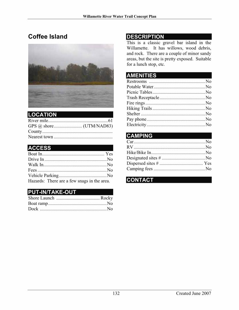
Willamette River Water Trail Concept Plan
132 Created June 2007
Coffee Island
LOCATIONRiver mile...................................................61 GPS @ shore........................ (UTM/NAD83) County............................................................ Nearest town ..................................................
ACCESSBoat In..................................................... Yes Drive In .....................................................No Walk In......................................................No Fees ...........................................................No Vehicle Parking.........................................No Hazards: There are a few snags in the area.
PUT-IN/TAKE-OUTShore Launch ..................................... Rocky Boat ramp..................................................No Dock .........................................................No
DESCRIPTION This is a classic gravel bar island in the Willamette. It has willows, wood debris, and rock. There are a couple of minor sandy areas, but the site is pretty exposed. Suitable for a lunch stop, etc.
AMENITIES Restrooms ................................................No Potable Water............................................No Picnic Tables.............................................No Trash Receptacle.......................................No Fire rings ...................................................No Hiking Trails .............................................No Shelter .......................................................No Pay phone..................................................No Electricity..................................................No
CAMPINGCar.............................................................No RV.............................................................No Hike/Bike In..............................................No Designated sites # .....................................No Dispersed sites # ..................................... Yes Camping fees ............................................No
CONTACT

Willamette River Water Trail Concept Plan
133 Created June 2007
Candiani Bar
LOCATIONRiver mile............................................. 58-59 GPS @ shore........................ (UTM/NAD83) N. 45’ 11. 958 W. 123’ 02.596 County............................................................ Nearest town ..................................................
ACCESSBoat In..................................................... Yes Drive In .....................................................No Walk In......................................................No Fees ...........................................................No Vehicle Parking.........................................No Hazards: The entrance to the back channel is narrow and has strainers. A few strainers continue down back channel.
PUT-IN/TAKE-OUTShore Launch .....................................Gravel Boat ramp..................................................No Dock .........................................................No
DESCRIPTION This is very large gravel bar with a mature stand of cottonwood among other trees and shrubs. The main channel side has a very large gravel area with occasional flat spots suitable for a tent. There are no services.
The back channel can be shallow in places with strainers. Access to the site is easier from the main channel side. There is little in the way of traffic noise. This area is at the head of the Newberg pool, and the current slows significantly here.
AMENITIES Restrooms ................................................No Potable Water............................................No Picnic Tables.............................................No Trash Receptacle.......................................No Fire rings ...................................................No Hiking Trails .............................................No Shelter .......................................................No Pay phone..................................................No Electricity..................................................No
CAMPINGCar.............................................................No RV.............................................................No Hike/Bike In..............................................No Designated sites # .....................................No Dispersed sites # ..................................... Yes Camping fees ............................................No
CONTACT

Willamette River Water Trail Concept Plan
134 Created June 2007
Yamhill Landing
LOCATIONRiver mile...................................................58 GPS @ shore........................ (UTM/NAD83) N. 45’ 11. 958 W. 123’ 02.596 (across from Canadian Bar) County............................................................ Nearest town ..................................................
ACCESSBoat In..................................................... Yes Drive In .....................................................No Walk In.................................................... Yes Fees ...........................................................No Vehicle Parking.........................................No Hazards .....................................................No
PUT-IN/TAKE-OUTShore Launch ..................................... Rocky Boat ramp..................................................No Dock .........................................................No
DESCRIPTION This is a large site with abundant vegetation. It also has a large gravel bar suitable for landing and camping if needed. The bar is covered with willows, then receding to taller trees and shrubs.
AMENITIES Restrooms ................................................No Potable Water............................................No Picnic Tables.............................................No Trash Receptacle.......................................No Fire rings ...................................................No Hiking Trails .............................................No Shelter .......................................................No Pay phone..................................................No Electricity..................................................No
CAMPINGCar.............................................................No RV.............................................................No Hike/Bike In..............................................No Designated sites # .....................................No Dispersed sites # ..................................... Yes Camping fees ............................................No
CONTACT

Willamette River Water Trail Concept Plan
135 Created June 2007
San Salvador Park
LOCATIONThe park is on the right bank. River Mile ..................................................57 GPS @ ................................. (UTM/NAD83) County................................................Marion Nearest town ..................................... St. Paul
ACCESSBoat In..................................................... Yes Drive In ................................................... Yes Walk In.................................................... Yes Fees ...........................................................No Vehicle parking....................................... Yes Hazards: Boat ramp can have strong cross current.
PUT IN/TAKE OUT Shore Launch .........................................Sand Boat Ramp .............................................. Yes Dock..........................................................No
DESCRIPTION San Salvador Park is a very small rural parcel located near St. Paul. The site offers an unimproved boat ramp and bank access.
AMENITIES Restroom.......................................... Portable Potable Water............................................No Picnic Tables.............................................No Trash Receptacle..................................... Yes Fire Rings..................................................No Hiking Trails/Paths ...................................No Shelter .......................................................No Pay Phone..................................................No Electricity..................................................No Other ..........................Seasonal Public Toilet
CAMPINGCar.............................................................No Boat In.......................................................No Hike/Bike In..............................................No Designated sites # ........................................0 Dispersed sites # ..........................................0 Camping fees ............................................No
CONTACTThis property is owned by ODFW and is currently managed by OPRD through a Cooperative Agreement.

Willamette River Water Trail Concept Plan
136 Created June 2007
Hess Creek Landing
LOCATIONThe park is on the left bank. River Mile ..................................................53 GPS @ shore ............................................No County...............................................Yamhill Nearest town ................................... Newberg
ACCESSBoat In..................................................... Yes Drive In .....................................................No Walk In......................................................No Fees ...........................................................No Vehicle parking.........................................No Hazards .....................................................No
PUT-IN/TAKE-OUTShore Launch ........................................ Mud Boat ramp................................................ Yes Dock........................................................ Yes Comments: Too steep to safely access this parcel from the river.
DESCRIPTION This small parcel is too steep to use as a put-in and it is not recommended to access this parcel from the river. The steep banks make this a dangerous site to use on a river trip.
There is a small creek that flows through this heavily wooded parcel that drains into the Willamette River.
AMENITIES Restroom...................................................No Potable Water............................................No Picnic Tables.............................................No Trash Receptacle.......................................No Fire Rings..................................................No Hiking Trails .............................................No Shelter .......................................................No Pay Phone..................................................No Electricity..................................................No
CAMPINGCar.............................................................No RV.............................................................No Boat In.......................................................No Hike/Bike In..............................................No Designated sites # ........................................0 Dispersed sites # ..........................................0 Camping fees ............................................No
CONTACTOregon Parks and Recreation Department 725 Summer St. N.E., Suite C Salem, OR 97301 503-986-0707

Willamette River Water Trail Concept Plan
137 Created June 2007
Roger’s Landing
LOCATIONRiver mile................................................50.5 GPS @ shore........................ (UTM/NAD83) County...............................................Yamhill Nearest town ................................... Newberg
ACCESSBoat In..................................................... Yes Drive In ................................................... Yes Walk In.................................................... Yes Fees ......................................................... Yes Vehicle Parking....................................... Yes Hazards .....................................................No
PUT-IN/TAKE-OUTShore Launch ..................................... Rocky Boat ramp................................................ Yes Dock ....................................................... Yes
DESCRIPTION This is a newly refurbished site with a large ramp and dock. It receives year-round use and significant fishermen and recreational power boat use in summer.
Newberg pool, and SP newsprint mill are immediately adjacent to the site, which lessens its appeal. Makes a good take-out.
AMENITIES Restrooms ............................................Flush Potable Water.......................................... Yes Picnic Tables........................................... Yes Trash Receptacle..................................... Yes Fire rings ...................................................No Hiking Trails .............................................No Shelter .......................................................No Pay phone..................................................No Electricity..................................................No
CAMPINGCar.............................................................No RV.............................................................No Hike/Bike In..............................................No Designated sites # .....................................No Dispersed sites # .......................................No Camping fees ............................................No
CONTACTYamhill County

Willamette River Water Trail Concept Plan
138 Created June 2007
Parrett Mountain Access
LOCATIONThe park is on the left bank. River Mile ...............................................45.5 GPS @ shore ............................................No County...............................................Yamhill Nearest town ..................................Butteville
ACCESSBoat In..................................................... Yes Drive In .................................................. Yes Walk In.................................................... Yes Fees ...........................................................No Vehicle parking....................................... Yes Hazards: Very steep shore launch from trail.
PUT-IN/TAKE-OUTShore Launch ........................... Sand & Mud Boat ramp..................................................No Dock..........................................................No Comments: There is a steep climb down from trail.
DESCRIPTION This parcel is easy to miss from the river and the road. There is a trail from the parking lot that runs approximately a mile along the river bank through a nice forest and to the riverbank.
The site is across the river from Champoeg State Park. Please do not trespass on adjacent landowners’ property. There is a nice upland grassy area on this site.
AMENITIES Restroom...............................................Vault Potable Water............................................No Picnic Tables.............................................No Trash Receptacle..................................... Yes Fire Rings..................................................No Hiking Trails ........................................... Yes Shelter .......................................................No Pay Phone..................................................No Electricity..................................................No
CAMPINGCar.............................................................No RV.............................................................No Boat In.......................................................No Hike/Bike In..............................................No Designated sites # ........................................0 Dispersed sites # ..........................................0 Camping fees ............................................No
CONTACTOregon Parks and Recreation Department 725 Summer St. N.E., Suite C Salem, OR 97301 503-986-0707

Willamette River Water Trail Concept Plan
139 Created June 2007
French Prairie Access
LOCATIONThe park is on the right bank. River Mile ..................................................41 GPS @ shore ............................................No County.......................................... Clackamas Nearest town ..................................Butteville
ACCESSBoat In..................................................... Yes Drive In ................................................... Yes Walk In.................................................... Yes Fees ...........................................................No Vehicle parking....................................... Yes Hazards .....................................................No
PUT-IN/TAKE-OUTShore Launch ...........................................No Boat ramp.............................................. Dock Comments: Too steep to safely access this parcel from the river.
DESCRIPTION This site has been closed and is dangerous to access due to steep banks.
AMENITIES Restroom...................................................No Potable Water............................................No Picnic Tables.............................................No Trash Receptacle.......................................No Fire Rings..................................................No Hiking Trails .............................................No Shelter .......................................................No Pay Phone..................................................No Electricity..................................................No
CAMPINGCar.............................................................No RV.............................................................No Boat In.......................................................No Hike/Bike In..............................................No Designated sites # ........................................0 Dispersed sites # ..........................................0 Camping fees ............................................No
CONTACTOregon Parks and Recreation Department 725 Summer St. N.E., Suite C Salem, OR 97301 503-986-0707

Willamette River Water Trail Concept Plan
140 Created June 2007
Boones Ferry Public Boat Ramp
LOCATIONThe park is on the left bank. River Mile ...............................................39.5 GPS @ shore ....................... (UTM/NAD83) N 45’ 17.510 W 122’ 46.524 County.......................................... Clackamas Nearest town ............................... Wilsonville
ACCESSBoat In..................................................... Yes Drive In ................................................... Yes Walk In.................................................... Yes Fees ...........................................................No Vehicle parking....................................... Yes Hazards: I-5 Boone Bridge is just downriver, RR bridge is just upriver. Area gets heavy use by water-skiers and personal watercraft, especially on weekends.
Comments: Be sure to park in public lot or overflow lot across street, not in marina parking.
PUT-IN/TAKE-OUTShore Launch .....................................Gravel Boat ramp................................................ Yes Dock........................................................ Yes
DESCRIPTION Boones Ferry Public Boat Ramp is 2 lane paved access from shore. Public ramp shares site with private marina. Marina sells ice, ice cream, snacks, drinks, etc. Marina owner/operator is Leslie Kush. Leslie is interested in adding canoe/kayak racks at the marina, if she can figure out security system.
Parking lot under railroad bridge. Boat ramp is across from Boones Ferry Park. Boones Bridge and RR bridge visible from ramp.
AMENITIES Restroom.......................................... Portable Potable Water.......................................... Yes Picnic Tables........................................... Yes Trash Receptacle..................................... Yes Fire Rings..................................................No Hiking Trails .............................................No Shelter .......................................................No Pay Phone................................................ Yes Electricity..................................................No
CAMPINGCar.............................................................No RV.............................................................No Boat In.......................................................No Hike/Bike In..............................................No Designated sites # ........................................0 Dispersed sites # ..........................................0 Camping fees ............................................No
CONTACTClackamas County Parks Department 9101 S.E. Sunnybrook Blvd.Clackamas, OR 97015 503-353-4414

Willamette River Water Trail Concept Plan
141 Created June 2007
Boones Ferry Park
LOCATIONThe park is on the left bank. River Mile ...............................................39.5 GPS @ shore ....................... (UTM/NAD83) N 45’ 17.600N W 122’ 46.448 County.......................................... Clackamas Nearest town ............................... Wilsonville
ACCESSBoat In..................................................... Yes ................................................................. Yes Walk In.................................................... Yes Fees ...........................................................No Vehicle parking....................................... Yes Hazards: Some large partially submerged logs near shore launch. RR bridge just upriver from site. Site is across from Boones Ferry Public Boat Ramp, and this part of the river gets heavy motorized traffic. Comments: Paved path on gentle, non-ADA grade leads from parking lot to shore launch.
PUT-IN/TAKE-OUTShore Launch ............................ Gravel/Mud Boat ramp..................................................No Dock..........................................................No Comments: Paved path on gentle, non-ADA grade leads from parking lot to shore launch.
DESCRIPTION Upland: Landscaped city park surrounded by residential neighborhoods, with historic home on site. From river: I-5 Boones Bridge just downriver, RR bridge upriver. Across from Boones Ferry Public Boat Ramp. Marina, houses, and private docks visible from water.
Within 1 mile walk of services in Wilsonville, including food, coffee, grocers, drugstore. River gets noise from nearby I-5. Park located at site of historic Boones Ferry Crossing.
AMENITIES Restroom...............................................Flush Potable Water.......................................... Yes Picnic Tables........................................... Yes Trash Receptacle..................................... Yes Fire Rings..................................................No Hiking Trails ........................................... Yes Shelter ..................................................... Yes Pay Phone..................................................No Electricity..................................................No Comments: Trail connects two waterfront parks: The Boones Ferry to Memorial Park The park contains the. historical Tauschman House, a basketball court, playground and gazebo.
CAMPINGCar.............................................................No RV.............................................................No Boat In.......................................................No Hike/Bike In..............................................No Designated sites # ........................................0 Dispersed sites # ..........................................0 Camping fees ............................................No
CONTACTWilsonville Planning Division 503-682-4960

Willamette River Water Trail Concept Plan
142 Created June 2007
Wilsonville Memorial Park
LOCATIONThe park is on the left bank. River Mile ..................................................38 GPS @ shore ............................................No County.......................................... Clackamas Nearest town ............................... Wilsonville
ACCESSBoat In..................................................... Yes Drive In ................................................... Yes Walk In.................................................... Yes Fees ...........................................................No Vehicle Parking....................................... Yes Hazards: Many partially submerged logs on river left just upriver from the sites.
PUT-IN/TAKE-OUTShore Launch ........................................ Mud Boat ramp..................................................No Dock........................................................ Yes Comments: Floating dock suitable for paddle craft. Short portage (<1.4 mile) down gravel/dirt path to boat dock is required to access river.
DESCRIPTION This is Wilsonville’s largest park (100 acres) and is within a mile walk of most of the services that Wilsonville has to offer. I-5 can be noisy but the dock and nice park surroundings make this an excellent potential lunch spot.
The Boones Ferry to Memorial Park Trail connects this park to Boones Ferry Park. This park’s amenities include Murase Plaza, ball fields, picnic areas, playgrounds, covered shelters, trails, off-leash dog run, and other active recreation opportunities.
AMENITIES Restroom...............................................Flush Potable Water.......................................... Yes Picnic Tables .......................................... Yes Trash Receptacle .................................... Yes Fire Rings .................................................No Hiking Trails .......................................... Yes Shelter .................................................... Yes Pay Phone................................................ Yes Electricity..................................................No
CAMPINGCar.............................................................No RV.............................................................No Boat In.......................................................No Hike/Bike In..............................................No Designated sites # ........................................0 Dispersed sites # ..........................................0 Camping fees ............................................No
CONTACTWilsonville Planning Division 503-682-4960

Willamette River Water Trail Concept Plan
143 Created June 2007
Willamette Meridian Landing
LOCATIONThe park is on the left bank. River Mile ..................................................37 GPS @ shore ............................................No County.......................................... Clackamas Nearest town ............................... Wilsonville
ACCESSBoat In..................................................... Yes Drive In .....................................................No Walk In......................................................No Fees ...........................................................No Vehicle parking.........................................No Hazards: Steep banks make it dangerous to access parcel from river.
PUT-IN/TAKE-OUTShore Launch ........................................ Mud Boat ramp..................................................No Dock..........................................................No
DESCRIPTION This parcel is a densely vegetated site with difficult river access due to steep river banks.
AMENITIES Restroom...................................................No Potable Water............................................No Picnic Tables.............................................No Trash Receptacle.......................................No Fire Rings..................................................No Hiking Trails .............................................No Shelter .......................................................No Pay Phone..................................................No Electricity..................................................No
CAMPINGCar.............................................................No RV.............................................................No Boat In.......................................................No Hike/Bike In..............................................No Designated sites # ........................................0 Dispersed sites # ..........................................0 Camping fees ............................................No
CONTACTOregon Parks and Recreation Department 725 Summer St. N.E., Suite C Salem, OR 97301 503-986-0707

Willamette River Water Trail Concept Plan
144 Created June 2007
Molalla River State Park
LOCATIONThe park is on the right bank. River Mile ..................................................34 GPS @ shore ............................................No County.......................................... Clackamas Nearest town ............................... Wilsonville
ACCESSBoat In..................................................... Yes ................................................................. Yes Walk In.................................................... Yes Fees ...........................................................No Vehicle parking....Yes; no parking 8pm-7am Hazards: Canby Ferry is just downriver. Comments: To access, take Holly St. out of Canby towards Canby Ferry and follow signs to park.
PUT-IN/TAKE-OUTShore Launch ........................................ Mud Boat ramp................................................ Yes Dock..........................................................No Comment:
DESCRIPTION This is a quiet parcel close to the Canby Ferry. There are several trails on this large park that follow the river and lead to large open fields and through cottonwoods. AMENITIES Restroom...............................................Flush Potable Water.......................................... Yes Picnic Tables........................................... Yes Trash Receptacle..................................... Yes Fire Rings..................................................No Hiking Trails ........................................... Yes Shelter .......................................................No Pay Phone..................................................No Electricity..................................................No Comments: BBQ grills, pet area and horseshoes
CAMPINGCar.............................................................No RV.............................................................No Boat In.......................................................No Hike/Bike In..............................................No Designated sites # ........................................0 Dispersed sites # ..........................................0 Camping fees ............................................No
CONTACTOregon Parks and Recreation Department 725 Summer St. N.E., Suite C Salem, OR 97301 503-986-0707

Willamette River Water Trail Concept Plan
145 Created June 2007
Rock Island Landing
LOCATIONThe park is on the left bank. River Mile ...............................................30.8 GPS @ ...........................................Unknown County.......................................... Clackamas Nearest town ..............................Oregon City
ACCESSBoat In..................................................... Yes Drive In .....................................................No Walk In......................................................No Fees ...........................................................No Vehicle parking.........................................No Hazards: Rock shoals along both sides of Rock Island
PUT IN/TAKE OUT Shore Launch ............................................No Boat Ramp ................................................No Dock .........................................................No
DESCRIPTION Rock Island Landing is only accessible from the river. There are no facilities on site.
AMENITIES Restroom...................................................No Potable Water............................................No Picnic Tables.............................................No Trash Receptacle.......................................No Fire Rings..................................................No Hiking Trails/Paths ...................................No Shelter .......................................................No Pay Phone..................................................No Electricity..................................................No
CAMPINGCar.............................................................No Boat In.......................................................No Hike/Bike In..............................................No Designated sites ..........................................0 Dispersed sites ............................................0 Camping fees ...............................................0
CONTACTOregon State Parks & Recreation Dept. 725 Summer St. N.E., Suite C Salem, Oregon 97301 503-986-0707

Willamette River Water Trail Concept Plan
146 Created June 2007
Coalca Landing
LOCATIONThe park is on the right bank. River Mile ...............................................30.7 GPS @ ...........................................Unknown County.......................................... Clackamas Nearest town ..............................Oregon City
ACCESSBoat In..................................................... Yes Drive In ................................................... Yes Walk In.................................................... Yes Fees ...........................................................No Vehicle parking....................................... Yes Hazards: Just north rock shoals along both sides of Rock Island.
PUT IN/TAKE OUT Shore Launch .........................................Sand Boat Ramp ................................................No Dock..........................................................No
DESCRIPTION Coalca Landing has a gravel parking area with fishing & swimming access. It has a small picnic area with tables and garbage can, as well as a pit toilet.
AMENITIES Restroom...............................................Vault Potable Water............................................No Picnic Tables........................................... Yes Trash Receptacle..................................... Yes Fire Rings..................................................No Hiking Trails/Paths ................................. Dirt Shelter .......................................................No Pay Phone..................................................No Electricity..................................................No Other ..............................................................
CAMPINGCar.............................................................No Boat In.......................................................No Hike/Bike In..............................................No Designated sites # ........................................0 Dispersed sites ............................................0 Camping fees ...............................................0
CONTACTOregon State Parks & Recreation Dept. 725 Summer St. N.E., Suite C Salem, Oregon 97301 503-986-0707

Willamette River Water Trail Concept Plan
147 Created June 2007
Willamette Park
LOCATIONThe park is on the left bank. River Mile ...............................................28.2 GPS @ ...........................................Unknown County.......................................... Clackamas Nearest town .................................West Linn
ACCESSBoat In..................................................... Yes Drive In ................................................... Yes Walk In.................................................... Yes Fees ...........................................................No Vehicle parking....................................... Yes Hazards: Currents at mouth of Tualatin.
PUT IN/TAKE OUT Shore Launch ....................Gravel and Rocky Boat Ramp ................................................No Dock..........................................................No
DESCRIPTION Located at the confluence of the Willamette and Tualatin Rivers. Park area consists of put in area right at the mouth of the Tualatin River. Willamette Park has plenty of recreational areas that include open fields, horseshoe pits, volleyball courts and wading pool. Willamette Park is located upriver, on adjoining property, from Bernert landing Boat Ramp.
AMENITIES Restroom...............................................Flush Potable Water.......................................... Yes Picnic Tables........................................... Yes Trash Receptacle..................................... Yes Fire Rings..................................................No Hiking Trails/Paths ................................. Dirt Shelter ..................................................... Yes Pay Phone..................................................No Electricity................................................ Yes
CAMPINGCar.............................................................No Boat In.......................................................No Hike/Bike In..............................................No Designated sites # ........................................0 Dispersed sites # ..........................................0 Camping fees .......................................... Yes
CONTACTCity of West Linn Parks and Recreation Dept. 22500 Salamo Road, #1100 West Linn OR 97068 503-557-4700

Willamette River Water Trail Concept Plan
148 Created June 2007
Bernert Landing Boat Ramp
LOCATIONThe park is on the left bank. River Mile ...............................................28.2 GPS @ ...........................................Unknown County.......................................... Clackamas Nearest town .................................West Linn
ACCESSBoat In..................................................... Yes Drive In ................................................... Yes Walk In.................................................... Yes Fees ...........................................................No Vehicle parking....................................... Yes Hazards: Sits above Willamette Falls.
PUT IN/TAKE OUT Shore Launch .......................................Paved Boat Ramp .............................................. Yes Dock........................................................ Yes
DESCRIPTION Located at the confluence of the Willamette and Tualatin Rivers, Bernert Landing sits just below the mouth of the Tualatin River. This boat ramp adjoins Willamette Park.
AMENITIES Restroom...............................................Flush Potable Water.......................................... Yes Picnic Tables........................................... Yes Trash Receptacle..................................... Yes Fire Rings..................................................No Hiking Trails/Paths ................................. Dirt Shelter .......................................................No Pay Phone..................................................No Electricity..................................................No Other ..............................................................
CAMPINGCar.............................................................No Boat In.......................................................No Hike/Bike In..............................................No Designated sites ............................................ Dispersed sites .............................................. Camping fees .......................................... Yes
CONTACTCity of West Linn Parks and Recreation Dept. 22500 Salamo Road, #1100 West Linn OR 97068 503-557-4700

Willamette River Water Trail Concept Plan
149 Created June 2007
West Bridge Park & McLean House
LOCATIONThe park is on the left bank. River Mile ...............................................25.2 GPS @ ...........................................Unknown County.......................................... Clackamas Nearest town .................................West Linn
ACCESSBoat In..................................................... Yes Drive In ................................................... Yes Walk In.................................................... Yes Fees ...........................................................No Vehicle parking................................. Limited Hazards:PUT IN/TAKE OUT Shore Launch ...................... Gravel and Mud Boat Ramp ................................................No Dock..........................................................No
DESCRIPTION West Bridge Park is located on the same property as the Historic McLean House in West Linn. The 1927 McLean House sits on 2.5 acres & Westbridge Park consists of four acres.
AMENITIES Restroom...................................................No Potable Water............................................No Picnic Tables.............................................No Trash Receptacle..................................... Yes Fire Rings..................................................No Hiking Trails/Paths ................................. Dirt Shelter .......................................................No Pay Phone..................................................No Electricity..................................................No Other ..............................................................
CAMPINGCar.............................................................No Boat In.......................................................No Hike/Bike In..............................................No Designated sites ............................................ Dispersed sites .............................................. Camping fees .......................................... Yes
CONTACTCity of West Linn Parks and Recreation Dept. 22500 Salamo Road, #1100 West Linn OR 97068 503-557-4700

Willamette River Water Trail Concept Plan
150 Created June 2007
Maddax Woods
LOCATIONThe park is on the left bank. River Mile ...............................................24.8 GPS @ ...........................................Unknown County.......................................... Clackamas Nearest town .................................West Linn
ACCESSBoat In..................................................... Yes Drive In ................................................... Yes Walk In.................................................... Yes Fees ...........................................................No Vehicle parking................................. Limited Hazards:
PUT IN/TAKE OUT Shore Launch ...................... Gravel and Mud Boat Ramp ................................................No Dock..........................................................No
DESCRIPTION This site situated provides 7 acres of natural area on the river. Located behind Goat Island on the river. Goat Island houses one of the areas largest heron rookeries. The park is named after Dorothy and Virgil Maddax who donated their land to the City of West Linn.
AMENITIES Restroom...................................................No Potable Water............................................No Picnic Tables.............................................No Trash Receptacle..................................... Yes Fire Rings..................................................No Hiking Trails/Paths ................................. Dirt Shelter .......................................................No Pay Phone..................................................No Electricity..................................................No Other ..............................................................
CAMPINGCar.............................................................No Boat In.......................................................No Hike/Bike In..............................................No Designated sites ............................................ Dispersed sites .............................................. Camping fees .......................................... Yes
CONTACTCity of West Linn Parks and Recreation Dept. 22500 Salamo Road, #1100 West Linn OR 97068 503-557-4700

Willamette River Water Trail Concept Plan
151 Created June 2007
Mary S. Young Park
LOCATIONThe park is on the left bank. River Mile ...............................................23.7 GPS @ ...........................................Unknown County.......................................... Clackamas Nearest town .................................West Linn
ACCESSBoat In..................................................... Yes Drive In ................................................... Yes Walk In........................................... April-Oct Fees ...........................................................No Vehicle parking....................................... Yes Hazards:
PUT IN/TAKE OUT Shore Launch ........... Gravel, Mud, and Sand Boat Ramp ................................................No Dock..........................................................No
DESCRIPTION Formerly Known as Mary S. Young State Park. Mary S Young Park is now under the management of the City of West Linn. This spark provides shoreline access for river travelers. Sand beaches and scenic areas with wildlife exist with in this park, inside the City limits.
AMENITIES Restroom...............................................Flush Potable Water............................................No Picnic Tables........................................... Yes Trash Receptacle..................................... Yes Fire Rings..................................................No Hiking Trails/Paths ................Dirt and Paved Shelter ..................................................... Yes Pay Phone..................................................No Electricity..................................................No Other ..............................................................
CAMPINGCar.............................................................No Boat In.......................................................No Hike/Bike In..............................................No Designated sites ............................................ Dispersed sites .............................................. Camping fees .......................................... Yes
CONTACTCity of West Linn Parks and Recreation Dept. 22500 Salamo Road, #1100 West Linn OR 97068 503-557-4700

Willamette River Water Trail Concept Plan
152 Created June 2007
Cedar Island
LOCATIONThe park is on the left bank. River Mile ...............................................23.2 GPS @ ...........................................Unknown County.......................................... Clackamas Nearest town .................................West Linn
ACCESSBoat In..................................................... Yes Drive In .....................................................No Walk In..........................................April-Oct) Fees ...........................................................No Vehicle parking................................. Limited Hazards:
PUT IN/TAKE OUT Shore Launch ...................... Gravel and Mud Boat Ramp ................................................No Dock..........................................................No
DESCRIPTION This City owned Island has been improved for walkers and boaters alike. Paths and seasonal bridge (April - October) provide access to the shoreline and Mary S Young Park.
AMENITIES Restroom...................................................No Potable Water............................................No Picnic Tables.............................................No Trash Receptacle.......................................No Fire Rings..................................................No Hiking Trails/Paths ................................. Dirt Shelter .......................................................No Pay Phone..................................................No Electricity..................................................No Other ..............................................................
CAMPINGCar.............................................................No Boat In.......................................................No Hike/Bike In..............................................No Designated sites ............................................ Dispersed sites .............................................. Camping fees .......................................... Yes
CONTACTCity of West Linn Parks and Recreation Dept. 22500 Salamo Road, #1100 West Linn OR 97068 503-557-4700

Willamette River Water Trail Concept Plan
153 Created June 2007
Cedaroak Boat Ramp
LOCATIONThe park is on the left bank. River Mile ..................................................23 GPS @ ...........................................Unknown County.......................................... Clackamas Nearest town .................................West Linn
ACCESSBoat In..................................................... Yes Drive In ................................................... Yes Walk In........................................... April-Oct Fees ...........................................................No Vehicle parking................................. Limited Hazards:
PUT IN/TAKE OUT Shore Launch ...................... Gravel and Mud Boat Ramp .............................................. Yes Dock........................................................ Yes
DESCRIPTION Cedaroak boat ramp provides launch site and small beach area, and a couple of tables for picnicking or relaxing. Cedaroak boat ramp is located just below Cedar Island.
AMENITIES Restroom...............................................Flush Potable Water.......................................... Yes Picnic Tables........................................... Yes Trash Receptacle..................................... Yes Fire Rings..................................................No Hiking Trails/Paths ................................. Dirt Shelter .......................................................No Pay Phone..................................................No Electricity..................................................No Other ..............................................................
CAMPINGCar.............................................................No Boat In.......................................................No Hike/Bike In..............................................No Designated sites ............................................ Dispersed sites .............................................. Camping fees .......................................... Yes
CONTACTCity of West Linn Parks and Recreation Dept. 22500 Salamo Road, #1100 West Linn OR 97068 503-557-4700

Willamette River Water Trail Concept Plan
154 Created June 2007
Peter Kerr Natural Area
LOCATIONSW Greenwood Rd. & Riverside Dr. The park is on the left bank. River Mile ..................................................19 GPS @ ...........................................Unknown County......................................... Multnomah Nearest town .................................... Portland
ACCESSBoat In..................................................... Yes Drive In ................................................... Yes Walk In.................................................... Yes Fees ......................................................... Yes Vehicle parking....................................... Yes Hazards: (none)
PUT IN/TAKE OUT Shore Launch .......................................... Yes Pedestrian River Access...................Informal
DESCRIPTION Undeveloped and little known natural area on the western shore of the Willamette River directly across from Elk Rock Island. Property is bordered on the west by SW Riverside Road.
AMENITIES Restroom................................................. Yes Potable Water.......................................... Yes Picnic Tables........................................... Yes Trash Receptacle..................................... Yes Fire Rings................................................ Yes Hiking Trails/Paths ..................Informal path Shelter ..................................................... Yes Pay Phone................................................ Yes Electricity................................................ Yes Other .............................................................. Comments: Largely undeveloped
CAMPINGCar........................................................... Yes Boat In..................................................... Yes Hike/Bike In............................................ Yes No Camping ............................ Day-Use only
CONTACTPortland Parks & Recreation 1120 SW Fifth Ave #1302 Portland, OR 97204

Willamette River Water Trail Concept Plan
155 Created June 2007
Elk Rock Island Natural Area
LOCATIONThe park is towards the Right bank. River Mile ..................................................19 GPS @ ...........................................Unknown County......................................... Multnomah Nearest town .................................... Portland
ACCESSBoat In.......................Public and commercial Drive In ................................................... Yes Walk In..................................During summer Fees ......................................................... Yes Vehicle parking....................................... Yes Hazards: (none)
PUT IN/TAKE OUT Shore Launch .......................................... Yes Boat Ramp .............................................. Yes Dock........................................................ Yes
DESCRIPTION 15 acre natural area situated in the middle of the Willamette River just south of Portland city limits. The island is accessible by boat on the west side but during low water, visitors can walk to the island from the east edge of the Willamette. Popular as a natural area field trip and kayak destination.
AMENITIES Restroom................................................. Yes Potable Water.......................................... Yes Picnic Tables........................................... Yes Trash Receptacle..................................... Yes Fire Rings................................................ Yes Hiking Trails/Paths ...............Nothing formal Shelter ..................................................... Yes Pay Phone................................................ Yes Electricity................................................ Yes Other ......... This is a natural area, not a park.
CAMPINGCar........................................................... Yes Boat In..................................................... Yes Hike/Bike In............................................ Yes No Camping ............................ Day-Use only
CONTACTPortland Parks & Recreation 1120 SW Fifth Ave #1302 Portland, OR 97204

Willamette River Water Trail Concept Plan
156 Created June 2007
Jefferson Street Boat Ramp at Milwaukie Riverfront Park
LOCATIONThe park is on the right bank. River Mile ...............................................18.5 GPS @ ...........................................Unknown County.......................................... Clackamas Nearest town ................................ Milwaukie
ACCESSBoat In..............................................Informal Drive In ................................................... Yes Walk In.................................................... Yes Fees ......................................................... Yes Vehicle parking....................................... Yes Hazards: Unimproved and rocky; motor boat and car traffic.
PUT IN/TAKE OUT Shore Launch ...................................Informal Boat Ramp .............................................. Yes Dock........................................................ Yes
DESCRIPTION Riverfront Park between Johnson and Kellogg Creeks with motor boat launch in place and informal paddle boat access adjacent to launch.
AMENITIES Restroom........................................................ Potable Water.......................................... Yes Picnic Tables........................................... Yes Trash Receptacle..................................... Yes Fire Rings................................................ Yes Hiking Trails/Paths ................................. Yes Shelter ..................................................... Yes Pay Phone................................................ Yes Electricity................................................ Yes
CAMPINGCar........................................................... Yes Boat In..................................................... Yes Hike/Bike In............................................ Yes Designated sites ............................................ Dispersed sites .............................................. Camping fees .......................................... Yes
CONTACT(Agency in charge) Community Services 10722 SE Main Street Milwaukie, OR 97222 cityofmilwaulie.org 503-786-7555

Willamette River Water Trail Concept Plan
157 Created June 2007
Powers Marine Park
LOCATIONThe park is on the left bank. River Mile ..................................................17 GPS @ ...........................................Unknown County......................................... Multnomah Nearest town .................................... Portland
ACCESSBoat In..................................................... Yes Drive In ................................................... Yes Walk In.................................................... Yes Fees ......................................................... Yes Vehicle parking...................................Gravel Hazards: Boat ramp drops off sharply
PUT IN/TAKE OUT Shore Launch .......................................... Yes Pedestrian River Access.......................... Yes Boat Ramp: 1 lane, former ferry dock in the row
DESCRIPTION 13 acre linear natural river park in SW Portland with nature trail and beach access. Parking lot is used by vehicles with boat trailers who are launching at boat ramp next to Staff Jennings. Boat ramp is in the City ROW and not maintained. Ramp served once as an old ferry dock.
AMENITIES Restroom................................ Yes (Portable) Potable Water.......................................... Yes Picnic Tables........................................... Yes Trash Receptacle..................................... Yes Fire Rings................................................ Yes Hiking Trails/Paths ................. Unpaved path Shelter ..................................................... Yes Pay Phone................................................ Yes Electricity................................................ Yes Other ..................This is a natural area with a boat ramp available at the north end
CAMPINGCar........................................................... Yes Boat In..................................................... Yes Hike/Bike In............................................ Yes No Camping ............................ Day-Use only
CONTACTPortland Parks & Recreation 1120 SW Fifth Ave #1302 Portland, OR 97204

Willamette River Water Trail Concept Plan
158 Created June 2007
Oaks Crossing
LOCATIONThe park is on the right bank. River Mile ...............................................16.4 GPS @ ...........................................Unknown County......................................... Multnomah Nearest town .................................... Portland
ACCESSBoat In..................................................... Yes Drive In ................................................... Yes Walk In.................................................... Yes Fees ......................................................... Yes Vehicle parking....................................... Yes Hazards:
PUT IN/TAKE OUT Shore Launch .......................................... Yes Pedestrian River Access.......................... Yes Boat Ramp .............................................. Yes Dock........................................................ Yes
DESCRIPTION This 6 acre natural area site sits adjacent to Sellwood Riverfront Park on the north side. The property is owned by Metro but managed by Parks and Recreation.
AMENITIES Restroom................................................. Yes Potable Water.......................................... Yes Picnic Tables........................................... Yes Trash Receptacle..................................... Yes Fire Rings................................................ Yes Hiking Trails/Paths ..................Informal path Shelter ..................................................... Yes Pay Phone................................................ Yes Electricity................................................ Yes Other .............................................................. Comments: Walk in beach area
CAMPINGCar........................................................... Yes Boat In..................................................... Yes Hike/Bike In............................................ Yes No Camping ............................ Day-Use only
CONTACTPortland Parks & Recreation 1120 SW Fifth Ave #1302 Portland, OR 97204

Willamette River Water Trail Concept Plan
159 Created June 2007
Sellwood Riverfront Park
LOCATIONThe park is on the right bank. River Mile ...............................................16.3 GPS @ ...........................................Unknown County......................................... Multnomah Nearest town .................................... Portland
ACCESSBoat In..................................................... Yes Drive In ................................................... Yes Walk In.................................................... Yes Fees ......................................................... Yes Vehicle parking....................................... Yes Hazards:
PUT IN/TAKE OUT Shore Launch .......................................... Yes Pedestrian River Access.......................... Yes Boat Ramp .............................................. Yes Dock........................................................ Yes
DESCRIPTION 8.75 acre river park located just north of the Sellwood Bridge. Park has a beach, swimming walking paths, and a transient dock that also serves as a canoe launch and fishing dock.
AMENITIES Restroom................................................. Yes Potable Water.......................................... Yes Picnic Tables........................................... Yes Trash Receptacle..................................... Yes Fire Rings................................................ Yes Hiking Trails/Paths ................ Informal paths Shelter ..................................................... Yes Pay Phone................................................ Yes Electricity................................................ Yes Other ..............................................................
CAMPINGCar........................................................... Yes Boat In..................................................... Yes Hike/Bike In............................................ Yes No Camping ............................ Day-Use only
CONTACTPortland Parks & Recreation 1120 SW Fifth Ave #1302 Portland, OR 97204

Willamette River Water Trail Concept Plan
160 Created June 2007
Butterfly Park
LOCATIONThe park is on the left bank. River Mile ..................................................16 GPS @ ...........................................Unknown County......................................... Multnomah Nearest town .................................... Portland
ACCESSBoat In.............................................. Landing Drive In ................................................... Yes Walk In.................................................... Yes Fees ......................................................... Yes Vehicle parking....................................... Yes Hazards:(none)...............................................
PUT IN/TAKE OUT Shore Launch .......................................... Yes Pedestrian River Access.......................... Yes Boat Ramp .............................................. Yes Dock........................................................ Yes
DESCRIPTION Butterfly Park is a very small natural area with shore access located between Willamette Park & Macadam Bay. It has Interpretative signage, viewpoint and seating. Accessible only by foot, bike or water.
AMENITIES Restroom............................................. Flush) Potable Water.......................................... Yes Picnic Tables........................................... Yes Trash Receptacle..................................... Yes Fire Rings................................................ Yes Hiking Trails/Paths ................Unpaved paths Shelter ..................................................... Yes Pay Phone................................................ Yes Electricity................................................ Yes Other ........................... Interpretative signage
CAMPINGCar........................................................... Yes Boat In..................................................... Yes Hike/Bike In............................................ Yes No Camping ............................ Day-Use only
CONTACTPortland Parks & Recreation 1120 SW Fifth Ave #1302 Portland, OR 97204

Willamette River Water Trail Concept Plan
161 Created June 2007
Willamette Moorage
LOCATION
The park is on the left bank. River Mile ..................................................16 GPS @ ...........................................Unknown County......................................... Multnomah Nearest town .................................... Portland
ACCESSBoat In..................................................... Yes Drive In ................................................... Yes Walk In.................................................... Yes Fees ......................................................... Yes Vehicle parking....................................... Yes Hazards:
PUT IN/TAKE OUT Shore Launch .......................................... Yes Pedestrian River Access........Nothing formal Boat Ramp .............................................. Yes Dock................... Shared with Macadam Bay
DESCRIPTION Willamette Moorage natural area is somewhat hidden behind the Macadam Bay floating home enclave. Roughly adjacent to Willamette Park and Butterfly Park the property is bordered by the river on the east and unimproved SW Miles Rd on the west. Access to Willamette moorage is available from a public transient dock at Macadam Bay.
AMENITIES Restroom................................................. Yes Potable Water.......................................... Yes Picnic Tables........................................... Yes Trash Receptacle..................................... Yes Fire Rings................................................ Yes Hiking Trails/Paths ..................Informal path Shelter ..................................................... Yes Pay Phone................................................ Yes Electricity................................................ Yes Other ..............................................................
CAMPINGCar........................................................... Yes Boat In..................................................... Yes Hike/Bike In............................................ Yes No Camping ............................ Day-Use only
CONTACTPortland Parks & Recreation 1120 SW Fifth Ave #1302 Portland, OR 97204

Willamette River Water Trail Concept Plan
162 Created June 2007
Willamette Park
LOCATIONThe park is on the left bank. River Mile ...............................................15.8 GPS @ ...........................................Unknown County......................................... Multnomah Nearest town .................................... Portland
ACCESSBoat In.......................Public and commercial Drive In ................................................... Yes Walk In.................................................... Yes Fees ..................................................Mar-Oct Vehicle parking....................................... Yes Hazards: Congestion
PUT IN/TAKE OUT Shore Launch .......................................... Yes Pedestrian River Access.............Using docks Boat Ramp ......................................... 4 lanes Dock........................................................ Yes
DESCRIPTION Willamette Park is a 30 acre riverfront park with a 4 lane boat ramp & beach for light watercraft launch. It provides the main motorized boating access on the west side of the river within the Portland 17 mile stretch of the Willamette.
AMENITIES Restroom...............................................Flush Potable Water.................. Drinking fountains Picnic Tables........................................... Yes Trash Receptacle..................................... Yes Fire Rings................................................ Yes Hiking Trails/Paths ........... Paved path; ADA Shelter ..................................................... Yes Pay Phone................................................ Yes Electricity................................................ Yes Other .......... Playground, tennis courts, fields Comments: Primary boat ramp in Portland very busy in season.
CAMPINGCar........................................................... Yes Boat In..................................................... Yes Hike/Bike In............................................ Yes No Camping ............................ Day-Use only
CONTACTPortland Parks & Recreation 1120 SW Fifth Ave #1302 Portland, OR 97204

Willamette River Water Trail Concept Plan
163 Created June 2007
Toe Island
LOCATIONIn Willamette River at SW Pendleton; South of Ross Island. The park is on the Bank. River Mile ..................................................15 GPS @ ...........................................Unknown County......................................... Multnomah Nearest town .................................... Portland
ACCESSBoat In..................................................... Yes Drive In ................................................... Yes Walk In.................................................... Yes Fees ......................................................... Yes Vehicle parking....................................... Yes Hazards:
PUT IN/TAKE OUT Shore Launch .............................Landing site Pedestrian River Access.......................... Yes Boat Ramp .............................................. Yes Dock........................................................ Yes
DESCRIPTION This tiny 1.4 acre island in the middle of the Willamette River at almost the center point of Ross Island was a gift to the city. It is an undeveloped natural area accessible only by boat.
AMENITIES Restroom................................................. Yes Potable Water.......................................... Yes Picnic Tables........................................... Yes Trash Receptacle..................................... Yes Fire Rings................................................ Yes Hiking Trails/Paths ................ Informal paths Shelter ..................................................... Yes Pay Phone................................................ Yes Electricity................................................ Yes Other ..............................................................
CAMPINGCar........................................................... Yes Boat In..................................................... Yes Hike/Bike In............................................ Yes No Camping ............................ Day-Use only
CONTACTPortland Parks & Recreation 1120 SW Fifth Ave #1302 Portland, OR 97204

Willamette River Water Trail Concept Plan
164 Created June 2007
River Place Marina Breakwater
LOCATIONThe park is on the left bank. River Mile ...............................................13.2 GPS @ ...........................................Unknown County......................................... Multnomah Nearest town .................................... Portland
ACCESSBoat In.......................Public and commercial Drive In ................................................... Yes Walk In.................................................... Yes Fees ...................................................Pay box Vehicle parking....................................... Yes Hazards: Boat wakes for boats docked on outside breakwater.
PUT IN/TAKE OUT Shore Launch .......................................... Yes Pedestrian Public River Access .............. Yes Boat Ramp .............................................. Yes Dock........................................................ Yes
DESCRIPTION Long crescent shaped breakwater serves as a transient dock, protecting River Place Marina and providing boater’s access to Waterfront Park and downtown Portland. The outside of the transient dock is permitted for commercial uses and the inside is permitted for overnight public docking. Breakwater is heavily used during summer festival months. Dock is in need of major maintenance. AMENITIES Restroom................................................. Yes Potable Water............................................No Picnic Tables........................................... Yes Trash Receptacle..................................... Yes Fire Rings................................................ Yes Hiking Trails/Paths ................................. Yes Shelter ..................................................... Yes Pay Phone................................................ Yes Electricity..................................................No Other: Shops, eateries and downtown Comments: This is a transient dock. People must walk to amenities.
CAMPINGCar........................................................... Yes Boat In..................................................... Yes Hike/Bike In............................................ Yes Camping:...................................................No (You can camp overnight in your boat.)
CONTACTPortland Parks & Recreation 1120 SW Fifth Ave #1302 Portland, OR 97204

Willamette River Water Trail Concept Plan
165 Created June 2007
South Waterfront Park
LOCATIONThe park is on the left bank. River Mile ..................................................13 GPS @ ...........................................Unknown County......................................... Multnomah Nearest town .................................... Portland
ACCESSBoat In..................................................... Yes Drive In ................................................... Yes Walk In.................................................... Yes Fees ......................................................... Yes Vehicle parking............... Street parking only Hazards:
PUT IN/TAKE OUT Shore Launch .......................................... Yes (It is possible to launch a kayak but not a common practice.) River Access ................... Pedestrian & ADA Boat Ramp .............................................. Yes Dock........................................................ Yes
DESCRIPTION Just south of River Place Marina, the 4.5 acre South Waterfront Park is an extension of the larger expanse of Waterfront Park. The park was designed as a sitting and strolling garden. The pedestrian promenade provides two (ADA) access points to the river’s edge. The park is located next to Riverplace shops, eateries and housing.
AMENITIES Restroom................................................. Yes Potable Water.......................................... Yes Picnic Tables........................................... Yes Trash Receptacle..................................... Yes Fire Rings................................................ Yes Hiking Trails/Paths .................... Formal path Shelter ..................................................... Yes Pay Phone................................................ Yes Electricity................................................ Yes Other: Coffee Shop (seasonal)
CAMPINGCar........................................................... Yes Boat In..................................................... Yes Hike/Bike In............................................ Yes No Camping ............................ Day-Use only
CONTACTPortland Parks & Recreation 1120 SW Fifth Ave #1302 Portland, OR 97204

Willamette River Water Trail Concept Plan
166 Created June 2007
Tom McCall Waterfront Park
LOCATIONThe park is on the west side of the river. River Mile ...............................................12.5 GPS @ ...........................................Unknown County......................................... Multnomah Nearest town .................................... Portland
ACCESSBoat In................... Commercial and Military Drive In ...........................Car & Bus drop off Walk In.................................................... Yes Fees ..........................Permit required to dock Vehicle parking......................... Very limited Hazards: Seawall
PUT IN/TAKE OUT Shore Launch .......................................... Yes Boat Ramp .............................................. Yes Dock........................................................ Yes (Two: Ankeny dock is currently closed. Salmon Springs is used by cruise ships.)
DESCRIPTION 36 acre linear park along the west side of the Willamette River in downtown Portland. The park’s seawall accommodates commercial cruise ship docking. But there is no direct water access or public docking at this site. There are two docks; Ankeny and Salmon Springs. Ankeny is currently closed.
AMENITIES Restroom...............................................Flush Potable Water.................. Drinking fountains Picnic Tables........................................... Yes Trash Receptacle..................................... Yes Fire Rings................................................ Yes Hiking Trails/Paths ...................... Paved path With river promenade Shelter ..................................................... Yes Pay Phone................................................ Yes Electricity................................ No public use Other .................... Benches, lawn, basketball Comments: This is heavily used urban park which does have a year-round transient population.
CAMPINGCar (Day-Use only)................................. Yes Boat In..................................................... Yes Hike/Bike In............................................ Yes Camping fees .......................................... Yes
CONTACTPortland Parks & Recreation 1120 SW Fifth Ave #1302 Portland, OR 97204

Willamette River Water Trail Concept Plan
167 Created June 2007
Vera Katz Eastbank Esplanade
LOCATIONRiver Mile ...............................................11.5 GPS @ ...........................................Unknown County......................................... Multnomah Nearest town .................................... Portland
ACCESSBoat In.............................................. Landing Drive In ................................................... Yes Walk In.................................................... Yes Fees ......................................................... Yes (Overnight permit required.) Vehicle parking....................................... Yes (Parking lot under Hawthorne Bridge) Hazards: Parts of walkway are grated.
PUT IN/TAKE OUT Shore Launch .......................................... Yes Dock is tall and meant as transient moorage. Pedestrian River Access.......................... Yes Boat Ramp .............................................. Yes Dock.............................................................2
DESCRIPTION Unique, urban 1.5 mile long linear park along the east side of the Willamette River between the Steele and Hawthorne bridges. The Eastbank Esplanade includes a floating walkway and two large transient docks.
AMENITIES Restroom.......................................... Portable Potable Water....................Drinking fountain (near fire dock) Picnic Tables........................................... Yes Trash Receptacle..................................... Yes Fire Rings................................................ Yes Hiking Trails/Paths ................................. Yes (Park is a 1.5 mile paved path) Shelter ..................................................... Yes Pay Phone................................................ Yes Electricity................................................ Yes Other ...........................Viewpoints for sitting
CAMPINGCar........................................................... Yes Boat In..................................................... Yes Hike/Bike In............................................ Yes No Camping ............................ Day-Use only
CONTACTPortland Parks & Recreation 1120 SW Fifth Ave #1302 Portland, OR 97204

Willamette River Water Trail Concept Plan
168 Created June 2007
Cathedral Park
LOCATIONThe park is on the right bank. River Mile .................................................5.9 GPS @ ...........................................Unknown County......................................... Multnomah Nearest town .................................... Portland
ACCESSBoat In..................................................... Yes Drive In ................................................... Yes Walk In.................................................... Yes Fees ......................................................... Yes Vehicle parking....................................... Yes Hazards:(none)...............................................
PUT IN/TAKE OUT Shore Launch .......................................... Yes Pedestrian River Access.......................... Yes Boat Ramp ......................................... 2 lanes Dock........................................................ Yes
DESCRIPTION 17.50 acre park in North Portland set under the St. John’s Bridge. This scenic park has a 2 lane boat ramp, transient dock, beach, swimming area, fishing dock and light watercraft launch area.
AMENITIES Restroom...............................................Flush Potable Water.................. Drinking fountains Picnic Tables........................................... Yes Trash Receptacle..................................... Yes Fire Rings................................................ Yes Hiking Trails/Paths ........Paved path & beach Shelter ..................................................... Yes Pay Phone................................................ Yes Electricity................................................ Yes
CAMPINGCar........................................................... Yes Boat In..................................................... Yes Hike/Bike In............................................ Yes No Camping ............................ Day-Use only
CONTACTPortland Parks & Recreation 1120 SW Fifth Ave #1302 Portland, OR 97204-1933

Willamette River Water Trail Concept Plan
169 Created June 2007
Kelley Point Park
LOCATIONThe park is on the right bank. River Mile ....................................................0 GPS @ ...........................................Unknown County......................................... Multnomah Nearest town .................................... Portland
ACCESSBoat In..................................................... Yes Drive In ................................................... Yes Walk In.................................................... Yes Fees ...........................................................No Vehicle parking....................................... Yes Hazards: None, river currents at confluence.
PUT IN/TAKE OUT Shore Launch .......................................... Yes Pedestrian River Access.......................... Yes Boat Ramp ................................................No Dock.................. Yes, light watercraft launch on the Columbia Slough, no motorized
DESCRIPTION This large regional park and natural area is distinguished by its location at the confluence of the Willamette and the Columbia Rivers. The park also borders the Columbia Slough which outlets into the Willamette. No other park in the Portland system provides as much beach access.
AMENITIES Restroom................................................. Yes Potable Water.......................................... Yes Picnic Tables........................................... Yes Trash Receptacle..................................... Yes Fire Rings..................................................No Hiking Trails/Paths ................................. Yes paved and informal paths Shelter ..................................................... Yes Pay Phone..................................................No Electricity................................................ Yes Other ........................................ Group Picnic
CAMPINGCar.............................................................No Boat In.......................................................No Hike/Bike In..............................................No No Camping ............................ Day-Use only
CONTACTPortland Parks & Recreation 1120 SW Fifth Ave #1302 Portland, OR 97204

Willamette River Water Trail Concept Plan
170 Created June 2007

Willamette River Water Trail Concept Plan
Appendix D –Multnomah Channel
171 Created June 2007

Willamette River Water Trail Concept Plan
Wapato Access / Hadley’s Landing
LOCATIONThe park is on the Multnomah Channel. River Mile ............................................ 17-18 GPS @ ..........................................Unknown County ........................................ Multnomah Nearest town ..................................... Linnton
ACCESSBoat In..................................................... Yes Drive In ................................................... Yes Walk In.................................................... Yes Fees ...........................................................No Vehicle parking....................................... Yes Hazards: None
PUT IN/TAKE OUT Shore Launch ............................................No Boat ramp..................................................No Dock........................................................ Yes
DESCRIPTION Located on Sauvie Island, Wapato Access features a 2 mile loop trail, picnic shelter and great bird viewing opportunities. Hadley’s Landing is a boot dock/moorage with picnic tables and fire rings (portable toilets available in summer only).
AMENITIES Restroom.............................................. Toilet (Hadley’s Landing in summer) Potable Water............................................No Picnic Tables........................................... Yes (At picnic shelter & Hadley’s Landing) Trash Receptacle.......................................No Fire Rings....................... (Hadley’s Landing) Hiking Trails/Paths ................................. Yes Shelter ..................................................... Yes Pay Phone..................................................No Electricity..................................................No Comments: No garbage service at this site.
CAMPINGCar.............................................................No Boat In..................................................... Yes Hike/Bike In...........................................Hike Designated sites # .............. None established Dispersed sites # .......................................n/a Camping fees ........................................ None Comment: Camping above high water mark at Hadley’s Landing)
CONTACTOregon State Parks & Recreation Dept. 725 Summer St. N.E., Suite C Salem, Oregon 97301 503-986-0707
172 Created June 2007

Willamette River Water Trail Concept Plan
Gilbert River Boat Ramp, Sauvie Island
LOCATIONThe site is on the right bank. River Mile ...............................................6.25 (Multnomah Channel) GPS @ ...........................................Unknown County............................................Columbia Nearest town .................................Scappoose
ACCESSBoat In..................................................... Yes Drive In ................................................... Yes Walk In.................................................... Yes Fees ......................................................... Yes Vehicle parking....................................... Yes Hazards: Logs and drift materials present during high water.
PUT IN/TAKE OUT Shore Launch ............................................No Boat Ramp .............................................. Yes Dock........................................................ Yes Comments: Sauvie Island parking permit required to park at this site or any other location on the Sauvie Island Wildlife Area. Daily or annual permits may be purchased at ODFW in Clackamas or Sauvie Island, at major license agents in the Portland area, and at several local vendors on or near Sauvie Island.
DESCRIPTION An improved boat ramp and fishing dock exist at the confluence of the Gilbert River and Multnomah Channel on the Sauvie Island Wildlife Area.
AMENITIES Restroom...............................................Vault Potable Water............................................No Picnic Tables................................................1 Trash Receptacle..................................... Yes Fire Rings..................................................No Hiking Trails/Paths ...................................No Shelter .......................................................No Pay Phone..................................................No Electricity..................................................No Other: Information kiosk; paved parking area; bank angling trails; fishing pier.
CAMPINGCar.............................................................No Boat In.......................................................No Hike/Bike In..............................................No Designated sites # ........................................0 Dispersed sites # ..........................................0 Camping fees ............................................No
CONTACTOregon Department of Fish and Wildlife Sauvie Island Wildlife Area 18330 NW Sauvie Island Road Portland, OR 97231 (503) 621-3488
Area closed to all use 10 pm to 4 am.
173 Created June 2007

Willamette River Water Trail Concept Plan
Scappoose Bay Landing
LOCATIONThe park is on the Multnomah Channel / Slough Side. River Mile .............................. between 4 & 5 GPS @ ...........................................Unknown County............................................Columbia Nearest town ................................. St. Helens
ACCESSBoat In..................................................... Yes Drive In .....................................................No Walk In......................................................No Fees ...........................................................No Vehicle parking.........................................No Hazards: Unknown
PUT IN/TAKE OUT Shore Launch ............................................No Boat Ramp ................................................No Dock..........................................................No
DESCRIPTION Scappoose Bay Landing is only accessible from the river. There are no facilities on site.
AMENITIES Restroom...................................................No Potable Water............................................No Picnic Tables.............................................No Trash Receptacle.......................................No Fire Rings..................................................No Hiking Trails/Paths ...................................No Shelter .......................................................No Pay Phone..................................................No Electricity..................................................No Other ..............................................................
CAMPINGCar.............................................................No Boat In.......................................................No Hike/Bike In..............................................No Designated sites ............................................ Dispersed sites .............................................. Camping fees ............................................n/a
CONTACTOregon State Parks & Recreation Dept. 725 Summer St. N.E., Suite C Salem, Oregon 97301 503-986-0707
174 Created June 2007