a close-up view of - · pdf file · 2015-01-27> stadium construction and...
TRANSCRIPT
Facts
> 12 stadiums host the 20th football World Cup in Brazil
> The World Cup is broadcast in more than 200 countries
> Stadium construction and renovation cost around €3 billion
Benefits
> Better preparation and modification of constructions
> Up-to-date information on construction progress
> Identification of construction faults
Policy Objectives
> White paper on sport
> Lisbon Treaty, Article 165
> Work Plan for Sport 2011-2014
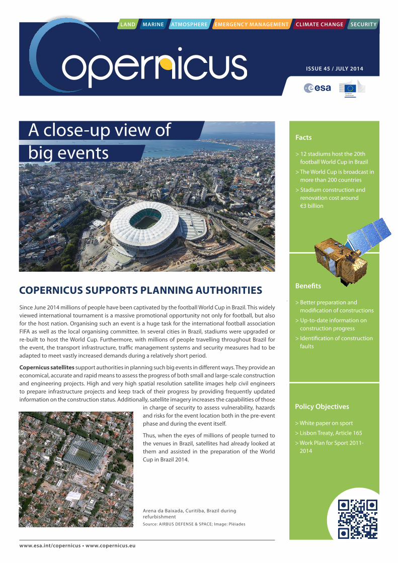
Arena da Baixada, Curitiba, Brazil during refurbishmentSource: AIRBUS DEFENSE & SPACE; Image: Pléiades
COPERNICUS SUPPORTS PLANNING AUTHORITIES
www.esa.int/copernicus • www.copernicus.eu
Since June 2014 millions of people have been captivated by the football World Cup in Brazil. This widely viewed international tournament is a massive promotional opportunity not only for football, but also for the host nation. Organising such an event is a huge task for the international football association FIFA as well as the local organising committee. In several cities in Brazil, stadiums were upgraded or re-built to host the World Cup. Furthermore, with millions of people travelling throughout Brazil for the event, the transport infrastructure, traffic management systems and security measures had to be adapted to meet vastly increased demands during a relatively short period.
Copernicus satellites support authorities in planning such big events in different ways. They provide an economical, accurate and rapid means to assess the progress of both small and large-scale construction and engineering projects. High and very high spatial resolution satellite images help civil engineers to prepare infrastructure projects and keep track of their progress by providing frequently updated information on the construction status. Additionally, satellite imagery increases the capabilities of those
in charge of security to assess vulnerability, hazards and risks for the event location both in the pre-event phase and during the event itself.
Thus, when the eyes of millions of people turned to the venues in Brazil, satellites had already looked at them and assisted in the preparation of the World Cup in Brazil 2014.
A close-up view of big events
LAND MARINE ATMOSPHERE EMERGENCY MANAGEMENT CLIMATE CHANGE SECURITY
ISSUE 45 / JULY 2014
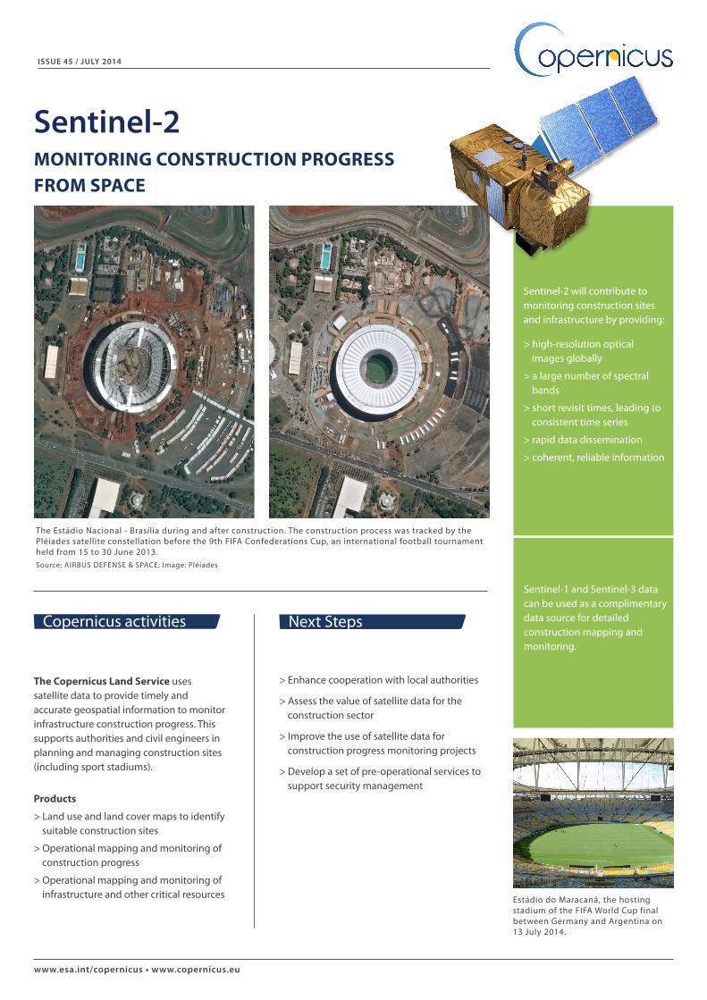
The Estádio Nacional - Brasília during and after construction. The construction process was tracked by the Pléiades satellite constellation before the 9th FIFA Confederations Cup, an international football tournament held from 15 to 30 June 2013.Source: AIRBUS DEFENSE & SPACE; Image: Pléiades
www.esa.int/copernicus • www.copernicus.eu
> Enhance cooperation with local authorities
> Assess the value of satellite data for the construction sector
> Improve the use of satellite data for construction progress monitoring projects
> Develop a set of pre-operational services to support security management
Estádio do Maracanã, the hosting stadium of the FIFA World Cup final between Germany and Argentina on 13 July 2014.
The Copernicus Land Service uses satellite data to provide timely and accurate geospatial information to monitor infrastructure construction progress. This supports authorities and civil engineers in planning and managing construction sites (including sport stadiums).
Products
> Land use and land cover maps to identify suitable construction sites
> Operational mapping and monitoring of construction progress
> Operational mapping and monitoring of infrastructure and other critical resources
Copernicus activities Next Steps
Sentinel-2 will contribute to monitoring construction sites and infrastructure by providing:
> high-resolution optical images globally
> a large number of spectral bands
> short revisit times, leading to consistent time series
> rapid data dissemination
> coherent, reliable information
ISSUE 45 / JULY 2014
Sentinel-2MONITORING CONSTRUCTION PROGRESS FROM SPACE
Sentinel-1 and Sentinel-3 data can be used as a complimentary data source for detailed construction mapping and monitoring.