a climate-smart resource stewardship strategy for sequoia
TRANSCRIPT

National Park Service U.S. Department of the Interior
Sequoia and Kings Canyon National Parks
A Climate-Smart Resource Stewardship Strategy for Sequoia and Kings Canyon National Parks October 2017

ii
For a brief overview of the Resource Stewardship Strategy, go to the webpage: go.nps.gov/sekiRSS On the Cover: View of Redwood Mountain Grove and the valley below. Photo by Randy Morse, Golden State Images.

iv
Project Management Team - Sequoia and Kings Canyon National Parks (SEKI) Dr. Koren Nydick, Science Coordinator/Ecologist – Project Manager Dr. Christy Brigham – Chief of Resource Management and Science Ginger Bradshaw – Ecologist Subject Matter Expert Contributors and Reviewers SEKI Daniel Boiano – Aquatic Ecologist Tony Caprio – Fire Ecologist Athena Demetry - Restoration Ecologist Howard Eldredge – Archivist Annie Esperanza – Air Quality Specialist Erik Frenzel – Plant Ecologist Daniel Gammons – Wildlife Biologist
Paul Hardwick – GIS and Data Coordinator David Humphrey – Cultural Resources Program Manager Erik Meyer – Physical Scientist Jessie Moore Russett – Archaeologist Larry Don Seale – Hydrologist Tom Warner – Forester
Sierra Nevada Network Inventory and Monitoring (SIEN) Sylvia Haultain – Program Manager Dr. Andrea Heard – Physical Scientist Dr. Jonathan Nesmith – Ecologist
U.S. Geological Survey – Sequoia Field Station Dr. Adrian Das – Ecologist Dr. Nathan Stephenson – Research Ecologist
Other ContributorsDavid Allen - SEKI Colleen Bathe - SEKI Savannah Boiano - Sequoia Parks Conservancy (SPC) Sarah Campe - Sierra Nevada Conservancy Malinee Crapsey - SEKI Marie Denn – Pacific West Region Alex Eddy - SIEN Matt Fagan - SEKI Karen Folger - SEKI
Nancy Hendricks - SEKI Jenny Kirk - SEKI Linda Mutch - SIEN Denise Robertson - SEKI Robert Sanders - SEKI Charisse Sydoriak - SEKI Katie Wightman - SPC Erika Williams - SEKI Eric Winford - SEKI Emily Zivot -SEKI
Reviewers Sarah Allen – Science Program Lead, Pacific West Region Malinee Crapsey – Interpretive Specialist, SEKI Nancy Hendricks – Planning and Compliance Coordinator, SEKI Denise Louie – Assistant Team Lead, Natural Resources, Pacific West Region Woody Smeck – Superintendent, SEKI Jason Watkins – Administrative Officer, SEKI

v
Table of Contents 1. Introduction ............................................................................................................................ 3
1.1 Purpose and Need for the Strategy ................................................................................... 4
1.2 Overarching Goal and Guiding Principles ......................................................................... 6
1.3 Development of a Climate-Smart Strategy ........................................................................ 9
2. Overview of Priority Resources and Major Stressors .............................................................13
2.1 Priority Resources ...........................................................................................................14
2.2 Major Stressors ...............................................................................................................22
2.3 Plausible Futures .............................................................................................................25
3. Assessments of Priority Resources .......................................................................................27
3.1 Cultural Resources .....................................................................................................28
3.2 Landscape Integrity and Biodiversity ...............................................................................30
3.3 Air Resources ..................................................................................................................31
3.4 Water Resources .............................................................................................................32
3.5 Aquatic Ecosystems and Species ....................................................................................34
3.6 Caves and Karst Systems ...............................................................................................36
3.7 Wet Meadows and Fens ..................................................................................................37
3.8 Foothill Terrestrial Ecosystems ........................................................................................38
3.9 Forest Ecosystems ..........................................................................................................39
3.10 Giant Sequoia Trees and Ecosystems ...........................................................................41
3.11 Alpine Terrestrial Ecosystems .......................................................................................42
3.12 Terrestrial Wildlife of Concern ........................................................................................43
4. Stewardship Strategies, Management Objectives, and Activities ...........................................45
4.1 Major Strategies ..............................................................................................................45
4.2. Management Approaches for Priority Resources ............................................................47
Cultural Resources ............................................................................................................48
Landscape Integrity and Biodiversity ..................................................................................53
Air Resources ....................................................................................................................58
Water Resources ...............................................................................................................62
Aquatic Ecosystems and Species ......................................................................................66
Caves and Karst Systems ..................................................................................................70
Wet Meadows and Fens ....................................................................................................73
Foothill Terrestrial Ecosystems ..........................................................................................76

vi
Forest Ecosystems ............................................................................................................80
Giant Sequoia and their Ecosystems .................................................................................84
Alpine Terrestrial Ecosystems ............................................................................................89
Terrestrial Wildlife of Concern ............................................................................................93
Crosscutting Activities ........................................................................................................96
4.4 Monitoring or Management Plans ....................................................................................98
4.5 Implementation of the RSS ............................................................................................ 101
4.6 Conclusion ..................................................................................................................... 101
5. Literature Cited ................................................................................................................... 103

1
To access the Overview and Appendices associated with this Resource Stewardship Strategy, go to the parks’ RSS webpage: go.nps.gov/sekiRSS
List of Appendices: Appendix A: Pre-RSS Goals and Indicators Tables
Appendix B: Climatic Change Summary
Appendix C: Vulnerability Assessment
Appendix D: Future Scenarios Report
Appendix E: Revisiting Goals Workshop Results
Appendix F: Changes to Goals
Appendix G: RSS Goals, Indicators, and Conditions Tables
Appendix H: RSS Activities Tables

2
As superintendent of the parks from 1920-1938 and 1941-1947, Colonel John White encouraged the removal of buildings in the Giant Forest to protect the health of the grove. His goals were achieved in the late 1990s.

3
1. Introduction The landscapes of Sequoia and Kings Canyon National Parks (SEKI) have a long history of stewardship. American Indians used traditional burning practices here for thousands of years. Captain Charles Young, superintendent in 1903, worked to stop livestock grazing in the parks. From the 1920s into the 1940s, Superintendent John White resisted over-developing park facilities. In more recent decades, with scientific studies supporting their actions, park managers have worked to restore nature in some of the areas where past human activity impacted resources. They took out buildings that encroached on giant sequoia trees, reintroduced fire to park ecosystems, repaired eroded wetlands, and removed non-native trout in naturally fishless lakes. People have cared for these special places in many ways for a long time. But there is still much work to be done. Like earlier stewards, today’s managers face many challenges while caring for these parks. The nature of current challenges is different, however. Of particular concern is accelerated global climate change. Its effects already are appearing in and around the parks. This is not surprising, as the huge elevational range in these parks creates a variety of localized conditions and habitats, each of which reacts to shifts in climate. Based on how rapidly the climate changes, we may soon see even more impacts on plants, animals, waterways, and other park resources. Current and forecasted climatic changes compel us to prepare for an uncertain future. From the foothills to the alpine peaks of the Sierra Nevada, climate change may result in shifting ecosystems and new combinations of species. Social conditions in and around national parks are changing as well. Demographics, economics, social expectations, and customs are all shifting. Changing environmental and social conditions complicate efforts to safeguard natural resources and provide unparalleled visitor experiences. Through this resource stewardship strategy and other planning efforts, the National Park Service (NPS) is facing these challenges. Photo: Philip Gross

4
1.1 Purpose and Need for the Strategy This Resource Stewardship Strategy (RSS) is a long-range strategic planning tool for managing and protecting natural and cultural resources of Sequoia and Kings Canyon National Parks (SEKI). It is informed by current, accurate science. A RSS is identified in NPS Management Policies 2006 (§2.3.2) as a major element of park planning and decision making to achieve and maintain desired resource conditions, which in turn are derived from relevant laws and NPS management directions. As part of SEKI’s planning portfolio, the RSS serves as a bridge between the parks’ Foundation Document, other plans, and everyday management of its natural and cultural resources. This RSS replaces the 1999 Natural and Cultural Resources Management Plan (NPS 1999) and will be implemented through project proposals, implementation plans, project and/or site-specific compliance, and annual work plans (Figure 1).
Figure 1. NPS Planning Framework The purpose of SEKI’s RSS is to:
1. Strategically guide investments in funding, planning, and implementing resource stewardship activities,
2. Track and evaluate resource stewardship progress, and 3. Integrate climate change adaptation and novel ways of thinking about resource
stewardship under changing conditions.
While the first two purposes are central to all NPS resource stewardship strategies, SEKI’s approach emphasizes the reality and need for adapting to changing conditions in the 21st century. Climate change has already affected some park resources and may soon have more profound impacts. We now know that striving to return to past conditions is not necessarily desirable given current and forecasted future conditions. Instead we recognize that rapid and unprecedented global change means that we need to prepare for a highly uncertain future and possibly novel conditions.

5
The RSS is not a “plan” in that it does not prescribe any particular set of activities. Rather, the RSS explores and presents a wider range of potential activities that managers could undertake to meet management goals in the coming one to two decades. Prior to implementation of the activities identified in the RSS, the proposed activities will be evaluated to determine the potential environmental impacts and appropriate level of analysis and documentation, in accordance with the National Environmental Policy Act, the National Historic Preservation Act, and other relevant laws and policies. The RSS is a compilation of the following interconnected parts:
● SEKI’s guiding principles for resource stewardship; ● Goals, indicators, and targets for each of the 12 priority resources; ● Assessments of current condition and trends, vulnerability, and plausible future
scenarios for each priority resource; ● Management approach for each priority resource, including a menu of prioritized
activities organized by management objective. Together, these RSS components answer five key questions that are essential to strategic planning in the 21st century: 1) Where are we now? 2) Where might the future take us? 3) Where do we feasibly want to be in the future? 4) What are the most important activities to accomplish to get there? 5) How will we review our progress? While the strategic framework of the RSS was designed for a 10-15 year lifespan, it also is meant to accommodate shorter-term changes. The RSS database enables updates as resource conditions and trends change, new information is gained, activities are accomplished, or priorities shift.
The California drought (2012-2016) was very severe due to the low precipitation combined with warm temperatures. It provided a view of a likely future where hotter droughts are more common. Photo by Donald Quintana.

6
1.2 Overarching Goal and Guiding Principles In 2011, NPS Director Jonathan Jarvis tasked the National Park System Advisory Board Science Committee to re-examine resource stewardship in the NPS. The science committee’s report revisits the 1963 “Wildlife Management in the National Parks,” also known as the Leopold Report. Written by A. Starker Leopold, the report set the NPS on a course of science-based management of its wildlife populations. “The Leopold Report has guided our management of natural resources for 50 years,” Jarvis said, “and while still valid in many ways, it needed to be revisited in light of the growing impacts of environmental change and human influences that we are experiencing in national parks and expanded to include the stewardship of cultural and historic resources” (Olson and Machlis 2012).
Furthermore, the Director’s Policy Memorandum 14-02 states specifically for cultural resources that NPS managers must keep in mind that: (1) cultural resources are primary sources of data regarding human interactions with climate change, and (2) changing climates affect the preservation and maintenance of cultural resources. SEKI Guiding Principles for Resource Stewardship: During the RSS planning process, we have considered what the goal suggested by the Revisiting Leopold report means in practice. As a result, the parks have described the following six principles to broadly guide its resource stewardship. These principles were informed by the literature on climate change adaptation, including Millar et al. (2007), Baron et al. (2009), Stephenson and Millar (2012), Stein et al. (2014), Melnick et al. (2015), and Millar and Stephenson (2015). These principles helped guide development of the RSS, but also are an integral part of the parks’ strategy. 1. Conserve regional native biodiversity. SEKI accepts that shifts in native species community composition are expected and are not likely to be resisted successfully over the long-term, nor is attempting to resist these changes necessarily an appropriate goal for park managers. Instead, the parks will focus on conserving the wide range of native species in the broader ecoregion, but not necessarily in the places that they currently exist. This means that we accept that some species may not persist within the parks’ boundaries in the future. To achieve this goal over the long-term, managers must accept and perhaps facilitate some degree of transformation, where species move to new locations and potentially form novel communities. We consider this principle a key component of implementing the idea of “stewarding resources in a context of continuous change that we do not fully understand.”
The Revisiting Leopold report suggested an overarching goal, “to steward NPS resources for continuous change that is not yet fully
understood, in order to preserve ecological integrity and cultural and
historical authenticity, provide visitors with transformative experiences,
and form the core of a national conservation land- and seascape”.

7
2. Conserve key ecosystem structures and functions. SEKI will focus on the most important aspects of ecosystem structure and function where core aspects of a system are retained but not necessarily within the range of historic variability. Ecosystem elements that are important to preserve include productivity, landscape connectivity, hydrologic regulation by vegetation and soil, top carnivores (as proxy for intact food webs), and a disturbance regime appropriate to support regional biodiversity and other important ecosystem functions. Accommodating change in ecosystems at a slow pace may allow for transitions to new ecosystem states with high resilience, rather than change with catastrophic simplification of ecosystems (e.g., large loss of habitat function and native biodiversity) (See Figure 2, from Millar and Stephenson 2015). We consider this principle key to maintaining the integrity of park ecosystems under changing conditions.
Figure 2. Management practices can influence the nature of transition between forest types. Numbers represent forest transitions through time. Top Panel: (1) Managing for historical range of variability. (2) Abrupt change with substantial mortality and loss of ecosystem services and biodiversity. (3) Slow recovery. Bottom Panel: (1) Managing to ease the transition to future states, possibly including thinning and establishment of species better suited to future conditions. (2) Gradual transition with better retention of ecosystems services and biodiversity. (3) More rapid recovery. Though some ecosystem services are lost in both scenarios, active management may facilitate more gradual transition. Figure and text adapted from Millar and Stephenson 2015.
8
3. Preserve the historical and cultural integrity of resources and recognize that climate change may alter resource settings and exacerbate the deterioration of cultural resources. SEKI acknowledges the importance of cultural and historical integrity as a reflection of a connection to a resource’s parent culture or accurate reflection of a specific cultural context. We will emphasize preservation of cultural and historical integrity during this period of rapid and extensive change as a way of focusing our conservation and management efforts. SEKI accepts that deterioration of cultural resources is inevitable over varying time scales and that climate change may alter the setting (e.g., soil properties, burial depth, or vegetation environment) or speed up the rate of deterioration. We will consider the vulnerability of cultural resources to changing climate as part of decision-making and these vulnerability assessments will be a key part of prioritizing cultural resource work.
4. Move audiences toward increased stewardship. SEKI will communicate to people at their current level of knowledge and interest to forge stronger intellectual and emotional connections to park resources. Wherever possible, we will strive to create information and programs that will be transformative for participants, increase their commitment to stewardship, result in better-informed decisions, and increase conservation actions. Given that the majority of the changes we are observing in our parks are human-caused, this is an incredibly important goal and we will strive to find effective ways to connect with a broad array of audiences around the globe including those who visit the parks and those who may never visit. This principle is important to both stewarding park resources through continuous change and providing transformative experiences to the public.
5. Minimize potential negative impacts on natural and cultural resources from human infrastructure and activities and recognize that climate change and other shifting conditions may alter infrastructure needs and exacerbate impacts of human use. The parks will consider interacting stressors (e.g., climate change and its influence on fires, flooding, erosion, vegetation, and wildlife) when making decisions regarding human infrastructure. As required by the National Environmental Policy Act (NEPA) and other guiding legislation and policy, we will minimize the impacts of park infrastructure, monitor these impacts over time, and mitigate projects when sufficient avoidance measures cannot be identified.
6. Cooperate across boundaries for ecoregional stewardship. SEKI will work cooperatively across the larger cross-jurisdictional landscape to conserve native species, ecosystem structures and functions, protect landscape-level movement corridors, and conserve historical and cultural integrity in our region. Park staff will continue to build connections and relationships, standardize data collection procedures, and partner in research, communication, analysis, and conservation actions at a landscape scale. This includes collaboration with indigenous peoples to learn and apply traditional knowledge about both natural and cultural resources. This principle forms the backbone of SEKI’s contribution “as an ecological and cultural core of a national and international network of protected lands and waters.”

9
1.3 Development of a Climate-Smart Strategy To develop the RSS, we integrated guidance from the RSS Development Guide (NPS 2015b) that was published part-way through our process and Climate Smart Conservation: Putting Adaptation Principles into Practice (Stein et al. 2014) that was developed by a suite of federal agencies, including the NPS.
A key theme of Climate-Smart Conservation is the reconsideration of management goals in light of changing conditions. SEKI’s RSS differs from previous NPS resource stewardship strategies in that we explicitly integrate this theme and carefully re-examine desired conditions in a climate change context. SEKI’s RSS Climate-Smart Conservation Cycle (Figure 3) provides an overview of how we integrated NPS guidance with Climate-Smart Conservation. We conducted steps 1-5 in the cycle to develop the RSS. These five steps are depicted chronologically, but in reality it was necessary to move back and forth among the steps. Steps 6 and 7 will occur during RSS implementation.
Figure 3. The RSS Climate-Smart Conservation Cycle used to develop SEKI’s RSS
Climate-Smart Conservation is the intentional and deliberate consideration of
climate change in resource management, realized through forward-looking goals
and linking actions to key climate impacts and vulnerabilities (Stein et al. 2014).
10
Step 1 - Identify priority resources and current goals We identified candidate priority resources by reviewing SEKI’s fundamental resources and values (FRVs) in the parks’ Foundation Document (NPS 2015a) and the focal resources identified in its Natural Resource Condition Assessment (NRCA) (NPS 2013). We then established criteria for selecting the priority resources and established an initial list. The criteria for selecting priority resources were as follows: 1) importance as reflected in law or policy, including the parks’ Foundation Document and General Management Plan, 2) importance due to public benefits or concerns, 3) resource at risk, now or in the future, 4) management activities relevant to the resource may need to change, 5) management activities can make a significant difference or inform important decisions about the resource, and 6) the resource has interconnections with many other important resources. Current (pre-RSS) goals were described for the priority resources based on SEKI planning documents and NPS management policies (see Appendix A). Step 2. Assess condition, vulnerabilities, and potential impacts Once priority resources had been selected, for each resource we summarized and interpreted relevant findings of SEKI’s Natural Resource Condition Assessment and supplemented it with critical information gained since it was published in 2013. Second, we described future climate projections (Appendix B) and conducted a vulnerability assessment (Appendix C) to consider future exposure to stressors, sensitivity to these stressors, and adaptive capacity to cope despite stressor impacts (Glick et al. 2011). Third, we used these findings and expert opinion to describe three plausible future scenarios for each resource (Appendix D). These scenarios are described for 20 years and 80 years from now and capture “much warmer and drier”, “much warmer and wetter”, and “warmer, similar to recent precipitation” alternative futures and potential impacts on priority resources. Step 3: Reconsider goals in light of changing conditions We reviewed and reconsidered current management goals for each priority resource by addressing three questions: 1) are current management goals being monitored and achieved, 2) are current management goals feasible in light of plausible future conditions, and 3) if needed, how should we revise management goals to become climate-smart. The first question was assessed by reviewing monitoring data and research. To evaluate the second question, we considered each of the three plausible future scenarios at time periods of 20 and 80 years from now (Appendix E). Putting all this information together and using expert judgment, we then suggested revisions, if appropriate, to management goals while keeping them within the broad scope of NPS management policies (Appendix F). The resulting RSS priority resource goals, indicators, measures, and targets are presented in detail in Appendix G, along with the corresponding condition status and trend information. The priority resource assessments found in section 3 of this RSS presents summarized information from these appendices.

11
Goals, indicators, and targets collectively define measurable desired conditions. Indicators are quantifiable biophysical or social/managerial variables that can be measured to track success at achieving a goal. Indicators are information-rich in the sense that their values are indicative of the quality, health, or integrity of the ecological or social system to which they belong. A target is the quantity or quality of an indicator that demonstrates whether or not a desired condition is achieved. When a target is not achieved, it may serve as a trigger warning that a change in management may be warranted. Identification of indicators and targets may also identify priorities for monitoring. In some cases, specific quantitative management targets may be difficult to define due to lack of data or because of uncertain future conditions; such information gaps suggest new research priorities. In all cases, targets should be reviewed and potentially revised over time to keep pace with new learning.
National Park Service staff participate in a workshop as part of the process to develop the RSS. Photo by Ginger Bradshaw. Step 4: Describe activities to reduce vulnerabilities and achieve goals Within each priority resource, we considered the three plausible future scenarios to help brainstorm broader management objectives and the more specific activities that would help achieve resource stewardship goals and reduce vulnerabilities in the face of uncertain future conditions. These objectives and activities encompassed a range of activity types, such as direct management intervention, research, education, or partnership building. A “crosscutting” category was created for activities that benefit several resources. After initially identifying management objectives for individual priority resources, we worked to reduce the overall number of objectives and highlight interconnections among priority resources. This meant grouping similar objectives across resources and revising the objectives to be interdisciplinary. As a result, a single management objective could point to several activities across more than one priority resource. Each activity was grouped under the single most appropriate objective, but an activity often was relevant to more than one objective.

12
Additionally, to allow flexibility and creativity, the RSS development process allowed considerable variation in what was considered an activity. The scope of an activity varies from a very specific project to a broader set of potential actions that will require more definition before being implemented. Furthermore, individual activities vary in their requirements for staff time and funding. Therefore, for multiple reasons, the number of activities listed under each priority resource or each objective is not very informative. Step 5: Prioritize activities We prioritized activities within each priority resource using the method outlined in the NPS RSS guidance (NPS 2015b). Because the activities were prioritized within priority resources, ratings are not meant to compare across the priority resources. Management objectives were not prioritized.
First, in a large group, we identified criteria that we associated with higher priority resource stewardship activities. These criteria are listed below.
● Provides or facilitates meaningful, long-lasting, robust benefits to priority resources. ● Required by law. ● Provides information to inform policy or management decisions. ● Is robust to climate change, reduces vulnerability, or eases climate-driven transitions. ● Facilitates or implements landscape-scale management. ● Helps protect resources with exceptionally high social value. ● Facilitates or demonstrates SEKI’s unique role or leadership in our region. ● Is identified in SEKI’s strategic plan or is critical to “Call to Action” or other park or NPS-
wide plans. ● Reduces a threat to life and property.
Then, we worked in small groups to sort activities within each priority resource into roughly equal thirds: high, medium, and low priority. Three groups, including one subject matter expert group and two interdisciplinary groups, ranked each activity. When groups disagreed on priority ratings, we discussed the activity in a large group and then came to an agreed upon priority category. In some cases, a lower priority was assigned to an activity when other activities were needed first before the activity in question would meet the criteria. For example, more information might be required to know if and when a particular activity is needed and how exactly to implement it. As activities are accomplished over time, the prioritization of other activities might change and new activities may be added. For management objectives and activities identified in this first version of the RSS, a complete listing with the activity priority results is found in Appendix H.

13
2. Overview of Priority Resources and Major Stressors
Founded in 1890, Sequoia is the second-oldest park in the system, joined in 1940 by Kings Canyon, created expressly as a “wilderness park.” Since 1943, the two parks have been administered jointly with one superintendent overseeing the management of both parks. Together, Sequoia and Kings Canyon National Parks preserve and protect the grandest and most pristine portion of the Sierra Nevada range. The parks protect more than 865,964 acres of land (404,063 acres in Sequoia and 461,901 acres in Kings Canyon) and also showcase a remarkable range of elevations from 1,370 feet in the Sierra foothills to the 14,494 feet (4,418 m) peak of Mount Whitney. A majority of the lands within the parks are designated as wilderness, which is defined under the Wilderness Act. As of 2015, approximately 808,078 acres are designated wilderness (93.3% of the parks), and 29,516 acres are proposed wilderness, and 212 additional acres are potential wilderness (totaling approximately 96.8% of the park acreage). The parks are nearly surrounded by three national forests: Sierra National Forest, northwest of the parks; Inyo National Forest, east of the parks; and Sequoia National Forest / Giant Sequoia National Monument, south and west of the parks. Within these national forests are four designated wilderness areas: Golden Trout Wilderness to the southeast, John Muir Wilderness to the north, and Monarch Wilderness and Jennie Lakes Wilderness to the west. The primary access to the parks’ eastern wilderness is by foot or stock travel through US Forest Service lands. Not only do these undeveloped surrounding lands provide ecological connectivity with the parks, they also help protect the surrounding natural viewsheds and dark night skies as experienced in the parks. Maps of the parks are available here: http://insideparkatlas.nps.gov/. Nearby communities to the west of the parks include Three Rivers, at the entrance to Sequoia National Park, and Squaw Valley and Dunlap, near the entrance to Kings Canyon National Park. Visalia and Fresno are larger cities to the west of the parks, in California’s Great Central Valley. Lone Pine, Independence, Big Pine, and Bishop, California, are gateway communities on the east side of the park, below the crest of the highest Sierra. There are no roads crossing the parks east to west.
Park Purpose: Sequoia and Kings Canyon National Parks preserve and provide for
the enjoyment of present and future generations the wonders, curiosities, and evolving
ecological processes of the southern Sierra Nevada—including the largest giant
sequoia trees in the world, free-flowing wild and scenic rivers, and the heart of the vast
High Sierra wilderness (NPS 2015a).

14
2.1 Priority Resources A priority resource is a cultural or natural resource or value that the NPS manages or monitors to maintain park purpose and significance, to address policy/law mandates, or because of scholarly and scientific research needs or findings (NPS 2015b). Park managers identified 12 priority resources listed below. Some priority resources were further divided into components. • Cultural resources • Landscape integrity and biodiversity • Air resources • Water resources • Cave and karst systems • Aquatic ecosystems and species
• Wet meadows and fens • Foothill terrestrial ecosystems • Forests • Giant sequoias • Alpine terrestrial ecosystems • Terrestrial wildlife of concern
Cultural Resources: archeological resources, cultural landscapes, historic structures, ethnographic resources, and museum collections and archives. The parks preserve the traces of more than 8,000 years of human occupation and use, including patterns of prehistoric trade and travel, early European American exploration, mountaineering, the impacts of early modern extractive economies, the record of military-era administration, early NPS development, and the continuing evolution of NPS stewardship approaches. The establishment of the parks was a part of an early American conservation ethic. The parks preserve sites, photographs, historic structures, documentation, written history (plans, administrative records), oral histories, artifacts, named trees, cultural landscapes, and personal collections that demonstrate and interpret these historic themes. These themes include the history of scientific process, investigation, and collections in the parks. The parks share these resources and stories with the public through interpretation, museums, and visitor centers. The parks work with current day Native Americans to continue Tribal use of park lands, to learn traditional ecological knowledge (TEK) valuable to present day stewardship, and to educate the public regarding present day Native American uses and the complex and ever evolving different Native American cultures associated with these landscapes. Landscape Integrity and Biodiversity: habitat intactness and connectivity, biodiversity, and soil. The parks protect the largest elevation gradient in the lower 48 states. The physical characteristics of the parks, including their large size, location, relatively intact natural processes, and steep elevation gradient, support remarkable biodiversity. There are 12 amphibian species (11 native), 201 bird species (192 native), 11 fish species (5 native), 72 mammal species (68 native), 21 reptile species (all native), and 1,551 plant species (1,355 native), plus thousands of species of invertebrates and other species of unknown status that may occur in the parks. The parks possess four of the world’s five biomes (grassland, tundra, forest, and aquatic) and intact, self-regulating ecosystems that include: foothill woodlands, montane forest, subalpine forest, alpine tundra, wetlands, and aquatic ecosystems. This collection of ecosystems is valued because of their extensive area, relatively minimal alteration by humans, remarkable species richness, and/or charismatic species. The minimally fragmented landscape in the parks (e.g., from roads and other developments) provides for intact processes and a high continuity of ecosystems.

15
Air Resources: air quality, night skies, and natural soundscapes. The parks are designated Class I areas by the Clean Air Act. Clean air is fundamental to preserving the health of species (including humans) and ecosystems and the full extent of scenic views. Night skies refer to the preservation of natural lightscapes to protect scenic night time views and natural ecosystem function, including the behavior and survival of nocturnal animals. The night sky is a timeless resource important to many people, cultures, and religions. SEKI provides important habitat for nocturnal wildlife, wilderness opportunities, recreational activities after dark, and a unique opportunity for millions of visitors to enjoy night sky resources. Natural soundscapes refer to the acoustic environment as an important natural resource, cultural resource, or both. Natural sounds are a critical component of the parks’ wilderness character and play an important role in wildlife communication, behavior, and other ecological processes. Water Resources: water quality and hydrology (timing, form, and amount). Water resources include an extensive seasonal snowpack, glaciers (including rock glaciers), lakes and ponds, rivers, streams, wetlands (including wet meadows and fens), springs, seeps, and groundwater. The parks contain three main watersheds (Kings, Kaweah, and Kern) and portions of two watersheds (South Fork of the San Joaquin and North Fork of the Tule). There are an estimated 2,144 miles (3,450 km) of mapped rivers and streams, plus an unknown amount of primarily intermittent streams. There are three designated Wild and Scenic Rivers (North Fork of the Kern River, Middle Fork of the Kings River, and South Fork of the Kings River) and two rivers determined to be eligible and suitable for designation (South Fork of the San Joaquin River and Kaweah River). An extensive snowpack accumulates primarily above 6,000 feet (1,829 m), though snow can fall at any elevation within the parks. The snowpack functions as a natural storage system for water that accumulates in the winter months and is released slowly, providing water to ecosystems and downstream users, during the dry summer months. Most of the parks’ estimated 3,365 lakes and ponds are located at high elevations, above 8,900 feet (2,712 m). Though a few lakes exceed 70 acres, most are only a few acres in size. Located in the nutrient poor alpine and subalpine zones, most park lakes have exceptionally low productivity and dilute water chemistry. This system of water resources, its water quality and natural hydrological processes, provides for a variety of aquatic and riparian ecosystems (see below); offers recreational opportunities; and plays a critical role in downstream water quantity. The parks watersheds provide clean water to the Tulare Basin and the southern portion of California’s Central Valley. This water is managed for agriculture, recreation, electrical power generation, and other uses. Cave and Karst Systems: wild caves and Crystal Cave. The parks contain extensive karst aquifers that have resulted in the formation of more than 275 caves, making it one of the most cave-rich landscapes in the western United States. These include California’s longest cave, caves with endemic cave-adapted species, and caves with rare and fragile mineral resources. The caves in the parks have contributed to the advancements of speleological knowledge of international significance. Crystal Cave is one of the most popular commercial caves in California. Cave tours are led by the parks’ partner, Sequoia Parks Conservancy.

16
Aquatic Ecosystems and Species: low-elevation ecosystems and species, and high-elevation ecosystems and species. Lower-elevation aquatic ecosystems include rivers, streams, riparian wetlands, springs, and seeps. Common aquatic vertebrate species in the foothills zone include rainbow trout (Oncorhynchus mykiss, native at low to mid elevations), Pacific tree frog (Pseudacris regilla), California and Sierra newts (Taricha torosa and T. sierra), western pond turtle (Emys marmorata) and Sierra garter snake (Thamnophis couchii). The foothill yellow-legged frog (Rana boylii) has been extirpated from the park foothills and the western pond turtle is a California state species of special concern and is under review for federal listing under the Endangered Species Act. Native aquatic vertebrate species that are common in forested ecosystems include rainbow trout (native only in the lower reaches of the montane zone), Pacific tree frog, Sierra garter snake, and western terrestrial garter snake (Thamnophis elegans). Higher elevation aquatic ecosystems include streams, lakes, ponds, riparian wetlands, springs, seeps, and wet meadows and fens (which were identified as a separate priority resource, see below). The most common native aquatic vertebrate species in the high elevations today is the Pacific tree frog. Virtually all lakes in the Sierra Nevada originally were fishless, but historic stocking with non-native trout has resulted in self-sustaining populations of fish in about half of the parks’ lakes. This has altered native food webs and caused the decline of some native species. Two species of mountain yellow-legged frogs (Rana muscosa and R. sierrae) were historically abundant in the high elevations, but today are federally listed as endangered under the Endangered Species Act. The Yosemite toad (Anaxyrus canorus) and Little Kern golden trout (Oncorhynchus mykiss whitei) are federally listed as threatened. Wet Meadows and Fens. Meadow habitats (including dry meadows, wet meadows, and fens) extend over roughly 22,000 acres (3%) of the park lands. Wet meadows and fens are generally classified as wetlands and are the focus of this priority resource. They comprise about 45% of the meadow habitat in the parks and include over 2,300 wetlands. Most are located in the montane and subalpine zones at elevations between 5,000-9,000 ft. (1,500-2,700 m). Sierra Nevada meadows are defined by the presence of persistent shallow groundwater, fine-textured soils, and predominantly herbaceous vegetation. The herbaceous species are generally perennial grasses, sedges, rushes, and broadleaved herbs. Trees and shrubs inhabit some meadows but are rarely dominant. Meadows in the parks range from dry meadows, where groundwater may be near the surface in spring but is generally deeper than 1 m during the summer, to wet meadows with surface water or near-surface groundwater for most of the growing season, to fens which have persistent surface water or near-surface groundwater throughout the growing season promoting peat accumulation. Peat is often patchy within a single meadow, so meadow-fen complexes are common. Wet meadows and fens often support similar vegetation, but fens are usually characterized by a higher proportion of bryophytes (e.g., Sphagnum spp.) and obligate wetland species than wet meadows. These meadow habitats have high ecological and cultural significance despite their limited extent within the parks. Meadows and fens support much of the Sierra Nevada flora and fauna at both local and regional scales. Plant communities are highly diverse within individual meadows and clusters of meadow systems. Meadows provide essential habitat for at least a portion of the life-cycle of a wide-range of faunal species, including invertebrates, amphibians, birds, and mammals. Wet meadows and fens provide a critical interface for the transfer of

17
nutrients between aquatic and terrestrial ecosystems. Ecosystem services provided by wet meadows and fens include sediment storage, nutrient cycling, and delayed release of seasonal precipitation. For millennia, indigenous people living in the range actively managed meadow systems and used the vegetation and associated wildlife of meadow habitat as a source for high-value food and material. In the historic era, meadows have provided forage for pack animals supporting both recreational and administrative trips in the wilderness of the parks. The iconic mountain vistas afforded by these open spaces have also served to inspire conservation in the Sierra Nevada and beyond. Foothill Terrestrial Ecosystems. The parks’ foothill ecosystems encompass the low-elevation hardwood and chaparral zone between approximately 1,500-6,000 feet (460-1,830 m) in elevation. This ecological zone supports plant communities adapted to hot, dry summers and winter rain. Foothill vegetation communities consist of a mosaic patchwork of deciduous oak woodlands, evergreen hardwood forests, deciduous and evergreen shrublands, and mixed hardwood and coniferous forests with herbaceous understories. Foothill vegetation communities occupy 55,014 acres (6%) of the parks and serve as an important link between the mid- and high-elevation habitats protected by the parks and lower elevation agricultural landscapes outside their boundaries. While foothill vegetation is extensive throughout the western side of the Sierra Nevada, it has been greatly altered by non-native plant species, grazing, agriculture, or rural development. The lower elevations of the parks were extensively grazed by livestock early in the 20th century. Today, the parks protect some of the most extensive un-grazed foothill tracts designated for long-term preservation in California, including blue oak (Quercus douglasii) woodland. Administrative pack stock grazing in the foothills is limited to about 1,200 acres. Forests: montane forests and subalpine forests. Sierra Nevada coniferous forests comprise one of the largest and most ecologically and economically important vegetation regions in California. Forest dynamics–primarily birth, growth, and death rates of trees–are sensitive to climate and fire regimes. Forest distributions are linked to moisture availability, as determined by geology and topography, soil depth, and evaporative demand. Moisture availability affects growth, recruitment and death rates of trees, as well as frequency and intensity of fire. Forests store carbon, stabilize soil, provide food and habitat for a variety of organisms (including several wildlife species of conservation concern), and offer plentiful recreational opportunities. Forests are the most common vegetation type in the parks, where they account for a third of the area and almost half of the non-barren lands; the largest remaining old growth forest in the southern Sierra Nevada is found in these parks. Montane forests generally occur at altitudes between 5,000 and 9,000 feet (1,524 and 2,743 m) and are water-limited, fire-adapted ecosystems (with some exceptions). At the lower elevation range, montane forests are characterized by ponderosa pine (Pinus ponderosa), incense-cedar (Calocedrus decurrens), white fir (Abies concolor), sugar pine (Pinus lambertiana), and black oak (Quercus kelloggii). Ponderosa pine-mixed conifer forests, and in some cases pinyon pine, occupy drier sites, while white fir-mixed conifer forests with scattered giant sequoia groves are found in moister areas. Above this zone, forming a transition to higher subalpine forests, occur upper montane red fir (Abies magnifica), Jeffrey pine (Pinus jeffreyi), and lodgepole pine (Pinus contorta) forests that can extend to nearly 10,000 feet (3,350 m). The subalpine zone begins at about 9,000 ft. (2,743
18
m) in elevation where forest dynamics are more temperature and soil limited. Treeline is approximated at 10,000 feet (3,350 m) for much of the parks, but extends to 10,827 feet (3,300 m) in the Mt. Whitney region. Subalpine forests are dominated by mountain hemlock (Tsuga mertensiana), western white pine (Pinus monticola), lodgepole pine, whitebark pine (Pinus albicaulis), foxtail pine (Pinus balfouriana), and Sierra juniper (Juniperus grandis) and includes several geographically restricted forest types. Whitebark pine (Pinus albicaulis) is a candidate for federal listing under the Endangered Species Act. Giant Sequoia: large sequoia trees, giant sequoia trees and ecosystems, and groves of highest social value. Giant sequoia (Sequoiadendron giganteum) is the largest tree species on Earth. They are endemic to a 250 mile (400 km) long, 9 mile (15 km) wide belt across the western Sierra Nevada range at elevations of 4,600-7,000 feet (1,400-2,150 m). They grow in scattered groves that occur in moister areas of montane forests. Individual mature sequoias can use more than 500 gallons (2,000 liters) of water on a summer day. Giant sequoia is a fire-adapted species that combines pioneer traits including large numbers of light seeds released from semi-serotinous cones, rapid post-disturbance colonization, and rapid growth with late-seral traits, such as longevity and large size. Individual trees can live 3,200 years and possibly longer. Fire is essential to the germination of seedlings and hence the long-term survival of the species. The protection of giant sequoia trees from logging was one of the primary forces for the creation of Sequoia National Park. The parks contain 39 named giant sequoia groves, which account for roughly 40% of all giant sequoia grove area in the world, including the largest unlogged giant sequoia grove (Redwood Canyon grove). The four largest giant sequoia trees—by trunk volume—are in these parks (including the General Grant Tree, the nation’s only living National Shrine). The groves, and the magnificent trees contained therein, have inspired generations of visitors from around the world with a sense of awe. Research into giant sequoias influenced the field of fire ecology and provided impetus for establishing a prescribed fire program in the parks. Alpine Terrestrial Ecosystems: alpine tundra/uplands. The rugged, remote wilderness of the alpine zone accounts for 275,915 acres (32%) of the parks’ area. The parks protect much of the alpine environment of the southern Sierra Nevada. Alpine environments are considered quite rare globally, and the Sierra Nevada alpine zone is among the most botanically species-rich of the continental alpine environments. In these environmentally extreme and isolated highlands, life is tightly constrained by harsh growing conditions. Vegetation is dominated by slow-growing perennial plants that are adapted to the extreme climatic conditions. Alpine plant species are found not only above the tree line but also in openings in subalpine woodlands. Exclusive alpine habitat types include alpine talus slope, scree slope, snow patch communities, fell-field, and permanent snowfield/glacier. Many other vegetation types partially occur in the alpine zone. The alpine ecosystem provides primary habitat for species of conservation concern, including two species of frogs and one toad (see aquatic ecosystems and species above), Sierra Nevada bighorn sheep (Ovis canadensis sierrae), Sierra Nevada red fox (Vulpes vulpes necator), wolverine (Gulo gulo), and 32 of the parks 150 special status plants.

19
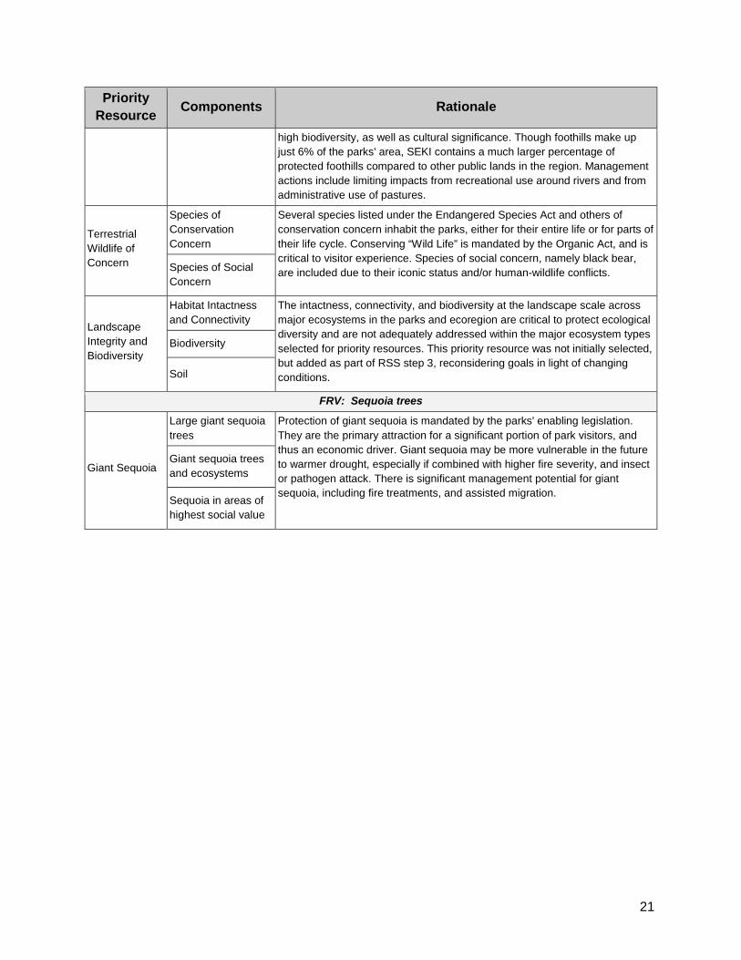
Terrestrial Wildlife of Concern: species of conservation concern and species of social concern. While there are many native terrestrial wildlife species common in the parks, this priority resource focuses on species of conservation or social concern. Wildlife species federally listed under the Endangered Species Act are the Sierra Nevada bighorn sheep, which inhabit the upper elevations and were nearly extirpated from the southern Sierra Nevada in the early 1900s, and the California condor (Gymnogyps californianus), which are only observed in the parks on occasion. The California spotted owl (Strix occidentalis occidentalis ) and the black-backed woodpecker (Picoides arcticus) are under review for federal listing. The Pacific fisher (Pekania pennant) was a candidate for federal listing, but in 2016 was determined not to require protection under the Endangered Species Act. The brown/grizzly bear (Ursus arctos californicus) historically occupied the lower elevations of the parks, but was extirpated from California in the 1920s. Wolverine and Sierra Nevada red fox also are likely extirpated. The American black bear (Ursus americanus ) is a species of social concern due to their status as a “charismatic megafauna” that people enjoy viewing and because of human-black bear conflicts. Black bears inhabit most of the parks, but are rarely observed above treeline. Though most of the bears subsist on natural foods, others have learned to forage for human foods. Table 1. Linkage between the priority resources and the fundamental resources and values (FRVs) described in the parks’ Foundation Document.
Priority Resource
Components Rationale
FRV: Human History
Cultural Resources
Archaeological Resources
Cultural resource documentation and protection is required by the National Historic Preservation Act (NHPA), and other federal laws. Human history was identified as a Fundamental Resource or Other Value (FRV) in the parks' Foundation Document. Protection of cultural resources is important to local cultures and is part of the NPS’ fundamental mission to preserve resources unimpaired. Visitors benefit from experiencing historic structures, scenes, and stories. Some resources are at risk from climate change and increased visitation. More strategic prioritization of cultural resources is needed.
Cultural Landscapes
Historic structures
Ethnographic Resources
Museum Collections and Archives
FRV: Scenic Landscapes & Wilderness Character
Air Resources
Air Quality
Under the Clean Air Act, the parks are designated Class I Airsheds. Air quality is a main component of the Scenic Landscapes FRV in the parks' Foundation Document. Air quality affects the health of every organism and ecosystem. Though the parks offer exceptional opportunities to experience both daytime scenic vistas and dark night skies, haze reduces visibility dramatically, and particulate pollutants "scatter artificial light, increasing the effect of light pollution on the night sky" (NPS 2016). Ozone is known to injure certain species of plants. Other air contaminants such as nutrients and pesticides enter aquatic systems, causing degradation.
Night Skies
Soundscapes Soundscapes (natural quiet) are considered with the Wilderness Character FRV in the Foundation Document, and are important to both natural processes and to visitor experience. Soundscape monitoring is an emerging

20
Priority Resource
Components Rationale
discipline with promise for improved understanding of biodiversity recovery following restoration and disturbance events.
FRV: Water Resources
Water Resources
Water Quality Water quality is protected under the Clean Water Act. Water Resources were identified as a FRV in the parks’ Foundation Document. Water quality and quantity are threatened and they affect the health of park organisms and ecosystems. Management activities include efforts to conserve water, conduct forest and wetland restoration, and gather information that can be used to influence policy and human behaviors.
Hydrology
FRV: Caves and Karst Systems
Caves & Karst Systems
Wild Caves Caves are a FRV in the parks’ Foundation Document and are protected under the Cave Protection Act. The parks’ cave resources are nationally significant due to the number and extent of caves. There are endemic cave fauna about which relatively little is known, including risks. The need for a cave management plan has been identified as a high priority. Crystal Cave
FRV: Ecological Diversity Aquatic Ecosystems
High Elevation Aquatic Ecosystems and Species
Aquatic ecosystems cover a relatively small area of the parks compared to other ecosystems, but support a wide array of ecosystem services and biodiversity, including several species listed under the Endangered Species Act. Aquatic species and other ecosystem components and functions are at risk now and in the future. Management actions are ongoing to restore lakes, streams, and wetlands.
Low Elevation Aquatic Ecosystems and Species
Wet Meadows and Fens
Wet Meadows and Fens
Wet meadows and fens comprise a small percentage of park area, but have a large impact on biodiversity. Wetlands are threatened by past management (e.g., grazing and roads), climate change, and other stressors. Management activities include monitoring condition relative to pack stock grazing, removal of non-native invasive plants, revegetation and full restoration.
Alpine Terrestrial Ecosystems
Alpine Tundra/Uplands
The high Sierran wilderness is called out in the parks’ purpose statement in the Foundation Document. Alpine environments make up 31% of the parks' area. Alpine ecosystems and species are particularly at risk from climate change as some areas may become 'sky islands' cut off from adjacent peaks lacking contiguous habitat. High peaks are a key part of visitor experience, both for those viewing from scenic overlooks, and for those recreating in wilderness. Management interventions are more limited in the alpine, but opportunities exist, such as removal of non-native invasive plants and revegetation/restoration.
Forest Ecosystems
Subalpine Forest Together, the subalpine (17%) and montane (46%) zones make up 63% of the parks' area and contain 84% of the parks' total forest cover. In the subalpine, whitebark pine is a candidate for listing under the Endangered Species Act. Montane forests provide habitat for species of conservation concern including Pacific fisher and California spotted owl. These forests are at risk from altered fire regimes, drought, white pine blister rust, and insect outbreak. Fire management in the parks has focused on montane forests.
Montane Forest
Foothill Terrestrial Ecosystems
Foothill Terrestrial Ecosystems
Foothill ecosystems have the highest current stressor exposure. They are at risk now and there is not enough evidence to know if they will be more or less vulnerable than other ecosystems to climate change. The foothills contain
21
Priority Resource
Components Rationale
high biodiversity, as well as cultural significance. Though foothills make up just 6% of the parks' area, SEKI contains a much larger percentage of protected foothills compared to other public lands in the region. Management actions include limiting impacts from recreational use around rivers and from administrative use of pastures.
Terrestrial Wildlife of Concern
Species of Conservation Concern
Several species listed under the Endangered Species Act and others of conservation concern inhabit the parks, either for their entire life or for parts of their life cycle. Conserving “Wild Life” is mandated by the Organic Act, and is critical to visitor experience. Species of social concern, namely black bear, are included due to their iconic status and/or human-wildlife conflicts. Species of Social
Concern
Landscape Integrity and Biodiversity
Habitat Intactness and Connectivity
The intactness, connectivity, and biodiversity at the landscape scale across major ecosystems in the parks and ecoregion are critical to protect ecological diversity and are not adequately addressed within the major ecosystem types selected for priority resources. This priority resource was not initially selected, but added as part of RSS step 3, reconsidering goals in light of changing conditions.
Biodiversity
Soil
FRV: Sequoia trees
Giant Sequoia
Large giant sequoia trees
Protection of giant sequoia is mandated by the parks' enabling legislation. They are the primary attraction for a significant portion of park visitors, and thus an economic driver. Giant sequoia may be more vulnerable in the future to warmer drought, especially if combined with higher fire severity, and insect or pathogen attack. There is significant management potential for giant sequoia, including fire treatments, and assisted migration.
Giant sequoia trees and ecosystems
Sequoia in areas of highest social value

22
2.2 Major Stressors Air pollution, altered fire regimes, climate change, invasive species, insects and disease, regional habitat fragmentation, land use, and park visitation are stressors that affect the parks’ priority resources and are likely to continue and may intensify in the future. For more detail and referenced literature on these stressors and potential impacts on priority resources, see the climate change report (Appendix B) and vulnerability assessment (Appendix C).
Air Pollution - SEKI experiences some of the worst air pollution of any national park in the U.S. The parks are downwind of many air pollution sources, including agriculture, industry, major highways, and urban pollutants from as far away as the San Francisco Bay Area. Air pollutants carried into the park can harm natural and scenic resources such as forests, soils, streams, fish, frogs, and visibility. Ozone and fine particulate levels in some locations periodically exceed human health standards. Rain, snow, and dry deposition bring a variety of pollutants into the parks. Nitrogen and sulfur compounds can cause acidification, fertilization, and changes in soil and water chemistry that alter nutrient cycling and biodiversity. Mercury and other toxic pollutants, such as pesticides, accumulate in the food chain and can affect both wildlife and human health by harming neurological, endocrine, and reproductive systems. Several pollutants contribute to significantly reduced visibility.

23
Altered Fire Regimes - Fire plays a critical role in Sierra Nevada ecosystems. Changes in fire frequency and severity have occurred due to exclusion of wildfires, absence of Native American burning, and climate change. These changes have led to cascading impacts throughout many ecosystems. Lack of periodic low- and mixed-intensity fire in some lower and middle elevation montane forests has caused increases in overall forest density and fuels and shifts toward more shade-tolerant tree species. These alterations can increase fire hazard while decreasing resistance of the forest to insects, disease, warming temperatures, and drought. In the southern Sierra Nevada, the amount of fire on the landscape (frequency, size, total area) is still considerably less than the conditions prior to about 1850, but these fire regime components have been increasing over the past few decades along with fire severity and coincident with warming temperatures. Fire frequency and severity are projected to continue to increase in future climate change scenarios. Climate Change - In the Sierra Nevada, average annual temperatures have increased by around 1-2.5 °F (0.5-1.4°C) over the last 75 to 100 years. Based on records from five meteorological stations in and near the parks, temperature rose by 1.0 °F (0.58 °C) from 1975 to 2011. In comparison to historic conditions going back to 1901, the more recent temperatures over the past 10-30 years were extremely warm (> 95th percentile). Total annual precipitation has been highly variable year to year, however, with no trend up or down. From 2012 to 2016 California experienced its most severe drought in the 120 year instrumented record and perhaps up to the last 1,200 years. The impacts of this drought were intensified by the continued high temperatures (and therefore it is referred to as a “hotter drought”). Warming is already implicated in a suite of observed hydrological and ecological changes in the western U.S., including declining snow-to-rain ratio, melting glaciers, earlier snowmelt, declining snowpack, increased tree mortality, shift in elevation ranges of some small mammals, and increasing fire frequency, size, total area burned, and severity. How climate change will impact park resources in the future is uncertain; however, all likely scenarios include continued rising temperatures. Additional warming of about 2°C (4°F) is projected by mid-century and 3-4°C (5-7°F) by late century for the southern Sierra Nevada. Precipitation projections are uncertain with both increases and decreases possible. Hotter droughts are expected to be a significant driver of ecosystem change, including forest die-off. More information on climate change is found in the Climatic Change Report (Appendix B). Three potential futures for park resources are introduced in section 2.3 and described more fully in Appendix D. Non-native Plants - There are 219 non-native plants known in the parks, and 78 are invasive, meaning they may spread and impact native vegetation. The invasive plants of highest concern spread rapidly, form persistent seed banks, are difficult to detect and identify, and/or cause severe ecological impacts. Cheatgrass (Bromus tectorum) is the most widespread species of highest concern. Sites where disturbance occurs with a high availability of light, water, and nutrients (such as recent high severity fires, stock activity, gray-water spray fields, and high visitation areas) are high-risk areas for invasion. Climate change is expected to worsen invasive plant problems.

24
Non-native Animals - There are over 30 non-native animal species in the parks, and 13 are considered invasive. Several trout species, including those non-native to the region, were introduced to about 600-1,000 historically fishless water bodies in the parks and have dramatically altered these ecosystems and their native species. Endangered mountain yellow legged frogs (Rana muscosa and R. sierrae) have disappeared from more than 90% of their historic range in the Sierra Nevada, in large part due to non-native trout. Other non-native animals documented in the parks include barred owl (Strix varia), brown-headed cowbird (Molothrus ater), trespassing cattle, turkey (Meleagris gallopavo), and feral hogs (Sus scrofa). Additionally, American bullfrog (Lithobates (Rana) catesbeianus), green sunfish (Lepomis cyanellus), and black bullhead (Ameiurus melas) occur in the North Fork Kaweah River. Insects and Disease - Forest pests are a natural part of forest ecosystems. Most are native bark beetles, wood borers, defoliators, and diseases. The population density, and consequently the impact, of some native beetles has increased in forests stressed by drought and high tree density. During and following the 2012-2016 California drought, increased abundance and activity of bark beetles and defoliators were observed, contributing to a significant spike in tree mortality in the parks’ lower elevation mixed conifer forests. Additionally, white pine blister rust (Cronartium ribicola) is a non-native forest pathogen which persists primarily in understory shrubs (such as gooseberries and currants) and five needle pines. It first was detected in the parks in 1969 and has since spread and infected sugar pine, western white pine, and whitebark pine. Another non-native, amphibian chytrid fungus (Batrachochytrium dendrobatidis,“Bd”) is a highly virulent pathogen that has caused extinction of more than 200 amphibians worldwide. The parks’ endangered mountain yellow-legged frogs are highly susceptible to Bd. Lastly, the transmission of diseases from domestic sheep to Sierra Nevada Bighorn Sheep is a concern. Fragmentation and Land Use - SEKI is located in Fresno and Tulare Counties, which have the fastest and third fastest growing populations of the 10 counties in south-central Sierra Nevada. The parks are primarily bounded by other federal lands, much of which are designated wilderness. The foothill communities to the west have experienced significant land use development over the past 40 years, however. During this time, across the south-central Sierra Nevada region, about 45% of private land shifted to a more developed land use category (e.g., from undeveloped to rural residential or rural residential to exurban). From 1940-2000, regional housing density increased by 33%. Rates of growth are projected to accelerate with a possible increase of 750% in housing density from 2000-2090. Currently, the parks are located within the least fragmented area of the southern Sierra Nevada and are critical to the remaining habitat and wildlife connectivity of the region. Only the westernmost part of the parks showed some habitat fragmentation on a regional scale. Ninety-two percent of SEKI fell within the least fragmented category with patch sizes greater than 3,100 km2; only 35% of the larger regional landscape exhibited this low level of fragmentation, however. Park Visitation - Recent visitor counts show a pattern of greatly increased visitation. The impacts of visitors on park natural and cultural resources may become a concern, especially in areas of high human use or high sensitivity. Climate warming may continue to boost visitation into the future, with an increase occurring disproportionately during the shoulder seasons of April-May and September-October.

25
2.3 Plausible Futures Three sets of plausible future temperature and precipitation conditions were used to create three climate change scenarios for the parks, summarized through 2040 in Table 2. Changes are in comparison to a baseline period of about 1970-2000. See Appendix D for a detailed report on these scenarios, including potential changes to the priority resources through both 2040 and 2100. Table 2. Overview of the three climate change scenarios with potential changes described through 2040.
Scenario 1: Much Warmer and Drier
Scenario 2: Warmer and Similar Precipitation
Scenario 3: Much Warmer and Wetter
Temperature and Precipitation
Temperature rises 1.4°C (2.5°F) by 2040 and 4°C (7.2°F) by 2100. Precipitation is slightly lower annually, but there is still a lot of inter-annual variability.
Temperature rises 1.0°C (1.8°F) by 2040 and 3°C (5.4°F) by 2100. Precipitation patterns are similar to historic.
Temperature rises 1.4°C (2.5°F) by 2040 and 4°C (7.2°F) by 2100. Winter precipitation increases (+15%) by 2040 and with an increasing percentage falling as rain instead of snow.
Hydrology Snowpack declines 60-70% on average; more % loss at lower elevation. Rain-snow transition moves uphill (700 ft.), increased rain to snow ratio. Snow melts much earlier. Runoff is higher in winter; lower in summer. Annual runoff decreases about -8% on average. Much higher climatic water deficit (CWD) stresses vegetation. Water temperatures increase and summer flows/lake levels decrease, concentrating nutrients and contaminants.
Snowpack declines 50% on average; more % loss at lower elevation. Rain-snow transition moves uphill (500 ft.); increased rain to snow ratio; snow melts much earlier. Runoff is higher in winter; lower in summer. Annual runoff is similar to now. Moderately higher climatic water deficit (CWD) stresses vegetation. Slight increase in water temperature and decrease in summer flows/lake levels concentrate nutrients and contaminants. Responses are highly variable with some locations buffered from warming and drying.
High Sierra snowpack increases; declines more than 60% at lower elevations. Rain-on-snow more frequent; cause spikes in runoff and flooding. More summer rain and lightning storms. River and stream flow more erratic; overall annual runoff increases slightly (2-5%). Climatic water deficit (CWD) decreases slightly. Rivers and creeks are more erosive, more turbid, and move more sediment. Overall, nutrient and contaminant loads are higher in aquatic environments.
Fire Fire season 6-8 weeks longer; more fires; higher fire severity; area burned increases by 50%. Dense forests and large areas of trees killed by drought. Fire resources mostly devoted to suppression; prescribed burns not completed in summer due to low capacity, high risk, and deteriorating air quality.
Fire season 3-5 weeks longer; more and larger fires; higher fire severity. Prescribed burning windows shrink; more burns in spring and fall. Fire response work increases and impacts visitor services, access, and employee morale due to stress, smoke, and more frequent evacuations.
Fire season slightly shorter; fewer fires in most years; fires are larger and more severe in times of drought. Fire severity very high in previously fire-suppressed areas. Suitable opportunities for prescribed and managed fire are still fairly common.

26
As part of a program to monitor wet meadows and fens, National Park Service biologists examine a soil profile to determine wetland type. Photo by Linda Mutch.

27
3. Assessments of Priority Resources The assessments in this section provide a summary of the information used by park staff as they identified, described, and prioritized management actions for each priority resource. Each assessment includes the following:
1) Management goals are long-term aspirations for the condition of the parks’ priority resources. These goals embrace the overarching goal for resource stewardship, SEKI’s guiding principles, and take into consideration resource vulnerabilities and what is feasible given plausible future scenarios. These goals were developed by reconsidering existing goals in light of the plausible futures (See Appendix E and Appendix F).
2) Current condition describes the status and trend over time (if known) of the priority
resource along with a rating of confidence. Condition is based on a suite of indicators measured to track condition of the resource and success at achieving the management goals. Condition ratings were based on existing data or reports. If documented evidence was lacking, we indicated “unknown condition.” See Appendix G for full details on priority resources goals, indicators, and conditions.
3) Vulnerability - This section summarizes key vulnerabilities to a suite of stressors and rates them according to the color chart below.
Highest vulnerability, often due to interactions
High vulnerability
Moderate vulnerability
Slight vulnerability
Vulnerability refers to the extent to which a habitat, species, ecosystem process, or other resource is susceptible to harm from climate change and other stressors. A vulnerability assessment evaluates what things are most vulnerable, why they are vulnerable, and what characteristics of the resource or its environment make it vulnerable. See Appendix C for the in depth vulnerability assessment.
4) Climate change scenarios - This section summarizes potential climate change impacts for 11 of the priority resources through the year 2040 (See Appendix D for more details). The scenario for the 12th priority resource, landscape integrity and biodiversity, was developed for 2100 based on potential biome shifts described in Appendices B and C.

ID & CLI data entry
Landscape condition
Significance evaluation
DOEs
Area surveyed
ASMIS data entry
Site condition
Significance evaluation
DOEs Salvage documentation
Cultural Resources – Archeology, Historic Landscapes and Structures
Management Goals1. Archeological and historic resources are preserved and protected in an undisturbed condition where feasible in
light of climate change and with consideration of their significance.2. Archeological resources are identified, assessed, and documented - with the location of surveys directed via
probability and vulnerability assessments. 3. Archeological and historic resources are evaluated and nominated if eligible for national register listing,
prioritizing those that are both threatened and potentially significant.4. Archeological resources are salvaged when disturbance or deterioration is unavoidable.
Current Condition• Archeological sites: Very little park area is surveyed, but rate is improving. Data entry
to ASMIS database is a concern, but also improving. Majority of known sites were in good condition when last surveyed, but most are not evaluated for significance nor have determinations of eligibility (DOEs), nor have nominations pending for National Register of Historic Properties (NRHP). Salvage documentation is to standards.
• Cultural landscapes: All 22 of the parks cultural landscapes are identified and entered in the Cultural Landscape Inventory (CLI). Condition is unknown for most of the cultural landscapes, although two are in good condition and one is in poor condition. Few have been evaluated for significance or have DOEs.
• Historic structures: Most of the historic structures were evaluated within the last five years. The majority are in good condition. List of Classified Structures (LCS) is up to date (other databases need work), but there are no completed, up-to-date evaluations or Historic Structure Reports (HSRs). The number of structures with a DOE or listed on NRHP is in good condition.
Scenario 1: Much Warmer/Drier
Scenario 2: Warmer/Similar Precipitation
Scenario 3: Much Warmer/Wetter
Many cultural resources (esp. structures, rock art, and fiber objects) are damaged by fire and by post-fire erosion, including floods and landslides. Exposed resources are subject to more looting and vandalism as park visitation increases.
Some cultural resources (esp. structures, rock art, and fiber objects) are damaged by fire and by post-fire erosion, including floods and landslides. Exposed resources are subject to more looting and vandalism as park visitation increases.
Large, severe fire damages or destroys historical structures, rock art, and fiber objects. Unvegetated slopes fail and damage or move cultural artifacts. Exposed resources are subject to more looting and vandalism as park visitation increases.
Climate Change Scenarios: Potential Impacts thru 2040
Vulnerability Key vulnerability – Fire, flood, erosion, vandalism, lack of information, and limited preservation effort.
Air Pollution Warming/ Drying
Altered Fire Regime
More extreme weather
Loss of snowpack
Fragment-ation and land use
Increased visitation
Non-native plants
Non-native animals
Insects and disease
Multiple Stressor Interactions
Historic buildings and structures
Increased freeze/thaw, faster deterioration
Fires burn structures, smoke damage, erosion
Increased wind, flooding, erosion
Faster decay (non- freezing winters) Less structural damage
More vandalism, erosion
New or increased destructive organisms?
Lack of document-ation X stressors
Cultural landscapes
Shifts in resource setting, phenology
Shifts in resource setting
Flooding, erosion
Shifts in resource setting
Washout of roads or trails
More vandalism, erosion
Threat to culturally significant native species
New or increased destructive organisms?
Lack of document-ation X stressors
Archaeology Changes in vegetation can expose or hide artifacts
Heat damage, erosion, vegetation shifts
Flooding, erosion
Melting glaciers and snowfields may expose artifacts
Develop-ment may damage artifacts
More looting, trampling, erosion
Lack of document-ation X stressors
% evaluated in last 5 yrs
Structure condition
LCS data entry
Significance eval./HSRsDOEs or NRHP
28

Number ID’d, assessed, and evaluated
DOEs and TCPs
Condition and access
Affiliatedgroups
Cultural Resources – Ethnography; Museum Collections and Archives
Management Goals1. Ethnographic resources are preserved and protected such that access and use is provided for traditionally
affiliated cultural groups' purposes. 2. Ethnographic resources are identified and documented to allow for the evaluation of condition, determination of
eligibility, and nomination of suitable resources as Traditional Cultural Properties (TCPs) on the National Register.3. Museum environments are controlled for long-term preservation of museum objects. Access to museum is
controlled and unauthorized entry is prevented. 4. Museum collections represent the purpose, fundamental resources, and values of the parks though time.5. Objects in the museum collection are highly accessible for scholarly, administrative, and public use.6. The park will not hold collections in violation of the Native American Graves Repatriation Act (NAGPRA).
Climate Change Scenarios: Potential Impacts thru 2040
Vulnerability Key vulnerability – Various environmental changes, vandalism, lack of information, and limited preservation effort
Current Condition• Ethnographic resources are a significant concern because they have not been
identified, assessed, evaluated, or had determination of eligibility (DOE) as Traditional Cultural properties (TCPs). Their condition and access are unknown. An Ethnographic Overview and Assessment has been initiated to provide background information and start the process of identifying and documenting ethnographic resources. The parks maintain active communications with traditionally affiliated groups through project level consultations and attending and/or hosting tribal forums.
• Museum environment, storage space, and security are of moderate to significant concern because more consolidated climate-controlled, secure space is needed. Additionally, the special storage needs of electronic records are not fully addressed. Representativeness of museum collection is of moderate concern for natural history (plants are well-documented, but not other taxa), cultural artifacts (visitor experience could be better documented), and archives (paper records mostly accounted for, but not electronic records). Collection accessibility is in good to moderate condition: 95% of collections are catalogued, all objects are photographed except plant specimens, 75% of archival collections have finding aids linked to the catalog, and >90% of research requests were satisfied. Native American Graves Repatriation Act (NAGPRA) compliance is in good condition and is reviewed regularly.
Scenario 1: Much Warmer/Drier
Scenario 2: Warmer/Similar Precipitation
Scenario 3: Much Warmer/Wetter
Some traditional cultural sites become more accessible due to removal of thick vegetation, though many culturally significant plants and animals are absent due to drier conditions. Restoration using traditional methods is very difficult due to lack of water.
Some traditional cultural sites become more accessible due to reduction of thick vegetation, and site restoration using traditional methods is feasible in some places.
Some traditional cultural sites become less accessible due to growth of dense understory vegetation. Site restoration using traditional methods such as small burns is feasible in many places.
Air Pollution
Warming/ Drying
Altered Fire Regime
More extreme weather
Loss of snowpack
Fragment-ation and land use
Increased visitation
Non-native plants
Non-native animals
Insects and disease
Multiple Stressor Interactions
Ethnographic resources
Loss of native plants and animals
Loss of native plants and animals
Flooding, erosion
Loss of cultural significance
Recreationaluse of cultural sites
Threat to native species
Lack of document-ation X stressors
Museum collections and archives
Increased difficulty and expense to maintain temperature
Fire/smoke damage or destruction
Heat, flooding, humidity
Lack of attention (funding) X stressors
Environment conditions
Storage space
Fire protection and security
Natural history specimens
Cultural artifacts
Archives
Deaccession outside scope
% collectioncatalogued
% objects photographed
% with finding aids
Research requests
NAGPRA compliance
29

Soil indicators to be determined
Vegetation shifts
Native plants
Native birds Native mammals
Native herpetofauna
Native fishes
Other taxa Non-native plants
Endemic plants
Soil
Developmentin sensitive areasFragmentation within the parksFragmentationwithin ecoregionLand use change in ecoregionConnectivity corridors
Landscape Integrity and Biodiversity
Current Condition
• Habitat intactness and connectivity: The parks’ development footprint in ecologically sensitive areas is unknown because it has not been formally quantified, but removal of infrastructure from Giant Forest has reduced (i.e., improved) this footprint overall. Landscape fragmentation within the parks is low compared to the ecoregion, but was rated moderate concern in a previous assessment (NRCA). Fragmentation and land use change in the ecoregion are significant and moderate concerns, respectively, and increased (i.e., deteriorated) over time. 65% of ecoregion has moderate-high fragmentation. Foothills west of parks had extensive housing development from 1970-2010. The amount and configuration of connectivity corridors enabling species movements is unknown.
Management Goals1. Critical connectivity corridors and core habitat areas provide opportunity for species to migrate in response to
climate change.
2. A diversity of native vegetation types exist on the landscape even if species assemblages and distributions shift.
3. Soil is maintained during vegetation type conversions (i.e., avoid soil loss).
Air Pollution Warming/ Drying
Altered Fire Regime
More extreme weather
Loss of snowpack
Fragment-ation and land use
Increased visitation
Non-native plants
Non-native animals
Insects and disease
Multiple Stressor Interactions
Landscape integrity and biodiversity
Species shifts, favors non-natives
Biome shifts, species extirpation
Biome shifts, species extirpation
Species extirpation, flooding or erosion of sensitive locations
Biome shifts, species extirpation
Natural and human-caused barriers to dispersal and migration
More develop-mentpressure
Shifts in ecosystem structure or function, species extirpations
Shifts in ecosystem structure or function, species extirpations
Forest and woodland die-off
Climate change X drought X fragment-ation limits adaptive capacity
VulnerabilityKey vulnerability: Climate change, drought, changing disturbance regimes, and invasive species interactions
combined with barriers for species to adapt to these changes.
All Scenarios
One fifth to four fifths of the parks may be vulnerable to biome shifts by 2100. For the parks, subalpine forest shows the highest potential losses as temperate conifers such as pines shift up and dominate fir and other subalpine forests. For the ecoregion, temperate broadleaf forests shows the highest losses as oaks shift and may mix with conifers, creating temperate mixed forestareas. These projections are from a model (MC1) that does not account for certain factors, however, including time lag between changes in climate and growth of new vegetation .
Climate Change Scenarios: Potential Impacts thru 2100
• Biodiversity: Vegetation distribution shifts within the parks or southern Sierra Nevada have not been studied, but shifts since the 1930s have been documented for Yosemite National Park and appear to be connected with either human management choices or climate warming. Native biodiversity of major taxonomic groups was rated as overall good for plants, birds, and mammals; moderate concern for herpetofauna; significant concern for fishes; and unknown for other taxa groups. Non-native plants are a moderate concern to native biodiversity, with invasion generally highest on the western sides of the parks and at lower elevations. Condition of endemic plants is unknown because the trend over time is unknown. The parks have 102 plant taxa endemic to Sierra Nevada floristic subregion, 39 endemic to southern Sierra Nevada, and 12 locally endemic to within near the parks.
• Soil condition is unknown. A parkwide soil survey began in 2012 and may provide a baseline, but there is no monitoring to detect change over time.
30

Night skies Natural sounds
Mercury in aquatic biotaAirborne contaminantsVisibility
Sulfur deposition is a moderate concern for lake and soil acidification. Ozone, nitrogen deposition, mercury deposition, airborne contaminants, and visibility are significant concerns. Ozone has improved slightly over time, but still exceeds the federal standard for human health. Nitrogen deposition exceeds critical loads for park ecosystems sensitive to nutrient-enrichment. Mercury loads in precipitation and concentrations in aquatic biota are high compared to other western U.S. locations. Airborne contaminants (mainly pesticides) were found in air, snow, vegetation, and lake sediments at high concentrations compared to other parks. Visitors can see, on average, about half the distance they would see in clean air.
Particulates (PM 2.5)
Ozone
Ammonia Nitrogen deposition
Sulfur deposition
Mercury deposition
Management Goals1. Perpetuate the best possible clean air to protect human and ecosystem health while recognizing and mitigating
compounding effects of climate change on air quality.2. Protect natural darkness and other components of the natural lightscape.3. Minimize the impact of anthropogenic sound sources in relation to natural acoustic conditions.
Current Condition• Air quality: Southwesterly air flow carries pollutants to the parks’ western slopes.
Pollution sources include major cities, heavily-traveled highways, the extensive San Joaquin Valley agricultural landscape, and sources from beyond our continent. Particulate matter (PM2.5), ammonia, and sulfur deposition are moderate concerns. High PM2.5 levels occur occasionally as a result of fires. Ammonia concentrations are 3-4 times higher than 2 other California sites, possibly due to proximity to agriculture.
Scenario 1: Much Warmer/Drier
Scenario 2: Warmer/Similar Precipitation
Scenario 3: Much Warmer/Wetter
Ozone concentrations are elevated almost year-round in the lower and mid-elevations. Foliar injury becomes severe in sensitive species. Human and forest health compromised. Longer periods of fine particulate matter (PM) from smoke and increased agricultural and industrial inputs.
Ozone concentrations are slightly up in the summer; but more notably the “ozone season” lengthens. Poor air quality is compounded by increasing periods of smoke from uncontrolled wildfires.
Nitrogen deposition concentration is declining, but precipitation is increasing, resulting in increased overall loads of nitrogen.
Air Quality, Night Skies, and Natural Soundscapes
Air Pollution
Warming/ Drying
Altered Fire Regime
More extreme weather
Loss of snowpack
Fragment-ation and land use
Increased visitation
Non-native plants
Non-native animals
Insects and disease
Multiple Stressor Interactions
Air Quality Pollutants Increased PM & ozone
Increased PM
Increased Emissions
Air Pollution X Fire
Visibility & Scenery
Reduced Visibility
Vegetation Change
Reduced Visibility
Altered Viewshed
Night Sky Visibility Light Pollution
Sound-scape
Loss of natural sounds
Machine-generated noise
Loss of natural quiet
Climate Change Scenarios: Potential Impacts thru 2040
VulnerabilityKey vulnerabilities: Atmospheric deposition, ozone, light pollution, and machine generated noise that originates
outside the parks, potentially interacting with increased smoke from fires and climatic changes.
• Night sky brightness is a moderate concern and ranges from 18% to 74% higher than natural conditions. Natural soundscapes in the parks are in good condition.
31

River water clarity
River pH and ions
River DOand nutrients
Temperature
Dissolved Oxygen (DO)
ANC
E. Coli bacteria
Nutrients
Lake ANC Lake nutrients
Lake temperature, water clarity, dissolved oxygen (DO), ions, andbiological indicators
Pesticides Metals
Emerging contaminants
Physiologicalindicators
Current Condition• Legal standards: Park waters meet most legal water quality standards. Dissolved oxygen
(DO), acid neutralizing capacity (ANC), E. coli bacteria, and nutrients are in good condition E.coli bacteria is within standards except occasionally with storm flow. Acid neutralizing capacity (ANC) is a moderate concern but appears to be improving.
• High-elevation lakes are naturally dilute, clear, have low productivity, and support species adapted to these conditions. Low acid neutralizing capacity (ANC) is a moderate concern, but it has increased (i.e., improved) over the past few decades as a result of the Clean Air Act. Lake nutrients are a moderate concern because of nitrogen and phosphorus enrichment from air deposition, which exceeds levels needed to protect these sensitive ecosystems. The condition of other indicators is unknown because of uncertain baselines for comparison.
• Rivers generally have good water quality based on monitoring by the State of California Water Quality Control Board.
• Pesticides, metals, and emerging contaminants (such as sunscreen, insect repellent, caffeine, and pharmaceuticals) have been found in water, sediment, and aquatic biota at levels of moderate to significant concern. Physiological indicators show that frogs and turtles in areas receiving higher pesticide deposition had irreversible neurological damage compared to areas receiving lower airborne pesticides.
Management Goals1. Surface water quality meets legal standards for all relevant physical and biological constituents.2. Water quality in lakes, rivers, and streams supports desired social and ecological conditions.3. Concentrations of contaminants are below levels that harm aquatic and riparian life.
Scenario 1: Much Warmer/Drier
Scenario 2: Warmer/Similar Precipitation
Scenario 3: Much Warmer/Wetter
Snowpack declines 60-70% on average; more % loss at lower elevation. Rain-snow transition moves uphill (700 ft), increased rain to snow ratio. Snow melts much earlier.Runoff higher in winter; lower in summer; annual runoff decreases about -8% on average. Much higher climatic water deficit (CWD) stresses vegetation. Water temperatures increase and summer flows/lake levels decrease, concentrating nutrients and contaminants.
Snowpack declines 50% on average; more % loss at lower elevation. Rain-snow transition moves uphill (500 ft); increased rain to snow ratio; snow melts much earlier. Runoff higher in winter; lower in summer. Annual runoff similar to now. Moderately higher CWD stresses vegetation.Slight increase in water temperature and decrease in summer flows/lake levels concentrates nutrients and contaminants. Responses highly variable; some locations received enough cold water.
High Sierra snowpack increases; declines > 60% at lower elevations by 2040. Rain-on-snow more frequent; cause spikes in runoff and flooding. More summer rain and lightning storms. River and stream flow more erratic; overall annual runoff increases slightly (2-5%). Climatic water deficit (CWD) decreases slightly. Rivers and creeks have more erosive power, are more turbid, and move more sediment. Overall, nutrient and contaminant loads are higher in aquatic environments.
Climate Change Scenarios: Potential Impacts thru 2040
VulnerabilityKey vulnerabilities: Reduced water quantity, shifts in flow timing; air pollution effects; water warming; flooding;
erosion and sedimentation.
Water Resources: Water Quality
Air Pollution Warming/ Drying
Altered Fire Regime
More extreme weather
Loss of snowpack
Fragment-ation and land use
Increased visitation
Non-native plants
Non-native animals
Insects and disease
Multiple Stressor Interactions
Water Quality
Excessnutrients, contamin-ants (metals, pesticides, etc.)
Warmerwater, more concen-tratedpollutants, eutroph-ication
Erosion, nutrients, turbidity
Erosion, nutrients, turbidity
Warmer water, hydrological changes
Increased contaminants and waste
Air pollution X climate change X increased fire X increased human use
32
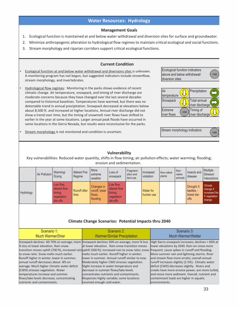
Ecological function indicators above and below withdrawal/diversion sites
Stream morphology indicators
Airtemperature
Precipitation
Snowpack Total annual river discharge
Extreme river flows
Timing of river discharge
Current Condition• Ecological function at and below water withdrawal and diversions sites is unknown.
A monitoring program has not begun, but suggested indicators include streamflow, stream morphology, and invertebrates.
• Hydrological flow regimes: Monitoring in the parks shows evidence of recent climatic change. Air temperature, snowpack, and timing of river discharge are moderate concerns because they have changed over the last several decades compared to historical baselines. Temperatures have warmed, but there was no detectable trend in annual precipitation. Snowpack decreased at elevations below about 8,500 ft. and increased at higher locations. Annual river discharge did not show a trend over time, but the timing of snowmelt river flows have shifted to earlier in the year at some locations. Larger annual peak floods have occurred in some locations in the Sierra Nevada, but results were inconclusive for the parks.
• Stream morphology is not monitored and condition is uncertain.
Management Goals1. Ecological function is maintained at and below water withdrawal and diversion sites for surface and groundwater.2. Minimize anthropogenic alteration to hydrological flow regimes to maintain critical ecological and social functions.3. Stream morphology and riparian corridors support critical ecological functions.
Climate Change Scenarios: Potential Impacts thru 2040
VulnerabilityKey vulnerabilities: Reduced water quantity, shifts in flow timing; air pollution effects; water warming; flooding;
erosion and sedimentation.
Water Resources: Hydrology
Air Pollution Warming/ Drying
Altered Fire Regime
More extreme weather
Loss of snowpack
Fragment-ation and land use
Increased visitation
Non-native plants
Non-native animals
Insects and disease
Multiple Stressor Interactions
Hydrology
Low flow, altered flow timing, vegetation die-offs
Runoff after fires
Changes in runoff, lower flows, flooding
Low flow, altered flow timing, vegetation die-offs
Water for human use
Drought X beetles -forest die-offs
Climate change X increased fire X vegetation change
Scenario 1: Much Warmer/Drier
Scenario 2: Warmer/Similar Precipitation
Scenario 3: Much Warmer/Wetter
Snowpack declines 60-70% on average; more % loss at lower elevation. Rain-snow transition moves uphill (700 ft), increased rain to snow ratio. Snow melts much earlier.Runoff higher in winter; lower in summer; annual runoff decreases about -8% on average. Much higher climatic water deficit (CWD) stresses vegetation. Water temperatures increase and summer flows/lake levels decrease, concentrating nutrients and contaminants.
Snowpack declines 50% on average; more % loss at lower elevation. Rain-snow transition moves uphill (500 ft); increased rain to snow ratio; snow melts much earlier. Runoff higher in winter; lower in summer. Annual runoff similar to now. Moderately higher CWD stresses vegetation.Slight increase in water temperature and decrease in summer flows/lake levels concentrates nutrients and contaminants. Responses highly variable; some locations received enough cold water.
High Sierra snowpack increases; declines > 60% at lower elevations by 2040. Rain-on-snow more frequent; cause spikes in runoff and flooding. More summer rain and lightning storms. River and stream flow more erratic; overall annual runoff increases slightly (2-5%). Climatic water deficit (CWD) decreases slightly. Rivers and creeks have more erosive power, are more turbid, and move more sediment. Overall, nutrient and contaminant loads are higher in aquatic environments.
33

Foothill yellow-legged frogSacramentopikeminnow
Non-native species- occupancyNon-native species – abundance
Herpetofaunadiversity
Herp. breeding & phenology
Western pond turtle in parks
Western pond turtle in region
Native fish
Low-Elevation Aquatic Ecosystems and Species
Management Goals1. Low elevation native aquatic species are well represented in the parks and ecoregion.
2. Non-native/invasive nuisance species are prevented or controlled at high priority locations and reduced overall.
3. Extirpated species are restored in low elevation aquatic ecosystems where feasible.
Current Condition• Native species: Herpetofauna (amphibians and reptiles) are in good condition overall
for diversity, but its breeding and phenology (seasonal life cycle) have an unknown condition and are vulnerable to drying of stream habitat. Occupancy of western pond turtles has not changed for stream pools monitored in the parks, but this turtle is declining throughout its range in the ecoregion and has been petitioned for listing under the Endangered Species Act. Native fish populations have declined in abundance and diversity, mainly due to competition with non-native fish.
VulnerabilityKey vulnerabilities: Interactions of non-native species, warming, habitat drying, and excess nutrients.
Scenario 1: Much Warmer/Drier
Scenario 2: Warmer/Similar Precipitation
Scenario 3: Much Warmer/Wetter
Warming and drying of rivers and creeks concentrate nutrients and contaminants. Contaminant bioaccumulation in food webs increases. Warmer water and lower flows shift invertebrates to taxa more tolerant of these conditions and restrict native rainbow trout to bottom of cold pools during summer. Increased sediment transport from burned slopes alters stream morphology, further influencing habitat. Non-native bullfrogs, black bullhead, and green sunfish increase and expand upstream. Smallmouth bass invade from below the parks. Water clarity decreases. Algal blooms foul swimming areas earlier in season and at higher elevation.
Slightly higher water temperatures and lower summer flows concentrate nutrients and contaminants. Warmer and lower summer flows restrict movement of native rainbow trout in some summers. In some areas, invertebrate shift toward warm adapted species. Non-native bullfrogs, black bullhead, and green sunfish increase, but cold winter flows continue to restrict upstream movement. New Zealand mudsnailsinvade local reservoirs and spread upstream. Algal blooms impact popular swimming areas.
Annual streamflow increases slightly. Snowmelt starts weeks earlier. Rain-on-snow events are more common. High flows are sustained later into the season for water courses with high elevation headwaters. Rivers and creeks have more erosive power, waters more turbid, and move more sediment. Nutrient and contaminant loads are higher. Water warms in streams that don’t have higher elevation headwaters kept cool by snowmelt. Mid-elevation streams shift from snowmelt to rain-driven flow and temperatures more typical of low elevation creeks. Productivity increases, but so does decomposition, lowering oxygen levels and increasing contaminant bioaccumulation. Some non-natives benefit from warmer water, such as green sunfish and other species novel to the parks.
Air Pollution
Warming/ Drying
Altered Fire Regime
More extreme weather
Loss of snowpack
Fragment-ation and land use
Increased visitation
Non-native plants
Non-native animals
Insects and disease
Multiple Stressor Interactions
Low Elevation Aquatic
Nutrients,contamin-ants
Warmer water, drying habitat
Erosion,fire suppres-sionimpacts
Sediment,stream-bank erosion
Decreased summer water
Species extirpation
Introduced pollutants & diseases
Increased/ new invasions
Increased/ new invasion
New disease?
Warming X drying X invasives x nutrients
Climate Change Scenarios: Potential Impacts thru 2040
• Non-native species: American bullfrog, green sunfish, and black bullhead are present in the parks, probably localized to the lower North Fork Kaweah River. Bullfrogs may be moving up the North Fork. New Zealand mud snail and zebra mussel have not been observed, but there is no active monitoring to search for them.
• Extirpated species: Foothill yellow-legged frogs occurred in two of the parks 12 watersheds and are now extirpated, possibly due to pesticides and/or chytrid fungus. Sacramento pikeminnow no longer occur in the parks, but little is known about historical occupancy and causes of extirpation.
34
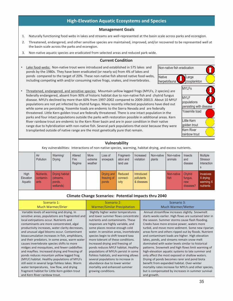
MYLFs
MYLFpopulationspersisting with diseaseYosemite toad
Little Kern golden troutKern River rainbow trout
Non-native fish eradication
Native herpetofauna
Large zooplankton
Air Pollution
Warming/ Drying
Altered Fire Regime
More extreme weather
Loss of snowpack
Fragment-ation and land use
Increased visitation
Non-native plants
Non-native animals
Insects and disease
Multiple Stressor Interactions
High Elevation Aquatic
Nutrients,contamin-ants
Drying habitat (streams, ponds, wetlands)
Drying and freezing of ponds
Reduced connect-ivity
Introduced pollutants & diseases
Non-native fish
Chytrid fungus, new diseases?
Invasives X dryingwarming X nutrients
Climate Change Scenarios: Potential Impacts thru 2040
High-Elevation Aquatic Ecosystems and Species
Management Goals1. Naturally functioning food webs in lakes and streams are well-represented at the basin scale across parks and ecoregion.
2. Threatened, endangered, and other sensitive species are maintained, improved, and/or recovered to be represented well at the basin scale across the parks and ecoregion.
3. Non-native aquatic species are eradicated from selected areas and reduced park-wide.
Current Condition• Lake food-webs: Non-native trout were introduced and established in 575 lakes and
ponds by the 1980s. They have been eradicated (or nearly so) from 4% of lakes and ponds compared to the target of 20%. These non-native fish altered native food-webs, including competing with and/or consuming native frogs, snakes, and invertebrates.
VulnerabilityKey vulnerabilities: Interactions of non-native species, warming, habitat drying, and excess nutrients.
Scenario 1: Much Warmer/Drier
Scenario 2: Warmer/Similar Precipitation
Scenario 3: Much Warmer/Wetter
Variable levels of warming and drying. In sensitive areas, populations are fragmented and local extirpations occur. Nutrients and contaminants are more concentrated, algal productivity increases, water clarity decreases, and unusual algal blooms occur. Contaminant bioaccumulation increases in fish, amphibians, and their predators. In some areas, warm water causes invertebrate species shifts to more midges and mosquitoes, and fewer caddisflies and mayflies. Increased drying and freezing of ponds reduces mountain yellow legged frog (MYLF) habitat. Healthy populations of MYLFs still exist in several large fishless lakes. Warm water temperatures, low flow, and drying fragment habitat for Little Kern golden trout and Kern River rainbow trout.
Slightly higher water temperatures and lower summer flows concentrate nutrients and contaminants. These responses are highly variable, and some places receive enough cold water. In sensitive areas, invertebrate species begin to shift toward taxa more tolerant of these conditions. Increased drying and freezing of ponds reduces MYLF habitat. Healthy populations of MYLFs persist in some fishless habitats, and warming allows several populations to increase in abundance due to lower winter mortality and enhanced summer growing conditions.
Annual streamflow increases slightly. Snowmelt starts weeks earlier. High flows are sustained later in the season. Summer storms cause flash flooding. Creeks have more erosive power, waters more turbid, and move more sediment. Some new riparian areas form and others ripped out by floods. Nutrient and contaminant loads are higher. High elevation lakes, ponds, and streams remain snow-melt dominated with water levels similar to historical patterns. Snowmelt and high flows limit warming of high-elevation aquatic systems to late summer and only affect the most exposed or shallow waters. Drying of ponds becomes rarer and pond biota benefit from expanded habitat. Over-winter mortality rates increase for MYLFs and other species, but is compensated by increases in summer survival and growth.
• Threatened, endangered, and sensitive species: Mountain yellow legged frogs (MYLFs, 2 species) are federally endangered, absent from 90% of historic habitat due to non-native fish and chytrid fungus disease. MYLFs declined by more than 60% from 1997-2002 compared to 2009-20013. About 10 MYLF populations are not yet infected by chytrid fungus. Many recently infected populations have died out while some are persisting. Yosemite toads are endemic to the Sierra Nevada and are federally threatened. Little Kern golden trout are federally threatened. There is one intact population in the parks and four intact populations outside the parks with restoration possible in additional areas. Kern River rainbow trout are endemic to the Kern River basin and are in poor condition in their native range due to hybridization with non-native fish. Several park populations that exist because they were transplanted outside of native range are the most genetically pure that remain.
35
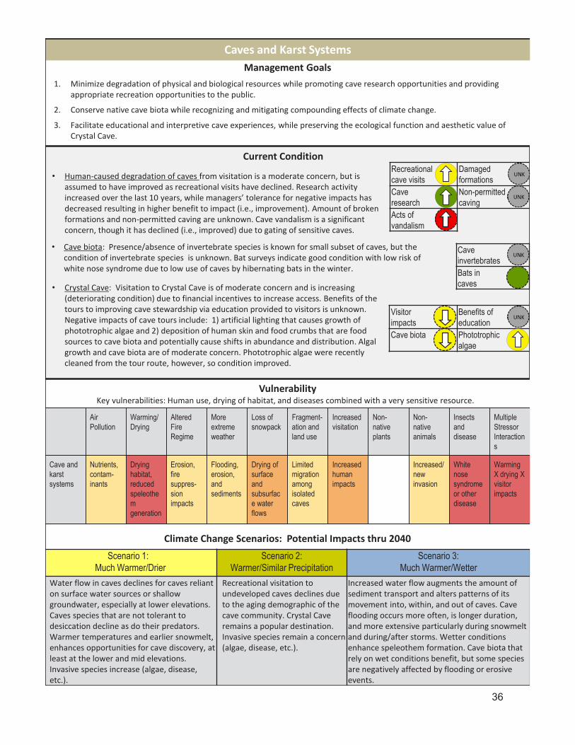
Visitor impacts
Benefits of education
Cave biota Phototrophicalgae
CaveinvertebratesBats incaves
Recreational cave visits
Damagedformations
Cave research
Non-permitted caving
Acts of vandalism
Management Goals1. Minimize degradation of physical and biological resources while promoting cave research opportunities and providing
appropriate recreation opportunities to the public.
2. Conserve native cave biota while recognizing and mitigating compounding effects of climate change.
3. Facilitate educational and interpretive cave experiences, while preserving the ecological function and aesthetic value of Crystal Cave.
Scenario 1: Much Warmer/Drier
Scenario 2: Warmer/Similar Precipitation
Scenario 3: Much Warmer/Wetter
Water flow in caves declines for caves reliant on surface water sources or shallow groundwater, especially at lower elevations. Caves species that are not tolerant to desiccation decline as do their predators. Warmer temperatures and earlier snowmelt, enhances opportunities for cave discovery, at least at the lower and mid elevations. Invasive species increase (algae, disease, etc.).
Recreational visitation to undeveloped caves declines due to the aging demographic of the cave community. Crystal Cave remains a popular destination. Invasive species remain a concern (algae, disease, etc.).
Increased water flow augments the amount of sediment transport and alters patterns of its movement into, within, and out of caves. Cave flooding occurs more often, is longer duration, and more extensive particularly during snowmelt and during/after storms. Wetter conditions enhance speleothem formation. Cave biota that rely on wet conditions benefit, but some species are negatively affected by flooding or erosive events.
Climate Change Scenarios: Potential Impacts thru 2040
VulnerabilityKey vulnerabilities: Human use, drying of habitat, and diseases combined with a very sensitive resource.
Caves and Karst Systems
Current Condition
• Human-caused degradation of caves from visitation is a moderate concern, but is assumed to have improved as recreational visits have declined. Research activity increased over the last 10 years, while managers’ tolerance for negative impacts has decreased resulting in higher benefit to impact (i.e., improvement). Amount of broken formations and non-permitted caving are unknown. Cave vandalism is a significant concern, though it has declined (i.e., improved) due to gating of sensitive caves.
• Crystal Cave: Visitation to Crystal Cave is of moderate concern and is increasing (deteriorating condition) due to financial incentives to increase access. Benefits of the tours to improving cave stewardship via education provided to visitors is unknown. Negative impacts of cave tours include: 1) artificial lighting that causes growth of phototrophic algae and 2) deposition of human skin and food crumbs that are food sources to cave biota and potentially cause shifts in abundance and distribution. Algal growth and cave biota are of moderate concern. Phototrophic algae were recently cleaned from the tour route, however, so condition improved.
Air Pollution
Warming/ Drying
Altered Fire Regime
More extreme weather
Loss of snowpack
Fragment-ation and land use
Increased visitation
Non-native plants
Non-native animals
Insects and disease
Multiple Stressor Interactions
Cave and karst systems
Nutrients, contam-inants
Drying habitat, reduced speleothem generation
Erosion, fire suppres-sionimpacts
Flooding, erosion, and sediments
Drying of surface and subsurface water flows
Limited migration among isolated caves
Increased human impacts
Increased/ new invasion
White nose syndrome or other disease
Warming X drying X visitor impacts
• Cave biota: Presence/absence of invertebrate species is known for small subset of caves, but the condition of invertebrate species is unknown. Bat surveys indicate good condition with low risk of white nose syndrome due to low use of caves by hibernating bats in the winter.
36

Hydrology, soils, and vegetation in transitioning wetlands
Area of human-use wetlands achieving targets belowNative plants Non-native
plantsResidual biomass
Bare ground
Streambank alteration
Water table depth
Restoring wetlands altered by human actions
Total wetland area
Non-native plants
Soil, water table depth, native plants, and macroinvertebrates
Management Goals1. Maintain wetland characteristics of wet meadows and fens, as feasible, in the face of changing climatic conditions.
2. Restore wetland structure and function that have been altered by human actions, prioritizing areas where self-sustaining wetlands are likely to persist under changing climate.
3. Limit impacts from visitor and administrative activities to levels that don't degrade wetland structure or function over the long-term by themselves or in combination with climate change or other stressors.
4. Wet meadows and fens are managed to minimize disruption of critical ecological functions during transition to different ecosystem types where self-sustaining wetlands are not likely to persist under changing climate.
Scenario 1: Much Warmer/Drier
Scenario 2: Warmer/Similar
Precipitation
Scenario 3: Much Warmer/Wetter
Drier wetlands dry out more and shift to upland plant species with more bare ground. Obligate wetland plants decline. Erosion and gully-formation channelize flow and dry wetlands. Drying peat decomposes and causes organic soil loss. There is more invasion by non-native plants , more burrowing rodents, and more establishment of upland woody species into meadows.Large wetlands become smaller. Small wetlands disappear. Habitat for wetland dependent speciesdeclines. Fire frequency increases in wetlands.
Changes are similar to Scenario #1, but less in magnitude and extent. Themost vulnerable wetlands are negatively affected (for example, 3-5%).
Wetlands already degraded with incised channels become further degraded with more extensive and deeper gully systems. Restoration of these degraded sites is more difficult. Growing season lengthens for wetland plants, productivity increases, and species composition shifts. Wetlands in good condition are more resistant to extreme rainfall events and gain biomass. At highest elevations, existing wetlands expand due to more snowpack and warmer temperatures.
Climate Change Scenarios: Potential Impacts thru 2040
VulnerabilityKey vulnerabilities: Loss of wetland area due to warming and drying of habitat - and interactions with other stressors, which may speed erosion (including gully formation), lowering of water table, and loss of wetland soils.
Wet Meadows and Fens
Current Condition• Wetland characteristics are in good overall condition based on current total area of wet
meadows and fens in the parks. Abundance of non-native plants in wet meadows and fens is a moderate concern. Condition and trend of other indicators (soils, water table depth, native plants, and macroinvertebrates) are unknown, but a long-term monitoring program recently began to measure them.
• Restoring wetlands altered by human actions is a significant concern because there are areas known to be damaged (e.g., Cahoon Meadow), but restoration needs have not been systematically identified and mapped. Recent restoration has been successful (e.g., Halstead Meadow), however, so the trend is improving.
• Wetlands with visitor or administrative human use are in good condition for native plants, but are a moderate concern for non-native plants, residual plant biomass, and bare ground. Streambank alteration and water table depth are not measured (unknown condition), but few locations have known concerns. Monitoring is not adequate to estimate total area of human-use wetlands that achieve targets for these indicators.
• Transitioning wetlands condition is unknown. Wetlands likely to persist versus transition have not been identified. This type of monitoring has not begun.
Air Pollution Warming/ Drying
Altered Fire Regime
More extreme weather
Loss of snowpack
Fragment-ation and land use
Increased visitation
Non-native plants
Non-native animals
Insects and disease
Multiple Stressor Interactions
Wet meadows and fens
Nutrient & contam-inantdeposition
Shrinkage,total loss of wetland
Watershed effects, tree migration
Runoff, gully formation
Decreased summer water
Historic livestock grazing, pack stock use
Trampling, new roads and trails
Increased/ new invasion
Increased/ new invasion
Yosemite toad sensitive to chytrid fungus?
Drying X other stressors
37

Woodlandarea
Shrublandarea
Oak woodland tree density, size distribution and species richnessNon-native plants
Native shrubs
Native herb. diversity
Blue oaks
Fire regime -woodlands
Fire regime -shrublands
Hydrology Nutrient cycling
Phenology (seasonal timing)
% grazed lands (pasture) that meet guidelines
Management Goals1. Oak woodlands, shrublands and riparian zones are structurally and compositionally complex, resilient, and support
native biodiversity and important ecosystem functions, even if species assemblages and distributions shift.
2. Expanded grasslands or novel vegetation types retain ecosystem services (to an acceptable extent) and support native species.
Scenario 1: Much Warmer/Drier
Scenario 2: Warmer/Similar Precipitation
Scenario 3: Much Warmer/Wetter
Following significant mortality of trees in all size classes during the drought of 2012-15, stem density of blue oak woodlands has decreased significantly. Increased fire frequency has also contributed to loss of stands of large old blue oak and species shifts in chaparral . Former woodlands are now dominated by non-native annual grasses where severe fire removed large oaks. Nonnative annual grasses and other invasive plants also dominate areas where dense tree and shrub layers were removed by fire and drought mortality.
Blue oak woodlands become less dense following the severe drought of 2012-15. Chaparral and savannah vegetation types expand in these areas. Yellow starthistle has moved into the parks along roadsides. The lower elevation pines decrease due to periodic severe drought.
Oaks benefit from increased winter rain. Blue oak and black oak rebound after losses in the 2012-15 drought. Sudden oak death becomes established after an El Nino year, but spread is limited. Warmer, wetter conditions enhance growth of non-native annual grasses, which then out-compete native grasses and forbs. These grasses also fuel fast-moving fires that are harder to control. While a greater proportion of acorns become seedlings, increased predation by swelling ground squirrel and deer populations limit transition to the sapling stage.
Climate Change Scenarios: Potential Impacts thru 2040
VulnerabilityKey vulnerabilities: Prolonged, hot drought is causing loss of oak trees and may further depress seedling regeneration. Altered fire regime may cause conversion from oak woodlands to shrublands) and shrublands to annual grasslands.
Foothill Terrestrial Ecosystems
Current Condition
• Oak woodlands, shrublands, and riparian zones: Total areas of woodland and shrubland are in good condition with the baseline provided by the parks’ 2007 vegetation map. Condition of oak woodland tree density, size distribution, and species richness is unknown. Foothill ecosystems are some of the most highly invaded by non-native plants in the parks (significant concern). Native herbaceous plant diversity declined between the 1980s and 90s, but has not been re-measured since (moderate concern). Research suggests that regeneration is not enough to balance mortality (moderate concern). Monitoring of blue oak woodland began in 2017 to study effects of the 2012-2016 drought; preliminary results suggest that mortality of blue oaks and live oaks was significant.
• Ecosystem function is not well-understood in foothill ecosystems. Alteration of the fire regime (Fire Return Interval Departure) is moderate concern. Hydrology data, such as for soil or vegetation moisture, are lacking (unknown condition). Nutrient cycling is not monitored routinely, but research suggests leaching of nitrate in foothill soils (moderate concern). Limited phenology monitoring occurs, but data are not adequate to assess condition. There is some concern about the condition of grazed lands in administrative pastures, but better monitoring is needed to assess condition.
• Expanded grasslands or novel vegetation types have not been identified and are not monitored so condition is unknown for soil, vegetation cover, and invasive plants.
Air Pollution Warming/ Drying
Altered Fire Regime
More extreme weather
Loss of snowpack
Fragment-ation and land use
Increased visitation
Non-native plants
Non-native animals
Insects and disease
Multiple Stressor Interactions
Foothills terrestrial ecosystem
Nutrient deposition
Decreased soil moisture
Too much/ too little fire.Suppression impacts
Loss of connectivity
Increased risk of priority species introduction
Type conversion
Increased/ new invasion
Increased damage from insects and disease
Heat X Drought
Expanded grasslands or novel vegetation types
38

Fire regime Insects and pathogens
Hydrology, soil, nutrient cycling, and plant phenology indicators
Montane forest area
Density of small trees
Density of big trees
Tree size distribution
Live tree biomass
Snag density
Gap size distribution
Tree mortality rate
Tree canopy health
Native tree richness
Native shrub & herb richness
Non-native plants
Management Goals1. Montane forests are structurally and compositionally complex, resilient, and support native biodiversity and ecosystem
functions even if species assemblages and distributions shift.
Scenario 1: Much Warmer/Drier
Scenario 2: Warmer/Similar Precipitation
Scenario 3: Much Warmer/Wetter
Mortality of lower elevation pines, incense cedar, and firs increasesmarkedly. More open montane forests with shrubs, grassland, and black oak. Sugar pine decline dramatically due to blister rust and insects; mainly survive in cooler areas. Giant sequoia groves are refugia for otherwise declining forest species, except sugar pine. Non-natives such as cheat grass increase in the understory. Conifer seedling regeneration reduced, especially in low elevation, south or west-facing forests.
Mortality of pines, incense cedar, and firs increases during and after 2012-2015 drought. Ponderosa and Jeffrey pines in major decline from drought, ozone, and beetles. Sugar pine declines throughout range. Black oaks and other deciduous species are more common. Conifer recruitment is episodic. More shrub growth increases shrub-conifer type prevalence. Giant sequoia groves act as refugia for otherwise declining forest species, and even some sugar pine remain. Invasive plants dramatically increase in former ponderosa pine forests.
Conifer seedlings thrive, forming dense thickets. Ladder fuels increase. Forest is denser with more closed canopy, more fir and incense cedar. Fungal diseases proliferate. Sugar pine is reduced to small rust-resistant populations. There is a mosaic of dense white fir-incense cedar dominated forest in unburned areas and, patches of shrub oak, black oak, and young giant sequoia in burned areas.With denser, more closed canopies, unburned forests are more resistant to non-native plants, though species preferring moist, shaded conditions, such as Himalayan blackberry spread. Non-native plants continue to inhabit open forests in burned areas.
Climate Change Scenarios: Potential Impacts thru 2040
VulnerabilityKey vulnerabilities: Interactions among hotter droughts, insects and diseases, and altered fire regimes.
Currently, exposure and impacts are more severe in lower elevation montane forests than in subalpine forests.
Forests - Montane
Current Condition
• Area of montane forest is in good condition with baseline of the 2007 vegetation map. • Forest structure and composition: Density of small trees is elevated due to fire
suppression, which affects much of the forest despite a proactive fire and fuels management program (moderate concern). Big tree density, tree size distribution, and above-ground live tree biomass are in good condition. Snag density is a moderate concern. Size of forest gaps is not monitored. Tree death rates doubled from 1983-2004, coincident with warming temperatures. During the 2012-2016 hotter drought, canopy water content - an indicator of canopy health - declined and millions of additional trees died in Sierra Nevada forests (moderate concern). Insect infestations killed tree species (incense cedar) resistant in the past. Native tree species richness is moderate concern because sugar and ponderosa pines are declining. Shifts in plant species more broadly are unknown. Non-native plants are moderate concern.
• Forest function: Fire regime alteration and increasing outbreaks of beetles and pathogens (white pine blister rust) are moderate concerns. Functions of hydrologic regulation, soil retention, nutrient cycling, and phenology are unmeasured. Atmospheric nitrogen deposition may be high enough to affects forest lichen and fungi, but these responses also are unmeasured.
Air Pollution
Warming/ Drying
Altered Fire Regime
More extreme weather
Loss of snowpack
Fragment- ationand land use
Increased visitation
Non-native plants
Non-native animals
Insects and disease
Multiple Stressor Interactions
Montane forests
Ozone injury
Moisture stress; upslope movement of suitable range
Larger, more severe fires
Moisture stress
More ignitions? Introduced species?
Increased/ new invasion
Increased/ new invasion
Weakened or killed trees
Hotter drought X insects/ pathogens X fire
39

40
Fire regime Insects and pathogens
Plant phenology
Subalpineforest area
Tree size distribution
Live tree biomass
Tree mortality rate
Tree canopy health
Native tree richness
Native shrub & herb richness
Non-native plants
Management Goals1. Subalpine forests are structurally and compositionally complex, resilient, and support native biodiversity even if
species assemblages and distributions shift.
VulnerabilityKey vulnerabilities: Interaction among hotter droughts, insects and diseases, and altered fire regimes. Currently, condition of subalpine forests is better than montane forests. Over the long-term subalpine forests may be more vulnerable than montane
forests due to less adaptive capacity for the subalpine to cope with or recover from impacts.
Forests – Subalpine
Current Condition
• Area of subalpine forest is in good condition with the baseline provided in the 2007 vegetation map.
• Forest structure and composition: Negative effects of warming temperatures and the 2012-2016 hotter drought have been significantly less for subalpine forest compared to montane forests. Tree size distribution, aboveground live tree biomass, and tree mortality rate are in good condition. Native tree richness also is in good condition as there is no evidence that species composition has changed since the 1930’s.Dedicated long-term monitoring of subalpine forest plots recently began, however, so confidence in condition ratings is mostly low and trends over time are mostly unknown. Subalpine forests have low invasion by non-native plants (good condition).
• Forest function: Historically, fire was much less frequent in subalpine forests compare to montane forests, and this is still the case. The subalpine fire regime has not been altered much (good condition). Impacts from insects and pathogens have been relatively minor thus far in the subalpine, but they appear to be increasing.
Air Pollution Warming/ Drying
Altered Fire Regime
More extreme weather
Loss of snowpack
Fragment-ation and land use
Increased visitation
Non-native plants
Non-native animals
Insects and disease
Multiple Stressor Interactions
Subalpine forests
Contraction of suitable range
Increased fire frequency
Moisture stress
(occurs in more fragmented stands than montane)
More ignitions? Introduced species?
Increased/ new invasion
Increased/ new invasion
Weakened or killed trees
Hotter drought X insects/ pathogens X fire
Whitebark pine
Contraction of suitable range
Increased fire frequency
Moisture stress
(occurs in more fragmented stands than montane)
Weakened or killed trees (blister rust X beetles)
Hotter drought X beetles X blister rust
Scenario 1: Much Warmer/Drier
Scenario 2: Warmer/Similar Precipitation
Scenario 3: Much Warmer/Wetter
Longer fire season and hotter temperatures allow fires to spread from lower elevations into the subalpine more frequently. Red fir and lodgepole forests are more fragmented due to drought, fire, and beetles. White fir seedlings outcompete red fir in some areas. About a quarter of western white pine infected by white pine blister rust, which also is found in a few stands of whitebark pine. Insects more problematic. Lodgepole pine seedlings begin upward movement when soil conditions allow, but beetles attack it at lower elevations. More non-native plant species move into previously-resistant higher-elevation forest.
Fires spread more easily. Lodgepole pine start to outcompete red firs but pine health declines as beetles proliferate during drought. White fir seedlings outcompete red fir regeneration in burned areas, and blister rust infects all five-needle pines, but infection and mortality rates are low, especially for subalpine.
Red fir and lodgepole pine forests thrive in some places and are attacked by pathogens and beetles in others. Die-back areas begin to be colonized by lower elevation species, especially white fir and incense cedar. White pine blister rust infects all 5-needle pine species and mortality in subalpine forests and woodlands increases substantially. Whitebark pine is an endangered species. Lodgepole, red fir, and western white pine seedlings begin upward movement higher into the subalpine where soil conditions allow. Aspen thrive and expand in disturbed areas.
Climate Change Scenarios: Potential Impacts thru 2040

41
Fire regime Tree density (all species)
Sequoia seedlings
Fuel load mosaic
Gap/patch distribution
Nativebiodiversity
Non-native plants
Hydrology and soils
Health of large sequoia
Large sequoia survival rate
Management Goals1. Maximize persistence of large, living giant sequoias.
2. Maximize persistence of structurally and compositionally complex giant sequoia groves that are sustainable, resilient (to drought, fire, insects, etc.), and support native biodiversity.
3. Manage for ecological functions essential to giant sequoia groves (fire, hydrology).
4. Prepare for potential shifts in giant sequoia distribution to enable its persistence in the broader Sierra Nevada landscape.
5. Prioritize persistence of giant sequoia in areas of highest social value.
Scenario 1: Much Warmer/Drier
Scenario 2: Warmer/Similar Precipitation
Scenario 3: Much Warmer/Wetter
Giant sequoia stress levels increase and significant pockets of mortality are evident. Sensitive areas lose giant sequoia reproduction and have higher conifer mortality and shrub encroachment. In general, giant sequoia groves are refugia for otherwise declining forest tree species, except sugar pine.
Effects similar to Scenario #1, but at lesser magnitude.
While mature giant sequoias persist similarly as today, the forest is denser with a more closed canopy, and species composition shifts toward more fir. The resulting mosaic consists of unburned areas (dense fir-dominated forest) with patches of shrub oak, black oak, and young giant sequoia in areas that burn.
Climate Change Scenarios: Potential Impacts thru 2040
VulnerabilityKey vulnerabilities: Interaction among hotter droughts, fire, and unknown future insects or pathogens.
Giant Sequoia Trees and Ecosystems
Current Condition
• Large, living giant sequoias: Mature sequoias had significant dieback of foliage midway through the hotter 2012-2016 drought, but overall sequoias coped well compared to other montane tree species. Not many sequoias died during the drought, but dedicated sequoia monitoring is not in place so we don’t know the actual survival rate.
• Sequoia ecosystems and functions: Fire suppression affects fire regime in sequoia groves; 20% is within desired fire return interval (moderate concern but improving). Small trees are overly dense in most groves (moderate concern). Sequoia seedlings germinate after fire, but overall condition of regeneration is unknown. Fuel load mosaic, distribution of forest patch/gap size, native biodiversity , hydrology, and soils are not monitored. Non-native plants are a moderate concern.
• Prepare for potential shifts: Level of preparation is a significant concern based on genetic preservation (sequoia seeds collected and stored for only 3 groves), understanding of where sequoias will survive and reproduce in the future, and capacity to plant them in potentially suitable habitat outside of current groves.
• Socially valued components of sequoia groves, other than the sequoias themselves, have not been formally identified so condition is unknown. Very few trees of special interest have been damaged or killed due to human actions, but this is not formally tracked.
Air Pollution Warming/ Drying
Altered Fire Regime
More extreme weather
Loss of snowpack
Fragmentation and land use
Increased visitation
Non-native plants
Non-native animals
Insects and disease
Multiple Stressor Interactions
Giant sequoia
Ozone stress on seedlings
Moisture Stress
Lack of fire; large high severity fires
Increased wind damage?
Moisture Stress
Isolated groves, low genetic diversity, limited dispersal
Soil compaction - seedling regener-ation
Increased/ new invasion
Increased/ new
invasion
Unknown insects and disease in the future?
Hot drought X fire X insects/ pathogens
Genetic preservationUnderstanding & feasibility to plant in future, suitable locations
Social valued components
Trees of special interest

42
Area of alpine uplands
Native plant richness
Native plant cover
Non-native plants
Trees at subalpine-alpine ecotoneEcosystem function
Visitor impacts
Pack stock grazing
Management Goals1. Alpine tundra/uplands are structurally and compositionally complex, resilient, and support native biodiversity even if species
assemblages and distributions shift.
Scenario 1: Much Warmer/Drier
Scenario 2: Warmer/Similar Precipitation
Scenario 3: Much Warmer/Wetter
Decreased snowpack and warming has led to a loss of snow fields that used to last through most of the summer. Shifts in herbaceous plant species are detected and woody plants become more common. Isolated patches of non-native plants are discovered in higher use areas. Alpine wildlife experience changing habitat and food availability; some species adapt to new conditions, but others decline. Alpine chipmunk populations are more genetically distinct from one another due to changes in habitat continuity.
Snow fields that used to last through most of the summer melt earlier, and soils dry faster under warmer conditions. Some tundra species begin to migrate upwards and subalpine ruderal species move upslope.
Winter snow accumulation allows formation of snow drifts and fields that persist throughout most of the summer in protected habitats, though much snow melts off early. Species common to the subalpine increase in alpine habitats. Alpine small mammals such as pika and alpine chipmunk have longer foraging seasons.
Climate Change Scenarios: Potential Impacts thru 2040
VulnerabilityKey vulnerabilities: Shifts in alpine species composition and loss of alpine habitat due to the interaction of warming, changes in
snowpack dynamics, nitrogen deposition, and increased spread of non-native plants.
Alpine Terrestrial Ecosystems
Current Condition
• Area of alpine ecosystems is considered to be in good condition with the baseline provided by the 2007 vegetation map.
• Plant structure and composition: Native plant species richness in alpine vegetation is in good condition. It is moderately high compared to other vegetation types in the parks. Of SEKI’s 150 special status plants, 32 occur in the alpine , but none are listed as threatened or endangered. Native plant cover is unknown. The alpine is still relatively free of invasive non-native plants, but monitoring in the alpine is limited. The current treeline, which defines the transition from subalpine to alpine is considered the baseline and in good condition.
• Ecosystem function: Not enough information exists to evaluate the condition of nutrient cycling, wildlife habitat, and plant and animal phenology.
• Human impacts: Visitor impacts, as measured by campsite condition in the wilderness, is in good condition and improved between surveys conducted in the 1970s and 2006-2007. Pack stock grazing in alpine areas is very limited. The amount of grazing is low compared to estimated capacity, and monitoring data do not suggest significant impacts.
Air Pollution Warming/ Drying
Altered Fire Regime
More extreme weather
Loss of snowpack
Fragment-ation and land use
Increased visitation
Non-native plants
Non-native animals
Insects and disease
Multiple Stressor Interactions
Alpine Terrestrial Ecosystem
Nitrogen -shifts in plant species
Shifts in plant species, range contraction
Drying of habitat, loss of insulation
Alpine is isolated “sky island”
Introduction of non- nativeplants; soil compaction, erosion, social trails
Increased or new invasion
Increased or new invasion
New diseases?
Warming X altered snowpack X nitrogen X invasions

• Sierra Nevada bighorn sheep (Ovis canadensis sierrae) are federally endangered, but are rebounding from near extirpation in early 1900s. While still rare, most herds have increased. Reintroductions began in these parks in 2012.
• Pacific fisher (Pekania pennanti) was a candidate for federal listing, but in 2016 was found by U.S. Fish and Wildlife Service not to need protection of the Endangered Species Act (ESA). Research is limited to a 2002-2004 survey, which found fishers occupy expected habitat in the parks.
• California spotted owl (Strix occidentalis occidentalis) is a candidate for federal listing under the ESA. The parks’ population appears to be stable, but may be under threat from non-native barred owls.
• California condor (Gymnogyps californianus) only occupies these parks on occasion. It is federally endangered (only 429 individuals existed in the world as of 2013), but increasing in recent years to include occasional sightings in these parks. While of significant concern at the population level, within these parks, the level of concern is moderate.
• Black-backed woodpecker (Picoides arcticus) is a candidate for federal listing under the ESA. It prefers recently fire-or insect killed trees and is considered vulnerable in California. Not much is known about this species in these parks.
• Wolverine (Gulo gulo) and brown/grizzly bear (Ursus arctos californicus ) are extirpated in these parks. Brown bear no longer occur in California.
• Sierra Nevada red fox (Vulpes vulpes necator) likely does not occur in these parks; it’s historical occurrence is unknown.
• Human conflict with American black bear (Ursus americanus): Conflict with black bears appears to have declined over the long-term, but incidents still occur. There has never been a retrospective analysis of bear management data in these parks so condition is unknown for a variety of indicators (number of conflicts, management removals, property damage, number of food conditioned bears, etc.).
Sierra Nevada bighorn sheepPacific fisherCalifornia spotted owlCalifornia condorBlack-backed woodpeckerWolverine andgrizzly bearSierra Nevada red fox
Air Pollution Warming/ Drying Altered Fire Regime
More extreme weather
Loss of snowpack Fragment- ation and land use
Increased visitation
Non-native plants Non-native animals
Insects and disease
Multiple Stressor Interactions
Sierra Nevada bighorn sheep
Nitrogen deposition -changes in habitat and food
Changes in habitat and food resources
Fire suppres-sion reduces open habitat
Changes in habitat and food resources
Small population, limited distribution, low genetic diversity
Changes in habitat and food resources
Disease from domestic sheep, new disease?
Small populations X predation X disease X loss habitat /food
American pika Nitrogen deposition -changes in habitat and food
Heat stress, habitat loss
Extreme heat
Loss of winter insulation, vegetation change
Isolated high elevation habitat
Vegetation change
Disease? Warming X loss of snowpack X loss of habitat
Pacific fisher Loss of habitat Habitat loss -large severe fires
Loss of habitat, but increased mobility?
Small, isolated populations, low genetic diversity
Illegal use -poisoning
Small isolated populations X fire X poison X habitat loss
Birds Bioaccumulation, respiratory rates
Habitat loss, range shifts, phenology mismatch
Too much or too little fire
Habitat loss, range shifts, phenology mismatch
Local, regional, and global impacts
Collisions with cars, recreational impacts
Non-native birds
West nile virus, etc.
Varies by species
American black bear
Loss of acorns, sugar pine seeds, and other fall foods
Develop- ment outside parks
Increased conflict and food rewards
Loss of sugar pine (beetles/ blister rust), wildlife disease
More visitors X less natural food sources
Management Goals1. Facilitate recovery and persistence of threatened and endangered species and other species of conservation concern.
2. Restore extirpated species where feasible.
3. Minimize human-wildlife conflict.
Scenario 1: Much Warmer/Drier
Scenario 3: Much Warmer/Wetter
Pacific fisher habitat declines due to more large crown fire and drought-caused forest die-offs. Sierra Nevada Bighorn Sheepincrease, but one herd declines because its range is now mountain lion habitat. Another herd contracted a disease. Black bear fluctuate from food shortages during drought. This effect increases and moderates bear incidents, which are still a problem especially with higher visitation.
Pacific fisher love the dense forests with disease and mistletoe, which provide denning habitat. They survive in spite of other stresses, but SEKI’s population is isolated into “islands” due to multiple large fires. Sierra Nevada Bighorn Sheep increase, but its habitat is more densely vegetated and provides less escape terrain. Predation losses increase. Black bears thrive with ample food and cover, lots of cubs survive. Bear incidents are an on-going nuisance, especially with bad behaviors learned during 2012-2015 drought. During the next drought, this burgeoning population starts to starve.
Climate Change Scenarios: Potential Impacts thru 2040
Vulnerability (Key vulnerabilities: varies by species )
Terrestrial Wildlife
Current Condition
Human-bear conflict
43

44
Fire is an important tool for managing vegetation in these parks. Managers use both natural and prescribed fire to improve and maintain the health of sequoia groves. Photo by Tony Caprio.
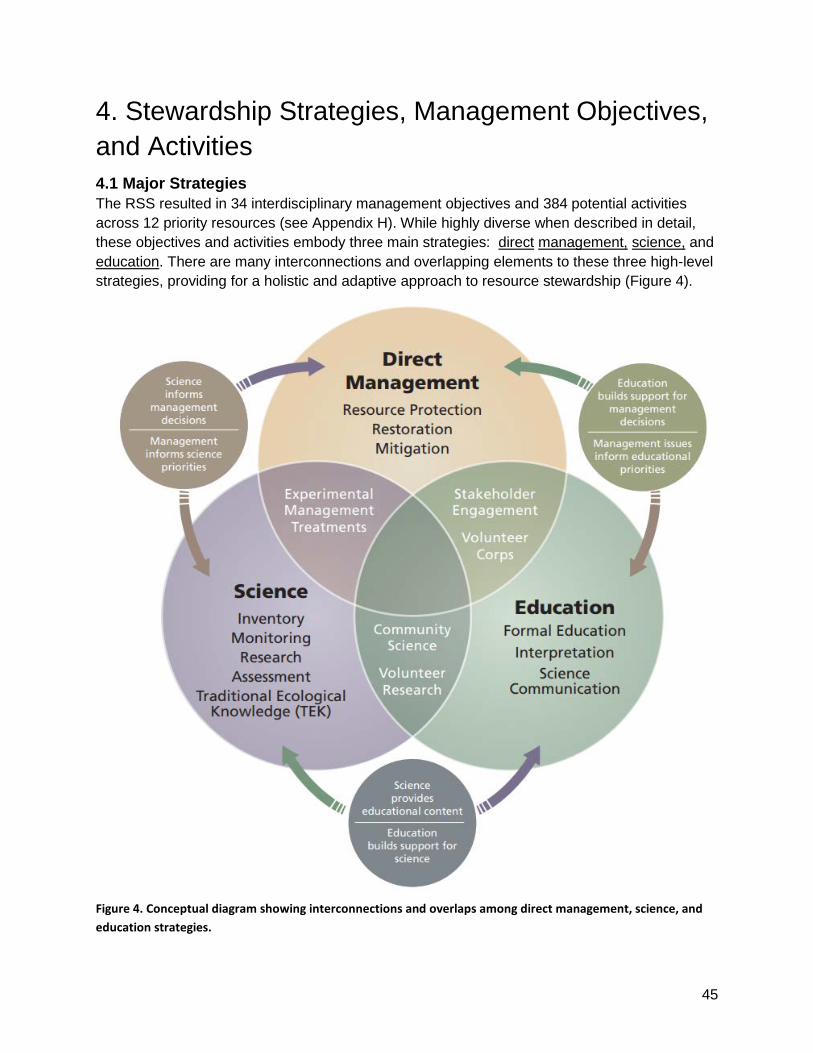
45
4. Stewardship Strategies, Management Objectives, and Activities 4.1 Major Strategies The RSS resulted in 34 interdisciplinary management objectives and 384 potential activities across 12 priority resources (see Appendix H). While highly diverse when described in detail, these objectives and activities embody three main strategies: direct management, science, and education. There are many interconnections and overlapping elements to these three high-level strategies, providing for a holistic and adaptive approach to resource stewardship (Figure 4).
Figure 4. Conceptual diagram showing interconnections and overlaps among direct management, science, and education strategies.

46
The Management Strategy consists of intervention activities to directly manage natural and cultural resources to ultimately achieve goals for priority resources. Such activities may be targeted at preventing or reducing stressors, maintaining or restoring key ecosystem structures or processes, maintaining or restoring cultural resources, mitigating stressor impacts, or facilitating gradual ecosystem changes. Science is critical at all phases of the process: to inform management decisions about what types of intervention to conduct and when and where it should be implemented; to determine whether expected results were achieved; and in assessing how to make improvements. Therefore, management and science are strongly interconnected. Experimentation with potential new types of management treatments is a part of both the management and science strategies. Such innovation is particularly important in the face of unprecedented global change. These experimental management activities incorporate the scientific method and include not only treatment implementation, but also monitoring and evaluation of outcomes. In turn, the concerns of managers help set priorities for science. The Science Strategy employs a peer-reviewed, interactive process based on the scientific method and consists of inventories, monitoring, research, and assessments. Inventories are used to determine resource baselines. Monitoring provides data to track the status and trends of resources and stressors. Research and assessments help us to understand system dynamics, describe correlational or causal relationships, evaluate resource conditions, describe vulnerabilities, and provide forecasts of plausible future conditions. Traditional Ecological Knowledge (TEK) augments these studies. The Pacific West Region (PWR) Science Strategy provides overall guidance on promoting and applying science to inform resource management decision-making and provides specific objectives that integrate disciplines among NPS programs. In addition to informing management decisions, science provides content for formal education, interpretation, and science communication. Science also provides a hands-on venue for education. Community science and volunteer monitoring are part of both the Science and Education Strategies. In turn, education builds scientific literacy and support for the scientific process. The Education Strategy facilitates learning opportunities about the natural and cultural resources in the parks and ecoregion - and the challenges faced in managing them. To promote a supportive environment for park decision-making, it is increasingly important to engage people about potential impacts from climate change and other stressors, discuss activities that may be warranted to protect valued resources, and communicate what losses to these values may be inevitable. Communication of various types also encourages public discourse and learning. This can inform law and policy decisions affecting park resources, including potential regulations and voluntary actions to reduce external stressors. The Education Strategy includes teaching science and resource stewardship in curriculum-based (formal education) settings, communicating science via a variety of methods and partners in formats accessible to non-technical and culturally diverse audiences; providing meaningful interpretation and other interactive opportunities for transformative visitor experiences; engaging local communities and youth in hands-on resource management and science opportunities; and increasing cross-disciplinary interconnections, science communication, and training for park staff. Volunteer stewardship is part of both the Education and Management Strategies. It provides a learning experience while simultaneously improving park resources through direct management.

47
4.2. Management Approaches for Priority Resources This section provides an overview of the RSS management approach for each priority resource and lists the management objectives and abbreviated descriptions of the activities for each resource. Some of the proposed activities will require further evaluation, through environmental impact analysis, cultural resource impact assessment, or public involvement before the activity can proceed. To allow flexibility and creativity, the RSS development process allowed considerable variation in what was considered an activity. The scope of an activity varies from a very specific project to a broader set of potential actions that will require more definition before being implemented. Furthermore, individual activities vary in their requirements for staff time and funding. Therefore, the number of activities listed under each priority resource is not very informative, and it is important to read through the objectives and activities to better understand the management approach. While all of the RSS activities are considered beneficial for the parks, each activity was rated as comparatively higher, intermediate, or lower priority within each priority resource. Because the rating occurred separately for each priority resource, priority ratings across resources are not directly comparable. The full descriptions of management objectives and activities are organized by priority resource in Appendix H. Lastly, while these management approaches are described by priority resource, embedded within them are many inter-connected elements. For example, the condition of the parks’ terrestrial ecosystems (foothills, forests, and alpine) affects water resources, wet meadows and fens, aquatic ecosystems, wildlife, and natural soundscapes. Conversely, air and water quality and changes in hydrology influence the health of all park ecosystems. Some natural resources, such as oak trees and their acorns, also have special cultural significance, and there are many ways in which management of natural resources affects cultural resource and vice versa.

48
Cultural Resources Archeological Resources, Cultural Landscapes, Ethnographic Resources, Historic Structures, Museum Collections and Archives Management Goals:
● Archeological resources are preserved and protected in an undisturbed condition where feasible in light of climate change and with consideration of their significance.
● Archeological resource identification is directed via probability and vulnerability assessments. Associated documentation facilitates the evaluation of condition, determination of eligibility, and nomination of suitable features for National Register listing.
● Archeological resources are salvaged when disturbance or deterioration is unavoidable ● Cultural landscapes are preserved and protected in an undisturbed condition where
feasible and with consideration for their uniqueness and importance. ● Cultural landscapes are evaluated and nominated if eligible, prioritizing those that are
both threatened and potentially significant. Ensure data is available to public, historians, and scientists.
● Historic structures are preserved and protected in an undisturbed condition where feasible and with consideration for their uniqueness and importance.
● Ethnographic resources are preserved and protected such that access and use is provided for traditionally affiliated cultural groups' purposes.
● Ethnographic resources are identified and documented to allow for the evaluation of condition, determination of eligibility, and nomination of suitable resources as Traditional Cultural Properties (TCPs) on the National Register.
● Museum environments are controlled for long-term preservation of museum objects. Access to museum is controlled and unauthorized entry is prevented.
● Museum collection represents the purpose, fundamental resources, and values of the parks though time.
● Objects in the museum collection are highly accessible for scholarly, administrative, and public use.
● The park will not hold collections in violation of the Native American Graves Repatriation Act (NAGPRA). These include Native American human remains, funerary objects, sacred objects, and objects of cultural patrimony.
Management Approach: Cultural resources are vulnerable to direct human impacts (unintentional damage, vandalism, and looting) and from weathering, decay, flooding, erosion, and fire. Biotic cultural resources (plants, etc.) also are vulnerable to a variety of stressors. Deterioration of cultural resources is inevitable over varying time scales, and climate change may alter the resource setting or speed up the rate of deterioration. Understanding and documentation of cultural resource presence, significance, condition, and vulnerability are needed to prioritize which resources are actively maintained and protected, or allowed to deteriorate. Critical to this stewardship is understanding of ethnography, which includes the beliefs, traditions, and other cultural values and traditional ecological knowledge (TEK) of American Indians who have ancestral ties to the parks.

49
The management approach for cultural resources focuses on efforts to prevent damage or loss due to management or visitor activities, while also improving cultural resource documentation to establish specific conservation requirements through eligibility for national registers or other means. Archaeological surveys and other types of cultural resource evaluations are required for legal compliance on proposed projects (such as trails, facilities, prescribed fire, and wetland restoration). These compliance assessments comprise a major portion of cultural resource documentation for the parks, but the resulting coverage is far from comprehensive and is not strategic to enable protection from non-project based impacts. The RSS therefore calls for a more intentional approach using geospatial probability modeling and vulnerability assessment to inform decisions about where to focus cultural resource surveys, documentation, protection, and conservation to prevent or mitigate impacts from other stressors, including climate change. The RSS specifically includes the completion of an ethnographic overview and identification of ethnographic resources, including those that are both natural and cultural resources, as a prerequisite to facilitate appropriate stewardship efforts. The parks’ museum and archives protect and make available a wide variety of materials that tell the story of the parks and their significance. Collections include documents, reports, publications, electronic files, photographs, postcards, film, historical objects, artwork, prehistoric artifacts, and natural history specimens. These objects often are irreplaceable and subject to deterioration or loss. The management strategy for museum collections and archives focuses on providing adequate facilities to protect archives and objects from theft and environmental threats, such as fire and humidity. The approach also includes improving the completeness, organization, and accessibility of the collection to support its use for park management and scholarly research. Continuing efforts to electronically photograph, digitize, and web-archive museum collections is central to both accessibility and as insurance against total loss. Table 4. Cultural Resources management objectives, activities (short titles), and their priority rating (Pr). Higher priority = H (red), medium priority = M (yellow), lower priority = L (blue).
Archeological Resources, Cultural Landscapes, Ethnographic Resources, and Historic Structures
Management Objective # Pr Activity Short Name
Assess resource vulnerability and value across the landscape to enable selection of appropriate management goals and activities.
CR01 H Identify high probability areas for presence of cultural resources. Overlay with vulnerability to erosion, fire, vandalism, etc. to inform management prioritization.
CR02 H Develop inspection and maintenance schedule for archaeological sites based on significance and vulnerability.
Enable use of existing and planned data in all formats - including data,
CR04 M Link assessment of individual features of a cultural landscape to the overall landscape condition and enter in Cultural Landscape Inventory (CLI).

50
Archeological Resources, Cultural Landscapes, Ethnographic Resources, and Historic Structures
Management Objective # Pr Activity Short Name
publications, reports, field notes, and images - in recognition of the vital role of data management.
CR03 L Review archeological site data in ASMIS to correct errors and identify missing records.
CR05 L Update historic structures on List of Classified Structures (LCS), track condition, and submit fund proposals to repair and maintain.
Identify and conserve ethnographic resources, including managing biotic resources for both their cultural and ecological significance.
CR06 M Complete SEKI Ethnographic Overview & Assessment regarding beliefs, traditions and other cultural values of American Indians who have ancestral ties to the parks.
CR07 H Document ethno-biotic resources (e.g., plants and animals that are resources for food, fiber, and medicine) based on Ethnographic Overview and interviews with tribal elders.
CR08 H
Participate in and host Tribal Forums as a foundation to understand values and concerns of American Indians, inform park management and interpretation of ethnographic resources, and integrate Traditional Ecological Knowledge (TEK) into resource stewardship.
CR09 L Assess vulnerability of ethno-biotic resources and determine strategy to manage as both natural and cultural resources.
Identify, evaluate, and nominate cultural resources for inclusion on the National Register.
CR10 H Conduct surveys, evaluations, and eligibility determinations for all cultural resources, focusing on compliance needs and areas of highest probability, value, and vulnerability.
CR11 M Nominate eligible ethnographic resources for inclusion on the National Register of Historic Places.
CR12 H Review identified cultural landscapes and complete inventory, eligibility, and nominations to ensure they are properly documented and protected.
CR13 M Complete evaluation of the Grant Grove Cultural Landscape for National Register listing eligibility and submit to State Historic Preservation Office (SHPO) for concurrence.
CR14 M Prioritize and prepare Consensus Determinations of Eligibility (DOEs) for cultural landscapes. Prioritize landscapes that have onsite evaluations (i.e., Dillonwood)
CR15 M Prepare Historic Structure Reports (HSR) to inform National Register eligibility, major rehabilitation efforts, and interpretation.

51
Archeological Resources, Cultural Landscapes, Ethnographic Resources, and Historic Structures
Management Objective # Pr Activity Short Name
CR16 H
Prioritize and prepare National Register of Historic Places (NRHP) nominations or Determinations of Eligibility (DOEs) for historic structures. Ensure structures eligible or potentially eligible for NRHP are on List of Classified Structures (LCS).
CR17 L Survey and document Mt. Whitney region historic trails for listing in National Register of Historic Places to document national significance and establish clear legal requirements.
Prevent loss of irreplaceable resources that have unique cultural or scientific value.
CR18 H Conduct surveys for archaeological resources ahead of planned ground-disturbing activities and mitigate impacts as needed.
CR19 M Investigate educational opportunities and recommend methods to conserve cultural resources by reducing impacts such as illegal collecting, etc.
CR20 L Install 'trail cameras' to monitor access routes to popular cultural resource sites to help prevent vandalism and loss, but not interfere with access for traditional use.
CR21 L Create a docent program to help protect and interpret cultural resources in well-visited, culture-rich areas.
Prepare for likely climate change impacts using adaptation approaches robust across plausible climate scenarios.
CR22 H Collaborate with American Indians to incorporate Traditional Ecological Knowledge (TEK) into climate change adaptation activities.
Restore native species, communities, and ecological conditions that support ecological, social, and cultural values.
CR23 L Reintroduce traditional ecological knowledge and cultural practices (such as Native American burning, thinning, and non-native plant removal), into ethnographic landscapes where appropriate.

52
Museum Collections and Archives
Management Objective # Pr Activity Short Name
Prevent loss of irreplaceable resources that have unique cultural or scientific value.
CR24 H Transfer fragile and inherently unstable collections to improved storage facilities off-site to decrease chance of loss or damage.
CR25 H Remodel collections storage areas to improve cooling capability and access efficiency.
CR26 M Closely monitor archival collections environments for long term preservation of collections.
CR27 M
Create a platform and set of best practices to preserve and provide access to irreplaceable electronic records pertaining to park operations, baseline ecological processes, and climate change impacts.
CR28 L Conduct condition surveys for museum collections, including photographic negatives and correct deficiencies to ensure long-term preservation of collections.
Enable use of existing and planned data in all formats - including data, publications, reports, field notes, and images - in recognition of the vital role of data management.
CR29 H Catalog new archival and museum collections as they are received to maintain integrity of collections and to enable organization and efficiency of retrieval.
CR30 H Catalog and digitize backlog of films and still photography to improve access to collections and provide insurance against loss.
CR31 M Digitize and georeference aerial photography in the parks' archival collections to improve access to collections and provide insurance against loss.
CR32 M Assist researchers from inside and outside the parks to make archival and museum collections available for research and to deepen our understanding of the parks and their place in history.
CR33 L Research and publish material of historical interest using available channels to build public understanding and research interest in park collections.
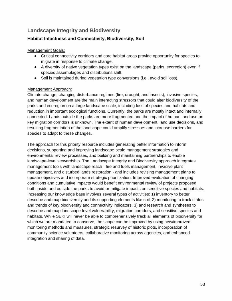
53
Landscape Integrity and Biodiversity Habitat Intactness and Connectivity, Biodiversity, Soil Management Goals:
● Critical connectivity corridors and core habitat areas provide opportunity for species to migrate in response to climate change.
● A diversity of native vegetation types exist on the landscape (parks, ecoregion) even if species assemblages and distributions shift.
● Soil is maintained during vegetation type conversions (i.e., avoid soil loss). Management Approach: Climate change, changing disturbance regimes (fire, drought, and insects), invasive species, and human development are the main interacting stressors that could alter biodiversity of the parks and ecoregion on a large landscape scale, including loss of species and habitats and reduction in important ecological functions. Currently, the parks are mostly intact and internally connected. Lands outside the parks are more fragmented and the impact of human land use on key migration corridors is unknown. The extent of human development, land use decisions, and resulting fragmentation of the landscape could amplify stressors and increase barriers for species to adapt to these changes. The approach for this priority resource includes generating better information to inform decisions, supporting and improving landscape-scale management strategies and environmental review processes, and building and maintaining partnerships to enable landscape-level stewardship. The Landscape Integrity and Biodiversity approach integrates management tools with landscape reach - fire and fuels management, invasive plant management, and disturbed lands restoration - and includes revising management plans to update objectives and incorporate strategic prioritization. Improved evaluation of changing conditions and cumulative impacts would benefit environmental review of projects proposed both inside and outside the parks to avoid or mitigate impacts on sensitive species and habitats. Increasing our knowledge base involves several types of activities: 1) inventory to better describe and map biodiversity and its supporting elements like soil, 2) monitoring to track status and trends of key biodiversity and connectivity indicators, 3) and research and syntheses to describe and map landscape-level vulnerability, migration corridors, and sensitive species and habitats. While SEKI will never be able to comprehensively track all elements of biodiversity for which we are mandated to conserve, the scope can be improved by using new/improved monitoring methods and measures, strategic resurvey of historic plots, incorporation of community science volunteers, collaborative monitoring across agencies, and enhanced integration and sharing of data.

54
Table 5. Landscape Integrity and Biodiversity management objectives, activities (short titles), and their priority rating (Pr). Higher priority = H (red), medium priority = M (yellow), lower priority = L (blue).
Landscape Integrity and Biodiversity
Management Objective # Pr Activity Short Name
Assess resource vulnerability and value across the landscape to improve understanding of characteristics driving vulnerability and to enable selection of appropriate management goals and activities.
LI01 M Compare and integrate vulnerability assessment products to describe and map vulnerability to climate change and other stressors at parkwide and larger regional scales.
LI02 L Create landform maps that integrate geology, soils, and topography to help understand vulnerability and manage watersheds, ecosystems, cultural resources, and natural hazards.
LI03 M Identify and map species with rare habitats and determine conservation needs so these species are not lost due to changing conditions.
Understand genetic diversity and environmental tolerances and protect genetic resources to enable adaptation to changing climate conditions.
LI04 M Understand the landscape genetics and distribution of species that are highly valued and/or vulnerable.
LI05 M Collect and store seeds of vulnerable species in long-term seed storage banks as insurance against species loss and to use in future restoration or relocation projects.
Maintain landscape-level connectivity especially across elevations from foothills to alpine
LI06 M
Map elevation corridors and intact foothills habitats inside and outside of the parks to avoid development in critical migration corridors, target restoration locations, and allow species to migrate in response to climate change.
Ensure existing and new facilities/infrastructure do not negatively impact sensitive resources and are resilient to climate change.
LI07 M Conduct visitor capacity study to inform facility and resource management/protection decision making, as described in the parks' strategic plan.
LI08 M Assess climate change vulnerability caused or exacerbated by existing and planned facilities and mitigate risk to sensitive areas.
Limit or reduce the impacts of past and ongoing administrative and recreational use for improvement of resource conditions and long-term sustainability.
LI09 H Continue to support existing environmental review for both project design and execution to ensure that management actions do not cause negative impacts on park resources.
LI10 L Consider changing patterns of visitation and resource use in the environmental review of all future projects to avoid or mitigate stress on species or ecosystems.
LI11 L Develop better methods for cumulative impact assessment and review of significant actions proposed by adjacent land

55
Landscape Integrity and Biodiversity
Management Objective # Pr Activity Short Name
owners/agencies.
LI12 H Conduct a parkwide Disturbed Lands Inventory and prioritization strategy to guide future restoration projects.
LI13 H Restore, monitor, and evaluate restoration of lands degraded by past human actions.
Implement fire and fuel management to maintain a mix of fire return intervals on the landscape; manage for resilient ecosystems that resist rapid type conversion and continue to provide ecosystem functions.
LI14 M Revise SEKI's Fire and Fuels Management Plan to incorporate new learning, integrate climate change more thoroughly, and revise management objectives and prioritization concepts as needed.
LI15 M Expand inter-agency collaboration to increase the pace and scale of prescribed and managed fire across park and regional scales.
LI16 H Conduct fire management treatments across the landscape to allow a mix of species to persist and to mitigate stress.
Monitor fire behavior and effects to evaluate the effectiveness of the fire and fuels management program and better understand climate-fire interactions and their effects on fire-adapted ecosystems.
LI17 H Monitor and track fire return interval, severity, gap creation, and regeneration/succession across the landscape.
LI18 M Evaluate effectiveness of different fire treatments to maintain ecosystem services by reducing impacts of drought and other stressors.
Protect native biodiversity by preventing introduction of invasive non-native organisms (plants, animals, pathogens) and reducing their impacts where they occur.
LI19 H Complete Invasive Plant Management Plan - to incorporate public input, provide transparency, and formalize invasive plant management activities.
LI20 H Assess and prioritize invasive nonnative plants for management using a systematic, transparent assessment system.
LI21 L Determine how to classify plant and animal species as climate migrants versus invasive species and develop monitoring and management frameworks for response to changes in distribution.
LI22 H Prevent introduction of regionally nonnative plants new to the park or new to a local site through education, regulations, and monitoring of incoming materials.
LI23 H Rapid detection and response: survey, detect, and eradicate new and

56
Landscape Integrity and Biodiversity
Management Objective # Pr Activity Short Name
high priority invasive non-native plants within 3 years of introduction to a site.
LI24 H When invasive non-native plants do become established, remove high priority invasive species from prioritized locations. Otherwise, prevent expansion and reduce cover of invasives where feasible.
LI25 M In prioritized locations, restore ecosystems and key ecological processes that have been severely degraded by invasive species.
Monitor status and trends in species, ecosystems, and ecological processes to detect change in resource condition in response to stressors or management action.
LI26 M Continue to monitor landscape-scale biodiversity proxies (e.g., birds) as one tool for understanding and responding to changes in diversity across the parks.
LI27 M Research more effective techniques to monitor species richness (soundscape monitoring, eDNA, remote cameras/sensors).
LI28 H Detect landscape-scale changes in vegetation types through remotely sensed imagery and applications
LI29 H Resurvey sites (e.g., NRI plots) to detect changes in species distribution and abundance.
LI30 M Update SEKI's 2001 vegetation map to facilitate vegetation change analysis and identify areas of concern for potential management action.
Acquire or improve baseline knowledge of biological and physical resources in the parks to support decision making, predictive modeling, and change detection.
LI31 M Complete SEKI soil survey/map to improve predictive modeling and inform management actions that may impact soils.
LI32 L Facilitate collection and curation of plant and animal specimens in repositories with data available on relevant internet sites that are positioned to make information accessible for biodiversity study.
Collaborate with partners to leverage organizational strengths, build capacity, and/or manage priority resources at larger landscape and regional scales.
LI33 M
Reinvigorate the Southern Sierra Conservation Cooperative (SSCC) so that we have an established inter-agency group focused on landscape-scale ecosystem management, science, and communication needs.
LI34 L
Continue to participate in the Southern Sierra Integrated Regional Water Management (SSIRWM) and Tulare Basin Watershed Connections groups to leverage collaborative conservation for maximum effectiveness.

57
Landscape Integrity and Biodiversity
Management Objective # Pr Activity Short Name
LI35 L Establish landscape monitoring partnerships to understand species adapting to changing conditions versus those in danger of being lost from the ecoregion.
LI36 H Continue developing and applying data management protocols for new spatial databases so that data is discoverable, accessible, and useable.
LI37 H Standardize data integration and evaluate values, metrics, and management across jurisdictions at a landscape scale.
LI38 M Collaboratively create a publically accessible clearinghouse for Southern Sierra Nevada datasets to build landscape-scale understanding of values, vulnerability, and change.
LI39 M Contribute to a Climate-Smart Conservation Strategy for the Southern Sierra Nevada and apply to Demonstration Landscape Areas.
Landscape connectivity across elevations is important for species movements in response to a changing climate. Photo by Koren Nydick.

58
Air Resources Air Quality, Dark Skies, Natural Soundscapes Management Goals:
● Perpetuate the best possible clean air to protect human and ecosystem health while recognizing and mitigating compounding effects of climate change on air quality.
● Protect natural darkness and other components of the natural lightscape. ● Minimize the impact of anthropogenic sound sources in relation to natural acoustic
conditions. Management Approach: The parks are downwind of many air pollution sources, including agriculture, industry, major highways, and urban pollutants. Ozone, fine particulates (PM2.5), and deposition of nutrients, mercury, and other contaminants such as pesticides already impact park resources and in some cases human health. An expanding human population, land use decisions, and climate change could further increase these stressors and their impacts. On the other hand, regulatory policies, technology, and partnerships could be enacted to reduce them. The management approach for air quality focuses on monitoring air pollutants, better mapping their sources, and improving understanding of how and where they affect park resources and human health, including establishment of “critical loads” below which significant harmful effects to sensitive resources do not occur. This work interconnects with the management approach for other affected priority resources, such as water and alpine communities. Communication of this critical scientific information to diverse audiences is the basis for working collaboratively with government agencies and other stakeholders to ultimately reduce pollutant emissions. This information also is necessary to provide air quality forecasts and health advisories to enable people to take action to protect themselves from poor air quality. The parks’ soundscapes and dark skies are vulnerable to intrusion of unnatural light and sounds from both within and outside the parks. The management approach for protecting the parks’ dark skies focuses on following outside lighting guidelines and conducting outreach about light pollution and the benefits of dark skies (i.e., supporting the Night Sky Festival and pursuing International Dark Sky Certification). Work on soundscapes focuses on continuing to minimize noise intrusion from park overflights and monitoring both natural and human sounds. Soundscape monitoring will improve understanding of how various types of human activities (recreation, park management, external influences) alter the soundscape. These data also are needed to develop targets for acceptable levels of sound intrusion to enable effective management response.

59
Table 6. Air Resources management objectives, activities (short titles), and their priority rating (Pr). Higher priority = H (red), medium priority = M (yellow), lower priority = L (blue).
Air Quality
Management Objective # Pr Activity Short Name
Detect change in physical resources and processes due to global and regional scale stressors such as climate change and air pollution, and local stressors such as human use.
AR01 H Measure ozone along an elevation gradient to assist in health advisories and to understand ecological effects.
AR02 H Measure fine particulates (PM2.5) as part of the IMPROVE network to determine trends in visibility.
AR03 M Measure fine particulates (PM2.5) as part of an interagency effort to monitor smoke dispersion.
AR04 H Measure wet and dry deposition to detect trends in nitrogen, sulfur, and acidic deposition.
AR05 H Measure wet deposition to detect trends in mercury deposition.
AR06 H Measure atmospherically deposited contaminants of emerging concern (e.g., flame retardant, new classes of pesticides/herbicides) in prioritized locations.
Understand the dynamics of stressors such as air pollution and changes in temperature and precipitation regimes, and their effects on ecosystems.
AR07 H Map threats and evaluate risk from airborne pesticides to inform field sampling locations and identify which pesticides to analyze.
AR08 H Determine the ecosystem components most at risk from toxic air contaminants, including higher trophic levels or species more sensitive to contaminants.
AR09 M Research how pesticide pollutants (current and historic use) come into the parks and how they interact with ecosystems.
AR10 M Understand dynamics of airborne nutrient pollutants (e.g., sources, transport, effects), including receptors (e.g., soil, vegetation, water), risks, and management options to reduce ecological impacts.
AR11 L Determine extent of phosphorus deposition and its contribution to eutrophication of aquatic and/or terrestrial systems
AR12 L Research ammonia gas contribution to nitrogen deposition and ozone formation.
AR13 L Continue long-term Tokopah watershed research to understand effects of atmospheric deposition and climate change on lake and watershed dynamics.

60
Air Quality
Management Objective # Pr Activity Short Name
AR14 L Develop lichen biomonitoring program as indicator of air pollution impact on terrestrial ecosystems.
AR15 L Determine Critical Loads of nitrogen for oak woodland beyond what is currently understood via lichens.
AR16 M Evaluate knowledge and information gaps to determine Critical Loads of nutrient deposition for alpine terrestrial ecosystems.
AR17 M Formally adopt appropriate Critical Loads for park ecosystems and use these thresholds in park reporting and media.
AR18 L Determine how climate change will affect ozone levels across elevations.
AR19 L Research how airborne industrial and metal pollutants enter the parks, how they interact with ecosystems, and management actions to reduce impacts.
Enable people to take action to reduce their contributions to air pollution and to protect themselves from poor air quality.
AR20 M Improve forecasts of fine particulates (PM2.5) during fires to better inform people about health effects.
AR21 M Develop PM2.5 management action points that help define when people should be moved due to smoke.
AR22 M Using local and regional data, develop air quality health advisories as needed.
Target communications with diverse audiences to increase stewardship.
AR23 H Continue to publish reports about impacts of pesticides and fertilizers transported into the parks to inform lawmakers and regulators.
AR24 M Continue to provide air related presentations to SEKI staff, schools, and other interested parties.
Collaborate with partners to manage priority resources at larger landscape and regional scales.
AR25 H Work with the San Joaquin Valley Air Pollution Control District on addressing ozone and PM 2.5.
AR26 H Collaborate with agencies, stakeholders, and California's agricultural community to reduce air pollution, including dust, fertilizer and pesticide applications that impact park resources.

61
Natural Soundscapes & Dark Skies
Management Objective # Pr Activity Short Name
Monitor status and trends in species, ecosystems, and ecological processes to detect change in resource condition in response to stressors or management action.
AR27 M
Measure and monitor natural sounds in areas before and after large events (e.g., burned and unburned, pre and post restoration, pre and post flooding) in selected areas to measure change in biological activity and diversity.
Reduce light and sound intrusion into designated Wilderness and other natural areas.
AR28 L Monitor sounds in frontcountry and Wilderness. Develop acceptable levels of sound intrusion to enable management response.
AR29 L Develop and maintain an online SEKI sound library as a source of baseline data and educational resource.
AR30 H Continue to work collaboratively to reduce park overflights and resulting noise intrusion.
AR31 M Support the Night Sky Festival and other education opportunities to promote minimizing light pollution.
AR32 M Follow SEKI's outside lighting guidelines to reduce light intrusion.
AR33 L Pursue International Dark Sky certification to show commitment.
Dark skies above Grant Grove. Photo by Colin Bloom.
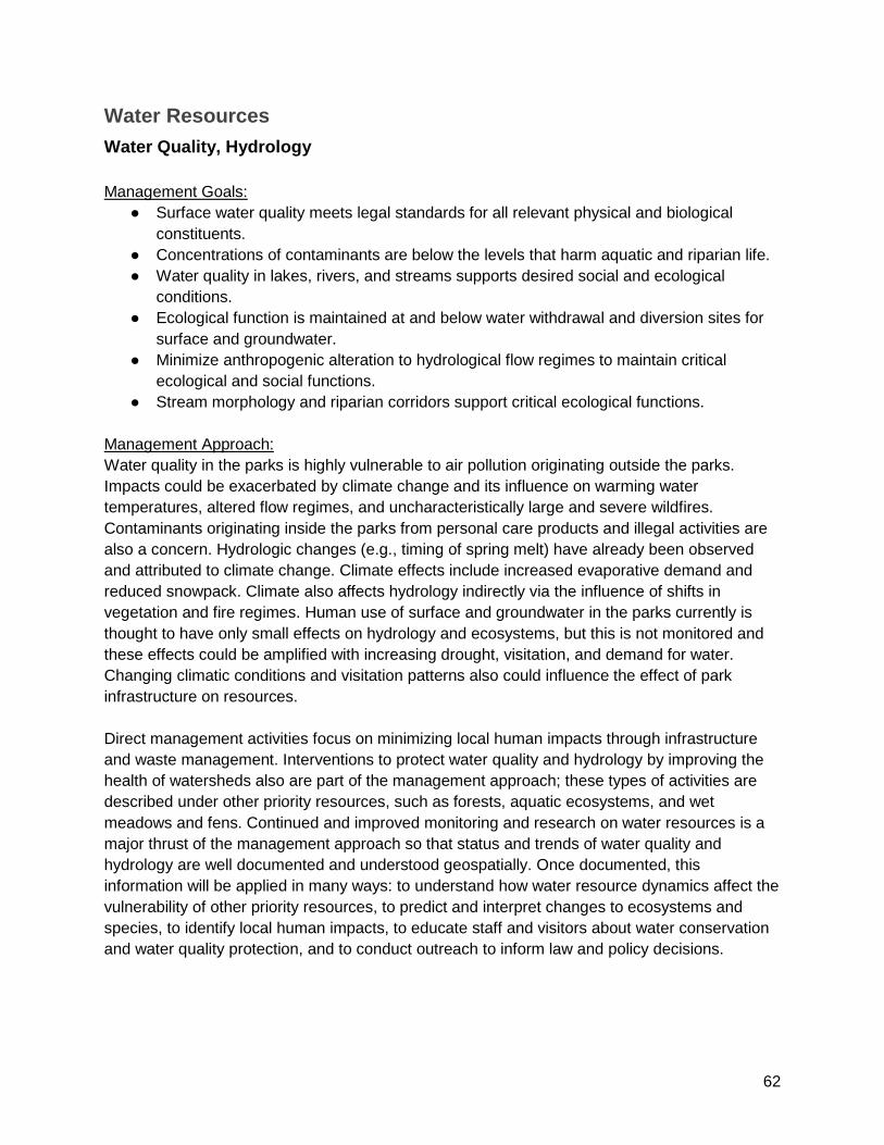
62
Water Resources Water Quality, Hydrology Management Goals:
● Surface water quality meets legal standards for all relevant physical and biological constituents.
● Concentrations of contaminants are below the levels that harm aquatic and riparian life. ● Water quality in lakes, rivers, and streams supports desired social and ecological
conditions. ● Ecological function is maintained at and below water withdrawal and diversion sites for
surface and groundwater. ● Minimize anthropogenic alteration to hydrological flow regimes to maintain critical
ecological and social functions. ● Stream morphology and riparian corridors support critical ecological functions.
Management Approach: Water quality in the parks is highly vulnerable to air pollution originating outside the parks. Impacts could be exacerbated by climate change and its influence on warming water temperatures, altered flow regimes, and uncharacteristically large and severe wildfires. Contaminants originating inside the parks from personal care products and illegal activities are also a concern. Hydrologic changes (e.g., timing of spring melt) have already been observed and attributed to climate change. Climate effects include increased evaporative demand and reduced snowpack. Climate also affects hydrology indirectly via the influence of shifts in vegetation and fire regimes. Human use of surface and groundwater in the parks currently is thought to have only small effects on hydrology and ecosystems, but this is not monitored and these effects could be amplified with increasing drought, visitation, and demand for water. Changing climatic conditions and visitation patterns also could influence the effect of park infrastructure on resources. Direct management activities focus on minimizing local human impacts through infrastructure and waste management. Interventions to protect water quality and hydrology by improving the health of watersheds also are part of the management approach; these types of activities are described under other priority resources, such as forests, aquatic ecosystems, and wet meadows and fens. Continued and improved monitoring and research on water resources is a major thrust of the management approach so that status and trends of water quality and hydrology are well documented and understood geospatially. Once documented, this information will be applied in many ways: to understand how water resource dynamics affect the vulnerability of other priority resources, to predict and interpret changes to ecosystems and species, to identify local human impacts, to educate staff and visitors about water conservation and water quality protection, and to conduct outreach to inform law and policy decisions.

63
Table 7. Water Resources management objectives, activities (short titles), and priority rating (Pr). Higher priority = H (red), medium priority = M (yellow), lower priority = L (blue).
Water Resources
Management Objective # Pr Activity Short Name
Ensure existing and new facilities/infrastructure do not negatively impact sensitive resources and are resilient to climate change.
WR01 H Evaluate potential resource impacts from the withdrawal of surface and groundwater for human use in the parks.
WR02 H Conduct regulatory monitoring as needed to comply with the Clean Water Act (wastewater treatment monitoring, etc.).
WR03 M Work interdivisionally to identify and mitigate potential water resources problems that could be caused by trails.
WR04 M Review, plan, and implement changes to culverts and bridges based on the Federal Lands Hydraulic Initiative, which assessed vulnerability to increases in runoff from climate change.
WR05 M Continue to upgrade and maintain water infrastructure to improve conservation and reduce the impact of human water use.
WR06 M Integrate climate change scenario planning into park facility improvement planning to ensure that park managers consider potential impacts to water resources, vegetation, visitation, etc.
Limit or reduce impacts of recreational use to improve of resource conditions.
WR07 M
Continue and increase the use and education about personal Waste Alleviation and Gelling (WAG) bags to reduce human waste deposition for selected high-elevation areas as indicated by the Wilderness Stewardship Plan.
Target communications with diverse audiences to increase resource stewardship.
WR08 M Continue and improve water resources education and interpretation on water quality, hydrology, and potential stressor impacts as well as solutions: watershed management and water conservation.
Detect change in physical resources and processes due to global and regional scale stressors such as climate change and air pollution, and local stressors such as human use.
WR09 M Continue and expand monitoring of precipitation and snowpack to understand broader hydrologic changes in park ecosystems.
WR10 H Continue and potentially expand monitoring of streamflow (volume and timing) to detect hydrologic changes from climate change.
WR11 M Report on existing river water quality information to document whether or not water quality goals are achieved and to enable potential management action if they are not.
WR12 M Develop and implement water quality and stream/riparian habitat monitoring programs for river or streams focusing on youth and

64
Water Resources
Management Objective # Pr Activity Short Name
other volunteers.
Detect change in physical resources and processes due to global and regional scale stressors such as climate change and air pollution, and local stressors such as human use.
WR13 L Detect changes in stream morphology caused by hydrological events outside of historic ranges and by heavy recreational use that may degrade riverbanks.
WR14 H Monitor water temperature continuously (i.e., install sensors) in rivers and streams to understand effects of climate change and identify potential refugia.
WR15 M Determine quantitative targets or assessment points for water quality measures to enable evaluation of resource condition and facilitate management response.
WR16 H Monitor contaminants (after prioritizing where and how) to assess impact to water resources and native species or ecosystems.
WR17 H Continue monitoring status and trends of water chemistry in high-elevation lakes (I&M lake monitoring) as one measure of high elevation ecosystem health.
WR18 H Incorporate nitrogen assessment points into lake condition reporting as triggers for management response activities.
WR19 H Monitor lake temperature profiles continuously (i.e., install sensors) as an addition to I&M lake monitoring to understand effects of climate change on lake ecosystems.
WR20 L Monitor lake water levels and timing of ice-on/off as an addition to I&M lake monitoring to understand effects of climate change on lake ecosystems.
Conduct or solicit specific research and synthesis to answer management questions and to base park management decisions on the best sound scientific information.
WR21 M Assess vulnerability of high-elevation lakes to algal blooms, detect effects if they are occurring, and understand system dynamics to identify possible solutions.
WR22 L Support research and development of more accurate snow cover products that estimate snow cover across the landscape.
WR23 L Conduct high resolution temperature and precipitation studies; use results to identify climate change refugia.
WR24 L Develop an extreme events assessment program to further inform park management and visitors of hydrologic conditions.

65
Water Resources
Management Objective # Pr Activity Short Name
WR25 L Expand research partnerships that complement and build on existing water quality research and monitoring to create a comprehensive monitoring program.
National Park Service scientists collect lake water samples to measure water quality. Photo by Linda Mutch.

66
Aquatic Ecosystems and Species High Elevation and Low Elevation Aquatic Ecosystems and Species Management Goals: High Elevations
● Naturally functioning food webs in lakes and streams are well-represented at the basin scale across parks and ecoregion.
● Non-native aquatic species are eradicated from selected areas and reduced parkwide. ● Threatened and endangered species and other sensitive species are maintained,
improved, and/or recovered to be represented well at the basin scale across the parks and ecoregion.
Low Elevations ● Low-elevation native aquatic species are well represented in the parks and ecoregion. ● Non-native/invasive nuisance species are prevented or controlled at high priority
locations and reduced overall in the parks. ● Extirpated species are restored in low-elevation aquatic ecosystems where feasible.
Management Approach: Non-native species, climate warming, habitat drying, changing flow regimes, excess nutrients, contaminants, and their interactions are critical vulnerabilities for aquatic ecosystems and species. Non-native species include: trout that were historically introduced to mid- and high-elevation aquatic habitat; chytrid fungus which causes disease in amphibians; the more recent expansion of green sunfish, black bullhead, and bullfrogs to lower elevation rivers; and other species that may yet invade as water warms and flow conditions change. The management approach for aquatic ecosystems and species is tightly interconnected with the approach for water resources (see above), including efforts to better understand and protect water quality, water quantity, flow regimes, and other physical aspects of aquatic habitat. The overlap in approaches also includes identifying climate change refugia that may help native species persist in the face of changing environmental conditions. In the high elevations, the management approach focuses on implementing the High Elevation Aquatic Ecosystems Restoration Plan, which was approved in 2016 and includes selected lakes, ponds, streams, and wetlands found at elevations of approximately 6,000-12,000 feet. This Restoration Plan includes the eradication of non-native fish from selected lakes and streams to restore native species, food-webs, and ecosystem processes, including creating climate change refugia for native species in deep lakes and complex stream habitat. Past efforts have removed non-native fish from four percent of lakes and ponds that contained fish (i.e., 25 of 575) compared to the new target of nearly 20%. Non-native fish also have been removed from 3.4 miles of stream; the new target expands this to nearly 35 miles. Also critical to the High Elevation Aquatic Ecosystems Restoration Plan are additional efforts specific to the restoration of two species of endangered mountain yellow legged frogs, including treatments to resist disease caused by chytrid fungus. The management approach also includes protection, monitoring, and possibly intervention for other species of concern: Yosemite toad, Little Kern golden trout, and Kern River rainbow trout.

67
In the lower-elevations, there is comparatively little scientific information and no existing management plan. Therefore, the RSS is recommending a program of monitoring (to better understand current conditions and trends for native species and their habitats) and research (to identify future suitable habitat requirements). The lower-elevation approach also calls for: initiating efforts to monitor, reduce the spread of, and eradicate non-native species invading lower-elevation aquatic habitat; periodically thinning out overly-dense riparian habitat to improve aquatic conditions; limiting impacts from administration or visitor uses; and assessing the feasibility of restoring extirpated species. Monitoring and research information is needed to design climate change adaptation strategies, including new types of interventions that might be used in the future to conserve native species and their habitats. Because monitoring of many species across the landscape is costly and difficult, new monitoring techniques (eDNA, acoustic monitoring, etc.) would likely improve detection of species or communities of conservation interest in aquatic habitats across all elevations. Table 8. Aquatic Ecosystems and Species management objectives, activities (short titles), and their priority rating (Pr). Higher priority = H (red), medium priority = M (yellow), lower priority = L (blue).
Aquatic Ecosystems and Species
Management Objective # Pr Activity Short Name
Implement Aquatic Restoration Plan to improve degraded high-elevation aquatic habitat and recover threatened or endangered species.
AQ01 H Eradicate non-native fish from selected high-elevation lakes and streams to restore degraded habitat in the face of environmental change.
AQ02 M Conduct education about high-elevation aquatic habitat restoration to minimize potential for restoration to be compromised, targeting anglers and other wilderness users.
AQ03 H
Conduct active mountain yellow legged frog restoration, including disease resistance treatment, translocations, captive-rearing, immunizations, reintroductions, emergency salvage, temporary predator relocation, monitoring, and research.
AQ04 H Develop a structured and adaptive implementation blueprint for mountain yellow legged frog restoration and monitoring utilizing expert knowledge.
Monitor, protect, and (when feasible) restore species of conservation concern.
AQ05 H Monitor and protect existing populations of Yosemite toad.
AQ06 H Restore the Yosemite toad by researching methods, collaborating across agencies, and implementing a restoration plan to improve the status of this threatened species.
AQ07 M Maintain protection for Little Kern golden trout, monitor populations, translocate if needed, and assist efforts outside parks.
AQ08 M Monitor populations of Kern River rainbow trout and translocate if necessary to protect this subspecies.
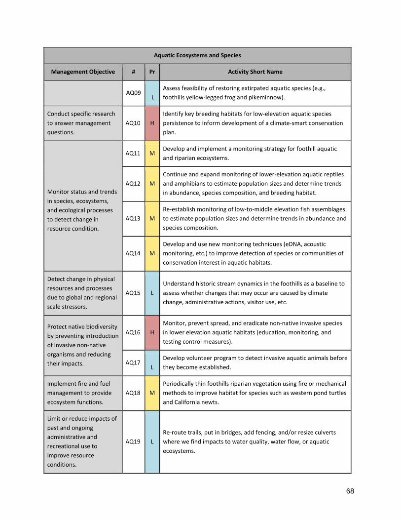
68
Aquatic Ecosystems and Species
Management Objective # Pr Activity Short Name
AQ09
L Assess feasibility of restoring extirpated aquatic species (e.g., foothills yellow-legged frog and pikeminnow).
Conduct specific research to answer management questions.
AQ10 H Identify key breeding habitats for low-elevation aquatic species persistence to inform development of a climate-smart conservation plan.
Monitor status and trends in species, ecosystems, and ecological processes to detect change in resource condition.
AQ11 M Develop and implement a monitoring strategy for foothill aquatic and riparian ecosystems.
AQ12 M Continue and expand monitoring of lower-elevation aquatic reptiles and amphibians to estimate population sizes and determine trends in abundance, species composition, and breeding habitat.
AQ13 M Re-establish monitoring of low-to-middle elevation fish assemblages to estimate population sizes and determine trends in abundance and species composition.
AQ14 M Develop and use new monitoring techniques (eDNA, acoustic monitoring, etc.) to improve detection of species or communities of conservation interest in aquatic habitats.
Detect change in physical resources and processes due to global and regional scale stressors.
AQ15 L Understand historic stream dynamics in the foothills as a baseline to assess whether changes that may occur are caused by climate change, administrative actions, visitor use, etc.
Protect native biodiversity by preventing introduction of invasive non-native organisms and reducing their impacts.
AQ16 H Monitor, prevent spread, and eradicate non-native invasive species in lower elevation aquatic habitats (education, monitoring, and testing control measures).
AQ17 L
Develop volunteer program to detect invasive aquatic animals before they become established.
Implement fire and fuel management to provide ecosystem functions.
AQ18
M Periodically thin foothills riparian vegetation using fire or mechanical methods to improve habitat for species such as western pond turtles and California newts.
Limit or reduce impacts of past and ongoing administrative and recreational use to improve resource conditions.
AQ19 L Re-route trails, put in bridges, add fencing, and/or resize culverts where we find impacts to water quality, water flow, or aquatic ecosystems.
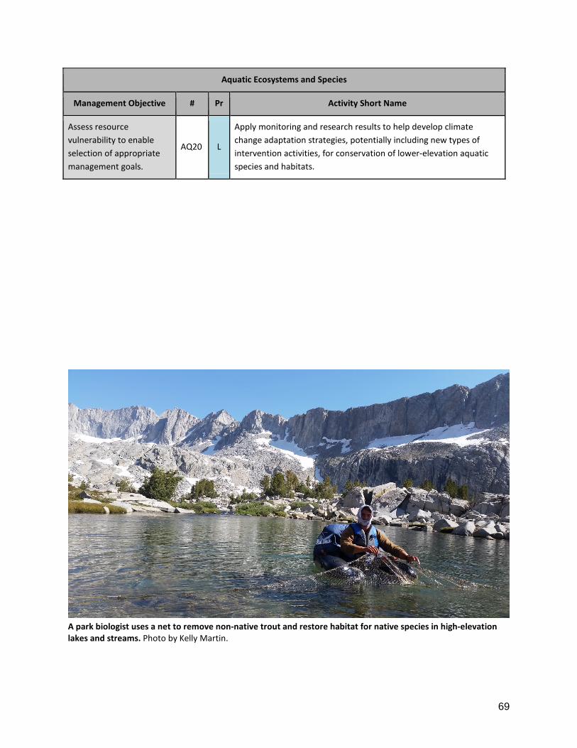
69
Aquatic Ecosystems and Species
Management Objective # Pr Activity Short Name
Assess resource vulnerability to enable selection of appropriate management goals.
AQ20 L
Apply monitoring and research results to help develop climate change adaptation strategies, potentially including new types of intervention activities, for conservation of lower-elevation aquatic species and habitats.
A park biologist uses a net to remove non-native trout and restore habitat for native species in high-elevation lakes and streams. Photo by Kelly Martin.

70
Caves and Karst Systems Wild Caves, Crystal Cave Management Goals:
● Minimize degradation of physical and biological resources while promoting cave research opportunities and providing appropriate recreation opportunities to the public.
● Conserve native cave biota while recognizing and mitigating compounding effects of climate change.
● Facilitate educational and interpretive cave experiences while preserving the ecological function and aesthetic value of Crystal Cave.
Management Approach: Caves are very sensitive resources containing irreplaceable karst formations and rare biota adapted to narrow environmental conditions. Cave visitation, warming and drying of habitat, contaminants, and disease are all stressors that can affect cave resources. However, the underground extent, formations, and biota have only been mapped or inventoried for a handful of caves and very little is known about the vulnerability of individual caves to stressors. The management approach for wild caves focuses on restricting visitation for the most sensitive caves while strategically expanding inventories, research, and monitoring to document baseline conditions and determine relative vulnerability of different caves. Understanding vulnerability will help managers prioritize locations for long-term monitoring and direct management interventions. While the surface area of influence for the parks caves has yet to be mapped, conducting prescribed fire in cave watersheds will help reduce the risk of uncontrolled wildfire and potential effects to caves from erosion and wildfire suppression impacts. Continued efforts to prevent the introduction of white nose syndrome into SEKI’s caves will help protect the parks’ bats. For Crystal Cave, the RSS calls for enhanced study and mitigation of impacts from high visitation that occurs there due to its use for commercial, educational cave tours. Monitoring of cave invertebrates will allow managers to track biotic conditions in the cave and determine if and how visitation is affecting cave biota. In particular, imported food sources, such as lint and crumbs, should be studied to determine effects on cave food webs and species. Table 9. Caves and Karst Systems management objectives, activities (short titles), and their priority rating (Pr). Higher priority = 3 (red), medium priority = 2 (yellow), lower priority = 1 (blue).
All Caves
Management Objective # Pr Activity Short Name
Limit or reduce impacts of administrative and recreational use for improvement of resource condition.
CV01 M Complete Cave Management Plan refining visitation to wild caves, including management of area closures (gates), to reduce stressors and protect cave resources.
CV02 H Continue enforcing decontamination protocols for prevention of white nose syndrome (WNS) in SEKI caves, including Crystal Cave.
Prevent loss of irreplaceable resources
CV03 H Continue restricting cave entries via permitting and cave gates. Initiate remote monitoring to protect caves from visitor impacts.

71
All Caves
Management Objective # Pr Activity Short Name
that have unique cultural or scientific value.
CV04 M Identify caves vulnerable to human impacts and install new cave gates.
CV05 M Analyze cave visitation history in concert with a survey of damaged cave formations and consider management responses to mitigate impacts.
Implement fire and fuel management to manage for resilient ecosystems.
CV06 H Conduct prescribed fires in cave watersheds to reduce fire severity and protect caves and karst systems.
Acquire or improve baseline knowledge of biological and physical resources to support decision making and change detection.
CV07 L More accurately inventory cave underground extents, formations, and surface area of influence on the cave system to enable more robust assessment of potential impacts from stressors.
CV08 H Define natural range of cave biota abundance and rarity to detect and respond to changes over time.
Assess resource vulnerability and value across the landscape to improve understanding of characteristics driving vulnerability and to enable selection of appropriate management goals and activities.
CV09 H Conduct karst springs survey to understand which caves/watersheds have sustainable water sources.
CV10 H Analyze caves relative to waterways and infrastructure to identify locations vulnerable to surface and ground sources of contamination.
CV11 M Analyze exposure of caves to unregulated visitation and climate change using cave entrance locations, solar aspect, and cold air sheds.
Monitor status and trends in species, ecosystems, and ecological processes to detect change.
CV12 M Monitor bat roosts and hibernacula to help managers prevent introduction and spread of White Nose Syndrome (WNS).
Detect change in physical resources and processes due to global and regional stressors.
CV13 M Monitor environmental change (temperature, humidity, streamflow, sediment) in caves vulnerable to climate change.
Understand stressor dynamics and effects on ecosystems.
CV14 M Analyze air quality data to better understand the influence of airborne contaminants on cave environments.

72
All Caves
Management Objective # Pr Activity Short Name
Conduct or solicit specific research and synthesis to answer management questions and to base park management decisions on the best sound scientific information.
CV15 M Promote research on cave biota to deepen understanding of cave ecosystems and how they change over time.
CV16 L Increase understanding of groundwater pathways (especially karst) so managers can improve monitoring for threats, such as groundwater extraction or pollution discharge.
CV17 L Conduct acoustic studies near cave entrances to assess wildlife use and human disturbances.
CV18 L Track cave research from permit to final published reports.
Crystal Cave
Management Objective # Pr Activity Short Name
Limit or reduce the impacts of past and ongoing administrative and recreational use for improvement of resource conditions and long-term sustainability.
CV19 H Develop Crystal Cave Management Strategy or plan to monitor conditions and ensure that human impacts are at acceptable levels.
CV20 M Accurately track Crystal Cave visitation to enable study of visitor impacts.
CV21 M Perform food web study of cave invertebrates in Crystal Cave to document and communicate the impact of food introduced by visitors.
CV22 H Reduce disruption of food webs in Crystal Cave due to visitor use (clean hair and lint and stress no-food on cave tours).
CV23 M Periodically remove unnatural algal growth near light sources in Crystal Cave.
Monitor species, ecosystems, and ecological processes to detect change in condition.
CV24 H Improve invertebrate monitoring in Crystal Cave to understand resource condition and respond to changes over time.
Target communications with diverse audiences to increase resource stewardship.
CV25 L Enhance park/partner relationship to address Crystal Cave educational opportunities.
CV26 L Provide virtual cave tour experience for those unable to access Crystal Cave

73
Wet Meadows and Fens Management Goals:
● Maintain wetland characteristics of wet meadows and fens, as feasible, in the face of changing climatic conditions.
● Restore wetland structure and function that have been altered by human actions prioritizing areas where self-sustaining wetlands are likely to persist under changing climate.
● Limit impacts from visitor and administrative activities to levels that don't degrade wetland structure or function over the long-term by themselves or in combination with climate change.
● Wet meadows and fens are managed to minimize disruption of critical ecological functions during transition to different ecosystem types where self-sustaining wetlands are not likely to persist under changing climate (i.e., directed change including reduction of non-climate stressors).
Management Approach: Climate change and potential drying of wetland habitat are key vulnerabilities for wet meadows and fens, but responses will vary dramatically across the landscape. Therefore, mapping the climate change vulnerability for these wetlands is a high priority. The combination of vulnerability assessment, ecological and social value of specific wetlands, current conditions (including human-caused degradation), and feasibility of taking action will be used to determine management objectives for specific wetlands (including managing for persistence, facilitating gradual ecological transitions, or a hands-off approach). Therefore, it also is important to conduct values assessments and inventory existing impacts to be able to prioritize meadows for restoration or other management actions. Research is needed to test methods of increasing or retaining moisture in wet meadows and fens as a climate change adaptation tool. Monitoring of wetlands and fens is critical to evaluate whether management goals are being achieved, and if not why. Targeted monitoring of meadows will continue, and be improved as feasible, to enable adaptive management of these resources. The impact of visitors and administrative activities is not a major stressor on a landscape-scale, but local impacts could be severe. Therefore, monitoring conditions, limiting impacts and restoring ecosystems that have been historically degraded are important management goals. Outreach with visitors and park staff helps to prevent degradation and builds support for park management decisions, such as restoration and climate change adaptation.

74
Table 10. Wet Meadow and Fen management objectives, activities (short titles), and their priority rating (Pr). Higher priority = 3 (red), medium priority = 2 (yellow), lower priority = 1 (blue).
Wet Meadows and Fens
Management Objective # Pr Activity Short Name
Assess resource vulnerability and value across the landscape and enable selection of appropriate management goals.
WM01 H Map climate change vulnerability for wet meadows and fens.
WM02 H Map conservation value of meadows and fens.
WM03 H Identify goals for individual meadows based on their value and vulnerability.
Experiment with potential adaptation actions to reduce vulnerability.
WM04 M Test methods to retain moisture in wet meadows and fens for climate change adaptation.
Protect native biodiversity by preventing and controlling non-native species.
WM05 H Survey and control non-native plants in wet meadows and fens.
Limit or reduce the impacts of past and ongoing administrative and recreational use for improvement of resource conditions and long-term sustainability.
WM06 H Monitor pack stock grazing locations and amount in wet meadows and fens.
WM07 H Monitor wet meadows and fens impacted by visitors or administrative activities as described in Wilderness Stewardship Plan.
WM08 L Add hydrologic monitoring of wet meadows and fens impacted by visitors or administrative activities.
WM09 H Develop and periodically revise grazing guidelines and monitoring targets for wet meadows and fens impacted by visitors or administrative activities.
WM10 M Conduct outreach to stock users to reduce impacts.
WM11 H Complete a disturbed lands inventory and prioritization strategy for wet meadows and fens.
WM12 H Restore priority wet meadows and fens (design, implement, monitor, and evaluate).
Facilitate gradual ecological transitions to allow desired ecosystem functions such as hydrologic regulation and native species habitat.
WM13 L Identify desirable alternative states and define targets in areas that will not persist as wet meadows and fens in a changing climate.
WM14 L Implement guided transformation where self-sustaining wet meadows and fens are not likely to persist under changing climate.
WM15 M Prevent fires in large, dried out peat/organic soil bodies to slow release

75
Wet Meadows and Fens
Management Objective # Pr Activity Short Name
of soil carbon and enable gradual ecosystem transition.
WM16 L Identify locations where wet meadows and fens don't exist now but might be able to in the future.
Monitor status and trends in species, ecosystems, and ecological processes to detect change in resource condition in response to stressors or management action.
WM17 M Define hydrologic indicators and targets for maintaining/restoring wet meadows and fens.
WM18 H Continue monitoring of wet meadow and fen soil, vegetation, hydrology, and macroinvertebrates (I&M Wetlands Monitoring).
WM19 L Test soil carbon flux as a measure of wet meadow and fen structure and function and to quantify carbon sequestration.
WM20 M Periodically (~10 yr) re-map wet meadows and fens to assess change (area, distribution).
Enable use of data in all formats in recognition of the vital role of data management.
WM21 L Scan and curate wet meadow and fen archives to make accessible to managers and researchers.
WM22 L
Write environmental history of wet meadow and fen research and management, including Soil and Moisture Conservation Crews to understand their effects on current conditions and inform future management.
Target communications with diverse audiences to increase stewardship.
WM23 M Enhance education about benefits of wetland management in the face of a changing climate.
Collaborate with partners to manage priority resources at larger landscape scales.
WM24 M Participate in regional meadow and wetland conservation groups.
WM25 M Identify opportunities to standardize wet meadow and fen data collection and conduct collaborative regional research.
76
Foothill Terrestrial Ecosystems
Management Goals: ● Oak woodlands, shrublands and riparian zones are structurally and compositionally
complex, resilient, and support native biodiversity and important ecosystem functions, even if species assemblages and distributions shift.
● Expanded grasslands or novel vegetation types retain ecosystem services (to an acceptable extent) and support native species.
Management Approach: Key vulnerabilities for the foothills include drought, warming, and changing fire regimes. Prolonged, hot drought is causing decline in oaks, chaparral, and manzanita and may further depress seedling regeneration. Altered fire regime, including increases in fire severity may cause contraction in oak woodlands (in favor of shrublands) and increased fire frequency may lead to conversion of shrublands to annual grasslands. While these are among the greatest threats to foothill terrestrial ecosystems, our ability to mitigate them currently is constrained by gaps in knowledge and limited management capacity. There is relatively little monitoring and research occurring in the foothills so the management approach includes filling these scientific information gaps. The approach also includes applying relatively small-scale direct management actions to reduce vulnerabilities to stressors such as non-native invasive species, visitor and administrative use, and illegal marijuana cultivation. While small in scope, these activities focus on places with the most severe impacts (or potential for impact) and some target accessible, high value locations with interpretive power. Foothill grassland communities already are dominated by non-native annuals, but face further threats from invasives that have not yet become widespread; therefore the focus of non-native species prevention and control is on invasive species that can do the most harm to native species and ecosystem processes. However, there also is a desire to restore small, accessible foothill areas to serve as native biodiversity demonstration areas. The foothill management approach also includes experimenting with new types of climate change adaptation treatments - and the range and extent of such innovative treatments may grow as research and monitoring provide more information to support their implementation. Also critical to the approach is reaching out to Indian tribes, neighboring agencies and landowners, and volunteers for assistance in not only implementing projects but also designing them to improve the integration of natural and cultural resource management. Interpretation, education, and outreach go hand in hand with many of these activities to prevent or reduce visitor impacts and build support for management actions.

77
Table 11. Foothill Terrestrial Ecosystem management objectives, activities (short titles), and their priority rating (Pr). Higher priority = 3 (red), medium priority = 2 (yellow), lower priority = 1 (blue).
Foothill Terrestrial Ecosystems
Management Objective # Pr Activity Short Name
Monitor status and trends in species, ecosystems, and ecological processes to detect change in resource condition in response to stressors or management action.
FT01 H Develop and implement a monitoring plan for terrestrial foothill ecosystems.
FT02 M Continue phenological monitoring of California buckeye and blue oak (including citizen scientists).
FT03 L Install Foothills Visitor Center exhibit to encourage volunteer phenological monitoring (picture post and website photo upload).
FT04 M Monitor foothill herpetofauna potentially with citizen science and cross-agency collaboration.
Collaborate with partners to manage priority resources at larger landscape scales.
FT05 M Collaborate with partners to study cross-boundary resource issues and make recommendations to reduce stressors and impacts.
Conduct or solicit specific research and synthesis to answer management questions and to base park management decisions on the best sound scientific information.
FT06 H Study drought impacts and spatial patterns in oak woodlands (tree mortality, etc.) to inform management actions.
FT07 L Study foothill nutrient and carbon cycling to recommend monitoring measures and thresholds to support biodiversity and ecosystem function.
FT08 L Study foothill hydrology to recommend monitoring indicators and improve understanding of climate-water-vegetation interactions.
Implement fire and fuel management to maintain a mix of fire return intervals on the landscape; manage for resilient ecosystems that resist rapid type conversion and continue to provide ecosystem functions.
FT09 M Describe fire's natural range of variability in the foothills, including methods to measure too-frequent as well as less frequent fire.
FT10 H Conduct foothill prescribed fires to demonstrate benefits other than fuel reduction.
FT11 L Re-establish beneficial fire regime in at least one chaparral location.
FT12 L Interpret foothills fire restoration with before-after photo points, including citizen science picture posts.
FT13 L Conduct outreach to local communities to increase community fire safety and acceptance of prescribed fire.
Limit or reduce the impacts of past and ongoing
FT14 H Complete Ash Mountain Pasture Grazing Guidelines for administrative pack stock use and establish monitoring.

78
Foothill Terrestrial Ecosystems
Management Objective # Pr Activity Short Name
administrative and recreational use for improvement of resource conditions and long-term sustainability.
FT15 H Manage administrative pack stock grazing of Ash Mountain Pasture based on Grazing Guidelines.
FT16 H Continue to support and expand the volunteer River Rover program (trash, safety, etc.).
FT17 L Develop 'Adopt-a-Camp' volunteer program to remove litter and weeds, revegetate, clean fire pits, etc. in/near campgrounds.
FT18 L Inventory recreational impacts to popular foothills destinations, determine indicators and management trigger points, and monitor.
FT19 H In high use foothills areas, assess visitor impacts and recommend facility improvements (restrooms, trash bin, trails, etc.) to reduce resource impact and improve visitor experience.
FT20 L Manage recreation at popular foothills destinations to minimize resource impacts while enhancing visitor experience.
FT21 M Research what kind of education or communication is successful at increasing visitor stewardship of foothills areas.
Prevent/minimize/mitigate negative resource impacts from illegal activities using best practices and innovative solutions.
FT22 H Prevent resource damage from illegal marijuana cultivation by acting early in the growing season.
FT23 H Detect illegal marijuana cultivation, remove debris before first fall rains, document, and restore as needed.
Protect native biodiversity by preventing introduction of invasive non-native organisms (plants, animals, pathogens) and reducing their impacts where they occur.
FT24 H Conduct early detection and removal of high priority invasive plant species.
FT25 M Conduct landowner outreach and weed eradication to reduce non-native seed sources from outside the parks.
FT26 H Monitor, assess impact, and recommend response for park areas vulnerable to feral pigs and trespass cattle.
FT27 M Coordinate with California Department of Fish and Wildlife on sport hunting to reduce feral pigs outside the parks.
Restore native species, communities, and ecological conditions that support ecological, social, and
FT28 M Partner with Indian tribes and youth to identify foothill restoration or adaptation project opportunities.
FT29 H Restore and maintain demonstration areas of foothill native plant communities and collaborate with Indian tribes to design and

79
Foothill Terrestrial Ecosystems
Management Objective # Pr Activity Short Name
cultural values in prioritized locations.
implement.
FT30 M Interpret foothills native plant restoration project in collaboration with Indian tribes (exhibits, guided walks, etc.).
Experiment and document effectiveness of adaptation actions to reduce vulnerability of native species and ecosystems to negative effects of climate change and other stressors.
FT31 H Assist blue oak recruitment in strategic areas of drought-resistant genotypes using direct planting, tree shelters, or nurse sites to mitigate climate/drought induced mortality.
FT32 L Conduct experimental thinning of shade tolerant trees or shrubs that out-compete black oaks and other species.
Target communications with diverse audiences to increase stewardship of natural and cultural resources.
FT33 L Engage audiences about oak woodlands, including protecting them inside and outside the parks.
FT34 L Interpret climate change in tangible ways, using foothill examples and distinguishing between weather and climate.
Volunteers plant elderberry bushes and other native plants at the site of a former Native American village in the foothills.
80
Forest Ecosystems Montane and Subalpine Forests Management Goals:
● Montane and subalpine forests are structurally and compositionally complex, resilient, and support native biodiversity and ecosystem functions even if species assemblages and distributions shift.
Management Approach: The key vulnerability of the parks’ forest is the interaction between hotter droughts, insects and diseases, and altered fire regimes. Currently, the exposure to and impacts of these stressors are more severe at lower elevations, but in the long-term subalpine forests may be more vulnerable due to less adaptive capacity to cope with, or recover from, impacts. The management approach includes research and monitoring to understand and map these vulnerabilities across the landscape, track resource status and trends (including re-measurement of historic plots), better define management targets for resilient ecosystems, and identify areas where conversion to other vegetation types is acceptable. This information will help managers to prioritize which direct management actions to apply where and when across the forest landscape. Fire and fuels treatments remain the parks’ most powerful tool for increasing resistance and resilience of forests to stressor impacts at large to small scales, but more research and monitoring is needed to improve targets and prescriptions in light of changing environmental conditions. Understanding past versus current and potential future forest conditions would provide important context for decision making regarding, for example, what are desired fire regimes in subalpine forests and where will conditions be suitable in the future for conserving certain species. Adaptive experiments are needed to test potential new management treatments for their feasibility and effectiveness, including methods to prevent or reduce epidemic beetle outbreaks in vulnerable areas. This also includes better understanding of white pine blister rust, its impacts on five needle pines, and management options to increase disease resistance. Outreach and education to build support for fire and fuels management and other forest management tools, including potential new types of strategies, are important to the feasibility of these actions. Continued survey and mitigation of tree hazards is especially needed during and following drought conditions or high severity fire events to protect life and property. Tree hazard surveys also inform managers about the scale of forest changes in developed areas and where revegetation might be needed.

81
Table 12. Forest management objectives, activities (short titles), and their priority rating (Pr). Higher priority = 3 (red), medium priority = 2 (yellow), lower priority = 1 (blue).
Forest Ecosystems
Management Objective # Pr Activity Short Name
Assess resource vulnerability and value across the landscape and enable selection of appropriate management goals.
FR01 H Map forest vulnerability to moisture stress to help prioritize fire and fuels management and other treatments (Leaf to Landscape project).
FR02 L Identify suitable habitat for whitebark pine in the future based on climate, soil, etc. to help prioritize management treatments.
Manage for resilient ecosystems.
FR03 H Identify metrics to define "resilient forests and landscapes" and revise management prescriptions as needed.
Facilitate gradual ecological transitions to allow desired ecosystem functions.
FR04 M Identify areas where conversion of forests to another vegetation type is acceptable due to past conditions, management activities, etc.
Protect native biodiversity by preventing and controlling non-native species.
FR05 M Implement non-native invasive plant detection and control measures to prevent undesirable vegetation conversions.
Implement fire and fuel management to manage for resilient ecosystems that provide ecosystem functions.
FR06 H Continue and expand fire and fuels management to maintain an appropriate fire regime.
FR07 H Build funding for expansion of prescribed fire to a longer season.
Target communications with diverse audiences to increase stewardship.
FR08 H Conduct outreach and education to increase understanding of fire, forest ecology, and climate change to build support for fire and fuel management.
Monitor fire behavior and effects to evaluate effectiveness of fire and fuels management program, and to better understand climate-fire interactions and their effects on structure and function of fire-adapted ecosystems.
FR09 H Continue and enhance fire effects monitoring, the parks' most comprehensive, plot-based dataset relating specifically to fire.
FR10 H Expand fire return interval departure (FRID) to identify areas burning more frequently than the historic FRI, in addition to areas burning more infrequently.
FR11 M Continue to acquire, analyze, ground truth (Composite Burn Index protocol), and evaluate satellite based fire severity data on large fires to provide coarse scale estimate of fire effects and vegetation response.
FR12 H Install more fire effects plots and revisit existing plots in subalpine forests to capture changing fire regime and fire effects.
FR13 H Improve understanding of historical fire regimes in subalpine forests.

82
Forest Ecosystems
Management Objective # Pr Activity Short Name
FR14 L Analyze fire return interval departure (FRID) in subalpine forests, using improved historic information, to map areas with less or more fire than in the past.
FR15 H Determine if prescribed fire etc. designed to restore forests to historic conditions increase resistance to tree mortality during drought.
Experiment with and document effectiveness of potential adaptation actions to reduce vulnerability of native species and ecosystems to negative effects of climate change and other stressors.
FR16 H Test management strategies for increasing forest resilience by reducing tree densities below historic levels using prescribed fire.
FR17 L Design an adaptive management experiment following extreme fire, wind, etc. to test erosion controls and planting genotypes/species suitable for future conditions.
FR18 M Create a sugar pine adaptive management plan for identifying and planting genotypes resistant to blister rust.
FR19 L Test climate adaptation strategies to provide vegetation cover in Cedar Grove campgrounds that experienced severe drought tree mortality.
Minimize the negative effects of insects and pathogens on native biodiversity.
FR20 M
Identify vulnerable areas, then prevent or minimize epidemic outbreaks of native forest pests that have potential to cause unprecedented forest mortality. Research how other managers responded to native insect infestations and incorporate their lessons learned.
FR21 M Quantify effects on resources due to impacts of insects and pathogens (tree cover, carbon storage, native species, wildlife habitat, etc.).
Protect life and property from environmental hazards while minimizing resource impacts.
FR22 H Continue surveying and managing tree hazards to protect life and property.
Prevent loss of irreplaceable resources that have unique cultural or scientific value.
FR23 L Identify locations and tree species with remnant/subfossil wood in high-elevation or ghost forests. Monitor campsites to minimize loss to fuel wood burning.
FR24 M Implement subfossil wood education (through wilderness permitting) to inform visitors not to use this irreplaceable paleo resource.
Monitor status and trends in species, ecosystems, and ecological processes to detect change in resource condition
FR25 H Continue USGS and I&M forest monitoring to assess stressor exposure and forest health, demographics, and structure.
FR26 L Re-measure Natural Resource Inventory (NRI) plots to understand long-term change in forest structure at a parkwide scale.

83
Forest Ecosystems
Management Objective # Pr Activity Short Name
in response to stressors or management action.
FR27 M Re-measure existing blister rust plots every 10 years to determine status and spread of white pine blister rust.
FR28 M Develop monitoring strategy for western white pine, which is susceptible to blister rust.
FR29 L Re-measure 25+ year-old Keifer plots in Rock Creek/Boreal Plateau to detect change in lodgepole and foxtail pine forests.
FR30 H Track status of sugar pine by remeasuring existing plots and analyzing population demographics (birth and death rates).
Conduct or solicit specific research to answer management questions.
FR31 L Assess sugar pine demographics in fire-restored vs. fire-suppressed sites.
FR32 L Solicit dendrochronology research for high-elevation tree species to better compare current and past conditions.
Understand stressor dynamics and ecosystem effects.
FR33 M Research the interactions of multiple stressors on five-needle pines.
Collaborate to manage resources at landscape scales.
FR34 H Develop regional conservation strategy for subalpine forests.
U.S. Geological Survey biologists track changes in forest structure and function in the parks. Photo by Nate Stephenson.

84
Giant Sequoia and their Ecosystems Large Living Giant Sequoia Trees, Giant Sequoia Species and Ecosystems, Sequoia in Areas of Highest Social Value Management Goals:
● Maximize the persistence of large, living giant sequoias. ● Maximize the persistence of structurally and compositionally complex giant sequoia
groves that are sustainable, resilient, and support native biodiversity. ● Manage for ecological functions essential to giant sequoia groves. ● Prepare for potential shifts in giant sequoia distribution to enable its persistence in the
broader Sierra Nevada landscape. ● Maximize the persistence of giant sequoia in areas of highest social value.
Management Approach: Giant sequoias are the parks’ most iconic resource. For the last 50 years, research has provided a robust understanding of giant sequoia fire ecology, and the parks have been actively managing fire to improve ecological conditions in some groves. In addition, the Giant Forest Restoration project removed infrastructure thought to stress these trees. Now concerns rest with the effects of climate change and vulnerabilities to warming temperatures, drought, uncharacteristically severe fires, and the possibility of future biotic agents (insects, disease) that could weaken or kill sequoias. Science priorities for stewardship of giant sequoia include research to improve understanding of their ecological thresholds and adaptive capacity; geospatial assessment (mapping) of vulnerabilities, climate change refugia, and potential future distributions; monitoring of status and trend of giant sequoias and their stressors; and evaluating the effects of management treatments and other administrative activities. Direct management priorities include continuing and expanding the use of fire and fuels treatments, reducing other stressors like invasive plants, establishing seed banks, and research with new or expanded treatments that may increase resistance and resilience to climate change, drought, insects, disease, and uncharacteristically severe fires. Such experimental treatments may include using fire to thin groves beyond the range of historic variability, increasing the use of fuel breaks, attempting to control forest insects and pathogens, post-disturbance planting with genotypes and species more adapted to future conditions, and assisted migration of giant sequoia. Partnerships and collaboration among scientists and managers across jurisdictions is critical for sharing information and managing for persistence of giant sequoia in the ecoregion. Vulnerability information, combined with assessment of current condition, values of specific grove areas, and feasibility, will inform decisions on where to conduct management treatments.

85
Education and engagement are important for helping with specific objectives such as the prevention of invasive plant, insect, or pathogen introductions, but will also improve public understanding of the challenges facing giant sequoia and build support for forest stewardship. As an iconic species, giant sequoia provide a platform for reaching out to broad audiences and encouraging discourse about climate change, the role of science, and forest management more broadly.
Table 13. Giant Sequoia management objectives, activities (short titles), and their priority rating (Pr). Higher priority = 3 (red), medium priority = 2 (yellow), lower priority = 1 (blue).
Giant Sequoia and Their Ecosystems
Management Objective # Pr Activity Short Name
Prepare for likely climate change impacts using adaptation approaches robust across plausible climate scenarios.
SE01 H Complete a Giant Sequoia Monitoring and Management Plan, as called for in SEKI's 2016-2021 Strategic Plan.
SE02 M Engage staff and partners in climate change facilitated dialogue and scenario exercises about giant sequoia management.
Assess resource vulnerability and value across the landscape to improve understanding of characteristics driving vulnerability and to enable selection of appropriate management goals.
SE03 H Map giant sequoia and forest drought vulnerability and monitor across the landscape using remotely sensed data (Leaf to Landscape project).
SE04 L Obtain fine scale environmental measurements to determine if giant sequoia groves are climate change refugia.
SE05 M Conduct niche modeling including soils information to compare current and potential future distributions of giant sequoia habitat.
SE06 L Identify possible problematic areas of unsustainable soil loss by modeling soil erosion under climate change scenarios.
Acquire or improve baseline knowledge of park resources to support decision making, predictive modeling, and change detection.
SE07 H Improve mapping of giant sequoia groves and trees by correcting the Sequoia Tree Inventory.
Implement fire and fuel management to maintain a mix of fire return intervals on the landscape; manage for resilient ecosystems that resist rapid type conversion and continue to provide ecosystem functions.
SE08 H Conduct fuel and fire management in giant sequoia groves for multiple resource benefits (includes mechanical where fire is not feasible).
SE09 H Build upon and maintain fuel breaks in strategic locations to limit spread of uncontrolled wildfire into giant sequoia groves.
SE10 M Suppress fire with high risk of being high severity (crown fire) over large areas within and across giant sequoia groves.

86
Giant Sequoia and Their Ecosystems
Management Objective # Pr Activity Short Name
SE11 L Suppress fires that risk damage to Giant sequoia trees of special interest or special management areas (SMAs).
Monitor fire behavior and effects to evaluate effectiveness of fire and fuels management, and better understand climate-fire interactions in fire-adapted ecosystems.
SE12 H Continue to map fire return interval departure (FRID), fire size, and severity to track changing fire regimes and condition of sequoia groves.
SE13 H Continue to monitor fire effects in and adjacent to sequoia groves to evaluate program effectiveness and assess conditions following repeated burns over the long term.
Experiment with and document effectiveness of potential adaptation actions to reduce vulnerability of native species and ecosystems to negative effects of climate change and other stressors.
SE14 H Determine if prescribed fire etc. designed to restore sequoia mixed conifer forests to historic conditions increase resistance to tree mortality during drought.
SE15 H Test management strategies for increasing giant sequoia mixed conifer forest resilience by reducing tree densities below historic levels using prescribed fire.
SE16 L Design an adaptive management experiment following extreme fire, wind, etc. to test erosion controls and planting genotypes/species suitable for future conditions.
SE17 L Conduct giant sequoia assisted adaptation (plant adapted genotypes) or assisted migration (move seedlings to future suitable habitat) management experiment to test seedling success and social response.
SE18 L Test how best to improve the health of logged/second growth sequoia groves (i.e., Dillonwood or Big Stump), including how to reintroduce fire to these areas.
Protect native biodiversity by preventing introduction of invasive non-native organisms and reducing their impacts where they occur.
SE19 H Prevent invasive plant, insect, or pathogen introductions using a combination of education and policy.
SE20 H Monitor occurrence and extent of high priority invasive non-native plant species that occur in giant sequoia groves.
Minimize the negative effects of insects and pathogens on native biodiversity.
SE21 M Improve and coordinate surveys for early detection of invasive insects and disease.
SE22 L Control insects and pathogens that cause or are likely to cause extensive tree mortality within high value areas of sequoia groves.
SE23 L Plant blister rust-resistant sugar pines in high-value sequoia groves.

87
Giant Sequoia and Their Ecosystems
Management Objective # Pr Activity Short Name
Limit or reduce impacts of past and ongoing administrative and recreational use for improvement of resource conditions and sustainability.
SE24 L Assess administrative water withdrawals and their effects on giant sequoia groves.
SE25 L Restore hydrologic and soil functioning of Lost Grove.
Understand genetic diversity and environmental tolerances and prepare seed stocks for future planting efforts to enable adaptation to changing climate conditions.
SE26 M Collect giant sequoia seeds for seed banking, genetic analysis, and experimental assisted migration.
SE27 M Establish stocks of native seeds adapted to future climates for a variety of plant species for revegetation in giant sequoia groves.
SE28 L Assess genetic diversity of giant sequoia within and across groves to determine variability in climate stress tolerance and adaptive capacity.
Monitor status and trends in species, ecosystems, and ecological processes to detect change in resource condition in response to stressors or management action.
SE29 M Continue to support and apply findings from USGS forest demography monitoring.
SE30 H Finalize the US Geological Survey report describing a monitoring protocol for giant sequoia demography and evaluate implementation feasibility.
SE31 M Continue and improve application of findings from the USFS Forest Health Program (insect and disease outbreaks and tree mortality).
SE32 L Develop protocols to monitor biodiversity as an indicator to track condition of giant sequoia groves.
SE33 L Monitor fire scars on giant sequoia Trees of Special Interest to achieve the intent of the Fire and Fuels Management Plan and Trees of Special Interest Policy.
Research and monitor social science indicators to track resource conditions important to stakeholders.
SE34 L Survey stakeholder values about giant sequoia to inform goal-setting, monitoring indicators, and implementation decisions.
SE35 L Develop protocols to monitor social values in giant sequoia groves.
Detect change in physical resources and processes.
SE36 H Develop long-term monitoring protocol for hydrology and soil indicators within and adjacent to sequoia groves.
Understand the dynamics of stressors such as air pollution and changes in temperature and precipitation regimes,
SE37 H Monitor meteorology in and adjacent to giant sequoia groves to better understand physical conditions over time.
SE38 M Continue to monitor air quality at Ash Mountain and Kaweah monitoring

88
Giant Sequoia and Their Ecosystems
Management Objective # Pr Activity Short Name
and their effects on ecosystems.
sites to provide data near sequoia groves.
Enable use of existing data, reports, field notes, and images; analyze and interpret to improve understanding current and future resource conditions.
SE39 L Track current and past research conducted in park sequoia groves to better learn from and communicate this work.
SE40 M Organize giant sequoia relevant spatial datasets so that they are discoverable, accessible, and well documented.
SE41 M Create NPS web map of giant sequoia decision support maps.
Collaborate with partners to manage priority resources at larger landscape and regional scales.
SE42 M Collaborate to integrate data across jurisdictions for a landscape-scale understanding of giant sequoia ecology, status, and trends.
SE43 M Continue to participate in the Giant Sequoia Working Group to share information with other managers of sequoia groves.
Target communications with diverse audiences to increase stewardship of natural and cultural resources.
SE44 H Conduct outreach to increase understanding of fire, sequoia ecology, and climate change to build support for fire and fuel management.
SE45 M Engage visitors and the public in climate change facilitated dialogue and scenario exercises about giant sequoia to understand possible public response to management intervention or lack thereof.
The park collaborates with university scientists and the U.S. Geological Survey to study the health of giant sequoias during and after extreme drought conditions. Photo by Lincoln Else.

89
Alpine Terrestrial Ecosystems Management Goal:
● Alpine tundra/uplands are structurally and compositionally complex, resilient, and support native biodiversity even if species assemblages and distributions shift.
Management Approach: Interaction of stressors such as climate change, air pollution, and species invasion make alpine environments some of the most vulnerable in the region, especially over the long term. Although the parks’ alpine environments have high diversity, many species are tightly constrained by extreme environmental conditions and have limited migration potential if climate change makes their naturally fragmented “sky island” habitat unsuitable. The management approach for alpine terrestrial ecosystems includes preventing or reducing impacts for which park managers have at least some control (trail, visitor, and pack stock management and non-native plants). For external influences of climate change and air pollution, the approach relies on research and monitoring combined with outreach and education to tell the story of alpine vulnerability and change to inform societal decision-making. Identification and protection of climate change refugia may help some sensitive species remain in the parks, while collecting and storing of seeds will provide some insurance against species loss. Table 14. Alpine Terrestrial Ecosystems management objectives, activities (short titles), and their priority rating (Pr). Higher priority = H (red), medium priority = M (yellow), lower priority = L (blue).
Alpine Terrestrial Ecosystems
Management Objective # Pr Activity Short Name
Protect native biodiversity by preventing introduction of invasive non-native organisms (plants, animals, pathogens) and reducing their impacts where they occur.
AL01 H Enhance early detection efforts for non-native plants, concentrating on vulnerable alpine areas.
AL02 H Eradicate invasive non-native plant species in alpine areas when population numbers are low and the likelihood of successful control is high.
Limit or reduce the impacts of past and ongoing administrative and recreational use for improvement of resource conditions and long-term sustainability.
AL03 L Continue monitoring the effects of pack stock on alpine upland meadows to ensure impacts are minimized.
AL04 L Assess informal/abandoned trails in the alpine to identify areas especially sensitive and prone to erosion and other impacts of foot traffic.
AL05 M Where informal/abandoned trails create unacceptable impacts, restore to natural-functioning conditions or adopt into maintained trail system.
AL06 M Conduct restoration in the alpine to mitigate impacts from stressors such as visitor use and invasive species.

90
Alpine Terrestrial Ecosystems
Management Objective # Pr Activity Short Name
AL07 M Conduct interpretation training for wilderness staff/trail crew to educate visitors about their direct impacts and those of invasive species.
Assess resource vulnerability to improve understanding and enable selection of appropriate management goals and activities.
AL08 H Conduct species and habitat vulnerability review to focus monitoring and management efforts on species and habitats less intrinsically adaptable to climate change.
Understand genetic diversity and environmental tolerances and protect genetic resources to enable adaptation to changing climate conditions.
AL09 H Collect seeds for alpine species vulnerable to climate change and store in offsite seedbanks.
Detect change in physical resources and processes due to stressors such as climate change, air pollution, and human use.
AL10 H Increase alpine weather and snowpack monitoring (low-cost sensors) to characterize and track climate and enable identification of climate change refugia.
AL11 L Expand monitoring of rock and ice glacial change/melt to determine loss rate.
Prepare for climate change impacts using adaptation approaches robust across plausible climate scenarios.
AL12 H Identify potential climate refugia for alpine organisms to protect them from trails, campsite development, etc. and provide places to move species to aid in future persistence.
Acquire or improve baseline knowledge of biological and physical resources in the parks to support decision making, predictive modeling, and change detection.
AL13 M Continue to document the distribution and abundance of alpine fauna, especially invertebrates and cryptic amphibians.
Al14 M Continue to document the distribution and abundance of alpine flora, especially bryophytes, lichens, and aquatic plants.
Monitor status and trends in species, ecosystems, and ecological processes
AL15 H Continue supporting high-elevation I&M monitoring of lakes, birds, wetlands, and subalpine forests to detect changes in alpine ecosystem components.

91
Alpine Terrestrial Ecosystems
Management Objective # Pr Activity Short Name
to detect change in resource condition in response to stressors or management action.
AL16 H Revisit Natural Resource Inventory (NRI) plots to detect early shifts in distribution of alpine plants and establish second data point for long term monitoring.
AL17 H Monitor SEKI Mt. Langley GLORIA sites every 5 years to detect changes in plant species and cover due to climate change or other stressors.
AL18 M Participate in regional GLORIA activities and data analysis to place SEKI into larger regional context regarding shifts in alpine plant communities.
AL19 M Develop citizen science program that enables alpine visitors to track observations of plant phenology, weeds, and wildlife.
AL20 M Determine good alpine and subalpine phenological indicators and expand phenological monitoring to include these species.
AL21 L Define targets for measuring the condition of the vegetative structure as an indicator of alpine ecosystem health.
AL22 L Evaluate carbon and nutrient dynamics in alpine terrestrial ecosystems, evaluate if the measures are good indicators of alpine ecosystem function, and establish thresholds of concern (targets).
AL23 L Evaluate the potential for expanding the Yosemite Sky Islands monitoring protocol to the unglaciated alpine plateaus of the Kern River watershed.
Conduct or solicit specific research and synthesis to answer management questions and to base park management decisions on the best sound scientific information.
AL24 H Continue to encourage research on snowpack dynamics and consequences for alpine organisms and ecosystems.
AL25 M Continue to encourage research on potential impacts of climate change on individual species, assemblages, and biotic interactions.
AL26 M Conduct ecotone studies to document species distribution shifts to understand if species are being lost or are just changing distribution.
Target communications with diverse audiences to increase stewardship of natural and cultural resources.
AL27 H Collaboratively improve messaging and outreach programs about alpine stressors such as air pollution, pesticide transport, and climate change and solicit press coverage.
AL28 L Educate local communities about glacial retreat in their own watershed as a tangible example of climate change.

92
Alpine Terrestrial Ecosystems
Management Objective # Pr Activity Short Name
AL29 L Incorporate information into programs such as Sequoia for Youth about pesticide inputs to high-elevation systems.
AL30 L Develop online social media curriculum for 'adopting' an alpine plant or animal: draw it, research it, and explain it to others to increase stewardship of alpine biota.
AL31 L Develop curriculum around school gardens comparing/contrasting with alpine meadows to help students visualize the alpine.
National Park Service biologists and volunteers monitor alpine vegetation on Mount Langley as part of the Global Observation Research Initiative in Alpine Environments (GLORIA) program.

93
Terrestrial Wildlife of Concern Species of Conservation Concern, Species of Social Concern Management Goals:
● Facilitate recovery and persistence of threatened and endangered wildlife species and other species of conservation concern.
● Restore extirpated wildlife species where feasible. ● Minimize human-wildlife conflict
Management Approach: Terrestrial wildlife of concern are vulnerable for a variety of reasons, most of which vary by species. The management approach focuses on being an active partner in species recovery efforts, including contributing to or reviewing recovery plans or strategies and ensuring that park operations do not negatively impact wildlife populations. Better understanding of wildlife distributions, abundances, suitable habitat, and movement corridors will improve management capacity to protect species of concern. A more comprehensive vulnerability assessment will help managers prioritize monitoring efforts for wildlife that may become future species of concern due to climate change or other stressors. Modernizing the parks’ Wildlife Observation Database to encourage more frequent reporting, continued monitoring of birds by the Sierra Nevada Inventory and Monitoring Program, and addition of new monitoring programs (potentially with the help of volunteers) will help track the conditions of a wider array of wildlife species and enable management action before species decline drastically While American black bears are likely less vulnerable on a population level than many other terrestrial wildlife species in the parks, stressors such as human land use, park visitation, and droughts affect bear behavior. The bear management program focuses on hazing bears and managing trash and human food as the main tools to minimize food conditioning and human-bear conflicts. Revision of the Bear Management Plan would ensure that it incorporates the latest scientific findings and is maximally effective. Research is needed to analyze the history of bear management in the parks for lessons learned and to improve techniques to haze bears, educate (and motivate) people to follow regulations and best-practices, and use bear-proof trash containers. Improvement of the Bear Incident Management System (BIMS) database is needed to allow efficient tracking and analysis of bear incidents and other data. Consideration of funding for bear-resistant trash containers for local communities and establishment of minimum viewing distances for wildlife also are recommended.

94
Table 15. Terrestrial Wildlife of Concern management objectives, activities (short titles), and their priority rating (Pr). Higher priority = H (red), Medium priority = M (yellow), lower priority = L (blue).
Terrestrial Wildlife of Concern
Management Objective # Pr Activity Short Name
Monitor, protect, and (when feasible) restore species of conservation concern.
WI01 H
Contribute to/review species recovery plans and evaluate opportunities to facilitate recovery of T&E and candidate species and other species of concern (Sierra Nevada bighorn sheep, California spotted owl, California condor, Pacific fisher).
Collaborate with partners to manage priority resources at larger landscape and regional scales.
WI02 L Participate with interagency groups to evaluate the feasibility of restoring extirpated species (wolverine, grizzly/brown bear, Sierra Nevada red fox) to the parks.
Limit or reduce impacts of administrative and recreational use for improvement of resource conditions.
WI03 H Analyze park operations with respect to Pacific fisher and California spotted owl. Recommend conservation actions or operational changes.
Maintain landscape-level connectivity especially across elevations from foothills to alpine.
WI04 L Map and monitor wildlife movement corridors, including using remote cameras and volunteers, to enable the protection of these corridors.
Assess resource vulnerability and value to improve understanding of characteristics driving vulnerability and to enable selection of management goals and activities.
WI05 M
Conduct a more comprehensive wildlife vulnerability assessment for park wildlife. For species with higher vulnerability and high social value, project future changes in suitable habitat and prioritize for monitoring and possible management.
Conduct or solicit specific research and synthesis to answer management questions and to base park management decisions on the best sound scientific information.
WI06 H Map habitat suitability for California spotted owl and Pacific fisher and apply results to avoid or mitigate impacts to these species.
WI07 M Conduct a Pacific fisher survey to validate/calibrate the habitat suitability model. Update every 5-10 years.
Enable use of existing and planned data in recognition
WI08 H Modernize the parks' wildlife observation database to increase frequency of reported observations to better understand status and

95
Terrestrial Wildlife of Concern
Management Objective # Pr Activity Short Name
of the vital role of data management.
trends of wildlife. Use digital tools such as apps to facilitate reporting.
Monitor status and trends in species, ecosystems, and ecological processes to detect change in resource condition in response to stressors or management action.
WI09 H Continue to monitor and report on birds as a biodiversity indicator (I&M monitoring vital sign).
WI10 M Support continued long-term monitoring of California spotted owls, conducted by USFS inside and outside the parks.
WI11 M Initiate pika monitoring to confirm/reject anecdotal evidence suggesting populations are stable.
WI12 M Monitor terrestrial herpetofauna as an indicator of biodiversity.
WI13 L Develop and implement a wildlife monitoring program for mid-level carnivores and common herbivores as an indicator of ecosystem health.
Minimize human-wildlife conflicts while maintaining opportunities to observe wildlife in natural habitat.
WI14 M Continue to haze bears to discourage proximity to humans or human food as an effective means to reduce food conditioning in bears.
WI15 M Continue to research better techniques to prevent human-bear conflict, including educating people, better trash cans, and better hazing techniques.
WI16 M Cost-share bear-resistant trash containers for local communities to protect bears from food conditioning as bears move across park boundaries
WI17 H Improve the SEKI Bear Incident Management System (BIMS) database and extract information to track conditions over time and analyze potential explanatory variables.
WI18 H Analyze history of bear management in the parks to understand what methods have been successful in the past and why.
WI19 M Revise the Bear Management Plan, reconsidering bear management objectives to ensure that the plan is up to date and maximally effective.
WI20 M Require visitors to maintain a minimum distance from wildlife while educating visitors and staff as to why this is important to protecting wildlife.

96
Crosscutting Activities Crosscutting activities are not resource-specific and are relevant to the stewardship of many priority resources. They include partnership activities (e.g., development of a Science Learning Center), self-education to foster a learning organization about climate change and other stressors, and a variety of outreach, interpretation, and education activities (including formal prioritization of resource issues that would benefit from these efforts, active engagement of visitors and other publics in conducting stewardship science, and methods to improve outreach via the parks’ website and social media). These activities are intended to engage a wide range of collaborators, including university researchers and students, scientists and managers from other agencies or non-profit organizations, teachers and youth, members of local communities and associated tribes, and park visitors. Table 16. Crosscutting management objectives, activities (short titles), and their priority rating (Pr). Higher priority = H (red), medium priority = M (yellow), lower priority = L (blue).
Crosscutting Activities
Management Objective # Pr Activity Short Name
Collaborate with partners to leverage organizational strengths, build capacity, and/or manage priority resources at landscape and regional scales.
XC01 H
Design and implement Science Learning Center/partnership program to increase research benefits, strengthen bridges between research and education, and facilitate higher levels of understanding and preservation of park resources.
XC02 H Collaborate with Sequoia Parks Conservancy and other potential funders to fund resource stewardship partnership projects.
Foster a learning organization by sharing information, continuing education and training, and learning from mistakes, to enable adaptation to rapid change and uncertainty. Include all park staff in the learning culture.
XC03 M Increase staff and partner knowledge about climate change science and adaptation to build a cadre of staff prepared to think about and plan for the complexities of climate change and SEKI management.
XC04 M Collaborate to share knowledge of how managers have mitigated effects of extreme events (fire, flood, wind, drought, etc.) on resources, and present results in a paper and/or symposium.
XC05 M Engage staff and partners in climate change facilitated dialogue and scenario planning exercises about potential management action alternatives, including those that are controversial.
Target communications with diverse audiences to increase stewardship of natural and cultural resources.
XC06 H Increase fire education and outreach (schools, community meetings, media outlets) to increase understanding of fire, fire-adapted ecosystems, and climate change.
XC07 H Provide opportunities for visitors to learn about and contribute to volunteer monitoring programs to expand data collection capacity and increase visitor stewardship.

97
Crosscutting Activities
Management Objective # Pr Activity Short Name
XC08 H Provide opportunities for visitors, volunteers, and park staff to interact with scientists working in the parks.
Target communications with diverse audiences to increase stewardship of natural and cultural resources.
XC09 H Increase engagement of SEKI resource staff and researchers in local communities through their involvement in curricula, citizen science, teacher trainings, youth camps, and internships.
XC10 M
Prioritize resource issues for communication messages or educational programs for which public education and engagement are needed to support park management decisions and/or reduce external threats to the parks.
XC11 M Create science-rich outreach and education materials for identified resource priority issues (such as, newsletters, curricula, fact sheets, talking points, websites, video).
XC12 M Develop a process to add new information about resources, stressors, and related resource stewardship activities to enable dynamic web and social media content.
XC13 M Develop a SEKI climate change webpage that tells the story of climate change and its effects (observed and projected) to build public support for climate change adaptation.
XC14 M Encourage subject matter experts to contribute to social media to build public awareness of park science and build stewardship.
XC15 L Solicit immediate feedback from visitors via social media by providing suggested hashtags at exhibits and programs.
XC16 L Engage visitors and other publics in climate change facilitated dialogue and scenario planning exercises about potential management actions.
XC17 L Bring an event like the Resource Management seasonal orientation to broader audiences to increase stewardship, build volunteer/intern base, and build public support for research and science in the parks.
XC18 L Engage audiences with programs that relate the steep elevation gradient to tangible experiences, especially with temperature warming/cooling.
XC19 L Design and implement a high school education program on the effects of pesticides.

98
4.4 Monitoring or Management Plans Development of new or revised monitoring or management plans/strategies is recommended by the RSS and summarized in the table below.
Table 17. Monitoring and management plans with management objectives, activities (short titles), priority rating (Pr), and plan name. Higher priority = H (red), medium priority = M (yellow), lower priority = L (blue).
Priority Resource
# Pr Activity Short Name Plan/Strategy Name
Cultural Resources
CR09 L Assess vulnerability of ethno-biotic resources and determine strategy to manage as both natural and cultural resources
Ethno-Biotic Resource Management Strategy
Landscape Integrity and Biodiversity
LI39 M Contribute to a Climate-Smart Conservation Strategy for the Southern Sierra Nevada and apply to Demonstration Landscape Areas.
Southern Sierra Nevada Climate-smart Conservation Strategy
LI19 H Complete Invasive Plant Management Plan to incorporate public input, provide transparency, and formalize invasive plant management activities.
Invasive Plant Management Plan
LI14 M
Revise SEKI's Fire and Fuels Management Plan to incorporate new learning, integrate climate change more thoroughly, and revise management objectives and prioritization concepts as needed.
Fire and Fuels Management Plan
LI12 H Conduct a parkwide Disturbed Lands Inventory and prioritization strategy to guide future restoration projects. Disturbed Lands
Inventory and Prioritization Strategy Wet
Meadows and Fens
WM11 H Complete a disturbed lands inventory and prioritization strategy for wet meadows and fens.
Air Resources AR26 H
Collaborate with agencies, stakeholders, and California's agricultural community to reduce air pollution, including fertilizer and pesticide applications that impact park resources.
Regional Air Pollution Reduction Strategy
Caves and Karst
CV01 M
Complete Cave Management Plan refining visitation to wild caves, including management of area closures (gates), to reduce stressors and protect cave resources.
Cave Management Plan
CV19 H Develop Crystal Cave Management Strategy or plan to monitor conditions and ensure that human impacts are at acceptable levels.
Crystal Cave Management Strategy

99
Priority Resource
# Pr Activity Short Name Plan/Strategy Name
Aquatic Ecosystems and Species
AQ06 H
Restore the Yosemite Toad by researching methods, collaborating across agencies, and implementing a restoration plan to improve the status of this threatened species.
Yosemite Toad Recovery Strategy / Plan
AQ11 M Develop and implement a monitoring strategy for foothill aquatic and riparian ecosystems.
Foothill Aquatic and Riparian Monitoring Strategy
AQ20 L
Apply monitoring and research to develop climate change adaptation strategies, potentially including new types of intervention activities, for conservation of lower-elevation aquatic species and habitats.
Foothill Aquatic and Riparian Conservation Strategy
Foothills Terrestrial
Ecosystems
FT01 H Develop and implement a monitoring plan for terrestrial foothill ecosystems.
Terrestrial Foothill Monitoring Strategy
FT15 H Complete Ash Mountain Pasture Grazing Guidelines for administrative packstock use and establish monitoring.
Ash Mountain Pasture Grazing Guidelines and Monitoring Strategy
Forests
FR03 H Identify metrics to define "resilient forests and landscapes" and revise management prescriptions as needed.
Sequoia Management and Monitoring Plan; Fire and Fuel Management Plan
FR18 M Create a sugar pine adaptive management plan for identifying and planting genotypes resistant to blister rust.
Sugar Pine Management Plan
FR28 M Develop monitoring strategy for western white pine, which is susceptible to blister rust.
Western White Pine Monitoring Strategy
FR34 L Develop regional conservation strategy for subalpine forests.
Sierra Nevada Subalpine Forest Conservation Strategy
Giant Sequoia
SE01 H Complete a Giant Sequoia Monitoring and Management Plan, as called for in SEKI's 2016-2021 Strategic Plan.
Giant Sequoia Monitoring and Management Plan
Terrestrial Wildlife of Concern
WI01 H
Contribute to/review new species recovery plans and evaluate opportunities to facilitate recovery of T&E and candidate species and other species of concern (California spotted owl, Pacific fisher).
California Spotted Owl and Pacific Fisher Recovery Plans

100
Priority Resource
# Pr Activity Short Name Plan/Strategy Name
WI19 M Revise the Bear Management Plan, reconsidering bear management objectives to ensure that the plan is up to date and maximally effective.
Bear Management Plan
Crosscutting XC01 H
Design and implement Science Learning Center/partnership program to increase research benefits, strengthen bridges between research and education, and facilitate higher levels of understanding and preservation of park resources.
Science Partnership Strategic Plan
To study an American black bear that has become habituated to humans, park biologists attach a tracking collar that records its movements.

101
4.5 Implementation of the RSS The RSS describes SEKI’s vision and goals for resource stewardship; lays out current conditions, stressors, vulnerabilities, and potential future impacts for the parks’ priority resources; and presents a portfolio of recommended management activities to maintain or improve resource conditions, reduce vulnerabilities, and ultimately achieve stewardship goals. To implement the RSS, there are several key considerations:
• While all the activities in the RSS are important, SEKI will likely not be able to accomplish them all due to expected funding and staffing shortfalls. The prioritized portfolio approach allows for both strategic implementation of activities and for opportunistic accomplishments should funding or other conditions allow. In general, more effort will be allocated to implementing higher priority activities, including writing proposals to obtain necessary funding. Depending on the nature of the activity, funding and other support could come from NPS or other Department of Interior sources, state agencies, universities, or private organizations. Accomplishing some activities will require partnerships that bring in additional capacity, including funds, in-kind contributions, and volunteers. Additionally, some activities will require supplementary law and policy compliance review in order to be implemented.
• The RSS is presented here as a static report, but the key components―priority resources, goals, indicators, targets, conditions, objectives, activities, and prioritization―“live” dynamically in a database.
• Over time, both socio-economic and environmental conditions will change and this
will alter priorities and opportunities. SEKI staff will update active RSS activities annually. Every two years, staff will review RSS activities and make changes as needed, including potentially altering priority ratings and adding or deleting activities. In five years, the RSS will receive a more thorough review that may also include changing resource indicators, targets, or conditions and adding new vulnerability information. In ten years, conditions may have changed drastically enough to require a major revision of the RSS.
4.6 Conclusion Effects of environmental and social change are now apparent in the national parks. As a result, parks must adapt traditional management approaches to take the rapid pace of change—and its effects—into account. The Resource Stewardship Strategy is a tool for just that. It prioritizes resources for management, assesses their vulnerabilities to stressors that may be aggravated by climate change or other factors, and guides decisions on how to best care for these valued resources in the face of an uncertain future.

102
A biologist removes invasive plants from a meadow to maintain the native plant community. Photo by Kirke Wrench.
103
5. Literature Cited Baron, J.S., et al. 2009. Options for National Parks and Reserves for Adapting to Climate
Change. Environmental Management 44:1033-1042.
Colwell, R., S. et al. 2012. Revisiting Leopold: Resource Stewardship in the National Parks. Washington D.C.: National Park System Advisory Board Science Committee.
Glick, P., B.A. Stein, and N.A. Edelson. 2011. Scanning the Conservation Horizon: A Guide to Climate Change Vulnerability Assessment. National Wildlife Federation, Washington, D.C.
Melnick, R.Z., et al. 2015. A Decision Framework for Managing Cultural Landscapes Impacted by Climate Change: A Preliminary Report. The George Wright Forum 31(1):77-88.
Millar, C.I., N.L. Stephenson, and S.L. Stephens. 2007. Climate change and forests of the future: managing in the face of uncertainty. Ecological Applications 17 (8):2145-2151.
Millar, C.I and N. L. Stephenson. 2015. Temperate forest health in an era of emerging megadisturbance. Science 349:823-826.
National Park Service. 2006. Final General Management Plan and Comprehensive River Management Plan. edited by Sequoia and Kings Canyon National Parks. Tulare and Fresno Counties, CA: DOI-NPS.
National Park Service. 2013. A Natural Resource Condition Assessment for Sequoia and Kings Canyon National Parks. Natural Resource Report NPS/SEKI/NRR-2013/665. National Park Service, Fort Collins, Colorado. NPS 102/120974, June 2013. http://www.nature.nps.gov/water/nrca/assets/docs/SEKI_NRCA_Final.pdf
National Park Service. 2015a. Foundation Document for Sequoia and Kings Canyon National Parks California. National Park Service, U.S. Department of the Interior, SEKI 102/129847, April 2016. https://parkplanning.nps.gov/document.cfm?parkID=342&projectID=60663&documentID=72921
National Park Service. 2015b. Development Guide: Resource Stewardship Strategy. National Park Service. U.S Department of the Interior.
National Park Service. 2017. Science Strategy, Pacific West Region. National Park Service. U.S. Department of the Interior.
Olson, J.G., and G. Machlis. 2012. "Top Scientists Examine Resource Stewardship in National Parks." Recommendations delivered to NPS Director for Founders Day.
Stein, B.A., P. Glick, N. Edelson, and A. Staudt. 2014. Climate-Smart Conservation: Putting Adaptation Principles into Practice. Washington, D.C.: National Wildlife Federation.

104
Stein, Bruce, Patty Glick, Naomi Edelson, and Amanda Staudt. 2013. Quick guide to climate-smart conservation. Washington, D.C.: National Wildlife Federation. http://www.nwf.org/What-We-Do/Energy-and-Climate/Climate-Smart-Conservation.aspx.
Stephenson, N.L., and C.I. Millar. 2012. Climate Change: Wilderness's Greatest Challenge. Park Science 28 (3).
Stephenson, N.L. 2014. Making the Transition to the Third Era of Natural Resources Management. The George Wright Forum 31(3):227–235.
Winford, Eric, Katherine Cummings, and Koren Nydick. 2013. Southern Sierra Change Adaptation Workshop Final Report. Three Rivers, CA: Sequoia and Kings Canyon National Parks. http://climate.calcommons.org/aux/sscaw/SSCAW_FinalReport_20130612-2.pdf

Mountain yellow-legged frogs. Photo by Isaac Chellman
.

The National Park Service preserves unimpaired the natural and cultural resources and values of the National Park System for the enjoyment, education, and inspiration of this and future generations.
National Park Service U.S. Department of the Interior
Sequoia and Kings Canyon National Parks