a casi n project in kelantan nur shahidaii binti ahmad
TRANSCRIPT
PERPUSTAKAAN UMP
111111111111111111111111111111111111111111111111 0000073595
A CASI N PROJECT
IN KELANTAN
NUR SHAHIDAII BINTI AHMAD SOBRI
A report submitted in partial fulfillment of the Requirements for the award of the degree of
Bacliélór of Civil Engineering
Faculty of Civil Engineering and Earth Resources
UNIVERSITI MALAYSIA PAJIANG
JUNE 2012

vi
ABSTRACT
In 2004, Kelantan is one of the states that most affected by the flood event.
The disaster has caused a lot of damages and losses to resident. Although flood is
difficult to avoid, the impact still can be minimize by some actions and precaution.
The objectives of this study are to identify the worst area affected by flood in
Kelantan and identify the flood mitigation projects that have been implemented in
Kelantan. Data needed in this study are rainfall data, water level data and the details
on the implemented project. At the same time, site visits and investigation were also
conducted to understand the existing condition as well as the problems faced in the
studied area. Besides that, set of questionnaires also were distributed among residents
in some district in Kelantan. From the analysis, the area that has been identified
worst affected by flood are Tumpat, Pasir Mas and Kuala Krai. Some of the flood
project mitigation was applied at Bukit Sireh and Taman Warisan in Kuala Krai and
the same goes to Jalan Sirat. In the end of this study, recommendations in order to
overcome this flood problem in study area such as constructing a strong levee at low
lying area as well as deepening and widening of the river and the drainage have been
proposed..
vii
ABSTRACT
Negeri Kelantan merupakan salah satu negeri yang paling teruk terjejas akibat
kejadiaan banjir pada tahun 2004. Bencana tersebut telah mengakibatkan banyak
kerosakan dan kehilangan kepada penduduk-penduduk di Kelantan. Biarpun bencana
banjir sukar dielakkan, tapi kita masih boleh untuk mengambil langkah berjaga-jaga
dan mengurangkan masalah banjir. Objektif kajian mi adalah untuk mengenalpasti
kawasan yang paling temk dilanda banjir di Negeri Kelantan clan mengenalpasti
projek-projek penebatan banjir yamg telah di buat untuk mengatasi masalah banjir
mi. Antara data-data yang diperiukan untuk kajian mi adalah seperti data hujan, data
paras air sungai dan projek-projek mengenai penebatan banjir. Lawatan dan
penyelidikan di tapak jugak turut dijalankan untuk memahami keadaan sebenar dan
mengetahui masalah yang sedang dihadapi. Selain itu, borang soal selidik turut
diedarkan pada penduduk di Negeri Kelantan. Berdasarkan analisis dan kajian yang
dibuat, kawasan yang paling teruk mengalami banjir di Negeri Kelantan adalah di
kawasan Tunpat, Pasir Mas dan Kuala Krai. Antara projek penebatan yang telah
dibuat adalah di Bukit Sireh clan Taman Warisan di Kuala Krai dan di Jalan Sirat,
Kota Bham. Antara cadangan yang telah dikemukakan bagi mengatasi masalah
banjir di Negeri Kelantan adalah seperti membuat tembok penahan banjir
terutamanya dikawasan yang rendah serta membuat pelebaran dan pendalaman
sungai dan longkang.

TABLE OF CONTENTS
Page
SUPERVISOR'S DECLARATION
STUDENT'S DECLARATION
DEDICATION iv
ACKNOWLEDGMENT v
ABSTRACT vi
ABSTRAK vii
TABLE OF CONTENT viii
LIST OF TABLES xi
LIST OF FIGURES xii
CHAPTER 1 INTRODUCTION
1.1 Introduction 1
1.2 Problem Statement 3
1.3 Objective of Study 4
1.4 Scope of Study 4
1.5 Significant of Study 5
CHAPTER 2 LITERATURE REVIEW
2.1 Flood
6
2.2 Flood Definition 6
2.3 Flood Severity Categories
7
2.3.1 Minor Flooding
7
2.3.2 Moderate Flooding 8
2.3.3 Major Flooding 8
2.4 Types of Flood
8
2.4.1 River Flooding 8
2.4.2 Flooding From The Sea or Coastal
8
Floods
viii

lx
2.4.3 Urban Flooding 9
2.5 Hydrologic Cycle 9
2.6 Flash Flood 10
2.6.1 Flash Flood Condition and Losses 11
2.6.2 Causes of Flooding 12
2.7 Floodplain 14
2.7.1 Changing Nature of Floodplains 14
2.7.2 Frequency of Flooding 16
2.7.3 Length in Inundation 17
2.7.4 Flood Mitigation: Attributes and 17
Consequences
2.8 Monsoon 19
2.8.1 Cause Monsoon 19
2.8.1.1 Monsoon Season 19
2.8.1.2 Drought Season 20
2.9 Flood Prevention 20
CHAPTER 3 METHODOLOGY
3.1 Introduction 21
3.2 Research Design 22
3.3 Population and Samples 22
3.4 Data Collection Instrument 23
3.5 Questionnaire Design 23
3.6 Site Investigation 27
3.7 Data Analysis Technique 27
3.7.1 Analysis Descriptive 27
3.7.2 Pilot Study 27
3.8 Summary 27
CHAPTER 4 DATA ANALYSIS AND DISCUSION
4.1 Introduction 29

4.2 Flood Area 29
4.3 Simple Analysis (Depends on the data) 30
4.4 Case Study 1: Tumpat 30
4.4.1 Questionnaire 30
4.4.2 Losses 31
4.5 Case Study 2: Kuala Krai 31
4.5.1 Questionnaire 32
4.5.2 Losses 32
4.5.3 Mitigation Project 32
4.5.3.1 Jalan Jirat 33
4.5.3.2 Bukit Sireh and Taman 33
Warisan
4.6 Case Study 3: Pasir Mas 37
4.6.1 Questionnaire 37
4.6.2 Losses 37
4.7 Flood Hydrology 38
4.8 Water Level 38
4.9 Factors of Flood 39
CHAPTER 5 CONCLUSION AND RECOMMENDATION
5.1 Introduction 41
5.2 Conclusion 41
5.3 Recommendation 42
REFERENCES 43
APPENDIX
A Financial losses of structure damage 45
B Affected flood to residential 51
C Rainfall data 57
D Hydrograph water level 58
x
LIST OF TABLES
Table No. Page
1 Summary of the questionnaire result in Tumpat 31
2 Summary of the questionnaire result in Kuala Krai 32
3 Summary of the questionnaire result in Pasir Mas 37
4 Water level in Sg. Kelantan for 2010/2011 38
xi

LIST OF FIGURES
xii
Page
2
3
10
12
13
Figure No.
1.1 Flood Prone areas in Malaysia
1.2 Flood Prone areas in Malaysia, Sabah and Sarawak
2.1 Flow of the hydrologic cycle
2.2 Creeks overtop their banks
2.3 Drainage system back up because they cannot cope with
the volume of water or blocked by rubbish.
2.4 Sewers overflow because of illegal connections and the
sewer system cannot cope with the increased volumes.
2.5 Floodplain
3.1 Summary of research method that will be used in this
study
4.1 Location of Jalan Jirat
4.2 Location of Bukit Sireh
4.3 Before the project mitigation
4.4 During the construction of mitigation project
4.5 Pie chart of the condition before the floog mitigation
project
13
14
22
33
34
34
35
36

XII'
4.6 Pie chart of the condition before the floog mitigation 36
project
CHAPTER 1
BACKGROUND
1.1 Introduction
Flood is defined as water body that rises and overflow submerged the land. It
had taken place in many parts in the world. Flood is one of the major natural disaster
to human, it is one of the serious and often occur in high intensity for a period of
heavy rains. Its impact upon human lives and activities had been severe especially in
the recent decade (Smith & Ward, 1999). One-third of all losses due to nature's
forces can be attributed to flooding and recently, losses generated by flood disaster
have increased drastically. The impact of flood can be more significant as it endanger
human, animal life and cause economic losses where it cause damages to any type of
structure, including bridges, cars, building, sewer system, roadways and canals. Even
worse, it also cause human and livestock die due to drowning and can also lead to
epidemics disease. With the continuing development in flood-prone areas, the impact
is expected to increase significantly.
Malaysia is one of the countries that developed rapidly. Various infrastructure
and development was undertaken and established for economic development. With
the vital infrastructure and densely populated area, the impact of flood are more
significant, worst case might also happen due to unplanned development in public
areas and residential. Part of the area in Peiinsular Malaysia especially at the east
coast will be facing Monsoon season. The high risk flood victims are people who live
at the lower land and near to sea-side as the disaster is forecasted to happen once or
twice a year. (The Star, Dec)
I
2
Flood that normally occurs in Malaysia is the flash flood. This is due to the
unpredictable climate change and normally starts in the middle of October to January
every year. The impacts of flash floods are usually worst as it swept the residential
areas, affect the public health and give a bad impact to the environment.
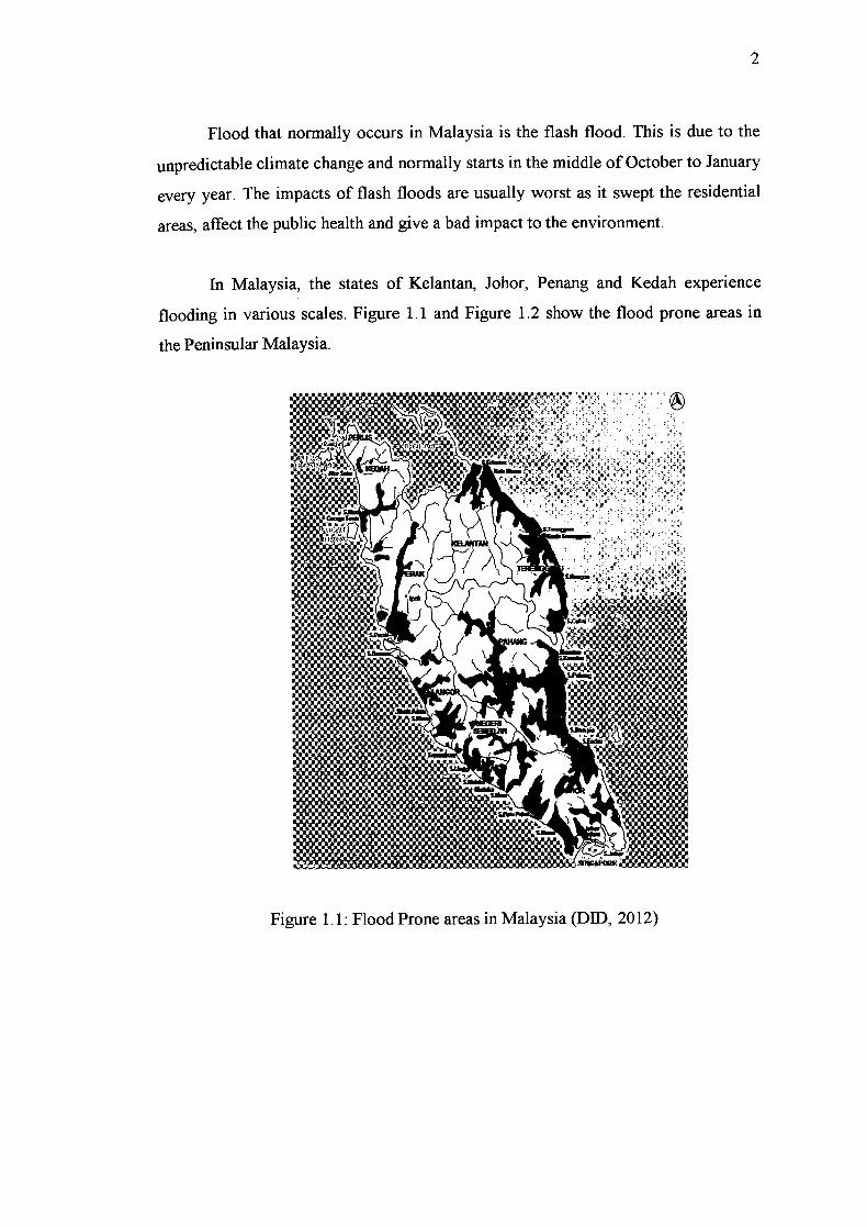
In Malaysia, the states of Kelantan, Johor, Penang and Kedah experience
flooding in various scales. Figure 1.1 and Figure 1.2 show the flood prone areas in
the Peninsular Malaysia.
Figure 1.1: Flood Prone areas in Malaysia (DID, 2012)
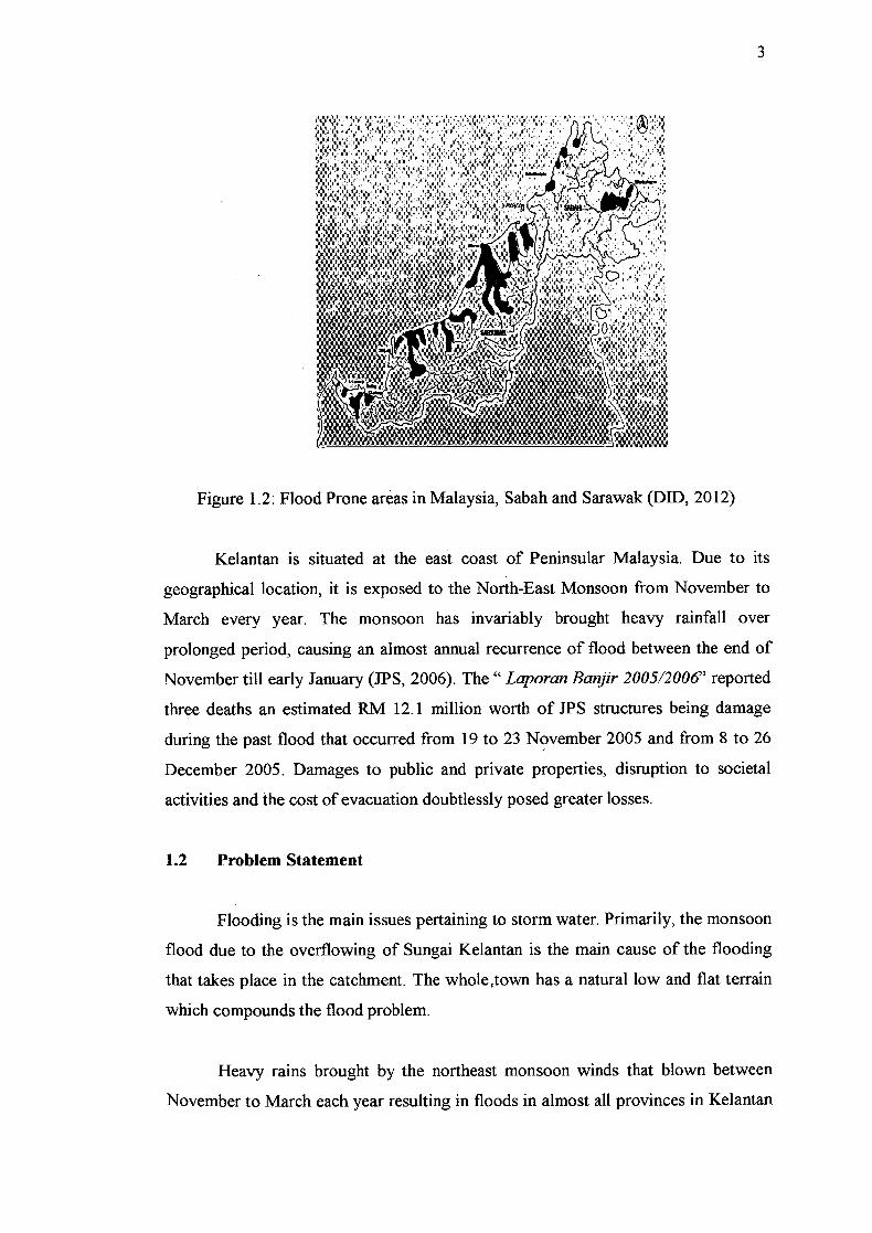
3
Figure 1.2: Flood Prone areas in Malaysia, Sabah and Sarawak (DID, 2012)
Kelantan is situated at the east coast of Peninsular Malaysia. Due to its
geographical location, it is exposed to the North-East Monsoon from November to
March every year. The monsoon has invariably brought heavy rainfall over
prolonged period, causing an almost annual recurrence of flood between the end of
November till early January (JPS, 2006). The " Laporan Banjir 200512006' reported
three deaths an estimated RM 12.1 million worth of JPS structures being damage
during the past flood that occurred from 19 to 23 November 2005 and from 8 to 26
December 2005. Damages to public and private properties, disruption to societal
activities and the cost of evacuation doubtlessly posed greater losses.
1.2 Problem Statement
Flooding is the main issues pertaining to storm water. Primarily, the monsoon
flood due to the overflowing of Sungai Kelantan is the main cause of the flooding
that takes place in the catchment. The whole town has a natural low and flat terrain
which compounds the flood problem.
Heavy rains brought by the northeast monsoon winds that blown between
November to March each year resulting in floods in almost all provinces in Kelantan
4
state. Apart from the heavy of rain, other factors such as changes in the topography
and local drainage make the worsen the situation.
Flood in 2004 was the worst flooding recorded since 1926 and was reported
happened due to heavy rainfall event on 8th to December 12th, 2004. It caused much
damage to property and loss of life. An effective flood forecasting system is needed
to reduce loss of life and damages caused by floods.
In January until Mid-December, 2011, 9 people were killed in flash flooding
in Kelantan. Even some actions and improvement taken in some places in Kelantan,
the flood problem is still unsolved.
1.3 Objectives
The purposed of this study is to investigate and defines the major cause of
flood in Kelantan with aim to solve the flood problems in the above mentioned areas.
In order to achieve this targeted aim, several objectives have been outlined:
1. To identify the worst areas in Kelantan that affected by flash flood
2. To study the flood mitigation project done by authority in order to
inprove the affected areas.
3. To propose action to be taken in order to minimise the risk and impact
of flash flood.
1.4 Scope Study
This study involved areas that experienced severe floods in Kelantan. Data
used in this study are the rainfall data and the flow recorded on 2010/2011.
1. To carry out a literature review and find out the latest development in
this research area.

5
2. To collection all related data and informationfrom JPS and identify
the worst affected area in Kelatan.
3. To prepare a set of questionnaire in order to study the evacuation
process and response from victims.
4. To Propose an idea to improve the existing flood prevention system.
1.5 Significant of Study
From this study, it is hope that the proposed approach or method can
minimize the loss properties and life. Moreover, it is hope that this study will come
out with some values that can give ways and ideas on how to minimize the effect of
flood.
CHAPTER 2
LITERATURE REVIEW
2.1 Flood
Flooding also is a natural and recurring event for a river or stream. Statistically,
streams will equal or exceed the mean annual flood once every 2.33 years (Leopold
et al, 1964). Flooding is a result of heavy or continuous rainfall exceeding the
absorptive capacity of soil and the flow capacity of rivers, streams and coastal areas.
This caused a watercourse to overflow its banks onto adjacent lands. Floodplains are,
in general, those land most subject to recurring floods, situated adjacent to rivers and
streams. Floodplains are therefore "flood prone" and are hazardous to development
activities if the vulnerability of those activities exceeds an acceptable level.
2.2 Flood Definition
Flood can be defined as an excess of water in place that is normal dry. There
are several different types of floods. The most common is where a river over flow its
banks due to a large input of rainfall. Another definition of flood is an overflow
inundation that comes from a river or other body of water and cause or threatens
damage (Varsney, 1974).
Saul (1992) stated that a flood commonly is considered to be unusually high
stage of the river. It is often described as that stage at which the stream channel
becomes filled and above which it over flows its banks. Floods affect many of the
engineering structures such as bridges, embankments, tanks and reservoirs. In order
ON
7
to reduce the effect cause by flooding, proper safe guards must be made for the safe
of the maximum flood expected such as by implementing the structural and non-
structural measures in flood protection and mitigation. To implement the measures
requires the studies on the hydrological characteristics of a river catchment, shape
and size of the catchment, topography, types of soil, channel configuration, stream
flow data and rainfall data are necessary.
The floods happen when the river capacity is not enough to carry the water that
has entered the river network and bank overflow, which is called floodplain. In the
flood also, there are several factors how to determine the size of flooding, rainfall
intensity and duration,, how dry or wet land, topography and many more. Therefore
the flooding is the complex natural phenomenon.
Flooding is the most significant natural hazard in Malaysia in terms of
population affected, frequency, area extent, flood duration and social economic
damage. Having 189 river basins throughout Malaysia, including Sabah and
Sarawak, the rivers and their corridors of floodplains fulfill a variety of function both
for human use and for the natural ecosystem, where they are fundamental parts of the
natural, economic, and social system wherever they occur. However, these rivers
pose a threat of flooding the surrounding areas if unnatural periods of rain occur
(Ministry of Natural Resources and Environment Malaysia, 2007).
Besides of that, flood is the part of the natural cycle or a "Hydrologic Cycle"
where in this cycle, the energy of the sun causes water to evaporate and form clouds
which move inland and become rain. This rain will then runoff either directly
through the river system or is absorbed into the soil to later form groundwater flow.
2.3 Flood Severity Categories
2.3.1 Minor Flooding
8
Causes inconvenience. Low-lying areas next to watercourses are inundated
which may require the removal of stock and equipment. Minor roads may be closed
and low level bridges submerged.
2.3.2 Moderate Flooding
In addition to the above, the evacuation of some houses may be reqiured. The
traffic routes may be covered. The area of inundation is substantial in rural areas
requiring the removal of stock.
2.33 Major Flooding
In addition to the above, extensive rural areas and urban areas are inundated.
Properties and towns are likely to be isolated and major traffic routes likely to be
closed. Evacuation of people from flood affected areas may be required.
2.4 Types of Floods
Floods are categorized and named in several distinct ways. At the geography,
the physical features in the area or the source of the flood water can be:
2.4.1 River Flooding
This is the most common type of flooding. When the actual amount of river
flow is larger than the amount that the channel can hold, river will overflow its banks
and flood the areas alongside the river. And this may cause by reasons like snow
melt or heavy spring rain.
2.4.2 Flooding from the sea or coastal floods
Coastal flood usually occur along coastal areas. When there are hurricanes and
tropical storms which will produce heavy rains, or giant tidal waves created by
volcanoes or earthquakes, ocean water may be driven onto the coastal areas and
cause coastal floods. Heavy storms or other extreme weather conditions combined
with high tides can cause sea levels to rise above normal, force sea water to the land
and cause coastal flooding. Proper flooding defences need to be in place to safeguard
life and property. The Environment Agency constantly monitors sea levels and
releases flood warnings when required.
2.4.3 Urban flooding
In most of the urban area, roads are usually paved. With heavy rain, the large
amount of rain water cannot be absorbed into the ground and leads to urban floods.
2.5 Hydrologic Cycle
The hydrological cycle is a conceptual model that described the storage and the
movement of water. The water of this earth can be stored in reservoirs, such as
oceans, lakes, rivers and so on. Water moves from one reservoir to other reservoir by
process like condensation, evaporation, precipitation, sublimation, deposition, runoff,
transpiration, melting, infiltration and groundwater flow. In the atmosphere, it can be
found that the oceans supply more evaporated water. Of this evaporated water, only
91% can be return to the ocean basins by precipitation way. The remaining 9% is
transported to areas over landmasses where climatological factors induce the
formation of precipitation. The resulting imbalance between rates of evaporation and
precipitation over land and ocean is corrected by runoff and groundwater flow to
oceans. The flows of the hydrologic cycle refer in the Figure 2.1.

')ibn Advebn
f1 (ZIn",^on
suMb T L €'r) Adv&thn
Stw& Mt t Gbds Rutff Evapera1spf8tion
tI I Rn
Lr .i I ation
- Ocean
OmdvdFbw
Sol "Is
_i Pn r' ----
GMWdWrW
Figure 2.1: Flow of the hydrologic cycle
2.6 Flash Flood
Flooding can be divided into different categories according to duration which is
a) Slow-Onset Floods
Usually last for a relatively longer period, it may last for one or ore weeks, or
even months. This kind of flood is last for a long period, it can lead to lose of
stock, damage to agricultural products, roads and rail links.
b) Rapid—Onset Floods
This flood last for a relatively short period, they usually last for one or two
days only. This kind of flood lasts for a shorter period, it can cause more
damages and pose a greater risk to life and property because there are generally
10

11
much less time to take preventative action, and flow of water is faster and more
dangerous.
c) Flash Floods
This flood occurs in relatively short period. It may occur within minutes or a
few hours after heavy rainfall, often from severe thunderstorm. It causes the
greatest damages to society.
A flood caused by heavy or excessive rainfall in a short period of time,
generally in 6 hours. They can occur within minutes or a few hours excessive of
rainfall. They also can occur even if no rain has fallen for instance after a levee or
dam has failed.
2.6.1 Flash Flood Conditions and Losses
The problem of flash flood is one of the greatest difficulties to solve. It is
generally agreed that flash floods have the following characteristics:
1. They occur suddenly, with little lead time for warning
2. They are fast-moving and generally violent, resulting in a high threat to life
and severe damage to property and infrastructure
3. They are generally small in scale with regard to area of impact
4. They are frequently associated with other events, such as riverine floods on
larger streams and mudslides.
5. They are rare (Gruntfest and Handmer,2001)
Several important factors arise as a result of these characteristics. First, area
prone to flash flood need to be prepared. Because such events usually come as

12
surprises, warning and preparation are essential. However, because they are rare the
motivation to invest time and resources info such activities is low. Because flash
floods usually affect relatively small areas, losses resulting from them do not always
generate much long term response, unless there is high loss of life. However losses
per unit (acre, square mile or kilometer) of area affected tend to be high compared to
other events like riverine floodsor hurricanes. Finally, it is sometimes very difficult
to attribute specific losses to flash flood events, particularly when they occur in
combination with other events. Thus, losses may be underestimated in many
instances.
2.6.2 Causes of Flooding
The causes of flooding can be determined by storm, heavy rainfall and failure of a
construction in the water system such as weir. Figure 2.2, 2.3, and Figure 2.4 show
the flood taken place after heavy rainfall.
Figure 2.2: Creeks overtop their banks

13
Figure 2.3 :Drainage system back up because they can not cope with the
volume of water or blocked by rubbish.
S. I
I.
I
.1•
Th 0
Figure 2.4: Sewers overflow because of illegal connections and the sewer
system cannot cope with the increased volumes.

Landformi of M iItuvM river fLooLan with tre(y
A Attuvi.r L • Levees
8'tufis OOxbwLoke
meanders: Y Thioo strer
14
2.7 Floodplain
Floodplains are land areas adjacent to rivers and streams that are subjected to
recurring inundation. Floodplain can defined as a strip of relatively smooth land
bordering a stream and overflowed at a time of high water (Leopold et al, 1964).
Adapter from Strahler, A.N. and Strahier. A.H. Environmental Geoscience:
Interaction between Natural System and Man can be seen in the Figure 2.5.
Figure 2.5: Floodplain
2.7.1 Changing Nature of Floodplains
Floodplains are neither static nor stable. Composed of unconsolidated
sediments, they are rapidly eroded during floods and high flows of water, or they are
may be the site on which new layers of mud s sand, and silt are deposited. As such,
the river may change its course and shift from one side of the floodplain to the other.
Figure 2.6 portrays this dynamic pattern whereby the river channel may change
within the broader floodplain and the floodplain may be periodically modified by
floods as the channel migrates back and forth across it.
15
Floodplain width is a function of the size of the stream, the rates of down
cutting, the channel slope, and the hardness of the channel wall. Floodplains are
uncommon in head water channels because the stream is small, the slopes and rate of
down cutting are high, and the walls are often exposed bedrock.
In moderately small streams the floodplain is commonly found only on the
inside of a bend, but the location of the floodplain alternates from side to side as the
stream bend from one side of the valley to the other.
Larger streams, particularly those with low channel slopes, develop broad
floodplains. As these plains develop, the sideward migration of the river channel
produces oxbow lakes, sloughs, natural levees, and back swamp deposits that are
disconnected from the present channel. If a river carries fairly coarse sediment during
a flood, it tends to be deposited along the channel bank as a natural levee. This may
result in the formation of a perched channel where the channel bottom is continually
raised to a point where it may actually be higher than the surrounding topography.
This condition can result in surface water elevations contained within the channel
being considerably higher than the land surface elevations immediately outside these
levees, which results in a flooding potential that is much worse than that in the
typical situation where the channel is at the bottom of a U-shaped cross section of the
floodplain.
These features change with time. Widening of a river channel and destruction
of part of the floodplain by major floods is common and has been observed in
semiarid regions. As is the case with these regions having a high erosion potential,
the phenomenon of channel migration during flooding events will often cause a large
portion of flood waters to be carried in a channel that did not exist prior to the onset
of the flooding event. This phenomenon occurs all too frequently in arid regions,
where high velocity flood waters make drastic changes in the channel configuration
during the flooding event. This can cause the area of inundation to be considerably
different than in its original state.