a case study of hibernia illustrating the benefits of ais ... · que les données provenant du...
TRANSCRIPT

Defence R&D Canada – Atlantic
DEFENCE DÉFENSE&
A case study of Hibernia illustrating the
benefits of AIS transponders on oilrigs
T.R. Hammond
Technical Memorandum
DRDC Atlantic TM 2004-210
July 2005
Copy No.________
Defence Research andDevelopment Canada
Recherche et développementpour la défense Canada

This page intentionally left blank.

A case study of Hibernia illustrating the benefits of AIS transponders on oilrigs
T.R. Hammond
Defence R&D Canada – Atlantic Technical Memorandum DRDC Atlantic TM 2004-210 July 2005

Abstract
Automatic Identification Systems (AIS) are VHF transponders that continuously transmit detailed information about the vessels on which they are deployed. This information includes the ship’s identity, course, destination, cargo, and position. As of the end of 2004, the use of AIS is mandatory for most international vessel traffic. This paper proposes that an AIS transponder be installed on the Hibernia oilrig, that the AIS data received by it be fused with ship tracks from Hibernia’s radar systems, and that these fused tracks be forwarded to the Marine Security Operations Centre (MSOC) at TRINITY by satellite communications. It also describes the benefits for Hibernia and Canada’s Recognized Maritime Picture, and so makes the case for AIS installations on other offshore platforms. The paper explores two options for ensuring that the track data are forwarded for the foreseeable future: by individual contractual arrangements or by new government regulations requiring the collection of AIS data by oilrigs more generally. The latter would provide permanent, more extensive coverage than individual contractual arrangements could promise.
Résumé
Les systèmes d’identification automatiques (SIA) sont des transpondeurs THF qui émettent continuellement de l’information sur les vaisseaux sur lesquels ils sont déployés. Cette information comprend l’identité, la route, la destination, la cargaison et la position du navire. Depuis la fin de 2004, l’utilisation du SIA est obligatoire pour la majorité des navires effectuant des voyages internationaux. Le présent rapport propose qu’un transpondeur SIA soit installé sur la plate-forme pétrolière de Hibernia, que les données provenant du transpondeur soient fusionnées avec les traces provenant du radar de cette station, et que les traces fusionnées obtenues soient transmises au Centre de Sécurité Opérationnel Maritime (CSOM) à TRINITY par satellite. Il décrit également les bénéfices pour le tableau de la situation maritime (TSM) et pour Hibernia, promouvant ainsi l’installation de SIA dur d’autres plates-formes en mer. Ce rapport explore deux options pour assurer que les données seraient transmises continuellement dans le futur: des contrats d’affaires individuels ou des règlements gouvernementaux qui exigeraient plus généralement la collection de données provenant de SIA sur les plates-formes pétrolières. La deuxième option établirait une couverture plus étendue et plus permanente.
DRDC Atlantic TM 2004-210 i

This page intentionally left blank.
ii DRDC Atlantic TM 2004-210

Executive summary
Introduction
The purpose of this document is to propose that offshore oilrigs collect Automatic Identification System (AIS) and radar ship tracks in support of the recognized maritime picture (RMP). This picture of maritime activity is meant to be comprehensive, at least within regions of prime security interest, but some ocean areas have only intermittent coverage. It is meant to help identify suspicious activity, but there are enough ambiguities and unidentified contacts that no one of these could raise a credible alarm. Thus, the RMP needs to improve to fulfil its growing role in the security environment, and AIS is widely regarded as a leading means to that end. AIS has attracted interest because it broadcasts a ship’s identity, position, course, speed, cargo, destination and more by VHF radio at regular intervals. Much of this information is difficult to obtain from other sensors.
Principal Results
This paper focuses attention on the particular example of Hibernia because this oilrig is considered typical. It was found that the vessel traffic around Hibernia is not currently covered effectively in the RMP. Even during the Atlantic Littoral ISR eXperiment (ALIX), when all data sources were in use, Hibernia’s radar systems were tracking several ships that were not to be found in the RMP. It was determined that the primary barrier to AIS installation at Hibernia is concern about possible disruption to oilrig operations. As a result, free equipment and installation are not likely to be effective inducements. Thus, the Canadian government may need to make legal requirements to install AIS equipment on oilrigs and to transfer the radar and AIS track data to the RMP.
Military Significance
The military benefits of installing AIS on oilrigs include the provision of identified vessel tracks to the RMP, from areas poorly covered at present. These tracks would lead to a marked improvement in the quality of the RMP around the rigs. If an oilrig were to come under terrorist attack, such a local improvement would be particularly useful.
Future plans
DRDC Atlantic is developing a prototype AIS Vessel Monitoring System (AVMS), which consists of multiple remote stations and a management station on shore. A remote station consists of a rugged box containing an AIS receiver and a satellite phone. The phone forwards the AIS data selectively to the management station for incorporation into the RMP. Pending the introduction of the regulatory requirements advocated above, the installation of a remote station on Hibernia would provide further illustration of the benefits of AIS, at little inconvenience to rig operations.
Hammond, T.R. 2005. A case study of Hibernia illustrating the benefits of AIS transponders on oilrigs. DRDC Atlantic TM 2004-210, Defence R&D Canada – Atlantic.
DRDC Atlantic TM 2004-210 iii

Sommaire
Introduction
Le présent rapport propose que les plates-formes pétrolières collectionnent les traces de navires provenant du système d’identification automatique (SIA), ainsi que du radar, pour les introduire dans le tableau canadien de la situation maritime (TSM). Ce tableau est sensé d’être compréhensif, au moins dans les endroits vitaux, mais d’importantes régions ne sont pas couvertes continuellement. Il est sensé d’aider avec l’identification d’activités illégitimes, mais il s’y trouve assez d’ambiguïtés et de contactes non identifiés, que aucun d’entre eux ne puisse éveiller un soupçon crédible. Le TSM a donc besoin d’amélioration pour remplir son rôle de plus en plus important dans l’environnement sécuritaire et le SIA est un outil qui convient bien à cet objectif. Le SIA transmet régulièrement l’identité, la position, la direction, la vitesse, la cargaison et la destination d’un navire (parmi d’autres données) par radio VHF, des informations difficiles d’obtenir par d’autres moyens.
Principaux résultats
Ce document se concentre sur l’exemple particulier de Hibernia parce que cette plate-forme pétrolière est typique. L’étude de ce cas a indiqué que le trafique maritime autour de Hibernia n’est pas couvert dans le TSM. Même pendant la récente expérience RSR sur le littoral Atlantique (ALIX), durant laquelle toutes sources d’information étaient employées, les systèmes radars de Hibernia ont observé plusieurs navires qui ne se trouvaient pas dans le TSM. Il a été constaté que la plus importante barrière empêchant l’installation de SIA à Hibernia est la crainte que les activités d’installation pourraient interrompre les activités de la station. L’équipement et l’installation gratuite ne seraient donc probablement pas convaincantes. Pour cette raison, le gouvernement canadien devrait exiger l’installation d’équipement SIA sur ces plates-formes et la transmission des données du radar ainsi que du SIA au TSM.
Portée des résultats
Les bénéfices militaires de l’installation de SIA sur les plates-formes pétrolières comprendraient la provision de traces identifiées au TSM, des traces qui viennent d’endroits mal couverts dans le TSM à présent. Ces traces fourniraient une amélioration importante de la qualité du TSM autour de la station. En cas d’attentat terroriste, cette amélioration serait bien utile.
Plans futurs
RDDC Atlantique développe présentement un Système de Surveillance Maritime SIA (SSMS) qui comprend plusieurs stations lointaines et un système de gestion à terre. Une station lointaine est composée d’une boite robuste, qui contient un récepteur SIA et un téléphone satellite Iridium. Le système recevrait les transmissions SIA et les enverrait au système de gestion avec ce téléphone, pour incorporation éventuelle dans le TSM. En attendant les règlements gouvernementaux suggérés ci-dessus, l’installation d’une station lointaine à Hibernia pourrait illustrer d’avantage les bénéfices de SIA, sans grande inconvenance pour l’opération de Hibernia.
Hammond. T.R. 2005. Une étude de cas sur Hibernia illustrant les avantages de transpondeurs SIA sur les plates-formes pétrolières. RDDC Atlantique TM 2004-210,R&D pour la défense Canada – Atlantique.iv DRDC Atlantic TM 2004-210

Table of contents
Abstract........................................................................................................................................ i
Executive summary ................................................................................................................... iii
Sommaire................................................................................................................................... iv
Table of contents ........................................................................................................................ v
List of figures ............................................................................................................................ vi
Acknowledgements .................................................................................................................. vii
1. Introduction ................................................................................................................... 1
2. Hibernia’s current sensors ............................................................................................. 5
3. Hardware and software options ..................................................................................... 8
4. Expected benefits......................................................................................................... 10 4.1 For Hibernia ................................................................................................... 10 4.2 For DND......................................................................................................... 10 4.3 For DRDC ...................................................................................................... 11
5. Conclusion................................................................................................................... 14
6. References ................................................................................................................... 15
List of symbols/abbreviations/acronyms/initialisms ................................................................ 16
Distribution list ......................................................................................................................... 17
DRDC Atlantic TM 2004-210 v

List of figures
Figure 1. The Hibernia oilrig is located in the Jeanne d'Arc Basin, 315km east of St John's, Newfoundland, in water 80m deep...................................................................................... 3
Figure 2. The Hibernia oilrig is located near other oil fields: Terra Nova (currently producing), White Rose (in the development phase) and Hebron/Ben Nevis. The map above is reproduced from Petro-Canada’s website (www.terranovaproject.com). ............. 4
Figure 3. This cropped screenshot from Hibernia’s Seascan radar display, courtesy of HMDC, was taken July 13th, 2004 at 12:47 local time. It shows range rings at 6 nm intervals. We see the tanker Kometic passing just on the outside of the 6 nm exclusion zone. The Placentia Pride, a custom-designed tug that also functions as a firefighter, is in close. The Nascopie is a 9600 horsepower ship with a steel-reinforced hull that is used to tow icebergs away from the platform......................................................................................... 6
Figure 4. The image above was taken July 13th, 2004 at 16:03 local time, and shows a portion of a screenshot from the VTMS, with Hibernia at the top left in red. The green marks indicate the subsurface buoys on the end of the offshore loading system, where tankers would fill up with oil. The Vinland (on the end of the range bearing line) is being tracked by the VTMS at a range of 18.5 nm, as indicated in a window that is not shown in this cropped portion. The range ring that is shown is the 6 nm exclusion zone. Kometic and Vinland are two of the three 127 000 dead-weight ton tankers that HMDC uses to transfer oil to Placentia Bay in Newfoundland................................................................................. 7
Figure 5. (a) Receive-only unit (b) Mobile AIS transponder (c) Base-station transponder. A mobile AIS transponder need not move around, nor need a base-station be immobile. ..... 8
Figure 6. Top (a) and side (b) views of an AVMS remote station. The top view shows the VHF antenna mount and the white, combined Iridium/GPS antenna, while the side view shows the key driven power switch and the connector for the electrical power. This connector also functions as an Ethernet or serial port. A cable integrating these three functions would be supplied with the unit........................................................................... 9
Figure 7. The chart on the left was taken from Raytheon’s website, on which they were promoting the daytime coverage of the two HFSWR installations in Newfoundland, one of which is depicted in the photo on the right. Hibernia is located in the overlap of these coverage fans..................................................................................................................... 11
Figure 8. This screenshot section was taken August 28th, 2004 at 22:45 Zulu time from the VTMS. It shows Hibernia in the centre of the circle. None of the ships in this picture was to be found in the RMP at the time. Sister ships Norseman and Nascopie are iceberg tugs. The Kingfisher is not associated with Hibernia....................................................... 12
vi DRDC Atlantic TM 2004-210

Acknowledgements
Joe Arsenault of the Hibernia Management Development Company provided invaluable assistance in the preparation of this paper. I am also grateful for comments from Pete Smith and Neil Carson of the operations research community at TRINITY.
DRDC Atlantic TM 2004-210 vii

This page intentionally left blank.
viii DRDC Atlantic TM 2004-210

1. Introduction The Canadian Navy’s Recognized Maritime Picture (RMP) is a depiction of maritime activity. It is intended to support commanders at sea, other branches of the Canadian Forces (CF), allies and other government departments by communicating the current situation to them [1]. Commanders are expected to use the RMP to develop a surveillance and reconnaissance plan for their mission [2]. And the RMP is also to play a role in wide area surveillance. This last role requires that the RMP be useful in identifying vessels engaged in suspicious activity, a capability it has yet to support effectively [1]. The primary motivation behind the proposal in this paper is pushing the RMP along the path to effective wide area surveillance. To be effective at identifying suspicious activity, the RMP would have to identify and track the vast majority of vessels. Only then could an unidentified vessel engaged in illicit activities be discriminated from the many law-abiding ships pursuing their legitimate business. Unfortunately, the current picture contains far too many unidentified contacts that are uncorrelated with any known vessel track for any of them to arouse suspicion. Operators are too burdened with demands on their time to process these contacts effectively. Moreover, Canada’s vast territorial waters contain great areas that are not covered effectively by any of the 22 sensors contributing to the maritime picture [1]. For these reasons, improvements to the RMP should focus on reducing these key difficulties. Several of the operators building the RMP pin some of their best hopes for improvements to that picture on the Automatic Identification System (AIS) [1, 3]. A good portion of the Department of National Defence’s (DND’s) interest in AIS stems from the fact that many ships are required to carry AIS transponders. The International Maritime Organization (IMO) requires that all ships (except military and fishing vessels) of greater than 300 gross tons that make international voyages carry AIS transponders and keep them in continuous operation [4]. Transport Canada proposed similar regulations for Canadian waters in March of 2004, but these regulations have not yet come into force. US requirements are already in place, however, and these have created a strong incentive to carry AIS systems. Several European nations have also enacted AIS requirements. When a ship is underway, AIS transmits its position, course and speed by VHF radio every few seconds and receives such transmissions from other vessels [5]. It enables ships to track each other with great accuracy within VHF range and so is expected to reduce collision risks. The system also allows base-stations on shore to receive AIS data in a form that is readily integrated into any information system [6]. Every six minutes (or in response to an interrogation signal), AIS transmissions also report the name, MMSI number (a unique identifier), type, destination and estimated time of arrival (ETA) of the vessel, as well as its cargo and crew complement, most of which are impossible to obtain automatically with conventional traffic-monitoring sensors. Thus AIS adds useful detail to the RMP. The RMP already contains AIS data from a number of sources. Among unclassified sources, the AIS data recorded during provincial airlines (PAL) flights are currently the most important. By 2010, however, the Canadian Coast Guard (CCG) is expected to have completed its AIS project, which is intended to enhance marine security and improve the
DRDC Atlantic TM 2004-210 1

safety of navigation. This project involves the installation of up to 80 coastal AIS base stations at sites that have been ordered by priority in consultation with DND and Marine Communications and Vessel Traffic Services (MCTS). Thus many of the sites are intended to address maritime security issues highlighted by DND. On the west coast, these sites will cover Queen Charlotte Sound, Dixon Entrance and the Juan da Fuca Strait. On the east coast, they will monitor the Strait of Belle Isle, Cabot Strait, the Gulf of St. Lawrence and the entrance to the St. Lawrence Seaway. Thus, by 2010 the coast guard will become a major source of AIS data in the RMP, but most of these data will come from ships within 50 nautical miles of the shore because of the range limitations of VHF radio. In an effort to extend AIS coverage further offshore, DND considered asking that the Canadian Coast Guard include AIS installations on three offshore platforms in the AIS project. These platforms were Hibernia, Terra Nova and the Sable Island Offshore Energy Project. It was decided within DND, however, that the money was better spent on additional coastal sites, so this proposal is no longer being considered. Nor do there seem to be other plans to place AIS transponders on any offshore platforms.
The purpose of this document is to propose that offshore oilrigs provide valuable platforms from which to collect vessel traffic information off the Canadian coast. The installation of AIS transponders [3] on the rigs would provide an efficient means of collecting such information, improving safety and security. Communications satellites could relay the AIS track data to a Marine Security Operations Center (MSOC) on shore in near real-time, so that the tracks can improve the RMP. To illustrate these benefits, this paper provides a case study of the Hibernia oilrig (www.hibernia.ca, Figure 1), which is maintained by the Hibernia Management Development Company (HMDC). It documents the benefits that an AIS installation on Hibernia would provide. These benefits suggest that the government of Canada should take steps to obtain similar benefits from all of Canada’s oil and petroleum drilling rigs.
2 DRDC Atlantic TM 2004-210

Figure 1. The Hibernia oilrig is located in the Jeanne d'Arc Basin, 315km east of St John's, Newfoundland, in water 80m deep.
This paper explores hardware and administrative options for an AIS installation at Hibernia. For the most part, these options generalize readily to other oilrigs or petroleum installations, like the Sable Offshore Energy Project (www.soep.com). In some cases, however, Hibernia’s particular situation provides unique advantages, such as its position in range of the High Frequency Surface Wave Radar (HFSWR) installations in Newfoundland. Hibernia is also situated near a number of other offshore developments in the Jeanne-d’Arc Basin, including Terra Nova (Figure 2). In the future, these rigs may share their maritime surveillance data with one another to form a common operating picture covering a fairly broad area of the ocean, but this paper will concern itself merely with the benefits of data from around a single rig. Even these restricted benefits are significant enough to warrant maritime security interest.
DRDC Atlantic TM 2004-210 3

Figure 2. The Hibernia oilrig is located near other oil fields: Terra Nova (currently producing), White Rose (in the development phase) and Hebron/Ben Nevis. The map above is reproduced from Petro-Canada’s website (www.terranovaproject.com).
4 DRDC Atlantic TM 2004-210

2. Hibernia’s current sensors Currently, the Hibernia oilrig has 3 S-band Sigma radar systems, which are linked by a Vessel Traffic Monitoring System (VTMS) to provide a single picture of the traffic around the rig. It also has a relatively new Seascan radar system for iceberg detection. The VTMS was installed by a Norwegian company called Norcontrol-IT and includes a primary display and a maintenance backup. The VTMS does not currently provide for the export of data (other than by screenshot capture), so this capability would have to be custom built in order to share data with DND. Hibernia does not have an AIS system now, but the supply ships servicing the rig do have AIS transponders. Hibernia currently has a data link to connect voice and data back to Newfoundland via satellite. Figure 3 shows a section of the display from the Seascan radar. It demonstrates that operators can display ship names on their screen. To do so, they have to call up the vessel by VHF radio, communicate with the officer of the watch on the ship and then type in the name. Such identification is not done routinely, as indicated by the unidentified contacts at the lower right. Figure 4 provides a similar shot from the VTMS.
DRDC Atlantic TM 2004-210 5

Figure 3. This cropped screenshot from Hibernia’s Seascan radar display, courtesy of HMDC, was taken July 13th, 2004 at 12:47 local time. It shows range rings at 6 nm intervals. We see the tanker Kometic passing just on the outside of the 6 nm exclusion zone. The Placentia Pride, a custom-designed tug that also functions as a firefighter, is in close. The Nascopie is a 9600 horsepower ship with a steel-reinforced hull that is used to tow icebergs away from the platform
6 DRDC Atlantic TM 2004-210

Figure 4. The image above was taken July 13th, 2004 at 16:03 local time, and shows a portion of a screenshot from the VTMS, with Hibernia at the top left in red. The green marks indicate the subsurface buoys on the end of the offshore loading system, where tankers would fill up with oil. The Vinland (on the end of the range bearing line) is being tracked by the VTMS at a range of 18.5 nm, as indicated in a window that is not shown in this cropped portion. The range ring that is shown is the 6 nm exclusion zone. Kometic and Vinland are two of the three 127 000 dead-weight ton tankers that HMDC uses to transfer oil to Placentia Bay in Newfoundland.
DRDC Atlantic TM 2004-210 7
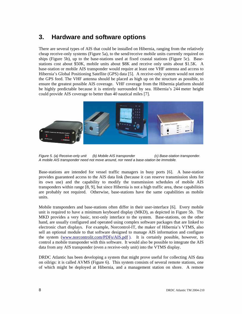
3. Hardware and software options There are several types of AIS that could be installed on Hibernia, ranging from the relatively cheap receive-only systems (Figure 5a), to the send/receive mobile units currently required on ships (Figure 5b), up to the base-stations used at fixed coastal stations (Figure 5c). Base-stations cost about $50K, mobile units about $8K and receive only units about $1.5K. A base-station or mobile AIS transponder would require at least one VHF antenna and access to Hibernia’s Global Positioning Satellite (GPS) data [5]. A receive-only system would not need the GPS feed. The VHF antenna should be placed as high up on the structure as possible, to ensure the greatest possible AIS coverage. VHF coverage from the Hibernia platform should be highly predictable because it is entirely surrounded by sea. Hibernia’s 244 meter height could provide AIS coverage to better than 40 nautical miles [7].
Figure 5. (a) Receive-only unit (b) Mobile AIS transponder (c) Base-station transponder. A mobile AIS transponder need not move around, nor need a base-station be immobile.
Base-stations are intended for vessel traffic managers in busy ports [6]. A base-station provides guaranteed access to the AIS data link (because it can reserve transmission slots for its own use) and the capability to modify the transmission schedules of mobile AIS transponders within range [8, 9], but since Hibernia is not a high traffic area, these capabilities are probably not required. Otherwise, base-stations have the same capabilities as mobile units. Mobile transponders and base-stations often differ in their user-interface [6]. Every mobile unit is required to have a minimum keyboard display (MKD), as depicted in Figure 5b. The MKD provides a very basic, text-only interface to the system. Base-stations, on the other hand, are usually configured and operated using complex software packages that are linked to electronic chart displays. For example, Norcontrol-IT, the maker of Hibernia’s VTMS, also sell an optional module to that software designed to manage AIS information and configure the system (www.norcontrolit.com/PDFs/AIS.pdf ). It is certainly possible, however, to control a mobile transponder with this software. It would also be possible to integrate the AIS data from any AIS transponder (even a receive-only unit) into the VTMS display. DRDC Atlantic has been developing a system that might prove useful for collecting AIS data on oilrigs: it is called AVMS (Figure 6). This system consists of several remote stations, one of which might be deployed at Hibernia, and a management station on shore. A remote
8 DRDC Atlantic TM 2004-210

station is a rugged, portable box containing an AIS receiver and a satellite phone. The box is easy to deploy on any ship of opportunity (requiring only a source of electrical power), whereupon it will collect AIS transmissions. The phone then forwards this AIS data selectively to the management station on shore, for incorporation into the RMP.
Figure 6. Top (a) and side (b) views of an AVMS remote station. The top view shows the VHF antenna mount and the white, combined Iridium/GPS antenna, while the side view shows the key driven power switch and the connector for the electrical power. This connector also functions as an Ethernet or serial port. A cable integrating these three functions would be supplied with the unit.
AVMS might prove an attractive option for an initial deployment on Hibernia because installation is simple, not disruptive and does not require any modification of the oilrig’s existing security systems. Nor would it require the station to use any of its existing satellite bandwidth. The remote station would allow the oilrig to benefit from the AIS data it receives because it provides access to these data through an Ethernet port, configurable through a web browser interface. The main disadvantage of this approach is that it would not give DND access to any of the station’s radar data. For that reason this system is attractive more as a proof of concept than as a long-term solution.
DRDC Atlantic TM 2004-210 9

4. Expected benefits
4.1 For Hibernia The installation of a mobile AIS transponder (or a base station) would benefit the safety and security of Hibernia personnel in several ways: 1) Enhanced collision avoidance. 2) Enhanced situation awareness. 3) Larger coverage area 4) Automated vessel identification on VTMS screen 5) Safety related messages, like automatic alerting to the exclusion zone around Hibernia. 6) Addressed messaging. 7) More rapid response from Canadian Forces to a terrorist incident Benefits 1, 5, and 6, would call for a mobile transponder rather than a receiver or AVMS remote station. To obtain these benefits, however, HMDC would have to decide whether the installation of the AIS antenna could be done without disrupting station operations, whether the station’s data could be forwarded to outside parties without consuming too much bandwidth or compromising the operation of critical security systems, and whether the benefits provided outweigh the costs. Because of these costs, it has proved difficult to motivate HMDC, even with financial incentives. Indeed, DRDC’s verbal offer to pay for AIS equipment, and to contribute towards maintenance costs and communications fees, has not tempted HMDC to agree, even in principle.
4.2 For DND DND’s ability to provide maritime security would benefit directly from an AIS installation on Hibernia because it would obtain unique, high-quality identified vessel tracks for incorporation into the RMP. But improving the RMP, which is constructed in a program called Global Command and Control System (Maritime) (GCCS(M)), is not merely a matter of putting more data into it. It is also important to keep track of whether the information being provided is really new, or whether it pertains to existing tracks. Currently, it is difficult for GCCS operators to fuse new unidentified tracks with those already in GCCS(M). Manual procedures for fusion in GCCS(M) are in development, but they are cumbersome and require many judgments, consuming scarce operator time. Automatic fusion techniques are also under development, but few are trusted with unidentified contacts. By contrast, identified tracks are merged automatically with any matching identified ones in GCCS(M). For these reasons, those hoping to improve the RMP should ensure that new data comes in the form of identified tracks, whenever possible. While AIS contributes identified tracks and thus is valuable to maritime domain awareness on its own, the full potential of this source is realized only in combination with other sensors [4].
10 DRDC Atlantic TM 2004-210

The combination of AIS and radar data, for example, can be expected to enhance both sources. On the one hand, AIS can identify the ships in the radar image. On the other, radar can detect ships that turn off or spoof their AIS transmissions. For this reason, DND should seek to obtain both sources from offshore oilrigs, whenever possible.
4.3 For DRDC High Frequency Surface Wave Radar (HFSWR) is another sensor that could be combined with AIS. This technology was pioneered by DRDC Ottawa, and has garnered an important role in Canada’s marine surveillance strategy, with the expected construction of numerous additional sites on both coasts. Collecting AIS data around Hibernia is a cost-effective means of getting ground-truth data in support of HFSWR studies [4] because, as shown in the illustration below, the coverage areas (as reported by Raytheon) from existing HFSWR sites (Figure 7) overlap conveniently there.
Figure 7. The chart on the left was taken from Raytheon’s website, on which they were promoting the daytime coverage of the two HFSWR installations in Newfoundland, one of which is depicted in the photo on the right. Hibernia is located in the overlap of these coverage fans.
The overlap between potential AIS coverage from Hibernia and the existing HFSWR coverage fans creates the opportunity to greatly improve HFSWR tracks. Any vessel that came within VHF radio range of Hibernia’s AIS transponder would provide its name, destination, cargo and estimated time of arrival, among other useful information, all of which are impossible to obtain from HFSWR. This information could be preserved when the ship
DRDC Atlantic TM 2004-210 11
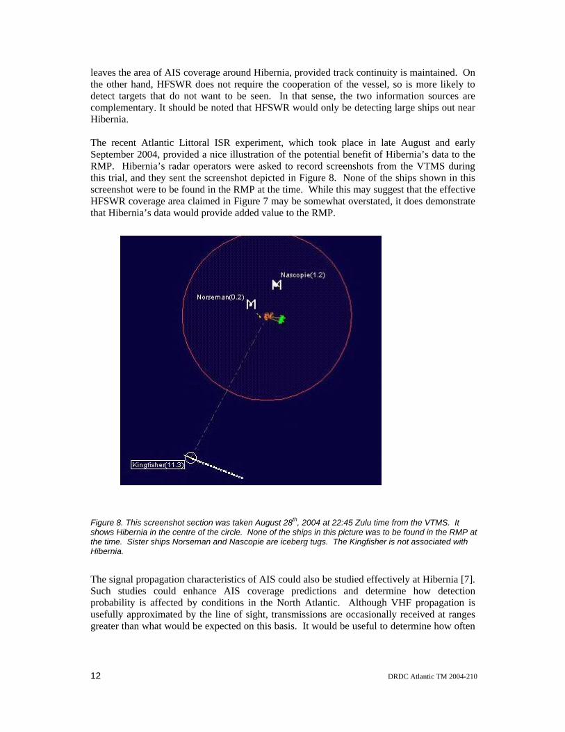
leaves the area of AIS coverage around Hibernia, provided track continuity is maintained. On the other hand, HFSWR does not require the cooperation of the vessel, so is more likely to detect targets that do not want to be seen. In that sense, the two information sources are complementary. It should be noted that HFSWR would only be detecting large ships out near Hibernia. The recent Atlantic Littoral ISR experiment, which took place in late August and early September 2004, provided a nice illustration of the potential benefit of Hibernia’s data to the RMP. Hibernia’s radar operators were asked to record screenshots from the VTMS during this trial, and they sent the screenshot depicted in Figure 8. None of the ships shown in this screenshot were to be found in the RMP at the time. While this may suggest that the effective HFSWR coverage area claimed in Figure 7 may be somewhat overstated, it does demonstrate that Hibernia’s data would provide added value to the RMP.
Figure 8. This screenshot section was taken August 28th, 2004 at 22:45 Zulu time from the VTMS. It shows Hibernia in the centre of the circle. None of the ships in this picture was to be found in the RMP at the time. Sister ships Norseman and Nascopie are iceberg tugs. The Kingfisher is not associated with Hibernia.
The signal propagation characteristics of AIS could also be studied effectively at Hibernia [7]. Such studies could enhance AIS coverage predictions and determine how detection probability is affected by conditions in the North Atlantic. Although VHF propagation is usefully approximated by the line of sight, transmissions are occasionally received at ranges greater than what would be expected on this basis. It would be useful to determine how often
12 DRDC Atlantic TM 2004-210

this happens with AIS messages. By following AIS tracks to record the range at which they drop out of view, one would obtain a clear indication of the maximum effective range of the system. This range could also be compared to the range at which tracks first appear. The range to last report should be greater, on average, than the range to first reception because of the way that AIS assigns transmission slots [4]. A recent DRDC contract report on AIS [7], by MacDonald Dettwiler and Associates, recommended research into partially corrupted AIS messages, which are now routinely discarded by AIS transponders. It was felt that these might yet be useful for surveillance purposes. The installation of AIS on Hibernia could support all these research questions.
DRDC Atlantic TM 2004-210 13

5. Conclusion Although attention was confined in this paper to the specific example of Hibernia, it is clear that the benefits of installing AIS on an oilrig generalize readily to other sites. The military benefits include the provision of high-quality, identified vessel tracks, in areas that are poorly covered at present, if they are covered at all. AIS provides information like cargo and destination that is hard to obtain with conventional sensors. These benefits are likely to lead to a marked improvement in the quality of the RMP around the rig itself. Such a local improvement would prove particularly valuable, if terrorists were to attack an oilrig. And the benefits extend not only to military surveillance, but also to the safety of the oilrig itself. AIS information could improve the vessel tracks provided by other sensors like HFSWR, most significantly by labeling them with the name of the vessel. Should a HFSWR track enter the range of AIS coverage around an oilrig, for example, it may acquire AIS labels that can then follow for the track’s full duration, provided that AIS and HFSWR data are fused together routinely in the RMP. All the maritime surveillance benefits of an AIS installation on Hibernia could be provided by a receive-only system. But a receive-only system would not provide collision avoidance benefits, nor would it allow HMDC to send addressed or safety-related messages the way a mobile AIS transponder or base station would. Since oilrigs are not generally in high-traffic areas, the additional expense of an AIS base station, which provides guaranteed access to the AIS data link, is not justified. Thus, a mobile station would provide the best all around value in the long term. This conclusion would also apply to Canada’s other offshore platforms. Determining the best option for the short term involves consideration of non-technical issues. Discussions with HMDC revealed that financial inducements to install AIS, in the form of free equipment and installation, were not persuasive, in large part because of the risk of disruption to oilrig operations. Therefore, DRDC’s AVMS system might prove an effective short-term solution for Hibernia, pending the introduction of the government regulations proposed here, because it would not disrupt station operations nor require modification to existing security systems. It would not provide the station’s radar data, however, and thus should not represent the long-term solution. DRDC plans to offer HMDC the use of a prototype AVMS remote station for Hibernia in the fall of 2005. In summary, a mobile AIS transponder should be installed on the Hibernia oil platform, for its safety benefits, for its information to be included in the RMP and for research purposes. This installation would provide ground-truth data for the evaluation of High Frequency Surface Wave Radar (HFSWR), ship identity information with which to label Hibernia’s radar tracks and data for evaluating AIS transmission range under the environmental conditions of the North Atlantic. To obtain these benefits, the government of Canada should make regulations or pass laws requiring such an installation on all oilrigs.
14 DRDC Atlantic TM 2004-210

6. References
1. Davenport, M., Rafuse, J. and Widdis, E. RMP Baseline Update Study Volume 1: Main Report”, DRDC Atlantic TR 2004-293.
2. National Defence Canada, The Canadian Navy’s Operational Intelligence Surveillance and Reconnaissance (ISR) Blueprint to 2010. Ottawa, 2000.
3. ITU-R M.1371-1. Technical characteristics for a universal shipborne automatic identification system using time division multiple access in the VHF maritime mobile band. 2001. http://ecs.itu.ch/cgi-bin/dms-ebookshop
4. Hammond, T.R. and Kessel, R.T. The implications of the universal shipborne Automatic Identification System (AIS) for maritime intelligence, surveillance and reconnaissance. DRDC Atlantic TM 2003-143.
5. IALA Guidelines on the Universal Automatic Identification System (AIS). Volume 1, Part I – Operational Issues, Edition 1.1 2002. http://www.iala-aism.org/web/pages/publications/docpdf/ais/AISGDLoi.PDF
6. IALA Guidelines on AIS as a VTS tool. 2001. http://www.iala-aism.org/web/pages/publications/docpdf/ais/GUIDEL24.PDF
7. Somers, C and Chaulk, N. Extending Automatic Identification System (AIS) Coverage to the Middle Zone. DRDC Atlantic CR 2004-067.
8. IALA Guidelines on the Universal Automatic Identification System (AIS). Volume 1, Part II – Technical Issues, Edition 1.1 2002. http://www.iala-aism.org/web/pages/publications/docpdf/ais/AISGDLti.PDF
9. IALA Technical Clarifications on Recommendation ITU-R M.1371-1. 2002. http://www.iala-aism.org/web/pages/publications/docpdf/ais/ITU.pdf
DRDC Atlantic TM 2004-210 15

List of symbols/abbreviations/acronyms/initialisms
AIS Automatic Identification System
ALIX Atlantic Littoral ISR Experiment
DND Department of National Defence
DRDC Defence R&D Canada
ETA Estimated time of arrival
GCCS(M) Global Command and Control System (Maritime)
GPS Global Positioning Satellite
HFSWR High Frequency Surface Wave Radar
HMDC Hibernia Management Development Company
ISR Intelligence Surveillance and Reconnaissance
MKD Minimum keyboard display
MSOC Maritime Security Operations Centre
MMSI Maritime Mobile Security Identifier
RMP Recognized maritime picture
VHF Very High Frequency
VTMS Vessel Traffic Management System
16 DRDC Atlantic TM 2004-210

Distribution list LIST PART 1: 2 DRDC ATLANTIC LIBRARY FILE COPIES 4 DRDC ATLANTIC LIBRARY (SPARES) 1 Tim Hammond 1 Ron Kessel 1 David Chapman 1 Richard Cross 1 Bill Campbell 1 Liesa Lapinski 1 H/MICS 1 LCdr MacLennan 14 TOTAL LIST PART 1 LIST PART 2: DISTRIBUTED BY DRDKIM 3 1 NDHQ/ ADMS&T/ DRDKIM 3 National Defence Headquarters 305 Rideau Street Ottawa, ON K1A 0K2 1 MARLANT N02OR P.O, Box 99000 Stn Forces Halifax, NS B3K 2X0 1 CO HMCS TRINITY P.O, Box 99000 Stn Forces Halifax, NS B3K 5X5 1 CO HMCS ATHENA P.O, Box 17000 Stn Forces Victoria, BC V9A 7N2 1 C. Helleur DRDC Ottawa 3701 Carling Avenue Ottawa, ON
DRDC Atlantic TM 2004-210 17

K1A 0Z4 1 DRDC CORA/CORT 101 Colonel By Drive Ottawa, ON K1A 0K2 1 Miriam Van Roosmalen Canadian Coast Guard 200 Kent Street Ottawa, ON K1A OE6 1 Sam Ryan Canadian Coast Guard 200 Kent Street
Ottawa, ON K1A OE6
1 Martial Richard Canadian Coast Guard
Electronic and Informatics Systems PO Box 1000
Dartmouth, NS B2Y 3Z8 9 TOTAL LIST PART 2 23 TOTAL COPIES REQUIRED
18 DRDC Atlantic TM 2004-210
UNCLASSIFIED
DOCUMENT CONTROL DATA(Security classification of the title, body of abstract and indexing annotation must be entered when the overall document is classified)
1. ORIGINATOR (The name and address of the organization preparing the document, Organizationsfor whom the document was prepared, e.g. Centre sponsoring a contractor's report, or tasking agency,are entered in section 8.)
Publishing: DRDC Atlantic
Performing: DRDC Atlantic
Monitoring:
Contracting:
2. SECURITY CLASSIFICATION(Overall security classification of the documentincluding special warning terms if applicable.)
UNCLASSIFIED
3. TITLE (The complete document title as indicated on the title page. Its classification is indicated by the appropriate abbreviation (S, C, R, or U) in parenthesis atthe end of the title)
A case study of Hibernia illustrating the benefits of AIS transponders on oilrigs (U)Une étude de cas sur Hibernia illustrant les avantages de transpondeurs SIA sur lesplates−formes pétrolières
4. AUTHORS (First name, middle initial and last name. If military, show rank, e.g. Maj. John E. Doe.)
T.R. Hammond
5. DATE OF PUBLICATION(Month and year of publication of document.)
July 2005
6a NO. OF PAGES(Total containing information, includingAnnexes, Appendices, etc.)
24
6b. NO. OF REFS(Total cited in document.)
7. DESCRIPTIVE NOTES (The category of the document, e.g. technical report, technical note or memorandum. If appropriate, enter the type of report, e.g.interim, progress, summary, annual or final. Give the inclusive dates when a specific reporting period is covered.)
Technical Memorandum This document advocates the drafting of regulations that wouldrequire the instllation of AIS transponders on oilrigs.
8. SPONSORING ACTIVITY (The names of the department project office or laboratory sponsoring the research and development − include address.)
Sponsoring:
Tasking: DRDC Atlantic
9a. PROJECT OR GRANT NO. (If appropriate, the applicableresearch and development project or grant under which the document waswritten. Please specify whether project or grant.)
11hd
9b. CONTRACT NO. (If appropriate, the applicable number under whichthe document was written.)
10a. ORIGINATOR'S DOCUMENT NUMBER (The officialdocument number by which the document is identified by the originatingactivity. This number must be unique to this document)
DRDC Atlantic TM 2004−210
10b. OTHER DOCUMENT NO(s). (Any other numbers under whichmay be assigned this document either by the originator or by thesponsor.)
11. DOCUMENT AVAILABILIY (Any limitations on the dissemination of the document, other than those imposed by security classification.)
Unlimited distribution
12. DOCUMENT ANNOUNCEMENT (Any limitation to the bibliographic announcement of this document. This will normally correspond to the DocumentAvailability (11), However, when further distribution (beyond the audience specified in (11) is possible, a wider announcement audience may be selected.))
Unlimited announcement
UNCLASSIFIED

UNCLASSIFIED
DOCUMENT CONTROL DATA(Security classification of the title, body of abstract and indexing annotation must be entered when the overall document is classified)
13. ABSTRACT (A brief and factual summary of the document. It may also appear elsewhere in the body of the document itself. It is highly desirable that the abstract ofclassified documents be unclassified. Each paragraph of the abstract shall begin with an indication of the security classification of the information in the paragraph(unless the document itself is unclassified) represented as (S), (C), (R), or (U). It is not necessary to include here abstracts in both official languages unless the text isbilingual.)
(U) Automatic Identification Systems (AIS) are VHF transponders that continuously transmit detailed informationabout the vessels on which they are deployed. This information includes the ship’s identity, course, destination,cargo, and position. As of the end of 2004, the use of AIS is mandatory for most international vessel traffic. Thispaper proposes that an AIS transponder be installed on the Hibernia oilrig, that the AIS data received by it befused with ship tracks from Hibernia’s radar systems, and that these fused tracks be forwarded to the MarineSecurity Operations Centre (MSOC) at TRINITY by satellite communications. It also describes the benefits forHibernia and Canada’s Recognized Maritime Picture, and so makes the case for AIS installations on otheroffshore platforms. The paper explores two options for ensuring that the track data are forwarded for theforeseeable future: by individual contractual arrangements or by new government regulations requiring thecollection of AIS data by oilrigs more generally. The latter would provide permanent, more extensive coveragethan individual contractual arrangements could promise.
(U) Les systèmes d’identification automatiques (SIA) sont des transpondeurs VHF qui émettent continuellement del’information sur les vaisseaux sur lesquels ils sont déployés. Cette information comprend l’identité, la route, ladestination, la cargaison et la position du navire. Depuis la fin de 2004, l’utilisation du SIA est obligatoire pourla majorité des navires effectuant des voyages internationaux. Le présent rapport propose qu’un transpondeurSIA soit installé sur la plate−forme pétrolière de Hibernia, que les données provenant du transpondeur soientfusionnées avec les traces provenant du radar de cette station, et que les traces fusionnées obtenues soienttransmises au Centre de Sécurité Opérationnel Maritime (CSOM) à TRINITY par satellite. Il décrit égalementles bénéfices pour le tableau de la situation maritime (TSM) et pour Hibernia, promouvant ainsi l’installation deSIA dur d’autres plates−formes en mer. Ce rapport explore deux options pour assurer que les données seraienttransmises continuellement dans le futur: des contrats d’affaires individuels ou des règlementsgouvernementaux qui exigeraient plus généralement la collection de données provenant de SIA sur lesplates−formes pétrolières. La deuxième option établirait une couverture plus étendue et plus permanente.
14. KEYWORDS, DESCRIPTORS or IDENTIFIERS (Technically meaningful terms or short phrases that characterize a document and could be helpful in cataloguing thedocument. They should be selected so that no security classification is required. Identifiers, such as equipment model designation, trade name, military project codename, geographic location may also be included. If possible keywords should be selected from a published thesaurus, e.g. Thesaurus of Engineering and ScientificTerms (TEST) and that thesaurus identified. If it is not possible to select indexing terms which are Unclassified, the classification of each should be indicated as withthe title.)
(U) AIS; oilrig; AVMS
UNCLASSIFIED

This page intentionally left blank.
