a canoeist and kayaker’s guide - pesda press
TRANSCRIPT

a canoeist and kayaker’s guide
Eddie Palmer Adam Robson & Nigel Wilford
Welsh Canoe Classics

River Conwy
Llyn Celyn
Bala Lake
River Dee
River Severn
River Dyfi
River Wye/Afon Gwy
River Teifi
River Tywi
River Usk
River Taff
River Wye
RiverVyrnwy
Haverfordwest
Conwy
Porthmadog
Bangor
Caernarfon
Holyhead
Betws-y-CoedRuthin
Tywyn Machynlleth
Dolgellau
Welshpool
Llangollen
Oswestry
Bala
Wrexham
Chester
LIVERPOOL
Hereford
Shrewsbury
Newtown
Llangurig
Builth Wells
Rhayader
Llandrindod Wells
Abergavenny/ Y Fenni
MonmouthMerthyr Tydfil
Brecon
ChepstowCwmbran
Newport
CARDIFF
BRISTOL
Cardigan
Port Talbot
Llandovery
Llandeilo
NeathLlanelli
Carmarthen
Swansea
Fishguard
TenbyPembroke
Dock
MilfordHaven
Haverfordwest
Aberystwyth
ENG
LAN
D
WESTCOAST
NORTH WEST
NORTHEAST
WESTCOAST
EAST
SOUTH WEST
SOUTH
21
34
5
6 7
8
9
10
11
1213
14
15
16
18
17
19
20
21
22
23
24
25

a canoeist and kayaker’s guide
Eddie Palmer, Adam Robson & Nigel Wilford
Welsh Canoe Classics

First published in Great Britain 2016 by Pesda Press
Tan y Coed Canol
Ceunant
Caernarfon
Gwynedd
LL55 4RN
© Copyright 2016 Eddie Palmer, Adam Robson & Nigel Wilford
ISBN: 978-1-906095-55-0
The Authors assert the moral right to be identified as the authors of this work.
All rights reserved. No part of this publication may be reproduced, stored in a retrieval
system or transmitted, in any form or by any means, electronic, mechanical, photocopying,
recording or otherwise, without the prior written permission of the Publisher.
Maps – Bute Cartographic
Contains Ordnance Survey Data © Crown copyright and database right 2016
Printed in Poland, www.lfbookservices.co.uk

3 d
edic
atio
n
DedicationThis book is dedicated to Wilf ’s father, Trevor David Wilford, who died of pancreatic cancer 14 October 2016, aged 71.For information on pancreatic cancer visit www.pancreaticcanceraction.org

4 Co
nte
nts
ContentsContents . . . . . . . . . . . . . . . . . . . . . . . . . .5 Important Notice – Disclaimer . . . . . . . . .6 Introduction . . . . . . . . . . . . . . . . . . . . . . . .7 Acknowledgements . . . . . . . . . . . . . . . . . .7 The Authors . . . . . . . . . . . . . . . . . . . . . . . .8 Using the Guide . . . . . . . . . . . . . . . . . . . .10
n o r t h w e s t wa l e s . . . . . . 1 701 River Conwy . . . . . . . . . . . . . . . . . . . .19 02 Llyn Padarn . . . . . . . . . . . . . . . . . . . . .25 03 Upper River Glaslyn (WW) . . . . . . . . .29
n o r t h e a s t wa l e s . . . . . . . 3 504 River Dee (WW) . . . . . . . . . . . . . . . . .37 05 Bala Lake . . . . . . . . . . . . . . . . . . . . . .41 06 Lower River Tryweryn (WW) . . . . . . .45 07 Llangollen Canal . . . . . . . . . . . . . . . . .49
e a s t wa l e s . . . . . . . . . . . . 5 508 Upper River Severn . . . . . . . . . . . . . . .57 09 River Banwy (WW) . . . . . . . . . . . . . . .63 10 Upper River Wye (WW) . . . . . . . . . . .67
t h e w e s t c o a s t . . . . . . . . . 7 311 Mawddach Estuary . . . . . . . . . . . . . . .75 12 River Dysynni . . . . . . . . . . . . . . . . . . .79 13 River Dyfi . . . . . . . . . . . . . . . . . . . . . .83 14 Lower River Rheidol . . . . . . . . . . . . . .87 15 Lower River Ystwyth . . . . . . . . . . . . .91
s o u t h w e s t wa l e s . . . . . . 9 516 Upper River Teifi (WW) . . . . . . . . . . . .97 17 Lower River Teifi and Estuary . . . . . .101 18 River Gwili (WW) . . . . . . . . . . . . . . .105 19 River Tywi . . . . . . . . . . . . . . . . . . . . .109 20 Tywi Estuary . . . . . . . . . . . . . . . . . . .113 21 Western River Cleddau (WW) . . . . .117 22 Daugleddau Estuary . . . . . . . . . . . . .121
s o u t h wa l e s . . . . . . . . . . 1 2 523 Upper River Usk (WW) . . . . . . . . . . .127 24 Middle River Usk (WW) . . . . . . . . . .131 25 Monmouthshire and Brecon Canal . .135
a p p e n d i c e s . . . . . . . . . . . 1 4 0Index . . . . . . . . . . . . . . . . . . . . . . . . . . .140
5 Co
nte
nts

Important Notice – Disclaimer
Canoeing and kayaking are healthy outdoor activities that carry some degree of risk. They involve adventurous travel, often away from close habitation. Guidebooks give an idea of where to access a river, where to egress, the level of difficulty and the nature of the hazards to be encountered.However, nature being what it is, river valleys are changed by time and erosion, water levels vary considerably with rain, and man-made features can be updated or altered – therefore weirs, walls and landings are not always as expected. Coastal sections, large lakes and estuaries are also subject to change due to wind and weather. This guidebook is no substitute for personal inspection at the time of paddling, and your own risk assessment and judgement. Your decision to paddle or not, and any consequences arising from that decision, is your responsibility.
6 IN
tro
Du
ctIo
N

IntroductionWelcome to Welsh Canoe Classics – a collection of the best rivers, lakes, canals and coastal trips in Wales compiled by the three authors, all experienced canoeists. This is not a guide to all canoeing rivers in Wales, but to the ones the authors have enjoyed most, whether for the water, the scenery, the interesting surroundings, or nearby attractions. This guide will be most useful to beginners and moderate paddlers, and aims to provide a selection of enjoyable trips, most of which can be paddled with loaded open canoes.
One difference from the other books in the ‘Canoe Classics’ series is that it includes a few smaller and higher grade rivers which, although usually paddled in a kayak, have become accessible to open canoeists in recent years as their skill levels have increased. These rivers would, however, be difficult with loaded canoes. We have marked them with (WW) – ‘whitewater’ after the title and with the symbol of the appropriate grade.
The regional divisions are ours, and seem to make sense.
AcknowledgementsFrom Eddie – Thanks to all my paddling friends over the years, particularly those who took me, as a gawky teenager, on my first moving water in the Midlands, and then on to whitewater in North Wales. They are too many to mention. Thanks also to all the people I met on the recent expeditions in Wales. Most were very friendly and helpful. Also to Ellie for her patience.
From Adam – Many thanks, in a new endeavour for me, to Jimmy Mitchell, Paul Maton, Tim Vercoe, Chris Leesmith, Colin Crockart, Richard Witheridge and Paul Morrissey.
From ‘Wilf ’ – There are so many people to thank, not just for their assistance with the production of this book, but for their help in general. To my wife Ruth, and our children Emily and Dominic, thank you for sharing my passion for boating and adventures, your enthusiasm and tolerance is so important. For the endless encouragement and support from the rest of my family and to all of you who have paddled with me, helped explore new routes, had your photograph taken, driven to places to pick me up or looked after my family while I’ve been elsewhere, a most sincere, thank you.
All three of us have to thank Ray Goodwin for various bits of help and encouragement over the years!
The photographs were taken by the authors, unless otherwise indicated.
7 In
tro
du
ctIo
n

Eddie PalmerEddie’s first kayak, over 50 years ago, was made from wood and canvas, He set out in it to paddle rivers in his part of middle England and Wales. Since then, he has kayaked and canoed extensively in the UK, Ireland, Western and Eastern Europe, the USA, Canada, and Southern Africa. Eddie has also competed in slalom and whitewater racing and continues to paddle whitewater. He is also a sailor. His passion over the past few years has been long-distance canoe camping journeys.
Eddie is a Board Director of the Scottish Canoe Association. He is the author of Scottish Canoe Classics and the co-author of Scottish Canoe Touring, Irish Canoe Classics, English Canoe Classics – North and English Canoe Classics – South.
The Authors
Adam RobsonAdam (or Robson as he is more commonly known) is an expe-rienced paddler and paddlesport coach and guide. He began his paddling career in the Scouts, where he developed an interest in both freestyle kayaking and descending whitewater rivers. As his knowledge and skills developed, so did his ambitions. Adam has paddled many of the favourite whitewater runs in England, Wales, Scotland and the Alps. Having experienced coaching in the early stages of his paddling life and recognis-ing its benefits, Adam joined the British Canoe Union (BCU) Coaching Service to share his enthusiasm, aid the develop-ment of others, and become a respected river leader.
His interest in canoeing started one dry summer when he borrowed an old open canoe on the River Dee at Llangollen. His curiosity turned into a passion and he purposefully set out to master the craft, exploring its intricacies and versatility. During this personal journey he has completed several solo, unsupported long-distance expeditions in the UK and Europe including Wales’ River Dee source to sea trip.
8 Th
e A
uTh
ors

Nigel WilfordNigel has been involved with canoeing for most of his adult life, paddling throughout the UK, mainland Europe, Canada, USA and New Zealand. Born in North West Leicestershire, his first canoe experience was on the gentle River Soar. Not long after, he moved to Yorkshire to attend university. The enjoyment he found while paddling the rivers of the North East firmly established canoeing as his activity of choice. In 1991 he joined the BCU Coaching Service, helping others to improve their canoeing or to become better coaches.
Nigel has held various roles within the BCU including Local Coaching Organiser and English White Water Safety Coordinator. He is a BCU (now British Canoeing) Level 5 Coach and brand ambassador for Pyranha. Nigel is also the co-author of English Canoe Classics – North and English Canoe Classics – South.
9 Th
e A
uTh
ors

Using the GuideTo use the guide, you will need an up-to-date and appropriate Ordnance Survey map of the relevant area and the ability to use it. In addition, for any tidal area you will need up-to-date tide tables.
Each route begins with some quick reference information, relevant Ordnance Survey (OS) Landranger 1:50,000 maps, length of the route in kilometres, vehicle shuttle dis-tances, portages and start and finish points. This is followed by an overall description of the area, details of access points and water levels, and finally a route description with distances between the main features.
Types of WaTer
B Canals, slow-moving rivers and small inland lakes which are placid water, and easy to cope with.
C Inland lakes, still with no current or tide, but which in high winds can produce large waves.
2 Rivers of a whitewater nature, or where flood conditions can make paddling difficult, and requiring a higher level of skill. The grade of any rapids is denoted from 1 to 4 within the icon.
D Estuaries, where the direction of the tide is all-important, and usually cannot be paddled against.
E Open sea, safer coastal routes suitable for placid water touring kayaks and canoes (in calm, stable weather).
10
Usi
ng
th
e g
Uid
e
start
finish
alternative start
alternative finish
dam/weir lock rapid bridge
portage
described route
campsite
town / buildings
significant peak
castle
Map symbols in this book

RiveR gRades
This book includes whitewater paddling of up to Grade 3 with a few portageable sections of Grade 4. Rivers are graded by the international river grading system from Grade 1 to Grade 6:
gRade 1 Easy. Occasional small rapids or riffles, waves regular and low. Most appropriate course, with deepest water, easy to see from canoe or kayak and to steer down. Obstacles such as pebble banks very easy to see. Presents no problems to paddlers able to steer canoes and kayaks. Steering is needed, especially on narrow rivers.
gRade 2 Medium. Fairly frequent rapids, usually with regular waves, easy eddies, and small whirlpools and boils. Course generally easy to recognise, but may meander around gravel banks and trees etc. Paddlers in kayaks may get wet, those in open canoes much less so.
gRade 3 Difficult. Rapids numerous, and can be continuous. Course more difficult to see, landing to inspect may be wise. Drops may be high enough not to see water below, with high and irregular waves, broken water, eddies and whirlpools/boils. There is no water with rapids of above Grade 3 advised in this guide. Where there are Grade 3 rapids, avoiding or portaging is possible.
gRade 4 Very difficult. Long and extended stretches of rapids with high, irregular waves, difficult broken water, strong eddies and whirlpools. Course often difficult to recognise. High falls, inspection from bank nearly always necessary.
gRade 5 Exceedingly difficult. Long and unbroken stretches of whitewater with individual features, and routes very difficult to see. Many submerged rocks, high waterfalls, falls in steps, very difficult whirlpools and very fast eddies. Previous inspection absolutely necessary, risk of injury, swims always serious.
gRade 6 Absolute limit of difficulty. Definite risk to life.
Campsites
In the river sections, we have sometimes referred to specific sites, usually because they are actually on the river. Please note however that campsites can come and go, or change, for instance from taking tents to only taking caravans. For these reasons, we strongly urge readers to carry out an internet search for open campsites before setting off.
RiveR level
Getting the river level right is very important. Too low and the trip will be a scrape, too high and the river changes into a dangerous torrent. To help you determine the best level at which to paddle, we have suggested a variety of tools. For some rivers, it is simply a case of observing the water height from the road, a bridge, or checking a physical gauge in the river. For others, we have recommended websites where the data is easy to read.
www.rainchasers.com has been developed by Rob Tuley with information contributed by paddlers. The site uses Environment Agency/Natural Resources Wales data available under Open Government Licence.
11
Usi
ng
th
e g
Uid
e

www.riverlevels.uk is an independent website providing river level information using Environment Agency/Natural Resources Wales data available under Open Government Licence.
https://flood-warning-information.service.gov.uk is a service provided by the UK Government which covers Welsh rivers which flow into England. Select ‘View the latest river and sea levels near you’ and don’t be put off by ‘Enter a place or postcode in England’. It will work for the rivers where we have recommended it.
Flood monitoring in Wales is the responsibility of Natural Resources Wales (NRW – Cyfoeth Naturiol Cymru in Welsh). Unfortunately at the time of going to print the NRW ‘river levels’ webpage is still under construction. Natural Resources Wales was created a few years ago by merging the Environment Agency, the Forestry Commission and the Countryside Council for Wales.
Please use the system sensibly and cautiously. Make sure that the data you are looking at is relevant. Major rivers, for instance the Teifi, have several measuring stations, so make sure you are reading levels where you might actually paddle! As a general rule of thumb, the best (and safest) level to paddle will be towards the top end of the typical range. If it says ‘flooding is possible’, the river will be going over its banks and this is probably not a good time to launch your canoe. Wales has some very ‘flashy’ rivers in steep valleys, that rise very fast, and an extra metre of water can easily materialise in a few hours (or even minutes).
Access in WAles
This is our personal understanding of the situation at the time of writing in 2016. These notes are written without prejudice.
Canoeists in England and Wales do not enjoy unequivocal access arrangements to all inland waters. This means that on occasions land owners may not wish to have people journeying through their land. The routes included in this book have all been paddled free from significant access impediments, for many years. However, the situation may change and canoeists are strongly advised to check the access situation before embarking upon a trip.
The latest legal opinion, by the Rev. Douglas Caffyn, PhD, is that there has never been an act of parliament which rescinded the original rights of access and navigation on all rivers. To date, no legal adverse opinion or court judgement is being sought to challenge this opinion.
No canoeist has ever been taken to court for ‘trespassing’ on a river in England or Wales, and ‘trespass’ is a breach of the civil rights of the owner, not a police matter. One day we hope to secure a fair and unambiguous arrangement for access to all of our waterways. Until then canoeists must anticipate that they may be challenged about the legitimacy of their presence on our beautiful rivers. This advice does not entitle you to recklessly interrupt angling, or disturb spawning ground in autumn or winter.
12
Usi
ng
th
e g
Uid
e

Some years ago, Canoe Wales, the governing body for paddling in Wales, decided to stop giving ‘access advice’ to individuals or clubs. Their thinking was that by doing so, they were colluding with restricting people’s rights of access to water. There are a few helpful local paddlers ready to give people advice, but the lack of a centralised ‘access system’ has resulted in an unhelpful ‘free-for-all’, with paddlers going wherever they can.
The Welsh Government has consulted on the issue, and made some moves to increase access to land, but unfortunately it has shied away from legislating about water. A Welsh Government consultation in mid-2015 said, ‘we encourage more voluntary ac-cess agreements’, but it doesn’t look as if this is helping matters. Canoe Wales responded to this consultation.
We strongly recommend membership of Canoe Wales, particularly for the automatic third party insurance cover which is essential for anybody undertaking outdoor activities.
An introduction to canoeing – finding instruction
Paddling a canoe or a kayak can bring great pleasure and does not require large financial resources. However, simply buying a craft and heading for the nearest water can quickly turn an afternoon out into an epic. Most canoeists who get into trouble have the right gear but no idea about how to use it, and are unaware of their surrounding environment.It is essential that you learn not only how to paddle efficiently, but also how to organ-ise a trip and take into account factors such as water height and flow, tide, wind and weather. Experienced paddlers may cover 30 miles a day on some rivers but novices will not be able to. Paddling in company, rather than by yourself, is much safer.If you are not an experienced canoeist, please seek instruction from a local canoe club, a centre with approved coaches, or approach your national governing body for advice on getting started. In Wales, information is available from www.canoewales.com.
Weirs
Please note – some of the rivers in this book feature weirs. Do not shoot them unless confident of your competence and ability to assess the risk involved.
Portages
‘Portaging’ means ‘carrying boats and supplies overland’ and is taken from the French ‘portage’, ‘to carry’. Portaging is often necessary to cross weirs and locks. The portages mentioned in this book are usually about 50 metres long, but in a few rare cases can be much longer, and will require both boat and gear to be carried.On flat ground, a canoe trolley may be useful. A good quality, sturdy and long-lasting trolley will cost £70–£100 and is an investment that we thoroughly recommend.
13
usi
ng
th
e g
uid
e

Using the internet
Maps and satellite images found on the internet are useful resources to familiarise your-self with areas you intend to paddle. ‘Google Earth’ images can be used to follow the whole course of a river to identify weirs and other dangers. There are also various online mapping programmes derived from the British Ordnance Survey (OS) system. It is a good idea to take either a paper OS map or a printed page off the internet (make it waterproof!) with you.
Online information can also be useful for planning shuttles and identifying rendezvous points. The access and egress points for the trips included in this book have been chosen for their proximity to easy parking for vehicles, but it is worth double-checking them before embarking on a long journey.
environmental concerns for canoeists
Paddlers have a duty to do their best to keep our environment clean and tidy. This includes not dropping litter, but maybe also, in a community-spirited way, cleaning up after other people. The main areas needing care are when camping in the wild, and preventing the transfer of non-native invasive species from one river system to another.
Where available, paddlers should always use formal campsites. In Wales, wild camping requires the consent of the landowner, and is therefore more appropriate in the wilder areas of Scotland and Ireland.
14
usi
ng
th
e g
uid
e

North East WalesNorth East Wales is dominated by the long River Dee, one of the most famous rivers in Wales for paddlers. The focal point of the Dee Valley is Llangollen, a Mecca for canoe-ists. The town rose to prominence in the early 1960s when fibreglass kayaks were first developed and made the Dee rapids and falls possible.
This historic town has something to offer everyone, with a wide range of cafés, bars, hotels, restaurants, guesthouses, B&Bs, cottages and campsites. It also has many independ-ent shops to browse and interesting places to discover. Visitors can ride on a steam railway or enjoy peace and quiet gliding along the Llangollen Canal on a horse-drawn boat.
The famous Llangollen International Musical Eisteddfod takes place every year during the second week of July. Singers and dancers from around the world are invited to take part in over twenty high-quality competitions, followed, every evening, by a concert where the best and most colourful competitors share the stage with professional artists. Five thousand singers, dancers and instrumentalists from over fifty countries perform to a total audience of over 50,000 during the six days of the event.
Llangollen is part of a UNESCO World Heritage Site which includes eleven miles of canal from Gledrid to the Horseshoe Falls via the spectacular Pontcysyllte Aqueduct, an-other canoeing ‘must’ described in this section. The town was granted Cittaslow status in 2013, an award which recognises communities working for the common good, especially in community activities, the arts, and a slow pace of life.
Bala is a small market town which became known to paddlers in the 1970s, when the National White Water Centre was founded on the reliable dam-released Tryweryn. The river is also popular for rafting, offering the experience of a narrow and exciting rapid river. Llyn Celyn, the supply reservoir, was built between 1960 and 1965, and a village was drowned in the process.
Both the Dee and the Tryweryn have hosted slaloms and whitewater races over the years which have attracted paddlers from all over the UK and across the world.
35
no
rth
ea
st w
ale
s

Autumn on the Lower Dee 36
no
rth
ea
st w
ale
s

Trev
or R
ocks
, Rive
r Dee
04 River Dee (WW)123 OS Sheet 117 | Llangollen to Overton Bridge | 26km
Shuttle 10 miles, via A539 from Overton Bridge to Ruabon and Llangollen, 20min
Portages Possibly two: at Erbistock Weir, SJ 348 414, and Overton Weir, SJ 354 421
Start Llangollen, downstream of bridge, river left, SJ 217 420
Finish Overton Bridge, downstream of bridge, river left, SJ 355 428
Introduction
This trip is on a superb section of the beautiful River Dee (‘Afon Dyfrdwy’ in Welsh). There are plenty of interesting rapids and also some flat water. It is very suitable for open canoe trips, and perfect as a first moving water experience. Take a packed lunch, as you will enjoy a very full day on the river.
The Dee leaves Bala Lake in the east of Gwynedd and, joined by the waters of the Tryweryn, flows one hundred and forty kilometres through the steep-sided valleys of Denbighshire to Connah’s Quay on the north coast. The river becomes tidal at Chester. Several tributaries are of whitewater interest, namely the Alwen near Corwen and the Ceiriog near Chirk.
37
no
rth
ea
st w
ale
s rI
ver
Dee
(ww
)

The section described follows a pretty wooded valley down towards the English border. The river is narrow all the way and loses height rapidly. Trevor Rocks Rapid is believed to be the site of the very first canoe slalom held in the UK in 1939. It remained in use until the 1960s. Below Trevor, the river passes under the towering Pontcysyllte Aqueduct. At times, the Dee winds through fairly industrial parts, but this is never obvious from deep down in the wooded valley. After Newbridge, and especially below the high and busy A5 viaduct, the river becomes surprisingly remote, with few visible habitations.
There is a good flow until just before Erbistock, after which the river becomes much slower. There are two weirs on the route; one at Erbistock and the other before the Overton Bridge, not far from the end.
Novices, please note that access isn’t easy on the second half of the trip.
Water level
Information on water levels is available from www.rainchasers.com or www.riverlevels.uk. Enter ‘Dee’ or ‘Corwen’ in the ‘search’ box to find the appropriate page. The optimum flow for paddling is 0.55 on the gauge at Corwen, after the Alwen confluence.
A compensation flow provided at the Bala sluices keeps the river at a minimum level. However, it is worth checking that there is enough water to paddle a canoe easily below Llangollen Bridge and at Trevor Rocks Rapid.
Newbridge
Cefn-mawr
Gobowen
Chirk / Y Waun
Knolton
Wrexham/Wrecsam
Llangollen
Oswestry
Rhosllanerchrugog
Minera
Coedpoeth
Bersham
Rhostyllen
Marchwiel
Cross Lanes
Eyton
Gyfelia
Ruabon / Rhiwabon
Berwyn
Dudleston Heath
Street Dinas
Sodylt Bank
Overton/Owrtyn
WelshFrankton
Froncysyllte
St Martin's
Glyn CeiriogPontfadog
Craignant
Selattyn
Rhydycroesau
Morda
Llawnt
Llansilin
Whittington
Queen's Head
Erbistock
PontcysyllteAqueduct
Cefn-bychan
Newbridge
TrevorRocks
R i v e r D e e
Carn-y-Brain
World’s End
EglwysegMountain
FoelRhiwlas
A539
A528
A52
8
A525
A525
A534
A525
A525
A542
A542
A5
A539
A5
A495
A5
A483
B5426
B5426
B5069
B5068
B4500
B4579
B4580
B5009
Weir
Weir
LlangollenSteam
Railway
A483
Ri v
e r C
e i ri o
g
0 4km
38
no
rth
ea
st W
ale
s ri
ver
Dee
(WW
)

Campsites
The Boat Inn, on the river at Erbistock, allows diners to camp. Alternatively, there are several campsites around Llangollen.
Access and egressLlangollen, downstream of the bridge, river left, via a public car park behind the Ponsonby Arms – SJ 217 420
Trevor Rocks (river left) – SJ 267 420
Ty Mawr Country Park, river left, after the beach, up the steps before the viaduct, footpath to the car park, 500m – SJ 277 413
Erbistock, Boat Inn, left bank – SJ 354 414
Overton Bridge, downstream, river left, via a field to the road – SJ 355 428
Parking is possible at the Cross Foxes pub, up the hill on the left. The proprietors are always happy to allow paddlers to leave cars in the rear car park, as long as you promise to have a drink or something to eat afterwards (highly recommended!).All other bridges are very high and access would be extremely difficult.
Description
The Ponsonby Arms is on the way out of town on the shuttle route. The public car park at the back of the pub gives access to the river. Upstream, there is a fearsome weir below Llangollen Bridge which should be avoided.
The flow is good, and the town is soon left behind. The first rapid, a 300m wavetrain, is also the longest and a nice warm-up. There are often anglers on this stretch, but they are always friendly. The A539 and the Llangollen Canal are often visible high on the left bank, but otherwise nothing disturbs the peace. Between wooded islands, the river proceeds mainly eastwards, and then turns in a long, slow bend to the left. After a very sharp bend left, and then right with rocky shallows, Trevor Rocks Rapid is by a converted mill on the left bank.
Rounding the right-hand bend, the rapid falls over reefs and steps for about 150m. The left side of the river is often dry, and the right-hand route does need to be steered down. It is fairly easy for kayaks and only a little more complicated for open canoes. Be aware of a second shelf-drop directly under the road bridge, as it is often shielded from view until the last minute. Access to, and egress from, the river is possible via a footpath below the bridge, river left.
The Pontcysyllte Aqueduct is an obvious feature overhead. Break out into the eddy underneath the right-hand arch to find a commemorative plaque only visible from the river. Beginning directly under the central arch is a straightforward (but meaty) rapid, which requires care. Then everything slows down.
39
no
rth
eA
st w
Ale
s ri
ver
Dee
(ww
)

The Dee wanders in a left-hand bend around Cefn-bychan, and 1km downstream is the Ty Mawr Country Park on the left. There is a sandy beach, ideal for a stop, and it is possible to egress the river using the steps on the left, 150m further downstream.
A high railway viaduct is next, and then the road bridge at Newbridge, on a sharp right-hand bend. The river then appears to leave civilisation, with a long, wooded bend right and then left for 3km, until it passes under the high A5 viaduct. There are fairly frequent straightforward rapids down this stretch, becoming larger and heavier once past the via-duct. Thick woods abound for a further 2km. From here on, there are shooting estates on both sides of the river. At an obvious bend to the left, the riverbed becomes more gravelly and the River Ceiriog joins from the right, a fairly small tributary at summer levels. The Ceiriog is a super grade 3 whitewater river in its higher reaches. Immediately after the Ceiriog is a short narrow section, with some excellent eddies, for practice.
After this, the Dee slows down, and turns north-easterly for the first time, passing the Gronwen and Pen-y-Lan estates, the latter with a private road bridge. After about 4km of flat water, Erbistock Weir is just around a very sharp bend to the right. The village is still invisible at this point. This weir is potentially dangerous, with a central block of concrete and a stopper at high water levels. It may be prudent to portage along the footpath on the left bank. In low water, the simplest way is to walk down the left-hand face of the weir. Erbistock village is 500m further, on the left bank, with landing possible at the Boat Inn.
A long bend to the left, followed by several small, tight bends and quiet pools, takes you 3km further on, to Overton Weir. This is high and sloping and has dangerous metal spikes down its face. Paddling it can be a bit of an epic in high water. The weir on the right side down an angled, rocky chute can be shot if there is enough water to cover the rocks. In higher levels it becomes wider and more difficult to stay on line and it would be dangerous in very high water. Alternatively, you can portage on the right-hand bank before this chute, or on the left side, but this brings you very close to the mill house.
The end is 500m further at Overton Bridge, obvious downstream. Egress on the left side, up through a field.
40
no
rth
ea
st w
ale
s ri
ver
Dee
(ww
)
Ope
n ca
noe
on B
ala
Lake
| Ray
Goo
dwin
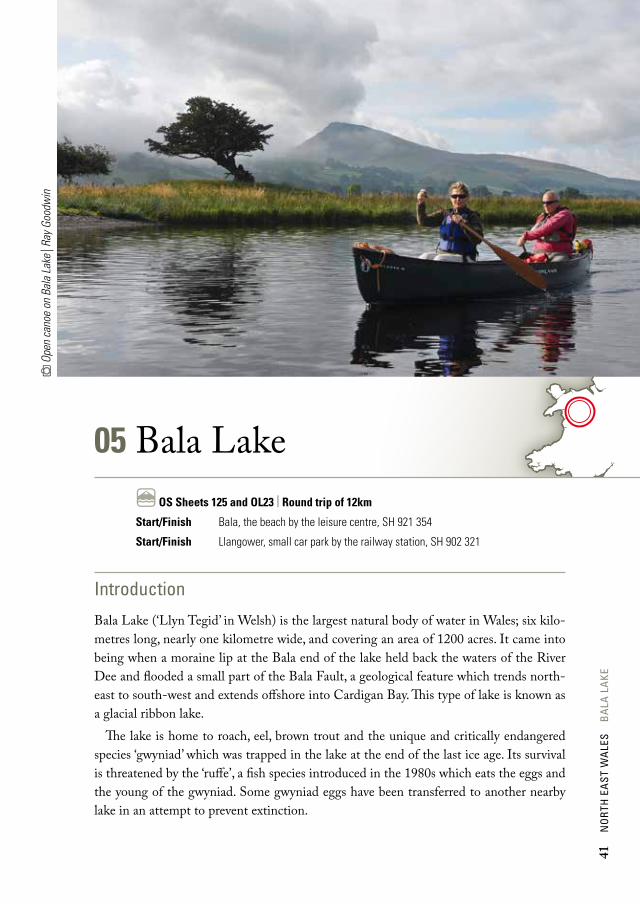
05 Bala LakeC OS Sheets 125 and OL23 | Round trip of 12km
Start/Finish Bala, the beach by the leisure centre, SH 921 354
Start/Finish Llangower, small car park by the railway station, SH 902 321
Introduction
Bala Lake (‘Llyn Tegid’ in Welsh) is the largest natural body of water in Wales; six kilo-metres long, nearly one kilometre wide, and covering an area of 1200 acres. It came into being when a moraine lip at the Bala end of the lake held back the waters of the River Dee and flooded a small part of the Bala Fault, a geological feature which trends north-east to south-west and extends offshore into Cardigan Bay. This type of lake is known as a glacial ribbon lake.
The lake is home to roach, eel, brown trout and the unique and critically endangered species ‘gwyniad’ which was trapped in the lake at the end of the last ice age. Its survival is threatened by the ‘ruffe’, a fish species introduced in the 1980s which eats the eggs and the young of the gwyniad. Some gwyniad eggs have been transferred to another nearby lake in an attempt to prevent extinction.
41
no
rth
ea
st w
ale
s b
ala
la
ke

0 2km
L LY
N T
EG ID OR B
ALA LAKE
SailingClub
Bala / Y Bala
Cefn-ddwysarn
Llanfor
Llanycil
Llangower
Llanuwchllyn
Rhosdylluan
Alltforgan
SailingClub
Glanllyn
Bala LakeRailway
Foel y Geifr
Aran Benllyn
Aran Fawddwy
A f o n L l a f a r
A4212
A494
A494
A494
B4403
B4391
B4401
At the north-eastern end of the lake, the town of Bala has several pubs, cafés and restaurants as well as a range of shops for supplies.
There is a small day charge for paddling on the lake which is payable to the warden who may be seen out and about, or at the warden centre on the foreshore. Weekly and annual permits are available if you intend to visit regularly.
Campsites
Glanllyn is on the north shore of the lake at the western end and Pant yr Onnen on the southern shore, near Llangower. Both offer launching facilities.
Access and egressBala, the beach by the leisure centre – SH 921 354
Llangower, the small car park by the railway station – SH 902 321
42
no
rth
eA
st w
Ale
s b
AlA
lA
ke

0 2km
L LY
N T
EG ID OR B
ALA LAKE
SailingClub
Bala / Y Bala
Cefn-ddwysarn
Llanfor
Llanycil
Llangower
Llanuwchllyn
Rhosdylluan
Alltforgan
SailingClub
Glanllyn
Bala LakeRailway
Foel y Geifr
Aran Benllyn
Aran Fawddwy
A f o n L l a f a r
A4212
A494
A494
A494
B4403
B4391
B4401
Description
The lake is described in a clockwise direction from the Bala foreshore. Leaving the beach and heading east, the shore is a boggy area of flat, grassy marshland on the outskirts of town. After 1km of paddling the outflow of the River Dee is reached. Depending on the water levels, it may be possible to paddle down a short way to the sluice gates and back. Beware of getting too close to the gates as the water flows underneath them and it could be extremely dangerous. The lake water level can fluctuate massively in periods of high rainfall and the fields to the south-west are often underwater.
Heading south-west from the northern end of the lake, Aran Benllyn (885m) domi-nates the view. The name of this peak translates as ‘head of the lake’ – appropriate, as you will be able to see it for the duration of your paddle.
Continuing along the shore, you will pass Bala Sailing Club. The town and roads are left behind and there is more of a feeling of being away from it all. A narrow-gauge railway follows the shore and occasionally a steam locomotive will pass by carrying a host of waving tourists. The countryside is a mixture of farm and woodland and there is plenty of opportunity to spot small mammals and birds. The paddle becomes more and more remote until Llangower Point. The beach on the south side of the point is the Llangower access point and makes an ideal lunch spot, sheltered from the wind. You may find ‘canoe guru’ Ray Goodwin launching here for one of his many training courses or a personal coaching session. Say “hello” and avoid being forced into buying a copy of his wonderful book.
Fam
ily p
addl
ing
on B
ala
Lake
| Ra
y Goo
dwin
43
no
rth
ea
st w
ale
s b
ala
la
ke

After the point, you enter the south-eastern reaches of the lake and there are lots of small bays and river inlets to explore. At the far end of the lake, many of these bays have interesting grassy mounds that are wonderful for children to investigate. The inflow of the River Dee can be explored upriver, but you may need to pole your canoe.
Continuing clockwise, there is a large bay with Glanllyn, the Welsh-speaking outdoor centre, the venue for the Welsh Open Canoe Symposium, and the Glanllyn campsite, which has hosted the ‘Song of the Paddle Big Meet’, one of the largest gatherings of open canoes in the UK. This bay is sheltered and is an excellent place for beginners to experi-ence their first solo paddle, or for the more capable to practise rescue or rolling techniques.
Heading north-east out of the bay, the main A494, originally a Roman road, soon comes into view and follows the shore, reassuringly close by, for the remainder of the trip. The road is hidden from view by a narrow band of woodland which dampens the noise quite nicely. In this woodland, there are several nice sneaky bivvy spots where a very small group could enjoy an evening under tarp.
Continuing north, the finish is in sight. The fetch increases and with the prevailing wind from behind, the waves may build. Occasionally, on very blustery days, it is possible to surf right onto the car park – a wonderful end to a paddle.
Bala sluices
The original sluice gates were built by Thomas Telford to help maintain the flow in the Llangollen Canal. The modern sluices partly fulfil the same purpose but also control the amount of water going down the river. In summer the lake is normally kept at ‘recreational level’ to enable craft to operate closer to the shore. In winter the level is dropped, ready to take the peak off winter floods.
44
no
rth
ea
st w
ale
s B
ala
la
ke


An illustrated guide to some of the finest tours of Wales’ waterways. Scenic lakes, broad estuaries and whitewater rivers, as they can only be seen from canoe or kayak.
Eddie, Adam and ‘Wilf ’ have chosen the best inland touring routes which are described in great detail and illustrated with numerous colour photos and maps. The selected routes are suitable for open canoes, sit-on-tops and touring kayaks, and include seven whitewater trips. Many of them can be tackled as a single voyage, others as a series of day trips with campsites en route.
The journeys are all accessible but highly varied, travelling along lakes, estuaries, rivers and canals. A wonderful book for planning voyages and inspiring dreams or sharing your experiences with others.
Welsh Canoe Classicsa canoeist and kayaker’s guide
Cover – Pontcysyllte Aquaduct over the River Dee | Jimmy Mitchell
Back cover – Mawddach Estuary | Adam Robson
NORTH WEST NORTH
EaST
WEST cOaST EaST
SOuTH WEST
SOuTH