a book of discovery - yesterdaysclassics.com · isbn-13: 978-1-59915-192-2 ... discovery, some...
TRANSCRIPT

A BOOK OF DISCOVERY

PTOLEMY’S MAP OF THE WORLD, ORIGINALLY DRAWN ABOUT 150 A.D.
Taken from the first printed edition of 1472 (the first book to have printed maps) and the famous Rome edition of 1508. It is only necessary to compare this map with the mythical geography represented in a mediaeval map, such as Hereford map of the world, made eleven centuries later, to recognize the extraordinary accuracy and scientific value of Ptolemy’s geography.

A BOOK OF DISCOVERY
BY
M. B. SYNGE
Fully illustrated from authentic sources and with maps
YESTERDAY’S CLASSICS
CHAPEL HILL, NORTH CAROLINA

Cover and arrangement © 2007 Yesterday’s Classics.
This edition, first published in 2007 by Yesterday’s Classics, is an unabridged republi-cation of the work originally published by G. P. Putnam’s Sons in 1912. For a complete listing of the books published by Yesterday’s Classics, visit www.yesterdaysclassics.com. Yesterday’s Classics is the publishing arm of the Baldwin Project which presents the complete text of hundreds of classic books for children at www.mainlesson.com under the editorship of Lisa M. Ripperton and T. A. Roth.
ISBN-10: 1-59915-192-8 ISBN-13: 978-1-59915-192-2
Yesterday’s Classics PO Box 3418 Chapel Hill, NC 27515


INTRODUCTION “Hope went before them, and the world was wide.”
SUCH was the spirit in which the exploration of the world was accomplished. It was the inspiration that carried men of old far beyond the sunrise into those magic and silent seas whereon no boat had ever sailed. It is the incentive of those to-day with the wander-thirst in their souls, who travel and suffer in the travelling, though there are fewer prizes left to win. But
“The reward is in the doing, And the rapture of pursuingIs the prize.”
“To travel hopefully,” says Stevenson, “is a better thing than to arrive.” This would explain the fact that this Book of Discovery has become a record of splendid endurance, of hardships bravely borne, of silent toil, of courage and resolution unequalled in the annals of mankind, of self-sacrifice unrivalled and faithful lives laid ungrudgingly down. Of the many who went forth, the few only attained. It is of these few that this book tells.
“All these,” says the poet in Ecclesiastes—“all these were honoured in their generation, and were the glory of their times . . . their name liveth for evermore.”
But while we read of those master-spirits who suc-ceeded, let us never forget those who failed to achieve.
“Anybody might have found it, but the Whisper came to Me.”
Enthusiasm too was the secret of their success. Among the best of crews there was always some one who would have
turned back, but the world would never have been explored had it not been for those finer spirits who resolutely went on—even to the death.
This is what carried Alexander the Great to the “earth’s utmost verge,” that drew Columbus across the trackless Atlantic, that nerved Vasco da Gama to double the Stormy Cape, that induced Magellan to face the dreaded straits now called by his name, that made it possible for men to face without flinching the ice-bound regions of the far North.
“There is no land uninhabitable, nor sea unnavigable,” asserted the men of the sixteenth century, when England set herself to take possession of her heritage in the North. Such an heroic temper could overcome all things. But the cost was great, the sufferings intense.
“Having eaten our shoes and saddles boiled with a few wild herbs, we set out to reach the kingdom of gold,” says Orellana in 1540.
“We ate biscuit, but in truth it was biscuit no longer, but a powder full of worms,—so great was the want of food, that we were forced to eat the hides with which the mainyard was covered; but we had also to make use of sawdust for food, and rats became a great delicacy,” related Magellan, as he led his little ship across the unknown Pacific.
Again, there is Franklin returning from the Arctic coast, and stilling the pangs of hunger with “pieces of singed hide mixed with lichen,” varied with “the horns and bones of a dead deer fried with some old shoes.”
The dangers of the way were manifold.
For the early explorers had no land map or ocean chart to guide them, there were no lighthouses to warn the strange mariner of dangerous coast and angry surf, no books of travel to relate the weird doings of fierce and inhospitable savages, no tinned foods to prevent the terrible scourge of sailors, scurvy. In their little wooden sailing ships the men of old faced every

conceivable danger, and surmounted obstacles unknown to modern civilisation.
“Now strike your Sails ye jolly Mariners,For we be come into a quiet Rode.”
For the most part we are struck with the light-heartedness of the olden sailor, the shout of gladness with which men went forth on these hazardous undertakings, knowing not how they would arrive, or what might befall them by the way, went forth in the smallest of wooden ships, with the most incompetent of crews, to face the dangers of unknown seas and unsuspected lands, to chance the angry storm and the hidden rock, to discover inhospitable shores and savage foes. Founded on bitter experience is the old saying—
“A Passage Perilous makyth a Port Pleasant.” For the early navigators knew little of the art of navigation.
Pytheas, who discovered the British Isles, was “a great mathematician.” Diego Cam, who sailed to the mouth of the Congo, was “a knight of the King’s household.” Sir Hugh Willoughby, “a most valiant gentleman.” Richard Chancellor, “a man of great estimation for many good parts of wit in him.” Anthony Jenkinson, a “resolute and intelligent gentleman.” Sir Walter Raleigh, an Elizabethan courtier, and so forth.
It has been obviously impossible to include all the fa-mous names that belong to the history of exploration. Most of these explorers have been chosen for some definite new discovery, some addition to the world’s geographical know-ledge, or some great feat of endurance which may serve to brace us to fresh effort as a nation famous for our seamen. English navigators have been afforded the lion’s share in the book, partly because they took the lion’s share in exploring, partly because translations of foreign travel are difficult to transcribe. Most of these stories have been taken from original sources, and most of the explorers have been allowed to tell part of their own story in their own words.

Perhaps the most graphic of all explorations is that writ-ten by a native of West Australia, who accompanied an exploring party searching for an English lad named Smith, who had been starved to death.
“Away, away, away, away; we reach the water of Djun-jup; we shoot game. Away, away, away through a forest away, through a forest away; we see no water. Through a forest away, along our tracks away; hills ascending, then pleasantly away, away, through a forest away. We see a water—along the river away—a short distance we go, then away, away, away through a forest away. Then along another river away, across the river away. Still we go onwards, along the sea away, through the bush away, then along the sea away. We sleep near the sea. I see Mr. Smith’s footsteps ascending a sandhill; onwards I go regarding his footsteps. I see Mr. Smith dead. Two sleeps had he been dead; greatly did I weep, and much I grieved. In his blanket folding him, we scraped away the earth. The sun had inclined to the westward as we laid him in the ground.”
The book is illustrated with reproductions from old maps—old primitive maps, with a real Adam and Eve standing in the Garden of Eden, with Pillars of Hercules guarding the Straits of Gibraltar, with Paradise in the east, a realistic Jerusalem in the centre, the island of Thule in the north, and St. Brandon’s Isles of the Blest in the west.
Beautifully coloured were the maps of the Middle Ages, “joyous charts all glorious with gold and vermilion, compasses and crests and flying banners, with mountains of red and gold.” The seas are full of ships—“brave beflagged vessels with swelling sails.” The land is ablaze with kings and potentates on golden thrones under canopies of angels. While over all presides the Madonna in her golden chair.”
The Hereford Mappa Mundi, drawn in the thirteenth century on a fine sheet of vellum, circular in form, is among the most interesting of the mediæval maps. It must once have been gorgeous, with its gold letters and scarlet towns, its green seas and its blue rivers. The Red Sea is still red, but the Mediterra-

nean is chocolate brown, and all the green has disappeared. The mounted figure in the lower right-hand corner is probably the author, Richard de Haldingham. The map is surmounted by a representation of the Last Judgment, below which is Paradise as a circular island, with the four rivers and the figures of Adam and Eve. In the centre is Jerusalem. The world is divided into three—Asia, “Affrica,” and Europe. Around this earth-island flows the ocean. America is, of course, absent; the East is placed at Paradise and the West at the Pillars of Hercules. North and South are left to the imagination.
And what of the famous map of Juan de la Cosa, once pilot to Columbus, drawn in the fifteenth century, with St. Christopher carrying the infant Christ across the water, supposed to be a portrait of Christopher Columbus carrying the gospel to America? It is the first map in which a dim outline appears of the New World.
The early maps of “Apphrica” are filled with camels and unicorns, lions and tigers, veiled figures and the turrets and spires of strange buildings—
“Geographers in Afric maps With savage pictures fill their gaps.”
“Surely,” says a modern writer,—“surely the old carto-grapher was less concerned to fill his gaps than to express the poetry of geography.”
And to-day, there are still gaps in the most modern maps of Africa, where one-eleventh of the whole area remains unexplored. Further, in Asia the problem of the Brahmaputra Falls is yet unsolved; there are shores untrodden and rivers unsurveyed.
“God hath given us some things, and not all things, that our successors also might have somewhat to do,” wrote Barents in the sixteenth century. There may not be much left, but with the words of Kipling’s Explorer we may fitly conclude—

“Something hidden. Go and find it. Go and look behind the Ranges—Something lost behind the Ranges. Lost and waiting for you. Go!”
Thanks are due to Mr. S. G. Stubbs for valuable assis-tance in the selection and preparation of the illustrations, which, with few exceptions, have been executed under his directions.

CONTENTS
I. A LITTLE OLD WORLD .......................................................1
II. EARLY MARINERS............................................................. 9
III. IS THE WORLD FLAT? ......................................................18
IV. HERODOTUS—THE TRAVELLER........................................25
V. ALEXANDER THE GREAT EXPLORES INDIA ....................... 34
VI. PYTHEAS FINDS THE BRITISH ISLES................................. 46
VII. JULIUS CÆSAR AS EXPLORER ...........................................52
VIII. STRABO’S GEOGRAPHY.................................................... 58
IX. THE ROMAN EMPIRE AND PLINY ..................................... 64
X. PTOLEMY’S MAPS ........................................................... 70
XI. PILGRIM TRAVELLERS......................................................73
XII. IRISH EXPLORERS............................................................79
XIII. AFTER MOHAMMED........................................................ 84
XIV. THE VIKINGS SAIL THE NORTHERN SEAS......................... 89
XV. ARAB WAYFARERS .......................................................... 94
XVI. TRAVELLERS TO THE EAST..............................................102
XVII. MARCO POLO ................................................................109
XVIII. THE END OF MEDIAEVAL EXPLORATION......................... 121
XIX. MEDIAEVAL MAPS .........................................................128
XX. PRINCE HENRY OF PORTUGAL ........................................134
XXI. BARTHOLOMEW DIAZ REACHES THE STORMY CAPE ........ 145

XXII. CHRISTOPHER COLUMBUS..............................................150
XXIII. A GREAT NEW WORLD...................................................160
XXIV. VASCO DA GAMA REACHES INDIA...................................168
XXV. DISCOVERY OF THE SPICE ISLANDS .................................176
XXVI. BALBOA SEES THE PACIFIC OCEAN..................................185
XXVII. MAGELLAN SAILS ROUND THE WORLD ...........................190
XXVIII. CORTES EXPLORES AND CONQUERS MEXICO ..................201
XXIX. EXPLORERS IN SOUTH AMERICA.....................................210
XXX. CABOT SAILS TO NEWFOUNDLAND..................................218
XXXI. JACQUES CARTIER EXPLORES CANADA .......................... 222
XXXII. SEARCH FOR A NORTH-EAST PASSAGE ........................... 228
XXXIII. MARTIN FROBISHER SEARCHES FOR A NORTH-WEST
PASSAGE........................................................................237
XXXIV. DRAKE’S FAMOUS VOYAGE ROUND THE WORLD .............241
XXXV. DAVIS STRAIT ............................................................... 252
XXXVI. BARENTS SAILS TO SPITZBERGEN................................... 258
XXXVII. HUDSON FINDS HIS BAY ............................................... 266
XXXVIII. BAFFIN FINDS HIS BAY ..................................................273
XXXIX. SIR WALTER RALEIGH SEARCHES FOR EL DORADO .........277
XL. CHAMPLAIN DISCOVERS LAKE ONTARIO ........................ 282
XLI. EARLY DISCOVERERS OF AUSTRALIA..............................288
XLII. TASMAN FINDS TASMANIA ............................................ 294
XLIII. DAMPIER DISCOVERS HIS STRAIT.................................. 298
XLIV. BEHRING FINDS HIS STRAIT.......................................... 304
XLV. COOK DISCOVERS NEW ZEALAND ...................................310
XLVI. COOK’S THIRD VOYAGE AND DEATH .............................. 320
XLVII. BRUCE’S TRAVELS IN ABYSSINIA.................................... 329
XLVIII. MUNGO PARK AND THE NIGER .......................................337
XLIX. VANCOUVER DISCOVERS HIS ISLAND............................. 346
L. MACKENZIE AND HIS RIVER...........................................351
LI. PARRY DISCOVERS LANCASTER SOUND...........................353
LII. THE FROZEN NORTH .................................................... 360
LIII. FRANKLIN’S LAND JOURNEY TO THE NORTH.................. 369
LIV. PARRY’S POLAR VOYAGE ................................................374
LV. THE SEARCH FOR TIMBUKTU..........................................377
LVI. RICHARD AND JOHN LANDER DISCOVER THE MOUTH
OF THE NIGER .............................................................. 384
LVII. ROSS DISCOVERS THE NORTH MAGNETIC POLE ............. 388
LVIII. FLINDERS NAMES AUSTRALIA ....................................... 396
LIX. STURT’S DISCOVERIES IN AUSTRALIA............................. 404
LX. ROSS MAKES DISCOVERIES IN THE ANTARCTIC SEAS .......412
LXI. FRANKLIN DISCOVERS THE NORTH-WEST PASSAGE ........416
LXII. DAVID LIVINGSTONE..................................................... 424
LXIII. BURTON AND SPEKE IN CENTRAL AFRICA, 1856............. 433
LXIV. LIVINGSTONE TRACES LAKE SHIRWA AND NYASSA ......... 439
LXV. EXPEDITION TO VICTORIA NYANZA................................ 443
LXVI. BAKER FINDS ALBERT NYANZA ..................................... 450
LXVII. LIVINGSTONE’S LAST JOURNEY ..................................... 456
LXVIII. THROUGH THE DARK CONTINENT ................................. 466
LXIX. NORDENSKIÖLD ACCOMPLISHES THE NORTH-EAST
PASSAGE .......................................................................479
LXX. THE EXPLORATION OF TIBET......................................... 489
LXXI. NANSEN REACHES FARTHEST NORTH............................ 498
LXXII. PEARY REACHES THE NORTH POLE, 1909...................... 506
LXXIII. THE QUEST FOR THE SOUTH POLE..................................512
LXXIV. DATES OF CHIEF EVENTS .............................................. 522

1
CHAPTER I
A LITTLE OLD WORLD NO story is complete unless it begins at the very beginning. But where is the beginning? Where is the dawn of geography—the knowledge of our earth? What was it like before the first explorers made their way into distant lands? Every day that passes we are gaining fresh knowledge of the dim and silent past.
Every day men are patiently digging in the old heaps that were once the sites of busy cities, and, as a result of their unwearying toil, they are revealing to us the life-stories of those who dwelt therein; they are disclosing secrets writ on weather-worn stones and tablets, bricks and cylinders, never before even guessed at.
Thus we read the wondrous story of ancient days, and breathlessly wonder what marvelous discovery will thrill us next.
For the earliest account of the old world—a world made up apparently of a little land and a little water—we turn to an old papyrus, the oldest in existence, which tells us in familiar words, unsurpassed for their exquisite poetry and wondrous simplicity, of that great dateless time so full of mystery and awe.
“In the beginning God created the heaven and the earth. And the earth was waste and void; and darkness was upon the face of the deep: and the spirit of God moved upon the face of the waters . . . And God said, Let there be a firmament in the midst of the waters, and let it divide the waters from the waters. And God . . . divided the waters which were under the firmament from the waters which were above the firmament. . . . And God said, Let the waters under the heaven be gathered into

A BOOK OF DISCOVERY
2
one place, and let the dry land appear. . . . And God called the dry land Earth; and the gathering together of the waters called he Seas.”
Thus beautifully did the children of men express their earliest idea of the world’s distribution of land and water.
And where, on our modern maps, was this little earth, and what was it like? Did trees and flowers cover the land? Did rivers flow into the sea? Listen again to the old tradition that still rings down the ages—
“And the Lord God planted a garden eastward in Eden . . . and a river went out
of Eden to water the garden; and from thence it was parted, and became four heads. The name of the first is Pison . . and the name of the second river is Gihon; the name of the third river is Hiddekel (Tigris). And the fourth river is Euphrates.”
Now look at a modern map of Asia. Between Arabia and Persia there is a long valley watered by the Tigris and Euphrates, rivers which rise in Armenia and flow into the Persian Gulf. This region was the traditional “cradle of the human race.” Around and beyond was a great world, a world with great surging seas, with lands of trees and flowers, a world with continents and lakes and bays and capes, with islands and mountains and rivers.
There were vast deserts of sand rolling away to right and to left there were mountains up which no man had climbed; there were stormy seas over which no ship had ever sailed. But these men of old had never explored far. They believed that their world was just a very little world, with no other occupants than themselves. They believed it to be flat, with mountains at
THE GARDEN OF EDEN WITH ITS FOUR
RIVERS
From the Hereford Map of the World.

A LITTLE OLD WORLD
3
either end on which rested a solid metal dome known as the “firmament.”
In this shining circle were windows, in and out of which the sun would creep by day and the moon and stars by night. And the whole of this world was, they thought, balanced on the waters. There was water above, the “waters that be above the firmament,” and water below, and water all around. Long ages pass away. Let us look again at the green valley of the Euphrates and Tigris. It has been called the “nursery of nations”—names have been given to various regions round about, and cities have arisen on the banks of the rivers. Babylonia, Mesopo-tamia, Chaldea, Assyria—all these long names belonged to this region, and around each centres some of the most interesting history and legend in the world.
Rafts on the river and caravans on the land carried mer-chandise far and wide—men made their way to the “Sea of the Rising Sun,” as they called the Persian Gulf, and to the “Sea of the Setting Sun,” as they called the Mediterranean. They settled on the shores of the Caspian Sea, on the shores of the Black Sea, on the shores of the Red Sea. They carried on magnificent trade—cedar, pine, and cypress were brought from Lebanon to Chaldea, limestone and marble from Syria, copper and lead from the shores of the Black Sea.
BABYLONIAN MAP OF THE WORLD ON CLAY
Showing the ocean sur-rounding the world and the position of Babylon on the Euphrates. In the British Museum.

A BOOK OF DISCOVERY
4
THE OLDEST KNOWN SHIPS: BETWEEN 6000 AND 5000 B.C.
From a pre-Egyptian vase painting.
And these dwellers about Babylonia built up a wonder-ful civilisation. They had temples and brick-built houses, libraries of tablets revealing knowledge of astronomy and astrology; they had a literature of their own. Suddenly from out the city of Ur (Kerbela), near the ancient mouth of the Euphrates, appears a traveller. There had doubtless been many before, but records are scanty and hard to piece together, and a detailed account of a traveller with a name is very interesting.
“Abram went . . . forth to go into the land of Canaan. . . And Abram journeyed, going on still toward the South. And there was a famine in the land. And Abram went down into Egypt to sojourn there.” He would have travelled by the chief caravan routes of Syria into Egypt. Here about the fertile mouth of the Nile he would have found an ancient civilisation as wonderful as that to which he was accustomed in Babylonia. It was a grain-growing country, and when there was famine in other lands, there was always “corn in Egypt”—thanks to the mighty life-giving Nile.
But we must not linger over the old civilisation, over the wonderful Empire governed by the Pharaohs or kings, first from Memphis (Cairo) and then from the hundred-gated Thebes; must not linger over these old pyramid builders, the temple, sphinxes, and statues of ancient Egypt. Before even Abram came into their country we find the Egyptians famous
A LITTLE OLD WORLD
5
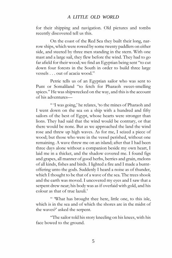
for their shipping and navigation. Old pictures and tombs recently discovered tell us this.
On the coast of the Red Sea they built their long, nar-row ships, which were rowed by some twenty paddlers on either side, and steered by three men standing in the stern. With one mast and a large sail, they flew before the wind. They had to go far afield for their wood; we find an Egyptian being sent “to cut down four forests in the South in order to build three large vessels . . . out of acacia wood.”
Petrie tells us of an Egyptian sailor who was sent to Punt or Somaliland “to fetch for Pharaoh sweet-smelling spices.” He was shipwrecked on the way, and this is the account of his adventures—
“ ‘I was going,’ he relates, ‘to the mines of Pharaoh and I went down on the sea on a ship with a hundred and fifty sailors of the best of Egypt, whose hearts were stronger than lions. They had said that the wind would be contrary, or that there would be none. But as we approached the land the wind rose and threw up high waves. As for me, I seized a piece of wood; but those who were in the vessel perished, without one remaining. A wave threw me on an island; after that I had been three days alone without a companion beside my own heart, I laid me in a thicket, and the shadow covered me. I found figs and grapes, all manner of good herbs, berries and grain, melons of all kinds, fishes and birds. I lighted a fire and I made a burnt-offering unto the gods. Suddenly I heard a noise as of thunder, which I thought to be that of a wave of the sea. The trees shook and the earth was moved. I uncovered my eyes and I saw that a serpent drew near; his body was as if overlaid with gold, and his colour as that of true lazuli.’
“ ‘What has brought thee here, little one, to this isle, which is in the sea and of which the shores are in the midst of the waves?’ asked the serpent.
“The sailor told his story kneeling on his knees, with his face bowed to the ground.

A BOOK OF DISCOVERY
6
“ ‘Fear not, little one, and make not thy face sad,’ con-tinued the serpent, ‘for it is God who has brought thee to this isle of the blest, where nothing is lacking and which is filled with all good things. Thou shalt be four months in this isle. Then a ship shall come from thy land with sailors, and thou shalt go to thy country. As for me, I am a prince of the land of Punt. I am here with my brethren and children around me; we are seventy-five serpents, children and kindred.’
“Then the grateful sailor promised to bring all the treas-ures of Egypt back to Punt, and ‘I shall tell of thy presence unto Pharaoh; I shall make him to know of thy greatness,’ said the Egyptian stranger.
“But the strange prince of Punt only smiled.
“ ‘Thou shalt never more see this isle,’ he said; ‘it shall be changed into waves.’ ”
Everything came to pass as the serpent said. The ship came, gifts were lavished on the sailor from Egypt, perfumes of cassia, of sweet woods, of cypress, incense, ivory tusks, baboons, and apes, and thus laden he sailed home to his own people.
Long centuries after this we get another glimpse at the land of Punt. This time it is in the reign of Queen Hatshepsu, who sent a great trading expedition into this famous country. Five ships started from Thebes, sailing down the river Nile and probably reaching the Red Sea by means of a canal. Navigation in the Red Sea was difficult; the coast was steep and inhospita-ble; no rivers ran into it. Only a few fishing villages lay along the coasts used by Egyptian merchants as markets for mother-of-pearl, emeralds, gold, and sweet-smelling perfumes.
Thence the ships continued their way, the whole voyage taking about two months. Arrived at Punt, the Egyptian commander pitched his tents upon the shore, to the great astonishment of the inhabitants.

A LITTLE OLD WORLD
7
EGYPTIAN SHIP OF THE EXPEDITION TO PUNT, ABOUT 1600 B.C.
From a rock-carving at Der el Bahari.
“Why have ye come hither unto this land, which the people of Egypt know not?” asked the Chief of Punt. “Have ye come through the sky? Did ye sail upon the waters or upon the sea?”
Presents from the Queen of Egypt were at once laid be-fore the Chief of Punt, and soon the seashore was alive with people. The ships were drawn up, gang-planks were very heavily laden with “marvels of the country of Punt.” There were heaps of myrrh, resin, of fresh myrrh trees, ebony and pure ivory, cinnamon wood, incense, baboons, monkeys, dogs, natives, and children. “Never was the like brought to any king of Egypt since the world stands.” And the ships voyaged safely back to Thebes with all their booty and with pleasant recollections of the people of Somaliland.
In spite of these little expeditions the Egyptian world seemed still very small. The Egyptians thought of the earth with its land and sea as a long, oblong sort of box, the centre of which was Egypt. The sky stretched over it like an iron ceiling, the part toward the earth being sprinkled with lamps hung from

A BOOK OF DISCOVERY
8
strong cables lighted by night and extinguished by day. Four forked trunks of trees upheld the sky roof. But lest some storm should overthrow these tree trunks there were four lofty peaks connected by chains of mountains. The southern peak was known as the “Horn of the Earth,” the eastern, the “Mountain of Birth,” the western, the “Region of Life,” the southern was invisible. And why? Because they thought the Great Sea, the “Very Green,” the Mediterranean, lay between it and Egypt. Beyond these mountain peaks, supporting the world, rolled a great river, an ocean stream, and the sun was as a ball of fire placed on a boat and carried round the ramparts of the world by the all-encircling water.
THE ARK ON ARARAT AND THE CITIES OF
NINEVEH AND BABYLON.
From Leonardo Dati’s map of 1422.
So we realise that the people living in Babylonia about the river Euphrates, and those living in Egypt about the river Nile, had very strange ideas about the little old world around them.

9
CHAPTER II
EARLY MARINERS THE law of the universe is progress and expansion, and this little old world was soon discovered to be larger than men thought.
Now in Syria the highway between Babylonia and Egypt—dwelt a tribe of dusky people known as Phœnicians. Some have thought that they were related to our old friends in Somaliland, and that long years ago they had migrated north to the seacoast of that part of Syria known as Canaan.
Living on the seashore, washed by the tideless Mediter-ranean, they soon became skilful sailors. They built ships and ventured forth on the deep; they made their way to the islands of Cyprus and Crete and thence to the islands of Greece, bringing back goods from other countries to barter with their less daring neighbours. They reached Greece itself and cruised along the northern coast of the Great Sea to Italy, along the coast of Spain to the Rock of Gibraltar, and out into the open Atlantic.
How their little sailing boats lived through the storms of that great ocean none may know, for Phœnician records are lost, but we have every reason to believe that they reached the northern coast of France and brought back tin from the islands known to them as the Tin Islands. In their home markets were found all manner of strange things from foreign unknown lands, discovered by these master mariners—the admiration of the ancient world.
“The ships of Tarshish,” said the old poet, “did sing of thee in thy market, and thou wast replenished and made very glorious in the midst of the seas; thy rowers have brought thee

A BOOK OF DISCOVERY
10
into great waters; the east wind hath broken thee in the midst of the seas.”
All the world knew of the Phœnician seaports, Tyre and Sidon. They were as famous as Memphis and Thebes on the Nile, as magnificent as Nineveh on the Tigris and Babylon on the Euphrates. Men spoke of the “renowned city of Tyre,” whose merchants were as princes, whose “traffickers” were among the honourable of the earth. “O thou that art situate at the entry of the sea,” cries the poet again, when the greatness of Tyre was passing away, “which art a merchant of the people from many isles. . . . Thy borders are in the midst of the seas; thy builders have perfected thy beauty. They have made all thy ship-boards of fir trees . . . they have taken cedars of Lebanon to make masts for thee. Of the oaks of Basan have they made thy oars. . . . Fine linen with broidered work from Egypt was that which thou spreadest forth to be thy sail. . . . The inhabitants of Sidon . . . were thy mariners; thy wise men were thy pilots.
A PHOENICIAN SHIP, ABOUT 700 B.C.
From a bas-relief at Nineveh.
As time goes on, early groups round the Euphrates and the Nile continue, but new nations form and grow, new cities arise; new names appear. Centuries of men live and die, ignorant

EARLY MARINERS
11
of the great world that lies about them—“Lords of the eastern world that knew no west.”
England was yet unknown, America undreamt of, Aus-tralia still a desolate island in an unknown sea. The burning eastern sun shone down on to vast stretches of desert-land uninhabited by man, great rivers flowed through dreary swamps unrealised, tempestuous waves beat against their shores, and melancholy winds swept over the face of endless ocean solitudes.
And still, according to their untutored minds, the world is flat, the world is very small and it is surrounded by ever-flowing waters, beyond which all is dark and mysterious.
Around the shores of the Mediterranean Sea, revealed by the boundless energy and daring skill of the Phœnicians, there were colonies along the coasts of Africa and Europe, though they were not yet called by their names. They have discovered and explored, but they have kept their information to themselves, and they have specially refused to divulge their voyages to the Greeks.
A story is told at a later date than this of a Phœnician shipmaster who was bound for the Tin Islands, when he suddenly discovered that he was being followed by a strange ship evidently bent on finding out where these unknown islands lay. The Phœnician purposely ran his ship on to a shoal in order to keep the secret of the discovery. When he returned home his conduct was upheld by the State!
But though the Phœnicians have left us no record of their travels and voyages, they had been the carriers of knowledge, and it was from them that the Greeks learnt of “the extreme regions of the world” and of the dim “far west.” Indeed, it is highly probable that from the Phœnicians they got material for their famous legend of the Argonauts and their adventures in the Black Sea. Though the story is but legendary, and it has been added to with the growing knowledge of the world, yet it gives an idea of the perils that beset the sailors of those remote ages and of their limitations.

A BOOK OF DISCOVERY
12
And again we must remind ourselves that both the Phœnicians and early Greeks had, like the Egyptians and Babylonians, childish ideas as to the form of the earth. To them it was a circular plane, encircled by the ocean, which they believed to be a broad, deep-running river flowing round and round the world. Into this ocean stream ran all the rivers and seas known to them. Over the earth was raised a solid firmament of bronze in which the stars were set, and this was supported on tall pillars “which kept the heaven and the earth asunder.”
The whole delightful story of the Argonauts can be read in Kingsley’s “Heroes.” It is the story of brave men who sailed in the ship Argo, named after the great shipbuilder Argos, to bring back the Golden Fleece from Colchis in the Black Sea.
Nowhere in all the history of exploration have we a more poetical account of the launching of a ship for distant lands: “Then they have stored her well with food and water, and pulled the ladder up on board, and settled themselves each man to his oar and kept time to Orpheus’ harp; and away across the bay they rowed southward, while the people lined the cliffs; and the women wept while the men shouted at the starting of that gallant crew.” They chose a captain, and the choice fell on Jason, “because he was the wisest of them all”; and they rowed on “over the long swell of the sea, past Olympus, past the wooded bays of Athos and the sacred isle; and they came past Lemnos to the Hellespont, and so on into the Propontis, which we call Marmora now.” So they came to the Bosphorus, the “land then as now of bitter blasts, the land of cold and misery,” and a great battle of the winds took place.
Then the Argonauts came out into the open sea—the Black Sea. No Greek had ever crossed it, and even the heroes, for all their courage, feared “that dreadful sea and its rocks and shoals and fogs and bitter freezing storms,” and they trembled as they saw it “stretching out before them without a shore, as far as the eye could see.”

EARLY MARINERS
13
A MAP OF THE VOYAGE OF THE ARGONAUTS.
Drawn according to the principal classical tradi-tions. The voyage through the ocean which, according to the ancient idea, surrounded the world will be especially noted.
Wearily they sailed on past the coast of Asia; they passed Sinope and the cities of the Amazons, the warlike women of the east, until at last they saw the “white snow peaks hanging glittering sharp and bright above the clouds. And they knew that they were come to Caucasus at the end of all the earth—Caucasus, the highest of all mountains, the father of the rivers of the East. And they rowed three days to the eastward, while the Caucasus rose higher hour by hour, till they saw the dark stream of Phasis rushing headlong to the sea and, shining above the treetops, the golden roofs of the Child of the Sun.”
How they reached home no man knows. Some say they sailed up the Danube River and so came to the Adriatic,

A BOOK OF DISCOVERY
14
dragging their ship over the snowclad Alps. Others say they sailed south to the Red Sea and dragged their ship over the burning desert of North Africa. More than once they gave themselves up for lost, “heart-broken with toil and hunger,” until the brave helmsman cried to them, “Raise up the mast and set the sail and face what comes like men.”
After days and weeks on the “wide wild western sea” they sailed by the coast of Spain and came to Sicily, the “three-cornered island,” and after numerous adventures they reached home once more. And they limped ashore weary and worn, with long, ragged beards and sunburnt cheeks and garments torn and weather-stained. No strength had they left to haul the ship up the beach. They just crawled out and sat down and wept, till they could weep no more. For the houses and trees were all altered, and all the faces which they saw were strange; and their joy was swallowed up in sorrow while they thought of their youth and all their labour, and the gallant comrades they had lost. And the people crowded round and asked them, “Who are you that sit weeping here?”
“We are the sons of your princes, who sailed away many a year ago. We went to fetch the Golden Fleece and we have brought it back.” Then there was shouting and laughing and weeping, and all the kings came to the shore, and they led the heroes away to their homes and bewailed the valiant dead. Old and charming as is the story of the Argonauts, it is made up of travellers’ tales, probably told to the Greeks by the Phœnicians of their adventures on unknown seas.
The wanderings of Ulysses by the old Greek poet Homer shows us that, though they seldom ventured beyond the Mediterranean Sea, yet the Greeks were dimly conscious of an outer world beyond the recognised limits. They still dreamt that the earth was flat, and that the ocean stream flowed for ever round and round it. There were no maps or charts to guide the intrepid mariners who embarked on unknown waters.
The siege of Troy, famous in legend, was over, and the heroes were anxious to make their way home. Ulysses was one

EARLY MARINERS
15
of the heroes, and he sailed forth from Asia Minor into the Ægean Sea. But contrary winds drove him as far south as Cape Malea.
“Now the gatherer of the clouds,” he says, in telling his story, “aroused the North Wind against our ships with a terrible tempest, and covered land and sea alike with clouds, and down sped night from heaven. Thus the ships were driven headlong, and their sails were torn to shreds by the might of the wind. So we lowered the sails into the hold in fear of death, and rowed the ships landward apace.”
Throughout all ages Cape Malea has been renowned for sudden and violent storms, dreaded by early mariners as well as those of later times.
“Thence for nine whole days was I borne by ruinous winds over the teeming deep; but on the tenth day we set foot on the land of the lotus-eaters who eat a flowery food.”
Now ten days’ sail to the south would have brought Ulysses to the coast of North Africa, and here we imagine the lotus-eaters dwelt. But their stay was short. For as soon as the mariners tasted the “honey-sweet fruit of the lotus” they forgot their homes, forgot their own land, and only wanted to stay with the “mild-eyed melancholy lotus-eaters.”
“They sat them down upon the yellow sand, Between the sun and moon upon the shore; And sweet it was to dream of Fatherland, Of child, and wife, and slave; but evermore Most weary seem’d the sea, weary the oar, Weary the wandering fields of barren foam. Then someone said: ‘We will return no more’; And all at once they sang, ‘Our island home Is far beyond the wave; we will no longer roam.’ ”
“Therefore,” said Ulysses, “I led them back to the ships, weeping and sore against their will, and dragged them beneath the benches. Soon they embarked and, sitting orderly, they smote the grey sea water with their oars. Thence we sailed

A BOOK OF DISCOVERY
16
onward, stricken at heart. And we came to the land of the Cyclops.”
No one knows exactly where the land of the Cyclops is. Some think it may be Sicily and the slopes of Mount Etna facing the sea.
The famous rock of Scylla and whirlpool of Charybdis, known to the ancients as two sea-monsters, near the Straits of Messina, next claimed his attention. Let us see how Ulysses passed them.
“We began to sail up the narrow strait,” he says, lament-ing. “For on the one side lay Scylla and on the other mighty Charybdis sucking down the salt sea water. Like a cauldron on a great fire she would seethe up through all her troubled deeps, and overhead the spray fell on the top of either cliff—the rock around roared horribly, and pale fear gat hold on my men. Toward her, then, we looked, fearing destruction; but Scylla meanwhile caught from out my hollow ships six of my company. They cried aloud in their agony, and there she devoured them shrieking at her gates, they stretching forth their hands to me in their death struggles. And the most pitiful thing was this, that mine eyes have seen of all my travail in searching out the paths of the sea.”
Some have thought that the terrifying stories of Scylla, Charybdis, and the Cyclops were stories invented by the Phœnicians to frighten travellers of other nations away from the sea that they wished to keep for themselves for purposes of trade.
It would take too long to tell of the great storm that de-stroyed the ships and drowned the men, leaving Ulysses to make a raft on which he drifted about for nine days, blown back to Scylla and Charybdis and from thence to the island of Ogygia, “in the centre of the sea.” Finally he reached his home in Ithaca so changed, so aged and weather-worn, that only his dog Argus recognised him.

EARLY MARINERS
17
This, very briefly, is Homer’s world-picture of a bygone age, when those who were seized with a thirst for travel sailed about the Mediterranean in their primitive ships, landing on unnamed coasts, cruising about unknown islands, meeting strange people, encountering strange adventures.
It all reads like an old fairy tale to us to-day, for we have our maps and charts and know the whereabouts of every country and island about the tideless Mediterranean.
“THE UNROLLING OF THE CLOUDS.” — I.
The world as known at the time of Homer.

18
CHAPTER III
IS THE WORLD FLAT? STILL, although the men of ancient time were learning fast about the land and sea, they were woefully ignorant. Hesiod, a Greek poet, who lived seven hundred and fifty years before the Christian era, declared that the world was flat, and the ocean stream or the “perfect river,” as he called it, flowed round and round, encompassing all things.
Still, there was something beyond the water—something dim, mysterious, unknowable. It might be the “Islands of the Blest”; it might be the “sacred isle.” One thing he asserted firmly: “Atlas upholds the broad Heaven . . . standing on earth’s verge with head and unwearied hands,” while the clear-voiced Hesperides guarded their beautiful golden apples “beyond the waters of Ocean.”
“Hesperus and his daughters threeThat sung about the golden tree.”
But who thinks now of the weary Titan doomed for ever to support the ancient world on his head and hands, when the atlas of to-day is brought forth for a lesson in geography?
About this time comes a story—it may be fact or it may be fiction—that the Phœnicians had sailed right round Africa. The voyage was arranged by Neco, an enterprising Egyptian king, who built his ships in the Red Sea in the year 613 B.C. The story is told by Herodotus, the Greek traveller, many years afterwards.
“Libya,” he says, “is known to be washed on all sides by the sea, except where it is attached to Asia. This discovery was
IS THE WORLD FLAT?
19
first made by Neco, the Egyptian king, who sent a number of ships manned by Phœnicians with orders to make for the Pillars of Hercules (now known as the Straits of Gibraltar), and return to Egypt through them and by the Mediterranean Sea. The Phœnicians took their departure from Egypt by way of the Erythræan Sea, and so sailed into the Southern Ocean. When autumn came (it is supposed they left the Red Sea in August) they went ashore, wherever that might happen to be, and, having sown a tract of land with corn, waited until the grain was fit to cut. Having reaped it, they set sail, and thus it came to pass that two whole years went by, and it was not till the third year that they doubled the Pillars of Hercules and made good their voyage home. On their return they declared (I, for my part, says Herodotus, do not believe them, but perhaps others may) that in sailing round Libya they had the sun upon their right hand. In this way was the extent of Libya first discovered.”
To modern students, who have learnt more of Phœn-ician enterprise, the story does not seem so incredible as it did to Herodotus; and a modern poet, Edwin Arnold, has dreamed into verse a delightful account of what this voyage may have been like.
Ithobal of Tyre, Chief Captain of the seas, standing before Neco, Pharaoh and King, Ruler of Nile and its lands, re-lates the story of his two years’ voyage, of the strange things he saw, of the hardships he endured, of the triumphant end. He tells how, with the help of mechanics from Tarshish, Tyre, and Sidon, he built three goodly ships, “Ocean’s children,” in a “windless
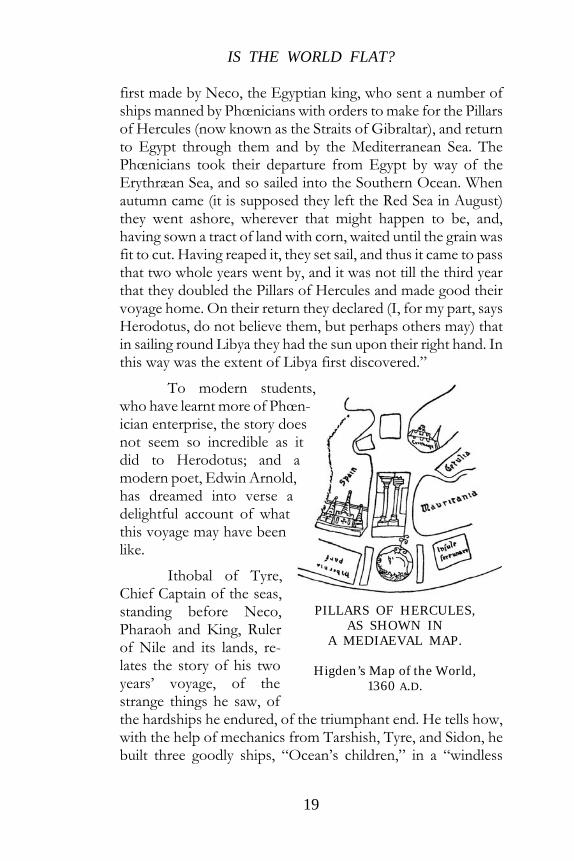
PILLARS OF HERCULES, AS SHOWN IN
A MEDIAEVAL MAP.
Higden’s Map of the World, 1360 A.D.

A BOOK OF DISCOVERY
20
creek” on the Red Sea, how he loaded them with cloth and beads, “the wares wild people love,” food-flour for the ship, cakes, honey, oil, pulse, meal, dried fish and rice, and salted goods. Then the start was made down the Red Sea, until at last “the great ocean opened” east and south to the unknown world and into the great nameless sea, by the coast of that “Large Land whence none hath come” they sailed.
Ithobal had undertaken no light task; contrary winds, mutiny on board, want of fresh water, all the hardships that confront the mariner who pilots his crews in search of the unknown. Strange tribes met them on the coast and asked them whither they went.
“We go as far as the sun goes As far as the sea rolls, as far as the stars Shine still in sky. To find for mighty Pharaoh what his worldHolds hidden.”
South and ever south they sailed, “day after day and night succeeding night, close clinging to the shore.” New stars appeared, lower and lower sank the sun, moons rose and waned, and still the coast stretched southwards till they reached a “Cape of Storms” and found the coast was turning north. And now occurred that strange phenomenon mentioned by Herodotus, that while sailing westwards the sun was on their right hand. “No man had seen that thing in Syria or in Egypt.”
A year and a half had now passed away since they left home, but onward to the north they now made their way, past the mouth of the golden waters (Orange River), past the Congo, past the Niger, past the island of Gorillas described by Hanno, who explored the west coast under Neco either before or after this time, until at last the little Phœnician ships sailed peacefully into the Mediterranean Sea.
“Here is the Ocean-Gate. Here is the Strait Twice before seen, where goes the Middle SeaUnto the Setting Sun and the Unknown—

IS THE WORLD FLAT?
21
No more unknown, Ithobal’s ships have sailedAround all Africa. Our task is done. These are the Pillars, this the Midland Sea. The road to Tyre is yonder. Every wave Is homely. Yonder, sure, Old Nilus pours Into this Sea, the Waters of the World, Whose secret is his own and thine and mine.”
It will ever remain one of the many disputed points in early geography whether or not Africa was circumnavigated at this early date. If the Phœnicians did accomplish such a feat they kept their experiences a secret as usual, and the early maps gave a very wrong idea of South Africa. On the other hand, we know they had good seaworthy ships in advance of their neighbours.
“I remember,” says Xenophon, “I once went aboard a Phœnician ship, where I observed the best example of good order that I ever met with; and es-pecially it was surprising to observe the vast numbers of implements which were necessary for the manage-ment of such a small vessel. What numbers of oars, stretchers, ship-hooks, and spikes were there for bringing the ship in and out of the harbour! What numbers of shrouds, cables; ropes; and other tackling for the ship! What a vast quantity of provisions were there for the sustenance and support of the sailors!” Captain and sailors knew where everything was stowed away on board, and “while the captain stood upon the deck, he was considering with himself what things might be wanting in his voyage, what things wanted repair, and what length of time his provisions would last; for, as he observed to me, it is no proper time, when
THE PILLARS OF HERCULES, AS SHOWN ON
THE ANGLO-SAXON MAP OF THE WORLD, TENTH
CENTURY.
A BOOK OF DISCOVERY
22
the storm comes upon us, to have the necessary implements to seek, or to be out of repair, or to want them on board; for the gods are never favourable to those who are negligent or lazy; and it is their goodness that they do not destroy us when we are diligent.”
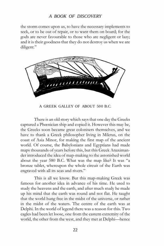
A GREEK GALLEY OF ABOUT 500 B.C.
There is an old story which says that one day the Greeks captured a Phœnician ship and copied it. However this may be, the Greeks soon became great colonisers themselves, and we have to thank a Greek philosopher living in Miletus, on the coast of Asia Minor, for making the first map of the ancient world. Of course, the Babylonians and Egyptians had made maps thousands of years before this, but this Greek Anaximan-der introduced the idea of map-making to the astonished world about the year 580 B.C. What was the map like? It was “a bronze tablet, whereupon the whole circuit of the Earth was engraved with all its seas and rivers.”
This is all we know. But this map-making Greek was famous for another idea in advance of his time. He used to study the heavens and the earth, and after much study he made up his mind that the earth was round and not flat. He taught that the world hung free in the midst of the universe, or rather in the midst of the waters. The centre of the earth was at Delphi. In the world of legend there was a reason for this. Two eagles had been let loose, one from the eastern extremity of the world, the other from the west, and they met at Delphi—hence

IS THE WORLD FLAT?
23
it was assumed that Delphi was at the centre of the world. And Delphi at this time was such a wonderful city. On the slopes of Mount Parnassus it stood high on a rock—on the heights stood the temple of Apollo with its immense riches, its golden statue of the great god, and its ever-smoking fire of wood.
In the same way, in those days of imperfect geography, as we hear of Delphi being the centre of the Greek world, so we hear of Jerusalem being considered the central point of the world.
“This is Jerusalem,” says Ezekiel, “in the midst of the nations and countries that are round about her.” In the Mappa Mundi (thirteenth century) in Hereford Cathedral, Jerusalem is still the centre of the earth.
JERUSALEM, THE CENTRE OF THE WORLD.
From the Hereford Map of the World, thirteenth century.

A BOOK OF DISCOVERY
24
Following close on these ideas came another. It, too, came from Miletus, now famous for its school of thought and its searchers after truth.
A Tour of the World is the grand-sounding title of the work of Hecatæus, who wrote it about 500 years B.C. It contains an account of the coast and islands of the Mediterra-nean Sea and an outline of all the lands the Greeks thought they knew. In the fragments that have come down to us, the famous old geographer divides both his work and the world into two parts. One part he calls Europe, the other Asia, in which he includes Africa bounded by the river Nile. He held that these two parts were equal. They were divided from one another by the Mediterranean Sea, the Black Sea, and the Caspian Sea, while round the whole flat world still flowed the everlasting ocean stream.

25
CHAPTER IV
HERODOTUS—THE TRAVELLER
THE greatest traveller of olden times now comes upon the scene—Herodotus, the Greek, the “Father of History.”
He is a traveller as well as a writer. He has journeyed as one eager for knowledge, with a “hungry heart” and a keen, observant eye. He tells us what he has seen with his eyes, what he has heard with his ears. He insists that the world is flat, he acknowledges that it is divided into two parts—Europe and Asia; but he can afford to laugh at those who draw maps of the world “without any sense to guide them,” in which they make the whole world round as if drawn with a pair of compasses, with the ocean stream running round it, making Europe and Asia of equal size.
His first journey is to Egypt.
“I speak at length about Egypt,” he says, “because it contains more marvellous things than any other country—things too strange for words. Not only is the climate different from that of the rest of the world and the rivers unlike any other rivers, but the people also, in most of their manners and customs, reverse the common practice of mankind. The women are employed in trade and business, while the men stay at home to spin and weave. Other nations in weaving throw the woof up the warp, but an Egyptian throws it down. In other countries, sons are constrained to make provision for their parents; in Egypt it is not only the sons, but the daughters. In other countries the priests have long hair; in Egypt their heads are shaven. Other nations fasten their ropes and hooks to the

A BOOK OF DISCOVERY
26
outside of their sails, but the Egyptians to the inside. The Greeks write and read from left to right, but the Egyptians from right to left.”
After sailing for some seven hundred miles up the river Nile from the coast, past Heliopolis, the once famous city of Ancient Egypt, past Memphis, the old capital, past Thebes, with its hundred gates, to Elephantine, the “ivory island,” opposite to what is now Assuan, he is more than ever puzzled about its course and the reason of its periodical floods.
“Concerning the nature of the river, I was not able to gain any information from the priests. I was particularly anxious to learn from them why the Nile, at the commencement of the summer solstice, begins to rise and continues to increase for a hundred days—and why, as soon as that number is past, it forthwith retires and contracts its stream, continuing low during the whole of the winter until the summer solstice comes round again. On none of these points could I obtain any explanation from the inhabitants, though I made every inquiry.”
The sources of the Nile entirely baffled Herodotus as they baffled many another later explorer long years after he had passed away. “Of the sources of the Nile no one can give any account, since the country through which it passes is desert and without inhabitants,” he explains, his thirst for knowledge unsatisfied. Some priest volunteers this explanation. On the frontiers of Egypt are two high mountain-peaks called Crophi and Mophi; in an unfathomable abyss between the two rose the Nile. But Herodotus does not believe in Crophi and Mophi; he inclines to the idea that the Nile rises away in the west and flows eastward right across Libya.
He travelled a little about Libya himself, little realising the size of the great continent of Africa through which he passed. Many a strange tale of these unknown parts did he relate to his people at home. He had seen the tallest and handsomest race of men in the world, who lived to the age of one hundred and twenty years—gold was so abundant that it was used even

HERODOTUS – THE TRAVELLER
27
for the prisoners’ chains—he had seen folks who lived on meat and milk only, never having seen bread or wine.
Some thirty days’ journey from the land of the lotus-eaters he had found tribes who hunted with four-horse chariots and whose oxen walked backwards as they grazed, because their horns curve outwards in front of their heads, and if they moved forwards these horns would stick in the ground.
A MERCHANT-SHIP OF ATHENS, ABOUT 500 B.C.
From a vase-painting.
Right across the desolate sandy desert of the north, Herodotus seems to have made his way. The “region of the wild beasts” must have been truly perilous, “for this is the tract,” he says, “in which huge serpents are found, and the lions, the elephants, the bears, and the horned asses.”
He also tells us of antelopes, gazelles, asses, foxes, wild sheep, jackals, and panthers. There is no end to the quaint sights he records. Here is a tribe whose wives drive the chariots to battle, here another who paint themselves red and eat honey and monkeys, another who grow their hair long on the right

A BOOK OF DISCOVERY
28
side of their heads and shave it close on the left. Back through Egypt to Syria went our observant traveller, visiting the famous seaport of Tyre on the way. “I visited the temple of Hercules at that place and found two pillars, one of pure gold, the other of emerald, shining with great brilliancy at night.’’ That temple was already two thousand three hundred years old.
Herodotus makes some astounding statements about various parts of the world. He asserts that a good walker could walk across Asia Minor, from north to south, in five days, a distance we know now to be three hundred miles! He tells us that the Danube rises in the Pyrenees Mountains and flows right through Europe till it empties its waters into the Black Sea, giving us a long and detailed account of a country he calls Scythia (Russia) with many rivers flowing into this same Black Sea.
But here we must leave the old traveller and picture him reading aloud to his delighted hearers his account of his dis-coveries and explorations, discussing with the learned Greeks of the day the size and wonders of the world as they imagined it.
News travelled slowly in these bygone days, and we know the Phœnicians were very fond of keeping their dis-coveries secret, but it seems strange to think that Herodotus never seems to have heard the story of Hanno the Carthaginian, who coasted along the west of North Africa, being the first explorer to reach the place we know as “Sierra Leone.”
Hanno’s “Periplus,” or the “Coasting Survey of Hanno,” is one of the few Phœnician documents that has lived through the long ages. In it the commander of the expedition himself tells his own story. With an idea of colonising, he left Carthage—the most famous of the Phœnician colonies—with sixty ships containing an enormous number of men and women.
“When we had set sail,” says Hanno shortly, “and passed the pillars (of Hercules) after two days’ voyage, we founded the first city. Below this city lay a great plain. Sailing thence westward we came to a promontory of Libya thickly

HERODOTUS – THE TRAVELLER
29
covered with trees. Here we built a temple to the Sea-god and proceeded thence half a day’s journey eastward, till we reached a lake lying not far from the sea and filled with abundance of great reeds. Here were feeding elephants and a great number of other wild animals. After we had gone a day’s sail beyond the lakes we founded cities near to the sea.”
Making friends with the tribes along the coast, they reached the Senegal River. Here they fell in with “savage men clothed with the skins of beasts,” who pelted them with stones so that they could not land. Past Cape Verde they reached the mouth of the Gambia, “great and broad and full of crocodiles and river-horses,” and thence coasted twelve days to the south and again five days to the south, which brought them to Sierra Leone the Lion Mountain as it was called long years after by the Portuguese.
Here Hanno and his party landed, but as night ap-proached they saw flames issuing from the island and heard the sound of flutes and cymbals and drums and the noise of con-fused shouts.
“Great fear then came upon us; we sailed therefore quickly thence much terrified, and passing on for four days found at night a country full of fire. In the middle was a lofty fire, greater than all the rest, so that it seemed to touch the stars. When day came on we found that this was a great mountain which they called the chariot of the gods.” They had a last adventure before they turned homewards at what they called the Isle of Gorillas. Here they found a “savage people” (Gorillas) whom they pursued, but were unable to catch. At last they managed to catch three. “But when these, biting and tearing those that led them, would not follow us, we slew them and, flaying off their skins, carried them to Carthage.”
Then abruptly this quaint account of the only Phœnician voyage on record stops. “Further,” says the commander, “we did not sail, for our food failed us.”

A BOOK OF DISCOVERY
30
THE COAST OF AFRICA, AFTER PTOLEMY
This map shows the extent of Hanno’s voyage from the Pillars of Hercules, past the Equator, to what is now called Sierra Leone.

HERODOTUS – THE TRAVELLER
31
Further knowledge of the world was now supplied by the Greeks, who were rapidly asserting themselves and settling round the coast of the Mediterranean as the Phœnicians had done before them. As in more ancient days Babylonians and Egyptians had dominated the little world, so now the power was shifting to the Greeks and Persians. The rise of Persia does not rightly belong to this story, which is not one of conquest and annexation, but of discovery, so we must content ourselves by stating the fact that Persia had become a very important country with no less than fifty-six subject States paying tribute to her, including the land of Egypt. Efforts to include Greece had failed.
In the year 401 B.C. one Artaxerxes sat on the throne of Persia, the mighty Empire which extended eastwards beyond the knowledge of Greeks or Phœnicians, even to the unknown regions of the Indus. He had reigned for many years, when Cyrus, his brother, a dashing young prince, attempted to seize the throne. Collecting a huge army, including the famous Ten Thousand Greeks, he led them by way of Phrygia, Cilicia, and along the banks of the Euphrates to within fifty miles of the gates of Babylon. The journey took nearly five months, a dis-tance of one thousand seven hundred miles through recognised tracks. Here a battle was fought and Cyrus was slain.
It was midwinter when the Ten Thousand Greeks who had followed their leader so loyally through the plains of Asia Minor found themselves friendless and in great danger in the very heart of the enemy’s country.
How Xenophon—a mere Greek volunteer, who had accompanied the army from the shores of Asia Minor—rose up and offered to lead his countrymen back to Greece is a matter of history. It would take too long to tell in detail how they marched northward through the Assyrian plains, past the neighbourhood of Nineveh, till they reached the mountain regions which were known to be inhabited by fierce fighters, unconquered even by the powerful Persians.

A BOOK OF DISCOVERY
32
Up to this time their line of retreat had followed the “royal road” of merchants and caravans. Their only chance of safety lay in striking north into the mountains inhabited by this warlike tribe who had held out amid their wild and rugged country against the Persians themselves. They now opposed the Greeks with all their might, and it took seven days of continuous fighting to reach the valley which lay between them and the high tableland of Armenia. They crossed the Tigris near its source, and a little farther on they also crossed the Euphrates not far from its source, so they were informed by the Armenians. They now found themselves some five or six thousand feet above sea-level and in the midst of a bitter Armenian winter. Snow fell heavily, covering all tracks, and day after day a cold north-east wind, “whose bitter blast was torture,” increased their sufferings as they ploughed their way on and on through such depths of snow as they had never seen before.
Many died of cold and hunger, many fell grievously sick, and others suffered from snow-blindness and frostbite.
But Xenophon led his army on, making his notes of the country through which they were toiling, measuring distances by the day’s march, and at last one day when the soldiers were climbing a steep mountain, a cry, growing louder and more joyous every moment, rent the air—
“Thalassa! Thalassa! The sea! The sea!”
True enough, on the distant horizon, glittering in the sunlight, was a narrow silver streak of sea—the Black Sea—the goal of all their hopes. The long struggle of five months was over; they could sail home now along the shores of the Black Sea. They had reached the coast near the spot Colchis, where the Argonauts landed to win the Golden Fleece long centuries before.
In a work known as the Anabasis, Xenophon wrote the adventures of the Ten Thousand Greeks, and no geographical explorer ever recorded his travels through unknown countries

HERODOTUS – THE TRAVELLER
33
more faithfully than did the Greek leader of twenty-three hundred years ago.
34
CHAPTER V
ALEXANDER THE GREAT EXPLORES
INDIA STILL greater light was shed on the size of the world by Alexander the Great on his famous expedition to India, by which he almost doubled the area of the world known to the people of his time. It was just sixty years after Xenophon had made his way right across Asia to the shores of the Black Sea when Alexander resolved to break, if possible, the power of the Persians.
The great Persian Empire extended from the shores of the Mediterranean right away to the east, far beyond the know-ledge of the Greeks. Indeed, their knowledge of the interior of Asia was very imperfect, and Alexander’s expedition was rather that of an explorer than of a conqueror. How he overthrew the Persians and subdued an area as large as Europe in the space of twelve years reads like a romance rather than fact, and it is not for us to tell the story in detail. Rather let us take up the story after Alexander has fought and conquered the Persians twice, besieged Tyre, taken the Phœnician fleet, occupied Egypt, marched across the desert and crossed the Euphrates, passed over the plain and followed the Tigris to near Nineveh, where he crossed that river too, fought another famous battle over the Persians, which decided the fate of King and Monarchy and opened to him the capitals of Babylon and Susa, wherein the immense treasures of the Persian Empire were stored. King of all Asia, he sat on the throne of the Persian kings under a golden canopy in the palace of Persepolis.

ALEXANDER THE GREAT EXPLORES INDIA
35
So far the whole expedition was over country known, if imperfectly, to the Greeks. Now we have to follow the con-quering hero more closely as he leads us into an unknown land away to the east, known as “the farthest region of the inhabited world towards the east, beyond which lies the endless sandy desert void of inhabitants.” And all the while the great land of India lay beyond, and beyond again was China, and away far over the ocean sea lay America—and they knew it not.
Alexander was a young man yet, only twenty-six. It was four years since he had left Europe, and in that short time he had done wonders. He had conquered the whole eastern half of the Persian Empire. Now he resolutely turned his face to the unknown east and started forth on an expedition of exploration.
Following the main highway from Media, which to-day leads from Teheran, capital of modern Persia, into the land of the Turkomans and the borders of Russia, he found himself between the great salt desert and the mountains, which to-day mark the frontier of Persia. Suddenly, to his great surprise, the Caspian Sea came into sight. It seemed about the same size as the Black Sea, and he concluded it was connected with the Sea of Azof; though the men of his day were certain enough that it was the most northern of four great gulfs connected with the outer ocean which flowed round the world.
Onwards towards the east he marched with his great army. To conciliate the tribes through which he passed, he adopted Persian dress. This annoyed his Greek countrymen, but, “as they admired his other virtues, they thought he might be suffered to please himself a little and enjoy his vanity.”
Arrived at the modern boundary between Persia, Af-ghanistan, and Russia, he and his men pushed on across Afghanistan, by the caravan route that had long existed from the shores of the Caspian, by modern Herat, Kandahar, which still bears the conqueror’s name, and Kabul to India. Their way lay through deep snow, deeper than they had ever seen before; and by the time they had reached the mountains of Kabul it was midwinter.

A BOOK OF DISCOVERY
36
Between Alexander and India still lay the lofty range of the Hindu Koosh or Indian Caucasus. But before going south toward India, he turned northwards to explore the unknown country which lay about the river Oxus. They found the Oxus, a mighty stream, swollen with melting snows. There were no boats and no wood to build them, so Alexander pioneered his men across in “life-preservers” made out of their leather tent coverings and stuffed with straw. This river impressed the Greeks even more than the Euphrates and Tigris, as it im-pressed many an explorer and poet since these early days. Let us recall Matthew Arnold’s famous description of the Oxus, now seen for the first time by the Greeks.
“But the majestic river floated on, Out of the mist and hum of that low land, Into the frosty starlight,—he flow’d Right for the polar star, past Orgynje Brimming, and bright, and large; then sands begin To hem his watery march and dam his streams, And split his currents; that for, many a league The shorn and parcell’d Oxus strains along Through beds of sand and matted rushy isles— Oxus, forgetting the bright speed he had, In his high mountain-cradle in Pamere, A foil’d circuitous wanderer—till at last The long’d for dash of waves is heard, and wide His luminous home of waters opens, bright And tranquil, from whose floor the new-bathed starsEmerge, and shine upon the Aral Sea.”
Here in this valley the Greeks met more determined op-position than they had yet encountered since entering Asia, and over two years were occupied in reducing this single district (now Bokhara and Turkestan) to submission, though it was only some three hundred and fifty miles square, and in one single year Alexander had conquered a kingdom over one thousand miles in width.
ALEXANDER THE GREAT EXPLORES INDIA
37
It was not till the spring of 827 B.C. that he was ready to cross the Hindu Koosh and begin the great expedition into India. The night before the start Alexander discovered that his troops were now so heavily laden with spoils that they were quite unfit for the long march. So in the early morning, when they were all ready to start, he suddenly set fire to his own baggage, and, giving orders that all his men were to do the same, the army started for the passes of the lofty mountain range. And—
“ . . . . as a troop of pedlars from Kabul Cross underneath the Indian Caucasus, That vast sky neighbouring mountain of milk snow; Crossing so high, that, as they mount, they pass Long flocks of travelling birds dead on the snow, Choked by the air, and scarce can they themselves Slake their parch’d throats with sugar’d mulberries— In single file they move, and stop their breath, For fear they should dislodge the o’erhanging snows.”
The banks of the river of Kabul were reached at last. Sending part of the army by the now famous Kyber Pass toward the Indus, Alexander himself undertook to subdue the moun-tain tribes and get control of the Chitral passes. The shepherds of this region opposed him vigorously, but swiftly and pitilessly the King of Asia sacked their peaceful homes, and city after city fell to him as he advanced towards the boundaries of Kashmir.
At last the valley of the Indus was reached. A bridge of boats was hastily thrown over, and Alexander and his army passed to the other side.
Porus, the ruler of the country between the Indus and the river Hydaspes (Jehlam), sent presents of welcome to the invader, including three thousand animals for sacrifice, ten thousand sheep, thirty elephants, two hundred talents of silver, and seven hundred horsemen. The new king was also greeted with presents of ivory and precious stones. Even from far Kashmir came greetings to Alexander, whose fame was spread-

A BOOK OF DISCOVERY
38
ing rapidly. He now entered the Punjab, the “Land of the Five Rivers.” But on the other side of the river Hydaspes a different reception awaited him.
There the king (Porus) had assembled a sturdy, well-disciplined troop to dispute the passage of the river, which separated the new King of Asia from his territory. But under cover of a mighty thunderstorm Alexander contrived to cross, though the river was rushing down yellow and fierce after the rains. Secretly the Greeks put together their thirty-oared galleys hidden in a wood, and utterly surprised Porus by landing on the other side. In their strange wanderings the Greeks had fought under varying conditions, but they had never faced elephants before. Nevertheless, they brilliantly repulsed an onslaught of these animals, who slowly retreated, “facing the foe, like ships backing water, and merely uttering a shrill, piping sound.” Despite the elephants the old story was repeated, civilised arms triumphed over barbarians, and the army of Porus was annihilated, his chariots shattered, and thirty-three thousand men slain.
The kingdom beyond the Hydaspes was now Alexan-der’s. Ordering a great fleet of rafts and boats to be built for his proposed voyage to the mouth of the Indus, he pushed on to complete the conquest of the Five Stream Land, or the Punjab—the last province of the great Persian Empire. This was India—all that was known at this time. The India of the Ganges valley was beyond the knowledge of the Western world—the Ganges itself unknown to the Persians. And Alexander saw no reason to change his mind.
“The great sea surrounds the whole earth,” he stoutly maintained.
But when he reached the eastern limit of the Punjab and heard, that beyond lay a fertile land “where the inhabitants were skilled in agriculture, where there were elephants in yet greater abundance and men were superior in stature and courage,” the world stretched out before him in an unexpected direction, and

ALEXANDER THE GREAT EXPLORES INDIA
39
he longed to explore farther, to conquer new and utterly unknown worlds!
But at last his men struck. They were weary, some were wounded, some were ill; seventy days of incessant rain had taken the heart out of them.
“I am not ignorant, soldiers,” said Alexander to the hesi-tating troops, that during the last few days the natives of this country have been spreading all sorts of rumours to work upon your fears. The Persians in this way sought to terrify you with the gates of Cilicia, with the plains of Mesopotamia, with the Tigris and Euphrates, and yet this river you crossed by a ford and that by means of a bridge. By my troth, we had long ago fled from Asia could fables have been able to scare us. We are not standing on the threshold of our enterprise, but at the very close. We have already reached the sunrise and the ocean, and unless your sloth and cowardice prevent, we shall thence return in triumph to our native land, having conquered the earth to its remotest bounds. I beseech you that ye desert not your king just at the very moment when he is approaching the limits of the inhabited world.”
But the soldiers, “with their heads bent earthwards,” stood in silence. It was not that they would not follow him beyond the sunset; they could not. Their tears began to flow, sobs reached the ears of Alexander, his anger turned to pity, and he wept with his men.
“Oh, sir,” at last cried one of his men, “we have done and suffered up to the full measure of the capacity of mortal nature. We have traversed seas and lands, and know them better than do the inhabitants themselves. We are standing now almost on the earth’s utmost verge, and yet you are preparing to go in quest of an India unknown even to the Indians themselves. You would fain root out, from their hidden recesses and dens, a race of men that herd with snakes and wild beasts, so that you may traverse as a conqueror more regions than the sun surveys. But while your courage will be ever growing, our vigour is fast waning to its end. See how bloodless be our bodies, pierced

A BOOK OF DISCOVERY
40
with how many wounds and gashed with how many scars! Our weapons are blunt, our armour worn out! We have been driven to assume the Persian dress! Which of us has a horse? We have conquered all the world, but are ourselves destitute of all things.”
The conqueror was at last conquered. The order to turn back was reluctantly given by the disappointed king and leader. It was received with shouts of joy from the mixed multitudes of his followers, and the expedition faced for home. Back they marched through the new lands where no less than two thousand cities had owned his sway, till they came to the banks of the river where the ships were building. Two thousand boats were ready, including eighty thirty-oared galleys.
It was now September 326 B.C.
Nearchus from Crete was made Admiral of the new fleet, which at dawn one October morning pushed out upon the river Hydaspes and set sail downstream towards the unknown sea, Alexander standing proudly on the prow of the royal galley. The trumpets rang out, the oars moved, and the strange argosy, “such as had never been seen before in these parts,” made its way down the unknown river to the unknown sea. Natives swarmed to the banks of the river to wonder at the strange sight, marvelling specially to see horses as passengers on board! The greater part of the army followed the ships on land, marching along the shores. At last the waters of the Hydaspes mingled with those of the Indus, and onwards down this great river floated the Persian fleet. Alexander had no pilots, no local knowledge of the country, but with his “unquenchable ambition to see the ocean and reach the boundaries of the world,” he sailed on, “ignorant of everything on the way they had to pass.” In vain they asked the natives assembled on the banks how far distant was the sea; they had never heard of the sea! At last they found a tide mixing its salt waters with the fresh. Soon a flood-tide burst upon them, forcing back the current of the river, and scattering the fleet. The sailors of the Mediterranean knew nothing of the rise and fall of tides. They were in a state of panic and consternation. Some tried to push off their ships with

ALEXANDER THE GREAT EXPLORES INDIA
41
long poles, others tried to row against the incoming tide; prows were dashed against poops, oars were broken, sterns were bumped, until at last the sea had flowed over all the level land near the river mouth.
Suddenly a new danger appeared! The tide turned and the sea began to recede. Further misfortunes now befell the ships. Many were left high and dry; most of them were damaged in some way or another. Alexander sent horsemen to the seashore with instructions to watch for the return of the tide and to ride back in haste so that the fleet might be prepared.
Thus they got safely out to sea on the next high tide.
Alexander’s explorations were now at an end. Leaving Nearchus to explore the seacoast at the mouth of the Indus, he left the spot near where the town of Hyderabad now stands, and turned his face toward the home he was never to reach. We must not linger over his terrible coast journey through the scorching desert of Beluchistan: the billows of sand, the glare of the barren sea, the awful thirst, the long hungry marches of forty miles a day under the burning Eastern sun.
Our story is one of discovery, and we must turn to Nearchus, Admiral of the fleet, left behind at the mouth of the Indus to explore the coast to the Persian Gulf, where he was to meet Alexander if possible. Shortly after the fleet had emerged from the mouth of the Indus a violent south-west monsoon began to blow and Nearchus was obliged to seek shelter in a harbour, which he called the port of Alexander, but which to-day is known as Karachi, the most western seaport of India. The waters of the Indian Ocean were quite unknown to the Greeks, and they could only coast along in sight of land, anchoring at different points for the men to land and get water and food. Past the wild barren shores of Beluchistan they made their way; the natives subsisted on fish entirely even as they do to-day—even their huts being made of fish bones and their bread of pounded fish.

A BOOK OF DISCOVERY
42
A SKETCH-MAP OF ALEXANDER’S CHIEF EXPLORATORY MARCHES FROM ATHENS TO HYDERABAD AND GAZA.
The dotted line shows the course of Nearchus’ voyage down the river Indus, along the northern shores of the Indian Ocean, and up the Persian Gulf to Babylonia.
They had but one adventure in their five months’ cruise to the Persian Gulf, but we have a graphic account of how the terrified Greeks met a shoal of whales and how they frightened the whales away. Here is the story. One day towards daybreak they suddenly saw water spouting up from the sea, as if being violently carried upwards by whirlwinds. The sailors, feeling very frightened, asked their native guides what it meant. The natives replied that it was caused by whales blowing the water up into the air. At this explanation the Greek sailors were panic-stricken and dropped the oars from their hands. Nearchus saw that something must be done at once. So he bade the men draw up their ships in line as if for battle and row forward side by side towards the whales, shouting and splashing with their oars. At a given signal they duly advanced, and when they came near the sea-monsters they shouted with all their might and blew their trumpets and made all possible noise with their oars. On hearing which, says the old story, “the whales took fright and plunged into the depths, but not long after came to the surface

ALEXANDER THE GREAT EXPLORES INDIA
43
again close to the sterns of the vessels and once more spouted great jets of water. Then the sailors shouted aloud at their happy and unlooked-for escape,” and Nearchus was cheered as the saviour of the fleet. It is not uncommon to-day for steamers bound from Aden to Bombay to encounter what is called a “school of whales” similar to those which alarmed the fleet of Nearchus in the year 323 B.C.
The expedition was completely successful and Nearchus pioneered his fleet to the mouth of the Euphrates.
But the death of Alexander the Great and the confusion that followed set back the advance of geographical discovery in this direction for some time.
Alexandria—one of the many towns founded by Alex-ander—had become the world centre of the learned from Europe, Asia, and Africa. Its position was unrivalled. Situated at the mouth of the Nile, it commanded the Mediterranean Sea, while by means of the Red Sea it held easy communication with India and Arabia. When Egypt had come under the sway of Alexander, he had made one of his generals ruler over that country, and men of intellect collected there to study and to write. A library was started, and a Greek, Eratosthenes, held the post of librarian at Alexandria for forty years, namely, from 240–190 B.C. During this period he made a collection of all the travels and books of earth description—the first the world had ever known—and stored them in the Great Library of which he must have felt so justly proud. But Eratosthenes did more than this. He was the originator of Scientific Geography. He realised that no maps could be properly laid down till something was known of the size and shape of the earth.
By this time all men of science had ceased to believe that the world was flat; they thought of it as a perfect round, but fixed at the centre in space. Many had guessed at the size of the earth. Some said it was forty thousand miles round, but Eratosthenes was not content with guessing. He studied the length of the shadow thrown by the sun at Alexandria and compared it with that thrown by the sun at Syene, near the first

A BOOK OF DISCOVERY
44
ALEXANDRIA IN PIZZIGANI’S MAP,
FOURTEENTH CENTURY.
The river with the buildings on its bank is the Nile.
cataract of the Nile, some five hundred miles distant, and, as he thought, in the same longitude. The differences in the length of these two shadows he calculated would represent one-fiftieth of the circumference of the earth, which would accordingly be twenty-thousand miles. There was no one to tell him whether he had calculated right or wrong, but we know to-day that he was wonderfully right. But he must know more. He must find out how much of this earth was habitable. To the north and south of the known countries men declared it was too hot or too cold to live. So he decided that from north to south, that is, from the land of Thule to the land of Punt (Somaliland), the habitable earth stretched for some three thousand eight hundred miles, while from east to west—that is, from the Pillars of Hercules (Straits of Gibraltar) to India—would be some eight thousand miles. All the rest was ocean. Ignoring the division of

ALEXANDER THE GREAT EXPLORES INDIA
45
the world into three continents, he divided it into two, north and south, divided by the Mediterranean and by a long range of mountains intersecting the whole of Asia.
Then the famous librarian drew a map of the world for his library at Alexandria, but it has perished with all the rest of the valuable treasure collected in this once celebrated city. We know that he must have made a great many mistakes in drawing a map of his little island world which measured eight thousand miles by three thousand eight hundred miles. It must have been quaintly arranged. The Caspian Sea was connected with a Northern Ocean, the Danube sent a tributary to the Adriatic, there was no Bay of Biscay, the British Isles lay in the wrong direction, Africa was not half its right size, the Ganges flowed into the Eastern Ocean, Ceylon was a huge island stretching east and west, while across the whole of Asia a mountain chain stretched in one long unbroken line. And yet, with all his errors, he was nearer the truth than men three centuries later.

46
CHAPTER VI
PYTHEAS FINDS THE BRITISH ISLES
FOR some centuries past men had been pushing eastward, and to west, vast lands lay unexplored, undreamt of, amongst them a little far-off island “set in a silver sea.” Pytheas was the first explorer to bring the world news of the British Isles.
About the time that Alexander was making his way eastward through Persia, Pytheas was leaving the Greek colony of Marseilles for the west and north. The Phœnicians, with their headquarters at Carthage, had complete command of the mineral trade of Spain—the Mexico of the ancient world. They knew where to find the gold and silver from the rivers—indeed, they said that the coast, from the Tagus to the Pyrenees, was “stuffed with mines of gold and silver and tin.” The Greeks were now determined to see for themselves—the men of Carthage should no longer have it all their own way. Where were these tin islands, kept so secret by the master-mariners of the ancient world?
A committee of merchants met at Marseilles and en-gaged the services of Pytheas, a great mathematician, and one who made a study of the effect of the moon on the tides. All sorts of vague rumours had reached the ears of Pytheas about the northern regions he was about to visit. He would discover the homes of the tin and amber merchants, he would find the people who lived “at the back of the north wind,” he would reach a land of perpetual sunshine, where swans sang like nightingales and life was one unending banquet.

PYTHEAS FINDS THE BRITISH ISLES
47
So Pytheas, the mathematician of Marseilles, started off on his northern trip. Unfortunately, his diary and book called The Circuit of the Earth have perished, and our story of geographical discovery is the poorer. But these facts have survived.
The ships first touched at Cadiz, the “Tyre of the West,” a famous port in those days, where Phœnician merchants lived, “careless and secure” and rich. This was the limit of Greek geographical knowledge; here were the Pillars of Hercules, beyond which all was dim and mysterious and interesting. Five days’ sail, that is to say, some three hundred miles along the coast of Spain, brought Pytheas to Cape St. Vincent.
He thought he was navigating the swift ocean river flowing around the world. He was, therefore, surprised to find as he rounded the Cape that the current had ceased, or, in his own words, the “ebb came to an end.” Three days more and they were at the mouth of the Tagus. Near this part of the coast lay the Tin Islands, according to Greek ideas, though even to-day their exact locality is uncertain. Pytheas must have heard the old tradition that the Cassiterides were ten in number and lay near each other in the ocean, that they were inhabited by people who wore black cloaks and long tunics reaching to the feet, that they walked with long staves and subsisted by their cattle. They led a wandering life; they bartered hides, tin, and lead with the merchants in exchange for pottery, salt, and implements of bronze.
That these islands had already been visited by Himilco the Carthaginian seems fairly certain. He had started from Cadiz for the north when Hanno started for the south. From the Tin Islands his fleet had ventured forth into the open sea. Thick fogs had hidden the sun and the ships were driven south before a north wind till they reached, though they did not know it, the Sargasso Sea, famous for its vast plains of seaweed, through which it was difficult to push the ships.
“Sea animals,” he tells us, “crept upon the tangled weed.” It has been thought that with a little good fortune

A BOOK OF DISCOVERY
48
Himilco might have discovered America two thousand years before the birth of Columbus. But Himilco returned home by the Azores or Fortunate Islands, as they were called.
Leaving the Tin Islands, Pytheas voyaged on to Cape Finisterre, landing on the island of Ushant, where he found a temple served by women priests who kept up a perpetual fire in honour of their god. Thence Pytheas sailed prosperously on up the English Channel till he struck the coast of Kent. Britain, he announced, was several days’ journey from Ushant, and about one hundred and seventy miles to the north. He sailed round part of the coast, making notes of distances, but these are curiously exaggerated. This was not unnatural, for the only method of determining distance was roughly based on the number of miles that a ship could go in an hour along the shore. Measuring in this primitive fashion, Pytheas assures us that Britain is a continent of enormous size, and that he has discovered a “new world.” It is, he says, three cornered in shape, something like the head of a battleaxe. The south side, lying opposite the coast of France, is eight hundred and thirty-five miles in length, the eastern coast is sixteen hundred and sixty-five miles, the western two thousand two hundred and twenty-two—indeed, the whole country was thought to be over four thousand miles in circumference. These calculations must have been very upsetting to the old geographers of that age, because up to this time they had decided that the whole world was only three thousand four hundred miles long and six thousand eight hundred broad.
He tells us that he made journeys into the interior of Britain, that the inhabitants drink mead, and that there is an abundance of wheat in the fields.
“The natives,” he says, “collect the sheaves in great barns and thrash out the corn there, because they have so little sunshine that an open thrashing-place would be of little use in that land of clouds and rain.” He seems to have voyaged north as far as the Shetland Islands, but he never saw Ireland.

PYTHEAS FINDS THE BRITISH ISLES
49
Having returned from the north of the Thames, Pytheas crossed the North Sea to the mouth of the Rhine, a passage which took about two and a half days. He gives a pitiable account of the people living on the Dutch coast and their perpetual struggle with the sea. The natives had not learnt the art of making dykes and embankments. A high tide with a wind setting toward the shore would sweep over the low-lying country and swamp their homes. A mounted horseman could barely gallop from the rush and force of these strong North Sea tides.
But the Greek geographers would not believe this; they only knew the tideless Mediterranean, and they thought Pytheas was lying when he told of the fierce northern sea. Pytheas sailed past the mouth of the Elbe, noting the amber cast upon the shore by the high spring tides. But all these interesting discoveries paled before the famous land of Thule, six days’ voyage north of Britain, in the neighbourhood of the frozen ocean. Grand excitement reigned among geographers when they heard of Thule, and a very sea of romance rose up around the name. Had Pytheas indeed found the end of the world? Was it an island? Was it mainland? In the childhood of the world, when so little was known and so much imagined, men’s minds caught at the name of Thule— Ultima Thule—far-away Thule, and weaved round it many and beautiful legends. But to-day we ask: Was it Iceland? Was it Lapland? Was it one of the Shetland Isles?
“Pytheas said that the farthest parts of the world are those which lie about Thule, the northernmost of the Britannic Isles, but he never said whether Thule was an island or whether the world was habitable by man as far as that point. I should think myself”—the speaker is Strabo, a famous Greek traveller who wrote seventeen books of geography—“I should think myself that the northern limit of habitude lies much farther to the south, for the writers of our age say nothing of any place beyond Ireland, which is situate in front of the northern parts of Britain.” Pytheas said that Thule was six days’ sail north of Britain. “But who in his senses would believe this?” cries Strabo

A BOOK OF DISCOVERY
50
again. “For Pytheas, who described Thule, has been shown to be the falsest of men. A traveller, starting from the middle of Britain and going five hundred miles to the north, would come to a country somewhere about Ireland, where living would be barely possible.”
NORTH BRITAIN AND THE ISLAND OF THULE.
From Mercator’s edition of Ptolemy’s map.
The first account of the Arctic regions likewise reads like pure romance to the ignorant and untravelled. “After one day’s journey to the north of Thule,” says Pytheas, “men come to a sluggish sea, where there is no separation of sea, land, and air, but a mixture of these elements like the substance of jelly-fish, through which one can neither walk nor sail.” Here the nights were very short, sometimes only two hours, after which the sun rose again. This, in fact, was the “Sleeping Palace of the Sun.”
With all this wealth of discovery, Pytheas returned home by the Bay of Biscay to the mouth of the Gironde; thence sailed

PYTHEAS FINDS THE BRITISH ISLES
51
up the Garonne, and from the modern town of Bordeaux he reached Marseilles by an overland journey.