a better way to grow?
TRANSCRIPT
-I;
A BETTER WAY TO GROW?
Land Readjustment through Town Planning Schemes in Ahmedabad
By
Chandan Deuskar
BA in ArchitectureColumbia University
New York, New York (2007)
Submitted to the Department of Urban Studies and Planningin partial fulfillment of the requirements for the degree of
Master in City Planning
at the
MASSACHUSETTS INSTITUTE OF TECHNOLOGY
June 2011
@ 2011 Chandan Deuskar. All Rights Reserved.The author hereby grants to MIT the permission to reproduce and to distributepublicly paper and electronic copies of the thesis document in whole or in part.
MASSACHUSETTS INSTITUTEOF TECH oLoGy
JUN 3 0 2011
L IBRA R IES
ARCHIVES
Department of Urban Studies and PlanningMay 19, 2011
Certified by
Accepted by
Professor Bishwapriya SanyalDepartment of Urban Studies and Planning
Thesis Supervisor
/t"- r Professor Joseph FerreiraChair, MCP Committee
Department of Urban Studies and Planning
Author
/
r C-1

. ........... .......... -- ---- ----------- --
A Better Way to Grow?Land Readjustment through Town Planning Schemes in Ahmedabad
By Chandan Deuskar
Submitted to the Department of Urban Studies and Planning on May 19, 2011 in partialfulfillment of the requirements for the degree of Master in City Planning
ABSTRACT
The Town Planning Scheme mechanism for the expansion of the city of Ahmedabad,India, has attracted widespread interest in recent years. It is seen as a participatory andequitable means of acquiring land from rural landowners on the urban fringe. A form of landreadjustment, it allows local authorities to acquire a proportion of all the land parcels in adefined area on which to build public roads, parks, and other amenities. The authoritiesreturn remaining land to the original landowners in the form of reconstituted parcels, whichhave increased in value due to the improvements. The landowner pays half of this increase inland value to the government as a betterment charge, which helps the government covers itscosts. As it appears to benefit both landowners and the government while also expandingurban infrastructure, proponents often claim that the TP scheme mechanism is a 'win-win'proposition.
This thesis evaluates the extent to which the mechanism lives up to the claims made on itsbehalf. It compares the idealized version of the process laid out in legislation to how itactually works on the ground in Ahmedabad. While landowners and the government both dobenefit financially, land valuation is carried out in a roundabout way, with large differencesbetween calculated land values and actual market values. The mechanism is not asparticipatory as it is often described as being, with the state government playing acontrolling role, and courts usually defending the government's use of its wide-rangingpowers of discretion. Authorities also have not taken full advantage of the ability of TPschemes to house the poor. This thesis suggests alternative institutional models with whichTP schemes could be made more efficient, and which would allow landowners to havegreater control over the process.
Thesis Committee:Bishwapriya SanyalFord International Professor of Urban Development and Planning
Annette KimFord International Career Development Associate Professor of Urban Studies and Planning
ACKNOWLEDGMENTS
This thesis would not have been possible without the guidance of my advisor, Bish Sanyal.Working with him on this and other projects over the last two years has been a valuablelearning experience, a source of many opportunities, and a pleasure. I would also like tothank my reader, Annette Kim for her insights; Yu-Hung Hong and Karin Brandt of theLincoln Institute for Land Policy, who were instrumental in giving me the chance to researchthis subject; Stephanie Tam, whose comments helped me refine my argument; and ShibenBanerji, whose advice and guidance a few years ago brought me to MIT.
I am grateful to all those who generously shared their time and expertise with me on myvisits to Ahmedabad and Delhi: Shirley Ballaney, Bimal Patel, Patricia Clarke Annez, ChetanVaidya, Ranesh Nair, Rutul Joshi, RB Joshi, Vatsal Patel, Snehanshu Mukherjee, ChirayuBhatt, Sonal Shah, Dinesh Mehta and Genevieve Connors.
Lastly, I would like to thank my family, as well as my classmates and friends at DUSP, fortheir support.
CONTENTS
Abstract 4
Acknowledgments 5
List of Tables and Figures 6
Glossary of Abbreviations 9
A Note on Terminology 10
1 Introduction 1|
2 History 15
2.1 Origins 15
2.2 TP schemes after Independence 19
2.3 TP schemes today 24
3 Rules and Realities 26
3.1 The Development Plan 26
3.2 The Town Planning Scheme mechanism: as prescribed 32
3.3 The Town Planning Scheme mechanism: as practiced 37
4 DP-TPS and the Public 55
4.1 Public participation in the development plan 55
4.2 Public participation in the preparation of TP schemes 56
4.3 TP schemes and housingfor the poor 67
4.4 TP schemes and the courts 75
5 Land Readjustment in Other Indian States 78
5.1 Maharashtra 78
5.2 Kerala 80
5.3 Andhra Pradesh 82
5.4 Tamil Nadu 82
5.5 Punjab 82
6 Conclusions 85
6.1 The future of TP schemes 85
6.2 Alternative institutional models 92
6.3 Unresolved questions 94
Appendices 97
A List of AMC TP schemes and their sanction dates 97
B List of A UDA TP schemes and their sanction dates 100
References 103
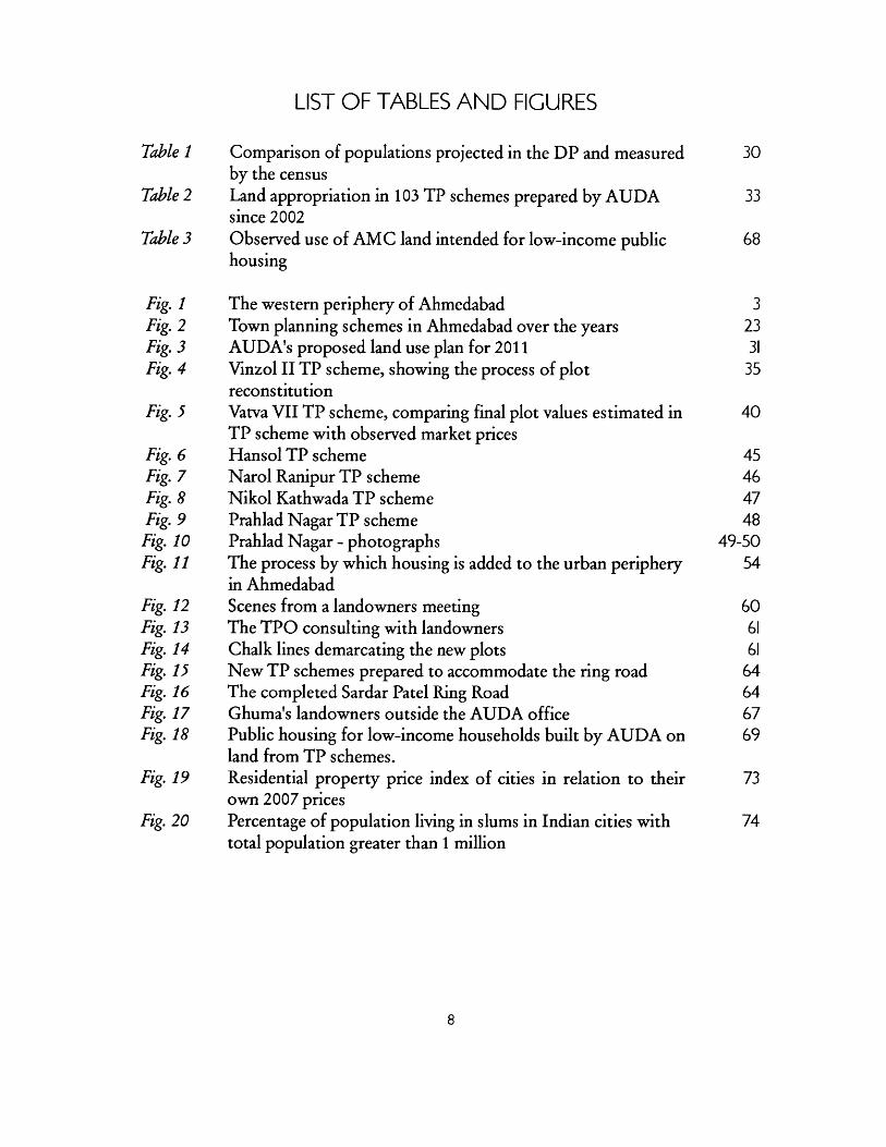
LIST OF TABLES AND FIGURES
Table 1 Comparison of populations projected in the DP and measured 30by the census
Table 2 Land appropriation in 103 TP schemes prepared by AUDA 33since 2002
Table 3 Observed use of AMC land intended for low-income public 68housing
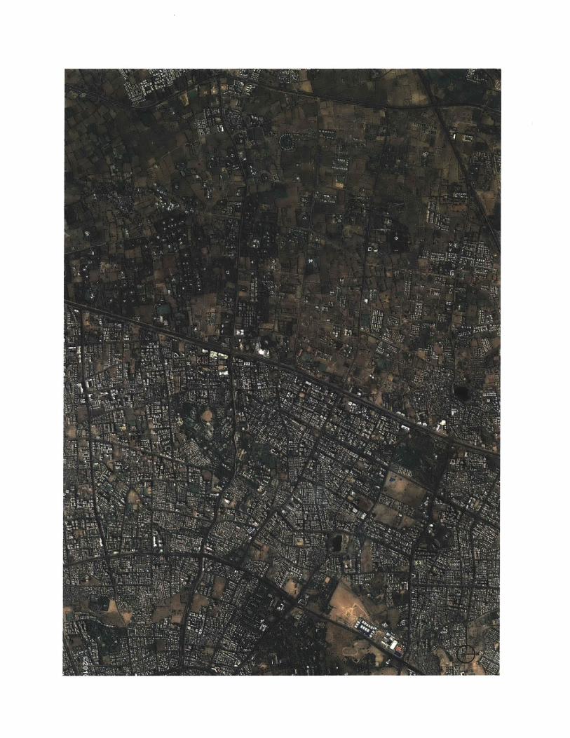
Fig. 1 The western periphery of Ahmedabad 3Fig. 2 Town planning schemes in Ahmedabad over the years 23Fig. 3 AUDA's proposed land use plan for 2011 31Fig. 4 Vinzol II TP scheme, showing the process of plot 35
reconstitutionFig. 5 Vatva VII TP scheme, comparing final plot values estimated in 40
TP scheme with observed market pricesFig. 6 Hansol TP scheme 45Fig. 7 Narol Ranipur TP scheme 46Fig. 8 Nikol Kathwada TP scheme 47Fig. 9 Prahlad Nagar TP scheme 48Fig. 10 Prahlad Nagar - photographs 49-50Fig. 11 The process by which housing is added to the urban periphery 54
in AhmedabadFig. 12 Scenes from a landowners meeting 60Fig. 13 The TPO consulting with landowners 61Fig. 14 Chalk lines demarcating the new plots 61Fig. 15 New TP schemes prepared to accommodate the ring road 64Fig. 16 The completed Sardar Patel Ring Road 64Fig. 17 Ghuma's landowners outside the AUDA office 67Fig. 18 Public housing for low-income households built by AUDA on 69
land from TP schemes.Fig. 19 Residential property price index of cities in relation to their 73
own 2007 pricesFig. 20 Percentage of population living in slums in Indian cities with 74
total population greater than 1 million
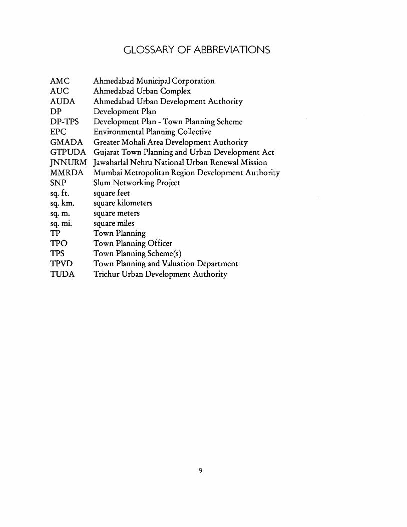
GLOSSARY OF ABBREVIATIONS
AMCAUCAUDADPDP-TPSEPCGMADAGTPUDAJNNURMMMRDASNPsq. ft.sq. km.sq. m.sq. mi.TPTPOTPSTPVDTUDA
Ahmedabad Municipal CorporationAhmedabad Urban ComplexAhmedabad Urban Development AuthorityDevelopment PlanDevelopment Plan - Town Planning SchemeEnvironmental Planning CollectiveGreater Mohali Area Development AuthorityGujarat Town Planning and Urban Development ActJawaharlal Nehru National Urban Renewal MissionMumbai Metropolitan Region Development AuthoritySlum Networking Projectsquare feetsquare kilometerssquare meterssquare milesTown PlanningTown Planning OfficerTown Planning Scheme(s)Town Planning and Valuation DepartmentTrichur Urban Development Authority
A NOTE ON TERMINOLOGY
The Town Planning (TP) Scheme mechanism is a type of "land pooling", "plot
reconstitution" and/or "land readjustment" mechanism. According to Archer (1992), among
other differences, "land pooling/ readjustment" projects recover costs through the sale of
land only, while "plot reconstitution" projects recover costs through a betterment charge. As
TP schemes do both, by this definition they would be considered a hybrid of the two.
However, elsewhere, Archer himself makes a different distinction (1999), saying that the
difference between "land pooling" and "land readjustment" is that in land pooling, the land is
legally consolidated before being reconstituted and redistributed to the original landowners,
whereas in land readjustment land is only notionally consolidated, making TP schemes a
type of land readjustment. Given the inconsistent nature of these distinctions, this text uses
the terms interchangeably. When discussing the use of land readjustment in different parts of
India, the local terminology is generally used (eg. "Land Pooling Schemes" in Punjab).
The terms "slum" and "informal settlement" are used interchangeably. Unlike in the
United States, the term "slum" is used in a non-pejorative sense in India (for example by the
National Slum Dwellers Association.)
Chapter 1
INTRODUCTION
As India urbanizes, its national, state and local governments have been trying in a
variety of ways to address the challenge of acquiring land and providing infrastructure to
accommodate urban growth. India is expected to remain predominantly rural in the near
future, but even the anticipated shift from 30% urban (340 million people) in 2008 to 40%
urban (590 million people) by 2030 will require the construction of "a new Chicago every
year" in terms of commercial and residential space in cities (McKinsey Global Institute
2010). The Town Planning Scheme mechanism, as used in Ahmedabad in the western state of
Gujarat, has received national attention in recent years as a relatively inexpensive,
uncontentious, and equitable means of expanding urban infrastructure. This thesis tries to
understand how this process works, who benefits from it, and how.
Gujarat is one of India's most urbanized states.' Its urban population is 25 million, 44%
of its total population (McKinsey Global Institute 2010). Gujarat is also one of India's more
prosperous states, with both a total GDP and a per capita GDP in the top 5 out of 35 states
and union territories (VMW Analytic Services). Ahmedabad is Gujarat's largest city, and it is
growing rapidly. Its population is estimated to have increased from 2.5 to 6.5 million people
between 1981 and 2011 (AUDA and AMC 2006). The physical expansion of the city to
accommodate this population growth has been largely achieved using TP schemes.
1 Only Tamil Nadu has a higher rate of urbanization (53%), with the urbanization rate of Maharashtra,Gujarat's neighbor to the south, roughly equal to that of Gujarat (McKinsey Global Institute 2010).
Il
TP schemes are a form of land readjustment, a process not unique to India. Variants of
it have been used extensively in Germany, Japan, Korea, Taiwan, Australia, and elsewhere.
The TP scheme version of land readjustment has a long history in Ahmedabad, but has been
used particularly extensively in the last decade. In order to implement a town planning
scheme, agricultural landowners at the urban fringe are required to give up part of their land,
up to 40%, to the government, in exchange for a compensation. The government builds
roads and other civic amenities on a portion of this land, and sells a portion on the market in
order to raise revenues. The remaining land is reconstituted into new plots, which are
returned to the original landowners. The landowners sell their serviced plots on the market,
and usually receive a high price from real estate developers. They pay half of the increase in
value of their land to the government as a betterment charge, while the remaining increase is
theirs to keep. According to the proponents of TP schemes, both landowners and the
government benefit, making it a 'win-win' proposition.
TP schemes are sometimes thought of as a new innovation, but in fact were introduced
to India in 1915 by the British colonial government. Their use continued after Indian
independence, but diminished as local and state governments began to view them as overly
time-consuming, complex and expensive. In the late 1990s, key changes were made to the
enabling legislation in Gujarat, which allowed TP schemes to be prepared more quickly, and
allowed the government to earn profits through the sale of land on the market. Chapter 2
traces this history.
Chapter 3 explores how the DP-TPS mechanism works. The process begins with the
Development Plan (DP), a periodically updated master plan for the city which is meant to
frame the implementation of TP schemes in a larger strategy of urban growth, but which is
subject to many of the criticisms that have caused the practice of master planning to fall out
of favor. The subsequent sections find that although landowners and government bodies
benefit financially from TP schemes, the way they function on the ground differs
significantly from the idealized procedure laid out in the law: the original landowners are
often not poor farmers, the calculated land values do not match actual market values, and
implementation often suffers from long delays.
While TP schemes are often lauded for being democratic and inclusive, mechanisms for
public participation in the DP-TPS process are found to be lacking, as chapter 4 explores. As
a collective action problem, land readjustment necessitates some degree of power to
withstand holdouts. Still, in keeping a controlling grip on the process, the government risks
losing the trust of the landowners it claims to benefit through TP schemes, trust that is vital
for the replicability of the process.
TP schemes are also promoted as a source of land for low-income housing, a claim that
is investigated in the following section. Land reserved for low-income housing often ends up
being used illegally for other purposes. Land from TP schemes is also used for slum
rehabilitation, but when informal settlers relocated from other parts of the city are given
land in TP schemes, the resettlement process is usually severely unfavorable to the resettled
households. Litigation surrounding TP schemes reveals a tendency of the courts to rule in
favor of authorities and against individual landowners, evoking the public good in their
rulings.
Variations of the Gujarat model have been used, with various degrees of success, in
other Indian states, as chapter 5 describes. Some of these variations can act as test cases,
helping us to understand what changes might be beneficial to the mechanism.
The thesis concludes that while Ahmedabad's use of the TP scheme mechanism has not
been perfect, as long as its limitations are understood, it should continue to be one of the
tools available to local governments in India. It suggests alternative institutional
arrangements which, with a larger role for landowners, could help make the mechanism
more flexible and efficient, and bring the potential of TP schemes, as a better way for cities
to grow, closer to becoming a reality.
Chapter 2
HISTORY
2.1 Origins
The town planning scheme mechanism was first introduced under the Bombay Town
Planning Act of 1915. At the time, the British colonial government was trying to use town
planning principles to combat plague epidemics, which had been killing thousands of city-
dwellers each month. The causes of the spread of plague had not yet been identified, and
colonial authorities placed the blame on living practices in the "insanitary labyrinths" of the
native city. "Improvement trusts" were created, beginning with the Bombay Improvement
Trust in 1898, in order to carry out large-scale demolitions that would bring light and air into
cities. The trusts were granted sweeping powers of land acquisition and demolition in order
to ventilate cities. These were unpopular with local landowners, who received little or no
compensation for land appropriated from them. When an improvement trust built a road, it
acquired the adjacent land as well, so that it was the trust itself and not the original
landowners who enjoyed the benefits of the new infrastructure. Local anger at the trusts
manifested itself in riots, particularly when religious buildings was demolished (Home 1997;
Home 2002).
However, by the 1910s, the British colonial government's attitude towards its Indian
subjects was starting to change. The Government of India Act of 1909 (the "Minto-Morley
reforms") had allowed Indians to be elected to certain legislative positions for the first time.
While these reforms were limited, they suggest that the British government was beginning to
feel the need to give Indians at least a token participatory role in the governance of their
country. In the same decade, tens of thousands of Indian soldiers fought and died alongside
their British counterparts on the battlefields of World War I. The news of the Indian soldiers'
heroism, broadcast around the world through newspapers and the new medium of radio,
won respect for the nation, and is said to have altered the relationship between Britain and
India (Brown 1994; Robb 2002).
It was against this backdrop that the Bombay Town Planning Act of 1915 became the
first act related to town planning to be passed in India (Mirams 1919). Unlike the land
improvement trusts, the 1915 act acknowledged the interests of the local landowners, and
used benefits to them as a selling point. Devised by Arthur Edward Mirams, the Consulting
Surveyor to the Bombay Presidency, the 1915 act was "a sincere attempt to embody in one
measure all that was best from every other Town Planning Act extant" (Mirams 1919). The
Town Planning Scheme process outlined in the act combined elements of the English
Housing and Town Planning Act of 1909, which dealt with land use zoning and land
reservation, and the German Lex Adickes, which dealt with land readjustment (Mirams 1919;
Archer 1992).
First proposed by Franz Adickes, the Burgermeister or Mayor of Frankfurt, the Lex
Adickes of 1902 allowed the municipal government of the city to acquire, pool, reconstitute
and then return private plots of land, retaining up to 40% of the area for streets and parks
(Mullin 1976). While the Lex Adickes is often considered the founding land readjustment
legislation, a very similar policy had in fact been used by George Washington over a century
earlier, in 1791, as a means of acquiring land to carry out L'Enfant's plan for Washington, DC
(Caemmerer 1939; Schnidman 1988; Home 2007). The notion of land readjustment thus
predates not just the modern Indian city, but the emergence of modern town planning as
well.
A.E. Mirams, the man who introduced the concept to India, was known as a sort of
evangelist for the cause of town planning in the British colonies. He had traveled the Indian
subcontinent presenting lectures and slideshows on the merits of the 1909 English Housing
and Town Planning Act, efforts that have been described by a historian as enthusiastic, but
isolated and "rather amateurish" (Meller 1994). Mirams was also a social reformer: in 1917 he
conducted a wide-ranging "social survey" of industrial workers in Bombay, hoping to
convince government and industry leaders that improving the quality of life of workers
would not only improve industrial productivity, but was also an important objective in itself
(Aspengreen 2010).
Mirams described the new town planning act that he had devised for Bombay in the
following terms:
[T]he Bombay Town Planning Act aims at distributing the cost of
development schemes over the lands improved thereby, and yet at the same
time allows a fair margin of profit to the owners of the land, who as a rule have
done absolutely nothing to improve the value of their property. At the same
time, the Act brings into the market large areas of land which without
cooperative action would for untold years remain agricultural land. In this way
the community at large is able to obtain land at a reasonable price. (Mirams
1919)
Mirams himself acted as an arbitrator for some 60 Town Planning Schemes, explaining
the process to landowners and addressing their concerns and requests. He described the
Bombay act as "a magnificent thing", which left the landowners "intensely pleased", their
attitude transforming "from possible open hostility to undisguised gratitude for benefits
conferred"2 (Mirams 1919; Mirams 1923-24).
The Town Planning Act was first applied to Salsette Island in Bombay. The first town
planning scheme was prepared for 7 acres (3 hectares) in Bandra. The practice was soon
extended to the rest of the Bombay Presidency, which included parts of today's Maharashtra
and Gujarat. The TP scheme for Pune was much larger, covering 1500 acres (over 600
hectares). The first TP scheme for Ahmedabad was prepared in 1917, for Jamalpur
(Adusumilli 2009).
In 1919, Mirams was invited to speak at the Town Planning Institute in England about
the Bombay Town Planning Act. In the audience discussion that followed, town planners at
the institute remarked that TP schemes were preferable to land acquisition because they
were more participatory; that estimating future post-improvement land values would be
2 Looking back later, as a Town Planning Adviser to the Government of Uganda in 1930, Mirams seems tohave considered the Bombay act too generous, describing the sharing of the benefits a "sop in the pan", i.e.a way to make the schemes more palatable to the landowners. For the planning of Kampala, Uganda, herecommended doing away with this "gratuitous" benefit and charging the entire increase in land value to theowner (Mirams 1930).
difficult; and that arbitrators (now called Town Planning Officers) had a high degree of
discretionary power. The fact that these are largely the same observations made about TP
schemes today suggests that the mechanism has not changed very substantially in the last
century. The major differences between the mechanism then and now are that TP schemes
under British rule were not prepared as part of a larger Development Plan for cities as they
are today, and that there was no provision then for the use of acquired land for low-income
housing. Even the financing of the scheme through the acquisition of land by the
government for re-sale at a higher price, often thought of today as an innovation of the
1990s, was described by Mirams in 1919 in relation to a scheme for Ahmedabad (Mirams
1919).
The early history of TP schemes demonstrates that while some modifications have been
made in the intervening century, the town planning schemes being prepared today continue
to follow a template laid down nearly a century ago, by very different institutions operating
in an entirely different context.
2.2 TP schemes after Independence
The Bombay Presidency continued to prepare town planning schemes over the course
of the next several decades. After India achieved Independence from Great Britain in 1947,
the Presidency was reorganized into Bombay State, which passed a new Bombay Town
Planning Act in 1954. The relatively modest scope of individual TP schemes and the fact that
cities were not mandatorily required to prepare them were considered limitations of the 1915
Act. The 1954 act aimed to address these limitations. It made it mandatory for cities to
prepare a development plan for its entire jurisdiction, with town planning schemes remaining
an optional tool to fill in these larger plans bit by bit. Like the pre-Independence town
planning act of 1915, the 1954 act too was based on British legislation, the Town and
Country Planning Act of 1947. As a result it has attracted criticism for borrowing
unquestioningly from the colonizing foreign culture, instead of emerging from a "ground
level understanding" of local urban problems (Menon 1997; Ballaney 2009).
Bombay State was split into Maharashtra and Gujarat in 1960, and each state passed its
own town planning act. The Maharashtra Regional and Town Planning Act was passed in
1966, and the Gujarat Town Planning and Urban Development Act (GTPUDA) in 1976. As
urbanization was now beginning to spill over municipal boundaries, both these Acts
emphasized a regional approach to planning, with the creation of Development Authorities,
such as the Ahmedabad Urban Development Authority (AUDA), to manage the growth of
entire metropolitan regions. Maharashtra continued using TP schemes for a few years, but
by the 1980s they had gained a reputation as overly complex, time-consuming and
contentious, and despite several proposals for amendments to the act, TP schemes fell out of
use in Maharashtra?
The Gujarat act differed from the Maharashtra one in important ways. The process of
preparing TP schemes in Gujarat was split into three stages, with each of the three - the draft
scheme, preliminary scheme, and final scheme - requiring approval by the state government.
3 See chapter 5 for a more detailed history of TP schemes in Maharashtra.
20
In order to address the long delays that regularly occurred as financial matters were resolved,
the GTPUDA "de-linked" physical and financial considerations. This allowed
implementation to begin once the physical layout had been decided upon, without waiting
for financial matters to be sorted out. Still, in Gujarat too, delays were the norm, with some
schemes taking over 20 years for completion (Ballaney 2009). They were also far from being
self-financing: in 1986, the World Bank estimated that 50-90% of total costs were subsidized
by the government (Baker 1992). TP schemes began to fall into disuse in Gujarat as they had
in Maharashtra. Authorities began to reserve land for public purpose using the development
plan itself, bypassing the entire TP scheme process altogether.
This was until TP schemes were revived by AUDA in the late 1990s, when 47 new
schemes were prepared as a means of assembling land for a new ring road around the city, a
pet project of AUDA chairman Surendra Patel. The original idea had been to simply take the
land from farmers in exchange for a minimal compensation as per the Land Acquisition Act
of 1894, but the idea had proved very unpopular, and TP schemes were seen as a potentially
more acceptable alternative. AUDA officials are said to have personally built trust among the
affected landowners, convincing them to give up their land earlier in the process so that
AUDA could begin building the road (Ballaney 2009; Ballaney and Patel 2009; Vaidya 2011).
More than 80% of the 47 mile (76 km) long ring road was acquired through TP schemes,
with landowners giving up portions of their land "by consent", receiving no compensation in
return (AUDA 2007). As we will see in section 4.2, how consensually this really happened
can be seriously questioned. In any case, the ability of AUDA to take possession of land for
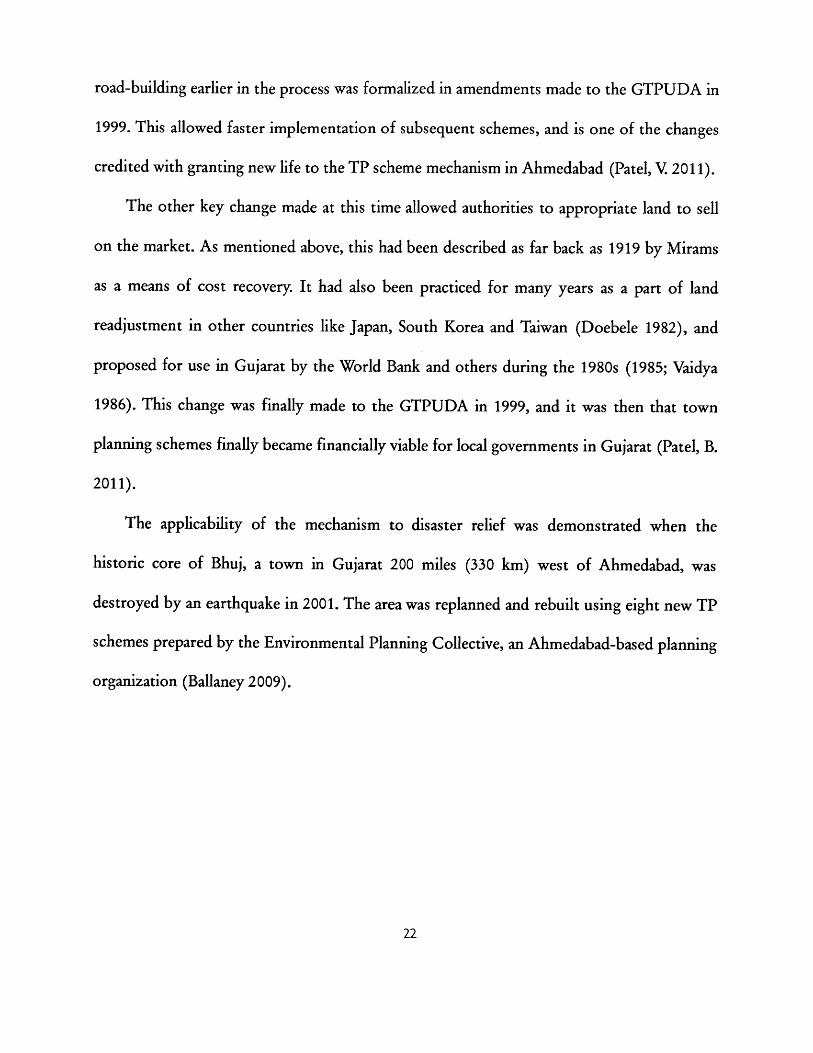
road-building earlier in the process was formalized in amendments made to the GTPUDA in
1999. This allowed faster implementation of subsequent schemes, and is one of the changes
credited with granting new life to the TP scheme mechanism in Ahmedabad (Patel, V. 2011).
The other key change made at this time allowed authorities to appropriate land to sell
on the market. As mentioned above, this had been described as far back as 1919 by Mirams
as a means of cost recovery. It had also been practiced for many years as a part of land
readjustment in other countries like Japan, South Korea and Taiwan (Doebele 1982), and
proposed for use in Gujarat by the World Bank and others during the 1980s (1985; Vaidya
1986). This change was finally made to the GTPUDA in 1999, and it was then that town
planning schemes finally became financially viable for local governments in Gujarat (Patel, B.
2011).
The applicability of the mechanism to disaster relief was demonstrated when the
historic core of Bhuj, a town in Gujarat 200 miles (330 km) west of Ahmedabad, was
destroyed by an earthquake in 2001. The area was replanned and rebuilt using eight new TP
schemes prepared by the Environmental Planning Collective, an Ahmedabad-based planning
organization (Ballaney 2009).
J
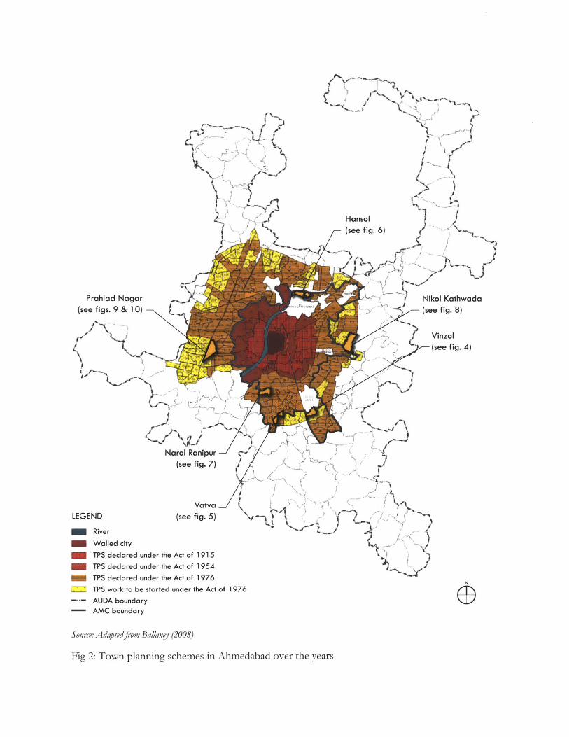
Hansol(see fig. 6)
Prahlad Nagar(see figs. 9 & 10)
L~
Narol Ranipur(see fig. 7)
Vatva J \LEGEND (see fig. 5) N
RiverWalled cityTPS declared under the Act of 1915TPS declared under the Act of 1954TPS declared under the Act of 1976TPS work to be started under the Act of 1976AUDA boundary
- AMC boundary
Source: Adaptedfrom Ballaney (2008)
Fig 2: Town planning schemes in Ahmedabad over the years
Vinzol(see fig. 4)
......... - --------------
2.3 TP schemes today
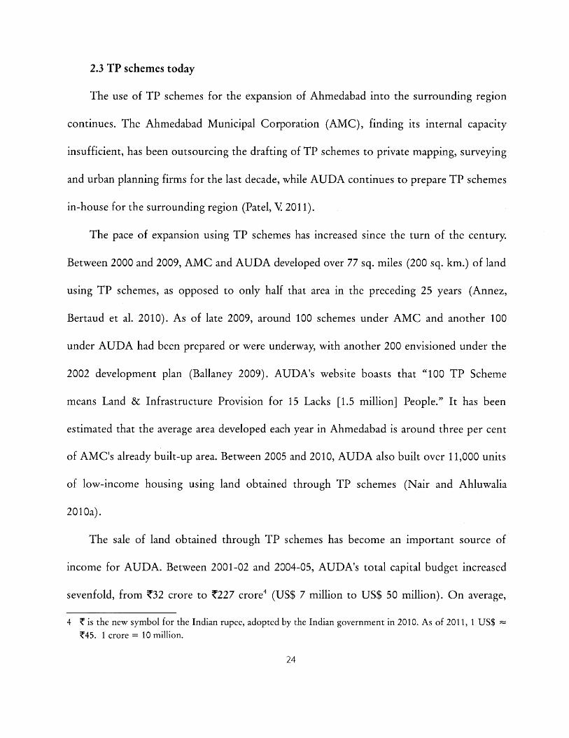
The use of TP schemes for the expansion of Ahmedabad into the surrounding region
continues. The Ahmedabad Municipal Corporation (AMC), finding its internal capacity
insufficient, has been outsourcing the drafting of TP schemes to private mapping, surveying
and urban planning firms for the last decade, while AUDA continues to prepare TP schemes
in-house for the surrounding region (Patel, V 2011).
The pace of expansion using TP schemes has increased since the turn of the century.
Between 2000 and 2009, AMC and AUDA developed over 77 sq. miles (200 sq. km.) of land
using TP schemes, as opposed to only half that area in the preceding 25 years (Annez,
Bertaud et al. 2010). As of late 2009, around 100 schemes under AMC and another 100
under AUDA had been prepared or were underway, with another 200 envisioned under the
2002 development plan (Ballaney 2009). AUDA's website boasts that "100 TP Scheme
means Land & Infrastructure Provision for 15 Lacks [1.5 million] People." It has been
estimated that the average area developed each year in Ahmedabad is around three per cent
of AMC's already built-up area. Between 2005 and 2010, AUDA also built over 11,000 units
of low-income housing using land obtained through TP schemes (Nair and Ahluwalia
2010a).
The sale of land obtained through TP schemes has become an important source of
income for AUDA. Between 2001-02 and 2004-05, AUDA's total capital budget increased
sevenfold, from ?32 crore to Z227 crore' (US$ 7 million to US$ 50 million). On average,
4 Z is the new symbol for the Indian rupee, adopted by the Indian government in 2010. As of 2011, 1 US$Z45. 1 crore = 10 million.
between 2003-04 and 2008-09, 29% of AUDA's revenue came from the sale of land. In April
2006, AUDA auctioned 20 plots for Z172 crore (US$ 38 million), to large real estate firms.
In that year, 65% of AUDA's revenue came from land sales. The proceeds from land sales
have been used by AUDA to finance large infrastructure projects, mostly road development,
water supply, sanitation, drainage, etc (Mahadevia 2009; Sridhar and Reddy 2009). A recent
development plan states that from 24 schemes, AUDA has created a land bank worth Z500
crores, i.e. over US$ 100 million (AUDA/ AMC City Development Plan 2006-2012).
Although some other states have experimented with similar legislation, none of them
has used TP schemes as extensively as Gujarat has. With the growing pressure on urban land
in Indian cities, several states have shown a renewed interest in TP schemes, perceiving them
to be a financially and politically superior alternative to land acquisition, and a relatively fast
way of expanding urban infrastructure into the surrounding landscape (see chapter 5).
Chapter 3
RULES AND REALITIES5
3.1 The Development Plan
Town planning schemes are part of the two-step Development Plan - Town Planning
Scheme (DP-TPS) process. Every ten or so years, AUDA prepares a development plan (DP)
for the entire metropolitan region, intended as a "comprehensive strategic document for the
development of the city" (Ballaney and Patel 2009). The DP attempts to address a variety of
issues, such as infrastructure development, transportation, heritage protection, economic
development, and environmental protection and land use zoning.
The development plan includes a land use master plan, which identifies areas of future
expansion of the city into the surrounding agricultural region, in anticipation of estimated
population growth. Once areas have been identified for future expansion, they are rezoned
in order to be "opened up" for non-agricultural uses (residential/ commercial, industrial,
institutional, etc.). For example, a version of the 1999 DP designated around 39 sq. miles
(100 sq. km., an area more than five times the size of Cambridge, Massachusetts) of
additional land in the Ahmedabad metropolitan area to be developed by 2011
(Environmental Planning Collective 1999). These newly urbanizable areas are then divided
into smaller areas of 250-500 acres (100-200 hectares), usually encompassing land owned by
5 Chapters 3 and 4 make reference throughout to the written work of Ahmedabad-based planners ShirleyBallaney and Bimal Patel (Ballaney 2008; Ballaney 2009; Ballaney and Patel 2009). Information was alsogathered through interviews with them, as well as with Vatsal Patel (AMC) and R.B. Joshi (AUDA) inAhmedabad.
100 to 250 landowners, for which more detailed physical plans are prepared. These are the
Town Planning Schemes.
This kind of large-scale land use master planning has been the subject of much criticism
in planning literature. It is now often considered by many to be a relic of early 20 th century
Modernist planning, which has fallen out of favor in the Western countries of its origin and
lives on only in developing countries. It has been suggested that the reason for the
persistence of master planning is that government officials in the developing world use their
control over land resources as a source of power. According to the UN Human Settlements
Program (2009) "Planning can be used as a 'tactic of marginalization', where particular
ethnic or income groups are denied access to planning services and are then marginalized or
stigmatized because they live in informal or unregulated areas."
Some of the major criticisms of the master plan approach as adopted by Indian cities are
the following (Tiwari 2002):
- Detailed land use plans are static and inflexible, projecting a desired long-term
end state without paying enough attention to short- and medium-term action or
mid-course corrections that may be required.
- The preparation and approval of master plans is very time-consuming.
- Obtaining land in order to implement these plans is usually difficult.
- Public participation in master plans is ineffective, resulting in a top-down
approach.
- The preparation of master plans in India is hindered by a severe lack of data on
socio-economic variables, housing prices and availability, and environmental
conditions. There is usually no system of continuous data collection in place.
- Physical standards for the built environment are impractically high, making
developments unaffordable to the poor.
- Insufficient attention is paid to financial strategies needed to implement the
plan.
Physical order is overemphasized, while social, economic and institutional
development is neglected.
- The master plan does not account for the role of the private sector in
implementation.
- Regulations are usually not complied with or enforced.
- Once prepared, plans are often not implemented. There is no system in place to
monitor and evaluate the implementation of plans over time.
According to the UN Human Settlements Programme (2009),
Some 2000 Indian cities now have master plans, all displaying the problems
that caused countries such as the UK to shift away from this approach, and yet
the main task of municipal planning departments is to produce more such
plans... Recently, the growing criticism of the master plan in India led the
Ministry of Urban Development to organize a national conference on the
theme of Alternatives to the Master Plan. After extensive discussions and
debates extending over three days, the meeting concluded that the only
alternative to the master plan is a 'better' master plan.
TP schemes have allowed Ahmedabad to avoid some of the land acquisition difficulties
mentioned above, but most of the criticisms of master plans could be leveled at
Ahmedabad's development plan as well. The city's DP has been criticized in particular for its
lack of analytical rigor and transparency in designating areas of future growth. Population
growth estimates for an area are arrived at using trend-based statistical projections. This
means that the population in an area is expected to continue growing at the rate it has been,
regardless of the location of the area in the city, anticipated job growth, socioeconomic
character, transportation infrastructure, housing supply, etc. Such estimations of population
growth in previous DPs have proven significantly inaccurate, generally overestimating
growth in secondary centers and underestimating growth in the central agglomeration of the
city (see table 1). Even once population estimates have been arrived at using these methods,
the relationship between these projections and the corresponding rezoning of land is not
fully explained (Adhvaryu forthcoming).
The DP land use plan has also been criticized for not sufficiently allowing mixed uses,
and for not paying enough attention to informality in the public realm (Kleinenhammans
2009). 6
6 Public participation concerns relating to the DP are discussed in section 4.1.
29
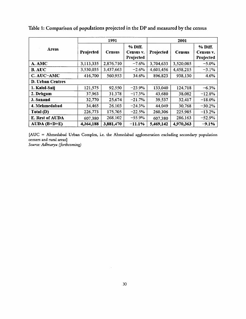
Table 1: Comparison of populations projected in the DP and measured by the census
1991 2001
Areas % Diff. % Diff.Projected Census Census v. Projected Census Census v.
Projected Projected
A. AMC 3,113,335 2,876,710 -7.6% 3,704,633 3,520,085 -5.0%B. AUC 3,530,035 3,437,663 -2.6% 4,601,456 4,458,215 -3.1%
C. AUC-AMC 416,700 560,953 34.6% 896,823 938,130 4.6%D. Urban Centres1. Kalol-Saij 121,575 92,550 -23.9% 133,040 124,718 -6.3%2. Dehgam 37.963 31,378 -17.3% 43,680 38,082 -12.8%3. Sanand 32,770 25,674 -21.7% 39,537 32,417 -18.0%
4. Mehmedabad 34,465 26,103 -24.3% 44,049 30;768 -30.2%Total (D) 226,773 175,705 -22.5% 260,306 225,985 -13.2%
E. Rest of ALDA 607.380 268,102 -55.9% 607,380 286,163 -52.9%
AUDA (B+D+E) 1 4,364,188 3,881,470 -11.1% [ 5,469,142 4,970,363 -9.1%
[AUC = Ahmedabad Urban Complex, i.e. the Ahmedabad agglomeration excluding secondary populationcenters and rural areas]Source: Adhvaryu (forthcoming)
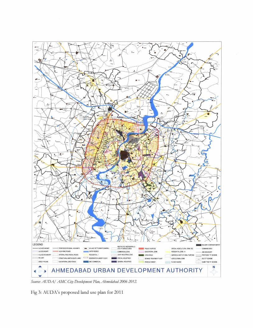
LEGENDAUDABOUNDARY PROPOSED REGIONAL HIGHWAYS a ]VILLAGE SETTLEMENT(GANTAL)
ULC BOUNDARY AUDA RING ROADS WATER BODIES
- VILLAGE BOUNDARY ARTERIAL RING RADIAL ROADS RESIDENTIAL-I
- RAILWAY STRUCTURALNORTH-SOUTH UNKS RESERVATON UNDER 12(2)K)
ONGC PIPELINE SUBARTERIAL GRID ROADS AMC COMMERCIAL
4.
RESTRICTED RESIDENTIAL&UTiLITY SERVICE AREA
- COMMERCIALZONE
LIGHT INDUSTRIAL ZONE
SPECIAL INDUSTRIES
GENERAL INDUSTRIES
PUBLIC PURPOSE
EDUCATIONALZONE
OPEN SPACE
_ SEWAGE TREATMENT PLANT
I PARKS & FOREST
SPECIAL AGRICULTURAL ZONE (R3)
RESIDENTIALZONE -1
SERVICE&INSTITUTIONAL PURPOSE
AGRICULTURAL ZONE
FLOOD HAZARD
AHMEDABAD URBAN DEVELOPMENT AUTHORITY
Source: AUDA/ AMC Ciy Development Plan, Abmedabad 2006-2012.
Fig 3: AUDA's proposed land use plan for 2011
RAILWAYICONTAINER DEF
COMMAND AREA
AMC BOUNDARY
-- PROPOSED TP SCHEME
OLDTP SCHEME
SUBMITTEDTP SCHEME
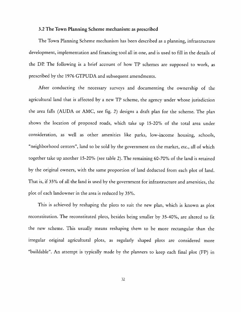
3.2 The Town Planning Scheme mechanism: as prescribed
The Town Planning Scheme mechanism has been described as a planning, infrastructure
development, implementation and financing tool all in one, and is used to fill in the details of
the DP. The following is a brief account of how TP schemes are supposed to work, as
prescribed by the 1976 GTPUDA and subsequent amendments.
After conducting the necessary surveys and documenting the ownership of the
agricultural land that is affected by a new TP scheme, the agency under whose jurisdiction
the area falls (AUDA or AMC, see fig. 2) designs a draft plan for the scheme. The plan
shows the location of proposed roads, which take up 15-20% of the total area under
consideration, as well as other amenities like parks, low-income housing, schools,
"neighborhood centers", land to be sold by the government on the market, etc., all of which
together take up another 15-20% (see table 2). The remaining 60-70% of the land is retained
by the original owners, with the same proportion of land deducted from each plot of land.
That is, if 35% of all the land is used by the government for infrastructure and amenities, the
plot of each landowner in the area is reduced by 35%.
This is achieved by reshaping the plots to suit the new plan, which is known as plot
reconstitution. The reconstituted plots, besides being smaller by 35-40%, are altered to fit
the new scheme. This usually means reshaping them to be more rectangular than the
irregular original agricultural plots, as regularly shaped plots are considered more
"buildable". An attempt is typically made by the planners to keep each final plot (FP) in
roughly the same location as the original plot (OP) 7, but there is still always some exchange
of ownership required. This process of plot reconstitution generally does not apply to
officially recognized village settlements, only to the largely open agricultural land
surrounding them. When a village falls within the area of a TP scheme, it is left alone, either
with a road built around it, or with the roads within it integrated into the new surrounding
road network.!
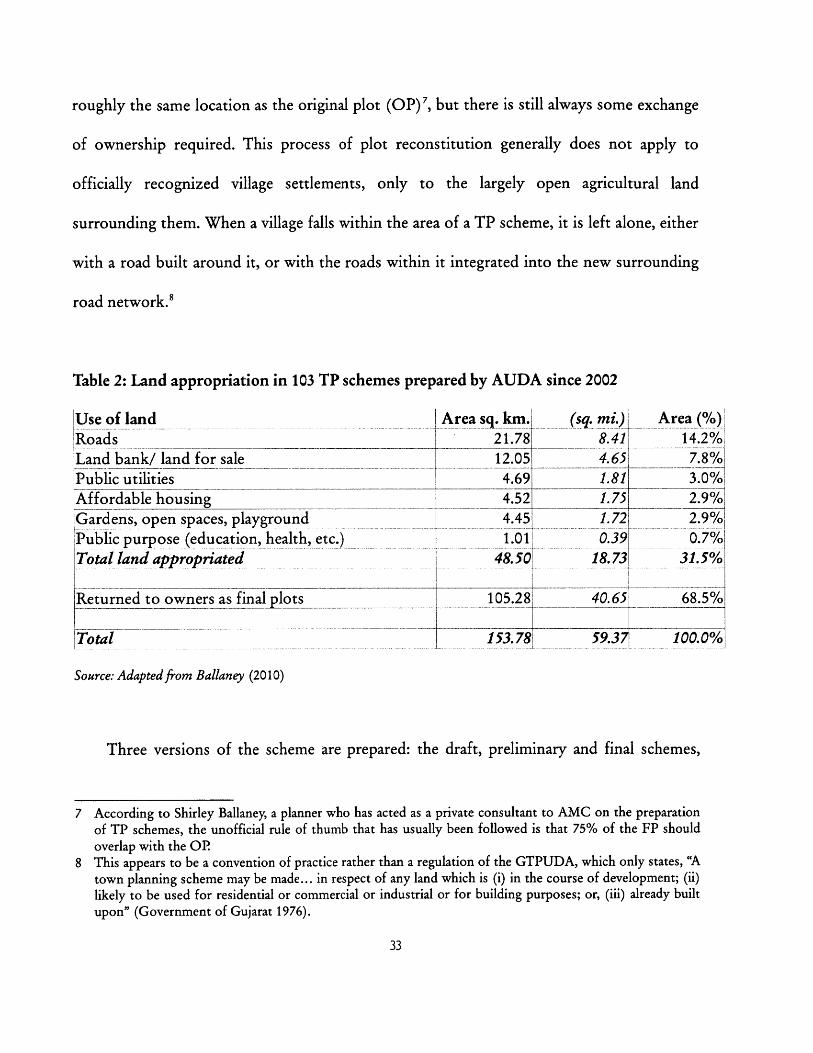
Table 2: Land appropriation in 103 TP schemes prepared by AUDA since 2002
Use of landRoads
Land bank/ land for salePublic utilitiesAffordable housingGardens, open spaces, playgroundPublic purpose (education, health, etc.)Total land appropriated
[iReturned to owners as final lots
Total
Area sq. km.l21.7812.05
4.69
4.524.451.01
48.501
105.28
153.78
(sq. mi.) Area (%)8.41 14.2%
4.65 7.8%1.81 3.0%
1.75 2.9%1.72 2.9%
0.39 0.7%1
18.73 31.5%
40.65 68.5%
59.37 100.0%,
Source: Adapted from Ballaney (2010)
Three versions of the scheme are prepared: the draft, preliminary and final schemes,
7 According to Shirley Ballaney, a planner who has acted as a private consultant to AMC on the preparationof TP schemes, the unofficial rule of thumb that has usually been followed is that 75% of the FP shouldoverlap with the OR
8 This appears to be a convention of practice rather than a regulation of the GTPUDA, which only states, "Atown planning scheme may be made... in respect of any land which is (i) in the course of development; (ii)likely to be used for residential or commercial or industrial or for building purposes; or, (iii) already builtupon" (Government of Gujarat 1976).
each of which needs to be sanctioned (approved) by the state government. Consultations
with the affected landowners are held at various stages (see chapter 4). The government is
allowed to take possession of land needed for the construction of roads after the state
sanctions the draft scheme. The ownership of all other plots is considered to be transferred
to the government after the preliminary scheme is sanctioned, at which point the
construction of other amenities may begin. The subsequent changes, made between the
preliminary and the final scheme, relate only to financial matters. The Act allows a total of
four years and one month for the preparation of a TP scheme, from the initial declaration of
intention to the sanction of the final scheme.
Finances are dealt with as follows: An assessment is made of the financial value of each
original plot prior to the scheme, based on recent land sales. The government owes each
landowner some amount of money for the portion of land it has appropriated from them
(the 35-40% mentioned above), based on these original plot values. At the same time (before
actual construction of infrastructure), an estimate is also made of the future value that each
plot will achieve once all the infrastructure has been built. The difference between the
original plot value and final plot value, i.e. the increase in land value or "increment" that
comes about through government action, has been attained by the landowner through no
effort of his or her own. The landowner therefore owes the government a betterment charge
for this improvement, amounting to 50% of this increment. The idea here is that the
financial benefit of the scheme is split down the middle between the government and the
landowner.
LEGENDSale for ResidentialSale for CommercialGardenSocial Infrastructure
Low Income HousingTP Scheme Boundary
Source: Adaptedfrom Ballaney & Patel (2009)
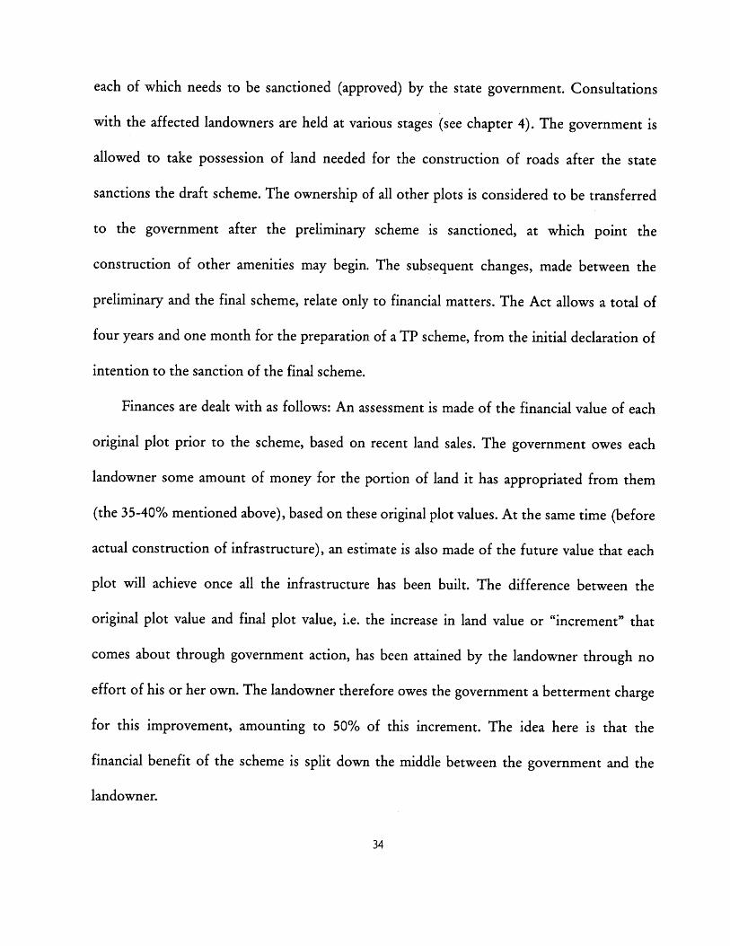
Fig. 4: Vinzol II TP scheme, showing the process of plot reconstitution
b I I t
So the government owes the landowner compensation for land taken, and in turn the
landowner owes the the government a betterment charge. The difference between the two
amounts is calculated, and this balance is paid in the direction required. For example, if the
betterment charge exceeds the compensation, which is usually the case, the landowner must
pay this excess amount to the authority, in installments over ten years.
A hypothetical example may be useful here in order to illustrate this somewhat
complicated process. (The values used in this example are comparable to actual observed
values). Let us imagine that a farmer, Mr. X, owns a plot of agricultural land of 1,000 square
meters on the periphery of Ahmedabad. His plot falls within the boundaries of a new TP
scheme being prepared by AMC. AMC assesses the value of this plot to be Z200 per sq. M.,
i.e. ?200,000 in total. While preparing the TP scheme, AMC decides that 40% of land will be
taken from each plot, which means that it takes 400 sq. m. of land from Mr. X, which is
worth 780,000 in compensation. So AMC now owes Mr. X T80,000. 600 sq. m. of land,
worth ?120,000, remains with Mr. X. AMC estimates that once the improvements have been
made, the value of the land in Mr. X's reshaped final plot will increase from 7200 to Z500 per
sq. M., i.e. the total value of his land will increase from ?120,000 to ?300,000. The
improvements have thus caused the value of his remaining land to go up by 7180,000. In
order to share this benefit with the government, he now owes 50% of this, ?90,000, to AMC
as a betterment charge, which goes towards AMC's project costs. Since AMC already owed
him Z80,000 for the land it originally took, his net payment to AMC is Z10,000. The other
50% of the estimated increase in his land value, ?90,000, is his to keep. If all estimations used
above are accurate, in total Mr. X is ?90,000 better off than he was before.
TP schemes are frequently described as a "win-win" proposition (Ballaney 2008;
Kleinenhammans 2009; The Hindu 2010). Small agricultural landowners at the urban fringe
get to keep the majority of their land as infrastructural improvements are made, and then sell
the improved land to developers at a high price. This is seen as more favorable to farmers
than simply appropriating all their land under the Land Acquisition Act, for a compensation
that is often considered unfair (Lahiri 2010).
While the landowner's value goes up under TP schemes, the government agency also is
able to recover its costs through betterment charges and through the sale of land. The
government also benefits by not having to pay either the financial or the political costs of
the kind of direct land acquisition described above (CITYNET 1995). TP schemes are also
visually orderly compared other forms of urban growth in India, which are perceived as
haphazard. More broadly, TP schemes have been seen in the context of proposed supply-side
solutions to formal housing shortages in Indian cities (see section 4.3).
3.3 The Town Planning Scheme mechanism: as practiced
The reality of preparing TP schemes differs from the idealized version described above
in several important ways.
To begin with, the owners of land at the urban fringe are not necessarily the poor rural
farmers that TP schemes appear to benefit. While there is no documentation of the
landowners' backgrounds or incomes, officials, planners and developers in Ahmedabad
believe that in many cases the real owners are speculative land assemblers, developers,
businesspeople, and even politicians and bureaucrats (Chakravarti 1999; Ballaney 2011; Joshi
2011). Under the Bombay Tenancy and Agricultural Lands Act, 1948, land in Gujarat and
Maharashtra designated as agricultural land may only be sold to an "agriculturist" (Lands of
Maharashtra), but it appears that either the definition of who qualifies as an agriculturist is
loose, or people who are not farmers gain control of land by securing power of attorney.
Land assemblers are even believed to routinely forge documents, falsify power of attorney
and duplicate sales records in order to acquire the rights to land without the knowledge of
the rightful owners. Hundreds of such cases of fraud have been filed in recent months ("265
land-grabbing cases in Ahmedabad dist", Times News Network 2011). As a result of all of
the above, actual farmers may not benefit as greatly by TP schemes as is usually claimed.
A second key difference between the rules and realities of TP schemes is in the finances.
The entire process of financial evaluation described in the previous section is essentially a
pretense; neither the assessed original plot values nor the predicted final plot values are even
expected to match real land prices. In fact, given the extremely murky nature of land
transactions in India, it would be impossible for the government to value land accurately
from recent sales.9 Original plot values, instead of being based on recent sales in the area, are
based on a standard land "reckoner". The calculation of future, post-implementation values
is more of a difficulty, one which has been noted wherever betterment levies are charged
9 Ballaney estimates that in every land sale, 40% of the price is declared and the remaining 60% is paid in cashunder the table, in order to pay lower stamp duties, which are charged each time the property changeshands.
around the world (Peterson 2009).
Instead, the final plot values are determined in a round-about way. The government first
predicts the cost of infrastructure (roads, water supply, drainage and street lights) and
certain administrative costs. These are calculated according to a standard schedule, which
tends to reflect costs of a very low standard of construction, and so does not capture the full
costs that actually will be incurred. The government does not expect to even completely
recover these unrealistically low costs from landowners, so it decides what portion of the
costs it will bear itself, and what balance it will have to recover from landowners through
betterment charges. Since the betterment charges are a function of final plot values (as
described in the previous section), the final plot values are calculated in order to recover the
predetermined betterment charge. In this manner, the process of land "valuation" is really
conducted in reverse.
In reality, the betterment charge comes nowhere close to equaling half of the increase in
land value. On the outskirts of a rapidly growing city like Ahmedabad, the real final plot
values when sold for development tend to be very high. (The assumption is that the original
landowners will always choose to sell their land rather than remain on it).
LEGEND:-SR.NO. PARTICULAR
1. ANC BOUNDARY2. TP8 BOUNDARYa. viz&M BOUIMARY4. sRnSIT UMuSRT/ulubo.
5. 0.P.SOUNDART/OJ..NO.5 . F.BUDUND /7F.P.1K.7. SURVET HEMAS. DP./T.PROAD
0. CANAWWAT BODY10. H.T.IM11. PUEUA/KUcNA STM2. GanIS. KVunM EUNDOS
I. fLL/IE POIinI. M./IL LINELG. N.B.AC.C.17. 5 & E...H.
1R. RALEFR CUNIOMIL1S. RALE JNR BESEENCSO. GARDE & WEN SPACE
SYMBOL/OM
avme
Final values estimated in TP scheme at:t- 500 /sq. m.
/ T -C484 /sq. m
/ / Ir- !490 /sq. m/ r-T476 /sq. m/ T -C490 /sq. m
Currently being soldr - on the market at
/ T9,558 /sq. m.
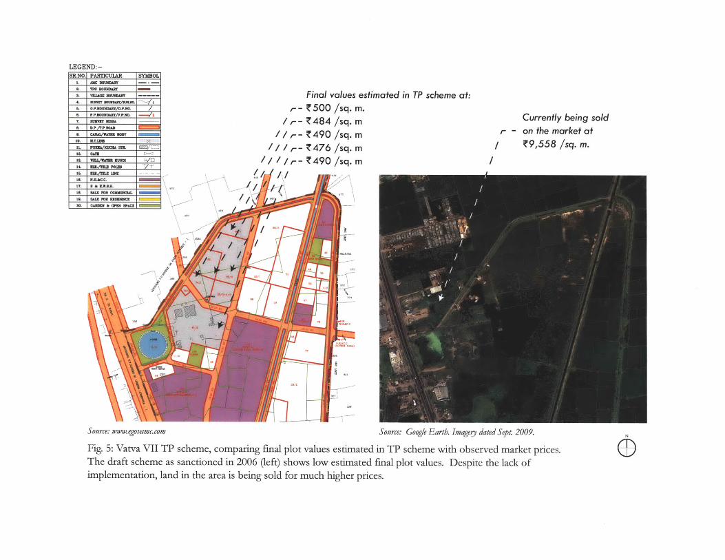
Source: ww-w. ego vamc.com Source: Google E arth. Imagerj dated Sept. 2009.
Fig. 5: Vatva VII TP scheme, comparing final plot values estimated in TP scheme with observed market prices.The draft scheme as sanctioned in 2006 (left) shows low estimated final plot values. Despite the lack ofimplementation, land in the area is being sold for much higher prices.
Figure 5 illustrates an example of the discrepancy between land values on paper and on
the market. The Vatva VII draft scheme was sanctioned by the state government in March
2006. It estimated that after the construction of roads, parks, etc, the final value of the plots
indicated will be Z480 to 500 per square meter. The satellite image suggests that no
construction of infrastructure had occurred by September 2009. The preliminary scheme and
final scheme have not been sanctioned by the state government (AMC n.d.). Despite this, a
plot of land just beyond the boundary of this TP scheme is being advertised on a real estate
website at Z9,558 per square meter ("Residential Land in Vatva, Ahmedabad City & East",
from 99acres.com). This land is under another TP scheme, which received draft sanction in
1995 but also has not received any subsequent sanctions or seen any construction of
infrastructure. If land prices on the market are 20 times the estimated final plot values even
before the schemes are finalized and any infrastructure is laid out, one can imagine that the
discrepancy once the TP scheme is completed will be far greater. Ballaney estimates that
whereas a final plot value on paper may be Z500 per square meter, when sold on the market
after the TP scheme is complete, the same plot may receive Z20,000 to 60,000 per square
meter (Ballaney 2011).
However, even if they do not equal half the increase in land value, betterment charges
still do fulfill an important function. By varying the final plot values by some amount to
reflect locational advantages and disadvantages, landowners benefiting differentially are
differentially burdened with betterment charges. This satisfies landowners that the process is
fair. If, for example, one landowner's new plot fronts a major street or is next to a park, his
final plot value (unrealistic as it is) will be estimated at slightly a higher figure than his
neighbors, so he will have to pay a slightly higher betterment charge. If another's is next to a
low-income housing block or a crematorium, her final plot value will be slightly lower so she
will pay a lower betterment charge. This keeps each landowner satisfied that he or she has
benefited proportionately to the other landowners (Patel, B. 2011).
The government also does make large sums of money from the schemes, not through
betterment charges but through the sale of banked land (as described in section 2.3). This is
why the recent practice of land-banking has been so critical, as this is the main source of
revenue for the government from TP schemes.
What the above illustrates is that the premise of TP schemes benefiting original
landowners while also being self-financing for local governments is actually borne out in
Ahmedabad, even if not in the manner intended by the enabling legislation. In fact, both
parties benefit much more greatly than originally envisioned when they sell land on the
market. However, it is important to understand the origin of this vast increase in value. In
the complicated process of land readjustment and valuation described above, it is easy to lose
sight of the key fact that as part of the TP scheme, land is being rezoned for urban
development. In a rapidly growing city like Ahmedabad, newly available land in the
metropolitan area is highly valuable, which guarantees large gains for landowners and
government. It is unclear how much of the increase in value is attributable to the
infrastructure and amenities built by the government as part of the TP scheme, and how
much is simply a consequence of the urban fringe land coming onto the market.
The third difference between legislation and practice is that although the process of
preparing the scheme is meant to take only four years and one month, it usually takes much
longer. The time taken for the various stages (draft, preliminary and final) to be sanctioned
by the state government is often lengthened indefinitely. Since AUDA first began preparing
TP schemes in 1976, 100 draft schemes have been sanctioned by the state government. Of
these, only 25 have gone on to receive preliminary scheme sanction. An average of 7 years
passed between the draft and preliminary scheme sanctions (a minimum of 4 years and a
maximum of 26 years). The remaining 75, dating back to 1990, have not yet received
preliminary scheme sanctions. Only 17 out of the 100 have received final sanction, which
took another 4 years on average after the preliminary sanction (see appendix A).
AMC has prepared 101 schemes, dating back to 1925. 3 schemes prepared between 2007
and 2009 have not yet received draft scheme sanction. 47 schemes have received draft
scheme sanction but have not yet received preliminary scheme sanction (mostly from the
last decade, but also including several from the early 1990s). 5 schemes have received
preliminary but not final scheme sanction. 45 out of the 101 have received the final scheme
sanction, of which only 3 have received it since 2000 (see appendix B).
The state government's sanctioning process has been identified as the primary cause of
these delays. According to Ballaney (2009), the state's town planning department has a
severe shortage of staff and lacks technical capacity, and yet must conduct multiple rounds
of detailed, in-house reviews on hundreds of TP schemes from various cities at the same
time. She describes this system as "very paternalistic".
It presumes that local capacities are inadequate, that they cannot be developed
and that higher levels of government know better. That plans need to be
protected from vested interests at local levels is often cited as the main reason
why the State Government should have such broad and overarching review
and sanctioning powers. Whatever be the merit of this view, it is clear that role
of the Development Authority is envisaged as being dependent; a vision that
undermines the building of capacity at local levels. (Ballaney 2009)
However, the delays in the preliminary and final sanctions cannot fully explain delays in
implementation, as AMC and AUDA are allowed to begin constructing roads after the
sanction of the draft scheme itself. Comparing TP scheme layouts and the date of draft
scheme sanctions with series of satellite images reveals that infrastructure often remains
unbuilt for years after the draft scheme is sanctioned. For example, figure 6.1 shows an aerial
image of Hansol in northern Ahmedabad in November 2003. Figure 6.2 shows AMC's draft
scheme for the area, which was sanctioned by the state government in September 2004.
Figure 6.3 shows the same area in January 2010, over five years later, with a very small
amount of road-building appearing to have taken place. Figures 7, 8 and 9 show similar
comparisons for other TP schemes.
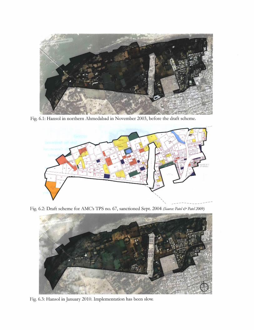
Fig. 6.1: Hansol in northern Ahmedabad in November 2003, before the draft scheme.
Fig. 6.2: Draft scheme for AMC's TPS no. 67, sanctioned Sept. 2004 (Source: Pate/& Patel 2009)
Fig. 6.3: Hansol in January 2010. Implementation has been slow.
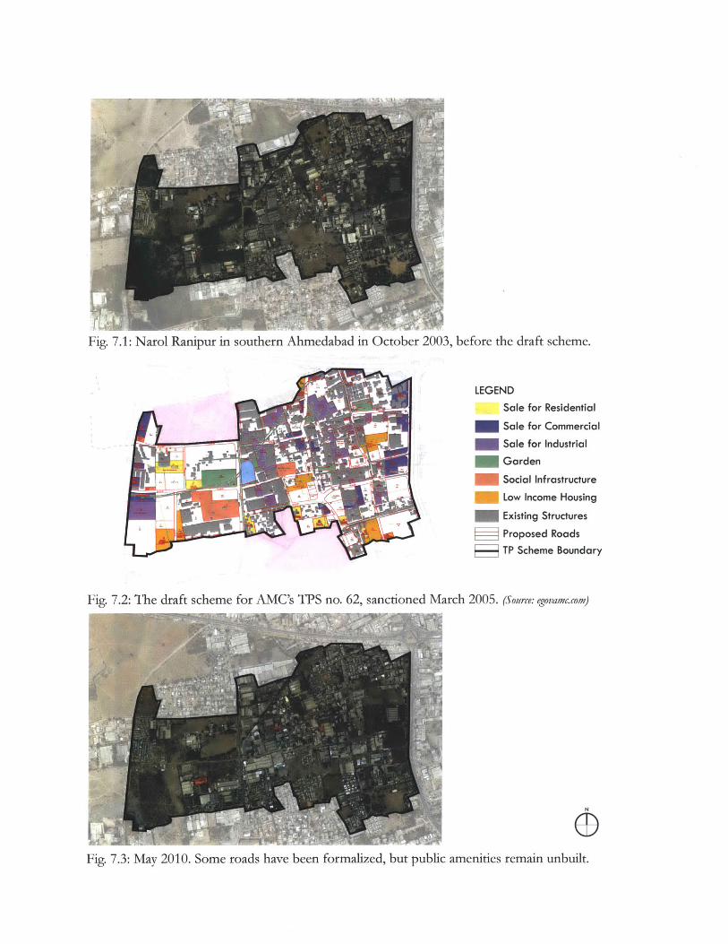
Fig. 7.1: Narol Ranipur in southern Ahmedabad in October 2003, before the draft scheme.
LEGEND
Sale for Residential
Sale for Commercial
Sale for Industrial
Garden
Social Infrastructure
Low Income Housing
Existing Structures
Proposed Roads
TP Scheme Boundary
Fig. 7.2: The draft scheme for AMC's TPS no. 62, sanctioned March 2005. (Source: egovamc.com)
Fig. 7.3: May 2010. Some roads have been formalized, but public amenities remain unbuilt.
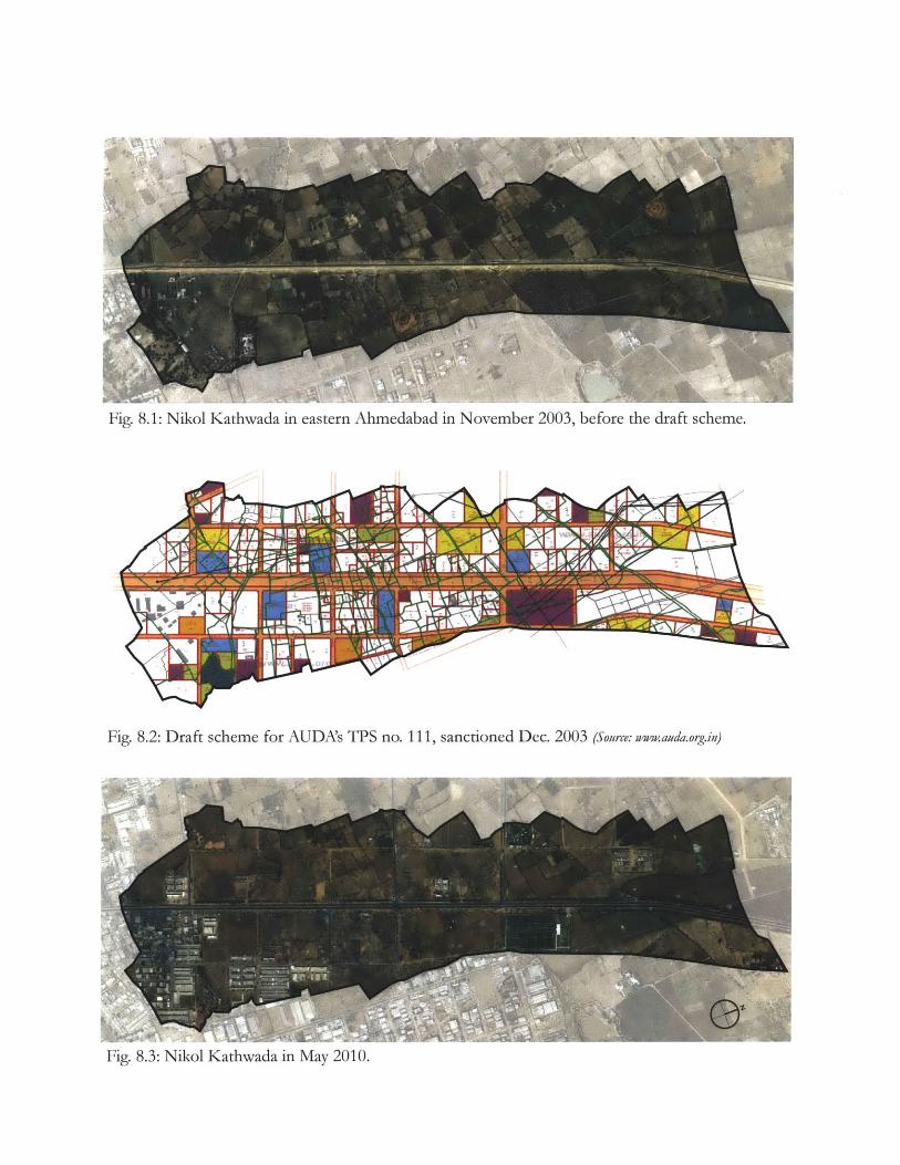
Fig. 8.1: Nikol Kathwada in eastern Ahmedabad in November 2003, before the draft scheme.
Fig. 8.2: Draft scheme for AUDA's TPS no. 111, sanctioned Dec. 2003 (Source: www.auda.org.in)
Kathwada in May 2010.Fig. 8.3: Nikol
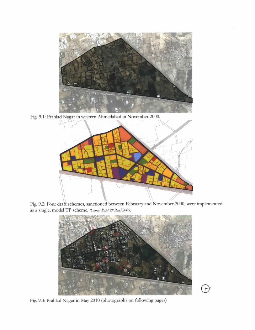
Fig. 9.1: Prahlad Nagar in western Ahmedabad in November 2000.
Fig. 9.2: Four draft schemes, sanctioned between February and November 2000, were implemented
as a single, model TP scheme. (Source: Patel & Patel 2009)
OFig. 9.3: Prahlad Nagar in May 2010 (photographs on following pages)
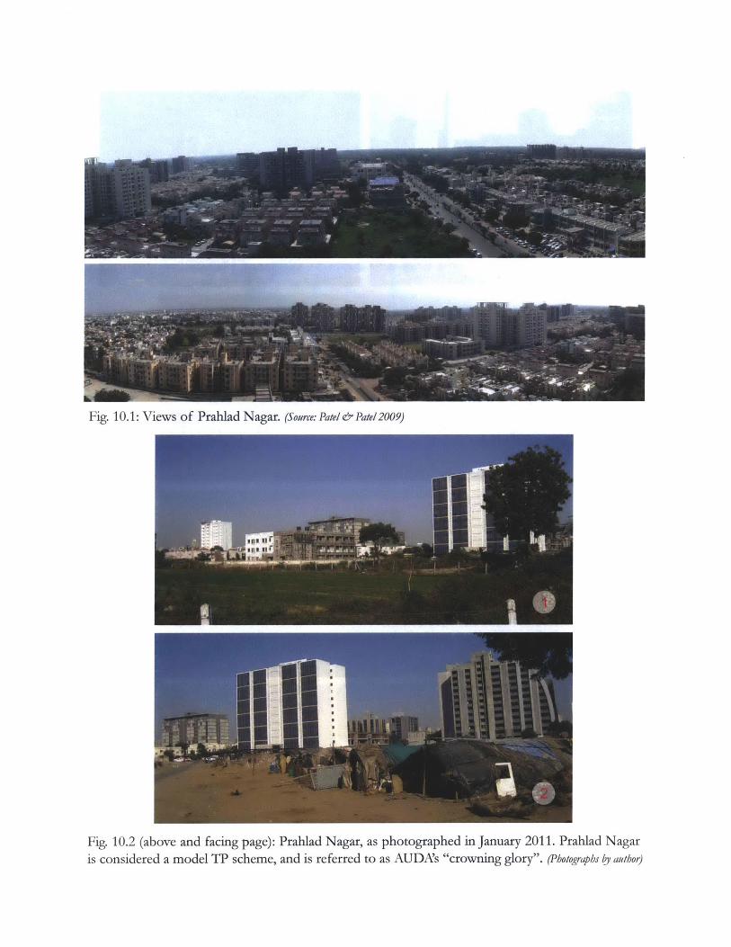
Fig. 10.1: Views of Prahlad Nagar. (Source: Patel & Patel 2009)
Fig. 10.2 (above and facing page): Prahlad Nagar, as photographed in January 2011. Prahlad Nagaris considered a model TP scheme, and is referred to as AUDA's "crowning glory". (Photographs by author)
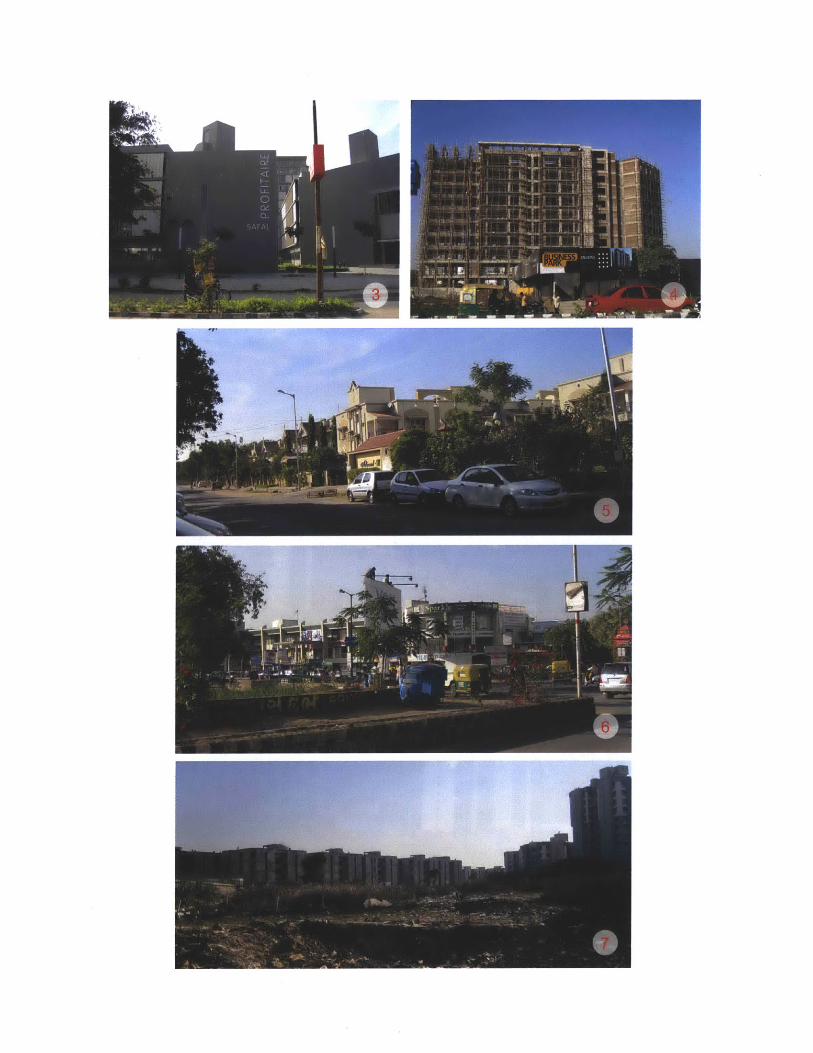
AUDA and AMC prepare a large number of TP schemes at once, but then only
implement them in phases over several years, as resources become available. This phasing is
not mentioned in the development plan, and is done in an ad hoc manner. The AMC is
unable to predict the implementation of its TP schemes even up to a five year time horizon
(Nayudu 2009). This suggests that while the DP makes urban expansion appear uniform, a
large amount of discretion rests with authorities to prioritize certain areas for development
over others.
Another reason for implementation delays in recent years appears to be corruption. In
2008, a report in a local newspaper ("AUDA projects are trapped in mess of alleged
corruption") quoted real estate professionals describing how increasing corruption and
bureaucratic mismanagement in AMC and AUDA had caused progress on TP schemes to
slow down. "The level of corruption has gone up significantly, whether one wants plans
approved, roads designed, or open space sanctioned," said a developer (Langa 2008). In 2009,
Navaneet Baloya', the chief town planner of AMC, was arrested on corruption charges.
Baloya was caught in a trap laid by the state's Anti-Corruption Bureau, accepting a bribe of
Z2 lakh (US$ 4,500) from developers in exchange for reducing the betterment charges owed
by them. According to the Municipal Commissioner of Ahmedabad, AMC had warned
Baloya multiple times and even divested him of all his duties three years previously in
response to allegations against him (Ahmedabad Mirror Bureau 2009). Still, the fact that the
corrupt planner was able to remain at his post and continue his widely acknowledged rent-
10 Also spelled "Navnit Balewa" and "Navneet Baleva" in other news reports.
51

seeking behavior suggests a culture of leniency towards corruption at AMC.
The Estate and Town Development department, which is responsible for implementing
town planning schemes, is considered the most corrupt department in AMC. It is blamed
for tacitly allowing illegal construction in Ahmedabad on a large scale. Between April 2010
and January 2011, 193 complaints of corruption were made against this department, three
times as many as against any other. AMC sources describe officials from this department
being involved in a "politician-official-builder nexus", ignoring illegal construction due to
political pressure or in exchange for bribes (Dave 2011).
Perhaps the greatest roadblock between the design of TP schemes and the availability of
the resulting land for construction is the vast array of complex bureaucratic procedures that
the original landowner needs to go through in order to obtain permission for urban use on
his/her land. The most tortuous of these are the requirements of the Government of
Gujarat's Revenue Department. If a landowner's plot is one that is categorized as 'restricted
tenure' or 'new tenure', s/he must first have it converted to 'old tenure'." Once this is done,
the landowner must then obtain permission from the Revenue Department for non-
agricultural use of his/her land, which involves obtaining 14 'no-objection' certificates from
various different government bodies." According to Patel, Ballaney et al (2009), these
11 Land was originally designated as 'new tenure' under various land grant abolition or land ceiling acts, orwhen land was donated by the government for public use or to the landless poor. Land granted to tenants aspart of land reforms in 1948 was designated 'restricted tenure'. Without government approval, new orrestricted tenure land cannot be sold, transferred, subdivided, or used for purposes other the original use.Old tenure land is not subject to these restrictions.
12 The government bodies from which the landowner must get a no-objection certificate are: Land acquisition,Special Agencies-Narmada Project, Roads and Building, Gujarat Electricity Board, District IndustriesCommissioner, Gujarat Pollution Control Board, Airport Authority, District Health Officer, RevenueDepartment, Collector, UDAs/ADAs, Public Works Department, and Income Tax Department.
52
restrictions on non-agricultural use originated from a historical concern for food security
and in order to ensure that the government earned revenue from land. They argue that food
security is no longer a significant concern and revenue from non-agricultural assessment
levies is negligible, so the Revenue Department's conservative approach to permitting non-
agricultural use of land in urban regions is "anachronistic and counterproductive".
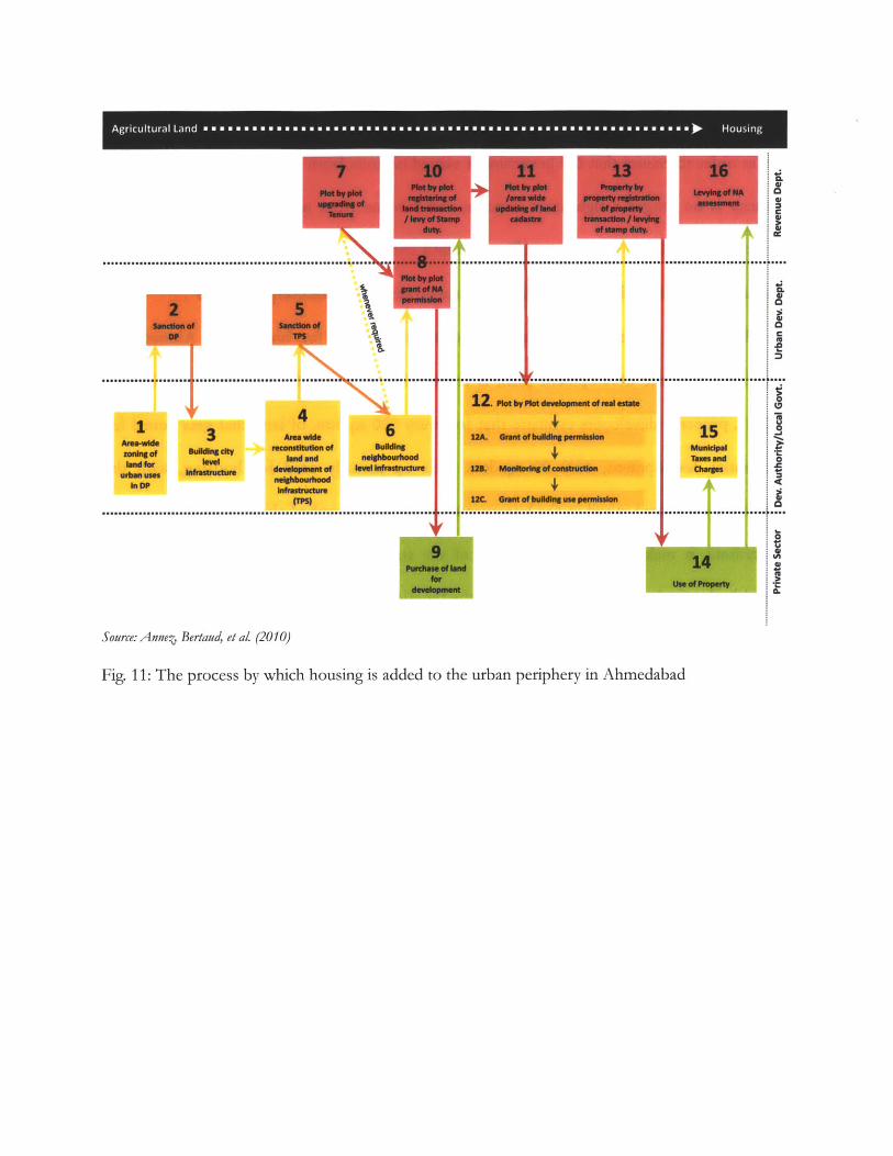
The entire process by which land becomes available for housing in Ahmedabad,
beginning with the development plan, is represented in figure 11. According to Ballaney
(2011), property developers estimate that for every 100 sq. km. of land that gets zoned for
residential development, only 20 sq. km. ends up actually used for housing, with the
remainder becoming mired in the bureaucratic processes described above. If this estimation
is accurate, it makes these requirements of the state government's Revenue Department
arguably the single biggest impediment to the functioning of town planning schemes.
As a result of all of the above, the transition in the character of the area from an
agricultural one to an urban one is very gradual. It often begins illegally before the TP
scheme is prepared. Different landowners sell their land at different times, with some giving
up land to speculators before the TP scheme has started, and others only selling it directly to
developers once construction of infrastructure and surrounding developments are complete,
having waited for the highest possible price. The various subsequent bureaucratic processes
involved result in yet further stretches of time before construction can be completed.
1 33s U.sgy
N" ... e r 6aiis
6apft.tIr W"----
rarn~
....... 1................
........
Source: Anne, Bertaud, et aL (2010)
Fig. 11: The process by which housing is added to the urban periphery in Ahmedabad
15-.. ..
caM-W
Agricultural Land ===== =========== =========== ======== =mo m s som so a m =m =oo = mo = =a = = a am = ame ma =a =wn -- Housing
4
Chapter 4
DP-TPS AND THE PUBLIC
4.1 Public participation in the development plan
The preparation of the development plan allows "limited" public participation (Ballaney
2008). A three-phase stakeholder consultation was conducted as part of the planning process
for the 2006-12 DP, which began with a 'City Development Strategy' workshop in 1999,
organized by AMC, AUDA and the Government of Gujarat's Urban Development
Department, with support from the World Bank and the Australian Agency for International
Development. According to AMC, the consultative process involved a "wide cross section of
citizen [s]" including elected representatives, professionals, corporate leaders,
business/industry associations, educational institutions, NGOs, government officials and
senior citizens (AUDA and AMC ; NIUA and AMC 2006). In AMC's words:
NGOs, Business associations represented the poor and the labour class as well
as citizen with environment and other societal concerns... [A]s it addressed
overall developmental aspects, contentious issues were fewer. Whenever such
issues arose, they were resolved through debate and discussion.
Stakeholder responses to specific technical decisions were taken as additional
points of enquiry and a final decision was made after sufficient technical
analysis.
The issues related to social aspects, which involved relocation and/or some
alteration, in individual/group's stake, the PAPs [project-affected persons]
have been made part of the project beneficiary in the development process.
PAPs have been fully identified and alternative plans have been discussed for
finalisation.
As part of Slum Policy and Vendor Policy development, specific surveys to
elicit the stakeholders view was done before making the draft policy. After
synthesis recommendations were made through full participation of
stakeholders. Urban poor formed core of the stakeholder community
participated decision process. [sic] (NIUA and AMC 2006)
As seen above, the language used to describe the public participation process is often
vague, confusing or platitudinous, and claims of this kind are rarely supported or elaborated
upon. Shirley Ballaney, the principal planner at Environmental Planning Collective (EPC)
which helped coordinate the public participation process for the 2006-12 DP, has suggested
that reforms are needed in order to ensure widespread public participation in the process
(2009). Kleinenhammans (2009) goes further, saying that at the DP level, where an
agglomeration of six million people is zoned in a single plan, meaningful local participation is
not even possible, and ends up being a "farce" in practice.
4.2 Public participation in the preparation of TP schemes
Most recent writing about TP schemes praises them for being participatory, especially
compared to land acquisition (Patel 2007 ; Ballaney 2009; Nair and Ahluwalia 2010a). For
example, Ballaney (2008) describes TP schemes as participatory, democratic, equitable,
inclusive, transparent, non-disruptive and non-coercive.
In evaluating how valid this characterization is, it is important to note first of all that
the landowners affected by these schemes are not given a choice of whether or not they wish
to participate. TP schemes do not require the consent of the landowners to proceed, unlike
similar land readjustment practices in other countries, (eg. Japan, where the consent of two-
thirds of the owners, owning two-thirds or more of the land, is required, (Doebele 1982)).
The intention to prepare the scheme is simply declared in the local press. Nor is there any
consultation with landowners during the preparation of the first draft scheme.
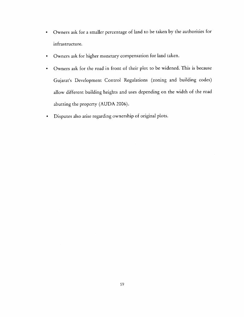
Only once a proposal for a draft scheme has been prepared, the landowners are invited,
via notices in local newspapers, to a public venue for a meeting at which the planners present
the scheme (see fig. 12). Ballaney, who has conducted such public presentations with AMC,
relates, "Much depends on the skill of the planning staff to keep the meeting civil and
constructive. The objective of the meeting is to clarify the procedure and proposals of the
TPS, to build a consensus regarding the merits of the TPS proposals and to get a sense of the
opposition to the scheme" (2009). The government planners make changes based on all
reasonable objections raised by landowners at the meeting or in writing. The decision of
what is deemed "reasonable" is left to the discretion of the planners.
The draft scheme is now sent to the state government for sanction. Once the scheme is
sanctioned, the state government appoints a "quasi-judicial" official known as a Town
Planning Officer (TPO) to take over and carry forward the process in consultation with the
landowners. The TPO is an urban planner from the Town Planning and Valuation
Department (TPVD) of the Government of Gujarat's Urban Development and Urban
Housing Department. Due to a lack of staff capacity at the TPVD, a TPO usually cannot be
immediately appointed when a draft plan is sanctioned. Even once appointed, TPOs often
have to divide their attention between eight to ten schemes, sometimes not even within the
same city. This leads to long delays in the consultation process.
Once appointed, the TPO consults with every landowner on matters relating to the
landowner's individual plot. The TPO meets individual landowners three times at this stage:
first regarding the physical proposals, then regarding financial proposals, and then again after
changes have been made in response to the first two meetings.
According to officials at AUDA and AMC, commonly raised issues include the
following:
Owners object if their final plot is not in the same place as the original plot, as
it means having to take ownership from another owner. This is particularly an
issue if the new plot has some locally undesirable land use on it, like a garbage
dump or an informal settlement. Ownership of land in TP schemes is decided
purely on the basis of documentation, which means that they usually ignore
the existence of informal settlements on reconstituted plots given to
landowners. However, informal settlements are sometimes cleared to make
way for TP schemes (see section 4.3)
- Owners ask for a smaller percentage of land to be taken by the authorities for
infrastructure.
- Owners ask for higher monetary compensation for land taken.
- Owners ask for the road in front of their plot to be widened. This is because
Gujarat's Development Control Regulations (zoning and building codes)
allow different building heights and uses depending on the width of the road
abutting the property (AUDA 2006).
- Disputes also arise regarding ownership of original plots.
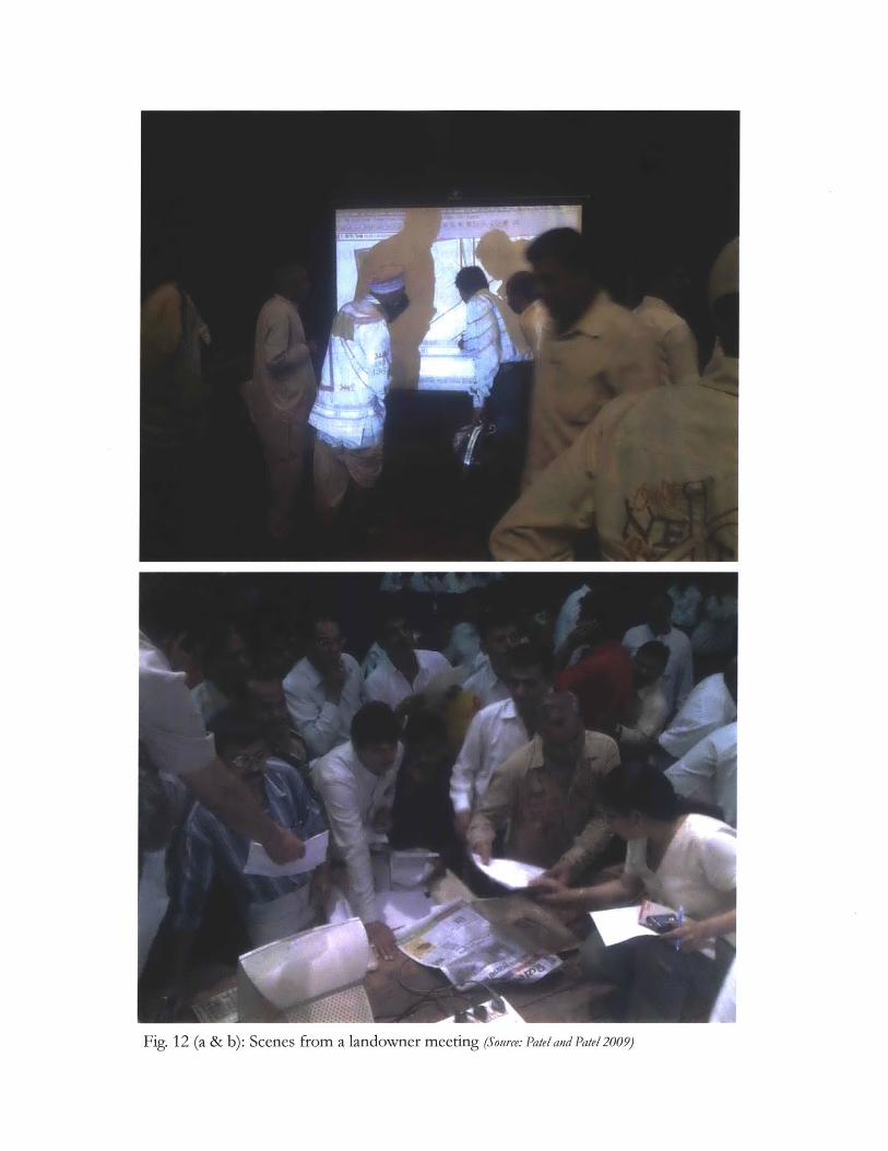
Fig. 12 (a & b): Scenes from a landowner meeting (Source: Patel and Patel 2009)
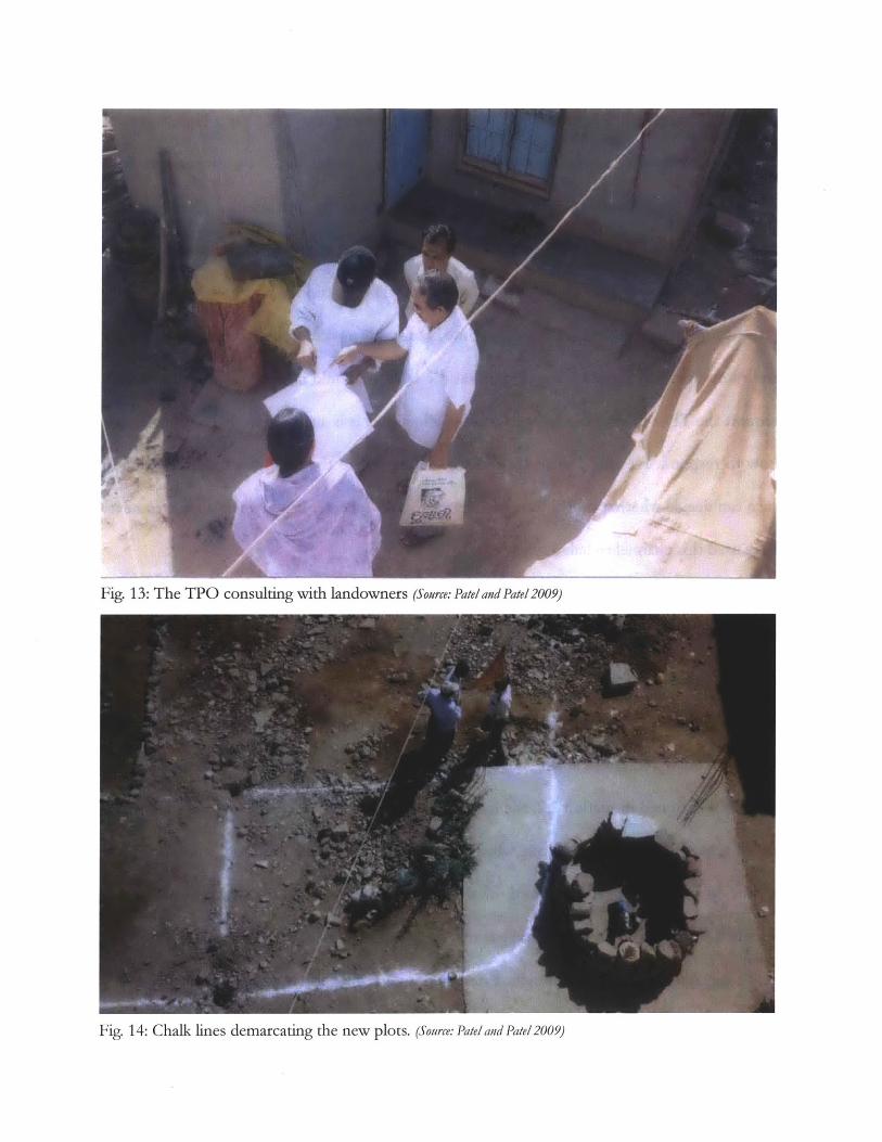
Fig. 13: The TPO consulting with landowners (Source: Patel and Pate! 2009)
Fig. 14: Chalk lines demarcating the new plots. (Source: Pateland Pate! 2009)

Even though all changes need to be justified in writing, the TPO has a high degree of
discretionary power in making modifications to the scheme based on discussions with
landowners. Once modified, the scheme is referred to as the preliminary TP scheme. A
notice is again published in the local newspapers, declaring the "award" of the preliminary
scheme, and it is sent again to the state government to be sanctioned.
According to the GTPUDA, at any time before this notice is published, if both AUDA
and more than half the landowners feel that the scheme should not be carried out, they can
request the TPO to stop it. Upon consulting all parties, it is again up to the TPO to decide
how to respond. He may choose to forward the request to the state government, which in
turn can decide whether or not to proceed with the TP scheme. Landowners appear to never
have used this channel to halt a scheme.
Once the preliminary scheme has been sanctioned by the state government, no changes
to the physical plan are made. The TPO meets landowners again to discuss financial matters,
and may make changes accordingly, resulting in the final scheme, which is again sent to the
state government for sanction. Once the final scheme has been drawn up, objections can be
made to a board of appeals at the state government prior to its sanction of the scheme.
As mentioned in section 2.2, the ring road is thought of as a key moment in the history
of TP schemes in Ahmedabad, one which led to the increased use of TP schemes in the last
ten or so years. However, accounts of the affected landowners' attitudes towards it vary
widely. The commonly repeated story is that in an effort to guarantee the completion of the
ring road, AUDA chairman Surendra Patel, who is described as having been the "uncrowned
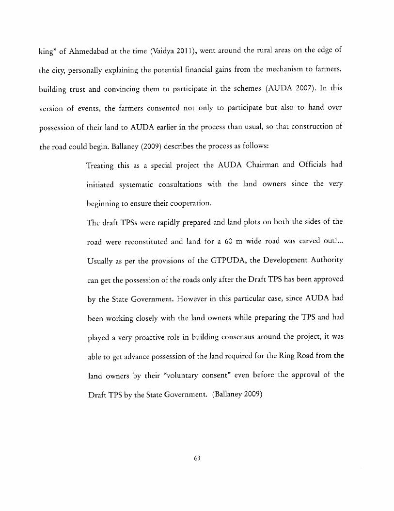
king" of Ahmedabad at the time (Vaidya 2011), went around the rural areas on the edge of
the city, personally explaining the potential financial gains from the mechanism to farmers,
building trust and convincing them to participate in the schemes (AUDA 2007). In this
version of events, the farmers consented not only to participate but also to hand over
possession of their land to AUDA earlier in the process than usual, so that construction of
the road could begin. Ballaney (2009) describes the process as follows:
Treating this as a special project the AUDA Chairman and Officials had
initiated systematic consultations with the land owners since the very
beginning to ensure their cooperation.
The draft TPSs were rapidly prepared and land plots on both the sides of the
road were reconstituted and land for a 60 m wide road was carved out!...
Usually as per the provisions of the GTPUDA, the Development Authority
can get the possession of the roads only after the Draft TPS has been approved
by the State Government. However in this particular case, since AUDA had
been working closely with the land owners while preparing the TPS and had
played a very proactive role in building consensus around the project, it was
able to get advance possession of the land required for the Ring Road from the
land owners by their "voluntary consent" even before the approval of the
Draft TPS by the State Government. (Ballaney 2009)
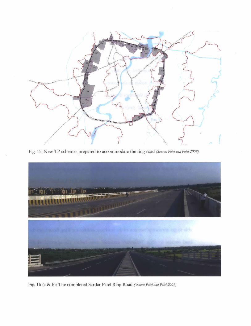
I I I- -' - - I. -
I * a.g~ I
I -- -- I a-a-
I - - -
I / a
-, a - -.
a a
\-/ a
--
a a~-~1
C .1a -~
-a -~~-
a -~
-- I
a -*Ia I
alIgIII,a4
//
Fig. 15: New TP schemes prepared to accommodate the ring road (Source: Pate/and Pate! 2009)
Fig. 16 (a & b): The completed Sardar Patel Ring Road (Source: Pateland Pate! 2009)
...........
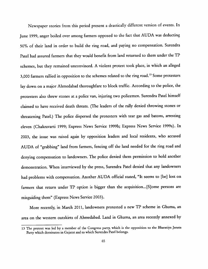
Newspaper stories from this period present a drastically different version of events. In
June 1999, anger boiled over among farmers opposed to the fact that AUDA was deducting
50% of their land in order to build the ring road, and paying no compensation. Surendra
Patel had assured farmers that they would benefit from land returned to them under the TP
schemes, but they remained unconvinced. A violent protest took place, in which an alleged
3,000 farmers rallied in opposition to the schemes related to the ring road. 13 Some protesters
lay down on a major Ahmedabad thoroughfare to block traffic. According to the police, the
protesters also threw stones at a police van, injuring two policemen. Surendra Patel himself
claimed to have received death threats. (The leaders of the rally denied throwing stones or
threatening Patel.) The police dispersed the protesters with tear gas and batons, arresting
eleven (Chakravarti 1999; Express News Service 1999b; Express News Service 1999a). In
2003, the issue was raised again by opposition leaders and local residents, who accused
AUDA of "grabbing" land from farmers, fencing off the land needed for the ring road and
denying compensation to landowners. The police denied them permission to hold another
demonstration. When interviewed by the press, Surendra Patel denied that any landowners
had problems with compensation. Another AUDA official stated, "It seems to [be] lost on
farmers that return under TP option is bigger than the acquisition... [S]ome persons are
misguiding them" (Express News Service 2003).
More recently, in March 2011, landowners protested a new TP scheme in Ghuma, an
area on the western outskirts of Ahmedabad. Land in Ghuma, an area recently annexed by
13 The protest was led by a member of the Congress party, which is the opposition to the Bharatiya Janata
Party which dominates in Gujarat and to which Surendra Patel belongs.
65
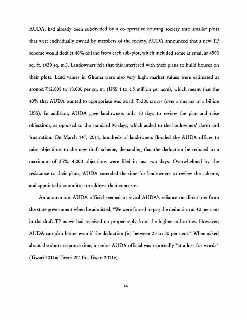
AUDA, had already been subdivided by a co-operative housing society into smaller plots
that were individually owned by members of the society. AUDA announced that a new TP
scheme would deduct 40% of land from each sub-plot, which included some as small as 4500
sq. ft. (420 sq. m.). Landowners felt that this interfered with their plans to build houses on
their plots. Land values in Ghuma were also very high: market values were estimated at
around Z12,000 to 18,000 per sq. m. (US$ 1 to 1.5 million per acre), which meant that the
40% that AUDA wanted to appropriate was worth Z1200 crores (over a quarter of a billion
US$). In addition, AUDA gave landowners only 10 days to review the plan and raise
objections, as opposed to the standard 90 days, which added to the landowners' alarm and
frustration. On March 1 4', 2011, hundreds of landowners flooded the AUDA offices to
raise objections to the new draft scheme, demanding that the deduction be reduced to a
maximum of 25%. 4,000 objections were filed in just two days. Overwhelmed by the
resistance to their plans, AUDA extended the time for landowners to review the scheme,
and appointed a committee to address their concerns.
An anonymous AUDA official seemed to reveal AUDA's reliance on directions from
the state government when he admitted, "We were forced to peg the deduction at 40 per cent
in the draft TP as we had received no proper reply from the higher authorities. However,
AUDA can plan better even if the deduction [is] between 25 to 30 per cent." When asked
about the short response time, a senior AUDA official was reportedly "at a loss for words"
(Tiwari 2011a; Tiwari 2011b ; Tiwari 2011c).
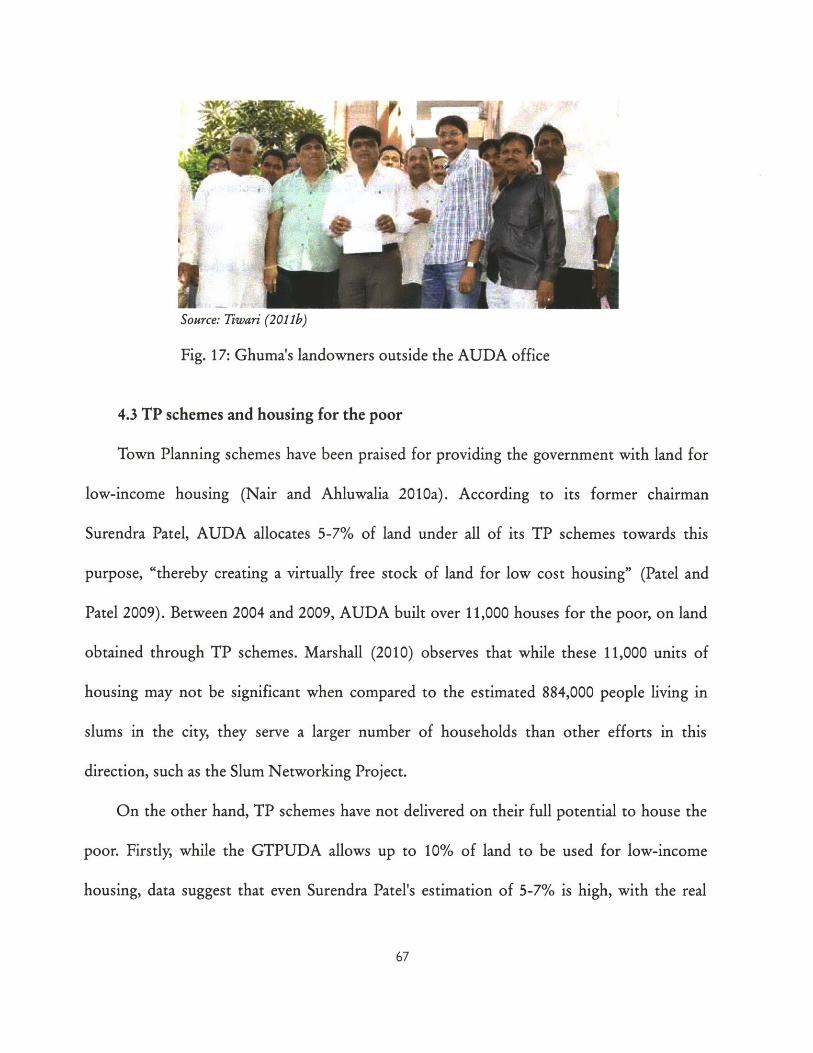
Source: Tiwari (2011b)
Fig. 17: Ghuma's landowners outside the AUDA office
4.3 TP schemes and housing for the poor
Town Planning schemes have been praised for providing the government with land for
low-income housing (Nair and Ahluwalia 2010a). According to its former chairman
Surendra Patel, AUDA allocates 5-7% of land under all of its TP schemes towards this
purpose, "thereby creating a virtually free stock of land for low cost housing" (Patel and
Patel 2009). Between 2004 and 2009, AUDA built over 11,000 houses for the poor, on land
obtained through TP schemes. Marshall (2010) observes that while these 11,000 units of
housing may not be significant when compared to the estimated 884,000 people living in
slums in the city, they serve a larger number of households than other efforts in this
direction, such as the Slum Networking Project.
On the other hand, TP schemes have not delivered on their full potential to house the
poor. Firstly, while the GTPUDA allows up to 10% of land to be used for low-income
housing, data suggest that even Surendra Patel's estimation of 5-7% is high, with the real
...... . . .................. .. ........ .....................
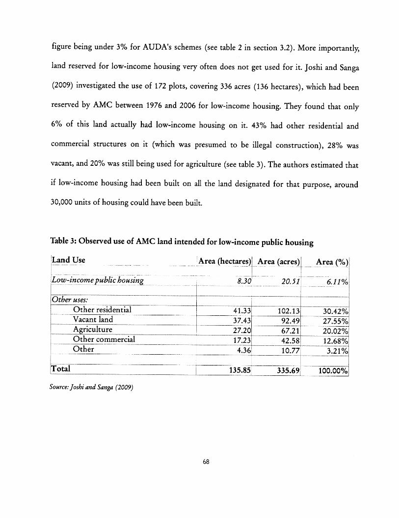
figure being under 3% for AUDA's schemes (see table 2 in section 3.2). More importantly,
land reserved for low-income housing very often does not get used for it. Joshi and Sanga
(2009) investigated the use of 172 plots, covering 336 acres (136 hectares), which had been
reserved by AMC between 1976 and 2006 for low-income housing. They found that only
6% of this land actually had low-income housing on it. 43% had other residential and
commercial structures on it (which was presumed to be illegal construction), 28% was
vacant, and 20% was still being used for agriculture (see table 3). The authors estimated that
if low-income housing had been built on all the land designated for that purpose, around
30,000 units of housing could have been built.
Table 3: Observed use of AMC land intended for low-income public housing
Land Use Area (hectares) Area (acres)
Low-income public housing 8.30 20.51
Other uses:
Other residential 41.33 102.13Vacant land 37.43 92.49A oricuiltur1
Area (%)I
6.11%
30.42%27.55%
Other commercial _17.23 42.58 12.68%Other - 4.36 10.77 3.21%
otal 135.85 335.69 100.000
Source: Joshi and Sanga (2009)
I
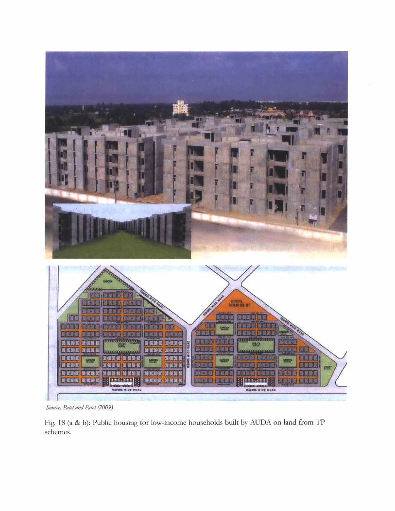
Source: Patel and Patel (2009)
Fig. 18 (a & b): Public housing for low-income households built by AUDA on land from TPschemes.
Joshi and Sanga contend that the policy of reserving lands for low-income housing
under TP schemes is "deficiently planned; inadequately financed and inefficiently
implemented". In their opinion, it has failed completely in its execution, and the only reason
it continues to be practiced in spite of "the former apathy and now hostility to the urban
poor" is that it is a legally binding requirement of the GTPUDA.
Whether or not this is true, a lack of attention to low-income housing has been
noticable for some time. In a case study of the Memnagar TP scheme, drafted in 1976, Baker
(1992) noted that only 0.8% had been reserved for low-income housing. When his team
visited the site 10 years after the scheme had been implemented, 70-80% of the land had
been built-up, mostly with middle- and upper-middle income residences, whereas none of
the low-income housing had been built. None of the planned public facilities (schools,
health clinics, markets), had been built either.
In addition to not resulting in as much low-income housing as they could, town
planning schemes sometimes lead to the displacement of low-income populations from
existing informal settlements. TP schemes have even resulted in the demolition of
settlements which have been upgraded through AMC's own Slum Networking Project
(SNP). The fact that AMC claims to be unable to forecast when future TP schemes will be
implemented, even within a five year time frame, adds to the uncertainty surrounding
resettlement. According to the AMC engineer in charge of the SNP, slum resettlement is
justified in order to carry out infrastructure projects: "The authority has the flexibility to
shift slums, otherwise how will the city develop?" (Nayudu 2008; Nayudu 2009)
Recently, land acquired through TP schemes has been used to resettle households that
have been displaced from informal settlements along Ahmedabad's riverfront, to make way
for AMC's high-profile Sabarmati Riverfront Development Project. While the land created
by the riverfront project is estimated to be worth Z1600 crore (US$ 360 million), AMC has
reportedly failed to provide even the promised Z5,000 (US$ 110) to resettled households
(Nayudu 2008; DNA 2010). In addition, resettlement housing is usually provided on the
outskirts of the city, without access to schools, hospitals, water supply or toilets. Resettled
families are cut off from jobs and business opportunities. According to a representative of
Action Aid, a local NGO active in informal settlements, the "constant reshuffling of slums
has led to a major employment crisis in this section of the society." Resettled households are
typically forced to turn to predatory lenders and take high-interest loans in order to survive"
(Concerned Citizens of Ahmedabad 2010; IIM Ahmedabad 2010; Mahadevia 2011).
It is sometimes argued that whether or not TP schemes directly result in low-income
housing, they do bring about an increase in the supply of housing of all types, making
housing more affordable for everyone. In their recent paper "Working with the Market:
Approach to Reducing Urban Slums in India" (2010), Annez, Bertaud, et al argue that the
rapid expansion of Ahmedabad in the last ten years has allowed the city to avoid an
explosion of informal housing. The guidelines for urban reform suggested by the
14 When interviewed by a citizens' committee in 2009, the head of one resettled household described his
difficult circumstances in despair. His family had been herded onto a truck in the middle of the night in
2005 and deposited onto a snake-infested plot of land on the outskirts of the city. "I am really desperate,"
said the 40-year old father of two, who four years after being relocated was considering suicide as he couldno longer make ends meet. "I can't see my future. I can't see my children's future... All my dreams have
been smashed by these people who relocated us" (TIM Ahmedabad 2010).
7|
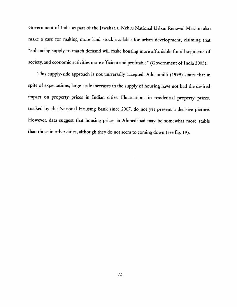
Government of India as part of the Jawaharlal Nehru National Urban Renewal Mission also
make a case for making more land stock available for urban development, claiming that
"enhancing supply to match demand will make housing more affordable for all segments of
society, and economic activities more efficient and profitable" (Government of India 2005).
This supply-side approach is not universally accepted. Adusumilli (1999) states that in
spite of expectations, large-scale increases in the supply of housing have not had the desired
impact on property prices in Indian cities. Fluctuations in residential property prices,
tracked by the National Housing Bank since 2007, do not yet present a decisive picture.
However, data suggest that housing prices in Ahmedabad may be somewhat more stable
than those in other cities, although they do not seem to coming down (see fig. 19).
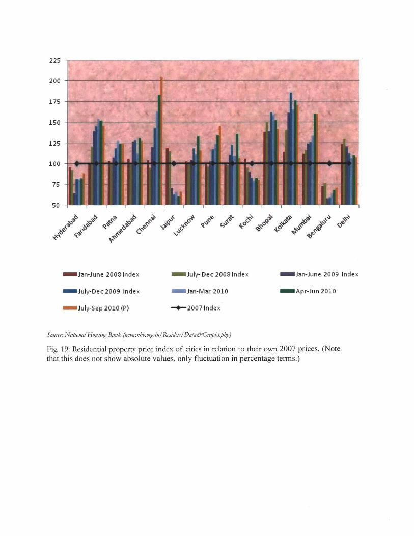
Jan-June 2008 Index
July-Dec 2009 Index
July-Sep 2010 (P)
July- Dec 2008 Index
Jan-Mar 2010
-0-2007 Index
Jan-June 2009 Index
SApr-Jun 2010
Source: National Housing Bank (www.nb.org.in/ Residex/Data&Graphs.php)
Fig. 19: Residential property price index of cities in relation to their own 2007 prices. (Notethat this does not show absolute values, only fluctuation in percentage terms.)
225
200
175
150
125
100
75
50

1Ii~iil70 -
m~-
III~I 1.4- N K
11o d 4
Gties(m creasiigorder of total ppulationfirmleftto right)
Source: Census data (NILTA)
Fig. 20: Percentage of population living in slums, in Indian cities with total population greaterthan 1 million.
60%
50%
40%
30%
20%
10% I; 1
There is some evidence to support the claim that Ahmedabad has avoided an explosion
of slums on the scale of other large Indian cities. Census data from 2001 show that out of 26
Indian cities with populations exceeding one million, Ahmedabad ranked 19 th in terms of the
percentage of the population living in slums (see fig. 20). According to the census, 12.5% of
Ahmedabad's population lives in areas defined as slums, compared to 17-18% of the
population of both Hyderabad and Chennai, which are cities of comparable size, and far
below Mumbai's 49%. However, other estimates of Ahmedabad's slum population vary
greatly, with AMC itself estimating that 26% lived in slums in 2001, up from 16% in 199115
(AUDA and AMC 2006). Also, it has also been observed that urban expansion in western
Ahmedabad has coincided with an increase rather than a decrease in slums. This has been
linked with a decline in industrial employment on the eastern side of the city, and a growing
demand for domestic workers in the new developments on the western side. The inadequate
supply of public housing for these low-income workers results in the formation of new
informal settlements (Pandey 2002).
4.4 TP schemes and the courts
A number of court cases have arisen in relation to TP schemes in Ahmedabad, which
have reached both the Gujarat High Court and the Supreme Court of India.16 Landowners
go to court seeking higher compensation for land taken, refusing to hand over land, trying
15 The Census of India 2001 defined a 'slum' as any area recognized by a state or local government as a slum,and any "compact area of at least 300 population or about 60-70 households of poorly built congested
tenements, in unhygienic environment usually with inadequate infrastructure and lacking in proper sanitaryand drinking water facilities." AMC's higher figure comes from a survey conducted by local NGOs SEWAand SAATH, which included areas with fewer than 60 households.
75
to force authorities to clear informal settlements on their final plots, etc. A look through a
selection of court reports dating back to the 1940s suggests that the courts typically uphold
the decisions made by the authorities regarding TP schemes, sometimes invoking the public
good as a reason to reject claims made by individual landowners (eg. Hasmukh Shah vs.
Ahmedabad Municipal Corporation 2000).
The courts' attitude towards government use of planning power was demonstrated in a
case brought before the Gujarat High Court in 1996. A group complained that after buying
a final plot in a TP scheme from an original landowner, AMC had modified the scheme so
that their land was now to be used for a World Bank sponsored slum upgradation project.
The petitioners argued that this was being done with a "political motive", and that there was
no question of slum upgradation on their land as there were no slums there. They further
claimed that AMC frequently acquires plots ostensibly for slum upgradation which
eventually get used for other purposes. According to them, if AMC were to take their land,
it would amount to an "arbitrary" action, in violation of their fundamental rights and the
principles of natural justice. The court dismissed the case, ruling that the GTPUDA gave
AMC the right to modify schemes. On the issue of slum upgradation, the court stated, "It is
not for the Court to decide whether land could be reserved for slum upgradation[, this]
being a part of the policy matter. It must be remembered that Court is obliged to till the
balance between judicial restraint and judicial activism. Court cannot embark upon
16 It is difficult to ascertain how many such cases have been raised in court over the decades, but searching anonline database of Indian legal reports dating back to the 19' century (wwwindiankanoon.com), gives someindication. For instance, searching for the terms "town planning scheme" and "Ahmedabad" yields over 400cases as results, the earliest being from 1944.
scrutinising rightly executive policies of the State or statutory authority." (Rajan
Sankalchand Patel vs State Of Gujarat 1996)
In another instance, the case of a landowner dissatisfied with the compensation given
for appropriated land reached the Supreme Court of India, which dismissed his case but
permitted him to subsequently question the constitutional validity of the Town Planning
Act. When he proceeded to do this, the Supreme Court upheld the validity of the Act
Courts do favor citizens on occasion. For example, in 1991 the Supreme Court ruled
that a TP scheme had in fact injuriously affected a tenant who had been running a shop on
the land in question for fifty years. The court ordered AMC to find another shop within the
city for him to run (Jaswant Singh Mathura Singh and Anr. Vs. Ahmedabad Municipal
Corporation and Ors. 1991). (As another indication of the lengths of time involved in TP
schemes, it is worth noting that this case related to a TP scheme which was initiated in 1951,
had its final version sanctioned in 1970, and was implemented around 1981. The case was
decided in 1991.)
Chapter 5
LAND READJUSTMENT IN OTHER INDIAN STATES
While TP schemes are mostly associated with Gujarat, they have been used to various
degrees in a number of other states in India. The cases below illustrate the growing interest
in land readjustment policy beyond Gujarat. The slightly varied processes and institutional
models employed in different parts of the country are also instructive. Their successes and
failures show some of the constraints and opportunities associated with introducing land
readjustment to new areas.
5.1 Maharashtra
As recounted in chapter 2, TP schemes originated in what is now Maharashtra state, and
had a significant history there before being abandoned. Over 120 schemes covering over 40
square miles (100 sq. km.) were prepared in Maharashtra. 40 schemes were carried out in the
city of Bombay alone, including in areas like Bandra, Mahim and Andheri, now wealthy
secondary centers. A recent land auction in Bandra in 2006-07, in which 32 acres (13
hectares) were sold for US$ 1.2 billion, gives an indication of the extremely high land values
prevailing in the same areas today (Peterson 2009). According to the Chief Town Planner at
the Mumbai Metropolitan Region Development Authority (MMRDA), the best-planned
areas in major cities in Maharashtra have been developed using TP schemes (Adusumilli
2009).
However, Maharashtra's act (1966) did not include the time-saving amendments of the
later Gujarat act (1976), which allowed the government to begin construction of roads prior
to the finalization of the financial details. Schemes in Maharashtra were plagued by long
delays, with the completion time averaging 15 years (MMRDA 1999). While authorities were
only permitted to recover their costs by levying betterment charges from landowners,
implementation costs continued to rise due to the delays, and the government invariably had
to put in their own funds. There was no provision in the Maharashtra act for acquiring land
for the purpose of reselling on the market.
MMRDA's 2006-2011 regional plan cites the complexity of land valuation and of
equitable distribution of benefits as additional factors that discourage the use of any kind of
land readjustment scheme. According to MMRDA (1999) , "[d]espite being conceptually
attractive, TPS has proved to be procedurally very cumbersome." (MMRDA 1999)
In 1994, a committee appointed by the All India Institute of Local Self Government
made a number of recommendations regarding TP scheme legislation in Maharashtra. These
included, among others,
- the appointment of a full-time Project Officer instead of a Town Planning Officer,
responsible for formulating the scheme, processing it, getting it sanctioned and
implementing it on site, guided by statutory mechanisms,
- compensation for appropriated land either in the form of additional permitted floor
space, or as a monetary payment linked to the recipient's income (the committee
suggested a figure of 100 times the net monthly income),
- separating the preparation of the scheme into a physical plan and a financial plan, as
in Gujarat, but with state approval required only once.
The Mumbai Chapter of the Institute of Town Planners, India (ITPI) also conducted
a seminar on TP schemes in 2000 which resulted in more proposals. The Government of
Maharashtra did not directly act on any of these, but has reportedly shown more interest in
potentially reviving TP schemes in recent years (Adusumilli 2009).' As of 2011, the city of
Nagpur is starting to design its first TP schemes, with the help of Ahmedabad-based
consultants.
5.2 Kerala
Until recently, an amended version of the Travancore Town Planning Act of 1932 was in
place in Kerala. Based on the Madras Town Planning Act of 1920, which in turn was based on
the Bombay Town Planning Act of 1915 discussed earlier, the Travancore act made provisions
for the use of plot reconstitution in a manner similar to the Gujarat and Maharashtra acts.
However, this feature of the act was not used for over fifty years, until the Trichur Urban
Development Authority (TUDA) faced opposition to land acquisition in 1983, and decided
to try a plot reconstitution scheme.
This scheme, known as the Kannankulangara Detailed Town Planning Scheme, is
17 In one case of land acquisition with some similarities to TP schemes, the City and Industrial DevelopmentCorporation of Maharashtra sold a small amount of land, 12.5%, back to the original owners afterdevelopment, for more than double the original acquisition price (MMRDA 1999).
80
described by Acharya (1989). There were a few salient differences between this case and
those in Maharashtra or Gujarat:
- There was a much smaller number of landowners, only nine, who actively negotiated
details of the plan with TUDA. In subsequent interviews, the landowners spoke
proudly of their role in making the scheme a success.
- There was no compensation given to landowners by TUDA in exchange for
appropriated land, which amounted to 35% on average of the original area. However,
their land value went up 7.7 times on average.
- There was no betterment charge levied by TUDA either. TUDA recovered costs, and
in fact made a profit, from the sale of its portion of the land on the market, a practice
that was not common at the time even in Gujarat.
- Both TUDA and the landowners agreed to a strict time schedule. If TUDA took
longer than three years to build infrastructure, the landowners could take back
possession of the land. In turn if the landowners took more than three years beyond
that to finish building on their land, TUDA could take it from them as well. TUDA
expedited the implementation of the scheme by designating the area as the site of an
address delivered by the Pope, who visited Trichur in 1986.
Despite the success of the Kannankulangara scheme, only six plot reconstitution
schemes have been successfully completed in Kerala (Centre for Good Governance 2010).
In the last few years however, there has been a resurgence of interest in land pooling
and plot reconstitution. Officials in the capital, Thiruvananthapuram, have extolled its
potentially transformational effects, in news articles that describe the policy as a "new
concept", seemingly unaware of its past use in the state. The fact that it was already
supported by the existing Travancore act had been used to promote the idea (Nandakumar
2005; "Land pooling mooted for planned growth" 2010).
However, the future of plot reconstitution schemes in Kerala was abruptly thrown into
question in February of 2011, when the Kerala High Court declared all existing Town
Planning Acts not just outdated but also unconstitutional, for being in violation of the 74th
Constitutional Amendment (1992), which calls for the devolution of planning power to
urban local bodies (ULBs). A new act is currently being formulated ("High Court declares
Act unconstitutional" 2011 a; "Sri.V.Shivaprasad vs State Of Kerala" 2011 d).
5.3 Andhra Pradesh
The Andhra Pradesh Town Planning Act, originally formulated in 1920, allows land
pooling and plot reconstitution. It was used in coastal areas of Andhra Pradesh under the
Madras Presidency prior to Independence, but, as in other states, eventually fell out of use
(Centre for Good Governance 2010).
The mechanism is now being revived under the Hyderabad Metropolitan Development
Authority Act, 2008. A project called 'Ozone Valley', at Paradesipalem in the Visakhapatnam
metropolitan area, is currently underway, with government land from the project already
sold at auction ("VUDA Auction of Plots Nets Rs. 60.36 Crores" 2011 e). According to the
Visakhapatnam Urban Development Authority, land pooling is an "ideal concept", and the
project is the first of its kind in Andhra Pradesh. Revenue generated from the sale of land at
Ozone Valley is to be used for amenities in Ozone Valley itself ("Land-pooling project:
allotment letters given to landholders" 2011 b).
5.4 Tamil Nadu
In 2010, a committee considering possible amendments to the Tamil Nadu Town and
Country Planning Act of 1971 proposed adopting a policy of land pooling and plot
reconstitution as used in Gujarat. The proposals are currently being considered by the state
government. (Srivathsan 2010; Srivathsan 2011)
5.5 Punjab
In 2010, the Greater Mohali Area Development Authority (GMADA) wanted to
acquire agricultural land in Mohali, near Chandigarh. Landowners were given the choice of
whether to participate in a land pooling scheme or whether to have their land simply
acquired by the government for a cash compensation. The cash compensation offered,
around Z3,700 per sq. m., was much larger than the amounts typically offered in India, which
in recent years have been between Z4 and Z250 per sq. m. (Antony 2007). GMADA
conducted "awareness campaigns", in order to explain the benefits of land pooling to
farmers. Still, the majority of the landowners chose the cash compensation, with only
owners of 15% of the land in question choosing to enter into the land pooling scheme. A
GMADA official stated that while most landowners did not want to wait for two years to
receive final plots from the authority, "those not opting for LPS [land pooling scheme]
would repent when prices of the developed plots would skyrocket and go higher than the
cash compensation." (Times News Network 2009; Express News Service 2010; Jain 2010;
Times News Network 2010)
Chapter 6
CONCLUSIONS
6.1 The future of TP schemes
What role can TP schemes play in the future of urban expansion, both in Gujarat and in
the rest of India? We have seen that Ahmedabad's experience with TP schemes has not been
perfect, and that the mechanism has limitations. A United Nations committee has observed
that "land readjustment is merely a land development method and should be regarded as a
complement to other methods. It will never be a panacea to the staggering shortage of
housing and infrastructure in developing countries" (CITYNET 1995). However, if we
recognize that there is no silver bullet for urban growth, and understand the realities of the
TP scheme mechanism, there is no reason why it should not be one of the tools available to
city governments in Gujarat and elsewhere, particularly if some key modifications are made.
Before considering how the TP scheme mechanism might be improved, it is important
to recognize that TP schemes themselves are only as good as the DPs that they help to
implement. TP schemes have been useful in overcoming hindrances that authorities typically
face in acquiring land for carrying out development plans. AUDA claims that the use of TP
schemes has allowed Ahmedabad to become the first city in India to implement 90% of its
DP (Joshi 2011). Yet if the development plans of Indian cities are as rigid and impractical as
described in section 3.1, TP schemes can be of only limited value. Any attempt to address
shortcomings in the TP scheme mechanism will be ineffective without a parallel effort to
make DPs more flexible, inclusive and effective.
In order to understand how TP schemes might work in other contexts, it must be noted
that the financial feasibility of the process relies heavily on a high demand for urban land.
Only when this demand exists, both landowners and government bodies are guaranteed to
be able to sell their portions of land for a price high enough to make the endeavor
worthwhile. If landowners doubt their ability to profit from TP schemes, they may be
unwilling to give up any land to the government. If governments are unable to cover their
costs by auctioning off their land, TP schemes once again become the drain on public
finances that they were in the past. This suggests that it may prove difficult to apply TP
schemes to more distant rural contexts in anticipation of future urban growth. Even in more
urban contexts, the demand pressure on land needs to be considered before experimenting
with TP schemes.
AUDA and AMC have not been able to take full advantage of land for low-income
housing which TP schemes have the potential to provide (section 4.3). Perhaps the policy of
reserving small pockets of land in every new TP scheme, regardless of their location in
relation to where low-income housing is most needed, is a flawed one. Instead, reserved land
from a number of adjacent TP schemes could be consolidated at the most suitable locations.
Alternatively, rather than as a source of land, TP schemes could be used as a source of funds
for low-income housing, by "ring-fencing" the proceeds from the sale of a certain
proportion of land (Annez 2011).
Most importantly, any attempt to modify or replicate the TP scheme legislation should
recognize that while the process may benefit both government and landowners financially,
financial calculations do not work the way the GTPUDA of 1976 originally intended them
to. Written accounts of the TP scheme mechanism continue to describe only how the
mechanism is supposed to work, ignoring the reality of how it actually works. Yet as we have
seen (in section 3.3), the process of estimating original and final plot values is a kind of
pretense, as it is universally understood that these values bear no relation to reality.
These values do result in the calculation of a betterment charge, which despite being
nowhere close to equaling half the increase in land value as originally intended by the
GTPUDA, does vary from owner to owner enough to compensate for perceived differences
in benefits, creating the perception of fairness. However, there may be less elaborate means
of achieving the same result. For instance, the first land readjustment scheme in Kerala, at
Kannankulangara, was considered successful by landowners despite there being no
estimation of original or final plot values, and therefore no betterment charge paid or
compensation received (section 5.2). There was, however, wide variation in the proportion
of land given up by the owners to the development authority, instead of an equal proportion
as in Gujarat. Varying the area of land appropriated and doing away with betterment charges
entirely might be a simpler and quicker way of adjusting the benefits of different owners
whose plots are located differently. In order for this to work however, there would need to
be a high degree of involvement on the part of the landowners from the beginning, as there
was in the Kerala case, as well as trust in the government and in the process.
The importance of trust relationships in land readjustment has been stressed by Hong
and Needham (2007). It is usually claimed that the trust built by former AUDA chairman
Surendra Patel among landowners on the periphery of Ahmedabad for the ring road project
led to a rebirth of TP schemes in the city. However, the violent protests surrounding land
appropriation for the ring road suggest that many continued to seriously distrust the
authorities. Recent protests over land appropriations by AUDA in Ghuma show that this
distrust persists (section 4.2). In Punjab, despite efforts to create awareness, authorities were
unable to convince landowners to trust in the eventual benefits of a land readjustment
scheme (section 5.5).
One of the essential ways in which governments can avoid the often disruptive
consequences of such distrust is involving the public in a more meaningful manner. While it
could be argued that a collective action like land readjustment could not occur in the absence
of firm government control, excluding landowners from the decision-making process could
marginalize the interests of the very people TP schemes claim to benefit. Public participation
has been lacking in Ahmedabad in a few key ways. Firstly, landowners are only involved once
the draft scheme has already been prepared, so from the start they can only play a reactive
role in the process. While they do have multiple opportunities to request changes in their
favor, authorities have a high degree of discretion regarding whether to make any changes
based on these requests. As described in section 3.3, corruption allegedly pervades the town
planning system in Ahmedabad, which undermines confidence in the degree of fairness with
which the authorities will use the discretionary power that they have.
Secondly, public participation in TP schemes is restricted to landowners, on matters
relating only to their own plots. There is no collective input regarding the road network,
open spaces and other amenities (Ballaney 2009). Landowners typically sell their plots once
the scheme is completed, and so their own interest in the outcome is limited to receiving a
final plot that can be sold to a developer for a higher price. As we have seen, landowners do
appear to benefit greatly from the sale of their plots. However, as there is no mechanism for
the general public to take part in the design of TP schemes, there seems to be a
disconnection between the parties being consulted, i.e. the original landowners, and the
future users of the buildings, streets and public spaces constructed. Any future legislation
around TP schemes should try to address this disconnection.
Thirdly, there is no attempt to include informal actors in the process, either through
acknowledging their claims on the land or through accommodating future informal activity.
Kleinenhammans (2009) believes that "TPS lack true participation by the poor and the
informal sector. The poor and informal are not sufficiently represented by public planners
who [lack] the knowledge and ambition to plan for them in a proper and truly inclusive
way." TP schemes sometimes lead to the displacement of existing informal settlements, even
those that have been upgraded through municipal investment. TP schemes should try to
incorporate rather than work against existing in-situ slum upgradation projects. When land
from TP schemes is used for the resettlement of informal residents from elsewhere, it is
done in a manner so brutal and disruptive to their livelihoods that it tarnishes the entire
endeavor of setting aside land for the poor (see section 4.3). The availability of TP scheme
land for the poor on the outskirts of the city should not encourage authorities to use
resettlement when alternatives like the granting of tenure and in-situ upgradation are
feasible.
Lastly, the firm control of the state government on the process hinders meaningful
participation at the local level. It has been argued that the "provision of infrastructure and
services... should mainly be the responsibility of urban local governments, as this level of
government is more intimately linked to urban life than government at the subnational and
national levels" (ESCAP 1994). In order to strengthen trust relationships through local
accountability, local authorities need to be more significantly empowered. According to the
GTPUDA, the initial draft TP scheme is supposed to be designed by a local government
body. However, the fiasco surrounding the Ghuma scheme suggests that AUDA relies on
instructions from the state government's planning department even at the draft stage, in
order to make as basic a decision as what percent of land to appropriate from owners.
Beyond the draft stage, the decision-making power lies entirely with the state government
and its representative, the Town Planning Officer. Once a scheme has been implemented,
growth of the housing stock is greatly slowed by the complex procedures that the state
government's Revenue Department requires landowners to go through before they can sell
or build on their plots. This severely limits the effectiveness of TP schemes. For TP schemes
to be made significantly more effective, an important first step is for the state government to
relinquish some of its control.
Even leaving aside the issue of whether or not Gujarat's top-down approach is desirable
or efficient, the state government should consider the fact that this withholding of power
over TP schemes may not be considered legal for much longer. While the constitutional
validity of the GTPUDA has been upheld by courts in the 1980s, it could now again be
challenged in light of the the 74 th Constitutional Amendment of 1992, which prescribes the
devolution of powers from state governments to local governments. As we have seen,
exactly such a case was brought before the High Court of the state of Kerala in early 2011,
leading to the town planning acts of that state, which dated back to the 1930s, being struck
off the books.
As a result of this top-down approach, long delays bedevil the process of sanctioning
the TP schemes at the state level. However, as we have noted, there are also major delays in
the implementation of TP schemes, unrelated the state government's bureaucratic process
(section 3.3). Authorities are free to choose which schemes to implement and which to put
off indefinitely, which leaves room for favoritism and rent-seeking. However, expedient
implementation is vital if trust is to be maintained. This was demonstrated by the Punjab
case (section 5.5), in which farmers chose not to participate in a land pooling scheme despite
being explained the benefits, simply because they felt it would take too long. The more
successful Kerala example (section 5.2), in which both the development authority and the
landowners had firm time limits for implementation built into the contract, could serve as a
model. For TP schemes to be successful, authorities need to develop a greater understanding
of how various stakeholders perceive and value time.
6.2 Alternative institutional models
While none of the above concerns dictate that the use of TP schemes should be
abandoned altogether, they do suggest that alternative institutional arrangements to carry
them out are worth investigating. Instead of being solely responsible for the entire TP
scheme process, the government could consider shifting its role to one of facilitation. TP
schemes are often described loosely as public-private partnerships (Centre for Good
Governance 2010; Patel, V. 2011), but at present, the organized private sector only enters the
picture once TP schemes have been completed. With the growing presence of large real
estate companies in India (Mahadevia 2009), a greater role for the private real estate sector in
the design, coordination and implementation of TP schemes is worth considering. This
would draw on the private sector's comparative advantage in implementation, while
maintaining the role of government regulations that are necessary to ensure inclusive
decision-making and equitable outcomes.
An even greater opportunity arises if landowners themselves are allowed and
encouraged to initiate land readjustment schemes. We have seen that landowners can
organize themselves and act in coordination when it comes to protesting TP schemes that do
not suit them, and that they are willing to hire lawyers and fight in court to protect their
land. If allowed to, this energy could be redirected by landowners into coordinating among
themselves, pooling their land and hiring consultants to help them redesign their
neighborhoods according to their own preferences.
This is not far-fetched. Examples already exist of agricultural landowners on the urban
periphery acting together to determine the fate of their own land. At Magarpatta in
Maharashtra, farmers pooled their land and formed a real estate company, through which
they designed and built a mixed-use, high land-value township on the outskirts of Pune,
sharing profits among the original landowners (Dalal and Basu 2007; Nair and Ahluwalia
2010b). This is not an instance of land readjustment, and the fact that the landowners in
Magarpatta all belonged to one extended family with strong political connections makes it a
somewhat unique case. However, lessons could still be learned from that experience, if the
TP scheme mechanism were to be modified to allow greater initiative on the part of
landowners.
The extensive experience of Japan in this regard could serve as a model here. 30% of all
urban land in Japan has been developed through land readjustment, and around half of all
land readjustment projects are initiated and carried out by landowner associations. Legally
established guidelines dictate procedures, such as minimum levels of consensus among the
landowners, but otherwise the government remains relatively hands-off (Doebele 1982;
Sorensen 2007). The Gujarat state government could learn the details of these procedures
from the Japanese. As it happens, the Japanese government is already involved in urban
development in Gujarat, designing "eco cities" in the state as part of the Delhi-Mumbai
Industrial Corridor project (Shah 2008; Press Trust of India 2010). This existing link
between Gujarat and Japan provides an ideal opportunity for a potential transfer of best
practices regarding this model of land readjustment, an opportunity which would be a shame
to waste.
Empowering landowners in this manner would not directly address the disconnection
between the interests of landowners, who usually sell their land, and the end users of the
developments on that land. Nevertheless it would put to rest some of the concerns described
above, particularly those of landowner participation and trust. The government could
continue to have a role in facilitating, monitoring and guiding landowner-led TP schemes, in
order to ensure equitable outcomes.
Transferring responsibility to landowners or the private sector would necessitate a
major shift in the notion of the TP scheme mechanism as a government-controlled endeavor,
a notion that has persisted since its colonial origins nearly a century ago. Such a change
might appear disruptive and complicated. However, it is unreasonable to expect TP schemes,
originally the product of a very different era, to continue to work unchanged into the
twenty-first century. Adapting to the new realities and priorities of city planning would
allow TP schemes to help shape the future of Indian cities in the coming era of urbanization.
6.3 Unresolved questions
The scope of this thesis has not allowed an investigation into all of the issues
surrounding TP schemes, and there are a number of compelling directions that could be
taken by future research in this area.
There has been a lack of field research into the experience of landowners going through
the TP scheme process. How they understand it, how they make decisions, how their lives
change when they leave their land, how they use the money they make from selling their
land, and a host of other questions need to be further investigated. This thesis has also not
analyzed the internal structure and workings of the Government of Gujarat, Ahmedabad
Municipal Corporation or Ahmedabad Urban Development Authority in detail.
Understanding how these bodies operate as organizations and make decisions could yield
further insight into how TP schemes function and how they could be improved.
In a context where both the local and state governments are controlled by the BJP, a
right-wing party with a Hindu nationalist ideology, one cannot ignore the implications for
the Muslim minority population of the discretion that authorities have in prioritizing TP
schemes. Whether or not the government actively excludes Muslim communities, one
imagines that the history of communal violence in Gujarat and the resulting distrust,
resentment and lack of cooperation between Muslims and the government cannot fail to
affect TP schemes. A study needs to be undertaken of how TP schemes affect Muslims in
particular, and whether TP schemes have contributed to the spatial segregation of
Ahmedabad along communal lines.
Not enough attention has been paid to what kind of a built environment results from
TP schemes. According to AUDA, designing these schemes is simply a "game of geometry",
of fitting in the right number and size of plots into the space available, and shaping them
regularly so that they can be easily built upon (Joshi 2011). Others believe that the
government has not yet understood the kind of design expertise that is needed to produce
good TP schemes, and that outsourcing design functions to mapping and surveying firms
without design experience has hurt the quality of the resulting urban space (Patel, B. 2011).
Particularly if TP schemes are to be expanded to other parts of India, it is vital to understand
their effect on how the urban realm functions and is experienced.
Finally, greater attention also needs to be paid to the environmental impact of urban
expansion through TP schemes, and of the patterns of living and commuting that they
engender. Concerns about American-style "sprawl" might be misplaced here; Ahmedabad's
population density has been increasing, and in fact TP schemes have been credited with
keeping the city compact (AUDA and AMC 2006). Nevertheless, with the urgent need to
curb carbon emissions, TP schemes need to be thought of as more than just a way of
extending the road network for private automobiles. Even leaving aside environmental
concerns, in a country with only 3 cars per 1000 people (Chamon, Mauro et al. 2008), the
need to grant equal accessibility to all sections of society underscores the importance of
research into how TP schemes might be better integrated with public transportation.
Urbanization is a reality that cannot be wished away. However, once land becomes
urbanized, it will remain so, and planners need to understand the long-term effects of urban
expansion, from the variety of perspectives outlined above. The residential and commercial
neighborhoods, streets, and public spaces that are laid out in TP schemes today will need to
not just accommodate and support but also provide a meaningful sense of place to millions
of people, for centuries to come.
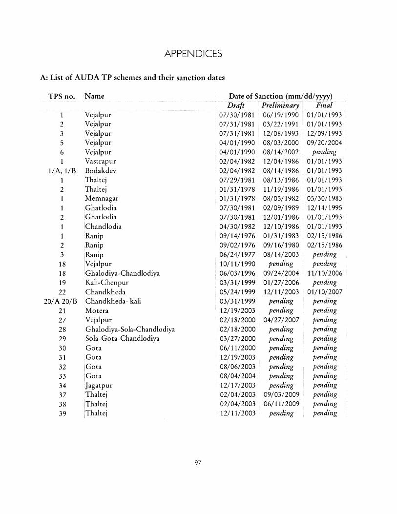
APPENDICES
A: List of AUDA TP schemes and their sanction dates
TPS no. Name
123561
1/A, 1/B121121123
18181922
20/A 20/B2127282930313233
34373839
Date of Sanction (mm/dd/yyyy)Draft Preliminary Final
07/30/1981 06/19/1990 01/01/199307/31/1981 03/22/1991 01/01/199307/31/1981 12/08/1993 12/09/199304/01/1990 08/03/2000 09/20/200404/01/1990 08/14/2002 pending02/04/1982 12/04/1986 01/01/199302/04/1982 08/14/1986 01/01/199307/29/1981 08/13/1986 01/01/199301/31/1978 11/19/1986 01/01/199301/31/1978 08/05/1982 05/30/198307/30/1981 02/09/1989 12/14/199507/30/1981 12/01/1986 01/01/199304/30/1982 12/10/1986 01/01/199309/14/1976 01/31/1983 02/15/198609/02/1976 09/16/1980 02/15/198606/24/1977 08/14/2003 pending10/11/1990 pending pending06/03/1996 09/24/2004 11/10/200603/31/1999 01/27/2006 pending05/24/1999 12/11/2003 01/10/2007
VejalpurVejalpurVejalpurVejalpurVejalpurVastrapurBodakdevThaltejThaltejMemnagarGhatlodiaGhatlodiaChandlodiaRanipRanipRanipVejalpurGhalodiya-ChandlodiyaKali-ChenpurChandkhedaChandkheda- kaliMoteraVejalpurGhalodiya-Sola-ChandlodiyaSola-Gota-ChandlodiyaGotaGotaGotaGotaJagatpurThaltejThaltejThaltej
pendingpending
04/27/2007pendingpendingpendingpendingpendingpendingpending
09/03/200906/11/2009
pending
pendingpendingpendingpendingpendingpendingpendingpendingpendingpendingpendingpendingpending
03/31/199912/19/200302/18/200002/18/200003/27/200006/11/200012/19/200308/06/200308/04/200412/17/200302/04/200302/04/200312/11/2003
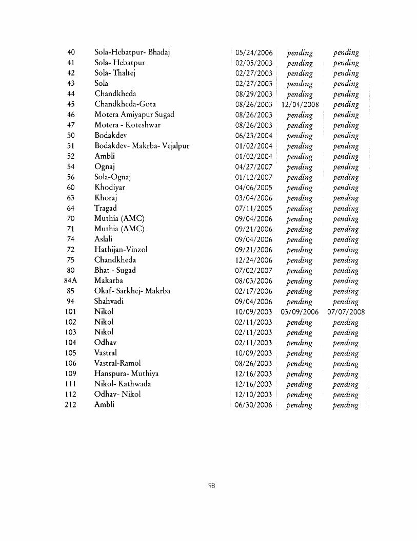
40414243444546475051525456606364707174727580
84A8594101102103104105106109111112212
Sola-Hebatpur- BhadajSola- HebatpurSola- ThaltejSolaChandkhedaChandkheda-GotaMotera Amiyapur SugadMotera - KoteshwarBodakdevBodakdev- Makrba- VejalpurAmbliOgnajSola-OgnajKhodiyarKhorajTragadMuthia (AMC)Muthia (AMC)AslaliHathijan-VinzolChandkhedaBhat - SugadMakarbaOkaf- Sarkhej- MakrbaShahvadiNikolNikolNikolOdhavVastralVastral-RamolHanspura- MuthiyaNikol- KathwadaOdhav- NikolAmbli
05/24/200602/05/200302/27/200302/27/200308/29/200308/26/200308/26/200308/26/200306/23/200401/02/200401/02/200404/27/200701/12/200704/06/200503/04/200607/11/200509/04/200609/21/200609/04/200609/21/200612/24/200607/02/200708/03/200602/17/200609/04/200610/09/200302/11/200302/11/200302/11/200310/09/200308/26/200312/16/200312/16/200312/10/200306/30/2006
pendingpendingpendingpendingpending
12/04/2008pendingpendingpendingpendingpendingpendingpendingpendingpendingpendingpendingpendingpendingpendingpendingpendingpendingpendingpending
03/09/2006pendingpendingpendingpendingpendingpendingpendingpendingpending
pendingpendingpendingpendingpendingpendingpendingpendingpendingpendingpendingpendingpendingpendingpendingpendingpendingpendingpendingpendingpendingpendingpendingpendingpending
07/07/2008pendingpendingpendingpendingpendingpendingpendingpendingpending
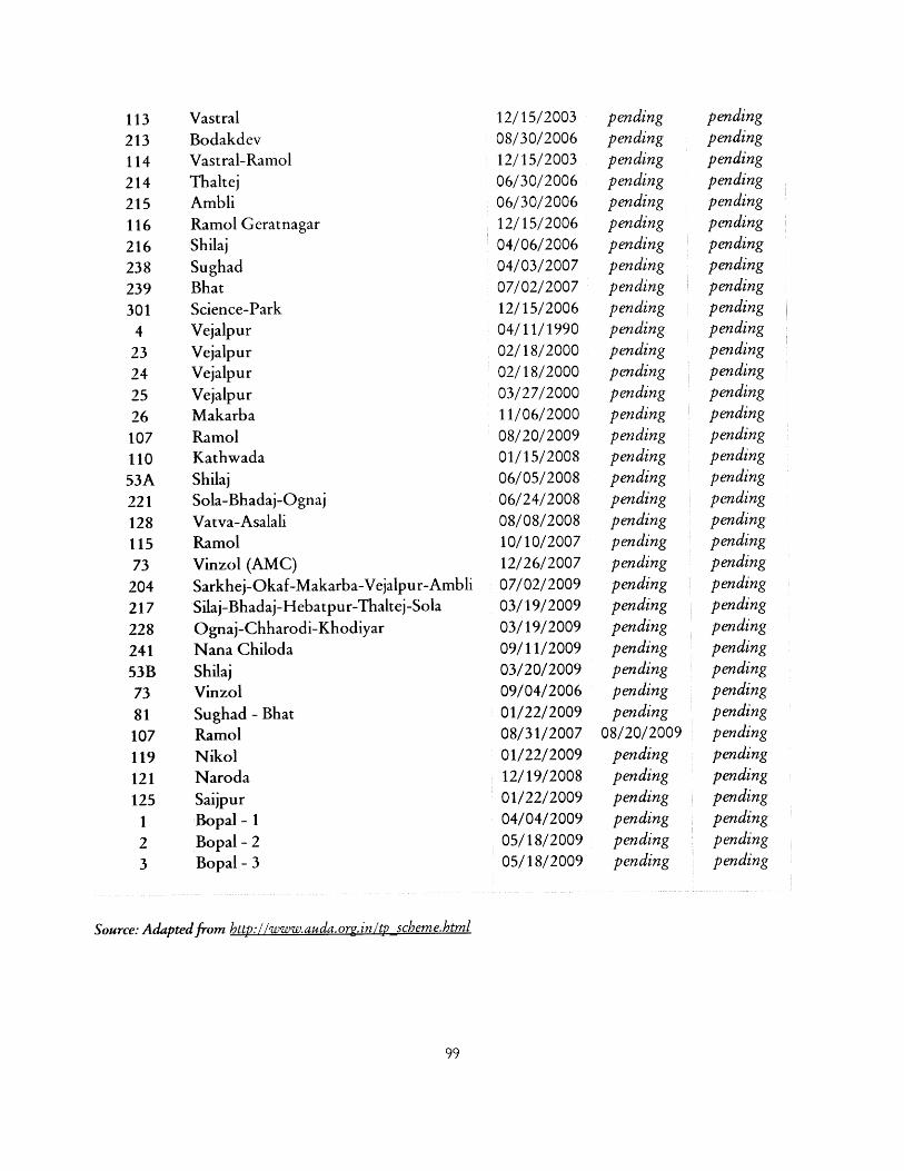
113213114214215116216238239301
423242526107110
53A22112811573
20421722824153B7381107119121125
123
VastralBodakdevVastral-RamolThaltejAmbliRamol GeratnagarShilajSughadBhatScience-ParkVejalpurVejalpurVejalpurVejalpurMakarbaRamolKathwadaShilajSola-Bhadaj-OgnajVatva-AsalaliRamolVinzol (AMC)Sarkhej-Okaf-Makarba-Vejalpur-AmbliSilaj-Bhadaj-Hebatpur-Thaltej-SolaOgnaj-Chharodi-KhodiyarNana ChilodaShilajVinzolSughad - Bhat
RamolNikolNarodaSaijpurBopal - 1
Bopal - 2Bopal - 3
Source: Adapted from http://www.auda.org.in/tp scheme.html
12/15/200308/30/200612/15/200306/30/200606/30/200612/15/200604/06/200604/03/200707/02/200712/15/200604/11/199002/18/200002/18/200003/27/200011/06/200008/20/200901/15/200806/05/200806/24/200808/08/200810/10/200712/26/200707/02/200903/19/200903/19/200909/11/200903/20/200909/04/200601/22/200908/31/200701/22/200912/19/200801/22/200904/04/200905/18/200905/18/2009
pendingpendingpendingpendingpendingpendingpendingpendingpendingpendingpendingpendingpendingpendingpendingpendingpendingpendingpendingpendingpendingpendingpendingpendingpendingpendingpendingpendingpending
08/20/2009pendingpendingpendingpendingpendingpending
pendingpendingpendingpendingpendingpendingpendingpendingpendingpendingpendingpendingpendingpendingpendingpendingpendingpendingpendingpendingpendingpendingpendingpendingpendingpendingpendingpendingpendingpendingpendingpendingpendingpendingpendingpending
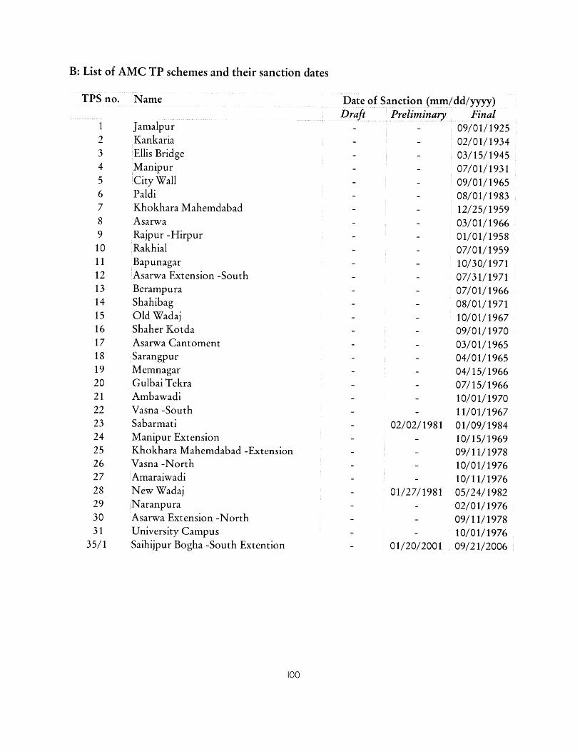
B: List of AMC TP schemes and their sanction dates
TPS no. Name
12345678910111213141516171819202122232425262728293031
35/1
JamalpurKankariaEllis BridgeManipurCity WallPaldiKhokhara MahemdabadAsarwaRajpur -HirpurRakhialBapunagarAsarwa Extension -SouthBerampuraShahibagOld WadajShaher KotdaAsarwa CantomentSarangpurMemnagarGulbai TekraAmbawadiVasna -SouthSabarmatiManipur ExtensionKhokhara Mahemdabad -ExtensionVasna -NorthAmaraiwadiNew WadajNaranpuraAsarwa Extension -NorthUniversity CampusSaihijpur Bogha -South Extention
Date of Sanction (mm/dd/yyyy)Draft Preliminary Final
- 09/01/1925- 02/01/1934- 03/15/1945- 07/01/1931- 09/01/1965- 08/01/1983- 12/25/1959- 03/01/1966- 01/01/1958
- - 07/01/1959- - 10/30/1971- - 07/31/1971- - 07/01/1966- - 08/01/1971- - 10/01/1967- - 09/01/1970- - 03/01/1965- - 04/01/1965- - 04/15/1966- - 07/15/1966- - 10/01/1970- - 11/01/1967
02/02/1981 01/09/1984- 10/15/1969
- - 09/11/1978- - 10/01/1976- - 10/11/1976- 01/27/1981 05/24/1982
- 02/01/1976- 09/11/1978- 10/01/1976
01/20/2001 09/21/2006
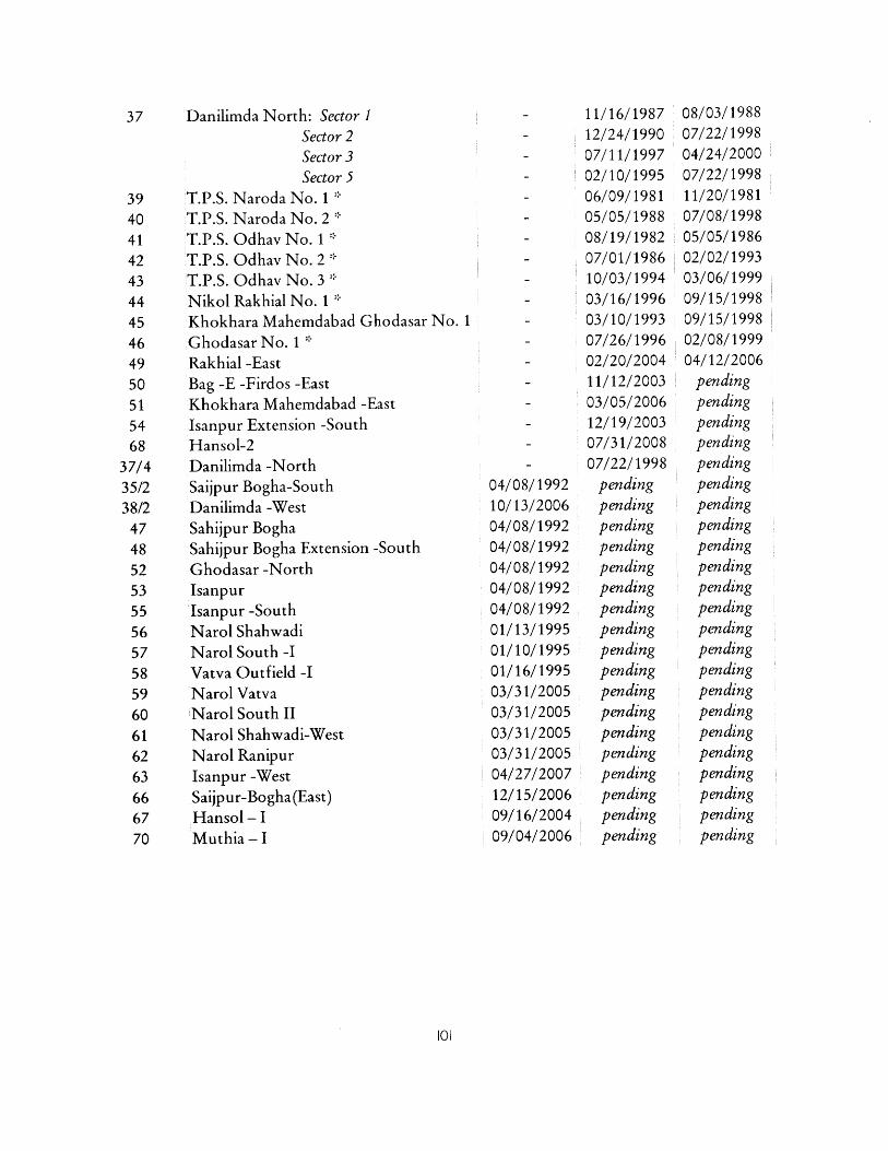
37 Danilimda North: Sector 1Sector 2Sector 3Sector 5
39 T.P.S. Naroda No. 140 T.P.S. Naroda No. 241 T.P.S. Odhav No. 1 *42 T.P.S. Odhav No. 2 *43 T.P.S. Odhav No. 344 Nikol Rakhial No. 145 Khokhara Mahemdabad Ghodasar No. 146 Ghodasar No. 1 *49 Rakhial -East50 Bag -E -Firdos -East51 Khokhara Mahemdabad -East54 Isanpur Extension -South68 Hansol-2
37/4 Danilimda -NorthSaijpur Bogha-SouthDanilimda -WestSahijpur BoghaSahijpur Bogha Extension -South
Ghodasar -NorthIsanpurIsanpur -SouthNarol ShahwadiNarol South -IVatva Outfield -INarol VatvaNarol South IINarol Shahwadi-WestNarol RanipurIsanpur -WestSaijpur-Bogha(East)Hansol - IMuthia -I
- 11/16/1987- 12/24/1990
- 07/11/1997- 02/10/1995- 06/09/1981- 05/05/1988- 08/19/1982- 07/01/1986- 10/03/1994
- 03/16/1996- 03/10/1993- 07/26/1996- 02/20/2004
- 11/12/2003
- 03/05/2006- 12/19/2003- 07/31/2008
- 07/22/1998
04/08/199210/13/200604/08/199204/08/199204/08/199204/08/199204/08/199201/13/199501/10/199501/16/199503/31/200503/31/200503/31/200503/31/200504/27/200712/15/200609/16/200409/04/2006
pendingpendingpendingpendingpendingpendingpendingpendingpendingpendingpendingpendingpendingpendingpendingpendingpendingpending
08/03/198807/22/199804/24/200007/22/199811/20/198107/08/199805/05/198602/02/199303/06/199909/15/199809/15/199802/08/199904/12/2006
pendingpendingpendingpendingpendingpendingpendingpendingpendingpendingpendingpendingpendingpendingpendingpendingpendingpendingpendingpendingpendingpendingpending
35/238/2
47485253555657585960616263666770
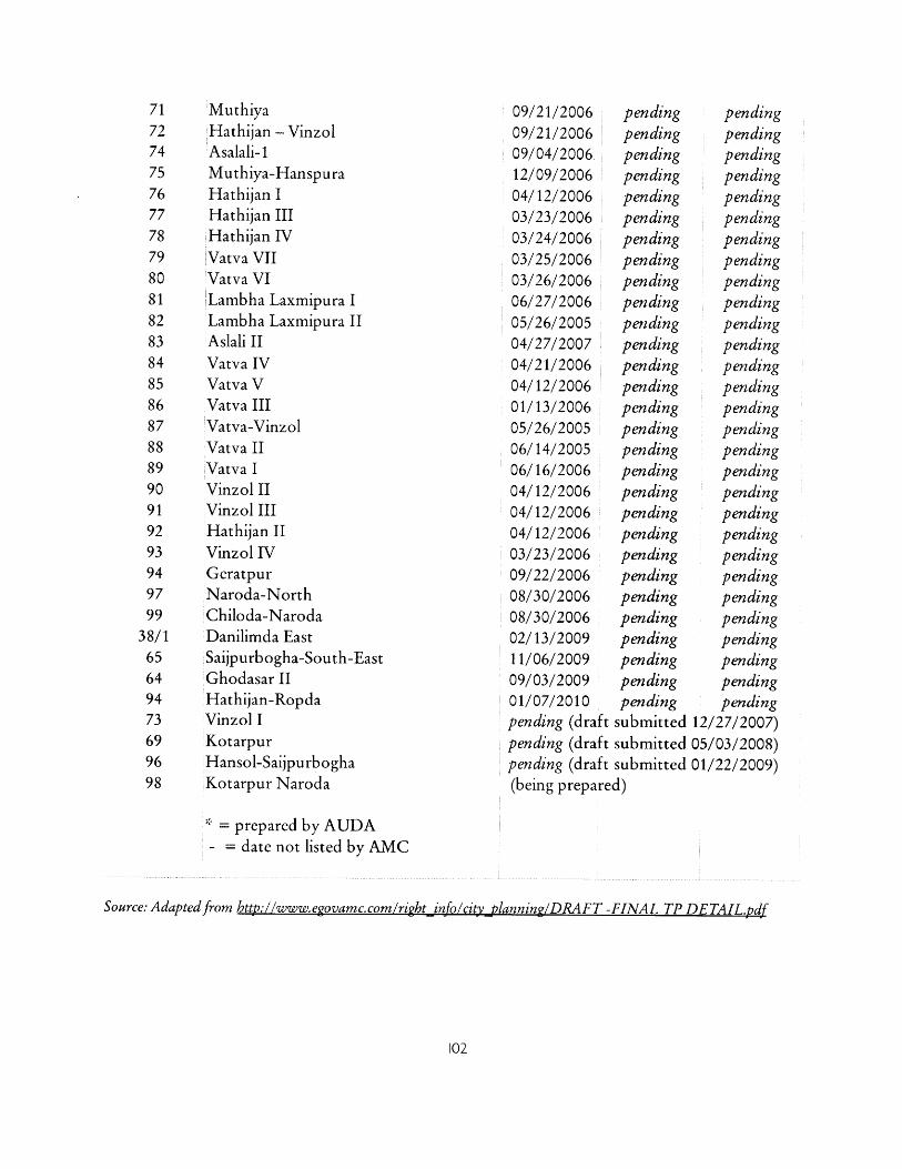
717274
75
7677
78798081828384858687888990919293949799
38/1656494736996
MuthiyaHathijan - VinzolAsalali- 1Muthiya-HanspuraHathijan IHathijan IIIHathijan IVVatva VIIVatva VILambha Laxmipura ILambha Laxmipura IIAslali IIVatva IVVatva VVatva IIIVatva-VinzolVatva IIVatva IVinzol IIVinzol IIIHathijan IIVinzol IVGeratpurNaroda-NorthChiloda-NarodaDanilimda EastSaijpurbogha-South-EastGhodasar IIHathijan-RopdaVinzol IKotarpurHansol-Saijpurbogha
98 Kotarpur Naroda
09/21/200609/21/200609/04/200612/09/200604/12/200603/23/200603/24/200603/25/200603/26/200606/27/200605/26/200504/27/200704/21/200604/12/200601/13/200605/26/200506/14/200506/16/200604/12/200604/12/200604/12/200603/23/200609/22/200608/30/200608/30/200602/13/200911/06/200909/03/200901/07/2010pending (draftpending (draftpending (draft(being prepared)
= prepared by AUDA- = date not listed by AMC
Source: Adapted from http://www.egovamc.com/right info/city planning/DRAFT -FINAL TP DETAIL.pdf
pendingpendingpendingpendingpendingpendingpendingpendingpendingpendingpendingpendingpendingpendingpendingpendingpendingpendingpendingpendingpendingpendingpendingpendingpendingpendingpendingpendingpendingsubmittedsubmittedsubmitted
pendingpendingpendingpendingpendingpendingpendingpendingpendingpendingpendingpendingpendingpendingpendingpendingpendingpendingpendingpendingpendingpendingpendingpendingpendingpendingpendingpendingpending
12/27/2007)05/03/2008)01/22/2009)
REFERENCES
Prakash Amichand Shah vs. State of Gujarat (1981).Prakash Amichand Shah vs. State Of Gujarat & Ors (1985).Jaswant Singh Mathura Singh and Anr. vs. Ahmedabad Municipal Corporation and Ors.
(1991).Rajan Sankalchand Patel vs. State Of Gujarat (1996).Hasmukh Shah vs. Ahmedabad Municipal Corporation (2000)."Land pooling mooted for planned growth." The Hindu, 9 August 2010."High Court declares Act unconstitutional." The Hindu, 10 February 2011 a."Land-pooling project: allotment letters given to landholders." The Hindu, 7 January 2011 b."Residential Land in Vatva, Ahmedabad City & East." http://ww.99acres.com/Residential-
Land-in-Vatva-Ahmedabad%2OCity%20&%20East-for-Sale-spid-J3546471.Sri. VShivaprasad vs. State Of Kerala (2011 d)."VUDA Auction of Plots Nets Rs. 60.36 Crores." The Hindu, 28 January 2011 e.Acharya, B. P. "Kerala's Experience with Plot Reconstitution." Urban India: Journal of the
N.I.U.A. 8-9 (1989): 74-117.Adhvaryu, B. 'The Ahmedabad urban development plan making process: A critical review."
Planning Practice and Research (forthcoming).Adusumilli, U. "Partnership approaches in India." In Making Common Ground: Public-
private partnerships in landfor housing, edited by G. Payne. London: IntermediateTechnology Publications, 1999.
Adusumilli, U. 'Town Planning Schemes in Maharashtra." Centre for Good Governance,2009.
Ahmedabad Mirror Bureau. "AMC chief town planner caught taking bribe." AhmedabadMirror, 08 May 2009.
AMC. "Details of Final Town Planning Scheme."http://www.egovamc.com/right-info/city planning/DRAFT%20-FINAL%20TP%20DETAIL.pdf.
Annez, R C. Delhi, 2011Annez, P C., A. Bertaud, et al. 'Working with the Market: Approach to Reducing Urban
Slums in India." Policy Research Working Paper (2010).Antony, M. J. "Sore points in land acquisition." Business Standard, 21 March 2007.Archer, R. W. Land pooling/readjustment versus plot reconstitution for the planned
development ofIndian cities. Bangkok, Thailand: Urban Land Program, HumanSettlements Division, Asian Institute of Technology, 1992.
Archer, R. W. 'The potential of land pooling/ readjustment to provide land for low-costhousing in developing countries." In Making Common Ground: Public-privatepartnerships in landfor housing, edited by G. Payne. London: IntermediateTechnology Publications, 1999.
Aspengreen, H. C. "Sociological knowledge and colonial power in Bombay around the First
World War." The British Journalfor the History of Science FirstView (2010): 1-16.AUDA. "General Development Control Regulations." 2006.AUDA. "Public-Private Partnership for Road Infrastructure Development."
http://www.auda.org.in/library/ring road.pdf.AUDA and AMC. "City Development Plan, Ahmedabad 2006-2012." 2006.Baker, L. India: private/public partnership in land development United States Agency for
International Development Working Paper. Washington, DC: USAID, 1992.Ballaney, S. 'The Town Planning Mechanism in Gujarat, India." (2008).Ballaney, S. 'The Town Planning Scheme Mechanism in Gujarat - A Documentation of the
Planning Mechanism as practiced (draft version)." Centrefor Good GovernanceWorking Paper (2009), http://www.cgg.gov.in/workingpapers2/TPS%20for%20Center%20for%2OGood%20Governance%206%20sent%20on%2027%20August%202009.pdf.
Ballaney, S. Town Planning Scheme Mechanism, Gujarat [Presentation]. Washington, DC,2010.
Ballaney, S. Interview, Ahmedabad, 2011Ballaney, S. and B. Patel. "Using the 'Development Plan-Town Planning Scheme'
Mechanism to Appropriate Land and Build Urban Infrastructure." In IndiaInfrastructure Report 2009: Land - A Critical Resource for Infrastructure, 190-204:Oxford University Press, 2009.
Brown, J. M. Modern India: the origins ofan Asian democracy: Oxford University Press,1994.
Caemmerer, H. P. A manual on the origin and development of Washington. Washington: U.S.G.P.O., 1939.
Centre for Good Governance. "Managing Urban Growth using the Town Planning Schemesin Andhra Pradesh." 2010.
Chakravarti, V. "Ahmedabad urban body decision stirs a hornet's nest." Indian Express, June17 1999.
Chamon, M., P Mauro, et al. "Mass car ownership in the emerging market giants." EconomicPolicy 23, no. 54 (2008): 243-296.
CITYNET. "Municipal land management in asia : a comparative study." New York, N.Y:United Nations, 1995.
Concerned Citizens of Ahmedabad. "Report of A Public Hearing on Habitat and LivelihoodDisplacements in Ahmedabad." Ahmedabad: "Our Inclusive Ahmedabad" (a forum ofConcerned Citizens of Ahmedabad), 2010.
Dalal, S. and D. Basu. "The amazing story of Magarpatta." RediffIndia Abroad (2007),http://www.rediff.com/money/2007/jan/11bspec.htm.
Dave, J. "'Corrupt' estate department blamed for illegal buildings in Ahmedabad." DNA, 30January 2011.
DNA. "Sabarmati Riverfront expands its borders." DNA, 5 September 2010.Doebele, W A. Land readjustment: a different approach to financing urbanization. Lexington,
Mass.: Lexington Books, 1982.Environmental Planning Collective. "Revised Draft Development Plan Ahmedabad."
http://www.hcp.co.in/pdfs/Final%20AUDA.pdf.ESCAP. "Urbanization in Asia and the Pacific." Bangkok: ESCAP/ UNCHS Joint Section
on Human Settlements, 1994.
Express News Service. "Farmers' rally turns violent." Indian Express, 15 June 1999a.
Express News Service. "Scheme will benefit farmers -- AUDA chairman." Indian Express, 14
June 1999b.Express News Service. "Farmers land a blow, accuse authority of 'grabbing' land." Indian
Express, 14 July 2003.Express News Service. "Rs 1.5 crore cash or developed sites, offers GMADA." Indian
Express, 09 March 2010.Government of Gujarat. "The Gujarat Town Planning And Urban Development Act."
http://www.egovamc.com/rightjinfo/PRO/tdo/05-A-TPACT-1976.pdf.Government of India. "Census of India 2001: Metadata and Brief Highlights on Slum
Population." The Office of Registrar General & Census Commissioner of India,
Ministry of Home Affairs.,http://censusindia.gov.in/Data Products/DataHighlights/DataHighlights link/me
tadata highlights.pdf.Government of India. "JNNURM Primer. Simplification Of Legal And Procedural
Framework For Conversion Of Agricultural Land To Non-Agricultural Purposes."
(2005).Home, R. Ofplanting and planning: the making of British colonial cities: Spon, 1997.
Home, R. "Why Was Land Readjustment Adopted in British India but not in Britain?: A
Historical Exploration." In Workshop on Land Readjustment. Boston: Lincoln
Institute of Land Policy, 2002.
Home, R. "Land Readjustment as a Method of Development Land Assembly: A
Comparative Overview." The Town Planning Review 78, no. 4 (2007): 459-483.
Hong, Y.-H. and B. Needham. Analyzing land readjustment: economics, law, and collective
action. Cambridge, Mass.: Lincoln Institute of Land Policy, 2007.IIM Ahmedabad. The Globalizing State, Public Services and the New Governance of Urban
Local Communities in India - Newsletter, no. 2 (2010).
Jain, N. "Land pooling scheme in Mohali evokes poor response." Indian Express, 11 May2010.
Joshi, R. and P Sanga. "Land reservations for the urban poor: the case of town planning
schemes in Ahmedabad, Working Paper 4." (2009).Joshi, R. B. Interview, Ahmedabad, 2011Kleinenhammans, S. "Re-envisioning the Indian city : informality and temporality." Thesis,
Architecture, Massachusetts Institute of Technology, 2009.Lahiri, T. "Where's That Land Acquisition Law?" In Wall Street Journal: India Real 7ime,
2010.
Lands of Maharashtra. "Restrictions over Transfer of Land."http://www.landsofmaharashtra.com/restrictionsovertransferofland.html.
Langa, M. "AUDA projects are trapped in mess of alleged corruption." DNA, July 15 2008.Mahadevia, D. "Urban land market and access of the poor." In India Urban Poverty Report:
Oxford University Press, 2009.Mahadevia, D. "Tenure security and urban social protection in India." In Centrefor Social
Protection Research Report 05: Institute for Development Studies / Centre for SocialProtection, 2011.
Marshall, S. "Of squatters and schemes : considering city-level strategies for housing thepoor in India." Thesis, Department of Urban Studies and Planning, MassachusettsInstitute of Technology, 2010.
McKinsey Global Institute. India's urban awakening: building inclusive cities, sustainingeconomic growth. [Chennai]: McKinsey Global Institute, 2010.
Meller, E. H. Patrick Geddes Social Evolutionist and City Planner. Hoboken: Routledge,1994.
Menon, A. G. K. "Imagining the Indian City." Economic and political weekly. 32, no. 46(1997): 2932.
Mirams, A. E. Town planning in Bombay under the Bombay Town Planning Act, 1915 : alecture. London: Town Planning Institute, 1919.
Mirams, A. E. "Comments." Journal of Town Planning Institute 10 (1923-24): 195-197.Mirams, A. E. Kampala: report on the town planning and development. Entebbe, Uganda:
Government Printer., 1930.MMRDA. "Regional Plan for Mumbai Metropolitan Region 1996 - 2011, Chapter 9: Urban
Land Policy." 225-226. Mumbai, 1999.Mullin, J. "American Perceptions of German City Planning at the Turn of the Century."Nair, R. and I. J. Ahluwalia. "Expand our towns for urban growth. Why we must, and how
we can." Indian Express, 24 February 2010a.Nair, R. and I. J. Ahluwalia. "Magarpatta: building a city with rural-urban partnership."
Indian Express, 26 May 201 ob.Nandakumar, T. "Land pooling - the key to clean up urban chaos." The Hindu, 29 October
2005.Nayudu, U. "Mega city dream a nightmare for slum dwellers." Indian Express, 15 October
2008.Nayudu, U. "Civic body's town planning scheme threatens its own slum networking
project." Indian Express, 01 September 2009.NIUA. "Slum Population in Million Plus Cities."
http://www.niua.org/indiaurbaninfo/tablenew/table6.htm.NIUA and AMC. "AMC comments in response to Appraisal of City Development Plan
Ahmedabad." 2006.Pandey, S. "Rapid growth of slums in western Ahmedabad." The Times ofIndia, 17
September 2002.
Patel, B. "Making Urban Planning Work: Gujarat's Town Planning Scheme Mechanism."http://indiausp.net/?q=node/1 51.
Patel, B. Interview, Ahmedabad, 2011Patel, B., S. Ballaney, et al. "Reforming Urban Land Management in Gujarat." In India
Infrastructure Report 2009: Land - A Critical Resource for Infrastructure176-189: Oxford University Press, 2009.Patel, S. and B. Patel. (Creating and) Unlocking Land Values To Finance Urban Infrastructure
- Use of Urban Planning and the Town Planning Scheme Mechanism in Gujarat[Presentation]. Bangalore, 2009.
Patel, V Interview, Ahmedabad, 2011Peterson, G. E. Unlocking land values to finance urban infrastructure. Washington, DC:
World Bank: Public-Private Infrastructure Advisory Facility, 2009.Press Trust of India. "Japan signs pact with 3 States for DMIC project." The Hindu, 30 April
2010.Robb, P G. A history of India: Palgrave, 2002.Schnidman, F. "Land readjustment : [the replatting of a usually sizable area of land with
multiple owners and its subsequent (re)development under a unified plan]." Urbanland. 47, no. 2 (1988).
Shah, R. "'Mini-Japan' between Federa, Dholera." The Times of India, 15 October 2008.Sorensen, A. "Consensus, Persuasion, and Opposition: Organizing Land Readjustment in
Japan." In Analyzing land readjustment: economics, law, and collective action, edited byY-h. Hong and B. Needham. Cambridge, Mass.: Lincoln Institute of Land Policy,2007.
Sridhar, K. S. and A. V Reddy. "Land as a Municipal Financing Option: A Pilot Study fromIndia." Public Affairs Centre, 2009.
Srivathsan, A. "Tamil Nadu looks to Gujarat model to address land acquisition issues." TheHindu, 7 August 2010.
Srivathsan, A. "Amendments to Town and Country Planning Act under consideration." TheHindu, 15 January 2011.
Times News Network. "Land-pooling: GMADA to clear farmers' doubts." The Times ofIndia, 5 October 2009.
Times News Network. "GMADA to build awareness campaign on land-pooling." The Timesof India, 7 September 2010.
Times News Network. "265 land-grabbing cases in Ahmedabad dist." The Times ofIndia, 04March 2011.
Tiwari, D. P "Challenges in Urban Planning for local bodies in India"http://www.gisdevelopment.net/application/urban/overview/urbanoOO37.htm.
Tiwari, K. "Land owners get time to study TP." Ahmedabad Mirror, 15 March 2011 a.Tiwari, K. 'TP draft eats into Ghuma plots, buyers fight back." Ahmedabad Mirror, 14 March
2011b.Tiwari, K. "Will war over deduction turn Ghuma into another Bopal?" Ahmedabad Mirror, 16
March 2011c.UN Human Settlements Programme. "Planning sustainable cities: global report on human
settlements 2009." London; Sterling, VA: Earthscan, 2009.Vaidya, C. 'Taxation as an Instrument to Improve Urban Land Management in India."
Nagarlok 18, no. 1 (1986): 25-37.Vaidya, C. Interview, Delhi, 2011VMW Analytic Services. "Economy of the Federal States & Population for Year 2011."
http://unidow.com/india%20home%20eng/statewise-gdp.html.World Bank. "Gujarat Urban Development Project - Staff Appraisal Report." 1985.