8 identification of potential impacts - eskom.co.za · reference in terms of this disadvantage: a...
TRANSCRIPT

Chapter 8: Identification of potential impacts Lidwala Consulting Engineers (SA) (Pty) Ltd
2013-09-30 Weskusfleur Substation EIA: Final Scoping Report. DEA Ref Number: 14/12/16/3/3/2/5088-1
8 IDENTIFICATION OF POTENTIAL IMPACTS
8.1 Introduction
Scoping is widely recognised as a critical step in the Environmental Impact Assessment (EIA)process. This Scoping Study is twofold as it identifies significant issues that require furtherinvestigation as well as identifying the preferred site/s that will go through for furtherinvestigation. These issues and sites will be carried forward into the EIA phase andsubsequently the Environmental Management Plan.
The scoping of all environmental issues was assessed according to the following factors:
The nature of the proposed activities and the receiving environment; the legal, policy and planning context of the proposed new substation; and the socio-economic and environmental priorities of the Interested and Affected Parties
(I&APs).
The focus of an EIA ultimately narrows down to a judgement (decision based on the resultsfrom specialist studies) on whether the predicted impacts are significant. Significance is,however, relative and must always be set in a context, e.g. competition for resources, socialsensitivity or the scale and rate of development.
The following section of the Scoping Report provides a discussion on the findings of thespecialist studies, undertaken to date, with regards to identified issues and impacts.
8.2 Identification of Impacts of the Identified Alternatives – Technical Analysis
The following potential technical issues and descriptions have been identified to date withregards to each of the identified alternative sites (Table 8.1):
Table 8.1: Eskom’s initial descriptions of the of the five alternatives
Alternative Location and GPS Co-ordinates
Description
1 At North east corner ofthe KNPS for the 400kVyard and the southernpart of the parking areasouth of the incoming400kV lines for the132kV yard
400kV yard:
Located approximately 250 m from theKoeberg Power Station and a part of the siteis partially transformed. This site is theclosest to Koeberg power station with anexisting HV yard, thus line deviations will beshorter
All lines will come from one side, thus lineswill stay almost completely within theKoeberg security area

Chapter 8: Identification of potential impacts Lidwala Consulting Engineers (SA) (Pty) Ltd
2013-09-30 Weskusfleur Substation EIA: Final Scoping Report. DEA Ref Number: 14/12/16/3/3/2/5088-2
33°40'15.73"S18°26'1.39"E
132kV yard:33°40'26.64"S18°26'11.32"E
No crossing of transmission lines will benecessary
Utilises a large portion of the existing lineswhich has known reliability.
400KV and 132KV substations split AISconfiguration as well as GIS combinedconfiguration.
Disadvantages Limited space for future lines and narrow
servitude means taller structures. Little useable land left for future expansion
(especially because of close proximity toocean which blocks lines on west side)
Space constraints are increased because it isnot allowed to construct underneath existinglines: Construction underneath the existinglines is not viable because the current verticalclearance underneath the 400kV lines is 8.1mas per SABS 10280 specification. The heightof the 500kV gantries proposed for the AISwill infringe the phase-to-earth clearancescausing flashovers. Picking up AIS equipmentwith cranes or truck-mounted cranes will alsoinfringe on the required phase-to-earthclearances and will lead to serious injury ordeath of the workers. Similarly constructionof buildings (for housing the GIS) underneaththe lines will infringe on the clearancerequirements. The following also havereference in terms of this disadvantage: AGIS alternative in the parking area has beenproposed by the City of Cape Town. Contraryto the initial perception, as raised during theFocus Group meeting on 13 August 2013,construction of the GIS on the parking area isnot an option as the existing power linescross the entire parking area and an equallylarge area to the north of the parking area.
Marine pollution and heavy corrosion The 400kV AIS yard, as well as the combined
400kV and 132kV GIS yards, enters the sanddune area
The large 400kV AIS yard enters the sanddune area extensively; hence a buffer wouldhave to be designed in order to prevent the

Chapter 8: Identification of potential impacts Lidwala Consulting Engineers (SA) (Pty) Ltd
2013-09-30 Weskusfleur Substation EIA: Final Scoping Report. DEA Ref Number: 14/12/16/3/3/2/5088-3
sand from covering the yard stone in theSubstation.
The area surrounding Koeberg has high levelsof ground water.
The 400kV AIS yard extends over theproposed Nuclear 1 site and has a very largefootprint (Figure 4.9).
Pre-requirements Move of existing parking lot, security gates
and buildings etc. Connection space for overhead connection
to generators is limited and theconnection type should be checked foracceptance from the NNR.
Outage requirements will be at least oneweek per out-going line for swap over duringconstruction as well as a month per generatortransformer for the swap over to thecable/overhead gantry connections.
The AIS alternative will have massiveimplications during constructability phase onsecurity at Koeberg, cost implications due tomove of parking lot, entrance gates etc. andis therefore not viable due to constructabilityconcerns.
The GIS alternative is a viable alternative dueto the small size and deviation of lines whichis constructible.
2 The area at the southeastern corner of theKNPS where part of thePBMR was planned
33°40'48.14"S18°26'10.34"E
Site is located partially transformed land tothe south of the Power Station
400KV and 132KV substations combined AISconfiguration as well as GIS combinedconfiguration.
All lines can come from one side thussequence of events can be clearly planned
No crossing of transmission lines will benecessary
Utilises a large portion of the existing lineswhich has known reliability
Disadvantages Little useable space for future expansion due
to close proximity to the ocean Limited space for future lines and also long
distance from existing lines – longer linedeviations than option 1
AIS will too large and will clash with DuineSubstation and the research centre

Chapter 8: Identification of potential impacts Lidwala Consulting Engineers (SA) (Pty) Ltd
2013-09-30 Weskusfleur Substation EIA: Final Scoping Report. DEA Ref Number: 14/12/16/3/3/2/5088-4
The GIL ducts for a GIS substation will be toolong
Extremely high marine pollution and heavycorrosion
Limited space for the overhead line routefrom the Gen Transformers to the new 400kVyard.
Limited space for the overhead line routefrom the Station Transformers to the new132kV yard.
Pre-requirements Connection space for overhead connection
to generators is limited and theconnection type should be checked foracceptance from the NNR as well as move ofbuildings etc.
Move of Duine station and Research station isrequired.
Outage requirements will be at least oneweek per out-going line for swap over duringconstruction as well as a month per generatortransformer for the swap over to thecable/overhead gantry connections.
The site will have massive implications duringconstructability phase on security at Koeberg,cost implications due to move of variousstations, research centres etc. and istherefore not viable due to constructabilityconcerns.
3 The area on the corner ofthe main access road justeast of the road to theconservation offices andnorth of the main accessroad south of theincoming 400 kV lines
33°40'34.95"S18°26'32.81"E
Site is located east of the main KoebergPower Station.
400KV and 132KV substations combined AISconfiguration as well as GIS combinedconfiguration.
Is in close proximity with existing power lines Utilises a large portion of the existing lines
which has known reliability.Disadvantages
There is not enough space to turn in the linesand construction underneath the existing linesposes a high safety risk and the alternative istherefore not technically viable for the AISoption.
Exporting of power on distribution linesdifficult due to space constraints of AIS
No useable land left for future expansion.

Chapter 8: Identification of potential impacts Lidwala Consulting Engineers (SA) (Pty) Ltd
2013-09-30 Weskusfleur Substation EIA: Final Scoping Report. DEA Ref Number: 14/12/16/3/3/2/5088-5
The GIL ducts for a GIS substation will be toolong
Large visual impact on the nature reserve(Koeberg nature reserve)
New Lines are required for the GenTransformer and Station Transformerconnections.
Line crossingsPre-requirements The site is not technically viable
4 Offsite option to the eastof the R27 on the farmBrakke Fontein 32
33°40’00.54” S18°28’17.32” E
Site is located on private property that hasbeen intensively invaded by alien vegetation.
400KV and 132KV substations combined AISwith existing GIS combination or 400KV and132KV with AIS only.
Very few transmission line crossings areneeded but there is a lot more space toaccommodate this.
Further from the R27, thus less visual impact. Sufficient space Provides possibility of keeping existing GIS
after integration with the new AIS and swapbetween the AIS and GIS if there is a problemwith one.
Suitable overhead line route for theconnection from the Gen Transformers to thenew 400kV yard. (New lines might berequired due to the 400kV insulation levelrequirement)
Existing 400kV lines can be used for theconnection from the Station Transformers tothe new 132kV yard.
The AIS only options without the existing GISwill allow for the removal of a few lines aftercompletion of the project when the new yardhas proven reliability.
Within the 5km restriction zone of Koebergand allowed since it supports the operation ofKoeberg.
Disadvantages Longer distance from Koeberg means longer
lines from generation transformers to the newyard (two new lines need to be built at 500kVlevel to accommodate construction outagerequirements as well as the move of the

Chapter 8: Identification of potential impacts Lidwala Consulting Engineers (SA) (Pty) Ltd
2013-09-30 Weskusfleur Substation EIA: Final Scoping Report. DEA Ref Number: 14/12/16/3/3/2/5088-6
132kV dedicated supply line). Longer deviations from existing lines to the
South. The GIL ducts to substation will be too long. New Lines might be required for the Gen
Transformer connections due to the 400kVinsulation requirements.
Only AIS is viablePre-requirements 132kV Koeberg-Ankerlig line will have to be
shifted North of current position toaccommodate 2 (or 3 for future reactor)500kV line servitudes of 45m each. This willhave to be done before construction of theother lines start as this will be the dedicatedsupply line. The dedicated supply line willhave to feed into the new HV yard and canthus be a temporary line until it is turned intothe new yard. The last piece of the dedicatedline will be cable where it crosses underneaththe generator and station transformer lines.
The 400kV Ankerlig Sterrekus line will have tobe deviated around the yard’s position tominimize line crossings. In its current positionit will cross underneath 14 lines and afterdeviation will cross underneath only 3 lines.This might be possible before the lineconstruction starts.
The connection of the generator transformersvia overhead lines will have to be furtherinvestigated with an accurate survey to avoidthe use of 400kV cables as far as possible.
132kV double circuit Koeberg-Dassenberg linewill have to be deviated around site.
Outage requirements will be at least oneweek per out-going line for swap over duringconstruction as well as a month per generatortransformer for the swap over to thecable/overhead gantry connections.
5 Offsite option next to theexisting Sterrekus(Omega) Substation
33°41’55.68” S18°30’48.50” E
Site 5 is situated on the farm GrootOliphantskop and its surrounding terrain isone of gently sloping hills covered with wheatfields. It is situated alongside the R304 andthe Mamre Road. There are a few hills thatstand out above the rest.
Chapter 8: Identification of potential impacts Lidwala Consulting Engineers (SA) (Pty) Ltd
2013-09-30 Weskusfleur Substation EIA: Final Scoping Report. DEA Ref Number: 14/12/16/3/3/2/5088-7
400KV and 132KV substations combined AISconfiguration
Suitable overhead line route for theconnection from the generator transformersto the new 400kV yard. (New lines might berequired due to the 400kV insulation level)
Existing 400kV lines can be used for theconnection from the Station Transformers tothe new 132kV yard although the swopbetween the existing GIS and new AIS willnot be possible.
Disadvantages Blocks negotiated route for 765kV Kappa
– Sterrekus line which will be inconstruction shortly (2014).
Longer distance from Koeberg means longerlines from generation transformers to the newyard which will severely impact on theperformance in the high marine pollutionenvironment leading to possible faults on thegenerator transformers.
Swap between AIS and GIS not possible Far from Koeberg means performance
problems on connections from the generatortransformers.
Due to above mentioned reasons the site isnot deemed technically viable.
Table 8.2 presents a summary of all the alternatives that have been considered to date andthe viability of these alternatives. The technical analysis of all the alternatives was alsoundertaken the same period when the scoping studies were undertaken. Details on all thealternatives that have been considered for the proposed Weskusfleur Substation have beencaptured in Chapter 4.

Chapter 8: Identification of potential impacts Lidwala Consulting Engineers (SA) (Pty) Ltd
2013-09-30 Weskusfleur Substation EIA: Final Scoping Report. DEA Ref Number: 14/12/16/3/3/2/5088-8
Table 8.2: Alternative Summary - Technical Analysis
8.3 Identification of Potential Biophysical Impacts
8.3.1 Geology
Potential geological issues that should to be taken into consideration are as follows:• Impacts related to the construction-related earthworks• Impacts related to the pollution in case of spillage/leakage of hydrocarbon and other
hazardous material from storage facilities
Potential groundwater issues that should to be taken into consideration are as follows:• Contamination of ground water due to hydrocarbon spillage and seepage into
groundwater reserves, affecting groundwater quality.• Further construction of infrastructure and compaction of the area will further contribute
to reduced water infiltration rates to replenish groundwater aquifers.
A geohydrological study will also be included in the EIA phase to evaluate the sites with regardto their suitability.
The desktop geotechnical scoping study concluded the following:

Chapter 8: Identification of potential impacts Lidwala Consulting Engineers (SA) (Pty) Ltd
2013-09-30 Weskusfleur Substation EIA: Final Scoping Report. DEA Ref Number: 14/12/16/3/3/2/5088-9
Based on the performance of the existing engineered structures around Site Option 1,this site is considered feasible for the proposed new substation.
The land area available on Alternative 2 may be inadequate to locate the proposedsubstation.
The Fynbos vegetation observed on Alternative 3 makes this site not suitable from anenvironmental perspective.
Based on the information obtained from the desktop study the soil properties onalternatives 4 & 5 fall in the class with the least engineering geological problems which isthe most desirable developmental option but the gradient of Site Option 5 is moderatelysteep compared to the other sites and this would make the earthworks volumes (cut andfill) costly during development.
8.3.2 Soil and agricultural potential
The proposed new substation development will not have large impacts on Alternatives sites 1 –4 due to the overall low agricultural potential and the current land use. Alternative 5 may haveslightly higher impact due to the low to medium agricultural potential where there areindications of dryland cultivation and slightly better soils.
Potential soil and agricultural issues that should to be taken into consideration are as follows:
Increased wind and water erosion susceptibility due to the sandy nature of the soils whenvegetation is removed.
The occurrence of water tables during the rainy season can also be expected in depressionsat most of the sites.
8.3.3 Avifauna
The Alternatives and in particular the AIS on intact vegetation areas are least favourable froman avifaunal perspective as this would result in the largest extent of habitat loss and would alsoplace the development in closer proximity to a greater variety of bird species with increasedprobability of secondary impacts such as electrocution and collision with the power lineinfrastructure. In terms of the GIS options within the transformed habitats, a large proportionof the impact associated with the substation would stem from the additional power lineinfrastructure that would be required to connect the new substation to the grid.
Nature: The presence of the substation would result in some habitat loss for avifauna, but the
greatest potential threat comes from the risk of collisions with any new power linesrequired by the development.
A number of listed species occur in the area and impacts on these species would be highlyundesirable given their slow breeding rates and high conservation status.
Extent: The extent of the impact would be largely restricted to the local area.

Chapter 8: Identification of potential impacts Lidwala Consulting Engineers (SA) (Pty) Ltd
2013-09-30 Weskusfleur Substation EIA: Final Scoping Report. DEA Ref Number: 14/12/16/3/3/2/5088-10
Potential Significance: The significance of habitat loss would be relatively minor, but as thepower lines remain in place for decades, collisions pose a long-term cumulative impact thatcould have high long-term significance.
General description of impacts of substations and power lines on birds
Because of its size and prominence, electrical infrastructure constitutes an important interfacebetween wildlife and man. Negative interactions between wildlife and electricity structures takemany forms, but two common problems in southern Africa are electrocution of birds (and otheranimals) and birds colliding with power lines (Ledger 1983; Verdoorn 1996; Kruger 1999; VanRooyen 1999; Van Rooyen 2000). Other problems are electrical faults caused by bird excretawhen roosting or breeding on electricity infrastructure, (Van Rooyen & Taylor 1999) anddisturbance and habitat destruction during construction and maintenance activities.
o ElectrocutionsElectrocution of birds on overhead lines is an important cause of unnatural mortality ofraptors and storks. It has attracted plenty of attention in Europe, USA and South Africa(APLIC 1994; van Rooyen & Ledger 1999). Electrocution refers to the scenario where abird is perched or attempts to perch on the electrical structure and causes an electricalshort circuit by physically bridging the air gap between live components and/or live andearthed components (van Rooyen 2004).
o CollisionsCollisions are the biggest single threat posed by over-head transmission power lines tobirds in southern Africa (van Rooyen 2004). In general, large transmission lines withearth wires that are not always visible to birds can have the largest impact in terms ofcollisions. Most heavily impacted upon are korhaans, bustards, storks, cranes andvarious species of water birds. These species are mostly heavy-bodied birds with limitedmanoeuvrability, which makes it difficult for them to take the necessary evasive actionto avoid colliding with power lines (van Rooyen 2004, Anderson 2001). The Red Dataspecies vulnerable to power line collisions are generally long living, slow reproducingspecies under natural conditions. Some require very specific conditions for breeding,resulting in very few successful breeding attempts, or breeding might be restricted tovery small areas. These species have not evolved to cope with high adult mortality, withthe results that consistent high adult mortality over an extensive period could have aserious effect on a population’s ability to sustain itself in the long or even medium term.Many of the anthropogenic threats to these species are non-discriminatory as far as ageis concerned (e.g. habitat destruction, disturbance and power lines) and thereforecontribute to adult mortality, and it is not known what the cumulative effect of theseimpacts could be over the long term.
o Habitat destructionDuring the construction phase and maintenance of substations and power lines somehabitat destruction and alteration inevitably takes place. This happens with theconstruction of access roads, and the clearing of servitudes, as well as clearing

Chapter 8: Identification of potential impacts Lidwala Consulting Engineers (SA) (Pty) Ltd
2013-09-30 Weskusfleur Substation EIA: Final Scoping Report. DEA Ref Number: 14/12/16/3/3/2/5088-11
vegetation at the substation site. Servitudes have to be cleared of excess vegetation atregular intervals in order to allow access to the line for maintenance, to preventvegetation from intruding into the legally prescribed clearance gap between the groundand the conductors and to minimize the risk of fire under the line which can result inelectrical flashovers. These activities have an impact on birds breeding, foraging androosting in or in close proximity of the servitude through modification of habitat. Habitatdestruction is anticipated to be of moderate to high significance in this study area.
o DisturbanceSimilarly, the above mentioned construction and maintenance activities impact on birdthrough disturbance, particularly during bird breeding activities. Disturbance of birds isanticipated to be of moderate significance.
8.3.4 Critical Biodiversity Areas and Broad-Scale Ecological Processes
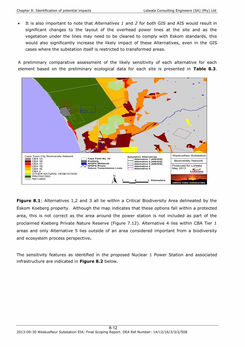
Potential issues in relation to Critical Biodiversity Areas and Broad-Scale Processes (Figure8.1): The site lies within the planning domain of the Cape Town City Biodiversity Network.
Various corridors have been implemented within the network to maintain or restoreconnectivity to the general highly fragmented urban landscape.
Although a large proportion of the Koeberg property has been proclaimed as part of theKoeberg Private Nature Reserve, the area around the power station itself is not part of thereserve and consequently, none of the Alternatives 1 -3 actually fall within the NatureReserve itself.
Eskom is yet to sign a binding stewardship agreement for the site or commit any parts ofthe Koeberg property to formal conservation.
Alternatives 3 and 4 pose the greatest risks to disrupt broad-scale ecological processes(both within natural or semi-natural habitats within areas that are likely to play animportant role for landscape connectivity and act as corridors for the movement of faunaand flora).
The AIS options at Alternatives 1 and 2 would also significantly impact intact vegetationand their proximity to the coastline also increases the likelihood that the connectivity of thecoastal strip would be disrupted by the development of these sites.
The GIS options at Alternatives 1 and 2 are restricted largely to transformed habitats inclose proximity to existing infrastructure and the additional contribution to the loss thelandscape connectivity would be low.
As Alternative 4 is currently highly degraded, Alternative 3 is identified as the leastpreferred option in terms of biodiversity impact and the potential for disruption of broader-scale ecological processes.
However in the longer term, the protection of Koeberg Nature Reserve cannot beguaranteed and the maintenance of the corridor to the north of Koeberg is consideredessential as this would be the only corridor linking the Blaauberg Nature Reserve with theDassenberg Coastal Catchment Corridor to the north.
As such, Alternative 4 is not considered a viable option by the City of Cape Town due to thepotential for development at this site to disrupt the north-south corridor.
Chapter 8: Identification of potential impacts Lidwala Consulting Engineers (SA) (Pty) Ltd
2013-09-30 Weskusfleur Substation EIA: Final Scoping Report. DEA Ref Number: 14/12/16/3/3/2/5088-12
It is also important to note that Alternatives 1 and 2 for both GIS and AIS would result insignificant changes to the layout of the overhead power lines at the site and as thevegetation under the lines may need to be cleared to comply with Eskom standards, thiswould also significantly increase the likely impact of these Alternatives, even in the GIScases where the substation itself is restricted to transformed areas.
A preliminary comparative assessment of the likely sensitivity of each alternative for eachelement based on the preliminary ecological data for each site is presented in Table 8.3.
Figure 8.1: Alternatives 1,2 and 3 all lie within a Critical Biodiversity Area delineated by the
Eskom Koeberg property. Although the map indicates that these options fall within a protected
area, this is not correct as the area around the power station is not included as part of the
proclaimed Koeberg Private Nature Reserve (Figure 7.12). Alternative 4 lies within CBA Tier 1
areas and only Alternative 5 lies outside of an area considered important from a biodiversity
and ecosystem process perspective.
The sensitivity features as identified in the proposed Nuclear 1 Power Station and associatedinfrastructure are indicated in Figure 8.2 below.

Chapter 8: Identification of potential impacts Lidwala Consulting Engineers (SA) (Pty) Ltd
2013-09-30 Weskusfleur Substation EIA: Final Scoping Report. DEA Ref Number: 14/12/16/3/3/2/5088-13
Figure 8.2: Nuclear-1 Duynefontein sensitivity map Source: Arcus GIBB (Pty) Ltd. 2011
8.3.5 Flora
The Alternatives within the intact vegetation would be almost certain to impact listed plantspecies, a relatively large number of which have been recorded in the Koeberg Private NatureReserve. As the affected vegetation types are themselves also listed as Endangered orCritically Endangered, impacts to intact vegetation would be highly undesirable and the optionswithin the transformed habitats are highly preferred as a result.
Nature: Site preparation and construction will result in a lot of disturbance which would impact
indigenous vegetation at all the AIS Alternatives except Alternative 5. Given the abundance of listed species in the area and the high conservation status of the
constituent vegetation types, a high negative impact on the vegetation and listed speciescan be expected to occur under such a scenario.
Extent: Although the extent of the development is relatively low, the conservation significanceof the intact vegetation and the presence of numerous listed species means that anytransformation within these areas would have an impact that must be considered to haverelevance beyond the local area. Should the development be restricted to the transformedhabitats the extent of impact would be restricted to the site.

Chapter 8: Identification of potential impacts Lidwala Consulting Engineers (SA) (Pty) Ltd
2013-09-30 Weskusfleur Substation EIA: Final Scoping Report. DEA Ref Number: 14/12/16/3/3/2/5088-14
Potential Significance: The significance of this impact would depend entirely on the final locationof the substation. Within the Alternatives restricted transformed areas, the significance wouldbe low, while within the intact vegetation the significance would be very high and could not beeffectively mitigated.
Impacts can therefore be placed in three categories, namely:
Direct impacts:o Destruction of threatened and protected flora species;o Destruction of sensitive/ pristine habitat types;
Indirect Impacts:o Floristic species changes subsequent to development;o Impacts on surrounding habitat/ species;
Cumulative Impacts:o Increase in local and regional fragmentation/ isolation of habitat; ando Increase in environmental degradation.
Table 8.3 presents a summary of past, current and future Eskom EIA EnvironmentalAuthorizations within vicinity of Koeberg Power Station excluding high voltage line projects.The aim of the table is to illustrate the cumulative impact of developments in the study area.
Table 8.3: Past, Current and Future Eskom EIA Environmental Authorizations within vicinity ofKoeberg Power Station excluding high voltage line projects
ProjectCurrent,Past orFuture
Approx. lossof un-
transformedindigenousvegetation
FynbosType
Comments
Koeberg Adminand TrainingCentre Campus
Past 8 ha AtlantisDune Fynbos
EA did not require anybiodiversity off-sethowever stewardshipagreement is required
Ankerlig powerstationconversion andintegration
Past 17.5 ha Cape FlatsDuneStrandveld
EA requires a biodiversityoff set of 225 ha. Off-setnot yet implemented dueto project on hold
WeskusfleurSubstation
Current Alt 1: NoneAlt 4: 27 ha
Alt 1:PreviouslyTransformedAlt 4:AtlantisDune Fynbos
Biodiversity off set (ifrequired) subject to EIAprocess
Nuclear-1 Current 265 ha Some CapeFlats DuneStrandveld,someunlisted
Biodiversity off set (ifrequired) subject to EIAprocess
KoebergTransient
FutureProposed
None PreviouslyTransformed
Biodiversity off set (ifrequired) subject to EIA

Chapter 8: Identification of potential impacts Lidwala Consulting Engineers (SA) (Pty) Ltd
2013-09-30 Weskusfleur Substation EIA: Final Scoping Report. DEA Ref Number: 14/12/16/3/3/2/5088-15
Interim NuclearUsed FuelStorage Facility
CapeSeashoreFynbos
process
KoebergThermal PowerUprate
FutureProposed
None N/A No biodiversity off-setrequired
Koebergportableequipmentstore and waterstorage tank
FutureProposed
None PreviouslyTransformed
Biodiversity off set (ifrequired) subject to EIAprocess
KoebergInsulatorPollution TestStation
FutureProposed
None PreviouslyTransformed
Biodiversity off set (ifrequired) subject to EIAprocess
KoebergVisitor’s Centre
FutureProposed
None PreviouslyTransformed
Biodiversity off set (ifrequired) subject to EIAprocess
The nature and extent of these impacts will be assessed in the EIA phase of the project.
8.3.6 Fauna
Potential faunal impacts include:
Nature: Increased levels of noise, pollution, disturbance and human presence will be detrimental to
fauna during the construction phase. Sensitive and shy fauna are likely to move away from the area during the construction phase
as a result of the noise and human activities present. Some mammals and reptiles such as tortoises would be vulnerable to illegal collection or
poaching during the construction phase as a result of the large number of constructionpersonnel that are likely to be present.
In the longer term impacts on fauna are likely to be relatively low provided that effectivemitigation can be applied.
Extent: The extent of the impact would be largely restricted to the local area.
Potential Significance: Disturbance during the construction is likely to be high as a result ofdisturbance, noise and human presence. However, during the operational phase impacts arelikely to be of relatively low significance, especially for the transformed alternatives. As withvegetation, the significance of the development on fauna would depend to a large degree on thefinal location of the substation and associated infrastructure.
Loss of Landscape Connectivity and Ecological Function

Chapter 8: Identification of potential impacts Lidwala Consulting Engineers (SA) (Pty) Ltd
2013-09-30 Weskusfleur Substation EIA: Final Scoping Report. DEA Ref Number: 14/12/16/3/3/2/5088-16
Nature: The presence of the substation within areas of natural vegetation would disrupt landscape
connectivity and would pose an obstacle for the movement of many fauna. Subterranean species such as the local endemic Bloubergstrand Dwarf Burrowing Skink
would be most vulnerable.
Extent: The extent of this impact would depend on the final preferred Alternative and would beof regional significance in the worst case scenario.
Potential Significance: The significance of this impact would depend on the final preferredAlternative, but for Alternatives 3 and 4 and AIS Alternatives 1 and 2, the significance would behigh given the likely importance of these areas for faunal movement and landscapeconnectivity.
8.3.7 Biodiversity Comparative Assessment
Each Alternative and substation type option are preliminary compared within a table in terms ofthe sensitivity of each Alternative for each element of the terrestrial biodiversity. At this stage,a broad subjective assessment is used to categorise each alternative as low, medium, high orvery high sensitivity for a particular biodiversity element.
Table 8.4: Summary assessment of the likely sensitivity of each Alternative for each element
of biodiversity, based on the preliminary ecological data available for each site.
Alternative FloraEcologicalFunction
Mammals Reptiles Amphibians Avifauna
Alt1
AIS Moderate Moderate Moderate Moderate Moderate ModerateGIS Low Low Low Low Low Low
Alt2
AIS High High High High High HighGIS Low Low Low Low Low Low
Alt3
AIS Very High Very High High Very High Moderate HighGIS High High Moderate High Moderate Moderate
Alt4
AIS High High Moderate High Moderate ModerateGIS High High Low High Low Low
Alt5 AIS
Low Low Low Low Low Low
The results of the comparative assessment are to some extent dependent on the power linesassociated with each option and not only the location of the substation. Currently themanagement of the vegetation beneath the power lines is detrimental to biodiversity, andshould the policy at Eskom change and the vegetation beneath the power lines is allowed topersist without continued clearing and disturbance as is currently the case, then the rankingwould be based more exclusively on the location of the substation itself.

Chapter 8: Identification of potential impacts Lidwala Consulting Engineers (SA) (Pty) Ltd
2013-09-30 Weskusfleur Substation EIA: Final Scoping Report. DEA Ref Number: 14/12/16/3/3/2/5088-17
However, at this point, only the status quo can be safely assumed and under such a scenario,Alternative 5 is likely to be preferable option in terms of overall ecological impact, followed byAlternative 4 GIS although not technically viable and Alternative 2 GIS. Alternatives 1, 2 and 3for AIS are likely to be the least preferred alternatives as they would result in the greatest lossof currently intact habitat and would have the greatest ecological impact. The no-go alternativewould maintain the status quo and would obviously not have a direct impact on biodiversity.However, under the current situation some areas such as the area to the east of the R27 isbecoming heavily invaded by woody aliens and would impact the biodiversity value of thissensitive area.
8.3.8 Surface Water
The primary drainage paths is located a distance from the sites except for a small tributary ofthe Sout River which run through the western corner of the proposed Alternative 5 north of theSterrekus Substation. The area of all the proposed alternatives consists mainly of minordrainage paths over a flat sandy terrain. Impacts as a result of flooding linked to watercoursesare therefore absent. Although flooding below the Sterrekus Substation (Alternative 5) which islocated in the proximity of a tributary of the Salt River has taken place. This impact is linkedto storm-water management and adequate storm water measures.
A large area will be cleared for construction activities and flat surfaces will be created for heavyelectrical equipment. These activities will affect the storm water runoff characteristics of theland. The flat surfaces will result in more point specific discharge points which in turnconcentrate flow and increase the erosion potential. The absence of vegetation and theassociated reduced infiltration result in a higher runoff coefficient (higher percentage of waterrunoff from the site). Watercourses and man-made drainage structures will carry more waterwhich may result into flooding.
The following potentially negative impacts on the surface water associated with theconstruction phase have been identified:
Clearance of the site to prepare for construction; Storage of hazardous chemical substances; Storage of fuel and oil; Cement and concrete batching; Transportation of material to site and the storage of material on site; and Dust as a result of construction activities.
The abovementioned impacts associated with the construction phase are generic and can beadequately managed through the implementation of a construction Environmental ManagementPlan.
The following potentially negative impacts on the surface water associated with theoperational phase have been identified:

Chapter 8: Identification of potential impacts Lidwala Consulting Engineers (SA) (Pty) Ltd
2013-09-30 Weskusfleur Substation EIA: Final Scoping Report. DEA Ref Number: 14/12/16/3/3/2/5088-18
Blocked surface water management systems as result of build-up of dust and silt; The cut of the supply of surface water to wetlands as a result of the diversion of site
storm water into storm-water infrastructure.
8.4 Identification of Potential Social Impacts
8.4.1 Visual
Based on the status, extent and duration of the change to the existing landscape, a preliminaryvisual impact magnitude was defined in order to rank the five sites in terms of risk to landscapedegradation (Table 8.5).
The preliminary visual impacts in terms of the different alternatives identified:
The low risk sites were Alternative 5 and Alternative 2 GIS due to their close proximity to theSterrekus substation and Koeberg power station, which already generate high levels of visualcontrast.
The impact of Alternative 4 was rated medium for the site and high for the transmission line.The site is degraded by close proximity to the transmission line corridors and is covered byalien vegetation. The site is flat without much visual appeal but is in closer proximity to theR27 and isolated farmsteads in the area. The Alternative 4 transmission line crosses overfour dwellings and the change in landscape will be strongly experienced as the receptorswould have to undergo relocation.
The impact of Alternative 1 GIS was rated medium. Although mostly on transformed land,the northern extent does intrude into a high sensitivity dune field area.
Alternatives 3 (AIS and GIS) were rated moderate to high as they are located on significantvegetation, are strong associated with the gateway to the Koeberg complex which iscurrently of interest and defined by natural vegetation surrounding the developed areas, andwould be in clear view of the R27 and Duinefontein receptors who have higher sensitivity tolandscape change.
Alternative 1 and 2 AIS were rated high risk to landscape character. Alternative 1 AISintrudes significantly into the northern dune fields which have been identified by the Nuclear1 EIA as having high environmental significance.
Alternative 2 AIS is located within a high exposure area to the Duinefontein residential areawhere the current buffer zone from the power station has become a key aspect of the localsense of place. Landscape change in this area will be strongly felt and resisted.

Chapter 8: Identification of potential impacts Lidwala Consulting Engineers (SA) (Pty) Ltd
2013-09-30 Weskusfleur Substation EIA: Final Scoping Report. DEA Ref Number: 14/12/16/3/3/2/5088-19
Table 8.5: Visual Impact Summary Table
Project component
Sta
tus
Exte
nt
Du
rati
on
Mag
nit
ud
e
Alternative 1 GIS -ve direct Site Permanent Medium
Alternative 1 AIS -ve direct Regional Permanent High
Alternative 2 GIS -ve indirect Site Permanent Low
Alternative 2 AIS -ve indirect Regional Permanent High
Alternative 3 GIS -ve direct Site Permanent Medium - High
Alternative 3 AIS -ve indirect Regional Permanent Medium - High
Alternative 4 AIS -ve indirect Regional Permanent Medium
Alternative 4 TX -ve direct Site Permanent High
Alternative 5 -ve indirect Regional Permanent Low - Medium
8.4.2 Heritage
Heritage scoping has indicated that the proposed construction of the Weskusfleur substation willnot impact on any significant surface archaeological heritage, in site Alternatives 1-5. Thefollowing potential heritage impacts have been identified:
The desk top study has shown, however, that most of the significant archaeological andpalaeontological heritage is deeply buried and will only be exposed during the constructionphase of the project. This applies particularly to Alternatives 1 and 2.
Some archaeological heritage (mainly ESA artefacts) might be exposed or uncovered inAlternatives 3, 4 and 5, but these are expected to be thinly and unevenly distributed overthe proposed development sites and will be of little scientific value.
Unmarked human burials may be exposed or uncovered during bulk earthworks andexcavations.
Exposure of heritage resources (in Alternatives 1 & 2) may result in extensive and lengthymitigation, possibly delaying construction of the proposed substation by several years. Theseare potential risks that will need to be taken into account when deciding on the preferred sitealternative.
Construction of the new Weskusfleur substation will however, also provide a unique and rareopportunity to sample, record (their context), collect and rescue material, where deepexcavations penetrate or intersect these archaeological and fossil-bearing deposits

Chapter 8: Identification of potential impacts Lidwala Consulting Engineers (SA) (Pty) Ltd
2013-09-30 Weskusfleur Substation EIA: Final Scoping Report. DEA Ref Number: 14/12/16/3/3/2/5088-20
No old buildings, structures or features of historical significance were encountered duringscoping, and impacts on significant colonial period heritage resources are unlikely to occur.
The cultural landscape is not a significant heritage indicator. The existing nuclear/industrialcomplex at KNPS and Groot Oliphantskop has already compromised the rural agriculturallandscape character of the receiving environment. Brakkefontein No. 32/1 does, however,still retain a rural agricultural `sense of place’.
8.4.3 Social
The key social issues that would need to be assessed during the SIA can be divided into:
Perceptions and fears associated with the proposed power line; and Local, site-specific issues (during construction and operation phases).
The local site-specific issues can in turn be divided into construction and operational relatedissues.
Perceptions and Fears
Social impacts are unique in that the mere introduction of information into the public domaincan result in social impacts that manifest themselves in the form of perceptions, fears andexpectations. In the case of the proposed Weskusfleur substation, the introduction ofinformation in the form of maps and diagrams indicating the potential alternative alignments islikely to have resulted in social impacts, specifically for the land owners whose properties maypotentially be affected.
The extent and nature of these fears are likely to be linked to concerns related to the visual andsense of place impacts associated with large, substations and high voltage transmission lines aswell as fuelling existing issues and concerns that landowners have regarding the existinginfrastructure in the study area.
These impacts could in turn have negative implications for property values, investments intourism initiatives and the public’s perception of Eskom and their contractors in general etc.The SIA will seek to identify and assess the potential extent and severity of these fears andperceptions as part of the assessment process.
Local, Site-specific Issues
The potential impacts during the construction phase include:
Presence of construction workers and the potential risks to personal safety, specifically forfarmers, increase in stock theft, trespassing, poaching and fires;
Potential for interaction between construction workers and farm workers may result in socialimpacts, such as relationship conflicts, prostitution, un-planned pregnancies, spread ofsexually transmitted diseases, alcohol and drug abuse etc;

Chapter 8: Identification of potential impacts Lidwala Consulting Engineers (SA) (Pty) Ltd
2013-09-30 Weskusfleur Substation EIA: Final Scoping Report. DEA Ref Number: 14/12/16/3/3/2/5088-21
Damage to natural vegetation and grazing due to construction related activities; Damage to access and farm roads due to heavy vehicular traffic associated with
construction activities; Impact on farm infrastructure (fences, gates etc) due to construction related activities; Impact on tourism related activities due to construction related activities; The impact of the compensation process on farming activities. Concern is that delays in
payment of compensation for land takes can impact negatively on farming activities andresult in uncertainty regarding future investments in infrastructure etc.
Creation of local employment and business opportunities; and Creation of opportunities for skills development and training for members from local
communities.
The potential impacts during the operational phase include:
The impact of the proposed alignments on the visual character of the area and sense ofplace. These impacts will be felt at both a local, individual landowner level, and also at alarger, landscape level that affects visitors to the area. The nature and extent of the visualand sense of place impacts will be related to the nature of the terrain affected by thesubstation and transmission lines, the number of people affected, and the existing activitiesand sense of place of the area;
The impact of the proposed substation on farming activities and land use potential; The potential impact associated with the perceived electromagnetic fields on farming
activities and worker health and safety; The potential increased fire risks associated with the proposed substation and the
implications for farming and other land use related activities, such as tourism andconservation;
The impact on current and future tourism and conservation related activities and potential.This will be closely linked to the visual and sense of place impacts associated with theproposed substation;
Impact on property values. Although the SIA will not be in a position to quantify thepotential impact on property values, the establishment of substation is likely to have anegative impact on property values for certain landowners;
The potential impacts associated with maintenance and repair work on farming and otherland use related activities, such as tourism and conservation;
The impact on the servitudes on fire management programmes and the implications forfarmers and other land uses, such as tourism and conservation. In many instances thenatural vegetation under power lines cannot be burnt on a regular basis due the potentialdamage to the power lines. Also the presence of the power lines impacts upon the firefighting options that can be used to combat fires;
The potential cumulative impacts on the social environment associated with the proposedsubstation;
The broader social benefits for South Africa associated with an improved, more stableenergy supply network;
Creation of local employment and business opportunities associated with the maintenanceand up-keep of the substation; and

Chapter 8: Identification of potential impacts Lidwala Consulting Engineers (SA) (Pty) Ltd
2013-09-30 Weskusfleur Substation EIA: Final Scoping Report. DEA Ref Number: 14/12/16/3/3/2/5088-22
Creation of opportunities for skills development and training for members from localcommunities associated with maintenance and up-keep of the transmission lines.
Decommissioning:
Depending on the final alternative selected (Chapter 4) the decommissioning of some of theexisting Koeberg GIS substation infrastructure and lines is also proposed as part of some of thealternatives. Important aspects for consideration for decommissioning: Assessing soil conditions; Ensuring the site is reclaimed to the pre-disturbance land capability and is compatible with
current adjacent land use.
The scope of the decommissioning will determine which impacts may be expected duringdecommissioning. The current Koeberg Substation is within the security fence of the KoebergNuclear Power station site and will most likely not be fully rehabilitated to its natural state andtherefore will the impacts of decommissioning be only localised.
The above mentioned impacts will be investigated in more detail during the EIA phase of theproject.