7.2.3.1.1 next generation sub-precinct
TRANSCRIPT

1 Moreton Bay Regional Council Planning Scheme Proposed Amendment for Neighbourhood Development Plan Area No.1 (NDP1) of the Caboolture West Local Plan (and other consequential amendments to the MBRC Planning Scheme) – State Approval Version August 2021
7.2.3.1.1 Next generation sub-precinct
7.2.3.1.1.1 Purpose - Next generation sub-precinct
Editor's note - Next generation neighbourhoods are a concept first canvassed in the Next Generation Planning handbook. They are a typology bringing together a range of planning and urban design objectives for residential areas for the South East Queensland context. The planning for Caboolture West is based on a series of walkable neighbourhoods. Each neighbourhood has a neighbourhood centre or ‘hub’ typically where major streets cross, or could centre on a local Park(57), and are based on a 400m or 5 minute walking catchment. Neighbourhood hubs are mixed use and ‘mixed housing’ typically containing convenience retail, commercial, community and residential activities. Three or four neighbourhoods are clustered around a local centre forming about a 1km catchment. Local centres are large enough for a full-line supermarket. They are strongly mixed use. Buildings and public life is oriented to the street (not car parks). They are walkable, comfortable, pleasant and safe. A local centre provides a focus for medium density residential development. A net residential density of 20 dwellings per hectare is targeted for next generation neighbourhoods, and the network of neighbourhood centres and local centres provide for ‘day to day needs of residents’ within easy walking distance. Where 3 or 4 neighbourhoods are clustered around a local centre, the local centre provides opportunity to locate medium density residential development thereby increasing the overall density of a suburb scaled unit to 22 dwellings per hectare. Home offices(53) and home businesses are also encouraged in next generation neighbourhoods. Such uses are particularly appropriate along the major streets, still residential but offering some exposure useful for live/work situations. Neighbourhood serving shops and services are located at the heart of the neighbourhood, where major streets cross. Attached houses and live/work buildings cluster around the centre/hub, and along the major through streets. Rear lanes are used to provide parking access. A local Park(57) and school are on the edge of the neighbourhood, still within easy walk. Alternatively a local Park(57) could provide a focus. Buses ply the major streets (the cross streets), spaced at 800m intervals to provide coverage without leaving the major streets. A ‘tiled’ grid of streets provides good access and connectivity while managing intersections.
1. The purpose of the Next generation sub-precinct will be achieved through the following overall outcomes:
a. The Next generation sub-precinct supports site densities between 15 and 75 dwellings per hectare.
b. Neighbourhoods will have a mix of residential uses, tenure and densities on a variety of lot sizes providing housing choice and affordability for different lifestyle choices and life stages to meet diverse community needs.
c. Neighbourhoods are designed to provide well-connected, safe and convenient movement and open space networks through interconnected streets and active transport linkages that provide high levels of accessibility between residences, open space areas and places of activity.
d. Medium to high density uses (e.g. Multiple dwelling, Relocatable home park, Residential care facility, Retirement facility, Rooming accommodation, Short-term accommodation) are located in proximity to a range of services, centres, parks and public transport stop(s) or station(s).
a. The Next generation sub-precinct is developed as a series of neighbourhoods consisting of a mix of residential, convenience retail, commercial, community, education, recreation and open space activities.
b. Next generation residential development is the predominate form of development within each neighbourhood.
c. The scale and density of development facilitates an efficient land use pattern that supports compact, walkable and sustainable communities that are well connected to
Version: 12, Version Date: 09/08/2021Document Set ID: 62535721

2 Moreton Bay Regional Council Planning Scheme Proposed Amendment for Neighbourhood Development Plan Area No.1 (NDP1) of the Caboolture West Local Plan (and other consequential amendments to the MBRC Planning Scheme) – State Approval Version August 2021
local centres, neighbourhood hubs, schools, Community uses(17), Parks(57) and open space.
d. The Next generation sub-precinct contains a mix of residential dwellings, tenure and densities providing housing and lot choice and affordability for different lifestyle choices and life stages to meet diverse community needs.
e. Neighbourhoods have a safe and convenient movement network consisting of interconnected streets and active transport linkages that provide high levels of accessibility between residences, centres, open space areas, schools and places of activity.
f. Development provides sufficient and appropriately located land for local centres, neighbourhood hubs, schools and open space activities.
e. Residential dwelling mix in a Next generation sub-precinct is aimed at achieving a minimum net density of 20 dwellings per hectare.
Note - Notwithstanding the target net residential density for the Next generation sub-precinct, it is acknowledged that early years of the development (i.e. 1st five years) of the Caboolture West local plan area are likely to commence with a predominance of detached lots in the 15 to 20 dwellings per hectare density range.
Note - Net residential density refers to the density of development of an area which includes land for local streets, local Parks(57)(53) and developable land i.e. Before development occurs. Council's density calculations for the Caboolture West Local Plan assume that 70% of an area is developable and that 30% of the area is taken up by local streets and Parks(57) .
Note - Refer to Planning scheme policy - Neighbourhood design for density calculation.
f. Development within 400m walking distance of a local centre sub-precinct must include a mix of low rise apartments, row houses and plexes to achieve a minimum net density of 30 dwellings per hectare.
i. Development protects and preserves the cultural heritage significance of the Upper Caboolture Uniting Church and adjacent cemetery(12).
g. The design, siting and construction of residential activities uses are to:
i. contributes to a safe, attractive, pedestrian friendly an attractive streetscape with a priority given to pedestrians;
ii. encourages passive surveillance of public spaces;
iii. results in separation of public and private spaces, privacy and residential amenity consistent with the low to medium density and residential character intended for of the area;
iv. orientates to integrate with the street and surrounding neighbourhood;
v. provides a diverse and attractive built form where buildings are located closer to the street and encourage active frontages;
vi. incorporates sub-tropical urban design principles that respond to local climatic conditions;
vii. incorporates sustainable practices including maximising energy efficiency and water conservation;
Version: 12, Version Date: 09/08/2021Document Set ID: 62535721

3 Moreton Bay Regional Council Planning Scheme Proposed Amendment for Neighbourhood Development Plan Area No.1 (NDP1) of the Caboolture West Local Plan (and other consequential amendments to the MBRC Planning Scheme) – State Approval Version August 2021
viii. incorporates natural features and responds to site topography;
ix. locates car parking so as not to dominate the street;
x. caters for appropriate car parking and manoeuvring areas on site;
xi. be of a scale and density consistent with the low to medium density residential character intended for the area;
xii. provides urban services such as reticulated water, sewerage, sealed roads, Pparks(57) and other identified infrastructure;
xiii. ensures domestic outbuildings are subordinate in appearance and function to the dwelling.
h. Home based business can only be established where the scale and intensity of the activity does not detrimentally impact upon the character and amenity associated with the surrounding area. Specifically, Home based business does not include the sale or restoration of more than 4 vehicles in any calendar year or, undertake a mechanical repairs or panel beating activity associated with a business at the subject premises.
i. Non-residential uses take the form of community activities, corner stores, and neighbourhood hubs.
j. Community activities must:
i. be integrated into next generation neighbourhoods;
ii. form part of a local centre or neighbourhood hub or in a specific location in accordance with a Neighbourhood development plan that reflects the urban structure concept shown indicatively on Figure 7.2.3.5 - Centres, employment and schools;
i. establish be in a locations that may be serviced by public transport;
ii. do not negatively impact adjoining residents or the streetscape;
iii. do not undermine the viability of existing or future centres.
k. Corner stores may establish as a standalone use (not part of a neighbourhood hub) where:
i. the store is of a scale that remains subordinate to all centres and neighbourhood hubs within the local plan area;
ii. clear separation from existing neighbourhoods hubs and centres within the network are maintained to reduce catchment overlap. The corner store should not be within 1600m of another corner store, neighbourhood hub or centre measured from the centre of the corner store, neighbourhood hub or centre;
iii. they are appropriately designed and located to include active frontages.
l. Educational establishments(24) are located:
i. in accordance within an approved a Neighbourhood development plan that generally reflects the urban structure concept shown indicatively on Figure 7.2.3.5 - Centres, employment and schools; or
Version: 12, Version Date: 09/08/2021Document Set ID: 62535721
4 Moreton Bay Regional Council Planning Scheme Proposed Amendment for Neighbourhood Development Plan Area No.1 (NDP1) of the Caboolture West Local Plan (and other consequential amendments to the MBRC Planning Scheme) – State Approval Version August 2021
ii. on connecting streets between neighbourhoods (not on cul-de-sacs), to maximise an equal catchment distribution among two or three neighbourhoods;
iii. along green network corridors (where possible) to maximise the use of open space for sport and recreation purposes and to promote active travel as a means of transport to and from school.
Editor's note - State primary and high school locations and their general catchments have been indicatively shown identified in the Caboolture West local plan. School site boundaries and sizes within are to be determined at an approved Neighbourhood development plan stage in consultation with the Department of Education Training and Employment. The locational and design criteria proposed seeks to integrate schools into the design of the town. Non-government school locations are not identified and must adopt the same locational and design criteria as government schools.
m. Educational establishments(24) are designed: i. to ensure the efficient use of land (e.g. compact built form where in proximity to a centre, share recreation space, buildings and sports fields with the community, council and other schools etc);
ii. to be pedestrian oriented and complement walkable and cycleable neighbourhoods by providing multiple access points;
iii. to maintain the safety of users accessing the Educational establishment(24).
n. Regional and district sports parks and facilities:
i. are provided in accordance with a Neighbourhood development plan that generally reflects the urban structure concept shown indicatively on Figure 7.2.3.4 - Green network and open space.
ii. are developed to:
A. maintain the ongoing viability and relevancy of existing and new indoor and outdoor sports and recreation facilities to meet community sport and recreation needs;
B. where applicable, be in accordance with a Council Master Plan approved under Council policy or Management Plan under the Land Act 1994;
C. only include activities other than sports and recreation activities that have a nexus with or are ancillary to, sports and recreation activities where:
I. activities do not compete with similar uses in centres;
II. activities do not detract from the primary sports and recreation activity occurring on a site;
III. activities do not have adverse impacts on the character and amenity of the surrounding receiving environment, including noise, traffic generation, lighting, rubbish and waste disposal.
D. adopt a high standard of design and achieve quality buildings, and structures, including adopting the principles of Crime Prevention Through Environmental Design (CPTED);
Version: 12, Version Date: 09/08/2021Document Set ID: 62535721

5 Moreton Bay Regional Council Planning Scheme Proposed Amendment for Neighbourhood Development Plan Area No.1 (NDP1) of the Caboolture West Local Plan (and other consequential amendments to the MBRC Planning Scheme) – State Approval Version August 2021
E. be compatible with the existing and intended scale and character of the streetscape and surrounding area and does not appear visually dominant or overbearing;
F. adopt sensitive design and siting considerations when adjoining residential areas. Design measures such as landscaping, screening and separation are adopted to minimise the visual impact of buildings and hard surfaces and nuisance effects associated with lighting, noise, dust and rubbish disposal;
G. mitigate potential traffic impacts by:
I. locating on roads of a standard and capacity to accommodate traffic demand;
II. providing safe and accessible vehicle access points, on-site manoeuvring and parking areas;
III. providing for active transport opportunities.
Editor’s note - Further detailed planning through the Neighbourhood development planning process is required to confirm the location, size and design of Parks including the Town centre park, Regional sports park, District sports parks, District recreation parks and Local recreation parks. This will be reflected in an approved Neighbourhood development plan.
Editor's note - Regional and district sports parks have been designed at the town scale and their locations and sizes identified in the Structure plan. A town centre Park(57) is also noted. District and some local recreation park locations are also identified, but detailed planning through the Neighbourhood Development Planning process is required to confirm the location, size and design of parks(57).
o. Retail and commercial activities (excluding Service stations) must:
i. cluster with other non-residential uses (excluding corner stores and activities associated with a regional or district sports park facility) forming a neighbourhood hub;
ii. are be centred around a main street central core, fostering opportunities for social and economic exchange;
iii. be of a small scale, appropriate for a neighbourhood hub;
Note - For further information on the size and scale of neighbourhood hubs refer to Table 7.2.3.3. Retail and commercial uses that will result in a new or existing hub expanding to a scale that exceeds what is appropriate for a neighbourhood hub are therefore more comparable to a local centre. Accordingly, development of this nature are to be assessed as if establishing a new local centre. Refer to the Centre zone code for relevant assessment benchmarks.
iv. do not negatively impact adjoining residents or the streetscape;
v. are be subordinate in function and scale to all centres within the local plan area and the region;
vi. not undermine the viability of existing or future centres or neighbourhood hubs.
p. Service stations:
i. establish where they will not disrupt, fragment or negatively impact active frontages (e.g. within a neighbourhood hub);
Version: 12, Version Date: 09/08/2021Document Set ID: 62535721

6 Moreton Bay Regional Council Planning Scheme Proposed Amendment for Neighbourhood Development Plan Area No.1 (NDP1) of the Caboolture West Local Plan (and other consequential amendments to the MBRC Planning Scheme) – State Approval Version August 2021
ii. establish on heavily trafficked roads where the amenity of surrounding residential uses is already subject to impacts by road vehicle noise;
iii. establish in locations that will not have a negative impact on the street environments intended to include active frontages (e.g. Neighbourhood hubs or centres);
iv. do not negatively impact adjoining residents or the streetscape;
v. ancillary uses or activities only service the convenience needs of users.
q The design, siting and construction of non-residential uses (excluding Educational establishments(24)):
i. contributes to a safe, attractive, pedestrian friendly streetscape maintains a human scale, through appropriate building heights and form;
ii. provides low rise development;
ii. provides attractive, active frontages that maximise pedestrian activity along road frontages, movement corridors and public spaces (excluding Service stations);
iv.results in separation of public and private spaces, privacy and residential amenity consistent with the density and residential character of the area, and accessibility for business customers;
iii. provides for active and passive surveillance of road frontages, movement corridors and public spaces;
iv. promotes active transport options and ensures an oversupply of car parking is not provided;
v. locates car parking so as not to dominate the street;
vi. caters for appropriate car parking and manoeuvring areas on site;
vii. does not result in large internalised Shopping centres(76) (e.g. large blank external walls with tenancies only accessible from within the building) surrounded by expansive areas of surface car parking.
r. Expansion of existing Nneighbourhood hubs are established where or the establishment of a new neighbourhood hub only occurs where:
i. it will service the immediate convenience needs of the local neighbourhood, providing an important activity node and is consistent with the centres network within the local plan area;
i. it is of a scale that remains subordinate to all other centres within the local plan area and the region;
Note - Retail and commercial uses that will result in a new or existing neighbourhood hub expanding to a scale and function more consistent with a Local centre are to be assessed as if establishing a new Local centre. Refer to the Centre zone code for relevant assessment criteria.
ii. the function and scale of uses and activities will not have a negative impact on the community;
iii they are appropriately designed to include active frontages around a main street core, and
Version: 12, Version Date: 09/08/2021Document Set ID: 62535721

7 Moreton Bay Regional Council Planning Scheme Proposed Amendment for Neighbourhood Development Plan Area No.1 (NDP1) of the Caboolture West Local Plan (and other consequential amendments to the MBRC Planning Scheme) – State Approval Version August 2021
iv. they are staged where relevant to retain key (highly accessible) sites for long-term development.
s Neighbourhood hubs are located:
i. in accordance with a Neighbourhood development plan that reflects the urban structure concept shown indicatively on Figure 7.2.3.5 - Centres, employment and schools;
I generally within a 400m walk of most residents;
ii. at the junction of main streets and public transport routes in accessible and visible locations;
iii. generally to the side of the intersection creating pedestrian focused main streets;
ii. with clear separation from existing neighbourhood hubs and centres within the network to reduce catchment overlap.
t General works associated with the development achieves the following:
i. new development is provided with a high standard of services to meet and support the current and future needs of users of the site, including roads, street lighting services, telecommunications and reticulated electricity (underground wherever possible), water and sewerage (where available);
ii. the development manages stormwater to:
A. ensure the discharge of stormwater does not adversely affect the quality, environmental values or ecosystem functions of downstream receiving waters;
B. prevent stormwater contamination and the release of pollutants; C. maintain or improve the structure and condition of drainage lines and riparian
areas; D. avoid off-site adverse impacts from stormwater.
iii. the development does not result in unacceptable impacts on the capacity and safety of the external road network;
iv. the development ensures the safety, efficiency and useability of access ways and parking areas;
v. site works including earthworks are managed to be safe and have minimal impacts on adjoining or adjacent premises, the streetscape or the environment.
u Activities associated with the use do not cause nuisance by ways of aerosols, fumes, light, noise, odour, particles or smoke.
v. Noise generating uses are designed, sited and constructed to minimise the transmission of noise to appropriate levels and do not cause environmental harm or nuisance.
w. Noise sensitive uses are designed, sited and constructed so as not to be subject to unacceptable levels of noise.
x. Development has good access to existing and proposed transport infrastructure, public transport services, and bicycle and pedestrian networks and does not interfere with the safe and efficient operation of the surrounding road network.
n. Development ensures the safety, efficiency and useability of the street network, access ways and parking areas.
o. Development does not result in unacceptable impacts on the capacity and safety of the external road network.
Version: 12, Version Date: 09/08/2021Document Set ID: 62535721

8 Moreton Bay Regional Council Planning Scheme Proposed Amendment for Neighbourhood Development Plan Area No.1 (NDP1) of the Caboolture West Local Plan (and other consequential amendments to the MBRC Planning Scheme) – State Approval Version August 2021
y. Facilities, infrastructure and public realm improvements are provided to support active transport usage and contribute to improved pedestrian connectivity and walkability between key destinations.
z. Pedestrian connections are provided to integrate the development with the surrounding area as well as the street and public spaces.
r.Development constraints:
aa Development responds to overlay mapping with regards to Acid sulphate soils, Bushfire hazard, Infrastructure buffers (High voltage lines, bBulk water supply), Overland flow path, and Heritage and landscape by:
i. adopting a ‘least risk, least impact’ approach when designing, siting and locating development in any area subject to a constraint to minimise the potential risk to people, property and the environment;
ii. providing establishing appropriate and effective separation distances, buffers and mitigation measures along the high voltage transmission line and bulk water supply infrastructure as well as promoting the ongoing viability, operation, maintenance and safety of infrastructure;
iii. protecting historic and cultural values of significant places and buildings of heritage and cultural significance;
iv. ensuring effective and efficient disaster management response and recovery capabilities;
v. for where located in an overland flow path;
A. development siting, built form, layout and access responds to the risk presented by the overland flow and minimises risk to personal safety;
B. development is resilient to overland flow impacts by ensuring the siting and design accounts for the potential risks to property associated with overland flow;
C. development does not impact on the conveyance of overland flow up to and including the overland flow defined flood event;
D. development directly, indirectly and cumulatively avoid an increase in the severity of overland flow and potential for damage on the premises or to a surrounding property.
Editor’s note - Overlay map - Heritage and landscape character identifies local heritage places.
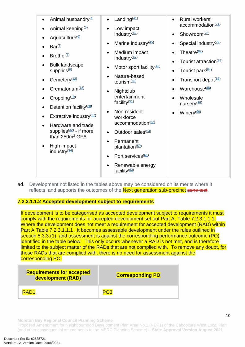
Ab. Development in the Next generation sub-precinct is for one or more of the uses identified below:
• Caretaker's accommodation(10)
• Residential care facility(65) - if within 800m walking
• Where in a neighbourhood hub:
Version: 12, Version Date: 09/08/2021Document Set ID: 62535721

9 Moreton Bay Regional Council Planning Scheme Proposed Amendment for Neighbourhood Development Plan Area No.1 (NDP1) of the Caboolture West Local Plan (and other consequential amendments to the MBRC Planning Scheme) – State Approval Version August 2021
• Child care centre(13)
• Club(14)
• Community care centre(15)
• Community residence(15)
• Community use(15)
• Dual occupancy(21)
• Dwelling house(22)
• Dwelling unit(23)
• Educational establishment(24)
• Emergency services(25)
• Health care services(32)
• Home based business(35)
• Multiple dwelling(49)
• Place of worship(60)
• Relocatable home park(62) - if within 800m walking distance of the Town centre precinct
distance of the Town centre precinct
• Retirement facility(67) - if within 800m walking distance of the Town centre precinct
• Rooming accommodation(69) - if within 800m walking distance of the Town centre precinct
• Sales office(72)
• Shop(75) - if for a corner store
• Short-term accommodation(77) - if within 800m walking distance of the Town centre precinct
A. Food and drink outlet(28)
B. Hardware and trade supplies(32)
C. Health care services(33)
D. Indoor sport and recreation(38) - for a gymnasium or exercise and fitness centre
E. Office(53)
F. Service industry(73)
G. Shop(75)
H. Shopping centre(76)
I. Veterinary services(87)
• Where in a regional or district sports facility park:
A. Food and drink outlet(28) (where ancillary to sports and recreation activities)
B. Indoor sport and recreation(38)
C. Market(46)
D. Outdoor sport and recreation(55)
ac. Development in the Next generation sub-precinct does not include one or more of the following uses:
• Adult store(1)
• Agricultural supplies store(2)
• Air services(3)
• Hotel(37)
• Intensive animal industry(39)
• Intensive horticulture(40)
• Research and technology industry(64)
• Resort complex(66)
• Rural industry(70)
Version: 12, Version Date: 09/08/2021Document Set ID: 62535721
10 Moreton Bay Regional Council Planning Scheme Proposed Amendment for Neighbourhood Development Plan Area No.1 (NDP1) of the Caboolture West Local Plan (and other consequential amendments to the MBRC Planning Scheme) – State Approval Version August 2021
• Animal husbandry(4)
• Animal keeping(5)
• Aquaculture(6)
• Bar(7)
• Brothel(8)
• Bulk landscape supplies(9)
• Cemetery(12)
• Crematorium(18)
• Cropping(19)
• Detention facility(20)
• Extractive industry(27)
• Hardware and trade supplies(32) - if more than 250m2 GFA
• High impact industry(34)
• Landing(41)
• Low impact industry(42)
• Marine industry(45)
• Medium impact industry(47)
• Motor sport facility(48)
• Nature-based tourism(50)
• Nightclub entertainment facility(51)
• Non-resident workforce accommodation(52)
• Outdoor sales(54)
• Permanent plantation(59)
• Port services(61)
• Renewable energy facility(63)
• Rural workers' accommodation(71)
• Showroom(78)
• Special industry(79)
• Theatre(82)
• Tourist attraction(83)
• Tourist park(84)
• Transport depot(85)
• Warehouse(88)
• Wholesale nursery(89)
• Winery(90)
ad. Development not listed in the tables above may be considered on its merits where it reflects and supports the outcomes of the Next generation sub-precinct zone test.
7.2.3.1.1.2 Accepted development subject to requirements
If development is to be categorised as accepted development subject to requirements it must comply with the requirements for accepted development set out Part A, Table 7.2.3.1.1.1. Where the development does not meet a requirement for accepted development (RAD) within Part A Table 7.2.3.1.1.1 , it becomes assessable development under the rules outlined in section 5.3.3.(1), and assessment is against the corresponding performance outcome (PO) identified in the table below. This only occurs whenever a RAD is not met, and is therefore limited to the subject matter of the RADs that are not complied with. To remove any doubt, for those RADs that are complied with, there is no need for assessment against the corresponding PO.
Requirements for accepted development (RAD)
Corresponding PO
RAD1 PO3
Version: 12, Version Date: 09/08/2021Document Set ID: 62535721

11 Moreton Bay Regional Council Planning Scheme Proposed Amendment for Neighbourhood Development Plan Area No.1 (NDP1) of the Caboolture West Local Plan (and other consequential amendments to the MBRC Planning Scheme) – State Approval Version August 2021
RAD2 PO4
RAD3 PO5
RAD4 PO5
RAD5 PO8
RAD6 PO12
RAD7 PO1
RAD8 PO15
RAD9 PO25
RAD10 PO18
RAD11 PO19
RAD12 PO19
RAD13 PO19
RAD14 PO29
RAD15 PO31
RAD16 PO28
RAD17 PO28
RAD18 PO32
RAD19 PO35
RAD20 PO36
RAD21 PO37
RAD22 PO36
Version: 12, Version Date: 09/08/2021Document Set ID: 62535721

12 Moreton Bay Regional Council Planning Scheme Proposed Amendment for Neighbourhood Development Plan Area No.1 (NDP1) of the Caboolture West Local Plan (and other consequential amendments to the MBRC Planning Scheme) – State Approval Version August 2021
RAD23 PO43
RAD24 PO38
RAD25 PO38
RAD26 PO41
RAD27 PO41
RAD28 PO42
RAD29 PO44
RAD30 PO44
RAD31 PO44
RAD32 PO44
RAD33 PO44
RAD34 PO49
RAD35 PO44
RAD36 PO44
RAD37 PO46
RAD38 PO46
RAD39 PO51
RAD40 PO51
RAD41 PO51
RAD42 PO52
RAD43 PO53
Version: 12, Version Date: 09/08/2021Document Set ID: 62535721

13 Moreton Bay Regional Council Planning Scheme Proposed Amendment for Neighbourhood Development Plan Area No.1 (NDP1) of the Caboolture West Local Plan (and other consequential amendments to the MBRC Planning Scheme) – State Approval Version August 2021
RAD44 PO54
RAD45 PO58
RAD46 PO58
RAD47 PO58
RAD48 PO58
RAD49 PO58
RAD50 PO58
RAD51 PO58
RAD52 PO58
RAD53 PO58
RAD54 PO63
RAD55 PO63
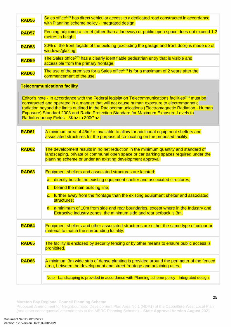
RAD56 PO63
RAD57 PO63
RAD58 PO63
RAD59 PO63
RAD60 PO63
RAD61 PO65
RAD62 PO66
RAD63 PO67
RAD64 PO67
Version: 12, Version Date: 09/08/2021Document Set ID: 62535721

14 Moreton Bay Regional Council Planning Scheme Proposed Amendment for Neighbourhood Development Plan Area No.1 (NDP1) of the Caboolture West Local Plan (and other consequential amendments to the MBRC Planning Scheme) – State Approval Version August 2021
RAD65 PO67
RAD66 PO67
RAD67 PO68
RAD68 PO77
RAD69 PO81
RAD70 PO81
RAD71 PO83
RAD72 PO84
RAD73 PO86
RAD74 PO87
RAD75 PO77
RAD76 PO88
RAD77 PO89
RAD78 PO89
RAD79 PO89
RAD80 PO89
RAD81 PO89
RAD82 PO93
RAD83 PO93
RAD84 PO93
RAD85 PO92
Version: 12, Version Date: 09/08/2021Document Set ID: 62535721

15 Moreton Bay Regional Council Planning Scheme Proposed Amendment for Neighbourhood Development Plan Area No.1 (NDP1) of the Caboolture West Local Plan (and other consequential amendments to the MBRC Planning Scheme) – State Approval Version August 2021
RAD86 PO92
RAD87 PO95
RAD88 PO94-PO96, PO97-PO100
RAD89 PO94-PO96
RAD90 PO97
RAD91 PO101
Part A — Requirements for accepted development - Next generation sub-precinct
Table 7.2.3.1.1.1 Requirements for accepted development - Next generation sub-precinct
Requirements for accepted development
General requirements
Building height (Residential uses)
RAD1 Building height does not exceed: a. that mapped on Overlay map – Building heights; or
b. for domestic outbuildings, including free standing carports and garages, 4m and a
mean height not exceeding 3.5m.
Building height (Non-residential uses)
RAD2 Building height does not exceed the maximum height identified on Overlay map - Building heights.
Setbacks (Residential uses)
RAD3 Setbacks (excluding built to boundary walls) comply with Table 6.2.6.3.3 'Setbacks' - Setback (Residential uses).
Note - Greater setbacks may be required if the lot adjoins an environmental corridor or area (Refer to values and constraints for details).
RAD4 Buildings (excluding class 10 buildings and structures) ensure that built to boundary walls are:
Version: 12, Version Date: 09/08/2021Document Set ID: 62535721

16 Moreton Bay Regional Council Planning Scheme Proposed Amendment for Neighbourhood Development Plan Area No.1 (NDP1) of the Caboolture West Local Plan (and other consequential amendments to the MBRC Planning Scheme) – State Approval Version August 2021
a. only established on lots having a primary frontage of 18m or less and where permitted in Table 6.2.6.3.4;
b. of a length and height not exceeding that specified in Table 6.2.6.3.4 'Built to boundary walls (Residential uses)';
c. setback from the side boundary:
i. if a plan of development provides for only one built to boundary wall on the one boundary, not more than 200mm; or
ii. if a built to boundary wall may be built on each side of the same boundary, not more than 20mm;
d. on the low side of a sloping lot.
Editor's note - Lots containing built to boundary walls should also include an appropriate easement to facilitate the maintenance of any wall within 600mm of a boundary. For boundaries with built to boundary walls on adjacent lots a 'High Density Development Easement' is recommended; or for all other built to boundary walls a 'easement for maintenance purposes' is recommended.
Site cover (Residential uses - where not a Dwelling House22)
RAD5 Site cover (excluding eaves, sun shading devices, patios, balconies and other unenclosed
structures) does not exceed the specified percentages in the table below.
Building
height
Lot Size
300m2 or
less
301-
400m2
401-
500m2
501-
1,000m2
1,001 -
2,500m2
Greater
than2,501
m2
8.5m or
less
75% 70% 60% 60% 60% 60%
>8.5m -
12.0m
50% 50% 80% 50% 50% 50%
Greater
than
12.0m
N/A N/A N/A 50% 40% 40%
Lighting
RAD6 Artificial lighting on-site is directed and shielded in such a manner as not to exceed the recommended maximum values of light technical parameters for the control of obtrusive light given in Table 2.1 of Australian Standard AS 4282 (1997) Control of Obtrusive Effects of Outdoor Lighting.
Note - “Curfewed hours” are taken to be those hours between 10pm and 7am on the following day.
Clearing of habitat trees
RAD7 Development does not result in the damaging, destruction or clearing of habitat tree. This does not apply to:
a. Clearing of habitat tree located within an approved development footprint;
Version: 12, Version Date: 09/08/2021Document Set ID: 62535721

17 Moreton Bay Regional Council Planning Scheme Proposed Amendment for Neighbourhood Development Plan Area No.1 (NDP1) of the Caboolture West Local Plan (and other consequential amendments to the MBRC Planning Scheme) – State Approval Version August 2021
b. Clearing of habitat tree within 10m from a lawfully established building reasonably necessary for emergency access or immediately required in response to an accident or emergency;
c. Clearing of habitat tree reasonably necessary to remove or reduce the risk vegetation poses to serious personal injury or damage to infrastructure;
d. Clearing of habitat tree reasonably necessary to construct and maintain a property boundary fence and not exceed 4m in width either side of the fence;
e. Clearing of habitat tree reasonably necessary for the purpose of maintenance or works within a registered easement for public infrastructure or drainage purposes;
f. Clearing of habitat tree in accordance with an existing bushfire management plan previously accepted by Council;
g. Clearing of habitat tree associated with maintaining existing open pastures, windbreaks, lawns or created gardens;
h. Grazing of native pasture by stock.
Editor's note - A native tree measuring greater than 80cm in diameter when measured at 1.3m from the ground is recognised as a ‘habitat tree’. For further information on habitat trees, refer to Planning scheme policy – Environmental areas and corridors. Information detailing how this measurement is undertaken is provided in Australian Standard AS 4970 2009 Protection of Trees on Development Sites - Appendix A.
Work requirements
Utilities
RAD8 Development is provided with an appropriate level of service and infrastructure in accordance with Planning scheme policy - Integrated design (Appendix A).
Access
RAD9 The frontage road is fully constructed to Council’s standards.
Note - Roads are considered to be constructed in accordance with Council standards when there is
sufficient pavement width, geometry and depth to comply with the requirements of Planning scheme
policy - Integrated design and Planning scheme policy - Operational works inspection, maintenance and
bonding procedures. Testing of the existing pavement may be required to confirm whether the existing
works meet the standards in Planning scheme policy - Integrated design and Planning scheme policy -
Operational works inspection, maintenance and bonding procedures.
Note - Frontage roads include streets where no direct lot access is provided.
RAD10 Any new or changes to existing direct vehicle access for residential development does not occur from arterial or sub-arterial roads.
RAD11 Any new or changes to existing crossovers and driveways are designed, located and constructed in accordance with:
a. where for a Council-controlled road and associated with a Dwelling house: i. Planning scheme policy - Integrated design;
Version: 12, Version Date: 09/08/2021Document Set ID: 62535721

18 Moreton Bay Regional Council Planning Scheme Proposed Amendment for Neighbourhood Development Plan Area No.1 (NDP1) of the Caboolture West Local Plan (and other consequential amendments to the MBRC Planning Scheme) – State Approval Version August 2021
b. where for a Council-controlled road and not associated with a Dwelling house:
i. AS/NZS2890.1 Parking facilities Part 1: Off street car parking; ii. AS/NZS 2890.2 - Parking facilities Part 2: Off-street commercial vehicle
facilities; iii. Planning scheme policy - Integrated design; iv. Schedule 8 - Service vehicle requirements;
c. where for a State-Controlled road, the Safe Intersection Sight Distance requirements
in Austroads and the appropriate IPWEAQ standard drawings, or a copy of a Transport Infrastructure Act 1994, section 62 approval.
RAD12 Any new or changes to existing internal driveways and access ways are designed and constructed in accordance with AS/NZS 2890.1 Parking Facilities Part 1: Off street car parking and the relevant standards in Planning scheme policy - Integrated design.
RAD13 Access driveways, manoeuvring areas and loading facilities are sealed and provide for service vehicles listed in Schedule 8 - Service vehicle requirements for the relevant use. The on-site manoeuvring is to be in accordance with Schedule 8 - Service vehicle requirements.
Stormwater
RAD14 Any new or changes to existing stormwater run-off from the site is conveyed to a point of lawful discharge without causing actionable nuisance to any person, property or premises in accordance with Planning scheme policy – Integrated design.
Note - A watercourse as defined in the Water Act may be accepted as a lawful point of discharge providing the drainage discharge from the site does not increase the downstream flood levels during events up to and including the 1% AEP storm. An afflux of +20mm may be accepted on Council controlled land and road infrastructure. No worsening is ensured when stormwater is discharged into a catchment that includes State Transport Infrastructure.
RAD15 Development incorporates a ‘deemed to comply solution’ to manage stormwater quality where the development:
a. is for an urban purpose that involves a land area of 2500m2 or greater; and b. will result in:
i. 6 or more dwellings; or ii. an impervious area greater than 25% of the net developable area.
Note - The deemed to comply solution is to be designed, constructed, established and maintained in accordance with the requirements of Water by Design ‘Deemed to Comply Solutions - Stormwater Quality Management for South East Queensland’ and Planning scheme policy - Integrated design.
RAD16 Development ensures that surface flows entering the premises from adjacent properties are not blocked, diverted or concentrated.
Version: 12, Version Date: 09/08/2021Document Set ID: 62535721

19 Moreton Bay Regional Council Planning Scheme Proposed Amendment for Neighbourhood Development Plan Area No.1 (NDP1) of the Caboolture West Local Plan (and other consequential amendments to the MBRC Planning Scheme) – State Approval Version August 2021
Note - A report from a suitably qualified Registered Professional Engineer Queensland may be required certifying that the development does not increase the potential for significant adverse impacts on an upstream, downstream or surrounding premises.
RAD17 Development ensures that works (e.g. fences and walls) do not block, divert or concentrate the flow of stormwater to adjoining properties.
Note - A report from a suitably qualified Registered Professional Engineer Queensland may be required certifying that the development does not increase the potential for significant adverse impacts on an upstream, downstream or surrounding premises.
RAD18 Stormwater drainage infrastructure (excluding detention and bio-retention systems) through or within private land is protected by easements in favour of Council (at no cost to Council). Minimum easement widths are as follows:
Pipe Diameter Minimum Easement Width (excluding access requirements)
Stormwater Pipe up to 825mm diameter 3.0m
Stormwater Pipe up to 825mm diameter with Sewer pipe up to 225m diameter
4.0m
Stormwater pipe greater than 825mm diameter
Easement boundary to be 1m clear of the outside wall of the pipe and clear of all pits
Note - Additional easement width may be required in certain circumstances in order to facilitate maintenance access to the stormwater system.
Note - Refer to Planning scheme policy - Integrated design (Appendix C) for easement requirements over open channels.
Site works and construction management
RAD19 The site and any existing structures are to be maintained in a tidy and safe condition.
RAD20 Development does not cause erosion or allow sediment to leave the site.
Note - The International Erosion Control Association (Australasia) Best Practice Erosion and Sediment Control provides guidance on strategies and techniques for managing erosion and sedimentation.
RAD21 No dust emissions extend beyond the boundaries of the site during soil disturbances and construction works.
Version: 12, Version Date: 09/08/2021Document Set ID: 62535721

20 Moreton Bay Regional Council Planning Scheme Proposed Amendment for Neighbourhood Development Plan Area No.1 (NDP1) of the Caboolture West Local Plan (and other consequential amendments to the MBRC Planning Scheme) – State Approval Version August 2021
RAD22 Existing street trees are protected and not damaged during works.
Note - Where development occurs in the tree protection zone, measures and techniques as detailed in Australian Standard AS 4970 Protection of trees on developments sites are adopted and implemented.
RAD23 Any damage to council land or infrastructure is to be repaired or replaced, with the same materials prior to plan sealing or final building classification.
RAD24 Construction traffic, including contractor car parking, is controlled in accordance with a traffic management plan prepared in accordance with the Manual of Uniform Traffic Control Devices (MUTCD).
RAD25 Any material dropped, deposited or spilled on the road(s) as a result of construction processes associated with the site are to be cleaned at all times.
RAD26 All native vegetation to be retained on-site is temporarily fenced or protected prior to and during development works.
Note - No parking of vehicles or storage of machinery or goods is to occur in these areas during development works.
RAD27 Disposal of materials is managed in one or more of the following ways:
a. all cleared vegetation, declared weeds, stumps, rubbish, car bodies, scrap metal and the like are removed and disposed of in a Council land fill facility; or
b. all native vegetation with a diameter below 400mm is to be chipped and stored on-site.
Note - No burning of cleared vegetation is permitted.
Note - the chipped vegetation must be stored in an approved location.
RAD28 All development works are carried out within the following times:
a. Monday to Saturday (other than public holidays) between 6:30am and 6:30pm on the same day;
b. no work is to be carried out on Sundays or public holidays.
Earthworks
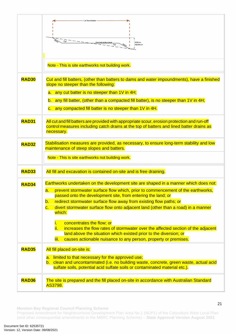
RAD29 The total of all cut and fill on-site does not exceed 900mm in height.
Figure - Cut and Fill
Version: 12, Version Date: 09/08/2021Document Set ID: 62535721
21 Moreton Bay Regional Council Planning Scheme Proposed Amendment for Neighbourhood Development Plan Area No.1 (NDP1) of the Caboolture West Local Plan (and other consequential amendments to the MBRC Planning Scheme) – State Approval Version August 2021
Note - This is site earthworks not building work.
RAD30 Cut and fill batters, (other than batters to dams and water impoundments), have a finished slope no steeper than the following:
a. any cut batter is no steeper than 1V in 4H;
b. any fill batter, (other than a compacted fill batter), is no steeper than 1V in 4H;
c. any compacted fill batter is no steeper than 1V in 4H.
RAD31 All cut and fill batters are provided with appropriate scour, erosion protection and run-off control measures including catch drains at the top of batters and lined batter drains as necessary.
RAD32 Stabilisation measures are provided, as necessary, to ensure long-term stability and low
maintenance of steep slopes and batters.
Note - This is site earthworks not building work.
RAD33 All fill and excavation is contained on-site and is free draining.
RAD34 Earthworks undertaken on the development site are shaped in a manner which does not:
a. prevent stormwater surface flow which, prior to commencement of the earthworks,
passed onto the development site, from entering the land; or
b. redirect stormwater surface flow away from existing flow paths; or
c. divert stormwater surface flow onto adjacent land (other than a road) in a manner which:
i. concentrates the flow; or
ii. increases the flow rates of stormwater over the affected section of the adjacent
land above the situation which existed prior to the diversion; or
iii. causes actionable nuisance to any person, property or premises.
RAD35 All fill placed on-site is:
a. limited to that necessary for the approved use; b. clean and uncontaminated (i.e. no building waste, concrete, green waste, actual acid
sulfate soils, potential acid sulfate soils or contaminated material etc.).
RAD36 The site is prepared and the fill placed on-site in accordance with Australian Standard AS3798.
Version: 12, Version Date: 09/08/2021Document Set ID: 62535721

22 Moreton Bay Regional Council Planning Scheme Proposed Amendment for Neighbourhood Development Plan Area No.1 (NDP1) of the Caboolture West Local Plan (and other consequential amendments to the MBRC Planning Scheme) – State Approval Version August 2021
Note - The fill is to be inspected and tested in accordance with Planning scheme policy - Operational works inspection, maintenance and bonding procedures
RAD37 No filling or excavation is undertaken in an easement issued in favour of Council or a public
sector entity.
Note - Public sector entity is defined in Schedule 2 of the Act.
RAD38 Filling or excavation that would result in any of the following is not carried out on site:
a. a reduction in cover over any Council or public sector entity infrastructure to less than 600mm;
b. an increase in finished surface grade over, or within 1.5m on each side of, the Council or public sector entity infrastructure above that which existed prior to the filling or excavation works being undertaken;
c. prevent reasonable access to Council or public sector entity maintained infrastructure or any drainage feature on, or adjacent to the site for monitoring, maintenance or replacement purposes.
Note - Public sector entity is defined in Schedule 2 of the Act.
Note - All building work covered by QDC MP1.4 is excluded from this provision.
Fire services
RAD39 External fire hydrant facilities are provided on site to the standard prescribed under the relevant parts of Australian Standard AS 2419.1 (2005) – Fire Hydrant Installations.
Note - For this requirement for accepted development, the following are the relevant parts of AS 2419.1 (2005):
a. in regard to the form of any fire hydrant - Part 8.5 and Part 3.2.2.1, with the exception that for Tourist parks(84) or development comprised solely of dwellings and their associated outbuildings, single outlet above-ground hydrants or suitably signposted in-ground hydrants would be an acceptable alternative;
b. in regard to the general locational requirements for fire hydrants - Part 3.2.2.2 (a), (e), (f), (g) and (h) as well as Appendix B of AS 2419.1 (2005);
c. in regard to the proximity of hydrants to buildings and other facilities - Part 3.2.2.2 (b), (c) and (d), with the exception that:
i. - for dwellings and their associated outbuildings, hydrant coverage need only extend to the roof and external walls of those buildings;
ii. - for caravans and tents, hydrant coverage need only extend to the roof of those tents and caravans;
iii. - for outdoor sales(54), processing or storage facilities, hydrant coverage is required across the entire area of the outdoor sales(54), outdoor processing and outdoor storage facilities; and
d. in regard to fire hydrant accessibility and clearance requirements - Part 3.5 and where applicable, Part 3.6.
Version: 12, Version Date: 09/08/2021Document Set ID: 62535721

23 Moreton Bay Regional Council Planning Scheme Proposed Amendment for Neighbourhood Development Plan Area No.1 (NDP1) of the Caboolture West Local Plan (and other consequential amendments to the MBRC Planning Scheme) – State Approval Version August 2021
RAD40 A continuous path of travel having the following characteristics is provided between the vehicle access point to the site and each external fire hydrant and hydrant booster point on the land:
a. an unobstructed width of no less than 3.5m;
b. an unobstructed height of no less than 4.8m;
c. constructed to be readily traversed by a 17 tonne HRV fire brigade pumping appliance;
d. an area for a fire brigade pumping appliance to stand within 20m of each fire hydrant and 8m of each hydrant booster point.
RAD41 On-site fire hydrant facilities are maintained in effective operating order in a manner prescribed in Australian Standard AS1851 (2012) – Routine service of fire protection systems and equipment.
RAD42 For development that contains on-site fire hydrants external to buildings:
a. those external hydrants can be seen from the vehicular entry point to the site; or b. a sign identifying the following is provided at the vehicular entry point to the site:
i. the overall layout of the development (to scale); ii. internal road names (where used); iii. all communal facilities (where provided); iv. the reception area and on-site manager’s office (where provided); v. external hydrants and hydrant booster points; vi. physical constraints within the internal roadway system which would restrict access
by fire fighting appliances to external hydrants and hydrant booster points.
Note - The sign prescribed above, and the graphics used are to be:
a. in a form;
b. of a size;
c. illuminated to a level;
which allows the information on the sign to be readily understood, at all times, by a person in a fire fighting appliance up to 4.5m from the sign.
RAD43 For development that contains on-site fire hydrants external to buildings, those hydrants are identified by way of marker posts and raised reflective pavements markers in the manner prescribed in the technical note Fire hydrant indication system produced by the Queensland Department of Transport and Main Roads.
Note - Technical note Fire hydrant indication system is available on the website of the Queensland Department of Transport and Main Roads.
Use specific requirements
Dual occupancies
Version: 12, Version Date: 09/08/2021Document Set ID: 62535721
24 Moreton Bay Regional Council Planning Scheme Proposed Amendment for Neighbourhood Development Plan Area No.1 (NDP1) of the Caboolture West Local Plan (and other consequential amendments to the MBRC Planning Scheme) – State Approval Version August 2021
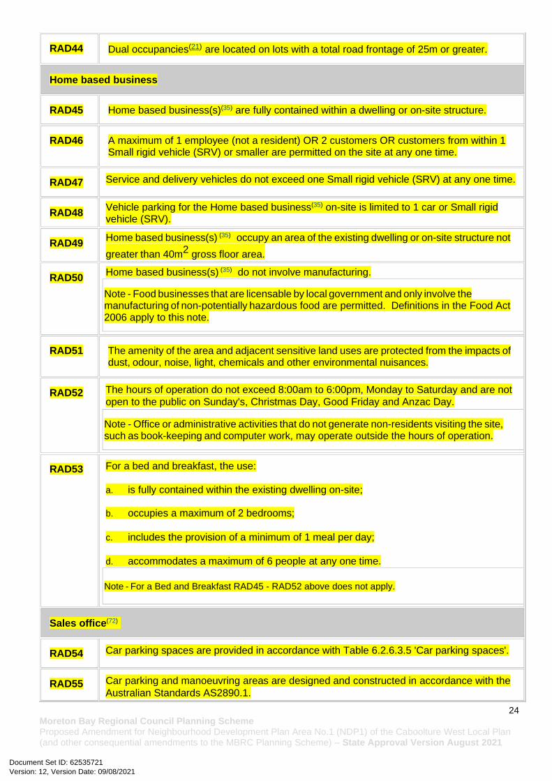
RAD44 Dual occupancies(21) are located on lots with a total road frontage of 25m or greater.
Home based business
RAD45 Home based business(s)(35) are fully contained within a dwelling or on-site structure.
RAD46 A maximum of 1 employee (not a resident) OR 2 customers OR customers from within 1 Small rigid vehicle (SRV) or smaller are permitted on the site at any one time.
RAD47 Service and delivery vehicles do not exceed one Small rigid vehicle (SRV) at any one time.
RAD48 Vehicle parking for the Home based business(35) on-site is limited to 1 car or Small rigid vehicle (SRV).
RAD49 Home based business(s) (35) occupy an area of the existing dwelling or on-site structure not
greater than 40m2 gross floor area.
RAD50 Home based business(s) (35) do not involve manufacturing.
Note - Food businesses that are licensable by local government and only involve the manufacturing of non-potentially hazardous food are permitted. Definitions in the Food Act 2006 apply to this note.
RAD51 The amenity of the area and adjacent sensitive land uses are protected from the impacts of dust, odour, noise, light, chemicals and other environmental nuisances.
RAD52 The hours of operation do not exceed 8:00am to 6:00pm, Monday to Saturday and are not
open to the public on Sunday's, Christmas Day, Good Friday and Anzac Day.
Note - Office or administrative activities that do not generate non-residents visiting the site, such as book-keeping and computer work, may operate outside the hours of operation.
RAD53 For a bed and breakfast, the use: a. is fully contained within the existing dwelling on-site;
b. occupies a maximum of 2 bedrooms;
c. includes the provision of a minimum of 1 meal per day;
d. accommodates a maximum of 6 people at any one time.
Note - For a Bed and Breakfast RAD45 - RAD52 above does not apply.
Sales office(72)
RAD54 Car parking spaces are provided in accordance with Table 6.2.6.3.5 'Car parking spaces'.
RAD55 Car parking and manoeuvring areas are designed and constructed in accordance with the
Australian Standards AS2890.1.
Version: 12, Version Date: 09/08/2021Document Set ID: 62535721
25 Moreton Bay Regional Council Planning Scheme Proposed Amendment for Neighbourhood Development Plan Area No.1 (NDP1) of the Caboolture West Local Plan (and other consequential amendments to the MBRC Planning Scheme) – State Approval Version August 2021
RAD56 Sales office(72) has direct vehicular access to a dedicated road constructed in accordance
with Planning scheme policy - Integrated design.
RAD57 Fencing adjoining a street (other than a laneway) or public open space does not exceed 1.2
metres in height.
RAD58 30% of the front façade of the building (excluding the garage and front door) is made up of
windows/glazing.
RAD59 The Sales office(72) has a clearly identifiable pedestrian entry that is visible and
accessible from the primary frontage.
RAD60 The use of the premises for a Sales office(72) is for a maximum of 2 years after the
commencement of the use.
Telecommunications facility
Editor's note - In accordance with the Federal legislation Telecommunications facilities(81) must be constructed and operated in a manner that will not cause human exposure to electromagnetic radiation beyond the limits outlined in the Radiocommunications (Electromagnetic Radiation - Human Exposure) Standard 2003 and Radio Protection Standard for Maximum Exposure Levels to Radiofrequency Fields - 3Khz to 300Ghz.
RAD61 A minimum area of 45m2 is available to allow for additional equipment shelters and associated structures for the purpose of co-locating on the proposed facility.
RAD62 The development results in no net reduction in the minimum quantity and standard of landscaping, private or communal open space or car parking spaces required under the planning scheme or under an existing development approval.
RAD63 Equipment shelters and associated structures are located:
a. directly beside the existing equipment shelter and associated structures;
b. behind the main building line;
c. further away from the frontage than the existing equipment shelter and associated structures;
d. a minimum of 10m from side and rear boundaries, except where in the Industry and Extractive industry zones, the minimum side and rear setback is 3m.
RAD64 Equipment shelters and other associated structures are either the same type of colour or material to match the surrounding locality.
RAD65 The facility is enclosed by security fencing or by other means to ensure public access is prohibited.
RAD66 A minimum 3m wide strip of dense planting is provided around the perimeter of the fenced area, between the development and street frontage and adjoining uses.
Note - Landscaping is provided in accordance with Planning scheme policy - Integrated design.
Version: 12, Version Date: 09/08/2021Document Set ID: 62535721

26 Moreton Bay Regional Council Planning Scheme Proposed Amendment for Neighbourhood Development Plan Area No.1 (NDP1) of the Caboolture West Local Plan (and other consequential amendments to the MBRC Planning Scheme) – State Approval Version August 2021
Note - Council may require a detailed landscaping plan, prepared by a suitably qualified person to ensure compliance with Planning scheme policy - Integrated design.
RAD67 All equipment comprising the telecommunications facility(81) which produces audible or non-audible sound is housed within a fully enclosed building incorporating sound control measures sufficient to ensure no noise from this equipment can be heard, or felt at the site boundary.
Retail, commercial and community uses
RAD68 Where involving an extension (building work) in the front setback a minimum of 50% of the front facade of the building is made up of windows or glazing between a height of 1m and 2m. The minimum window/glazing is to remain uncovered and free of signage. Any tinting, signage or vinyl wrap applied to a glazed facade located at ground floor is to maintain visibility of the internal activity from the street and not obscure surveillance of the street.
RAD69 Development does not result in a reduction in the number or standard of car parking spaces
provided on the site except where a reduction is required for the provision of cycle parking.
RAD70 Where additional car parking spaces are provided they are not located between the frontage
and the main building line.
RAD71 Where involving an extension (building work), bins and bin storage areas are provided,
designed and managed in accordance with Planning scheme policy – Waste.
RAD72 Where involving an extension (building work) it does not result in a reduction in the amount
or standard of established landscaping on-site.
RAD73 Artificial lighting on-site is directed and shielded in such a manner as not to exceed the
recommended maximum values of light technical parameters for the control of obtrusive
light given in Table 2.1 of Australian Standard AS 4282 (1997) Control of Obtrusive Effects
of Outdoor Lighting.
Note - “Curfewed hours” are taken to be those hours between 10pm and 7am on the following day.
RAD74 Hours of operation do not exceed 6:00am to 9:00pm Monday to Sunday.
RAD75 Development does not involve a drive-through facility.
Values and constraints requirements
Note - The relevant values and constraints requirements do not apply where the development is consistent with a current Development permit for Reconfiguring a lot or Material change of use or Operational work, where that approval has considered and addressed (e.g. through a development footprint plan or conditions of approval) the identified value or constraint under this planning scheme.
Version: 12, Version Date: 09/08/2021Document Set ID: 62535721

27 Moreton Bay Regional Council Planning Scheme Proposed Amendment for Neighbourhood Development Plan Area No.1 (NDP1) of the Caboolture West Local Plan (and other consequential amendments to the MBRC Planning Scheme) – State Approval Version August 2021
Acid sulfate soils - (refer Overlay map - Acid sulfate soils to determine if the following requirements apply)
Note - Planning scheme policy - Acid sulfate soils provides guidance for requirements for accepted development that has the potential to disturb acid sulfate soils i.e. development involving filling or excavation works below the thresholds of 100m3 and 500m3 respectively.
RAD76 Development does not involve:
a. excavation or otherwise removing of more than 100m3 of soil or sediment where below 5m Australian Height Datum AHD, or
b. filling of land of more than 500m3 of material with an average depth of 0.5m or greater where below the 5m AHD.
Heritage and landscape character (refer Overlay map - Heritage and landscape character to determine if the following requirements apply)
Note - Places, including sites, objects and buildings having local cultural heritage significance, are identified on Overlay map - Heritage and landscape character and listed in Schedule 1 of Planning scheme policy - Heritage and landscape character. Places also having cultural heritage significance at a State level and being entered in the Queensland Heritage Register, are also identified in Schedule 1 of Planning scheme policy - Heritage and landscape character.
RAD77 Development is for the preservation, maintenance, repair and restoration of the site, object or building.
This does not apply to Listed item 99, in Schedule 1 - List of sites, objects and buildings of significant historical and cultural value of Planning scheme policy - Heritage and landscape character.
Note - Preservation, maintenance, repair and restoration are defined in Schedule 1 - Definitions
RAD78 A cultural heritage conservation management plan is prepared in accordance with Planning scheme policy – Heritage and landscape character and submitted to Council prior to the commencement of any preservation, maintenance, repair and restoration works. Any preservation, maintenance, repair and restoration works are in accordance with the Council approved cultural heritage conservation management plan.
Version: 12, Version Date: 09/08/2021Document Set ID: 62535721
28 Moreton Bay Regional Council Planning Scheme Proposed Amendment for Neighbourhood Development Plan Area No.1 (NDP1) of the Caboolture West Local Plan (and other consequential amendments to the MBRC Planning Scheme) – State Approval Version August 2021
This does not apply to Listed item 99 in Schedule 1 - List of sites, objects and buildings of significant historical and cultural value of Planning scheme policy - Heritage and landscape character.
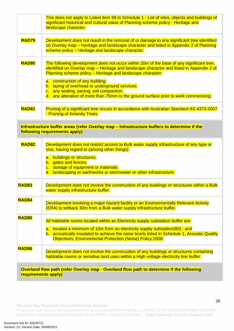
RAD79 Development does not result in the removal of or damage to any significant tree identified on Overlay map – Heritage and landscape character and listed in Appendix 2 of Planning scheme policy – Heritage and landscape character.
RAD80 The following development does not occur within 20m of the base of any significant tree, identified on Overlay map – Heritage and landscape character and listed in Appendix 2 of Planning scheme policy – Heritage and landscape character:
a. construction of any building; b. laying of overhead or underground services; c. any sealing, paving, soil compaction; d. any alteration of more than 75mm to the ground surface prior to work commencing.
RAD81 Pruning of a significant tree occurs in accordance with Australian Standard AS 4373-2007 - Pruning of Amenity Trees.
Infrastructure buffer areas (refer Overlay map – Infrastructure buffers to determine if the following requirements apply)
RAD82 Development does not restrict access to Bulk water supply infrastructure of any type or size, having regard to (among other things):
a. buildings or structures; b. gates and fences; c. storage of equipment or materials; d. landscaping or earthworks or stormwater or other infrastructure.
RAD83 Development does not involve the construction of any buildings or structures within a Bulk water supply infrastructure buffer.
RAD84 Development involving a major hazard facility or an Environmentally Relevant Activity (ERA) is setback 30m from a Bulk water supply infrastructure buffer.
RAD85 All habitable rooms located within an Electricity supply substation buffer are:
a. located a minimum of 10m from an electricity supply substation(80) ; and b. acoustically insulated to achieve the noise levels listed in Schedule 1, Acoustic Quality
Objectives, Environmental Protection (Noise) Policy 2008.
RAD86 Development does not involve the construction of any buildings or structures containing habitable rooms or sensitive land uses within a High voltage electricity line buffer.
Overland flow path (refer Overlay map - Overland flow path to determine if the following requirements apply)
Version: 12, Version Date: 09/08/2021Document Set ID: 62535721

29 Moreton Bay Regional Council Planning Scheme Proposed Amendment for Neighbourhood Development Plan Area No.1 (NDP1) of the Caboolture West Local Plan (and other consequential amendments to the MBRC Planning Scheme) – State Approval Version August 2021
RAD87 Development for a material change of use or building work does not involve the construction of a building or structure in an Overland flow path area.
RAD88 Development for a material change of use or operational work does not impede the flow of flood waters through the premises or worsen flood flows to other premises.
Note - A report from a suitably qualified Registered Professional Engineer Queensland is required certifying that the development does not increase the potential for significant adverse impacts on an upstream, downstream or surrounding premises.
Note - Reporting to be prepared in accordance with Planning scheme policy – Flood hazard, Coastal hazard and Overland flow
RAD89 Development for a material change of use or building work ensures that fencing in an overland flow path area is at least 50% permeable.
RAD90 Development for a material change of use or building work that involves a hazardous chemical ensures the hazardous chemicals is not located within an overland flow path area.
RAD91 Development for a material change of use or building work for a Park(57) ensures that work is provided in accordance with the requirements set out in Appendix B of the Planning scheme policy - Integrated design.
7.2.3.1.1.3 Requirements for assessment - Next generation sub-precinct
Part A B - Criteria for assessable development - Next generation sub-precinct
Where development is categorised as assessable development - code assessment in the Table of Assessment, and located in a precinct, the assessment benchmarks are the criteria set out in Part A B, Table 7.2.3.1.1.12, as well as the purpose statement and overall outcomes.
Where development is assessable development - impact assessment, the assessment benchmarks becomes the whole of the planning scheme.
Table 7.2.3.1.1.2 Assessable development - Next generation sub-precinct
Performance outcomes Examples that achieve aspects of the Performance Outcomes
General criteria
Neighbourhood structure
PO1 No example provided.
Version: 12, Version Date: 09/08/2021Document Set ID: 62535721

30 Moreton Bay Regional Council Planning Scheme Proposed Amendment for Neighbourhood Development Plan Area No.1 (NDP1) of the Caboolture West Local Plan (and other consequential amendments to the MBRC Planning Scheme) – State Approval Version August 2021
Development within the Next generation sub-precinct is in accordance with an approved Neighbourhood development plan that reflects the urban structure concept shown indicatively on Figure 7.2.3.1 - Caboolture West structure plan, and includes:
a. a series of compact and walkable neighbourhoods that have a mix of residential uses, tenure and densities on a variety of lot sizes;
b. medium density neighbourhoods located within 400m walking distance of local centres;
c. neighbourhoods that are well connected to centres, Community uses(17) and social infrastructure;
d. appropriately located non-residential uses that contribute to the creation and ongoing function of a sustainable urban community;
e. where possible and practicable, koala bushland and habitat trees to be retained and incorporated into the design of a neighbourhood development plan as, but not limited to, park and open space areas, street trees and urban landscaping.
Density
PO2
Development in the Next generation sub-precinct has a low to medium residential density in accordance with the minimum indicated on a Neighbourhood development plan.
Development in the Next generation sub-precinct has a low to medium residential density of between 15 and 75 dwellings per ha (site density).
Note - Refer to Planning scheme policy - Neighbourhood design for density calculation.
No example provided.
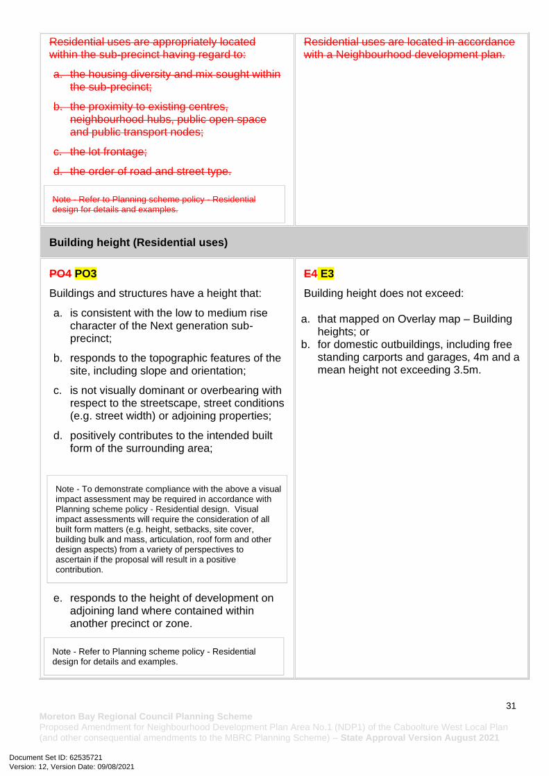
Residential uses
PO3 E3
Version: 12, Version Date: 09/08/2021Document Set ID: 62535721
31 Moreton Bay Regional Council Planning Scheme Proposed Amendment for Neighbourhood Development Plan Area No.1 (NDP1) of the Caboolture West Local Plan (and other consequential amendments to the MBRC Planning Scheme) – State Approval Version August 2021
Residential uses are appropriately located within the sub-precinct having regard to:
a. the housing diversity and mix sought within the sub-precinct;
b. the proximity to existing centres, neighbourhood hubs, public open space and public transport nodes;
c. the lot frontage;
d. the order of road and street type.
Note - Refer to Planning scheme policy - Residential design for details and examples.
Residential uses are located in accordance with a Neighbourhood development plan.
Building height (Residential uses)
PO4 PO3
Buildings and structures have a height that:
a. is consistent with the low to medium rise character of the Next generation sub-precinct;
b. responds to the topographic features of the site, including slope and orientation;
c. is not visually dominant or overbearing with respect to the streetscape, street conditions (e.g. street width) or adjoining properties;
d. positively contributes to the intended built form of the surrounding area;
Note - To demonstrate compliance with the above a visual impact assessment may be required in accordance with Planning scheme policy - Residential design. Visual impact assessments will require the consideration of all built form matters (e.g. height, setbacks, site cover, building bulk and mass, articulation, roof form and other design aspects) from a variety of perspectives to ascertain if the proposal will result in a positive contribution.
e. responds to the height of development on adjoining land where contained within another precinct or zone.
Note - Refer to Planning scheme policy - Residential design for details and examples.
E4 E3
Building height does not exceed:
a. that mapped on Overlay map – Building heights; or
b. for domestic outbuildings, including free standing carports and garages, 4m and a mean height not exceeding 3.5m.
Version: 12, Version Date: 09/08/2021Document Set ID: 62535721

32 Moreton Bay Regional Council Planning Scheme Proposed Amendment for Neighbourhood Development Plan Area No.1 (NDP1) of the Caboolture West Local Plan (and other consequential amendments to the MBRC Planning Scheme) – State Approval Version August 2021
Building height (Non-residential uses)
PO5 PO4
The height of non-residential buildings does not adversely affect amenity of the area or of adjoining properties. and positively contributes to the intended built form of the surrounding area.
Note - To demonstrate compliance with the above a visual impact assessment may be required in accordance with Planning scheme policy - Residential design. Visual impact assessments will require the consideration of all built form matters (e.g. height, setbacks, site cover, building bulk and mass, articulation, roof form and other design aspects) from a variety of perspectives to ascertain if the proposal will result in a positive contribution.
E5 E4
Building heights does not exceed the maximum height identified on Overlay map - Building heights except for architectural features associated with religious expression on Place of worship and Educational establishment buildings that mapped on a Neighbourhood development plan.
Setbacks (Residential uses)
PO6 PO5
Residential buildings and structures are setback to:
a. be consistent with the low to medium character intended for the area, where buildings are positioned closer to the footpath to create more active frontages and maximise private open space at the rear;
b. result in development not being visually dominant or overbearing with respect to the streetscape and the adjoining sites;
c. maintain private open space areas that are of a size and dimension to be usable and functional;
d. maintain the privacy of adjoining properties;
e. ensure parked vehicles do not restrict pedestrian and traffic movement and safety;
f. limit the length, height and openings of boundary walls to maximise privacy and amenity on adjoining properties;
g. provide adequate separation to particular infrastructure and waterbodies to minimise
E6.1 E5.1
Setbacks (excluding built to boundary walls) comply with Table 7.2.3.1.1.2 - Setback (Residential uses).
E6.2 E5.2
Buildings (excluding class 10 buildings and structures) ensure that built to boundary walls are:
a. only established on lots having a primary frontage of 18m or less and where permitted in Table 7.2.3.1.1.3;
b. of a length and height not exceeding that specified in Table 7.2.3.1.1.3;
c. setback from the side boundary:
i. if a plan of development provides for only one built to boundary wall on the one boundary, not more than 200mm; or
ii. if a built to boundary wall may be built on each side of the same boundary, not more than 20mm;
d. on the low side of a sloping lot.
Version: 12, Version Date: 09/08/2021Document Set ID: 62535721

33 Moreton Bay Regional Council Planning Scheme Proposed Amendment for Neighbourhood Development Plan Area No.1 (NDP1) of the Caboolture West Local Plan (and other consequential amendments to the MBRC Planning Scheme) – State Approval Version August 2021
adverse impacts on people, property, water quality and infrastructure;
h. ensure built to boundary walls do not create unusable or inaccessible spaces and do not negatively impact the streetscape character, amenity or functionality of adjoining properties.
Note - Refer to Planning scheme policy - Residential design for details and examples.
Editor's note - Lots containing built to boundary walls should also include an appropriate easement to facilitate the maintenance of any wall within 600mm of a boundary. For boundaries with built to boundary walls on adjacent lots a 'High Density Development Easement' is recommended; or for all other built to boundary walls and 'easement for maintenance purposes' is recommended.
Setbacks (Non-residential uses)
PO7 PO6
Front setbacks ensure non-residential buildings address and actively interface with streets and public spaces.
E7.1 E6.1
For the primary frontage buildings are constructed:
a. to the property boundary; or
b. setback a maximum of 3m from the property boundary, where for the purpose of outdoor dining.
E7.2 E6.2
For the secondary frontage, setbacks are consistent with an adjoining building.
PO8 PO7
Side and rear setbacks cater for driveway(s), services, utilities and buffers required to protect the amenity of adjoining sensitive land uses and the development will not be visually dominant or overbearing with respect to adjoining properties.
E8 E7
No example provided.
Site cover (Residential uses - where not a Dwelling House22)
PO9 PO8
Residential buildings and structures will ensure that site cover:
a. does not result in a site density that is inconsistent with the intended low to medium character of the area;
b. does not result in an over development of the site;
E8E9 PO8
Site cover (excluding eaves, sun shading devices, patios, balconies and other unenclosed structures) does not exceed the specified percentages in the table below.
Lot Size
Version: 12, Version Date: 09/08/2021Document Set ID: 62535721

34 Moreton Bay Regional Council Planning Scheme Proposed Amendment for Neighbourhood Development Plan Area No.1 (NDP1) of the Caboolture West Local Plan (and other consequential amendments to the MBRC Planning Scheme) – State Approval Version August 2021
c. does not result in other elements of the site being compromised (e.g. setbacks, open space etc);
d. reflects the low to medium density character intended for the area.
Note - Refer to Planning scheme policy - Residential design for details and examples.
Building height
300m² or less
301- 400m²
401- 500m²
501- 1000m²
1001- 2500m²
Greater than 2501m²
Less than 8.5m
75%
70%
60%
60% 60%
60%
8.5m -12.0m
50% 50%
60%
50% 50% 50%
Greater than 12.0m
N/A N/A N/A 50% 40% 40%
Note - Refer to Planning scheme policy - Residential design for method of calculation.
Movement network
PO10 PO9
Development is designed to connect to and form part of the surrounding neighbourhood by providing interconnected street, pedestrian and cyclist pathways to adjoining development, nearby centres, neighbourhood hubs, community facilities, public transport nodes and open space generally in accordance with an approved Neighbourhood development plan that generally reflects the urban structure concept shown indicatively on Figure 7.2.3.2 - Movement, major streets and Figure 7.2.3.3 - Movement, walking and cycling.
No example provided.
Water sensitive urban design
PO11 PO10
Best practice Water Sensitive Urban Design (WSUD) is incorporated within development sites adjoining street frontages to mitigate impacts of stormwater run-off in accordance with Planning scheme policy - Integrated design.
No example provided.
Version: 12, Version Date: 09/08/2021Document Set ID: 62535721

35 Moreton Bay Regional Council Planning Scheme Proposed Amendment for Neighbourhood Development Plan Area No.1 (NDP1) of the Caboolture West Local Plan (and other consequential amendments to the MBRC Planning Scheme) – State Approval Version August 2021
Sensitive land use separation
PO12 PO11
Sensitive land uses within 250m of land in the Enterprise and employment precinct - gGeneral industry sub-precinct must mitigate any potential exposure to industrial air, noise or odour emissions that impact on human health, amenity and wellbeing.
Note - A noise impact assessment may be required to demonstrate compliance with this PO. Noise impact assessments are to be prepared in accordance with Planning scheme policy – Noise.
E12 E11
Development is designed and operated to ensure that:
a. it meets the criteria outlined in the Planning Scheme Policy – Noise; and
b. the air quality objectives in the Environmental Protection (Air) Policy 2008, are met.
Amenity
PO13 PO12
The amenity of the area and adjacent sensitive land uses are protected from the impacts of dust, odour, noise, light, chemicals and other environmental nuisances
No example provided.
Cultural Heritage
PO14
Development on Lot 48 S31711 (containing the Upper Caboolture Uniting Church and adjacent cemetery(12)) will:
a. not diminish or cause irreversible damage to the cultural heritage values present on the site, and associated with a heritage site, object or building;
b. protect the fabric and setting of the heritage site, object or building;
c. be consistent with the form, scale and style of the heritage site, object or building;
d. utilise similar materials to those existing, or where this is not reasonable or practicable, neutral materials and finishes;
e. incorporate complementary elements, detailing and ornamentation on the heritage site, object or building;
E14
Development is for the preservation, maintenance, repair and restoration of a site, object or building of cultural heritage value.
Version: 12, Version Date: 09/08/2021Document Set ID: 62535721
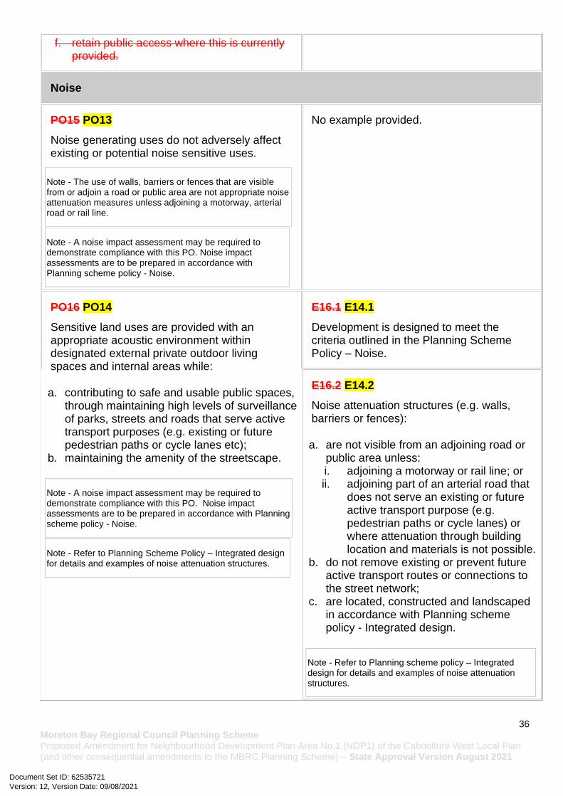
36 Moreton Bay Regional Council Planning Scheme Proposed Amendment for Neighbourhood Development Plan Area No.1 (NDP1) of the Caboolture West Local Plan (and other consequential amendments to the MBRC Planning Scheme) – State Approval Version August 2021
f. retain public access where this is currently provided.
Noise
PO15 PO13
Noise generating uses do not adversely affect existing or potential noise sensitive uses.
Note - The use of walls, barriers or fences that are visible from or adjoin a road or public area are not appropriate noise attenuation measures unless adjoining a motorway, arterial road or rail line.
Note - A noise impact assessment may be required to demonstrate compliance with this PO. Noise impact assessments are to be prepared in accordance with Planning scheme policy - Noise.
No example provided.
PO16 PO14
Sensitive land uses are provided with an appropriate acoustic environment within designated external private outdoor living spaces and internal areas while:
a. contributing to safe and usable public spaces, through maintaining high levels of surveillance of parks, streets and roads that serve active transport purposes (e.g. existing or future pedestrian paths or cycle lanes etc);
b. maintaining the amenity of the streetscape.
Note - A noise impact assessment may be required to demonstrate compliance with this PO. Noise impact assessments are to be prepared in accordance with Planning scheme policy - Noise.
Note - Refer to Planning Scheme Policy – Integrated design for details and examples of noise attenuation structures.
E16.1 E14.1
Development is designed to meet the criteria outlined in the Planning Scheme Policy – Noise.
E16.2 E14.2
Noise attenuation structures (e.g. walls, barriers or fences):
a. are not visible from an adjoining road or public area unless: i. adjoining a motorway or rail line; or ii. adjoining part of an arterial road that
does not serve an existing or future active transport purpose (e.g. pedestrian paths or cycle lanes) or where attenuation through building location and materials is not possible.
b. do not remove existing or prevent future active transport routes or connections to the street network;
c. are located, constructed and landscaped in accordance with Planning scheme policy - Integrated design.
Note - Refer to Planning scheme policy – Integrated design for details and examples of noise attenuation structures.
Version: 12, Version Date: 09/08/2021Document Set ID: 62535721
37 Moreton Bay Regional Council Planning Scheme Proposed Amendment for Neighbourhood Development Plan Area No.1 (NDP1) of the Caboolture West Local Plan (and other consequential amendments to the MBRC Planning Scheme) – State Approval Version August 2021
Note - Refer to Overlay map – Active transport for future active transport routes.
Works criteria
Utilities
PO17 PO15
All services including water supply, sewage disposal, electricity, street lighting, telecommunications and gas (if available) are provided in accordance with Planning scheme policy - Integrated design (Appendix A).
No example provided.
Access
PO18 PO16
Development provides functional and integrated car parking and vehicle access, that:
a. prioritises the movement and safety of pedestrians between car parking areas at the rear through to the 'main street' and the entrance to the building (e.g. Rear entry, arcade etc.);
b. provides safety and security of people and property at all times;
c. does not impede active transport options; d. does not impact on the safe and efficient
movement of traffic external to the site; e. where possible vehicle access points are
consolidated and shared with adjoining sites.
Note - Refer to Planning scheme policy - Centre and neighbourhood hub design for details and examples.
No example provided.
PO19 PO17
Where required access easements contain a driveway and provision for services constructed to suit the user’s needs. The easement covers all works associated with the access in accordance with Planning scheme policy - Integrated design.
No example provided.
PO20 PO18 E20.1 E18.1
Version: 12, Version Date: 09/08/2021Document Set ID: 62535721
38 Moreton Bay Regional Council Planning Scheme Proposed Amendment for Neighbourhood Development Plan Area No.1 (NDP1) of the Caboolture West Local Plan (and other consequential amendments to the MBRC Planning Scheme) – State Approval Version August 2021
The layout of the development does not compromise:
a. the development of the road network in the area;
b. the function or safety of the road network; c. the capacity of the road network.
Note - The road hierarchy is mapped on in accordance with an approved Neighbourhood development plan (conceptually shown on Figure 7.2.3.2 - Movement, Major streets).
Direct vehicle access for residential development does not occur from arterial or sub-arterial roads or a motorway.
Editor's note - Residential developments should consider amalgamation with the lot to the rear and gaining access via a laneway.
Note - The road hierarchy is in accordance with a Neighbourhood development plan (conceptually shown on Figure 7.2.3.2 - Movement, Major streets).
E20.2 E18.2
The development provides for the extension of the road network in the area in accordance with Council’s road network planning.
E20.3 E18.3
The development does not compromise future road widening of frontage roads in accordance with the relevant standard and Council’s road planning.
E20.4 E18.4
The development layout allows forward vehicular access to and from the site.
PO21 PO19
Safe access is provided for all vehicles required to access the site.
E21.1 E19.1
Site access and driveways are designed, located and constructed in accordance with:
a. where for a Council-controlled road and associated with a Dwelling house: i. Planning scheme policy - Integrated
design;
b. where for a Council-controlled road and not associated with a Dwelling house: i. AS/NZS 2890.1 Parking facilities Part
1: Off street car parking;
ii. AS 2890.2 - Parking facilities Part 2: Off-street commercial vehicle
Version: 12, Version Date: 09/08/2021Document Set ID: 62535721
39 Moreton Bay Regional Council Planning Scheme Proposed Amendment for Neighbourhood Development Plan Area No.1 (NDP1) of the Caboolture West Local Plan (and other consequential amendments to the MBRC Planning Scheme) – State Approval Version August 2021
facilities;
iii. Planning scheme policy - Integrated design;
iv. Schedule 8 - Service vehicle requirements;
c. where for a State-controlled road, the Safe Intersection Sight Distance requirements in Austroads and the appropriate IPWEAQ standard drawings, or a copy of a Transport Infrastructure Act 1994, section 62 approval.
E21.2 E19.2
Internal driveways, car parks and access ways are designed and constructed with a sealed pavement and in accordance with:
a. AS/NZS 2890.1 Parking Facilities Part 1: Off street car parking;
b. AS 2890.2 Parking Facilities Part 2: Off street commercial vehicle facilities;
c. Planning scheme policy - Integrated design; and
d. Schedule 8 - Service vehicle requirements.
Note - This includes queue lengths (refer to Schedule 8 - Service vehicle requirements), pavement widths and construction.
E21.3 E19.3
Access driveways, manoeuvring areas and loading facilities are sealed and provide for service vehicles listed in Schedule 8 - Service vehicle requirements for the relevant use. The on-site manoeuvring is to be in accordance with Schedule 8 - Service vehicle requirements.
E21.4 E19.4
Version: 12, Version Date: 09/08/2021Document Set ID: 62535721
40 Moreton Bay Regional Council Planning Scheme Proposed Amendment for Neighbourhood Development Plan Area No.1 (NDP1) of the Caboolture West Local Plan (and other consequential amendments to the MBRC Planning Scheme) – State Approval Version August 2021
Landscaping (including shade trees) is provided within car parks in accordance with Planning scheme policy - Integrated design.
PO22 PO20
Sealed and flood free road access during the minor storm event is available to the site from the nearest arterial or sub-arterial road.
Editor's note - Where associated with a State-controlled road, further requirements may apply, and approvals may be required from the Department of Transport and Main Roads.
E22 E20
Roads or streets giving access to the development from the nearest arterial or sub-arterial road are flood free during the minor storm event and are sealed.
Note - The road network is mapped on an approved Neighbourhood development plan Overlay map - Road hierarchy.
PO23 PO21
Roads which provide access to the site from an arterial or sub-arterial road remain trafficable during major storm events without flooding or impacting upon residential properties or other premises.
E23.1 E21.1
Access roads to the development have sufficient longitudinal and cross drainage to remain safely trafficable during major storm (1% AEP) events.
Note - The road network is mapped on an approved Neighbourhood development plan Overlay map - Road hierarchy.
Note - Refer to QUDM for requirements regarding trafficability.
E23.2 E21.2
Culverts and causeways do not increase inundation levels or increase velocities, for all events up to the defined flood event, to upstream or downstream properties.
Street design and layout
PO24 PO22
Streets are designed and constructed in accordance with Planning scheme policy - Integrated design and Planning scheme policy - Operational works inspection, maintenance and bonding procedures. The street design and construction accommodates the following functions:
No example provided.
Version: 12, Version Date: 09/08/2021Document Set ID: 62535721
41 Moreton Bay Regional Council Planning Scheme Proposed Amendment for Neighbourhood Development Plan Area No.1 (NDP1) of the Caboolture West Local Plan (and other consequential amendments to the MBRC Planning Scheme) – State Approval Version August 2021
a. access to premises by providing convenient vehicular movement for residents between their homes and the major road network;
b. safe and convenient pedestrian and cycle movement;
c. adequate on street parking;
d. stormwater drainage paths and treatment facilities;
e. efficient public transport routes;
f. utility services location;
g. emergency access and waste collection;
h. setting and approach (streetscape, landscaping and street furniture) for adjoining residences;
i. expected traffic speeds and volumes; and
j. wildlife movement (where relevant).
Note - Preliminary road design (including all services, street lighting, stormwater infrastructure, access locations, street trees and pedestrian network) may be required to demonstrate compliance with this PO.
Note - Refer to Planning scheme policy - Environmental areas and corridors for examples of when and where wildlife movement infrastructure is required.
PO25 PO23
The existing road network (whether trunk or non-trunk) is upgraded where necessary to cater for the impact from the development.
Note - An applicant may be required to submit an Integrated Transport Assessment (ITA), prepared in accordance with Planning scheme policy - Integrated transport assessment to demonstrate compliance with this PO, when any of the following occurs:
• Development is near a transport sensitive location;
E25.1 E23.1
New intersections onto existing roads are designed to accommodate traffic volumes and traffic movements taken from a date 10 years from the date of completion of the last stage of the development. Detailed design is to be in accordance with Planning scheme policy - Integrated design.
Note - All turns vehicular access to existing lots is to be retained at new road intersections wherever practicable.
Version: 12, Version Date: 09/08/2021Document Set ID: 62535721

42 Moreton Bay Regional Council Planning Scheme Proposed Amendment for Neighbourhood Development Plan Area No.1 (NDP1) of the Caboolture West Local Plan (and other consequential amendments to the MBRC Planning Scheme) – State Approval Version August 2021
• Forecast traffic to/from the development exceeds 5% of the two way flow on the adjoining road or intersection, and congestion currently exists or is anticipated within 10 years of the development completion;
• Development access onto a sub arterial, or arterial road or within 100m of a signalised intersection;
• Residential development greater than 50 lots or dwellings;
• Offices greater than 4,000m2 Gross Floor Area (GFA);
• Retail activities including Hardware and trade supplies, Showroom, Shop or Shopping centre greater than 1,000m2 GFA;
• Warehouses(88) greater than 6,000m2 GFA;
• On-site carpark greater than 100 spaces.
The ITA is to review the development’s impact upon the external road network for the period of 10 years from completion of the development. The ITA is to provide sufficient information for determining the impact and the type and extent of any ameliorative works required to cater for the additional traffic. The ITA must include a future structural road layout of adjoining properties that will form part of this catchment and road connecting to these properties. The ITA is to assess the ultimate developed catchment’s impacts and necessary ameliorative works, and the works or contribution required by the applicant as identified in the study.
Note - The road network is mapped on an approved Neighbourhood development plan Overlay map - Road hierarchy.
Note - The primary and secondary active transport network is mapped on an approved Neighbourhood development plan Overlay map - Active transport.
Note - Existing on-street parking is to be retained at new road intersections and along road frontages wherever practicable.
E25.2 E23.2
Existing intersections external to the site are upgraded as necessary to accommodate increased traffic from the development. Design is in accordance with Planning scheme policy - Operational works inspection, maintenance and bonding procedures.
Note - All turns vehicular access to existing lots is to be retained at upgraded road intersections wherever practicable.
Note - Existing on-street parking is to be retained at upgraded road intersections and along road frontages wherever practicable.
E25.3 E23.3
The active transport network is extended in accordance with Planning scheme policy - Integrated design.
PO26 PO24
New intersections along all streets and roads are located and designed to provide safe and convenient movements for all users.
Note - Refer Planning scheme policy - Integrated design and Planning scheme policy - Operational works inspection, maintenance and bonding procedures for design and construction standards.
E26 E24
New intersection spacing (centreline – centreline) along a through road conforms with the following;
a. Where the through road provides an access or residential street function; i. intersecting road located on same
side = 60 metres; or
Version: 12, Version Date: 09/08/2021Document Set ID: 62535721

43 Moreton Bay Regional Council Planning Scheme Proposed Amendment for Neighbourhood Development Plan Area No.1 (NDP1) of the Caboolture West Local Plan (and other consequential amendments to the MBRC Planning Scheme) – State Approval Version August 2021
Note - An Integrated Transport Assessment (ITA) including preliminary intersection designs, prepared in accordance with Planning scheme policy - Integrated transport assessment may be required to demonstrate compliance with this PO. Intersection spacing will be determined based on the deceleration and queue storage distances required for the intersection after considering vehicle speed and present/forecast turning and through volumes.
ii. intersecting road located on opposite side = 40 metres.
b. Where the through road provides a local collector or district collector function: i. intersecting road located on same
side = 100 metres; or
ii. intersecting road located on opposite side = 60 metres.
c. Where the through road provides a sub-arterial function: i. intersecting road located on same
side = 250 metres; or
ii. intersecting road located on opposite side = 100 metres.
d. Where the through road provides an arterial function: i. intersecting road located on same
side = 350 metres; or
ii. intersecting road located on opposite side = 150 metres.
e. Walkable block perimeter does not exceed 500 metres in the Next generation neighbourhood sub-precinct.
Note - Based on the absolute minimum intersection spacing identified above, all turns access may not be permitted (ie. left in/left out only) at intersections with sub-arterial roads or arterial roads.
Note - The road network is mapped on Overlay may - Road hierarchy.
Note - An Integrated Transport Assessment (ITA) including preliminary intersection designs, prepared in accordance with Planning scheme policy - Integrated transport assessment may be required to demonstrate compliance with this E. Intersection spacing will be determined based on the deceleration and queue storage distances required for the intersection after considering vehicle speed and resent/forecast turning and through volumes.
Version: 12, Version Date: 09/08/2021Document Set ID: 62535721

44 Moreton Bay Regional Council Planning Scheme Proposed Amendment for Neighbourhood Development Plan Area No.1 (NDP1) of the Caboolture West Local Plan (and other consequential amendments to the MBRC Planning Scheme) – State Approval Version August 2021
PO27 PO25
All Council controlled frontage roads adjoining the development are designed and constructed in accordance with Planning scheme policy - Integrated design and Planning scheme policy - Operational works inspection, maintenance and bonding procedure. All new works are extended to join any existing works within 20m.
Note - Frontage roads include streets where no direct lot access is provided.
Note - The road network is mapped on an approved Neighbourhood development plan Overlay map - Road hierarchy.
Note - The primary and secondary active transport network is mapped on an approved Neighbourhood development plan Overlay map - Active transport.
Note - Roads are considered to be constructed in accordance with Council’s standards when there is sufficient pavement width, geometry and depth to comply with the requirements of Planning scheme policy - Integrated design and Planning scheme policy - Operational works inspection, maintenance and bonding procedures.
E27 E25
Design and construct all Council controlled frontage roads in accordance with Planning scheme policy - Integrated design, Planning scheme policy - Operational works inspection, maintenance and bonding procedures and the following:
Situation Minimum construction
Frontage road unconstructed or gravel road only;
OR
Frontage road sealed but not constructed* to Planning scheme policy - Integrated design standard;
OR
Frontage road partially constructed* to Planning scheme policy - Integrated design standard.
Construct the verge adjoining the development and the carriageway (including development side kerb and channel) to a minimum sealed width containing near side parking lane (if required), cycle lane (if required), 2 travel lanes plus 1.5m wide (full depth pavement) gravel shoulder and table drainage to the opposite side.
The minimum total travel lane width is:
• 6m for minor roads;
• 7m for major roads.
Note - Major roads are sub-arterial roads and arterial roads. Minor roads are roads that are not major roads.
Note - Construction includes all associated works (services, street lighting and linemarking).
Note - Alignment within road reserves is to be agreed with Council.
Note - *Roads are considered to be constructed in accordance with Council standards when there is sufficient pavement width, geometry and depth to comply with the requirements of Planning scheme policy - Integrated design and Planning scheme policy - Operational works inspection, maintenance and bonding procedures. Testing of the existing pavement may be required to confirm whether the existing works meet the standards in Planning scheme policy - Integrated design and Planning scheme policy - Operational works inspection, maintenance and bonding procedures.
Version: 12, Version Date: 09/08/2021Document Set ID: 62535721

45 Moreton Bay Regional Council Planning Scheme Proposed Amendment for Neighbourhood Development Plan Area No.1 (NDP1) of the Caboolture West Local Plan (and other consequential amendments to the MBRC Planning Scheme) – State Approval Version August 2021
Stormwater
PO28 PO26
Minor stormwater drainage systems (internal and external) have the capacity to convey stormwater flows from frequent storm events for the fully developed upstream catchment whilst ensuring pedestrian and vehicular traffic movements are safe and convenient.
E28.1 E26.1
The capacity of all minor drainage systems are designed in accordance with Planning scheme policy - Integrated design.
E28.2 E26.2
Stormwater pipe network capacity is to be calculated in accordance with the Hydraulic Grade Line method as detailed in Australian Rainfall and Runoff or QUDM.
E28.3 E26.3
Development ensures that inter-allotment drainage infrastructure is provided in accordance with the relevant level as identified in QUDM.
Note - Development is to provide inter-allotment – QUDM level III drainage, including bunds, to all lots that have a gradient less than 1 in 100 (for the whole of the allotment) to the road. The inter-allotment drainage system (including easements) is provided in accordance with Planning scheme policy - Integrated design (Appendix C).
PO29 PO27
Major stormwater drainage system(s) have the capacity to safely convey stormwater flows for the 1% AEP event for the fully developed upstream catchment.
E29.1 E27.1
The internal drainage system safely and adequately conveys the stormwater flows for the 1% AEP event for the fully developed upstream catchment through the site.
E29.2 E27.2
The external (downstream) drainage system safely conveys the stormwater flows for the 1% AEP event for the fully developed upstream catchment without allowing the flows to encroach upon private lots.
E29.3 E27.3
Overland flow paths from roads and public open space areas do not pass through private lots. Drainage pathways are
Version: 12, Version Date: 09/08/2021Document Set ID: 62535721
46 Moreton Bay Regional Council Planning Scheme Proposed Amendment for Neighbourhood Development Plan Area No.1 (NDP1) of the Caboolture West Local Plan (and other consequential amendments to the MBRC Planning Scheme) – State Approval Version August 2021
provided to accommodate overland flows from roads and public open space areas.
E29.4 E27.4
The flow velocity in all unlined or soft faced open drains is kept within acceptable limits for the type of material or lining and condition of the channel.
Note - Refer to QUDM for recommended average flow velocities.
PO30 PO28
Provide measures to properly manage surface flows for the 1% AEP event (for the fully developed catchment) draining to and through the land to ensure no actionable nuisance is created to any person or premises as a result of the development. The development must not result in ponding on adjacent land, redirection of surface flows to other premises or blockage of a surface flow relief path for flows exceeding the design flows for any underground system within the development.
E30 E28
The stormwater drainage system is designed and constructed in accordance with Planning scheme policy - Integrated design.
PO31 PO29
Stormwater run-off from the site is conveyed to a point of lawful discharge without causing actionable nuisance to any person, property or premises.
Note - Refer to Planning scheme policy - Integrated design for details and examples.
Note - downstream drainage discharge report in accordance with Planning scheme policy - Stormwater management may be required to demonstrate achievement of this performance outcome.
Note - A watercourse as defined in the Water Act may be accepted as a lawful point of discharge providing the drainage discharge from the site does not increase the downstream flood levels during events up to and including the 1% AEP storm. An afflux of +20mm may be accepted on Council controlled land and road infrastructure. No worsening is ensured when stormwater is discharged into a catchment that includes State Transport Infrastructure.
No example provided.
Version: 12, Version Date: 09/08/2021Document Set ID: 62535721
47 Moreton Bay Regional Council Planning Scheme Proposed Amendment for Neighbourhood Development Plan Area No.1 (NDP1) of the Caboolture West Local Plan (and other consequential amendments to the MBRC Planning Scheme) – State Approval Version August 2021
PO32 PO30
Stormwater generated from the development does not compromise the capacity of existing stormwater infrastructure downstream of the site.
Note - A downstream drainage discharge report in accordance with Planning scheme policy - Stormwater management may be required to demonstrate compliance with this performance outcome.
No example provided.
PO33 PO31
Where development:
a. is for an urban purpose that involves a land area of 2500m2 or greater; and
b. will result in:
i. 6 or more dwellings; or
ii. an impervious area greater than 25% of the net developable area,
stormwater quality management systems are designed, constructed, established and maintained to minimise the environmental impact of stormwater on surface, groundwater and receiving water environments and meet the design objectives outlined in Schedule 10 - Stormwater management design objectives.
Note - A site based stormwater management plan prepared by a suitably qualified professional will be required in accordance with Planning scheme policy - Stormwater management. Stormwater quality infrastructure is to be designed in accordance with Planning scheme policy - Integrated design (Appendix C).
No example provided.
PO34 PO32
Stormwater drainage pipes and structures through or within private land (including inter-allotment drainage) are protected by easements in favour of Council with sufficient area for practical access for maintenance purposes.
Note - In order to achieve a lawful point of discharge, stormwater easements may also be required over temporary drainage channels/infrastructure where stormwater discharges to a balance lot prior to entering Council’s stormwater drainage system.
E34 E32
Stormwater drainage infrastructure (excluding detention and bio-retention systems) through or within private land (including inter-allotment drainage) is protected by easements in favour of Council. Minimum easement widths are as follows:
Version: 12, Version Date: 09/08/2021Document Set ID: 62535721
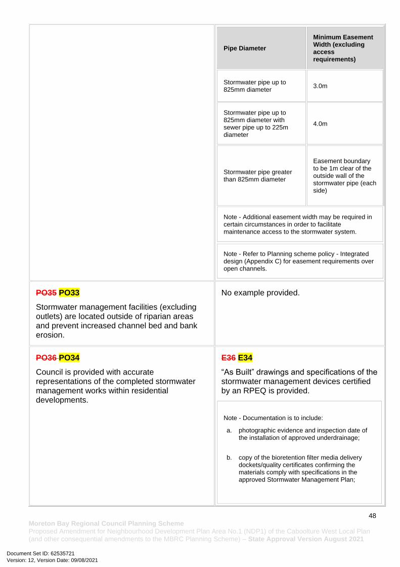
48 Moreton Bay Regional Council Planning Scheme Proposed Amendment for Neighbourhood Development Plan Area No.1 (NDP1) of the Caboolture West Local Plan (and other consequential amendments to the MBRC Planning Scheme) – State Approval Version August 2021
Pipe Diameter
Minimum Easement Width (excluding access requirements)
Stormwater pipe up to 825mm diameter
3.0m
Stormwater pipe up to 825mm diameter with sewer pipe up to 225m diameter
4.0m
Stormwater pipe greater than 825mm diameter
Easement boundary to be 1m clear of the outside wall of the stormwater pipe (each side)
Note - Additional easement width may be required in certain circumstances in order to facilitate maintenance access to the stormwater system.
Note - Refer to Planning scheme policy - Integrated design (Appendix C) for easement requirements over open channels.
PO35 PO33
Stormwater management facilities (excluding outlets) are located outside of riparian areas and prevent increased channel bed and bank erosion.
No example provided.
PO36 PO34
Council is provided with accurate representations of the completed stormwater management works within residential developments.
E36 E34
“As Built” drawings and specifications of the stormwater management devices certified by an RPEQ is provided.
Note - Documentation is to include:
a. photographic evidence and inspection date of the installation of approved underdrainage;
b. copy of the bioretention filter media delivery dockets/quality certificates confirming the materials comply with specifications in the approved Stormwater Management Plan;
Version: 12, Version Date: 09/08/2021Document Set ID: 62535721

49 Moreton Bay Regional Council Planning Scheme Proposed Amendment for Neighbourhood Development Plan Area No.1 (NDP1) of the Caboolture West Local Plan (and other consequential amendments to the MBRC Planning Scheme) – State Approval Version August 2021
c. date of the final inspection.
Site works and construction management
PO37 PO35
The site and any existing structures are maintained in a tidy and safe condition.
No example provided.
PO38 PO36
All works on-site are managed to:
a. minimise as far as practicable, impacts on adjoining or adjacent premises and the streetscape in regard to erosion and sedimentation, dust, noise, safety and light;
b. minimise as far as possible, impacts on the natural environment;
c. ensure stormwater discharge is managed in a manner that does not cause actionable nuisance to any person or premises;
d. avoid adverse impacts on street streets and their critical root zone.
E38.1 E36.1
Works incorporate temporary stormwater run-off, erosion and sediment controls and trash removal devices designed in accordance with the Urban Stormwater Quality Planning Guidelines, State Planning Policy, Schedule 10 - Stormwater management design objectives, Planning scheme policy - Stormwater management and Planning scheme policy - Integrated design, including but not limited to the following:
a. stormwater is not discharged to adjacent properties in a manner that differs significantly from pre-existing conditions;
b. stormwater discharged to adjoining and downstream properties does not cause scour or erosion of any kind;
c. stormwater discharge rates do not exceed pre-existing conditions;
d. minimum design storm for all temporary diversion drains and sedimentation basins in accordance with Schedule 10 - Stormwater management design objectives;
Version: 12, Version Date: 09/08/2021Document Set ID: 62535721

50 Moreton Bay Regional Council Planning Scheme Proposed Amendment for Neighbourhood Development Plan Area No.1 (NDP1) of the Caboolture West Local Plan (and other consequential amendments to the MBRC Planning Scheme) – State Approval Version August 2021
e. ponding or concentration of stormwater does not occur on adjoining properties.
E38.2 E36.2
Stormwater run-off, erosion and sediment controls are constructed in accordance with Planning scheme policy - Integrated design (Appendix C) prior to commencement of any clearing work or earthworks and are maintained and adjusted as necessary at all times to ensure their ongoing effectiveness.
Note - The measures are adjusted on-site to maximise their effectiveness.
E38.3 E36.3
The completed earthworks (fill or excavation) area is stabilised using turf, established grass seeding, mulch or sprayed stabilisation techniques to control erosion and sediment and dust from leaving the property.
E38.4 E36.4
Existing street trees are protected and not damaged during works.
Note - Where development occurs in the tree protection zone, measures and techniques as detailed in Australian Standard AS 4970 Protection of trees on development sites are adopted and implemented.
PO39 PO37
Dust suppression measures are implemented during construction works to protect nearby premises from unreasonable dust impacts.
E39 E37
No dust emissions extend beyond the boundaries of the site during soil disturbances and construction works.
PO40 PO38
All development works including the transportation of material to and from the site are managed to not negatively impact the
E40.1 E38.1
Construction traffic including contractor car parking is controlled in accordance with a traffic management plan, prepared in accordance with the Manual of Uniform Traffic Control Devices (MUTCD) to ensure
Version: 12, Version Date: 09/08/2021Document Set ID: 62535721
51 Moreton Bay Regional Council Planning Scheme Proposed Amendment for Neighbourhood Development Plan Area No.1 (NDP1) of the Caboolture West Local Plan (and other consequential amendments to the MBRC Planning Scheme) – State Approval Version August 2021
existing road network, the amenity of the surrounding area or the streetscape.
Note - A Traffic Management Plan may be required to demonstrate compliance with this PO. A Traffic Management Plan is to be prepared in accordance with the Manual of Uniform Traffic Control Devices (MUTCD).
Note - A haulage route must be identified and approved by Council where imported or exported material is transported to the site via a road of Local Collector standard or less, and:
a. the aggregate volume of imported or exported material is greater than 1000m3; or
b. the aggregate volume of imported or exported material is greater than 200m3 per day; or
c. the proposed haulage route involves a vulnerable land use or shopping centre.
Note - A dilapidation report (including photographs) may be required for the haulage route to demonstrate compliance with this PO.
Editor's note - Where associated with a State-controlled road , further requirements may apply, and approval may be required from the Department of Transport and Main Roads.
all traffic movements to and from the site are safe.
E40.2 E38.2
All contractor car parking is either provided on the development site, or on an alternative site in the general locality which has been set aside for car parking. Contractor vehicles are generally not to be parked in existing roads.
E40.3 E38.3
Any material dropped, deposited or spilled on the roads as a result of construction processes associated with the site are to be cleaned at all times.
E40.4 E38.4
Construction traffic to and from the development site uses the highest classification streets or roads where a choice of access routes is available. Haul routes for the transport of imported or spoil material and gravel pavement material along Council roads below sub-arterial standard must be approved routes.
Note - The road hierarchy is mapped on Overlay map - Road hierarchy.
Note - A dilapidation report may be required to demonstrate compliance with this E.
E40.5 E38.5
Where works are carried out in existing roads, the works must be undertaken so that the existing roads are maintained in a safe and useable condition. Practical access for residents, visitors and services (including postal deliveries and refuse collection) is retained to existing lots during the construction period and after completion of the works.
Note - A traffic control plan prepared in accordance with the Manual of Uniform Traffic Control Devices (MUTCD) will be required for any works that will affect access, traffic movements or traffic safety in
Version: 12, Version Date: 09/08/2021Document Set ID: 62535721

52 Moreton Bay Regional Council Planning Scheme Proposed Amendment for Neighbourhood Development Plan Area No.1 (NDP1) of the Caboolture West Local Plan (and other consequential amendments to the MBRC Planning Scheme) – State Approval Version August 2021
existing roads.
E40.6 E38.6
Access to the development site is obtained via an existing lawful access point.
PO41 PO39
All disturbed areas are to be progressively stabilised and the entire site rehabilitated and substantially stabilised at the completion of construction.
Note - Refer to Planning scheme policy - Integrated design for details and examples.
E41 E39
At completion of construction all disturbed areas of the site are to be:
a. topsoiled with a minimum compacted thickness of fifty (50) millimetres;
b. stabilised using turf, established grass seeding, mulch or sprayed stabilisation techniques.
Note - These areas are to be maintained during any maintenance period to maximise grass coverage.
PO42 PO40
Earthworks are undertaken to ensure that soil disturbances are staged into manageable areas.
Note - A site specific Erosion and Sediment Control Plan (ESCP) will be required to demonstrate compliance with this PO. An Erosion and Sediment Control Plan is to be prepared in accordance with Planning scheme policy - Stormwater management and Planning scheme policy - Integrated design (Appendix C).
E42 E40
Soil disturbances are staged into manageable areas of not greater than 3.5 ha.
PO43 PO41
The clearing of vegetation on-site:
a. is limited to the area of infrastructure works, buildings areas and other necessary areas for the works;
b. includes the removal of declared weeds and other materials which are detrimental to the intended use of the land;
c. is disposed of in a manner which minimises nuisance and annoyance to existing premises.
E43.1 E41.1
All native vegetation to be retained on-site is temporarily fenced or protected prior to and during development works.
Note - No parking of vehicles or storage of machinery or goods is to occur in these areas during development works.
E43.2 E41.2
Version: 12, Version Date: 09/08/2021Document Set ID: 62535721
53 Moreton Bay Regional Council Planning Scheme Proposed Amendment for Neighbourhood Development Plan Area No.1 (NDP1) of the Caboolture West Local Plan (and other consequential amendments to the MBRC Planning Scheme) – State Approval Version August 2021
Note - No burning of cleared vegetation is permitted.
Disposal of materials is managed in one or more of the following ways:
a. all cleared vegetation, declared weeds, stumps, rubbish, car bodies, scrap metal and the like are removed and disposed of in a Council land fill facility; or
b. all native vegetation with a diameter below 400mm is to be chipped and stored on-site.
Note - The chipped vegetation must be stored in an approved location.
PO44 PO42
All development works are carried out at times which minimise noise impacts to residents.
E44 E42
All development works are carried out within the following times:
a. Monday to Saturday (other than public holidays) between 6:30am and 6:30pm on the same day;
b. no work is to be carried out on Sundays or public holidays.
Note - Work outside the above hours may be approved (in writing) where it can be demonstrated that the work will not cause significant inconvenience or disruption to the public, or the work is unlikely to cause annoyance or inconvenience to occupants of adjacent properties.
PO45 PO43
Any alteration or relocation in connection with or arising from the development to any service, installation, plant, equipment or other item belonging to or under the control of the telecommunications authority, electricity authorities, the Council or other person engaged in the provision of public utility services is to be carried with the development and at no cost to Council.
No example provided.
Earthworks
PO46 PO44 E46.1 E44.1
All cut and fill batters are provided with appropriate scour, erosion protection and
Version: 12, Version Date: 09/08/2021Document Set ID: 62535721

54 Moreton Bay Regional Council Planning Scheme Proposed Amendment for Neighbourhood Development Plan Area No.1 (NDP1) of the Caboolture West Local Plan (and other consequential amendments to the MBRC Planning Scheme) – State Approval Version August 2021
On-site earthworks are Filling and or excavation is designed to consider the visual and amenity impact as they relate to:
a. the natural topographical features of the site; b. short and long-term slope stability; c. soft or compressible foundation soils; d. reactive soils; e. low density or potentially collapsing soils; f. existing fills and soil contamination that may
exist on-site; g. the stability and maintenance of steep slopes
and batters; h. excavation (cut) and fill and impacts on the
amenity of adjoining lots (e.g. residential)
run-off control measures including catch drains at the top of batters and lined batter drains as necessary.
E46.2 E44.2
Stabilisation measures are provided, as necessary, to ensure long-term stability and low maintenance of steep slopes and batters.
E46.3 E44.3
All fill batters steeper than 1 (V) in 6 (H) on residential lots are fully turfed to prevent scour and erosion.
E46.4 E44.4
All filling or excavation is contained within the site and is free draining.
E46.5 E44.5
All fill placed on-site is:
a. limited to that area necessary for the approved use;
b. clean and uncontaminated (i.e. no building waste, concrete, green waste, actual acid sulfate soils, potential acid sulfate soils or contaminated material etc.).
E46.6 E44.6
The site is prepared and the fill placed on-site in accordance with AS3798.
Note - The fill is to be inspected and tested in accordance with Planning scheme policy - Operational works inspection, maintenance and bonding procedures.
E46.7 E44.7
Inspection and certification of steep slopes and batters may be required by a suitably qualified and experienced RPEQ.
PO47 PO45 E47 E45
Version: 12, Version Date: 09/08/2021Document Set ID: 62535721

55 Moreton Bay Regional Council Planning Scheme Proposed Amendment for Neighbourhood Development Plan Area No.1 (NDP1) of the Caboolture West Local Plan (and other consequential amendments to the MBRC Planning Scheme) – State Approval Version August 2021
Embankments are stepped, terraced and landscaped to not adversely impact on the visual amenity of the surrounding area.
Any embankments more than 1.5 metres in height are stepped, terraced and landscaped.
Figure - Embankment(Popup full image)
PO48 PO46
Filling or excavation is undertaken in a manner that:
a. does not adversely impact on a Council or public sector entity maintained infrastructure or any drainage feature on, or adjacent to the land;
b. does not preclude reasonable access to a Council or public sector entity maintained infrastructure or any drainage feature on, or adjacent to the land for monitoring, maintenance or replacement purposes.
Note - Public sector entity is defined in Schedule 2 of the Act.
E48.1 E46.1
No earthworks filling and or excavation is are undertaken in an easement issued in favour of Council or a public sector entity.
Note - Public sector entity is defined in Schedule 2 of the Act.
E48.2 E46.2
Earthworks Filling or excavation that would result in any of the following are not carried out on-site:
a. a reduction in cover over the Council or public sector entity maintained service to less than 600mm;
b. an increase in finished surface grade over, or within 1.5m on each side of, the Council or public sector entity maintained infrastructure above that which existed prior to the earthworks being undertaken; and
c. prevent reasonable access to Council or public sector entity maintained infrastructure or any drainage feature on, or adjacent to the site for monitoring, maintenance or replacement purposes.
Note - Public sector entity is defined in Schedule 2 of the Act.
Version: 12, Version Date: 09/08/2021Document Set ID: 62535721
56 Moreton Bay Regional Council Planning Scheme Proposed Amendment for Neighbourhood Development Plan Area No.1 (NDP1) of the Caboolture West Local Plan (and other consequential amendments to the MBRC Planning Scheme) – State Approval Version August 2021
Note - All building work covered by QDC MP1.4 is excluded from this provision.
PO49 PO47
Filling or excavation does not result in land instability.
Note - Steep slopes and batters are inspected and certified for long-term stability by a suitably qualified and experienced geotechnical engineer with RPEQ qualifications. Stabilisation measures are provided, as necessary, to ensure long-term stability and low maintenance.
No example provided.
PO50 PO48
Filling or excavation does not result in
a. adverse impacts on the hydrological and hydraulic capacity of the waterway or floodway;
b. increased flood inundation outside the site; c. any reduction in the flood storage capacity in
the floodway; d. any clearing of native vegetation.
Note - To demonstrate compliance with this outcome, Planning scheme policy - Stormwater management provides guidance on the preparation of a site based stormwater management plan by a suitably qualified professional. Refer to Planning scheme policy - Integrated design for guidance on infrastructure design and modelling requirements..
No example provided.
PO51 PO49
Filling or excavation on the development site is undertaken in a manner which does not create or accentuate problems associated with stormwater flows and drainage systems on land adjoining the site.
E51 E49
Filling and excavation undertaken on the development site are shaped in a manner which does not:
a. prevent stormwater surface flow which, prior to commencement of the earthworks, passed onto the development site, from entering the land; or
b. redirect stormwater surface flow away from existing flow paths; or
Version: 12, Version Date: 09/08/2021Document Set ID: 62535721

57 Moreton Bay Regional Council Planning Scheme Proposed Amendment for Neighbourhood Development Plan Area No.1 (NDP1) of the Caboolture West Local Plan (and other consequential amendments to the MBRC Planning Scheme) – State Approval Version August 2021
c. divert stormwater surface flow onto adjacent land, (other than a road), in a manner which:
i. concentrates the flow; or
ii. increases the flow rate of stormwater over the affected section of the adjacent land above the situation which existed prior to the diversion; or
iii. causes actionable nuisance to any person, property or premises.
PO52 PO50
All earth retaining structures provide a positive interface with the streetscape and minimise impacts on the amenity of adjoining residents.
Note - Refer to Planning scheme policy - Residential design for guidance on how to achieve compliance with this performance outcome.
E52 E50
Earth retaining structures:
a. are not constructed of boulder rocks or timber;
b. where height is no greater than 900mm, are provided in accordance with Figure - Retaining on a boundary;
c. where height is greater than 900mm but no greater than 1.5m, are to be setback at least the equivalent height of the retaining structure from any property boundary;
d. where height is greater than 1.5m, are to be setback and stepped 1.5m vertical: 1.5m horizontal, terraced, landscaped and drained as shown below.
Version: 12, Version Date: 09/08/2021Document Set ID: 62535721

58 Moreton Bay Regional Council Planning Scheme Proposed Amendment for Neighbourhood Development Plan Area No.1 (NDP1) of the Caboolture West Local Plan (and other consequential amendments to the MBRC Planning Scheme) – State Approval Version August 2021
Fire Services
Note - The provisions under this heading only apply if:
a. the development is for, or incorporates: i. reconfiguring a lot for a community title scheme creating 1 or more vacant lots; or ii. material change of use for 2 or more sole occupancy units on the same lot, or within the same community titles
scheme; or iii. material change of use for a Tourist park(84) with accommodation in the form of caravans or tents; or iv. material change of use for outdoor sales(54), outdoor processing or outdoor storage where involving
combustible materials.
AND
b. none of the following exceptions apply: i. the distributor-retailer for the area has indicated, in its netserv plan, that the premises will not be served by that
entity’s reticulated water supply; or ii. every part of the development site is within 60m walking distance of an existing fire hydrant on the distributor-
retailer’s reticulated water supply network, measured around all obstructions, either on or adjacent to the site.
Version: 12, Version Date: 09/08/2021Document Set ID: 62535721
59 Moreton Bay Regional Council Planning Scheme Proposed Amendment for Neighbourhood Development Plan Area No.1 (NDP1) of the Caboolture West Local Plan (and other consequential amendments to the MBRC Planning Scheme) – State Approval Version August 2021
Note - The provisions under this heading do not apply to buildings that are required by the Building Code of Australia to have a fire hydrant system complying with Australian Standard AS 2419.1 (2005) – Fire Hydrant Installations or other fire fighting facilities which provide equivalent protection.
PO53 PO51
Development incorporates a fire fighting system that:
a. satisfies the reasonable needs of the fire fighting entity for the area;
b. is appropriate for the size, shape and topography of the development and its surrounds;
c. is compatible with the operational equipment available to the fire fighting entity for the area;
d. considers the fire hazard inherent in the materials comprising the development and their proximity to one another;
e. considers the fire hazard inherent in the surrounds to the development site;
f. is maintained in effective operating order.
Note - The Queensland Fire and Emergency Services is the entity currently providing the fire fighting function for the urban areas of the Moreton Bay Region.
E53.1 E51.1
External fire hydrant facilities are provided on site to the standard prescribed under the relevant parts of Australian Standard AS 2419.1 (2005) – Fire Hydrant Installations.
Note - For this requirement for accepted development, the following are the relevant parts of AS 2419.1 (2005) that may be applicable:
a. in regard to the form of any fire hydrant - Part 8.5 and Part 3.2.2.1, with the exception that for Tourist parks(84) or development comprised solely of dwellings and their associated outbuildings, single outlet above-ground hydrants or suitably signposted in-ground hydrants would be an acceptable alternative;
b. in regard to the general locational requirements for fire hydrants - Part 3.2.2.2 (a), (e), (f), (g) and (h) as well as Appendix B of AS 2419.1 (2005);
c. in regard to the proximity of hydrants to buildings and other facilities - Part 3.2.2.2 (b), (c) and (d), with the exception that: i. for dwellings and their associated outbuildings,
hydrant coverage need only extend to the roof and external walls of those buildings;
ii. for caravans and tents, hydrant coverage need only extend to the roof of those tents and caravans;
iii. for outdoor sales(54), processing or storage facilities, hydrant coverage is required across the entire area of the outdoor sales(54), outdoor processing and outdoor storage facilities;
d. in regard to fire hydrant accessibility and clearance requirements - Part 3.5 and, where applicable, Part 3.6.
E53.2 E51.2
A continuous path of travel having the following characteristics is provided between the vehicle access point to the site and each external fire hydrant and hydrant booster point on the land:
a. an unobstructed width of no less than 3.5m;
b. an unobstructed height of no less than 4.8m;
Version: 12, Version Date: 09/08/2021Document Set ID: 62535721

60 Moreton Bay Regional Council Planning Scheme Proposed Amendment for Neighbourhood Development Plan Area No.1 (NDP1) of the Caboolture West Local Plan (and other consequential amendments to the MBRC Planning Scheme) – State Approval Version August 2021
c. constructed to be readily traversed by a 17 tonne HRV fire brigade pumping appliance;
d. an area for a fire brigade pumping appliance to stand within 20m of each fire hydrant and 8m of each hydrant booster point.
E53.3 E51.3
On-site fire hydrant facilities are maintained in effective operating order in a manner prescribed in Australian Standard AS1851 (2012) – Routine service of fire protection systems and equipment.
PO54 PO52
On-site fire hydrants that are external to buildings, as well as the available fire fighting appliance access routes to those hydrants, can be readily identified at all times from, or at, the vehicular entry point to the development site.
E54 E52
For development that contains on-site fire hydrants external to buildings:
a. those external hydrants can be seen from the vehicular entry point to the site; or
b. a sign identifying the following is provided at the vehicular entry point to the site:
i. the overall layout of the development (to scale);
ii. internal road names (where used);
iii. all communal facilities (where provided);
iv. the reception area and on-site manager’s office (where provided);
v. external hydrants and hydrant booster points;
vi. physical constraints within the internal roadway system which would restrict access by fire fighting appliances to external hydrants and hydrant booster points.
Version: 12, Version Date: 09/08/2021Document Set ID: 62535721

61 Moreton Bay Regional Council Planning Scheme Proposed Amendment for Neighbourhood Development Plan Area No.1 (NDP1) of the Caboolture West Local Plan (and other consequential amendments to the MBRC Planning Scheme) – State Approval Version August 2021
Note - The sign prescribed above, and the graphics used are to be:
a. in a form;
b. of a size;
c. illuminated to a level;
which allows the information on the sign to be readily understood, at all times, by a person in a fire fighting appliance up to 4.5m from the sign.
PO55 PO53
Each on-site fire hydrant that is external to a building is signposted in a way that enables it to be readily identified at all times by the occupants of any firefighting appliance traversing the development site.
E55 E53
For development that contains on-site fire hydrants external to buildings, those hydrants are identified by way of marker posts and raised reflective pavement markers in the manner prescribed in the technical note Fire hydrant indication system produced by the Queensland Department of Transport and Main Roads.
Note - Technical note Fire hydrant indication system is available on the website of the Queensland Department of Transport and Main Roads.
Use specific criteria
Dual occupancies(21)
PO56 PO54
Dual occupancies(21):
a. are dispersed within the streetscape;
b. contribute to the diversity of dwelling types and forms;
c. are not the predominant built form.
Note - Refer to Planning scheme policy - Residential design for dispersal methods and calculation.
E56 E54
Dual occupancies(21) are dispersed within the streetscape in accordance with one or more of the following:
a. no more than 20% of sites within a block contain an existing or approved Dual occupancy(21) and Dual occupancy lots (running along the street frontage) are separated by a minimum of one lot not containing an existing, approved or properly made application for a Dual occupancy; or
b. a Dual occupancy(21) is separated by a minimum of 6 lots (running along the street frontage) from another lot containing an existing or approved dual occupancy(21); or
c. a Dual occupancy(21) is not located within 100m (in all directions) of an
Version: 12, Version Date: 09/08/2021Document Set ID: 62535721
62 Moreton Bay Regional Council Planning Scheme Proposed Amendment for Neighbourhood Development Plan Area No.1 (NDP1) of the Caboolture West Local Plan (and other consequential amendments to the MBRC Planning Scheme) – State Approval Version August 2021
existing or approved Dual occupancy(21).
Note - Laneway lots may contain Dual occupancies(21) (lofts) on the end two lots within a laneway.
Note - Refer to Planning scheme policy - Residential design for dispersal methods and calculation.
Educational establishments(24)
PO57 PO55
Educational establishments(24) are located:
a. generally in accordance with a Neighbourhood development plan that reflects the urban structure concept shown indicatively on Figure 7.2.3.5 - Centres, employment and schools; or
a. generally between neighbourhoods;
b. on highly accessible sites along neighbourhood connecting streets;
c. with close access to highly frequent public transport;
d. generally along green network corridors to maximise the use of open space for sport and recreation purposes and to promote active travel as a means of transport to and from school;
e. if a high school or major private school - on major connecting streets.
Note - The urban design rationale for Caboolture West further outlines locational criteria for schools.
No example provided.
PO58 PO56 No example provided.
Version: 12, Version Date: 09/08/2021Document Set ID: 62535721
63 Moreton Bay Regional Council Planning Scheme Proposed Amendment for Neighbourhood Development Plan Area No.1 (NDP1) of the Caboolture West Local Plan (and other consequential amendments to the MBRC Planning Scheme) – State Approval Version August 2021
Educational establishments(24) are designed to:
a. if adjacent to a local centre, promote development of a compact pedestrian oriented local centre, including an urban format that is (multi-storey buildings, not a suburban campus format) and physically designed to have a pedestrian orientation to the street;
b. enable shared recreation space and buildings with community out of hours;
c. share sports fields with council and other schools where possible to reduce land requirements;
d. provide adequate parking (including on and off street parking);
e. provide access via slow speed environments to promote walking and cycling.
Food and drink outlet (where in a regional or district sports facility)
PO59 PO57
Food and drink outlets(28) :
a. remain secondary and ancillary to an open space, sport or recreation use;
b. do not restrict or inhibit the ability for a recreation and open space area to be used for its primary sport and recreation purpose;
c. do not appear, act or function as a separate and stand-alone commercial activity, and have a clearly expressed relationship with an open space, sport or recreation use;
d. do not generate nuisance effects such as noise, dust and odour on the character and amenity of the recreation and open space areas or on adjoining properties.
No example provided.
Home based business(35)
PO60 PO58
The scale and intensity of the Home based business(35):
No example provided.
Version: 12, Version Date: 09/08/2021Document Set ID: 62535721
64 Moreton Bay Regional Council Planning Scheme Proposed Amendment for Neighbourhood Development Plan Area No.1 (NDP1) of the Caboolture West Local Plan (and other consequential amendments to the MBRC Planning Scheme) – State Approval Version August 2021
a. is compatible with the physical characteristics of the site and the character of the local area;
b. is able to accommodate anticipated car parking demand and on-site manoeuvring without negatively impacting the streetscape or road safety;
c. does not adversely impact on the amenity of the adjoining and nearby premises;
d. remains ancillary to the residential use of the Dwelling house(22);
e. does not create conditions which cause hazards or nuisances to neighbours or other persons not associated with the activity;
f. ensures employees and visitors to the site do not negatively impact the expected amenity of adjoining properties;
g. ensures service and delivery vehicles do not negatively impact the amenity of the area.
Major electricity infrastructure, Substation and Utility installation
PO61 PO59
The development does not have an adverse impact on the visual amenity of a locality and is:
a. high quality design and construction; b. visually integrated with the surrounding area; c. not visually dominant or intrusive; d. located behind the main building line; e. below the level of the predominant tree
canopy or the level of the surrounding buildings and structures;
f. camouflaged through the use of colours and materials which blend into the landscape;
g. treated to eliminate glare and reflectivity; h. landscaped; i. otherwise consistent with the amenity and
character of the zone and surrounding area.
E61.1 E59.1
Development is designed to minimise surrounding land use conflicts by ensuring infrastructure, buildings, structures and other equipment:
a. are enclosed within buildings or structures;
b. are located behind the main building line; c. have a similar height, bulk and scale to
the surrounding fabric; d. have horizontal and vertical articulation
applied to all exterior walls.
E61.2 E59.2
A minimum 3m wide strip of dense planting is provided around the outside of the fenced area, between the development and street frontage, side and rear boundaries.
Version: 12, Version Date: 09/08/2021Document Set ID: 62535721

65 Moreton Bay Regional Council Planning Scheme Proposed Amendment for Neighbourhood Development Plan Area No.1 (NDP1) of the Caboolture West Local Plan (and other consequential amendments to the MBRC Planning Scheme) – State Approval Version August 2021
PO62 PO60
Infrastructure does not have an impact on pedestrian health and safety.
E62 E60
Access control arrangements:
a. do not create dead-ends or dark alleyways adjacent to the infrastructure;
b. minimise the number and width of crossovers and entry points;
c. provide safe vehicular access to the site; d. do not utilise barbed wire or razor wire.
PO63 PO61
All activities associated with the development occur within an environment incorporating sufficient controls to ensure the facility:
a. generates no audible sound at the site boundaries where in a residential setting; or
b. meet the objectives as set out in the Environmental Protection (Noise) Policy 2008.
E63 E61
All equipment which produces audible or non-audible sound is housed within a fully enclosed building incorporating sound control measures sufficient to ensure noise emissions meet the objectives as set out in the Environmental Protection (Noise) Policy 2008.
Market(46)
PO64 PO62
Markets(46):
a. are temporary or periodic in nature;
b. remain limited in size, scale and intensity to avoid adverse detrimental impacts on the character and amenity of an adjoining area, including vehicle access, traffic generation, on and off site car parking and pedestrian safety;
c. do not restrict or inhibit the ability for a recreation and open space area to be used for its primary sport and recreation purpose;
d. have minimal economic impact on established businesses on commercially zoned land in the immediate vicinity;
e. do not generate nuisance effects such as noise, dust, odour, hours and frequency of operation, on the character and amenity of the recreation and open space areas or on adjoining properties;
E64.1 E62.1
The Market(46) does not impact on the ability to undertake activities associated with the primary recreation and open space purpose of the site.
E64.2 E62.2
Market(46) operates as follows:
a. no more than 2 days in any week;
b. no more than 50 individual stalls;
c. all activities, including set-up and pack-up, occur within the hours of 7.00am and 3.00pm;
d. no use of amplified music, public address systems and noise generating plant and equipment;
e. waste containers are provided at a rate of 1 per food stall and 1 per 4 non-food stalls.
Version: 12, Version Date: 09/08/2021Document Set ID: 62535721

66 Moreton Bay Regional Council Planning Scheme Proposed Amendment for Neighbourhood Development Plan Area No.1 (NDP1) of the Caboolture West Local Plan (and other consequential amendments to the MBRC Planning Scheme) – State Approval Version August 2021
f. do not adversely impact on the safe and efficient operation of the external road network.
Sales office(72)
PO65 PO63
The Sales office(72) is designed to:
a. provide functional and safe access, manoeuvring areas and car parking spaces for the number and type of vehicles anticipated to access the site;
b. complement the streetscape character while maintaining surveillance between buildings and public spaces;
c. be temporary in nature.
Note - Refer to Planning scheme policy - Integrated design for access and crossover requirements.
No example provided.
Telecommunications facility(81)
Editor's note - In accordance with the Federal legislation Telecommunications facilities (81)must be constructed and operated in a manner that will not cause human exposure to electromagnetic radiation beyond the limits outlined in the Radiocommunications (Electromagnetic Radiation - Human Exposure) Standard 2003 and Radio Protection Standard for Maximum Exposure Levels to Radiofrequency Fields - 3Khz to 300Ghz.
PO66 PO64
Telecommunications facilities(81) are co-located with existing telecommunications facilities(81), Utility installation(86), Major electricity infrastructure(43) or Substation(80) if there is already a facility in the same coverage area.
E66.1 E64.1
New telecommunication facilities(81) are co-located on existing towers with new equipment shelter and associated structures positioned adjacent to the existing shelters and structures.
E66.2 E64.2
If not co-located with an existing facility, all co-location opportunities have been investigated and fully exhausted within a 2km radius of the site.
PO67 PO65
A new Telecommunications facility(81) is designed and constructed to ensure co-masting or co-siting with other carriers both on the tower
E67 E65
A minimum area of 45m2 is available to allow for additional equipment shelters and associated structures for the purpose of co-locating on the proposed facility.
Version: 12, Version Date: 09/08/2021Document Set ID: 62535721

67 Moreton Bay Regional Council Planning Scheme Proposed Amendment for Neighbourhood Development Plan Area No.1 (NDP1) of the Caboolture West Local Plan (and other consequential amendments to the MBRC Planning Scheme) – State Approval Version August 2021
or pole and at ground level is possible in the future.
PO68 PO66
Telecommunications facilities(81) do not conflict with lawful existing land uses both on and adjoining the site.
E68 E66
The development results in no net reduction in the minimum quantity and standard of landscaping, private or communal open space or car parking spaces required under the planning scheme or under an existing development approval.
PO69 PO67
The Telecommunications facility(81) does not have an adverse impact on the visual amenity of a locality and is:
a. high quality design and construction; b. visually integrated with the surrounding area; c. not visually dominant or intrusive; d. located behind the main building line; e. below the level of the predominant tree
canopy or the level of the surrounding buildings and structures;
f. camouflaged through the use of colours and materials which blend into the landscape;
g. treated to eliminate glare and reflectivity; h. landscaped; i. otherwise consistent with the amenity and
character of the zone and surrounding area.
E69.1 E67.1
Where in an urban area, the development does not protrude more than 5m above the level of the existing treeline, prominent ridgeline or building rooftops in the surrounding townscape.
E69.2 E67.2
In all other areas towers do not exceed 35m in height.
E69.3 E67.3
Towers, equipment shelters and associated structures are of a design, colour and material to:
a. reduce recognition in the landscape; b. reduce glare and reflectivity.
E69.4 E67.4
All structures and buildings are setback behind the main building line and a minimum of 10m from side and rear boundaries, except where in the Light industry sub-precinct, Industry and Extractive industry zones, the minimum side and rear setback is 3m.
Where there is no established building line the facility is located at the rear of the site.
E69.5 E67.5
Version: 12, Version Date: 09/08/2021Document Set ID: 62535721

68 Moreton Bay Regional Council Planning Scheme Proposed Amendment for Neighbourhood Development Plan Area No.1 (NDP1) of the Caboolture West Local Plan (and other consequential amendments to the MBRC Planning Scheme) – State Approval Version August 2021
The facility is enclosed by security fencing or by other means to ensure public access is prohibited.
E69.6 E67.6
A minimum 3m wide strip of dense planting is provided around the perimeter of the fenced area, between the facility and street frontage and adjoining uses.
Note - Landscaping is provided in accordance with Planning scheme policy - Integrated design.
Note - Council may require a detailed landscaping plan, prepared by a suitably qualified person, to ensure compliance with Planning scheme policy - Integrated design.
PO70 PO68
Lawful access is maintained to the site at all times that does not alter the amenity of the landscape or surrounding uses.
E70 E68
An Access and Landscape Plan demonstrates how 24 hour vehicular access will be obtained and maintained to the facility in a manner that is appropriate to the site’s context.
PO71 PO69
All activities associated with the development occur within an environment incorporating sufficient controls to ensure the facility generates no audible sound at the site boundaries where in a residential setting.
E71 E69
All equipment comprising the Telecommunications facility(81) which produces audible or non-audible sound is housed within a fully enclosed building incorporating sound control measures sufficient to ensure no noise from this equipment can be heard, or felt at the site boundary.
Regional and district sports facilities
PO72 PO70
Regional and district sports facilities are located in accordance with an approved Neighbourhood development plan that reflects the urban structure concept shown indicatively on Figure 7.2.3.4 - Green network and open space.
No example provided.
PO73 PO71 No example provided.
Version: 12, Version Date: 09/08/2021Document Set ID: 62535721
69 Moreton Bay Regional Council Planning Scheme Proposed Amendment for Neighbourhood Development Plan Area No.1 (NDP1) of the Caboolture West Local Plan (and other consequential amendments to the MBRC Planning Scheme) – State Approval Version August 2021
The development of Regional and district sports facilities is to:
a. ensure that buildings and structures are not overbearing, visually dominant or out of character with the surrounding built environment nor detract from the amenity of adjoining land;
b. ensure buildings and structures do not result in overlooking of private areas when adjoining residential areas, or block or impinge upon the receipt of natural sunlight and outlook;
c. be designed in accordance with the principles of Crime Prevention Through Environment Design (CPTED) to achieve a high level of safety, surveillance and security;
d. incorporate appropriate design responses, relative to the size and function of buildings, that acknowledge and reflect the region's sub-tropical climate;
e. maintain the open space character as a visual contrast to urban development; or where a higher density of built form is anticipated, the visual appearance of building bulk is reduced through:
i. design measures such as the provision of meaningful recesses and projections through the horizontal and vertical plane;
ii. use of a variety of building materials and colours;
iii. use of landscaping and screening.
f. achieve the design principles outlined in Planning scheme policy - Integrated design.
Retail, commercial and community uses
PO74 PO72
Community activities:
a. are located to:
i. cluster with other non-residential activities to form a neighbourhood
No example provided.
Version: 12, Version Date: 09/08/2021Document Set ID: 62535721

70 Moreton Bay Regional Council Planning Scheme Proposed Amendment for Neighbourhood Development Plan Area No.1 (NDP1) of the Caboolture West Local Plan (and other consequential amendments to the MBRC Planning Scheme) – State Approval Version August 2021
hub (this may include being located within or adjacent to an existing neighbourhood hub); or
ii. if establishing a new neighbourhood hub (as described in the PO76 below) be on a main street.
b. are located on allotments that have appropriate area and dimensions for the siting of:
i. buildings and structures;
ii. vehicle servicing, deliveries, parking, manoeuvring and circulation;
iii. landscaping and open space including buffering.
c. are of a small scale, having regard to the surrounding character;
d. are serviced by public transport;
e. do not negatively impact adjoining residents or the streetscape;
f. do not undermine the viability of existing or future centres or other neighbourhood hubs.
PO75 PO73
Retail and commercial uses within a neighbourhood hub are of a scale that provide for the convenience needs or localised services of the immediate neighbourhood and do not constitute the scale or function of a Local centre.
Note - Refer to Table 7.2.3.3 Caboolture West - Centres network. Retail and commercial uses exceeding the thresholds above should be part of a local centre.
E75 E73
Retail and commercial uses within a neighbourhood hub consist of no more than:
a. 1 small format supermarket with a maximum GFA of 1200m2;
b. 10 small format retail or commercial tenancies with a maximum GFA of 100m2 each.
PO76 PO74
The establishment of a new neighbourhood hub must:
a. be located in accordance with a Neighbourhood development plan that reflects the urban structure concept shown indicatively on Figure 7.2.3.5 - Centres, employment and schools;
No example provided.
Version: 12, Version Date: 09/08/2021Document Set ID: 62535721
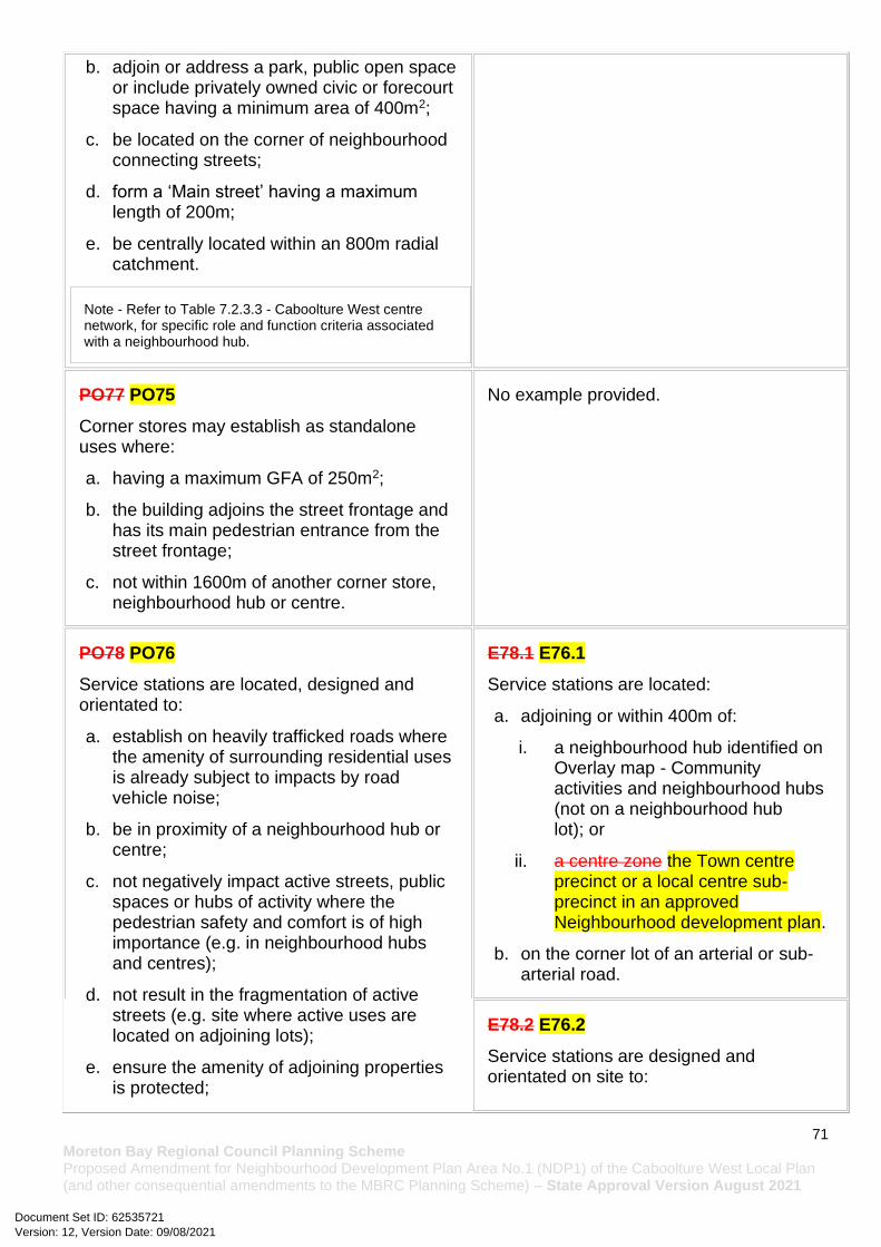
71 Moreton Bay Regional Council Planning Scheme Proposed Amendment for Neighbourhood Development Plan Area No.1 (NDP1) of the Caboolture West Local Plan (and other consequential amendments to the MBRC Planning Scheme) – State Approval Version August 2021
b. adjoin or address a park, public open space or include privately owned civic or forecourt space having a minimum area of 400m2;
c. be located on the corner of neighbourhood connecting streets;
d. form a ‘Main street’ having a maximum length of 200m;
e. be centrally located within an 800m radial catchment.
Note - Refer to Table 7.2.3.3 - Caboolture West centre network, for specific role and function criteria associated with a neighbourhood hub.
PO77 PO75
Corner stores may establish as standalone uses where:
a. having a maximum GFA of 250m2;
b. the building adjoins the street frontage and has its main pedestrian entrance from the street frontage;
c. not within 1600m of another corner store, neighbourhood hub or centre.
No example provided.
PO78 PO76
Service stations are located, designed and orientated to:
a. establish on heavily trafficked roads where the amenity of surrounding residential uses is already subject to impacts by road vehicle noise;
b. be in proximity of a neighbourhood hub or centre;
c. not negatively impact active streets, public spaces or hubs of activity where the pedestrian safety and comfort is of high importance (e.g. in neighbourhood hubs and centres);
d. not result in the fragmentation of active streets (e.g. site where active uses are located on adjoining lots);
e. ensure the amenity of adjoining properties is protected;
E78.1 E76.1
Service stations are located:
a. adjoining or within 400m of:
i. a neighbourhood hub identified on Overlay map - Community activities and neighbourhood hubs (not on a neighbourhood hub lot); or
ii. a centre zone the Town centre precinct or a local centre sub-precinct in an approved Neighbourhood development plan.
b. on the corner lot of an arterial or sub-arterial road.
E78.2 E76.2
Service stations are designed and orientated on site to:
Version: 12, Version Date: 09/08/2021Document Set ID: 62535721
72 Moreton Bay Regional Council Planning Scheme Proposed Amendment for Neighbourhood Development Plan Area No.1 (NDP1) of the Caboolture West Local Plan (and other consequential amendments to the MBRC Planning Scheme) – State Approval Version August 2021
f. reduce the visual impact of the Service station from the streetscape while maintaining surveillance from the site to the street;
g. minimise impacts on adjoining residential uses, to a level suitable relative to expected residential amenity of the area. (e.g. high order road in urban or next generation neighbourhood, likely to be noisy and not like suburban);
h. provide ancillary uses that meet the convenience needs of users.
a. include a landscaping strip having a minimum depth of 1m adjoining all road frontages;
b. building and structures (including fuel pump canopies) are setback a minimum of 3m from the primary and secondary frontage and a minimum of 5m from side and rear boundaries;
c. include a screen fence, of a height and standard in accordance with a noise impact assessment (Note - Noise impact assessments are to be prepared in accordance with Planning scheme policy - Noise), on side and rear boundaries where adjoining land is able to contain a residential use;
d. not include more than 2 driveway crossovers.
PO79 PO77
Non-residential uses (excluding a Service station) address and activate streets and public spaces by:
a. ensuring buildings and individual tenancies address street frontage(s), civic space and other areas of pedestrian movement;
b. new buildings adjoin or are within 3m of the primary frontage(s), civic space or public open space;
c. locating car parking areas and drive-through facilities behind or under buildings to not dominate the street environment;
d. establishing and maintaining interaction, pedestrian activity and casual surveillance through appropriate land uses and building design (e.g. the use of windows or glazing and avoiding blank walls with the use of sleeving);
e. providing visual interest to the façade (e.g. windows or glazing, variation in colour, materials, finishes, articulation, recesses or projections);
f. establishing and maintaining human scale.
No example provided.
Non-residential activities
Version: 12, Version Date: 09/08/2021Document Set ID: 62535721
73 Moreton Bay Regional Council Planning Scheme Proposed Amendment for Neighbourhood Development Plan Area No.1 (NDP1) of the Caboolture West Local Plan (and other consequential amendments to the MBRC Planning Scheme) – State Approval Version August 2021
PO80 PO78
All buildings exhibit a high standard of design and construction, which:
a. adds visual interest to the streetscape (e.g. variation in materials, patterns, textures and colours, cantilevered awning);
b. enables differentiation between buildings;
c. contributes to a safe environment;
d. incorporates architectural features within the building facade at the street level to create human scale (e.g. cantilevered awning);
e. includes building entrances that are readily identifiable from the road frontage;
f. locate and orientate to favour active and public transport usage by connecting to pedestrian footpaths on the street frontage and adjoining sites;
g. incorporate appropriate acoustic treatments, having regard to any adjoining residential uses;
h. facilitate casual surveillance of all public spaces.
No example provided.
PO81 PO79
Development provides functional and integrated car parking and vehicle access, that:
a. prioritises the movement and safety of pedestrians between the street frontage and the entrance to the building;
b. provides safety and security of people and property at all times;
c. does not impede active frontage and active transport options;
d. does not impact on the safe and efficient movement of traffic external to the site;
e. is consolidated and shared with adjoining sites wherever possible.
No example provided.
PO82 PO80 No example provided.
Version: 12, Version Date: 09/08/2021Document Set ID: 62535721

74 Moreton Bay Regional Council Planning Scheme Proposed Amendment for Neighbourhood Development Plan Area No.1 (NDP1) of the Caboolture West Local Plan (and other consequential amendments to the MBRC Planning Scheme) – State Approval Version August 2021
The safety and efficiency of pedestrian movement is prioritised in the design of car parking areas through providing pedestrian paths in car parking areas that are:
a. located along the most direct route between building entrances, car parks and adjoining uses;
b. protected from vehicle intrusion through the use of physical and visual separation (e.g. wheel stops, trees etc);
c. are of a width to allow safe and efficient access for prams and wheelchairs.
PO83 PO81
The number of car parking spaces is managed to:
a. provide for the parking of visitors and employees that is appropriate to the use and the site's proximity to public and active transport options;
b. avoid an oversupply of car parking spaces;
c. avoid the visual impact of large areas of open space parking from road frontages and public areas;
d. promote innovative solutions, including on-street parking and shared parking areas;
e. promote active and public transport options.
Note - Refer to Planning scheme policy - Integrated transport assessment for guidance on how to achieve compliance with this outcome.
E83 E81.1
Car parking is provided in accordance with Table 7.2.3.1.1.4.
Note - The above rates exclude car parking spaces for Dwelling houses and for people with a disability required by Disability Discrimination Act 1992 or the relevant disability discrimination legislation and standards.
E81.2
All car parking areas are designed and constructed in accordance with Australian Standard AS2890.1 Parking facilities Part 1: Off-street car parking.
PO84
Car parking is designed to avoid the visual impact of large areas of surface car parking.
No example provided.
PO85
Car parking design includes innovative solutions, including on-street parking and shared parking areas.
No example provided.
PO86 PO82 E86.1 E82.1
Version: 12, Version Date: 09/08/2021Document Set ID: 62535721

75 Moreton Bay Regional Council Planning Scheme Proposed Amendment for Neighbourhood Development Plan Area No.1 (NDP1) of the Caboolture West Local Plan (and other consequential amendments to the MBRC Planning Scheme) – State Approval Version August 2021
a. End of trip facilities are provided for employees or occupants, in the building or on-site within a reasonable walking distance, and include:
i. adequate bicycle parking and storage facilities; and
ii. adequate provision for securing belongings; and
iii. change rooms that include adequate showers, sanitary compartments, wash basins and mirrors.
b. Notwithstanding a. there is no requirement to provide end of trip facilities if it would be unreasonable to provide these facilities having regard to:
i. the projected population growth and forward planning for road upgrading and development of cycle paths; or
ii. whether it would be practical to commute to and from the building on a bicycle, having regard to the likely commute distances and nature of the terrain; or
iii. the condition of the road and the nature and amount of traffic potentially affecting the safety of commuters.
Editor's note - The intent of b above is to ensure the requirements for bicycle parking and end of trip facilities are not applied in unreasonable circumstances. For example these requirements should not, and do not apply in the Rural living precinct Rural zone or the Rural residential zone etc.
Editor's note - This performance outcome is the same as the Performance Requirement prescribed for end of trip facilities under the Queensland Development Code. For development incorporating building work, that Queensland Development Code performance requirement cannot be altered by a local planning instrument and has been reproduced here solely for information purposes. Council’s assessment in its building work concurrence agency role for end of trip facilities will be against the performance requirement in the Queensland Development Code. As it is subject to change at any time, applicants for development incorporating building work should ensure that proposals that do not comply with the examples under this heading meet the current performance requirement prescribed in the Queensland Development Code.
Minimum bicycle parking facilities are provided in accordance with the table below (rounded up to the nearest whole number).
Use Minimum Bicycle Parking
Residential uses comprised of dwellings
Minimum 1 space per dwelling
All other residential uses
Minimum 1 space per 2 car parking spaces identified in Schedule 7 – car parking
Non-residential uses
Minimum 1 space per 200m2 of GFA
Editor's note - The examples for end of trip facilities prescribed under the Queensland Development Code permit a local planning instrument to prescribe facility levels higher than the default levels identified in those acceptable solutions. This example is a combination of the default levels set for end of trip facilities in the Queensland Development Code and the additional facilities required by Council.
E86.2 E82.2
Bicycle parking is:
a. provided in accordance with Austroads (2008), Guide to Traffic Management - Part 11: Parking;
b. protected from the weather by its location or a dedicated roof structure;
c. located within the building or in a dedicated, secure structure for residents and staff;
d. adjacent to building entrances or in public areas for customers and visitors.
Note - Bicycle parking structures are to be constructed to the standards prescribed in AS2890.3.
Note - Bicycle parking and end of trip facilities provided for residential and non-residential activities may be pooled, provided they are within 100 metres of the entrance to the building.
Version: 12, Version Date: 09/08/2021Document Set ID: 62535721
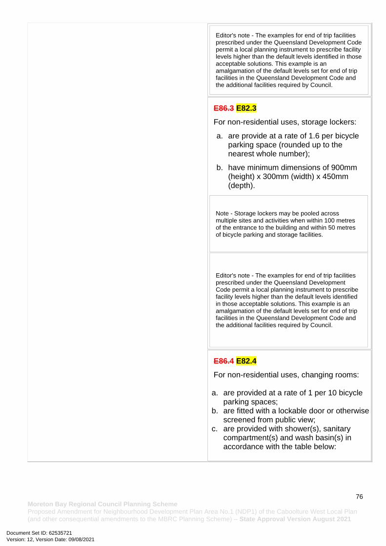
76 Moreton Bay Regional Council Planning Scheme Proposed Amendment for Neighbourhood Development Plan Area No.1 (NDP1) of the Caboolture West Local Plan (and other consequential amendments to the MBRC Planning Scheme) – State Approval Version August 2021
Editor's note - The examples for end of trip facilities prescribed under the Queensland Development Code permit a local planning instrument to prescribe facility levels higher than the default levels identified in those acceptable solutions. This example is an amalgamation of the default levels set for end of trip facilities in the Queensland Development Code and the additional facilities required by Council.
E86.3 E82.3
For non-residential uses, storage lockers:
a. are provide at a rate of 1.6 per bicycle parking space (rounded up to the nearest whole number);
b. have minimum dimensions of 900mm (height) x 300mm (width) x 450mm (depth).
Note - Storage lockers may be pooled across multiple sites and activities when within 100 metres of the entrance to the building and within 50 metres of bicycle parking and storage facilities.
Editor's note - The examples for end of trip facilities prescribed under the Queensland Development Code permit a local planning instrument to prescribe facility levels higher than the default levels identified in those acceptable solutions. This example is an amalgamation of the default levels set for end of trip facilities in the Queensland Development Code and the additional facilities required by Council.
E86.4 E82.4
For non-residential uses, changing rooms:
a. are provided at a rate of 1 per 10 bicycle parking spaces;
b. are fitted with a lockable door or otherwise screened from public view;
c. are provided with shower(s), sanitary compartment(s) and wash basin(s) in accordance with the table below:
Version: 12, Version Date: 09/08/2021Document Set ID: 62535721

77 Moreton Bay Regional Council Planning Scheme Proposed Amendment for Neighbourhood Development Plan Area No.1 (NDP1) of the Caboolture West Local Plan (and other consequential amendments to the MBRC Planning Scheme) – State Approval Version August 2021
Bicycle spaces provided
Male/ Female
Change rooms required
Showers required
Sanitary compartments required
Washbasins required
1-5 Male and female
1 unisex change room
1 1 closet pan 1
6-19 Female
1 1 1 closet pan 1
20 or more
Male 1 1 1 closet pan 1
Female
1 2, plus 1 for every 20 bicycle spaces provided thereafter
2 closet pans, plus 1 sanitary compartment for every 60 bicycle parking spaces provided thereafter
1, plus 1 for every 60 bicycle parking spaces provided thereafter
Male 1 2, plus 1 for every 20 bicycle spaces provided thereafter
1 urinal and 1 closet pans, plus 1 sanitary compartment at the rate of 1 closet pan or 1 urinal for every 60 bicycle space provided thereafter
1, plus 1 for every 60 bicycle parking spaces provided thereafter
Note - All showers have a minimum 3-star Water Efficiency Labelling and Standards (WELS) rating shower head.
Note - All sanitary compartments are constructed in compliance with F2.3 (e) and F2.5 of BCA (Volume 1).
d. are provided with:
Version: 12, Version Date: 09/08/2021Document Set ID: 62535721

78 Moreton Bay Regional Council Planning Scheme Proposed Amendment for Neighbourhood Development Plan Area No.1 (NDP1) of the Caboolture West Local Plan (and other consequential amendments to the MBRC Planning Scheme) – State Approval Version August 2021
i. a mirror located above each wash basin;
ii. a hook and bench seating within each shower compartment;
iii. a socket-outlet located adjacent to each wash basin.
Note - Change rooms may be pooled across multiple sites, residential and non-residential activities when within 100 metres of the entrance to the building and within 50 metres of bicycle parking and storage facilities
Editor's note - The examples for end of trip facilities prescribed under the Queensland Development Code permit a local planning instrument to prescribe facility levels higher than the default levels identified in those acceptable solutions. This example is an amalgamation of the default levels set for end of trip facilities in the Queensland Development Code and the additional facilities required by Council.
PO87 PO83
Bins and bin storage area/s are designed, located and managed to prevent amenity impacts on the locality.
E87 E83
Development is designed to meet the criteria in the Planning scheme policy - Waste and is demonstrated in a waste management program.
PO88 PO84
On-site landscaping is provided, that:
a. is incorporated into the design of the development;
b. reduces the dominance of car parking and servicing areas from the street frontage;
c. retains mature trees wherever possible;
d. does not create safety or security issues by creating potential concealment areas or interfering with sight lines;
e. maintains the achievement of active frontages and sight lines for casual surveillance.
Note - All landscaping is to accord with Planning scheme policy - Integrated design.
No example provided.
PO89 PO85 E89 E85
Version: 12, Version Date: 09/08/2021Document Set ID: 62535721

79 Moreton Bay Regional Council Planning Scheme Proposed Amendment for Neighbourhood Development Plan Area No.1 (NDP1) of the Caboolture West Local Plan (and other consequential amendments to the MBRC Planning Scheme) – State Approval Version August 2021
Surveillance and overlooking are maintained between the road frontage and the main building line.
No fencing is provided forward of the building line.
PO90 PO86
Lighting is designed to provide adequate levels of illumination to public and communal spaces to maximise safety and minimise adverse impacts on residential and other sensitive land uses.
No example provided.
PO91 PO87
The hours of operation minimise adverse amenity impacts on adjoining sensitive land uses.
E91 E87
Hours of operation do not exceed 6:00am to 9:00pm Monday to Sunday.
Values and constraints criteria
Note - The relevant values and constraints criteria do not apply where the development is consistent with a current Development permit for Reconfiguring a lot or Material change of use or Operational work, where that approval has considered and addressed (e.g. through a development footprint plan (or similar in the case of Landslide hazard) or conditions of approval) the identified value or constraint under this planning scheme.
Acid sulfate soils - (refer Overlay map - Acid sulfate soils to determine if the following assessment criteria apply)
Note - To demonstrate achievement of the performance outcome, an Acid sulfate soils (ASS) investigation report and soil management plan is prepared by a qualified engineer. Guidance for the preparation an ASS investigation report and soil management plan is provided in Planning scheme policy - Acid sulfate soils.
PO92 PO88
Development avoids disturbing acid sulfate soils. Where development disturbs acid sulfate soils, development:
a. is managed to avoid or minimise the release of surface or groundwater flows containing acid and metal contaminants into the environment;
b. protects the environmental and ecological values and health of receiving waters;
c. protects buildings and infrastructure from the effects of acid sulfate soils.
E92 E88
Development does not involve:
a. excavation or otherwise removing of more than 100m3 of soil or sediment where below than 5m Australian Height datum AHD; or
b. filling of land of more than 500m3 of material with an average depth of 0.5m or greater where below the 5m Australian Height datum AHD.
Heritage and landscape character (refer Overlay map - Heritage and landscape character to determine if the following assessment criteria apply)
Version: 12, Version Date: 09/08/2021Document Set ID: 62535721
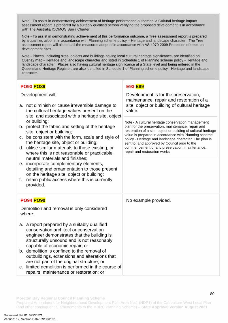
80 Moreton Bay Regional Council Planning Scheme Proposed Amendment for Neighbourhood Development Plan Area No.1 (NDP1) of the Caboolture West Local Plan (and other consequential amendments to the MBRC Planning Scheme) – State Approval Version August 2021
Note - To assist in demonstrating achievement of heritage performance outcomes, a Cultural heritage impact assessment report is prepared by a suitably qualified person verifying the proposed development is in accordance with The Australia ICOMOS Burra Charter.
Note - To assist in demonstrating achievement of this performance outcome, a Tree assessment report is prepared by a qualified arborist in accordance with Planning scheme policy – Heritage and landscape character. The Tree assessment report will also detail the measures adopted in accordance with AS 4970-2009 Protection of trees on development sites.
Note - Places, including sites, objects and buildings having local cultural heritage significance, are identified on Overlay map - Heritage and landscape character and listed in Schedule 1 of Planning scheme policy - Heritage and landscape character. Places also having cultural heritage significance at a State level and being entered in the Queensland Heritage Register, are also identified in Schedule 1 of Planning scheme policy - Heritage and landscape character.
PO93 PO89
Development will:
a. not diminish or cause irreversible damage to the cultural heritage values present on the site, and associated with a heritage site, object or building;
b. protect the fabric and setting of the heritage site, object or building;
c. be consistent with the form, scale and style of the heritage site, object or building;
d. utilise similar materials to those existing, or where this is not reasonable or practicable, neutral materials and finishes;
e. incorporate complementary elements, detailing and ornamentation to those present on the heritage site, object or building;
f. retain public access where this is currently provided.
E93 E89
Development is for the preservation, maintenance, repair and restoration of a site, object or building of cultural heritage value.
Note - A cultural heritage conservation management plan for the preservation, maintenance, repair and restoration of a site, object or building of cultural heritage value is prepared in accordance with Planning scheme policy - Heritage and landscape character. The plan is sent to, and approved by Council prior to the commencement of any preservation, maintenance, repair and restoration works.
PO94 PO90
Demolition and removal is only considered where:
a. a report prepared by a suitably qualified conservation architect or conservation engineer demonstrates that the building is structurally unsound and is not reasonably capable of economic repair; or
b. demolition is confined to the removal of outbuildings, extensions and alterations that are not part of the original structure; or
c. limited demolition is performed in the course of repairs, maintenance or restoration; or
No example provided.
Version: 12, Version Date: 09/08/2021Document Set ID: 62535721
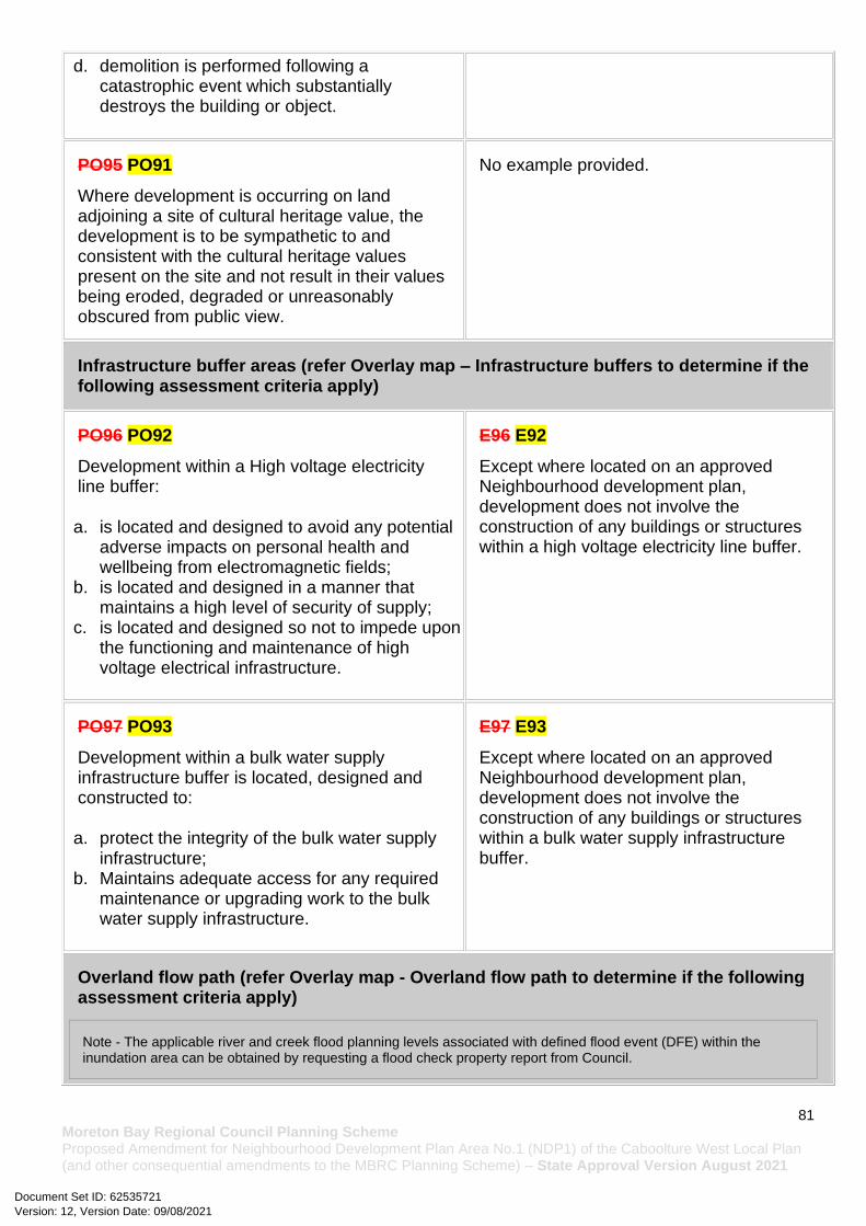
81 Moreton Bay Regional Council Planning Scheme Proposed Amendment for Neighbourhood Development Plan Area No.1 (NDP1) of the Caboolture West Local Plan (and other consequential amendments to the MBRC Planning Scheme) – State Approval Version August 2021
d. demolition is performed following a catastrophic event which substantially destroys the building or object.
PO95 PO91
Where development is occurring on land adjoining a site of cultural heritage value, the development is to be sympathetic to and consistent with the cultural heritage values present on the site and not result in their values being eroded, degraded or unreasonably obscured from public view.
No example provided.
Infrastructure buffer areas (refer Overlay map – Infrastructure buffers to determine if the following assessment criteria apply)
PO96 PO92
Development within a High voltage electricity line buffer:
a. is located and designed to avoid any potential adverse impacts on personal health and wellbeing from electromagnetic fields;
b. is located and designed in a manner that maintains a high level of security of supply;
c. is located and designed so not to impede upon the functioning and maintenance of high voltage electrical infrastructure.
E96 E92
Except where located on an approved Neighbourhood development plan, development does not involve the construction of any buildings or structures within a high voltage electricity line buffer.
PO97 PO93
Development within a bulk water supply infrastructure buffer is located, designed and constructed to:
a. protect the integrity of the bulk water supply infrastructure;
b. Maintains adequate access for any required maintenance or upgrading work to the bulk water supply infrastructure.
E97 E93
Except where located on an approved Neighbourhood development plan, development does not involve the construction of any buildings or structures within a bulk water supply infrastructure buffer.
Overland flow path (refer Overlay map - Overland flow path to determine if the following assessment criteria apply)
Note - The applicable river and creek flood planning levels associated with defined flood event (DFE) within the inundation area can be obtained by requesting a flood check property report from Council.
Version: 12, Version Date: 09/08/2021Document Set ID: 62535721

82 Moreton Bay Regional Council Planning Scheme Proposed Amendment for Neighbourhood Development Plan Area No.1 (NDP1) of the Caboolture West Local Plan (and other consequential amendments to the MBRC Planning Scheme) – State Approval Version August 2021
PO98 PO94
Development:
a. minimises the risk to persons from overland flow;
b. does not increase the potential for damage from overland flow either on the premises or other premises, public land, watercourses, roads or infrastructure.
No example provided.
PO99 PO95
Development:
a. maintains the conveyance of overland flow predominantly unimpeded through the premises for any event up to and including the 1% AEP for the fully developed upstream catchment;
b. does not concentrate, intensify or divert overland flow onto an upstream, downstream or surrounding property.
Note - A report from a suitably qualified Registered Professional Engineer Queensland is required certifying that the development does not increase the potential for significant adverse impacts on an upstream, downstream or surrounding premises.
Note - Reporting to be prepared in accordance with Planning scheme policy – Flood hazard, Coastal hazard and Overland flow.
No example provided.
PO100 PO96
Development does not:
a. directly, indirectly or cumulatively cause any increase in overland flow velocity or level;
b. increase the potential for flood damage from overland flow either on the premises or other premises, public lands, watercourses, roads or infrastructure.
Note - Open concrete drains greater than 1m in width are not an acceptable outcome, nor are any other design options that may increase scouring.
No example provided.
PO101 PO97 E101 E97
Version: 12, Version Date: 09/08/2021Document Set ID: 62535721
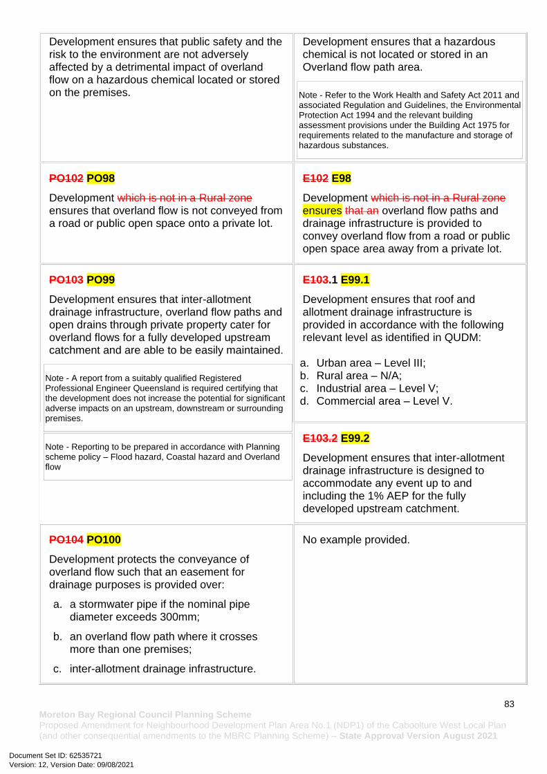
83 Moreton Bay Regional Council Planning Scheme Proposed Amendment for Neighbourhood Development Plan Area No.1 (NDP1) of the Caboolture West Local Plan (and other consequential amendments to the MBRC Planning Scheme) – State Approval Version August 2021
Development ensures that public safety and the risk to the environment are not adversely affected by a detrimental impact of overland flow on a hazardous chemical located or stored on the premises.
Development ensures that a hazardous chemical is not located or stored in an Overland flow path area.
Note - Refer to the Work Health and Safety Act 2011 and associated Regulation and Guidelines, the Environmental Protection Act 1994 and the relevant building assessment provisions under the Building Act 1975 for requirements related to the manufacture and storage of hazardous substances.
PO102 PO98
Development which is not in a Rural zone ensures that overland flow is not conveyed from a road or public open space onto a private lot.
E102 E98
Development which is not in a Rural zone ensures that an overland flow paths and drainage infrastructure is provided to convey overland flow from a road or public open space area away from a private lot.
PO103 PO99
Development ensures that inter-allotment drainage infrastructure, overland flow paths and open drains through private property cater for overland flows for a fully developed upstream catchment and are able to be easily maintained.
Note - A report from a suitably qualified Registered Professional Engineer Queensland is required certifying that the development does not increase the potential for significant adverse impacts on an upstream, downstream or surrounding premises.
Note - Reporting to be prepared in accordance with Planning scheme policy – Flood hazard, Coastal hazard and Overland flow
E103.1 E99.1
Development ensures that roof and allotment drainage infrastructure is provided in accordance with the following relevant level as identified in QUDM:
a. Urban area – Level III; b. Rural area – N/A; c. Industrial area – Level V; d. Commercial area – Level V.
E103.2 E99.2
Development ensures that inter-allotment drainage infrastructure is designed to accommodate any event up to and including the 1% AEP for the fully developed upstream catchment.
PO104 PO100
Development protects the conveyance of overland flow such that an easement for drainage purposes is provided over:
a. a stormwater pipe if the nominal pipe diameter exceeds 300mm;
b. an overland flow path where it crosses more than one premises;
c. inter-allotment drainage infrastructure.
No example provided.
Version: 12, Version Date: 09/08/2021Document Set ID: 62535721

84 Moreton Bay Regional Council Planning Scheme Proposed Amendment for Neighbourhood Development Plan Area No.1 (NDP1) of the Caboolture West Local Plan (and other consequential amendments to the MBRC Planning Scheme) – State Approval Version August 2021
Note - Refer to Planning scheme policy - Integrated design for details and examples.
Note - Stormwater Drainage easement dimensions are provided in accordance with Section 3.8.5 of QUDM.
Additional criteria for development for a Park
PO105 PO101
Development for a Park(57) ensures that the design and layout responds to the nature of the overland flow affecting the premises such that:
a. public benefit and enjoyment is maximised;
b. impacts on the asset life and integrity of park structures is minimised;
c. maintenance and replacement costs are minimised.
E105 E101
Development for a Park(57) ensures works are provided in accordance with the requirements set out in Appendix B of the Planning scheme policy - Integrated design.
Table 7.2.3.1.1.2 Setbacks
Residential uses
Height of wall
Frontage primary Frontage secondary to street
Frontage secondary to lane
Side non-built to boundary wall To OMP and wall
Rear To OMP and wall
Trafficable water body To OMP and wall
To wall
To OMP
To covered car parking space*
To wall
To OMP
To covered car parking space*
To OMP and wall
Less than 4.5m
Min 3m
Min 2m
Min 5.4m
Min 2m
Min 1m
Min 5.4m
Min 0.5m Min 1.5m Min 1.5m
Min 4.5m
4.5m to 8.5m
Min 3m
Min 2m
N/A Min 2m
Min 1m
N/A Min 0.5m Min 2m Min 2m
Min 4.5m
Greater than 8.5m
Min 6m
Min 5m
N/A Min 3m
Min 2m
N/A Min 0.5m Min 2m up to 8.5m in height; plus 0.5m for every 3m in height (or
Min 5m
Min 4.5m
Version: 12, Version Date: 09/08/2021Document Set ID: 62535721
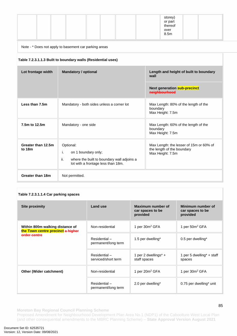
85 Moreton Bay Regional Council Planning Scheme Proposed Amendment for Neighbourhood Development Plan Area No.1 (NDP1) of the Caboolture West Local Plan (and other consequential amendments to the MBRC Planning Scheme) – State Approval Version August 2021
storey) or part thereof over 8.5m
Note - * Does not apply to basement car parking areas
Table 7.2.3.1.1.3 Built to boundary walls (Residential uses)
Lot frontage width Mandatory / optional Length and height of built to boundary wall
Next generation sub-precinct neighbourhood
Less than 7.5m Mandatory - both sides unless a corner lot Max Length: 80% of the length of the boundary Max Height: 7.5m
7.5m to 12.5m Mandatory - one side Max Length: 60% of the length of the boundary Max Height: 7.5m
Greater than 12.5m to 18m
Optional:
i. on 1 boundary only;
ii. where the built to boundary wall adjoins a lot with a frontage less than 18m.
Max Length: the lesser of 15m or 60% of the length of the boundary Max Height: 7.5m
Greater than 18m Not permitted.
Table 7.2.3.1.1.4 Car parking spaces
Site proximity Land use Maximum number of car spaces to be provided
Minimum number of car spaces to be provided
Within 800m walking distance of the Town centre precinct a higher order centre
Non-residential 1 per 30m2 GFA 1 per 50m2 GFA
Residential – permanent/long term
1.5 per dwelling* 0.5 per dwelling*
Residential – serviced/short term
1 per 2 dwellings* + staff spaces
1 per 5 dwelling* + staff spaces
Other (Wider catchment) Non-residential 1 per 20m2 GFA 1 per 30m2 GFA
Residential – permanent/long term
2.0 per dwelling* 0.75 per dwelling* unit
Version: 12, Version Date: 09/08/2021Document Set ID: 62535721

86 Moreton Bay Regional Council Planning Scheme Proposed Amendment for Neighbourhood Development Plan Area No.1 (NDP1) of the Caboolture West Local Plan (and other consequential amendments to the MBRC Planning Scheme) – State Approval Version August 2021
Residential – serviced/short term
1 per dwelling* + staff spaces
1 per 5 dwellings* + staff spaces
Note - Car parking rates are to be rounded up to the nearest whole number.
Note - * Where Dwellings are not being established (e.g. beds and communal area) the car parking rate specified above is to be provided per Non-residential GFA.
Note - Allocation of car parking spaces to dwellings is at the discretion of the developer.
Note - Residential - Permanent/long term includes: Multiple dwelling(49), Relocatable home park(62), Residential care facility(65), Retirement facility(67).
Note - Residential - Serviced/short term includes: Rooming accommodation(69) or Short-term accommodation(77).
Version: 12, Version Date: 09/08/2021Document Set ID: 62535721