7.0 the frederick lodge site complex and research contexts
TRANSCRIPT

Frederick Lodge Site Complex
7-1
7.0 THE FREDERICK LODGE SITE COMPLEX AND RESEARCH CONTEXTS
The goal of this section of the report is to consider the various lines of evidence that enable us to understand how and why American Indians chose to live and work at the Frederick Lodge Site Complex landscape over roughly eight millennia. Because those of us living in a modern world are far removed in time and lifeways from Delaware’s pre-European population, it is critical to address this issue by focusing the research questions raised in Section 2.0. The specific locations on the Frederick Lodge landscape that we have designated as archaeological sites were a part of a settlement-subsistence system with social and economic links that likely stretched widely beyond this part of Delaware. The research areas addressed here begin with the basic questions archaeologists ask about pre-Contact American Indians and are expanded to create a more humanistic view of the past: creating a chronological framework; technology, materiality, and social processes; scales of social organization; paleoenvironmental studies; and, a landscape approach. 7.1 Creating a Chronological Framework
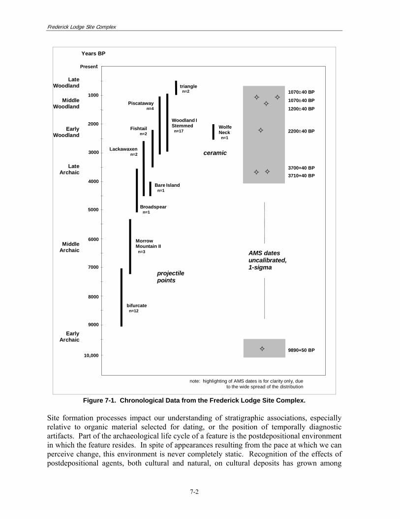
The chronological data from the Frederick Lodge Site Complex are plotted together in Figure 7-1. The AMS dates are reported by the consulting lab as probability distributions, using 1-sigma confidence intervals based on uncalibrated conventional radiocarbon ages. Due both to the precision of the AMS technique (sigma is typically ±40 years) and the scale of the chart, the dates appear as points rather than lines. Two radiocarbon assays that returned modern ages were not included in the chart. The lengths of the lines representing the artifact types indicate the generally accepted time range for each form, while frequencies of occurrence are noted as sample sizes. 7.1.1 Stratigraphy and Site Formation Processes
Understanding stratigraphic associations is the initial step for creating a chronological framework for the Frederick Lodge Site Complex. The relationships between the data of known temporal range and the surrounding non-diagnostic materials were assessed through detailed examination of both horizontal and vertical contexts. Detailed examination of both horizontal and vertical contexts helped reveal the relationships between data of known temporal range and the surrounding non-diagnostic material. In this sense, stratigraphic association was a critical form of relative chronological data used in the analysis of the Frederick Lodge Site Complex. The results of contextual analyses were detailed in Section 6.0, in which several forms of evidence regarding sedimentary and cultural stratigraphy at Frederick Lodge were examined and evaluated. The surface of the Frederick Lodge Site Complex had been plowed repeatedly, yet sub-plow zone deposits were present in several locations across the landform. These deposits were relatively undisturbed, particularly in comparison with the overlying plow-disturbed layer. Yet, in many of these areas cultural deposition below the plow zone was shallow and contained multiple component occupations than had become intermixed, either contemporaneously, as open ground surfaces were re-occupied, or post-depositionally, as the debris from thinly separated occupations was combined through the effects of natural soil disturbances.
Frederick Lodge Site Complex
7-2
AMS datesuncalibrated,1-sigma
1070±40 BP
1200±40 BP
2200±40 BP
3700+40 BP3710+40 BP
9890+50 BP
1070±40 BP
Present
4000
6000
8000
10,000
1000
2000
5000
7000
9000
projectilepoints
triangle n=2
Piscataway n=4
Woodland IStemmed n=17
Lackawaxen n=2
Fishtail n=2
Years BP
LateWoodland
MiddleWoodland
LateArchaic
MiddleArchaic
EarlyArchaic
EarlyWoodland
Bare Island n=1
MorrowMountain II n=3
bifurcate n=12
Broadspear n=1
note: highlighting of AMS dates is for clarity only, dueto the wide spread of the distribution
WolfeNeck n=1
ceramic3000
Figure 7-1. Chronological Data from the Frederick Lodge Site Complex.
Site formation processes impact our understanding of stratigraphic associations, especially relative to organic material selected for dating, or the position of temporally diagnostic artifacts. Part of the archaeological life cycle of a feature is the postdepositional environment in which the feature resides. In spite of appearances resulting from the pace at which we can perceive change, this environment is never completely static. Recognition of the effects of postdepositional agents, both cultural and natural, on cultural deposits has grown among

Frederick Lodge Site Complex
7-3
archaeologists over the past few decades and has led to the documentation of potential disturbance processes (Wood and Johnson 1978; Schiffer 1987). 7.1.2 Temporally Diagnostic Artifacts
The resolution brought to chronology by the various temporally diagnostic artifacts types varies considerably, depending on the data available concerning the specific types. Some artifacts, like the bifurcate points, are better understood chronologically, having relatively distinctive shapes and well- documented temporal ranges that do not appear to overlap substantially with many other types. Others have more generalized shapes and time ranges that reach across periods of wider cultural transition. The ranges of Lackawaxen and Fishtail points, for example, span the generalized foraging adaptations characteristic of the latter end of the Late Archaic period and the introduction of ceramics and increasingly sedentary patterns of settlement of the Woodland period. These two point types also encompass a period during which a proliferation of point styles has long been acknowledged as a hindrance to detailed chronological and contextual interpretation (Evans 1984; Custer 1994). The particular temporal implications of Woodland I Stemmed points at the Frederick Lodge Site Complex represent another case of a common, but imprecisely dated, diagnostic artifact. Nevertheless, the points provide an overall time frame within which to assess the depositional contexts at the site, and in so doing, they assist in identifying specific component assemblages that can be used to interpret site use. In addition, a single typable ceramic sherd was recovered. This Wolf Neck sherd supports the presence of a Woodland period component at Frederick Lodge. It is worth emphasizing here that artifacts used in this way are diagnostic of time only. They are a means of marking change in material culture over time, and material culture is only one aspect of culture as a whole. Artifacts are thus not necessarily indicators of socio-political units or boundaries, and while they may often mark those boundaries, they as often may not. 7.1.3 AMS Assays
Ideally, radiocarbon assays can provide a fairly precise age for discrete occupations—as opposed to the broad temporal ranges typically associated with diagnostic stone and ceramic artifacts. The nine radiocarbon assays from Frederick Lodge span a range beginning with the Paleoindian period and continuing into the modern era, with three assays obtained from discrete cultural features (Table 7-1). Two of the assays—one from Feature 2 (Beta-149968) and one from Feature 32 (Beta-149974)—impinge on the end of the calibration data set and are clearly invalid. One valid radiocarbon assay was obtained from Feature 23 (Beta-149969), placing this cultural feature into the Early Woodland period. Of three assays obtained from Stratum B, Level 2 in Block D, two fall into the Late Archaic period (Beta-149971 and Beta-149973) and the third, apparently invalid date (Beta-149972), was associated with the Paleoindian period. The remaining assays are from bulk soil samples (Beta-150338, Beta-150339, Beta-150340). All three assays straddle the end of the Middle Woodland and beginning of the Late Woodland periods.

Frederick Lodge Site Complex
7-4
Table 7-1. AMS Dates from the Frederick Lodge Complex Sites.
Block Excavation Sample No.
Sample Material Provenience Conventional
Radiocarbon AgeCalibrated Results
(2 Sigma) Probability
(%) 13C/12C
ratio (o/oo)Laboratory Sample No.
B 5001 charcoal (oak)
N285/E575-576, Feature 2, Stratum II, Level-1
150+40 BP AD 1666 to 1784 AD 1795 to 1892 AD 1908 to 1953*
48.1 33.9 18.0
-25.6 Beta-149968
D 5004 charcoal (pine)
N298/E546, Feature 32 220+40 BP
AD 1525 to 1557 AD 1631 to 1695 AD 1726 to 1813 AD 1838 to 1842 AD 1853 to 1867 AD 1874 to 1875 AD 1918 to 1952*
3.1 35.2 46.5 0.2 0.8
0.05 14.2
-26.4 Beta-149974
H 5011 charcoal (unidentified)
N205/E664, Feature 23, Stratum I, Level-2
2220+40 BP BC 387 to 197 100.0 -26.4 Beta-149969
D 5028 charcoal (unidentified)
N294/E551, Stratum B, Level-2 3710+40 BP
BC 2270 to 2259 BC 2206 to 2009 BC 2002 to 1977
0.9 95.3 3.8
-27.4 Beta-149973
D 5029 charcoal (unidentified)
N294/E552, Stratum B, Level-2 3700+40 BP BC 2202 to 1974
BC 1966 to 1966 99.9 0.1 -26.9 Beta-149971
D 5032 charcoal (amorphous carbon)
N296/E549, Stratum B, Level-2 9890+50 BP
BC 9647 to 9608 BC 9523 to 9503 BC 9458 to 9254
2.4 1.2
96.4 -27.0 Beta-149972
K 5040 bulk soil sample
N195/E786, Horizon 2AB, 70cm bs.
1200+40 BP AD 689 to 752 AD 761 to 899 AD 919 to 948
13.8 81.5 4.7
-21.0 Beta-150338
Phase II
unit 5041 bulk soil
sample N195/E715, Horizon 2C 1070+40 BP AD 892 to 1023 100.0 -21.8 Beta-150339
D 5042 bulk soil sample
N295/E535, Horizon 2AB, 67 cm bs.
1070+40 BP AD 892 to 1023 100.0 -22.5 Beta-150340
*Range suspect because impinges on the end of the calibration data set.

Frederick Lodge Site Complex
7-5
7.1.4 Analysis of the Chronological Data
Points and dates clustered in the upper portion of Figure 7-1 (p. 7-2), corresponding with the Woodland period, and in particular, the Early and Middle Woodland subperiods. The lack of early dates may have been as much a function of the preservation of organic material over long periods of time as it was a reflection of occupational intensity at Frederick Lodge. Artifact frequencies indicated occupation almost as intensive during the early portion of the Middle Archaic as in the later, Early/Middle Woodland period, although there was less evidence fire-related activity based on lower thermally altered stone frequencies. Based on analyses of the three forms of temporal data—AMS analyses, diagnostic artifacts, and contextual analyses—single component occupations were identified in several locations. Middle Archaic assemblages were present in two areas: in the western part of Frederick Lodge, on the landform crest in Block D; and in the eastern area on the rim of the larger bay/basin in Block I. A Late Archaic assemblage was present on the bay/basin toe-slope in Block H, and Early/Middle Woodland assemblages were present on the crest in Blocks B, D, and E. The earliest temporal data from Frederick Lodge consisted of an AMS date of 9890±50 years BP (cal 2 σ BC 9647 to 9254; Beta-149972), returned on organic material recovered from the lower levels of Stratum B in Block D. The assay falls into the Paleoindian period, and thus predates the earliest artifactual evidence from the Frederick Lodge Site Complex—the bifurcate points recovered from the same deposit. The finding raised the possibility of site use in one of the earliest periods of known occupation in the Middle Atlantic region, although the specific context for the data is questionable. Definite occupation of the Frederick Lodge Site Complex landscape occurred during the Middle Archaic period, as evidenced by bifurcate points recovered from a number of locations. Artifact assemblages from the period were documented in Block I and Block D, representing locations of intensive activity. Broad use of the landscape was implied by bifurcate points collected on the surface on the central terrace, on the eastern side of the saddle and along the mid-slope of the larger bay/basin, and in a mixed Archaic and Woodland context in Block K, on the eastern crest. Later Middle Archaic occupation was seen in the form of points with morphological affinities to the Morrow Mountain II type. Site use appeared to have been less intensive than was true for the early part of the Middle Archaic. Diagnostic points occurred in several locations on the high ground above the bay/basins: on the western crest in Block D, on the surface of the central terrace, and on the eastern crest in Block K. No artifact assemblages could be related directly to these diagnostic artifacts. Late Archaic site use was similarly widespread but not as intensive, judging from the incidence of diagnostic artifacts dating from the period. A single artifact assemblage could be attributed to the Late Archaic, occurring on the toe-slope of the larger bay/basin in Block H. In that location, a Fishtail point was recovered in association with a thermally altered stone feature (Feature 23) and a distribution of artifacts that suggested a relatively undisturbed deposit. Diagnostic points from the Late Archaic also occurred in

Frederick Lodge Site Complex
7-6
chronologically mixed subsurface deposits on both crests: to the west in Block D, and to the east in Block K. And finally, points occurred on the surface in three areas: the ridge between the two bay/basins, the rim of the larger bay/basin, and to the north of the gravelly knoll. Two AMS assays, 3700±40 BP (cal 2 σ BC 2202 to 1966; Beta-149971) and 3710±40 BP (cal 2 σ BC 2270 to 1977), fell into the first half of the Late Archaic period. Both dates were from unidentified charcoal fragments recovered from the lower levels of Stratum B in the eastern half of Block D, a deposit that was identified as Middle Archaic on the basis of bifurcate points present at that level. The charcoal was not from a feature context, but was part of a sample from the general stratigraphic level in two adjacent units. Also present in the deposit was the charcoal sample noted above that provided an AMS assay from the Paleoindian period. The three AMS dates are not in agreement with the temporally diagnostic artifacts. Given the non-feature contexts for the AMS dates, these probably should be viewed with caution. Evidence from the early portions of the Woodland period was the most abundant at Frederick Lodge, consisting of a variety of diagnostic points, a ceramic sherd, and four AMS assays. Diagnostic points from the Early/Middle Woodland included a number of small Woodland I Stemmed points recovered from block excavations on the western crest (Blocks B, D, and E), and in surface proveniences across most of the Frederick Lodge Site Complex area. Also diagnostic were Piscataway points recovered from mixed excavation contexts in Block K, on the eastern crest, and from a surface provenience in the saddle area between the eastern crest and the central terrace. A single ceramic sherd—a cord-marked, crushed-quartz-tempered ware identified as Wolfe Neck—was recovered during surface collection along the rim of the larger bay/basin west of Block K. A sample of Woodland I Stemmed points occurring on the western crest, above the smaller bay/basin, provided good contextual associations, on the basis of which, an extensive artifact assemblage and several features were ascribed to the Early/Middle Woodland component. The artifact assemblage comprised material from the upper part of the soil profile in Blocks B and D. These deposits included intact sub-plow zone levels in both blocks containing thermally altered stone features, several of which in Block B had been partially disturbed by plowing. Also part of the Early/Middle Woodland component were two additional features: Feature 2, a small thermally altered stone cluster located in intact sediments immediately below the plow line in Block A; and Feature 10, a large pit feature in Block E. Four AMS dates corresponded with the Woodland period. A date from the early part of the period, 2220±40 BP (cal 2 σ BC 387 to 197; Beta-149969), was returned on a fragment of unidentified wood charcoal recovered from Feature 23, a thermally altered stone feature in Block H. Three other dates were from very late in the Middle Woodland or the early Late Woodland. All three of these dates—1200±40 BP (cal 2 σ AD 689 to 948; Beta-150338), and two measured as 1070±40 years BP (cal 2 σ AD 892 to 1023; Beta-150339 and 150340), resulted from bulk soil sampling. The Late Woodland period was very lightly represented at Frederick Lodge. The bases of two triangle points were recovered on the western crest, one from the plow zone in Block D,

Frederick Lodge Site Complex
7-7
and one from immediately below the plow zone in Block B. No additional corroborating evidence from the Late Woodland was recovered from the Frederick Lodge Site Complex, and so the artifacts were assumed to denote non-intensive use by American Indian groups. By implication, any associated non-diagnostic material from the period would have had only minor impact on the composition of earlier component assemblages. Also late were two AMS dates: 220±40 BP (cal 2 σ AD 1525 to 1952; Beta-149974) on pine charcoal; and 150±40 years B.P. (cal 2 σ AD 1666 to 1953l Beta-149968) on oak charcoal. These dates both have ranges that impinge on the end of the radiocarbon calibration data set and should be considered as not valid. 7.2 Technology, Materiality, and Social Processes
The data recovered from the Frederick Lodge Site Complex provided an opportunity to study several aspects of American Indian stone tool manufacturing technology as expressed in the artifact assemblages from the Archaic and Woodland periods. In the first part of this report section, raw material selection is examined. Due to Frederick Lodge’s location on the Coastal Plain, relatively far from primary sources of suitable lithic raw materials, knappers here were assumed to have relied on locally available gravels for lithic tool manufacture, and this proposition is evaluated here. The second part of the section focuses on the Middle Archaic component in Block I. The artifact assemblage in this excavation block contained a large quantity of flaking debris that appeared to represent one or more specific manufacturing activities. Detailed analyses of these materials were undertaken, and the results provide insights into the structure of the flintknapping tradition during this period and the choices made by the artisans who created the stone tools used for a variety of tasks at Frederick Lodge. Further analysis of the single sherd recovered at Frederick Lodge is not presented here, because this represents an isolated find. 7.2.1 Exploitation of Secondary Gravel Sources
Research in Delaware has suggested that stone tool manufacture at sites on the Coastal Plain was largely dependent on secondary sources of pebble and cobble material available in stream beds, cutbanks, and other topographic features. These sources generally represented exposures of the Columbia Formation, coarse-grained sediments formed of glacial outwash deposits that underlie surface soils on the Coastal Plain. Recent data, derived from large, riverine occupation sites, such as the Snapp site (7NC-G-101), Leipsic (7K-C-194A), Puncheon Run (7K-C-51), and Hickory Bluff (7K-C-411), support this notion (Custer and Silber 1995; Custer et al. 1996a; LeeDecker 2001; Petraglia et al. 2005). Additional evidence has come from smaller upland sites, such as Lums Pond (7NC-F-18) and Sandom Branch (7NC-J-227/7NC-J-228), both occurring on terraces overlooking low-order streams (Petraglia et al. 1998; Versar 2011). The Frederick Lodge occupations provided an opportunity to examine lithic remains specifically linked to Archaic and Woodland period occupations in the uplands. The data were examined for distinctive patterns of the selection and use of particular raw material types, and for patterns in the comparative size ranges of the artifacts and gravels. Samples of pebbles and cobbles were collected at locales occurring between 1 and 2 km north of the Frederick Lodge Site Complex, in the Sandom Branch and Blackbird Creek
Frederick Lodge Site Complex
7-8
stream valleys. A detailed presentation of this study is included in the technical report on the Sandom Branch Site Complex (Versar 2011) and is only summarized here. The study samples consisted of eight 5-gallon container loads of gravel from Sandom Branch and five 5-gallon container loads from Blackbird Creek. The samples were collected from gravel bars located in the stream beds, from exposed gravel deposits eroding from the side walls of tributary gullies, and from gravel-bearing C-horizon deposits exposed in the excavation blocks at nearby archaeological sites—the Sandom Branch Site Complex (7NC-J-227/7NC-J-228), and the Blackbird Creek site (7NC-J-195D). Gravel from each sample was sorted by size, using the Wentworth particle-size scale (Wentworth 1922), that classifies rock fragments based on the diameters of their long axis:
1/16 – 2 mm sand 2 – 4 mm granule
4 – 64 mm pebble 64 – 256 mm cobble
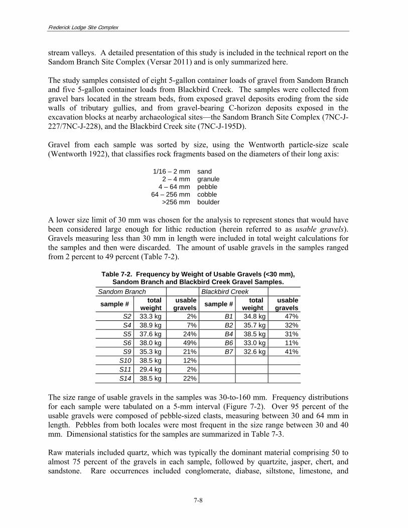
>256 mm boulder A lower size limit of 30 mm was chosen for the analysis to represent stones that would have been considered large enough for lithic reduction (herein referred to as usable gravels). Gravels measuring less than 30 mm in length were included in total weight calculations for the samples and then were discarded. The amount of usable gravels in the samples ranged from 2 percent to 49 percent (Table 7-2).
Table 7-2. Frequency by Weight of Usable Gravels (<30 mm), Sandom Branch and Blackbird Creek Gravel Samples.
Sandom Branch Blackbird Creek
sample # total weight
usable gravels sample # total
weight usable
gravels S2 33.3 kg 2% B1 34.8 kg 47% S4 38.9 kg 7% B2 35.7 kg 32% S5 37.6 kg 24% B4 38.5 kg 31% S6 38.0 kg 49% B6 33.0 kg 11% S9 35.3 kg 21% B7 32.6 kg 41%
S10 38.5 kg 12% S11 29.4 kg 2% S14 38.5 kg 22%
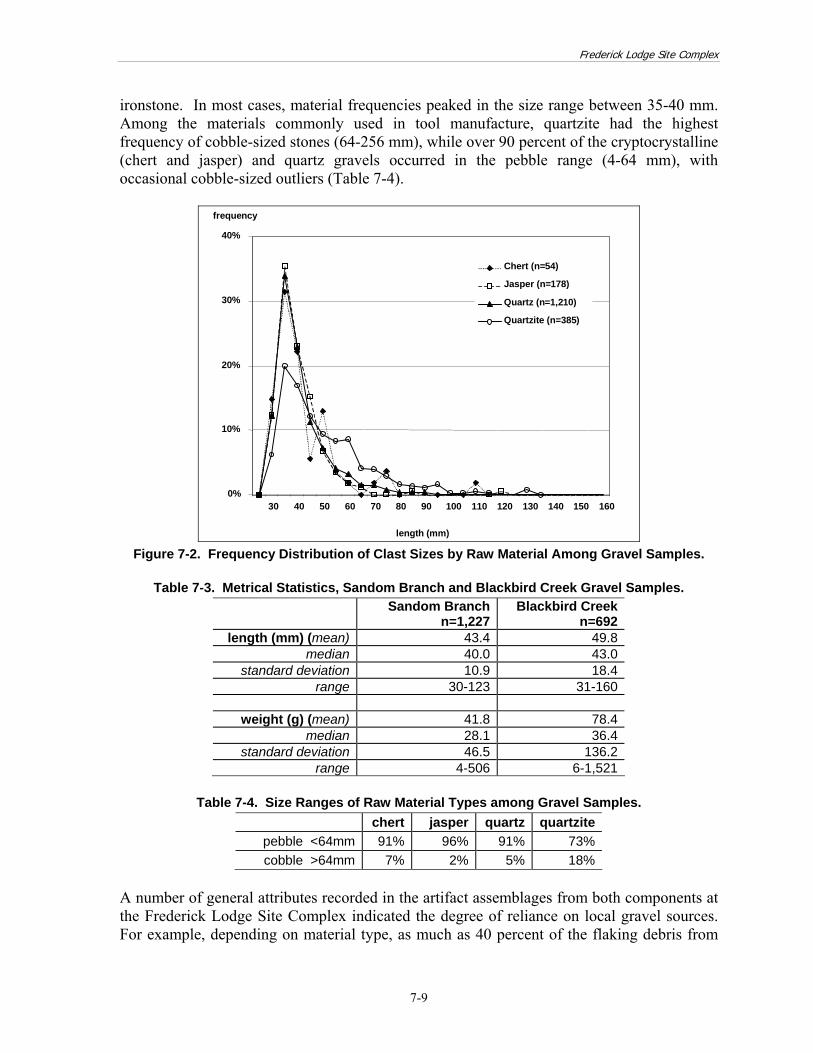
The size range of usable gravels in the samples was 30-to-160 mm. Frequency distributions for each sample were tabulated on a 5-mm interval (Figure 7-2). Over 95 percent of the usable gravels were composed of pebble-sized clasts, measuring between 30 and 64 mm in length. Pebbles from both locales were most frequent in the size range between 30 and 40 mm. Dimensional statistics for the samples are summarized in Table 7-3. Raw materials included quartz, which was typically the dominant material comprising 50 to almost 75 percent of the gravels in each sample, followed by quartzite, jasper, chert, and sandstone. Rare occurrences included conglomerate, diabase, siltstone, limestone, and
Frederick Lodge Site Complex
7-9
ironstone. In most cases, material frequencies peaked in the size range between 35-40 mm. Among the materials commonly used in tool manufacture, quartzite had the highest frequency of cobble-sized stones (64-256 mm), while over 90 percent of the cryptocrystalline (chert and jasper) and quartz gravels occurred in the pebble range (4-64 mm), with occasional cobble-sized outliers (Table 7-4).
0%
10%
20%
30%
40%
30 40 50 60 70 80 90 100 110 120 130 140 150 160
frequency
length (mm)
Jasper (n=178)
Quartz (n=1,210)
Quartzite (n=385)
Chert (n=54)
Figure 7-2. Frequency Distribution of Clast Sizes by Raw Material Among Gravel Samples.
Table 7-3. Metrical Statistics, Sandom Branch and Blackbird Creek Gravel Samples.
Sandom Branchn=1,227
Blackbird Creek n=692
length (mm) (mean) 43.4 49.8 median 40.0 43.0
standard deviation 10.9 18.4 range 30-123 31-160
weight (g) (mean) 41.8 78.4
median 28.1 36.4 standard deviation 46.5 136.2
range 4-506 6-1,521
Table 7-4. Size Ranges of Raw Material Types among Gravel Samples. chert jasper quartz quartzite
pebble <64mm 91% 96% 91% 73% cobble >64mm 7% 2% 5% 18%
A number of general attributes recorded in the artifact assemblages from both components at the Frederick Lodge Site Complex indicated the degree of reliance on local gravel sources. For example, depending on material type, as much as 40 percent of the flaking debris from

Frederick Lodge Site Complex
7-10
each assemblage retained cortex (Table 7-5), implying that primary reduction was commonly practiced at Frederick Lodge. Moreover, bipolar cores were present in most of the assemblages, and several points and bifaces retained cortex on their proximal ends or ventral surfaces. Furthermore, in each assemblage finished tools such as points were small in size, an attribute that may have been connected with limitations of size in the raw materials. Lastly, non-local materials, such as argillite and rhyolite, were generally absent, and when present, they accounted for less than one percent of the raw material in the assemblages. Taken together, these findings suggest that the stone tool artisans at the Frederick Lodge Site Complex operated within restrictions resulting from their reliance on locally lithic raw materials, which limited them to producing relatively small tools.
Table 7-5. Frequency of Cortical Flaking Debris among the Major Raw Materials in Dated Components at the Frederick Lodge Site Complex.
chert jasper cryptocrystalline quartz Middle Archaic
Block I 22% 38% 31% 15% Block D 9% 42% 24% 32%
Early/Middle Woodland Block B 17% 43% 31% 23% Block D 42% 42% 42% 22%
Other choices made by the knappers were clear from analysis of raw material frequencies. Table 7-6 compares the distributions of raw material frequencies of the chipped stone artifacts from each component assemblage with the gravels collected from the two sampling locales. Since all of the gravel samples exhibited similar material frequencies, they were combined for the analysis. The most conspicuous feature of the table was the difference in the relative frequencies of quartz and cryptocrystalline materials among gravels and artifacts. Quartz, for example, comprised over 60 percent of the gravels in the samples, yet constituted only 7 to 21 percent of the artifacts in the assemblages. In contrast, cryptocrystalline material accounted for 12 percent of the gravels, but between 70 and more than 90 percent of the chipped stone assemblages. Quartzite, which comprised 20 percent of the gravels, typically comprised around one percent of the assemblage totals.
Table 7-6. Raw Material Frequencies among Gravel Samples and Chipped Stone Artifacts
Material Type Gravel Sample
Middle Archaic Block I
Middle Archaic Block D
Early/Middle Woodland, Block B
Early/Middle Woodland Block D
Count Freq. Count Freq. Count Freq. Count Freq. Count Freq. quartz 1,210 63% 159 9% 22 7% 23 21% 55 17%
quartzite 385 20% 13 1% 1 <1% 7 7% 3 1% cryptocrystalline 232 12% 1,558 89% 302 93% 76 71% 257 81%
sandstone 71 4% -- -- -- -- -- -- -- -- ironstone 5 <1% 1 <1% -- -- -- -- -- --
argillite -- -- 4 <1% -- -- 1 1% 3 1% rhyolite -- -- 6 <1% -- -- -- -- -- --
other 16 1% 5 <1% -- -- -- -- -- -- totals 1,919 1,746 325 107 318

Frederick Lodge Site Complex
7-11
The more specific implications of these findings pertain largely to raw material selection in the different temporal components present at the Frederick Lodge Site Complex. In all periods, selection processes were apparent, with knappers selecting cryptocrystalline gravels over the considerably more abundant quartz or quartzite clasts. Evidence was also noted in the Middle Archaic assemblage in Block I that conformed to a pattern documented in the Middle Archaic period across Delmarva. By the Middle Archaic, the high-quality knapping materials, including jasper and chert, that had characterized raw material selection during the Paleoindian and Early Archaic periods became less frequently used. Instead, knappers began employing coarse-grained material—and rhyolite in particular—in their manufacturing processes (Stewart 1984; Custer 1986b). At the Frederick Lodge Site Complex, the incidence of non-local, coarse-grained materials was highest in the Middle Archaic assemblage from Block I, and virtually non-existent in other periods. Artifact length was compared with gravel size to determine the proportion of artifacts from the assemblages that could have been derived from the gravels and the proportion derived from larger material presumably imported from elsewhere. The size distributions of cryptocrystalline and quartz gravels are represented by a bar chart at the bottom of Figure 7-3, while the artifact size ranges are represented above as lines drawn to scale along the axis of the chart. The quantity of tools in the assemblages was limited, and many of the tools were fragmented and could not be adequately measured for the analysis. Nevertheless, these data were consistent with interpretations of that local gravels were preferentially selected by Frederick Lodge’s American Indian inhabitants to manufacture stone tools. The measured artifacts fit easily within the dimensional ranges of the gravels. No artifacts exceeded the maximum dimensions of the gravels, implying that all could have been produced from gravel clasts similar in size range to those in the study samples. The mean sizes of the gravels ranged from 45 to 47 mm, depending on material. Points were generally smaller, between 26 and 52 mm. Bifaces had a similar range, 26 to 50 mm, while cores were larger, ranging from 30 to 90 mm. A trend was thus apparent in the range of artifact sizes in that cores were generally the largest items, bifaces were intermediate, and points were smallest; this progression follows the decrease in artifact size that occurs in the typical staged reduction sequence, implying that the artisans generally worked within a contained production system constrained by the size ranges of the local gravels. 7.2.2 Flake Analysis, Middle Archaic Assemblage, Block I
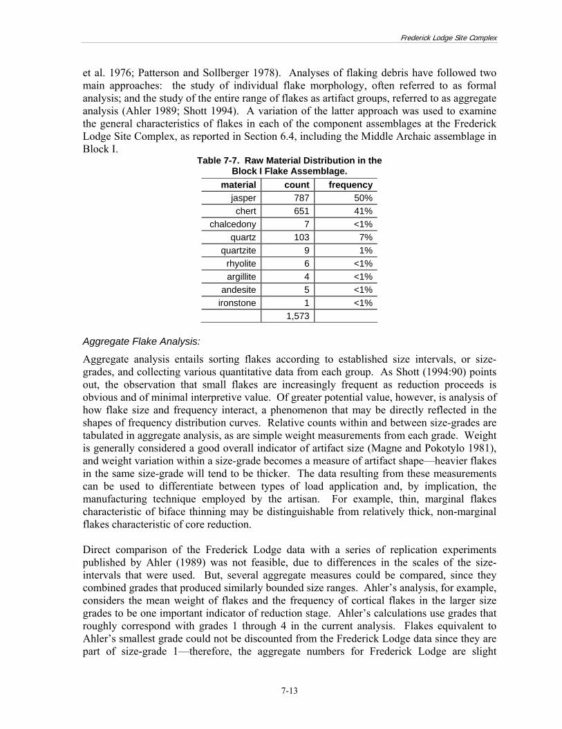
The artifact assemblage recovered in Block I included a large sample of flaking debris: 1,729 artifacts, which included 1,573 flakes and 156 chips (angular flaking debris without clear flake attributes such as striking platforms or paired dorsal and ventral faces). As a group, the flakes were dominated by cryptocrystalline materials—jasper and chert—which together comprised more than 90 percent of the flake assemblage (Table 7-7). Quartz was the third most common raw material in the assemblage. Quartzite and a series of coarse-grained material types that do not usually occur in Coastal Plain deposits, including rhyolite, argillite, andesite, and ironstone, were present in very low quantities.

Frederick Lodge Site Complex
7-12
Figure 7-3. Comparison of Size Distributions of Gravel Samples and Artifacts
from Frederick Lodge Component Assemblages. Stratigraphic and spatial analyses suggested that the flaking debris in Block I represented a discrete, unmixed assemblage from a single occupation during the early portion of the Middle Archaic period, an unusual occurrence in an upland archaeological site in Delmarva. Taking advantage of the opportunity provided by this material, an in-depth study of flake attributes was conducted. Stone tool manufacture is by its nature a process of reduction—tools are shaped by removing material from a central mass or core. Various replication studies have indicated that it is often possible to distinguish between the debris produced by specific reduction processes, particularly between core reduction and biface thinning (Henry
Middle Archaic Block I point core
Middle Archaic Block D biface
Early/Middle Woodland Block Bpoints
coresbiface
points
Early/Middle Woodland Block D
coresbifaces
GRAVEL SIZE RANGE (frequency distribution of gravels using the same size interval as above)
ARTIFACT LENGTH (lines depict the size range of artifact types from each component with reference to the scale below)
length (mm)30 40 50 60 70 80 90
0%
10%
20%
30%
40%
quartz (n=1,210) cryptocrystalline (n=232)
length (mm)30 40 50 60 70 80 90
Frederick Lodge Site Complex
7-13
et al. 1976; Patterson and Sollberger 1978). Analyses of flaking debris have followed two main approaches: the study of individual flake morphology, often referred to as formal analysis; and the study of the entire range of flakes as artifact groups, referred to as aggregate analysis (Ahler 1989; Shott 1994). A variation of the latter approach was used to examine the general characteristics of flakes in each of the component assemblages at the Frederick Lodge Site Complex, as reported in Section 6.4, including the Middle Archaic assemblage in Block I.
Table 7-7. Raw Material Distribution in the Block I Flake Assemblage.
material count frequencyjasper 787 50%chert 651 41%
chalcedony 7 <1%quartz 103 7%
quartzite 9 1%rhyolite 6 <1%argillite 4 <1%
andesite 5 <1%ironstone 1 <1%
1,573 Aggregate Flake Analysis:
Aggregate analysis entails sorting flakes according to established size intervals, or size-grades, and collecting various quantitative data from each group. As Shott (1994:90) points out, the observation that small flakes are increasingly frequent as reduction proceeds is obvious and of minimal interpretive value. Of greater potential value, however, is analysis of how flake size and frequency interact, a phenomenon that may be directly reflected in the shapes of frequency distribution curves. Relative counts within and between size-grades are tabulated in aggregate analysis, as are simple weight measurements from each grade. Weight is generally considered a good overall indicator of artifact size (Magne and Pokotylo 1981), and weight variation within a size-grade becomes a measure of artifact shape—heavier flakes in the same size-grade will tend to be thicker. The data resulting from these measurements can be used to differentiate between types of load application and, by implication, the manufacturing technique employed by the artisan. For example, thin, marginal flakes characteristic of biface thinning may be distinguishable from relatively thick, non-marginal flakes characteristic of core reduction. Direct comparison of the Frederick Lodge data with a series of replication experiments published by Ahler (1989) was not feasible, due to differences in the scales of the size-intervals that were used. But, several aggregate measures could be compared, since they combined grades that produced similarly bounded size ranges. Ahler’s analysis, for example, considers the mean weight of flakes and the frequency of cortical flakes in the larger size grades to be one important indicator of reduction stage. Ahler’s calculations use grades that roughly correspond with grades 1 through 4 in the current analysis. Flakes equivalent to Ahler’s smallest grade could not be discounted from the Frederick Lodge data since they are part of size-grade 1—therefore, the aggregate numbers for Frederick Lodge are slight

Frederick Lodge Site Complex
7-14
underestimates, tending to include more small flakes. Table 7-8 shows the results of the calculations for the experimental data based on the debris from the replication of specific reduction activities, such as unpatterned flake-tool production and biface thinning.
Table 7-8. Aggregate Flake Characteristics from Ahler’s Experimental Data. Mean Weight
Grades 1-3% Cortex
Grades 1-3 Random Flake Production 2.59 g 72%
Hard Hammer Cobble Testing 6.92 g 97% Hard Hammer Bipolar Core
Reduction1.33 g 59%
Hard Hammer 2 Edging 1.78 g 73% Hard Hammer 3/4 Thinning 0.64 g 31%
Soft Hammer 5 Shaping 0.26 g 8% The mean weight calculations for jasper and chert at Frederick Lodge (Table 7-9) corresponded with data from the thinning and shaping tasks in Ahler’s experimental data, while the results for quartz corresponded with earlier stages. Cortical frequencies were more difficult to interpret. The frequncies were low in the Frederick Lodge debris in comparison with the experimental dataset, occurring generally in the range of the biface thinning replications. Yet, the additional small flakes in the Frederick Lodge data decreased the cortical frequency ratio to an undetermined extent. Morever, important differences were recognized in the derivations of the two datasets that complicate the analysis. The experimental replications used raw material from primary outcrops, while the Frederick Lodge data appeared to be derived from secondary gravel deposits, and thus substantially higher cortical frequencies overall would be expected in the Frederick Lodge debris.
Table 7-9. Aggregate Flake Characteristics from Frederick Lodge, by Material Type.
Mean Weight Grades 1-4
% Cortex Grades 1-4
jasper 0.41 g 38%chert 0.37 g 22%
quartz 1.60 g 15% A different application of flake size distribution analysis consists of log-linear modeling, an exercise based on Patterson’s (1990) logarithmic transformations of size frequency distributions. Patterson used experimental and archaeological datasets to demonstrate that biface reduction can produce a distinctive concave curve when size-interval frequencies are plotted on a simple linear graph (Figure 7-4a). He further observed that a semi-log plot of the same data, with size-intervals plotted on a linear scale and frequency on a logarithmic scale, results in a straight-line curve or log-linear regression with a negative slope (Figure 7-4b). Shott (1994:92) further developed the model, plotting several additional sets of published experimental data on the same set of axes (specifically, results from Behm [1983] and Tomka [1989]), noting that there may be a direct relationship between the slope of the line and the reduction stage, with steeper slopes associated with later reduction stages.

Frederick Lodge Site Complex
7-15
0% 10% 20% 30% 40% 50% 60% 70% 80%
10 15 20 25 30 35 40 flake size (mm)
frequency
a) Linear Plot
0.01
0.10
1.00
10 15 20 25 30 35 40 flake size (mm)
log transform of frequency
b) Semi-Log Plot
Figure 7-4. Patterson’s Experimental Biface Reduction Flake Size Distribution Plots. When the Block I data were plotted by material type, jasper and chert showed roughly concave distribution curves, while quartz was more irregular (Figure 7-5). Semi-log plots showed cryptocrystalline materials varying somewhat from the linear distribution projected for biface reduction, with quartz much farther off (Figure 7-6). The cryptocrystalline materials appeared to include a large amount of late stage debris, the quartz considerably less. These findings suggest that there was more early stage reduction of quartz at Frederick Lodge, and more extensive curation/resharpening of cryptocrystalline tools.

Frederick Lodge Site Complex
7-16
size-grade
frequency
0%
10%
20%
30%
40%
50%
60%
1 2 3 4 5
jasper (n=651)chert (n=787)quartz (n=103)
Figure 7-5. Flake Size Distribution (Linear), Block I Assemblage.
0.00
0.01
0.10
1.00
1 2 3 4 5size-grade
log transfrom of frequency
jasper (n=651)chert (n=787) quartz (n=103)
Figure 7-6. Flake Size Distribution (Semi-Log), Block I Assemblage.
Analysis of Flake Breakage Ratios
Analysis of the morphological characteristics of individual flakes is the second major approach taken in the investigation of flaking debris. A number of studies have attempted to define morphological characteristics associated with particular types and phases of stone tool production, typically to differentiate between core reduction and the various stages of biface thinning and finishing. One of the simplest measures proposed involves examining the

Frederick Lodge Site Complex
7-17
relative numbers of complete and broken flakes in the assemblage. Jelinek (1976) observed that manufacturing sites tend to contain more broken flakes, partially worked cores, and bifaces than do occupation sites at which little primary tool production was carried out. Expanding on this idea, Sullivan and Rozen (1985) attempted to quantify the ratio of broken to complete flakes as a means of distinguishing between core reduction and tool production debris. Succeeding commentary on their findings (Amick and Maudlin 1989; Ensor and Roemer 1989; Humphries 2009; Rozen and Sullivan 1989a; 1989b) points to the fact that consensus has yet to be achieved as to the utility of such a ratio as an analytical tool. And in fact, the relationship between flake fragmentation and reduction trajectory is surely more complex than simple ratios can be expected to describe. In addition, assemblages with mixed technologies will obviously be challenging to interpret. Fragmentation rates in the flake assemblage from Block I were high, at or slightly above 80 percent for all material types (Table 7-10). Quartz is a hard and brittle crystalline material, whose structure typically contains internal irregularities that can lead to uneven, uncontrolled flaking and often result in broken or shattered flakes (Boudreau 1981). Thus, it is not uncommon for quartz debitage to be more fragmented than the debitage generated from manufacturing lithic tools from other materials. Yet, in the present sample from the Block I assemblage, broken quartz flakes were no more frequent than those of cryptocrystalline materials and quartzite, suggesting less breakage in relative terms. Assuming that breakage ratios do in fact provide valid data related to reduction trajectories, these results would imply that the artisans treated quartz differently from the other major raw materials in the assemblage, possibly selecting it for producing flake tools rather than bifaces.
Table 7-10. Frequency of Broken Flakes Among Common Material Types in the Block I Assemblage.
material segment count frequencyjasper whole 157 20%
fragment 630 80%chert whole 112 17%
fragment 539 83%quartz whole 15 15%
fragment 88 85%quartzite whole 2 22%
fragment 7 78% Analysis of Flake Platform Attributes
Morphological analyses in flake studies can focus on a variety of attributes associated with the proximal end of individual flakes, where evidence of applied force such as the platform or bulb of percussion is located. Thus, further analysis of the flaking debris from Block I was conducted on a sub-assemblage of lithic debitage, consisting of whole and proximal flakes. The sample included 545 items, roughly one-third of the entire assemblage of flaking debris. Raw materials were distributed in approximately the same frequencies as in the full sample (Table 7-11): over 90 percent of the flakes were cryptocrystalline, with minor amounts of quartz, quartzite, and other coarse-grained materials. Two chalcedony flakes were included with the chert total.

Frederick Lodge Site Complex
7-18
Table 7-11. Raw Material Distribution Among Whole and Proximal Flakes Used in the Platform Attribute Study.
material count frequencyjasper 319 56%chert 206 36%
quartz 31 5%quartzite 4 <1%
other coarse-grained 9 2%
total 569 Variables coded in the analysis and included in the database (Appendix E) are detailed in Table 7-12. The analysis was based on a study conducted by Phagan (1976) on flake assemblages from the highlands of Peru, and used platform attributes defined in that study. The underlying technological assumption of the study was that platform complexity, in terms of both shape and preparation, is related to the stage of reduction: that is, more complex shapes and greater attention to platform preparation are directly associated with later reduction stages and vice versa. Four rectilinear platform shapes—rectangular (RECT), diamond (DIA), triangular (TRI), and square (SQU)—were seen as indicating little or no platform preparation, and thus suggesting initial core shaping. Other platform shapes associated with core shaping included crescent (CRES) and gull wing (GUWG). Lenticular (LENT) and round (RND) platforms were assumed to indicate increased preparation and platform isolation. Semicircular (SEMI) platforms indicated an “excessively strong platform” usually along the margins of a biface or thin core. Among six platform types or surface treatments, cortical (CORT) and single-flake (1FSCAR) surfaces were seen as characteristic of minimal platform preparation, and most likely would have been associated with initial core reduction. The other four categories, 2-3 flake scars (2-3FSCAR), multi-faceted (FACET), crushed (CRHNG), and ground (GROUND), indicated a higher level of platform preparation and concern with greater flaking control. Although not exclusive, these latter platform surfaces were presumed to have been associated with biface reduction. An additional platform attribute, ventral lipping is often associated with soft hammer percussion and later reduction stages, when thinner, narrower, and possibly flatter flakes are produced (Phagan 1976). Flake Dimensions
Length, width, and thickness measurements were virtually the same for complete jasper flakes (n=157) and chert flakes (n=112). In comparison with jasper flakes, quartz flakes (n=15) were the same length (F=1.23, df=1, p=0.270), but were generally thicker (F=26.75, df=1, p=0.000). This finding could relate to either reduction technology or the flaking characteristics of the lithic raw material types.

Frederick Lodge Site Complex
7-19
Table 7-12. Attributes Recorded on Flakes from Middle Archaic Assemblage in Block I. Attribute Type or Measurement
Condition W – whole P – proximal
Length mm Width mm Thickness mm Platform width mm Percent of Cortex mm Flake scars (dorsal surface) Count
Platform Shape
RECT – rectangular DIAM – diamond TRI – triangular SQU – square LENT – lenticular RND – round CRES – crescent GUWG – gull wing SEMI – semi-circular
Platform Surface
CORT – cortex 1FSCAR – one flake scar 2-3FSCAR – two to three flake scars FACET – faceted CRHNG – crushed/hinged GROUND – ground or smoothed
Platform Angle In degrees Ventral Lipping Yes or No Usewear on platform or dorsal surface Yes or No
Flake index is a statistic tabulated by Phagan as a means of estimating overall flaking control. The variable is defined as the surface area of the flake divided by its thickness (Phagan 1976:41). Large index values describe wide, thin flakes (characteristic of biface thinning), while small values describe small, thick flakes (characteristic of a greater variety of technological processes, such as core reduction, early stage biface reduction, or flake tool manufacture). In the Block I assemblage (Table 7-13, the mean values of flake area and flake index were nearly identical for the cryptocrystalline materials, although chert flakes displayed the largest individual flakes. Quartz flakes were slightly larger in terms of flake area; with a greater flake average index, they also appeared to have been thicker, corresponding with the data from direct measurements noted above. Platform Attributes
Bivariate and multivariate analyses were conducted after the individual platform attributes were tabulated. In most of these analyses, the tabulated results for jasper and chert flakes were almost identical, while quartz was quite different. The quartz results could be a factor of small sample size (n=20).

Frederick Lodge Site Complex
7-20
Platform Width
Approximately 75 percent of both jasper and chert platforms were 2 mm or less in width (Figure 7-7). Mean widths were calculated as 1.9 mm for jasper, 1.7 mm for chert. Quartz platforms were considerably wider on average, measuring 3.4 mm.
Table 7-13. Flake Area and Flake Index Calculations for Whole Flakes, Block I Flake Assemblage.
minimum maximum mean chert (n=112)
area 34.2 mm 1,354.6 mm 171.8 mm index 13.1 mm 191.1 mm 62.0 mm
jasper (n=157) area 11.9 mm 855.5 mm 173.2 mm
index 6.3 mm 196.1 mm 59.5 mm quartz (n=15)
area 48.8 mm 595.4 mm 209.7 mm index 30.8 mm 102.2 mm 54.1 mm
Figure 7-7. Distribution of Platform Widths, Block I Assemblage.
Platform Shape
Three platform shapes, LENT, SEMI, CRES were the most frequent overall (Table 7-14). Their distributions were similar among jasper and chert flakes, but fewer LENT platforms occurred among quartz flakes. Rounded flake platforms are considered indicative of a greater degree of platform preparation, since straight edges are more likely to have been trimmed away. To determine whether overriding patterns were present in the data, the platform shapes were grouped as either angular (RECT, DIAM, TRI, SQU) or rounded
0%
10%
20%
30%
40%
50%
60%
1 2 3 4 5 6 7 8 9 10 11
jasper (n=311)chert (n=201)quartz (n=20)
frequency
platform width (mm)

Frederick Lodge Site Complex
7-21
(LENT, RND, CRES, GUWG, SEMI). Between 70 and 75 percent of the cryptocrystalline flakes had platforms in the rounded category, in contrast to about 45 percent of quartz flakes. If rounded platforms do indeed signal a greater degree of platform preparation and thus later stages of reduction, the lower frequency of rounding on quartz flakes implied that more of that debris resulted from early stage work.
Table 7-14. Frequency of Occurrence of Platform Shapes, Block I Flake Assemblage. platform shape jasper (n=311) chert (n=201) quartz (n=20)
angular RECT 8% 4% 15% DIAM 5% 6% 15%
TRI 15% 14% 25% SQU 0% 1% 0%
rounded LENT 30% 28% 5% RND 2% 3% 5% SEMI 17% 18% 25%
CRES 17% 16% 5% GUWG 5% 10% 5%
Platform surface
Platform surfaces were generally simpler on jasper and chert flakes compared to quartz flakes (Table 7-15). While approximately 20 percent of platforms among each of the three materials were plain (1-FSCAR), relatively few quartz platforms were identified as 2-3FSCAR, and a large proportion were identified as multi-faceted (FACET). Given the presumed correlation between platform complexity and reduction stage, these results argue less preparation and an earlier reduction stage for cryptocrystalline materials, and more preparation and thus later reduction stages for quartz. The findings appeared to contradict the findings of the platform shape analysis.
Table 7-15. Frequency of Occurrence of Platform Surfaces, Block I Flake Assemblage.
jasper (311) chert (201) quartz (20) 1FSCAR 21% 21% 20%
2-3FSCAR 35% 29% 15% CORT 14% 13% 5%
CRHNG 14% 22% 30% FACET 8% 8% 25%
GROUND 7% 7% 5% Ventral Lipping
Almost one-third of the cryptocrystalline flakes were lipped, in contrast to 5 percent of quartz flakes. The occurrence of this attribute, which is often considered to be associated with soft-hammer, late stage reduction, suggested a higher incidence of late stage reduction debris among cryptocrystalline flakes than among quartz flakes.
Frederick Lodge Site Complex
7-22
Heat Treatment
Although not part of Phagan’s formal analysis, the occurrence of heat treatment was documented on flaking debris during cataloging. Only cryptocrystalline flakes showed evidence of having been heated, and, of those, by far the largest proportion was jasper: 4 of 201 chert flakes (2 percent), and 98 of 311 jasper flakes (32 percent). The most common sign of heating in the assemblage consisted of reddening, while several flakes were potlidded or had dulled and crazed surfaces. Caution was exercised in interpreting these results. Jasper tends to contain a relatively large amount of iron, which provides its characteristic light brown coloration, and may show evidence of oxidation more than is true of other stone types in the assemblage. Oxidation does not solely register the effects of heating, but can result from other chemical reactions during and after the formation of the stone (Luedtke 1992). In the end, no definitive evidence for systematic heat treatment of jasper was recorded in the assemblage. Bivariate Analyses
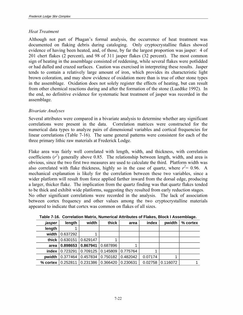
Several attributes were compared in a bivariate analysis to determine whether any significant correlations were present in the data. Correlation matrices were constructed for the numerical data types to analyze pairs of dimensional variables and cortical frequencies for linear correlations (Table 7-16). The same general patterns were consistent for each of the three primary lithic raw materials at Frederick Lodge. Flake area was fairly well correlated with length, width, and thickness, with correlation coefficients (r2) generally above 0.85. The relationship between length, width, and area is obvious, since the two first two measures are used to calculate the third. Platform width was also correlated with flake thickness, highly so in the case of quartz, where r2= 0.96. A mechanical explanation is likely for the correlation between these two variables, since a wider platform will result from force applied farther inward from the dorsal edge, producing a larger, thicker flake. The implication from the quartz finding was that quartz flakes tended to be thick and exhibit wide platforms, suggesting they resulted from early reduction stages. No other significant correlations were recorded in the analysis. The lack of association between cortex frequency and other values among the two cryptocrystalline materials appeared to indicate that cortex was common on flakes of all sizes.
Table 7-16. Correlation Matrix, Numerical Attributes of Flakes, Block I Assemblage. jasper length width thick area index pwidth % cortexlength 1 width 0.637292 1 thick 0.630151 0.629147 1 area 0.898653 0.867941 0.687896 1
index 0.723291 0.709125 0.145809 0.775764 1 pwidth 0.377464 0.457834 0.750182 0.482042 0.07174 1
% cortex 0.252811 0.231386 0.366420 0.230631 0.02758 0.116072 1

Frederick Lodge Site Complex
7-23
chert length width thick area index pwidth % cortexlength 1 width 0.722082 1 thick 0.823671 0.723153 1 area 0.932232 0.850597 0.823988 1
index 0.657920 0.709043 0.273318 0.689279 1 pwidth 0.615961 0.468313 0.811570 0.601730 0.088266 1
% cortex 0.102957 0.026810 0.208668 0.055367 -0.121400 0.156465 1
quartz length width thick area index pwidth % cortexlength 1 width 0.486748 1 thick 0.845475 0.580807 1 area 0.836234 0.860434 0.850293 1
index 0.319658 0.644864 0.048822 0.533884 1 pwidth 0.780010 0.453211 0.962512 0.731508 -0.082830 1
% cortex -- -- -- -- -- -- 1correlation coefficients above 0.80 are highlighted in bold
Evidence from experimental studies suggests that wide, thin flakes are more likely to have resulted from biface reduction than of other modes or stages of reduction (Callahan 1979; Magne and Pokotylo 1981; Ahler 1986). Soft hammer or billet flaking is employed most often in biface thinning, and ventral platform lipping tends to be characteristic of soft hammer percussion. It was proposed that a relationship might be present in the assemblage between flake size and ventral lipping: i.e., that large, wide flakes in the assemblage would more likely have lipped platforms than would be true for small, narrow flakes. To examine this hypothesis, statistical tests were conducted on the area and index calculations for lipped and non-lipped flakes of jasper and chert. The test compared the average areas and indexes—the samples of lipped and non-lipped flakes were of different sizes, and thus analysis of variance was used rather than t-tests. No statistically significant difference was demonstrated by this test:
chert area F=0.772 df=1, p=0.381 index F=0.028 df=1, p=0.868 jasper area F=1.910 df=1, p=0.169 index F=2.300 df=1, p=0.131
Lipped platforms were not more likely on large, wide flakes. Jasper flakes showed values closer to statistical significance, while chert did not; this suggests some variation in the treatment of the two cryptocrystalline materials. Yet, in formal statistical terms, the samples of lipped and non-lipped flakes of both material types came from populations with similar mean area and index measures.

Frederick Lodge Site Complex
7-24
Multivariate Analyses
Correspondence analysis was used to examine the various levels of categorical data from the assemblage. Correspondence analysis produces a form of data reduction on categorical data that is similar to factor analysis of continuous numerical data (Bølviken et al. 1982; Shennan 1988). In effect, it reduces the number of dimensions in complex data, in this case to two. The resulting two dimensional data can then be plotted on a bivariate graph. Correspondence analysis is usually considered a form of exploratory data analysis (EDA), which represents a set of non-standard statistical techniques for examining patterning in data. First, the relationship between platform surface and remnant dorsal cortex was examined. For this analysis, cortex was considered as a specific form of categorical variable—a binary variable—and recorded as present or absent. The results were consistent with expectations in that cortical platform surfaces and cortical flakes corresponded for both cryptocrystalline groups (Figure 7-8). The first analytical dimension, plotted on the x-axis, separated cortical and non-cortical flakes. Cortical platforms, lying far to the right on the chart, aligned strongly with cortical flakes. All of the remaining platform surface types aligned with the non-cortical flake attribute, although clustering near the origin on both axes suggested that the correspondences were not absolute. Examining a plot of the various combinations of platform shape and platform surface (Figure 7-9), the first analytical dimension, drawn on the x-axis, separated angular and rounded platform shapes, shown as open circles on the chart. This shape distinction was similar to that made earlier when analyzing the incidence of platform shapes among the material types, and it reinforced the validity of the discrimination. Prepared platforms tended to align on the rounded side of the chart, while simple platforms were on the angular side. The result appeared to indicate a technological division, such as between soft and hard hammer percussion. This pattern was strongest among jasper flakes.
-3 -1 1 3Dim(1)
-3
-1
1
3
Dim(2) CORTCortical
GROUNDFACET
CRHNG
1FSCAR2-
Non-cortical

Frederick Lodge Site Complex
7-25
Figure 7-8. Correspondence Plot of Platform Surface and Dorsal Cortex Variables.
-1.0 -0.5 0.0 0.5 1.0 Dim(1)
-1.0
-0.5
0.0
0.5
1.0
Dim(2) 1FSCAR
2-3FSCAR
GROUND
FACET
CRHNGCORT
SQU
DIAMCRES
SEMI
LENT
RND
GUWG
TRI
RECT
rounded, prepared platforms soft hammer, pressure
angular, simple platformshard hammer
Figure 7-9. Correspondence Plot of Platform Shape and Platform Surface Variables.
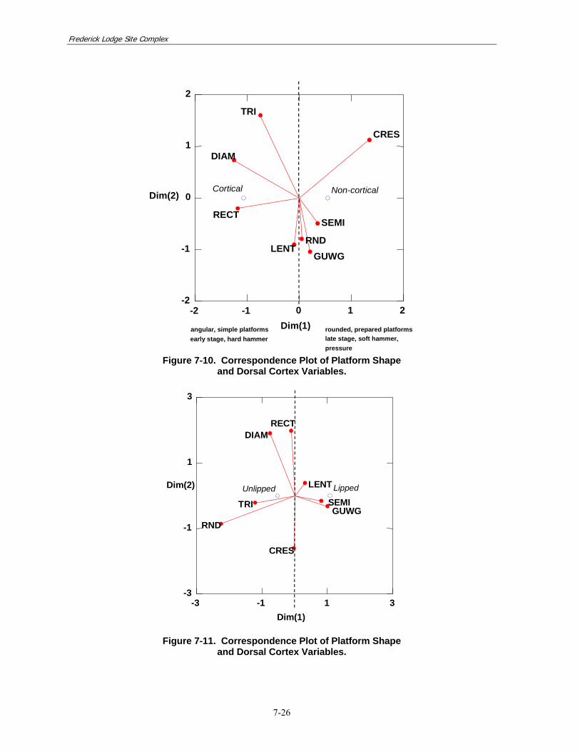
Analysis of platform shapes and dorsal cortex implied a correspondence between several of the rounded forms (CRES, SEMI, RND, GUWG) and non-cortical flakes, with both groups aligned on the correspondence plot (Figure 7-10). In contrast, angular shapes (TRI, DIAM, and RECT) aligned with cortical flakes. The configuration of the variables may again describe the separation of early stage, hard hammer debris from later stage soft hammer or pressure flakes. The correspondence was strong among jasper flakes, but not among chert specimens. The difference in the result between these two materials may have been due to choices in reduction techniques. Fracture patterns and flaking control are essentially the same for jasper and chert, and thus a possible explanation for the pattern variation could lie in the form of the raw material nodule. If, for example, chert pebbles were consistently larger than jasper pebbles, different reduction techniques may have been used–more early stage bipolar reduction associated with smaller jasper pebbles, for example. Examination of gravel samples from area deposits, described in the preceding section, suggested that chert gravels were, in fact, more readily available in larger sizes than jasper gravels (Table 7-7) Finally, analysis of platform shape and ventral lipping indicated a tendency for several rounded shapes, GULL, SEMI, and LENT in particular, to correspond with lipped platforms (Figure 7-11). Rounded or prepared platforms and ventral lipping are typically associated with soft hammer or later reduction stages, and thus may again describe a technological pattern in the data. However, the platform shape round (RND) was a small and possibly unrepresentative sample, which may account for its extreme location on the chart.
Frederick Lodge Site Complex
7-26
-2 -1 0 1 2Dim(1)
-2
-1
0
1
2
Dim(2)
CRES
Non-cortical
SEMI
GUWGRND
LENT
TRI
Cortical
RECT
DIAM
rounded, prepared platforms late stage, soft hammer,pressure
angular, simple platformsearly stage, hard hammer
Figure 7-10. Correspondence Plot of Platform Shape
and Dorsal Cortex Variables.
-3 -1 1 3Dim(1)
-3
-1
1
3
Dim(2) Lipped
GUWGSEMI
LENT
CRES
RECT
Unlipped
DIAM
TRI
RND
Figure 7-11. Correspondence Plot of Platform Shape
and Dorsal Cortex Variables.

Frederick Lodge Site Complex
7-27
Summary of Flake Morphological Analyses
Morphological analyses of the individual flakes from the Block I assemblage helped to delineate the technological choices made by the early American Indian inhabitants at Frederick Lodge. The statistical correlations and correspondences between attributes did lead to some contradictory interpretations, nevertheless. A strict following of Sullivan and Rozen’s approach to flake fragmentation, for example, which holds that a high frequency of occurrence of broken flakes indicates bifacial tool production rather than core reduction, suggests that most of the reduction represented by the Block I debris was related to biface manufacture, since approximately 80 percent of flakes—regardless of raw material—were broken. The unbroken flakes were small—almost 90 percent were 20 mm or less in length. This finding was not surprising since larger flakes are more likely to break, either during the knapping process or later, through post-depositional processes such as trampling. And in fact, this observation appears to be the basis for the Sullivan and Rozen model: i.e., that the large, thin flakes that are typical of biface manufacture are more likely to break than thicker flakes produced during core reduction. Yet, other morphological attributes cataloged in the Block I assemblage suggested that a more complex interpretation is needed to characterize the assemblage and the activities represented by the people who were making stone tools at the site. The frequency of cortical flakes among cryptocrystalline materials, for example, implied the presence of a considerable amount of early stage reduction debris, as did the incidence of simple flake platforms (including cortical, single facet, and 2-3 faceted types). The focus of the detailed formal analysis was on platform attributes, as the striking platform of a flake retains greatest amount of technological information about these manufacturing debris (Andrefsky 1998. The independent variable used most often in examining potential correspondences in the Block I data was platform shape. Much of the potential success in interpreting the results of the correspondence analyses, therefore, depends on understanding shape terminology and the implications that different shapes have for various aspects of lithic manufacture. Phagan’s ultimate conclusion was that platform shape may prove a relatively poor discriminator of technological process (Phagan 1976:90). He did not discuss the basis for this assessment nor its implications— whether, for example, his conclusions were related to the particular shapes chosen for his study, or whether platform shape in general was not a useful technological attribute. One of the approaches used in the Block I analysis suggested that the former may have been the case: i.e., that the particular breakdown of shapes chosen for the analysis may not have adequately described the appropriate technological variation. By simplifying the shape categories, grouping them into rounded and angular classes, correspondences were demonstrated that implied technological distinctions paralleling those described by characteristics such as flake size and cortical frequency. Thus, while platform shape in general appeared to correlate with certain technological characteristics, the breakdown of specific shapes, such as crescent, triangular, and gull wing, may not have been particularly discriminating. It seems clear that evidence was present in the assemblage of biface reduction and probably of bifacial tool maintenance or rejuvenation. However, a substantial amount of early stage reduction activity was also represented, based on the number of cortical flakes and simple platforms that were documented. Contrasting data were noted in some cases regarding cryptocrystalline materials and quartz. While some of the variation could be attributed to the
Frederick Lodge Site Complex
7-28
physical properties and flaking characteristics of quartz in comparison to jasper or chert, an additional implication was that quartz was knapped differently and for different purposes—probably not for biface manufacture but largely for flake tool production. Frederick Lodge’s American Indian inhabitants were well aware of the lithic raw materials available to them, and employed specific strategies for making the tools that they needed, whether formal bifaces or expedient flake tools. These results show that the people living along the margins of the bay/basin during the Middle Archaic period were artisans—flintknappers who selected chert, jasper, and quartz pebbles from local gravel exposures and manufactured bifaces from chert and jasper, and flake tools from the quartz. In the theoretical terms of the chaîne opératoire—which describes the structured production sequence accounting for the entire range of procurement, use, and discard activities—characteristics of cortical debitage from the Block I deposits indicated that raw material was obtained from local cobble beds rather than from sources external to the nearby area. All stages of manufacture were represented to some extent. Based on the number of cortical flakes and simple platforms that were documented archaeologically, the knappers conducted a substantial amount of early stage reduction, working unmodified pebbles of cobbles into rough forms that were then thinned and shaped into specific tools. Contrasting data were noted in some cases regarding the uses of cryptocrystalline materials and quartz. While some of this variation could be attributed to the physical properties and flaking characteristics of quartz in comparison to jasper or chert, an additional implication was that quartz was consciously selected for different uses than cryptocrystalline materials—i.e., largely for flake tool production rather than for biface manufacture. The process of obtaining stone and making tools was not haphazard, but was carefully and specifically planned. That cobble or pebble exposures were not present on-site indicated a clear knowledge of the landscape, the resources it provided, and the means for securing particular items. Individual and Aggregate Flake Analysis: Comparison
The detailed investigation of the flake assemblage from Block I enabled an assessment of the relative merits of the analytical techniques used in this study. Given the large debitage sample from an apparently well-bounded, single-component artifact assemblage, it was possible to compare the utility of the aggregate and individual flake analyses. In the former case, flake size distributions and mean weight calculations implied that the cryptocrystalline debris in the assemblage—jasper and chert flakes—resulted largely from late stage biface reduction tasks such as thinning and shaping, while the quartz debris resulted from earlier stages of reduction. Log-linear modeling of flake size distributions suggested a similar interpretation: most of the cryptocrystalline debris was similar in size and frequency to material generated during biface reduction, while quartz debris was dissimilar. Yet, cortical frequencies by size-interval for all three materials generally occurred within ranges associated with the biface thinning. Analysis of individual flake shapes suggested the same general conclusions, that most of the cryptocrystalline debris was related to later stages of biface reduction while quartz debris

Frederick Lodge Site Complex
7-29
tended to represent earlier stages or, more likely, different reduction strategies. However, individual flake analysis also indicated that more complexity was present in the assemblages than was expressed by simple dichotomies such as early versus late-stage reduction or core versus biface trajectories. Relatively high cortical frequencies among jasper and chert flakes, for example, suggested that those materials included early stage reduction debris as well. This finding could relate to either the presence of a mixture of core reduction and biface thinning or maintenance debris or, perhaps more likely, to the use of pebble materials as the ultimate source for most of the lithic tool manufacture represented by the assemblage. In the end, both analytical approaches produced parallel and corroborating results. Aggregate analysis provided a general assessment of the reduction trajectories. Morphological analysis of individual flakes reached similar conclusions, but introduced detail and complexity to the interpretation. One aspect of the manufacturing process that aggregate analysis tended to gloss over was the difference between forms of late stage knapping activity. For example, gross variations, such as between large flakes from core reduction and smaller flakes from biface thinning, seem readily apparent in the data within certain limits. Yet, distinguishing more specific variation, such as distinghuishing resharpening flakes, is best accomplished by examining striking platforms. Resharpening flakes, for example, tend to have actue platform angles and complex platform surfaces, the latter often consisting of remnant bifacial or unifacial tool edges showing evidence of usewear. This level of detailed information is not conveyed by the techniques of aggregate analysis, but must be obtained through examination of individual artifacts. This is indeed the general conclusion noted by other researchers (Shott 1994; Andrefsky 1998). Aggregate analysis, while a valuable analytical tool that employs quickly and easily measured variables, tends to provide more general information about lithic reduction strategies. But in focusing on general patterns, this type of analysis may overlook other meaningful variation within portions of the assemblage. Individual flake analysis can begin to address that variation, although its success depends on the choice of meanigful attributes that can be accurately and consistently measured. 7.3 Scales of Social Organization
The investigations at the Frederick Lodge Site Complex successfully defined intra-site spatial patterns in terms of settlement orientation within the bay/basin landscape and in terms of general and particular activity areas within individual occupations. In this section of the report, the distribution of site components across the landscape is detailed, followed by a discussion of occupation-specific patterning. Spatial patterning within the individual occupations was evidenced by flaking debris distributions, the occurrence of tools, and by thermally altered stone aggregations. The Middle Archaic occupations were largely characterized by discrete concentrations of flaking debris. The refitting of thermally altered stone associated with the Early/Middle Woodland occupations provided particularly detailed behavioral information, both in terms of stone use in thermal applications, and the spatial organization of this activity. A large, morphologically distinct pit feature was identified and excavated. The feature is discussed in terms of its morphology, location within Frederick Lodge, and its possible function. The findings are then considered in the context of the regional archaeological data base.

Frederick Lodge Site Complex
7-30
7.3.1 Site Structure
The data recovery (Phase III) investigations at the Frederick Lodge Site Complex covered over 18 acres, encompassing a variety of landforms associated with the bay/basin setting. The controlled surface collection strategy, in conjunction with systematic unit excavation, provided a comprehensive view of the prehistoric bay/basin landscape settlement. The earliest occupation of the site complex dated to the Middle Archaic. The Middle Archaic component was represented by bifurcate and Morrow Mountain II point types. The Late Archaic was represented by Fishtail and Lackawaxen types. Piscataway and Woodland I Stemmed points, and a Wolfe Neck sherd dated to the Early/Middle Woodland period. Middle Archaic
Bifurcate points were recovered across the Frederick Lodge Site Complex, except along the bay/basin toe-slopes (Figure 7-12). To recap, two main bifurcate assemblages were identified and extensively investigated. One was located along the larger bay/basin rim and was encapsulated by the Block I excavations. The second was within Block D on the crest associated with the smaller bay/basin. A bifurcate point was also recovered from a mixed context on the crest associated with the larger bay/basin near the eastern end of the site complex (Block K). The bifurcate occupations on the rim of the larger bay/basin (Block I) and on the western crest (Block D area) were very similar. Both were characterized by discrete concentrations of flaking debris, several exhausted points, expedient flake tools, and a very limited amount of thermally altered stone. While Middle Archaic activities in these two areas appeared to have been very similar, the occupation represented in Block I, on the bay/basin rim, appeared to have been somewhat more intensive.
E500 E550 E600 E650 E700 E750 E800N150
N200
N250
N300
N350
LargerBay/Basin
SmallerBay/Basin
MorrowMountain II
MorrowMountain II
MorrowMountain II
bifurcatebifurcate
bifurcatebifurcate
bifurcatebifurcate
bifurcate
bifurcatebifurcate bifurcate
bifurcateMiddle ArchaicAssemblage, Block D
Middle ArchaicAssemblage, Block I
Figure 7-12. Distribution of Middle Archaic Artifacts across the Frederick Lodge Site Complex. (intact artifact assemblages are grouped within ellipses, ungrouped artifacts are from surface of mixed contexts)

Frederick Lodge Site Complex
7-31
Paleoenvironmental research in other bay/basin settings in New Castle County has suggested that the depressions at Frederick Lodge were dry from ca. 11,000 to 6000 years BP (Webb et al. 1994). The bifurcate components represent the only significant occupation of the bay/basin setting during this time span. The occupations may have been geared toward the exploitation of more generalized forest resources rather than focused on upland marsh or wetland environments. In contrast, the Morrow Mountain II occupations appeared to have been highly ephemeral. One Morrow Mountain II point was recovered from surface contexts along the larger bay/basin rim; a second was recovered from buried but mixed contexts along the western crest; and a third from buried but mixed contexts along the eastern crest. Little flaking debris was directly associated with the Morrow Mountain II finds. The Middle Archaic bifurcate occupations in Block I and Block D shared specific spatial attributes. Foremost among these were highly discrete concentrations of flaking debris. These concentrations likely represented dedicated activity areas in which lithic reduction and tool maintenance were undertaken. Flake tools were recovered in direct association with the flaking debris clusters in both Block I and Block D. In the unplowed levels of Block I, flake tools were shown to occur adjacent to the core area of the flake distribution, suggesting the spatial separation of tool production and use. The same pattern was observed in the Middle Archaic levels in Block D. A reliance on expedient cutting tools was evident in both assemblages. The distributions of these tools suggested common areas in which tool manufacture was undertaken, with the by-products employed in adjacent locations. The flake concentrations and groups of flake tools were well-bounded in both Middle Archaic bifurcate occupations. Adjacent areas evidencing very low artifact densities may signal domestic spaces that were kept clear of occupation debris. Overall, the highly compact and discrete nature of the artifact deposits associated with the bifurcate-using American Indian populations suggested a very small group size, perhaps as small as an extended family unit. While the spatial pattering within both occupation areas was similar, the number of artifacts recovered from Block I was substantially higher, possibly reflecting a somewhat longer-term occupation or, conversely, repeated targeting of this specific site locale. In comparison, artifact counts and spatial distributions in the Block D occupations were limited, suggesting single episode, short-term occupation by a small group. Late Archaic
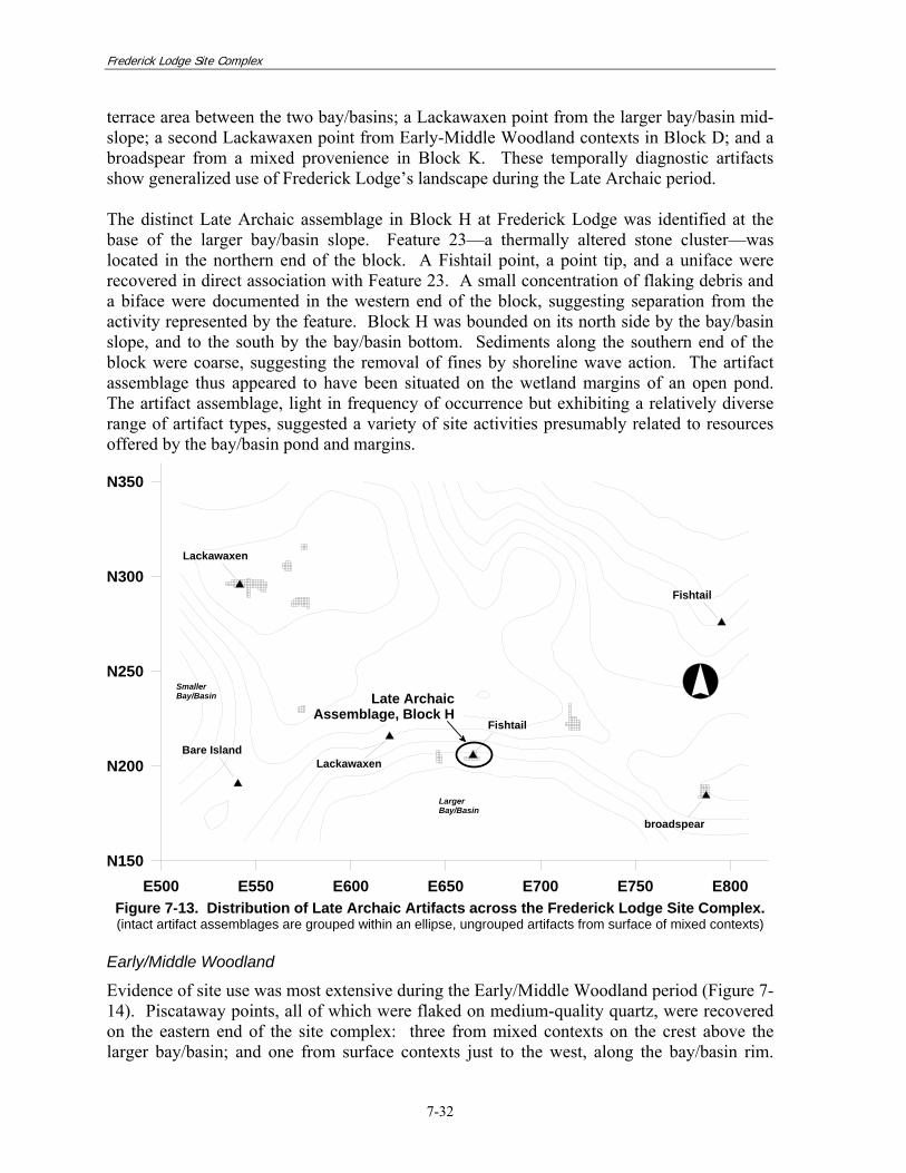
The Late Archaic component included six points characteristic of the period (Figure 7-13). A distinct assemblage was identified along the toe-slope of the larger bay/basin, in Block H. This assemblage included a Fishtail point, a cluster of thermally altered stone, unifacial and bifacial tools, and a small concentration of flaking debris. The occupation dated to a period during which regional data indicate that the bay/basin would have been ponded, with associated marsh and wetland plant and animal communities present (Webb et al. 1994:47). Located at the foot of the slope along the edge of the basin bottom, the occupation thus appeared to represent a short-term encampment along the wetland margins. The remaining Late Archaic points were recovered from isolated or mixed contexts: a Fishtail point on the northeast corner of the project area; a Bare Island point on the central
Frederick Lodge Site Complex
7-32
terrace area between the two bay/basins; a Lackawaxen point from the larger bay/basin mid-slope; a second Lackawaxen point from Early-Middle Woodland contexts in Block D; and a broadspear from a mixed provenience in Block K. These temporally diagnostic artifacts show generalized use of Frederick Lodge’s landscape during the Late Archaic period. The distinct Late Archaic assemblage in Block H at Frederick Lodge was identified at the base of the larger bay/basin slope. Feature 23—a thermally altered stone cluster—was located in the northern end of the block. A Fishtail point, a point tip, and a uniface were recovered in direct association with Feature 23. A small concentration of flaking debris and a biface were documented in the western end of the block, suggesting separation from the activity represented by the feature. Block H was bounded on its north side by the bay/basin slope, and to the south by the bay/basin bottom. Sediments along the southern end of the block were coarse, suggesting the removal of fines by shoreline wave action. The artifact assemblage thus appeared to have been situated on the wetland margins of an open pond. The artifact assemblage, light in frequency of occurrence but exhibiting a relatively diverse range of artifact types, suggested a variety of site activities presumably related to resources offered by the bay/basin pond and margins.
E500 E550 E600 E650 E700 E750 E800N150
N200
N250
N300
N350
LargerBay/Basin
SmallerBay/Basin Late Archaic
Assemblage, Block H
Lackawaxen
LackawaxenBare Island
Fishtail
Fishtail
broadspear
Figure 7-13. Distribution of Late Archaic Artifacts across the Frederick Lodge Site Complex. (intact artifact assemblages are grouped within an ellipse, ungrouped artifacts from surface of mixed contexts)
Early/Middle Woodland
Evidence of site use was most extensive during the Early/Middle Woodland period (Figure 7-14). Piscataway points, all of which were flaked on medium-quality quartz, were recovered on the eastern end of the site complex: three from mixed contexts on the crest above the larger bay/basin; and one from surface contexts just to the west, along the bay/basin rim.

Frederick Lodge Site Complex
7-33
Woodland I Stemmed points characteristic of the Early/Middle Woodland period were recovered along with associated artifact assemblages on the western crest overlooking the smaller bay/basin. These points, almost all of which were manufactured on chert and jasper, were associated with the dominant site occupation. Thermally altered stone clusters and at least one very large pit feature were identified in association with this component. While the generally accepted time spans of Piscataway and Woodland I Stemmed points overlap, the assemblages associated with these artifacts were separated spatially: Piscataway points occurred in the eastern part of Frederick Lodge; Woodland I Stemmed points were found mainly in the western part of the site complex. The two point types were further set apart by differences in the lithic materials chosen for their manufacture: quartz for Piscataway points; chert or jasper for Woodland I Stemmed points. These two spatially discrete assemblages could represent different ages of occupation, or possibly different activities taking place at the Frederick Lodge Site Complex.
E500 E550 E600 E650 E700 E750 E800N150
N200
N250
N300
N350
LargerBay/Basin
SmallerBay/Basin
Woodland IStemmed
Woodland IStemmed
Woodland IStemmed
Woodland IStemmed
Woodland IStemmed
Woodland IStemmed
Woodland IStemmed
Piscataway
Early/Middle WoodlandAssemblage, Blocks B, D, & E
Figure 7-14. Distribution of Early/Middle Woodland Artifacts Across
the Frederick Lodge Site Complex. (intact artifact assemblages are grouped within an ellipse, ungrouped artifacts from surface of mixed contexts)
The Early Middle Woodland assemblage on the western part of the site complex was present in Block D, Block B, and Block E. Spatial distributions of artifacts and the occurrence and preservation of features in these areas implied horizontal patterning strongly suggesting specific site activities. In addition, a small thermally altered stone cluster, Feature 1, was identified in an outlying block. The feature was likely associated with the Early/Middle component, but it lacked diagnostic artifacts in spatial association.

Frederick Lodge Site Complex
7-34
Block D
Spatial distributions of artifacts in Block D were characterized by discrete clusters of thermally altered stone, flaking debris, and tools. Two thermally altered stone features were also identified. Refitting and detailed attribute analysis of the thermally altered stone implied that the two features functioned in tandem in an activity involving indirect heating, such as stone boiling. Specifically, the features were interpreted as a hearth area in which stone was heated, and an associated discard area in which spent stone was placed. The distribution of flaking debris and tools in the block was for the most part separate and distinct from that of the heated stone, suggesting the spatial segregation of activities. Moving west to east across the block these activities included: stone boiling or other indirect heating activities; lithic reduction; and general workshop functions employing both bifacial and flake tools. It is not fully clear whether this patterning was the result of site activities undertaken during a single occupation, seasonal re-use by the same group, or if it was the product of repeated but unrelated site occupations during the period. However, in light of the clear resolution in artifact patterning seen in the excavation block, the initial interpretation of a single occupation seems most likely. Block B
The assemblage in Block B was dominated by thermally altered stone in widespread distribution and concentrated in four thermally altered stone features. Results of refitting and attribute analysis of the features strongly suggested that they were temporally linked and functionally related, involving indirect heating activities such as stone boiling. As in Block D, the features appeared to have been part of an organized functional unit: two hearth-like features in which stone was heated were identified along with a formal discard area in which used stone was deposited. Again, it is not clear whether the intensive use of thermally altered stone in Block B represented a specific activity area within a larger site occupation or the focus of a more limited site occupation. Four Woodland I Stemmed points were recovered from Block B. Flaking debris was limited and flake tools were absent. Block E
Block E, northeast of Block D, was excavated in order to investigate Feature 10, a large pit. Geochemical evidence outlined in Appendix H implied that the feature was open during occupation of Frederick Lodge, and diagnostic artifact analysis linked the occupation to the Early/Middle Woodland site component. Morphological characteristics, including the feature’s size, flat bottom, steep walls, and compacted, shelf-like areas, suggested that the pit may have represented either a large storage feature or the remains of a shelter or residential feature. Block A
Block A, northeast of Block E, contained Feature 1, a small cluster of thermally altered stone. Artifact frequencies in the plow zone overlying the feature suggested that it had likely been more substantial prior to being disturbed by plowing, since most of the stones from its original configuration had been incorporated into the plowed soils. No diagnostic artifacts were recovered in association with Feature 1. Several lines of evidence suggested that the feature may have been part of the Early/Middle Woodland occupation documented in the

Frederick Lodge Site Complex
7-35
blocks to the south: the proximity of Block A to the Early/Middle Woodland occupation area; the elevation of Feature 1 and its location relative to the base of the plow zone; and its morphology and state of preservation. All of these characteristics were distinctly similar to attributes of the thermally altered stone features in Blocks B and D. 7.3.2 Large Pit Features: Form and Function
Two large pit features, designated Feature 6 and Feature 10, were identified in the Phase II investigations and were subsequently excavated during the mitigation phase of the project. The investigation of these features was proposed in the Data Recovery Plan developed for the mitigation (Parsons 1999b) and was reiterated in the Research Design. Accordingly, blocks of 1-m2 units were allocated to examine the features. Feature 6 was located in the southwestern part of the site complex, near the intersection of both bay/basin rims. This feature was a large crescentic or D-shaped pit with a trench-like profile. Detailed results of its investigation are presented in Appendix L, where the debate regarding D-shaped pits as natural versus cultural in origin is explored at some length. The study draws the conclusion that the pit and many others like it were cultural in origin. Further, the argument is made that a residential rather than storage function best explains why Frederick Lodge’s American Indian inhabitants excavated this large depression. In the end, the lack of associated architectural remains—e.g., post holes—limits our ability to determine the exact nature of the feature as a residential structure. Geochemical analyses conducted on column samples from Feature 6 are summarized here in Table 7-17 and explored in detail in Appendix L.
Table 7-17. Feature 6 Fill Soil pH and Trace Chemical Analysis. Sample location Sample # pH P Ca Mg KControl 1 Outside pit rim 70-80cm bd -- 5.3 1.4 321.8 136.5 92.670-80 cm bd 4 5.6 6.4 173.8 47.4 54.080-90 cm bd 5 5.6 5.1 203.1 50.8 58.290-100cm bd 6 5.4 5.5 160.2 39.4 54.4100-110cm bd 7 5.5 6.7 153.4 40.4 57.0110-120 cm bd 8 5.7 10.5 110.9 35.2 53.0120-130 cm bd 9 5.8 4.1 124.8 42.1 63.5130-140 cm bd 10 5.7 0.9 220.4 104.3 86.9Control 2 below pit 140-150 cm bd 11 5.3 1.5 156.7 67.1 58.1P=phosphorus, Ca=calcium, Mg=magnesium, K=potassium all noted in mg/kg
Feature 10 was located in Block E, above the smaller bay/basin. As previously described, this feature consisted of a large pit with steep walls and a nearly level floor. Two pronounced, step-like contours or shelf areas were noted, one on the northwest side of the pit and the other as part of a narrow appendage on the southeast side. These areas were notably compact and may have been formed by soils with higher relative clay content than the surrounding subsoil. Although no post molds or other evidence of a superstructure was identified, one explanation for the pit feature was that it may have been the base of a shelter or residential structure. The feature was situated east of the crest area where the cultural horizons had been plowed and the top portion of the feature appeared to have been truncated.

Frederick Lodge Site Complex
7-36
Geochemical analyses were conducted on column samples from the feature (Appendix H). Results of the analyses are summarized here in Table 7-18. The analyses included examination of control samples from subsoil proveniences adjacent to and below the feature. While soil pH and several elemental signatures did not show clear patterning, the relative levels of available phosphorous—a key indicator of human activity (Eidt 1985; Schuldenrein 1995)—showed a marked pattern of variation with depth. Levels of phosphorous in the control samples and in the upper levels of Feature 10 were low, ranging from 2.1 to 4.0 mg/kg, while a pronounced increase to 8.5 mg/kg was recorded in the lowest level of the fill. The pattern implied that organic debris had collected in the base of the pit allowing phosphorous to concentrate in the sediments. Concentrations of organic material sufficient to raise phosphorus levels to this degree are not considered natural, an interpretation corroborated by control samples taken from below and outside the feature. These results suggest that the feature was open while American Indians lived and worked in this location. Given the amount of phosphorous detected in the samples, the debris probably represented the deliberate placement of material into the pit, possibly during use or as a means of disposal after the features was abandoned. In-filling of the pit later occurred naturally, as shown in reduced levels of phosphorous in the overlying samples, and evidence of sediment stratification that followed the basal contours of the feature.
Table 7-18. Feature 10, Soil pH and Chemical Analysis from Column Samples. Sample location pH P Ca Mg K Control 1 Outside pit wall 60-70 cm bd
5.9 2.1 318.6 116.9 83.7
40-50 cm bd 6.1 3.7 91.2 62.8 68.4 60-70 cm bd 6.0 4.1 194.7 60.6 60.0 80-90 bd 5.9 2.2 246.0 143.3 77.8 100-110cm bd 5.7 8.5 250.0 140.5 55.0 Control 2 below pit floor 115 cm 5.9 3.6 276.0 96.3 42.8 Control 3 below pit 130 cm bd 5.8 2.9 287.1 64.8 25.2 P=phosphorous Ca=calcium, Mg=magnesium, K=potassium, all in mg/kg; bd=below datum
Thus, the geochemical data indicate that the feature was cultural in origin. The projectile point recovered from the fill narrowed the span during which the feature may have been used to the Early/Middle Woodland period. 7.3.3 Inter-site and Regional Settlement Patterns
The investigations at the Frederick Lodge Site Complex marked the first intensive excavation in the Delmarva region of an archaeological site in a bay/basin setting. Here, we review Middle Archaic and Woodland period settlement in Delaware and adjacent areas in order to place the Frederick Lodge Site Complex findings in a broader regional context. In the Southeast Atlantic Coastal Plain, use of bay/basin settings is increasingly being recognized as having played an important role in the American Indian settlement of upland areas (Sassaman 1996; Brooks et al. 1996). Findings from the Frederick Lodge Site Complex are compared to known settlement data from bay/basin settings in that region, as well as similar settings in New Jersey, Maryland, and Virginia.

Frederick Lodge Site Complex
7-37
7.3.4 Middle Archaic
Regional Middle Archaic Settlement
Middle Archaic settlement patterns are not well understood in the Delmarva region. Archaeological sites from the period typically consist of surface artifact manifestations, often containing multiple overlapping Archaic and Woodland components that do not reflect clear horizontal spatial separation. In addition, many presumably favorable Middle Archaic site locations in Delmarva have been inundated by Holocene sea level rise, making observations of area settlement patterns more challenging. Custer (1989) and Dent (1995) remark that basic archaeological reconstructions of this time period are therefore incomplete and must draw on settlement data from outside the region. Several sites containing Middle Archaic components have been investigated in the project vicinity. Site 7K-C-360 and the Dover Downs Site (7K-C-365A and B) were located just north of Dover, on a low rise separating two stream heads (Riley et al. 1994b). The surrounding uplands were characterized by very gently undulating terrain, with lower areas typically containing small, freshwater wetlands. Excavators identified Middle Archaic occupations that were represented by bifurcate and Stanly points. The sites were also occupied into the Woodland period. The Middle Archaic occupations were interpreted as short-term procurement stations at which the refurbishing of tools and weapons was undertaken (Riley et al. 1994b:175). The Blueberry Hill site (7K-C-107) yielded significant information on the Middle Archaic use of interior streamside settings (Heite and Blume 1995). This site was located along a headwater branch of the St. Jones River, north of Dover, and was repeatedly occupied during the Middle Archaic period. In one part of the site, bifurcate points, a Stanly point, and a contracting-stemmed point similar to the Morrow Mountain II type were recovered from sub-plow zone contexts (Heite and Blume 1995:57). Tool types associated with the Middle Archaic levels represented a variety of activities. By contrast, tool types recovered from the earlier levels, associated with Early Archaic Palmer points, indicated strong evidence of cutting and scraping activities and a focus on biface manufacture. Artifacts collected by a private landowner from the Deneumoustier site, along the uppermost reaches of the St. Jones River drainage, established that there were American Indian occupations on this landscape throughout the Archaic and Woodland periods. The site was located along Fork Branch, a low-order headwater branch of the St. Jones River, near the divide between the St. Jones and Leipsic river watersheds. Over many years, the property owner collected almost 450 diagnostic projectile points from the site. This private artifact collection was inventoried by University of Delaware staff during planning survey efforts for SR 1. The specimens examined by the researchers dated from the Early Archaic through Late Woodland periods. Bifurcates were the most common Archaic point type in the collection, with 33 examples identified (LeeDecker et al. 2005). Nine prehistoric sites were identified during Phase I survey of the Osborne Wetlands Mitigation area, located along the headwater reaches of Sawmill Creek, just under 1.5 km southeast of the Frederick Lodge Site Complex. The Osborne Wetlands sites were situated on terrace remnants overlooking wetlands associated with steam headwaters (Bedell 1996).

Frederick Lodge Site Complex
7-38
One site, 7NC-J-212, yielded a Stanly point from sub-plow zone contexts. Phase II evaluation of another site in the group, 7NC-J-220, resulted in the recovery of an Early Archaic Palmer point from below the plow zone. Artifacts dating to the Woodland I and Woodland II periods were recovered from surface contexts at the site (Bedell 1996). This brief overview indicates fairly intensive utilization of the interior areas of Delaware, perhaps most concentrated during the Middle Archaic period by American Indian groups who manufactured and used bifurcate points. In their study of early Holocene projectile points and site locations in Delmarva, Custer and Bachman (1986a) noted a cluster of sites containing bifurcate points in interior areas of the peninsula, particularly near the drainage divide that roughly follows the Maryland-Delaware state line. Although acknowledging potential bias from collector data and the loss of coastal settings due to sea level rise, these researchers concluded that the distribution of bifurcate points underscores the settlement of interior areas during the Middle Archaic period. They further observed that bifurcate-tool using populations occupied a wider range of physiographic and ecological settings than was true for groups during the preceding Early Archaic period, implying an “opportunistic expansion of relatively mobile hunters and gatherers into increasingly numerous productive environmental settings” (Custer and Bachman 1986a:50). A comparable interpretation was advanced for the period in the northern Virginia Coastal Plain and Piedmont, where Johnson (1983) proposed a complex feedback system that, in a similarly ecologically deterministic interpretation, emphasized adaptive response to environmental changes occurring during the period. The clustering of sites with bifurcates in the interior portions of the Delmarva Peninsula has broad regional analogies in the southeastern United States. Anderson (1991) reviewed bifurcate distributions in the South Atlantic region and noted a marked preference for settlements away from coastal areas. In North and South Carolina, bifurcate points were most prevalent in the Piedmont, while they were absent or rare from the Coastal Plain (Anderson 1991). In general, synthetic works for the Middle Atlantic region, Custer (1989) and Dent (1995) portrayed the settlement of uplands during the Middle Archaic as typified by small, transient social groups focused on the exploitation of specific resources. Dent (1995) articulated a Middle Archaic settlement model in which an expanded temperate-zone biome and more dependably available resources enabled social groups to adopt a scheduled subsistence/settlement round involving revisits to a variety of settings on a regular, albeit seasonal, basis. Use of upland areas is seen as playing a significant role in this settlement scheme. In Delaware, Custer (1986, 1994) found evidence for increasing utilization of interior wetlands and other environmentally productive locations, including bay/basins. Middle Archaic sites are often interpreted as hunting locales based on the presence of weapons and cutting tools, and evidence for tool maintenance and rejuvenation. Yet, people made changes in their tool kits during this period by emphasizing greater use of expedient tools (Blanton and Sassaman 1989; Anderson 1991; Dent 1995). While hunting was an important economic activity, the obvious preservation bias toward stone implements likely

Frederick Lodge Site Complex
7-39
leaves evidence for foraging and gathering activities grossly under-represented. Regionally, short-term occupations by relatively small groups appear to have been typical. The concept of group fission-fusion has been central to most models of Middle Archaic settlement in the region. Gardner (1974), Custer (1980), and Hoffman and Foss (1980) have all developed settlement models that present a seasonal dispersal from major occupation sites along river floodplains or other ecologically productive locations to smaller encampments often located in upland settings. In these models, the range of archaeological site types envisioned roughly conforms to hierarchical classifications such macro-band camps, micro-band camps, and/or transient camps. Some researchers question the applicability of these models, particularly for the emphasis they place on fluvial settings as centralized foci from which task-oriented groups radiated on short-term resource procurement forays. For example, in the Delaware Valley Stewart and Cavallo (1991) noted that settlement data do not readily conform to the expectations of hierarchical site types as presented in regional settlement models. In particular, they note no significant size differences in Middle Archaic sites although the sites appear to have been functionally distinct. Based on these observations, Stewart and Cavallo proposed a Middle Archaic pattern in which small group size and high mobility was maintained. Similar patterns of Middle Archaic settlement were observed in South Carolina (Blanton and Sassaman 1989), as expressed by the occurrence and distributions of Morrow Mountain and Guilford site components. Blanton and Sassaman (1989) articulated a pattern of very high residential mobility based on observed evidence of small sites with non-specialized, portable tool kits, low artifact densities, but relatively high site density across the landscape. Parker (1990) reviewed a wide range of Early and Middle Archaic site data from the Virginia Piedmont and Ridge-and-Valley zones, examining variables such as topographic setting, site size and density, and settlement complexity in terms of the variety of tool types recovered. The study was structured in part to test the “fluvial-centric” assertions of some existing Middle Archaic settlement models. Results suggested that the riverine focus proposed for Archaic base camps may have been over-emphasized. The study showed no appreciable difference in size or complexity between riverine and upland sites. Survey data for Buckingham County, for example, demonstrated a preference by Middle Archaic groups for upland settings, despite the proximity of the James River (Parker 1990). Parker noted the settlement of a variety of settings, and upland settings in particular, as a key element in the overall social and economic systems of the period. The physical mobility necessitated by a highly diverse settlement round not only allowed Archaic populations to exploit a variety of seasonal resources, but also fostered interaction between groups over wide geographic areas. This interaction would have supported trade and material exchanges, and also would have provided a venue for social contact and exchange of information between normally dispersed groups (Parker 1990). Middle Archaic at the Frederick Lodge Site Complex
The archaeological investigation of the Frederick Lodge Site Complex offered a rare view of an intact, single-component Middle Archaic site dominated by bifurcate points. Much of the regional archaeological literature, particularly for upland sites, has depended on coarse-

Frederick Lodge Site Complex
7-40
grained data. Researchers normally have relied on partially mixed contexts, information collected over wide geographic areas, or analyses of existing artifact collections that may lack contextual information. Study of the discrete bifurcate occupations identified at the Frederick Lodge Site Complex provided a more detailed view of a site from the period, and included the definition of individual activity areas. The Middle Archaic occupants of the Frederick Lodge Site Complex largely conformed to broadly observed trends for the period. American Indians at the site complex clearly relied on expedient flake tools rather than formal bifaces—other than bifurcate points, and this was particularly reflected in the Block I artifact assemblage. Analyses of the lithic material from the Frederick Lodge Site Complex showed that substantial deposits of flaking debris were largely associated with expedient flake tool production. Also apparent was an emphasis on formal tool maintenance and curation. Bifurcate points recovered from Frederick Lodge had been extensively used: several were broken and others appeared to have been considerably reworked. The heavily resharpened state of the points suggested concerted efforts by inhabitants of Frederick Lodge to conserve existing lithic tool kits. Previous paleoenvironmental research in New Castle County has suggested that bay/basin features in the area were dry during the Early and Middle Archaic periods (Webb et al. 1994). Custer and Bachman (1986a, 1986b) noted that the settlement of bay/basin settings in New Castle County began with the appearance of people who used bifurcate points, an observation supported by the findings at Frederick Lodge, where the earliest component was represented by bifurcate assemblages. Assuming that the bay/basin features did not support wetland environments during this period, more general sylvan or forest resources may have been targeted by the area’s occupants. The degree to which the resident populations exploited resources from terrestrial environments as opposed to those from aquatic/wetland settings is not clear. However, the apparent clustering of sites with bifurcate points along the Delmarva watershed divide (Custer and Bachman 1986a) and the interior preference for settlement by American Indians using bifurcate points seen in North and South Carolina (Anderson 1991) may reflect a broad-based upland/sylvan orientation in lifeways during this time. 7.3.5 Woodland Settlement of the Delaware Uplands
Regional Woodland Settlement
The Woodland period in the Middle Atlantic region is defined by widespread cultural trends such as the manufacture and use of ceramic containers, plant husbandry, and the development of increasingly complex societies. In Delaware, the degree to which formal horticulture was adopted is unclear. Custer (1994) suggested that Woodland populations relied extensively on wild plants and animals, with marine resources playing a larger role in the coastal areas in the southern part of the state. This economic pattern appears to have continued through the Late Woodland, and it has implications for Woodland period settlement patterning and the use of uplands areas throughout the Delmarva Peninsula. Middle Atlantic region settlement models for periods prior to the Late Woodland are largely predicated on the base camp/support camp dichotomy noted previously in relation to Middle Archaic settlement. This concept suggests that large, functionally complex sites—referred to by some researchers as macro-band base camps or micro-band base camps—were the primary residential location. These larger sites would have been supported by short-term

Frederick Lodge Site Complex
7-41
resource procurement camps targeted to the exploitation of specific resources (Thomas et al. 1975; Custer 1994). Riverine or estuarine settings are typically presented as base camp locations, due to the diversity of resources these locations offered to American Indian populations, and their central location with respect to other environmental zones. Outlying support camps are postulated as being located in immediate proximity to the particular resources being exploited. In many Late Woodland models, semi-permanent villages usually replace the base camp site type; peripheral camps were used to collect a wide range of seasonally available resources. A significant number of sites in riverine/estuarine settings have been investigated in Delaware, including numerous sites on projects associated with previous SR1 construction. The Early/Middle Woodland occupations at Carey Farm and Island Field (Custer et al. 1995b), Leipsic (Custer et al. 1996a), and Snapp (Custer and Silber 1995), for example, were interpreted as large settlements at which groups resided for several months or more. By contrast, more recent studies at the Hickory Bluff site (Petraglia et al. 2005) and the Puncheon Run site (LeeDecker et al. 2005) suggest that the Early/Middle Woodland occupations along the upper reaches of the St. Jones River estuary represented repeated short-term visits by small groups. Both of these latter sites were situated in the Mid-Drainage physiographic zone, an area of high resource diversity centrally located with respect to other ecological zones. At Puncheon Run, LeeDecker et al. (2001) reported numerous large cylindrical pits that were dated radiometrically to AD 1-400 and were interpreted as storage facilities. The occurrence of large storage pits in the absence of evidence for residential stability led to the conclusion that the features were intended to support mobile populations that would periodically revisit the site location (LeeDecker et al. 2005). Preliminary surveys of the SR1 corridor in New Castle County failed to identify significant evidence for upland occupations in bay/basin settings after 2000 years BP (Custer and Bachman 1986b), traditionally the end of the Early Woodland. Significantly more data on Woodland settlement of non-bay/basin interior wetlands is documented, however. At the Dover Downs sites (7K-C-365A and B), both Middle and Late Woodland occupations were documented, the former represented by Wolfe Neck ceramics, the latter by Minguannan ceramics and triangle projectile points (Riley et al. 1994b). These occupations were clearly ephemeral and likely represented short-term encampments. A number of other Woodland period occupation sites along low-order streams in New Castle County have been subject to systematic excavation. A sample, working from north to south, includes the Glasgow Elementary School site; the Lums Pond site; the Whitby Branch site; and the Sandom Branch Site Complex. The Glasgow Elementary School site (7NC-D-212) was located in an area of upland wetlands in northern New Castle County. Recent excavations at the site identified a series of Middle and Late Woodland occupations (Bowen et al. 2003). Site use was centered on a rise overlooking minor wetlands and a headwater stem of Belltown Branch. Terrain in the surrounding areas was characterized by low knolls interspersed by poorly drained swales. The site was occupied intermittently during the last 8,000 years. The most intensive Woodland period use was during the Early Woodland, as evidenced by the presence of Dames Quarter and Marcey Creek ceramics and contracting

Frederick Lodge Site Complex
7-42
stemmed points typed as Rossville/Piscataway. Middle Woodland Mockley ceramics were also recovered. Features identified at the site consisted of oval and irregularly shaped pits that typically contained concentrations of thermally altered stone and flaking debris. A large D-shaped pit was also excavated. The Woodland occupations at the site were interpreted as relatively short-term encampments geared toward the exploitation of resources occurring in the interior forests and poorly drained woodlands. Located at the headwaters of St. Georges Creek, in central New Castle County, the Lums Pond site (7NC-F-18) was intermittently occupied during the Archaic and Late Woodland periods, while more intensive use occurred during the first half of the Woodland period (Petraglia et al. 1998). A series of large cylindrical pits were attributed to these occupations on the basis of diagnostic artifacts (Teardrop points) and a series of radiocarbon dates ranging from 2660 to 2960 years BP (Petraglia et al. 1998:143). Although no organic remains other than wood charcoal were recovered from the features, they were interpreted as having been used for storage, presumably for plant foods or other food products. The Whitby Branch site (7NC-G-151) was situated on a low terrace setting above the tidal portion of Whitby Branch, which flows northward to the Appoqunimink River (Jacoby et al. 1997). The site contained material evidence of occupation from the Late Archaic (Clyde Farm Complex) to the Late Woodland (Minguannan Complex) periods. Fourteen thermally altered stone features were identified, all consisting of small scatters of stone that were interpreted as the remains of cooking fires. Few of the features were assigned dates, although two were associated with Jack’s Reef points, characteristic of the late Middle Woodland period Webb Complex. A radiocarbon assay from a third cluster returned an early Late Woodland date. The site was interpreted as part of a group of sites in the southern part of the Appoquinimink River watershed that fit the standard base camp/support camp model, serving as procurement or processing stations associated with the Hell Island site (7NC-F-7). The latter, the type site for Middle Woodland Hell Island ceramics, was a large occupation site located a little over one kilometer to the north of the Whitby Branch site on an island in the Appoquinimink River (Thomas 1966). The Sandom Branch Site Complex (Versar 2011) was located along a first-order tributary stream, approximately one kilometer north of the Frederick Lodge Site Complex. The two adjacent sites forming the site complex—7NC-J-227 and 7NC-J-228—were occupied primarily during the first half of Woodland period. A range of site activities was indicated for the Early/Middle Woodland occupations, including cooking/processing activities using heated stone, the caching of raw materials or processed products in sub-surface pits, and the maintenance and manufacture of stone tools. The sites were interpreted as representing relatively short stays by task groups supporting larger settlements on the lower reaches of the stream. Early/Middle Woodland Settlement at the Frederick Lodge Site Complex
Early/Middle Woodland occupants at the Frederick Lodge Site Complex appeared to have consisted of one or more relatively small groups. The artifact assemblages were documented within a limited area, and overall artifact densities were low. The amount of time spent at the sites by these small American Indian groups is challenging to assess. While artifact counts

Frederick Lodge Site Complex
7-43
were low, a range of site activities was indicated, including cooking, lithic tool maintenance, and tool manufacture. In addition, aspects of internal site structure pointed towards longer-term occupation. The apparent organization of stone boiling or other heated-stone-related activities, for example, suggested both a level of planning and a use of space that might not be expected at a short-term encampment. If the large pit features represented residential structures, relatively lengthy occupations might also be implied. The Delaware Coastal Plain is dissected by a series of intermediate-order creeks and minor rivers from approximately the Chesapeake and Delaware (C&D) Canal south to Cape Henlopen. Listed in occurrence from north to south these creeks include St. Georges Creek (now the C&D Canal), Appoquimink River, Blackbird Creek, the Smyrna River, the Leipsic River, the St. Jones River, the Murderkill River, the Mispillion River, and Cedar Creek. Each of these drainages flows through the diverse Coastal Plain environmental zones of the peninsula. The compressed nature of these Delaware Coastal Plain environments is demonstrated by the fact that most of the drainages cover the area between the Delmarva drainage divide and the Delaware Bay shore within approximately 25 km or less. In an alternative settlement pattern model, the Watershed Range Model introduced earlier in Section 2.3.2, movement between residential locations would have been relatively fluid. Distances between these locations would have been short, while the occupation spans at each location would have varied. Such a system does not imply that American Indians approached their local environment in a haphazard fashion. Rather, subsistence/settlement strategies at Frederick Lodge and the surrounding region may have represented a focused orientation toward a set of highly localized and favorable environmental conditions in which a variety of rich resource bases were situated close together. The strategies for utilizing these resources are not viewed as diffuse or opportunistic—contra LeeDecker et al. (2001)—but would have been carried out within the parameters of both seasonal availability of resources and prescribed territorial limits. Resource short falls or unexpected abundance could be met with a flexible strategy that varied both movement and occupation span. Intra-territory and perhaps inter-territory trade and reciprocity could also have minimized uncertainty, following what Hart (1993) has deemed a divided-risk strategy. While the model requires a relatively high degree of residential mobility, the compact nature of the Delaware Coastal Plain would preclude the need for long-distance movement the region’s American Indian inhabitants. Extended travel would have been limited to hunting forays into the interior of the peninsula or excursions to conduct trade with groups on the Chesapeake shore, for example. Rather than characterizing Delaware’s native inhabitants as nomadic, their settlement mobility in this model can perhaps best be considered as “multi-residential.” The various residential locations are referred to as horizontally linked because they represented stop-over points in a serial settlement round. When viewed as archaeological sites, residential locations that were occupied during various times of the year would fit neither the traditional base camp nor the procurement station classifications. The relationship between the sites would thus not have been strictly hierarchical, but may be better characterized as hetearchical or unranked, the sites being either independent or interdependent settlements depending on changing situations (Crumley 2005).

Frederick Lodge Site Complex
7-44
The Woodland period settlement practices proposed by the Watershed Range Model portrayed as highly mobile within a restricted territory, can be considered part of the greater cultural trend that both Custer (1994) and Dent (1995) broadly refer to as the intensification of resource exploitation by American Indian populations. In essence, adoption of prescribed territories represented a response to ongoing population growth even while social groups maintained a less than sedentary lifeway focused on wild food sources. In the Watershed Range Model, evidence for such intensification could be expressed by the occurrence of large, formal storage pits on riverine sites such as Puncheon Run, as well as on interior streamside or upland sites such as Lums Pond. Other aspects characteristic of an ongoing intensification process may have included forest management practices by which the growth of economically useful trees, such as prime mast-producing specimens near occupation sites, would have been enhanced through the elimination of competing species. The active promotion of what are otherwise considered wild plant foods through the use of fire or other disruptive activities may also have been undertaken to some degree. While a significant amount of residential mobility is inherent in the Watershed Range Model, longer-term occupations by very small numbers of individuals, particularly at the periphery of a territorial range, may also have taken place. The Early/Middle Woodland component at the Frederick Lodge Site Complex appeared to have been such an occupation. The possible presence of a residential feature and clear evidence for internal site structure, in the form of spatially arranged thermally altered stone-related activity areas, lends support to this assertion. Small, extended-period settlements such as this may have represented seasonal adaptations such as a winter-time dispersal into individual nuclear family household units. Such settlements may also have been undertaken in response to episodic stresses, such as poor fish runs, low mast production, or intra-group conflict. And finally, small, isolated settlements in upland locations may also have been the product of idiosyncratic preferences by members of the larger group. 7.3.6 Regional Review of Bay/Basin Settlement
The following review places the American Indian utilization of bay/basin setting in a broader regional context. During the early planning and survey efforts for the SR1 project, Custer and Bachman (1986a, 1986b) recognized bay/basins as having played a potentially significant role in the American Indian settlement of portions of the Delmarva Peninsula. Their initial corridor surveys resulted in the identification of 86 sites associated with bay/basin settings in New Castle County. While the study relied on Phase I survey-level information alone, the large dataset generated suggested that settlement and use of bay/basins in the county was extensive. These data suggested that settlement began about 8500 years BP, while the period of most intensive use of the bay/basin features seemed to have been from between 4500 to 2000 years BP (Custer and Bachman 1986b). American Indian use of bay/basins has also been documented in southern New Jersey, by Bonfiglio and Cresson (1981). Extensive archaeological work has been conducted in the region around bay/basin-like landscape features, referred to locally as closed circular wetlands. Cresson (personal communication 2001) noted that in Burlington County, there is a strong pattern of Late Archaic/Early Woodland use of the features, while Early and Middle Archaic remains often occur in lower levels buried under aeolian deposition. Cresson further

Frederick Lodge Site Complex
7-45
noted that sporadic Paleoindian activity has been documented in association with bay/basins, while use of the settings decreased dramatically following the Early Woodland. Additional information on prehistoric settlement around Delaware bay/basins is derived from the extensive artifact collections of Joe Hughes in Kent County. Most of the finds were made near bay/basins located on the inland portions of his property, along the Mid-Peninsula Drainage divide at the headwaters of the Murderkill and Choptank rivers. His collections, inspected by the authors, contained large numbers of Early Archaic points, including Amos, Decatur, Palmer, and Kirk Corner-Notched types. Together this collection probably represents the most extensive, relatively well provenienced group of Early Archaic projectile points in the Middle Atlantic Coastal Plain. Further south, numerous Early Archaic components have also been documented at interior bay/basin settings in Somerset County, Maryland. These components are represented by Dalton, Amos, Palmer and Kirk projectile points (Lowery, personal communication 2001). The bay/basin settings also contained a wide range of later components, indicating extensive use throughout much of prehistory. Further west in Somerset County, bay/basins fronting the Tangier Sound, on the Chesapeake Bay, have been inundated by rising sea levels. Present day shoreline features have been identified as the relict dunes associated with these bay/basins. The dunes were utilized during Middle and Late Woodland times, with some containing shell midden sites (Lowery, personal communication 2001). On the southern end of the Delmarva Peninsula, a marked concentration of large bay/basin features is present along the Virginia Eastern Shore. Examination of 11 USGS quad sheets covering the counties of Accomac and Northampton identified 92 bay/basins that were fully discernible at the five-foot topographic contour interval used on the maps. The features measured from 300 m to over 1.5 km in diameter; the majority tended toward the large end of the range, while in comparison, the larger feature at Frederick Lodge measured 300 m. Over half of these bay/basins had crescentic dunes located along their rims. In most cases, the rim areas were open and in agricultural use. A review of the Virginia Department of Historic Resources (VDHR) archaeological site files indicated that no prehistoric sites were registered in association with these bay/basin settings. While surveys of the region have been undertaken (Wittkofski 1982, 1988), bay/basin settings were not extensively examined (Keith Egloff, VDHR, personal communication 2001), suggesting an avenue for future research. By far the most detailed information on the prehistoric use of bay/basins comes from studies the Upper Coastal Plain of South Carolina, where the features are also known as Carolina bays. Sassaman (1996), for example, cites Paleoindian and Early Archaic point finds along a bay/basin in Aiken County as evidence for a very early use of upland wetlands for settlement. Recent archaeological mitigation on Shaw Air Force Base, located in Sumter County, provided a wealth of information on bay/basin settlement during much of the prehistoric period (Cantley 1998). The study identified occupations along the rim of the Big Bay bay/basin dating from the Early Archaic to the Mississippian-influenced Late Woodland. The majority of these occupations appeared to have consisted of small, short-term encampments, particularly during the Archaic period. All of the occupations were geared toward the exploitation of the diverse resources present in association with the Big Bay

Frederick Lodge Site Complex
7-46
wetlands. Terminal Archaic (Toms Creek) period sites at the Big Bay location were interpreted as short-term occupations, perhaps of single family composition. The most intensive settlement of the area appeared to have been during the Middle Woodland, represented by small, semi-permanent residences associated with seasonal hamlets. Late Woodland/Mississippian use of the area was interpreted as comprising dispersed, multi-household units which likely established camps during periodic or seasonal movements away from longer-term occupation sites. Also in South Carolina, a multi-disciplinary study involving archaeological survey and testing was carried out on the Flamingo Bay bay/basin located at the Department of Energy Savannah River Site (Brooks et al. 1996). This archaeological study determined that the greatest use of the location had been from the Early Archaic (9500 – 8300 years BP) to the Late Archaic (4500-4000 years BP). Use of the Flamingo Bay setting appeared to have declined after about 4500-4000 years BP (Brooks et al. 1996:500-501). Interpretation of this waning use through time was linked to changes in the bay/basin environment due to ongoing infilling, during the course of which the Flamingo Bay was transformed from an open, permanent pond to a wetland location (Brooks et al. 1996: 501). Among other factors, the emergence of modern floodplain conditions on the Savannah River and its tributaries at about the same time may have shifted occupation emphasis away from upland locations. These South Carolina studies clearly underscore the importance of prehistoric settlement of upland wetlands, the extent of which had not been recognized prior to the research. In citing an accumulating body of evidence for use of bay/basin settings, Sassaman (1996) suggested that current, fluvially centered models of early prehistoric land use of the South Carolina Coastal Plain may need radical revision. The findings of these studies suggest that bay/basins were wet or ponded during much of the Holocene and that they constituted important focal points for human activity. 7.4 Paleoenvironmental Studies
The bay/basin features within and adjacent to the Frederick Lodge Site Complex represented unique topographic features with abundant plant and animal resources that attracted American Indians to this location. Bay/basins have been recognized as geomorphological entities since the nineteenth century. As noted, however, researchers have only recently begun to view these phenomena as playing a significant role in shaping pre-Contact American Indian settlement in the Coastal Plain uplands (Custer and Bachman 1986b; Sassaman 1996). The features have also been recognized as a source of paleoenvironmental information (Kellogg and Custer 1994; Brooks et al. 1996; Brooks et al. 1998; Grant et al. 1998). A regional review of the environmental data associated with bay/basins is provided with the aim of placing these landscape features in wider paleoenvironmental context. Specific data from bay/basins in New Castle County are also presented (Newby et al. 1994; Webb et al. 1994). And finally, the paleoenvironmental aspects of geoarchaeological research at the Frederick Lodge Site Complex are detailed, focusing primarily on the environmental implications of the soil morphologies and artifact contexts identified by the geoarchaeological investigation. Limited archaeobotanical data recovered at the Frederick Lodge Site Complex are also presented and discussed.

Frederick Lodge Site Complex
7-47
7.4.1 Bay/Basin Research
Bay/Basin Formation
To review, bay/basins are broad, circular-to-oval depressions that occur across much of the Atlantic Coastal Plain. These landscape features vary greatly in size from as little as 30 m in diameter to over two kilometers in greatest dimension. Though numerous, bay/basins are unevenly distributed along the Atlantic Coast from northern Florida to Delaware (Grant et al. 1998). One of the greatest concentrations occurs in the inner Coastal Plain of North Carolina (Kaczorowski 1977), where they are known as Carolina bays. While many of these large depressions remain ponded, use of the word “bay” likely refers to the distinctive vegetative communities characteristic of the landscape features, rather than to the presence of surface water. In historical times, many of the depressions have been drained or otherwise altered to claim the land for agricultural use (Krajick 1997). Some researchers maintain that bay/basin features in Delaware differ than those located further south, and therefore have used the term “closed drainage depressions” instead of bay/basins or Carolina bays (Bonfiglio and Cresson 1978). This variation in terminology is based in part on the observation that the Delaware features are often circular, while those occurring along the southern Atlantic Coastal Plain are generally oval or elliptical in form. Similar landscape features are known on the New Jersey Coastal Plain, where it has been proposed that their occurrence was linked to periglacial conditions (Bonfiglio and Cresson 1978, Cresson, personal communication, 2000). Others, notably Custer (1986c), have questioned the periglacial origins of the New Jersey features, assuming instead that they are part of the same bay/basin phenomenon seen from Delaware southward. There seems to be no clear consensus as to the origin of bay/basin features. Early theories included the notion that the depressions were the remnants of meteorite strikes. This explanation has effectively been countered through simple magnetometer surveys and trace mineral studies (Kaczorowski 1977). A revised extraterrestrial origin theory was put forth by Eyton and Parkhurst (1975), in which meteors were replaced as the extraterrestrial agent by the fragments of an icy comet. Supposedly, a comet exploded low over the Earth and produced thousands of fragments, many of which would have been large enough to have created the bay/basin depressions. In contrast to a rock meteor, the theory contends, the icy residue of these comet fragments would have left little or no physical traces beyond the impact craters. However, a wide range of radiocarbon dates, together with evidence for ongoing morphological changes, argue against a single, catastrophic event, as the sole source of bay/basin formation. In addition, other studies have indicated that soils below the organic deposits within bay/basins remain essentially unaltered (Gamble et al. 1977; Grant et al. 1998), making the impact model even more unlikely. Others have proposed various dissolution models for bay/basin formation. Smith (1931), for example, argued that bay/basins formed through the leaching of organics from soils by ground water. Johnson (1942) proposed a complex model which he called the “artesian-solution-lacustrine-aeolian” hypothesis. In this model, “artesian springs, rising through groundwater and operating in part by solution, produced broad shallow basins occupied by lakes, about the margins of which beach ridges were formed by wave actions and dune ridges by wind actions” (Johnson 1942:154). Both of these theories are problematical. For one,

Frederick Lodge Site Complex
7-48
organics in the soil would represent only a small percentage of the material that would need to be displaced in order to create the depressions. Similarly, Johnson’s model would require the removal of large amounts of material both through solution and fluvial action. An avenue for such fluvial transport is lacking in most bay/basins because they are closed depressions. Nonetheless, these and similar models were seen as viable alternatives to the extra-terrestrial impact explanations. Wind action has long been suspected as playing a role in modifying the bay/basin form. Tuomey (cited in Savage 1982:14) maintained in the mid-nineteenth century that bay/basin features were originally the result of artesian spring activity and were subsequently shaped by wind erosion. Aeolian deflation as the vehicle for bay/basin formation has received considerable attention from recent researchers who have proposed similar models (Odum 1952; Price 1968). Thom (1970) expanded on these theories by suggesting the bay/basins were formed as surface water collected on sand dune deflations, and that, as ponded depressions, they expanded with time under the influence of dominant southwesterly winds. Kaczorowski (1977) presented a convincing model in which he linked bay/basin development to persistent aeolian and littoral processes, the latter associated with wave action in open, ponded areas. He maintained that this phenomenon is operative not just on the Atlantic Coastal Plain, but also on the north coast of Alaska and the tip of Chile (Kaczorowski 1977). His model presents the morphological development of bay/basins as the result of strong unidirectional winds blowing across ponded water in upland locations and has gained a considerable measure of acceptance (Brooks et al. 1996:482). In his work, Kaczorowski presents a wide range of dates for the onset of organic deposition in the bay/basins, spanning a period from 40,000 to 6600 years BP (Kaczorowski 1977). Extensive research was recently undertaken on bay/basins at the Savannah River Site, on the Upper Coastal Plain of South Carolina (Brooks et al. 1996; Grant et al. 1998). These studies employed ground penetrating radar (GPR) to map subsurface bay/basin stratigraphy at Flamingo Bay and six other bay/basins on U.S. Department of Energy property. Synthesis of geological, ecological, and archaeological data suggested that the ponds in these bay/basins were significantly larger and more permanent in the early Holocene than is true today (Grant et al. 1998:481). During the early Holocene, these ponds would have been stable formations and deep enough to support permanent populations of fish and turtles. The stratigraphic record of the bay/basins indicated significant in-filling during the latter half of the Holocene. American Indian activities associated with these bay/basis consequently decreased in intensity of human activity around 4500 years BP (Grant et al. 1998:501). Bay/basin evolution occurred “during fluctuating but generally open water conditions, as breaking waves along bay shore lines eroded and transported sediment which was subsequently exposed for deflation during periods of low water. Deflation and transport of sand into standing vegetation along the margin of the bay created a rim in the form of a parabolic dune lacking obvious internal stratification. Simultaneously, in-filling occurred by shoreline erosion and transport from adjacent elevated surfaces” (Grant et al. 1998:325). The question of their origin aside, bay/basins are likely to have been subjected to ongoing modifications through much of their existence. The South Carolina GPR studies, correlated

Frederick Lodge Site Complex
7-49
with AMS dating of basin sediments, led researchers to postulate that the distinctive bay/basin morphology was actively being shaped during the early Holocene (Brooks et al. 1996:501). These and other GPR studies suggest that the bay/basin form was being modified as late as 4000 years BP (Brooks et al. 1998). It is also possible that multiple generations of bay/basins exist, and that some contemporary features represent the reworking and/or rejuvenation of much older entities. While these findings strongly suggest extensive Holocene modification of bay/basins, a large body of radiometric data indicate that bay/basins originated as Pleistocene age landscape features (Kaczorowski 1977; Thom 1970). The ultimate genesis of the landscape features that evolved into bay/basins is uncertain, but could include spring activity, deflation, or drainage channel abandonment (Grant et al. 1998). Early radiocarbon dates place the onset of bay/basin development before the last glacial maximum (prior to 18,000 years BP), during which time extensive changes in surface hydrology associated with regressing sea levels could be expected, including channel abandonment. In Delaware, dramatic changes in surface hydrology associated with proximity to glacial margins could have been a factor in the original bay/basin formation. Frost heaving or other dynamic forces associated with periglacial conditions may also have been important factors. The Frederick Lodge Bay/Basins
Bay/basins are widely distributed along the Delaware Coastal Plain. However, a marked concentration of these features is present between the towns of Smyrna and Townsend, just west of the project area. These bay/basins measure as little as 50 m in diameter to over 500 m in greatest dimension. While the Frederick Lodge bay/basins were dry and had been in recent agricultural use, they were likely ponded in the past. Numerous bay/basins west of the project area retain surface water to this day. A linear ditch extended from the southern edge of the larger bay/basin at Frederick Lodge, suggesting that its associated wetlands had been artificially drained. Fine sediments deposited on the bay/basin bottom provided direct evidence for ponding. Sediments along the lowest portion of the south-facing rim of the larger basin appear to have been reworked, suggesting the removal of fines by shoreline wave action. The location of this band of reworked soils would have been consistent with the shoreline of an open pond. At the Frederick Lodge Site Complex, it was clear that wind action had played a role in modifying the bay/basin form. A sandy dune-like ridge was present along the northeast quadrant (southwest aspect) of both the smaller and larger bay/basin. Prehistoric cultural material was encountered in buried contexts along the crests of these knoll-like ridges, indicating that the overlying sediments were aeolian in origin. In both instances, the aeolian sediments capped an existing ridge that appeared to have been the favored location for prehistoric occupation. Geoarchaeological analysis suggested that the earlier soils on the knolls often contained significant silt and fine sand components, and thus may also have been aeolian. The onset of deposition predated the oldest intact cultural horizon, represented by Middle Archaic bifurcate projectile point types. Dune-like ridges were observed on the north to east sides of bay/basins in close proximity to the Frederick Lodge Site Complex. The same phenomenon, including the burial of

Frederick Lodge Site Complex
7-50
archaeological deposits on the crest of a southwest facing dune ridge, was observed in an analogous location on the nearby Black Diamond Site (7NC-J-225), for example. Similar features are recognizable in numerous locations on USGS 7.5 Clayton quadrangle (1993). Paleohydrology and Palynology of Delaware Bay/Basins
A paleoenvironmental study of the SR1 corridor conducted through the Center for Archaeological Research at the University of Delaware (Kellogg and Custer 1994) included detailed investigations of four bay/basin locations in New Castle County. These studies (Newby et al. 1994; Webb et al. 1994) were conducted on similar features in similar settings, and are considered directly analogous to the Frederick Lodge location. Newby et al. (1994) analyzed sediment cores and pollen profiles from the Walter’s Puddle bay/basin, north of Frederick Lodge. .These initial investigations at Walter’s Puddle indicated a lowering of water tables over a period from approximately 11,880 to 5830 years BP (Newby et al. 1994:35). A second, more intensive coring study was repeated at Walters Puddle and at three additional nearby bay/basins: Nowakowski Pond, Longhauser Pond, and Prison Pond (Webb et al. 1994). This additional work confirmed a similarly timed reduction in water tables in all four bay/basins, suggesting a period in which the features may have been dry (Webb et al.1994:47). Following 6000 years BP, water levels rose to the point at which organic-rich sediments accumulated, implying that the depressions were again ponded (Webb et al. 1994:47). Thus, the recovery of preserved pollen profiles showed a consistent drop in water tables in the bay/basins during portions of the Holocene. Pollen cores suitable for detailed analysis were recovered from one of these bay/basins. Core material from Walters Puddle WP-2 context (61–122 cm) yielded a late glacial age (14,400–11,880 years BP) for these sediments. The presence of spruce, hemlock, pine, and birch pollen, together with sedges, suggested boreal vegetation across the area (Newby et al. 1994:34). Data from the deepest contexts (WP-3 122-300 cm) were challenging to interpret due to poor preservation and low pollen counts. However, the presence of oak pollen, which was absent from WP-2, suggested that the lowest deposits may have dated to the Wisconsin interstadial period of about 23,000 to 36,000 years BP (Newby et al. 1994:34). A distinct hiatus in the depositional sequence was noted at a depth of 61-63 cm, marking the break between the WP-2 and the WP-1 contexts. This break was expressed as a change from dark, silty lake muds to fine-grained sands (Newby et al. 1994:35). The basal level of the WP-1 context (52-61 cm) yielded a radiocarbon date of 5800 years BP. Pollen at this level was dominated by oak, with hickory present in moderate amounts. Secondary species included pine, birch, maple, beech, and poplar (Newby et al. 1994:35, Figure 23). This pollen assemblage closely mirrored modern tree communities in the area and suggested that essentially modern forest conditions had developed as early as 5820 years BP (Newby et al. 1994:35). Paleoenvironmental Implications of Bay/Basin-Related Aeolian Activity
In the littoral-aeolian model of bay/basin evolution, as articulated by Thom (1970), Kaczorowski (1977), and Grant et al. (1998), the morphology and orientation of the surface features carry strong implications for paleoenvironmental conditions. Environmental factors

Frederick Lodge Site Complex
7-51
influencing and reflected by bay/basin morphology are paleo-wind direction, moisture/water level, and vegetative cover. The northwest-southeast orientation of the bay/basins noted in South Carolina was interpreted as the result of long-shore erosion of the bay/basin margins by waves driven by southwesterly winds (Grant et al. 1998:343). However, the location and form of parabolic dunes associated with these same bay/basins would have required the transport of material out of the bay/basin by west and northwesterly winds. This apparent contradiction was resolved by postulating that southwesterly winds dominated the orientation of the bay/basins, as these winds are most common during the spring and summer when water levels are highest. Lowered water levels in the winter, coupled with strong northwest winds, would have led to increased sediment exposure, subsequent deflation, and downwind sediment accretion (Grant et al. 1998:343). In comparison, the presence of dune-like ridges on the northeast side of the Frederick Lodge bay/basins and analogous settings nearby indicated the transport of material by southwesterly winds. The lower temperatures and limited solar exposure of the Delaware winters probably inhibited desiccation, so that exposed sediments were not mobilized by the strong northwesterly winds typically associated with the arrival of wintertime cold fronts. Rather, it appears that the transport of sediments out of the Frederick Lodge bay/basins was associated with southwesterly winds associated with dry, summer conditions. These conditions would have lowered water levels allowing for the desiccation and aeolian transport of exposed soils at the margins of the bay/basin features. While aeolian features in and near the project area appeared to show association with southwesterly winds, a review of bay/basins on the Virginia Eastern Shore at the southern tip of the Delmarva Peninsula showed different dune orientations. The analysis was cursory in nature and relied on study of USGS quad sheets without field visits. Nonetheless, results suggested a preponderance of south-east quadrant orientations of bay/basin associated dunes (Table 7-19).
Table 7-19. Quadrant Orientation of Dunes Associated with Bay/Basins on the Virginia Eastern Shore.
direction N NE E SE S SW NW W multiple
count 2 4 10 23 4 1 1 1 8frequency 3.7 % 7.5% 18.5% 42.5% 7.4% 1.8% 1.8% 1.8% 14.8%
Of 92 bay/basins identified on the USGS quad sheets from a two-county area—Accomack and Northampton Counties in Virginia—54 bay/basin features exhibited associated dune landforms expressed in the five-foot interval topographic contour used on the maps. Of these, 23 dunes (42.5 percent) were centered along the southeast quadrant of the bay/basin. By contrast, only one example was centered on the northwest side. This finding strongly suggested dune formation was associated with northwesterly winds. This is more in line with the depositional wind direction reported in South Carolina by Grant et al. (1998) rather than what is seen with the Frederick Lodge and other Delaware bay/basins where sand rims appeared to be associated with transport from a southwesterly direction. In addition to the

Frederick Lodge Site Complex
7-52
strong association with northwesterly directional winds in Virginia, dune orientations indicate the transport of sediment from a variety of secondary directions, suggesting the potential complexity in the formation of some dunes. Eight Virginia examples (14.8 percent) exhibited a continuous dune, or major dune sections that encompassed two or more cardinal directions. One of these exhibited multiple dune sections that extended a full 360 degrees around the bay/basin. Aeolian activity has been closely linked to paleoenvironmental change in the Middle Atlantic region (Curry 1980; Custer 1989). However, care must be taken when considering the onset of aeolian activity as a broad indicator of climatic conditions. Researchers proposing the littorial-aeolian model of bay/basin evolution have noted that the model “can accommodate, but does not require, environmental conditions significantly different than those occurring today” (Grant et al. 1998:343). Such may have been the case in the Frederick Lodge area, where evidence indicated varying climatic conditions associated with bay/basins formation. Local conditions were likely dry prior to 6000 years BP, when Archaic period occupations were buried, while the aeolian activity that capped Woodland period occupations dated to a wetter period, during which water tables were high and the bay/basins were likely ponded. Thus, aeolian activity may be a very localized phenomenon, and recognition of area-specific as well as regional factors are critical to understanding the conditions necessary for its development. Finally, the role of anthropogenic conditions must also be considered. Human activity, such as the use of fire to drive game or to modify the botanical environment, could reduce vegetation cover over both local and broader areas, providing conditions for aeolian soil movement, particularly in sandy, coastal plain settings. Also, the mere occupation of site locations around bay/basins would likely result in the exposure of small areas, providing a source for aeolian soil modification on a highly localized scale. As an example, anthropogenic factors are seen as the primary cause for the burial of occupation surfaces in the Big Bay study area in South Carolina after 3000 years BP (Brooks et al. 1998:58). 7.4.2 Frederick Lodge Geoarchaeological Findings
A primary objective of geoarchaeological investigation at the Frederick Lodge Site Complex was to integrate geomorphological and archaeological observations in order to more fully interpret the contexts for American Indian occupations. The results of the geoarchaeological analysis of site stratigraphy, detailed in Appendix H, have implications for local paleoenvironmental conditions. As noted, neither bay/basin at the Frederick Lodge Site Complex contained surface water at the time of the CR division’s archaeological investigations. However, the presence of a ditch extending from the larger bay/basin suggested that it had been drained during historical times. Soils within the larger bay/basin bottom were wet and gleyed, and had been out of cultivation for some time. The smaller bay/basin had not been drained, and had remained in cultivation until just before the archaeological investigations began. Subsurface stratigraphy generally conformed to landform contours. The greatest modification to the Frederick Lodge Site Complex area undoubtedly was the result of
Frederick Lodge Site Complex
7-53
plowing. In some locations, such as the rim and slope of bay/basins, repeated plowing and subsequent erosion had resulted in extensive deflation of the soil profile. Some colluvial movement prior to the historical period was also apparent, as evidenced by down-slope soil accretion within archaeological contexts, such as in Block G on the bay/basin toe-slope. This soil movement was likely related to very localized anthropogenic impacts rather than more general paleoenvironmental conditions. Both the Woodland and Middle Archaic occupations on the crests were partially buried by aeolian soils. The orientation of the Block D landform with respect to bay/basins indicated transport and deposition of sediments by southwesterly winds. A similar situation was seen in Block K. Windborne transport of soil particles requires that surface sediments be exposed. Dessication of the bay/basins, either during dry climatic episodes or seasonally, during the summer months of wetter periods, is the most likely scenario for the exposure and subsequent mobilization of surface sediments. The relation of the aeolian soils seen in Block D to the cultural deposits indicates that movement occurred both during Archaic and Woodland times. In summary, soil profiles across site were consistently free of major Holocene-age unconformities or breaks in the stratigraphic sequence. Although evidence for aeolian deposition, colluvial soil movement, and erosion and deflation was documented, these processes appeared to have been ongoing and low intensity. Any major paleoenvironmental changes that might have occurred at the Frederick Lodge Site Complex do not appear to have been reflected in soil profiles. 7.4.3 Frederick Lodge Archaeobotanical Findings
Ten soil samples were collected from feature and unit stratum contexts at the site complex with the goal of recovering archaeobotanical data. The samples were subjected to flotation analysis by Justine McKnight, Consulting Ethnobotanist (Appendix I). Standard soil samples measured 2.0 liters, although two samples were 1.0 liter each. The preservation of organic material at the Frederick Lodge Site Complex was poor, and a limited amount of carbonized botanical remains was recovered. Non-carbonized seeds and botanical material were interpreted as representing modern contamination and were not inventoried. Care must be given when arriving at interpretive findings due to the scarcity of preserved botanical remains. Nonetheless, the botanical material provided insight into the American Indian occupations at the Frederick Lodge Site Complex and local paleoenvironmental conditions. Table 7-20 summarizes the ethnobotanical remains recovered from the Frederick Lodge Site Complex. Carbonized fragments of pine (Pinus sp.) were recovered from two samples, and represented three of the four identifiable fragments of wood charcoal from the site complex. These three fragments were recovered from Woodland period features. This finding was surprising at first glance. Oak and hickory species dominate well-drained upland areas in the High Coastal Plain of Delaware, and oak would have been the dominant forest species since at least 6000 years BP (Newby et al. 1994; Thomas et al. 1975). A fragment of oak charcoal was recovered from Feature 2. Pine, in contrast, is a pioneer species, often associated with re-growth in disturbed areas (Platt and Schwartz 1990:226). It seems unlikely that the

Frederick Lodge Site Complex
7-54
prehistoric site inhabitants would have purposefully selected pine as fuel over superior burning hardwood material, unless it was relatively abundant. Sediment cores taken from the St. Jones River, in Kent County, indicate a relatively high frequency of pine pollen for the period 2000 to 1000 years BP (Brush 1994:90). Pine can be viewed as an indicator of forest burning, as these species are more resistant to fire than deciduous trees (Sutton and Sutton 1985:23). As noted previously, pine requires a disruption of the climax forest condition, such as would have been caused by fire. An increase in pine may thus be seen as a indicator of dry, fire-prone conditions. Human activity may also be indicated: fires were sometimes used to drive game toward waiting hunters (Rountree 1989), and may also have been employed to disrupt the forest cover in order propagate the growth of economically useful plant species.
Table 7-20. Carbonized Botanical Remains Frederick Lodge Site Complex. provenience material weight
Feature 10 (large pit) 1 pine (Pinus sp.), 2 deciduous taxa charcoal fragments
.02 g
Feature 2 (small TAS) 1 oak (Quercus sp.) charcoal fragment <.01 g
Feature 32 (small pit) 2 pine (Pinus sp.) charcoal fragment .08 g
Feature 23 (small TAS) 1 bayberry (Myrica sp.) seed fragment .01 g
In contrast to the St. Jones River locations, pollen profiles taken from the Leipsic River show that pine decreased in frequency after 3000 years BP, with only minor peaks occurring thereafter (Brush 1994:91-92, Figure 57). An increase in pine for the period is not noted in the Walters Puddle profiles (Newby et al. 1994; Webb et al. 1994). The variations in pine frequency seen in north-central Delaware study locations may well be the result of local human disruption of the climax forest cover through burning and other actions, rather than reflecting climatic changes. In either case, the presence of carbonized fragments of pine in feature contexts suggests that the local forest conditions were not in a climax state, and that pine was relatively common in the Frederick Lodge area. A single identifiable carbonized seed was recovered. This specimen was identified as bayberry (Myrica sp.), and was recovered from sediments surrounding Feature 23, a thermally altered stone concentration situated at the foot of the larger bay/basin slope. The specimen belongs to the Sweet Gale (myriccacea) Family. Bayberry is a common name for three or more closely related species of stocky shrubs, also known as wax-myrtle or bay. Bayberry occupies a highly specific ecological niche. It thrives, often in large clumps, on infertile soil along coastal areas and around the sandy, open rims of brackish-to-freshwater ponds and wetlands (Fernald and Kinsey 1958:146; Angier 1974:30). Bayberry has fruiting branches covered with small berries or nutlets that have a waxy outer covering. Fruits are available from late summer to spring (Fernald and Kinsey 1958:146). The leaves of the bayberry can be used as a savory flavoring for a variety of dishes. Its chief modern-day value, however, is in the berries, which can easily be rendered in hot water to yield an

Frederick Lodge Site Complex
7-55
aromatic candle wax. The root of the plant also reputedly has medicinal value and was widely used in early colonial times to quiet diarrhea and as an anti-inflammatory (Angier 1974:30). Ethnohistorical records indicate medicinal uses in treating gastro-intestinal problems and reducing fevers (Moerman 1986:301). The presence of bayberry in the Feature 23 context may indicate subsistence activities (flavoring in cooking), technological applications (wax rendering), medicinal uses, or use of the leaves or wax purely as aromatics in a variety of domestic and ceremonial settings. Incidental inclusion of the berry seen in an American Indian camp fire cannot be ruled out given the location of the feature along the edge of the bay/basin, which was a favored environment for the plant. Regardless of its origin or use, the presence of bayberry provides information on paleoenvironmental conditions—the species is intolerant of shade and requires at least partially open environs, such as those provided by the rims of ponded bay/basins. A correlation with bay/basin ponds may be reflected in the pollen profiles for Walters Puddle, where Myrica species was recovered in very limited volume in WP-1, the uppermost stratum post-dating 5820 years BP (Newby et al. 1994: 33, Figure 23). The absence of this common plant from the older Walters Puddle stratigraphic contexts (WP-2 and WP-3) may be related to these features having been dry during earlier periods. 7.5 Landscape Approach
The three sites comprising the Frederick Lodge Site Complex (7NC-J-97. 7NC-J-98, and 7NC-J-99) may be seen as representing persistent places repeatedly visited over millennia. The past inhabitants of the Frederick Lodge Site Complex were targeting a specific type of landform as opposed to a specific location—the bay/basin features, resulting in superimposition of cultural remains (Camili and Ebert 1992:131). Studies of the Frederick Lodge Site Complex benefit from a landscape approach because American Indian use of bay/basin features is not well documented archaeologically in the region—including those in upland settings. Bay/basins are unique geomorphological and environmental landscapes, and their settlement by American Indian groups has been documented far less extensively than upland settings as a whole. However, the role that bay/basin settings played in the American Indian occupation of Coastal Plain uplands is increasingly capturing the attention of researchers. While artifacts were dispersed across the Frederick Lodge Site Complex, artifact concentrations and features were found to be clustered on the northeast aspects of the bay/basin topographic features. A similar pattern of site location was identified at the adjacent Black Diamond site (7NC-J-225) (Auman and Egghart 1999). This pattern transcended a specific time period, with the various site occupations dated to portions of both the Archaic and Woodland periods. A repeated pattern such as this may have been associated with favorable habitation factors present at these locations, such as high ground, good soil drainage, or prevailing wind direction. Natural resources associated with the features also had a likely influence on the targeting of these landscape locales, and there may have been social or ceremonial factors in the selection of the locations (Tooker 1979; Carmichael et al. 1994; Waldren et al. 1995; Hall 1997).

Frederick Lodge Site Complex
7-56
A GIS-based viewshed analysis provided some insight into the visual perspective American Indians had of the Frederick Lodge landscape. This analysis was conducted from the standpoint of the main excavation blocks associated with the three sites that comprised the Frederick Lodge Site Complex: Block B/D (7NC-J-98); Block H (7NC-J-97); Block I (between 7NC-J-97 and 7NC-J-99); and Block K (7NC-J-99). The results of the analyses indicated that since the occupations were close together on a common landform, they had similar viewsheds. From each location, American Indian groups would have had clear views in all directions: across the bay/basins to the south and west; to the southeast across the headwaters of two upland tributaries of Sawmill Branch that flow northeastward to that stream; and north to Sandom Branch and the tributaries of Blackbird Creek (Figure 7-15). The viewshed of Block H was somewhat restricted in comparison with the other locations, particularly to the northwest and northeast, due to its position down the side slope of one of the bay/basins rather than on the ridge crest along which the other occupations were situated (Figure 7-16). Whether any of the views indicated by the analyses were actually visible when the sites were occupied would have depended on the presence of obstructions, primarily in the form of vegetation. Paleoenvironmental studies have suggested that parts of the area may have had limited vegetation for periods of time (Curry 1992; Custer 1999; Webb et al. 1994).
Figure 7-15. Results of Viewshed Analysis Block D, Frederick Lodge Complex.
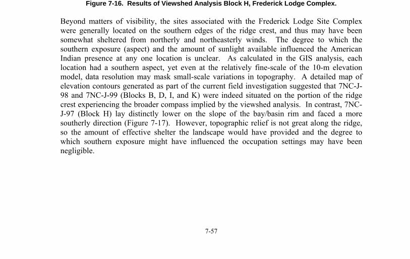
Frederick Lodge Site Complex
7-57
Figure 7-16. Results of Viewshed Analysis Block H, Frederick Lodge Complex.
Beyond matters of visibility, the sites associated with the Frederick Lodge Site Complex were generally located on the southern edges of the ridge crest, and thus may have been somewhat sheltered from northerly and northeasterly winds. The degree to which the southern exposure (aspect) and the amount of sunlight available influenced the American Indian presence at any one location is unclear. As calculated in the GIS analysis, each location had a southern aspect, yet even at the relatively fine-scale of the 10-m elevation model, data resolution may mask small-scale variations in topography. A detailed map of elevation contours generated as part of the current field investigation suggested that 7NC-J-98 and 7NC-J-99 (Blocks B, D, I, and K) were indeed situated on the portion of the ridge crest experiencing the broader compass implied by the viewshed analysis. In contrast, 7NC-J-97 (Block H) lay distinctly lower on the slope of the bay/basin rim and faced a more southerly direction (Figure 7-17). However, topographic relief is not great along the ridge, so the amount of effective shelter the landscape would have provided and the degree to which southern exposure might have influenced the occupation settings may have been negligible.
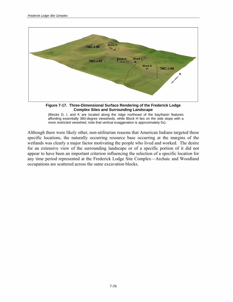
Frederick Lodge Site Complex
7-58
Figure 7-17. Three-Dimensional Surface Rendering of the Frederick Lodge
Complex Sites and Surrounding Landscape (Blocks D, I, and K are located along the ridge northeast of the bay/basin features affording essentially 360-degree viewsheds, while Block H lies on the side slope with a more restricted viewshed; note that vertical exaggeration is approximately 5x).
Although there were likely other, non-utilitarian reasons that American Indians targeted these specific locations, the naturally occurring resource base occurring at the margins of the wetlands was clearly a major factor motivating the people who lived and worked. The desire for an extensive view of the surrounding landscape or of a specific portion of it did not appear to have been an important criterion influencing the selection of a specific location for any time period represented at the Frederick Lodge Site Complex—Archaic and Woodland occupations are scattered across the same excavation blocks.