7. pedestrian infrastructure design - mapc.org · aashto's a policy on geometric design of...
TRANSCRIPT

The Boston Region’s Pedestrian Transportation Plan
7 - 39
7. Pedestrian Infrastructure Design
This chapter outlines design elements of the pedestrian infrastructure and identifies design standards to accommodate pedestrians. To the extent possible, pedestrian concerns expressed by the public should be incorporated.
a. Design Guidelines When implementing design tools for roadway infrastructure, it is critical to accommodate pedestrians. This section contains a brief description and direct links to reference the resources. These resources are considered to be the state and Federal standards in design for pedestrian infrastructure. MassDOT's Development and Design Guidebook The primary resource that should be adhered to is the MassDOT Project Development and Design Guidebook.
Multimodal accommodation that encourages and supports safe travel for pedestrians, bicyclists and other modes of travel is a key feature of the MassDOT Guidebook. The MassDOT Guidebook directs the designer to begin at the edge with the pedestrian and work their way in, to ensure that the needs of non-motorized users remain integral to project planning and design. This approach facilitates the use of context-sensitive design, environmental protection and the careful consideration of the safety and accessibility needs of pedestrians, bicyclists and non-motorized facility users.
Manual on Uniform Traffic Control Devices (MUTCD) The Manual on Uniform Traffic Control Devices, or MUTCD defines the standards used by road managers nationwide to install and maintain traffic control devices on all public streets, highways, bikeways, and private roads open to public traffic. States must adopt the 2009 National MUTCD as their legal State standard for traffic control devices within two years. The MUTCD gives guidelines regarding the location and frequency of crosswalk installation, how long a pedestrian should wait at an intersection before crossing, how much time a pedestrian has to cross a street as well as the design and placement of signals and striping.
Creating Design Standards for 40R Districts Prepared jointly by the Massachusetts Department of Housing and Community Development and the Cecil Group in 2008, this Guidebook serves as a resource for communities and citizens in Massachusetts working to establish special design standards in conjunction with Smart Growth Zoning Districts enabled by M.G.L. Chapter 40R. It provides practical information and references for crafting workable standards that will apply to the land uses and development within Smart Growth Zoning Districts. Accommodations for pedestrians such as walkway and sidewalk width, provision of benches, lighting fixtures and other street furniture elements are addressed in this Guidebook.

The Boston Region’s Pedestrian Transportation Plan
7 - 40
Pedestrian and Transit-Friendly Design: A Primer for Smart Growth Published by the Smart Growth Network, this guide is based on a manual prepared for the Florida Department of Transportation. The publication is a general guide to and discussion of design concepts that support pedestrian activity and transit use. The concepts are not presented in the format of design standards but they do provide some of the underlying rationale and strategies around which a community might develop measurable standards. The guide’s various elements are broken into three categories: “Essential Features”, “Highly Desirable Features”, and “Nice Additional Features.”
AASHTO's A Policy on Geometric Design of Highways and Streets (2004) Frequently referred to as the ‘Green Book’, this policy manual contains information about the latest design practices in universal use as the standard for highway geometric design. The intent of the ‘Green Book’ is to provide guidance to the designer by referencing a recommended range of values for critical dimensions. The pedestrian and pedestrian facilities are referenced throughout the ‘Green Book.’
AASHTO's Guide for the Planning, Design and Operation of Pedestrian Facilities (2004) The purpose of this guide is to provide guidance on the planning, design, and operation of pedestrian facilities along streets and highways. Specifically, the guide focuses on identifying effective measures for accommodating pedestrians on public rights-of-way. The AASHTO Guide is widely used in the planning and engineering industry.
Highway Capacity Manual (HCM) (2000) A publication of the Transportation Research Board (TRB), The Highway Capacity Manual (HCM) contains concepts, guidelines, and computational procedures for computing the capacity and quality of service of various highway facilities, including freeways, highways, arterial roads, roundabouts, signalized and unsignalized intersections, rural highways, and the effects of mass transit, pedestrians, and bicycles on the performance of these systems. The fifth edition, HCM 2010, is expected to be published in early 2010.

The Boston Region’s Pedestrian Transportation Plan
7 - 41
b. Accessibility Pedestrian facility design must comply with accessibility standards in the Rehabilitation Act of 1973 (Section 504) and the Americans with Disabilities Act (ADA) of 1990. ADA Standards for Accessible Design applies to all projects involving new or altered pedestrian facilities, not just projects funded by state or federal sources. Although improvements for people with disabilities are mandated, street designs that accommodate people with disabilities creates a better walking environment for all pedestrians. The U.S. Access Board has drafted standards which act as interim guidance for pedestrian facilities within the public right-of-way. Some standards have been approved for building sites (curb ramps, accessible routes, ground and floor surfaces, and bus stops and shelters) and are contained in the ADA Accessibility Guidelines (ADAAG). These have a higher standing since they are approved by federal agencies as final standards and need to be followed for pedestrian facilities in the public right-of-way. These are also featured as a subset of the drafted standards contained in the PROWAC guides.12 Since the PROWAC guidance has been recently revised and includes the latest ADAAG requirements for these facilities, it may be easier to follow PROWAC guidance. The Architectural Access Board (AAB) is a regulatory agency within the Massachusetts Office of Public Safety. Its legislative mandate is to develop and enforce regulations designed to make public buildings accessible to, functional for and safe for use by persons with disabilities. To carry out the board's mandate, the "Rules and Regulations", which appear in the code of Massachusetts Regulations as 521 CMR 1.00, have been developed and amended. Part C, Exterior, Sections 20-22 specifically applies to pedestrian access in the public right-of-way. These regulations are incorporated in the Massachusetts building code as a "specialized code", making them enforceable by all local and state building inspectors, as well as by the Board itself. It is critical that municipalities ensure compliance with ADA and AAB standards. This could be done through developing and implementing self-evaluation and transition plans. Another important resource is Designing Sidewalks and Trails for Access, Part II of II: Best Practices Design Guide, prepared by the US Department of Transportation, Federal Highway Administration. This guidebook is the second part of a two-phase project focused on designing sidewalks and trails for access. It was created to provide planners, designers, and transportation engineers with a better understanding of how sidewalks and trails should be developed to promote pedestrian access for all users, including those with disabilities. In addition, mobility, access and operational needs associated with emergency services, such as fire and ambulance operations, must be accommodated. Street width, number of travel lanes, geometric design of intersections, access management features, and signal timing are key factors that need to be addressed in street design. Accommodating mobility, access, and operational needs will improve response times and provide a safer environment for emergency vehicles.
12 PROWAC is an acronym for the U.S. Access Board’s Public Rights of Way Accessibility Committee’s Guidelines.

The Boston Region’s Pedestrian Transportation Plan
7 - 42
c. Design Essentials A safe and attractive pedestrian environment requires a high standard of facility design. This includes the quality of pedestrian facilities, the integration with the vehicular way and relation to surrounding buildings and activity centers. Implementation of pedestrian facilities has often run counter to the action items identified in this plan. The first image that follows (Figure 11, ‘Examples of what is Wrong’), taken within the MAPC region, identifies a long list of issues that run counter to the goals of this plan in accommodating and embracing pedestrian transportation. The contrasting second image (Figure 12, ‘Examples of what is Right’), also within the MAPC region, shows a number of design elements that meet the action items of this plan. Note that sidewalks at both of these locations have been reconstructed within the past five years. Figure 11 Examples of what is Wrong
Large turning radius = high vehicle turning speeds
Sidewalk is located adjacent to moving traffic
Sidewalk does not extend to the intersection
Utility pole in the middle of the crosswalk
Side slope of the crosswalk is not level per ADA
Storefronts face away from the street
Median does not extend to the crosswalk as a refuge
Missing crosswalk across the major street

The Boston Region’s Pedestrian Transportation Plan
7 - 43
Figure 12 Examples of what is Right

The Boston Region’s Pedestrian Transportation Plan
7 - 44
Figure 13 Brick Sidewalk in Newton
The following outlines recommended design practices for pedestrian facilities and the relationships with surrounding infrastructure. Design practices are separated into three sections; Walkways, Roadways, and Intersections.
i. Walkways Walkways comprise all facilities that carry pedestrians. This includes sidewalks, paths, and shared streets and shared-use paths.
Sidewalks Sidewalks are critical components for an effective pedestrian network. Sidewalks, provided on both sides of a street, are generally the preferred pedestrian facility and provide for a safe walking area outside the motor vehicle traffic travel-way. Sidewalk Material and Surface - According to the ADA Accessibility Guidelines for Buildings and Facilities (ADAAG) any material used for walkways must meet their ‘stable, firm and slip-resistant’ criteria. The preferred and most common sidewalk surface is concrete as it provides requires the least amount of maintenance and has a long life span. Other materials such as asphalt, brick, crushed granite/stone, or bricks and pavers may be used as long as ADAAG requirements are met. Sidewalks should be built to accommodate all pedestrians, and should be as flat as practical with a grade of 5 percent or less.13
There has been considerable debate regarding the use of brick as a sidewalk material. Aesthetic appeal and historic associations are positive aspects to using brick. Old brick sidewalks were set in stone dust which can create significant unevenness over time. The unevenness cases a tripping hazard and is noncompliant with the ADA. Although newer brick sidewalks are set in concrete, the surface can still be uneven and be slippery when wet. Appendix X, Sidewalk Construction Specifications, of the Cambridge Pedestrian Plan serves as a good model for sidewalk design standards. Figure 13, ‘Brick Sidewalk in Newton,’ is an example of a well maintained brick sidewalk.
Sidewalk Width - According to the Institute of Transportation Engineers (ITE), a sidewalk width of 5 feet is needed for two adult pedestrians to comfortably walk side-by-side. The Americans with Disabilities Act (ADA) mandates a minimum width of 3 feet of unobstructed sidewalk passageway. Reasonable flexibility exists to allow communities to adjust some dimensions to meet community goals. The ADA also requires an inclusion of a 5-by-5 foot passing space every 200 feet if a public sidewalk is less than 5 feet wide. The width of a sidewalk depends primarily on the number of pedestrians who are expected to use the sidewalk - high-use sidewalks should be wider than low-use sidewalks.
13 Pedestrian Facilities Users Guide, FHWA, 2002.

The Boston Region’s Pedestrian Transportation Plan
7 - 45
Figure 14 Sidewalk Zones
Source: Cambridge Pedestrian Plan, 2000.
Sidewalk Furnishings and Obstructions - Streetlights, utility poles, signposts, fire hydrants, mail boxes, parking meters, benches, and other street furniture should not be located in a sidewalk’s Travel Zone, but rather the Curb Zone. If a wider sidewalk cannot be provided, sidewalk furnishings and obstructions should be consistently located outside of the sidewalk. Each of these surface factors work in conjunction with each other to determine ease of use.
Walkinginfo.org, a website funded by the U.S. Department of Transportation Federal Highway Administration and maintained by the Pedestrian and Bicycle Information Center, provides more information about sidewalk design recommended guidelines for sidewalks.
Sidewalk Corridors - According to the Federal Highway Administration, sidewalk corridors that promote access include the following characteristics:
Wide pathways;
Clearly defined pedestrian, furniture, and frontage zones;
Minimal obstacles and protruding objects;
Moderate grades;
Minimal changes in level;
Firm, stable, and slip resistant surfaces; and
Good lighting.
Each of these surface factors work in conjunction with the others to determine how easily pedestrians can use the sidewalk.
Sidewalk Zones - According to Cambridge’s Pedestrian Plan and depicted in Figure 14, ‘Sidewalk Zones,’ the sidewalk is divided into three zones: Curb Zone, Travel Zone and the Building or Comfort Zone. The width of each zone depends in part on the overall width of the sidewalk. Sufficient Curb and Building or Comfort Zones are necessary in order to maintain a usable Travel Zone.
The Curb Zone The curb zone is the portion of the sidewalk immediately adjacent to the curb. Most street furniture, signs, trash cans, signal control boxes, bollards, and plantings are installed in this zone so they will not interfere with pedestrian traffic. This zone provides a buffer for pedestrians from the roadway.
The Travel Zone The Travel Zone is the area of the sidewalk corridor that is reserved for pedestrian travel. Ideally, it should be free of obstacles and protruding objects.
The Building or Comfort Zone The Building or Comfort Zone is the section of the sidewalk that is adjacent to the property line. In business districts, window shoppers often use this zone and it can be used for sidewalk cafes, building entrances or window sills.

The Boston Region’s Pedestrian Transportation Plan
7 - 46
Figure 15 Sidewalk in Norfolk, Massachusetts
Source: CTPS, Pedestrian and Bicycle Improvements in Town Centers
Figure 16 Paths in Lincoln (walking, left) and Natick (shared use, right)
Sidewalk Widening - Whenever roads are reconstructed, options for widening sidewalks should be considered, particularly for streets with heavy pedestrian traffic. Decisions about changing the width of sidewalks should be made on a street-by-street basis, taking into account cost, drainage, utility locations, vegetation, and other factors. Wider sidewalks can reduce vehicle speeds and increase safety for pedestrians. Figure 15, ‘Sidewalk in Norfolk, Massachusetts,’ is a good example of a sidewalk.
Paths Paths are walkways that are typically physically separated from the street at a greater distance than a typical concrete sidewalk. Paths may be wide enough (10 feet) to accommodate bicycle traffic or they may meander to avoid trees, walls, and other obstructions. The obstructions are often beneficial to the quality of the pedestrian environment and are part of the context sensitivity of the location. Good examples of paths are shown in Figure 16, ‘Paths in Lincoln and Natick.’
Best Practices – Sidewalk Design Requirements
Norwell Norwell’s Subdivision Rules and Regulations contain specific design requirements for sidewalks.
Reading Reading’s Downtown Smart Growth District Design Guidelines and Proposed Downtown Smart Growth Overlay contains specific design requirements for sidewalks.

The Boston Region’s Pedestrian Transportation Plan
7 - 47
Figure 17 Shared Street in Harvard Square, Cambridge
Figure 18 A Shared-Use Path
Shared Streets Many streets have narrow sidewalks as well as limited roadway width. Some are located in commercial districts with buildings adjacent to the sidewalks. As a result, pedestrians are squeezed on the limited sidewalk space and often spill into the adjacent roadway. A concept of a “shared street” is beginning to be implemented in the United States to address these issues.
A shared street is designed such that the entire roadway is raised to the level of the sidewalk. Drivers as well as pedestrians share the same space on the street. Street furniture such as benches, trees, or outdoor dining may be placed in the street while retaining enough of a clear width to allow motor vehicles to pass. Drivers and cyclists must travel at a speed that allows sharing of the roadway with pedestrians. The City of Cambridge has recently implemented two shared streets in Harvard Square. Both are one-way streets with low traffic volumes, high pedestrian traffic, and
retail on both sides of the street. Placement of buildings is also oriented toward the street. Shared streets are encouraged throughout the region where the right mix of uses and foot traffic is present. Figure 17, ‘Shared Street in Harvard Square, Cambridge,’ depicts one of the shared streets.
Shared-Use Path A shared-use path is a path that is also designed to accommodate bicycles and other wheeled users. Where a walking path may be as narrow as 4 feet wide, a shared use path is typically 10 feet wide or wider and either paved or a supportive surface such as stone dust. Shared-use paths are typically located away from the street right of way. An example of a shared-use path is shown in Figure 18.

The Boston Region’s Pedestrian Transportation Plan
7 - 48
Figure 19 Driveway Crossing at Sidewalk Level
Source: www.pedbikeimages.org.
Figure 20 Lane Rechannelization
ii. Roadways
Driveways Driveways that cut across sidewalks can be a significant hazard for pedestrians. The pedestrian right-of-way is more easily established when a sidewalk is extended across the driveway, at a constant elevation so drivers are aware they are entering a pedestrian area. Curb radii should be kept as small as possible and driveway widths should be at a minimum to help slow down entering and exiting vehicles. Driveway grades across sidewalks (e.g. “cross slopes”) should not exceed two percent. Driveway grades across sidewalks (e.g.; ‘cross slopes’) should not exceed two percent, as can be seen in Figure 19, ‘Example of Driveway Treatment.’ This is more usable for all pedestrians and makes it clear to motorists that they must look for pedestrians.14
Lane Rechannelization Lane rechannelization refers to a reduction in the number of vehicle travel lanes. An example of lane rechannelizaton is taking a four lane roadway (two lanes in each direction) and reducing it to a three lane roadway, with one lane in each direction, a center turn lane, and bike lanes. Lanes can be rechannelized by extending curbs, reducing curb radii, adding on-street parking, pedestrian refuge islands, and landscaping as shown in Figure 20, ‘Lane Rechannelization,’ and Figure 21, ‘Street that has Undergone Lane Rechannelization.’ With fewer lanes to cross, pedestrian safety is usually improved. Vehicular safety can also be improved since a turning lane can provide a safe refuge.
Adding two bike lanes, a turning lane and removing one vehicle travel lane from four vehicle travel lanes is an example of lane rechannelization.
Source: Chicago Department of Transportation.
14 FHWA, Pedestrian Facilities Users Guide, 2002, page 55.

The Boston Region’s Pedestrian Transportation Plan
7 - 49
Figure 22 Example of a Planter Strip
Figure 21 Street that has Undergone Lane Rechannelization
Before After
The ‘Before’ picture shows an aging main street (location unknown). There are four wide traffic lanes as well as parking on both sides of the street. The ‘After’ picture shows the same street, but with improvements. There are now two travel lanes with on street parking. Bike lanes as well as left and right turn lanes have been added. The center lane is now a turn lane and has stripes running across it to deter travel in that lane.
Source: US DOT, FHWA, Pedestrian and Bicycle Safety.
Separation Walkways should be separated from moving vehicle traffic to provide safety and security for the pedestrian as well as an attractive pedestrian environment. Separation can include any number of the following; street trees and planter strips, street furniture, bicycle lanes, and parallel parking.
Planter Strips Planter strips are often the most attractive and accommodating for pedestrians, providing a green space between the street and the sidewalk as shown in Figure 22, ‘Example of a Planter Strip.’ They can serve to provide drainage and filtering of runoff as well as green and cool the area through street trees. Street trees provide shade, beautify the community, can create a buffer between pedestrians and vehicles as well as pull carbon dioxide from the atmosphere.
The Boston Region’s Pedestrian Transportation Plan
7 - 50
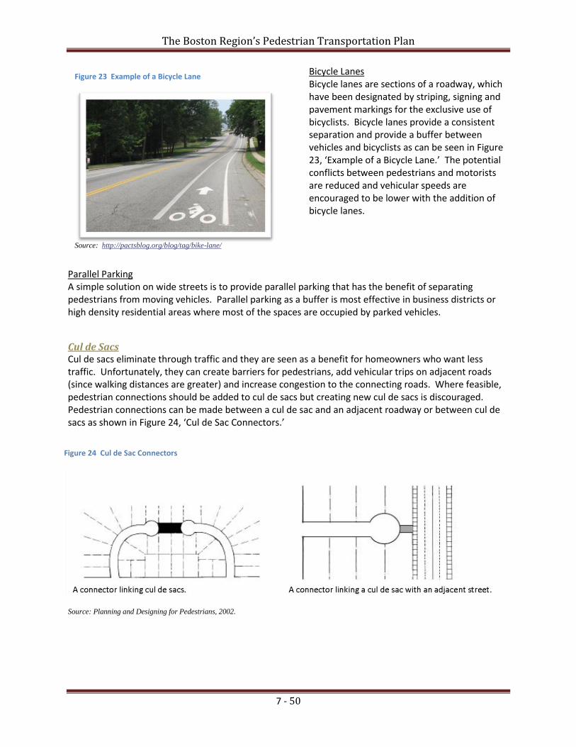
Figure 23 Example of a Bicycle Lane
Source: http://pactsblog.org/blog/tag/bike-lane/
Figure 24 Cul de Sac Connectors
Bicycle Lanes Bicycle lanes are sections of a roadway, which have been designated by striping, signing and pavement markings for the exclusive use of bicyclists. Bicycle lanes provide a consistent separation and provide a buffer between vehicles and bicyclists as can be seen in Figure 23, ‘Example of a Bicycle Lane.’ The potential conflicts between pedestrians and motorists are reduced and vehicular speeds are encouraged to be lower with the addition of bicycle lanes.
Parallel Parking A simple solution on wide streets is to provide parallel parking that has the benefit of separating pedestrians from moving vehicles. Parallel parking as a buffer is most effective in business districts or high density residential areas where most of the spaces are occupied by parked vehicles.
Cul de Sacs Cul de sacs eliminate through traffic and they are seen as a benefit for homeowners who want less traffic. Unfortunately, they can create barriers for pedestrians, add vehicular trips on adjacent roads (since walking distances are greater) and increase congestion to the connecting roads. Where feasible, pedestrian connections should be added to cul de sacs but creating new cul de sacs is discouraged. Pedestrian connections can be made between a cul de sac and an adjacent roadway or between cul de sacs as shown in Figure 24, ‘Cul de Sac Connectors.’
Source: Planning and Designing for Pedestrians, 2002.

The Boston Region’s Pedestrian Transportation Plan
7 - 51
Lighting Pedestrians often assume that motorists can see them at night. Without appropriate lighting, motorists may not be able to see pedestrians in time to stop. Well-designed and well-placed street lighting improves pedestrian visibility and safety. Providing street lighting at pedestrian crossing areas and locations where there are high concentrations of pedestrian activity is important. In areas with high concentrations of pedestrian activity (e.g., schools, shopping districts or downtown areas), placing pedestrian-level lighting over the sidewalks in addition to street lighting is recommended. Mercury vapor, incandescent, or high-pressure sodium lighting are preferred pedestrian-level lighting types. Pedestrian lighting should conserve electricity and avoid glare. Lighting that is designed for motorists is not necessarily appropriate for pedestrians. Pedestrians have a smaller field of focus and move at a slower pace. As a result, pedestrians require shorter light standards to direct more intense light onto a smaller space. Lighting for pedestrians should be spaced continuously to provide a consistent level of light and lighting levels should also be uniform. In order to avoid light pollution, it is important that lighting be directed downward, towards the pedestrian, not up to the sky.
iii. Intersections Pedestrians are most vulnerable at intersections. Although vehicles turn in multiple directions at intersections, signals and crosswalks provide various levels of protection for pedestrians. There are a variety of pedestrian crossing improvements to enhance safety and encourage more walking. Well placed and designed crossing improvements assist pedestrians in traversing complex intersections, make pedestrians more visible to oncoming traffic and encourage pedestrians to cross at specified locations.
Crosswalks Marked crosswalks are used to help designate right-of-way for motorists to yield to pedestrians and direct pedestrians to preferred crossing points. Features such as the number of lanes that pedestrians must cross, proximity to existing traffic signals, and the number of pedestrians who cross the street are critical factors that decide whether a marked crosswalk should be installed. Marked crosswalks contribute towards pedestrian safety. Ideally, marked crosswalks should be used in conjunction with other measures, such as curb extensions, advance warning signage for motorists, traffic signals and traffic calming treatments, to improve pedestrian crossing safety. Marked crosswalks should be provided at intersections where there is pedestrian activity, be placed at regular intervals and convenient locations for pedestrians, and be visible to both the motorist and the pedestrian. ADA-compliant wheelchair ramps should be provided at all crosswalks. The design of a marked crosswalk is dependent on traffic volumes, pedestrian volumes, speed and the number of lanes.
Thermoplastic and inlay tape are the preferred materials for marking crosswalks. Although initially more costly than paint, both inlay tape and thermoplastic are more cost-effective in the long run as both are longer-lasting and require less maintenance. Inlay tape and thermopolastic are more visible at night and slip resistant than paint when wet. As seen in Figure 25, ‘Examples of Crosswalk Markings,’ the MUTCD contains various crosswalk marking patterns. Since the pattern is more visible to motorists, MAPC strongly recommends the “continental” pattern as the preferred marking for crosswalks. Figure 26, ‘Continental Crosswalk Marking’ is an

The Boston Region’s Pedestrian Transportation Plan
7 - 52
Figure 26 Continental Crosswalk Marking - Recommended
Figure 25 Examples of Crosswalk Markings
example of a continental crosswalk. Parallel bar crosswalks are not recommended due to their minimal visibility at night, and confusion with the vehicle stop bar in advance of the crosswalk. Details on innovative pedestrian crossing treatments for crosswalks have been published in a document by the Institute of Transportation Engineers, Alternative Treatments for At- Grade Pedestrian Crossings, 2001. Measures such as incorporating signage, striping, lighting, curb extensions, textured paving and other alternative surface treatments, speed tables, signal equipment, pedestrian detection are
described in this resource. For a crosswalk to be useful, drivers must be aware of the crosswalk and the pedestrians need to utilize the crosswalk. Both sides of a marked crosswalk should have a strong connection to a destination or destinations towards which pedestrians are already heading. It is important for drivers to have adequate sight distance, the distance that a driver can see along the roadway before curvature or obstructions block the view, before approaching a crosswalk.
Source: Manual on Uniform Traffic Control Devices (MUTCD), FHWA, Washington DC, 2009
Yield lines and set-back stop lines in advance of crosswalks improve a driver’s view of pedestrians in crosswalks. Stop lines are used in advance of marked crosswalks at signalized intersections, while yield lines are placed in advance of unsignalized crosswalks. Restricting parking at corners improves visibility of the crossing for both drivers and pedestrians. Signage and crosswalks with in-roadway warning lights, also referred to as ‘flashing crosswalks’, may be used to further alert drivers to crosswalks. Figure 27, ‘Alternative Zebra Crosswalk Marking,’ and Figure 28, ‘Parallel Crosswalk Marking,’ are respective examples of good and poor crosswalks.

The Boston Region’s Pedestrian Transportation Plan
7 - 53
Mid-Block Crosswalks A mid-block crosswalk is a marked crosswalk located away from an intersection that may be either signalized or unsignalized. According to the MUTCD, mid-block crosswalks must be marked. Mid-block crosswalks serve to bridge long gaps between intersections and to serve high pedestrian demand. The following guidelines can assist in evaluating whether mid-block crosswalks should be installed:
Assess the relationship of roadway width, the preference to cross at mid-block, and crossing safety;
Evaluate location (e.g.; the distance to nearby intersections) and the relationship to adjacent land uses (e.g.; a building entry placed at mid-block with a parking lot directly across the street can create a demand for mid-block pedestrian movements); and
Analyze traffic volumes and speeds as well as pedestrian volumes.
If a mid-block crosswalk is designated for installation, then warning indicators such as signs, pavement markings, flashing lights, and pedestrian-activated traffic control signals need to be determined15. It has been debated that providing signs and markings at mid-block crosswalks gives pedestrians a false sense of security. There is no guarantee that a driver may be aware of the mid-block crosswalk and will exercise caution at the intersection. Some general principles for mid-block crossings include:
Reduce the number of lanes. Fewer lanes limit pedestrian crossing distances and generally lessen the likelihood of a collision.;
Install geometric changes that narrow or divide crossing the roadway (e.g.; curb extensions and raised islands or medians);
Improve crossing visibility (e.g.; restrict parking and manage landscaping in the vicinity of the mid-block crosswalk);
Mark mid-block crosswalks with highly reflective material;
Use flashing yellow warning beacons, often referred to as flashers, in conjunction with advance warning signs; and
Provide adequate lighting to increase pedestrian safety. In the early 1990s, the National Highway Traffic Safety Administration evaluated crash types for more than 5,000 pedestrian crashes in six states. The results showed that mid-block accidents were the second major grouping of crash types, accounting for 26.5 percent of all crashes. Increased enforcement and driver education will contribute towards a higher percentage of vehicles yielding as required by law to pedestrians. Marked or Unmarked Crosswalks A Federal Highway Administration (FHWA) study on whether it is safer for crosswalks to be marked or unmarked where there are no traffic signals or STOP signs present was conducted in 200516. This study analyzed five years of pedestrian crash data at 1,000 marked crosswalks and 1,000 unmarked comparison sites. The study concluded that on two-lane roads, the presence of marked crosswalks alone at an uncontrolled location was associated with no difference in pedestrian crash rates, compared to unmarked crosswalks. However, marked crosswalks on multi-lane roads with traffic volumes above
15 Walkinginfo.org 16 Safety Effects of Marked versus Unmarked Crosswalks at Uncontrolled Locations, USDOT, FHWA, September 2005.

The Boston Region’s Pedestrian Transportation Plan
7 - 54
Figure 27 Curb Extensions
Source: Cambridge Pedestrian Plan, 2000.
about 12,000 vehicles per day were associated with higher pedestrian crash rates compared to unmarked crosswalks. Raised Pedestrian Crossing A raised pedestrian crossing can is designed to slow drivers’ speeds, which will increase the likelihood of yielding to crossing pedestrians. The FHWA study concluded that raised medians significantly lower pedestrian crash rates at multi-lane sites with both marked and unmarked crosswalks17. This type of pedestrian crossing is most appropriate on local or neighborhood streets with low speed limits.
Curb Extensions Curb extensions extend the sidewalk into the street, reducing the time and distance it takes a pedestrian to cross. Curb extensions can also prevent drivers from parking in front of crosswalks and blocking curb ramps. The visibility between drivers and pedestrians is also improved with curb extensions because pedestrians start crossing farther out into the street. Curb extensions also reduce the curb turning radius and narrow the roadway. Curb extensions should not extend more than 6 feet from the curb.18 In addition they must not extend into travel or bicycle lanes and are only appropriate when there is on-street parking.19 Figures 29 and 30, ‘Curb Extensions,’ are model examples of curb extensions.
17 Safety Effects of Marked vs. Unmarked Crosswalks at Uncontrolled Locations, FHWA, USDOT, Research, Development, and Technology Turner-Fairbank Highway Research Center, September 2005. 18 Except as shown in Figure 27 which is a curb in conjunction with angled parking. 19 FHWA, Pedestrian Facilities Users Guide, 2002, page 69.

The Boston Region’s Pedestrian Transportation Plan
7 - 55
Figure 29 Diagram of Curb Radii
Source: Walk Arlington.
Figure 28 Curb Extension – Image and Graphic
Source: U.S. DOT, FHWA.
Curb Radii Curb radii is the measurement of the sharpness of a corner at an intersection. Generally, a smaller or tighter curb radius is better for pedestrians. Compared to a large curb radius, a smaller curb radius allows for more pedestrian area at the corner, flexibility in the placement of curb ramps, shorter street crossings, requires vehicles to slow as they turn the corner, and improves sight distance between pedestrians and drivers. An appropriate turning radius for new construction is about 15 feet and about 25 feet for arterial streets that carry a significant volume of turning buses and/or trucks.20 Having curb radii that accommodate emergency vehicles (e.g., the ability to turn at
an intersection) is essential. Figure 31, ‘Diagram of Curb Radii,’ and Figure 32, ‘Small Curb Radii and Large Curb Radii,’ depict the differences between small and large curb radii.
20 FHWA, Pedestrian Facilities Users Guide, 2002, page 58.

The Boston Region’s Pedestrian Transportation Plan
7 - 56
Figure 30 Small Curb Radii (left) and Large Curb Radii (right)
Curb Ramps Curb ramps are used wherever there is a difference in level along a path a pedestrian is traversing. They should be designed to provide an accessible route so pedestrians may safely transition from a roadway to a curbed sidewalk and vice versa. Curb ramps are most commonly found at intersections, but they may also be used at other locations such as on-street parking, driveways, loading zones, bus stops, and midblock crossings. Curb ramps should be designed to provide direct access and have proper width and slope.
Curb ramps must have a slope no greater than 1:12 (8.3 percent). The minimum curb ramp width is 36 inches; however, 48 inches is the desirable minimum. If a curb ramp is located where pedestrians must walk across the ramp, the ramp must have flared sides of no more than 1:10 (10 percent) slope, as depicted in Figure 33, ‘Sides of Curb Ramps and Landings at the Top of Curb Ramps.’ These flares are not needed where ramps are placed in a landscaped area. Curb ramps also require a minimum of 36 inches of level and clear passage of 48 inches or more are desirable at the top also depicted in Figure 29. Curb ramps must be designed in accordance with the ADA guidelines.21 A good example of a curb ramp is shown in Figure 34, ‘Curb Ramp.’ Figure 31 Sides of Curb Ramps (left) and Landings at the Top of Curb Ramps (right)
Source: ADA and ABA Accessibility Guidelines.
21 FHWA, Pedestrian Facilities Users Guide, 2002, page 44.

The Boston Region’s Pedestrian Transportation Plan
7 - 57
Figure 32 Curb Ramp
Signals at Intersections In an effort to create safe and walkable communities, different actions that can be taken to help make traffic signals work well for pedestrians. Most situations where traffic control devices affect pedestrians are addressed in detail in Part 4 of the Manual on Uniform Traffic Control Devices (MUTCD). Signal timing is an important component to how an intersection operates for pedestrians. Traffic signals create gaps in the traffic flow and allow pedestrians to safely cross a street. Signals need to be designed and timed to be pedestrian friendly and allow for adequate crossing time. They must provide a safe and efficient flow of vehicles, pedestrians and bicycles. Pedestrian signal indications are recommended to be used at all traffic signals, unless it is at a location where walking is not recommended. In general, shorter cycle lengths and longer walk intervals better serve pedestrians and promote signal compliance. Pedestrian signals should be clearly visible to the pedestrian at all times. Concurrent and Exclusive Signal Timing - There are two main ways that a pedestrian crossing phase is included at a signalized intersection – concurrent or exclusive. Concurrent signal timing allows pedestrians to cross while vehicles moving in the same direction have a green light. Exclusive signal timing stops traffic in all directions, allowing pedestrians to cross while all vehicles have red lights. With a concurrent pedestrian signal, motorists may turn left or right across pedestrians' paths after yielding to pedestrians. Wait times for a pedestrian signal are the same or similar to wait times for motor vehicles. In general, concurrent phases are preferred since they reduce the wait time for both pedestrians and vehicles and allow for the maximum time for pedestrians to cross a street. While vehicle/pedestrian conflicts are reduced or eliminated with exclusive signal timing, wait times for a pedestrian signal are typically much longer than motor vehicles at the same intersection. This type of phasing is most appropriate in locations with high pedestrian volumes, high turning movement conflicts, or high speed locations.

The Boston Region’s Pedestrian Transportation Plan
7 - 58
Figure 34 Countdown Timer
Source: walkinginfo.org.
However, a major drawback with concurrent signals is that pedestrian and vehicular movements can conflict with each other (pedestrians can cross while vehicles moving in the same direction have a green light). This situation can be alleviated with Leading Pedestrian Intervals (LPI). Figure 35, ‘Concurrent and Exclusive Signals,’ depicts the differences between these two signal types. Figure 33 Concurrent and Exclusive Signals
Source: WalkBoston/ Nina Garfinkle.
Leading Pedestrian Intervals (LPI) - An LPI gives pedestrians an advance walk signal before the driver gets a green light, giving the pedestrian several seconds to start in the crosswalk where there is a concurrent signal. This allows pedestrians to enter the crosswalk before turning traffic is released and reduces conflicts between pedestrians and turning vehicles. As a result, pedestrians are more visible to motorists and motorists are more likely to yield to them when their signal turns green. Signal cycles should be kept short (ideally 90 seconds maximum) to reduce pedestrian delay. A Countdown Timer displays the number of seconds that pedestrians have to cross the street before the light changes. Countdown timers can aid pedestrians in choosing whether to start across the intersection, or to cross more quickly in order to avoid on-coming traffic. An example of a countdown timer is shown in Figure 36, ‘Countdown Timer.’
Pedestrian Actuation - Pedestrian actuation, or the initiation of a change in or extension of a traffic signal phase by the pedestrian (e.g., pushbuttons), should only be used when pedestrian crossings are intermittent and should be made accessible to all pedestrians, including those with disabilities. Quick response to the pushbutton or feedback to the pedestrian (e.g., indicator light comes on) should be programmed into the system.
Pedestrian Detectors - Pedestrian detectors are currently being installed and tested in some U.S. cities. Detectors can be used to automatically activate the red traffic and WALK signals when pedestrians are detected or they can be used to extend the crossing time for slower moving pedestrians in the crosswalk. Pedestrian detectors are still considered experimental and their reliability may vary under different environmental conditions.

The Boston Region’s Pedestrian Transportation Plan
7 - 59
Audible Tones and Speech Messages - Accessible Pedestrian Signals (APS) are devices that communicate information about pedestrian timing in nonvisual formats such as audible tones, verbal messages that provide standard information about the status of the signal cycle (e.g., WALK, DON’T WALK) and/or vibrating surfaces. Information on the location, direction of travel, and the name of the street to be crossed is sometimes also included. APS units are recommended in PROWAC22 whenever pedestrian signal systems are added or altered at intersections. Refer to either the Access Board (R306) or walkinginfo.org for more information. The MUTCD recommends that accessible pedestrian signals have both audible and vibrotactile indications23. Audible walk indications are broadcast from a speaker that is incorporated into the pedestrian pushbutton housing. The MUTCD requires that the volume of the audible walk indication be carefully adjusted to be heard a minimum of 6 feet and a maximum of 12 feet from the pushbutton, or to the building line, whichever is less24. The MUTCD standard for automatic volume adjustment in response to ambient traffic sound level is a maximum volume of 100 dBA. Audible tone walk indications shall repeat at eight to ten ticks per second. Vibrotactile pedestrian devices provide information to pedestrians who are blind and deaf. These accessible pedestrian signals communicate, by touch, information about pedestrian timing using a vibrating surface. A vibrotactile walk indication is usually an arrow on the pushbutton that vibrates during the walk interval. The placement of audible and vibrotactile indicators on pedestrian signals is determined by appropriate engineering judgment. For the past 25 years, APS units have been provided at certain intersections at the request of people who are impaired. The incorporation of APS for all new and altered signal systems with pedestrian indicators will become required if PROWAC is approved in its present form by the Access Board and FHWA.
Signage - Signs can provide important information that can improve road safety. By letting people know what to expect and how to behave, prudently installed signs can guide appropriate reactions for both pedestrians and drivers. For example, giving motorists advance warning of an upcoming pedestrian crossing will alert them to modify their speed.
Crosswalks - Marked crosswalks at signals should always be installed. Crosswalks encourage pedestrians to cross at the signal and discourage motorists from encroaching into the crossing area.
Best Practice – Pedestrian Signal
Accessible Pedestrian Signals (APS) As part of a signalization upgrade in 2001, Community Development Block Grant (CDBG) funds were used to install Accessible Pedestrian Signals (APS) at 19 intersections in Newton, Massachusetts. APS features of some of the signals included walk indication with audible rapidly repeating tones, pushbutton locator tone, and automatic volume adjustment in response to ambient sound. Over the next few years, the City intends to add additional APS devices with similar features at selected high-volume pedestrian intersections.
22 PROWAC is an acronym for the U.S. Access Board’s Public Rights of Way Accessibility Committee’s Guidelines. 23 Section 4E.11 Accessible Pedestrian Signals and Detectors – Walk Indications. 24 Section 4E.12 Accessible Pedestrian Signals and Detectors – Tactile Arrows and Locator Tones.

The Boston Region’s Pedestrian Transportation Plan
7 - 60
d. Buildings and Land Use There is an integral connection between transportation planning and land use regulations. Land use regulations can encourage an accessible pedestrian network if pedestrian needs and mobility issues are incorporated into the development of zoning regulations and subdivision ordinances. Traditionally, zoning regulations have not encouraged mixed-use developments and subdivision ordinances have focused on vehicles as the primary mode of transportation. Subdivision ordinances often lack requirements for sidewalks on streets and pedestrian connections between the streets. As a result, these practices have led to increased dependency on vehicles. Communities should establish regulations that would require developers to design attractive and pedestrian accessible buildings and connect them with various land uses. For example, this could be done by implementing zoning regulations that require mixed-use development as well as the placement of buildings that relate to and are oriented toward the street and surrounding buildings (Figure 37, Building Façade Treatment in Needham and Figure 38, Street-Oriented Building in Canton). Parking lots should have clear pedestrian paths through them and be placed behind buildings. Massachusetts’ Smart Energy/Smart Growth Toolkit has a model by-law that communities can follow when developing their own building design guidelines. Figure 35 Building Facade Treatment in Needham on Path to Parking behind Streetfront Buildings
Figure 36 Street-Oriented Building in Canton

The Boston Region’s Pedestrian Transportation Plan
7 - 61
The following recommendations promote pedestrian accessibility and a pedestrian-friendly environment and should be considered for communities to incorporate when revising their zoning regulations and subdivision ordinances.25
General
Provide adequate pedestrian access to buildings, public spaces, and between adjacent uses.
Encourage mixed use developments with higher densities and increase allowable densities near major destination points, transit lines and multi-use paths.
Encourage design that promotes human scale and pedestrian-oriented character.
Require commercial districts that contain shopping and employment centers to have multiple building entrances and an on-site walkway system.
Make developments pedestrian-friendly by using amenities such as wide sidewalks/pathways, outdoor seating, and/or landscaping.
Design structures, parking, pathways and other pedestrian amenities to maximize ease of pedestrian access.
Include pedestrian-friendly street and sidewalk design principles as required components of a pedestrian network.
Require developers to include pedestrian facilities early in the site planning process, so planners can coordinate with other planned transportation improvements.
Building Orientation
Orient buildings toward the street to encourage pedestrian activity.
Orient buildings to enhance pedestrian access to buildings and between sites.
Building Design
Encourage the use of glass as an architectural and design element on building facades. Glass can provide variety, interest and openness.
Walls facing streets should have windows and architectural features such as awnings, cornice work, step-backs, edge detailing and other decorative finish materials.
Do not permit continuous lengths of flat, blank walls adjacent to streets, pedestrian pathways, or open spaces.
Require commercial uses to be located at the ground floor.
Do not allow doors to extend beyond the exterior façade into pedestrian pathways.
Building Scale
The size and detailing of buildings shall be pedestrian oriented (e.g.; have vertical elements that visually break up the width of the structure).
25 Southeastern Indiana Gateway: US 50 Transportation and Land Use Plan, January 2007 and Planning and Policy Models for Pedestrian and
Bicycle Friendly Communities in New York State, September 2007.

The Boston Region’s Pedestrian Transportation Plan
7 - 62
Parking
Locate vehicular parking spaces behind or beside buildings wherever possible.
Parking design should maximize the efficient use of existing and proposed parking facilities, and minimize the area of land to be paved for parking.
Reduce requirements for parking spaces.
Require shared parking.
Sidewalk Limit driveways across sidewalks frequently used by pedestrians. Minimize curb cuts. Adhere to use of appropriate sidewalk materials. Ensure sidewalks comply with appropriate width requirements.
Landscaping
Encourage pedestrian-friendly amenities, such as wide sidewalks/pathways, outdoor seating, patios, porches or courtyards.
Landscaping shall not encroach on sidewalks in a way that impedes pedestrian traffic.
Lighting
Direct lighting so that it does not cause glare for pedestrians.

The Boston Region’s Pedestrian Transportation Plan
7 - 63
Best Practices – Pedestrian Oriented Neighborhoods Davis Square, the Essex Street Pedestrian Mall and Mashpee Commons incorporate several components of the design tools discussed earlier in this section.
Davis Square Davis Square is an exceptional example of a pedestrian-oriented, mixed-use activity center anchored by the Red Line station in an established urban neighborhood. Traffic calming measures such as neck-downs, pedestrian safety islands, clearly marked crosswalks, signage, and pedestrian signalization all contribute to reducing the speed of traffic flow and improving pedestrian safety. Benches, trash receptacles, street lighting, plantings, public art, and sidewalk materials, all enhance the pedestrian experience.26 A main intersection at Davis Square is shown in Figure 39..
Essex Street Pedestrian Mall The City of Salem is known for its pedestrian mall, referred to as the Essex Street Pedestrian Mall. Created about 30 years ago and located in downtown Salem, the pedestrian mall is lined with storefronts and historic sites and is closed off to most automobile traffic. Museum Place and the East India Marine Hall are depicted in Figure 40.
Mashpee Commons In 1988, an underutilized five acre auto-oriented shopping center and strip mall in Mashpee, Massachusetts was successfully converted into Mashpee Commons, a mixed-use, mixed-income, pedestrian-oriented town center. There are over 278,000 square feet of commercial tenants and forty residential units above the retail space. A library, church, post office, movie theater, restaurants and elderly housing are also present at Mashpee Commons. A main intersection at Mashpee Commons is shown in Figure 41.
26 http://www.mass.gov/envir/smart_growth_toolkit/pages/CS-tod-somerville.html.
Figure 37 Davis Square, Somerville
Source: www.sixoneseven.net, by John Whittington
Figure 39 Mashpee Commons, Mashpee
Source: Smart Growth/Smart Energy Toolkit
Source: Salem News
Figure 38 Essex Street Pedestrian Mall, Salem

The Boston Region’s Pedestrian Transportation Plan
7 - 64
Best Practices – Studies, Plans and Guidelines to Improve the Pedestrian Environment
Canton The Town of Canton’s Design Review Guidelines provide advice for building owners, tenants, and developers and provide guidance for the Design Review Board when reviewing applications within the Canton Center Economic Opportunity District.
Concord and Lincoln The Walden Passage Feasibility Study researches the feasibility of establishing a combined crossing for wildlife and recreational users along a predefined study area, a 2.5-mile section of Route 2 in Concord and Lincoln, Massachusetts.
Needham The Needham Center Development Plan is an endeavor to develop a comprehensive plan for the future of the Needham Center commercial area. One of the plan’s key goals is to improve the pedestrian environment.
Stoughton Stoughton Center's Design Review Guidelines are intended to provide additional support to the by-law that established the Stoughton Center Mixed-Use Overlay District. The by-law includes creating a more compact, pedestrian-friendly living and working environment that encourages transit use and bicycling.
Woburn Woburn’s Busy Bend Design Study addresses streetscape and storefront façade guidelines that can be applied throughout the Woburn Square Revitalization Area. Specific pedestrian improvements include curb extensions and sidewalk upgrades.
Best Practices – Pedestrian Corridor Enhancements
Arlington The Massachusetts Avenue Corridor Project looks at converting Massachusetts Avenue from a transportation corridor to a pedestrian-friendly street. The primary goal of the project is to create a healthy balance between automobiles, bikes, pedestrians, and transit users.
Cambridge The Prospect Street Corridor Study is an urban design study exploring possible ways to improve this corridor. Improvements focus on urban design and the quality of the streetscape, and will aim to create a more pleasant environment and enhance the pedestrian experience.
Concord Concord’s Recommendations for the Village Center Study provides recommendations on what needs to be preserved and what ideally should change for three centers in Concord. One of the study’s primary goals is to provide direction on public investment for infrastructure which includes pedestrian enhancements.
Best Practice – Pedestrian Connection
Ipswich The Ipswich Historic Riverwalk is designed to heighten awareness of the town’s natural resources and to provide a recreational destination for residents and tourists. This project connects the town on both sides of the Ipswich River with its commercial center and facilitates access to the Ipswich commuter rail station.
The twelve-foot wide pedestrian bridge encourages downtown pedestrian traffic to benefit local businesses. In addition, the Riverwalk project creates a cohesive and attractive pathway system, increases tourism with a pedestrian-friendly downtown, and improves pedestrian access to downtown and public transportation.